Embed Size (px)
Citation preview
Platte Valley Mule Deer Migration Corridor
Draft
Biological Risk & Opportunity Assessment Teal Cufaude
Katie Cheesbrough
Britt Brito
Thomas Koenig
Embere Hall
Image credit: K. Cheesbrough

2 Draft. Platte Valley Migration Corridor Risk & Opportunity Assessment
Table of Contents
Abbreviations 4
Introduction 4
Platte Valley mule deer migration corridor 5
Habitat 5
Herd management objectives and population trends 6
Primary Conservation Challenges and Opportunities 6
Protected areas 6
Wilderness and Wilderness Study Areas 6
No Surface Occupancy (BLM designation) 6
Visual Resource Management (BLM designation) 7
Conservation easements 7
Wildlife Habitat Management Areas 7
Sage Grouse Core Areas 8
Migration corridor protections 8
Big game crucial range 8
Zoning and Exurban Development 9
Fences 10
Roads 11
Energy Development 12
Oil and gas 13
Renewable energy 14
Transmission lines 14
Mining 14
Energy development in other jurisdictions 14
Trails and Recreation 15
Invasive Species 15
Cheatgrass 16
Habitat Improvement Initiatives 18
3 Draft. Platte Valley Migration Corridor Risk & Opportunity Assessment
Methods 20
Segment development 20
Northern segments 20
Southern segments 20
Data collection 21
Data analyses 22
Area and linear distance 23
Numeric tally 23
Bottlenecks 23
Maps & data availability 23
Segment A (Dana Ridge/Elk Mountain) 25
Segment B (North Platte/Coad and Pennock Mountain) 33
Segment C (Cedar Hills) 40
Segment D (Beaver Hills/Baggott Rocks) 45
Segment E (Encampment River) 52
Conclusions 57
Literature Cited 57

4 Draft. Platte Valley Migration Corridor Risk & Opportunity Assessment
Abbreviations ACEC Area of Critical Environmental Concern
ATV All-terrain Vehicle
BBMM Brownian Bridge Movement Model
BLM Bureau of Land Management
CCWD Carbon County Weed and Pest
DOI Department of Interior
HWY Highway
LaVA Landscape Vegetation Analysis
NEPA National Environmental Policy Act
NGO Non-governmental Organization
NSO No Surface Occupancy
ORV Off-road Vehicle
OSLI Office of State Lands and Investments
PVHP Platte Valley Habitat Partnership
PVMDI Platte Valley Mule Deer Initiative
RAM Residential, Agricultural, and Mining
SERCD Saratoga-Encampment-Rawlins Conservation District
SMA Special Management Area
USFS United States Forest Service
VRM Visual Resource Management
WGFC Wyoming Game and Fish Commission
WGFD Wyoming Game and Fish Department
WHMA Wildlife Habitat Management Area
WOGCC Wyoming Oil and Gas Conservation Commission
WSA Wilderness Study Area
WYDOT Wyoming Department of Transportation
CR # County Road
US # United States Highway
WY # Wyoming State Highway

5 Draft. Platte Valley Migration Corridor Risk & Opportunity Assessment
Introduction
Platte Valley Mule Deer Migration Corridor The Platte Valley mule deer migration corridor is located in Carbon County in south-central Wyoming.
The corridor overlaps the Platte Valley Mule Deer Herd Unit. It encompasses deer hunt areas 78 and 79
on the west slope of the Medicine Bow Mountains (Snowy Range), and hunt area 81 on the east slope of
the Sierra Madre Range. Elevation in the corridor ranges from 6,600 feet along the North Platte River to
9,500 feet in the Snowy Range. Land ownership within the corridor includes a matrix of public (49.32%)
and private (50.34%) lands (Table 1). The Bureau of Land Management (BLM), United States Forest
Service (USFS) and the State of Wyoming manage the public land throughout the Platte Valley mule deer
migration corridor.
Migration along the corridor is complex and dynamic with some mule deer (Odocoileus hemionus)
migrating long distances (80 miles) while others migrate far less (20 miles). Most mule deer within the
Platte Valley herd unit are migratory, however there are some non-migrant individuals. The northern
part of the herd unit has a higher proportion of these residents compared to other areas (Kauffman et
al. 2015).
The corridor encompasses migration routes extending from four primary winter range areas, including
Beaver Hills, south Encampment, east Saratoga (Cedar Hills), and north of I-80 (Kauffman et al. 2015).
The corridor is based on these distinct wintering populations with southern migration routes that extend
from Saratoga to the Colorado state line and northern migration routes that extend from Saratoga to
north of I-80. Most deer wintering in the south follow the North Platte River south to summer ranges in
Colorado. In the north, most deer head south and east from winter ranges along I-80. Summer ranges
for Platte Valley deer include mountain ranges outside the Platte Valley (foothills surrounding North
Park, CO), Sierra Madre Range, the slopes of Elk Mountain, and the Medicine Bow Mountains (Snowy
Range).
Table 1. Land ownership in the Platte Valley mule deer migration corridor.
SEGMENT BLM USFS PRIVATE STATE OTHER TOTAL ACRES
Total 37,724.49 17,650.99 63,689.03 7,020.15 436.2 126,520.86
Percent 29.82% 13.95% 50.34% 5.55% 0.34% 100%
Habitat The corridor includes subalpine and montane forests, mixed-mountain shrub, sagebrush-grasslands,
cottonwood riparian and agricultural croplands. The forests are a mix of subalpine fir (Abies lasiocarpa),
Engelmann spruce (Picea engelmannii), Douglas-fir (Pseudotsuga menziesii), lodgepole pine (Pinus
contorta), aspen (Populus tremuloides) and scattered ponderosa pines (Pinus ponderosa), with
associated understory vegetation. Big sagebrush (Artemisia tridentata), antelope bitterbrush (Purshia
tridenta), and true mountain mahogany (Cercocarpus montanus) dominate the lower elevation winter
ranges. The persistence of the Platte Valley mule deer herd is contingent on deer having the ability to
move along the corridor between shrub-dominated winter habitats and higher elevation forb, grass, and
mountain shrub summer/fall habitats. Changes in seral stages of vegetative communities to less

6 Draft. Platte Valley Migration Corridor Risk & Opportunity Assessment
productive stages, severe drought and the conversion of habitat to residential and energy development
have cumulatively reduced habitat for mule deer in the corridor.
Herd management objectives and population trends The Wyoming Game and Fish Department (hereafter “Department'') manages the Platte Valley mule
deer population within 10% of a WGFC-approved “postseason” population size of 16,000 mule deer.
This objective is based on the number of deer the habitat can sustain, and the desires of hunters and
landowners. According to Department population models, the herd unit supported approximately
12,000 mule deer following the 2019 hunting season.
Deer seasons have been Limited Quota since 2013. Harvest has focused on the male segment of the
population since the mid-2000s. The firearm hunting season occurs during the first two weeks of
October, so mule deer are hunted on summer and transitional ranges, when they are less vulnerable
and more dispersed.
Primary Conservation Challenges and Opportunities
Protected areas While much of the Platte Valley mule deer migration corridor consists of intact open space, human
development and the associated infrastructure can impair connectivity. Habitat protections are an
important tool to help insure corridor viability. Currently much of the corridor is conserved under one or
more protected habitat designations (Table 2). Primary land protections in the Platte Valley include
Wilderness (USFS) and Wilderness Study Areas (BLM), No Surface Occupancy designations (BLM), Visual
Resource Management areas (BLM), conservation easements and the Pennock Mountain Wildlife
Habitat Management Area (WHMA). In addition, much of the migration corridor lies within sage grouse
(Centrocercus urophasianus) core areas, or coincides with crucial habitat priorities identified by the
Department, such as mule deer crucial winter range.
Wilderness and Wilderness Study Areas Wilderness Areas, designated by federal land management agencies, are intended to maintain land in a
natural state with minimal impacts from human activities. Permanent infrastructures, mechanized travel
and motorized use are prohibited. Because of their relatively undisturbed nature, Wilderness Areas
often provide important wildlife habitat. They are popular among backpackers and other non-motorized
recreationalists, for similar reasons. In the Platte Valley, mule deer move thorough and in some cases
summer in the Encampment River Wilderness, located along the Encampment River. Other important
Wilderness Areas adjacent to the designated corridor include Savage Run, Platte River and Huston Park.
Additionally, a subset of deer that winter in the Platte Valley spend the summer in the Mount Zirkel
Wilderness in Colorado’s Park Range. While Wilderness Areas provide migrating deer with protections
from roads, motorized travel and land development, associated regulations can limit options for suitable
habitat treatments.
No Surface Occupancy (BLM designation) No Surface Occupancy (NSO) is a BLM designation that prevents surface disturbing activities in specific
areas. Lands with this designation may include wilderness areas, cultural artifacts or sensitive spaces for
wildlife. Areas identified as NSO are open to fluid mineral leasing, assuming that the lease can be
developed by directionally or horizontally drilling from nearby acres without NSO limitations. The
7 Draft. Platte Valley Migration Corridor Risk & Opportunity Assessment
current Rawlins Field Office Resource Management Plan includes 3,138 acres (2.5% of corridor) of NSO
that overlap the designated migration corridor.
Visual Resource Management (BLM designation) Visual resources are components of the landscape that make up the scenery of an area. The BLM
classifies scenic values and visual qualities of public lands through the resource management planning
process. Management classes reflect the degree of acceptable visual change in primary elements of the
landscape. The designated migration corridor includes Class I, Class II and Class III designations. The
amount of acres protected under each class appears parenthetically below. Class descriptions are
excerpted from the Record of Decision and Approved Rawlins Resource Management Plan (2008).
● Class I provides for natural ecological changes only. This class includes primitive areas, some
natural areas, some Wild and Scenic Rivers, and other similar areas where landscape
modification activities are restricted. (1,974 ac)
● Class II areas are those areas where changes in any of the basic elements (i.e., form, line, color,
or texture) caused by management activity should not be evident in the characteristic
landscape. (43,371 ac)
● Class III includes areas where changes in the basic elements caused by a management activity
may be evident in the characteristic landscape. However, the changes should remain
subordinate to the visual strength of the existing character. (63,875 ac)
Conservation easements Conservation easements are voluntary contracts between a willing landowner and a conservation
organization. While the specifics of agreements vary, easements generally ensure that the encumbered
land will be maintained as open space into the future. This typically includes transferring the right to
subdivide a property to the entity that holds the easement. In nearly all cases the landowner can
continue activities that are compatible with open space and conservation value, including ranching. Of
the 63,690 acres of private land in the designated corridor, 14% is protected under conservation
easement. The majority of these acres are in the Dana Ridge / Elk Mountain and the Beaver Hills /
Baggot Rocks areas. As the human population grows in the Intermountain West, and pressure to
develop private land continues, conservation easements can offer an important tool to protect open
space and ensure landscape connectivity.
Wildlife Habitat Management Areas WHMAs are lands that provide crucial wintering habitat for big game and important production areas
for other wildlife. In addition, WHMAs help to protect adjacent private land from excessive ungulate
use, especially during winter.
In the Platte Valley, the Department manages the Pennock Mountain WHMA. This 11,091-acre area
encompasses the foothills below Pennock Mountain. Vehicle access is prohibited from December 1 to
April 30 each year to reduce disturbance to wintering wildlife. Collection of shed antlers and horns is
prohibited January 1- May 1 for similar reasons. Camping is allowed in designated areas and motor
vehicles are allowed on designated roads. The land is managed through a cooperative agreement with
the BLM and the WGFC.

8 Draft. Platte Valley Migration Corridor Risk & Opportunity Assessment
Sage Grouse Core Areas The current State of Wyoming Greater Sage Grouse Core Area Protection Executive Order, 2019-3, was
issued by Governor Mark Gordon in August 2019. The executive order provides a process for managing
development in sage grouse habitat across Wyoming and is the primary regulatory mechanism for sage
grouse conservation in the state. The executive order outlines a Core Area Protection strategy,
implemented by state agencies, that prioritizes the maintenance and enhancement of habitat and
populations within Core Population Areas, Connectivity Areas, and Winter Concentration Areas, a
combined area which supports 83% of the grouse population in the state. These protections include
71,531 acres associated with the South Rawlins and Hanna Core Population areas that overlap the Platte
Valley mule deer migration corridor. The executive order also designates Non-Core Population Areas as
sage grouse habitat with fewer stipulations for development, but where development should still be
designed to maintain populations and habitats.
Projects in Core Population Areas, Connectivity Areas, or Winter Concentration Areas should avoid
impacts first, minimize unavoidable impacts second and apply compensatory mitigation where
necessary as a last resort. Preferred development plans avoid negative impacts in Core Population Areas
and other Executive Order-delineated habitat through compliance thresholds and stipulations for
development outlined in the Executive Order. Avoidance can be both spatial and temporal (Order 2019-
3, Appendix E). Valid existing rights are recognized, with state-permitted activities allowed to continue
subject to the terms, conditions and authorizations specified for the activity.
Migration corridor protections The Governor’s Executive Order on mule deer and pronghorn (Antilocapra americana) migration
corridor protection (Order 2020-1) details a number of habitat protection measures specific to
designated migration corridors. These measures do not apply to private lands. Within designated
corridors, areas of varying use are classified as: bottlenecks, stopovers, high use, medium use and low
use. The Order stipulates that no new surface disturbance or seasonal human presence will be
permitted in bottlenecks. Surface disturbance and human activity during migration should be avoided in
all stopover areas that correspond with high use portions of the corridor. In high-use areas that are not
classified as stopovers, surface disturbance and human presence should be limited to levels consistent
with the functionality of the corridor. Regardless of the corridor-use classification, development should
occur outside of the designated corridor whenever possible. Valid existing rights are recognized, with
state-permitted activities allowed to continue subject to the terms, conditions and authorizations
specified for the activity.
Big game crucial range Crucial range describes geographic areas or habitat components that play a substantial role in the ability
of a population to maintain and reproduce over the long-term. In general, crucial winter range should be
available and intact in order to sustain abundances that align with population management objectives.
In the Platte Valley, most of the mule deer crucial range includes sage steppe, wherein shrubs and
grasses provide critical winter forage. To minimize disturbance to wintering ungulates, the Department
recommends that public land-management agencies minimize development activity in designated elk
(Cervus elaphus), moose (Alces alces), bighorn sheep (Ovis canadensis), mule deer or pronghorn crucial
winter range and crucial winter-yearlong range from November 15 – April 30.

9 Draft. Platte Valley Migration Corridor Risk & Opportunity Assessment
Table 2. Existing habitat protections in Platte Valley mule deer migration corridor.
PROTECTED AREAS TOTAL ACRES
BLM NSO 3,137.83
Wildlife Hunter Management Area 4.82
Visual Resource Management 0 17,293.66
Visual Resource Management I 1,974.29
Visual Resource Management II 43,371.48
Visual Resource Management III 63,874.86
Wilderness Study Area 1,974.21
Combined Crucial Habitat Priorities 4.82
Conservation Easement 9,208.4
Terrestrial Crucial Habitat Priorities 112,078.8
Wilderness Area 6,099.91
Sage-Grouse Core Area 71,531.27
Zoning and Exurban Development The Intermountain West has experienced some of the highest rates of human population growth in the
country, and Wyoming is no exception (Vias and Carruthers 2005, Kauffman et al. 2018). In many places,
low-density housing development has outpaced other forms of land use (Brown et al. 2005). Low-
density housing typically has a dispersed arrangement on the landscape, close proximity to undeveloped
land and high coincidence with preferred wildlife habitats. People often are drawn to the same
biological and physical characteristics as wildlife, including valley bottoms and riparian areas that
provide essential resources for migrating wildlife (Hansen et al. 2005). Indeed, subdivisions and the
corresponding infrastructure can negatively affect animal behavior and demography (Johnson et al.
2017, Polfus and Krausman 2012), alter plant communities, increase human-wildlife conflict, and reduce
available management options (Wyoming Game and Fish Department 2017). In western Wyoming, mule
deer increased their rate of movement through development and decreased the amount of time spent
in stopovers that included exurban housing (Wycoff et al. 2018). This response functionally decreases
the foraging benefits of migration, and risks animals arriving on seasonal ranges in suboptimal condition.
Rural-residential development, especially on winter range, has also been linked to decreased
recruitment, with twice the magnitude of effect on populations than other more commonly considered
factors like weather (Johnson et al. 2017). Given fidelity to migration routes (Sawyer et al. 2019), mule
deer likely lack the capacity to substantively alter movement paths to accommodate increases in rural
housing development.

10 Draft. Platte Valley Migration Corridor Risk & Opportunity Assessment
The entirety of the Platte Valley mule deer migration corridor lies in Carbon County. Development on
private land primarily is regulated by the Carbon County Comprehensive Land Use Plan (Carbon County
Board of Commissioners 2012), and informed by other management guidance, including the Saratoga-
Encampment-Rawlins Long Range Land Use and Natural Resource Management Plan (Saratoga-
Encampment-Rawlins Conservation District 2017). Zoning districts in the corridor include Residential,
Agriculture and Mining; Forestry Production and Seasonal Recreation; Rural Residential Agriculture; and
Residential single family. The amount of corridor acres in each district appears parenthetically below.
Descriptions are excerpted from the Carbon County Zoning Resolution (Carbon County Board of
Commissioners 2015).
● Residential, Agricultural and Mining. Preserve historic uses and open space areas of the County
while simultaneously permitting ranching, agriculture, animal husbandry, forestry and mining in
a manner that attains this purpose. All of the unincorporated area of the County not otherwise
zoned is designated as the Ranching, Agriculture and Mining Zone. Minimum lot area: 35 ac.
(63,789 ac)
● Forestry Production and Seasonal Recreation. Applied where timber production and seasonally
accessible recreation uses are the desirable predominant uses and agriculture is the secondary
use, and in which protection of the timber and recreational lands is essential to the general
welfare. Minimum lot area: 5 ac. (10 ac)
● Rural Residential Agriculture. Areas of the County which are particularly suited to large-lot
development that allow both agricultural and residential uses intermingled. In all cases,
agricultural uses have supremacy over residential uses. Minimum lot area: 5 ac. (67 ac)
● Residential single family. Provide land for residential development that is typically single family
detached and located within Town Expansion Areas and within or nearby Rural Centers.
Minimum lot area: 1 ac. (98 ac)
As development continues in Carbon County, we encourage adherence to zoning regulations established
in the Land Use Plan. Variances that allow parcels to be subdivided below minimum lot sizes should be
considered carefully.
Fences Physical barriers on the landscape, such as fences and roads, can complicate animal movement and
migrations. Fences are a dominant feature across the West and can be both impermeable and
semipermeable barriers impeding daily and seasonal wildlife movements. Fencing can exclude or restrict
access to crucial resources (e.g. high-quality forage, water, seasonal ranges, and escape from predators),
leading to population declines (Spinage 1992, Bolger et al. 2008, Harris et al. 2009, Sawyer et. al 2013,
Jakes et al. 2018). Animals attempting to navigate fences often expend substantial energy when they are
temporarily entangled or searching for a place to cross (Jakes et al. 2018, Seidler et al. 2018). Over time,
increased stress and energy expenditure may reduce overall individual fitness and increase mortality
rates (Jakes et al. 2018). In addition to impeding wildlife movement, fences also increase the risk of
entanglement and direct mortality (Harrington and Conover 2006, Rey et al. 2012). While there are
many different types of fence, woven wire fence with a single strand of barbed wire poses the greatest
risk of mortality to ungulates (Harrington and Conover 2006). Ungulates attempting to cross this type of
fence often become entangled between the barbed wire and stiff woven wire (Paige 2012), reducing the
animals ability to free itself. Furthermore, juveniles are often separated from their mothers when

11 Draft. Platte Valley Migration Corridor Risk & Opportunity Assessment
attempting to cross woven wire fences and thus experience increased risk of predation and starvation
(Harrington and Conover 2006). As anthropogenic disturbances continue to increase on the landscape,
implementation of wildlife-friendly fences is necessary to maintain habitat connectivity and migration
corridors.
Large-scale wildlife-friendly fence conversion is an important tool to mitigate wildlife movement barriers
(Paige 2012). Converting hazardous fences in migration corridors to wildlife-friendly fences can reduce
fence entanglements, mortalities, and animal energy expenditure while increasing overall habitat
connectivity. Various fencing modifications such as incorporating a smooth bottom wire, raising the
bottom wire/lowering the top wire, installing pole-tops along choke-points, and using wood stays can
improve permeability for wildlife while maintaining livestock confinement (Paige 2012). Wildlife-friendly
fence conversion has been successful in increasing wildlife movement in pronghorn, white-tailed deer
(Odocoileus virginianus), and mule deer (Burkholder et al. 2018, Jones et al. 2018, Jones et al. 2020).
Strategic placement of fence modifications may be just as important as the modification itself
(Harrington and Conover 2006, Paige 2012, Burkholder et al. 2018). Fence conversions should be
prioritized in areas where the risk of mortality is the highest, such as areas with high densities of
ungulates, areas where ungulates frequently cross fences and near water sources or other natural
concentration points (Harrington and Conover 2006). Throughout the Platte Valley, hundreds of miles of
fencing are used to delineate land ownership, maintain livestock and manage resources. Using GPS
collar data from Platte Valley mule deer movement and habitat use studies (Kauffman et al. 2015),
Department staff and cooperators have developed proposed locations for wildlife-friendly fence
conversions in mule deer migration corridors and high-use areas. The proposed fence conversions
should help to mitigate mule deer movement barriers and restore habitat connectivity and corridor
functionality.
Roads Roads may impede daily and seasonal wildlife movements, exclude and restrict wildlife access to crucial
resources, fragment habitat, and increase the risk of traffic related mortality. Wildlife can safely cross
roads with low traffic volume, especially if right-of-way fencing is absent or wildlife friendly fence occurs
adjacent to roadways (Sawyer et al. 2016). However, multiple lane roads with high traffic volumes such
as highways and interstates are typically bordered with right-of-way fencing and often function as near-
complete barriers to many wildlife species (Sawyer et al. 2014, Seidler et al. 2014). Once an animal has
successfully navigated the right-of-way fencing, it becomes increasingly at risk of collision with vehicles.
Collisions between vehicles and wildlife pose a significant threat to motorist safety and wildlife
populations. In the United States, an estimated 1-2 million wildlife-vehicle collisions occur annually
(Huijser et al. 2008). In Wyoming, an average of 6,000 wildlife-vehicle collisions occur each year. Major
factors influencing collision risk include wildlife density, traffic speed and volume, wildlife resource
availability along roadways, and temporal changes in wildlife and motorist behaviors (Gunson et al.
2011, Rea et al. 2014, Coe et al. 2015, Niemi et al. 2017, Colino-Rabanal et al. 2018, Laliberté and St-
Laurent 2020). Understanding why, when and where wildlife-vehicle collisions occur is essential to
developing effective mitigation measures.
Common mitigation practices to reduce wildlife-vehicle collisions include wildlife warning signs, speed
limit reductions, reflectors, game-proof fences, and wildlife crossing structures (Riginos et al. 2013, van
der Ree et al. 2015). Wildlife crossing structures such as underpasses or overpasses are increasingly used

12 Draft. Platte Valley Migration Corridor Risk & Opportunity Assessment
to reduce collisions and maintain habitat connectivity (Huijser et al. 2008, Sawyer et al. 2012, Smith et
al. 2015, Sawyer et al. 2016, Gilhooly et al. 2019). These structures, combined with game-proof fencing,
effectively and drastically reduce wildlife-vehicle collisions (McCollister and Van Manen 2010, Sawyer et
al. 2012, Huijser et al. 2016). Wildlife underpasses are easier and significantly cheaper to construct
compared to overpasses.
Placement of wildlife crossing structures should be carefully considered to maximize mitigation efforts.
Managers require extensive information regarding migration routes, species-specific preferences, and
financial costs to make informed decisions on when and where wildlife crossing structures should be
implemented on the landscape (Coe et al. 2015, Sawyer et al. 2016, Caldwell and Klip 2020). As mule
deer show strong fidelity to migration routes, crossing structures (with game-proof fencing) should be
constructed in areas where migration routes intersect high traffic volume roadways (Sawyer et al. 2012).
GPS movement data can facilitate selection of specific locations in the Platte Valley where deer-vehicle
collisions are most frequent. Given the large financial cost associated with wildlife crossing structures,
less expensive mitigation measures (e.g., wildlife warning signs, speed limit reductions, reflectors, etc.)
should be utilized when possible. Restoring habitat connectivity and corridor functionality will require
effective collaborations with diverse stakeholders including WYDOT, private landowners, conservation
districts, federal land management agencies, NGOs and county governments.
Energy Development As human populations grow the demand for energy production continues to increase. While the energy
industry is a major contributor to Wyoming’s economy, the impacts associated with development can
affect mule deer population dynamics and migration (Sawyer et al. 2017, Sawyer et al. 2019). The Platte
Valley mule deer migration corridor currently does not overlap any large-scale energy development.
Based on fossil fuel development potential and existing habitat protections, large-scale oil, gas, and coal
developments are unlikely to be a substantial future use. The corridor is, however, close to several
renewable energy projects and potential impacts from these types of developments are likely.
As part of the Wyoming Department of Environmental Quality Industrial Siting Division permitting
process, proponents of commercial scale wind and solar projects must consult with the Department to
assess wildlife considerations. Similarly, all renewable energy projects go through a county permitting
process wherein some counties will require consultation with the Department. This is typically the case
in Carbon County. Federal agencies will request comments on proposed federal mineral leases. In
response, the Department will evaluate wildlife concerns on parcels where state permitting is required.
The Department offers recommendations and guidelines based on the proposed development and the
existing wildlife resources and protections within the project area. Compliance with Department-
provided guidelines and recommendations is voluntary, unless otherwise stipulated by a permitting
agency or entity (e.g. Governor’s Executive Orders).
The WGFC Ungulate Migration Corridor Strategy specifies a case-by-case approach to recommendations
on state and federal surface projects. Zero development is not sought as an outcome, or necessarily
required to maintain function of migration corridors. Oil and gas surface occupancy within the corridor
could be supported if a conservation plan detailing avoidance, minimization, rectification, and/or
restoration is developed by the project proponents and the land management agency. Maintaining
habitat function and achieving no significant declines in species distribution or abundance are key
components to the Department’s recommendations. This biological risk and opportunity assessment

13 Draft. Platte Valley Migration Corridor Risk & Opportunity Assessment
could be used as a tool to identify where additional review and coordination is necessary to address
migration corridor concerns and develop project-specific solutions.
It is important for managers to understand that the behavioral effects of energy development on mule
deer can be long term and, as such, energy development mitigation measures should match the
duration of that impact (Sawyer et al. 2017). Onsite mitigation is one method of minimizing
development impacts and could be beneficial to species, like mule deer, that exhibit high fidelity to their
seasonal ranges (Garrott et al. 1987, Monteith et al. 2014). Since onsite mitigation is not always
possible, federal and state land managers could consider strategically foregoing leasing or reducing
intensity of development in critical habitats to avert population-level impacts (Sawyer et al. 2017).
Oil and gas Most of the corridor is classified by the BLM as having “low” oil and gas development potential. The
highest oil and gas potential is in the northern portion of the corridor which corresponds with historical
oil and gas production. State Lands in the corridor could experience future increases in oil and gas
development as a means to meet fiduciary responsibilities. The Wyoming Board of Land Commissioners
can condition the issuance of any oil and gas lease for the protection of the wildlife resources. If a parcel
is wholly or partially within a designated migration corridor conditions are put on the lease. To date, no
state or federal parcels have been permitted in the corridor since it was designated.
The Wyoming BLM holds four oil and gas lease sales per year. Once a lease is issued, the lessee has
exclusive rights to develop the federal minerals within the lease. The BLM uses a variety of strategies to
ensure the responsible development of federal minerals, including environmental analysis, lease
stipulations, conditions of approval, inspection and enforcement and reclamation requirements.
Roads, pipelines, fences and other infrastructure associated with oil and gas development represent
semi-permeable barriers for migrating deer. While deer usually can navigate these barriers, their
migratory behaviors often are altered. Intensive levels of development within migration routes cause
deer to increase their rate of travel, reduce use of stopover areas, and deviate from established
movement routes (Lendrum et al. 2012, Sawyer et al. 2013). Deer unaffected by intensive development
will spend up to 95% of the migration period in stopovers. This slows down the speed of migration,
allowing mule deer to take advantage of the best available forage along their routes (Sawyer and
Kauffman 2011). Increased levels of development in migration routes may also encourage detouring,
consequently restricting the width of suitable migration habitat and potentially compromising the
functionality of the corridor.
Research suggests that mule deer do not habituate to oil and gas development. Long-term avoidance of
infrastructure reduces the size of important seasonal habitats, such as winter range or stopovers, and
limits the number of animals that habitats can support. In addition, density-dependent effects can be
exacerbated as deer congregate in remaining areas of undisturbed habitat (Gill and Sutherland 2000).
Population declines associated with energy infrastructure avoidance can be long-term, if not permanent
(Sawyer et al. 2017). Habitat use by migratory mule deer in the Sublette herd steeply declined when
surface disturbance from energy development exceeded three percent of the migration route (Sawyer
et al. 2019). Understanding development thresholds is an important component of evaluating the
impacts of potential development and formulating appropriate mitigation strategies.

14 Draft. Platte Valley Migration Corridor Risk & Opportunity Assessment
Renewable energy Wind development is a fast growing industry. Given the corridor’s proximity to reliable sources of wind
power there likely may be interest in future wind development either near or within the corridor.
Commercial scale wind energy developments in Wyoming typically coincide with open landscapes
composed of sagebrush-steppe or grassland habitats. These habitats often are used by mule deer as
crucial winter ranges and important transition ranges. The Chokecherry and Sierra Madre Wind Energy
Project, with approximately 900 turbines, will be located west of WY 130 and the North Platte River. As
currently designated, the corridor does not cross the North Platte River. Much remains to be learned,
however, about the scope of indirect effects and the influence of large scale wind developments
adjacent to migration routes.
Wind requires a larger landscape footprint per unit of energy than coal, oil, or natural gas (Kauffman et
al. 2018). Consequently, the potential exists to displace mule deer or cause a loss of connectivity
between necessary seasonal habitats including migration corridors.
Solar energy facilities have been proposed in areas across Wyoming, but the potential for future solar
development in the corridor is unknown. Given the scope of ground disturbance that solar projects
require direct loss of habitat could be substantial. Additional infrastructure required to operate and
maintain these facilities, such as roads, could further fragment important mule deer habitats.
Transmission lines Transmission lines carry power to other states and are likely to increase in both number and capacity as
the wind industry expands in south-central Wyoming. Transmission lines and the associated
infrastructure may affect mule deer through habitat degradation, displacement due to human
disturbance, and habitat loss from service roads, structures and lines. The Rocky Mountain Power
Gateway South and Gateway West projects are ongoing and bisect the corridor. In addition, the
proximity of transmission lines could make the corridor more attractive for other renewable energy
development projects, such as solar.
Mining Sand, gravel and rock materials are essential for construction industries, snow and ice management, and
road stabilization and maintenance. Currently there are no open-pit gravel and rock mines (quarries) in
the corridor; however, there is interest in the development of a Limited Mining Operation on State
lands. If demand for these materials increases, private, federal, and OSLI lands in the corridor could
potentially be evaluated for the feasibility of open pit-mining.
Potential impacts to mule deer could include direct and indirect habitat loss and displacement. Mine
components such as the pit, waste rock dumps, tailings, impoundments and haul roads could
compromise corridor connectivity. Similar to other forms of energy development, increased vehicle
traffic, equipment operation and noise related to mining activities could lead to avoidance. Open-pits
that have not been adequately reclaimed would provide little or no value to mule deer (Cox et al. 2009).
Energy development in other jurisdictions Energy development occurring outside of Wyoming can affect the corridor as well. Deer that migrate in
the southern portion of the corridor continue along their migration routes to Colorado. Energy
development in northern Colorado, specifically oil, gas, and solar, could affect the migratory behavior
and population dynamics of Platte Valley deer. Portions of the corridor are currently experiencing

15 Draft. Platte Valley Migration Corridor Risk & Opportunity Assessment
increased traffic activity along WY 230 and WY 130 as oil produced in Colorado is transported to the
Sinclair Refinery. The increase in traffic could influence daily and seasonal movements of deer travelling
through the corridor. Managers should work cooperatively with agencies and companies outside of
Wyoming to minimize energy development impacts to both the corridor and the deer that travel within
it.
Trails and Recreation Throughout the United States, outdoor recreation has become increasingly common on wildlands.
Hiking, mountain biking, horseback riding and off-road vehicle (ORV) use are common outdoor
recreation activities (Cordell 2012). Of these, hiking, mountain biking and ORV use are rapidly increasing
in popularity. In particular, all-terrain vehicle (ATV) use is projected to see a ~30-60% increase in
ridership by 2060 (Bowker et al. 2012). In the Platte Valley, hiking, mountain biking, camping, shed
antler hunting and ORV use are common recreational activities throughout the spring and summer.
During fall and winter months, hunting, snowmobiling, cross-country skiing and snowshoeing become
the dominant recreation in the Valley. As outdoor recreation grows in popularity, the frequency of
human-wildlife interactions will likely increase. While non-motorized forms of recreation are often
perceived to have minimal effects on wildlife (Taylor and Knight 2003), both motorized and non-
motorized activities can have negative impacts (Taylor and Knight 2003, Courtemanch 2014, Larson et al.
2016, Wisdom et al. 2018).
Short-term, immediate behavioral and physiological responses to recreation have been documented in
many wildlife species (Knight and Cole 1991, Taylor and Knight 2003, George and Crooks 2006, Naylor et
al. 2009, Westekemper et al. 2018). In ungulates, disturbances caused by recreational activities often
result in increased vigilance, reduced foraging times, and temporal or spatial displacement from
preferred areas (Yarmoloy et al. 1988, Cassirer et al. 1992, Westekemper et al. 2018, Wisdom et al.
2018). For example, Wisdom et al. (2018) found elk avoided trails during recreational activities, and
maintained large distances from recreators by moving to areas farthest from trails. As a result of these
behavioral responses, ungulates may experience increased energy expenditure, increased stress, and
reduced fecundity (Phillips and Alldredge 2000, Neumann et al. 2010). Long-term effects of outdoor
recreation may result in avoidance of preferred habitats and altered movement patterns (Hamr 1988,
Courtemanch 2014), however, these effects are difficult to quantify over large spatial scales
characteristic of ungulate distributions. As outdoor recreation continues to increase on public lands,
successful mitigation will require balancing management of both wildlife and recreation.
Invasive Species An Invasive species is any species that is non-native to a system whose introduction is capable of causing
ecological or economic harm. Although an invasive species can be terrestrial, aquatic, or even microbial,
when it comes to impacting mule deer habitat in Wyoming, terrestrial invasive plants are a primary
concern (Mule Deer Working Group 2018). These plants can affect native forage production, reduce
important cover, change the hydrology of a system, alter natural fire regimes, increase erosion and
change soil nutrients and properties (Wyoming State Weed Team 2003). Most invasive plant species do
not have natural controls or competitors and can quickly overtake and degrade native wildlife habitats.
Bare ground and disturbed sites can be colonized quickly by invasive plants (Sheley et al. 1999). As such,
invasive species compound negative effects associated with other disturbances such as exurban
16 Draft. Platte Valley Migration Corridor Risk & Opportunity Assessment
development, energy development, excess herbivory, wild and prescribed fires, establishment of roads
and off-road vehicle use (Wyoming Game and Fish Department 2017).
Cheatgrass Cheatgrass (Bromus tectorum) is a winter annual grass, meaning this species generally germinates from
seed in late summer/early fall, with some germination occurring in the early spring. After fall
emergence, cheatgrass will grow rapidly until colder temperatures slow above-ground growth of the
seedlings. Interestingly, winter frost does not kill these cheatgrass seedlings or cause them to become
dormant; rather their root systems continue to develop throughout the winter. Then, in the early spring,
cheatgrass seedlings are ready to take full advantage of available water and nutrients while native
perennial grasses are still dormant. These seedlings resume growth in the spring, produce copious
amounts of seed, and die in late July/early August. Hence, cheatgrass is able to “cheat” in the spring,
outcompeting native perennial grasses and spreading quickly, especially in disturbed areas (Mealor et al.
2013).
Cheatgrass invasion of native plant communities impacts the quality and quantity of more desirable and
nutritious native forage species, thereby degrading habitats. Quality habitat is further threatened as
cheatgrass increases fire frequency and intensity, potentially sterilizing root systems and seedbanks of
native species and further promoting cheatgrass spread. Thus, the proliferation of cheatgrass effectively
reduces native plant production, diversity and density and can, if left untreated, create monotypic
stands of cheatgrass with little to no habitat value for wildlife.
This incredibly invasive annual plant has impacted much of the West, including Wyoming (DiTomaso
2000). Cheatgrass is recognized in the Wyoming State Wildlife Action Plan as an invasive species of
special concern (Wyoming Game and Fish Department 2010, 2017). However, cheatgrass is not
recognized as a designated noxious weed for the state nor for Carbon County which would provide legal
authority to regulate and manage it.
Cheatgrass is not only established within important mule deer habitats in the Platte Valley Mule Deer
Herd Unit, but has proliferated on southerly aspects within crucial migratory and wintering areas.
Additionally, the elevational extent of cheatgrass continues to expand into important mule deer
parturition areas and summer habitats due to increased temperatures and altered precipitation
associated with climate change (Bradley et al. 2009) as well as anthropogenic disturbance (Nielson et al.
2011). Noseworthy (2015) created statewide cheatgrass distribution prediction models to look at the
probability of cheatgrass establishment and to estimate the probability of cheatgrass impact across
Wyoming. This presence/absence model suggests that cheatgrass establishment is substantial with
approximately 50% of the state having a greater than 75% probability of establishment. Additionally, the
model indicates that the Platte Valley is one of the areas of highest cheatgrass dominance and impact in
the State (Noseworthy 2015). This is particularly true within the Platte Valley mule deer migration
corridor (Fig.1). As such, cheatgrass mitigation and establishment prevention should be considered a
priority for the health of the Platte Valley mule deer herd and corresponding habitats.

17 Draft. Platte Valley Migration Corridor Risk & Opportunity Assessment
Figure 1. Statewide cheatgrass class model indicating that Carbon County, Wyoming has a high
probability of cheatgrass dominance (Noseworthy 2015).
Coordinated efforts between the BLM, CCWP, SERCD, the USFS, and the Department to implement
large-scale cross boundary aerial herbicide treatments have been successfully conducted for many years
with a more targeted effort in important mule deer habitats since mule deer movement routes were
identified. Alternate cheatgrass treatment trials were conducted in the Valley as well, including D7 soil
bacteria treatment by the BLM and granular imazapic trials with UW on the Pennock WHMA. Aerial
application of liquid imazapic has been the standard treatment for the last decade. However, recent
approval of indaziflam for widespread use will allow managers to use this herbicide with the potential
for longer-term cheatgrass suppression.
Other invasives Although cheatgrass is currently the most prolific invasive plant in the Platte Valley, there are other
invasives that are impacting mule deer habitat as well. In particular, leafy spurge (Euphorbia esula) has
exploded along the riparian of the North Platte River throughout the herd unit. Leafy spurge is believed
to have been introduced in the Valley over 30 years ago in hay purchased by a local landowner. The
infestation has moved both up and down the North Platte River watershed since the first infestation was
documented and is displacing native forage and cover species. Other invasive species impacting the
migration corridor include, but are not limited to, Canada thistle (Cirsium arvense), musk thistle
(Carduus nutans), houndstongue (Cynoglossum officinale), oxeye daisy (Leucanthemum vulgare), russian
knapweed (Rhaponticum repens), and likely several others. Additionally, other annual grasses, such as
medusahead and ventenata are starting to spread throughout other areas in the state and, if established
in the Platte Valley, could become a significant threat to big game habitat and the mule deer migration
corridor.

18 Draft. Platte Valley Migration Corridor Risk & Opportunity Assessment
Habitat Improvement Initiatives The Platte Valley is not only home to spectacular landscapes and wildlife, but it’s also home to people
who care deeply for those natural resources. Habitat improvement efforts have been taking place in the
Valley for decades. Whether it’s ranchers keeping large tracts of land intact, federal natural resource
agencies ensuring habitats meets standards and guidelines for management objectives, the local
conservation district working with landowners to make range improvements for livestock and wildlife,
CCWP controlling invasive weeds across the county, or the Department working toward making winter
forage for big game on WHMAs, there is a long standing tradition of land stewardship. However, in the
past decade there has been a greater push to work more cooperatively to achieve large-scale
conservation goals. Some of these efforts have stemmed from mutual interest to keep sage grouse off
the endangered species list, while others have addressed issues with big game populations. After the
establishment of a mule deer initiative in the Wyoming Range, local concern over the Platte Valley mule
deer herd created the need for a local collaborative mule deer initiative in 2011.
Platte Valley Habitat Partnership The Platte Valley Habitat Partnership (PVHP) was formed in May 2012, stemming from the collaborative
efforts of the Wyoming Game and Fish Platte Valley Mule Deer Initiative (PVMDI). The PVHP was
developed to establish effective partnerships to maintain and improve mule deer habitat throughout
the Platte Valley. PVHP partners originally consisted of private landowners, concerned citizens, hunters,
outfitters, members of SERCD, and the staff of the Department, BLM, University of Wyoming Extension,
the USFS, and several NGOs. With these partners, an extensive, year-long collaborative effort was put
into successfully completing the PVHP Mule Deer Habitat Plan which serves as the foundational
document for the partnership and outlines PVHP’s origins, the collaborative decision-making processes
used, the decisions that were made, and the science explored to create desired conditions through
projects and future monitoring (Platte Valley Habitat Partnership 2013). This plan was completed in
August 2013 and the WGFC allocated $500,000 to PVHP to be leveraged by at least 1:5 to help initiate
habitat project interest and development. The PVHP submitted its first round of proposals in December
2013 with project implementation beginning in the spring of 2014.
The PVHP Habitat Plan outlines 6 major habitat Issues (Platte Valley Habitat Partnership 2013):
● Shrub nutritive quality ○ Increase young age class of preferred browse species ○ Improve digestibility and protein content of browse species
● Vegetative Production and Utilization ○ Increase herbaceous and shrub production ○ Adequate treatment size/scale to minimize impacts of grazing ungulates
● Species diversity and density ○ Increase diversity of plant types and age classes ○ Decrease presence of invasive plant species
● Aspen regeneration ○ Maintain healthy aspen stands ○ Increase aspen acreage, density, and young age class
● Riparian habitat ○ Improve watershed hydrology and stream health ○ Increase stream stability

19 Draft. Platte Valley Migration Corridor Risk & Opportunity Assessment
● Migration barriers and disturbance ○ Development (energy, residential, fence, roads, etc.) ○ Travel management
Projects were developed to address the major habitat issues and generally fall into the following
categories: shrub and aspen enhancements, fence conversions, invasive weeds, water developments,
and habitat improvement equipment. Table 3 shows the projects completed through PVHP with total
project costs of more than $1,442,485 using a total of $198,484 PVHP dollars, which were leveraged
more than 1:7.
In addition to these efforts, prescribed grazing may provide opportunities for habitat enhancement.
Grazing practices that maintain or increase the density, diversity and overall productivity of key forage
species can be valuable for deer. Cooperative, landscape-level approaches to grazing that consider
cross-boundary management and best practices can offer a productive path forward for both wildlife
and livestock. Grazing management plans, however, should be site-specific, and should consider the
distribution, timing, frequency and intensity of grazing, among other things.
Table 3. Projects completed through PVHP from 2014-2019.
PROJECT TYPE ACRES/MILES/UNITS
Enhancements Shrub, aspen, etc.
10,635 acres
Fence Conversion 35 miles
Invasive Weed Treatments > 13,400 acres
Water Developments 10
Habitat Improvement Equipment DMS, Temporary Fencing, Fence Rollers
Since the PVHP’s inception there have been changes that have created new opportunities for doing
mule deer habitat projects. This includes increased migration research through GPS collar studies and
the BBMM analysis of the Platte Valley Collar Study which has resulted in the designated Platte Valley
mule deer migration corridor. Having a defined migration corridor has helped to prioritize projects and
compete well for funding. In 2018, the Secretary of Interior signed Secretarial Order 3362 to improve
habitat quality of big game migration corridors and winter range on lands administered by the DOI,
which has made big game migrations a priority for federal agencies and opened up additional funding
sources. Additionally, the Medicine Bow National Forest has been undergoing a conditional NEPA
process called the Landscape Vegetation Analysis (LaVA) project. Upon approval, LaVA will allow for new
cross-boundary habitat treatment opportunities with the USFS. With these developments, the PVHP
working group decided to create a large-scale landscape level, long-term collaborative proposal from
the natural resource agency partners, rather than yearly piecemeal proposals from each individual
agency. This proposal consists of ten years of proposed work through three phases (Table 4).

20 Draft. Platte Valley Migration Corridor Risk & Opportunity Assessment
Table 4. The total project acres from this proposal are estimated costs and are subject to changes based
on new opportunities or limitations.
PROJECT TYPE PHASE I TOTAL PROJECT (I-II)
Invasive Weed Treatments 14,380 acres 26,530 acres
Shrub Treatments 120 acres 440 acres
Conifer Removal & Aspen Enhancements
1,990 acres 6,820 acres
Fence Conversions 17 miles 77 miles
Water Developments 3 6
Estimated Project Costs $1,230,275 $3,410,180
The partnerships that have continued to grow throughout the PVHP process are instrumental to
implementing effective large-scale habitat projects for the Platte Valley mule deer herd. With continued
support from the Department, the WGFC, and our dedicated partners, we hope to continue to
collaboratively pursue opportunities to maintain and improve the crucial habitats within and around the
Platte Valley mule deer migration corridor.
Methods
Segment development We partitioned the migration corridor into biologically relevant segments to facilitate site-specific
analyses and to focus our recommendations on meaningful sections of the herd (Fig. 2; Table 5). We
began by dividing the corridor into a northern portion and a southern portion consistent with data that
suggest limited interchange between animals that winter south of the Cedar Hills, and those to the
north (Kauffman et al. 2015). From there, we split the corridor into three northern segments and two
southern segments based on movement data (Kauffman et al. 2015), geography and timing of use.
Northern segments ● Segment A. Movement routes that cross I-80.
● Segment B. Movement routes in the northern portion of the herd that do not cross I-80.
● Segment C. High-use route near Cedar Hills that extends east to the Kenneday Peak.
Southern segments ● Segment D. Movement routes that extend from the Beaver Hills / Baggot rocks area south to
Colorado. Note that this includes an eastern arm and a western arm.
● Segment E. Movement routes that encompass the Encampment area, south to Colorado.

21 Draft. Platte Valley Migration Corridor Risk & Opportunity Assessment
Table 5. Total acreage and the percentage of corridor within each segment.
SEGMENT TOTAL ACRES % CORRIDOR
A 15,325.65 12.11%
B 39,749.39 31.42%
C 5,408.06 4.27%
D 52,572.31 41.55%
E 13,465.45 10.64%
Data collection We used the best-available spatial inventories of conservation challenges and opportunities that
coincided with the migration corridor. This included data from the Department and from numerous
collaborators. Primary data contributors were USFS, BLM, WYDOT and Carbon County (Table 6). In some
cases complete inventories of a challenge were not available. For example, the amount and type of
fence was not well documented for each segment. We note cases wherein our results might be
influenced by a lack of information.
Table 6. Spatial data sources used to evaluate biological risks and opportunities associated with the
Platte Valley mule deer migration corridor.
DATA SOURCE
YEAR THROUGH WHICH DATA ARE
CURRENT LIMITATIONS
BLM Fence Conversions (Range and Wildlife) BLM 2020
BLM Right-of-way WGFD Dates unavailable
BLM-Fire WGFD 2003 Incomplete inventory
Combined Crucial Habitat Priorities WGFD 2015
Conservation Easements WGFD 2019
County Zoning Carbon Co 2019
Fences WGFD Dates unavailable Incomplete inventory
Grazing Allotments WGFD 2004

22 Draft. Platte Valley Migration Corridor Risk & Opportunity Assessment
Habitat Treatments WGFD 2020 Does not include historical BLM
treatment data
Migration Corridor Use Segments WGFD 2020
OSLI Oil and Gas Leases OSLI 2020
Sage Grouse Core Areas Version4 WGFD 2015
Snowfence Footprint WYDOT Dates unavailable
Surface Mineral Ownership WGFD 2015
Terrestrial Crucial Habitat Priorities WGFD 2015
Transmission Lines
Rocky Mountain
Power Dates unavailable
USFS – Wild and Prescribed Fire USFS 2019
USFS- Invasive Weeds USFS 2020 Incomplete inventory
USFS Roads and Trails USFS 2016 Does not include user-created
trails
USFS-Wilderness/Protections USFS 2019
Wildlife Vehicle Collisions - WGFD WGFD 2019 Collisions are likely underreported
Wildlife Vehicle Collisions - WYDOT
WYDOT/ WGFD 2019 Collisions are likely underreported
Wind Energy Projects WGFD Dates unavailable
WOGCC Leases WOGCC 2020
Wyoming Roads WGFD Dates unavailable
Data analyses We quantified three types of variables to describe both conservation risks and opportunities: area
(acres), linear distance (miles) and numeric tally (number). All analyses were conducted in ArcGIS
Desktop using tools available through ArcToolbox (ESRI 2015).

23 Draft. Platte Valley Migration Corridor Risk & Opportunity Assessment
Area and linear distance Area and linear distance variables were calculated by intersecting the target data layer (e.g., land
ownership) with the corridor segments and dissolving on the disturbance type and the segment
boundary. We then added a field to the attribute table for the metric of interest (e.g. acres) and
calculated the geometry.
Numeric tally We calculated the number of structures or events, such as deer-vehicle collisions, within a segment by
spatially joining the target data layer to the segment and tallying the associated number of occurrences.
Bottlenecks Bottlenecks are portions of a migration corridor where animals are significantly physically or
behaviorally restricted (Wyoming Game and Fish Department 2015a, Executive Order 2020-1). When the
terrain allows, ungulates often fan out during migration, covering a wide swath of land. In bottlenecks,
however, landscape features, development or other topographic constraints limit the width of the
movement corridor. These narrow portions can be of high priority for conservation because the
potential to sever the corridor or otherwise disturb animals is exacerbated at “pinch points” (Kauffman
et al. 2018, Hilty et al. 2020). We identified bottlenecks by highlighting sections of the designated
corridor where animals move through a geographically constrained space. We then visited each site in
the field to better understand the landscape context, availability of alternate routes and possible
reasons for animal movement through that location. These visits were followed by an evaluation of the
timing of use and discussions with relevant landowners, agency personnel and Department staff.
Bottlenecks identified herein reflect our assessment of biologically important areas where deer
movement is confined to a geographically limited space.
Maps & data availability In addition to the maps included in the summary of each migration corridor segment, an interactive
mapping platform is available on the Department’s migration webpage (https://wgfd.wyo.gov/wildlife-
in-wyoming/migration/corridor-maps-and-data). This resource allows landowners, working group
members, stakeholders and members of the public to better visualize risks and opportunities at a site-
specific scale. We encourage readers to take advantage of this tool.

24 Draft. Platte Valley Migration Corridor Risk & Opportunity Assessment
Figure 2. Segments associated with the Platte Valley mule deer migration corridor. Segments facilitated
site-specific analyses and helped to focus recommendations on meaningful sections of the herd.

25 Draft. Platte Valley Migration Corridor Risk & Opportunity Assessment
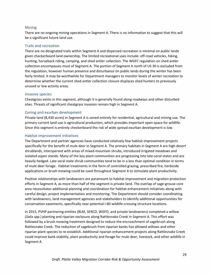
Segment A (Dana Ridge/Elk Mountain) Peak use: March 15-May 15 (spring), September 15 – December 1 (fall)
Segment A represents the northernmost portion of the Platte Valley mule deer migration corridor and
includes migration routes that extend from north of I-80 southeast approximately 20 miles to Halleck
Ridge and Elk Mountain (Fig. 3). Segment A encompasses 15,325 acres with 36.8% of the segment
containing stopover areas and 2.6% high use areas.
In early spring (March-April), many mule deer leave winter ranges north of I-80 near the North Platte
River and travel southeast across Saint Mary’s Ridge to Dana Ridge. Mule deer will spend considerable
time in a series of stopover areas north of I-80, including Saint Mary’s Hill and Dana Ridge North. These
stopover areas are characterized by high desert sagebrush basins, rolling topography, scattered juniper
ridges, and rocky outcrops. As deer head south along Dana Ridge, many will cross underneath I-80 via a
machinery underpass at milepost 244 and continue moving towards summer ranges near Halleck Ridge
and Elk Mountain. Stopover areas south of I-80 include Dana Ridge South and Halleck Ridge along
Rattlesnake Creek. Mixed-mountain shrublands, aspen stands, and forest fringe habitats on the north
slope of Elk Mountain provide key stopover areas in the southern extent of Segment A. In fall (October-
November), mule deer return to winter ranges north of I-80 using these same series of stopovers.
The land ownership pattern in this segment is entirely “checkerboard” with alternating sections of public
and private land (Table 7). The majority of the private lands are working agricultural landscapes. The mix
of land ownership may provide opportunities to collaborate with federal land managers and private
landowners to conduct larger-scale habitat treatments for the benefit of mule deer. To ensure that the
functionality of Segment A is maintained, it is imperative that the Department, land management
agencies, and private land owners continue to coordinate and communicate.
Table 7. Land ownership in Segment A.
SEGMENT A BLM USFS PRIVATE STATE WGFC OTHER TOTAL
Acres 5,757 0 8,428 1,140 0 0 15,325
Percent 37.6% 0% 55% 7.4% 0% 0% 100%
Risks and opportunities
Habitat protections
Approximately 57% of Segment A is within Hanna Sage-grouse Core Area. The southeast portion of the
segment coincides with the Department’s Terrestrial Enhancement Priority for Platte Valley mule deer
(Wyoming Game and Fish Department 2015b). This segment overlaps significantly (98.5%) with the
Department’s Terrestrial Crucial Habitat Priorities including sage-grouse core area protections and big
game crucial range protections for mule deer, elk and moose. Segment A also encompasses 2,180 acres
of private land protected under permanent conservation easements (Table 8).

26 Draft. Platte Valley Migration Corridor Risk & Opportunity Assessment
Nearly 300 acres of this segment are designated NSO by the BLM. There are no BLM identified ACECs,
SMAs, or WSAs in this segment. The majority of Segment A overlaps with the BLM’s VRM Class II or Class
III protections. Energy development on the 978 acres of BLM classified as VRM Class II would likely be
limited, however the scale of development on VRM Class III areas could be less restricted.
Table 8. Existing habitat protections in Segment A.
SEGMENT A BLM NSO CONSERVATION
EASEMENTS CRUCIAL
HABITATS SAGE-GROUSE
CORE VRM CLASS
II VRM CLASS
III
Acres 294 2,180 15,098 8,781 978 14,349
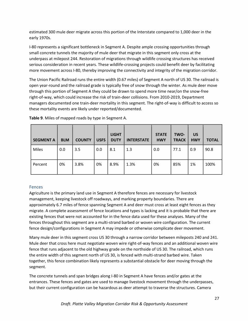
Roads Segment A contains 90.8 miles of roads (Table 9). From 2010-2019, eight mule deer mortalities
associated with vehicle collisions were recorded in Segment A. All of these mortalities were on US 30
and I-80. Due to the limitations of carcass data collection and reporting practices these mortality records
may not account for the total scope of deer-vehicle collisions.
The majority of roads in Segment A are two-track routes which provide access to undeveloped areas of
public and private land. Generally, these types of roads receive light local and recreational traffic. CR 400
(Rattlesnake Road) is a gravel road that bisects the segment. This county road receives moderate use
spring through summer. Traffic activity typically increases on CR 400 during the fall hunting seasons.
Negotiating rural county roads does not appear to be problematic for deer in this segment, however
development of rural roads for energy or residential use could threaten mule deer movements and
stopover areas.
US 30 is a paved two-lane highway that overlaps Segment A. Traffic volume on US 30 has recently
increased due to energy development projects near Hanna and Medicine Bow. This increase in traffic
could make crossing US 30 more risky for migrating mule deer. When I-80 closes due to severe weather
events, US 30 often is used as an alternative route and subsequently traffic increases. This shift in traffic
to US 30 can increase the risk to deer moving along the roadway and attempting to cross. Recently,
during weather related closures, WYDOT has closed both routes simultaneously which has moderated
these traffic pulses.
The construction of I-80 was completed in 1970 and severed the migration routes for thousands of
pronghorn and mule deer. Deer traveling in Segment A successfully cross underneath the Interstate
through a machinery underpass at milepost 244. In the 1970s, Lorin Ward studied the effects of I-80 on
deer migrations. He found that 37-60 deer-vehicle collisions occurred each year on the portion of
Interstate that intersected Dana Ridge. Ward estimated that 1,000 mule deer crossed the Interstate at
this location each spring and fall (Ward 1982). Following the construction of I-80, an eight-foot-tall game
fence was installed along this stretch of interstate in an attempt to funnel wildlife to concrete tunnels.
Ward, however, found that most of the small underpasses/tunnels were not used by deer. Today, an
27 Draft. Platte Valley Migration Corridor Risk & Opportunity Assessment
estimated 300 mule deer migrate across this portion of the Interstate compared to 1,000 deer in the
early 1970s.
I-80 represents a significant bottleneck in Segment A. Despite ample crossing opportunities through
small concrete tunnels the majority of mule deer that migrate in this segment only cross at the
underpass at milepost 244. Restoration of migrations through wildlife crossing structures has received
serious consideration in recent years. These wildlife-crossing projects could benefit deer by facilitating
more movement across I-80, thereby improving the connectivity and integrity of the migration corridor.
The Union Pacific Railroad runs the entire width (0.67 miles) of Segment A north of US 30. The railroad is
open year-round and the railroad grade is typically free of snow through the winter. As mule deer move
through this portion of Segment A they could be drawn to spend more time near/on the snow-free
right-of-way, which could increase the risk of train-deer collisions. From 2010-2019, Department
managers documented one train-deer mortality in this segment. The right-of-way is difficult to access so
these mortality events are likely under reported/documented.
Table 9. Miles of mapped roads by type in Segment A.
SEGMENT A BLM COUNTY USFS LIGHT DUTY INTERSTATE
STATE HWY
TWO-TRACK
US HWY TOTAL
Miles 0.0 3.5 0.0 8.1 1.3 0.0 77.1 0.9 90.8
Percent 0% 3.8% 0% 8.9% 1.3% 0% 85% 1% 100%
Fences Agriculture is the primary land use in Segment A therefore fences are necessary for livestock
management, keeping livestock off roadways, and marking property boundaries. There are
approximately 6.7 miles of fence spanning Segment A and deer must cross at least eight fences as they
migrate. A complete assessment of fence locations and types is lacking and it is probable that there are
existing fences that were not accounted for in the fence data used for these analyses. Many of the
fences throughout this segment are a multi-strand barbed or woven wire configuration. The current
fence design/configurations in Segment A may impede or otherwise complicate deer movement.
Many mule deer in this segment cross US 30 through a narrow corridor between mileposts 240 and 241.
Mule deer that cross here must negotiate woven wire right-of-way fences and an additional woven wire
fence that runs adjacent to the old highway grade on the northside of US 30. The railroad, which runs
the entire width of this segment north of US 30, is fenced with multi-strand barbed wire. Taken
together, this fence combination likely represents a substantial obstacle for deer moving through the
segment.
The concrete tunnels and span bridges along I-80 in Segment A have fences and/or gates at the
entrances. These fences and gates are used to manage livestock movement through the underpasses,
but their current configuration can be hazardous as deer attempt to traverse the structures. Camera
28 Draft. Platte Valley Migration Corridor Risk & Opportunity Assessment
traps at the I-80 underpasses have shown that the current design of these fences may deter some mule
deer from crossing underneath the Interstate.
Several snow fences (approximately 10) are located on the south side of I-80 between mileposts 244 and
245. As previously described, this is an important crossing area for mule deer. Snow fences may not
pose the same level of hazard to migrating deer as other fence types, however careful consideration
should be given when siting additional snow fences in these key crossing locations as they could deter or
completely prohibit mule deer from using I-80 crossing structures.
Neither the Department nor other land management agencies have converted fences to a wildlife-
friendly design in this segment. A concerted effort could be made to examine existing fence types and
convert old woven wire and hazardous fences to wildlife-friendly specifications. Several sequential fence
and roadway barriers exist in Segment A (Fig. 4). Improvements to any or all of these barriers would be
beneficial to mule deer.
Energy Development Currently, there is no coal potential described on BLM lands within Segment A and no large-scale wind
or solar developments. The potential wind and solar development given coincidence with sage-grouse
core habitat is limited, however, this segment does overlap the Executive Order 2019-3 Sage-Grouse
Final Core Transmission Corridor. This two-mile-wide corridor, which lies between Saint Mary’s Creek
and US 30, represents the State of Wyoming’s preferred alternative for routing electric transmission
lines to service existing approved energy projects in southern Wyoming.
A 500 kV transmission line (Rocky Mountain Power Energy Gateway Project-Gateway West) and ancillary
facilities are currently under construction on private and public lands in Segment A. In late 2019, three
500 kV single circuit steel lattice segment structures were built within the segment. One mile of existing
road will be used by crews to access structures during the construction and post-construction phases.
Approximately 1.4 miles of existing road improvements occurred in addition to construction of 0.3 miles
of new road. Temporary transmission line roads that coincide with this segment include 0.2 miles of
road that will be used during the construction phase (estimated completion in December 2020).
The Energy Gateway Project-Gateway South transmission line will be constructed within 300 feet of the
Gateway West transmission line. Construction crews likely will travel on access roads that were
constructed for Gateway West, which could reduce the development of additional roads in this
segment. Construction on this line will begin in 2021 and be completed in 2023. The BLM and private
landowners anticipate that the company will restore and re-vegetate disturbed areas. While mule deer
may tolerate transmission line structures once they are complete, roads and increased traffic associated
with construction could have impacts on deer movement and habitat use.
Currently, the BLM has authorized leases on 5,087 acres in Segment A, with no pending leases or
applications for permits to drill. There are three oil wells on BLM lands in Segment A, but none are
active. The BLM’s potential for oil and gas development in Segment A is mostly low. Approximately 780
acres of stopover area, in the Saint Mary’s Hill area, is classified as moderate for oil and gas potential.
Several major pipelines follow the I-80 right-of-way. In this segment, the BLM considers 313 acres BLM
lands suitable for oil and gas leasing. Currently, there is limited oil and gas development on private lands
north of I-80. The potential for future oil and gas expansion on private lands is unknown.
29 Draft. Platte Valley Migration Corridor Risk & Opportunity Assessment
Mining There are no ongoing mining operations in Segment A. There is no information to suggest that this will
be a significant future land use.
Trails and recreation There are no designated trails within Segment A and dispersed recreation is minimal on public lands
given checkerboard land ownership. The limited recreational uses include: off-road vehicles, hiking,
hunting, horseback riding, camping, and shed antler collection. The WGFC regulation on shed antler
collection encompasses most of Segment A. The portion of Segment A north of US 30 is excluded from
the regulation, however human presence and disturbance on public lands during the winter has been
fairly limited. It may be worthwhile for Department managers to monitor levels of winter recreation to
determine whether the current shed antler collection closure displaces shed hunters to previously
unused or low activity areas.
Invasive species Cheatgrass exists in this segment, although it is generally found along roadways and other disturbed
sites. Threats of significant cheatgrass invasion remain high in Segment A.
Zoning and exurban development Private land (8,430 acres) in Segment A is zoned entirely for residential, agricultural and mining use. The
primary current land use is agricultural production, which provides important open space for wildlife.
Since this segment is entirely checkerboard the risk of wide spread exurban development is low.
Habitat improvement initiatives The Department and partner agencies have conducted relatively few habitat improvement projects
specifically for the benefit of mule deer in Segment A. The primary habitats in Segment A are high desert
shrublands, interspersed with areas of mixed-mountain shrubs, introduced irrigated meadows and
isolated aspen stands. Many of the key plant communities are progressing into late-seral states and are
heavily hedged. Late-seral state shrub communities tend to be in a less than optimal condition in terms
of mule deer forage. Habitat treatments in the form of controlled grazing, prescribed fire, herbicide
applications or brush mowing could be used throughout Segment A to stimulate plant productivity.
Positive relationships with landowners are paramount to habitat improvement and migration protection
efforts in Segment A, as more than half of the segment is private land. The overlap of sage-grouse core
area necessitates additional planning and coordination for habitat enhancement initiatives along with
careful design, project implementation and monitoring. The Department should consider coordinating
with landowners, land management agencies and stakeholders to identify additional opportunities for
conservation easements, specifically near potential I-80 wildlife-crossing structure locations.
In 2015, PVHP partnering entities (BLM, SERCD, WGFD, and private landowners) completed a willow
(Salix spp.) planting and riparian exclosure along Rattlesnake Creek in Segment A. This effort was
followed by a brush mowing treatment designed to reduce the encroachment of sagebrush along
Rattlesnake Creek. The reduction of sagebrush from riparian banks has allowed willows and other
riparian plant species to re-establish. Additional riparian enhancement projects along Rattlesnake Creek
could improve bank stability, plant productivity and forage for mule deer, livestock, and other wildlife in
Segment A.

30 Draft. Platte Valley Migration Corridor Risk & Opportunity Assessment
Bottleneck I-80 represents a significant bottleneck in the migration corridor and is located in Segment A (Fig. 3).
This area, Dana Ridge (I-80 milepost 239-246), was also identified as a Wyoming Wildlife and Roadways
Initiative top priority project area. Improvement of current crossing structures in this area should be
considered to maintain the viability of mule deer migration this bottleneck. Construction of additional I-
80 wildlife-crossing structures should also be considered in this Segment.

31 Draft. Platte Valley Migration Corridor Risk & Opportunity Assessment
Figure 3. Segment A location and primary geographic features in the Platte Valley mule deer migration
corridor, including the Dana Ridge bottleneck.
32 Draft. Platte Valley Migration Corridor Risk & Opportunity Assessment
Figure 4. Important biological risks and opportunities in Segment A of the Platte Valley mule deer
migration corridor.

33 Draft. Platte Valley Migration Corridor Risk & Opportunity Assessment
Segment B (North Platte/Coad and Pennock Mountain) Peak use: April 1– June 1 (spring), October 15 – December 31 (fall)
Segment B includes migration routes that extend from the North Platte River east approximately 20
miles to Coad and Pennock Mountain (Fig. 5). This Segment D encompasses 39,749 acres with 38% of
the segment containing stopover areas and 41% high use areas. The distance mule deer travel in this
segment differs year-to-year depending on weather conditions. In years with heavy snowfall, deer
winter along the North Platte River west of WY 130. During winters with less snowfall, many deer will
only travel as far as the foothills of Elk Mountain to winter.
Segment B contains two main “arms” extending from winter range areas near the North Platte River.
The terminus of the northern arm is on Coad Mountain, while the southern arm ends at Pennock
Mountain. In the spring (April-May), many mule deer leave winter ranges near the North Platte River
west of WY 130 and travel east across Overland Flats to Dana Ridge South. They spend a substantial
amount of time in stopover areas along Dana Ridge South after which they head to stopovers on
Sheephead Mountain and then the foothills of Coad Mountain. The stopover areas along the North
Platte are characterized by hogbacks and high desert sagebrush basins while Sheephead and Coad
Mountain stopover sites consist of isolated aspen/deciduous stands, mixed-mountain shrubs, and
conifer forest edges. Other deer that travel in this segment, winter near the North Platte and migrate
southeast between Overland and Lake Creek Flats, stopping over in the mixed-mountain shrublands and
aspen stands along the foothills of Pennock Mountain before heading to higher elevation summer
ranges in the Medicine Bow Mountains. In the fall (October-December), mule deer return to winter
ranges along the foothills of Elk Mountain or the North Platte River.
Land ownership consists primarily of private land (66.4%). Land ownership west of WY 130 is
“checkerboard” with alternating sections of private and public land (Table 10). The majority of the
private lands in this segment are working ranches.
Table 10. Land ownership in Segment B.
SEGMENT B BLM USFS PRIVATE STATE WGFC OTHER TOTAL
Acres 11,316 104 26,402 1,699 0 228 39,749
Percent 28.4% 0.3% 66.4% 4.3% 0% 0.6% 100%
Risks and opportunities
Habitat protections Sixty-three percent of Segment B is within South Rawlins Sage-grouse Core Area. The eastern portion of
Segment B, including the foothills of the Medicine Bow Mountains, coincides with the Department’s
Terrestrial Enhancement Priority for Platte Valley mule deer (Wyoming Game and Fish Department
2015b). This segment also overlaps significantly (96%) with the Department’s Terrestrial Crucial Habitat
Priorities including sage-grouse core area protections and big game crucial range protections for

34 Draft. Platte Valley Migration Corridor Risk & Opportunity Assessment
pronghorn, mule deer and elk. Segment B also encompasses 565 acres of private land protected under
permanent conservation easements (Table 11).
Nearly 1,300 acres of Segment B are designated NSO by the BLM. There are no BLM ACECs, SMAs, or
WSAs in this segment. The majority of Segment B overlaps with the BLM’s VRM Class III protection
areas. The 39,151 acres classified as VRM Class III could be impacted by greater level of change on the
landscape than other VRM classified lands. VRM Class III, however, requires partial retention of the
existing landscape character, which could limit large-scale visual disturbances.
Table 11. Existing habitat protections in Segment B.
SEGMENT B BLM NSO CONSERVATION
EASEMENTS CRUCIAL
HABITATS SAGE-GROUSE
CORE VRM CLASS
II VRM CLASS
III
Acres 1,286 565 38,226 25,092 496 39,151
Roads Segment B contains 260.5 miles of roads (Table 12). From 2010-2019, six mule deer mortalities
associated with vehicle collisions were recorded in Segment B. All were on I-80 and WY 130. Due to
systematic underreporting, however, these six likely underestimate the number of deer-vehicle
collisions in the segment.
The majority of roads in Segment B are two-track routes and only receive light local and recreational
traffic. CR 400 (Rattlesnake Pass Road) bisects this segment and CR 404 (Pass Creek Road) runs along the
northern edge. These gravel roads receive moderate use spring through summer. There are typically
activity pulses during the fall hunting seasons. CR 404 and CR 406 receive light truck traffic from two
active gravel quarry operations. The county roads that deer must cross have generally low traffic
volumes and are not a significant obstacle. However, the development of these rural roads for energy or
residential use could threaten stopovers in Segment B particularly along the Rattlesnake Pass Road.
WY 130 is a paved two-lane highway that overlaps Segment B. There has been an increase in daily traffic
activity on WY 130 due to energy company trucks traveling from Colorado to Sinclair. Increasing traffic
volume could pose the potential for the highway to become a larger barrier to mule deer movements.
Each spring and fall, we set up Dynamic Message Signs along WY 130 to warn motorists of wildlife on the
roadway. This strategy seems to affect driver vigilance and reduce wildlife-vehicle collisions.
Collar data indicate that deer move along the hogbacks south of I-80, but do not cross. From 2010-2019,
however, there were several mule deer mortalities on I-80 in Segment B, indicating that deer attempted
to cross the Interstate. As mule deer move towards I-80 in this segment, they encounter woven-wire
right-of-way fences on either side of the Interstate. Little is known about mule deer movement in this
area before the Interstate construction, however I-80 could now be an impermeable barrier to
migration.
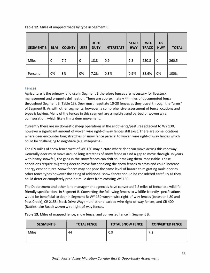
35 Draft. Platte Valley Migration Corridor Risk & Opportunity Assessment
Table 12. Miles of mapped roads by type in Segment B.
SEGMENT B BLM COUNTY USFS LIGHT DUTY INTERSTATE
STATE HWY
TWO-TRACK
US HWY TOTAL
Miles 0 7.7 0 18.8 0.9 2.3 230.8 0 260.5
Percent 0% 3% 0% 7.2% 0.3% 0.9% 88.6% 0% 100%
Fences Agriculture is the primary land use in Segment B therefore fences are necessary for livestock
management and property delineation. There are approximately 44 miles of documented fence
throughout Segment B (Table 13). Deer must negotiate 10-20 fences as they travel through the “arms”
of Segment B. As with other segments, however, a comprehensive assessment of fence locations and
types is lacking. Many of the fences in this segment are a multi-strand barbed or woven wire
configuration, which likely limits deer movement.
Currently there are no domestic sheep operations in the allotments/pastures adjacent to WY 130,
however a significant amount of woven wire right-of-way fences still exist. There are some locations
where deer encounter long stretches of snow fence parallel to woven wire right-of-way fences which
could be challenging to negotiate (e.g. milepost 4).
The 0.9 miles of snow fence west of WY 130 may dictate where deer can move across this roadway.
Generally deer must move around long stretches of snow fence or find a gap to move through. In years
with heavy snowfall, the gaps in the snow fences can drift shut making them impassable. These
conditions require migrating deer to move further along the snow fences to cross and could increase
energy expenditures. Snow fences may not pose the same level of hazard to migrating mule deer as
other fence types however the siting of additional snow fences should be considered carefully as they
could deter or completely prohibit mule deer from crossing WY 130.
The Department and other land management agencies have converted 7.2 miles of fence to a wildlife-
friendly specifications in Segment B. Converting the following fences to wildlife-friendly specifications
would be beneficial to deer in Segment B: WY 130 woven wire right-of-way fences (between I-80 and
Pass Creek), CR 215S (Stock Drive Way) multi-strand barbed wire right-of-way fences, and CR 400
(Rattlesnake Road) woven wire right-of-way fences.
Table 13. Miles of mapped fence, snow fence, and converted fence in Segment B.
SEGMENT B TOTAL FENCE TOTAL SNOW FENCE CONVERTED FENCE
Miles 44 0.9 7.2

36 Draft. Platte Valley Migration Corridor Risk & Opportunity Assessment
Energy Development The Overland Field, located in Overland Flats, is the largest oil and gas development in the Platte Valley
mule deer migration corridor. There are 14 wells located in Segment B with additional development in
close proximity (Fig. 6). These 14 wells include two idle oil wells, two plugged and abandoned gas wells,
eight plugged and abandoned oil wells, and two unknown wells. One pipeline mirrors CR 400 and several
others follow the I-80 corridor.
A company filed two Applications for Permit to Drill in 2003 and leased BLM land (T20N R83W Section
30) in 2004. The proposed well locations are in an extremely narrow portion of Segment B west of
Sheephead Mountain. The BLM lease was subsequently terminated in 2015, due to a violation of wildlife
stipulations. WOGCC currently classifies both wells as “Active Permits” but there have been no
production status updates since November of 2015. It is likely that the development of these areas is
deferred indefinitely.
Currently, the BLM has authorized leases on 8,882 acres in Segment B, with no pending leases or
applications for permits to drill. The BLM’s potential for oil and gas development is generally low and all
BLM lands in this segment are classified as having no coal potential.
The potential for wind and solar development is low given the coincidence with sage-grouse core
habitat. However, extensive wind energy development will be occurring on the edges of this segment in
the Chokecherry Sierra Madre Project Area. The impacts of wind development on deer and their
habitats are largely unknown. Ongoing mule deer research within the Chokecherry and Sierra Madre
Wind Energy Project Area should show us if any pronounced shifts in deer distribution, movement, or
habitat use occurs during the construction and post-construction phases.
Mining There are two active gravel quarries operated off of Pass Creek Road, north of this segment. These
quarries are both relatively small and the impacts to migrating deer are likely low as deer typically move
quickly through this area during migration. There are no other mining activities within Segment B and
there is no information to suggest that mining will be a substantial future use.
Trails and recreation There are no designated trails within Segment B and dispersed recreation is minimal given the land
ownership pattern. The limited recreational uses include: off-road vehicles, hiking, hunting, horseback
riding, camping, and shed antler collection. The WGFC regulation on shed antler collection encompasses
the entirety of Segment B and should provide important protections for wintering and migrating mule
deer.
Invasive species Cheatgrass exists in this segment, although it is generally found along roadways. Threats of significant
cheatgrass invasion remain high in Segment B.
Zoning and exurban development The majority of private lands in Segment B are zoned for residential, agricultural, and mining use. The
primary land use is agricultural production so these lands remain open, providing important space for
migrating deer. There are 55 acres in this segment, near Oberg Creek, that are zoned residential single
family. This is a small subdivision called Cherokee Trails and the activity around these homes and cabins

37 Draft. Platte Valley Migration Corridor Risk & Opportunity Assessment
is typically seasonal (summer-fall). The subdivision overlaps stopover area. Expansion of this
development or similar developments could present a risk to key habitats. Since a large portion of this
segment is checkerboard the risk of wide spread exurban development is low.
Habitat improvement initiatives The Department and partner agencies (BLM, SERCD, and private landowners) have conducted several
habitat improvement projects for the benefit of mule deer in Segment B. Like other segments in the
corridor, many of the shrub communities in Segment B are progressing into late-seral states and are
heavily hedged. Prescribed burns in the Sheephead Mountain area were used to reintroduce
disturbance into these systems and enhance shrub communities. Additional habitat treatments that
mimic natural disturbances should be considered throughout Segment B. These habitat treatments
could include brush mowing and prescribed fire.
The aspen stands throughout Segment B provide high quality forage and cover for mule deer. Habitat
treatments, such as mechanical harvest of encroaching conifers, should be considered to improve the
health of these stands. To prevent excessive herbivory from impeding the successful establishment of
aspen sprouts in these stands, managers should consider using fencing or other techniques to limit
ungulate browsing on aspen sprouts.

38 Draft. Platte Valley Migration Corridor Risk & Opportunity Assessment
Figure 5. Segment B location and primary geographic features in the Platte Valley mule deer migration
corridor.

39 Draft. Platte Valley Migration Corridor Risk & Opportunity Assessment
Figure 6. Important biological risks and opportunities in Segment B of the Platte Valley mule deer
migration corridor.

40 Draft. Platte Valley Migration Corridor Risk & Opportunity Assessment
Segment C (Cedar Hills) Peak use: April 15 –June 1 (spring), October 15 – December 1 (fall)
Segment C is a medium and high-use portion of the corridor that extends from Cedar Ridge east of WY
130 northeast to Cedar and Savage creeks near the base of Kennaday peak (Fig. 7). The northeast
terminus of this segment is within 0.5 miles of the Medicine Bow National Forest. Animals use this area
during winter, and as stopover habitat before moving south towards Baggot Rocks as winter progresses.
Eighty-three percent of the segment includes either stopover (75%) or high-use (8%) habitat. Animals
move through the area on open ridges that offer good visibility and access to standing forage. This
portion of the corridor provides critical connectivity between seasonal ranges and important
opportunities for energy intake during migration. Access to forage is especially crucial in spring when
animals leave winter range in an energy deficit.
Segment C includes a matrix of public (44%) and private (55%) lands. Agency ownership includes BLM,
USFS and State of Wyoming, with the majority of public land in the southwest 1/3 of the segment (Fig. 8;
Table 14). Habitat types in the segment that are important to mule deer primarily include sagebrush,
juniper woodland and irrigated agricultural fields.
Table 14. Land ownership in Segment C.
SEGMENT C BLM USFS PRIVATE STATE WGFC OTHER TOTAL
Acres 1434.6 312.1 3006.6 651.9 0 2.8 5408.1
Percent 26.53% 5.77% 55.59% 12.05% 0% 0.06% 100%
Risks and opportunities
Habitat protections The majority of the segment (92%) lies within the South Rawlins sage grouse core area. The entirety of
the segment also coincides with the Department’s Terrestrial Crucial Habitat Priorities (Wyoming Game
and Fish Department 2015b), including big game crucial ranges for mule deer, antelope and elk. Big
game crucial ranges carry the Department recommendation that human activity related to development
on public land be avoided from Nov 15 –April 30. None of the 5,408 acres in Segment C are protected
under conservation easements.
Roads Two County Roads (CR 209 and CR 504) bisect Segment C (Table 15). Except for a short asphalt section
east of Saratoga, both are gravel and receive moderate use. No state highways or other roadways with
notable traffic volume overlap the segment. Two-track routes and light-duty roads facilitate access to
undeveloped areas of public land, especially in the southwest portion of the segment. ORV use along
these roads is relatively high prior to Thanksgiving as hunters look for elk. Activity, however, drops
substantially in late November and is relatively low during winter and early spring when deer are likely
to be most affected. Additional two-track or light duty road development in the southwest portion of

41 Draft. Platte Valley Migration Corridor Risk & Opportunity Assessment
the segment should be considered carefully, given the density of deer that use the habitat and its
geographic importance to the herd.
Table 15. Miles of mapped roads by type in Segment C.
SEGMENT C BLM COUNTY USFS LIGHT DUTY INTERSTATE
STATE HWY
ROUGH / TWO-TRACK
US HWY TOTAL
Miles 1 2 0 2 0 0 18 0 23
Percent 4.3% 8.7% 0% 8.7% 0% 0% 78.3% 0% 100%
Fences Given that agriculture is the predominant land use in Segment C, fences that delineate boundaries and
help to manage livestock are common. These fences primarily comprise multi-strand barbed wire
constructions made from wood and wire, though a comprehensive assessment of fence locations and
types in Segment C is lacking (Table 16). A very small portion of the Department’s Pennock Wildlife
Habitat Management Area boundary fence coincides with the northeast portion of the segment. Efforts
to improve the permeability of the fence could help to facilitate big game movement. Neither the
Department nor other public land-management agencies have converted fences to a wildlife friendly
design in this segment.
Table 16. Miles of existing fence mapped in Segment C.
SEGMENT C TOTAL FENCE PENNOCK FENCE CONVERTED FENCE
Miles 11.42 0.05 0
Energy development The potential for energy development, given current technologies, is relatively low in Segment C.
Currently there are no authorized or pending oil and gas leases and no existing wells. The BLM classifies
the potential for additional oil and gas development in the area as low. Similar to other segments in the
corridor, there is no potential for coal development on BLM-owned land. Opportunities for wind and
solar development also may be limited, given the segment’s coincidence with sage grouse core habitat.
Currently there are no large-scale wind or solar developments planned for the area.
Mining There are no ongoing, large-scale mining operations in the segment, with nothing to suggest that this
will be a substantial future use.

42 Draft. Platte Valley Migration Corridor Risk & Opportunity Assessment
Trails and recreation There are no designated trails within the segment, though dispersed recreation is common on public
lands (Fig. 8). This includes ORV use, hiking, hunting, horseback riding, camping and shed antler
collection (starting May 1). Limiting disturbance during winter and early spring may help mule deer in
this area to retain energy reserves essential to individual survival and reproduction. While dispersed
recreation offers an important way for people to enjoy the landscape, substantial off-trail use increases
the risk of invasive weed spread and creates “social” trails which can degrade habitat. Given the
importance of the public land in the southwest 1/3 of the segment and the role that it plays in mule
deer overwinter survival, further trail development in this area (designated or user-created) should be
evaluated carefully.
Invasive species Substantial opportunity exists to treat an ongoing cheatgrass invasion on BLM land in the southwest
portion of the segment (Fig. 9). Following best practice, a treatment program would likely include an
initial chemical application, followed by a full growing season of livestock deferment to allow perennial
plants to recover. Two years of effective control are typical following treatment. Control varies in years 3
and 4 and largely depends on the response of native grasses and forbs in the first two years. Hence, a
follow-up application will be necessary to achieve desired results.
Zoning and exurban development Private land in Segment C is zoned entirely for residential, agricultural and mining use, with ranching as
the predominant current use. Current zoning allows for a base residential density of 1 housing unit per
35 acres (Carbon County Board of Commissioners 2015.). Existing ranch land in the segment provides
extensive open space and intact habitat. Fragmentation associated with rural subdivision, including
fences, infrastructure, access roads, traffic and domestic pets, could compromise habitat integrity for
migrating deer, and should be considered carefully.
Habitat improvement initiatives The Department and partner agencies have conducted relatively few habitat improvement projects
specifically for the benefit of mule deer in Segment C. The open space maintained by private landowners
for agricultural operations, combined with a number of irrigated fields and wet areas, offers productive,
intact habitat for deer. Additional treatment opportunities include invasive weed treatment on public
land adjacent to CR 209, along with targeted juniper removal in that same area. Selective removals
should focus on places with deeper soils, especially in draws where juniper encroachment can
substantially alter hydrology. As with any juniper treatment, older age class trees present on these
sections should be retained for thermal and hiding cover. When possible, as fences are replaced, or new
fences are built, agencies and landowners should consider wildlife friendly designs. Finally, existing
sagebrush and mountain shrub communities throughout the segment could benefit from mechanical
treatments to diversify age class, increase the prevalence of forbs in the understory and improve
nutritive quality. The overlap between Segment C and sage grouse core area necessitates additional
planning and coordination for habitat enhancement initiatives such as these, along with careful design,
project implementation and monitoring.

43 Draft. Platte Valley Migration Corridor Risk & Opportunity Assessment
Figure 7. Segment C location and primary geographic features in the Platte Valley mule deer migration
corridor.

44 Draft. Platte Valley Migration Corridor Risk & Opportunity Assessment
Figure 8. Fire ring at a dispersed campsite on BLM land, immediately adjacent to ridges commonly used
by migrating mule deer in the Platte Valley herd.
Figure 9. Evidence of a widespread cheatgrass invasion along cedar-encroached ridges in the southwest
portion of Segment C.

45 Draft. Platte Valley Migration Corridor Risk & Opportunity Assessment
Segment D (Beaver Hills/Baggott Rocks) Peak use: March 15 –June 15 (spring), October 1 –December 1 (fall)
Segment D is the largest segment of the Platte Valley Migration corridor at approximately 52,572 acres
making up almost 42% of the entire designated corridor. This segment includes migration routes
extending from Colorado north to crucial winter range in the Beaver Hills and Baggott Rocks. Many of
the mule deer that travel this segment move north from summer ranges in Colorado to winter in
Wyoming in the fall, returning to southern summer ranges in the spring. Almost half (47%) of Segment D
consists of important stopover (37%) and high-use areas (10%). The portion of the segment used by the
most deer (high-use areas) are located between the Big Creek/Prospect areas to just North of Prospect
peak, the area between Sixmile and Stovepipe Gulch, and the area north of Big Creek on the east slope
of the Sierra Madres (Fig. 11). Much of this segment is in mixed mountain shrub habitat and forest fringe
aspen communities covering a variety of land ownerships.
The mix of land ownerships within Segment D (Table 17) provides different opportunities to work with
federal and state land managers and private landowners to implement habitat treatments for the
benefit of mule deer. These different ownerships and managements have a variety of protections and
potential risks to mule deer movements along this segment. Almost half of this segment is on federally
owned land, especially in the higher elevations in the southern extent of the segment. As deer reach
winter range in the Valley and lower elevation in the northern part of the segment, private land
ownership predominates.
Table 17. Land ownership by acre and percent for Segment D.
Segment D BLM USFS PRIVATE STATE WGFC OTHER TOTAL
Acres 16,123 10,089 23,506 2,713 0 141 52,572
Percent 30.7% 19.2% 44.7% 5.1% 0% 0.3% 100%
Risks and opportunities
Habitat protections Sixty-two percent of Segment D lies within the South Rawlins sage grouse core area while 89% of the
segment overlaps the Department’s Terrestrial Crucial Habitat Priorities (SHP 2015). Segment D contains
most of the Prospect Mountain BLM Wilderness Study Area and skirts the edge of both the USFS Savage
Run and Platte River Wilderness areas (1,605 acres). Additionally, there are BLM NSO stipulations for big
game parturition areas, sage grouse leks, raptor nests, and recreation sites. Approximately two thirds of
the southern portion of the segment is within VRM Class II protections that would likely limit extensive
energy development (wind, solar, oil and gas) on BLM property. Impressively, 6,463 acres of private land
are enrolled in Conservation easements within this portion of the migration corridor.
Roads Segment D contains 280 miles of roads (Table 18). These roads range in size and traffic loads from rough
two-tracks to state highways. Most of the roads have traditionally received light local and recreational

46 Draft. Platte Valley Migration Corridor Risk & Opportunity Assessment
traffic. However, as population grows in the Valley and surrounding areas, traffic volume is likely to
increase. WY 230 is a major travel route that is already experiencing increased traffic due to energy
development in Colorado. The Wyoming Wildlife and Roadways Initiative, a collaborative effort to
improve public safety and reduce the effects of roads on wildlife, identified WY 230 between mileposts
112-118 as a priority project area. The Many of the USFS and BLM roads within this Segment D
experience heavy hunting traffic in the fall as well as recreational ORV use associated with both fall
hunting and spring antler gathering.
Table 18. Miles of mapped roads by type in Segment D.
Segment D BLM COUNTY USFS LIGHT DUTY INTERSTATE
STATE HWY
TWO-TRACK
US HWY TOTAL
Miles 8 7 2 15 0 3 245 0 280
Percent 2.9% 2.5% 0.7% 5.4% 0% 1.0% 87.5% 0% 100%
Fences Given the agricultural nature of much of the private and federal ownership in the southern portion of
the Platte Valley, there are many fences within Segment D (Table 19) that are used to maintain grazing
pastures/rotations and keep livestock off of roadways. As new fences are built, wildlife friendly designs
are becoming more common. Between the Department, BLM, SERCD, and USFS a concerted effort has
been made to convert old sheep fences and hazardous fences to wildlife friendly design. There are very
few snow fences currently in Segment D (0.2 miles), however WYDOT may install more in the future to
mitigate snow drifting across highway 230. WYDOT, likely would consult with the Department about
construction design. Siting of additional fences should be considered carefully to avoid complicating
deer movements.
Table 19. Miles of mapped fence and converted fence in Segment D.
Segment D TOTAL FENCE CONVERTED FENCE
Miles 81.35 16.45
Energy Development The southern Platte Valley has relatively little energy development or potential for future development.
There are currently no wind turbines or commercial scale wind energy projects within Segment D and,
considering the acreages of VRM protections in the corridor, there is not likely to be much wind or solar
development on BLM land. There are currently no authorized or pending oil and gas leases. Additionally,
there are no oil and gas or coalbed natural gas wells present. The majority of Segment D (31,910 acres)
is classified as low potential for oil and gas development. Currently, there are no large transmission lines
identified.

47 Draft. Platte Valley Migration Corridor Risk & Opportunity Assessment
Mining There are no coal related mining activities in this portion of the migration corridor. Mining activities are
limited to gravel mining and older mining claims on the forest.
Trails and Recreation Approximately half of the acreage within this corridor segment is public land, and as such, there is a
significant amount of pedestrian, equestrian and ORV recreation that occurs both within and around
Segment D (Table 20). Deer hunting in this area is extremely popular. In 2013 the Department
introduced a limited quota system, in part to reduce hunter crowding. This reduced traffic during deer
season; however, the area remains popular among those hunting for other species, and among outdoor
recreationists. In the past, shed antler hunting has brought an influx of people to this segment in late
winter and early spring. However, the entirety of Segment D is included in the newly expanded shed
antler regulation that prohibits antler collection on public land from January 1 to May 1, which will shift
the timing of recreational uses associated with shed hunting (ORV use, hiking, domestic dog traffic, etc.)
later into the spring.
Recreation associated with Platte River access (fishing, floating, dispersed and established campsites)
and the wilderness areas (hiking, horseback riding, and dispersed camping) also contribute to the high
levels of traffic in the area as well. Although mountain bike activity is currently relatively light in this
area, this type of recreation is increasing along the Front Range and throughout Wyoming. Mountain
bike and E-bike traffic is likely to increase outside of wilderness areas within this segment.
Table 20. Miles of mapped recreational trail within Segment D.
Segment D PEDESTRIAN TRAILS HORSE TRAILS TWO-TRACK/ORV
Miles 0.16 0.55 246
Invasive Species Although a more thorough invasive species inventory is needed for the Platte Valley, it is clear that
invasive species substantially affect mule deer migration habitats, especially within Segment D. Over the
past five years the Department, stakeholders, and conservation partners have treated approximately
3,000 acres of cheatgrass within this segment with additional acres treated in adjacent areas. Cheatgrass
impact niche models indicate that the area in and around Segment D has a high probability of dominant
cheatgrass occurrence (over 50% cover). Leafy spurge has affected the North Platte River riparian area
within Segment D and has had major impacts to the riparian vegetative communities where these
infestations occur. Other invasive plant species are present within this segment. A more thorough
inventory is needed to better quantify infestations and appropriate treatment options.
Zoning and exurban development The majority of private land within Segment D is zoned for residential, agricultural, and mining use
(Table 21). Provided these areas stay zoned as RAM, residential building should be limited to 1 housing
unit per 35 acres. However, concerns have arisen over the use of retroactive conditional use permitting
in the area to circumvent current zoning regulations. At the base of the Sierra Madres a relatively small
48 Draft. Platte Valley Migration Corridor Risk & Opportunity Assessment
number of acres are zoned as rural residential agriculture and residential single family. These zoning
designations allow for greater exurban development. We recommend that this zoning district remain
limited within the corridor.
Table 21. Private land zoning within Segment D.
Segment D RAM1 RD2 RRA3 FPSR4 TOTAL
Acres 23,508 35 67 0 23,610
Percent 99.6% 0.1% 0.3% 0% 100%
1RAM: Residential, Agricultural, and Mining 2RD: Residential 3RRA: Rural Residential Agriculture 4FPSR: Forestry Production and Seasonal Recreation
Habitat improvement initiatives The Department, along with collaborating agencies (BLM, USFS, SERCD, CCWP, Wyoming State Forestry,
and private landowners), has focused significant habitat efforts (Fig. 12; Table 22) in and around
Segment D as it has been a well-known high-use area for deer for some time. These collaborative
habitat projects have more recently been coordinated under the PVMDI and PVHP efforts and now
receive priority within the designated migration corridor. Mixed mountain shrub, sagebrush, and aspen
communities within this segment are trending toward older age classes due to a lack of natural
disturbance, such as fire. As such, habitat treatments simulate natural disturbance through methods like
mechanical shrub treatments, prescribed fire, juniper thinning and aspen enhancements. Cheatgrass
presence within the segment is substantial. Coordinated cross-boundary treatments have been
implemented to mitigate spread in this area. Additional large-scale, multi-jurisdiction habitat
improvement efforts likely will continue through approval of the USFS LaVA project.
Impacts of wildfire have affected the western reaches of this segment in the past few years with nearly
6,000 acres of Segment D burned by the Beaver Creek (2016) and Ryan (2018) fires on the East slope of
the Sierra Madres. The Mullen Fire (2020), ongoing at the time of writing, likely will also have a
substantial influence on habitat quality and availability in Segment D. These fires were large in scale and
some areas burned severely. For the most part, the fires have diversified forest communities and age
classes, increased herbaceous forage quantity and quality, and stimulated aspen growth. Taken together
the fires provided overall benefit to the mule deer habitat. However, this kind of disturbance also can
bring invasive species, especially cheatgrass. These areas remain closely monitored by the USFS, the
BLM, CCWP, and the Department and have been aerially treated with herbicide post-burn to mitigate
cheatgrass spread.

49 Draft. Platte Valley Migration Corridor Risk & Opportunity Assessment
Table 22. Habitat treatments in Segment D.
Segment D ASPEN
TREATMENTS INVASIVES JUNIPER
REMOVAL SHRUB
TREATMENTS RX BURN WILDFIRE
Acres 15.9 2,928 543.4 65.7 1,329 5,994
Bottlenecks We evaluated three areas in Segment D as potential bottlenecks. At this time, however, field managers
do not believe that animals are either geographically or behaviorally restricted in a way that meets the
criteria for a bottleneck. Areas under consideration included two cross-valley portions of the corridor
that extend from the east slope of the Sierra Madres to the foothills of the Snowies (Fig. 10). Deer
making these movements cross a variety of landownerships (especially in the southern section) and
navigate the increasingly busy Highway 230. Both road crossing locations are identified as priority points
in the Wyoming Wildlife and Roadways Initiative. Much of the private land within these cross-valley
portions are zoned as RAM, which helps maintain open space and forage resources associated with the
intact ranches. However, if zoning is either changed or circumvented through conditional use permits in
these areas the potential for expanded exurban development could affect these cross-valley
movements. Additionally, increased traffic on Highway 230, associated ROW fencing, and additional
snow fences could create barriers as well.
We also evaluated the slender piece of the segment along the North Platte River between the Beaver
Hills area and Baggott Rocks as a potential bottleneck, based on the BBMM output. Years of field
observations, however, suggest that the current corridor footprint does not necessarily reflect the entire
area used by mule deer.
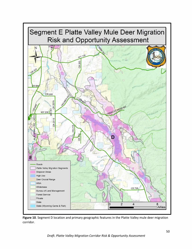
50 Draft. Platte Valley Migration Corridor Risk & Opportunity Assessment
Figure 10. Segment D location and primary geographic features in the Platte Valley mule deer migration
corridor.
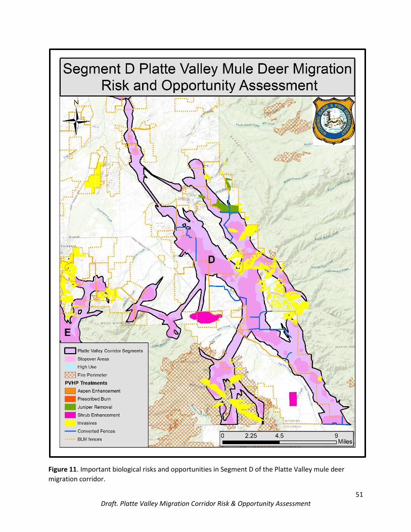
51 Draft. Platte Valley Migration Corridor Risk & Opportunity Assessment
Figure 11. Important biological risks and opportunities in Segment D of the Platte Valley mule deer
migration corridor.
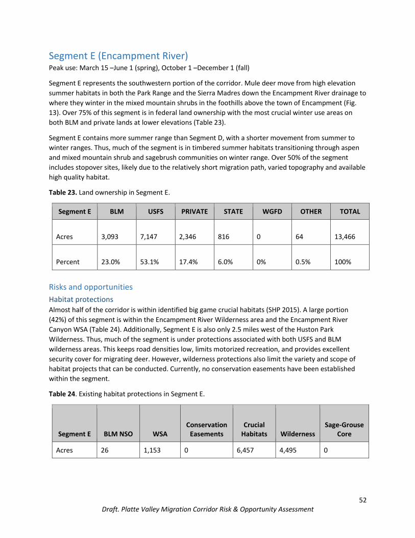
52 Draft. Platte Valley Migration Corridor Risk & Opportunity Assessment
Segment E (Encampment River) Peak use: March 15 –June 1 (spring), October 1 –December 1 (fall)
Segment E represents the southwestern portion of the corridor. Mule deer move from high elevation
summer habitats in both the Park Range and the Sierra Madres down the Encampment River drainage to
where they winter in the mixed mountain shrubs in the foothills above the town of Encampment (Fig.
13). Over 75% of this segment is in federal land ownership with the most crucial winter use areas on
both BLM and private lands at lower elevations (Table 23).
Segment E contains more summer range than Segment D, with a shorter movement from summer to
winter ranges. Thus, much of the segment is in timbered summer habitats transitioning through aspen
and mixed mountain shrub and sagebrush communities on winter range. Over 50% of the segment
includes stopover sites, likely due to the relatively short migration path, varied topography and available
high quality habitat.
Table 23. Land ownership in Segment E.
Segment E BLM USFS PRIVATE STATE WGFD OTHER TOTAL
Acres 3,093 7,147 2,346 816 0 64 13,466
Percent 23.0% 53.1% 17.4% 6.0% 0% 0.5% 100%
Risks and opportunities
Habitat protections Almost half of the corridor is within identified big game crucial habitats (SHP 2015). A large portion
(42%) of this segment is within the Encampment River Wilderness area and the Encampment River
Canyon WSA (Table 24). Additionally, Segment E is also only 2.5 miles west of the Huston Park
Wilderness. Thus, much of the segment is under protections associated with both USFS and BLM
wilderness areas. This keeps road densities low, limits motorized recreation, and provides excellent
security cover for migrating deer. However, wilderness protections also limit the variety and scope of
habitat projects that can be conducted. Currently, no conservation easements have been established
within the segment.
Table 24. Existing habitat protections in Segment E.
Segment E BLM NSO WSA Conservation
Easements Crucial
Habitats Wilderness Sage-Grouse
Core
Acres 26 1,153 0 6,457 4,495 0

53 Draft. Platte Valley Migration Corridor Risk & Opportunity Assessment
Roads Road densities in Segment E are relatively low, likely due to the amount of wilderness and WSA
designations in this area (Table 25). The most abundant road types are two-tracks, which see substantial
use from vehicles, ORVs, pedestrians, horseback riders and mountain bikers. Both county road 353
(Finley Hill Rd.) and 211 (Blackhall Rd.) are seeing increased traffic associated with fishing, floating, and
camping on the Encampment River.
Table 25. Miles of mapped roads by type in Segment E.
Segment E BLM COUNTY USFS LIGHT DUTY INTERSTATE
STATE HWY
TWO TRACK
US HWY TOTAL
Miles 0 4 1 4 0 1 36 0 46
Percent 0% 8.7% 2.2% 8.7% 0% 2.2% 78.2% 0% 100%
Fences Segment E contains cattle grazing allotments on federal land, and the majority of private land is in
ranching operations. Fences are important to maintain proper grazing management and to keep
livestock off roadways. Historically, there was quite a bit of domestic sheep grazing in the Sierra Madres,
with many miles of woven wire sheep fence (Table 26). As new fences are built, we encourage wildlife
friendly designs.
Table 26. Miles of mapped fence and converted fence in Segment E.
Segment E Total Fence* Converted Fence
Miles 12 0
*Fence mileage likely is underreported.
Energy Development Similar to Segment D, the southern Platte Valley has relatively little energy development or potential for
future development. Due to the wilderness protections in this segment, it is unlikely that energy
development of any type will impact the corridor directly. There are currently no authorized or pending
oil and gas leases within the segment. Additionally, there are no oil and gas or coalbed natural gas wells
present. The majority of Segment E (4,878 acres) is classified as low potential for oil and gas
development. Currently, there are no large transmission lines identified in this area.
Mining There are no coal related mining activities in this portion of the migration corridor. Mining activities are
limited to gravel mining within state land in the northwest arm of the segment and older mining claims
on the forest. There is recent interest in developing a Limited Mining Operation (15 acres) on State land

54 Draft. Platte Valley Migration Corridor Risk & Opportunity Assessment
within stopover habitat in this segment of the corridor. The Department has worked with the project
proponent and State lands to minimize the potential impacts of this mining development, consistent
with EO 2020-1.
Trails and Recreation Segment E contains portions of the Encampment River Trail, which begins on BLM, continues south into
the USFS Encampment River Wilderness, through to the Hog Park area and into Colorado. The trail sees
a significant amount of recreational use from anglers, hikers, horseback riders and mountain bikers
especially near the trailhead associated with the BLM Odd Fellows Camping area. Recreational use
tapers off farther into the wilderness, mostly due to downed trees on the trail. Both wilderness and non-
wilderness areas are used heavily during hunting season with associated traffic increases in the fall. The
area is also a popular destination for spring bear and lion hunters, as well as other outdoor enthusiasts.
The development of a ski resort on Green Mountain has occurred 5 miles west of this segment, which
combined with likely future developments and recreational opportunities associated with the resort
could potentially have impacts on migrating deer.
Invasive Species Cheatgrass is a significant problem at the lower elevations of this migration segment. Coordinated
efforts between partnering agencies have ensured large-scale cheatgrass treatments on BLM and USFS
fringes to moderate cheatgrass infestations within and adjacent to the segment. The BLM and CCWP
have treated 830 acres of cheatgrass within the segment as well as 118 acres of other invasive species
on USFS property boundary. This segment is also within an identified area showing a high probability of
dominant cheatgrass occurrence (Noseworthy et al. 2015).
Zoning and exurban development Segment E only contains 17.4% private land, but of that private land 99.3% is zoned for residential,
agricultural, and mining use (Table 27). As mentioned previously, however, a ski resort was recently
developed less than 5 miles west of the corridor on Green Mountain. This may indicate an ability to
change zoning quickly in the area to accommodate desired developments. Additionally, this kind of
recreational change may exacerbate development pressures in the area. Given the substantive effects
that commercial and residential developments can have on habitat integrity, changes to zoning come
under careful consideration.
Table 27. Private land zoning in Segment E.
Segment E RAM1 RD2 RRA3 FPSR4 TOTAL
Acres 2,356 8.3 0 7 2,371
Percent 99.3% 0.4% 0% 0.3% 100%
1RAM: Residential, Agricultural, and Mining 2RD: Residential 3RRA: Rural Residential Agriculture 4FPSR: Forestry Production and Seasonal Recreation

55 Draft. Platte Valley Migration Corridor Risk & Opportunity Assessment
Habitat improvement initiatives Most of the habitat improvements completed in this segment over the past several years have
addressed invasive weeds. This is, in part, due to the large amount of wilderness that precludes some
habitat improvement activities. Based on recent habitat assessments, the mixed mountain shrub,
sagebrush and aspen communities are trending toward older age classes due to a lack of natural
disturbance. However, this segment likely will be part of additional large-scale, cross-boundary habitat
treatment efforts with the approval of the USFS LaVA project at the Forest fringe outside of wilderness
particularly around Purgatory Gulch and Wood Mountain.
Bottleneck The majority of Segment E is within a topographical bottleneck contained within the Encampment River
Canyon. Steep slopes that border the river naturally funnel animals into a 1-2 mi wide expanse that
extends along the river corridor. The river and associated habitat is clearly of great importance to this
segment of the migration given the high proportion of area identified as stopover and its proximity to
winter range. Much of the Encampment River Canyon bottleneck overlaps the Encampment River
Wilderness and is protected from development. However, recent increases in recreation could
potentially impact mule deer use and movement. Additionally, Wilderness Study Areas came under
evaluation for reduced protections over the past few years. The potential for relaxing wilderness
regulations could negatively affect this segment.

56 Draft. Platte Valley Migration Corridor Risk & Opportunity Assessment
Figure 12. Segment E location and primary geographic features in the Platte Valley mule deer migration
corridor, including the Encampment River Canyon bottleneck.

57 Draft. Platte Valley Migration Corridor Risk & Opportunity Assessment
Conclusions Migration is a means to survive in places that are otherwise unsuitable for life year-round. The Platte
Valley mule deer migration corridor represents a critical pathway for more than 5,000 mule deer to
move between seasonal ranges. Diverse stakeholders, including federal and state agencies, local
governments, landowners and the public, have worked tirelessly together to identify, designate and
improve the corridor. This Biological Risk and Opportunity Assessment is intended to help inform
continued conservation.
Literature Cited Bradley, B. A., M. Oppenheimer, and D. S. Wilcove. 2009. Climate change and plant invasions:
restoration and opportunities ahead? Global Change Biology 15:1511-1521. Bolger, D. T., W. D. Newmark, T. A. Morrison, and D. F. Doak. 2008. The need for integrative approaches
to understand and conserve migratory ungulates. Ecology Letters 11:63-77. Bowker, J. M., A. E. Askew, H. K. Cordell, C. J. Betz, S. J. Zarnoch, and L. Seymour. 2012. Outdoor
recreation participation in the United States – projections to 2060. U.S. Forest Service Gen. Tech. Rep. SRS-GTR-160, Asheville, NC, USA.
Brown, D. G., K. M. Johnson, T. R. Loveland and D. M. Theobald. 2005. Rural land-use trends in the conterminous United States, 1950-2000. Ecological Applications 15:1851–1863.
Burkholder, E. N., A. F. Jakes, P. F. Jones, M. Hebblewhite, and C. J. Bishop. 2018. To jump or not to jump: Mule deer and white-tailed deer fence crossing decisions. Wildlife Society Bulletin 42:420-429.
Caldwell, M. R. and J. M. K. Klip. 2020. Wildlife interactions with highway underpasses. Journal of Wildlife Management 84:227-236.
Carbon County Board of Commissioners. 2012. Carbon County Comprehensive Land Use Plan. Carbon County, Rawlins.
Carbon County Board of Commissioners. 2015. Carbon County zoning resolution of 2015. Carbon County, Rawlins.
Cassirer, E. F., D. J. Freddy, and E. D. Ables. 1992. Elk responses to disturbance by cross-country skiers in Yellowstone National Park. Wildlife Society Bulletin 20:375-381.
Coe, P. K., R. M. Nielson, D. H. Jackson, J. B. Cupples, N. E. Seidel, B. K. Johnson, S. C. Gregory, G. A. Bjornstrom, A. N. Larkins, and D. A. Speten. 2015. Identifying migration corridors of mule deer threatened by highway development. Wildlife Society Bulletin 39:256-267.
Colino-Rabanal, V. J., T. A. Langen, S. J. Peris, and M. Lizana. 2018. Ungulate: vehicle collision rates are associated with the phase of the moon. Biodiversity Conservation 27:681-694.
Cordell, H. K. 2012. Outdoor recreation trends and futures: a technical document supporting the Forest Service 2010 RPA Assessment. U.S. Forest Service Gen. Tech. Rep. SRS-GTR-150, Asheville, NC, USA.
Courtemanch, A. 2014. Seasonal habitat selection and impacts of backcountry recreation on a formerly migratory bighorn sheep population in northwest Wyoming, USA. Thesis. University of Wyoming, Laramie, Wyoming, USA.
Cox, M., D. W. Lutz, T. Wasley, M. Fleming, B. B. Compton, T. Keegan, D. Stroud, S. Kilpatrick, K. Gray, J. Carlson, L. Carpenter, K. Urquhart, B. Johnson, and C. McLaughlin. 2009. Habitat Guidelines for Mule Deer: Intermountain West Ecoregion. Mule Deer Working Group, Western Association of Fish and Wildlife Agencies.
DiTomaso, J. M. 2000. Invasive weeds in rangelands: species, impacts, and management. Weed Science 48:255-265.
ESRI. 2015. ArcGIS Desktop: Release 10.3.1. Redlands, CA: Environmental Systems Research Institute.

58 Draft. Platte Valley Migration Corridor Risk & Opportunity Assessment
Garrott, R. A., G. C. White, R. M. Bartmann, L. H. Carpenter and A. W. Alldredge. 1987. Movements of Female Mule Deer in Northwest Colorado. Journal of Wildlife Management 51:634-643.
George, S. L. and K. R. Crooks. 2006. Recreation and large mammal activity in an urban nature reserve. Biological Conservation 133:107-117.
Gilhooly, P. S, S. E. Nielsen, J. Whittington, and C. C. St. Clair. 2019. Wildlife mortality on roads and railways following highway mitigation. Ecosphere 10:e02597.
Gill, J. A., and W. J. Sutherland. 2000. Predicting the consequences of human disturbance from behavioural decisions. In: Gosling, L.M., Sutherland, W.J. (Eds.), Behaviour and Conservation. Cambridge University Press, Cambridge, pp. 51–64.
Gunson, K. E., G. Mountrakis, L. J. Quackenbush. 2011. Spatial wildlife-vehicle collision models: A review of current work and its application to transportation mitigation projects. Journal of Environmental Management 92:1074-1082.
Hamr, J. 1988. Disturbance behavior of chamois in an alpine tourist area of Austria. Mountain Research and Development 8:65-73.
Hansen, A. J., R. L. Knight, J. M. Marzluff, S. Powell, K. Brown, P. H. Gude and K. Jones. 2005. Effects of exurban development on biodiversity: patterns, mechanism, and research needs. Ecological Applications 15:1893–1905.
Harrington, J. L., and M. R. Conover. 2006. Characteristics of ungulate behavior and mortality associated with wire fences. Wildlife Society Bulletin 34:1295-1305.
Harris, G., S. Thirgood, J. G. C. Hopcraft, J. P. G. M. Cromsigt, and J. Berger. 2009. Global decline in aggregated migrations of large terrestrial animals. Endangered Species Research 7:55-76.
Hilty, J., Worboys, G.L., Keeley, A.*, Woodley, S.*, Lausche, B., Locke, H., Carr, M., Pulsford I., Pittock, J., White, J.W., Theobald, D.M., Levine, J., Reuling, M., Watson, J.E.M., Ament, R., and Tabor, G.M. 2020. Guidelines for conserving connectivity through ecological networks and corridors. Best Practice Protected Area Guidelines Series No. 30. Gland, Switzerland: IUCN.
Huijser, M. P., P. McGowen, J. Fuller, A. Hardy, A. Kociolek, A. P. Clevenger, D. Smith, and R. Ament. 2008. Wildlife-vehicle collision reduction study: report to Congress. U. S. Department of Transportation, Federal Highway Administration. FHWYA-HRT-08-034 254 pp.
Huijser, M. P. E. R. Fairbank, W. Camel-Means, J. Graham, V. Watson, P. Basting, and D. Becker. 2016. Effectiveness of short sections of wildlife fencing and crossing structures along highways in reducing wildlife-vehicle collisions and providing safe crossing opportunities for large mammals. Biological Conversation 197:61-68.
Jakes, A. F., P. F. Jones, L. C. Paige, R. G. Seidler, and M. P. Huijser. 2018. A fence runs through it: A call for greater attention to the influence of fences on wildlife and ecosystems. Biological Conservation 227:310-318.
Johnson, H. E., J. R. Sushinsky, A. Holland, E. J. Bergman, T. Balzer, J. Garner and S. E. Reed. 2017. Increases in residential and energy development are associated with reductions in recruitment for a large ungulate. Global Change Biology 23:278-591.
Jones, P. F., A. F. Jakes, D. R. Eacker, B. C. Seward, M. Hebblewhite, and B. H. Martin. 2018. Evaluating responses by pronghorn to fence modifications across the Northern Great Plains. Wildlife Society Bulletin 42:225-236.
Jones, P. F., A. F. Jakes, A. M. MacDonald, J. A. Hanlon, D. R. Eacker, B. H. Martin, and M. Hebblewhite. 2020. Evaluating responses by sympatric ungulates to fence modifications across the Northern Great Plains. Wildlife Society Bulletin 44:130-141.
Kauffman, M., H. Sawyer, W. Schultz, and M. Hayes. 2015. Seasonal Ranges, Migration, and Habitat Use of the Platte Valley Mule Deer Herd. Wyoming Cooperative Fish and Wildlife Research Unit, University of Wyoming, Laramie. USA. 21 pp.

59 Draft. Platte Valley Migration Corridor Risk & Opportunity Assessment
Kauffman, M. J., J. E. Meacham, H. Sawyer, A. Y. Steingisser, W. J. Rudd and E. O. Ostlind, editors. 2018. Wild Migrations: Atlas of Wyoming’s Ungulates. Oregon State University Press, Corvallis.
Knight, R. L. and D. N. Cole. 1991. Effects of recreational activity on wildlife in wildlands. Transactions of the North American Wildlife and Natural Resources Conference 56:238-247.
Laliberté, J., and M. H. St-Laurent. 2020. In the wrong place at the wrong time: Moose and deer movement patterns influence wildlife-vehicle collision risk. Accident Analysis and Prevention 135, Article 105365.
Larson, C. L., S. E. Reed, A. M. Merenlender, and K. R. Crooks. 2016. Effects of recreation on animals revealed as widespread through a global systematic review. PLoS ONE 11:e0167259.
Lendrum, P. E., C. R. Anderson, Jr., R. A. Long, J. G. Kie, and R. T. Bowyer. 2012. Habitat selection by mule deer during migration: effects of landscape structure and natural-gas development. Ecosphere 3:1-19.
Mealor, B. A., R. D. Mealor, W. K. Kelley, D. L. Bergman, S. A. Burnett, et al. 2013. Cheatgrass Management Handbook: Managing and Invasive Annual Grass in the Rocky Mountain Region. Laramie, WY: University of Wyoming; Fort Collins, CO: Colorado State University.
McCollister, M. F., and F. T. Van Manen. 2010. Effectiveness of wildlife underpasses and fencing to reduce wildlife-vehicle collisions. Journal of Wildlife Management 74:1722-1731.
Monteith, K. L., V. C. Bleich, T. R. Stephenson, B. M. Pierce, M. M. Conner, J. G. Kie, and R. T. Bowyer. 2014. Life-History Characteristics of Mule Deer: Effects of Nutrition in a Variable Environment. Wildlife Monographs 186:1-62.
Mule Deer Working Group. 2018. The Wyoming Mule Deer Initiative. Wyoming Game and Fish Department. Cheyenne, Wyoming, USA. 80 pp.
Naylor, L. M., M. J. Wisdom, and R. G. Anthony. 2009. Behavioral responses of North American elk to recreational activity. Journal of Wildlife Management 37:328-338.
Nielsen, S. E., C. L. Aldridge, S. E. Hanser, M. Leu, and S. T. Knick. 2011. Occurrence of non-native invasive plants: the role of anthropogenic features. In: S. E. Hanser, M. Leu, S. T. Knick, and C. L. Aldridge. Sagebrush ecosystem conservation and management ecoregional assessment tools and models for Wyoming Basins. Lawrence, Kansas: Allen Press. Pages 357-386.
Niemi, M., C. M. Rolandsen, W. Neumann, T. Kukko, R. Tiilikainen, J. Pusenius, E. J. Solberg, and G. Ericsson. 2017. Temporal patterns of moose-vehicle collisions with and without personal injuries. Accident Analysis and Prevention 98:167-173.
Neumann, W., G. Ericsson, and H. Dettki. 2010. Does off-trail backcountry skiing disturb moose? European Journal of Wildlife Research 56:513-518.
Noseworthy, C. E. 2015. Cheatgrass (Bromus tectorum L.) in Wyoming: Distribution, Prioritization, and Targeted Grazing for Control. Thesis, University of Wyoming, Laramie, USA.
Platte Valley Habitat Partnership. 2013. Mule Deer Habitat Plan. Platte Valley Habitat Partnership. Paige, C., 2012. A Landowner’s Guide to Wildlife Friendly Fences: How to build fence with wildlife in
mind, Second edition. Private Land Technical Assistance Program, Montana Fish, Wildlife and Parks, Helena, Montana.
Phillips, G. E. and A. W. Alldredge. 2000. Reproductive success of elk following disturbance by humans during calving season. Journal of Wildlife Management 64:521-530.
Polfus, J. L. and P. R. Krausman. 2012. Impacts of residential development on ungulates in the Rocky Mountain west. Wildlife Society Bulletin 36:647–657.
Rea, R. V., C. J. Johnson, and S. Emmons. 2014. Characterizing moose-vehicle collision hotspots in Northern British Columbia. Journal of Fish and Wildlife Management 5:46-58.
Rey, A., A. J. Novaro, and M. L. Guichón. 2012. Guanaco (Lama guanicoe) mortality by entanglement in wire fences. Journal of Nature Conservation 20:280-283.

60 Draft. Platte Valley Migration Corridor Risk & Opportunity Assessment
Riginos, C., K. Krasnow, E. Hall, M. Graham, S. Sundaresan, D. Brimeyer, G. Fralick, and D. Wachob. 2013. Mule deer (Odocoileus hemionus) movement and habitat use patterns in relation to roadways in northwest Wyoming. Final Report to the Wyoming Department of Transportation. FHWA-WY-13/08F 72 pp.
Saratoga-Encampment-Rawlins Conservation District. 2017. Long range land use and natural resource management plan. Saratoga-Encampment-Rawlins Conservation District. Saratoga.
Sawyer, H., C. Lebeau, and T. Hart. 2012. Mitigating roadway impacts to migratory mule deer—A case study with underpasses and continuous fencing. Wildlife Society Bulletin 36:492-498.
Sawyer, H., M. J. Kauffman, A. D. Middleton, T. A. Morrison, R. M. Nielson, and T. B. Wyckoff. 2013. A framework for understanding semi-permeable barrier effects on migratory ungulates. Journal of Applied Ecology 50:68-78.
Sawyer, H., M. Hayes, B. Rudd, and M. J. Kauffman. 2014. The Red Desert to Hoback mule deer migration assessment. Wyoming Migration Initiative, University of Wyoming, Laramie, WY.
Sawyer, H., P, A. Rodgers, and T. Hart. 2016. Pronghorn and mule deer use of underpasses and overpasses along U. S. Highway 191. Wildlife Society Bulletin 40:211-216.
Sawyer, H., N. M. Korfanta, R. M. Nielson, K. L. Monteith, and D. Strickland. 2017. Mule deer and energy development-long-term trends of habituation and abundance. Global Change Biology 23:4521-4529.
Sawyer, H., J. A. Merkle, A. D. Middleton, S. P. H. Dwinnell and K. Monteith. 2019. Migratory plasticity is not ubiquitous among large herbivores. Journal of Animal Ecology 88:450-460.
Seidler, R. G., R. A. Long, J. Berger, S. Bergen, and J. P. Beckmann. 2014. Identifying impediments to long-distance mammal migrations. Conservation Biology 29:99-109.
Seidler, R. G., D. S. Green and J. P. Beckmann. 2018. Highways, crossing structures and risk: Behaviors of Greater Yellowstone pronghorn elucidate efficacy of road mitigation. Global Ecology and Conservation 15:e00416.
Sheley, R. L., J. K. Petroff, and M. M. Bonnan. 1999. Introduction. Pp. 1-3 in Biology and management of noxious rangeland weeds, ed. R. L. Sheley and J. K. Petroff. Corvallis: Oregon State University Press.
Smith, D. J., R. van der Ree, and C. Rosell. 2015. Wildlife crossing structures: and effective strategy to restore or maintain wildlife connectivity across roads. Pages 172-182 in R. van der Ree, D. J. Smith, and C. Grilo, editors. Handbook of Road Ecology. John Wiley & Sons Ltd., Chichester, West Sussex, United Kingdom.
Spinage, C. A. 1992. The decline of the Kalahari wildebeest. Oryx 26:147-150. Taylor, A. R., and R. L. Knight. 2003. Wildlife responses to recreation and associated visitor perceptions.
Ecological Applications 13:951-963. van der Ree, R., D. J. Smith, C. Grilo. 2015. Handbook of road ecology. John Wiley & Sons Ltd.,
Chichester, West Sussex, United Kingdom. Vias, A. C. and J. I. Carruthers. 2005. Regional development and land use change in the Rocky Mountain
West 1982-1997. Growth and Change 36:244–272. Ward, A. L. 1982. Mule deer behavior in relation to fencing and underpasses on Interstate 80 in
Wyoming. Transportation Research Record 859:8-13. Wisdom, M. J., H. K. Preisler, L. M. Naylor, R. G. Anthony, B. K. Johnson, and M. M. Rowland. 2018. Elk
responses to trail-based recreation on public forests. Forest Ecology and Management 411:223-233.
Westekemper, K., H. Reinecke, J. Signer, M. Meißner, S. Herzog, and N. Balkenhol. 2018. Stay on trails – effects of human recreation on the spatiotemporal behavior of red deer Cervus elaphus in a German national park. Wildlife Biology: 1:10.2981/wlb.00403.

61 Draft. Platte Valley Migration Corridor Risk & Opportunity Assessment
Wycoff, T. B., H. Sawyer, S. E. Albeke, S. L. Garman and M. J. Kauffman. 2018. Evaluating the influence of energy and residential development on the migratory behavior of mule deer. Ecosphere, 92: Article e02113.
Wyoming Game and Fish Department. 2010. Wyoming State Wildlife Action Plan. Wyoming Game and Fish Department, Cheyenne.
Wyoming Game and Fish Department. 2015a. Standardized Definitions for Seasonal Wildlife Ranges. Wyoming Game and Fish Department.
Wyoming Game and Fish Department. 2015b. Strategic Habitat Plan. Wyoming Game and Fish Department, Cheyenne.
Wyoming Game and Fish Department. 2017. Wyoming State Wildlife Action Plan. Wyoming Game and Fish Department, Cheyenne.
Wyoming State Weed Team. 2003. Wyoming weed management strategic plan. Wyoming weed management strategic plan. Wyoming Weed and Pest Council.
Yarmoloy, C., M. Bayer, and V. Geist. 1988. Behavior responses and reproduction of mule deer, Odocoileus hemionus, does following experimental harassment with an all-terrain vehicle. Canadian Field-Naturalist 102:425-429.