Embed Size (px)
Citation preview
Biomass retrieval in temperate forested Biomass retrieval in temperate forested areas with a synergetic approach using SAR areas with a synergetic approach using SAR
and Optical satellite imageryand Optical satellite imagery
Nicolas Ackermann
Supervisor: Prof. Christiane Schmullius
Co-supervisors: Dr. Christian Thiel, Dr. Maurice Borgeaud
Jena, the 11th June 2009
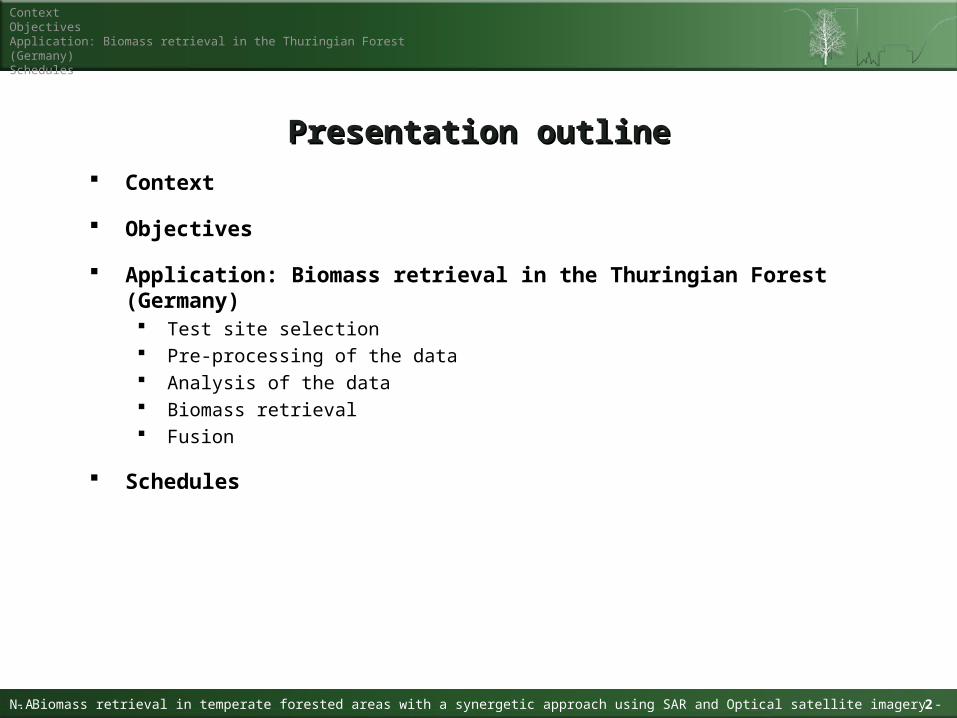
Context
Objectives
Application: Biomass retrieval in the Thuringian Forest (Germany) Test site selection Pre-processing of the data Analysis of the data Biomass retrieval Fusion
Schedules
Presentation outlinePresentation outline
ContextObjectivesApplication: Biomass retrieval in the Thuringian Forest (Germany)Schedules
N.A - Biomass retrieval in temperate forested areas with a synergetic approach using SAR and Optical satellite imagery -N.A 2
3
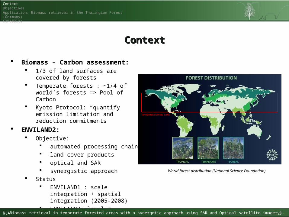
Biomass – Carbon assessment: 1/3 of land surfaces are covered by
forests Temperate forests : ~1/4 of world’s
forests => Pool of Carbon Kyoto Protocol: “quantify emission
limitation and reduction commitments”
ENVILAND2: Objective:
automated processing chain land cover products optical and SAR synergistic approach
Status ENVILAND1 : scale integration +
spatial integration (2005-2008) ENVILAND2: level 3 products
(kick-off: November 2008)
ContextContext
Idenfitication of forested areas in South-East China with satellite imagery Ackermann Nicolas
ContextObjectivesApplication: Biomass retrieval in the Thuringian Forest (Germany)Schedules
- Biomass retrieval in temperate forested areas with a synergetic approach using SAR and Optical satellite imagery -N.A 3
World forest distribution (National Science Foundation)
Temperate terrestial biome
4
ObjectivesObjectives
Idenfitication of forested areas in South-East China with satellite imagery Ackermann Nicolas
ContextObjectivesApplication: Biomass retrieval in the Thuringian Forest (Germany)Schedules
- Biomass retrieval in temperate forested areas with a synergetic approach using SAR and Optical satellite imagery -N.A 4
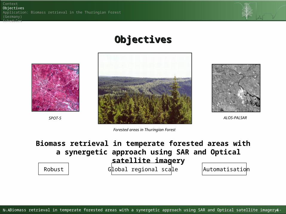
Forested areas in Thuringian Forest
SPOT-5 ALOS-PALSAR
Biomass retrieval in temperate forested areas with a synergetic approach using SAR and Optical satellite imagery
AutomatisationGlobal regional scaleRobust
Fusionprocessing
Results
Validation
Methodology
5
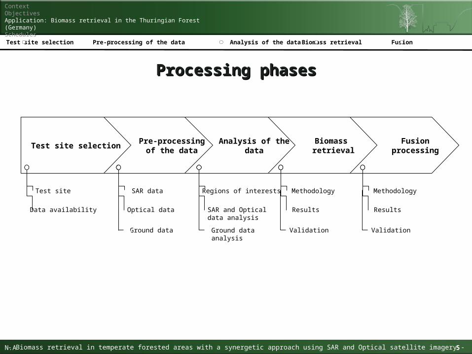
Processing phasesProcessing phases
Idenfitication of forested areas in South-East China with satellite imagery Ackermann Nicolas
ContextObjectivesApplication: Biomass retrieval in the Thuringian Forest (Germany)Schedules
- Biomass retrieval in temperate forested areas with a synergetic approach using SAR and Optical satellite imagery -N.A 5
Analysis of the dataTest site selection Pre-processing of the data Biomass retrieval
Biomass retrieval
Results
Validation
Methodology
Fusion
Analysis of the data
Regions of interests
SAR and Optical data analysis
Ground dataanalysis
SAR data
Pre-processing of the data
Optical data
Ground data
Test site selection
Test site
Data availability
Tree Species
Scots Pine (Kiefer)
European Larch
Norway Spruce (Fichte)
Oak
Sessile Oak
European Beech (Buche)
European Ash
6Idenfitication of forested areas in South-East China with satellite imagery Ackermann Nicolas
ContextObjectivesApplication: Biomass retrieval in the Thuringian Forest (Germany)Schedules
- Biomass retrieval in temperate forested areas with a synergetic approach using SAR and Optical satellite imagery -N.A 6
Analysis of the dataTest site selection Pre-processing of the data Biomass retrieval Fusion
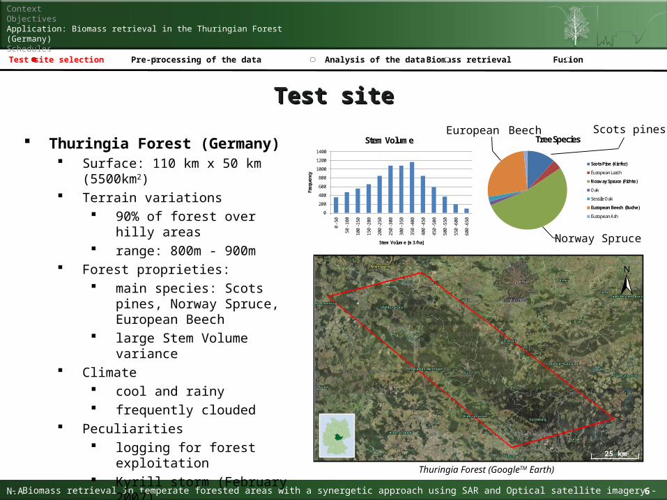
Thuringia Forest (Germany) Surface: 110 km x 50 km (5500km2) Terrain variations
90% of forest over hilly areas range: 800m - 900m
Forest proprieties: main species: Scots pines,
Norway Spruce, European Beech
large Stem Volume variance Climate
cool and rainy frequently clouded
Peculiarities logging for forest exploitation Kyrill storm (February 2007)
Test siteTest site
0
200
400
600
800
1000
1200
1400
0 -5
0
50 -
100
100
-150
150
-200
200
-250
250
-300
300
-350
350
-400
400
-450
450
-500
500
-550
550
-600
600
-650
Freq
uenc
y
Stem Volume [m3/ha]
Stem Volume
Thuringia Forest (GoogleTM Earth)
25 km
Scots pines
Norway Spruce
European Beech
7Idenfitication of forested areas in South-East China with satellite imagery Ackermann Nicolas
ContextObjectivesApplication: Biomass retrieval in the Thuringian Forest (Germany)Schedules
- Biomass retrieval in temperate forested areas with a synergetic approach using SAR and Optical satellite imagery -N.A 7
Analysis of the dataTest site selection Pre-processing of the data Biomass retrieval Fusion
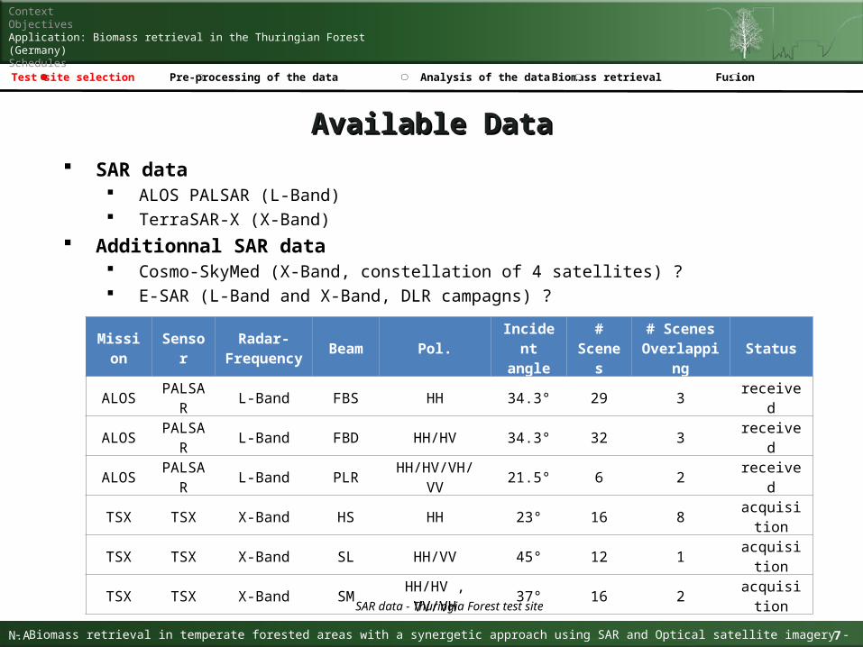
Available DataAvailable Data SAR data
ALOS PALSAR (L-Band) TerraSAR-X (X-Band)
Additionnal SAR data Cosmo-SkyMed (X-Band, constellation of 4 satellites) ? E-SAR (L-Band and X-Band, DLR campagns) ?
Mission SensorRadar-
Frequency Beam Pol.
Incident angle
# Scenes
# Scenes Overlapping
Status
ALOSPALSA
RL-Band FBS HH 34.3° 29 3 received
ALOSPALSA
RL-Band FBD HH/HV 34.3° 32 3 received
ALOSPALSA
RL-Band PLR HH/HV/VH/VV 21.5° 6 2 received
TSX TSX X-Band HS HH 23° 16 8 acquisition
TSX TSX X-Band SL HH/VV 45° 12 1 acquisition
TSX TSX X-Band SM HH/HV , VV/VH 37° 16 2 acquisition
SAR data - Thuringia Forest test site
PALSAR PLR
PALSAR FBD
PALSAR FBS
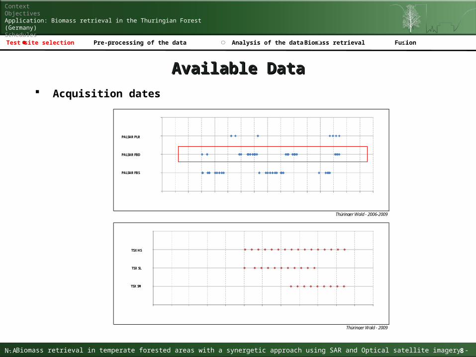
Thüringer Wald - 2006-2009
TSX HS
TSX SL
TSX SM
Thüringer Wald - 2009
Jan. 06 Jul. 06 Jan. 07 Jul. 07 Jan. 08 Jul. 08 Jan. 09 Jul. 09
Jan Feb Mrz Apr Mai Jun Jul Aug Sep Okt Nov Dez
8Idenfitication of forested areas in South-East China with satellite imagery Ackermann Nicolas
ContextObjectivesApplication: Biomass retrieval in the Thuringian Forest (Germany)Schedules
- Biomass retrieval in temperate forested areas with a synergetic approach using SAR and Optical satellite imagery -N.A 8
Analysis of the dataTest site selection Pre-processing of the data Biomass retrieval Fusion
Available DataAvailable Data Acquisition dates
9Idenfitication of forested areas in South-East China with satellite imagery Ackermann Nicolas
ContextObjectivesApplication: Biomass retrieval in the Thuringian Forest (Germany)Schedules
- Biomass retrieval in temperate forested areas with a synergetic approach using SAR and Optical satellite imagery -N.A 9
Analysis of the dataTest site selection Pre-processing of the data Biomass retrieval Fusion
Available DataAvailable Data
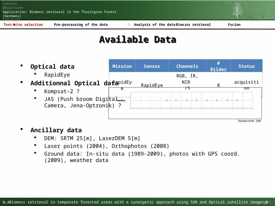
Optical data RapidEye
Additionnal Optical data Kompsat-2 ? JAS (Push broom Digital
Camera, Jena-Optronik) ?
Mission Sensor Channels # Bilder Status
RapidEye RapidEyeRGB, IR, NIR (5 Channels)
8 acquisition
Ancillary data DEM: SRTM 25[m], LaserDEM 5[m] Laser points (2004), Orthophotos (2008) Ground data: In-situ data (1989-2009), photos with GPS coord. (2009), weather data
RapidEye
Jan Feb Mrz Apr Mai Jun Jul Aug Sep Okt Nov Dez
RapidEye
Jan Feb Mrz Apr Mai Jun Jul Aug Sep Okt Nov Dez
RapidEye
Thüringer Wald - 2009
Jan Feb Mrz Apr Mai Jun Jul Aug Sep Okt Nov Dez
10Idenfitication of forested areas in South-East China with satellite imagery Ackermann Nicolas
ContextObjectivesApplication: Biomass retrieval in the Thuringian Forest (Germany)Schedules
- Biomass retrieval in temperate forested areas with a synergetic approach using SAR and Optical satellite imagery -N.A 10
Analysis of the dataTest site selection Pre-processing of the data Biomass retrieval Fusion
Pre-processing phasesPre-processing phases
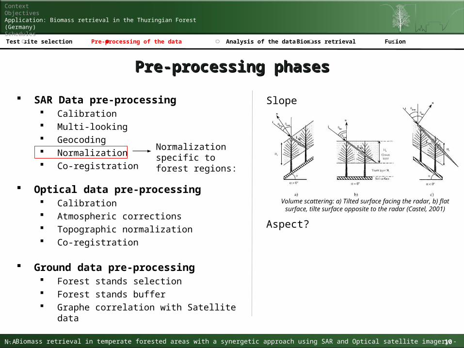
SAR Data pre-processing Calibration Multi-looking Geocoding Normalization Co-registration
Slope
Aspect?
Normalization specific to forest regions:
Volume scattering: a) Tilted surface facing the radar, b) flat surface, tilte surface opposite to the radar (Castel, 2001)
Ground data pre-processing Forest stands selection Forest stands buffer Graphe correlation with Satellite data
Optical data pre-processing Calibration Atmospheric corrections Topographic normalization Co-registration

Biomass retrieval ALOS PALSAR RapidEye
11Idenfitication of forested areas in South-East China with satellite imagery Ackermann Nicolas
ContextObjectivesApplication: Biomass retrieval in the Thuringian Forest (Germany)Schedules
- Biomass retrieval in temperate forested areas with a synergetic approach using SAR and Optical satellite imagery -N.A 11
Analysis of the dataTest site selection Pre-processing of the data Biomass retrieval Fusion
Data analysis perspectiveData analysis perspective
Forest identification ALOS PALSAR TSX RapidEye
Species identification TSX RapidEye
Tree and vegetation density TSX RapidEye
Forest stress and chlorophyll activity RapidEye
ASAR WS Biomass map (Santoro, et al., 2006)
12Idenfitication of forested areas in South-East China with satellite imagery Ackermann Nicolas
ContextObjectivesApplication: Biomass retrieval in the Thuringian Forest (Germany)Schedules
- Biomass retrieval in temperate forested areas with a synergetic approach using SAR and Optical satellite imagery -N.A 12
Analysis of the dataTest site selection Pre-processing of the data Biomass retrieval Fusion
Regions of interest (ROIs)Regions of interest (ROIs)
ROIs definition Land cover: Crops, Forest, Urban, Water Forest category: Sparse, Dense Forest type: Broadleaf, Needle Forest species: Scots pines (Kiefer), Norway Spruce (Fichte), European Beech (Buche)
ROIs selection procedure Orthophotos observations Areas > 100 pixels (~6 ha) Homogeneity (low variance intra-class)
Multitemporal PALSAR :
FBD : 3 - 9 scenes FBS: 2 - 10 scenes FBD - FBS: 5 - 16 scenes
TSX: HS: 9 scenes HS - SL: 9 - 10 scenes
13Idenfitication of forested areas in South-East China with satellite imagery Ackermann Nicolas
ContextObjectivesApplication: Biomass retrieval in the Thuringian Forest (Germany)Schedules
- Biomass retrieval in temperate forested areas with a synergetic approach using SAR and Optical satellite imagery -N.A 13
Analysis of the dataTest site selection Pre-processing of the data Biomass retrieval Fusion
SAR data analysisSAR data analysis
Frequency L-band vs X-band
PALSAR HH - TSX HH PALSAR HV - TSX HV
Polarisation HH vs HV
PALSAR HH - PALSAR HV TSX HH - TSX HV
HH vs VV TSX HH - TSX VV
VV vs VH TSX VV - TSX VH
VH vs HV TSX VH - TSX HV
Incident angle Radiometric analysis
TSX 23° - TSX 37° - TSX 45°
Geometric distortions analysis TSX 23° - TSX 37° - TSX 45°
The data analysis takes into consideration comparable data, namely for an analyzed parameter between two sets of data, all other parameter of this data must remain the same.
Multitemporal RapidEye
7 scenes ?
Bio-physical parameters RapidEye
Absorbed Photosynthetically Active Radiation (PAR)
Leaf Area Index (LAI)
14Idenfitication of forested areas in South-East China with satellite imagery Ackermann Nicolas
ContextObjectivesApplication: Biomass retrieval in the Thuringian Forest (Germany)Schedules
- Biomass retrieval in temperate forested areas with a synergetic approach using SAR and Optical satellite imagery -N.A 14
Analysis of the dataTest site selection Pre-processing of the data Biomass retrieval Fusion
Optical data analysisOptical data analysis
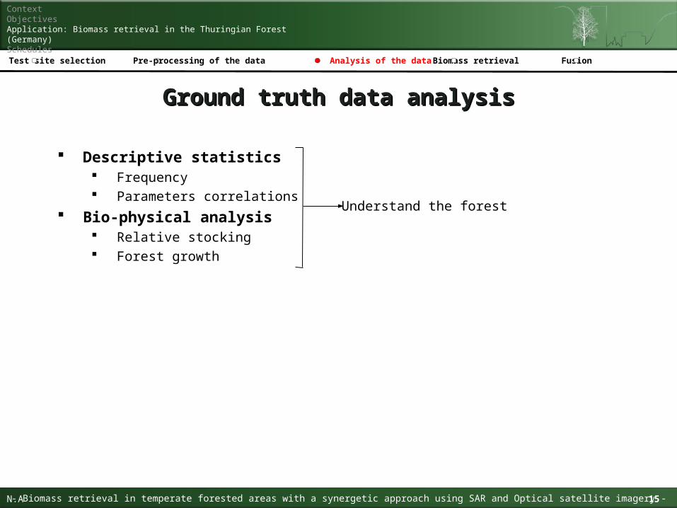
Descriptive statistics Frequency Parameters correlations
Bio-physical analysis Relative stocking Forest growth
15Idenfitication of forested areas in South-East China with satellite imagery Ackermann Nicolas
ContextObjectivesApplication: Biomass retrieval in the Thuringian Forest (Germany)Schedules
- Biomass retrieval in temperate forested areas with a synergetic approach using SAR and Optical satellite imagery -N.A 15
Analysis of the dataTest site selection Pre-processing of the data Biomass retrieval Fusion
Ground truth data analysisGround truth data analysis
Understand the forest
16Idenfitication of forested areas in South-East China with satellite imagery Ackermann Nicolas
ContextObjectivesApplication: Biomass retrieval in the Thuringian Forest (Germany)Schedules
- Biomass retrieval in temperate forested areas with a synergetic approach using SAR and Optical satellite imagery -N.A 16
Analysis of the dataTest site selection Pre-processing of the data Biomass retrieval Fusion
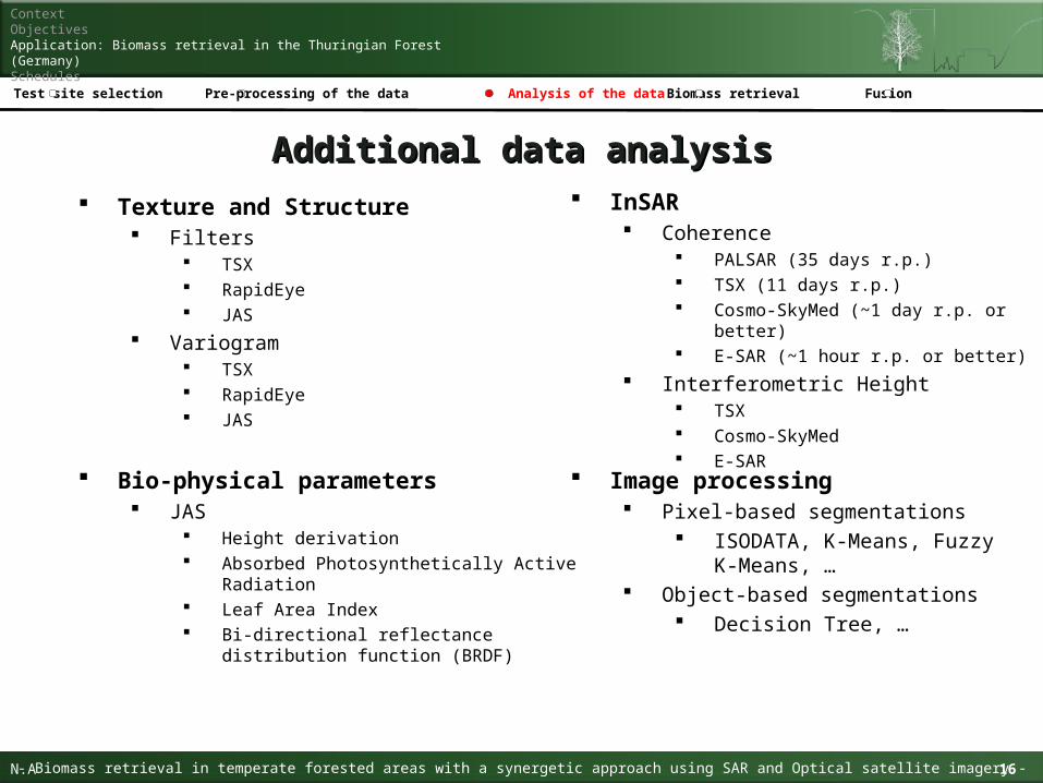
Additional data analysisAdditional data analysis
Texture and Structure Filters
TSX RapidEye JAS
Variogram TSX RapidEye JAS
Bio-physical parameters JAS
Height derivation Absorbed Photosynthetically Active Radiation Leaf Area Index Bi-directional reflectance distribution function
(BRDF)
InSAR Coherence
PALSAR (35 days r.p.) TSX (11 days r.p.) Cosmo-SkyMed (~1 day r.p. or better) E-SAR (~1 hour r.p. or better)
Interferometric Height TSX Cosmo-SkyMed E-SAR
Image processing Pixel-based segmentations
ISODATA, K-Means, Fuzzy K-Means, …
Object-based segmentations Decision Tree, …

17Idenfitication of forested areas in South-East China with satellite imagery Ackermann Nicolas
ContextObjectivesApplication: Biomass retrieval in the Thuringian Forest (Germany)Schedules
- Biomass retrieval in temperate forested areas with a synergetic approach using SAR and Optical satellite imagery -N.A 17
Analysis of the dataTest site selection Pre-processing of the data Biomass retrieval Fusion
Biomass retrievalBiomass retrieval
Remote sensing systems ALOS PALSAR RapidEye
Processing Empirical models
Linear regressions Non-linear regressions
Semi-empirical models Water Cloud Model (WCM) Branching Model …
Satellite[-DN-]
Ground dataStem Volume
y = ax + b
y = aebx
WCM(Attema and Ulaby (1978)
Vegetation component Ground component

18Idenfitication of forested areas in South-East China with satellite imagery Ackermann Nicolas
ContextObjectivesApplication: Biomass retrieval in the Thuringian Forest (Germany)Schedules
- Biomass retrieval in temperate forested areas with a synergetic approach using SAR and Optical satellite imagery -N.A 18
Analysis of the dataTest site selection Pre-processing of the data Biomass retrieval Fusion
Fusion perspectiveFusion perspective
Map accuracy improvement Biomass base map
Transferability concept Spatial: clouds, mosaicing Temporal: lack of data
SAR
Optical
Possible cases1. Optical image clear
2. Optical image cloud covered
3. SAR image clear
4. SAR image cloud covered
5. Superimposed Optical and SAR images clear
6. Superimposed Optical and SAR image cloud covered
Quality Factor (max=1)
0,8
0,5
0,7
0,7
0,9
0,8
1.
2.
3.
4.
6.
5.
t
t
Spatial transferability
Temporal transferability
Optical data
SAR data
19Idenfitication of forested areas in South-East China with satellite imagery Ackermann Nicolas
ContextObjectivesApplication: Biomass retrieval in the Thuringian Forest (Germany)Schedules
- Biomass retrieval in temperate forested areas with a synergetic approach using SAR and Optical satellite imagery -N.A 19
Analysis of the dataTest site selection Pre-processing of the data Biomass retrieval Fusion
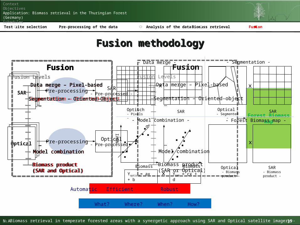
Fusion methodologyFusion methodology
Fusion
Segmentation – Oriented-object
Data merge – Pixel-based
Biomass product(SAR or Optical)
Model combination
Fusion Levels
…
…Optical
Pre-processing
Forest Biomassmap
SAR
Pre-processing
SAR- Pre-processed -
Optical- Pre-processed -
Automatic Efficient Robust
Fusion
Segmentation – Oriented-Object
Data merge – Pixel-based
Biomass product (SAR and Optical)
Model combination
Fusion Levels
…
…
Fusion
Segmentation – Oriented-Object
Data merge – Pixel-based
Biomass product(SAR and Optical)
Model combination
Fusion Levels
…
…
SAR Optical - Segmented -
x
- Segmentation -
Biomass
ND
VI
YSAR = cx + d
σ0
Biomass
Yoptisch= ax + b x
- Model combination -
Fusion
Segmentation – Oriented-Object
Data merge – Pixel-based
Biomass product(SAR and Optical)
Model combination
Fusion Levels
…
…
Optical - Biomass product -
x
SAR- Biomass product -
- Forest Biomass map -
Fusion
Segmentation – Oriented-Object
Data merge – Pixel-based
Biomass product(SAR and Optical)
Model combination
Fusion Levels
…
…
SAR
x
- Data merge -
Optisch- Pixels -
What? Where? When? How?
20Idenfitication of forested areas in South-East China with satellite imagery Ackermann Nicolas
ContextObjectivesApplication: Biomass retrieval in the Thuringian Forest (Germany)Schedules
- Biomass retrieval in temperate forested areas with a synergetic approach using SAR and Optical satellite imagery -N.A 20
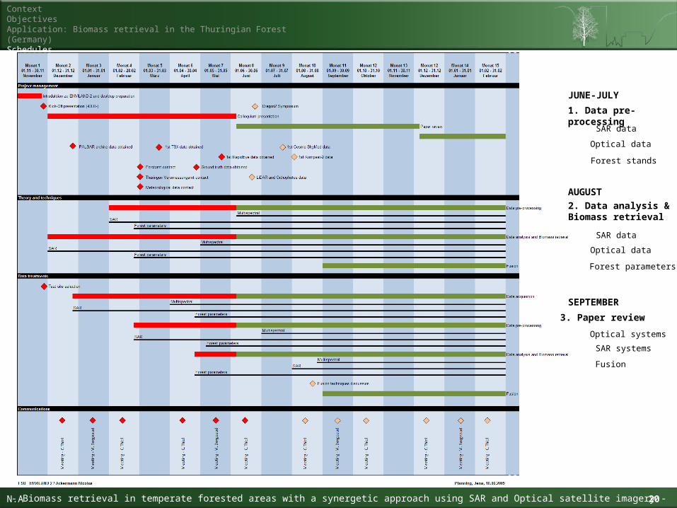
1. Data pre-processing
2. Data analysis & Biomass retrieval
3. Paper review
Fusion
SAR data
Optical systems
Optical data
SAR systems
Forest parameters
SAR data
Optical data
Forest stands
JUNE-JULY
AUGUST
SEPTEMBER
21Idenfitication of forested areas in South-East China with satellite imagery Ackermann Nicolas
ContextObjectivesApplication: Biomass retrieval in the Thuringian Forest (Germany)Schedules
- Biomass retrieval in temperate forested areas with a synergetic approach using SAR and Optical satellite imagery -N.A 21
Thank you for your attention!Thank you for your attention!
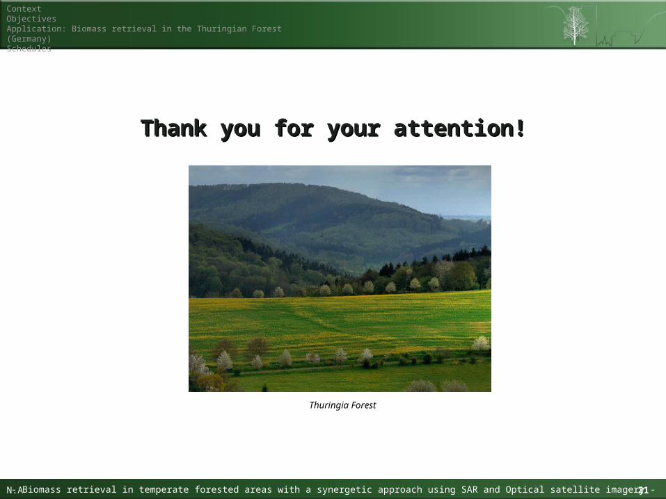
Thuringia Forest