Embed Size (px)
Citation preview
Wedsite: www.riverinabirds.org.au
Specialty Press - Total Print Solution. Phone: 02 6021 3366.
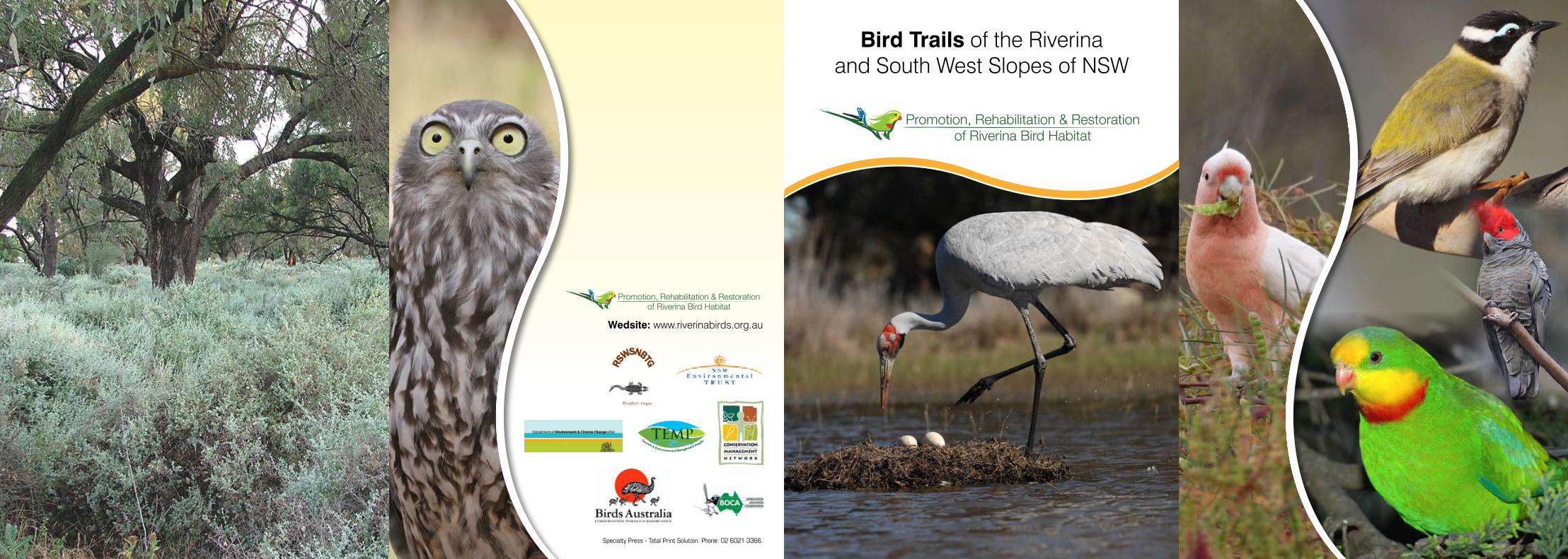
Promotion, Rehabilitation & Restoration of Riverina Bird Habitat
Wiradjuri: Gugaa
Promotion, Rehabilitation & Restoration of Riverina Bird Habitat
Bird Trails of the Riverinaand South West Slopes of NSW
Riverina & South West Slopes Bird Checklist ........... 56
Riverina & South West Slopes Birdwatching Code .... 58
Bird Trails of the Riverina and South West Slopes of NSW 1
Coolamon Shire ..................................... 23
Cootamundra Shire ................................. 11
Gundagai Shire .......................................... 7
Tumut Shire .................................................... 3
Junee Shire ............................................. 15
Temora Shire .......................................... 19
Foreword by John Ebsworth, Chair
This booklet is part of The Promotion, Rehabilitation & Restoration of Riverina Bird Habitats Project that was initiated by the Riverina and South West Slopes Nature Based Tourism Group (RSWS NBTG) with grant assistance by the NSW Environmental Trust.
We welcome you to the Riverina and South West Slopes of Southern New South Wales and its rich diversity of bird life. We trust that you will enjoy the self drive tour routes which have been designed to encourage more bird watching activities in our region.
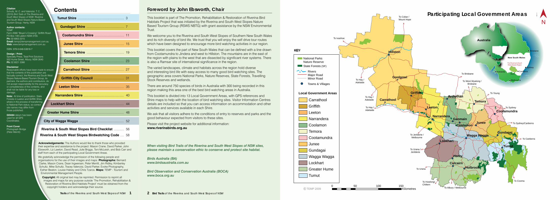
This booklet covers the part of New South Wales that can be defined with a line drawn from Cootamundra to Jindera and west to Hillston. The mountains are in the east of the region with plains to the west that are dissected by significant river systems. There is also a Ramsar site of international significance in the region.
The varied landscapes, climate and habitats across the region hold diverse and interesting bird life with easy access to many good bird watching sites. The geographic area covers National Parks, Nature Reserves, State Forests, Travelling Stock Reserves and wetlands.
There are around 750 species of birds in Australia with 300 being recorded in this region making this area one of the best bird watching areas in Australia.
This booklet is divided into 13 Local Government Areas, with GPS references and Shire maps to help with the location of bird watching sites. Visitor Information Centres details are included so that you can access information on accommodation and other activities and services available in each Shire.
We ask that all visitors adhere to the conditions of entry to reserves and parks and the good behaviour expected from visitors to these sites.
Please visit the project website for additional information:www.riverinabirds.org.au
When visiting Bird Trails of the Riverina and South West Slopes of NSW sites, please maintain a conservation ethic to conserve and protect site habitat.
Birds Australia (BA)www.birdsaustralia.com.au
Bird Observation and Conservation Australia (BOCA)www.boca.org.au
Leeton
Hillston
Narrandera
ArdlethanTemora
Cootamundra
Ganmain
CoolamonJunee
Lockhart
Henty
Culcairn
Wagga Wagga
Tumut
Gundagai
Holbrook
CarrathoolGriffithLeetonNarranderaCoolamonTemoraCootamundraJuneeGundagaiWagga WaggaLockhartGreater HumeTumut
KEY
National Parks Nature Reserve State Forests (SF)
Rivers Major Road Minor Road
Towns & Villages
Local Government Areas
To Sydney/Canberra
To Sydney
To Cooma
To Brisbane
To Cobar / Mount Hope
To Jerilderie / Melbourne
PARTICIPATING LOCAL GOVERNMENT AREAS
New South Wales
0 50 100 150Kilometres
To Ivanhoe
To Hay / Adelaide
To Hay / Adelaide
To Hay / Adelaide
Goolgowi
Carrathool
Griffith
To West Wyalong / Brisbane
To Urana / Jerilderie
To Albury / Melbourne
To Canberra
To Young
To Urana
To Howlong/Chiltern
Contents
Acknowledgements: The Authors would like to thank those who provided their expertise and assistance to the project: Mason Crane, David Parker, John Ebsworth, Liz Lawton, David Read, Julie Briggs, Toni McLeish, and Bob Carr and
to staff from each of the participating Local Government Areas.
We gratefully acknowledge the permission of the following people and organisations for the use of their images and maps: Photographs: Bernard Clarke, Mason Crane, Dean Ingwersen, Peter Merritt, Jim Ridley, Kimberley Schultz, Mike Schultz, Tracey Valenzisi, David Parker, Evoke Photography, Esther Beaton, Louise Halsey and Chris Tzaros. Maps: TEMP - Tourism and Environmental Management People.
Copyright: All original text may be reprinted. Permission to reprint all images and maps for any purpose outside ‘The Promotion, Rehabilitation &
Restoration of Riverina Bird Habitats Project’ must be obtained from the copyright holders and acknowledge their source.
Carrathool Shire ..................................... 27
Greater Hume Shire ................................................. 48
Griffith City Council .................................. 31
Leeton Shire ................................................ 35
Lockhart Shire ...................................................... 44
Narrandera Shire ............................................. 40
City of Wagga Wagga .................................................. 52
CitationSchultz, M. C. and Valenzisi, T. C.(2010) Bird Trails of The Riverina andSouth West Slopes of NSW. Riverinaand South West Slopes Nature-BasedTourism Group, Henty, NSW
Author contacts:TEMPFarm 2068 “Boyer’s Crossing” Griffith RoadPO Box 148 Leeton NSW 2705Ph: 02 6953 2215Email: [email protected] Web: www.tempmanagement.com.au
ISBN: 978-0-646-53816-7
Design / Print:Specialty Press, Total Print Solutions552 Hume Street, Albury. NSW 2640Ph: 02 6021 3366
DisclaimerReasonable efforts have been made to ensure that the contents of this publication arefactually correct, the Riverina and South West Slopes Nature-Based Tourism Group, its partners, the authors and contributors, donot accept responsibility for the accuracyor completeness of the contents, andshall not be liable for any loss ordamage.
Note: At time of publication, StateForests in Leeton and Griffith Shirewhere in the process of transferringto National Park status, so correctsite names may differ fromthose published.
GDA94 datum has beenused for all GPSCoordinates.
Front CoverPhotograph Brolga(Peter Merritt)
Gundagai
Ardlethan
Goolgowi
Lockhart
HentyCulcairn
The Riverina & South West Slopes Region
2 Bird Trails of the Riverina and South West Slopes of NSW
Participating Local Government Areas
Bird Trails of the Riverina and South West Slopes of NSW 3
Tucked away in the south west of New South Wales is the gateway to the northern end of the Snowy Mountains and the Riverina, an area spectacular in natural beauty and diversity.
Four distinct seasons define the Tumut Region, each with its own charm – the richness of colour in Autumn, the playgrounds of the snowfields in Winter, the beauty of blossoms in Spring, and the spectacular tracts of water and aquatic recreational activities in Summer.
This vast area of untouched beauty promises an unforgettable experience with its unique landscapes, flora and proliferation of wildlife. Inland lakes, crystal streams, and gentle fertile pastures lead to vast pine forests, towering mountains, the awesome Snowy Mountains
Scheme, and the many attractions of the northern end of the sensational Kosciusko National Park.
Each township within the region offers its own distinct identity. Adelong is steeped in history, Tumut famous for rich seasonal colour, Talbingo is known for its lakeside tranquility and Batlow for crisp mountain apples.
Tumut Region Visitor CentreAdelong RoadTumut NSW 2720
P: (02) 6947 7025E: [email protected]: www.tumut.nsw.gov.au
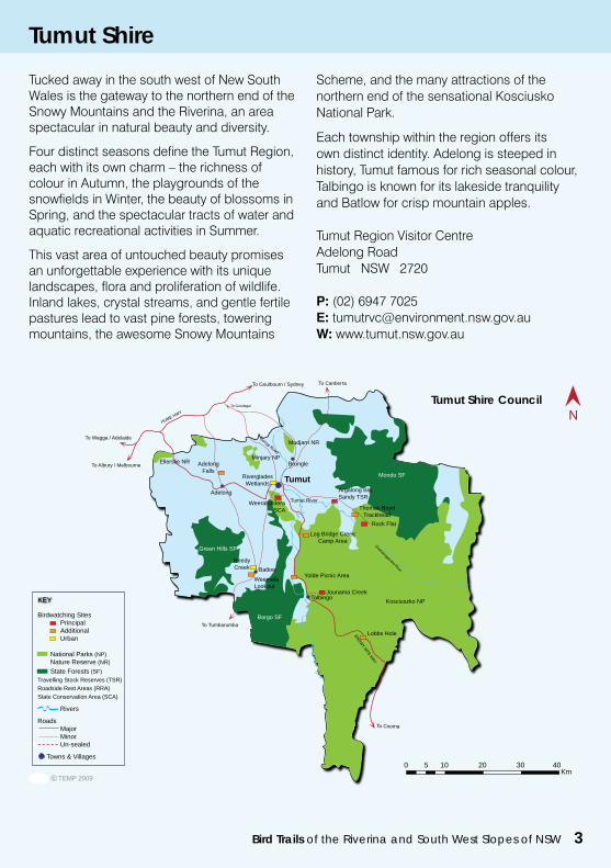
TUMUT SHIRE COUNCIL
0 5 10 20 30 40Km
Tumut
Yolde Picnic Area
Jounama Creek
Weemala Lookout
Log Bridge Creek Camp Area
Adelong Falls
Adelong
Batlow
Green Hills SF
Mondo SF
Bargo SFTo Tumbarumba
To Goulbourn / Sydney
To Gundagai
To Wagga / Adelaide
To Albury / MelbourneMinjary NP
Weeraboldera SCA Thomas Boyd
Trackhead
Kosciuszko NP
Tumut River
Mudjarn NR
Riverglades Wetlands
Talbingo
Reedy Creek
Ellerslie NR
Argalong Big Sandy TSR
Brungle
To Canberra
Birdwatching Sites Principal Additional Urban National Parks (NP) Nature Reserve (NR) State Forests (SF)Travelling Stock Reserves (TSR)Roadside Rest Areas (RRA)State Conservation Area (SCA)
Rivers
Roads Major Minor Un-sealed
Towns & Villages
KEY
Rock Flat
Lobbs Hole
Tumut Shire
TUMUT SHIRE COUNCIL
0 5 10 20 30 40Km
Tumut
Yolde Picnic Area
Jounama Creek
Weemala Lookout
Log Bridge Creek Camp Area
Adelong Falls
Adelong
Batlow
Green Hills SF
Mondo SF
Bargo SFTo Tumbarumba
To Goulbourn / Sydney
To Gundagai
To Wagga / Adelaide
To Albury / MelbourneMinjary NP
Weeraboldera SCA Thomas Boyd
Trackhead
Kosciuszko NP
Tumut River
Mudjarn NR
Riverglades Wetlands
Talbingo
Reedy Creek
Ellerslie NR
Argalong Big Sandy TSR
Brungle
To Canberra
Birdwatching Sites Principal Additional Urban National Parks (NP) Nature Reserve (NR) State Forests (SF)Travelling Stock Reserves (TSR)Roadside Rest Areas (RRA)State Conservation Area (SCA)
Rivers
Roads Major Minor Un-sealed
Towns & Villages
KEY
Rock Flat
Lobbs Hole
Tumut Shire Council
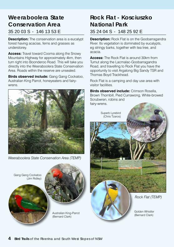
Description: The conservation area is a eucalypt forest having acacias, ferns and grasses as understorey.
Access: Travel toward Cooma along the Snowy Mountains Highway for approximately 4km, then turn right into Boonderoo Road. This will take you directly into the Weeraboolera State Conservation Area. Roads within the reserve are unsealed.
Birds observed include: Gang Gang Cockatoo, Australian King Parrot, honeyeaters and fairy-wrens.
Weeraboolera State Conservation Area35 20 03 S - 146 13 53 E
Weeraboolera State Conservation Area (TEMP)
Gang Gang Cockatoo(Jim Ridley)
Australian King-Parrot(Bernard Clark)
Description: Rock Flat is on the Goobarragandra River. Its vegetation is dominated by eucalypts, eg stringy barks, together with tea tree, and acacia.
Access: The Rock Flat is around 30km from Tumut along the Lacmalac-Goobarragandra Road, and travelling to Rock Flat you have the opportunity to visit Argalong Big Sandy TSR and Thomas Boyd Trackhead.
Rock Flat is a camping and day use area with visitor facilities.
Birds observed include: Crimson Rosella, Brown Thornbill, Pied Currawong, White-browed Scrubwren, robins andfairy-wrens.
Rock Flat - Kosciuszko National Park35 24 04 S - 148 25 92 E
Rock Flat (TEMP)
Superb Lyrebird(Chris Tzaros)
Golden Whistler(Bernard Clark)
4 Bird Trails of the Riverina and South West Slopes of NSW
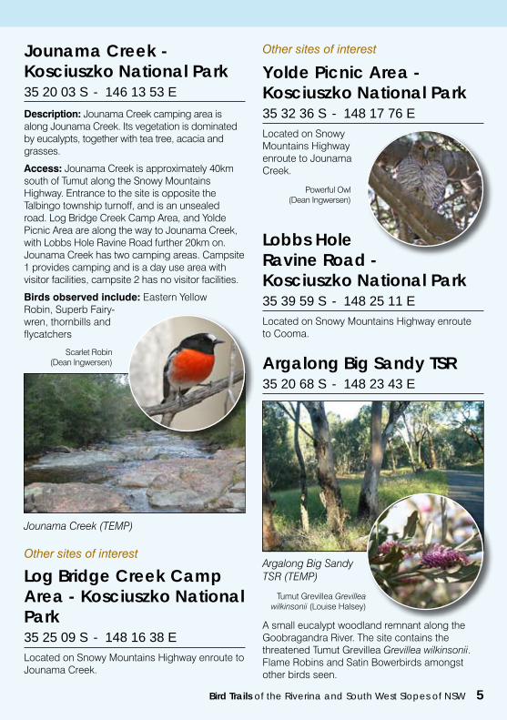
Description: Jounama Creek camping area is along Jounama Creek. Its vegetation is dominated by eucalypts, together with tea tree, acacia and grasses.
Access: Jounama Creek is approximately 40km south of Tumut along the Snowy Mountains Highway. Entrance to the site is opposite the Talbingo township turnoff, and is an unsealed road. Log Bridge Creek Camp Area, and Yolde Picnic Area are along the way to Jounama Creek, with Lobbs Hole Ravine Road further 20km on. Jounama Creek has two camping areas. Campsite 1 provides camping and is a day use area with visitor facilities, campsite 2 has no visitor facilities.
Birds observed include: Eastern Yellow Robin, Superb Fairy-wren, thornbills and flycatchers
Jounama Creek - Kosciuszko National Park35 20 03 S - 146 13 53 E
Scarlet Robin(Dean Ingwersen)
Jounama Creek (TEMP)
Other sites of interest
Log Bridge Creek Camp Area - Kosciuszko National Park35 25 09 S - 148 16 38 ELocated on Snowy Mountains Highway enroute to Jounama Creek.
Yolde Picnic Area - Kosciuszko National Park35 32 36 S - 148 17 76 ELocated on Snowy Mountains Highway enroute to Jounama Creek.
Lobbs Hole Ravine Road - Kosciuszko National Park35 39 59 S - 148 25 11 ELocated on Snowy Mountains Highway enroute to Cooma.
Bird Trails of the Riverina and South West Slopes of NSW 5
Argalong Big Sandy TSR 35 20 68 S - 148 23 43 E
A small eucalypt woodland remnant along the Goobragandra River. The site contains the threatened Tumut Grevillea Grevillea wilkinsonii. Flame Robins and Satin Bowerbirds amongst other birds seen.
Argalong Big Sandy TSR (TEMP)
Tumut Grevillea Grevillea wilkinsonii (Louise Halsey)
Other sites of interest
Powerful Owl(Dean Ingwersen)
Thomas Boyd Trackhead (TEMP)
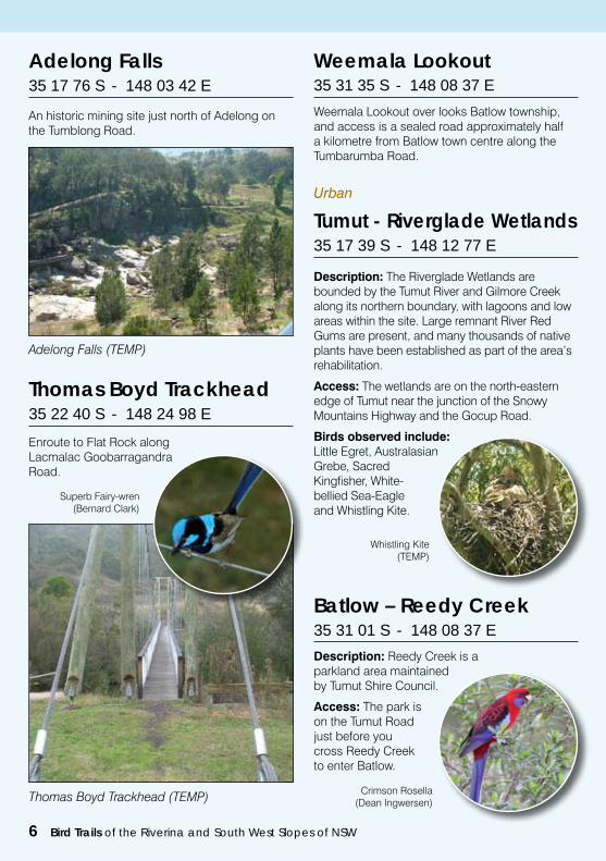
Thomas Boyd Trackhead35 22 40 S - 148 24 98 E
Enroute to Flat Rock alongLacmalac Goobarragandra Road.
Superb Fairy-wren(Bernard Clark)
Urban
Tumut - Riverglade Wetlands35 17 39 S - 148 12 77 E
Description: The Riverglade Wetlands are bounded by the Tumut River and Gilmore Creek along its northern boundary, with lagoons and low areas within the site. Large remnant River Red Gums are present, and many thousands of native plants have been established as part of the area’s rehabilitation.
Access: The wetlands are on the north-eastern edge of Tumut near the junction of the Snowy Mountains Highway and the Gocup Road.
Birds observed include: Little Egret, Australasian Grebe, Sacred Kingfisher, White-bellied Sea-Eagle and Whistling Kite.
Whistling Kite(TEMP)
Adelong Falls 35 17 76 S - 148 03 42 E
An historic mining site just north of Adelong on the Tumblong Road.
Adelong Falls (TEMP)
Batlow – Reedy Creek 35 31 01 S - 148 08 37 E
Description: Reedy Creek is a parkland area maintained by Tumut Shire Council.
Access: The park is on the Tumut Road just before you cross Reedy Creek to enter Batlow.
Crimson Rosella(Dean Ingwersen)
Weemala Lookout 35 31 35 S - 148 08 37 E
Weemala Lookout over looks Batlow township, and access is a sealed road approximately half a kilometre from Batlow town centre along the Tumbarumba Road.
6 Bird Trails of the Riverina and South West Slopes of NSW
Bird Trails of the Riverina and South West Slopes of NSW 7
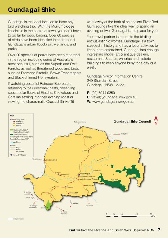
Gundagai is the ideal location to base any bird watching trip. With the Murrumbidgee floodplain in the centre of town, you don’t have to go far for good birding. Over 60 species of birds have been identified in and around Gundagai’s urban floodplain, wetlands, and parks.
Over 20 species of parrot have been recorded in the region including some of Australia’s most beautiful, such as the Superb and Swift Parrots, as well as threatened woodland birds such as Diamond Firetails, Brown Treecreepers and Black-chinned Honeyeaters.
If watching beautiful Rainbow Bee-eaters returning to their riverbank nests, observing spectacular flocks of Galahs, Cockatoos and Corellas settling into their evening roost or viewing the charasmatic Crested Shrike-Tit
work away at the bark of an ancient River Red Gum sounds like the ideal way to spend an evening or two, Gundagai is the place for you.
Your travel partner is not quite the birding enthusiast? No worries. Gundagai is a town steeped in history and has a lot of activities to keep them entertained. Gundagai has enough interesting shops, art & antique dealers, restaurants & cafes, wineries and historic buildings to keep anyone busy for a day or a week.
Gundagai Visitor Information Centre249 Sheridan StreetGundagai NSW 2722
P: (02) 6944 0250E: [email protected]: www.gundagai.nsw.gov.au
Muttama
To Cootamundra
Gundagai
To Sydney
To Junee
Coolac
To Tumut/Cooma
To Albury/Melbourne
To Wagga/Adelaide
South Gundagai Cemetery
Doctor’s Hill
To Tumut
Gundagai Comman
Tumut River
Billabong Creek
Nangus
Red Hill SF
Ellerslie NR
Muttama Cemetery
0 5 10 20 30Km
Nangus TSR
Tumblong
Turners TSR
To Adelong
Sturt Hwy
GUNDAGAI SHIRECOUNCIL
Birdwatching Sites Principal Additional Urban National Parks (NP) Nature Reserve (NR) State Forests (SF)Travelling Stock Reserves (TSR)Roadside Rest Areas (RRA)
Rivers
Roads Major Minor Un-sealed
Towns & Villages
KEY
Gundagai Shire
Gundagai Shire Council
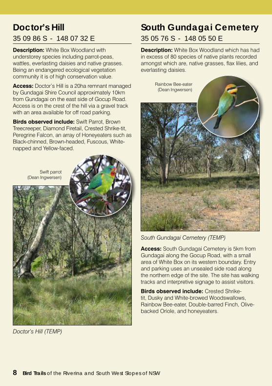
Doctor’s Hill35 09 86 S - 148 07 32 E
Description: White Box Woodland with understorey species including parrot-peas, wattles, everlasting daisies and native grasses. Being an endangered ecological vegetation community it is of high conservation value.
Access: Doctor’s Hill is a 20ha remnant managed by Gundagai Shire Council approximately 10km from Gundagai on the east side of Gocup Road. Access is on the crest of the hill via a gravel track with an area available for off road parking.
Birds observed include: Swift Parrot, Brown Treecreeper, Diamond Firetail, Crested Shrike-tit, Peregrine Falcon, an array of Honeyeaters such as Black-chinned, Brown-headed, Fuscous, White-napped and Yellow-faced.
South Gundagai Cemetery35 05 76 S - 148 05 50 E
Description: White Box Woodland which has had in excess of 80 species of native plants recorded amongst which are, native grasses, flax lilies, and everlasting daisies.
Doctor’s Hill (TEMP)
Swift parrot(Dean Ingwersen)
South Gundagai Cemetery (TEMP)
Rainbow Bee-eater(Dean Ingwersen)
Access: South Gundagai Cemetery is 5km from Gundagai along the Gocup Road, with a small area of White Box on its western boundary. Entry and parking uses an unsealed side road along the northern edge of the site. The site has walking tracks and interpretive signage to assist visitors.
Birds observed include: Crested Shrike-tit, Dusky and White-browed Woodswallows, Rainbow Bee-eater, Double-barred Finch, Olive-backed Oriole, and honeyeaters.
8 Bird Trails of the Riverina and South West Slopes of NSW
Bird Trails of the Riverina and South West Slopes of NSW 9
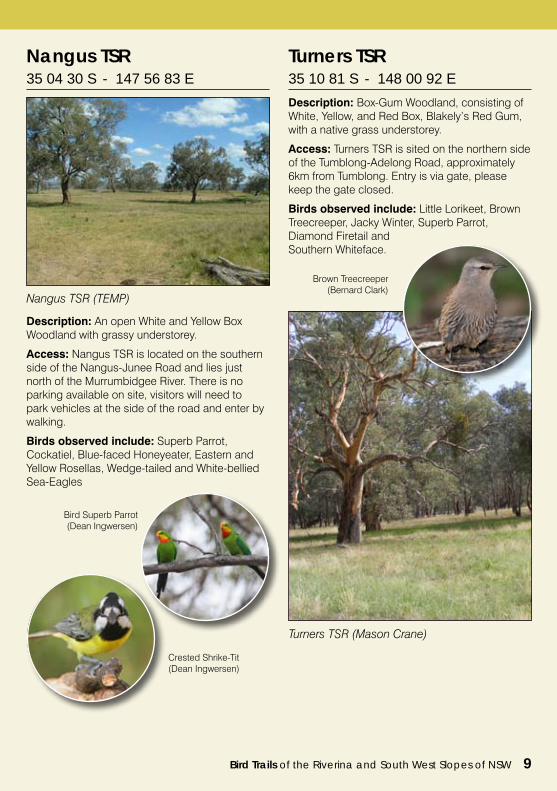
Nangus TSR 35 04 30 S - 147 56 83 E
Description: An open White and Yellow Box Woodland with grassy understorey.
Access: Nangus TSR is located on the southern side of the Nangus-Junee Road and lies just north of the Murrumbidgee River. There is no parking available on site, visitors will need to park vehicles at the side of the road and enter by walking.
Birds observed include: Superb Parrot, Cockatiel, Blue-faced Honeyeater, Eastern and Yellow Rosellas, Wedge-tailed and White-bellied Sea-Eagles
Turners TSR 35 10 81 S - 148 00 92 E
Description: Box-Gum Woodland, consisting of White, Yellow, and Red Box, Blakely’s Red Gum, with a native grass understorey.
Access: Turners TSR is sited on the northern side of the Tumblong-Adelong Road, approximately 6km from Tumblong. Entry is via gate, please keep the gate closed.
Birds observed include: Little Lorikeet, Brown Treecreeper, Jacky Winter, Superb Parrot, Diamond Firetail and Southern Whiteface.
Bird Superb Parrot(Dean Ingwersen)
Nangus TSR (TEMP)
Crested Shrike-Tit(Dean Ingwersen)
Turners TSR (Mason Crane)
Brown Treecreeper (Bernard Clark)
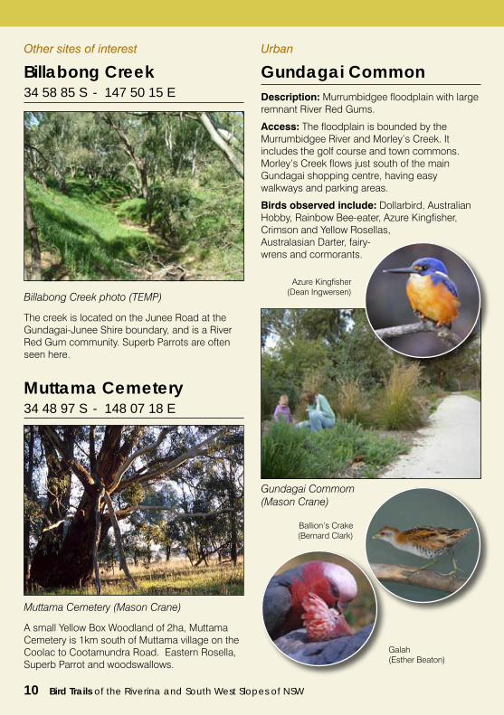
Gundagai Common Description: Murrumbidgee floodplain with large remnant River Red Gums.
Access: The floodplain is bounded by the Murrumbidgee River and Morley’s Creek. It includes the golf course and town commons. Morley’s Creek flows just south of the main Gundagai shopping centre, having easy walkways and parking areas.
Birds observed include: Dollarbird, Australian Hobby, Rainbow Bee-eater, Azure Kingfisher, Crimson and Yellow Rosellas, Australasian Darter, fairy-wrens and cormorants.
Other sites of interest
Billabong Creek 34 58 85 S - 147 50 15 E
The creek is located on the Junee Road at the Gundagai-Junee Shire boundary, and is a River Red Gum community. Superb Parrots are often seen here.
Muttama Cemetery 34 48 97 S - 148 07 18 E
A small Yellow Box Woodland of 2ha, Muttama Cemetery is 1km south of Muttama village on the Coolac to Cootamundra Road. Eastern Rosella, Superb Parrot and woodswallows.
Azure Kingfisher(Dean Ingwersen)
Ballion’s Crake(Bernard Clark)
Galah(Esther Beaton)
10 Bird Trails of the Riverina and South West Slopes of NSW
Muttama Cemetery (Mason Crane)
Gundagai Commom (Mason Crane)
Billabong Creek photo (TEMP)
Urban
Bird Trails of the Riverina and South West Slopes of NSW 11
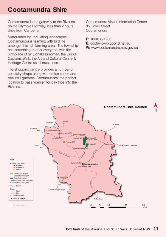
Cootamundra Shire
Cootamundra is the gateway to the Riverina, on the Olympic Highway, less than 2 hours drive from Canberra.
Surrounded by undulating landscapes, Cootamundra is teaming with bird life amongst this rich farming area. The township has something to offer everyone, with the birthplace of Sir Donald Bradman, the Cricket Captains Walk, the Art and Cultural Centre & Heritage Centre as all must sees.
The shopping centre provides a number of specialty shops along with coffee shops and beautiful gardens. Cootamundra, the perfect location to base yourself for day trips into the Riverina.
Cootamundra Visitor Information Centre85 Hovell StreetCootamundra
P: 1800 350 203E: [email protected]: www.cootamundra.nsw.gov.au
COOTAMUNDRA SHIRECOUNCIL
To Temora
Migurra Res
Pevency TSR
Stockinbingal
The Boundary TSR
Jindalee SFFlagstaff NR
0 5 10 20 30 Km
To Junee / Wagga Wagga
To Gundagai
To Young
To Yass / Goulburn
Captains Walk
WallendbeenJindalee SFTo Temora
Birdwatching Sites Principal Additional Urban National Parks (NP) Nature Reserve (NR) State Forests (SF)Travelling Stock Reserves (TSR)Roadside Rest Areas (RRA)
Rivers
Roads Major Minor Un-sealed
Towns & Villages
KEY
CootamundraPioneer Park
Gunolibindyal TSR
Bland Creek TSR
To Grogan Milvale
Cootamundra Shire Council
12 Bird Trails of the Riverina and South West Slopes of NSW
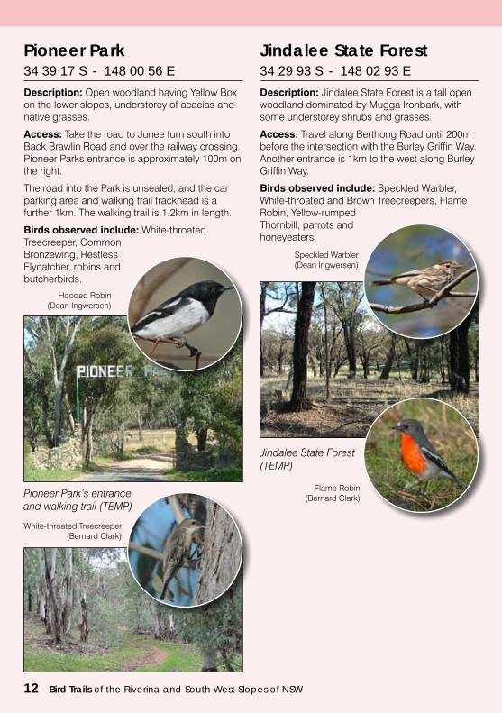
Pioneer Park 34 39 17 S - 148 00 56 E
Description: Open woodland having Yellow Box on the lower slopes, understorey of acacias and native grasses.
Access: Take the road to Junee turn south into Back Brawlin Road and over the railway crossing. Pioneer Parks entrance is approximately 100m on the right.
The road into the Park is unsealed, and the car parking area and walking trail trackhead is a further 1km. The walking trail is 1.2km in length.
Birds observed include: White-throated Treecreeper, Common Bronzewing, Restless Flycatcher, robins and butcherbirds.
Pioneer Park’s entrance and walking trail (TEMP)
Hooded Robin(Dean Ingwersen)
White-throated Treecreeper(Bernard Clark)
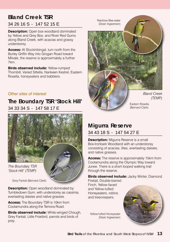
Jindalee State Forest 34 29 93 S - 148 02 93 E
Description: Jindalee State Forest is a tall open woodland dominated by Mugga Ironbark, with some understorey shrubs and grasses.
Access: Travel along Berthong Road until 200m before the intersection with the Burley Griffin Way. Another entrance is 1km to the west along Burley Griffin Way.
Birds observed include: Speckled Warbler, White-throated and Brown Treecreepers, Flame Robin, Yellow-rumped Thornbill, parrots and honeyeaters.
Jindalee State Forest (TEMP)
Speckled Warbler(Dean Ingwersen)
Flame Robin(Bernard Clark)
Bird Trails of the Riverina and South West Slopes of NSW 13
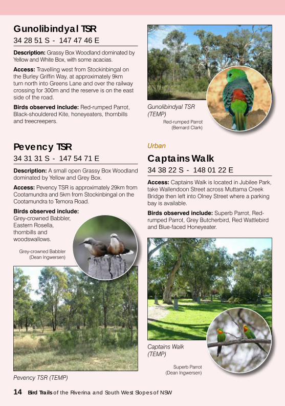
Bland Creek TSR 34 26 16 S - 147 52 15 E
Description: Open box woodland dominated by Yellow and Grey Box, and River Red Gums along Bland Creek, with acacias and grassy understorey.
Access: At Stockinbingal, turn north from the Burley Griffin Way into Grogan Road toward Milvale, the reserve is approximately a further 7km.
Birds observed include: Yellow-rumped Thornbill, Varied Sittella, Nankeen Kestrel, Eastern Rosella, honeyeaters and babblers.
Migurra Reserve 34 43 18 S - 147 54 27 E
Description: Migurra Reserve is a small Box-Ironbark Woodland with an understorey consisting of acacias, lilies, everlasting daisies, and native grasses.
Access: The reserve is approximately 15km from Cootamundra along the Olympic Way toward Junee. There is a short looped walking trail through the reserve.
Birds observed include: Jacky Winter, Diamond Firetail, Double-barred Finch, Yellow-faced and Yellow-tufted Honeyeaters, robins and treecreepers.
Bland Creek (TEMP)
Eastern Rosella (Bernard Clark)
Rainbow Bee-eater(Dean Ingwersen)
Other sites of interest
Yellow-tufted Honeyeater (Dean Ingwersen)
Description: Open woodland dominated by Tumbledown Gum, with understorey as cassinia, everlasting daisies and native grasses.
Access: The Boundary TSR is 10km from Cootamundra along the Temora Road.
Birds observed include: White-winged Chough, Grey Fantail, Little Friarbird, parrots and birds of prey.
The Boundary TSR ‘Stock Hill’34 33 34 S - 147 58 17 E
The Boundary TSR ‘Stock Hill’ (TEMP)
Grey Fantail (Bernard Clark)
14 Bird Trails of the Riverina and South West Slopes of NSW
Pevency TSR 34 31 31 S - 147 54 71 E
Description: A small open Grassy Box Woodland dominated by Yellow and Grey Box.
Access: Pevency TSR is approximately 29km from Cootamundra and 5km from Stockinbingal on the Cootamundra to Temora Road.
Birds observed include: Grey-crowned Babbler, Eastern Rosella, thornbills and woodswallows.
Grey-crowned Babbler (Dean Ingwersen)
Gunolibindyal TSR 34 28 51 S - 147 47 46 E
Description: Grassy Box Woodland dominated by Yellow and White Box, with some acacias.
Access: Travelling west from Stockinbingal on the Burley Griffin Way, at approximately 9km turn north into Greens Lane and over the railway crossing for 300m and the reserve is on the east side of the road.
Birds observed include: Red-rumped Parrot, Black-shouldered Kite, honeyeaters, thornbills and treecreepers.
Gunolibindyal TSR (TEMP)
Red-rumped Parrot (Bernard Clark)
Captains Walk 34 38 22 S - 148 01 22 E
Access: Captains Walk is located in Jubilee Park, take Wallendoon Street across Muttama Creek Bridge then left into Olney Street where a parking bay is available.
Birds observed include: Superb Parrot, Red-rumped Parrot, Grey Butcherbird, Red Wattlebird and Blue-faced Honeyeater.
Captains Walk (TEMP)
Superb Parrot(Dean Ingwersen)
Urban
Pevency TSR (TEMP)
Bird Trails of the Riverina and South West Slopes of NSW 15
Junee Shire
This pretty railway town is a feast for the eyes with its awnings, verandahs, wide streets and eccentric old-style architecture featuring stuccoed facades and decorative roof parapets.
The township developed on either side of the Sydney–Melbourne railway line, which reached the town in 1878.
During the 1880s, the line’s rail repair premises were moved to Junee from Wagga Wagga, increasing local employment opportunities significantly.
In recent times, Junee has become the largest producer of canola in NSW. It is also a centre for wheat, barley and oats.
A must to do in Junee, is a visit to Green Grove Organic, a licorice and chocolate factory, where they use organic Belgian chocolate, with its smooth and full flavour being actually good for your health.
The Monte Cristo was built in 1884 and is the finest colonial mansion in the Riverina. It has been faithfully restored and furnished in the high Victorian era circa 1840.
Junee Visitor Information CentreLorne Street Junee NSW 2663
P: (02) 6924 4682E: [email protected]: www.junee.nsw.gov.au
Wallacetown TSR/RA
Junee Reefs TSR
Clear Hills TSR
Billabong Creek
Junee
0 5 10 20 30Km
Bethungra Dam
JUNEE SHIRE COUNCIL
To Gundagai
To Cootamundra
To Coolamon
To Wagga Wagga
To Temora To Temora / Cootamundra
Old Junee TSR
Illabo
Bethungra
Old Junee
Junee Wetlands
Ulandra NR
Birdwatching Sites Principal Additional Urban National Parks (NP) Nature Reserve (NR) State Forests (SF)Travelling Stock Reserves (TSR)Roadside Rest Areas (RRA)
Rivers
Roads Major Minor Un-sealed
Towns & Villages
KEY
Junee Shire Council
16 Bird Trails of the Riverina and South West Slopes of NSW
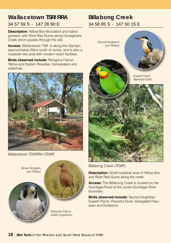
Wallacetown TSR/RRA 34 57 59 S - 147 26 90 E
Description: Yellow Box Woodland and native grasses, with River Red Gums along Houlaghans Creek which passes through the site.
Access: Wallacetown TSR is along the Olympic, approximately 20km south of Junee, and is also a roadside rest area with modern visitor facilities.
Birds observed include: Peregrine Falcon, Yellow and Eastern Rosellas, honeyeaters and waterfowl.
Wallacetown TSR/RRA (TEMP)
Brown Songlark(Jim Ridley)
Peregrine Falcon(Dean Ingwersen)
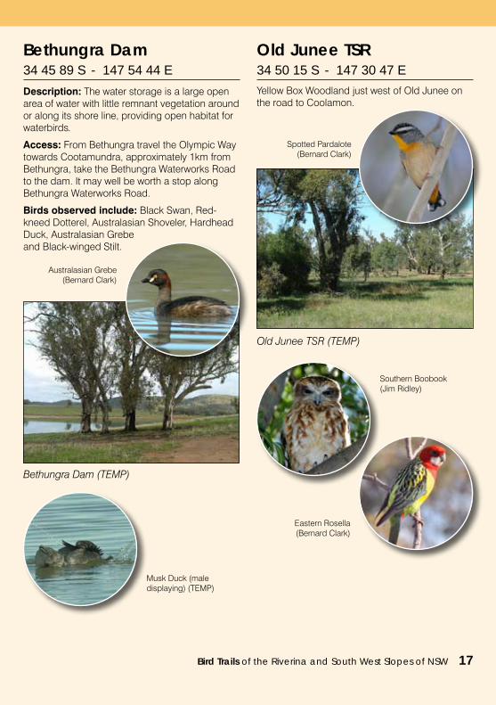
Billabong Creek 34 58 85 S - 147 50 15 E
Description: Small roadside area of Yellow Box, and River Red Gums along the creek.
Access: The Billabong Creek is located on the Gundagai Road at the Junee-Gundagai Shire boundary.
Birds observed include: Sacred Kingfisher, Superb Parrot, Peaceful Dove, Variegated Fairy-wren and Dollarbird.
Billabong Creek (TEMP)
Sacred Kingfisher(Jim Ridley)
Superb Parrot(Bernard Clark)
Bird Trails of the Riverina and South West Slopes of NSW 17
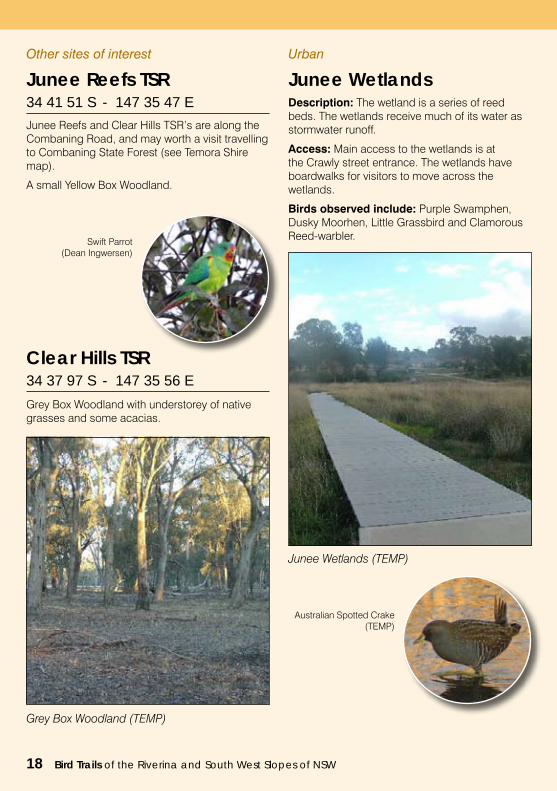
Bethungra Dam 34 45 89 S - 147 54 44 E
Description: The water storage is a large open area of water with little remnant vegetation around or along its shore line, providing open habitat for waterbirds.
Access: From Bethungra travel the Olympic Way towards Cootamundra, approximately 1km from Bethungra, take the Bethungra Waterworks Road to the dam. It may well be worth a stop along Bethungra Waterworks Road.
Birds observed include: Black Swan, Red-kneed Dotterel, Australasian Shoveler, Hardhead Duck, Australasian Grebe and Black-winged Stilt.
Bethungra Dam (TEMP)
Musk Duck (male displaying) (TEMP)
Australasian Grebe (Bernard Clark)
Old Junee TSR 34 50 15 S - 147 30 47 E
Yellow Box Woodland just west of Old Junee on the road to Coolamon.
Old Junee TSR (TEMP)
Spotted Pardalote (Bernard Clark)
Southern Boobook(Jim Ridley)
Eastern Rosella(Bernard Clark)
18 Bird Trails of the Riverina and South West Slopes of NSW
Junee Reefs TSR 34 41 51 S - 147 35 47 E
Junee Reefs and Clear Hills TSR’s are along the Combaning Road, and may worth a visit travelling to Combaning State Forest (see Temora Shire map).
A small Yellow Box Woodland.
Clear Hills TSR 34 37 97 S - 147 35 56 E
Grey Box Woodland with understorey of native grasses and some acacias.
Grey Box Woodland (TEMP)
Swift Parrot(Dean Ingwersen)
Urban
Junee Wetlands Description: The wetland is a series of reed beds. The wetlands receive much of its water as stormwater runoff.
Access: Main access to the wetlands is at the Crawly street entrance. The wetlands have boardwalks for visitors to move across the wetlands.
Birds observed include: Purple Swamphen, Dusky Moorhen, Little Grassbird and Clamorous Reed-warbler.
Junee Wetlands (TEMP)
Australian Spotted Crake (TEMP)
Other sites of interest
Bird Trails of the Riverina and South West Slopes of NSW 19
Centred upon the vibrant rural service town of Temora, the Shire of Temora offers the opportunity to explore the zone of subtle geographical change which distinguishes the South West Slopes of New South Wales from the Riverina.
A low range of hills bisects the shire, dividing the catchment of the Bland Creek system from that of the drier, Mirrool Creek.
Native tree species ranging from White and Yellow Box, through to Grey Box, Pine and Kurrajong to Ironbark, map the shire’s soil types and drainage patterns.
Well over a century of dry-land mixed farming enterprise has shaped the landscape, and this
diverse industry continues to underpin a strong local economy.
The Shire community offers a warm welcome to the visitor, the town of Temora and its associated villages of Ariah Park and Springdale, providing an attractive base from which to study the birdlife of an environment in which open woodlands intersperse fields and grassland.
Temora Visitor Information Centre294 Hoskins Street TEMORA NSW 2666
P: (02) 69 771 511E: [email protected]: www.temora.com.au
Temora Shire
Temora Shire Council
20 Bird Trails of the Riverina and South West Slopes of NSW
Ingalba Nature Reserve (TEMP)
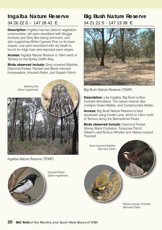
Ingalba Nature Reserve 34 26 22 S - 147 26 41 E
Description: Ingalba has two distinct vegetation communities, tall open woodland with Mugga Ironbark and Grey Box being dominant, and also supporting White Cypress Pine on its lower slopes. Low open woodland with dry heath is found on ridge tops and exposed open slopes.
Access: Ingalba Nature Reserve is 10km west of Temora on the Burley Griffin Way.
Birds observed include: Grey-crowned Babbler, Diamond Firetail, Painted and Black-chinned Honeyeaters, Hooded Robin, and Superb Parrot.
Barking Owl(Dean Ingwersen)
Hooded Robin(Dean Ingwersen)
Big Bush Nature Reserve 34 21 21 S - 147 13 38 E
Description: Like Ingalba, Big Bush is Box-Ironbark Woodland. The nature reserve also contains Green Mallee, and Cootamundra Wattle.
Access: Big Bush Nature Reserve is best accessed using Cedar Lane, which is 14km north of Temora along the Barmedman Road.
Birds observed include: Diamond Firetail, Glossy Black Cockatoo, Turquoise Parrot, Gilbert’s and Rufous Whistler and Yellow-rumped Thornbill.
Big Bush Nature Reserve (TEMP)
Grey-crowned Babbler (Bernard Clark)
Yellow-rumped Thornbill (Bernard Clark)
Bird Trails of the Riverina and South West Slopes of NSW 21
Combaning State Forest (TEMP)
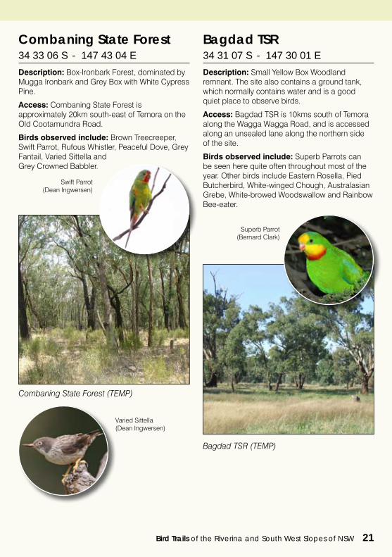
Combaning State Forest 34 33 06 S - 147 43 04 E
Description: Box-Ironbark Forest, dominated by Mugga Ironbark and Grey Box with White Cypress Pine.
Access: Combaning State Forest is approximately 20km south-east of Temora on the Old Cootamundra Road.
Birds observed include: Brown Treecreeper, Swift Parrot, Rufous Whistler, Peaceful Dove, Grey Fantail, Varied Sittella and Grey Crowned Babbler.
Swift Parrot(Dean Ingwersen)
Varied Sittella(Dean Ingwersen)
Bagdad TSR 34 31 07 S - 147 30 01 E
Description: Small Yellow Box Woodland remnant. The site also contains a ground tank, which normally contains water and is a good quiet place to observe birds.
Access: Bagdad TSR is 10kms south of Temora along the Wagga Wagga Road, and is accessed along an unsealed lane along the northern side of the site.
Birds observed include: Superb Parrots can be seen here quite often throughout most of the year. Other birds include Eastern Rosella, Pied Butcherbird, White-winged Chough, Australasian Grebe, White-browed Woodswallow and Rainbow Bee-eater.
Bagdad TSR (TEMP)
Superb Parrot(Bernard Clark)
22 Bird Trails of the Riverina and South West Slopes of NSW
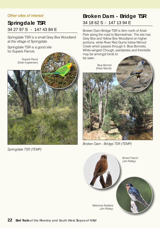
Springdale TSR 34 27 97 S - 147 43 84 E
Springdale TSR is a small Grey Box Woodland at the village of Springdale.
Springdale TSR is a good site for Superb Parrots
Other sites of interest Broken Dam - Bridge TSR 34 18 62 S - 147 13 94 E
Broken Dam-Bridge TSR is 5km north of Ariah Park along the road to Barmedman. The site has Grey Box and Yellow Box Woodland on higher portions, while River Red Gums follow Mirrool Creek which passes through it. Blue Bonnets, White-winged Chough, pardalotes and thornbills may be amongst birds to be seen.
Broken Dam - Bridge TSR (TEMP)
Blue Bonnet(Peter Merritt)
Springdale TSR (TEMP)
Brown Falcon(Jim Ridley)
Welcome Swallow(Jim Ridley)
Superb Parrot(Dean Ingwersen)
Bird Trails of the Riverina and South West Slopes of NSW 23
Tucked in between the Newell and Sturt Highways, there is an idyllic place that has managed to retain its rural Aussie character.
A place proudly described as the ‘Heart of Rural Heritage’ Coolamon and the Shire’s smaller towns of Ardlethan, Beckom, Ganmain, Marrar and Matong exude history, character and charm.
Take a step back to a more peaceful time and place - to fresh air and a slower pace. The best in country hospitality is available when you visit the cafes, antique and gift stores, museums and craft outlets that are sprinkled throughout the Shire. Beautifully presented parks provide ideal picnic or rest stops and our caravan parks are just a stone’s throw from quality recreational clubs and shopping.
Join in the many bird-watchers who seek out the 220+ species of birds found in our region and enjoy the varied sites and habitats on offer.
The simple things like finding a car park with ease and smiling faces provide the icing on the cake to this authentic, unpretentious rural experience.
Coolamon Shire Council55 Cowabbie StreetCoolamon NSW 2701
P: (02) 69273206E: [email protected]: www.coolamon.nsw.gov.au
0 5 10 20 30 40Km
COOLAMON SHIRECOUNCIL
Ardlethan
Dulah TSR
Berry Jerry Cemetery
Ganmain SF
Kindra SFGanmain
Coolamon
Lester SF
Matong
Yarranjerry SF
Wallaroobie SF
Matong SF Marrar
Marrar Cemetery
To Temora
To Temora / Sydney
To Griffith / Leeton
To Narrandera / Melbourne
To Narrandera / Melbourne
To Wagga Wagga
To Junee
Kindra SF
Mirrool
To West Wylong / Brisbane
Beckom
Birdwatching Sites Principal Additional Urban National Parks (NP) Nature Reserve (NR) State Forests (SF)Travelling Stock Reserves (TSR)Roadside Rest Areas (RRA)
Rivers
Roads Major Minor Un-sealed
Towns & Villages
KEY
Ganmain SF
Ardlethan SF
Beckom SF
Murumbang Reserve
Coolamon Shire
Coolamon Shire Council
24 Bird Trails of the Riverina and South West Slopes of NSW
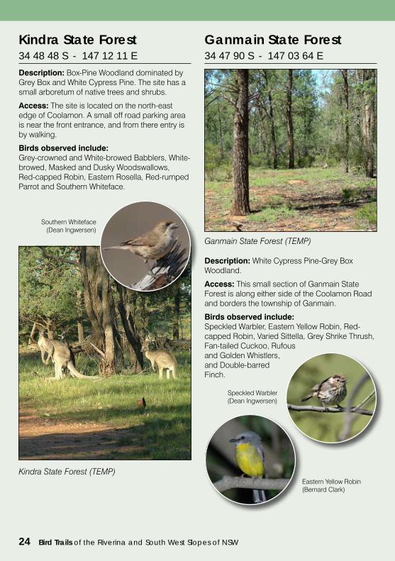
Kindra State Forest34 48 48 S - 147 12 11 E
Description: Box-Pine Woodland dominated by Grey Box and White Cypress Pine. The site has a small arboretum of native trees and shrubs.
Access: The site is located on the north-east edge of Coolamon. A small off road parking area is near the front entrance, and from there entry is by walking.
Birds observed include:Grey-crowned and White-browed Babblers, White-browed, Masked and Dusky Woodswallows, Red-capped Robin, Eastern Rosella, Red-rumped Parrot and Southern Whiteface.
Kindra State Forest (TEMP)
Southern Whiteface(Dean Ingwersen)
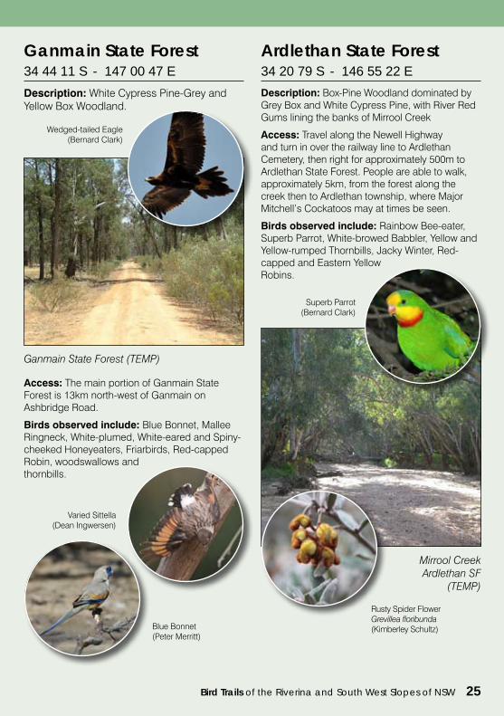
Description: White Cypress Pine-Grey Box Woodland.
Access: This small section of Ganmain State Forest is along either side of the Coolamon Road and borders the township of Ganmain.
Birds observed include:Speckled Warbler, Eastern Yellow Robin, Red-capped Robin, Varied Sittella, Grey Shrike Thrush, Fan-tailed Cuckoo, Rufous and Golden Whistlers, and Double-barred Finch.
Ganmain State Forest (TEMP)
Ganmain State Forest34 47 90 S - 147 03 64 E
Speckled Warbler(Dean Ingwersen)
Eastern Yellow Robin (Bernard Clark)
Bird Trails of the Riverina and South West Slopes of NSW 25
Ganmain State Forest34 44 11 S - 147 00 47 E
Description: White Cypress Pine-Grey and Yellow Box Woodland.
Ganmain State Forest (TEMP)
Wedged-tailed Eagle (Bernard Clark)
Access: The main portion of Ganmain State Forest is 13km north-west of Ganmain on Ashbridge Road.
Birds observed include: Blue Bonnet, Mallee Ringneck, White-plumed, White-eared and Spiny-cheeked Honeyeaters, Friarbirds, Red-capped Robin, woodswallows and thornbills.
Varied Sittella(Dean Ingwersen)
Blue Bonnet(Peter Merritt)
Ardlethan State Forest34 20 79 S - 146 55 22 E
Description: Box-Pine Woodland dominated by Grey Box and White Cypress Pine, with River Red Gums lining the banks of Mirrool Creek
Access: Travel along the Newell Highway and turn in over the railway line to Ardlethan Cemetery, then right for approximately 500m to Ardlethan State Forest. People are able to walk, approximately 5km, from the forest along the creek then to Ardlethan township, where Major Mitchell’s Cockatoos may at times be seen.
Birds observed include: Rainbow Bee-eater, Superb Parrot, White-browed Babbler, Yellow and Yellow-rumped Thornbills, Jacky Winter, Red-capped and Eastern Yellow Robins.
Rusty Spider Flower Grevillea floribunda (Kimberley Schultz)
Mirrool Creek Ardlethan SF
(TEMP)
Superb Parrot(Bernard Clark)
26 Bird Trails of the Riverina and South West Slopes of NSW
Other sites of interest
Berry Jerry Cemetery 34 44 35 S - 147 16 58 E
Small White Box Woodland remnant.
Marrar Cemetery 34 49 94 S - 147 22 87 E
Small White Box Woodland remnant 2km east of Marrar on the Junee Road.
Beckom State Forest 34 18 95 S - 147 02 43 E
Box-Pine Woodland on the north east edge of Beckom.
Dullah TSR 34 39 54 S - 147 04 57 E
Box-Buloke Woodland along the Ardlethan Road.
Matong State Forest 34 53 34 S - 146 55 68 E
Box-Pine Woodland on Deep Water Road.
Urban
Murumbang Reserve 34 47 55 S - 147 02 43 E
Murumbang Reserve is within Ganmain just north-east of the main shopping area. The reserve has walking trails, birdhide and interpretive information for visitors.
Murumbang Reserve(Evoke Photography)
Marrar Cemetery (TEMP) Superb Parrot
(Dean Ingwersen)
Bird Trails of the Riverina and South West Slopes of NSW 27
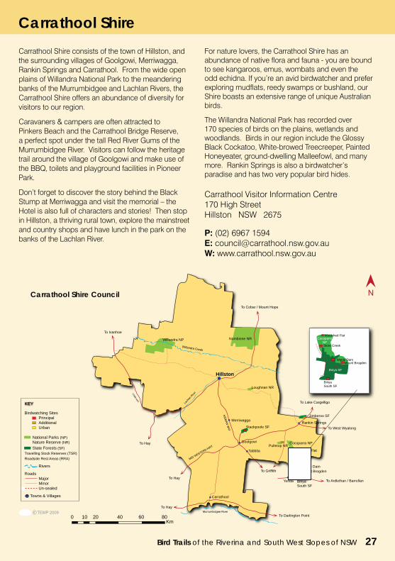
Carrathool Shire consists of the town of Hillston, and the surrounding villages of Goolgowi, Merriwagga, Rankin Springs and Carrathool. From the wide open plains of Willandra National Park to the meandering banks of the Murrumbidgee and Lachlan Rivers, the Carrathool Shire offers an abundance of diversity for visitors to our region.
Caravaners & campers are often attracted to Pinkers Beach and the Carrathool Bridge Reserve, a perfect spot under the tall Red River Gums of the Murrumbidgee River. Visitors can follow the heritage trail around the village of Goolgowi and make use of the BBQ, toilets and playground facilities in Pioneer Park.
Don’t forget to discover the story behind the Black Stump at Merriwagga and visit the memorial – the Hotel is also full of characters and stories! Then stop in Hillston, a thriving rural town, explore the mainstreet and country shops and have lunch in the park on the banks of the Lachlan River.
For nature lovers, the Carrathool Shire has an abundance of native flora and fauna - you are bound to see kangaroos, emus, wombats and even the odd echidna. If you’re an avid birdwatcher and prefer exploring mudflats, reedy swamps or bushland, our Shire boasts an extensive range of unique Australian birds.
The Willandra National Park has recorded over 170 species of birds on the plains, wetlands and woodlands. Birds in our region include the Glossy Black Cockatoo, White-browed Treecreeper, Painted Honeyeater, ground-dwelling Malleefowl, and many more. Rankin Springs is also a birdwatcher’s paradise and has two very popular bird hides.
Carrathool Visitor Information Centre170 High StreetHillston NSW 2675
P: (02) 6967 1594E: [email protected]: www.carrathool.nsw.gov.au
To Cobar / Mount Hope
To Griffith
To West Wyalong
To Ivanhoe
0 10 20 40 60 80Km
Cocoparra NP
CARRATHOOL SHIRECOUNCIL
To Hay
To Hay
Hillston
Merriwagga
Goolgowi
Rankin Springs
Tabbita
Carrathool
Yenda
Willandra NP Nombinne NR
Pulletop NR
Jimberoo SF
To Lake Cargelligo
Stackpoole SF
Binya South SF
Woolshed Flat
Store Creek
To Hay
To Darlington Point
Loughnan NR
To Ardlethan / Barrellan
Birdwatching Sites Principal Additional Urban National Parks (NP) Nature Reserve (NR) State Forests (SF)Travelling Stock Reserves (TSR)Roadside Rest Areas (RRA)
Rivers
Roads Major Minor Un-sealed
Towns & Villages
KEY
Mount BrogdenWattle Dam
Binya SF
Mount Brogden
Cocoparra NP
Wattle Dam
Store Creek
Binya SF
Woolshed Flat
Binya South SF
Carrathool Shire
Carrathool Shire Council
28 Bird Trails of the Riverina and South West Slopes of NSW
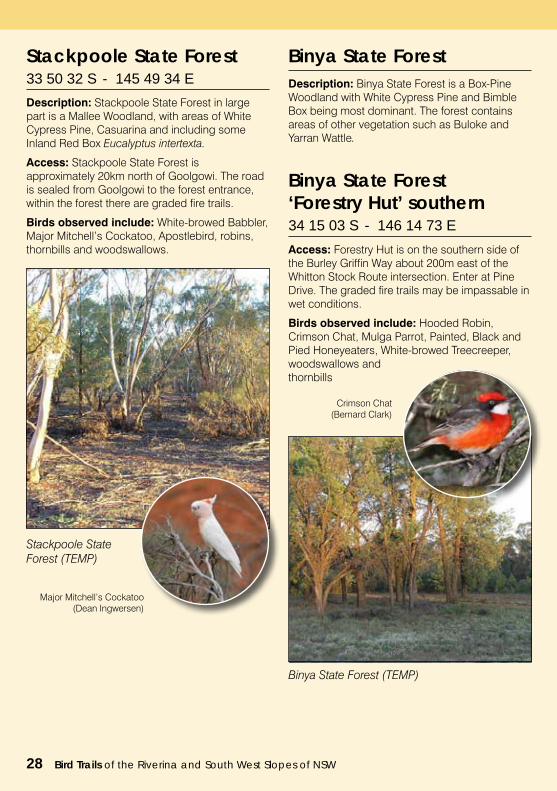
Stackpoole State Forest 33 50 32 S - 145 49 34 E
Description: Stackpoole State Forest in large part is a Mallee Woodland, with areas of White Cypress Pine, Casuarina and including some Inland Red Box Eucalyptus intertexta.
Access: Stackpoole State Forest is approximately 20km north of Goolgowi. The road is sealed from Goolgowi to the forest entrance, within the forest there are graded fire trails.
Birds observed include: White-browed Babbler, Major Mitchell’s Cockatoo, Apostlebird, robins, thornbills and woodswallows.
Stackpoole State Forest (TEMP)
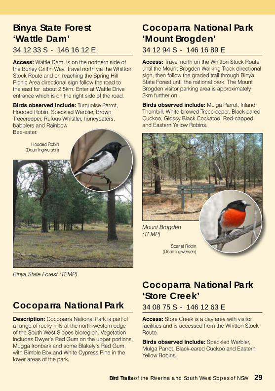
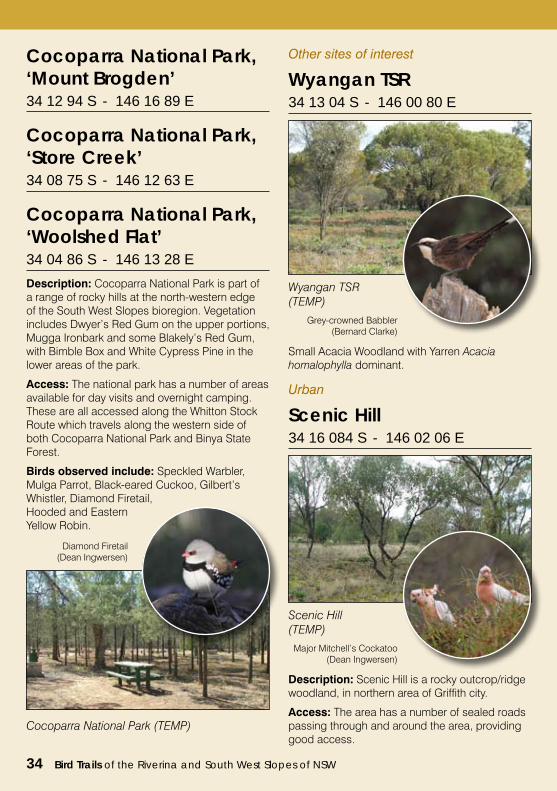
Binya State Forest Description: Binya State Forest is a Box-Pine Woodland with White Cypress Pine and Bimble Box being most dominant. The forest contains areas of other vegetation such as Buloke and Yarran Wattle.
Binya State Forest‘Forestry Hut’ southern 34 15 03 S - 146 14 73 E
Access: Forestry Hut is on the southern side of the Burley Griffin Way about 200m east of the Whitton Stock Route intersection. Enter at Pine Drive. The graded fire trails may be impassable in wet conditions.
Birds observed include: Hooded Robin, Crimson Chat, Mulga Parrot, Painted, Black and Pied Honeyeaters, White-browed Treecreeper, woodswallows and thornbills
Binya State Forest (TEMP)
Crimson Chat(Bernard Clark)
Major Mitchell’s Cockatoo (Dean Ingwersen)
Bird Trails of the Riverina and South West Slopes of NSW 29
Binya State Forest‘Wattle Dam’ 34 12 33 S - 146 16 12 E
Access: Wattle Dam is on the northern side of the Burley Griffin Way. Travel north via the Whitton Stock Route and on reaching the Spring Hill Picnic Area directional sign follow the road to the east for about 2.5km. Enter at Wattle Drive entrance which is on the right side of the road.
Birds observed include: Turquoise Parrot, Hooded Robin, Speckled Warbler, Brown Treecreeper, Rufous Whistler, honeyeaters, babblers and Rainbow Bee-eater.
Binya State Forest (TEMP)
Hooded Robin(Dean Ingwersen)
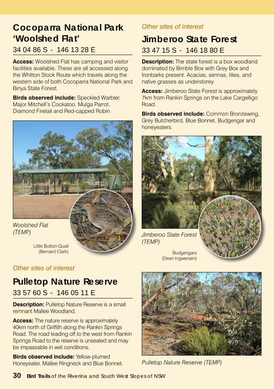
Cocoparra National ParkDescription: Cocoparra National Park is part of a range of rocky hills at the north-western edge of the South West Slopes bioregion. Vegetation includes Dwyer’s Red Gum on the upper portions, Mugga Ironbark and some Blakely’s Red Gum, with Bimble Box and White Cypress Pine in the lower areas of the park.
Access: Travel north on the Whitton Stock Route until the Mount Brogden Walking Track directional sign, then follow the graded trail through Binya State Forest until the national park. The Mount Brogden visitor parking area is approximately 2km further on.
Birds observed include: Mulga Parrot, Inland Thornbill, White-browed Treecreeper, Black-eared Cuckoo, Glossy Black Cockatoo, Red-capped and Eastern Yellow Robins.
Cocoparra National Park ‘Mount Brogden’34 12 94 S - 146 16 89 E
Scarlet Robin(Dean Ingwersen)
Mount Brogden(TEMP)
Access: Store Creek is a day area with visitor facilities and is accessed from the Whitton Stock Route.
Birds observed include: Speckled Warbler, Mulga Parrot, Black-eared Cuckoo and Eastern Yellow Robins.
Cocoparra National Park ‘Store Creek’34 08 75 S - 146 12 63 E
30 Bird Trails of the Riverina and South West Slopes of NSW
Access: Woolshed Flat has camping and visitor facilities available. These are all accessed along the Whitton Stock Route which travels along the western side of both Cocoparra National Park and Binya State Forest.
Birds observed include: Speckled Warbler, Major Mitchell’s Cockatoo, Mulga Parrot, Diamond Firetail and Red-capped Robin.
Cocoparra National Park ‘Woolshed Flat’34 04 86 S - 146 13 28 E
Woolshed Flat (TEMP)
Little Button-Quail(Bernard Clark)
Other sites of interest
Jimberoo State Forest 33 47 15 S - 146 18 80 E
Description: The state forest is a box woodland dominated by Bimble Box with Grey Box and Ironbarks present. Acacias, sennas, lilies, and native grasses as understorey.
Access: Jimberoo State Forest is approximately 7km from Rankin Springs on the Lake Cargelligo Road.
Birds observed include: Common Bronzewing, Grey Butcherbird, Blue Bonnet, Budgerigar and honeyeaters.
Jimberoo State Forest (TEMP)
Description: Pulletop Nature Reserve is a small remnant Mallee Woodland.
Access: The nature reserve is approximately 40km north of Griffith along the Rankin Springs Road. The road leading off to the west from Rankin Springs Road to the reserve is unsealed and may be impassable in wet conditions.
Birds observed include: Yellow-plumed Honeyeater, Mallee Ringneck and Blue Bonnet.
Pulletop Nature Reserve33 57 60 S - 146 05 11 E
Budgerigars(Dean Ingwersen)
Pulletop Nature Reserve (TEMP)
Other sites of interest
Bird Trails of the Riverina and South West Slopes of NSW 31
Famous for its designer, Walter Burley Griffin, the city boasts his famous circuits and wide, tree-lined streets, distinct from his design of Canberra, offering a contemporary yet country feel.
The city is blessed with a wonderful blend of cultures and people who are passionate about their food. Visitors and locals revel in the social atmosphere of superb fresco and fine dining.
You’ll find the locals love for cuisine is complimented by a love of wine. The region is the largest wine growing area in New South Wales, exporting around the world. Be sure to try some of the distinct sweet botrytis wines, spicy reds and fruity whites; there is something to suit every connoisseur.
In Griffith there are a range of other experiences to enjoy. Take time to explore Scenic Hill which provides panoramic views
over the city and surrounding farmlands. It is also the location of Pioneer Park Museum, the Italian Museum, and the Hermit’s Caves of Valerio Ricetti.
There is a wide choice of accommodation available in the city and surrounds from hotels, caravan parks, self contained apartments, motels through to farm stays and B & B’s. A city of celebration, Griffith hosts multicultural festivals, craft and antique shows, garden festivals, food and wine events. There’s something for the whole family to enjoy.
Griffith Visitors Information CentreCnr Banna & Jondaryan AvenueGRIFFITH NSW 2680
P: 1800 681 141E: [email protected]: www.griffith.com.au
To Leeton
GRIFFITH SHIRECOUNCIL
Lake Wyangan
0 5 10 20 30Km
Griffith
To Barellan / Ardlethan
To Goolgowi / Hillston To Rankin Springs
Campbell’s Swamp
Wyangan TSR
Nericon Swamp
Scenic Hill
Yoogali
Hanwood
YendaBinya SF
Mount Brogden
Cocoparra NP
Wattle Dam
Store Creek
Binya SF
Woolshed Flat
Beelbangera
Birdwatching Sites Principal Additional Urban National Parks (NP) Nature Reserve (NR) State Forests (SF)Travelling Stock Reserves (TSR)Roadside Rest Areas (RRA)
Rivers
Roads Major Minor Un-sealed
Towns & Villages
KEY
Binya South SF
To Whitton
To Carrathool
Darlington Point
Murrumbidgee Valley Regional Park
Griffith City Council
Griffith City Council
32 Bird Trails of the Riverina and South West Slopes of NSW
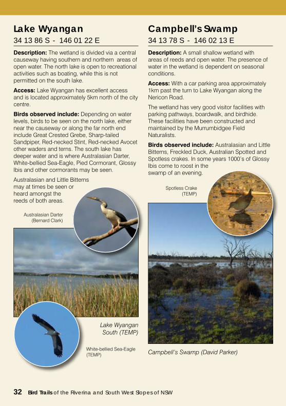
Lake Wyangan 34 13 86 S - 146 01 22 E
Description: The wetland is divided via a central causeway having southern and northern areas of open water. The north lake is open to recreational activities such as boating, while this is not permitted on the south lake.
Access: Lake Wyangan has excellent access and is located approximately 5km north of the city centre.
Birds observed include: Depending on water levels, birds to be seen on the north lake, either near the causeway or along the far north end include Great Crested Grebe, Sharp-tailed Sandpiper, Red-necked Stint, Red-necked Avocet other waders and terns. The south lake has deeper water and is where Australasian Darter, White-bellied Sea-Eagle, Pied Cormorant, Glossy Ibis and other cormorants may be seen.
Australasian and Little Bitterns may at times be seen or heard amongst the reeds of both areas.
Lake Wyangan South (TEMP)
Australasian Darter(Bernard Clark)
White-bellied Sea-Eagle(TEMP)
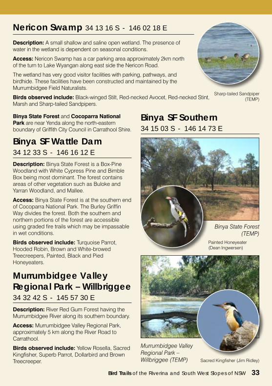
Campbell’s Swamp 34 13 78 S - 146 02 13 E
Description: A small shallow wetland with areas of reeds and open water. The presence of water in the wetland is dependent on seasonal conditions.
Access: With a car parking area approximately 1km past the turn to Lake Wyangan along the Nericon Road.
The wetland has very good visitor facilities with parking pathways, boardwalk, and birdhide. These facilities have been constructed and maintained by the Murrumbidgee Field Naturalists.
Birds observed include: Australasian and Little Bitterns, Freckled Duck, Australian Spotted and Spotless crakes. In some years 1000’s of Glossy Ibis come to roost in the swamp of an evening.
Campbell’s Swamp (David Parker)
Spotless Crake(TEMP)
Bird Trails of the Riverina and South West Slopes of NSW 33
Nericon Swamp 34 13 16 S - 146 02 18 E
Description: A small shallow and saline open wetland. The presence of water in the wetland is dependent on seasonal conditions.
Access: Nericon Swamp has a car parking area approximately 2km north of the turn to Lake Wyangan along east side the Nericon Road.
The wetland has very good visitor facilities with parking, pathways, and birdhide. These facilities have been constructed and maintained by the Murrumbidgee Field Naturalists.
Birds observed include: Black-winged Stilt, Red-necked Avocet, Red-necked Stint, Marsh and Sharp-tailed Sandpipers.
Sharp-tailed Sandpiper(TEMP)
Binya State Forest and Cocoparra National Park are near Yenda along the north-eastern boundary of Griffith City Council in Carrathool Shire.
Description: Binya State Forest is a Box-Pine Woodland with White Cypress Pine and Bimble Box being most dominant. The forest contains areas of other vegetation such as Buloke and Yarran Woodland, and Mallee.
Access: Binya State Forest is at the southern end of Cocoparra National Park. The Burley Griffin Way divides the forest. Both the southern and northern portions of the forest are accessible using graded fire trails which may be impassable in wet conditions.
Birds observed include: Turquoise Parrot, Hooded Robin, Brown and White-browed Treecreepers, Painted, Black and Pied Honeyeaters.
Painted Honeyeater (Dean Ingwersen)
Binya SF Wattle Dam34 12 33 S - 146 16 12 E
Binya SF Southern34 15 03 S - 146 14 73 E
Murrumbidgee Valley Regional Park – Willbriggee 34 32 42 S - 145 57 30 E
Description: River Red Gum Forest having the Murrumbidgee River along its southern boundary.
Access: Murrumbidgee Valley Regional Park, approximately 5 km along the River Road to Carrathool.
Birds observed include: Yellow Rosella, Sacred Kingfisher, Superb Parrot, Dollarbird and Brown Treecreeper.
Murrumbidgee Valley Regional Park – Willbriggee (TEMP) Sacred Kingfisher (Jim Ridley)
Binya State Forest (TEMP)
34 Bird Trails of the Riverina and South West Slopes of NSW
Cocoparra National Park, ‘Store Creek’34 08 75 S - 146 12 63 E
Cocoparra National Park, ‘Mount Brogden’34 12 94 S - 146 16 89 E
Cocoparra National Park, ‘Woolshed Flat’34 04 86 S - 146 13 28 E
Description: Cocoparra National Park is part of a range of rocky hills at the north-western edge of the South West Slopes bioregion. Vegetation includes Dwyer’s Red Gum on the upper portions, Mugga Ironbark and some Blakely’s Red Gum, with Bimble Box and White Cypress Pine in the lower areas of the park.
Access: The national park has a number of areas available for day visits and overnight camping. These are all accessed along the Whitton Stock Route which travels along the western side of both Cocoparra National Park and Binya State Forest.
Birds observed include: Speckled Warbler, Mulga Parrot, Black-eared Cuckoo, Gilbert’s Whistler, Diamond Firetail, Hooded and Eastern Yellow Robin.
Cocoparra National Park (TEMP)
Diamond Firetail(Dean Ingwersen)
Other sites of interest
Wyangan TSR 34 13 04 S - 146 00 80 E
Wyangan TSR (TEMP)
Grey-crowned Babbler(Bernard Clarke)
Urban
Scenic Hill 34 16 084 S - 146 02 06 E
Scenic Hill (TEMP)
Major Mitchell’s Cockatoo(Dean Ingwersen)
Description: Scenic Hill is a rocky outcrop/ridge woodland, in northern area of Griffith city.
Access: The area has a number of sealed roads passing through and around the area, providing good access.
Small Acacia Woodland with Yarren Acacia homalophylla dominant.
Bird Trails of the Riverina and South West Slopes of NSW 35
Leeton Shire
The Walter Burley Griffin designed town with its well appointed public parks, tree lined streets and an outstanding main streetscape of Art Deco architecture, make it a very attractive and inviting town.
Experience the Leeton SunRice Centre, where you will be treated to a presentation on Australia’s Rice industry, which includes viewing a video and rice tasting.
Beautifully maintained buildings that reflect the Art Deco era are a show piece of Leeton, which include the Roxy Community Theatre, Historic Hydro, main water towers and the Government Offices in Chelmsford place.
A delightful and rewarding spot for birdwatchers on the northern outskirts of town, Fivebough Swamp is a sanctuary and important feeding ground for migratory waterbirds.
The nearby Murrumbidgee River and recently
proclaimed Murrumbidgee Valley National Park, have wonderful forest drives, sandy beaches and excellent fishing spots. Gogeldrie Weir is a fantastic recreational area on the Murrumbidgee River worthy of inspection and the historic mansion of irrigation pioneer, Sir Samuel McCaughey is a ‘must see’ attraction.
The Courthouse and Gaol Museum at Whitton contains a comprehensive collection of early farming and irrigation equipment. The Yanco Powerhouse Museum was the original power generating station for the irrigation scheme.
Leeton Visitor Information CentreYanco AvenueLeeton NSW 2705
P: (02) 6953 6481E: [email protected]: www.leetontourism.com.au
To Griffith / Yenda LEETON SHIRECOUNCIL
Whitton Punt TSRGogelderie Weir Yanco Common
Wumbulgal TSR
0 5 10 20Km To Narrandera
Murrami
WamoonWhitton
YancoGogelderie Weir
Tuckerbil SwampKoonadan HS
Yanco Weir/TSR
Billenbah SF
STURT HWY
To Narrandera / Wagga
To Barellan / Ardlethan
To Barellan / Binya
To Hanwood / Griffith
To Hay / Adelaide
To Darlington Point
Binya SF
Cocoparra NP
Leeton
Grahame’s Grave
Fivebough Wetlands
Birdwatching Sites Principal Additional Urban National Parks (NP) Nature Reserve (NR)
Travelling Stock Reserves (TSR)Roadside Rest Areas (RRA)
Rivers
Roads Major Minor Un-sealed
Towns & Villages
KEY
Brick Kiln
Murrumbidgee Valley National Park
Murrumbidgee Valley National Park
Murrumbidgee Valley National Park
Murrumbidgee Valley National Park
Leeton Shire Council
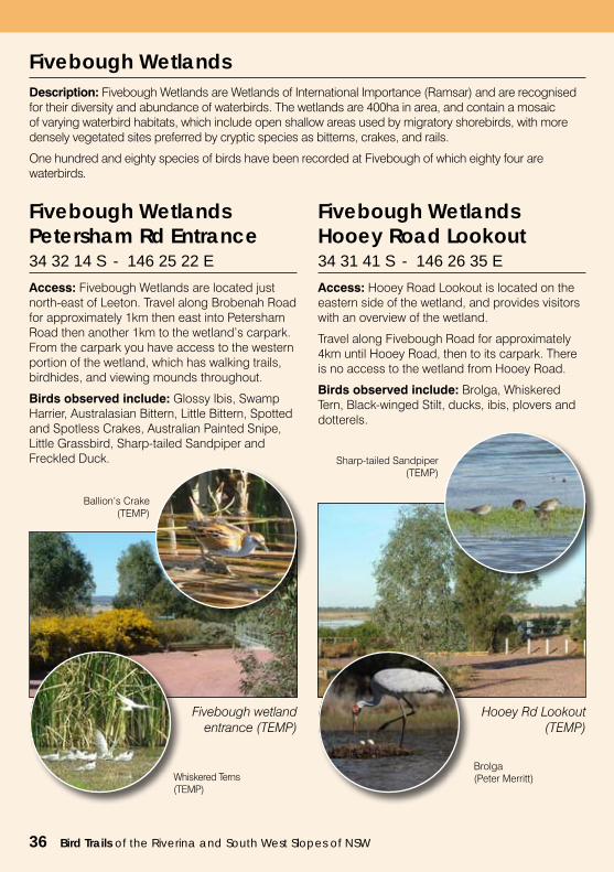
Fivebough Wetlands Description: Fivebough Wetlands are Wetlands of International Importance (Ramsar) and are recognised for their diversity and abundance of waterbirds. The wetlands are 400ha in area, and contain a mosaic of varying waterbird habitats, which include open shallow areas used by migratory shorebirds, with more densely vegetated sites preferred by cryptic species as bitterns, crakes, and rails.
One hundred and eighty species of birds have been recorded at Fivebough of which eighty four are waterbirds.
Fivebough Wetlands Petersham Rd Entrance 34 32 14 S - 146 25 22 E
Access: Fivebough Wetlands are located just north-east of Leeton. Travel along Brobenah Road for approximately 1km then east into Petersham Road then another 1km to the wetland’s carpark. From the carpark you have access to the western portion of the wetland, which has walking trails, birdhides, and viewing mounds throughout.
Birds observed include: Glossy Ibis, Swamp Harrier, Australasian Bittern, Little Bittern, Spotted and Spotless Crakes, Australian Painted Snipe, Little Grassbird, Sharp-tailed Sandpiper and Freckled Duck.
Fivebough Wetlands Hooey Road Lookout 34 31 41 S - 146 26 35 E
Access: Hooey Road Lookout is located on the eastern side of the wetland, and provides visitors with an overview of the wetland.
Travel along Fivebough Road for approximately 4km until Hooey Road, then to its carpark. There is no access to the wetland from Hooey Road.
Birds observed include: Brolga, Whiskered Tern, Black-winged Stilt, ducks, ibis, plovers and dotterels.
Fivebough wetland entrance (TEMP)
Ballion’s Crake(TEMP)
Whiskered Terns(TEMP)
Hooey Rd Lookout (TEMP)
Sharp-tailed Sandpiper(TEMP)
Brolga(Peter Merritt)
36 Bird Trails of the Riverina and South West Slopes of NSW
Bird Trails of the Riverina and South West Slopes of NSW 37
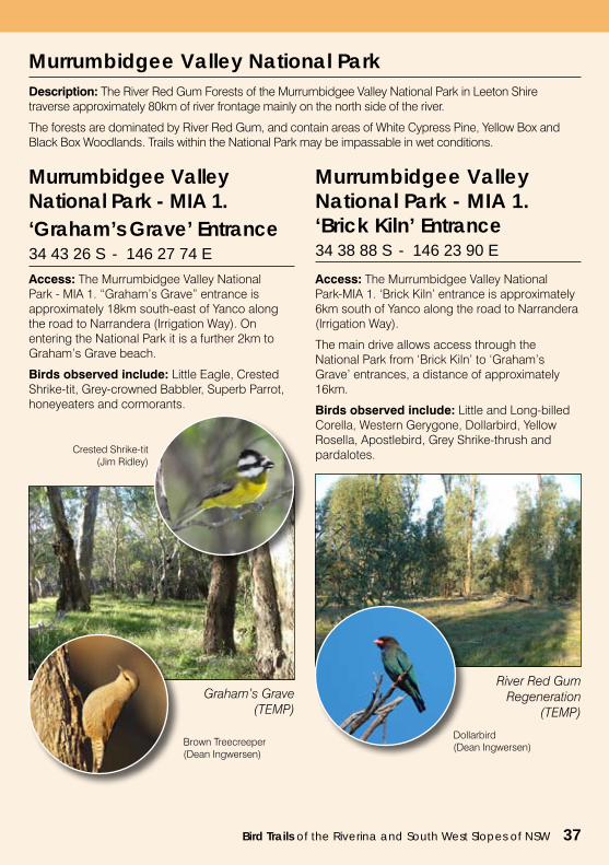
Murrumbidgee Valley National ParkDescription: The River Red Gum Forests of the Murrumbidgee Valley National Park in Leeton Shire traverse approximately 80km of river frontage mainly on the north side of the river.
The forests are dominated by River Red Gum, and contain areas of White Cypress Pine, Yellow Box and Black Box Woodlands. Trails within the National Park may be impassable in wet conditions.
Murrumbidgee Valley National Park - MIA 1. ‘Graham’s Grave’ Entrance 34 43 26 S - 146 27 74 E
Access: The Murrumbidgee Valley National Park - MIA 1. “Graham’s Grave” entrance is approximately 18km south-east of Yanco along the road to Narrandera (Irrigation Way). On entering the National Park it is a further 2km to Graham’s Grave beach.
Birds observed include: Little Eagle, Crested Shrike-tit, Grey-crowned Babbler, Superb Parrot, honeyeaters and cormorants.
Murrumbidgee Valley National Park - MIA 1. ‘Brick Kiln’ Entrance34 38 88 S - 146 23 90 E
Access: The Murrumbidgee Valley National Park-MIA 1. ‘Brick Kiln’ entrance is approximately 6km south of Yanco along the road to Narrandera (Irrigation Way).
The main drive allows access through the National Park from ‘Brick Kiln’ to ‘Graham’s Grave’ entrances, a distance of approximately 16km.
Birds observed include: Little and Long-billed Corella, Western Gerygone, Dollarbird, Yellow Rosella, Apostlebird, Grey Shrike-thrush and pardalotes.
Graham’s Grave (TEMP)
Crested Shrike-tit(Jim Ridley)
Brown Treecreeper (Dean Ingwersen)
River Red Gum Regeneration
(TEMP)
Dollarbird(Dean Ingwersen)
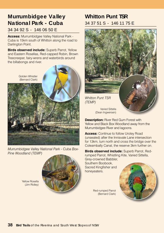
Murrumbidgee Valley National Park - Cuba 34 34 92 S - 146 06 50 EAccess: Murrumbidgee Valley National Park - Cuba is 15km south of Whitton along the road to Darlington Point.
Birds observed include: Superb Parrot, Yellow and Eastern Rosellas, Red-capped Robin, Brown Treecreeper, fairy-wrens and waterbirds around the billabongs and river.
Murrumbidgee Valley National Park - Cuba Box-Pine Woodland (TEMP)
Golden Whistler(Bernard Clark)
Yellow Rosella(Jim Ridley)
Whitton Punt TSR 34 37 51 S - 146 11 75 E
Description: River Red Gum Forest with Yellow and Black Box Woodland away from the Murrumbidgee River and lagoons.
Access: Continue to follow Uroley Road (unsealed) after the Innisvale Lane intersection for 13km, turn north and cross the bridge over the Coleambally Canal, the reserve 3km further on.
Birds observed include: Superb Parrot, Red-rumped Parrot, Whistling Kite, Varied Sittella, Grey-crowned Babbler, Southern Boobook, Sacred Kingfisher and honeyeaters.
Whitton Punt TSR (TEMP)
Varied Sittella(Dean Ingwersen)
Red-rumped Parrot (Bernard Clark)
38 Bird Trails of the Riverina and South West Slopes of NSW
Bird Trails of the Riverina and South West Slopes of NSW 39
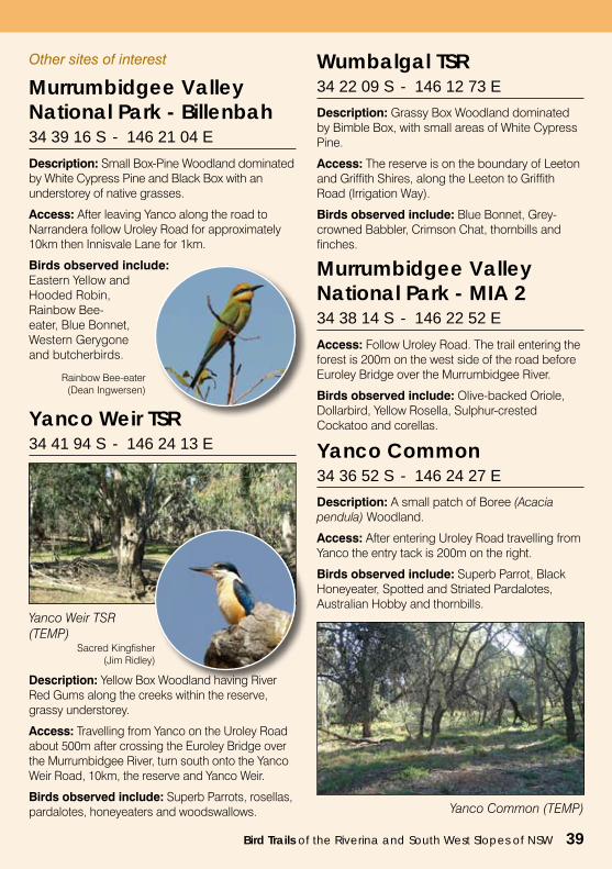
Wumbalgal TSR 34 22 09 S - 146 12 73 E
Description: Grassy Box Woodland dominated by Bimble Box, with small areas of White Cypress Pine.
Access: The reserve is on the boundary of Leeton and Griffith Shires, along the Leeton to Griffith Road (Irrigation Way).
Birds observed include: Blue Bonnet, Grey-crowned Babbler, Crimson Chat, thornbills and finches.
Other sites of interest
Murrumbidgee Valley National Park - MIA 2 34 38 14 S - 146 22 52 E
Access: Follow Uroley Road. The trail entering the forest is 200m on the west side of the road before Euroley Bridge over the Murrumbidgee River.
Birds observed include: Olive-backed Oriole, Dollarbird, Yellow Rosella, Sulphur-crested Cockatoo and corellas.
Murrumbidgee Valley National Park - Billenbah 34 39 16 S - 146 21 04 E
Description: Small Box-Pine Woodland dominated by White Cypress Pine and Black Box with an understorey of native grasses.
Access: After leaving Yanco along the road to Narrandera follow Uroley Road for approximately 10km then Innisvale Lane for 1km.
Birds observed include: Eastern Yellow and Hooded Robin, Rainbow Bee-eater, Blue Bonnet, Western Gerygone and butcherbirds.
Rainbow Bee-eater(Dean Ingwersen)
Yanco Weir TSR 34 41 94 S - 146 24 13 E
Description: Yellow Box Woodland having River Red Gums along the creeks within the reserve, grassy understorey.
Access: Travelling from Yanco on the Uroley Road about 500m after crossing the Euroley Bridge over the Murrumbidgee River, turn south onto the Yanco Weir Road, 10km, the reserve and Yanco Weir.
Birds observed include: Superb Parrots, rosellas, pardalotes, honeyeaters and woodswallows.
Yanco Weir TSR (TEMP)
Sacred Kingfisher(Jim Ridley)
Yanco Common 34 36 52 S - 146 24 27 E
Description: A small patch of Boree (Acacia pendula) Woodland.
Access: After entering Uroley Road travelling from Yanco the entry tack is 200m on the right.
Birds observed include: Superb Parrot, Black Honeyeater, Spotted and Striated Pardalotes, Australian Hobby and thornbills.
Yanco Common (TEMP)
40 Bird Trails of the Riverina and South West Slopes of NSW
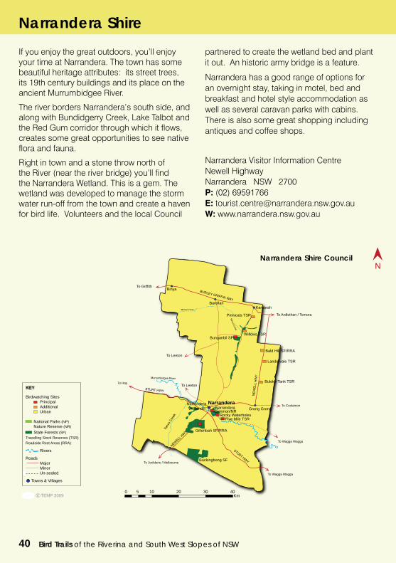
If you enjoy the great outdoors, you’ll enjoy your time at Narrandera. The town has some beautiful heritage attributes: its street trees, its 19th century buildings and its place on the ancient Murrumbidgee River.
The river borders Narrandera’s south side, and along with Bundidgerry Creek, Lake Talbot and the Red Gum corridor through which it flows, creates some great opportunities to see native flora and fauna.
Right in town and a stone throw north of the River (near the river bridge) you’ll find the Narrandera Wetland. This is a gem. The wetland was developed to manage the storm water run-off from the town and create a haven for bird life. Volunteers and the local Council
partnered to create the wetland bed and plant it out. An historic army bridge is a feature.
Narrandera has a good range of options for an overnight stay, taking in motel, bed and breakfast and hotel style accommodation as well as several caravan parks with cabins. There is also some great shopping including antiques and coffee shops.
Narrandera Visitor Information CentreNewell HighwayNarrandera NSW 2700P: (02) 69591766E: [email protected]: www.narrandera.nsw.gov.au
To Griffith
Gillenbah SF
NARRANDERA SHIRECOUNCIL
Bald Hill SF/RRA
Landervale TSR
Buloke Tank TSR
0 5 10 20 30 40Km
Bunganbil SF
To Jerilderie / Melbourne
To Hay
To Wagga Wagga
Binya
BarellanKamarah
Grong GrongNarrandera
To Coolamon
To Ardlethan / Temora
To Leeton
To Leeton
Five Mile TSR
Gillenbah SF/RRA
Buckingbong SF
Birdwatching Sites Principal Additional Urban National Parks (NP) Nature Reserve (NR) State Forests (SF)Travelling Stock Reserves (TSR)Roadside Rest Areas (RRA)
Rivers
Roads Major Minor Un-sealed
Towns & Villages
KEY
To Wagga Wagga
Willows TSR
Narrandera Wetlands
Pinnicals TSR
Narrandera Common/NR
Rocky Waterholes
Narrandera Shire
Narrandera Shire Council
Bird Trails of the Riverina and South West Slopes of NSW 41
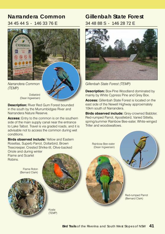
Narrandera Common34 45 44 S - 146 33 76 E
Description: River Red Gum Forest bounded in the south by the Murrumbidgee River and Narrandera Nature Reserve.
Access: Entry to the common is on the southern side of the main supply canal near the entrance to Lake Talbot. Travel is via graded roads, and it is advisable not to access the common during wet conditions.
Birds observed include: Yellow and Eastern Rosellas, Superb Parrot, Dollarbird, Brown Treecreeper, Crested Shrike-tit, Olive-backed Oriole and during winter Flame and Scarlet Robins.
Dollarbird(Dean Ingwersen)
Narrandera Common (TEMP)
Gillenbah State Forest 34 48 88 S - 146 28 72 E
Description: Box-Pine Woodland dominated by mainly by White Cypress Pine and Grey Box.
Access: Gillenbah State Forest is located on the east side of the Newell Highway approximately 10km south of Narrandera.
Birds observed include: Grey-crowned Babbler, Red-rumped Parrot, Apostlebird, Varied Sittella, spring/summer Rainbow Bee-eater, White-winged Triller and woodswallows.
Rainbow Bee-eater(Dean Ingwersen)
Gillenbah State Forest (TEMP)
Red-rumped Parrot (Bernard Clark)
Koala(TEMP)
Flame Robin(Bernard Clark)
42 Bird Trails of the Riverina and South West Slopes of NSW
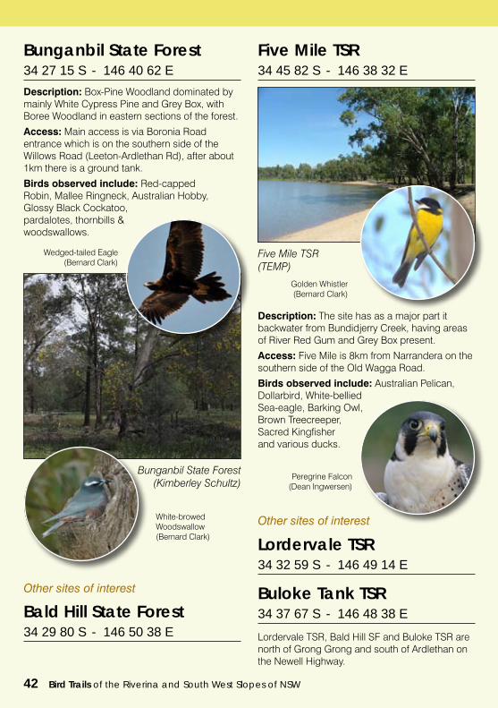
Bunganbil State Forest34 27 15 S - 146 40 62 E
Description: Box-Pine Woodland dominated by mainly White Cypress Pine and Grey Box, with Boree Woodland in eastern sections of the forest.
Access: Main access is via Boronia Road entrance which is on the southern side of the Willows Road (Leeton-Ardlethan Rd), after about 1km there is a ground tank.
Birds observed include: Red-capped Robin, Mallee Ringneck, Australian Hobby, Glossy Black Cockatoo, pardalotes, thornbills & woodswallows.
Bunganbil State Forest (Kimberley Schultz)
Wedged-tailed Eagle(Bernard Clark)
White-browed Woodswallow(Bernard Clark)
Five Mile TSR34 45 82 S - 146 38 32 E
Description: The site has as a major part it backwater from Bundidjerry Creek, having areas of River Red Gum and Grey Box present.
Access: Five Mile is 8km from Narrandera on the southern side of the Old Wagga Road.
Birds observed include: Australian Pelican, Dollarbird, White-bellied Sea-eagle, Barking Owl, Brown Treecreeper, Sacred Kingfisher and various ducks.
Five Mile TSR (TEMP)
Peregrine Falcon(Dean Ingwersen)
Golden Whistler(Bernard Clark)
Buloke Tank TSR 34 37 67 S - 146 48 38 E
Lordervale TSR, Bald Hill SF and Buloke TSR are north of Grong Grong and south of Ardlethan on the Newell Highway.
Lordervale TSR 34 32 59 S - 146 49 14 E
Other sites of interest
Bald Hill State Forest 34 29 80 S - 146 50 38 E
Other sites of interest
Bird Trails of the Riverina and South West Slopes of NSW 43
Rocky Waterholes (TEMP)
Willows TSR 34 24 84 S - 146 43 53 E
Willows TSR (TEMP)
Pinnicals TSR 34 21 29 S - 146 46 43 E
Box - Pine Woodland along the Kamarah Road.
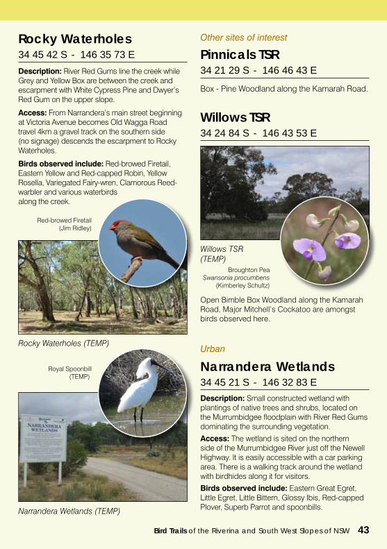
Rocky Waterholes 34 45 42 S - 146 35 73 E
Description: River Red Gums line the creek while Grey and Yellow Box are between the creek and escarpment with White Cypress Pine and Dwyer’s Red Gum on the upper slope.
Access: From Narrandera’s main street beginning at Victoria Avenue becomes Old Wagga Road travel 4km a gravel track on the southern side (no signage) descends the escarpment to Rocky Waterholes.
Birds observed include: Red-browed Firetail, Eastern Yellow and Red-capped Robin, Yellow Rosella, Variegated Fairy-wren, Clamorous Reed-warbler and various waterbirds along the creek.
Red-browed Firetail(Jim Ridley)
Broughton PeaSwansonia procumbens
(Kimberley Schultz)
Open Bimble Box Woodland along the Kamarah Road, Major Mitchell’s Cockatoo are amongst birds observed here.
Other sites of interest
Description: Small constructed wetland with plantings of native trees and shrubs, located on the Murrumbidgee floodplain with River Red Gums dominating the surrounding vegetation.
Access: The wetland is sited on the northern side of the Murrumbidgee River just off the Newell Highway. It is easily accessible with a car parking area. There is a walking track around the wetland with birdhides along it for visitors.
Birds observed include: Eastern Great Egret, Little Egret, Little Bittern, Glossy Ibis, Red-capped Plover, Superb Parrot and spoonbills.
Urban
Narrandera Wetlands 34 45 21 S - 146 32 83 E
Royal Spoonbill(TEMP)
Narrandera Wetlands (TEMP)
44 Bird Trails of the Riverina and South West Slopes of NSW
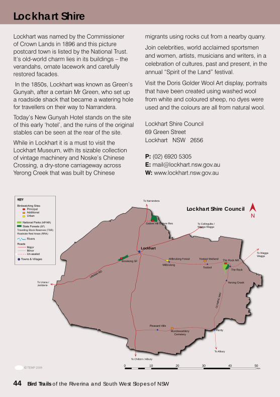
Lockhart was named by the Commissioner of Crown Lands in 1896 and this picture postcard town is listed by the National Trust. It’s old-world charm lies in its buildings – the verandahs, ornate lacework and carefully restored facades.
In the 1850s, Lockhart was known as Green’s Gunyah, after a certain Mr Green, who set up a roadside shack that became a watering hole for travellers on their way to Narrandera.
Today’s New Gunyah Hotel stands on the site of this early ‘hotel’, and the ruins of the original stables can be seen at the rear of the site.
While in Lockhart it is a must to visit the Lockhart Museum, with its sizable collection of vintage machinery and Noske’s Chinese Crossing, a dry-stone carriageway across Yerong Creek that was built by Chinese
migrants using rocks cut from a nearby quarry.
Join celebrities, world acclaimed sportsmen and women, artists, musicians and writers, in a celebration of cultures, past and present, in the annual “Spirit of the Land” festival.
Visit the Doris Golder Wool Art display, portraits that have been created using washed wool from white and coloured sheep, no dyes were used and the colours are all from natural wool.
Lockhart Shire Council69 Green StreetLockhart NSW 2656
P: (02) 6920 5305E: [email protected]: www.lockhart.nsw.gov.au
To Urana / Jerilderie
LOCKHART SHIRECOUNCIL
To Chiltern / Albury
To Albury
Lockhart
Brookong SF
Galore Hill Nature Res
The Rock NR
0 10 20 30 40 50 Km
To Narrandera
To Collingullie / Wagga Wagga
To Wagga Wagga
Milbrulong
Milbrulong Forest
TootoolThe Rock
Yerong Creek
Pleasant HillsHenty
Tootool Wetland
Mundawaddery Cemetery
Lockhart Shire
Lockhart Shire Council
Bird Trails of the Riverina and South West Slopes of NSW 45
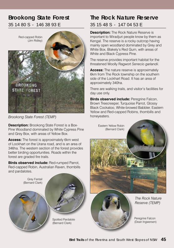
Brookong State Forest 35 14 80 S - 146 38 93 E
Brookong State Forest (TEMP)
Red-capped Robin(Jim Ridley)
Description: Brookong State Forest is a Box-Pine Woodland dominated by White Cypress Pine and Grey Box, with areas of Yellow Box.
Access: The forest is approximately 6km west of Lockhart on the Urana road, and is an area of 346ha. The western section of the forest provides better birding opportunities. Roads within the forest are graded fire trails.
Birds observed include: Red-rumped Parrot, Red-capped Robin, Australian Raven, thornbills and pardalotes.
Spotted Pardalote(Bernard Clark)
Grey Fantail(Bernard Clark)
The Rock Nature Reserve 35 15 48 S - 147 04 53 E
Description: The Rock Nature Reserve is important to Wiradjuri people know by them as Kengal. The reserve is a rocky outcrop having mainly open woodland dominated by Grey and White Box, Blakely’s Red Gum, with areas of White and Black Cypress Pine.
The reserve provides important habitat for the threatened Woolly Ragwort Senecio garlandii.
Access: The nature reserve is approximately 6km from The Rock township on the southern side of the Lockhart Road. It has an area of approximately 340ha.
There are walking trails, and visitor’s facilities for day use only.
Birds observed include: Peregrine Falcon, Brown Treecreeper, Turquoise Parrot, Glossy Black Cockatoo, White-browed Babbler, Eastern Yellow and Red-capped Robins, thornbills and honeyeaters.
The Rock Nature Reserve (TEMP)
Eastern Yellow Robin(Bernard Clark)
Peregrine Falcon(Dean Ingwersen)
46 Bird Trails of the Riverina and South West Slopes of NSW
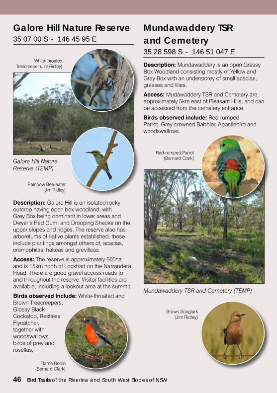
Galore Hill Nature Reserve35 07 00 S - 146 45 95 E
Description: Galore Hill is an isolated rocky outcrop having open box woodland, with Grey Box being dominant in lower areas and Dwyer’s Red Gum, and Drooping Sheoke on the upper slopes and ridges. The reserve also has arboretums of native plants established, these include plantings amongst others of, acacias, eremophilas, hakeas and grevilleas.
Access: The reserve is approximately 500ha and is 15km north of Lockhart on the Narrandera Road. There are good gravel access roads to and throughout the reserve. Visitor facilities are available, including a lookout area at the summit.
Birds observed include: White-throated and Brown Treecreepers, Glossy Black Cockatoo, Restless Flycatcher, together with woodswallows, birds of prey and rosellas.
Galore Hill Nature Reserve (TEMP)
White-throated Treecreeper (Jim Ridley)
Rainbow Bee-eater (Jim Ridley)
Description: Mundawaddery is an open Grassy Box Woodland consisting mostly of Yellow and Grey Box with an understorey of small acacias, grasses and lilies.
Access: Mudawaddery TSR and Cemetery are approximately 5km east of Pleasant Hills, and can be accessed from the cemetery entrance.
Birds observed include: Red-rumped Parrot, Grey-crowned Babbler, Apostlebird and woodswallows.
Mundawaddery TSR and Cemetery (TEMP)
Red-rumped Parrot(Bernard Clark)
Mundawaddery TSR and Cemetery35 28 598 S - 146 51 047 E
Brown Songlark(Jim Ridley)
Flame Robin(Bernard Clark)
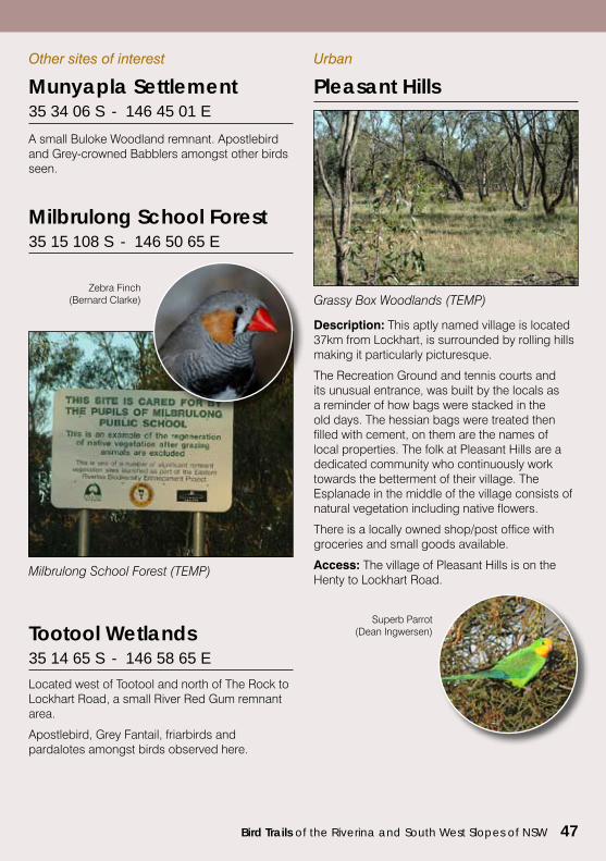
Bird Trails of the Riverina and South West Slopes of NSW 47
Other sites of interest
Milbrulong School Forest 35 15 108 S - 146 50 65 E
Milbrulong School Forest (TEMP)
Zebra Finch(Bernard Clarke)
Munyapla Settlement 35 34 06 S - 146 45 01 E
A small Buloke Woodland remnant. Apostlebird and Grey-crowned Babblers amongst other birds seen.
Urban
Pleasant Hills
Grassy Box Woodlands (TEMP)
Description: This aptly named village is located 37km from Lockhart, is surrounded by rolling hills making it particularly picturesque.
The Recreation Ground and tennis courts and its unusual entrance, was built by the locals as a reminder of how bags were stacked in the old days. The hessian bags were treated then filled with cement, on them are the names of local properties. The folk at Pleasant Hills are a dedicated community who continuously work towards the betterment of their village. The Esplanade in the middle of the village consists of natural vegetation including native flowers.
There is a locally owned shop/post office with groceries and small goods available.
Access: The village of Pleasant Hills is on the Henty to Lockhart Road.
Superb Parrot(Dean Ingwersen)
Located west of Tootool and north of The Rock to Lockhart Road, a small River Red Gum remnant area.
Apostlebird, Grey Fantail, friarbirds and pardalotes amongst birds observed here.
Tootool Wetlands35 14 65 S - 146 58 65 E
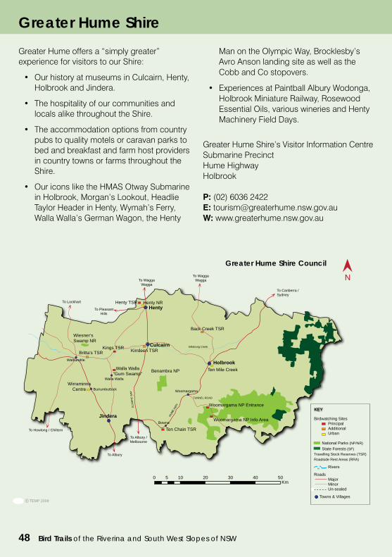
48 Bird Trails of the Riverina and South West Slopes of NSW
Greater Hume offers a “simply greater” experience for visitors to our Shire:
• OurhistoryatmuseumsinCulcairn,Henty,Holbrook and Jindera.
• Thehospitalityofourcommunitiesandlocals alike throughout the Shire.
• Theaccommodationoptionsfromcountrypubs to quality motels or caravan parks to bed and breakfast and farm host providers in country towns or farms throughout the Shire.
• OuriconsliketheHMASOtwaySubmarinein Holbrook, Morgan’s Lookout, Headlie Taylor Header in Henty, Wymah’s Ferry, Walla Walla’s German Wagon, the Henty
Man on the Olympic Way, Brocklesby’s Avro Anson landing site as well as the Cobb and Co stopovers.
• ExperiencesatPaintballAlburyWodonga,Holbrook Miniature Railway, Rosewood Essential Oils, various wineries and Henty Machinery Field Days.
Greater Hume Shire’s Visitor Information CentreSubmarine PrecinctHume HighwayHolbrook
P: (02) 6036 2422E: [email protected]: www.greaterhume.nsw.gov.au
Henty
Holbrook
Henty TSR
Back Creek TSR
Woomargama NP Entrance
GREATER HUME SHIRE COUNCIL
Walla Walla “Gum Swamp”
Kirrdeen TSRBritta’s TSR
0 5 10 20 30 40 50Km
Woomargama NP Info Area
Ten Chain TSR
To Canberra / Sydney
To WaggaWaggaTo Wagga
Wagga
To Pleasant Hills
To Lockhart
To Albury
To Albury / Melbourne
TUNNEL ROAD
Woomargama
Bowna
Ten Mile Creek
Jindera
Burrumbuttock
Walla WallaWirraminna
Centre
Walbundrie
Billabong Creek
Wiesner’s Swamp NR
Benambra NP
CulcairnKings TSR
Henty NR
To Howlong / Chiltern
Birdwatching Sites Principal Additional Urban National Parks (NP/NR) State Forests (SF)Travelling Stock Reserves (TSR)Roadside Rest Areas (RRA)
Rivers
Roads Major Minor Un-sealed
Towns & Villages
KEY
Greater Hume Shire
Greater Hume Shire Council
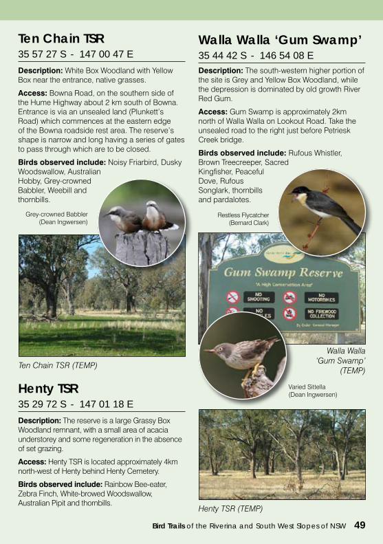
Bird Trails of the Riverina and South West Slopes of NSW 49
Ten Chain TSR (TEMP)
Ten Chain TSR 35 57 27 S - 147 00 47 E
Description: White Box Woodland with Yellow Box near the entrance, native grasses.
Access: Bowna Road, on the southern side of the Hume Highway about 2 km south of Bowna. Entrance is via an unsealed land (Plunkett’s Road) which commences at the eastern edge of the Bowna roadside rest area. The reserve’s shape is narrow and long having a series of gates to pass through which are to be closed.
Birds observed include: Noisy Friarbird, Dusky Woodswallow, Australian Hobby, Grey-crowned Babbler, Weebill and thornbills.
Grey-crowned Babbler(Dean Ingwersen)
Henty TSR (TEMP)
Henty TSR 35 29 72 S - 147 01 18 E
Description: The reserve is a large Grassy Box Woodland remnant, with a small area of acacia understorey and some regeneration in the absence of set grazing.
Access: Henty TSR is located approximately 4km north-west of Henty behind Henty Cemetery.
Birds observed include: Rainbow Bee-eater, Zebra Finch, White-browed Woodswallow, Australian Pipit and thornbills.
Description: The south-western higher portion of the site is Grey and Yellow Box Woodland, while the depression is dominated by old growth River Red Gum.
Access: Gum Swamp is approximately 2km north of Walla Walla on Lookout Road. Take the unsealed road to the right just before Petriesk Creek bridge.
Birds observed include: Rufous Whistler, Brown Treecreeper, Sacred Kingfisher, Peaceful Dove, Rufous Songlark, thornbills and pardalotes.
Walla Walla‘Gum Swamp’
(TEMP)
Walla Walla ‘Gum Swamp’35 44 42 S - 146 54 08 E
Restless Flycatcher(Bernard Clark)
Varied Sittella(Dean Ingwersen)
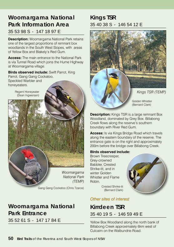
50 Bird Trails of the Riverina and South West Slopes of NSW
Kings TSR 35 40 38 S - 146 54 12 E
Description: Kings TSR is a large remnant Box Woodland, dominated by Grey Box. Billabong Creek flows along the reserve’s southern boundary with River Red Gum.
Access: Is via Kings Bridge Road which travels along the eastern boundary of the reserve. The entrance gate is on the right and approximately 200m before the bridge over Billabong Creek.
Birds observed include: Brown Treecreeper, Grey-crowned Babbler, Crested Shrike-tit, and in winter Golden Whistler and Flame Robin.
Kings TSR (TEMP)
Golden Whistler(Bernard Clark)
Crested Shrike-tit(Bernard Clark)
Kirrdeen TSR 35 40 19 S - 146 59 49 E
Yellow Box Woodland along the north bank of Billabong Creek approximately 6km west of Culcairn on the Walbundrie Road.
Other sites of interest
Description: Woomargama National Park retains one of the largest proportions of remnant box woodlands in the South West Slopes, with areas of Yellow Box and Blakely’s Red Gum.
Access: The main entrance to the National Park is via Tunnel Road which joins the Hume Highway at Woomargama village.
Birds observed include: Swift Parrot, King Parrot, Gang Gang Cockatoo, Speckled Warbler and honeyeaters.
Woomargama National Park
(TEMP)
Regent Honeyeater(Dean Ingwersen)
Gang Gang Cockatoo (Chris Tzaros)
Woomargama National Park Information Area35 53 98 S - 147 18 97 E
Woomargama National Park Entrance35 52 61 S - 147 17 84 E
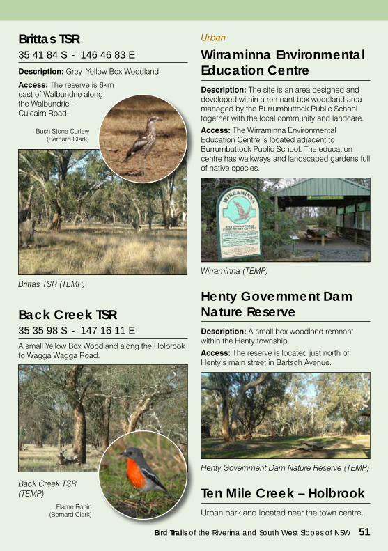
Bird Trails of the Riverina and South West Slopes of NSW 51
Back Creek TSR 35 35 98 S - 147 16 11 EA small Yellow Box Woodland along the Holbrook to Wagga Wagga Road.
Back Creek TSR (TEMP)
Brittas TSR 35 41 84 S - 146 46 83 E
Description: Grey -Yellow Box Woodland.
Access: The reserve is 6km east of Walbundrie along the Walbundrie - Culcairn Road.
Brittas TSR (TEMP)
Bush Stone Curlew(Bernard Clark)
Description: The site is an area designed and developed within a remnant box woodland area managed by the Burrumbuttock Public School together with the local community and landcare.
Access: The Wirraminna Environmental Education Centre is located adjacent to Burrumbuttock Public School. The education centre has walkways and landscaped gardens full of native species.
Urban
Wirraminna Environmental Education Centre
Wirraminna (TEMP)
Description: A small box woodland remnant within the Henty township.
Access: The reserve is located just north of Henty’s main street in Bartsch Avenue.
Henty Government Dam Nature Reserve
Henty Government Dam Nature Reserve (TEMP)
Ten Mile Creek – HolbrookUrban parkland located near the town centre.
Flame Robin(Bernard Clark)
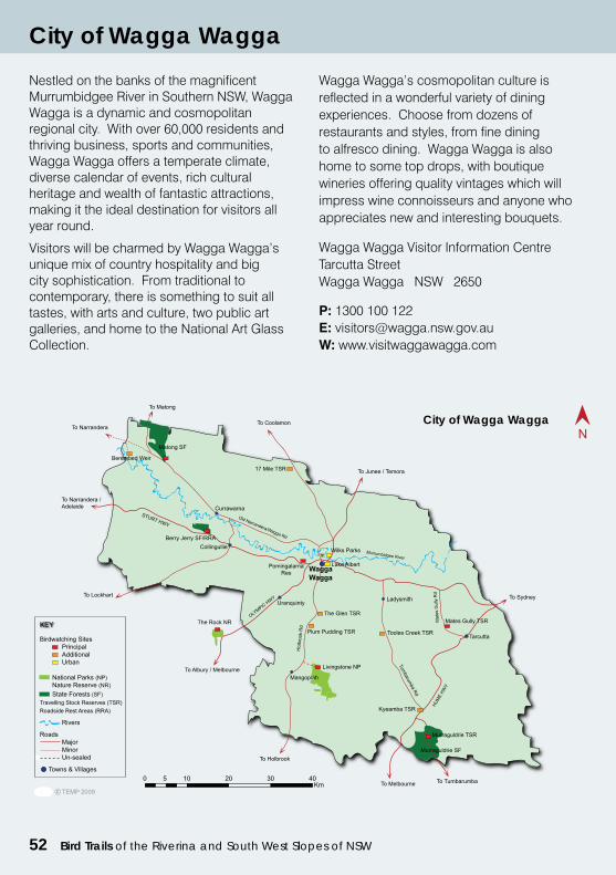
52 Bird Trails of the Riverina and South West Slopes of NSW
Nestled on the banks of the magnificent Murrumbidgee River in Southern NSW, Wagga Wagga is a dynamic and cosmopolitan regional city. With over 60,000 residents and thriving business, sports and communities, Wagga Wagga offers a temperate climate, diverse calendar of events, rich cultural heritage and wealth of fantastic attractions, making it the ideal destination for visitors all year round.
Visitors will be charmed by Wagga Wagga’s unique mix of country hospitality and big city sophistication. From traditional to contemporary, there is something to suit all tastes, with arts and culture, two public art galleries, and home to the National Art Glass Collection.
Wagga Wagga’s cosmopolitan culture is reflected in a wonderful variety of dining experiences. Choose from dozens of restaurants and styles, from fine dining to alfresco dining. Wagga Wagga is also home to some top drops, with boutique wineries offering quality vintages which will impress wine connoisseurs and anyone who appreciates new and interesting bouquets.
Wagga Wagga Visitor Information CentreTarcutta StreetWagga Wagga NSW 2650
P: 1300 100 122E: [email protected]: www.visitwaggawagga.com
City of Wagga Wagga
City of Wagga Wagga
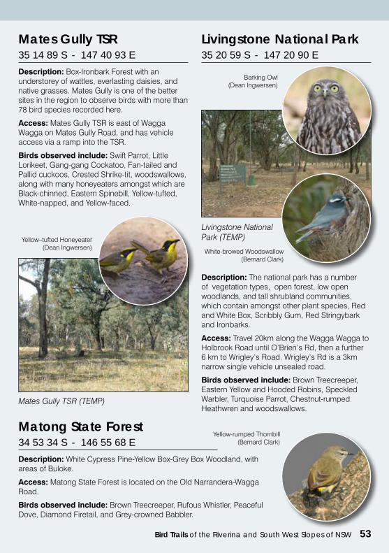
Bird Trails of the Riverina and South West Slopes of NSW 53
Mates Gully TSR (TEMP)
Mates Gully TSR 35 14 89 S - 147 40 93 E
Description: Box-Ironbark Forest with an understorey of wattles, everlasting daisies, and native grasses. Mates Gully is one of the better sites in the region to observe birds with more than 78 bird species recorded here.
Access: Mates Gully TSR is east of Wagga Wagga on Mates Gully Road, and has vehicle access via a ramp into the TSR.
Birds observed include: Swift Parrot, Little Lorikeet, Gang-gang Cockatoo, Fan-tailed and Pallid cuckoos, Crested Shrike-tit, woodswallows, along with many honeyeaters amongst which are Black-chinned, Eastern Spinebill, Yellow-tufted, White-napped, and Yellow-faced.
Yellow–tufted Honeyeater (Dean Ingwersen)
Livingstone National Park 35 20 59 S - 147 20 90 E
Description: The national park has a number of vegetation types, open forest, low open woodlands, and tall shrubland communities, which contain amongst other plant species, Red and White Box, Scribbly Gum, Red Stringybark and Ironbarks.
Access: Travel 20km along the Wagga Wagga to Holbrook Road until O’Brien’s Rd, then a further 6 km to Wrigley’s Road. Wrigley’s Rd is a 3km narrow single vehicle unsealed road.
Birds observed include: Brown Treecreeper, Eastern Yellow and Hooded Robins, Speckled Warbler, Turquoise Parrot, Chestnut-rumped Heathwren and woodswallows.
Livingstone National Park (TEMP)
Barking Owl(Dean Ingwersen)
White-browed Woodswallow(Bernard Clark)
Matong State Forest 34 53 34 S - 146 55 68 E
Description: White Cypress Pine-Yellow Box-Grey Box Woodland, with areas of Buloke.
Access: Matong State Forest is located on the Old Narrandera-Wagga Road.
Birds observed include: Brown Treecreeper, Rufous Whistler, Peaceful Dove, Diamond Firetail, and Grey-crowned Babbler.
Yellow-rumped Thornbill(Bernard Clark)
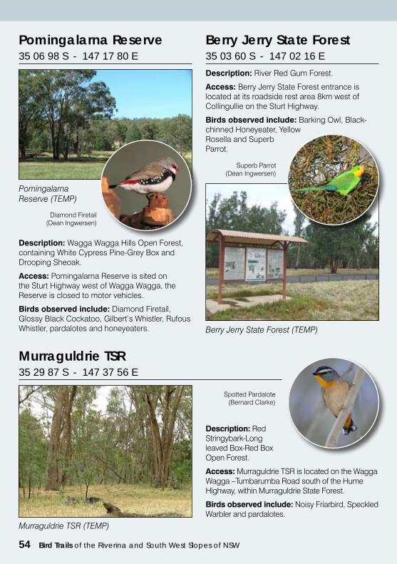
54 Bird Trails of the Riverina and South West Slopes of NSW
Pomingalarna Reserve 35 06 98 S - 147 17 80 E
Description: Wagga Wagga Hills Open Forest, containing White Cypress Pine-Grey Box and Drooping Sheoak.
Access: Pomingalarna Reserve is sited on the Sturt Highway west of Wagga Wagga, the Reserve is closed to motor vehicles.
Birds observed include: Diamond Firetail, Glossy Black Cockatoo, Gilbert’s Whistler, Rufous Whistler, pardalotes and honeyeaters.
Berry Jerry State Forest 35 03 60 S - 147 02 16 E
Description: River Red Gum Forest.
Access: Berry Jerry State Forest entrance is located at its roadside rest area 8km west of Collingullie on the Sturt Highway.
Birds observed include: Barking Owl, Black-chinned Honeyeater, Yellow Rosella and Superb Parrot.
Diamond Firetail(Dean Ingwersen)
Berry Jerry State Forest (TEMP)
Superb Parrot(Dean Ingwersen)
Pomingalarna Reserve (TEMP)
Murraguldrie TSR 35 29 87 S - 147 37 56 E
Description: Red Stringybark-Long leaved Box-Red Box Open Forest.
Access: Murraguldrie TSR is located on the Wagga Wagga –Tumbarumba Road south of the Hume Highway, within Murraguldrie State Forest.
Birds observed include: Noisy Friarbird, Speckled Warbler and pardalotes.
Murraguldrie TSR (TEMP)
Spotted Pardalote (Bernard Clarke)
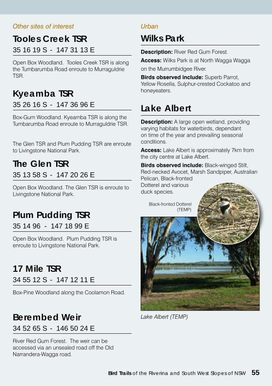
Bird Trails of the Riverina and South West Slopes of NSW 55
Other sites of interest
Tooles Creek TSR 35 16 19 S - 147 31 13 E
Open Box Woodland. Tooles Creek TSR is along the Tumbarumba Road enroute to Murraguldrie TSR.
Kyeamba TSR 35 26 16 S - 147 36 96 E
Box-Gum Woodland. Kyeamba TSR is along the Tumbarumba Road enroute to Murraguldrie TSR.
The Glen TSR 35 13 58 S - 147 20 26 E
Open Box Woodland. The Glen TSR is enroute to Livingstone National Park.
Plum Pudding TSR 35 14 96 - 147 18 99 E
Open Box Woodland. Plum Pudding TSR is enroute to Livingstone National Park.
17 Mile TSR 34 55 12 S - 147 12 11 E
Box-Pine Woodland along the Coolamon Road.
The Glen TSR and Plum Pudding TSR are enroute to Livingstone National Park.
Description: River Red Gum Forest.
Access: Wilks Park is at North Wagga Wagga
on the Murrumbidgee River.
Birds observed include: Superb Parrot, Yellow Rosella, Sulphur-crested Cockatoo and honeyeaters.
Urban
Wilks Park
Lake Albert (TEMP)
Description: A large open wetland, providing varying habitats for waterbirds, dependant on time of the year and prevailing seasonal conditions.
Access: Lake Albert is approximately 7km from the city centre at Lake Albert.
Birds observed include: Black-winged Stilt, Red-necked Avocet, Marsh Sandpiper, Australian Pelican, Black-fronted Dotterel and various duck species.
Lake Albert
Black-fronted Dotterel(TEMP)
Berembed Weir 34 52 65 S - 146 50 24 E
River Red Gum Forest. The weir can be accessed via an unsealed road off the Old Narrandera-Wagga road.
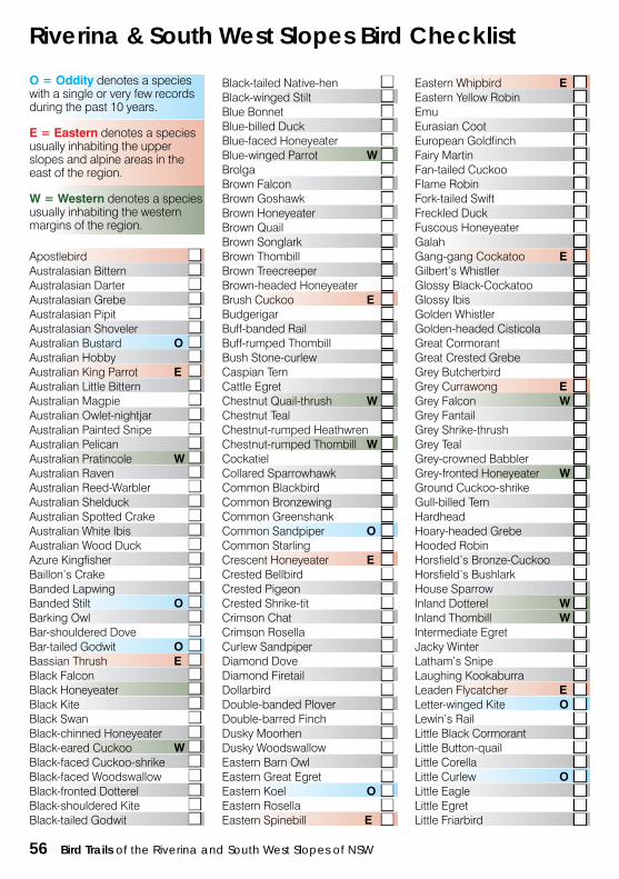
56 Bird Trails of the Riverina and South West Slopes of NSW
Riverina & South West Slopes Bird Checklist
O = Oddity denotes a species with a single or very few records during the past 10 years.
E = Eastern denotes a species usually inhabiting the upper slopes and alpine areas in the east of the region.
W = Western denotes a species usually inhabiting the western margins of the region.
Black-tailed Native-hen ■ Eastern Whipbird E ■Black-winged Stilt ■ Eastern Yellow Robin ■Blue Bonnet ■ Emu ■Blue-billed Duck ■ Eurasian Coot ■Blue-faced Honeyeater ■ European Goldfinch ■Blue-winged Parrot W ■ Fairy Martin ■Brolga ■ Fan-tailed Cuckoo ■Brown Falcon ■ Flame Robin ■Brown Goshawk ■ Fork-tailed Swift ■Brown Honeyeater ■ Freckled Duck ■Brown Quail ■ Fuscous Honeyeater ■Brown Songlark ■ Galah ■
Apostlebird ■ Brown Thombill ■ Gang-gang Cockatoo E ■Australasian Bittern ■ Brown Treecreeper ■ Gilbert’s Whistler ■Australasian Darter ■ Brown-headed Honeyeater ■ Glossy Black-Cockatoo ■Australasian Grebe ■ Brush Cuckoo E ■ Glossy Ibis ■Australasian Pipit ■ Budgerigar ■ Golden Whistler ■Australasian Shoveler ■ Buff-banded Rail ■ Golden-headed Cisticola ■Australian Bustard O ■ Buff-rumped Thombill ■ Great Cormorant ■Australian Hobby ■ Bush Stone-curlew ■ Great Crested Grebe ■Australian King Parrot E ■ Caspian Tern ■ Grey Butcherbird ■Australian Little Bittern ■ Cattle Egret ■ Grey Currawong E ■Australian Magpie ■ Chestnut Quail-thrush W ■ Grey Falcon W ■Australian Owlet-nightjar ■ Chestnut Teal ■ Grey Fantail ■Australian Painted Snipe ■ Chestnut-rumped Heathwren ■ Grey Shrike-thrush ■Australian Pelican ■ Chestnut-rumped Thombill W ■ Grey Teal ■Australian Pratincole W ■ Cockatiel ■ Grey-crowned Babbler ■Australian Raven ■ Collared Sparrowhawk ■ Grey-fronted Honeyeater W ■Australian Reed-Warbler ■ Common Blackbird ■ Ground Cuckoo-shrike ■Australian Shelduck ■ Common Bronzewing ■ Gull-billed Tern ■Australian Spotted Crake ■ Common Greenshank ■ Hardhead ■Australian White Ibis ■ Common Sandpiper O ■ Hoary-headed Grebe ■Australian Wood Duck ■ Common Starling ■ Hooded Robin ■Azure Kingfisher ■ Crescent Honeyeater E ■ Horsfield’s Bronze-Cuckoo ■Baillon’s Crake ■ Crested Bellbird ■ Horsfield’s Bushlark ■Banded Lapwing ■ Crested Pigeon ■ House Sparrow ■Banded Stilt O ■ Crested Shrike-tit ■ Inland Dotterel W ■Barking Owl ■ Crimson Chat ■ Inland Thombill W ■Bar-shouldered Dove ■ Crimson Rosella ■ Intermediate Egret ■Bar-tailed Godwit O ■ Curlew Sandpiper ■ Jacky Winter ■Bassian Thrush E ■ Diamond Dove ■ Latham’s Snipe ■Black Falcon ■ Diamond Firetail ■ Laughing Kookaburra ■Black Honeyeater ■ Dollarbird ■ Leaden Flycatcher E ■Black Kite ■ Double-banded Plover ■ Letter-winged Kite O ■Black Swan ■ Double-barred Finch ■ Lewin’s Rail ■Black-chinned Honeyeater ■ Dusky Moorhen ■ Little Black Cormorant ■Black-eared Cuckoo W ■ Dusky Woodswallow ■ Little Button-quail ■Black-faced Cuckoo-shrike ■ Eastern Barn Owl ■ Little Corella ■Black-faced Woodswallow ■ Eastern Great Egret ■ Little Curlew O ■Black-fronted Dotterel ■ Eastern Koel O ■ Little Eagle ■Black-shouldered Kite ■ Eastern Rosella ■ Little Egret ■Black-tailed Godwit ■ Eastern Spinebill E ■ Little Friarbird ■
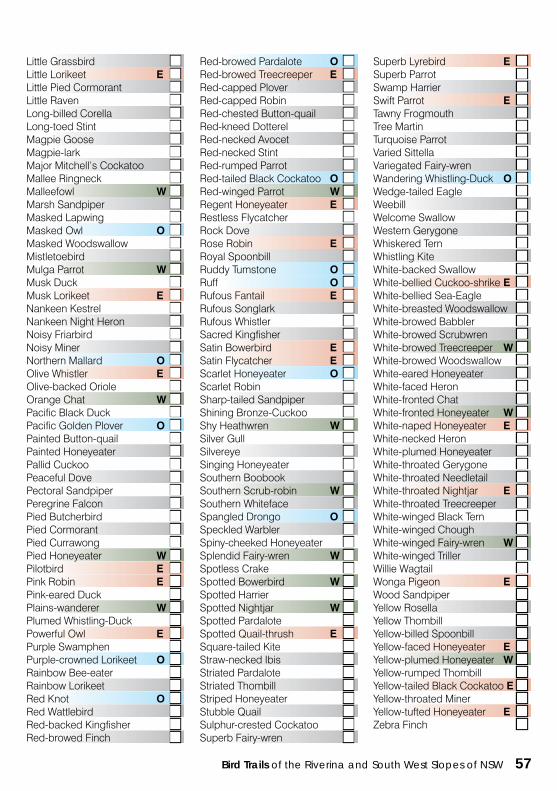
Bird Trails of the Riverina and South West Slopes of NSW 57
Little Grassbird ■ Red-browed Pardalote O ■ Superb Lyrebird E ■Little Lorikeet E ■ Red-browed Treecreeper E ■ Superb Parrot ■Little Pied Cormorant ■ Red-capped Plover ■ Swamp Harrier ■Little Raven ■ Red-capped Robin ■ Swift Parrot E ■Long-billed Corella ■ Red-chested Button-quail ■ Tawny Frogmouth ■Long-toed Stint ■ Red-kneed Dotterel ■ Tree Martin ■Magpie Goose ■ Red-necked Avocet ■ Turquoise Parrot ■Magpie-lark ■ Red-necked Stint ■ Varied Sittella ■Major Mitchell’s Cockatoo ■ Red-rumped Parrot ■ Variegated Fairy-wren ■Mallee Ringneck ■ Red-tailed Black Cockatoo O ■ Wandering Whistling-Duck O ■Malleefowl W ■ Red-winged Parrot W ■ Wedge-tailed Eagle ■Marsh Sandpiper ■ Regent Honeyeater E ■ Weebill ■Masked Lapwing ■ Restless Flycatcher ■ Welcome Swallow ■Masked Owl O ■ Rock Dove ■ Western Gerygone ■Masked Woodswallow ■ Rose Robin E ■ Whiskered Tern ■Mistletoebird ■ Royal Spoonbill ■ Whistling Kite ■Mulga Parrot W ■ Ruddy Tumstone O ■ White-backed Swallow ■Musk Duck ■ Ruff O ■ White-bellied Cuckoo-shrike E ■Musk Lorikeet E ■ Rufous Fantail E ■ White-bellied Sea-Eagle ■Nankeen Kestrel ■ Rufous Songlark ■ White-breasted Woodswallow ■Nankeen Night Heron ■ Rufous Whistler ■ White-browed Babbler ■Noisy Friarbird ■ Sacred Kingfisher ■ White-browed Scrubwren ■Noisy Miner ■ Satin Bowerbird E ■ White-browed Treecreeper W ■Northern Mallard O ■ Satin Flycatcher E ■ White-browed Woodswallow ■Olive Whistler E ■ Scarlet Honeyeater O ■ White-eared Honeyeater ■Olive-backed Oriole ■ Scarlet Robin ■ White-faced Heron ■Orange Chat W ■ Sharp-tailed Sandpiper ■ White-fronted Chat ■Pacific Black Duck ■ Shining Bronze-Cuckoo ■ White-fronted Honeyeater W ■Pacific Golden Plover O ■ Shy Heathwren W ■ White-naped Honeyeater E ■Painted Button-quail ■ Silver Gull ■ White-necked Heron ■Painted Honeyeater ■ Silvereye ■ White-plumed Honeyeater ■Pallid Cuckoo ■ Singing Honeyeater ■ White-throated Gerygone ■Peaceful Dove ■ Southern Boobook ■ White-throated Needletail ■Pectoral Sandpiper ■ Southern Scrub-robin W ■ White-throated Nightjar E ■Peregrine Falcon ■ Southern Whiteface ■ White-throated Treecreeper ■Pied Butcherbird ■ Spangled Drongo O ■ White-winged Black Tern ■Pied Cormorant ■ Speckled Warbler ■ White-winged Chough ■Pied Currawong ■ Spiny-cheeked Honeyeater ■ White-winged Fairy-wren W ■Pied Honeyeater W ■ Splendid Fairy-wren W ■ White-winged Triller ■Pilotbird E ■ Spotless Crake ■ Willie Wagtail ■Pink Robin E ■ Spotted Bowerbird W ■ Wonga Pigeon E ■Pink-eared Duck ■ Spotted Harrier ■ Wood Sandpiper ■Plains-wanderer W ■ Spotted Nightjar W ■ Yellow Rosella ■Plumed Whistling-Duck ■ Spotted Pardalote ■ Yellow Thombill ■Powerful Owl E ■ Spotted Quail-thrush E ■ Yellow-billed Spoonbill ■Purple Swamphen ■ Square-tailed Kite ■ Yellow-faced Honeyeater E ■Purple-crowned Lorikeet O ■ Straw-necked Ibis ■ Yellow-plumed Honeyeater W ■Rainbow Bee-eater ■ Striated Pardalote ■ Yellow-rumped Thombill ■Rainbow Lorikeet ■ Striated Thombill ■ Yellow-tailed Black Cockatoo E ■Red Knot O ■ Striped Honeyeater ■ Yellow-throated Miner ■Red Wattlebird ■ Stubble Quail ■ Yellow-tufted Honeyeater E ■Red-backed Kingfisher ■ Sulphur-crested Cockatoo ■ Zebra Finch ■Red-browed Finch ■ Superb Fairy-wren ■
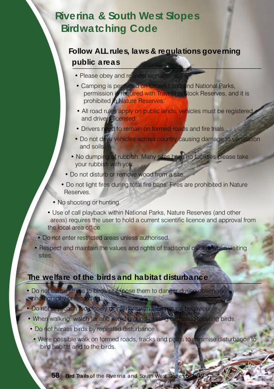
58 Bird Trails of the Riverina and South West Slopes of NSW
Riverina & South West Slopes Birdwatching Code
Follow ALL rules, laws & regulations governing public areas
•Pleaseobeyandrespectsignage.
•CampingispermittedonCrownLandandNationalParks, permission is required with Travelling Stock Reserves, and it is prohibited in Nature Reserves.
•Allroadrulesapplyonpubliclands,vehiclesmustberegistered and drivers licensed.
•Driversneedtoremainonformedroadsandfiretrials.
•Donotdrivevehiclesacrosscountrycausingdamagetovegetation and soils.
•Nodumpingofrubbish.Manysiteshavenofacilitiespleasetake your rubbish with you.
•Donotdisturborremovewoodfromasite.
•Donotlightfiresduringtotalfirebans.FiresareprohibitedinNature Reserves.
•Noshootingorhunting.
•UseofcallplaybackwithinNationalParks,NatureReserves(andother areas) requires the user to hold a current scientific licence and approval from
the local area office.
•Donotenterrestrictedareasunlessauthorised.
•Respectandmaintainthevaluesandrightsoftraditionalownerswhenvisiting sites.
The welfare of the birds and habitat disturbance
•Donotcausestresstobirdsorexposethemtodangerduringobservation,photography or recording.
•Donotapproachtoocloselyorinterferewiththeirnaturalbehaviour.
•Whenwalking,watchforandavoidground-nestingbirdsandroostingbirds.
•Donotharassbirdsbyrepeateddisturbance.
•Werepossiblewalkonformedroads,tracksandpathstominimisedisturbanceto bird habitat and to the birds.