Embed Size (px)
Citation preview
67
Sól tér sortna, sígur fold í mar,hverfa af himni heiðar stjörnur.Geisar eimi við aldurnara,leikur hár hiti við himin sjálfan.
The sun turns black, earth sinks into the sea,the bright stars vanish from the sky;steam rises up in the conflagration,a high flame plays against heaven itself.
“Völuspá” (The Wise Woman’s prophecy), ca. aD 1270larringTon 1996: 11
Iceland is one of the most volcanically active areas on earth, but were it not for the description of the end of the world in the poem “Völuspá,” one might think volcanic activity made little impression on Medieval Icelanders. Volcanic eruptions are duly recorded in annals from the early twelfth century onward, but as a rule they are noted with terse one-line accounts such as “1158: second fire in Hekla” (Storm 1888: 116) or at most with minimal amplifications like “such great darkness that the sun was blocked” (ibid.: 134). The most detailed surviving description is given for events in AD 1362:
Fire erupted in four places in the South and lasted from early June until autumn with such enormities that the whole of Litlahérað was deserted, and
T h r e e
Black Sun, High Flame, and Flood: Volcanic Hazards in Iceland
Andrew Dugmore and Orri Vésteinsson
a n D r e W D u g m o r e a n D o r r i V és T e i n s s o n
68
much of Hornafjörður and Lónshverfi. It devastated a nearly 200 km stretch [along the coast]. In addition Knappafell glacier burst forth into the sea with falling rocks, mud and dirt so that there was flat sand where before the sea had been 50 m deep. Two parishes were completely destroyed, those of Hof and Rauðalækr. The sand stood at mid-leg on flat land but was driven into dunes so that the houses could hardly be seen. Ash was blown to the North so that steps could be traced in the fallout. Also pumice was seen drifting on the sea off the Vestfjords, so dense that ships could hardly sail through. (ibid.: 226)
With the possible exception of the pre-literate period Eldgjá eruption in AD 934–938, the events of AD 1362 were by all accounts the greatest volca-nic calamity in Iceland in the Middle Ages (Thórarinsson 1958). Several other major volcanic eruptions occurred during the twelfth and thirteenth centuries AD, a period when Icelandic scholars wrote copiously about both recent his-tory and contemporary developments, but it seems that even if they had an appreciable impact on the environment and the economy, the eruptions were not considered significant enough for comment. Nature, let alone volcanic eruptions, is firmly in the background of these writings: there is not a single unequivocal reference to a volcanic eruption in the entire corpus of Icelandic Family Sagas (Falk 2007).
In contrast, modern writers have been eager to make the most of volcanic impacts on Icelandic history. Volcanism is routinely seen as one of the principal causes for the lack of development of Icelandic society by early modern times, while politicians like to claim that the perceived spirit and endurance of the Icelandic people was shaped on an anvil of ice and fire.
In this chapter we argue that neither the Medieval indifference nor the modern hyperbole is a useful guide to understand how volcanic hazards affected preindustrial Icelandic society. We suggest that each volcanic event has to be understood within its landscape and historical context. Most volca-nic eruptions occurred far from settled regions and had limited or no effect on society. In particular regions, volcanism was one element in a complex of environmental processes that could have negative impacts on land use and settlement, in both the short and long term. These regions represent a small proportion of settled areas in Iceland, and in the national context their deg-radation had negligible repercussions. Dramatic case histories of Icelandic volcanic eruptions are well-known, indeed iconic, yet they can only be truly understood in the context of the society and environment at the time, as well as their antecedents, trajectories of change, and complex interactions with each other.
Occasionally, major eruptions and unlucky circumstances have contrib-uted to nationwide calamities, depression, and famine. We stress that it was not the size or type of volcanic eruption alone that decided this outcome but rather
B l a c k s u n, h i g h F l a m e, a n D F l o o D
69
the time of year it took place and the coincidence of other negative factors such as bad weather, failing fish stocks, or disease (in humans or animals)—fac-tors that in combination could produce catastrophic shocks to the economic system. It is clear that Icelandic society dealt with such shocks on a routine basis. Some were exacerbated by volcanic eruptions and some were not, but in all cases the socioeconomic system recovered. This suggests that human suffer-ing on a massive scale is not necessarily a measure of system resilience (or fail-ure); societies can absorb enormous and inhuman pain and suffering without failing.
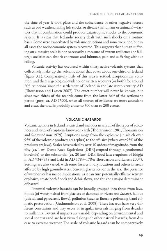
Volcanic activity has occurred within thirty active volcanic systems that collectively make up the volcanic zones that cover about one-third of Iceland (figure 3.1). Comparatively little of this area is settled. Eruptions are com-mon, and there is geological evidence or written accounts (or both) for around 205 eruptions since the settlement of Iceland in the late ninth century AD (Thordarson and Larsen 2007). The exact number will never be known; but since two-thirds of the records come from the latter half of the settlement period (post–ca. AD 1500), when all sources of evidence are more abundant and clear, the total is probably closer to 300 than to 200 events.
Volcanic Hazards
Volcanic activity in Iceland is varied and includes nearly all of the types of volca-noes and styles of eruptions known on earth (Thórarinsson 1981; Thórarinsson and Saemundsson 1979). Eruptions range from the explosive (in which over 95% of the volcanic products are tephra) to the effusive (where over 95% of the products are lava). Scales have varied by over 10 orders of magnitude, from the tiny (ca. 1 m3 Dense Rock Equivalent [DRE] erupted through a geothermal borehole) to the substantial (ca. 20 km3 DRE flood lava eruptions of Eldgjá in AD 934–938 and Laki in AD 1783–1784; Thordarson and Larsen 2007). Settings are also varied, with some fissures in dry locations and others in areas affected by high groundwaters, beneath glacier ice, or in the sea. The presence of water or ice has major implications, as it can turn potentially effusive activity explosive, create both floods and debris flows, and thus be a major determinant of hazard.
Potential volcanic hazards can be broadly grouped into those from lava, floods (of water melted from glaciers or dammed in rivers and lahars), fallout (ash fall and pyroclastic flows), pollution (such as fluorine poisoning), and cli-matic perturbation (Gudmundsson et al. 2008). These hazards have very dif-ferent constraints and may occur at irregular intervals ranging from decades to millennia. Potential impacts are variable depending on environmental and social contexts and are best viewed alongside other natural hazards, from dis-ease to extreme weather. The scale of volcanic hazards can be comparatively
a n D r e W D u g m o r e a n D o r r i V és T e i n s s o n
70
limited; they can affect a small region, or the hazards can be felt across the entire island and much farther afield (Grattan, Durand, and Taylor 2003; Grattan et al. 2003; Witham and Oppenheimer 2004). It is notable that despite over 200 volcanic events that could have led to a disaster, few have killed people either directly or indirectly. Laki in AD 1783 indirectly led to the deaths of thousands of Icelanders because out-gassing from the eruption created a toxic haze that caused the deaths of many livestock and contributed to the ensuing
3.1. Iceland, showing features named in the text. Cartography by Richard Streeter.

B l a c k s u n, h i g h F l a m e, a n D F l o o D
71
famine. The major eruptions of Hekla in AD 1300 and Öræfajökull in AD 1362 may have also caused fatalities, but there is no direct evidence for this (Gudmundsson et al. 2008). The impacts of the eruption of Hekla in AD 1104 (which produced ca. 2 km3 of tephra) and Eldgjá in AD 934 (the largest erup-tion in historical times) are unknown. While the Katla eruption in AD 1755 may have only directly killed one person, famine resulting from exceptional and unrelated cold weather in the mid-1750s reduced Iceland’s population by 5,800 (Karlsson 2000).
The human consequences of volcanic hazards have been shaped by the nature of Icelandic society. Historically, subsistence in Iceland has been based on pastoralism (primarily sheep and cattle) supplemented by utilizing wild resources, fishing from fresh waters and the sea, hunting marine mam-mals, wildfowling, and collecting eggs and shellfish (McGovern et al. 2007). Some cereal was grown during the first six centuries, but the practice died out in the sixteenth century AD. The slack was picked up by small-scale imports, but significant imports of foodstuffs did not begin until the late nineteenth century (Karlsson 2000). Icelandic society was self-reliant in its subsistence, a self-reliance based on flexible strategies of farming and wildlife exploitation. It is possible, however, that this flexibility came at the cost of economic develop-ment, which at best was sluggish until the end of the nineteenth century. The Icelandic system was designed to deal with setbacks, among which natural haz-ards were prominent, although disease and unfavorable weather had the most profound and persistent impacts. Modifying or abandoning the ability to deal with setbacks in favor of economic development did not seem like an accept-able strategy until modern times.
There tends to be little settlement in the immediate neighborhood of active volcanoes on the Icelandic mainland, in part because of the dispersed nature of pre-modern settlement in Iceland and in part because volcanoes form higher ground that has a less favorable climate. In addition, recent volcanic activity has been related to limited soil and vegetation cover. Notable exceptions can be found in Mývatnssveit, where settlement exists within the northern volcanic zone and along the southern coast.
Lavas create the most localized direct hazards, and within the volca-nic zones they have flowed over farms built in the neighborhood of fissures. Ögmundarhraun, for example, is a lava on the Reykjanes Peninsula south-west of Reykjavik that overran the Krísuvík farm in the mid-twelfth century ( Jóhannesson and Einarsson 1988). It has been argued that lava from the 1389 eruption of Hekla completely overran two or three farms (Thórarinsson 1968: 62–72), and in the north of Iceland the Mývatn fires of AD 1724–1729 pro-duced lavas that extended over 34 km2, including two farms and the farmhouses of the Reykjahlíð parsonage (Sæmundsson 1991). The church of Reykjahlíð, sited on higher ground, was left intact but was surrounded by the lava.
a n D r e W D u g m o r e a n D o r r i V és T e i n s s o n
72
The only recent flows that extended outside the volcanic zones were the four very extensive flood lava eruptions of historical times: Eldgjá, AD 934–938; Hallmundarhraun, ca. AD 950; Frambruni, prior to the thirteenth cen-tury AD; and Laki, AD 1783–1784 (Thordarson and Larsen 2007). New lava has an enduring effect on landscape—reshaping topography, altering drainage routes, and creating bare rock surfaces that take centuries to reestablish vegeta-tion communities and soil (Cutler, Belyea, and Dugmore 2008). Because of their nature, location, limited extent, and comparatively slow propagation, the flows of molten rock in and of themselves represent the most easily avoided yet locally destructive hazard. In 1973 major destruction (but limited death) was caused by the eruption of Eldfell on Heimaey, a small island off the south coast of Iceland. The absolute scale of the Eldfell eruption was small, but the fissure opened up on the edge of the town of Vestmannaeyjar and the lava destroyed 200 houses, with more damaged by tephra fall (Thórarinsson 1979). The town had grown up on the mostly submarine volcano system of Vestmannaeyjar because its summits form an island with a fine natural harbor off a mainland coast devoid of safe anchorages. Unusual for Iceland, major settlement was (and still is) in the heart of a volcanic system, and the result was that virtu-ally any volcanic activity produced a real and present danger to the people of Heimaey and Vestmannaeyjar. Fortunately, in 1973 the fissure opened up 200 m outside the town rather than within the built-up area.
As with lavas, volcanogenic floods in Iceland may affect significant areas both within and outside the volcanically active areas; unlike lavas, they prop-agate at speeds that cannot be outrun on foot (Gudmundsson et al. 2008). Floods are a particular hazard because a number of highly active volcanoes are ice-covered. For example, there have been approximately eighty-five sub-glacial eruptions from the Grímsvötn and Bárdarbunga central volcanoes, and every one of the twenty-one Katla eruptions in historical times has resulted in floods, the largest having a peak discharge of 300,000 m3/s and flooding up to 400 km2 (Tómasson 1996). The areas affected by floods in historical times did, however, follow the course of established glacier meltwater routes and were generally subjected to repeated volcanogenic floods that helped create outwash or san-dur plains with very limited settlement.
In these areas today, far greater impacts can happen as a result of twenti-eth-century developments that brought power lines, roads, bridges, and sum-merhouses to areas previously lacking infrastructure. The 1996 Gjálp eruption caused a flood that claimed no lives but cost 25 million euros in infrastructural damage (Gudmundsson, Sigmundsson, and Björnsson 1997; Gudmundsson et al. 2008). A notable exception to the general lack of settlement in poten-tial jökulhlaup (glacial flood) routes is Landeyjar in southern Iceland. Here, on the delta of the Markarfljót, stable “land islands” mantled with deep soils developed between the distributaries of the main river (Haraldsson 1981).
B l a c k s u n, h i g h F l a m e, a n D F l o o D
73
Both grazing and fodder production are very good in Landeyjar, and prosper-ous farms have been established across the floodplain. Despite the Markarfljót draining the ice cap that overlies the volcano Katla, no historically recorded Katla eruptions have led to flooding of the area. Such flooding is possible, how-ever, and it is potentially a real hazard because it has not occurred in the last millennium (Gudmundsson et al. 2008). In this respect Landeyjar today is not dissimilar to the parishes of Hof and Rauðalækr in Öræfajökull prior to AD 1362. They were prosperous, and local experiences since first settlement gave no indication of what was to come. In Lágeyjarhverfi and Álftaver on the edge of Mýrdalssandur, the abandonment of several settlements has been attributed to the effects of repeated flooding (Sveinsson 1947) but in this area the effects seem to have been gradual rather than catastrophic, with floods eroding the farmlands rather than directly threatening the settlements themselves.
The landscape impacts of floods may linger for generations, from the local-ized decadal endurance and slow melt of buried glacier ice within flood debris to the longer periods it may take for soils and vegetation to reestablish across the affected areas. Colonization is inhibited by the free-draining nature of flood deposits composed of pumice gravels. At the large scale, for example, the major sandur plains of Skeiðarársandur and Mýrdalssandur have little vegeta-tion because of repeated historical inundations. At the small scale a limited (ca. 6 km2) fan of pumice gravels formed on Skógasandur by a sixth-century AD flood from Katla (and not subsequently modified) remained vegetation-free until the late twentieth century AD, when a planting program introduced the Nootka lupin (Lupinus nootkatensis Donn ex Sims) to mitigate the hazard of blowing sand for road traffic crossing the area (Dugmore et al. 2000).
Tephra falls have affected much larger areas than either floods or lava flows; in contrast to the all-or-nothing effects of lavas or floods, their impacts grade in severity across the landscape depending on both the scale of fallout and the sensitivity of the affected zone (figure 3.2). They can have both nega-tive and positive effects on the landscape. As the fallout decreases in thickness, the persistence of the impact also tends to be reduced. Very thick (m-scale) tephras will effectively act like flood deposits in terms of impact longevity; as the fallout decreases, so generally does the direct physical impact on the land-scape. Deeper layers of tephra bury grazing; when they become mobile they can abrade vegetation and block watercourses, and it may take many seasons for the sediment to stabilize. Sigurdur Thórarinsson (1979) noted that fol-lowing the AD 1693 eruption of Hekla, farms (which at that time in Iceland were all pastorally based) affected by more than 25 cm of freshly fallen tephra were never resettled; farms affected by 10–15 cm were abandoned for between one and four years, while fallout less than 10 cm deep caused extensive damage but did not lead directly to abandonment. Similar effects were caused by the AD 1875 eruption of Askja and seem to have also resulted from the AD 1104
a n D r e W D u g m o r e a n D o r r i V és T e i n s s o n
74
eruption of Hekla, although in AD 1104 the affected area coincided with the upland margins of settlement, and change may have been driven by unrelated factors (Thórarinsson 1967, 1979). Centimeter-scale tephra layers that allow vegetation (particularly grasses) to grow rapidly may have a positive medium-term impact. Mosses can be smothered, and the decay of vegetation buried by the ash can generate a nutrient pulse for the surviving vegetation. Furthermore, if the tephra is basic (not silicic) in composition, weathering of the ash itself can generate another fertilizing effect. In addition, dark tephras may warm the surface because of their lower albedo. This is good for vegetation because cold is often the key constraint on plant growth in Iceland.
Running counter to these trends of impact duration and type propor-tional to depth, a fine dusting of ash associated with adsorbed toxins and dry weather can result in the deaths of many grazing animals, most notably as a result of fluorosis poisoning: pollution can persist at high levels when there is no rain to flush it away. Hekla has erupted twenty-three times since AD 1104 (Thordarson and Larsen 2007), and on almost all occasions for which there are accurate records livestock has been poisoned by toxic fallout (Gudmundsson
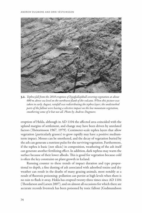
3.2. Tephra fall from the 2010 eruption of Eyjafjallajökull covering vegetation at about 600 m above sea level on the northwest flank of the volcano. When this picture was taken in early August, rainfall was redistributing the tephra layer; the undisturbed parts of the fallout were having a selective impact on the low mountain vegetation, smothering some of it but not all. Photo by Andrew Dugmore.

B l a c k s u n, h i g h F l a m e, a n D F l o o D
75
et al. 2008). This represents a significant hazard to a community dependent on pastoralism.
Volcanic gases can have similarly widespread and spatially variable impacts. The most profound historical impact of volcanic gases occurred in AD 1783–1784 as a result of emissions from the Laki flood lavas. These emissions cre-ated a persistent toxic haze across most of Iceland (Thordarson and Self 2003). Fluorosis poisoning of livestock and the related famine resulted in the loss of around 9,000 people, about a quarter of the population (Grattan 1998; Karlsson 2000). The haze spread through Europe, where it arguably resulted in the deaths of many more people than it did in Iceland. The haze and persistent high pressure over the British Isles and northwest Europe resulted in very poor air quality. The impact of this pollution is shown in “excess deaths”—higher mortality rates than would otherwise be expected. Mortality data through the eighteenth century AD establish trends of expected deaths season by sea-son, and in AD 1783 summertime deaths were significantly higher than the established range and were closely associated with the haze. The heightened death toll in England probably claimed an additional 20,000 people (Grattan, Durand, and Taylor 2003; Grattan et al. 2003; Witham and Oppenheimer 2005), and the effects may not have stopped there because increased mortality can also be identified in Scotland. The Laki eruption likely affected climate, but in Iceland and northwest Europe this hazard may have been of limited impact compared with the direct effects of the volcanic gases.
The longevity of hazards as well as their scale depends on a range of factors that may vary in importance. First is the scale of the volcanic erup-tion itself, which is perhaps the most obvious factor but not necessarily the most important. The potential hazard from an eruption is fundamentally shaped by the setting and context of the event. Very similar underground movements of magma may become very different eruptions depending on the surface environment; high groundwaters may turn a potentially effusive (lava-producing) eruption into an explosive one. The presence of glacier ice over the vent may lead to flooding, and steep gradients leading away from the eruption site may propagate flooding more swiftly and over a larger area. Abundant overlying ice, plus a potential for the flood to “pond” and build up before release, may result in a large volume of floodwater and high peak flows. Proximity to plains can create the potential for extensive inundations. Wind direction and strength will determine the concentration or dispersal of both pollution and tephra-fall. Rain can mitigate the effects of volatile pollution and speed the process of ecological recovery. Most significant of all are the patterns and status of settlement. Are people in harm’s way, and, if so, how able are they to cope?
Lava and floods, while locally catastrophic, have produced few fatalities because of their clearly defined extent and limited direct effect on settlement.

a n D r e W D u g m o r e a n D o r r i V és T e i n s s o n
76
In contrast, fallout and pollution can impact very large areas, and both direct and indirect effects can be particularly severe.
Long recurrence times and their varied nature have meant that prior to the twentieth century AD there was little specific planning to cope with volcanic impact. However, communal resilience in Iceland that developed to face other environmental challenges, such as extreme or unpredictable weather, has been the basis of effective response to volcanic hazards and the mitigation of their impacts. In the absence of outside assistance, the ability to cope within Iceland has been largely determined by the ability (or otherwise) to utilize support from unaffected or less affected areas and to switch between alternative forms of subsistence, in particular between farming (terrestrial) and hunting (wild) resources. Extreme weather is far more frequent than volcanic eruptions and can produce similar stresses to ash falls. Domestic animals die; access to graz-ing, pasture productivity, and fodder production are all impacted; and access to wild resources such as fish may be compromised. The synergistic effects of volcanic hazards, including economic constraints, disease, and bad weather, have had some of the greatest effects on the Icelandic population.
The impact of the AD 1783–1784 “Haze Famine” was probably exacer-bated by circumstances at the time—cold weather, the constraints imposed on eighteenth-century Icelandic society, an ineffectual response by the distant government, and a major earthquake in 1784 (Karlsson 2000). In 1755 Katla erupted, flooded large areas of Mýrdalssandur, and spread fallout through dis-tricts to the east of the volcano. It is debatable, however, whether any people died directly as a result. In contrast to the later Laki eruption, increased mor-tality at the time resulted from a range of other, non-volcanic hazards. The 1750s were a period of very unfavorable weather for the pastoralism that was the basis for subsistence. Pack ice appeared and persisted around the coast of Iceland. This sea ice interfered with subsistence fishing and locally intensified cold weather that impacted both rangeland grazing and fodder production. In 1755 pack ice remained off the northern coast of Iceland all summer, and in the autumn Katla erupted, adding to the misery of the people of southern Iceland. In 1756 the pack ice spread along the south coast. The cumulative effects of bad weather and social and economic constraints resulted in Iceland’s population being reduced by around 5,800 people, two-thirds of total Icelandic mortality in the aftermath of Laki (ibid.). If less was known about the climate, as well as the social and economic contexts, of 1755–1756, the impact of the Katla erup-tion could be assumed to be far greater than it probably was. Perhaps the most remarkable aspect of the disasters of both the 1750s and 1783–1784 is the way the Icelandic population recovered. Although environmental impacts were exacerbated by synergistic effects, Icelandic society proved remarkably able to cope with multiple stressors (Vasey 1996).

B l a c k s u n, h i g h F l a m e, a n D F l o o D
77
TepHrocHronology: daTing pasT Hazards THrougH THe use of Volcanic asH layers
Serendipitously, the volcanic events that create hazards in Iceland have also cre-ated a highly effective means of assessing those hazards. Tephrochronology is a dating technique based on the identification and correlation of tephra layers that was pioneered in Iceland by Sigurdur Thórarinsson in the mid-twentieth century (e.g., Thórarinsson 1944, 1967) and that now has worldwide applica-tion (e.g., Self and Sparks 1981; Shane 2000). Tephra layers have distinctive characteristics that can be used to identify and correlate separate deposits of the same tephra layer, which can then define time marker horizons, or isochrones, that have great utility. Tephras exhibit a range of macroscopic features that reflect major differences in chemical composition, eruption mechanism, total tephra volume, principal directions of fallout, and depositional environments. In Iceland tephra layers can vary from millimeters to meters in thickness and are primarily composed of vesicular glass shards. The colors of layers as a whole vary from white through yellows, reds, browns, and grays to black. Tephra lay-ers may be uniform in color or composed of characteristic mixes of different-colored pumices, crystals, or lithic fragments. Particle sizes range from cobble and coarse gravel grade to silt; particle shapes include a range of vesicularities and both rounded and elongated grains.
The analysis of many stratigraphic sections has led to the accurate map-ping of individual tephra layers that clearly shows their geographical origin, the scale and nature of the eruption, and contemporary weather patterns (e.g., Larsen and Thórarinsson 1977; Larsen et al. 2001; Thórarinsson 1967). The ages of tephra layers have been determined in a variety of ways. Thórarinsson’s groundbreaking work in Iceland showed that precise historical dates can be ascribed to tephra layers through a careful analysis of written records. For the earliest times of settlement in Iceland, when no contemporary written records exist, other approaches have to be used. Radiocarbon dating can give excel-lent results, especially if the dating is conducted within a Bayesian framework (Church et al. 2007); extrapolations can be made from securely dated layers using well-understood sediment accumulation patterns (e.g., Halflidason, Larsen, and Ólafsson 1992); and correlations can be made with the Greenland ice core records (e.g., Grönvold et al. 1995). A securely dated tephra layer can be used to define a landscape at a moment in time; with the identification of multiple in situ layers of primary fallout, intervals of time can be defined and changes tracked through both time and space (figure 3.3). Sometimes tephras within a stratigraphy may be moved on small scales (e.g., by soil movement) or large scales (e.g., by transport in glacier ice), or they may become incorporated in sediments of a different age by reworking and redeposition. In both of these situations the movement of the tephra represents an opportunity to gain more environmental data, as it allows movement to be traced through time.
a n D r e W D u g m o r e a n D o r r i V és T e i n s s o n
78
Rapid aeolian sediment accumulation across Iceland means that different tephra layers falling across the same region are clearly separated, even if the tephra deposition was only separated by a period as short as one decade. The highest-resolution, best-dated sequences occur where there is a combination of high background aeolian sedimentation and the deposition of several tephra layers each century that are thick enough to form discrete horizons but shallow enough to allow vegetation to grow through the layer and stabilize the deposit. In Iceland this generally means a layer more than ¼ cm thick but less deep than the contemporary vegetation cover. A deep sward and heath may stabilize lay-ers 5–10 cm thick, but centimeter-scale thicknesses of tephra rarely stabilize on well-grazed slopes because the vegetation needs to project through the tephra in order to survive and stabilize the surface.
Precise dating (to the decade, year, season, and even the day) allows true interdisciplinary collaboration and effective discussions about common ques-tions of hazard, mitigation, and disaster among historians, archaeologists, ecol-ogists, geographers, geologists, planners, and policy makers.
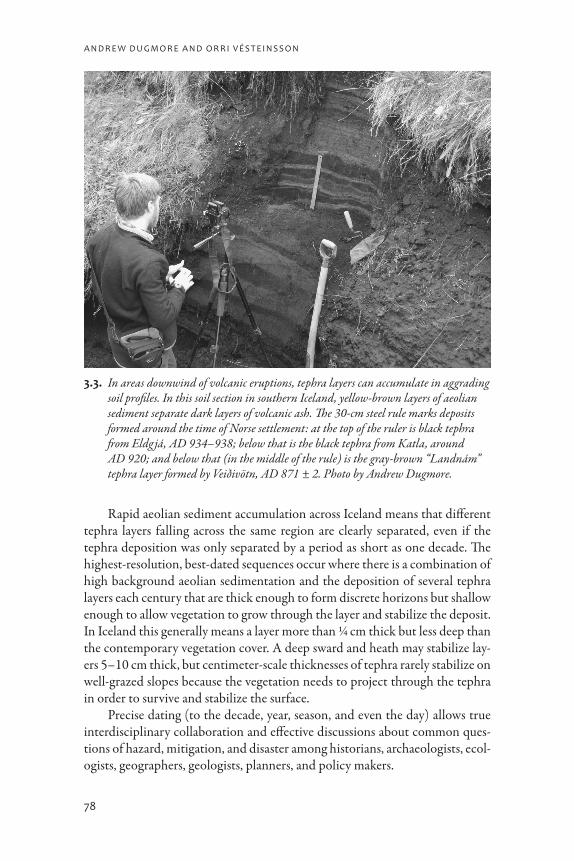
3.3. In areas downwind of volcanic eruptions, tephra layers can accumulate in aggrading soil profiles. In this soil section in southern Iceland, yellow-brown layers of aeolian sediment separate dark layers of volcanic ash. The 30-cm steel rule marks deposits formed around the time of Norse settlement: at the top of the ruler is black tephra from Eldg já, AD 934–938; below that is the black tephra from Katla, around AD 920; and below that (in the middle of the rule) is the gray-brown “Landnám” tephra layer formed by Veiðivötn, AD 871 ± 2. Photo by Andrew Dugmore.

B l a c k s u n, h i g h F l a m e, a n D F l o o D
79
indirecT Hazards from Volcanic acTiViTy
Deeper (multi-millennia) time perspectives can reveal patterns of activity and give some indication of possible return times between events. Knowledge of vol-canic activity over long timescales (for people but not volcanoes, which may be active over hundreds of thousands of years) can alert us to events that can occur but have not (yet) been experienced in historical time. Landscape provides a record of the sum total of these past events that is sometimes complete but most often fragmentary; much evidence is lost—destroyed by subsequent changes—and some processes leave little, if any, physical trace. What does remain, though, is still rich and diverse, with strong spatial patterns that are often the key to interpretation. Crucially, as the landscape is formed by the interplay of human and natural systems, it provides one way in which we can seek evidence of past hazards and also vulnerabilities that may otherwise leave little trace.
Various possible explanations exist for differing impacts of similar volca-nic hazards. Different outcomes may occur as a result of variations in environ-mental sensitivity, as some places may experience threshold-crossing events because of the inherent status of their ecology, soils, location, or climate. This idea underpins the concept of the over-optimistic pioneer fringe: areas that are occupied but simply too marginal or vulnerable for long-term settlement and where environmental degradation and local settlement failure are inevitable consequences (Dugmore et al. 2006). Alternatively, areas that are not environ-mentally marginal or vulnerable to hazards at the time of initial settlement may become so. Stochastic variables (such as season or wind direction during an eruption) could be vital, although other natural events such as climate change may also be significant.
The settlement of Iceland (or landnám) led to extensive environmental changes that affected the potential impacts of volcanic hazards in general and of tephra fall in particular (e.g., Arnalds et al. 2001; Einarsson 1963; Hallsdóttir 1987). Wholesale environmental changes were inevitable for two main rea-sons. First, landnám was a large-scale colonization involving thousands of set-tlers who relied on a pastoralist subsistence base (Vésteinsson, McGovern, and Keller 2002); this led to the clearance of large areas of woodland to create both fields for fodder production and extensive grasslands for grazing. Second, the lack of indigenous grazing mammals led to the large-scale introduction of a domesticated biota (cattle, sheep, goats, pigs, horses, and dogs) hitherto absent from the island.
The consequences of people in Iceland drawing false analogies from sim-ilar-looking landscapes in the British Isles and western Norway may be one explanation for the considerable variation in local impacts produced by set-tlement and in the vulnerability to volcanic hazards. In the inland valleys of Thórsmörk in southern Iceland, for example, there is both an early onset of soil erosion and an early abandonment of five settlements that may have been either
a n D r e W D u g m o r e a n D o r r i V és T e i n s s o n
80
summer farms or permanently occupied sites (Dugmore et al. 2006). Climate reconstructions indicate that this settlement change is unlikely to have been caused by either fundamentally unfavorable local weather or systematic climate change (Casely and Dugmore 2007). Evidence for one possible factor can be seen in surviving soil profiles; several thick tephra layers would have been close to the surface at the time of settlement, so even minor disturbance of the veg-etation would have exposed unstable pumice to erosion by wind and rain. In addition, the Katla eruption in approximately AD 920, which spread fallout as far as Reykjavik, would have fallen thickly in this area; soil erosion would have been enhanced as deep, unstable deposits of tephra killed underlying vegeta-tion in gullies and hollows and at the foot of slopes.
We conclude that two quite different aspects of volcanic hazard contrib-uted to environmental degradation in Thórsmörk: first, the enhanced landscape sensitivity caused by the presence of tephra layers close to the surface of the soil, and second, the direct impacts of the fallout from the 920 eruption of Katla.
The presence of volcanic impact and the coincidence of environmental degradation and settlement change, while notable, do not in and of themselves provide a satisfactory explanation of human-environment interaction because elsewhere they do not coincide, emphasizing that simplistic associations may be misleading. In the case of Thórsmörk, woodland management provides an alternative explanation of settlement change (Dugmore et al. 2006). The area contains one of the few surviving woods in the region and has a long history of providing charcoal to lowland farms. Woodland clearance occurred very rap-idly around newly established settlement sites, and through the first 500 years of settlement woodland was gradually cleared from low-lying areas; pollen dia-grams and the remains of charcoal production sites have enabled woodland clearance to be tracked up-valley. By the fourteenth century AD it is apparent that naturally wooded areas were much reduced, and it is about this time that settlement change occurred in the last wooded areas of Thórsmörk. Woodland was conserved, and seven centuries later it was still providing a key resource to an extensive network of lowland farms. While localized environmental deg-radation as a result of soil erosion (and the legacy of past volcanic eruptions), plus impacts of later volcanic eruptions, may have marginalized the Thórsmörk settlements, socio-political factors seem to be more important in the timing of settlement change. It is notable that a similar process of woodland conserva-tion may have contributed to settlement change in the Thjórsardalur region close to Hekla (Dugmore et al. 2007).
using THe pasT To idenTify fuTure Hazards
Today, volcanic emergency planning in Iceland has its own specific provisions based on detailed geological assessments (e.g., Gudmundsson et al. 2008).
B l a c k s u n, h i g h F l a m e, a n D F l o o D
81
The modern science of volcanic hazard assessment faces a number of specific challenges over establishing the nature of possible events and their potential impacts. Some past volcanic events leave clear traces behind, such as a layer of volcanic ash or a characteristic flood deposit. Others hazards, such as fluorine poisoning of livestock, may leave no direct physical evidence. Their occurrence has to be inferred indirectly through, for example, written records of impacts or studies of magma composition (to infer the presence of volatiles). Even when there is physical evidence, such as the landscape record of a flood, it may be ambiguous; was this caused by a volcanic event? How big was it?
Tephrochronology aids the understanding of past human-environment interactions by providing precise dating control and landscape-wide correla-tions. When combined with interdisciplinary approaches, this has helped the development of a more detailed, complex, and nuanced understanding of change. Just as the significance of past volcanic hazards for past human popula-tions has benefited from the application of tephrochronology, so has tephro-chronology aided understanding of what hazards are possible, even if people have not yet experienced them.
For example, Kate Smith (Smith 2004; Smith and Haraldsson 2005) has shown that floods from Katla have flowed eastward into areas unaffected by similar floods in recorded history (Larsen 2000). Future activity may not fol-low the pattern set by Katla’s twenty-one historic eruptions. Indeed, geomor-phological and stratigraphic mapping dated with tephrochronology shows that prehistoric floods from Katla did follow different routes and that they provide crucial data for contemporary emergency planning.
Immediately to the west of Katla, Eyjafjallajökull (1,666 m) is one of the largest volcanoes in Iceland (and Europe), capped by an ice cap of the same name. In March 2010 sub-aerial flank activity began that led to the forma-tion of cinder cones and a small lava flow. This was followed by activity in the central crater that generated a comparatively limited volume of fine-grained tephra and international impacts out of all proportion to its scale (figures 3.4, 3.5, and 3.6). Context was again key; the generation of fine ash and the prevail-ing weather conditions led to its persistent dispersal over airports and across European and trans-Atlantic flight routes. Prior to 2010, only small-scale volca-nic activity in the summit region and limited flooding were known from writ-ten sources, but geomorphological data constrained by tephrochronology have also identified flank activity in the late presettlement period and early tenth century AD. These eruptions produced extensive flooding over hill slopes to the northwest and southwest of the ice cap; if repeated, they could pose a seri-ous hazard to local communities.
The identification of Late Holocene flank activity was a challenge because the channel erosion and “scabland” formations its floods created lie in zones also affected by glaciation and the seasonal melting of snow and ice. Recognition
a n D r e W D u g m o r e a n D o r r i V és T e i n s s o n
82
of volcanogenic flooding rested on chronology and the ability to tie extensive areas of erosion or deposition to a single time and event. In this case (as in oth-ers; e.g., Smith and Dugmore 2006) the features and deposits produced by a volcanogenic flood were not particularly noteworthy in terms of scale, particle sizes, or the volume of material. Erosion forms are poorly developed, and the size of flood-transported material has been limited by the types of sediments available rather than the capacity of the flood to move it. Total volumes of sediment are likewise limited and thus give little indication of the peak dis-charge or duration of the event. Tephrochronology was well suited to tackling this problem and providing a means to correlate scattered landscape evidence despite the lack of tephra production from the flank eruptions themselves.
On Eyjafjallajökull the eruption of the Skerin fissure around AD 920 (northwestern part of the glacier) coincided with a much larger eruption in the neighboring volcano Katla—an association that also occurred in AD 1821–1823 and probably in both AD 1612 and late presettlement times, leading to anxious monitoring of both volcanoes when activity began in Eyjafjallajökull in March 2010. An eruption of Katla has been expected for some time; based on the very detailed records that have existed since AD 1500 Katla’s mean
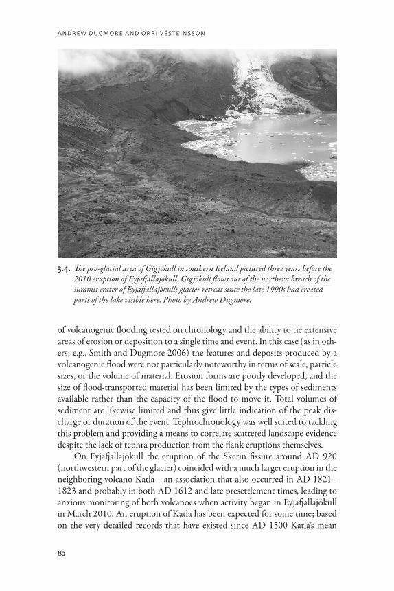
3.4. The pro-glacial area of Gíg jökull in southern Iceland pictured three years before the 2010 eruption of Eyjafjallajökull. Gíg jökull flows out of the northern breach of the summit crater of Eyjafjallajökull; glacier retreat since the late 1990s had created parts of the lake visible here. Photo by Andrew Dugmore.
B l a c k s u n, h i g h F l a m e, a n D F l o o D
83
eruption interval is forty-nine years (with a standard deviation of twenty-five years). It has been more than ninety years since Katla’s last eruption, an unusu-ally long period of time. The fact that it is “overdue” suggests that another erup-tion will occur sooner rather than later; combine that with the 2010 eruption of Eyjafjallajökull and repeated examples of near contemporaneous activity in Eyjafjallajökull and Kalta, and it seems quite probable that Katla will erupt soon and create both ash clouds and major floods.
conclusion
Volcanic eruptions have created many different hazards for the people of Iceland and contributed to some of their greatest human tragedies. Despite their frequent occurrence and sometimes very large magnitudes, they have not, however, proved to be the greatest hazard to the Icelandic people. Diseases such as the fifteenth-century plagues and later smallpox outbreaks have killed more people in discrete episodes, and other factors such as climate change and socio-political constraints may have led to a greater cumulative total of lives lost.
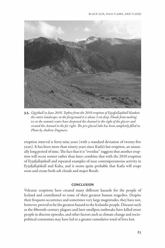
3.5. Gíg jökull in June 2010. Tephra from the 2010 eruption of Eyjafjallajökull blankets the entire landscape; in the foreground it is about 3 cm deep. Floods from melting ice in the summit crater have deepened the channel to the right of the glacier and created the channel to the far right. The pro-glacial lake has been completely filled in. Photo by Andrew Dugmore.
a n D r e W D u g m o r e a n D o r r i V és T e i n s s o n
84
The impacts of volcanic hazards themselves have been exacerbated by other factors, such as bad weather, earthquakes, and economic constraints. Limitations to the effects of volcanic hazards have been created by both envi-ronmental and cultural factors. With the notable exception of Vestamanneyjar, where the largely submerged volcanic system forms a fine natural harbor, there has been little to draw people to settle in the present volcanic zones, let alone on active volcanoes. Social systems developed to cope with the vagaries of life in Iceland have proved well suited to coping with volcanic hazards: mobility within the island has been possible, and volcanically induced livestock fatalities could be offset by increased emphasis on fishing and hunting.
At a global scale, it has been argued that volcanic eruptions can represent opportunities as well as threats and that, despite their undoubted destruction, they may also spur development and innovation (Grattan 2006). In Iceland, however, the impacts may well have promoted conservatism and stifled innova-tion (Karlsson 2000). Having said that, communities in Iceland have success-fully coped with volcanic hazards through approaches to living that is more regularly tested by bad weather and outbreaks of disease. Enduring settlement in Iceland is a testament to both Icelandic social organization and the durabil-ity of the Norse farm as a settlement strategy.
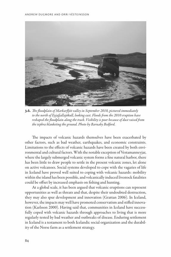
3.6. The floodplain of Markarfljót valley in September 2010, pictured immediately to the north of Eyjafjallajökull, looking east. Floods from the 2010 eruption have reshaped the floodplain along the track. Visibility is poor because of dust raised from the tephra blanketing the ground. Photo by Barnaby Bedford.
B l a c k s u n, h i g h F l a m e, a n D F l o o D
85
Acknowledgments. We acknowledge support from the Leverhulme Trust (Landscapes circum Landnám) and the US National Science Foundation through the Office of Polar Programs Arctic Social Sciences Grant 0732327 as part of the International Polar Year Humans in the Polar Regions project “IPY: Long Term Human Ecodynamics in the Norse North Atlantic: Cases of Sustainability, Survival, and Collapse.” This publication is a product of the North Atlantic Biocultural Organization (NABO) cooperative.
references
Arnalds, Olafur, Elín F. Thorarinsdottir, Sigmar Metusalemsson, Ásgeir Jonsson, Einar Gretarsson, and Arnór Arnason2001 Soil Erosion in Iceland. Soil Conservation Service and Agricultural
Research Institute, Reykjavik. (English translation of original Icelandic publication from 1997).
Casely, Andrew F., and Andrew J. Dugmore2007 Good for Glaciers, Bad for People? Archaeologically Relevant Climate
Models Developed from Reconstructions of Glacier Mass Balance. Jour-nal of Archaeological Science 34: 1763–1773.
Church, Mike J., Andrew J. Dugmore, Kerry-Anne Mairs, Andrew R. Millard, Gordon T. Cook, Guărún Sveinbjarnardóttir, Philippa A. Ascough, Anthony J. Newton, and Katy Roucoux2007 Timing and Mechanisms of Deforestation of the Settlement Period in
Eyjafjallsveit, Southern Iceland. Radiocarbon 49(2): 659–672.
Cutler, Nick A., Lesa R. Belyea, and Andrew J. Dugmore2008 The Spatiotemporal Dynamics of a Primary Succession. Journal of Ecology
96: 231–246.
Dugmore, Andrew J., Mike J. Church, Kerry-Anne Mairs, Thomas H. McGovern, Anthony J. Newton, and Guărún Sveinbjarnardóttir2006 An Over-Optimistic Pioneer Fringe? Environmental Perspectives on
Medieval Settlement Abandonment in Thórsmörk, South Iceland. In The Dynamics of Northern Societies, ed. Jette Arneborg and Bjarne Grønnow. Studies in Archaeology and History 10. Publications from the National Museum, Copenhagen, pp. 333–344.
Dugmore, Andrew J., Mike J. Church, Kerry-Anne Mairs, Thomas H. McGovern, Sophia Perdikaris, and Orri Vésteinsson2007 Abandoned Farms, Volcanic Impacts and Woodland Management: Revis-
iting Þjórsárdalur, the “Pompeii of Iceland.” Arctic Anthropology 44 (1): 1–11.
Dugmore, Andrew J., Anthony J. Newton, Gudrun Larsen, and Gordon T. Cook2000 Tephrochronology, Environmental Change and the Norse Settlement of
Iceland. Environmental Archaeology 5: 21–34.

a n D r e W D u g m o r e a n D o r r i V és T e i n s s o n
86
Einarsson, Thorleifur1963 Pollen Analytical Studies on the Vegetation and Climate History of Ice-
land in Late and Post-Glacial Times. In North Atlantic Biota and Their His-tory, ed. Áskell Löve and Doris Löve. Pergamon, Oxford, pp. 355–365.
Falk, Oren2007 The Vanishing Volcanoes: Fragments of Fourteenth-Century Icelandic
Folklore. Folklore 118(1): 1–22.Grattan, John P.
1998 The Distal Impact of Volcanic Gases and Aerosols in Europe: A Review of the 1783 Laki Fissure Eruption and Environmental Vulnerability in the Late 20th Century. Geological Society London, Special Publication 15: 7–53.
2006 Aspects of Armageddon: An Exploration of the Role of Volcanic Erup-tions in Human History and Civilization. Quaternary International 151: 10–18.
Grattan, John P., Michael Durand, David Gilbertson, and F. Brian Pyatt2003 Human Sickness and Mortality Rates in Relation to the Distant Eruption
of Volcanic Gases: Rural England and the 1783 Eruption of the Laki Fis-sure, Iceland. In Geology and Health: Closing the Gap, ed. Anthony Berger and H. Catherine Skinner. Oxford University Press, Oxford, pp. 19–25.
Grattan, John P., Michael Durand, and S. Taylor2003 Illness and Elevated Human Mortality Coincident with Volcanic Erup-
tions. In Volcanic Degassing, ed. Clive Oppenheimer, David M. Pyle, and Jenni Barclay. Special Publication 213. Geological Society of London, London, pp. 401–414.
Grönvold, Karl, Níels Óskarsson, Sigfús J. Johnsen, Henrik B. Clausen, Claus U. Hammer, Gerald Bond, and Edouard Bard1995 Tephra Layers from Iceland in the Greenland GRIP Ice Core Correlated
with Oceanic and Land Based Sediments. Earth and Planetary Science Letters 135: 149–155.
Gudmundsson, Magnus T., Gudrun Larsen, Ármann Höskuldsson, and Ágúst G. Gylfason2008 Volcanic Hazards in Iceland. Jökull 58: 251–268.
Gudmundsson, Magnus T., Freysteinn Sigmundsson, and Helgi Björnsson1997 Ice-Volcano Interaction of the 1996 Gjálp Subglacial Eruption, Vat-
najökull, Iceland. Nature 389: 954–957.Halflidason, Halflidi, Gudrun Larsen, and Gunnar Ólafsson
1992 The Recent Sedimentation History of Thingvallavatn, Iceland. Oikos 64: 80–95.
Hallsdóttir, Margret1987 Pollen Analytical Studies of Human Influence on Vegetation in Relation
to the Landnám Tephra Layer in Southwestern Iceland. Lundqua Thesis 18: 1–45.
B l a c k s u n, h i g h F l a m e, a n D F l o o D
87
Haraldsson, Hreinn1981 The Markarfljót Sandur Area, Southern Iceland: Sedimentological, Petro-
logical and Stratographical Studies. Striae 15: 1–60.Jóhannesson, Haukur, and Sigmundur Einarsson
1988 Krísuvíkureldar I. Aldur Ögmundarhrauns og Miðaldalagsins. Jökull 38: 71–85.
Karlsson, Gunnar2000 Iceland’s 1100 Years: History of a Marginal Society. Mál og Menning,
Reykjavik.Larrington, Carolyne
1996 The Poetic Edda: A New Translation by Carolyne Larrington. Oxford Uni-versity Press, Oxford.
Larsen, Gudrun2000 Holocene Eruptions within the Katla Volcanic System, South Iceland:
Characteristics and Environmental Impact. Jökull 49: 1–28.Larsen, Gudrun, Anthony J. Newton, Andrew J. Dugmore, and Elsa Vilmundardóttir
2001 Geochemistry, Dispersal, Volumes and Chronology of Holocene Silicic Tephra Layers from the Katla Volcanic System. Journal of Quaternary Sci-ence 16(2): 119–132.
Larsen, Gudrun, and Sigurdur Thórarinsson1977 H4 and Other Acidic Hekla Tephra Layers. Jökull 27: 28–46.
McGovern, Thomas H., Orri Vésteinsson, Adolf Fridriksson, Mike J. Church, Ian Lawson, Ian A. Simpson, Arni Einarsson, Andrew J. Dugmore, Gordon T. Cook, Sophia Perdikaris, Kevin Edwards, Amanda M. Thomson, W. Paul Adderley, Anthony J. Newton, Gavin Lucas, and Oscar Aldred2007 Landscapes of Settlement in Northern Iceland: Historical Ecology of
Human Impact and Climate Fluctuation on the Millennial Scale. Ameri-can Anthropologist 109(1): 27–51.
Sæmundsson, Kristján1991 Jarðfræði Kröflukerfisins (The Geology of the Krafla Volcanic System). In
Náttúra Mývatns (The Natural History of the Mývatn Area), ed. ArnÞór Gardarsson and Arni Einarsson. Hið íslenska náttúrufræðifélag, Reykja-vík, pp. 24–95 (in Icelandic).
Self, Steve, and R.S.J. Sparks, eds.1981 Tephra Studies. Dordrecht, Reidel.
Shane, Phil2000 Tephrochronology: A New Zealand Case Study. Earth-Science Reviews
49(1–4): 223–259.Smith, Kate T.
2004 Holocene Jökulhlaups, Glacier Fluctuations and Palaeoenvironment, Mýr-dalsjökull, South Iceland. PhD dissertation, Geography, School of Geo-sciences, University of Edinburgh, UK.

a n D r e W D u g m o r e a n D o r r i V és T e i n s s o n
88
Smith, Kate T., and Andrew J. Dugmore2006 Jökulhlaups Circa Landnám: Mid- to Late First Millennium AD Floods in
South Iceland and Their Implications for Landscapes of Settlement, South Iceland. Geografiska Annaler 88A(2): 165–176.
Smith, Kate T., and Hreinn Haraldsson2005 A Late Holocene Jökulhlaup, Markarfljót, Iceland: Nature and Impacts.
Jökull 55: 75–86.Storm, Gustav, ed.
1888 Islandske annaler indtil 1578. Norsk Historisk Kildeskriftfond, Christi-ania, Norway.
Sveinsson, Einar Ólafur1947 Byggð á Mýrdalssandi (Settlement in Mýrdalssandur). Skírnir 121: 185–
210 (in Icelandic).Thórarinsson, Sigurdur
1944 Tefrokronologiska studier på Island. Geografiska Annaler 26: 1–217.1958 The Öræfajökull Eruption of 1362. Náttúrugripasfn Íslands, Reykjavík.1967 The Eruptions of Hekla in Historical Times. The Eruption of Hekla 1947–
1948 1: 1–170.1968 Heklueldar (The Eruptions of Hekla). Sögufélagið, Reykjavík (in Icelandic).1979 On the Damage Caused by Volcanic Eruptions with Special Reference to
Tephra and Gases. In Volcanic Activity and Human Ecology, ed. Payson D. Sheets and Donald K. Grayson. Academic Press, San Diego, pp. 125–159.
1981 Jarðeldasvæði á nútíma (Volcanic Areas of the Holocene). In Náttúra Íslands, 2nd ed. Almenna bókafélagið, Reykjavík, pp. 81–119.
Thórarinsson, Sigurdur, and Kristján Sæmundsson1979 Volcanic Activity in Historical Time. Jökull 29: 29–32.
Thordarson, Thorvaldur, and Gudrun Larsen2007 Volcanism in Iceland in Historical Time: Volcano Types, Eruption Styles
and Eruptive History. Journal of Geodynamics 43: 118–152.Thordarson, Thorvaldur, and Steve Self
2003 Atmospheric and Environmental Effects of the 1783–1784 Laki Eruption: A Review and Reassessment. Journal of Geophysical Research 108(D1): 4011.
Tómasson, Haukur1996 The Jökulhlaup from Katla in 1918. Annals of Glaciology 22: 249–254.
Vasey, Daniel E.1996 Population Regulation, Ecology, and Political Economy in Preindustrial
Iceland. American Ethnologist 23(2): 366–392.Vésteinsson, Orri, Thomas H. McGovern, and Christian Keller
2002 Enduring Impacts: Social and Environmental Aspects of Viking Age Set-tlement in Iceland and Greenland. Archaeologia Islandica 2: 98–136.
Witham, Claire S., and Clive Oppenheimer2004 Mortality in England during the 1783–4 Laki Craters Eruption. Bulletin
of Volcanology 67: 15–26.
B l a c k s u n, h i g h F l a m e, a n D F l o o D
89
undersTanding Hazards, miTigaTing impacTs, aVoiding disasTers
statement for policy makers and the disaster management community
A long-term view of volcanic hazards in Iceland contains an important mes-sage for policy makers: context is vital. Although combinations of major erup-tions and unlucky circumstances have contributed to nationwide calamities, depression, and famine, we stress that it was not the size or type of volcanic eruption alone that decided this result but rather the time of year the erup-tion took place and the coincidence of other factors that in combination could produce catastrophic shocks to the economic system. It is notable that despite over 200 volcanic events in Iceland that could have led to a disas-ter, few have killed people either directly or indirectly; when bad synergies occur, however, death tolls can be great. Historical case studies suggest that human suffering on a massive scale is not necessarily a measure of system resilience (or failure): societies can absorb enormous and inhuman amounts of pain and suffering without failing.
Potential impacts of volcanic eruptions are variable depending on envi-ronmental and social contexts and are best viewed alongside other natural hazards, from disease to extreme weather. Long recurrence times and their varied nature have meant that prior to the twentieth century AD there was little specific planning to cope with volcanic impacts. However, communal resilience in Iceland that developed to face other environmental challenges, such as extreme or unpredictable weather, has been the basis of an effective response to volcanic hazards and the mitigation of their impacts. Self-reli-ance was key and was based on flexible strategies of farming and wildlife exploitation. Arguably, this flexibility came at the cost of economic devel-opment, which at best was sluggish until the end of the nineteenth century. Modifying or abandoning this ability to deal with setbacks in favor of eco-nomic development did not seem like an acceptable strategy until modern times. Serendipitously, the volcanic events that create hazards in Iceland have also created environmental records that are a highly effective means of assess-ing those hazards. Through a detailed, multidisciplinary study of the past, we can both acquire an appreciation of the likely physical effects of future events and assess how specific circumstances have led to economic cost and human suffering—or not. The key to effective anticipation of an unknowable future is to understand the importance of synergistic effects and how they might occur depending upon context.