Embed Size (px)
Citation preview

Page 1 of 11
DECISION MEMO Blue Quartz Placer Exploration Project
USDA Forest Service, Northern Region Nez Perce National Forest, Red River Ranger District
Idaho County, Idaho
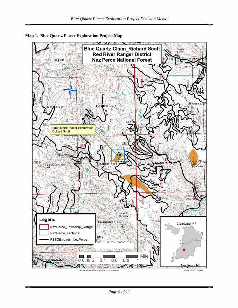
I. Decision I have decided to authorize the mineral exploration Plan of Operation with the following terms and conditions for the Blue Quartz Placer Exploration Project proposed by Mr. Rick Scott located on the Red River Ranger District of the Nez Perce National Forest at T29N, R6E, Section 24, Boise Meridian, Idaho County (see attached map). My decision authorizes Mr. Rick Scott, the operator, to excavate six ten-by-twelve feet test pits to test placer gravels for mineral values. These pits would be dug with a 304 Cat mini excavator to bedrock and are all within a previously disturbed area. Material would be dry screened to 3/8 inch minus size, and hauled offsite for further processing or the claimant will use a small washplant onsite to process placer materials. Material will be removed from each pit and stockpiled, and the pit will be used as a sump to collect processed water, which will be reused. A temporary water permit will be required for locally obtained water, and will be issued before the operating plan will be approved.
Pits would then be backfilled with remaining material and reclaimed. Only one pit would be open at a time. Some dead and/or down timber may be removed for access and safety. A number of small trees may need to be removed. These will be cut down and piled to one side, then scattered about the immediate area and left in place when work is finished. Access to the project site would be by existing roads and trails. Some minor berm removal would be necessary to access the site. Appropriate mitigation measures would be employed to protect against resource damage, and appropriate Idaho Best Management Practices for placer mining would be observed.
As part of this decision, the operator will be required to:
General: Notify the District Ranger or minerals administrator at least 48 hours before any work is to
begin. Wash all vehicles and equipment used at the site before being brought onto National Forest
system lands to prevent the spread of noxious weeds. Avoid disturbance of wetlands and stream riparian zones. Avoid working on saturated soils. Prevent discharge of water into any live stream or wetland. Place weed free straw bales or install silt fence in places as identified by a Forest Service
representative to minimize sediment migration from stockpiles and/or raw earth. Obtain prior approval from the Forest Service for cutting or removal of trees or other large
live vegetation. Downfall may be removed as needed.
Blue Quartz Placer Exploration Project Decision Memo
Page 2 of 11
Set aside cleared slash and green vegetation (e.g., beargrass) during test pit construction. Remove vegetation in clumps, if possible, with the soil mass intact. Store excavated topsoil and subsoil in separate stockpiles to be used during reclamation. Temporarily replant vegetation clumps in the topsoil stockpile.
Maintain only one (1) pit open at any one time. Cover water pump intake hose with a 3/32” mesh screen. Collect process water in the existing pit. Regulate discharge to prevent overtopping the pit,
and/or land apply excess water on a site designated by the Forest Service. (Application sites will typically be natural sumps or depressions, pits, or trap(s) that avoid impacts to wetlands or streams and minimizes impacts to other surface resources. Application rate will be such that overland flow is avoided.)
Backfill and reclaim each test pit as soon as testing has been completed for that site. Follow the State of Idaho Best Management Practices (BMPs) for all surface disturbing
activities, reclamation, and abandonment. BMPs are outlined in the Best Management Practices for Mining in Idaho (Idaho BMPs) (Idaho Department of Lands, et al. 1992).
Report accidents or injuries to the Forest Service within 24 hours. Develop a hazardous materials and spill prevention plan and submit it to the District Ranger
prior to operations. Store no more than 30 gallons of fuel or oil in the project area. Store all fuel or oil in a
secondary containment system that limits spills to the environment. Remove all equipment, garbage and trash resulting from the operation from National Forest
system lands prior to October 1, the end of the regular operating season. Dispose garbage and trash at a State of Idaho approved site.
Use and maintain a sanitary facility (e.g., porta-potty or self-contained camper) at the project area while operations are ongoing.
Comply with all applicable Federal and State fire laws and regulations and take all reasonable measures to prevent and suppress fires on the area of operations and require employees, contractors and subcontractors to do likewise (36 CFR 228.11).
Cultural Resources: If previously undiscovered cultural resources (historic or prehistoric objects, artifacts, or
sites) are exposed as a result of operations, cease operations until notification is received from a Forest Service archeologist or the District Ranger that the Forest Service and the operator has complied with provisions for mitigating unforeseen impacts as required by 36 CFR 228.4(e) and 36 CFR 800.
Reclamation: Reclaim test pits by: Restoring subsoil and topsoil to existing natural ground contour. Replanting beargrass clumps or other vegetation in topsoil. Placing locally available slash and duff over topsoil and around beargrass clumps or
other replanted vegetation. Seeding and mulching disturbed areas with appropriate seed mix and certified weed free
straw. Perform reclamation concurrently with the operation. Test pits and associated trails will be
reclaimed as soon as practicable when testing is completed at a site.
Blue Quartz Placer Exploration Project Decision Memo
Page 3 of 11
Reclamation Bond and Water Right: A reclamation bond must be received for this proposal by the Forest Service before work
can begin. Seasonal closeout and reclamation must be completed no later than October 1. This is to
ensure that all equipment is removed from the site and reclamation is complete before winter weather sets in.
Once the Forest Service receives the bond, the Plan of Operations may be approved.
Design Criteria and Mitigation Measures This project includes design criteria identified below to protect water quality. These items are not all-inclusive, as the Forest Plan standards are incorporated by reference (USDA Forest Service 1987, as amended).
Do not discharge water from operations within the riparian habitat conservation area (RCHA) of Little Leggett Creek (no closer than 300 feet, slope distance, to Little Leggett Creek; and no closer than 150 feet slope distance to the unnamed tributary).
Do not conduct ground disturbing activities within the RCHA of Little Leggett Creek (no closer than 300 feet, slope distance, to Little Leggett Creek; and no closer than 150 feet slope distance to the unnamed tributary).
Replant all disturbed soils as soon as possible to minimize soil erosion. Where feasible, incorporate the existing woody debris and vegetation located onsite into the
soil to maintain organic matter content and long-term soil productivity. Reconstruct waterbars on the native surface project roads prior to the end of the operating
season. Follow guidelines as specified in Attachment A.
II. Rationale for Decision and Reasons for Categorically Excluding the Decision A. Category of Exclusion and Rationale for Using the Category
The role of the Forest Service regarding mining activities on Forest Service system lands is to ensure that mining activities minimize adverse environmental effects to National Forest system resources, and comply with all applicable environmental laws. Congress has not given the Forest Service authority to unreasonably circumscribe or prohibit activities under the 1872 General Mining Law that are otherwise lawful.
Based on information in this document and the project record, I have determined this project is not significant in either context or intensity (40 CFR 1508.27), that no extraordinary circumstances affecting resource conditions exist (36 CFR 220.6), that this project may be categorically excluded from documentation in an EA or EIS, and that it meets all the criteria outlined for 36 CFR 220.6(e)(8) Short-term (one year or less) mineral, energy, or geophysical investigations and their incidental support activities that may require cross-country travel by vehicles and equipment, construction of less than one mile of low standard road, or use and minor repair of existing roads.
The rationale for my decision is based on: 1) the proposed action fully meeting the criteria for Categorical Exclusions, 2) the proposed action meeting the purpose and need, 3) the findings related to extraordinary circumstances, discussed below, 4) the project’s consistency with laws and regulations, including the Forest Plan, 5) the on-the-ground review and discussion with resource
Blue Quartz Placer Exploration Project Decision Memo
Page 4 of 11
specialists, and 6) my review of the Biological Assessments (BA), Biological Evaluations (BE), and specialists’ reports.
B. Finding of the Absence of Adverse Effects to Extraordinary Circumstances
1. Federally listed threatened or endangered species or designated critical habitat, species proposed for Federal listing or proposed critical habitat, or Forest Service sensitive species:
The Interdisciplinary Team (ID Team) Botanist, and Wildlife and Fisheries Biologists determined the proposed actions would have no effect or impact on listed or sensitive plant, wildlife, or fish species or habitat, and suitable habitat would not be altered because habitat is not present in the project area, habitat is present but the species do not occur in the project area, or habitat is present and the species may occur, but the project would not affect the habitat for the species, and therefore no incremental effects exist that would cause a cumulative effect, as documented in the Biological Assessments and Evaluations, and specialists’ reports (see plant, wildlife, and fish sections of the project record) with the following exceptions.
The Botanist determined the proposed actions may impact individuals or habitat of the following wildlife species, but are not likely to cause a trend toward federal listing or reduce viability for the populations or species: Payson’s milkvetch, clustered lady’s-slipper, green bug-on-a-stick, naked rhizomnium, and Idaho barren strawberry.
After reviewing habitat models for the area and reviewing photos provided, it appears there is potential habitat for Payson’s milkvetch, clustered lady’s-slipper, green bug-on-a-stick, naked rhizomnium, and Idaho barren strawberry in the area potentially affected. In the case of the lady’s-slipper, the habitat technically is suitable, but occurrence is unlikely based upon professional experience and judgment. While the proposed activities would likely negatively affect any existing plants, there would not be overall concern for viability due to the prevalence of the habitat in the area. The milkvetch would likely see an overall habitat improvement since it prefers disturbed areas.
2. Floodplains, wetlands, or municipal watersheds: No designated municipal watersheds exist in the analysis area. Leggett Creek and its tributaries are listed as temperature impaired waterbodies (Clean Water Act Section 303(d) listed), however, no ground disturbing activities are proposed within the RHCAs. Wetlands exist near the proposed activities, however, these areas will be avoided. No floodplains exist within the project area, as no ground disturbing activities are proposed within RHCAs. Therefore, no direct, indirect, or incremental effects that would cause a cumulatively significant effect are anticipated to water quality of streams within the area; downstream waters; or resources in floodplains, wetlands, and municipal watersheds; thereby complying with EO 11988, EO 11990, and FSH 1909.15 Chapter 30.3.2.
The proposed project is also consistent with all applicable State and Federal water quality laws because project Design Criteria and best management practices (BMPs) have been included to protect water resources. The proposed actions will have no effects to watershed resources, and the activities are consistent with soil and water standards in the Nez Perce National Forest Plan.
Blue Quartz Placer Exploration Project Decision Memo
Page 5 of 11
3. Congressionally designated areas, such as wilderness, wilderness study areas or national recreation areas:
The proposed action is not located within any of the congressionally designated areas, including wilderness, wilderness study areas, national recreation areas, and Wild and Scenic River corridors, and therefore, no direct or indirect effects, or incremental effects that would cause a cumulatively significant effect to these areas are anticipated.
4. Inventoried roadless areas or potential wilderness areas:
The project is not located within any Nez Perce National Forest Plan FEIS Appendix C Roadless Areas, Idaho Roadless Areas (36 CFR 294 Subpart C), or potential wilderness areas, and therefore, no direct or indirect effects, or incremental effects that would cause a cumulatively significant effect to these areas are anticipated.
5. Research Natural Areas:
The project area does not include land designated as Research Natural Areas, and therefore, no direct or indirect effects, or incremental effects that would cause a cumulatively significant effect to these areas are anticipated.
6. American Indians and Alaska native religious or cultural sites and 7. Archaeological sites, or historical properties or areas:
The Forest Cultural Resource Specialist has conducted an appropriate inventory, and determined that this project will have no adverse effects to cultural properties because they are not eligible for the National Register of Historic Places. The State Historic Preservation Office concurred with this determination on May 25, 2011 (Determination of Eligibility and Effect in project record).
Additionally, the Nez Perce Tribal Government Liaison and the Nez Perce Tribe reviewed the project and determined it would not affect Nez Perce Tribe Treaty rights or Nez Perce Tribal members’ abilities to exercise those rights.
III. Interested and Affected Agencies, Organizations, and Persons Contacted On January 12, 2010, a letter providing information and seeking public comment was mailed to 527 individuals, organizations, a variety of state and local agencies, and the Nez Perce Tribe. Four individuals/agencies responded during the public comment period. We considered their comments, and determined no significant issues concerning extraordinary circumstances, use of the 36 CFR 220.6(e)(8) category, or Forest Plan compliance were raised. The letters are located in the project record.
IV. Findings Required by Other Laws Based on my review of the actions associated with this project, I find that the project is consistent with applicable Federal laws and regulations.
National Forest Management Act and Nez Perce National Forest Plan: This action is consistent with the standards and guidelines contained in the 1987 Nez Perce National Forest Plan (USDA Forest Service 1987), as amended, as required by the National Forest Management Act of 1976 (see project record for further information) because minerals management goals, objectives, and standards are accomplished and protection of fish habitat is assured.
Blue Quartz Placer Exploration Project Decision Memo
Page 6 of 11
Forest Plan Amendment 20 - PACFISH Riparian Habitat Conservation Areas (RHCAs): All activities associated with the proposed action comply with direction regarding PACFISH because no effects to wildlife or fish species or habitat are anticipated. The project is consistent with the Forest Plan, including the PACFISH amendment which describes the Riparian Management Objectives (RMOS), and will have no effect on these RMOs, including pool frequency, water temperature, large woody debris, bank stability, lower bank angle, or width-to-depth ratio because of the project location in relation to the stream channel and the nature of the disturbance.
Endangered Species Act: A Forest Service Fish Biologist, Wildlife Biologist, and Botanist evaluated the proposed action with regard to the Endangered Species Act as documented in the Biological Assessments, Biological Evaluations, and specialists’ reports, and determined the Blue Quartz Placer Exploration project is consistent with Section 7 of the Endangered Species Act because no effects to threatened and endangered species are anticipated.
Clean Air Act: This project will comply with the provisions of the Clean Air Act, and the rules, regulations, and permit procedures of the Environmental Protection Agency (EPA) and the Idaho Department of Environmental Quality (IDEQ) because no effects to air quality are anticipated and no prescribed burning is planned.
Clean Water Act and State Water Quality Laws: The Interdisciplinary Team Hydrologist has determined that this project complies with the Clean Water Act, as amended, and state and federal water quality laws, and will protect beneficial uses. No municipal water supplies are located within, adjacent, or downstream of the project. Leggett Creek and its tributaries are listed as temperature impaired waterbodies (Clean Water Act Section 303(d) listed), however, no ground disturbing activities are proposed within the RHCAs. Additionally, the operator will comply with applicable federal and state water quality standards, including regulations issued pursuant to the Clean Water Act, as amended.
National Historic Preservation Act: The Forest Cultural Resource Specialist has conducted an appropriate inventory, and determined that this project will have no adverse effects to cultural properties because they are not eligible for the National Register of Historic Places. The State Historic Preservation Office concurred with this determination on May 25, 2011 (Determination of Eligibility and Effect in project record). Therefore, this project meets the agency’s responsibilities under the National Historic Preservation Act (16 USC 470), as amended, and is consistent with the Programmatic Agreement between the Idaho State Historic Preservation Officer, the Advisory Council on Historic Preservation and the Region 1 National Forests in Northern Idaho Regarding the Management of Cultural Resources.
Migratory Bird Treaty Act: No substantial losses of migratory bird habitat are expected from the implementation of this proposal, nor any measurable impact on neotropical migratory bird populations as a whole. The proposed action would comply with the Migratory Bird Treaty Act.
The project complies with the U.S. Fish and Wildlife Service Director’s Order #131 related to the applicability of the Migratory Bird Treaty Act to federal agencies and requirements for permits for “take.” In addition, this project complies with Executive Order 13186 because the analysis meets agency obligations as defined under the January 16, 2001 Memorandum of Understanding between
Blue Quartz Placer Exploration Project Decision Memo
Page 7 of 11
the Forest Service and U.S. Fish and Wildlife Service designed to complement Executive Order 13186.
Environmental Justice: The proposed action will not disproportionately impact consumers, Native American Indians, women, low-income populations, other minorities, or civil rights of any American Citizen in accordance with Executive Order 12898. No disproportionate impacts to minority or low-income populations were identified during the effects analysis.
Prime Farm Land, Range Land, and Forest Land: The proposed action complies with the Federal Regulations for prime land. The definition of "prime" forest land does not apply to lands within the National Forest system. The project area does not contain any prime range land or farm land. Federal lands would be managed with appropriate sensitivity to the effects on adjacent lands.
Energy Requirements: No unusual energy demands are required to implement the proposed action.
Other Laws or Requirements: The proposed action is consistent with all other Federal, State, or local laws or requirements for the protection of the environment and cultural resources.
V. Administrative Review and Appeal Opportunities, and Implementation Date This decision is not subject to appeal pursuant to Forest Service regulations 36 CFR Part 215.12(f) and may be implemented once bonding and other requirements listed above are satisfied by Mr. Scott. The plan of operations will terminate one year from the date of the operating plan approval.
VI. Contact Person Questions regarding this decision should be sent to Marty Gardner, Nez Perce National Forest Supervisor’s Office, 104 Airport Road, Grangeville, Idaho 83530 or by phone at (208) 983-1950 or fax at (208) 983-4042 during normal office hours [weekdays, 7:30 a.m. to 4:30 p.m. (PST)].
Blue Quartz Placer Exploration Project Decision Memo
Page 8 of 11
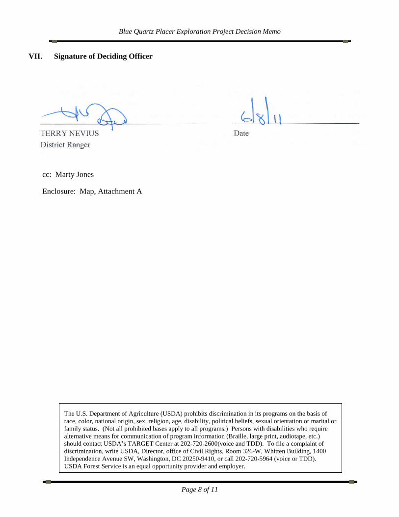
VII. Signature of Deciding Officer
_________________________________________ _______________________________
TERRY NEVIUS Date District Ranger
cc: Marty Jones
Enclosure: Map, Attachment A
The U.S. Department of Agriculture (USDA) prohibits discrimination in its programs on the basis of race, color, national origin, sex, religion, age, disability, political beliefs, sexual orientation or marital or family status. (Not all prohibited bases apply to all programs.) Persons with disabilities who require alternative means for communication of program information (Braille, large print, audiotape, etc.) should contact USDA’s TARGET Center at 202-720-2600(voice and TDD). To file a complaint of discrimination, write USDA, Director, office of Civil Rights, Room 326-W, Whitten Building, 1400 Independence Avenue SW, Washington, DC 20250-9410, or call 202-720-5964 (voice or TDD). USDA Forest Service is an equal opportunity provider and employer.
Blue Quartz Placer Exploration Project Decision Memo
Page 9 of 11
Map 1. Blue Quartz Placer Exploration Project Map
Blue Quartz Placer Exploration Project Decision Memo
Page 10 of 11
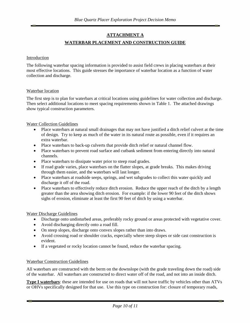
ATTACHMENT A
WATERBAR PLACEMENT AND CONSTRUCTION GUIDE
Introduction
The following waterbar spacing information is provided to assist field crews in placing waterbars at their most effective locations. This guide stresses the importance of waterbar location as a function of water collection and discharge.
Waterbar location
The first step is to plan for waterbars at critical locations using guidelines for water collection and discharge. Then select additional locations to meet spacing requirements shown in Table 1. The attached drawings show typical construction parameters.
Water Collection Guidelines • Place waterbars at natural small drainages that may not have justified a ditch relief culvert at the time
of design. Try to keep as much of the water in its natural route as possible, even if it requires an extra waterbar.
• Place waterbars to back-up culverts that provide ditch relief or natural channel flow. • Place waterbars to prevent road surface and cutbank sediment from entering directly into natural
channels. • Place waterbars to dissipate water prior to steep road grades. • If road grade varies, place waterbars on the flatter slopes, at grade breaks. This makes driving
through them easier, and the waterbars will last longer. • Place waterbars at roadside seeps, springs, and wet subgrades to collect this water quickly and
discharge it off of the road. • Place waterbars to effectively reduce ditch erosion. Reduce the upper reach of the ditch by a length
greater than the area showing ditch erosion. For example: if the lower 90 feet of the ditch shows sighs of erosion, eliminate at least the first 90 feet of ditch by using a waterbar.
Water Discharge Guidelines • Discharge onto undisturbed areas, preferably rocky ground or areas protected with vegetative cover. • Avoid discharging directly onto a road fill. • On steep slopes, discharge onto convex slopes rather than into draws. • Avoid crossing road or shoulder cracks, especially where steep slopes or side cast construction is
evident. • If a vegetated or rocky location cannot be found, reduce the waterbar spacing.
Waterbar Construction Guidelines
All waterbars are constructed with the berm on the downslope (with the grade traveling down the road) side of the waterbar. All waterbars are constructed to direct water off of the road, and not into an inside ditch.
Type I waterbars: these are intended for use on roads that will not have traffic by vehicles other than ATVs or OHVs specifically designed for that use. Use this type on construction for: closure of temporary roads,
Blue Quartz Placer Exploration Project Decision Memo
Page 11 of 11
roads to be obliterated, or long-term closure of roads in maintenance level 1. These waterbars are designed to remain effective until the road prism stabilizes with vegetation.
• Roadside ditches: intercept all ditch water by including a ditch block during construction of waterbars.
• Skew: construct with a 30-60 degree angle from the road centerline.
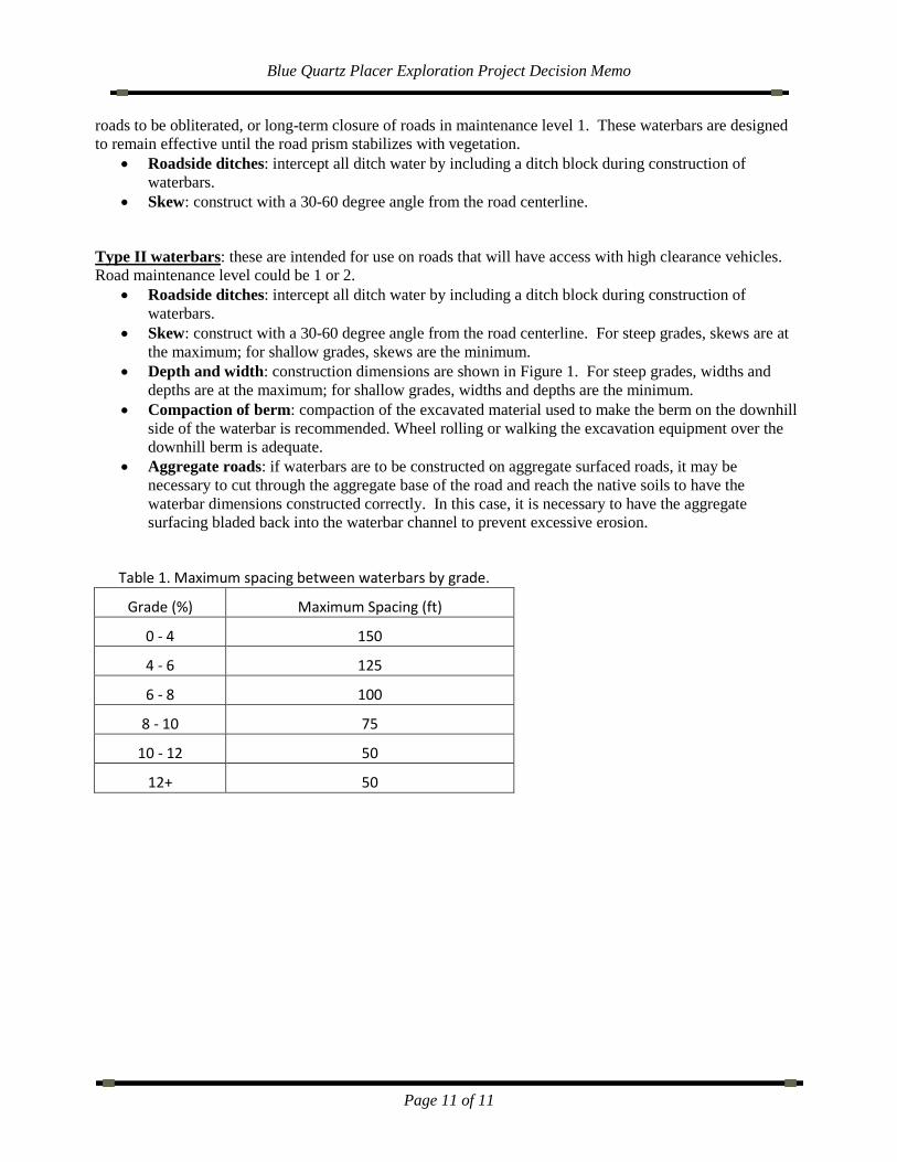
Type II waterbars: these are intended for use on roads that will have access with high clearance vehicles. Road maintenance level could be 1 or 2.
• Roadside ditches: intercept all ditch water by including a ditch block during construction of waterbars.
• Skew: construct with a 30-60 degree angle from the road centerline. For steep grades, skews are at the maximum; for shallow grades, skews are the minimum.
• Depth and width: construction dimensions are shown in Figure 1. For steep grades, widths and depths are at the maximum; for shallow grades, widths and depths are the minimum.
• Compaction of berm: compaction of the excavated material used to make the berm on the downhill side of the waterbar is recommended. Wheel rolling or walking the excavation equipment over the downhill berm is adequate.
• Aggregate roads: if waterbars are to be constructed on aggregate surfaced roads, it may be necessary to cut through the aggregate base of the road and reach the native soils to have the waterbar dimensions constructed correctly. In this case, it is necessary to have the aggregate surfacing bladed back into the waterbar channel to prevent excessive erosion.
Table 1. Maximum spacing between waterbars by grade.
Grade (%) Maximum Spacing (ft)
0 - 4 150
4 - 6 125
6 - 8 100
8 - 10 75
10 - 12 50
12+ 50