Embed Size (px)
Citation preview

Book of abstracts
VLIZ Young Scientists’ Day
Brugge, Belgium 25 February 2005
VLIZ Special Publication 20 2005
Deze publicatie dient als volgt geciteerd te worden:
Mees, J.; Seys J., eds (2005). VLIZ young scientists’ day, Brugge, Belgium, 25 February 2005: VLIZ Special Publication, 20. Vlaams Instituut voor de Zee (VLIZ): Oostende, Belgium. x, 129 pp.
Vlaams Instituut voor de Zee (VLIZ) vzw Flanders Marine Institute vzw Vismijn, Pakhuizen 45-52 B-8400 Oostende, Belgium Tel. +32-(0)59-34 21 30 Fax +32-(0)59-34 21 31 E-mail: [email protected] http://www.vliz.be
Niets uit deze uitgave mag worden verveelvoudigd en/of openbaar gemaakt door middel van druk, fotokopie, microfilm of op welke andere wijze ook zonder voorafgaandelijke schriftelijke toestemming van de uitgever.
ISSN 1377-0950
ii
Preface
The Flanders Marine Institute (VLIZ) supports marine scientific research in Flanders. VLIZ offers logistic support, promotes expertise internationally, and serves as an interface between the scientific community, governmental bodies, and the public at large. VLIZ wants to give exposure to marine, coastal and estuarine research in Flanders, whereby coordination and dissemination of information play key roles.
Marine research in Flanders is carried out by the six Flemish universities, research institutes and departments of the Flemish and federal authorities, and to a lesser extent by private enterprises. The major broad disciplines covered are: biology, earth sciences, chemistry, physics, aquaculture and fisheries, engineering, and maritime affairs. Annually, VLIZ bundles the scientific contributions of the Flemish marine researchers in the ‘VLIZ Collected Reprints’. VLIZ increases the visibility of marine research in Flanders by producing publications, organizing symposia and granting scientific awards.
On Friday, 25 February 2005, the fifth ‘VLIZ Young Scientists’ Day’ (168 pre-registered participants) was organized in Provinciehuis Boeverbos, Sint-Andries (Brugge), Belgium.
Programme:
two plenary lectures by senior scientists four oral presentations by young scientists
poster competition for young scientists
demonstrations of marine and coastal databases and services
presentation by laureates of ‘VLIZ aanmoedigingsprijzen mariene wetenschappen 2004’ and ‘Annual VLIZ North Sea Award 2004’
This ‘VLIZ Special Publication 20’ comprises the abstracts of the oral, poster and demo presentations as well as the summaries submitted by the laureates and applicants of the VLIZ aanmoedigingsprijzen mariene wetenschappen 2004’ and ‘Annual VLIZ North Sea Award 2004’.
Dr Jan Mees Director VLIZ
iii

Table of Contents
Laureates VLIZ aanmoedigingsprijzen mariene wetenschappen 2004 Neukermans Griet. Remote sensing of mangroves in Gazi Bay (Kenya) with very high
resolution QuickBird satellite imagery: automated methods for species and assemblage identification ........................................................................................ 2
Payo Dioli Ann. Molecular systematics and cryptic diversity of the genus Dictyota (Dictyotales: Phaeophyta) with special reference to species occurring in the Philippines.............................................................................................................. 4
Laureate Annual VLIZ North Sea Award 2004 Bonte Dries. Distribution of spiders in coastal grey dunes - Spatial patterns and
evolutionary-ecological importance of dispersal......................................................... 6
Oral presentations Volckaert Filip. Why the seas ain’t more blue elsewhere ...................................................... 12
Ameye Karel. ‘Expeditie Zeeleeuw’, an e-learning project on marine sciences ....................... 13
Grégoire Marielaure. Marine research at the Liège University: a long tradition of oceanography far away from the sea ...................................................................... 14
Dehenauw David. Predicting dangerous coastal weather..................................................... 15
Polet Hans. Let’s make the brown shrimp green! Evaluation of discarding practices in the North Sea brown shrimp (Crangon crangon L.) fishery ......................................... 16
Simpson Pauline. How to make your research more visible: repositories and the open archive initiative.................................................................................................... 17
Poster & demo presentations Appeltans Ward, Simon Claus, Daphne Cuvelier and Edward Vanden Berghe. Europe
counts marine life ................................................................................................. 19
Bekaert Karen and Marc Raemaekers. The quality index method for the assessment of fish freshness ........................................................................................................ 20
Belpaeme Kathy, Francis Kerckhof and Tom Gheskiere. About “clean” beaches and beach cleaning in Belgium..................................................................................... 21
v
Calewaert Jan-Bart. Environmental Impact Statement (EIS) for a new experimental station for aquaculture research near Palmar (province of Guayas, Ecuador) .............. 22
Claus Simon, Pieter Deckers, Francisco Hernandez and Edward Vanden Berghe. The Vlimar Gazetteer................................................................................................... 23
Cocquyt Ellen, Christine Maggs and Jim Provan. Ceramium Botryocarpum and C. Secundatum re-evaluated ...................................................................................... 24
Cox Tom, Tom Maris and Patrick Meire. Inundation areas with a controlled reduced tide: symbiosis between ecology and safety.............................................................. 25
de Brauwere Anouk, Fjo De Ridder, Rik Pintelon, Marc Elskens, Johan Schoukens and Willy Baeyens. Which model should I choose?......................................................... 26
De Cauwer Karien, Mia Devolder, Siegrid Jans, Angelino Meerhaeghe and Serge Scory. Online data services at the Belgian Marine Datacentre ................................... 27
Delefortrie Guillaume and Marc Vantorre. Defining the optimal dredging level from nautical viewpoint. ................................................................................................ 28
Deneudt Klaas, Roeland T’Jampens, Edward Vanden Berghe and Jan Mees. Scheldemonitor, the online information system on research and monitoring of the Scheldt Estuary ................................................................................................ 29
Deneudt Klaas, An Vanhoorne and Edward Vanden Berghe. The IMERS database, an integrated way of storing marine environmental readings and samplings .................... 30
Deprez Tim, Merckx Bea and Magda Vincx. Online identification of Mysida through NeMys. ................................................................................................................ 31
Derveaux Sabrine, Karen Bekaert and Marc Raemaekers. Computer-assisted authentication of fish, crustaceans and mollusks using isoelectric focusing of sarcoplasmic proteins............................................................................................ 32
Dooms Stefania, Daphné Deloof, Kristof Dierckens, Peter Bossier and Patrick Sorgeloos. Genetic characterisation of commercially important Brachionus strains....................... 33
ECOMAMA first year students 2003-2004. A comparative analysis of macrobenthic communities of sublittoral and littoral zones of the Belgian continental shelf and coast (Oostende and De Panne)............................................................................. 34
Fagel Nathalie and Robert Brasseur. Potential paleocirculation implications by coupling Pb and Nd Isotope analyses on different grain-size fractions from Labrador sea sediments............................................................................................................. 35
Fockedey Nancy, Stijn Bruwiere, An Ghekiere and Magda Vincx. In vitro embryogenesis of Neomysis integer (Crustacea, Mysidacea) as a potential indicator of endocrine disruption.............................................................................................. 36
vi
Ghekiere An, Nancy Fockedey, Tim Verslycke and Colin Janssen. Impact of endocrine disruptors on the molting and embryogenesis in Mysid shrimp (Crustacea; Mysidacea)........................................................................................................... 37
Guelinckx Jef, Joachim Maes, Frank Dehairs and Frans Ollevier. Estimating turnover rates of δ13C and δ15N in muscle, heart and liver tissue of juvenile sand gobies (Pomatoschistus minutus) ....................................................................................... 38
Haelters Jan and Francis Kerckhof. A remarkable increase in the number of stranded harbour porpoises - Phocoena phocoena at the Belgian coast................................... 39
Haspeslagh Jan, Klaas Deneudt, Roelandt T’Jampens and Edward Vanden Berghe. Revolutions in the IMIS world.................................................................................. 40
Haydée Domínguez Tejo. Hydromedusae and Siphonophores (Cnidaria: Hydrozoa) of the superficial waters of Gaira Bay, Colombian Caribbean ....................................... 41
Hoffman Stefan, Daan Delbare and Marc Raemaekers. The application of genetics in fisheries and aquaculture....................................................................................... 42
Lescrauwaet Ann-Katrien, An Vanhoorne, Sofie Bracke, Francisco Hernandez, Edward Vanden Berghe and Jan Mees. Indicators of sustainable development for monitoring, communication, and management guidance in the SAIL coastal region.................................................................................................................. 43
Mathys Mieke. Towards a genetic model for the quaternary evolution of the Belgian continental shelf (southern North Sea): integration and re-interpretation of existing datasets.................................................................................................... 44
Meert Ivy, David P. Gillikin, Anton Ervynck, Beatrijs Hillewaert, Eddy Keppens and Frank Dehairs. Reconstructing the environmental conditions in the coastal area of the southern bight over the past millennium using Mytilus edulis shells............................. 45
Meire Patrick and Ann Govaerts. Scheldefonds vzw ............................................................ 46
Monteyne Els M., Colin R. Janssen and Patrick Roose. Endocrine Disruptors in the Scheldt Estuary (2)................................................................................................. 47
Moulaert Ine, Kris Hostens and Hans Hillewaert. Effects of 30 years of sand extraction on the structural characteristics of the macrofauna communities of the Kwintebank (Belgian continental shelf)..................................................................... 48
Neukermans Griet, Nico Koedam, James G. Kairo and Farid Dahdouh-Guebas. Mapping Kenyan mangroves with very high resolution quickbird satellite imagery........ 49
Noppe Herline, Sofie Poelmans, Nathalie Van Hoof, Tim Verslycke, Colin Janssen and Hubert De Brabander. Endocrine disruptors in the Scheldt Estuary (1)......................... 50
Pauly Klaas, Tom Schils and Eric Coppejans. Biogeography and seasonality of macroalgal communities in the Gulf of Oman ......................................................... 51
vii
Poelmans Sofie, Tim Verslycke, Herline Noppe, Nathalie Van Hoof, Hubert De Brabander and Colin Janssen. Testosterone metabolism modulation in Neomysis integer: a biomarker for endocrine disruption .......................................................... 52
Provoost Pieter, Tom Schils and Eric Coppejans. Taxonomy and biogeography of macroalgal communities in the upwelling region off the coast of Dhofar, Oman ......... 53
Raemaekers Marc. Polychlorinated biphenyls and organochlor pesticides in sediment of the Belgian continental shelf................................................................................... 54
Raick Caroline, Karline Soetaert and Marilaure Grégoire. Application of a sequential data assimilation technique to improve the results of a 1D coupled physical-biogeochemical model of the Ligurian Sea .............................................................. 55
Rombouts Isabelle, A. Brierley and G. Aarts. An analysis of the distribution and abundance of sandeels in grey seals’ foraging hotspots around the inner Hebrides, West Scotland........................................................................................ 56
Rotenberg Serge, Gilles Reverdin and Philippe Claeys. Salinity in the Atlantic Ocean - Comparison of evaporation and precipitation datasets ............................................. 57
Stevens Maarten, Els Cuveliers, Joachim Maes and Frans Ollevier. The effect of fish and bird predation on an estuarine macrobenthic community: results of an exclosure experiment ........................................................................................................... 58
Van Colen Carl, Magda Vincx and Steven Degraer. Tidal flat macrobenthos resistance to medium-term emersion: the case of the Tricolor oil pollution prevention in the Zwin nature reserve (Belgium).................................................................................... 59
Van de Putte Anton, Cristina Beans, Filip Volckaert and Jean-Henri Hecq. Status, role and control of Electrona antarctica in the Lazarev Sea............................................... 60
Van de Vijver Kristin, Philippe Hoff, Krishna Das, Olivier Drouguet, Sophie Brasseur, Peter Reijnders, Ronny Blust and Wim De Coen. New insights in distribution and accumulation patterns between various perfluorochemicals....................................... 61
Van den Broeck Heidi, Hans De Wolf, Thierry Backeljau and Ronny Blust. Assessment of the myoglobin variation in the periwinkle Littorina Littorea along the Scheldt Estuary................................................................................................................. 62
Van den Broeck Koen, Dries Bonte, Viki Vandomme, Jean-Pierre Maelfait and Patrick Grootaert. Biological evaluation of the Belgian beaches by means of terrestrial invertebrates......................................................................................................... 63
Van Keeken Olvin A., Rob E. Grift and Adriaan D. Rijnsdorp. Sudden changes in the spatial distribution of juvenile plaice (Pleuronectes platessa) in the North Sea.............. 64
Van Schijndel Rob, Joost Post and Thijs van der Steen. Hyperspectral remote sensing as a decision support tool in community based coastal zone management in Fordate, Indonesia ................................................................................................ 65
viii
Vandepitte Leen, Nancy Fockedey, Thomas Vanagt and Magda Vincx. Spatial and temporal variability of the epi-, hyper- and endobenthos of Ecuadorian sandy beaches ............................................................................................................... 66
Verfaillie Els and Vera Van Lancker. Geostatistics as a tool for predictive modeling of the surficial sediment distribution ............................................................................ 67
Vitse Ilse, Stefanie Adam, Annelies De Backer, Steven Degraer, Bart Deronde, Rodney Foster, Jaak Monbaliu, Koen Sabbe and Sindy Sterckx. Tidesed: intertidal sediment characterization using hymap imagery....................................................... 68
Willaert Lies, Roeland Samson, Sam Provoost, Raoul Lemeur, Koen Meuleman and Robert De Wulf. Comparison of Lai determination techniques in different dune vegetation types .................................................................................................... 69
Willems Wouter, Peter Goethals, Vera Van Lancker, Els Verfaillie, Magda Vincx and Steven Degraer. Habitat suitability modelling of the North Sea macrobenthos: data exploration ................................................................................................... 70
Zintzen Vincent, Claude Massin and Jérome Mallefet. Subtidal amphipoda communities associated with artificial hard substrate on the Belgian continental shelf ..................... 71
Applicants VLIZ aanmoedigingsprijzen mariene wetenschappen 2004 Bruwiere Stijn. In vitro embryogenese van Neomysis integer (Crustacea: Mysidacea) als
potentiële indicator voor endocriene verstoring ........................................................ 73
Calewaert Jan-Bart. Environmental Impact Statement (EIS) for a new experimental station for aquaculture research near Palmar (province of Guayas, Ecuador) .............. 77
Cuveliers Els. Het effect van vis- en vogelpredatie op de macrobenthische gemeenschap: een exclosure-experiment................................................................. 85
Rabaut Marijn. System analysis for decision support in the allocation of marine protected areas in the Belgian part of the North Sea................................................. 87
Rappé Karen. Spatio-temporele verspreiding van Clupeidae op het Belgisch continentaal plat (zuidelijke bocht van de Noordzee) ................................................ 89
Schmitz Nele. Houtanatomie van de mangrove Rhizophora mucronata Lamk. en de relatie met de omgeving. De betekenis van de vatendichtheid voor de veiligheid van het watertransportsysteem. ............................................................................... 92
Van Colen Carl. De afdamming van het Zwin als gevolg van de Tricolor olieverontreiniging: effecten op en herstel van het macrobenthos............................... 96
Van den Broeck Koen. Biologische evaluatie van de Belgische stranden aan de hand van terrestrische invertebraten .............................................................................. 102
ix
Van Tendeloo Anneleen. Veranderingen in traditionele en commerciële mens-ecosysteemrelaties in de mangrovebaai van Gazi (Kenya): etnobiologie, percepties van de lokale gemeenschap en ecotoeristische activiteiten....................... 107
Vandeperre Frederic. Bereiken grote vissen de paaigronden eerst en paaien ze voor kleine vissen: Mallotus villosus paaiend op de stranden langsheen de kust van Newfoundland.................................................................................................... 109
Vanelslander Bart. Intra- en interspecifieke variatie in fenotype en genotype bij estuariene Navicula soorten................................................................................. 110
Vannerum Katrijn. Experimentele studie van de vegetatieve en seksuele reproductie van twee potentieel toxische diatomeeën, Pseudonitzschia fraudulenta (Cleve) Hasle en P. pungens (Grunow ex Cleve) Hasle (Bacillariophyceae).................................... 112
Verbeeck Kenny. Kustfenomenen, de confrontatie tussen natuur en cultuur op de grens tussen land en water: een ontwerpstrategie gededuceerd uit een typologische analyse .............................................................................................................. 114
Applicants VLIZ North Sea Award 2004 Lacroix Geneviève, Kevin Ruddick, José Ozer and Christiane Lancelot. Modelling the
impact of the rivers Scheldt and Rhine/Meuse on the salinity distribution in Belgian waters (southern North Sea) ..................................................................... 122
x
VLIZ aanmoedigingsprijzen mariene wetenschappen 2004
Jaarlijks kent het Vlaams Instituut voor de Zee (VLIZ) twee prijzen toe ter bekroning van twee afstudeerwerken (universitaire tweede cyclus of HOBU lange type). Zowel fundamentele als toegepaste onderzoeksonderwerpen in alle takken van de mariene wetenschappen komen in aanmerking. De prijzen bedragen elk 500 EUR en zijn voorbehouden aan jonge onderzoekers die ten hoogste twee jaar afgestudeerd zijn aan een Vlaamse universiteit of hogeschool.
De aanmoedigingsprijzen 2004 werden ex aequo toegekend aan:
Griet Neukermans voor het werk getiteld:
Remote sensing of mangroves in Gazi Bay (Kenya) with very high
resolution Quickbird satellite imagery: automated methods for species and assemblage identification
Dioli Ann Payo voor het werk getiteld:
Molecular systematics and cryptic diversity of the genus Dictyota
(Dictyotales: Phaeophyta) with special reference to species occurring in the Philippines
- 1 -
REMOTE SENSING OF MANGROVES IN GAZI BAY (KENYA) WITH VERY HIGH RESOLUTION QUICKBIRD SATELLITE IMAGERY: AUTOMATED METHODS FOR SPECIES AND ASSEMBLAGE IDENTIFICATION
Neukermans Griet
Laboratorium voor Algemene Plantkunde en Natuurbeheer, Vrije Universiteit Brussel Pleinlaan 2, B-1050 Brussel, Belgium Huidig adres: Hertstraat 127, B-9473 Welle, Belgium E-mail: [email protected]
Mangrove degradation is occurring worldwide at a fast rate. This degradation necessitates a rational management at a local, national and global level. Satellite imagery is a valuable tool in the early detection of mangrove degradation in which floristic composition as well as areal extent are important indicators. This thesis work focuses on a tropical bay in Kenya, Gazi Bay, on which very high resolution QuickBird satellite imagery (acquired in October 2002) is available. A field mission for ground-truthing the satellite image was done in July-August 2003. The aim of this thesis work is three fold. Firstly, to spectrally and spatially enhance the satellite image to ease visual interpretation. Different techniques were used and the most visual-interpretable images were found to be the contrast-stretched pansharpened multispectral false colour composite and the first three principal components of its principal component transformation. The former was used for visual assemblage delineation done by 3 naïve interpreters. Secondly, to classify the mangroves of Gazi Bay at species level using unsupervised and supervised (hard and soft) per-pixel classification techniques. Incorporation of texture and normalized difference vegetation index (NDVI) measures in image classification both increased the spectral separability between the image classes, but this was not indicative for the accuracy of the classification. On the contrary, the supervised fuzzy classification of the contrast-stretched multispectral image using a 3x3 pixels convolution window appeared to be the most accurate one (based on visual image interpretation and field knowledge). The accuracy of the supervised classification (using the maximum likelihood decision rule) of the contrast-stretched multispectral image was assessed using the Point-Centred-Quarter-Method (PCQM) transect data. The overall accuracy was found to be 68%. Thirdly, to develop automated methods for vegetation assemblage delineation, which were obtained based on fuzzy convolution techniques of an appropriate convolution window size. The automated delineation was compared with the visual delineation done by 3 naïve interpreters. Results showed that there were two possible disagreements between automated assemblages and visual assemblages: more than one automated assemblage could be included in a visual assemblage and vice versa, but overall the boundaries of the automated assemblages corresponded quite well with the visually delineated polygons. The correspondence between these delineations could however not be quantified.
- 2 -
Also an important methodological improvement was proposed for future mangrove remote sensing research. My suggestion is to add a canopy layer to the PCQM, describing the remotely sensed canopy, which can be used in classification accuracy assessment instead of the adult tree layer (which was used previously and does not always correspond to the remotely sensed canopy). In such a way, PCQM can still be used to determine structural forest parameters (such as absolute density, basal area, relative density, dominance, frequency, etc.) and at the same for classification accuracy. We can conclude that it is possible to create a mangrove species map of adequate accuracy through supervised classification of the QuickBird satellite image and to automatically identify assemblages using fuzzy convolution techniques of an appropriate window size. Therefore QuickBird satellite imagery has proven to be a valuable tool in the early detection of mangrove degradation in which floristic composition is as important as areal extent.
- 3 -
MOLECULAR SYSTEMATICS AND CRYPTIC DIVERSITY OF THE GENUS DICTYOTA (DICTYOTALES: PHAEOPHYTA) WITH SPECIAL REFERENCE TO SPECIES OCCURRING IN THE PHILIPPINES
Payo Dioli Ann
Ecological Marine Management Programme (ECOMAMA), Vrije Universiteit Brussel Pleinlaan 2, B-1050 Brussel, Belgium Huidig adres: Venus Alley, Blk. 27 lot 32 Phase 2B V&G subd., 6500 Tacloban City, Leyte, Philippines E-mail: [email protected]
In order to study the molecular sytematics and cryptic diversity of the brown macroalgal genus, Dictyota (Dictyotales: Phaeophyta), 3 objectives were set: 1. to make an inventory of the Dictyota species occurring in the Philippines; 2. to determine congruence between morphological and phylogenetic species concepts; 3. to study cryptic diversity in the Dictyota dichotoma complex. This thesis puts special emphasis on Philippine Dictyota species.
Inventory and morphological examination of specimens collected in the islands of Visayas in the Philippines revealed that at least 7 species of Dictyota can be found in the region. The species identified were the following: Dictyota bartayresiana Lamouroux, D. canaliculata De Clerck & Coppejans, D. cervicornis Kütz., D. ceylanica Kütz, D. ciliolata Sond. ex Kütz, D. crispata J.V. Lamour and D. friabilis Setchell. Dictyota dichotoma which had been frequently reported from several localities throughout the Philippines was not encountered during the present study. De Clerck (2003) seriously doubted the presence of the generitype, D. dichotoma (originally described from England) in tropical latitudes.
The phylogenetic analyses (focusing on Maximum likelihood tree outputs) used the LSU nrRNA gene, the plastid encoded rbcL gene, and interleaved nrRNA– LSU gene sequences of Dictyota species and other Dictyotaceae taxa as outgroups. The total numbers of taxa used for each dataset were 44, 35, and 29 taxa, respectively. Apart from Philippine samples, sequences were obtained from Dictyota and Dictyotales specimens from several different geographic regions. Some sequences deposited in GENBANK were also included in the analyses.
The family Dictyotaceae, the largest in the order Dictyotales, is subdivided into two tribes: Dictyoteae and Zonariae. The Dictyoteae are recognized by the single lens shaped apical cell as opposed to a row or group of apical cells found in the Zonariae. Scoresbyella, the only genus of Scoresbyellaceae and characterized by a wedge shaped vertically oriented apical cell, appears closely related to the Dictyoteae in the analyses.
- 4 -
Annual VLIZ North Sea Award - 2004
On the initiative of Bart Schiltz, the former President of the Belgian Fish Producers Organization, the Flanders Marine Institute (VLIZ) awards a scientific prize to foster innovative fundamental or applied research on the structure and functioning of the North Sea ecosystem, with emphasis on coastal and estuarine aeas of the Southern Bight and the Channel. The prize is awarded to a researcher (or a research team) working and residing in a country bordering the North Sea. The prize amounts to 1000 EUR and is indivisible. It is granted to reward a recent original scientific contribution, preferably having relevance to the sustainable management of the area concerned. Studies pertaining to the biodiversity of the local ecosystem are equally welcomed. The contribution has to be of postgraduate or postdoctoral level.
The Annual VLIZ North Sea Award 2004 is awarded to:
Dr Dries Bonte for his scientific contribution entitled:
Distribution of spiders in coastal grey dunes – spatial patterns and evolutionary-ecological importance of dispersal
- 5 -
DISTRIBUTION OF SPIDERS IN COASTAL GREY DUNES - SPATIAL PATTERNS AND EVOLUTIONARY-ECOLOGICAL IMPORTANCE OF DISPERSAL
Bonte Dries
Terrestrial Ecology Unit, University of Ghent K.L. Ledeganckstraat 35, B-9000 Ghent E-mail: [email protected]
Grey dune, known as “Fixed coastal dunes with herbaceous vegetation” include Atlantic moss dominated dunes as well as dune grassland and is ecologically the dry component of the “stressed dune landscape”. At present, rough grass- and scrub encroachment result in a strong fragmentation and patchily distributed habitat configuration. By using spider as bio-indicators, I aimed to document changes in species distribution and dispersal behaviour within the context of this changing landscape.
These topics are discussed into two major parts. In the first part (chapters II.1-II.4) we report on variation in spider assemblages within the entire coastal dune system of the Flemish coast and on regional and local variation within grey dune assemblages along the North Sea. In the second part (chapters III.1-III.8) some ecological and evolutionary consequences of inter- and intraspecific variation in dispersal are addressed.
In chapter II.2 we investigated spider assemblages in the ecosystem of the Flemish coastal dunes. These appear to be structured by variation in vegetation structure (succession), atmospheric and soil humidity and the presence of both natural and anthropogenic disturbance. Indicator species could be determined for almost all vegetation types. Variation within the assemblages from different habitats clearly depends on the mean patch size of these habitats. Especially spatially separated (fragmented) habitats, with relative small patch areas are characterized by a large variation in species composition and defined as unstable assemblages. A more detailed study on the spider assemblages from grey dunes indicated that total species richness does not increase in function of the patch area. The total number of typical species is, however, larger in larger patches. These patterns potentially result from higher edge influences in small patches, the expected higher microhabitat variation in large patches or from higher extinction rates of species in small patches, not compensated by colonization events. Assemblages from grey dunes also show considerable local and regional variation within four distinct dune regions along the North Sea, with a different geological history and landscape structure (chapter II.3). This variation can mainly be attributed to differences in local sand dynamics and the region. Species from dynamic dunes are mainly present in grey dunes from Belgium and France, while species from non-dunal xerotherm habitats (chalk grasslands and heathland) occur in both the Boulonnais and the North Holland dune region. These species are absent from the geologically young and isolated Flemish coastal dunes. Regional variation in spider assemblage composition hence results from local landscape characteristics (dynamics in the dune area), the latitude and the connectivity to non-dunal xerothermic habitats. This indicates the importance of landscape history and dispersal in structuring regional
- 6 -
assemblages. In conclusion (chapter II.4), we demonstrated that spider assemblages within the entire ecosystem of the Flemish coastal dunes and from grey dunes in four different regions are generally influenced by ecological time, disturbance and mechanisms related to the productivity of the habitat (vegetation succession, humidity, habitat heterogeneity). Because epigeic spiders are mobile, edge effects additionally determine variation within and between assemblages. Because we were able to identify indicator species for almost all relevant habitat types, different assemblages can be recognised in function of the vegetation structure.
As dispersal is crucial in structuring species distribution, population structure and species ranges, some aspects of its evolutionary and ecological importance are addressed in part III. Inter- and intraspecific variation in aerial dispersal was studied under standardised laboratory conditions by observing the pre-ballooning tiptoe-behaviour. This aerial dispersal by ballooning is a passive flight, by which wind dragging generates an upward lift on a silk thread. It is likely to reflect an aerial lottery, in which the absence of flight direction control is a serious cost for long-distance dispersal in a fragmented landscape. For species, occurring in one patchily distributed habitat type, dispersal is expected to evolve in a different way than morphological traits, directly linked to active dispersal. In chapter III.2, we demonstrated for 29 species from grey dunes, having different levels of habitat specialisation, that selection benefits a well-developed ballooning behaviour if the risk of landing in an unsuitable habitat is lower than the probability of reaching suitable habitat. This can be concluded from the negatively relationship between ballooning performance and habitat specialisation. These findings are concordant with recent insights that dispersal is selected as risk spreading in generalists, while it is selected against in specialist species. These data on ballooning propensity are used to investigate the relative contribution of dispersal, habitat specialisation and patch configuration in shaping species distribution patterns (chapter III.3). Since species distribution patterns may been explained by Hutchinson’s niche theory, metapopulation theory and source-sink theory, we linked data on the occurrence of species in 19 grey dune patches with data on patch isolation, patch area and the specific level of habitat specialisation. In coastal grey dunes from Flanders, spider distribution patterns only depended on aerial dispersal potential, and the interaction between patch connectivity and area. Niche breadth, measured as the degree of habitat specialisation in the total coastal dune system, did not contribute to the observed distribution patterns. Results from this study suggest that dispersal ability largely affects our perception of a species ‘fundamental niche’, and that source-sink and metapopulation dynamics may have a major impact on the distribution of species. Intraspecific variation in tiptoe-behaviour was investigated in Erigone atra, our first model species (chapter III.4). We investigated the influence of common lineage (family effect) and postnatal environmental conditions on latency to initiate preballooning tiptoe behaviour (ballooning latency). In a 3-week experiment, in which the spiders were fed only during the first day of each week, ballooning latency had low repeatability at week intervals. Ballooning latency declined with increasing food deprivation during the first week but not during the second and the third weeks. At intervals of less than 1 h however, ballooning latency showed high repeatability. We also investigated whether maternal and postnatal environmental conditions (i.e. during juvenile development)
- 7 -
influence phenotypic variation in ballooning latency, by rearing offspring of several families under two feeding and two temperature conditions. Environmental conditions explained more variation in ballooning latency than family. Ballooning latency was lower in spiders reared at 20°C than in those reared at 15°C. In addition, spiderlings fed four prey per 3 days were faster ballooners than those fed only four prey per week. An interaction between factors was present, indicating the existence of different reaction norms between the two environmental conditions. The expression of ballooning latency behaviour thus strongly depends on current nutrition, feeding history and the feeding and temperature conditions during juvenile development. Variation due to the family (additive variation and/or maternal effects) was low but biologically significant.
In the chapters III.5-III.7, we focussed on population dynamics, cursorial and aerial dispersal in the dune wolf spider Pardosa monticola. The spatial population dynamics of this species, inhabiting patchily distributed grasslands in the Flemish coastal dunes from Belgium and Northern France are documented in chapter II.5. Patterns in patch occupancy, colonisation and extinction were investigated with incidence function models using field survey data from 1998 and 2000. Mark-recapture experiments revealed maximum cursorial dispersal distances of 280 m for moss dunes and 185 m for higher dune grassland and different connectivity levels of the matrix vegetation. These habitat-dependant cursorial distances and the theoretically estimated ballooning distance were included with patch distances into a connectivity index for both dispersal modes. Forward multiple regression indicated that patch occurrence was influenced by habitat quality and ballooning connectivity. Habitat quality and cursorial connectivity explained patterns in short-term colonisation. Extinction appeared to be stochastic and not related to habitat quality and connectivity. Genetic differentiation and variability was low. The discrepancy between the estimated low dispersal capacity and the indirect estimate of gene flow FST indicates that historical population dynamics and/or historical ballooning dispersal influence the genetic structure in this species. In the previously discussed incidence model, patch-independent estimates of random dispersal were used to define patch connectivity. Behavioural mechanisms underlying alterations of such movements are however poorly understood, especially for arthropods. The assumed uniform random dispersal directions, might however, not be applicable to a large set of species for which dispersal and movement involve at least some element of decision-making. Therefore, variation of behavioural responses in function of the habitat was investigated for both cursorial and aerial dispersal.
In chapter III.6, we address the relationship between habitat quality and dispersal by studying variation in tiptoe behaviour in the dune wolf spider Pardosa monticola, inhabiting grassland habitats differing in connectivity and predictability. Offspring from field-captured females carrying eggsacs, were tested under standardized laboratory conditions. Our experiments revealed that postnatal proximate effects (starvation), prenatal maternal effects and innate effects influence the performance of tiptoe behaviour and that habitat fragmentation led to a decrease in dispersal rates, possibly because genes, associated with dispersal would disappear in isolated populations. Because maternal condition and fitness decrease with an increasing degree of patch isolation, selection against aerial dispersal may enhance a mechanism of risk spreading. Within one population, habitat quality as revealed from maternal condition,
- 8 -
influences offspring dispersal in an opposite way, and acts as a rescue effect for offspring in case the maternal habitat is of lower quality, resulting in a lower residual offspring size. As a consequence, behavioural traits narrowly linked to dispersal can evolve towards less mobile phenotypes in fragmented terrestrial habitats.
In chapter III.7, we investigated Pardosa monticola’s mobility and emigration pattern in the grey dune fragments from two high-density and one low-density population, where population density was related to patch quality. Pitfall trapping in combination with absolute quadrate sampling was applied. Orientation behaviour was additionally observed in the high- and low-density patches during two periods in the adult life-phase (mating and reproduction period). Our field experiments confirmed the hypothesis that increased activities of this dune wolf spider in a low-density habitat result in higher emigration rates. In the low-density patch, females are even more active than males and emigrate in the same proportions as males. Both males and females were not able to orientate and perform homeward movements during the spring period, in which vegetation height is more or less equal in the core habitat (grassland) and the matrix (moss dune). In June, no homeward orientation was observed in the habitat patch with low quality and low densities (low vegetation height). In the high-density patch, females but not males were able to perform homeward orientation behaviour at distances close to the pronounced border between grassland and moss dune. At distances of three meters, females orientated again randomly. The pattern of differentiated homeward orientation behaviour indicates that it results from visual perception or gender-specific motivation mechanisms and that males and females behave in a different way close to the habitat border. Increased emigration rates as a result of higher spider mobility together with the absence of orientation towards the patch border suggest the presence of an Allee effect in low-density patches.
In conclusion (chapter III.8), aerial dispersal, here estimated by investigating the propensity of ballooning, in spiders from fragmented grey dunes appears to be selected against if chances of reaching suitable habitat are low. Ballooning is hence reduced in strongly isolated populations or in species with a high degree of specialisation to the grey dune habitat and selected against, if the landscape becomes more heterogeneous and fragmented. In addition, proximate environmental factors are certainly an important trigger of spider dispersal, both for ballooning (acute food deprivation, temperature and feeding stress during the juvenile development, maternal habitat quality, landscape configuration) and cursorial dispersal (habitat quality, boundary structure). Residual variations remains however high, as shown for ballooning propensity in Erigone atra and aerial and cursorial dispersal in Pardosa monticola. This variable dispersal propensity within offspring is consistent with a mixed Evolutionary Stable Strategy, in which each individual from a genetical monomorphic population selects a variable strategy from a common probability distribution, with the possibility of fine adjustment according to environmental conditions, in our case also maternal conditions.
The apparently “random” strategy may however be a cryptic environmental or evolutionary trigger that only appears to be random because of hardly detectable relationships with the (maternal) environment. In contrast to the large residual and patch-specific variation in dispersal propensity, our general models, based upon random directional dispersal and patch-independent dispersal frequencies, predict the importance of dispersal characteristics for species distribution and population dynamics
- 9 -
in a significant way. Interdemic variation in dispersal is hence biologically important in shaping dispersal behaviour at the individual level (within habitat distribution), but presumably of minor importance at the scale of the community. However, interactions between individual-level behaviour and population-level dynamics, such as discussed throughout this thesis, are much more complex than those usually incorporated in individual-based population models. At least in some cases, incorporation of behavioural mechanisms, such as variability in mobility behaviour in relation to distances from habitat edges, may substantially increase the biological relevance of these population models and be particularly relevant in the case of endangered species, where integration of behavioural components with population dynamics may result in a better comprehension of the species life history, and hence, the implementation of more realistic conservation strategies.
Implementation of our results into a proper strategy for nature management (chapter IV.1), highlights the conservation of habitats related to the stressed and dynamic dune landscape. Not only habitats of endangered species are in this way conserved, but it additionally implicates that mechanisms related to sand dynamics and herbivory are retained. Under these conditions, the configuration of grey dune patches will evolve towards higher connectivity and patch areas and will ensure the occupancy of stenotopic spider species, which are characterised by a low dispersal.
- 10 -
ORAL PRESENTATIONS
WHY THE SEAS AIN’T MORE BLUE ELSEWHERE
Volckaert Filip
Laboratory of Aquatic Ecology, Katholieke Universiteit Leuven Ch. de Bériotstraat 32, B-3000 Leuven, Belgium E-mail: [email protected]
The course of life reflects a combination of education, decisions, opportunities and dedication. That is not different for those of us opting for a career in marine sciences. In addition, scientific endeavour is firmly embedded in society, hence socio-cultural factors play a crucial role in our lives. But above all, marine scientists love their job. They have the chance to be intimately associated with the ocean, a major component of planet earth. Unfortunately, man is increasingly influencing the dynamics of the ocean. That’s a pity, because the ocean remains largely unexplored and hence management is not for the uninitiated.
I will present a local and global perspective on my close association with the oceans.
- 12 -
‘EXPEDITIE ZEELEEUW’, AN E-LEARNING PROJECT ON MARINE SCIENCES
Ameye Karel
SHE Consultancy ’t Hoge 39, B-8200 Brugge, Belgium E-mail: [email protected]
Starting on the 12th of January 2005, 2000 Flemish high school students embarked on the ‘Zeeleeuw’. The oceanographic research vessel owned by the Flemish government is designed to accommodate 12 scientists at most. That is why ‘Expeditie Zeeleeuw’ had to be virtual. The eLearning project takes 17 to18 year-olds on a problem solving expedition in the North Sea. Participants have to find creative solutions to ten problem cases. They receive assistance from 20 scientists who are briefed to act as a coach. All educational tools are available on the Internet.
The problem cases represent ten major domains in which 500 scientists perform varying types of research in the North Sea realm. These domains are: climate, shipping, fisheries & aquaculture, biodiversity, pollution, marine heritage, marine air quality, beach litter, space use and war ammunition.
At the end of the project, three objectives will be evaluated. They are:
To which extent do participants of ‘Expeditie Zeeleeuw’ show more interest into a science degree?
The real-world context and hands-on activity provided by this educational project is assumed to trigger more interest in sciences.
Is the case-based pedagogical method more effective as compared to a cognitive method?
The over-arching pedagogical method is ‘social constructivism’. Constructivist learning landscapes are composed of the following attributes: (…the learning style is…) active, constructive, interactive, focused, complex, contextual, collaborative and reflective.
What is the value added by specific ICT tools?
‘Expedition Zeeleeuw’ attempts to measure the greatly intangible added value of various ICT tools. These are: hypertexted and annotated bibliographies, electronic slide shows, discussion forums, simulations, clickable and layered abstraction models, virtual role play and video interviews.
The objective of today’s presentation is to illustrate the underlying methods and tools using the eLearning platform located at www.expeditiezeeleeuw.be. By July 2005, an evaluation report should provide answers to the above questions.
- 13 -
MARINE RESEARCH AT THE LIÈGE UNIVERSITY: A LONG TRADITION OF OCEANOGRAPHY FAR AWAY FROM THE SEA
Grégoire Marilaure and the MARE group
MARE Interfacultary Research Centre B6c Sart-tilman, B-4000 Liège Belgium E-mail: [email protected]
MARE gathers 24 laboratories of the Faculties of Science, Applied Science, Law and Veterinary Medicine. It integrates complementary disciplines of Oceanology through both pluridisciplinary field works and modeling. Major research themes of MARE are:
1) The detection and prediction of changes in coastal ecosystems integrating data collection, the development of statistical tools and 3D interdisciplinary models used conjointly with specific diagnostic tools tailored to management purposes;
2) The study of the CO2 dynamics in order to budget fluxes in major coastal areas and the Southern Ocean, through data collection, satellite imagery and modeling studies;
3) The dynamic and diversity of the Ocean Pelagic Ecosystem;
4) Biodiversity and taxonomic studies in different coastal and deep-sea areas;
5) Study of marine trophic webs using stable carbon and nitrogen isotopes;
6) Ecotoxicology and Ecophysiology: study of the effects of pollutants on marine organisms including marine mammals and investigations on genetic diversity, pathology and causes of death of marine mammals and seabirds;
7) Ecology of macrophytes systems and of benthic algae;
8) Sediments studies (e.g. sediment transport, sediment structure analysis, benthic habitats characterization and diversity);
9) Reconstruction of paleocirculations using isotope analysis (Nd, Pb);
10) Study of coastal evolution and management. This includes the study of coastal geomorphology using remote sensing data and coastal engineering.
Moreover, MARE researchers have access to the research station STARESO in Corsica (http://www.stareso.com/), and to the Belgian R.V. Belgica, which operates in the North Sea and adjacent areas (http://www.mumm.ac.be/EN/Monitoring/Belgica/).
Finally, the MARE centre supports the extant set of second and third cycle Teachings (master in Oceanography; http://www.ulg.ac/oceanbio/, DEA in Oceanology, European DEA in Marine Environment Modeling) - unique in the French-speaking Community of Belgium -, of a Doctoral School, and of international Conferences and Colloquia (The International Liège Colloquium on Ocean Dynamics and associated Symposia).
The MARE Group can be contacted via: http://www.ulg.ac.be/oceanbio/MARE/welcome.htm, contact: [email protected].
- 14 -
PREDICTING DANGEROUS COASTAL WEATHER
Dehenauw David
Royal Meteorological Institute of Belgium Ringlaan 2, B-1180 Ukkel, Belgium E-mail: [email protected]
Forecasting dangerous weather events is the most important task of a National Weather Service like RMI. Severe weather has a large impact on our society. Large hail and strong gusts can hurt people and damage goods. Predicting these events is sometimes difficult. An improvement of the meteorological tools is necessary. A case study of the tornadic thunderstorm of 17th June 2004 is presented.
- 15 -
LET'S MAKE THE BROWN SHRIMP GREEN! EVALUATION OF DISCARDING PRACTICES IN THE NORTH SEA BROWN SHRIMP (CRANGON CRANGON L.) FISHERY
Polet Hans
Afdeling Technisch Visserijonderzoek, Departement Zeevisserij Ankerstraat 1, B-8400 Oostende, Belgium E-mail: [email protected]
The Brown Shrimp (Crangon crangon L.) fishery in the North Sea, the focus of this study, is carried out with small meshed nets in vulnerable areas like coastal zones and estuaries. The discarding practices associated with it have been regarded as a problem for many years. The discussion, however, was difficult since no sufficiently reliable discard data were available. The need for data on this issue and a solution for the discard problem was the starting point of the study. The main objectives were to quantify the biological and economic consequences of discarding in the Brown Shrimp fishery and to evaluate possible technical alterations to the shrimp beam trawl to reduce discarding in this fishery.
To fill the gap in knowledge on discarding practices in the North Sea Brown Shrimp fishery, a cooperative discard sampling programme was set up. In this study, absolute numbers of discards were produced. These were carefully examined in relation to other factors that determine the composition of a fish stock by using a newly designed biological and economic model.
A next step in the project was a detailed study of the selectivity of the shrimp trawl. This was done for the sake of having a good description of the selective properties of the shrimp beam trawl and as a preparation for the experiments with selectivity improving devices.
Three such devices were selected for study: 1) a selective sorting grid, 2) a selective sieve net and 3) electric pulses as an alternative stimulation.
Although the selective grids have some clear advantages, like catch reduction of Age 1+ fish, non-commercial fish and invertebrates and better cod-end selectivity, they were found to be too susceptible to malfunction. The sieve net on the other hand, seemed to be a more acceptable device to fishermen with better selective properties.
The basic idea in the application of electric pulses was to invoke selectively a startle response for shrimp with electric ticklers and to allow non-reacting species to escape underneath a raised groundrope. From the sea trials, it can be concluded that the electro-net gave satisfactory results. The losses of commercial shrimp were small or even non-existent. Part of the catch of undersized commercial fish species could escape and especially non-commercial fish and invertebrates were caught in lower numbers compared to the standard net.
New technical measures were established in 2002 and included, for Belgium, the enforcement of the use of sieve nets in the Brown Shrimp fishery. Without doubt, these measures will reduce the impact that shrimp fishing has on the fish stocks and on the ecosystem as a whole. Nevertheless, where fishing occurs, impact on the ecosystem is inevitable. The Sea Fisheries Department has the intention to continue to strive towards more environmental friendly fishing.
- 16 -
HOW TO MAKE YOUR RESEARCH MORE VISIBLE: REPOSITORIES AND THE OPEN ARCHIVE INITIATIVE
Simpson Pauline
Southampton Oceanography Centre, University of Southampton Waterfront Campus European Way, Southampton, SO 14 3ZH, England E-mail: [email protected]
The development of the Internet has allowed us to rethink scholarly communications. In particular, it has allowed us to ask whether there are new models that better serve the needs of researchers as both authors and readers.
This presentation will introduce open access, and describe how institutional repositories (e-Print archives) can provide one solution to the crisis in scholarly communication. Institutional repositories enable an institution or research laboratory to showcase the digital assets that are created by its staff and students, promoting visibility to researchers papers, particularly when records are searchable by both general search engines and specialist global ‘Open Archive Initiative compliant’ search engines.
- 17 -
POSTER & DEMO PRESENTATIONS
EUROPE COUNTS MARINE LIFE
Appeltans Ward, Simon Claus, Daphne Cuvelier and Edward Vanden Berghe
Vlaams Instituut voor de Zee Vismijn, Pakhuizen 45-52, B-8400 Oostende, Belgium E-mail: [email protected], [email protected]
Over 500 marine scientists are working together within the framework of MarBEF – a European network of excellence, which started in March 2004. Of all the seas, the European seas are among the most studied in the world. By bringing this expertise and knowledge together, MarBEF aims at a better understanding of long-term and large-scale distribution patterns and functionalities of biodiversity across marine ecosystems. To inventory this wealth of marine life, the European Register of Marine Species (ERMS), at this moment containing nearly 30,000 species names, is adopted and will serve as the reference list and taxonomic backbone within MarBEF. ERMS has been put into a relational database and will be maintained and regularly updated online by a consortium of taxonomic experts. The taxonomic register will be supplemented with biogeographic, ecological and socio-economic information, together with species illustrations, original descriptions and vernacular names. When available, links will be provided with other online species information systems. EurOBIS, the European node of the Ocean biogeographic Information System, is a distributed system that integrates individual datasets on biogeographic information into one large consolidated database and provides the end-user with a fully searchable geographic interface. EurOBIS already captures and freely communicates over 350,000 distribution data from 14,000 species, online. When combining these data with biological, physical, chemical and geologic data, our understanding of the ecosystem will greatly improve, resulting in better ecosystem-based management plans. The Flanders Marine Institute is taking a leading role in these major European data integrating projects within MarBEF and has recently developed online tools for ERMS and EurOBIS (http://www.marbef.org/data).
- 19 -
THE QUALITY INDEX METHOD FOR THE ASSESSMENT OF FISH FRESHNESS
Bekaert Karen and Marc Raemaekers
Departement Zeevisserij, Centrum voor Landbouwkundig Onderzoek Ankerstraat 1, B-8400, Oostende, Belgium E-mail: [email protected]
The last couple of years, the fisheries sector is under great pressure. For the development of durable and economic viable fisheries, fish quality and traceability in the supply chain is a central element. Freshness is an important factor in determining the overall quality of raw fish and sensory evaluation is the most common method for freshness assessment. However, the validity of the EU sensory grading system has been questioned as it is not taking into account differences between species and only using general characteristics. Efforts have been made to develop alternative, objective sensory methods. The most interesting freshness quality grading system at the moment is the Quality Index Method (QIM), first introduced in 1985, as a standardised, rapid and reliable method. The main characteristic of QIM is giving scores from 0 to 3 for changes of quality attributes that occur during storage on ice. The scores for all the characteristics are summarised to give an overall sensory score, the so-called Quality Index (QI). The aim is to obtain a linear relationship between QI and storage time in ice. As such, the QI might estimate the storage time. QIM has to be developed separately for each fish species. A QIM scheme for the sensory assessment of freshness of yellow gurnard (Trigla lucerna) was developed and validated by sensory and chemical parameters.
References
Bremner A. H., J. Olley and A. Vail. 1986. Estimating time-temperature effects by a rapid systematic sensory method, in Seafood Quality Determination, 413-435.
Luten J.B. and E. Martinsdottir. 1997. QIM: A European tool for fish freshness evaluation in the fishery chain, in Methods to determine the freshness of fish in research and industry, 287-296.
Olafsdottir G., E. Martinsdottir, J. Oehlenschlager, P. Dalgaard, B. Jensen, I. Undeland, I.M. Mackie, G. Henehan, J. Nielsen and H. Nilsen. 1997. Methods to evaluate fish freshness in research and industry. Trends in Food Science & Technology. 8: 258-265.
- 20 -
ABOUT “CLEAN” BEACHES AND BEACH CLEANING IN BELGIUM
Belpaeme Kathy1, Francis Kerckhof2 and Tom Gheskiere3
1 Co-ordinatiepunt Geïntegreerd Beheer van Kustgebieden p/a Vlaams Instituut voor de Zee, Vismijn, Pakhuizen 45-52, B-8400 Oostende, Belgium E-mail: [email protected]
2 Beheerseenheid Mathematisch Model voor de Noordzee 23e linieregimentsplein, B-8400 Oostende, Belgium
3 Sectie Mariene Biologie Vakgroep Biologie, Universiteit Gent Krijgslaan 281-S8, B-9000 Gent, Belgium
Clean beaches are a priority for all coastal municipalities. In Belgium, the beach cleaning happens mostly by using a beach cleaning machine. However, a mechanical beach cleaner not only removes most of the man-produced waste but unfortunately also takes away most of the organic material. The organic material in the high tide line has numerous natural functions in the coastal ecosystem, in terms of coastal defence, as feeding ground, as a biotope for pioneer plants, etc. On the other hand, manual cleaning undoubtedly has several positive effects: less waste is produced, less cost for the treatment of the waste, less fuel cost, bigger chance for the beach visitor to explore the natural material.
In close collaboration with the 10 coastal municipalities, a spring-cleaning action was scheduled in March 2004. General aim was to promote sustainable beach cleaning. All material on 10 beach zones was gathered. The information thus assembled is of capital importance if we want to convince municipalities to deploy their beach-cleaning machine in a more carefully thought-out and efficient way. More than half of the mechanically removed material from the beaches consisted of material with a biological origin. The beach clean action showed (1) that half of the waste is represented by two fractions: plastic and textile (incl. nets and ropes); (2) the fraction “plastic” is certainly number one, in terms of volume as well as weight (29%). This is in agreement with results obtained in other beach cleaning programmes such as Beach Watch in the UK; (3) Paper and glass each contributed 3% of the total fraction and were found least on the beach; (4) As in several other beach cleaning programmes, it was clear that a great part of the litter washed ashore originated from the sea: fishing nets, gloves, lightsticks, etc. This proves a lot of waste is still disposed at sea.
Tests with a beach cleaner clearly indicated a significant predominance of material from biological origin (31%) followed by stones (24%) and textile (12%). Therefore these preliminary results are in accordance with other studies likewise demonstrating a dominance of biological items in mechanically removed ‘waste’ from beaches. Removing organic matter from the beach has already proved to cause a significant reduction of diversity on microbiological as well as on endofaunal level. Consequently, it is likely that also higher feeding levels (e.g. shore birds) are affected by decreasing organic content in the high tide mark as this is one of their principal feeding grounds.
- 21 -
ENVIRONMENTAL IMPACT STATEMENT (EIS) FOR A NEW EXPERIMENTAL STATION FOR AQUACULTURE RESEARCH NEAR PALMAR (PROVINCE OF GUAYAS, ECUADOR)
Calewaert Jan-Bart
UGent/VUB (Ecomama) Pleinlaan 2, B-1050 Brussel, Belgium Unesco Centrum Vlaanderen, afdeling Antwerpen Kasteelstraat 49, 2000 Antwerpen E-mail: [email protected]
The Ecuadorian Laboratory for Aquaculture and Marine Research (CENAIM) is constructing a new 25 ha station for aquaculture research at a former shrimp farm near Palmar. The most striking feature in the area is a 36 ha mangrove. This study was conducted to produce an Environmental Impact Statement (EIS) for this project with two primary goals: (1) the identification of potential impacts on the total environment; and (2) the elaboration of a monitoring and mitigation plan to reduce the predicted negative impacts. Potential impacts were identified using conventional EIA techniques. An environmental impact matrix was based on a similar study in Tanzania while level of risk matrices were based on Australian and New Zealand standards for risk management. For water quality laboratory analysis, chlorophyll a, nutrients (TP, TAN and TN) and BOD were measured with standard methods and protocols as described by the American Public Health Association (APHA) while pH, DO, salinity and temperature were measured in-situ with basic equipment. Both the soil samples (filtrates) and water samples were analysed for (1) organic compounds using a Gas-Chromatograph and Mass Spectrometer; and (2) trace elements using an Inductively Coupled Plasma Atomic Emission Spectrometer. Analysis revealed relatively high copper concentrations in soil of the site (average of 36.31 μg.g-1) probably because of earlier use of copper sulphate for algal control. Exceptionally high levels of boron were observed for both water and soil samples and further investigation is needed to determine the cause. Hexachlorobenzene (HCB) was present in some soil samples, but the concentrations are considered to be below acceptable limits. Socio-economic screening revealed no major objections from local communities against the project. However, several potentially negative impacts were identified including noise pollution, reduced access to pristine seawater, oil and fuel spills and the disposal of feed bags. One of the most important mitigative measures that will be implemented is the use of a 4ha constructed wetland. In addition, more than 1,000 mangrove seedlings will be planted in the wetlands and reservoir. There are also several positive consequences associated with the project including employment and scientific research opportunities. We believe that when all proposed mitigation measures are properly implemented, the suggested project can run a socially and environmentally responsible operation. To make sure it does on the long term, a monitoring program is proposed that provides feedback on the environmental and social protection measures. Problems that are identified by monitoring should be corrected as the project develops and operates.
- 22 -
THE VLIMAR GAZETTEER
Claus Simon, Pieter Deckers, Francisco Hernandez and Edward Vanden Berghe
Vlaams Instituut voor de Zee Vismijn, Pakhuizen 45-52, B-8400 Oostende, Belgium E-mail: [email protected]
Dealing with different names of geographic features or entities, VLIZ is developing a standard, relational list of geographic names, coupled with information on the geographic location of these features. The purpose of the gazetteer is to improve access and clarity of the different geographic, mainly marine names such as seas, sandbanks, ridges, bays or even standard sampling stations used in marine research. The geographic cover is global, however the gazetteer is focused on the Belgian Continental Shelf, the Scheldt Estuary and the Southern Bight of the North Sea. The VLIMAR marine gazetteer is served from a relational SQL server database where different geographic units can have one or more relations between each other. The structure of the database is an open hierarchy where each geographic unit points to one or more other units applying different relation types. Such a structure allows the user to group joint geographic units. At the moment a web interface to have easy access through the gazetteer is being developed. The gazetteer will be linked with the S3 geographic database, consisting of shapes of different geographic features. This database makes use of a “SVG Sniplet Server” to generate interactive SVG maps. The end goal will be a hierarchic geographic gazetteer that will be consultable through a web interface and will be linked with a geographic interface. Not only can the VLIMAR marine gazetteer be most valuable as a search tool on its own, but also lots of applications can be derived from it such as linking different datasets, species distributions or sampling campaigns with geographic entities from the gazetteer.
- 23 -

CERAMIUM BOTRYOCARPUM AND C. SECUNDATUM RE-EVALUATED
Cocquyt Ellen1,2, Christine Maggs2 and Jim Provan2
1 Onderzoeksgroep Algologie, Vakgroep Biologie, Universiteit Gent K.L. Ledeganckstraat 35, B-9000 Gent, Belgium E-mail: [email protected]
2 Queen’s University Belfast 97 Lisburn Road, BT9 7BL Belfast, Northern Ireland, United Kingdom
In the British Isles the genus Ceramium is represented by 15 species, divided into to groups. The two groups without cortical spines are (1) fully corticated species and (2) those with ecorticated internodes. Group 1 species are very difficult to distinguish. In particular the key morphological features that discriminate between C. botryocarpum and C. secundatum include the number of periaxial cells and presence of adventitious branching (Maggs and Hommersand, 1993). However, these features may be influenced by the environment. By using various molecular markers, growing cultures in different conditions and crossing experiments we aim to clarify the relationship between the species of group 1.
Analysis of the formalin preserved vouchers showed that C. botryocarpum and C. secundatum are morphologically almost identical. They only differ in the number of periaxial cells (6-7 for C. botryocarpum and 7-8 for C. secundatum) and by the more robust, larger thallus of C. secundatum. Culture studies showed that the morphology of Ceramium is highly influenced by the environment. There was crossing with formation of tetrasporophytes between C. botryocarpum and C. secundatum. The phylogenetic analysis with the chloroplast marker (tufA/rpl31) and the mitochondrial marker (cox2-3 spacer, Gabrielsen 2002) clearly demonstrate that C. botryocarpum and C. secundatum are not respectively monophyletic. Analysis of multiple samples and with different techniques confirmed that C. botryocapum Griffiths ex harvey (1848) is a later symonym of C. secundatum Lyngbye (1819).
References
Maggs C.A. and M.H. Hommersand. 1993. Seaweeds of the British Isles. Volume 1. Rhodophyta. Part 3A. Ceramiales. British Museum (Natural History), London
Gabrielsen T.M. 2002. Phylogeny and phylogeography of North Atlantic Ceramium (Ceramiales, Rhodophyta). Faculty of Natural Sciences, University of Oslo
- 24 -
INUNDATION AREAS WITH A CONTROLLED REDUCED TIDE: SYMBIOSIS BETWEEN ECOLOGY AND SAFETY
Cox Tom, Tom Maris and Patrick Meire
Onderzoeksgroep Ecosysteembeheer, Departement Biologie, Universiteit Antwerpen Universiteitsplein 1, B-2160 Wilrijk, Belgium E-mail: [email protected]
Estuaries are well recognized as very productive ecosystems with important functions regarding biodiversity, biogeochemical nutrient cycling or protection against storm surges. In the Schelde estuary, embankments, dredging and dike works have strongly reduced the intertidal areas, both in quantity and quality (Meire et al., in press). The Schelde suffers from loss and degradation of habitat, the latter mainly due to anthropogenic pollution (Van Damme et al, in press.). The ecological functioning of the estuary is under pressure, causing a deterioration of the food web and increasing the risk for flooding.
Restoration of the estuarine habitat becomes more and more essential. Most estuaries however are situated in very densely populated areas with major economic activities. Hence land is scarce and expensive. A new philosophy is needed, combining safety, economy and nature. Controlled inundation areas (CIA) with a reduced tide (CRT) are one way of doing this.
CRT’s will differ in many ways from fully tidal areas (Maris et al, submitted). Simulations with a numerical computer model show that these areas can have a significant impact on the ecological functions of the estuary, with effects on oxygen concentrations, nitrification, denitrification and primary production. The ecology within a CRT showed to be very case specific, depending on e.g. the sluice design, morphology of the area and water quality (Maris et al, submitted). Choosing the right sluice design, water quality can be improved and sedimentation in the CRT can be influenced.
References
Meire P., T. Ysebaert, S. Van Damme, E. Van den Bergh and T. Maris. 2004. The Scheldt Estuary from past to future: a description of a changing ecosystem. Hydrobiologia, in press.
Van Damme S., E. Struyf, T. Maris, T. Ysebaert, F. Dehairs, M. Tackx, C. Heip and P. Meire. 2004. Spatial and temporal patterns of water quality along the estuarine salinity gradient of the Scheldt Estuary (Belgium and The Netherlands): results of an integrated monitoring approach. Hydrobiologia, in press.
Maris T., T. Cox, S. Temmerman, P. De Vleeschauwer, S. Van Damme, T. De Mulder, E. Van den Bergh and P. Meire. submitted. Tuning the tide: creating ecological conditions for tidal marsh development in a controlled inundation area. Hydrobiologia, submitted.
- 25 -
WHICH MODEL SHOULD I CHOOSE?
de Brauwere Anouk1, Fjo De Ridder2, Rik Pintelon2, Marc Elskens1, Johan Schoukens2 and Willy Baeyens1
1 Department of Analytical and Environmental Chemistry, Vrije Universiteit Brussel Pleinlaan 2, B-1050 Brussels, Belgium E-mail: [email protected]
2 Department of Electricity and Instrumentation, Vrije Universiteit Brussel Pleinlaan 2, B-1050 Brussels, Belgium
After collecting a set of data, often the difficulty arises of explaining the observed patterns. Which mechanisms generated these numbers? A priori, many theories could account for the observations, but the question is which of them is closest to the true machinery underlying the measurements. To differentiate between theories in an objective way, it is necessary to translate them into mathematical models. Only then, these models can be quantitatively compared to the numerical data.
Yet, the problem remains to choose exactly how this comparison should be made. In other words, which “quantity” determines how appropriate a model is to describe the given data? Obviously, the optimal model should fit the data well. So goodness-of-fit quantifies, at least partly, the suitability of a model. On the other hand, any measurement is subject to some random error. Consequently, a model that fits the observations too well is not acceptable because it is actually partly modelling the errors. Furthermore, this kind of model will be highly inefficient to account for future or replicate data, since these will be subject to different random noise. To summarize, the best model should exhibit a subtle balance between goodness-of-fit and robustness.
This problem of “model selection” is of present importance in many fields. For instance, think of the climate or ocean models, which are made increasingly complex, sometimes without obvious proof that this complexity is supported by the data.
We propose a method to objectively choose the most appropriate model given a certain dataset. In brief, the Weighted Least Squares cost function is a sample of a known χ2 distribution. This enables an assessment of how “probable” and thus acceptable a given model is. This approach is combined with the principle of parsimony by stating that the simplest of all acceptable models should be selected. It is very intuitive and easy to implement. The only requirement is the availability of the measurement uncertainties. Although the simplicity of the method, it performs well in very distinct situations, as will be shown on the poster.
- 26 -
ONLINE DATA SERVICES AT THE BELGIAN MARINE DATACENTRE
De Cauwer Karien, Mia Devolder, Siegrid Jans, Angelino Meerhaeghe and Serge Scory
Management Unit of Mathematical Models of the North Sea (MUMM), Royal Belgian Institute of Natural Sciences, Gulledelle 100, B-1200 Brussels, Belgium E-mail: [email protected]
Over the past few years, the Management Unit of the North Sea Mathematical Models (MUMM) has built up a centre of human and technical expertise oriented towards the management and the analysis of marine environmental data. The Belgian Marine Data Centre (BMDC) serves as national repository and processing centre for marine and environmental data and ensures a continuous and scientifically sound data flow between data producers and end-users of marine and environmental data collected in the frame of national and international research and monitoring programmes. The data cover most domains of oceanology as there are: physico-chemical, optical parameters, biodiversity, hydrodynamics, sedimentology, geography and human interest. Most of the datasets relate to the Belgian Continental Shelf, the Scheldt Estuary and its surrounding areas.
To promote the use of a high variety of data sets, different tools are constantly being developed and are presented on our website (www.mumm.ac.be/datacentre).
An interface to the integrated database on the quality of the marine environment was developed. This database mainly contains the results of measurements and observations in situ and laboratory analyses of air, water, sediment and biota samples. Besides an extensive inventory of the database and an advanced request form with several selection criteria, some more straightforward queries and geographical selection tools are being developed for a faster and easier access to a specific dataset. Data can freely be downloaded. Once the data are obtained, a spatial analysis tool is freely and online available for the visualization on an interactive map. A lot of documentation accompanying the data is online available. The strongest feature of this system is the common underlying structure for different kinds and sources of data. This opens the possibility to compare biodiversity data, physico-chemical data, sedimentological data and historical data.
Another database at MUMM, the real-time data acquisition system ‘ODAS’ stores the physical and chemical parameters measured onboard of the research vessel RV Belgica since 1984. The along –track data are published online shortly after the end of the measurement campaign together with all other information like the campaign reports, cruise tracks, … This is a valuable source of basic information for the scientists.
- 27 -
DEFINING THE OPTIMAL DREDGING LEVEL FROM NAUTICAL VIEWPOINT
Delefortrie Guillaume and Marc Vantorre
Afdeling Maritieme Techniek, Faculteit Toegepaste Wetenschappen, Vakgroep TW04, Universiteit Gent, Technologiepark 904, B-9052 Zwijnaarde, Belgium E-mail: [email protected]
Many access channels and harbours suffer from sedimentation and formation of mud layers. In order to keep navigation safe and economic, extensive maintenance dredging is required. Dredging, however, has its price, especially in muddy areas: the efficiency of dredging is reduced and dredging activities may affect the environment. Moreover, the bottom is hard to define as the mud layer acts as a transition zone between water and (solid) bottom. Therefore, the concept of the "nautical bottom", defined as "the level where physical characteristics of the bottom reach a critical limit, beyond which contact with a ship’s keel causes either damage or unacceptable effects on controllability and manoeuvrability" (PIANC, 1997), was introduced.
Up till now the required level of dredging has always been based on the physical characteristics of the mud layer, which not necessarily results in efficient dredging. For the harbour of Zeebrugge the level corresponding with a density of 1150kg m-³ was adopted as the nautical bottom, based on rheologic characteristics. Ship behaviour, however, also matters and knowledge on ship manoeuvrability in muddy areas can be useful to redefine the nautical bottom and the level of dredging.
A comprehensive research project, consisting of model tests and manoeuvring simulation runs, was carried out in 2002-2004 at Flanders Hydraulics Research (Antwerp, Belgium) with the scientific support of Ghent University. The experimental program comprised captive manoeuvring tests with ship models in the towing tank for manoeuvres in shallow water, the bottom of which was covered with mud simulating material. Based on the test results, mathematical models were developed for performing full mission bridge simulations in varying bottom and under keel clearance conditions.
During the simulation runs, the Zeebrugge pilots could experience the behaviour of a 6000 TEU container carrier navigating above and in contact with mud. It was concluded that an increase of the critical density to 1200kg m-³ can be considered, possibly resulting into a reduction of maintenance dredging. On the other hand, sufficient tug capacity has to be available in order to guarantee safe manoeuvres.
The research project was commissioned by T.V. Noordzee & Kust in the frame of the optimisation of the maintenance dredging contract for the harbour of Zeebrugge, financed by the Department Maritime Access of the Ministry of Flanders.
References
Approach channels – A guide for design, Final report of the joint Working Group PIANC and IAPH, in cooperation with IMPA and IALA. Supplement to PIANC Bulletin, No. 95, 108 pp, 1997
- 28 -
SCHELDEMONITOR, THE ONLINE INFORMATION SYSTEM ON RESEARCH AND MONITORING OF THE SCHELDT ESTUARY
Deneudt Klaas, Roeland T’Jampens, Edward Vanden Berghe and Jan Mees
Vlaams Instituut voor de Zee Vismijn, Pakhuizen 45-52, B-8400 Oostende, Belgium E-mail: [email protected]
The Scheldt Estuary has been, and still is, the object of study in numerous fundamental and more applied scientific studies. Quasi-continuously the Scheldt Estuary is monitored for all sorts of different parameters providing scientists and policy makers with the necessary data to base their conclusions and decisions. In the framework of long-term planning of the Scheldt Estuary, which is a cooperation between Flanders and The Netherlands, the need was detected for an information system that gathers and gives access to all the information on the performed research and monitoring of the estuary on both sides of the border. The “Administratie Waterwegen en Zeewezen (AWZ)” for the Flanders region and “Rijkswaterstaat – Rijksinstituut voor Kust en Zee” for the Netherlands have assigned the Flanders Marine Institute (VLIZ) the task to set up this information system.
Since the launch of the website in april 2004, the ScheldeMonitor is now an online accessible information system for research and monitoring information regarding the Scheldt Estuary. There is already a considerable amount of information in the database is gradually increasing. Based on the content, the available information has been classified into different contextual themes. The themes defined in ScheldeMonitor are: system characteristics, safety, shipping, waterway, nature, environmental quality, fish and fisheries, public administration and law, methods and techniques, social-economical system.
Technically, the ScheldeMonitor was set up as a subset of the IMIS database. Using the IMIS system and its built-in possibility of assigning records to a predefined context, an information system equal to IMIS but containing information specific for the Scheldt Estuary was realized. Like the IMIS system, the ScheldeMonitor presents its information in different modules, that are separately accessible for the user, but are closely interconnected and integrated. At the moment there are 6 information modules in the system: Persons, Institutes, Projects, Publications, Datasets, Conferences. Choosing for one of these modules, the information system tells the user who the main players are (Persons, Institutes), what projects are being carried out (Projects), what products are delivered (Publications, Datasets) and what events are being organised (Conferences). For each of the modules, the advanced search facilities ensure an efficient retrieval of the required information.
The ScheldeMonitor website can be visited on following urls: http://www.scheldemonitor.be, http://www.scheldemonitor.nl or http://www.scheldemonitor.org.
- 29 -
THE IMERS DATABASE, AN INTEGRATED WAY OF STORING MARINE ENVIRONMENTAL READINGS AND SAMPLINGS
Deneudt Klaas, An Vanhoorne and Edward Vanden Berghe
Vlaams Instituut voor de Zee Vismijn, Pakhuizen 45-52, B-8400 Oostende, Belgium E-mail: [email protected]
The IMERS database or Integrated Marine Environmental Samples and Readings database was set up at the Flanders Marine Institute (VLIZ) in response to the growing need for a general repository that could store the data resulting from sampling campaigns in a uniform way. The database has been designed for storing measurement data based on sampling of water, sediment, suspended matter and biota. The measurement data, the so-called readings, are stored together with a maximum of information on the actual sampling event that lay at the basis of the measurement. This way, for example biotic readings can be queried together with the environmental readings that were registered during the same visit of a station.
The design of the database can be split up into three major parts. The first part is based on the general concept of sample-taking and the main tables here are ‘Trips’, ‘Visits’, ‘Events’, ‘Samples’, ‘GranRecords’, ‘BioRecords’, ‘Specimens’ and ‘Readings’. The second part of the database structure is built around the table ‘ReadingTypes’. This part documents the reading and stores information on what parameter, unit, matrix is measured and what method is used. Each record in the ‘Readings’ table is linked to a readingtype. The third part of the database structure is built around the table ‘ReadingAdministration’. This part of the database stores information on the origin of a reading (file and data set), who is the author of the reading and what restrictions apply to it. All data can be traced back to their origin through a link with this table.
All data submitted to, or collected by VLIZ are stored in this single database. In order to be able to group data coming from various sources and to be able to make data selectively visible, a system of context labeling was built into the database. The one-to-many relationship between the readingadministration and these context labels make it possible for each reading to be part of one or more contexts. The same technique, using contexts, was applied to the IMIS database.
There is a maximum of integration of the database with the other databases managed at the Flanders Marine Data and Information Centre. All species records in the IMERS database are directly linked to the APHIA database (VLIZ’s marine species register for the North Sea (http://www.vliz.be/Vmdcdata/aphia/index.htm). The persons and institutes in the IMERS database are linked to IMIS (Integrated Marine Information System; http://www.vliz.be/Vmdcdata/imis2/index.php). Where relevant the trips in the IMERS database are linked to the trips in MIDAS (Marine Information and Data Acquisition System; http://www.vliz.be/Vmdcdata/midas/index.php).
The database consists of 53 tables and over 250 fields. At this moment the IMERS database contains over 55.000 biotic records and more than 15.000 records for environmental parameters. A web interface allowing online consultation of these data will be developed in the first half of 2005. Any news on evolutions regarding IMERS will be announced on the webpage http://www.vliz.be/Vmdcdata/imers/index.php .
- 30 -
ONLINE IDENTIFICATION OF MYSIDA THROUGH NEMYS
Deprez Tim, Merckx Bea and Magda Vincx
Afdeling Mariene Biologie, Vakgroep Biologie, Universiteit Gent Krijgslaan 281/ S8, B-9000 Gent, Belgium E-mail: [email protected]
Identification of specimens is a task that every biologist is confronted with. The process of identification in many cases delivers many problems due to unavailability of keys, difficult specialised keys or old keys.
Within NeMys (http://intramar.ugent.be/nemys) recently a new identification module has been added. Based upon morphological data derived from published literature, polytomous digital identification keys are made. This kind of keys has the advantage that users are not forced to follow a predefined pathway (as in dichotomous keys), users can choose their best suitable characteristics to work with and the keys can be easily updated with new insights through a fully online key-generation system.
By using internet technologies, the identification keys are at any time anywhere available for use. As the data used in the keys is derived from the database system NeMys, it is also possible to check the identification process at any level, with literature sources, images, distribution patterns, … on the website of NeMys.
This kind of technology opens new possibilities for biologists to share their taxonomic knowledge with a broader audience without being forced to go through the difficult process of creating dichotomous paper-based keys.
- 31 -
COMPUTER-ASSISTED AUTHENTICATION OF FISH, CRUSTACEANS AND MOLLUSCS USING ISOELECTRIC FOCUSING OF SARCOPLASMIC PROTEINS
Derveaux Sabrine, Karen Bekaert and Marc Raemaekers
Departement Zeevisserij, Centrum voor Landbouwkundig Onderzoek Ankerstraat 1, B-8400, Oostende, Belgium E-mail: [email protected]
Considering the European council regulation No 104/2000 of 17 December 1999 and the Belgian law of 22 May 1996, indication of official names on the label of fish and seafood products is enforced. Identification of fish, crustaceans and molluscs is possible based on morphological characteristics. However, when fish species are sold as fillets, mislabeling might be a problem. Substitution of a less valuable species for a more valuable one is a commercial fraud. For fresh or frozen fillets, authentication by generating species-specific protein patterns can detect this mislabeling. This is carried out by isoelectric focussing (IEF) where water soluble sarcoplasmic proteins are separated in an electric field according to their isoelectric point (pI). Standardisation of this biochemical technique results in reproducible and reliable results. The similarity of the IEF gel profiles between specimen of the same species is always found larger than between different species. Visual and computer-assisted comparison of IEF profiles of unknown samples with profiles of morphological identified seafood products produced on the same gel or on a previous gel results in a the percentage of similarity between the compared species. By generating IEF profiles of identified seafood species it is possible to develop a computerised identifying database of IEF patterns of sarcoplasmic proteins of all commercialised fish and seafood products.
References
Bossier P. and K. Cooreman. 2000. A databank able to be used for identifying and authenticating commercial flatfish (Pleuronectiformes) products at the species level using isoelectric focussing of native muscle proteins. Int. J. Food Sci. Technol. 35: 563-568.
Civera T. 2003. Species identification and safety of fish products . Veterinary Research Communications. 27 Suppl. 1: 481-489.
- 32 -
GENETIC CHARACTERISATION OF COMMERCIALLY IMPORTANT BRACHIONUS STRAINS
Dooms Stefania1,2, Daphné Deloof2, Kristof Dierckens1, Peter Bossier1 and Patrick Sorgeloos1
1 Laboratorium voor Aquacultuur & Artemia Reference Center, Vakgroep Dierlijke Productie, Universiteit Gent, Rozier 44, B-9000 Gent, Belgium E-mail: [email protected]
2 Departement Zeevisserij, Centrum voor Landbouwkundig Onderzoek Ankerstraat 1, B-8400 Oostende, Belgium
The development of the mass production of high quality fingerlings of marine fish species in Europe was made possible by improvements in the techniques for producing and utilizing live food: rotifers of the Brachionus plicatilis species complex. In the past all commercially used rotifer strains were named Brachionus plicatilis (L-type) or Brachionus rotundiformis (S-type). But recent studies of natural Brachionus populations, based on the mitochondrial COI and genomic ITS1 molecular markers, revealed the existence of at least 9 biotypes of which recently 3 were (re)described as species: B. plicatilis, B. rotundiformis, B. ibericus (Gómez et al., 1995, 1996, 2002; Ciros-Pérez et al., 2001). This rotifer production is still the biggest problem for the fingerling production: the mass culture of these rotifers is very unpredictable. Periods with total mortality or reduced reproduction (‘crashes’) regularly occur. To get an idea of the genetic diversity of commercially used Brachionus strains, samples of hatcheries were analysed using the mitochondrial 16SrDNA molecular marker: polymorphisms are detected by the SSCP (Single Strand Conformation Polymorphism) and DGGE (Denaturing Gradient Gel Electrophoresis) technique and by DNA sequencing. Our findings confirm the hypothesis of the existence of a Brachionus plicatilis species complex: so far 16 haplotypes were detected. Very few commercial hatcheries (not a single European hatchery!) massculture the true Brachionus plicatilis s.s.
References
Ciros-Pérez J., A. Gómez and M. Serra. 2001. On the taxonomy of three sympatric sibling species of the Brachionus plicatilis (Rotifera) complex from Spain, with the description of B. ibericus n. sp. Journal of Plankton Research, 23: 1311-1328.
Gómez A. and A. Serra. 1995. Behavioural reproductive isolation among sympatric strains of Brachionus plicatilis O.F. Müller, 1786: insights into the status of this taxonomic species. 313/314 (Dev. Hydrobiol. 109): 111-119.
Gómez A. and T.W. Snell. 1996. Sibling species and cryptic speciation in the Brachionus plicatilis species complex (Rotifera). Journal of Evolutionary Biology, 9: 953-964.
Gómez A., G.R. Carvalho and D.H. Lunt. 2000. Phylogeography and regional endemism of a passively dispersing zooplankter: mitochondrial DNA variation in rotifer resting egg banks. Proceedings of the Royal Society of London, 267: 2189-2197.
- 33 -
A COMPARATIVE ANALYSIS OF MACROBENTHIC COMMUNITIES OF SUBLITTORAL AND LITTORAL ZONES OF THE BELGIAN CONTINENTAL SHELF AND COAST (OOSTENDE AND DE PANNE)
ECOMAMA first year students 2003-2004
Meert Ivy, Lilian Lukambuzi, Lea K. C. Acera, Sheku Sei, Ning Dang, Enyue Xue, Thomas Kastner, Adriana Alvarez del Villar, Oliver Crawford, Muhammad Ilyas, Haydee Dominguez Tejo, Van Tran Thi, Huy Tran Van and Roberto B. Capati E-mail: [email protected]
Macrobenthos is defined as all organisms living in the bottom of the sea retained on a sieve with a mesh size of 1mm. The Belgian continental shelf has four typical macrobenthic communities: the Abra alba – Mysella bidentata community, the Nephtys cirrosa community, the Ophelia limacina – Glycera lapidum community and the Barnea candida community (Degraer et al., 1999). In the littoral zone the communities are mainly determined by morphodynamic differences attributed to waves and tides, while in the sublittoral mainly to sediment characteristics. The aim of this study was to compare littoral macrobenthic communities of De Panne (sampled in spring 2003) and Oostende (sampled in spring 2004), and to compare these communities with sublittoral communities (sampled in the same period in 2003 and 2004). A Van Veen grab was used to take sublittoral bottom samples and cores were used to take samples in the littoral zone. Both devices had the same surface area (0.1m2). The relative abundances at the genus and higher taxonomic levels, the Shannon-Wiener index, and the evenness of distribution were calculated per community and compared. We observed an increase in number of taxa from the high waterline towards the low waterline. The comparison of the sublittoral communities with the littoral communities of Oostende resulted in a higher diversity index for the sublittoral communities, while the same approach for De Panne resulted in a higher diversity index for the littoral communities.
Reference
Degraer S, I. Mouton, L. De Neve and M. Vincx.1999. Community structure and intertidal zonation of the macrobenthos on a macrotidal ultra-dissipative sandy beach: summer winter comparison. Estuaries. 22(3b): 742-752
- 34 -
POTENTIAL PALEOCIRCULATION IMPLICATIONS BY COUPLING Pb AND Nd ISOTOPE ANALYSES ON DIFFERENT GRAIN-SIZE FRACTIONS FROM LABRADOR SEA SEDIMENTS
Fagel Nathalie and Robert Brasseur
Research Unit Clay and Paleoclimate, Department of Geology, University of Liège Allée du 6 Août, Bât. 18, B-4000Liège, Belgium E-mail: [email protected]
The production of deep water in the North Atlantic is one of the puzzle in understanding oceanic influence in climate changes. In this work, Nd and Pb isotopes were measured on the fine fraction of Labrador Sea sediments. Our aim is to record the relative contribution of fine particle supplies carried by the North Atlantic deep components into Labrador Sea. Based on characterization of potential geographical sources of particles, three main sources contribute to sediment mixture at core location: an old Precambrian crustal material from Canada, Greenland and Scandinavia (NAS), a Paleozoic or younger crustal material from East Greenland, Europa, and Scandinavia (YC) and a volcanic source from Iceland, Faeroe and Reykjanes Ridge (MAR). For the last 12 kyr, clay isotope signatures indicate two mixtures of sediment sources. The first mixture is composed of proximal material from Labrador Sea margins and distal deep current-driven crustal source. From 6.5 kyr onward, the mixture is characterized by the crustal and volcanic components. Since the significant decrease in proximal deglacial supplies, the evolution of the relative contributions of sediment sources suggests major changes in relative contributions of the deep water masses carried by the Western Boundary Undercurrent (WBUC) over the past 8.4 kyr. The progressive intensification of WBUC was associated mainly with the transport of North East Atlantic Deep Water mass until 6.5 kyr and with Denmark Strait Overflow Water thereafter. The establishment of the modern circulation at 3 kyr suggests a reduced influence of the Denmark Strait Overflow Water, synchronous with the full appearance of the Labrador Sea Water mass. Our isotopic dataset emphasizes several changes in the relative contribution of the two major components of North Atlantic Deep Water throughout the Holocene. However, if the clay-size fraction gives informations about the inception and presence of a deep current, it does tell nothing about the strength of this current. Moreover, clays are not likely to be deposited in case of high-strength deep current, resulting in an uncomplete and/or biased reconstruction of deep current evolution. To overcome this problem, it is necessary to look also at coarser fractions. Pb and Nd isotope compositions were thus analysed by MC-ICP-MS on different grain-size fractions (clay-size < 2 `μm, cohesive silt 2-10 μm, fine silt 10-30 μm and coarse silt 30-60 μm) on Late Glacial and Holocene sediments. Four grain-size fractions were investigated for a set of 12 samples from core MD99-2227:. Our results show a clear variation of Pb concentration and isotopic signatures according to grain-size (Nd data still in progress). The observed shifts are interpreted in terms of changes in deep current strength. This approach allows to monitor deep current changes through time, whatever the strength of paleocurrent.
Acknowledgement This work has been made in collaboration with N. Mattielli, ULB; C.Hillaire-Marcel, GEOTOP, UQAM, Montreal,Canada; D. Weis, UBC, Vancouver, Canada. Analyses have been partly supported by FNRS.
- 35 -
IN VITRO EMBRYOGENESIS OF NEOMYSIS INTEGER (CRUSTACEA, MYSIDACEA) AS A POTENTIAL INDICATOR OF ENDOCRINE DISRUPTION
Fockedey Nancy1, Stijn Bruwiere1, An Ghekiere2 and Magda Vincx1
1 Marine Biology Section, Departement of Biology, Ghent University Krijgslaan 281/S8, B-9000 Ghent, Belgium E-mail: [email protected]
2 Laboratory of Environmental Toxicology and Aquatic Ecology, Ghent University J. Plateaustraat 22, B-9000 Ghent, Belgium
The brackish water mysid Neomysis integer has been put forward to use as a test organisms for the evaluation of environmental endocrine disruption in the brackish reaches of Western European estuaries and inland water bodies. As the embryonic development is a critical time window within the life history of an organism, it has high potential to serve as a bio-assay for testing endocrine disruption. Within the present study a protocol has been developed to follow the in vitro embryogenesis of Neomysis integer and the most sensitive endpoints for endocrine disruption has been determined.
Daily survival percentage, percentage survival days, hatching success, duration of each developmental stage and the size increment of the embryos were followed as potential endpoints. The optimal combination of salinity and temperature was obtained using a central composite design, and the response of the endpoints was fitted with a response surface model. The survival and hatching success are highly dependent on the salinity conditions, while the development time is strongly affected by temperature. Optimal salinity for embryonic development of Neomysis integer is 15psu; optimal temperature around 15 - 20°C.
The potential of the endpoints for use as a bio-assay for endocrine disruption was tested with the pesticide methopreen, a juvenile hormone-analog. Post-fertilization exposure of the embryos at 1μg to 100μg methopreen l-1 caused a significantly lower survival and hatching percentage. As a result of concentrations from 0.01μg methopreen l-1 and higher, the development time of the embryonic stage II and III and the time to hatching were altered.
- 36 -
IMPACT OF ENDOCRINE DISRUPTORS ON THE MOLTING AND EMBRYOGENESIS IN MYSID SHRIMP (CRUSTACEA; MYSIDACEA)
Ghekiere An1, Nancy Fockedey2, Tim Verslycke1 and Colin Janssen1
1 Laboratorium Milieutoxicologie en Aquatische Ecologie, Universiteit Gent Jozef Plateaustraat 22, B-9000 Gent, Belgium E-mail: [email protected]
2 Afdeling Mariene Biologie, Vakgroep Biologie, Universiteit Gent Krijgslaan 281 (S8), B-9000 Gent, Belgium
Invertebrates account for over 95% of the known animal species, yet surprisingly little effort has been made to evaluate and understand the effect of environmental endocrine disruptors (EDs) on these organisms. Increased knowledge of invertebrate-specific endocrine regulated processes and their disruption by chemicals, is required to fully evaluate the effects of EDs on ecosystems. Mysid shrimp have been proposed as suitable test organisms for the evaluation of endocrine disruption by several researchers and regulatory bodies (e.g. USEPA).
In this context, we have evaluated the use of two new endpoints, molting and embryogenesis, for assessing endocrine disruption in the mysid shrimp Neomysis integer. Embryos and juveniles <24h old were exposed to 0.01, 1 and 100μgl-1 of the insecticide methoprene for 3 weeks. Methoprene delayed molting significantly at 100μgl-1, whereas the embryogenesis was significantly affected at 1 and 100 μgl-1 by delayed hatching and lowered hatching rates. These results demonstrate that methoprene affected the embryogenesis at lower concentrations than those observed to impact molting. Furthermore both endpoints may be useful invertebrate-specific endpoints to examine endocrine disruption in N. integer.
- 37 -
ESTIMATING TURNOVER RATES OF δ13C AND δ15N IN MUSCLE, HEART AND LIVER TISSUE OF JUVENILE SAND GOBIES (POMATOSCHISTUS MINUTUS)
Guelinckx Jef1, Joachim Maes1, Frank Dehairs2 and Frans Ollevier1
1 Afdeling Ecologie en Systematiek der Dieren, Departement Biologie, Katholieke Universiteit Leuven, C. de Bériotstraat 32, B-3000 Leuven, Belgium E-mail: [email protected]
2 Afdeling voor Analytische Scheikunde en Milieuchemie, Vakgroep Scheikunde, Vrije Universiteit Brussel, Pleinlaan 2, B-1050 Brussel, Belgium
Large numbers of marine fish typically enter and remain within estuaries during their juvenile life stage. Stable isotopes of carbon and nitrogen can serve to trace these individual movements due to the food web differences among marine and estuarine habitats. Here, we present the background for the utilization of δ13C and δ15N to analyze the migration dynamics of juvenile sand gobies (Pomatoschistus minutus), between the North Sea and the Scheldt Estuary. The isotopic turnover of P. minutus, defined as the change in isotopic composition due to growth and metabolic tissue replacement, was examined for muscle, liver and heart tissue. A diet switch experiment simulating natural conditions for the Scheldt Estuary was conducted during 90 days. Fish were fed a commercial pellet diet, which was isotopically different from the initial goby tissue δ13C and δ15N. Chopped polychaetes (Arenicola sp.) and mussels (Mytilus edulis) were used as control diets to test for effects other than diet. Fish were sacrificed for stable isotope analysis (CF-IRMS) on regular time intervals depending on the diet. Trophic fractionation was estimated for the different tissues and the effect of food deprivation on stable isotope composition was also evaluated. Heart and liver tissues had a faster isotopic turnover than muscle tissue as a result of their higher metabolism. However, growth was found to explain most of the variation in isotopic composition within a single tissue. There was no significant effect of 20 days of food deprivation on δ13C and δ15N for the tissues. The isotopic assay of muscle, liver and heart tissue within and among individuals will allow a better delineation of those individuals not in equilibrium with their isotopic environment. Therefore new arrivals in the estuary will be identified on a finer temporal resolution than feasible with muscle tissue alone.
- 38 -
A REMARKABLE INCREASE IN THE NUMBER OF STRANDED HARBOUR PORPOISES - PHOCOENA PHOCOENA AT THE BELGIAN COAST
Haelters Jan and Francis Kerckhof
Management Unit of the North Sea Mathematical Models, Royal Belgian Institute of Natural Sciences, 3e en 23e Linieregimentsplein, B-8400 Oostende, Belgium E-mail: [email protected]
The harbour porpoise Phocoena phocoena is by far the most common cetacean in the North Sea. It was considered common in the southern part of the North Sea in the first half of the 20th century but since the 1960ies numbers gradually decreased. In the 1970ies and 1980ies the species probably was virtually absent from Belgian waters. Since the early 1990ies the abundance of the porpoise has increased markedly in the coastal waters of Belgium and The Netherlands. During the last years, especially between January and April, frequent sightings were made in Belgian waters, even from the coast. The higher number of sightings is reflected in the number of strandings and bycatches. While in the 1980ies and early 1990ies, only 3 to 6 porpoises washed ashore each year, this number gradually increased, and in 2003 and 2004 respectively 37 and 41 porpoises were found on Belgian beaches. Autopsies were performed on all stranded animals, and especially in 2004 bycatch in fishing gear was identified as a major cause of death. Particularly gill net fisheries, otherwise considered as a relatively environmentally friendly fishing technique, is known to incidentally kill thousands of porpoises each year in the North Sea. In Belgium a large proportion of the incidental catches had undoubtedly occurred in recreational beach gillnet fisheries. Several explanations for the increased number of porpoises in the southern North Sea are put forward. It is unlikely that the higher numbers are the consequence of a growing population size. We believe that in recent years a change in the migration patterns has occurred. This was possibly caused by changed environmental conditions, causing a change in the feeding opportunities for this species in the North Sea.
- 39 -
REVOLUTIONS IN THE IMIS WORLD
Haspeslagh Jan, Klaas Deneudt, Roeland T'Jampens and Edward Vanden Berghe
Vlaams Instituut voor de Zee Vismijn, Pakhuizen 45-52, B-8400 Oostende, Belgium E-mail: [email protected]
The Integrated Marine Information System (IMIS) of the Flanders Marine Institute acts more and more as the benchmarking information resource for its users. Since the conversion to IMIS2, a lot of extra features were added. Apart from the further development of the already existing modules (persons, institutes, literature, events, projects), some modules have been completely redesigned (data sets) and a few new modules are in full development (maps, infrastructure).
The redesigned data set module offers a uniform detailed description of data sets. The present metadata format is, on the one hand, based on an inquiry identifying the existing needs within the scientific user community and the attributes they consider essential for describing their data sets. On the other hand the used metadata format results from applying internationally accepted metadata standards (ISO-19115, EDMED). The description of the data set informs the user with details on the copy of the data set and with details on the data set entity and its content. Details on the content contain information on the measured parameters, the geographical and temporal cover, relevant taxonomic terms, links to the people and institutes responsible and links to the related projects and publications.
New modules in preparation will allow for detailed description of cartographic material (map bibliographic object as an extension of the library module), and scientific research equipment (infrastructure module). Further enhancements to the IMIS-database comprise web-based input facilities (in progress), and several output tools allowing to export predefined sets of records to other applications, e.g. an export to the XML-standard for Felnet (a distributed catalogue) and an export to the ISO-2709 format, used by ASFA.
In the new IMIS, records can be assigned to one or several predefined ‘contexts’; information on any of the knowledge items (persons, institutes…) can be made selectively visible based on the context in which IMIS is consulted; examples are the ScheldeMonitor, TROPHOS and ENDIS. On the ScheldeMonitor web site, only the information relevant to the ScheldeMonitor project is shown, though IMIS contains obviously many more records. Working with different contexts has several major advantages over separate databases for each application; the most important of these is that records relevant to more than one context only have to be created once, and can be assigned to several contexts.
Finally, the IMIS database is already in use today as the information platform for the WES-library (Westvlaams Economisch Studiebureau), and two other similar projects are in progress (IMIS as integrated information management tool for the Flanders Hydraulics Laboratory Antwerp; IMIS as the platform for the on line Directory of European Aquatic Information Centres, managed by Euraslic).
- 40 -
HYDROMEDUSAE AND SIPHONOPHORES (CNIDARIA: HYDROZOA) OF THE SUPERFICIAL WATERS OF GAIRA BAY, COLOMBIAN CARIBBEAN
Haydée Domínguez Tejo
Ecological Marine Management, Vrije Universiteit Brussel Pleinlaan 2, B-1050 Brussels, Belgium E-mail: [email protected]
In the last decades gelatinous zooplankton has received much attention mainly due to their role as predators in aquatic ecosystems (Mills, 1995). A study of the communities of hydromedusae and siphonophores of the superficial waters of Gaira Bay, in the colombian Caribbean, was conducted between August and October 2001, with the aim of determining their taxonomy, abundance, and relation with the food offer and with environmental variables influencing their distribution. Zooplankton samples were collected in four sampling campaigns in six stations representative of the study area. Eight species of hydromedusae were identified, the order Trachymedusae and the species Liriope tetraphylla dominated, followed by Aglaura hemistoma and the genus Obelia. In the siphonophore community 16 species were identified, the order Calycophora dominated as did the species Eudoxoides spiralis, Bassia bassensis, Abylopsis tetragona, species of the genus Lensia and Abylopsis eschscholtzi. Both the hydromedusae and siphonophores identified in the area are common and of world wide distribution, surviving under very different environmental conditions. Although the species of both communities were present throughout the bay, there were higher densities in the stations located in the north, with a more oceanic influence, characterized by a higher transparency. These results were expected, since the majority of species were oceanic.
The food offer was represented by the abundances of copepods, fish ova and fish larvae, and also by the dry biomass of three different mesozooplankton size classes (291-700μm, 700-1800μm and >1800μm). The only significant correlation obtained at the 95% confidence level was between siphonophore abundance and the dry biomass of the largest size class (Spearman correlation coefficient: 0.5577; p-value: 0.0126). In this size class, the presence of chaetognaths, crustacean decapod larvae and fish larvae was observed, all of which are fed upon by siphonophores. The superficial environmental variables measured were: temperature, salinity, pH, and transparency. Of the possible combinations of environmental variables studied, using the BIO-ENV multivariate analysis, transparency by itself explained most of the variation in the hydromedusae community, while temperature explained most of the variation in the siphonophore community. At higher temperatures lower siphonophore abundances were observed. However, these correlations did not prove to be statistically significant (harmonic Spearman correlation coefficient <0.8). Due to the great spatial and temporal variability of plankton, it is necessary to continue with more intensive studies in the different climatic periods of the region, in order to define the annual pattern of both communities, and to identify the principal biotic and abiotic factors that influence their distribution.
References
Mills C. 1995. Medusae, siphonophores and ctenophores as planktivorous predators in changing global ecosystems. ICES Journal of Marine Science. 52: 575-581.
- 41 -
THE APPLICATION OF GENETICS IN FISHERIES AND AQUACULTURE
Hoffman Stefan, Daan Delbare and Marc Raemaekers
Departement Zeevisserij, Centrum voor Landbouwkundig Onderzoek Ankerstraat 1, B-8400 Oostende, Belgium E-mail: [email protected]
The application of genetics in fisheries and aquaculture research can play a valuable role in performing numerous tasks such as fish authentication, population identification, stock assessment and estimating biodiversity. The tools applied herewith are based on the polymerase chain reaction (PCR) amplification of specific molecular markers such as highly variable fragments of the mtDNA genes Cytochrome b (cytb) and Cytochrome Oxidase I (COI) or by using nDNA markers such as micro-satellites. The genetic polymorphism found in these markers is analysed with molecular methods such as, sequencing, restriction fragment length polymorphism (RFLP), denaturing gradient gel electrophoresis (DGGE) and single-strand conformation polymorphism (SSCP). The results are expressed as number of alleles per loci (allele frequencies), heterozygosity, determination of different bio/haplotypes and determination of fish/population identity and origin. Past studies led to protocols for the RFLP-analysis’s of amplified cytb fragments for the species identification of flatfish, the differentiation of bluefin and yellowfin tuna and for the identification of the marine ingredients such as surimi in crab salad. Current efforts focus on refining the molecular techniques with emphasis on DGGE and SSCP, next to sequencing, for the more in-dept analysis of genetic polymorphisms in the cytb and COI markers in seafood products in general. This is done with regard to the construction of a mixed data type reference database for identification purposes. Further future activities will also search for micro-satellite markers for estimating biodiversity in aquacultured turbots used for restocking.
References
Kanto Y. 2001. Authentification génétique spécifique des ingrédients marins d’une salade de crabe. CLO-DVZ Travail de fin d’études 2000-2001.
Gromova E. 2002. Identification of flatfish using the polymerase chain reaction en restriction fragment length polymorphism. CLO-DVZ Thesis 2001-2002
Harrewyn P. 1999. Authenticiteitsonderzoek bij tonijn op basis van RFLP en CFLP DNA patronen. CLO-DVZ thesis 1998-1999.
Bossier P. 1999. Authentication of seafood products by DNA patterns, J. Food Sci 64:189-193.
- 42 -
INDICATORS OF SUSTAINABLE DEVELOPMENT FOR MONITORING, COMMUNICATION AND MANAGEMENT GUIDANCE IN THE SAIL COASTAL REGION
Lescrauwaet Ann-Katrien, An Vanhoorne, Sofie Bracke, Francisco Hernandez, Edward Vanden Berghe and Jan Mees
Vlaams Instituut voor de Zee Vismijn, Pakhuizen 45-52, B-8400 Oostende, Belgium E-mail: [email protected]
Integrated Coastal Zone Management (ICZM) requires robust sustainability indicators (SI) that gauge the ‘health’ of the coast in relation to environmental, economic and social activity. They are essential tools for monitoring the state of the coastal environment to inform managers and policy makers of the effectiveness of strategies in achieving sustainability. At the European level, a set of 27 SI has been adopted in November 2004, to facilitate an integrated and common approach to monitoring, and to measure whether we are moving away from or towards more sustainable coasts.
The SAIL partnership is a trans-national ICZM effort bordering the Southern North Sea, seeking regeneration of regional economies of Zeeland (NL), West-Flanders (B), Nord-Pas de Calais (F), Kent and Essex (UK), and the protection and enhancement of cultural and natural diversity. The SAIL project on SI, taken forward by VLIZ from January 2004, attempts to assemble compatible datasets for all 27 indicators at a very local level, through one common methodology and systematization tools such as fact sheets and mapping products. Datasets of different format and from varied sources must be ‘pre-packaged’ for the coastal zone. Data and metadata are stored in an SQL database and shared on the web. An ‘SVG Sniplet Server’ (SSS) was developed to improve performance of an interactive mapping tool of high-resolution maps for the SAIL region. Data capture has been completed for 20 indicators covering high-priority policy issues at the coast such as changes in the extent and quality of protected areas, significance of tourism, ports and fisheries, second homes, social deprivation and climate change.
This initiative is the first to tackle the EU set of 27 SI for the coastal zone through a coordinated trans-national approach based on a common methodology. The set of SI will be instrumental to EU Member States in preparing their national coastal strategies in 2006.
- 43 -
TOWARDS A GENETIC MODEL FOR THE QUATERNARY EVOLUTION OF THE BELGIAN CONTINENTAL SHELF (SOUTHERN NORTH SEA): INTEGRATION AND RE-INTERPRETATION OF EXISTING DATASETS
Mathys Mieke
Renard Centre of Marine Geology, Vakgroep Geologie en Bodemkunde, Universiteit Gent Krijgslaan 281, S8, B-9000 Gent, Belgium E-mail: [email protected]
Since the ‘80’s the Belgian Continental Shelf (BCS) has been intensively investigated in the framework of several international projects. This resulted in one of the most dense regional seismic networks of the world. More than 16,000km of high-resolution seismic profiles are available in the data files of the Renard Centre of Marine Geology (RCMG). In addition, an extended series of cores are stored in the repository of the Belgian Geological Survey (BGS). Notwithstanding the amount of information available, apart from some punctual detail studies these data were never brought together, processed or interpreted in an integrated coherent way.
The goal of this study is to archive, integrate and to (re-)interpret the existing data sets in order to develop a genetic model for the Quaternary geological evolution of the BCS. The different steps will be: (1) Inventorisation and digitisation of the seismic data sets. The seismic data are of variable quality and most of it is only available in analogue paper format. All of the data will be listed and given a quality label. Thanks to the EC project Seiscanex, the paper rolls will be scanned and the obtained image files will be converted to a ‘segy’ format, which can then be incorporated in every interpretation workstation. (2) Seismo-stratigraphic interpretation of the seismic data. After implementing tidal corrections to the obtained segy-files, the seismic profiles will be imported into the Kingdom Suite interpretation workstation. Horizons will be picked and a seismo-stratigraphic interpretation will be performed. (3) Compilation, analyses and (re-)interpretation of the available cores and core descriptions. The existing cores have been described and analysed to a varying extent and with variable reliability. These data will be re-interpreted, if necessary, and made uniform in terms of description and interpretation of sedimentary facies and of depositional environment. (4) Integration and visualisation of seismic and core data. The seismic data will then be calibrated with the core data to obtain a sedimentological ground-truthing for every identified seismic unit. A 3D visualisation of all the integrated data is possible using software packages as Kingdom Suite and Fledermaus. And finally (5) Development of an evolutionary model. The different facies divisions and sediment units will be fit in a chronological and chronostratigraphic context, with the aim to develop a genetic evolutionary model for the BCS during the Late-Quaternary.
As the BCS appears more often in the news nowadays, regarding issues as the construction of offshore windmill parks, requests for extending sand and gravel extractions etc., reliable knowledge of the nature and composition of the shallow subsurface of the BCS, which is closely related to its evolution, is indispensable.
- 44 -
RECONSTRUCTING THE ENVIRONMENTAL CONDITIONS IN THE COASTAL AREA OF THE SOUTHERN BIGHT OVER THE PAST MILLENNIUM USING MYTILUS EDULIS SHELLS
Meert Ivy1, David P. Gillikin1, Anton Ervynck², Beatrijs Hillewaert³, Eddy Keppens4 and Frank Dehairs1
1 Laboratorium Analytische en Milieuchemie, Vakgroep Scheikunde, Vrije Universiteit Brussel Pleinlaan 2, B-1050 Brussel, Belgium E-mail: [email protected]
² Vlaams Instituut voor het Onroerend Erfgoed Phoenix-gebouw, Koning Albert II-laan 19 bus 5, B-1210 Brussel, Belgium
³ RAAKVLAK Interlokale Vereniging voor Archeologie in Brugge en Ommeland Mariastraat 36A, B-8000 Brugge, Belgium
4 Departement Geologie, Vrije Universiteit Brussel Pleinlaan 2, B-1050 Brussel, Belgium
Global climate change is a big issue these days. To be able to predict changes and to have better monitoring of the climate in the future we need to know the climate of the present and past. Because measurements of seawater temperature, salinity and other environmental variables did not happen accurately in the past or simply do not exist, proxies are needed to obtain information about the palaeoenvironment. Much research has confirmed that the elemental and isotopic composition of calcareous skeletons are records of past and present environmental conditions and thus allow reconstruction of the environmental history. The calcareous skeleton of the bivalve Mytilus edulis is very useful to investigate global change because it is a cosmopolite. Sensitive microanalysis techniques, such as High Resolution Inductively Coupled Plasma-Mass Spectrometry (HRICP-MS) offer the possibility to analyse chemical compositions of calcareous skeletons at a high spatial and thus temporal resolution. Because the composition of biogenic carbonates is also clearly influenced by biological factors and not only by the environment, the correct interpretation of these chemical archives requires a precise understanding of the processes controlling the incorporation of elements.
Our contribution to this research branch consists of the investigation of recent and archaeological Mytilus edulis shells, the first were collected from the Belgian East-Coast (Knokke) and the latter were collected by Beatrijs Hillewaert in Brugge and the now non-existent village of Monnikerede. They have been dated and they range from the 13th until the 19th century. The calcareous skeletons are and will be analysed for their stable isotope composition of oxygen and carbon and their chemical composition of certain trace elements such as barium and lead. These parameters have been shown to be proxies of water temperature, salinity and pollution. But this reflection may be overshadowed by biochemical processes, boiling and diagenesis. To be able to assess the first artefact the chemical composition of organic material of the specimen (periostracum) will be studied. Because the mussels come from a waste pile, they were most likely boiled. The influence of boiling, if any, will be assessed by taking two series of recent mussels. Of one series half of the shell of each mussel will be boiled and one series will be kept as a control to see if there is no difference between the two halves of a shell. The level of diagenesis will be assessed by both chemical (Mn, Fe, Sr concentrations) and physical (state of crystal micro-structure) methods. Finally, a preliminary attempt of palaeoenvironment reconstruction of the Southern Bight over the past millennium will be given.
- 45 -
SCHELDEFONDS VZW
Meire Patrick and Ann Govaerts
Scheldefonds vzw Vismijn, Pakhuizen 45-52, B-8400 Oostende, Belgium E-mail: [email protected]
The Scheldefonds is a unique cooperation between the government, companies and environmental organisations from Flanders and the Netherlands. Its main goal is to underline the economic, as well as the ecological importance of the Scheldt Estuary, by combining forces.
Een duurzame ontwikkeling vereist dat we de rivier integraal gaan benaderen. Dit wil zeggen dat de verdere ingrepen moeten bijdragen aan zowel de economische, de ecologische als de sociale rol van het gebied. Alle waarden van de rivier moeten voldoende gerespecteerd worden! Om dit te bereiken is het nodig dat de vele honderdduizenden mensen die afhankelijk zijn van de Schelde inzicht krijgen in die onderlinge afhankelijkheid en de maatregelen die nodig zijn om de functies van de Schelde naar de toekomst te vrijwaren. Het Scheldefonds wil hieraan bijdragen door het brede publiek zoveel mogelijk terug met de rivier in contact te brengen. Hiertoe worden verschillende activiteiten georganiseerd.
Volgende projecten worden voorzien:
Scheldekrant: De Scheldekrant is een gezamenlijke uitgave van het Scheldefonds en het Schelde InformatieCentrum. De Scheldekrant is een gratis, jaarlijkse uitgave voor iedereen die zich betrokken voelt bij de rivier. De krant informeert over natuur, cultuur, visserij, economie en veiligheid langsheen de Schelde.
Scheldeschorrenproject: Dit is een educatief project rond de schorren van Linkeroever (Paardenschor, schor Ouden Doel en Sieperdaschor). Op deze locaties willen we graag kijkinfrastructuur voorzien om de bezoekers optimaal te laten genieten van het landschap en de natuur.
Op regelmatige basis voorziet het Scheldefonds lessenreeksen, studiedagen en andere activiteiten, waarbij de Schelde steeds centraal staat. Het doelpubliek varieert met het onderwerp.
Het Scheldefonds is een ledenorganisatie. Bedrijven, overheden en verenigingen kunnen hun steentje bijdragen door lid te worden of door individuele projecten te sponsoren. Leden geniet korting bij deelname aan activiteiten en worden jaarlijks uitgenodigd voor een excursie.
Website: www.scheldefonds.org
- 46 -
ENDOCRINE DISRUPTORS IN THE SCHELDT ESTUARY (2)
Monteyne Els M.1, Colin R. Janssen 2 and Patrick Roose1
1 Management Unit of the North Sea Mathematical Model, Royal Belgian Institute of Natural Sciences, 2e en 23 e Linieregimentsplein, B-8400 Oostende, Belgium E-mail: [email protected]
2 Laboratory of Environmental Toxicology and Aquatic Ecology, Faculty of Bioscience Engineering, Ghent University, J. Plateuastraat 22, B-9000, Ghent, Belgium
The Scheldt Estuary is known as one of the more polluted estuaries in Europe (OSPAR, 2000). All major compartments of the estuary, i.e. water, suspended matter, sediments and biota, may be contaminated with chemicals such as polychlorinated biphenyls (PCBs), organochlorine pesticides (OCPs) and organotin compounds. In the framework of the ENDIS-RISKS project, the different compartments of the estuary were sampled during the last 2 years and the concentration levels of 22 different polycyclic aromatic hydrocarbons (PAHs), 18 polybrominated diphenylethers (PBDEs), 5 OCPs, 16 PCBs and 6 organotin compounds were determined. For the biota, mysids were selected as indicator organism for this particular ecosystem. In this group of organisms, the highest contaminant levels were found for TBT with concentrations of up to 2500μg/kg on a dry weight basis (or approx. 100μg/kg on a wet weight basis). With an ecotoxicological assessment criterium (EAC) – as established by OSPAR – of 2.4μg/kg on wet weight basis, the EAC is exceeded by a factor of 50 at some sampling stations. For the same species, the body concentrations of ΣPCB7 varyied from 200 to 1400μg/kg (dry weight), again exceeding the OSPAR-EAC by a factor of more than 100. OCPs and PAHs are found in quantities varying from 5 to 100μg/kg (dry weight) which is below the EAC, except for lindane (EAC 0.29μg/kg on wet weight basis).
- 47 -
EFFECTS OF 30 YEARS OF SAND EXTRACTION ON THE STRUCTURAL CHARACTERISTICS OF THE MACROFAUNA COMMUNITIES OF THE KWINTEBANK (BELGIAN CONTINENTAL SHELF)
Moulaert Ine, Kris Hostens and Hans Hillewaert
Departement Zeevisserij, Centrum voor Landbouwkundig Onderzoek Ankerstraat 1, B-8400 Oostende, Belgium Email: [email protected]
The impact of sand extraction depends on numerous abiotic and biotic factors - including the macrofauna community type present - and might be site specific.
The data gathered by the Sea Fisheries Department during the past 10 years (1996-2004) at different sampling stations in sand extraction zone II give an idea of the global and neighbourhood stability of the macrobenthic community of the Kwintebank during that period. No major changes in species richness, abundance or macrobenthic community structure could be detected during the last decennium. It is assumed that the macrobenthic community of the Kwintebank is currently in a stage of relative stability.
Comparison with historical data however indicates that species composition has changed since the early stages of extraction activities. It also revealed a small change in sediment characteristics.
Samples from both datasets are characteristic for sandbank systems in which the dominant ecotypes are mobile and quickly burrowing organisms such as the genera Hesionura, Scoloplos and Nephtys. These species are able to withstand the physical disturbance of the sediment caused by strong tidal currents or sand extraction activities.
- 48 -
MAPPING KENYAN MANGROVES WITH VERY HIGH RESOLUTION QUICKBIRD SATELLITE IMAGERY
Neukermans Griet1, Nico Koedam1, James G. Kairo2 and Farid Dahdouh-Guebas1
1 Mangrove Management Group, Laboratory of General Botany and Nature Management, Vrije Universiteit Brussel, Pleinlaan 2, B-1050 Brussels, Belgium E-mail: [email protected]
2 Kenya Marine and Fisheries Research Institute P.O. Box 81651, Mombasa, Kenya
Mangroves are in worldwide decline. A valuable tool in the detection of mangrove degradation is satellite imagery. We focus on a tropical bay in Kenya, Gazi Bay, on which very high resolution QuickBird satellite imagery is available.
A first objective was to classify the mangroves at species level using unsupervised and supervised (hard and soft) per-pixel classification techniques. Incorporation of texture and normalized difference vegetation index (NDVI) measures in image classification both increased the spectral separability between the image classes, but this was not indicative for the accuracy of the classification. On the contrary, the supervised fuzzy classification of the contrast-stretched multispectral image using a 3x3 pixels convolution window appeared to be the most accurate one (based on visual image interpretation and field knowledge). The accuracy of the supervised classification (using the maximum likelihood decision rule) of the contrast-stretched multispectral image was assessed using the Point-Centred-Quarter-Method (PCQM) transect data. The overall accuracy was found to be 68%.
Secondly, automated methods for vegetation assemblage delineation were developed using fuzzy convolution techniques. The automated delineation was compared with the visual delineation done by 3 naïve interpreters. Results showed that there were two possible disagreements between automated assemblages and visual assemblages: more than one automated assemblage could be included in a visual assemblage and vice versa, but overall the boundaries of the automated assemblages corresponded quite well with the visually delineated polygons. The correspondence between these delineations could however not be quantified.
We can conclude that it is possible to create a mangrove species map of adequate accuracy through supervised classification of the QuickBird satellite image and to automatically identify assemblages. Therefore QuickBird satellite imagery has proven to be a valuable tool in the early detection of mangrove degradation in which floristic composition is as important as areal extent.
- 49 -
ENDOCRINE DISRUPTORS IN THE SCHELDT ESTUARY (1)
Noppe Herlinde1, Sofie Poelmans1, Nathalie Van Hoof1, Tim Verslycke2, Colin Janssen3 and Hubert De Brabander1
1 Laboratory of Chemical Analysis, Department of Veterinary Public Health and Food Safety, Ghent University, Salisburylaan 133, B-9820 Merelbeke, Belgium E-mail: [email protected]
2 Biology Department, Woods Hole Oceanographic Institution MS#32, Woods Hole, MA 02543, USA
3 Laboratory of Environmental Toxicology and Aquatic Ecology, Ghent University J. Plateaustraat 22, B-9000 Ghent, Belgium
The occurrence of pollutants, considered as endocrine disruptors in wastewater en freshwater has received more and more interest over the last decades and is now well documented. However, the occurrence of these compounds in the estuarine environment remains quite limited. This study was made in cooperation with the Endis-Risks project. The project aims to assess the distribution and possible effects of endocrine disrupting chemicals in the Scheldt Estuary (B-Nl). A 2-year survey of the occurrence of natural and synthetic estrogens and organonitrogen pesticides is presented. For this, samples were taken 3 times a year using the research vessel Belgica (MUMM) from December 2002 through to December 2004 at 7 sampling locations. Chemical analysis was performed using Accelerated Solvent and Solid Phase Extraction techniques. Detection was performed with ion trap gas chromatography and tandem mass spectrometry. Detected concentrations were in the ppt range. Estrogens were detected in water, suspended matter en biota. Temporal patterns of the target estrogens are irregular for this group. Estrone was detected most frequently and most in the upstream side of the estuary. For the organonitrogen pesticides seasonal, temporal and spatial patterns could be determined. They were detected in water and suspended matter.
Data is discussed according to the different geographical sampling locations along the estuary and to the different aqueous compartments (dissolved, particulate and biota). Conclusions are drawn with regard to the occurrence and fate of these target compounds.
- 50 -
BIOGEOGRAPHY AND SEASONALITY OF MACROALGAL COMMUNITIES IN THE GULF OF OMAN
Pauly Klaas, Tom Schils and Eric Coppejans
Phycology Research Group, Biology Department, Ghent University Krijgslaan 281 (S8), B-9000 Ghent, Belgium E-mail: [email protected]
We studied the biodiversity, biogeographical affinities and seasonal changes of the macroalgal flora at the OMIFCO site near Sur (Oman). The OMan India Fertiliser COmpany (OMIFCO) is a shared project between the Omani and Indian governments to produce fertiliser destined for India, powered by Omani gas supplies. Understanding natural variability of the community should provide a baseline survey for future monitoring.
In February and September 2003, during the northeast and southwest monsoon respectively, 3 transects from the intertidal to 20m depth were sampled. The data input consisted of abundance data, biomass data and a reference collection. At 3 intertidal stations and one control station, 7 species have been sampled for nutrient and stable isotope analysis. The macroalgal communities of the OMIFCO site were compared to neighbouring assemblages from the Socotra archipelago (Yemen) and Masirah Island (Oman) in the Arabian Sea.
A total of 76 species have been identified, of which 47 Rhodophyceae. Species richness did not fluctuate between seasons. Ordinations (DCA) based on biomass data show upwelling and depth related grouping along the first axis for the OMIFCO site and Socotra. The groups obtained from the qualitative DCA and cluster analysis show an important distinction between upwelling exposed and upwelling sheltered sites, followed by a difference between upwelling sheltered sites in the Arabian Sea and the Gulf of Oman. Total biomass of the intertidal OMIFCO stations was at least tenfold the total biomass of subtidal stations. Only the intertidal community showed significant seasonal changes in biomass, the summer being the most productive. In contrast with total tissue nutrients, stable isotope values did not show any seasonal trend.
Twenty-five species were recognised as new records for Oman, probably due to a historical undersampling of the region. Most species are very common in the Indian Ocean and have strong affinities with tropical East-African communities. Changes in productivity and tissue nutrient contents could not be related to current eddies bringing nutrient enriched upwelling water from the northern Arabian Sea into the Gulf of Oman during summer monsoon.
Although species richness is relatively low compared to the Arabian Sea, the OMIFCO site is important for its high productivity as a feeding ground for the Green turtle. Future monitoring of the site could be established using delta13C and delta15N values to assess whether fertiliser has contaminated the communities.
- 51 -
TESTOSTERONE METABOLISM MODULATION IN NEOMYSIS INTEGER: A BIOMARKER FOR ENDOCRINE DISRUPTION
Poelmans Sofie1, Tim Verslycke2, Herlinde Noppe1, Nathalie Van Hoof1, Hubert De Brabander1 and Colin Janssen3
1 Laboratory of Chemical Analysis, Department of Veterinary Public Health and Food Safety, Ghent University, Salisburylaan 133, B-9820 Merelbeke, Belgium E-mail: [email protected]
2 Biology Department, Woods Hole Oceanographic Institution MS#32, Woods Hole, MA 02543, USA
3 Laboratory of Environmental Toxicology and Aquatic Ecology, Department of Ecology and Environmental Biology, Ghent University, J. Plateaustraat 22, B-9000 Ghent, Belgium
Cytochrome P450-dependent monooxygenases (P450s) are important enzymes in the metabolic system and are involved in the regulation of hormone synthesis and in the detoxification and/or activation of xenobiotics. P450s are found in virtually all aerobic organisms, from invertebrates to vertebrates. A number of endocrine disruptors are suspected of exerting their effects through disruption of normal CYP function.
Consequently, alterations of steroid hormone metabolism by CYP modulators can be an important tool to study potential effects of endocrine disruptors in invertebrates. The invertebrate mysid Neomysis integer (Crustacea; Mysidacea) was used to asses changes in the testosterone metabolism after a short-term exposure to four environmentally relevant CYP modulators. N. integer was exposed to sublethal concentrations of different endocrine disruptors, tributyltin (TBT), nonylphenol (NP) and phenobarbital (PB), and subsequently to testosterone. Identification and quantification of the steroid components was performed using liquid chromatography coupled with multiple mass spectrometry.
The effects of the different CYP modulators on phase I and phase II testosterone metabolism are discussed and compared. We conclude that the testosterone metabolism of N. integer is a sensitive endpoint to detect endocrine disruption of chemicals after a short- term exposure.
- 52 -
TAXONOMY AND BIOGEOGRAPHY OF MACROALGAL COMMUNITIES IN THE UPWELLING REGION OFF THE COAST OF DHOFAR, OMAN
Provoost Pieter, Tom Schils and Eric Coppejans
Onderzoeksgroep Algologie, Vakgroep Biologie, Universiteit Gent Krijgslaan 281, S8, B-9000 Gent, Belgium E-mail: [email protected]
This study investigates the floristic composition and the ecological and biogeographical characteristics of macroalgal communities in three bays along the coastline of the southern province of Dhofar in the Sultanate of Oman. Dhofar is located in the north-western Arabian upwelling province. From June through September the south-west monsoon winds cause Ekman transport of surface waters away from the Arabian coastline. This brings cold nutrient-rich waters from deeper layers into the eufotic zone.
At each study site nine 0.25m2 quadrants were sampled, three in the intertidal zone, three at a depth of 5m and three at a depth of 10m. In the intertidal zone Ulva fasciata and Melanothamnus somalensis are the dominant species. At two of the study sites Nizamuddinia zanardinii and Sargassum oligocystum are the dominant species in the subtidal zone, at the third site Jania sp. and Codium duthieae are the most abundant.
Multivariate analysis was carried out on the data collected in the present study and data from previous studies on the macroalgal assemblages of the Socotra Archipelago and Masirah Island (Schils & Coppejans, 2003). DCA at species level showed a strong gradient in floristic composition from upwelling sheltered sites (Gulf of Oman, west coast of Masirah, north coast of Socotra and seagrass beds of both Masirah Island and the Socotra Archipelago) to upwelling exposed sites (east coast of Masirah Island, south coast of Socotra and Dhofar). The bays of Dhofar clearly have high affinities with the other upwelling exposed sites, but nonetheless cluster analysis showed that they are very well separated from all the other study areas. This uniqueness is also illustrated by the large number of indicator species pointed out by the indicator species analysis, among which are many endemics and species with a disjunct distribution.
Affinities with remote areas were assessed based on the data collected in this study and species inventories of 11 countries in the Indian Ocean. For all Arabian Sea locations the similarity with the tropical coasts of east Africa and Indonesia is much lower than the similarity with South Africa and Australia, where besides subtropical conditions also temperate conditions occur. The rbcL gene of a number of specimens of Codium and Portieria was sequenced in order to assess whether these specimens are related to morphologically similar Japanese specimens. This analysis has shown that the Japanese and Omani specimens of the supposedly disjunctly distributed species are not related.
References
Schils T. and E. Coppejans. 2003. Phytogeography of upwelling areas in the Arabian Sea. Journal of Biogeography 30(9): 1339-1356.
- 53 -
POLYCHLORINATED BIPHENYLS AND ORGANOCHLOR PESTICIDES IN SEDIMENT OF THE BELGIAN CONTINENTAL SHELF
Raemaekers Marc
Departement Zeevisserij, Centrum voor Landbouwkundig Onderzoek Ankerstraat 1, B-8400, Oostende, Belgium E-mail: [email protected]
Since the early eighties, polychlorinated bifenyls (PCBs) and organochlor pesticides (OCPs) have been monitored in sediment of the Belgian Continental Shelf (BCS) by the laboratory of organic contaminants of the Sea Fisheries Department. PCBs and OCPs are both determinants of highest priority in the international monitoring programmes of OSPAR (North Sea Task Force, 1993). Sediment samples are annually taken at more than 10 sampling stations by a Van Veen grabber on board of the research vessel Belgica. Sediment samples are stored frozen prior to analysis. As organic contaminants tend to adsorb on the fine matter, the sediment fraction less than 63μm is isolated by wet sieving. After Soxhlet extraction of the dried fine sediment fraction and removal of inorganic sulphur, the sample is cleaned-up and fractionated on a deactivated aluminum oxide and a silica column, respectively. Finally, the two fractions are quantified by a GC-system equipped with an electron capture detector (ECD). As such, 10 PCB congeners (CB 28, 31, 52, 101, 105, 118, 138, 153, 156 and 180) and 9 organochlor pesticides (HCB, alfa-HCH, lindane, transnonachlor, dieldrin, endrin, p,p’-DDT, p,p’-DDD and p,p’-DDE) are analysed. The participation at international laboratory proficiency tests organized by QUASIMEME is an important part of the quality assurance programme. Contents of PCBs and OCPs are expressed as nanogram per gram of dry fine sediment. In order to assess the BCS, the values for 8 sampling stations were averaged and considered as representative. The sampling stations consisted of 4 dredge dumping sites (Zeebrugge S1, Zeebrugge S2, Zeebrugge Oost and Oostende) and 4 reference stations (Oostende Bank, Raan, Steendiep and Westdiep). Results obtained between 1991 and 2003 are discussed.
Between 1991 and 2003, highest PCB and OCP values were observed in 1993. The sum of 10 PCBs amounted 30ng.g-1, but gradually decreased to 9ng.g-1 in 1997. From then on, an increase up to 23ng.g-1 in 2002 was measured. In 2003, the PCB level dropped to 14ng.g-1. In contrast, the OCP level sharply decreased between 1993 and 1997 and almost remained at the same low level until 2003. The average sum of 9 OCPs at that time was 1.7ng.g-1. Dieldrin, endrin, transnonachlor, p,p’-DDT and alfa-HCH are below 0.2ng.g-1 since 1997. In 2003, the HCB level was below 0.2ng.g-1 as well. Lindane levels are around 0.4ng.g-1 since 1997. p,p’-DDT has almost disappeared (lower than 0.07ng.g-1) and is found as its degradation products p,p’-DDD and p,p’-DDE. The sum of both represents the largest part of the OCP fraction in the sediment of the BCS.
References
North Sea Task Force, North Sea Quality Status Report 1993, Oslo and Paris Commissions, London, UK, 1993.
- 54 -
APPLICATION OF A SEQUENTIAL DATA ASSIMILATION TECHNIQUE TO IMPROVE THE RESULTS OF A 1D COUPLED PHYSICAL-BIOGEOCHEMICAL MODEL OF THE LIGURIAN SEA
Raick Caroline1, Karline Soetaert2 and Marilaure Grégoire1
1 Department of Oceanology, University of Liège Allée de la Chimie, 3, B-4000 Liège, Belgium E-mail: [email protected]
2 Centre for Estuarine and Coastal Ecology, Netherlands Institute of Ecology P.O. Box 140, NL-4400 AC Yerseke, The Netherlands
Data assimilation with a Kalman filter is a challenging task in ecosystem modelling. Ecosystem models are generally strongly non-linear and the numerical model responses depend largely on the chosen biogeochemical processes parameterisations and their parameters values. By combining the numerical model and the available observations, the data assimilation techniques are useful to improve the state estimation of the ocean.
A Singular Fixed Extended Kalman filter (Pham et al., 1998) has been implemented to improve the model results of a 1D coupled physical-ecosystem model of the Ligurian Sea (NW Mediterranean Sea). The physical model is the turbulent closure model (version 1D) developed at the GHER (University of Liège, Belgium). The ecosystem model contains nineteen state variables describing the carbon, nitrogen, and silicium cycles of the pelagic food web. The model is forced at the air-sea interface by the METEO France meteorological data. The DYFAMED time series data of year 2000 are used to calibrate and validate the biological model (Raick et al., 2005).By combining the numerical model and the available observations, the Singular Fixed Extended Kalman filter (Pham et al., 1998) has been used. Twin experiments were first performed to choose the suitable experimental protocol, which was then applied in real data assimilation experiments using DYFAMED data (Raick et al., submitted). The method has allowed to improve model results, but also to know about the performances and deficiencies of the model.
References
Pham D. T., J. Verron and M.-C. Roubaud. 1998. A Singular Evolutive Kalman filter for data assimilation in oceanography, Journal of Marine Systems, 16 (3-4): 323-340.
Raick C., E.J.M. Delhez, K. Soetaert and M. Grégoire. 2005. Study of the seasonal cycle of the biogeochemical processes in the Ligurian Sea using a 1D interdisciplinary model. Journal of Marine Systems, in press.
Raick C., A. Alvera-Azcarate, A. Barth, J.-M. Brankart, K. Soetaert and M. Grégoire. 2004. Application of a SEEK filter to a 1D biogeochemical model of the Ligurian Sea. Twin experiments and real data assimilation. Submitted to Journal of Marine Systems.
- 55 -
AN ANALYSIS OF THE DISTRIBUTION AND ABUNDANCE OF SANDEELS IN GREY SEALS’ FORAGING HOTSPOTS AROUND THE INNER HEBRIDES, WEST SCOTLAND
Rombouts Isabelle, A. Brierley and G. Aarts
Gatty Marine Laboratory, Department of Biology, University of Saint Andrews East Sands, Fife KY16 8LB, Scotland, United Kingdom E-mail: [email protected]
Quantifying the abundance and distribution of sandeels in grey seal foraging areas will provide an improved understanding of habitat use of grey seals on the West Coast of Scotland. The lesser sandeel, Ammodytes marinus, is a key food for many seabirds and seals, and is also the target of the largest single-species fishery in the North Sea (Furness, 2002).
Fisheries acoustic data were collected during 2 cruises in May 2004 and July 2004 around the Inner Hebrides, West Scotland. A fully calibrated EK500 echosounder was used, operating at two frequencies (38kHz and 120kHz). The collected data was processed using SonarData Echoview software. Acoustic identification of sandeels was established by using a dB difference algorithm (∆MVBS = MVBS38 – MVBS120; where ∆MVBS < -1 indicated sandeels). The resulting Nautical Area Backscattering Coefficient (NASC) was integrated for each 0.5 nmi interval and converted to a relative estimate of mean sandeel density in seal foraging areas. Information on the spatial distribution and movements of 34 grey seals around the West Coast of Scotland in 2003 and 2004 have been collected by SMRU using Satellite Relay Data Loggers (SDRL) and will be used to compare sandeel densities and distribution in areas of high seal usage.
The results indicated that the distribution of sandeels was extremely patchy along transects and the cruise track. A comparison of the relative abundance of sandeels in foraging areas showed that densities vary extremely between these areas. Highest densities of sandeels were recorded East of Tiree on the 14th of May and in Stanton Banks on the 17th of July.
Future research will involve establishing a correlation between seal usage of foraging areas and sandeel abundance and distribution. In addition, the analysis of other fish species and zooplankton in these areas will contribute to a further understanding of foraging strategies of grey seals.
The capabilities of underwater acoustic research and their implementation in ecosystem-based studies are constantly evolving. Interdisciplinary research should be encouraged in order to provide useful insights in ecosystem dynamics but also to benefit fisheries and conservation management strategies.
- 56 -
SALINITY IN THE ATLANTIC OCEAN - COMPARISON OF EVAPORATION AND PRECIPITATION DATASETS
Rotenberg Serge1, Gilles Reverdin2 and Philippe Claeys 3
1 Ecomama-student, graduated in 2004 Frans Verbeekstraat 160a, B-3090 Overijse, Belgium E-mail: [email protected]
2 Vakgroep LODYC, Universiteit Jussieu Paris VI P.O. Box 100, 4, place Jussieu, F-75252 Paris Cedex 05, France
3 Vakgroep Geologie, Vrije Universiteit Brussel Pleinlaan 2, B-1050 Brussel, Belgium
The fresh water exchanges between the Atlantic Ocean and the atmosphere and their relation to specific climatic patterns (El Nino Southern Oscillation (ENSO), North Atlantic Oscillation (NAO), tropical Atlantic dipole...) are still a matter of large debate. They have up-to-now mostly been studied from Reanalysis model datasets from the American National Centre for Environmental Prediction (NCEP) and from the European Centre for Medium-Range Weather Forecasts (ECMWF), as well as ship-estimates from Comprehensive Ocean-Atmosphere Data Set (COADS). An alternative would be to use satellite-derived evaporation and precipitation products. A couple of these sets are now available at monthly resolution. They do not cover a very long period, and have not yet been validated. For the satellite measurements we used a latent heat flux-product developed at LODYC (HeatDSDB) and the precipitation-dataset from NASA (GPCP). To have an idea how the ship estimate measurements are done, the first part of my thesis consisted in participating twice in a scientific data-gathering cruise from Iceland to Canada. The datasets have been compared in different ways: 1) Plotting the spatial and temporal distribution of the global monthly evaporation (E) and precipitation (P) 2) Checking the regression patterns to indices characteristic of ENSO, NAO and 3) Developing a salinity model to calculate the influence of the ocean-atmosphere exchanges using the data form these datasets. We studied 4 different regions more in detail: 1) The whole Atlantic Ocean; 2) the POMME-region, a region studied by LODYC from September 2000 till September 2001; 3) the ITCZ-region around the equator, with high P-values and 4) the Gulfstream-region with high E-and P-values. All datasets represent the general trends well (for P: maxima in the ITCZ, minima in the subtropics, high P-rates around the storm tracks in the winter and also in the SPCZ and in the SACZ; for E: High E-rates just off North-America and in the subtropical trade wind regions; for E-P: water vapour source regions in the subtropics of the North-Atlantic and in cold regions in the South-Atlantic. Water vapour sink regions can be found in the regions with high precipitation, mainly in the ITCZ.). The temporal distribution is also similar in all datasets: maxima in the winter and minima in the summer. On the other hand the extent of the regions with maxima and the magnitudes of the maxima and minima vary significantly. Reanalysis products (NCEP1, NCEP2 and ECMWF) tend to overestimate the E- and P-values and this mainly in the regions with high E- or P-values, while the ship estimates (COADS) are underestimated. One significant difference was found in the Eastern Indian Ocean for the NCEP-dataset: the P-values are overestimated compared to in situ measurements. The RMS-values for the different datasets are reasonably low, except for the HeatDSDB.
- 57 -
THE EFFECT OF FISH AND BIRD PREDATION ON AN ESTUARINE MACROBENTHIC COMMUNITY: RESULTS OF AN EXCLOSURE EXPERIMENT
Stevens Maarten, Els Cuveliers, Joachim Maes and Frans Ollevier
Laboratory of Aquatic Ecology, Katholieke Universiteit Leuven Ch. de Bériotstraat 32, B-3000 Leuven, Belgium E-mail: [email protected]
The highly productive benthic fauna in the intertidal areas of the Scheldt Estuary is an important food source for the higher trophic levels in the estuary. During summer and autumn thousands of birds and juvenile fishes visit the mudflats to forage. Previous studies designated the flatfishes flounder (Platichthys flesus) and sole (Solea solea) and the shelduck (Tadorna tadorna) as the most abundant foraging fish and bird species in the brackish part of the estuary. To examine the effects of predation on the benthic fauna, an exclosure experiment was carried out on the mudflat of Appelzak near the Dutch-Belgian border. Fish and bird exclosures and controls were placed on the mudflat at MLW+3m and monitored from July to September 2003. There was no significant effect of the exclosures on sediment properties. In the short timescale considered, the exclosures had little effect on benthos densities. On the other hand, predation seemed to act on the size distribution of Corophium volutator and Nereis diversicolor, two of the most important macrobenthic species in the mudflat. Stomach analysis of the most abundant fish species and analysis of shelduck droppings demonstrated the size selective predation by these species. The mean size of C. volutator was significantly larger in the cages and in the stomachs of fishes, while the size distributions of C. volutator in the field and in the droppings of shelducks were similar, showing the selection of larger individuals by fishes and non-size-selective feeding by birds. With regard to N. diversicolor, diet analysis of fishes and ducks indicated that they both selected the larger specimens. In the cages, however, a smaller mean size of the ragworm was recorded. N. diversicolor biomass was higher under predator-free conditions, but this could be almost fully accounted for by a few larger specimens in the cages. Our results suggest that in this particular situation predation by fishes and birds mainly affects the size distribution of C. volutator, resulting in smaller specimens in the mudflat. The patterns for N. diversicolor are less clear, but the results indicate that the biomass may be higher under predator-free conditions. In the absence of predation, other mechanisms such as inter- and intraspecific competition will probably become more important.
- 58 -
TIDAL FLAT MACROBENTHOS RESISTANCE TO MEDIUM-TERM EMERSION: THE CASE OF THE TRICOLOR OIL POLLUTION PREVENTION IN THE ZWIN NATURE RESERVE (BELGIUM)
Van Colen Carl, Magda Vincx and Steven Degraer
Section Marine Biology, Department of Biology, Ghent University Krijgslaan 281/S8, B-9000 Ghent, Belgium E-mail: [email protected]
As a result of the empending Tricolor oil pollution in the Southern Bight of the North Sea at the end of January 2003, the Zwin nature reserve was blocked from the North Sea by use of a sandbarrier. This method of protection has an important consequence for tidal flat ecosystems: the absence of the tide. To estimate the effects of the tideless situation on the ecological very important bottom-life of tidal flats, macrobenthic samples were collected starting just before, two times during (after 12 and 21 days of emersion), and frequently, after the removal of the sandbarrier, during one year. This study shows a high resistance of all macrobenthic species to a medium-term emersion during winter. Two ecological patterns could be distinguished during the emersion: (1) immigration into the emersed intertidal zone of Talitrus saltator and Orchestia gammarellus, (2) decreasing densities of polychaete species, which were very abundant before the construction of the sandbarrier. However both patterns were not significant. In view of the high survival of the macrobenthos to a medium-term emersion and the fact that a pollution in the nature reserve was inhibited, the choice to protect the reserve from the empending oil pollution by use of a sandbarrier, may be positively evaluated.
- 59 -
STATUS, ROLE AND CONTROL OF ELECTRONA ANTARCTICA IN THE LAZAREV SEA
Van de Putte Anton1, Cristina Beans2, Filip Vockaert1 and Jean-Henri Hecq2
1 Laboratorium Aquatische Ecologie, Departement Biologie, Katholieke Universiteit Leuven Ch. de Bériotstraat 32, B-3000 Leuven, Belgium E-mail: [email protected]
2 Unité d’Ecohydrodynamique, Université de Liège, Sart Tilman-Physique B5, B-4000 Liège, Belgium
The lanternfish, Electrona anarctica, is endemic to the Southern Ocean. It is a meso-plelagic that displays strong diurnal migrations. During the day it remains at great depth (500-750m) and migrates to the surface during the night to feed on copepods and euphausids. It is one of the most abundant fish in the open waters of the Southern Ocean and is an important resource for many top-predators.
During a campaign of the German RV Polarstern (ANT XXI/4, march-may 2004) in the Lazarev Sea, samples of different life classes were collected using pelagic trawls (RMT 8+1). By using three different approaches (ecology, modelling and genetic analysis) knowledge about the status role and control of this species will increase. Here, we present these different approaches and some preliminary results.
The ecological approach focuses on the distribution, feeding ecology and energy content of different life stages. By using dynamic programming different survival strategies for E. antarctica will be modelled and compared with each other. Finally by using mitochondrial and microsatellite markers the genetic structure of E. antarctica is studied on an population genetic (Lazarev Sea) en phylogeographic (Circum-Antarctic) scale.
This research is done in the framework of the DWTC-funded PELAGANT-project. This project is a joint-project of the KULeuven and the ULiège and is done in collaboration with research institutes in Germany (AWI), France (IPEV) and the Netherlands (ALTERRA).
- 60 -
NEW INSIGHTS IN DISTRIBUTION AND ACCUMULATION PATTERNS BETWEEN VARIOUS PERFLUOROCHEMICALS
Van de Vijver Kristin1, Philippe Hoff1, Krishna Das², Olivier Drouguet², Sophie Brasseur³, Peter Reijnders³, Ronny Blust1 and Wim De Coen1
1 Onderzoeksgroep Ecofysiologie, Biochemie en Toxicologie, Universiteit Antwerpen Groenenborgerlaan 171, B-2020 Antwerpen, Belgium E-mail: [email protected]
2 MARE Center, Laboratory for Oceanology, Université de Liège B6, B-4000 Sart-Tilman (Liège), Belgium
3 Alterra – Marine and Coastal Zone Research PO Box 167, NL-1790 AD Den Burg, The Netherlands
Although more information becomes available on the distribution of perfluorinated compounds (PFCs) in marine mammals, it is for the first time that animals from the Dutch Wadden Sea are analysed. Liver, kidney, blubber, muscle and spleen tissue of stranded harbour seals (Phoca vitulina) at the island Texel, were evaluated on their fluorinated contamination burden and stable isotope measurements were conducted on muscle tissue. This study gives proof of renovation due to the analysis of different tissues from the same animal and due to the detection of some short- and long-chained perfluorochemicals. Perfluorooctane sulfonate (PFOS) was the predominant compound in all seal samples measured (ranging from 8.85 to 2724 ng.g-1 wet weight), although large variations between tissues were monitored. To our knowledge, it is for the first time, that perfluorobutane sulfonate (PFBS) could be found at detectable concentrations (2.34 ± 0.68 ng.g-1 w wt) in wildlife. PFBS was only measured in spleen tissue. The dominant perfluorinated carboxylic acids (PFCA) in all tissues was perfluorononanoic acid (PFNA), and concentrations generally decreased for all other PFCA homologues with increasing chain length. Based on the data of the stable isotope measurements, a strong relation between the accumulation of PFOS in kidney and the trophic level on which these seals feed, can be detected. Furthermore, concentrations of PFOS in the liver increase with age, but are independent of the gender. This might give a first indication about the difference in tissue distribution and accumulation patterns between various perfluorinated chemicals.
- 61 -
ASSESSMENT OF THE MYOGLOBIN VARIATION IN THE PERIWINKLE LITTORINA LITTOREA ALONG THE SCHELDT ESTUARY
Van den Broeck Heidi1, Hans De Wolf1, Thierry Backeljau1,2 and Ronny Blust1
1 Department of Biology, University of Antwerp Groenenborgerlaan 171, B-2020 Antwerp, Belgium E-mail: [email protected]
2 Department of Invertebrates, The Royal Belgian Institute of Natural Sciences Rue Vautier 29, B-1000 Brussels, Belgium
The Scheldt Estuary (The Netherlands) consists of two tributaries, of which the western part is heavily polluted (i.e. domestic and industrial pollutants, including heavy metals) and the eastern is relatively clean. Pollutants generally follow downstream decreasing concentration gradients, thus opposing a natural occurring salinity gradient, which decreases upstream. Hence, the Scheldt Estuary forms an interesting setting to investigate the effects of both anthropogenic and natural kind.
The population genetic structure of the periwinkle, Littorina littorea, has already been studied in this estuary using esterases and RAPD markers. Both studies revealed an estuary based genetic structuring. This genetic patterning is unexpected since L. littorea has a planktonic larval development and thus little genetic differentiation is expected. However, radular myoglobin studies have shown intraspecific variation in L. littorea on a macrogeographical scale. In this contribution, myoglobin profiles of the radular muscle were phenotypically analysed along the Scheldt Estuary, using isoelectric focusing.
A total of 395 periwinkles, descending from four eastern estuarine, five western estuarine and one marine sampling site were collected and morphometrically characterized after which their individual Mb profile was determined. Four Mb bands could be identified and the distribution of each of these bands differed significantly between the western and eastern Scheldt Estuary. In addition, eight different Mb phenotypes were detected of which the distribution differed between both estuaries as well, yielding a significantly higher phenotypic variability in the Western Scheldt. A Dice similarity distance based multidimensional scaling minimum spanning tree (MDS-MST) analysis revealed no clear differentiation between both estuaries. Likewise the MDS-MST analysis failed to detect phenotypic structuring along the pollution-salinity gradient of the Western Scheldt sampling sites. However, the only marine sampling site was clearly separated from the nine remaining estuarine locations in the MDS-MST plot. These preliminary data suggest, in the presence of intense gene flow, (1) a high level of phenotypic Mb variability and (2) a marine versus estuarine phenotypic Mb structuring.
- 62 -
BIOLOGICAL EVALUATION OF THE BELGIAN BEACHES BY MEANS OF TERRESTRIAL INVERTEBRATES
Van den Broeck Koen1, Dries Bonte1, Viki Vandomme1, Jean-Pierre Maelfait1,2 and Patrick Grootaert3
1 Terrestrial Ecology Unit, Department of Biology, Ghent University K.L. Ledeganckstraat 35, B-9000 Ghent, Belgium E-mail: [email protected]
2 Institute of Nature Conservation Kliniekstraat 25, B-1070 Brussels, Belgium
3 Royal Belgian Institute of Natural Sciences Rue Vautier 29, B-1000 Brussels, Belgium
Beaches belong to the least studied ecosystems, although they contain typical habitats for a large amount of specialised terrestrial invertebrates. This specific beach fauna was quite diverse along the Belgian coast at the beginning of the twentieth century. Especially species bound to organic matter, washed up on the tide line, were well represented. As a result of the development of mass tourism, most of our beaches are subject to mechanical beach cleaning and the suppletion of sand. These activities are believed to be responsible for the degradation of the original habitat. However, documentation on this topic was scarce and evidence of negative effects on local biodiversity was lacking. Therefore, the main goal of this research was to make an inventory of the terrestrial arthropod fauna on Flemish beaches and analysing temporal and spatial variation, in function of abiotic components such as the degree of recreation and the intensity of mechanical beach cleaning. The main conclusion is that a high degree of recreation and mechanical beach cleaning indeed has a negative influence on the richness of the species bound to organic detritus and also induces a change in community structure of terrestrial invertebrates along the Flemish coast. Secondly, predators and even parasites are also indirectly influenced by these anthropogenic disturbances, as a result of the declining prey population. Excluding or at least reducing these impacts along certain sections of the Flemish coast, might ensure the preservation of the organic detritus on the tide line and hence its associated beach fauna.
Acknowledgements This research was done within the framework of the B.E.S.T. – Project (Biological Evaluation of Eleven Beach Zones along the Flemish Coast).
- 63 -
SUDDEN CHANGES IN THE SPATIAL DISTRIBUTION OF JUVENILE PLAICE (PLEURONECTES PLATESSA) IN THE NORTH SEA
Van Keeken Olvin A., Rob E. Grift and Adriaan D. Rijnsdorp
Nederlands Instituut voor Visserijonderzoek P.O. Box 68, NL-1970 AB IJmuiden, The Netherlands E-mail: [email protected]
To protect the main nursery area of plaice, an area called the “Plaice Box” was closed for trawl fisheries with large vessels in 1989, with the expectation that recruitment, yield and spawning stock biomass would increase. However, since then the plaice population declined and the rate of discarding outside the plaice box has increased, suggesting an offshore shift in spatial distribution of juvenile plaice. Using research vessel survey data collected since 1970, the change in distribution of juvenile age groups was analysed in relation to the distance to the coast. Further, a comparison of the distribution of different length classes of plaice between three historic periods was made (1902-09; 1983-87; 1999-2003). The available survey data clearly indicated changes in the spatial distribution of plaice. This shift particularly pronounced in the 20-29 cm and the 30-39 cm length classes. The offshore movement of juvenile plaice could be a response to the ambient temperature or food availability, a response to intra- or inter-specific competitors, or a response to predation risk. Since sole, which has higher optimum temperatures, did not show a shift in spatial distribution, the enhanced offshore movement of young plaice in the 1990s will be primarily a response to the increase in summer temperature.
- 64 -
HYPERSPECTRAL REMOTE SENSING AS A DECISION SUPPORT TOOL IN COMMUNITY BASED COASTAL ZONE MANAGEMENT IN FORDATE, INDONESIA
van Schijndel Rob1, Joost Post2 and Thijs van der Steen3
1 Department Coastal Zone Management, Van Hall Instituut Agora 1, NL-8934 CJ Leeuwarden, The Netherlands E-mail: [email protected]
2 Department Environmental Science, Van Hall Instituut Agora 1, NL-8934 CJ Leeuwaarden, The Netherlands
3 Aquatic Eco Technology, MatureDevelopment B.V. P.O. Box 137, NL-2270 AC Voorburg, The Netherlands
Fordate is a small island situated in the North of the Tanimbar archipelago, Eastern Indonesia. This area is among the top ten coral reef hot spots, identified by the UNEP’s World Conservation Monitoring Centre as exceptionally rich in endemic species, but facing extreme threat. This threat is recognized by the Fodatese people who depend heavily on marine resources for their livelihood. Coral reefs and mangroves can provide food, fish for trading, construction material, burning wood and coastal protection to the local community. Moving towards sustainable use of these resources, there is a need for an integrated coastal zone management plan which deals with the ecological and socio-economical aspects of the area. Using traditional management systems like ‘Sasi’ as a basis, a community based management plan will be developed. To be able to make decisions, monitor changes and identify valuable areas, data on societal, ecological and physical parameters is required. In this project a new monitoring method will be developed by MatureDevelopment B.V., Vito, the Flemish institute for technological research and Ghent University with support of the Belgium Science Policy, using hyper spectral remote sensing. The collected data will be translated into effective information, required for the community based management processes on Fordate.
References
Roberts C.M., C.J. McClean, J.E.N. Veron, J.P. Hawkins, G.R. Allen, D.E. McAllister, C.G. Mittermeier, F.W. Schueler, M. Spaliding, F. Wells, C. Vynne and T.B. Werner. 2002. Marine Biodiversity Hotspots and Conservation Priorities for Tropical reefs. Science, 295:1280-1284.
Van der Steen T. 2004. Benthic habitat mapping; Fordate, Indonesia. Unpublished B.Sc. thesis. Hogeschool Zeeland, department aquatic ecotechnology, integrated water resources management, Vlissingen, The Netherlands.
- 65 -
SPATIAL AND TEMPORAL VARIABILITY OF THE EPI-, HYPER- AND ENDOBENTHOS OF ECUADORIAN SANDY BEACHES
Vandepitte Leen, Nancy Fockedey, Thomas Vanagt and Magda Vincx
Marine Biology Section, Department of Biology, University of Ghent Krijgslaan 281 (S8), B-9000 Ghent, Belgium E-mail: [email protected]
Nine sandy beaches of different morphology along the Ecuadorian coast were sampled for surf zone epi-, hyper- and endobenthos on four occasions (August 1999, November 1999, February 2000 and May 2000). Spatial and temporal variation within and in between these three benthic groups were investigated, as well as a possible structural or functional link between the endo-, hyper- and epibenthos.
Within the endo- and hyperbenthos, five geographically distinct communities could be observed, which were different for both groups. Endobenthic communities were primarily structured by abiotic factors, with beach morphology being the major factor. Hyperbenthic communities on the other hand, were mainly subjected to seasonal fluctuations. Based on densities and species richness of the epibenthos, a preliminary distinction could be made between anthropogenically and non-antropogenically influenced beaches. A combined analysis of epi-, hyper and endobenthos into ‘macrobenthos’ only showed a separation between exposed and sheltered beaches.
No clear structural nor functional link was found between the three benthic groups. This is probably due to the fact that only densities, species composition, richness and a limited number of environmental variables were considered in the analyses. The use of biomass data and combining these data with stomach analyses could give a more distinct pattern and may lead to an integrated food web.
When studying Ecuadorian surf zone systems more in detail, for example within the framework of the effect of climate changes on the benthos, one should bear in mind that (1) different benthic groups show different spatial and temporal responses, (2) temporal patterns are not necessarily the same between beaches and (3) the structuring function of environmental variables and the impact of human disturbance can differ considerably between the benthic subgroups.
- 66 -
GEOSTATISTICS AS A TOOL FOR PREDICTIVE MODELLING OF THE SURFICIAL SEDIMENT DISTRIBUTION
Verfaillie Els and Vera Van Lancker
Renard Centre of Marine Geology, Vakgroep Geologie en Bodemkunde, Universiteit Gent Krijgslaan 281, S8, B-9000 Gent, Belgium E-mail: [email protected]
For the mapping of soft substrata habitats, it has been shown that the sedimentology is a very important factor to explain or predict the occurrence of the (macro)benthos (e.g. Van Hoey et al., 2004). Although, sediment samples are much more available than biological ones, their overall distribution remains often difficult to ‘predict’ (or interpolate) and this especially over complex seafloors.
Geostatistical techniques (also known as kriging techniques) allow taking advantage of the spatial correlation between neighbouring observations to predict values at unsampled locations (Goovaerts, 1999). Moreover, secondary information (e.g. bathymetry) can assist in the interpolation, because of the correlation with the primary information (e.g. median grain size). Generally secondary information is more widely available and often cheaper or easier to obtain, and as such can complement the sparsely sampled (primary) observations. If there is a correlation between the first and the second variable, this can be used to predict the first variable more accurately.
A very valuable source of secondary information is the bathymetry when available as a digital terrain model (DTM). Leecaster (2003) compares triangulation and kriging techniques to map the grain-size in Santa Monica Bay, California, with the bathymetry as secondary information. The result of cokriging showed better predictions in the depth-defined zones.
At present, models are being developed (RCMG_UGent models) that test several kriging techniques to predict the sedimentology using bathymetrical information. The first output will be a full coverage map of the sedimentology. The reliability of the prediction will be expressed as the estimation of the variance between the observed and the estimated values. If this geostatistical approach seems to be successful, other environmental variables will be interpolated. In a later phase, this information will be crucial to obtain full-coverage maps of ecosystem components that are substrate driven.
References
Goovaerts, P., 1999, Using elevation to aid the geostatistical mapping of rainfall erosivity: Catena, v. 34, p. 227-242.
Leecaster, M., 2003, Spatial analysis of grain size in Santa Monica Bay: Marine Environmental Research, v. 56, p. 67-78.
Van Hoey, G., S. Degraer, and M. Vincx, 2004, Macrobenthic community structure of soft-bottom sediments at the Belgian Continental Shelf: Estuarine, Coastal and Shelf Science, v. 59, p. 599-613
- 67 -
TIDESED: INTERTIDAL SEDIMENT CHARACTERIZATION USING HYMAP IMAGERY
Vitse Ilse1, Stefanie Adam1, Annelies De Backer2, Steven Degraer2, Bart Deronde3, Rodney Forster4, Jaak Monbaliu1, Koen Sabbe5 and Sindy Sterckx3
1 Laboratory for Hydraulics, Department of Civil Engineering, Katholieke Universiteit Leuven Kasteelpark Arenberg 40, B-3001 Heverlee, Belgium E-mail: [email protected]
2 Marine Biology Section, Department of Biology, Ghent University Krijgslaan 281-S8, B-9000 Ghent, Belgium
3 Flemish Institute for Technological Research (VITO) Boerentang 200, B-2400 Mol, Belgium
4 Center for Estuarine and Marine Ecology, Netherlands Institute of Ecology P.O. Box 140, NL-4400 AC Yerseke, The Netherlands
5 Laboratory of Protistology and Aquatic Ecology, Department of Biology, Ghent University Krijgslaan 281-S8, B-9000 Ghent, Belgium
With one of the largest wading bird populations in Western Europe, and several rare habitat types such as freshwater tidal marshes, the Scheldt Estuary is internationally known for its nature. On the other hand, the estuary is also a site of heavy industry, and is an important commercial shipping transport route. These two contrasting worlds make it difficult for coastal zone managers to make planning decisions that affect the whole ecosystem. Decision-making can be facilitated if better knowledge of the ecological processes is available. Many of the most important biogeochemical processes occur on the large areas of soft sediments, like the Molenplaat, which is exposed at low tide. Obtaining accurate data on the basic biological, chemical and physical processes in intertidal sediments is expensive and difficult: the accessibility of the site is limited, and estuaries are characterized by a wide spatial heterogeneity. Remote sensing methods can produce detailed information on ecological function in a cost-effective manner.
Hyperspectral HyMAP imagery is combined with intensive ground truthing, to quantify the most important biological and physical parameters such as pigment content, sediment grain size and water content. In addition, value-added products with relevance for coastal zone management will be produced, including a high-resolution map of primary production, an ecotope classification (functional groups of benthic algae and macrofauna) and a map of sediment stability.
To achieve these goals a consortium consisting of five research institutes with complementary skills in remote sensing, marine (and coastal zone) ecology and sediment mechanics joined forces in the TIDESED project financed by the Belgian Science Policy (DWTC) in the framework of the STEREO research program.
- 68 -
COMPARISON OF LAI DETERMINATION TECHNIQUES IN DIFFERENT DUNE VEGETATION TYPES
Willaert Lies1, Roeland Samson1, Sam Provoost2, Raoul Lemeur1, Koen Meuleman3 and Robert De Wulf4
1 Laboratorium voor Plantecologie, Vakgroep Toegepaste Ecologie en Milieubiologie, Universiteit Gent, Coupure links 653, B-9000 Gent, Belgium E-mail: [email protected]
2 Institute of Nature Conservation Kliniekstraat 25, B-1070 Brussels, Belgium
3 Teledetectie en aardobservatieprocessen, VITO Boeretang 200, B-2400 Mol, Belgium
4 Laboratorium voor Bosbeheer en Ruimtelijke Informatietechnieken, Vakgroep Bos- en Waterbeheer, Universiteit Gent, Coupure links 653, B-9000 Gent, Belgium
Research was conducted in the nature reserve De Westhoek (De Panne, Belgium) during the 2004 growing season. The main objectives of this research are (i) to directly determine the leaf-area-index (LAI) in different vegetation types destructively, (ii) and indirectly by different non-destructive optical methods (including airborne remote sensing), (iii) to compare the applied methods to estimate LAI, and (iv) to produce a map of the horizontal LAI distribution in the research area. The destructive LAI determination was conducted in ten plots representative for the herbaceous vegetation, and in three types of shrub vegetation (Salix repens, Hippohae rhamnoides and Ligustrum vulgare). It was found that the LAI of herbaceous vegetation is low and ranges between 0.87 and 4.60, with a mean LAI value of 2.11±0.34. The LAI of shrub vegetation ranges between 2.25 and 3.58, measured for Salix repens and Hippohea rhamnoides respectively. A mean LAI value for the shrub vegetations is 3.03±0.19. Because of the limited canopy height of the herbaceous vegetation, ground-based optical determination of LAI was only conducted in the shrub vegetation, by means of the SunScan (Delta-T Devices Ltd, Cambridge, UK). The indirect LAI determination, with a mean value of 5.67±0.50, systematically overestimated direct LAI. Another optical method is the hemispherical photography (Nikon Coolpix 5000 camera). The software used to analyze the hemispherical photographs is CAN_EYE (INRA-Avignon, France). The first results also indicate a systematic overestimation. An important reason for this overestimation is that besides the leaf area also the woody area is measured, so the plant-area-index (PAI) instead of the LAI is measured. Airborne remote sensing data are not yet analysed but will be used to establish a relationship between direct LAI and some vegetation indices such as the Normalized Difference Vegetation Index (NDVI). Both multispectral (3 bands) and hyperspectral (32 bands) data will be used. Based on the above established relationship a map of the horizontal LAI distribution in the nature reserve De Westhoek will be produced.
- 69 -
HABITAT SUITABILITY MODELLING OF THE NORTH SEA MACROBENTHOS: DATA EXPLORATION
Willems Wouter1, Peter Goethals2, Vera Van Lancker3, Els Verfaillie3, Magda Vincx1 and Steven Degraer1
1 Section Marine Biology, Department of Biology, Ghent University Krijgslaan 281/S8, B-9000 Ghent, Belgium E-mail: [email protected]
2 Laboratory of Environmental Toxicology and Aquatic Ecology, Department of Applied Ecology and Environmental Biology, Ghent University, J. Plateaustraat 22, B-9000, Ghent, Belgium
3 Renard Centre for Marine Geology, Department of Geology and Soil Science, Ghent University, Krijgslaan 281/S8, B-9000 Ghent, Belgium
In the context of sustainable management of the North Sea it is necessary to have detailed knowledge of the ecosystem status. This study aims at developing distribution maps of the North Sea macrobenthos (i.e. bottom dwelling animals >1mm) through habitat suitability modelling. Macrobenthos was selected because of (1) its key function as a food resource for many fish species, (2) the ecological knowledge already available, and (3) the well known link between the distribution of macrobenthos and the physical habitat, indispensable for habitat suitability models. Based on the suitability of the physical habitat, habitat suitability models can predict the spatial distribution of a species. To develop the models, three datasets with varying scale and resolution are available. These datasets contain information on the macrobenthos and the physical environment (North Sea, Belgian part of the North Sea and Belgian Western Coastal Banks).
As a first step in the modelling approach, classification trees (CTs) were constructed for a set of key species. This data mining technique uses a tree to present a habitat classification scheme based on a set of rules. It can help identify the important environmental variables (and their critical values) for a species. By answering questions on the physical habitat (e.g. depth > 10 m or depth < 10 m), the user is directed through the hierarchical tree down to the level of the actual prediction of the species occurrence. Opposed to traditional classification techniques (e.g. discriminant functions), CTs have a hierarchical structure and require fewer assumptions to be fulfilled. CTs are visually attractive and allow for an easy interpretation of the patterns in the data, also by non-experts (e.g. decision makers).
In a later stage of the research, regression and neural network models will be developed. All modelling techniques will be compared and a strategy will be proposed for intertuning data collection, modelling and management. This will particularly enhance and stimulate mapping exercises of the North Sea ecosystem, necessary to protect marine resources in a sustainable manner in the future.
- 70 -
SUBTIDAL AMPHIPODA COMMUNITIES ASSOCIATED WITH ARTIFICIAL HARD SUBSTRATE ON THE BELGIAN CONTINENTAL SHELF
Zintzen Vincent1,2, Claude Massin2 and Jérome Mallefet1
1 Laboratory of Marine Biology, Université Catholique de Louvain 3, place Croix du Sud, Bâtiment Kellner, B-1348 Louvain-la-Neuve, Belgium E-mail: [email protected]
2 Malacology Section, Royal Belgian Institute of Natural Sciences Vautierstraat 29, B-1000 Brussels, Belgium
The amount of artificial habitats in the marine environment has been continuously increasing during the last decades (Connell, 2001). Shipwrecks, among others, belong to the unplanned category of artificial habitat. Only a few studies described their epibenthic communities (van Moorsel et al. 1991, Massin et al. 2002, Zintzen et al. 2005) and their ecological impacts have been barely addressed. Further, the diversity pattern of different faunal groups for the Belgian continental Shelf (mainly macrobenthos and nematodes of soft sediments) has often only been discussed in relation to the type of sediment encountered. The epibenthic assemblages, which are characteristics of shipwrecks, offer the opportunity to look for a hypothetic onshore-offshore gradient with a relative independence of the sediment type. The abundance of 16 species of amphipoda from four shipwrecks located at increasing distance from the coast were analysed with multivariate techniques. Four amphipod communities were isolated each of them being characteristic of a single shipwreck. Moreover, the two species of the genus Monocorophium showed a remarkable pattern with M. sextonae being absent from the coastal zone and further increasing in abundance offshore while M. acherusicum showed an exactly opposite pattern. This gradient is further discussed in the light of the biology of these two species.
References
Connell S.D. 2001. Urban structures as marine habitats: an experimental comparison of the composition and abundance of subtidal epibiota among pilings, pontoons and rocky reefs. Marine Environmental Research, 52: 115-125.
Massin C., A. Norro and J. Mallefet. 2002. Biodiversity of a wreck from the Belgian continental shelf: monitoring using scientific diving. Preliminary results. Bulletin de l’Institut Royal des Sciences Naturelles de Belgique, 72: 67-72.
van Moorsel G.W.N.M., H.W. Waardenburg and J. van der Horst. 1991. Het leven op en rond scheepswrakken en andere harde substraten in de Noordzee (1986 t/m 1990) – een synthese. Bureau Waardenburg bv, Culemborg: 49 pp.
Zintzen V., C. Massin, A. Norro and J. Mallefet. (in press). Epifauna inventory of two shipwrecks from the Belgian Continental Shelf. Hydrobiologia.
- 71 -
APPLICANTS VLIZ AANMOEDIGINGSPRIJZEN MARIENE WETENSCHAPPEN 2004
IN VITRO EMBRYOGENESE VAN NEOMYSIS INTEGER (CRUSTACEA: MYSIDACEA) ALS POTENTIËLE INDICATOR VOOR ENDOCRIENE VERSTORING
Bruwiere Stijn
Onderzoeksgroep Mariene Biologie, Universiteit Gent Krijgslaan 281 (S8), B-9000 Gent Onderzoeksgroep Milieuxtoxicologie, Universiteit Gent Jozef Plateaustraat 22, B-9000 Gent Huidig adres: Driesstraat 62, B-9050 Ledeberg E-mail: [email protected]
Een endocriene verstoorder is een exogene substantie die een nadelige invloed heeft op een levend organisme of op zijn nakomelingen door de rechtstreekse interactie met zijn hormonaal of endocrien systeem. Processen zoals groei, vervelling, reproductie, ontwikkeling, osmoregulatie, feromoonproductie en nog enkele andere aspecten van de (invertebraten)fysiologie staan onder hormonale controle en kunnen dus potentieel beïnvloed worden. In aquatische milieus komen een groot aantal potentiële endocriene verstoorders terecht. Deze zijn afkomstig uit huishoudelijke en industriële lozingen van afvalwater, het gebruik van agrochemicaliën, de verontreiniging van bodems en afvalwater, de scheepvaart, dumpingen en atmosferische uitval.
Het onderzoek naar de impact van endocriene verstoorders op het milieu werd de laatste jaren sterk opgevoerd. Naast ecologische en de economische belangen van de industrie mengt ook de politieke wereld zich in deze problematiek (Colborn et al., 1996, Depledge and Billinghurst, 1999, Krimsky, 2000). Het mogelijke effect van endocriene verstoring op zowel invertebraten, vertebraten en uiteindelijk op aspecten van de volksgezondheid zoals een verhoogd risico op borstkanker en een verminderde vruchtbaarheid bij mannen, is daarom dringend aan een wetenschappelijke evaluatie toe. Niettegenstaande invertebraten 95% van alle diersoorten vertegenwoordigen (Barnes, 1980) wordt er relatief weinig inspanning geleverd naar onderzoek over hun bijdrage in de signalisatie van potentiële endocriene verstoorders van het milieu. Omgevingstoxicologen nemen nu algemeen aan dat de invertebraten belangrijk zijn voor ecotoxicologische testen (ECETOC, 1996) en voor het opvolgen van de veranderingen in omgevingscondities (LeBlanc and Bain, 1997).
Er zijn goede argumenten om Crustacea als testorganisme te kiezen om de impact van endocriene verstoorders te bepalen: (1) ze komen zeer algemeen voor in zoetwater, estuaria en ondiepe kustwateren, (2) ze vormen belangrijke schakels in aquatische voedselwebben, (3) ze zijn gevoelig aan de effecten van endocriene verstoring (US-EPA 2002a), (4) hun endocriene systemen zijn relatief goed gekend (De Fur et al., 1999). Bij de Crustacea werden al enkele stoffen als endocriene verstoorder geïdentificeerd. Zware metalen zoals cadmium (Bodar et al., 1990) en selenium (Schultz et al., 1980) hebben een nadelig effect op de hormonale regulatie van de metamorfose bij de crustaceeën. Het pesticide methopreen werd als significante endocriene verstoorder geïdentificeerd
- 73 -
bij de vervelling, groei en reproductie van estuariene crustaceeën (McKenney and Matthews, 1990, McKenney and Celestial, 1996, Lawrence and Poulter, 2002).
Estuaria behoren tot de meest productieve ecosystemen van het mariene milieu. Endocrien verstorende stoffen uit het grond- en oppervlaktewater komen via de estuaria uiteindelijk in zee terecht. Door de sterk fluctuerende abiotische factoren (saliniteit, temperatuur, opgeloste hoeveelheid zuurstof, turbiditeit,…) die in estuaria heersen, ondervinden de aanwezige organismes een zekere stress. De impact van endocriene verstoring op estuariene organismes zou dan ook relatief groter zijn dan de impact op zuiver mariene organismen. In West-Europese estuaria is de brakwateraasgarnaal Neomysis integer (Mysidacea) omwille van zijn abundant voorkomen en zijn belangrijke positie in het voedselweb een geschikte kandidaat voor ecotoxicologische testen. Daarnaast is er een goede kennis over zijn voorkomen, populatiedynamica, voeding, groei en is er een kweekprotocol beschikbaar (Mees et al., 1994, Fockedey et al., 1999, US-EPA 2002a, Verslycke et al., 2004).
In natuurlijke omstandigheden gebeurt de embryonale ontwikkeling bij de Mysidacea in een broedkamer (marsupium). Gezien doorheen het opake marsupium de ontwikkeling moeilijk te volgen is, werd een in vitro methodiek opgesteld voor de embryogenese van Neomysis integer. Dit biedt de mogelijkheid om de morfologie en de duur van de opeenvolgende ontwikkelingsstadia gedetailleerd te beschrijven. In een tweede luik werden de gecombineerde effecten van temperatuur en saliniteit op embryologische eindpunten onderzocht. Een empirische determinatie van de optimale temperatuurs- en saliniteitscondities is immers noodzakelijk wanneer men onder laboratorium-omstandigheden de reproductie en de ontwikkeling optimaal wil laten verlopen. Ten slotte werd de test gevalideerd door de embryo’s bloot te stellen aan een endocrien verstorende stof (methopreen) en door de meest gevoelige eindpunten aan te duiden.
Adulte vrouwtjes van Neomysis integer met rijpe ovaria werden geselecteerd en door adulte mannetjes bevrucht. Na drie dagen werden de embryo’s uit het marsupium verwijderd en in vitro tot ontwikkeling gebracht. Er werd aangetoond dat de in vitro embryogenese gevoelig verbeterd kan worden (in overleving en ontwikkelingsduur) door het water continu in beweging te houden door horizontale rotatie op een schudtafel (80 rpm). Dit positieve effect was het duidelijkst merkbaar tijdens de laatste ontwikkelingsfase (postnaupliaire larven).
Na een gedetailleerde morfologische studie werden de 3 ontwikkelingsstadia voor Neomysis integer duidelijk afgebakend: het embryologisch stadium I, het naupliair stadium II en het postnaupliair stadium III. De volgende eindpunten van de embryologie werden vooropgesteld: het overlevingspercentage per dag, het “percentage survival days” (Jones, 1972), het percentage hatching tot juveniel, de duur van ieder ontwikkelingsstadium en de afmetingen van de embryo’s.
De eindpunten werden bij 12 verschillende temperatuurs- en saliniteitscombinaties opgevolgd. De bevindingen uit dit onderzoek bevestigen de stelling dat de saliniteit een zeer beperkte invloed heeft op de ontwikkelingsduur, maar wel sterk de kans tot een succesvolle embryologische ontwikkeling beïnvloedt. De ontwikkelingsduur wordt daarentegen hoofdzakelijk door de temperatuur bepaald. Er kan voor Neomysis integer met dalende temperatuur een significante toename van de ontwikkelingsduur
- 74 -
vastgesteld worden. Door een “response surface model” te fitten kon het optimum voor de in vitro embryogenese rond 15 PSU bepaald worden. Opmerkelijk, gezien de meeste populaties van Neomysis integer in een lagere saliniteitszone leven in Europese estuaria. Een mogelijke verklaring voor dit fenomeen kan gezocht worden in een competitief voordeel van het leven in de lagere saliniteitszone (lagere predatiedruk, betere voedingsomstandigheden). Een mogelijke osmotische regulatie binnenin het marsupium of het optreden van seizoenale migraties van adulte wijfjes naar de optimale saliniteitszone voor de embryologische ontwikkeling moeten verder onderzocht worden.
Bij de hormonale regulatie van de metamorfose en de reproductie bij Insecta is er naast de initiërende functie van de ecdysteroïden ook de aanwezigheid van het juveniel hormoon (JH) vereist. Deze hormonen staan in voor de embryologische ontwikkeling, met name de regulatie van de vervellingen binnen het ei en tijdens de larvale groei (Sbrenna, 1991, Riddiford, 1994). Sommige insecticiden, zoals methopreen, zijn synthetische analogen van het JH. Methopreen werd reeds als endocriene verstoorder bij de reproductie en de ontwikkeling van andere Mysidacea geïdentificeerd (McKenney and Celestial, 1996). In deze studie met Neomysis integer zorgen blootstellingen van 1 en 100 μg methopreen/l voor een lager hatchingspercentage en bij blootstellingen vanaf 0.01 μg methopreen/l wordt een vertraagde ontwikkeling van stadium II en III waargenomen. Deze twee eindpunten zijn zeer geschikt voor de signalisatie van endocriene verstoring bij de embryogenese van Neomysis integer.
De embryologische ontwikkeling van Neomysis integer gebeurt in een relatief korte tijdsspanne (gemiddeld 15-16 dagen bij 16°C en 15 PSU). Het is een kritische periode in de levenscyclus, waar effecten door endocrien verstorende stoffen een grote impact kunnen hebben op de populatiedynamica van de soort (‘critical time window’). Er werd met succes een methodiek opgesteld voor de in vitro embryogenese van Neomysis integer. Door de optimale temperatuurs- en saliniteitscondities te bepalen en de gebruikte eindpunten te evalueren, werd uiteindelijk een test verkregen die potentiële endocriene verstoorders op een efficiënte en snelle manier zou kunnen screenen. In het kader van dit eindwerk kon de opgestelde test slechts voor één endocriene verstoorder worden gevalideerd. Er is dus nood aan verder en meer uitgebreid wetenschappelijk onderzoek.
References
Barnes R.D. 1980. Invertebrate Zoology. W.B. Saunders, Philadelphia, PA.
Bodar C. W. M., P.A. Voogt and D.I. Zandee. 1990. Ecdysteroids in Daphnia magna: their role in moulting and reproduction and their levels upon exposure to cadmium. Aq. Tox. 17: 339-350.
Colborn T., D. Dumanoski and J.P. Myers. 1996. Our stolen future. Penguin Books, New York NY, 1-306.
DeFur P.L., M. Crane, C. Ingersoll and L. Tattersfield. 1999. Endocrine Disruption in Invertebrates: Endocrinology, Testing, and Assessment. Society of Environmental Toxicology and Chemistry, Pensacola, FL, pp 1-303.
- 75 -
Depledge M. H. and Z. Billinghurst. 1999. Ecological relevance of endocrine disruption in marine invertebrates. Mar. Pollut. Bull. 39: 32-38.
ECETOC: European Centre for Ecotoxicology and Toxicology of Chemicals. (1996).
Environmental oestrogens. A compendium of test methods. Brussels, Belgium: ECETOC Document No. 33.
Fockedey N. and J. Mees. 1999. Feeding of the hyperbenthic mysid Neomysis integer in the maximum turbidity zone of the Elbe, Westerschelde and Gironde estuarines.
Jones M.B. 1972. Effects of salinity on the survival of the Jaera albifrons Leach group of Species (Crustacea: Isopoda). J. Exp. Mar. Biol. Ecol. 9: 231-237.
Krimsky S. 2000. Hormonal chaos. John Hopkins University Press, Baltimore, M.D.,1-284.
Lawrence A.J. and C. Poulter. 1996. The potential role of the estuarine amphipod Gammarus Duebeni in sub-lethal ecotoxicology testing. Water Sci. Technol. 34: 93-100.
LeBlanc G. A. and L.J. Bain. 1997. Chronic toxicity of environmental containments: Sentinels and biomarkers. Environ Health Perspect 105: 65-80.
McKenney C. L. Jr. and D.M. Celestial. 1996. Modified survival, growth and reproduction in an estuarine mysid (Mysidopsis bahia) exposed to a juvenile hormone analogue through a complete life cycle. Aquatic Toxicol. 35: 11-20.
Mc Kenney C. L. Jr. and E. Matthews. 1990. Alterations in the energy metabolism of an Estuarine mysid (Mysidopsis bahia) as indicators of a stress from chronic pesticide Exposure. Mar. Environ. Res. 30: 1-19.
Mees, J., Z. Abdulkerim and O. Hamerlynck. 1994. Life history, growth and production ofNeomysis integer in the Westerschelde estuary (SW Netherlands). Mar. Ecol. Prog. Ser.109: 43-57.
Riddiford L. M. 1994. Cellular and molecular actions of juvenile hormone. I. GeneralConsiderations and premetamorphic actions. Adv. Insect. Physiol. 24: 213-274
Sbrenna G. 1991. Roles of morphogenetic hormones in embryonic cuticle deposition Arthropods. In: Gupta, A. P., editor. Morphogenetic hormones of arthropods. New Brunswick N. J. Rutgers Univ. Pr. P44-80.
Schultz T., S.R. Freeman and J.N. Dumont. 1980. Uptake, depuration and distribution ofselenium in Daphnia and its effects on survival and ultrastructure. Arch. Env. Contamination & Tox. 9: 23-40.
US-EPA. 2002a. Draft detailed review paper on mysid life cycle toxicity test, EPA/68-W-01-023, Battelle, Columbus, OH, pp. 1-70.
Verslycke T.A., N. Fockedey, C.L. McKenney Jr., S.D. Roast, M.B. Jones, J. Mees and C.R. Janssen. 2004. Mysids as potential test organisms for the evaluation of environmental endocrine disruption: a review. Environmental Toxicology and Chemistry, 23 (5): 1219-1234.
- 76 -
ENVIRONMENTAL IMPACT STATEMENT (EIS) FOR A NEW EXPERIMENTAL STATION FOR AQUACULTURE RESEARCH NEAR PALMAR (PROVINCE OF GUAYAS, ECUADOR)
Calewaert Jan-Bart
Onderzoeksgroep voor Milieutoxicologie, Universiteit Gent Jozef Plateaustraat 22, B-9000 Gent, Belgium Huidig adres: Velodroomstraat 64, B-2600 Berchem, Belgium E-mail: [email protected]
Introduction
Global shrimp farming increased steadily since the 1970s with main cultivated species Litopenaeus chinensis, Litopenaeus monodon, and Litopenaeus vannamei. In Ecuador, the aquaculture industry largely consists of Litopenaeus vannamei monoculture. Unfortunately, due to several disease outbreaks in the last 15 years, it has experienced substantial damage. In addition, several negative environmental consequences have been identified that compromise further expansion of the industry both in Ecuador and other shrimp farming nations. Hence, there is a growing need for scientific solutions to solve the existing problems and improve the practices and efficiency of today’s shrimp farming activities.
Over the years, the Ecuadorian laboratory for aquaculture and marine research (CENAIM) experienced the need to confirm in the field some of its laboratory findings. In December 2002, the CENAIM-ESPOL foundation therefore bought the shrimp farm COFIMAR, about 12 km south of its main activities in San Pedro in the province of Guayas in Ecuador. The foundation is constructing a new 25 ha experimental station for aquaculture research at this site that will be largely focused on shrimp farming.
The rationale for the current study was to produce an Environmental Impact Statement (EIS) for this project with two primary goals: (1) the identification of potential impacts on the total environmental; and (2) the elaboration of a monitoring and mitigation plan to reduce the predicted negative impacts. In short, fieldwork of the study involved gathering information on the existing (total) environment and the project, verification of best management practices for shrimp farming (BMP’s), a soil and water quality analysis and an environmental impact assessment. In addition, mitigative measures were proposed for all potential negative impacts and a tailor-made monitoring plan was elaborated.
Study area
The project
The selected site for the experimental station was an existing shrimp farm with four ponds ranging in size from 3.7 ha to 8.5 ha (Pond 1 = 3.72 ha; Pond 2 = 5.90 ha; Pond 3 = 5.70 ha; and Pond 4 = 8.50 ha). To convert it to an experimental station
- 77 -
some restructuring of the ponds and the construction of additional civil infrastructure are necessary.
The complementary civil infrastructures for the experimental station include: (1) a base camp with offices, a meeting room, a kitchen, dormitories and a small laboratory; (2) dormitories with recreational installations; (3) sanitary installations (including septic tanks); (4) storage rooms for equipment and sampling materials; (5) an area for fuel storage tanks, an ice machine, an electrical station (including generators) and warehouses for food supplies; (6) an area for the assemblage and the storage of plastics and mobile aerators; and (7) a transit zone at the entrance of the research station for security (gate control), a wet laboratory for handling the harvest, a storage room and a freshwater reservoir.
The pond design of the experimental research station also requires some adaptations from the original lay-out. First of all, a high number of small ponds are required to allow for simultaneous trials of different treatments at minimal costs where extrapolation of the results to commercial pond size should still be possible. Secondly, there is a need for a variety of pond sizes depending on the type of trials and the type of organisms cultivated. And finally, relatively large ponds have to be provided for demonstration of research results under simulated commercial production systems.
The area of the influence
The experimental station is located at the northeast end of Palmar (02°01’37’’S; 80°43’52”W); west of the coastal road that connects Santa Elena with Puerto Lopez. Palmar belongs to the canton of Santa Elena, 32 km away from the cantonal headquarters, in the province of Guayas in South-West Ecuador. The site is surrounded on the northern and eastern sides by other shrimp farms, most of them small (between 5 and 25 ha) and performing the traditional semi-intensive culture.
The area of influence is highly characterized by the climatic conditions and the geomorphology of the coast. There are two distinct seasons: a dry season from June to December and a wet season from January to March. The coastal area north and south of Palmar contains rocky bulges forming a small bay that connects to an estuary with a small area of mangrove. This 36 ha mangrove at approximately 1 km west of the site, is the most important biological feature in the area with typical associations of fauna and flora.
The mangrove of Palmar mainly consists of Rhizophora mangle, Conocarpus erectus and Laguncularia racemosa stands with associated vegetation, predominantly small and branched shrubs and herbs from different families including Amaranthaceae, Eleocarpaceae, Fabaceae, Malvaceae, and Poaceae. Several bird species nest in the mangrove and it is a nursery and breeding ground for many aquatic species. It provides several benefits to the local community including treatment of effluents from agriculture and aquaculture, support of economic important fish and crustacean species, tourism and the harvest of mangrove crabs.
- 78 -
Methodology
The field data were obtained in Ecuador from August to December 2003 and processing of the information and further analysis was done in Belgium from January to May 2004.
The description of the planning, design and operation of the experimental station was largely based on information received from CENAIM. Description of the environment was based on available literature, studies performed in the area and own observations during regular site visits. Several online databases were used to verify species nomenclature and status including the Fishbase database, the Interagency Taxonomic Information System (ITIS) database, the 2003 IUCN Red List of Threatened SpeciesTM database and search engines from the Missouri Botanical Garden (W3TROPICOTM), Purdue University (NewCropTM) and de Royal Botanical Garden Kew (SEPASALTM).
All aspects of the project were evaluated against the recommended Best Management Practices (BMP) for shrimp farming from the Global Aquaculture Alliance (GAA). The BMP’s from the GAA were chosen because they are well established and because they are accepted by the members of the Ecuadorian Camara Nacional de Acuacultura.
Soil samples were collected using a tailor-made soil sampler in October 2003 from a total of 4 existing ponds. Samples were dried for 4 days at 50° C, crushed and then stored in a freezer (Ecuador). Upon arrival in Belgium, samples were freeze-dried for 24h with an end temperature set to -55°C, to remove traces of moist prior to chemical analyses.
All water samples were collected during a single day on the 28th of November 2003, from 7:00 am until 7:00 pm at several locations in the vicinity of the construction site. Sampling consisted of a 12-h sampling campaign at 1 location (intake canal) and sampling at different canals and location in the area of the construction site. Samples were collected for later BOD analysis and additional water was filtered with pre-weighed glass fiber filters for chlorophyll a and Total Suspended Solids (TSS) determination (twice 300 ml). Approximately 600 ml of the filtered water was kept for later Total Nitrogen (TN), Total Ammonia Nitrogen (TAN) and Total Phosphorus (TP) analysis. Additionally, 500 ml was kept for later determination of trace element composition and organic compounds. During sampling, salinity was measured with a standard refractometer, temperature and dissolved oxygen with an online detector and the pH with a pH-meter. Samples for trace elements analysis were spiked with 3 ml of concentrated HNO3 for every 100 ml of water and transferred to acid washed plastic bottles, stored in a freezer for transport to Belgium and kept in a freezer until analysis.
Total dissolved solids (gravimetry), total phosphorus (persulfate digestion in acidic conditions and ascorbic acid finish), total nitrogen (persulfate digestion in basic conditions, cadmium reduction and diazotization), and 5-day biochemical oxygen demand (BOD5) were measured according to the protocols presented by the American Public Health Association et al. (1998). Between 100 and 500 ml of water were filtered through a Whatman glass fiber GF/C filter (1.2 μn nominal pore size) and chlorophyll a concentration was measured after hot extraction with a 5:1 acetone-methanol solution (Pechar, 1987).
- 79 -
Acid extractable metal fraction procedure for soil and sediments (also called pseudo total metal fraction) was done as described by Ryssen et al. (1999) with a HCl/HNO3 digestion using 0.5 g of soil per sample in digestion bombs with 2 ml HNO3 (70% Merck) and 6 ml HCl (37% Merck).
Both the prepared soil extracts (filtrates) and water samples were analyzed for presence of trace elements using Inductively Coupled Plasma Atomic Emission Spectrometer – ICP-AES in Belgium in the Laboratory of Ecophysiology, Biochemistry and Toxicology (University of Antwerp). The soil samples were extracted using the acid extractable metal fraction procedure as described above. The observed values were then compared with normal background concentrations, toxicity levels and with specific threshold values for different environmental media (Fergusson, 1990; Pinet, 1992; Sadiq, 1992; Boyd and Tucker, 1998; Buchman, 1999).
Both the pre-treated (crushed, dried and freeze-dried) soil samples (filtrates) and water samples were screened for the presence of organic compounds at the department of toxicology of UIA (University of Antwerp). Selected soil samples were also subjected to a quantitative analysis of targeted pesticides. General methodology encompassed extraction and cleanup, gas-chromatography and mass spectrometric determination using a Hewlett Packard (Palo Alto, CA, USA) 6890 GC coupled with a HP 5973 mass spectrometer equipped with a 30m x 0.25mm x 0.25μm DB-1 (J&W Scientific) capillary column. Helium was used as carrier gas at a constant flow of 1.0 ml/min.
Potential impacts were identified using conventional EIA techniques based on site visits, field surveys, interviews, sampling and measurement of important parameters. Gathered information was then used to (1) compile an environmental impact matrix showing potential impacts due to projected activities executed both during the construction phase and during the operational phase; and (2) compile a level of risk matrix based on the qualitative risk assessment of potential negative impacts that were identified. The environmental impact matrix was based on a similar environmental impact assessment for a shrimp farming project in Tanzania (Boyd and Associates, 1997) and adapted to the specific circumstances of the present project. The qualitative risk assessment resulting in level of risk matrices was based on the 1999 edition of the joint Australian and New Zealand Standard for Risk Management (Australian and New Zealand Standards, 1999) as described by Crawford (2003). The standard was selected because of its simplicity and because it was already successfully used for qualitative risk assessment of aquacultural activities to support governmental decisions in the past (Crawford, 2003).
Results and discussion
Primary results
Analysis of soil samples taken on the construction site revealed that in general, the observed trace element content was within expected ranges of background values found in the literature with some exceptions. Copper concentrations were relatively high with values ranging from 4.96 μg/g to 66.34 μg/g and an average of 36.31 μg/g. Normal copper backgrounds in soil are around 17 μg/g but they can vary enormously. The observed copper concentrations could be due to the fact that copper (as copper
- 80 -
sulphate) is regularly used in shrimp farming for algal control or as a fish disease treatment. Probably it has been used by the former shrimp farm owner. Exceptionally high levels of boron were observed, and further investigation is needed to determine the cause. No organic toxicants or pesticides could be detected, except for hexachlorobenzene (HCB), a common pesticide. The concentrations of HCB however, are considered to be below acceptable limits.
Water samples, taken in the estuary, water reservoir and several effluent canals in the vicinity of the construction site during a 12-h sampling campaign, revealed an expected change of major water quality parameters in the estuary from high tide to high tide. Most common water quality parameters, nutrient levels and trace element concentrations at all water sampling sites seem to be normal with some exceptions: Total Suspended Solid (TSS) load was on the high side, but not uncommon for Ecuadorian estuarine water; and boron concentrations were above normal, although further investigation is needed to determine the cause. The highest levels of trace elements and the poorest water quality parameters were generally observed for the effluent canals in the area. No detectable amounts of pesticides or other screened organic contaminants were found.
Screening of the socio-economic conditions of the area of influence revealed that the main economic activities of the Palmar community are tourism, artisanal fishing and shrimp farming. Basic services and infrastructure is present but limited. They include two clinics (one public), primary and secondary education facilities, limited sanitary infrastructure (no sewer system), public services for electricity and freshwater, decent roads and some transport facilities (mainly buses). The community is used to the presence of aquaculture and no major objections against the construction and operation of the experimental station were observed as long as the health of the mangrove is not compromised.
Impact assessment
Several potentially negative impacts, associated with the construction and operation of the experimental station, were identified. For the construction phase, noise pollution and the pollution of air and water by oil spills and dust particles pose the highest risk to the total environment. Potential sources for these negative effects are the use of heavy machinery and earthworks. For the operation phase, the following effects pose the highest risk to the total environment (in decreasing order of risk level): (1) disposal of feed bags; (2) reduced access to pristine seawater; (3) dispersal of pathogens; (4) accidental oil and fuel spills; and (5) social conflicts. Possible causes for these negative impacts include (respectively); the accumulation of used feed bags; clogging of the mouth of the estuary; accidental water release and effluent discharge containing pathogens; the operation of power equipment; and theft.
Due to the amount of feed that will be used when the experimental station is fully operational, CENAIM-ESPOL believes that the accumulation of used feed bags poses considerable concern. Since burning or burying them at the station is to be avoided, a deal with the producer or distributor for proper disposal should be negotiated. Theft is
- 81 -
also a cause of concern, especially because it might interfere with research results and needs to be limited by security measures and good community relations.
However, aside from potential negative impacts, there are also several positive consequences and benefits associated with the project. The most important are employment opportunities, scientific research opportunities, prestige for the local and national community, increased aesthetic value of the area, increased monitoring of the Palmar mangrove health and the support and stimulation of local community projects.
In addition, former land use of the site, a small shrimp farming operation, was unsustainable due to viral outbreaks and poor management and infrastructure. The existing shrimp farm’s alternative value is limited: (1) it is unattractive for tourism; (2) it has a low aesthetic value; and (3) a comparable shrimp farm would yield little extra work for villagers and marginal contribution to society. Although shrimp farms can be quite destructive for the environment when not properly managed, there’s nothing worse than an abandoned shrimp farm as it leaves behind an ecological and social abyss that is not easily rehabilitated.
Impact mitigation and monitoring
Much of the mitigation for this project can be done with relative simple procedures and the implementation of good management practices during construction and operation of the experimental station. During construction these include: compaction of levees and pond bottoms, cut and fill operations, safe storage and disposal of oil, diesel and other wastes, use of local labour force with decent wages, open communication with neighbouring communities and use of planted mangrove and salt tolerant grasses around the station. During operation these include: proper handling and processing of used feed bags, use of a constructed wetland, careful monitoring, avoid intensive (high density) production, no use of non-food chemicals or antibiotics, use of proper safety constructions, practice an open communication policy, participation in community projects and the use of high quality feed.
One of the most important mitigative measures that will be implemented during operation of the station is the use of a constructed wetland. In an attempt to minimize the impact of operation on the fragile mangrove ecosystem and insure good water quality of the estuary over the years, all pond effluents will be retained in this wetland for a minimum period of 10 days to allow sedimentation of the suspended solids and removal of excessive nutrients. The total water treatment area is roughly 4 ha divided into two non-interconnected wetlands with a water column of minimum 2.5 m allowing for an aerobic layer where nitrification could occur and an anaerobic layer where sedimentation and denitrification will take place. In addition, it is also the intention of CENAIM- ESPOL to plant more than 1,000 seedlings in the wetlands and reservoir.
We believe that when all proposed mitigation measures are properly implemented, the suggested project can run a socially and environmentally responsible operation. Nevertheless, a monitoring program is needed to provide feedback on the environmental and social protection measures, and to suggest mechanisms to adjust
- 82 -

the management plan for any unanticipated impact that might be revealed during monitoring.
Implementation of a monitoring plan will allow correcting unanticipated adverse effects before they cause any serious negative impacts. The monitoring will reveal if the environmental assessment was correct and the mitigation plan adequate. To meet the aims of the monitoring plan, local data on water quality, geology, fisheries and marine environment, mangrove vegetation, wildlife and socioeconomic conditions will be collected regularly over a long period of time.
Final Recommendations and Conclusions
The project of CENAIM-ESPOL to construct and operate an experimental station near Palmar provides a valuable alternative for the actual land use. The operation can offer a wide range of benefits without compromising the health of the total environment, provided that best management procedures, the proposed mitigative measures, the monitoring plan, and recommendations highlighted in this document are rigorously followed. Mistakes that are identified by monitoring should be corrected as the project develops and operates. We believe that this study presents an important step towards a successful project. However, it provides no guarantees as the final outcome is influenced by many factors and CENAIM-ESPOL Foundation might still deviate from the conditions and recommendations stated in this EIS.
References
American Public Health Association (APHA), American Water Work Association, and Water Environment Federation. 1998. Standard Methods for the Examination of Water and Wastewater, 20th Edition. APHA, Washington D.C., USA.
Australian & New Zealand Standards. 1999. Standard for Risk Management AS/NZS 4360. Stratfield, NSW: Standard Association of Australia, 1-46.
Boyd C.E. and Associates Inc. 1997. Environmental Impact Assessment for An Ecologically-Responsible Prawn Farming Project in the Rufiji Delta, Tanzania. Prepared at the request of The Government of Tanzania, The Investment Promotion Center For African Fishing Company, Limited, Dar-es-Salaam, Tanzania.
Boyd C.E. and C.S. Tucker. 1998. Pond aquaculture water quality management. Kluwer Academic Publishers, Boston, 685p.
Buchman M. 1999. Screening Quick Reference Tables (SQRT). Hazmat report 99-1, NOAA, 12 p.
Crawford C. 2003. Qualitative risk assessment of the effects of shellfish farming on the environment in Tasmania, Australia. Ocean & Coastal Management 46, 47-58.
Fergusson J.E. 1990. The heavy elements: Chemistry, Environmental impact and health effects. Pergamon press, Oxford.
Pechar L. 1987. Use of an acetone-methanol mixture for the extraction and spectrophotometric determination of chlorophyll-a in phytoplankton. Archiv für Hydrobiologie, Supplement 78, 99-17.
Pinet P.R. 1992. Oceanography, An Introduction to the Planet Oceanus. West Publishing Company, New York, 571p.
- 83 -
Ryssen R., M. Leermakers and W. Baeyens. 1999. The mobilisation of potential trace metals in aquatic sediments a s a tool for sediment quality classification. Environmental Science and Policy 2, 75-86.
Sadiq M. 1992. Toxic metal Chemistry in Marine Environments. Marcel Dekker inc., New York, 390p.
- 84 -
HET EFFECT VAN VIS- EN VOGELPREDATIE OP DE MACROBENTHISCHE GEMEENSCHAP: EEN EXCLOSURE-EXPERIMENT
Cuveliers Els
Laboratorium voor Aquatische Ecologie, Katholieke Universiteit Leuven Charles De Bériotstraat 32, B-3000 Leuven, Belgium Huidig adres: Wijgmaalsesteenweg 91, B-3150 Haacht, Belgium E-mail: [email protected]
Het Schelde-estuarium vormt binnen Europa één van de weinige overgebleven estuaria met een vertakt riviersysteem. Een estuarium wordt vaak gedefinieerd als een overgangsgebied tussen een rivier en de zee, waar het getij een belangrijke invloed heeft op de waterbeweging en waar het zoete rivierwater en het zoute zeewater elkaar ontmoeten. De intergetijdengebieden van het Schelde-estuarium worden gebruikt als kinderkamer voor vele commerciële en ecologisch belangrijke schaaldieren en vissen. De jonge stadia van deze dieren vinden er voldoende voedsel en bescherming. Daarnaast worden deze gebieden tijdelijk gebruikt door diadrome vissen tijdens hun doortocht naar de rivieren of naar zee en zijn ze van belang voor vele steltlopers, eenden en ganzen als foerageergebied of als rustplaats tijdens hun trektochten naar de overwinteringsgebieden. De bescherming van deze waardevolle slik- en schorgebieden in combinatie met een aangepast beheer zijn bijgevolg van cruciaal belang voor het behoud van de biodiversiteit en voor het veilig stellen van de ecosysteemfuncties van het estuarium. Momenteel worden deze ecosystemen immers sterk bedreigd door menselijke ingrepen zoals het afsluiten van zeearmen, de constructie van dammen, inpoldering en uitdieping.
Omwille van het intensief gebruik van de intergetijdengebieden door vogels en vissen staat het benthos er onder een zware predatiedruk: bij laagwater worden deze bodemorganismen vooral opgegeten door vogels en bij hoogwater door vissen, krabben en garnalen. In de zomer maken vooral juveniele platvissen gebruik van de slikken en de zandplaten om zich te voeden. Als de slikken droogvallen, worden vooral foeragerende Bergeenden (Tadorna tadorna) waargenomen. Deze eenden bereiken een hoge densiteit in het studiegebied tijdens de zomermaanden, met een piek in de maand augustus.
Tijdens deze studie werd op een slik in het brakwaterdeel van het Schelde-estuarium, een experiment uitgevoerd om de graasdruk van vissen en vogels op het benthos te bepalen. Het exclosure-experiment startte in juli en liep tot september 2003.
Er werd gebruik gemaakt van kooien die bepaalde delen van het slik selectief afschermden voor ofwel vogels, ofwel vogels én vissen. De bekooide delen en de controles werden in juli en september bemonsterd voor sedimentkarakteristieken en voor fauna. De diversiteit, de soortensamenstelling en de densiteit van de aanwezige benthossoorten werd onderzocht en nadien vergeleken met stalen die werden genomen buiten de kooien op het slik, waar predatie niet werd verhinderd. Er werden in totaal 14 macrobenthische taxa waargenomen, waarvan zes soorten Annelida, drie soorten
- 85 -
Arthropoda, vier soorten Mollusca en Nematoda. Oligochaeten vormden de meest dominante groep op het slik.
Om na te gaan welke vissen foerageren op het slik en wat hun dieet is, werd gebruik gemaakt van hokfuiken. Alle soorten die specifiek op slikken foerageren bij hoogtij worden met deze niet-selectieve techniek gevangen. Er werden in deze studie in totaal 12 verschillende vissoorten gevangen.
Voor de zeeduizendpoot (Nereis diversicolor) en het slijkgarnaaltje (Corophium volutator) werd een analyse gemaakt van de populatiestructuur aan de hand van de lengtedistributie. Ook werd de lengte van geconsumeerde prooien onderzocht bij vissen (via maaganalyse) en vogels (via faecesanalyse).
Onze resultaten tonen aan dat vogels en vissen, in de tijdspanne die werd onderzocht, geen ingrijpend effect uitoefenen op de aantallen van het benthos. Er was geen duidelijk verschil in de densiteit van het benthos binnen en buiten de kooien. Verschillende factoren kunnen hiervoor verantwoordelijk zijn. Mogelijk oefenen garnalen, die door de maaswijdte van de kooien geraken, een niet te verwaarlozen predatiedruk uit op het benthos in de kooien. Wel was er een duidelijk effect merkbaar van predatie op de populatiestructuur van de slijkgarnalen. Zoals verwacht waren deze slijkgarnalen groter binnenin de kooien, waar ze beschermd werden tegen predatoren. Ook de resultaten van de maaganalyse van vissen suggereren dat vissen de grotere slijkgarnalen selecteren uit het prooiaanbod op het slik. Grotere prooien leveren immers meer energie bij gelijke inspanning. Bergeenden daarentegen blijken zich niet op een selectieve wijze te voeden. Zij slobberen met hun snavel heen en weer en nemen vooral kleine slijkgarnalen op, die in grote aantallen op het slik voorkomen. Dit werd afgeleid uit de analyse van de uitwerpselen van deze eenden.
In tegenstelling tot onze verwachtingen bleek de gemiddelde lengte van de zeeduizendpoot kleiner te zijn in de kooien, waar ze beschermd werden tegen vissen en vogels. De grootste wormen werden echter wel teruggevonden in de kooien. Naast abiotische factoren en predatie, zal competitie tussen individuen vermoedelijk ook een structurerende rol spelen bij Nereis diversicolor.
Hoewel de predatoren in het studiegebied van juli tot september geen belangrijke impact hebben op de densiteiten van het macrobenthos, blijken zij wel een effect uit te oefenen op de lengtedistributie van hun prooisoorten.
De vraag blijft of de impact van vissen en vogels wijzigt in de loop van het jaar. In het najaar treft men immers veel overwinterende vogels aan in het studiegebied. Bijkomend onderzoek is noodzakelijk om dit na te gaan. Naar de toekomst toe zou het interessant zijn om een model op te stellen dat de impact van predatie op de benthosgemeenschap kan voorspellen op langere termijn, dit om de stabiliteit van het systeem na te gaan.
- 86 -
SYSTEM ANALYSIS FOR DECISION SUPPORT IN THE ALLOCATION OF MARINE PROTECTED AREAS IN THE BELGIAN PART OF THE NORTH SEA
Rabaut Marijn
Afdeling Mariene Biologie, Vakgroep Biologie, Universiteit Gent Krijgslaan 281/S8, B-9000 Gent, Belgium Huidig adres: Spinnerstraat 13, B-9000 Gent, Belgium E-mail: [email protected]
Mariene beschermde gebieden worden wereldwijd erkend als een waardevol beleidsmiddel voor mariene bescherming door natuurbeheerders, managers, wetenschappers en kustplanners. De term marien beschermd gebied is vrij recent (20 tal jaar), maar het concept bestaat al eeuwen (NOAA, 2003). Voor verschillende groepen zijn uiteenlopende opvattingen rond MPAs ontstaan. De term is uitgegroeid tot een algemeen begrip, waar diverse vormen van mariene bescherming kunnen worden ondergebracht. Algemeen stellen we dat een marien beschermd gebied een intertidaal of subtidaal gebied is dat samen met de waterkolom en de geassocieerde flora, fauna, historische en culturele bronnen op adequate manier - al dan niet wettelijk - aangeduid wordt met als doel het milieu of een deel ervan te beschermen (IUCN, 1988). Het ultieme doel van een marien beschermd gebied is de bescherming van kritische ecologische processen die het ecosysteem laten functioneren en die diensten en goederen produceren voor menselijk gebruik; dit moet leiden tot een duurzaam gebruik van de bronnen die de zee ons biedt (Agardy, 1997). Tot op vandaag worden ze echter nog altijd aangeduid zonder een degelijke kennis van de economische, sociale en ecologische gevolgen.
Deze thesis is dan ook in de eerste plaats een literatuuroverzicht waarin de vele uiteenlopende ideeën over mariene beschermde gebieden geïntegreerd worden. Deze analyse krijgt vorm door de constructie van kwalitatieve flow charts. Op die manier brengen we verschillende denkpistes in kaart en wordt hun onderlinge verband duidelijk. De logische opbouw van dit conceptueel model creëert een basis voor beleidsondersteuning en het transparante karakter laat een vlotte informatie doorstroom naar het publiek toe. Het algemene kader met integratie van verschillende niveaus van systeemdenken, wordt weergegeven in de algemene flow chart. Hierin wordt vanuit een brede basis (draagvlak) vertrokken. Beleidsdoelstellingen worden daardoor gestuurd en zullen invloed uitoefenen op de manier waarop het marien beschermd gebied gedefinieerd zal worden. Het marien beschermd gebied wordt in essentie gedefinieerd door een waarde te geven aan de parameters (oppervlakte, patchiness, regime en geografische locatie). Specifieke flow charts geven weer hoe de parameters de impacten bepalen. Bescherming van het ecosysteem is de belangrijkste rechtstreekse impact die een marien beschermd gebied heeft. De ecologie van een marien beschermd gebied is de drijvende kracht voor de socio-economische impacten. De mechanismen voor economische impacts worden telkens in een flow chart weergegeven (visserij, zand en grind ontginning, toerisme, windmolen parken). De economische impact van een marien beschermd gebied is grootst voor de visserijsector en het toerisme. De sociale impacten worden weergegeven in de algemene flow chart. Sociale gevolgen mogen niet onderschat worden. Wetenschappelijk onderzoek werd hierin
- 87 -
ondergebracht, maar speelt een belangrijke rol voor de andere impacten en de andere niveaus van het algemeen model. De opbouw en ideeën voor de constructie van de flow charts zijn geldig voor gematigde gebieden, maar de ingevoerde beperkingen zijn gerelateerd met de Belgische situatie. Het Belgische deel van de Noordzee is hierbij een case study. Er is een duidelijke nood om wetenschappelijke mariene data beschikbaar, begrijpelijk en toegankelijk te maken voor beleidsmensen en managers (Hiscock et al, 2003); dit beleidsondersteunend systeem is dan ook een middel voor data gebruik en de vertaling ervan naar informatie.
Deze thesis schept een kader waarbinnen discussies omtrent het aanleggen en beheren van mariene beschermde gebieden kan gebeuren. De uitdaging is nu om dit model te kwantificeren.
- 88 -
SPATIO-TEMPORELE VERSPREIDING VAN CLUPEIDAE OP HET BELGISCH CONTINENTAAL PLAT (ZUIDELIJKE BOCHT VAN DE NOORDZEE)
Rappé Karen
Afdeling Mariene Biologie, Vakgroep Biologie, Universiteit Gent Krijgslaan 281/S8, B-9000 Gent, Belgium Huidig adres: Krommedijk 66, B-8300 Knokke-Heist, Belgium E-mail: [email protected]
Inleiding
De Noordzee is een van de meest productieve kustzeeën in het Noordelijk halfrond. De Noordzee is een rijk gebied en een zeer belangrijke visgrond: 5 % van de totale visvangst wereldwijd wordt hier gevangen. Haring, schol, schelvis en kabeljauw zijn de belangrijkste soorten voor menselijke consumptie (Cattrijsse & Vincx, 2001). De vangstresultaten van de Franse vloot werd in 1998 gedomineerd door haring en koolvis respectievelijk met 38 en 32 % (Vérin et al., 2001).
Het Belgisch Continentaal Plat (BCP) herbergt een zeer diverse fauna en is één van de rijkste gebieden in de Zuidelijke Noordzee (Cattrijsse & Vincx, 2001). Omwille van de beschermende functie van dichtbij de kust gelegen zandbanken, wordt het gebied verondersteld een kraamkamer te zijn voor verschillende vissoorten (Dyer & Huntley, 1999). Het zandbankencomplex is op internationaal vlak een belangrijk foerageergebied en rustplaats voor verschillende soorten zeevogels (Seys et al., 1999). De voorhaven van Zeebrugge is een belangrijke broedplaats voor de grote stern (Sterna sandvicensis) en de visdief (Sterna hirundo) (Provoost et al., 2003). Stienen et al. (unpublished) toonden aan dat de sternen in de buurt van de zandbanken gaan foerageren op prooien (o.m. pelagische vissen).
Doelstelling
Kwantitatieve gegevens van de pelagische vissen op het BCP ontbreken nagenoeg volledig. Het doel van deze scriptie is een verkennende studie uit te voeren van de ruimtelijke en temporele verspreiding van de pelagische vissen in de Belgische kustzone. Verder wordt er bestudeerd of de dieetsamenstelling van grote stern en visdief gerelateerd kan worden aan de verspreidingspatronen van hun prooivissen (Clupeidae en Ammodytidae).
Materiaal en methode
Van januari 2003 tot februari 2004 werden er op maandelijkse basis staalnames uitgevoerd met het onderzoeksschip R.V. De Zeeleeuw op acht stations op het Belgisch Continentaal Plat. De pelagische vissen werden bemonsterd met een MIK-net (Midwater Isaac’s Kidd trawl) met een maaswijdte van 3 op 3 mm. Per station werd een sleep boven de bodem en een sleep onder het wateroppervlak uitgevoerd. Per sleep werden
- 89 -
een aantal omgevingsvariabelen (turbiditeit, saliniteit en temperatuur) gemeten met behulp van een CTD-scan (SBE 19plus). Alle vissen werden gedetermineerd tot op soortsniveau, geteld, gemeten en de densiteiten werden berekend. Voor de soorten die de vangst domineerden werd de aandacht gericht op de ruimtelijke en de temporele verspreiding alsook op de grootteklasse verdeling.
Resultaten
De beste vangstresultaten werden bekomen bij een doorzicht van het water kleiner dan 1.8 m. Over 153 slepen werden 13705 individuen gevangen, behorende tot 23 vissoorten. De Clupeidae domineerden de vangstresultaten met 93 % waarvan 56 % vertegenwoordigd werd door sprot (Sprattus sprattus L.) en 37 % door haring (Clupea harengus L.).
Het densiteitsverloop van haring in de kustzone van het BCP vertoonde over een jaar een bimodaal verloop met een densiteitspiek in het voorjaar (april) en een piek in het najaar (oktober). In de temporele verspreiding van haring is een seizoenaal patroon zichtbaar gekoppeld aan de leeftijdscategorieën. In maart verschenen de eerste postlarvale stadia van haring, afkomstig van de Downs-populatie die paait tussen Cap d’Antifer en Cap Griz Nez (Frankrijk). Deze individuen bleven gedurende hun eerste levensjaar binnen de bescherming van de Belgische kustzone. In het najaar (oktober-november) was er nog een kleine influx van individuen kleiner dan 6 cm, vermoedelijk afkomstig van een residentiële groep van in het voorjaar paaiende haring. Tijdens de winter (november-februari) met een piek in december, verscheen adulte haring die op doortrek was (afkomstig van Fladen Grounds) van en naar de paaigronden in het noorden van Frankrijk
Sprot was het hele jaar door aanwezig in de kustzone van het BCP; de densiteit lag in het voorjaar iets lager dan in het najaar waar in oktober nog een densiteitspiek optrad. Net zoals bij haring is voor sprot een seizoenaal patroon zichtbaar gekoppeld aan leeftijdscategorieën. Postlarvale stadia van sprot verschenen voor het eerst in mei en deze individuen bleven in de Belgische kustzone gedurende hun eerste levensjaar om er zich verder te ontwikkelen. Adulte sprot kwam tijdens de winter in de kustzone voor van oktober tot april.
De gemiddelde lichaamslengtes van de prooivissen (Clupeidae en de Ammodytidae) (Brabant, 2004) aangevoerd door de grote stern en de visdief in de broedkolonie in de voorhaven van Zeebrugge waren groter dan de lichaamslengtes van deze vissen bemonsterd op het BCP met het MIK-net. Als mogelijk verklaring hiervoor kan gelden dat (1) grotere vissen niet gevangen worden omdat ze snel genoeg zijn om het net te kunnen ontwijken, (2) de lengtes van de prooivissen overschat zijn (?). Of de oorzaak hiervan methodologisch is laten we in het midden.
Het BCP is zeer rijk aan Clupeidae, individuen tussen 10 en 270 mm vertegenwoordigen 93 % van de pelagische vangst, terwijl bijvoorbeeld Clupeidae tussen 40 en 300 mm 59 % van de vangst vertegenwoordigen in de Zuidelijke Noordzee (Vérin et al., 2001). Of deze rijkdom aan pelagische vissen te koppelen is aan de algemene biodiversteit van het BCP moet nog onderzocht worden.
- 90 -
Referenties
Brabant R. 2004. Vergelijkende studie van het dieet van de grote stern (Sterna sandvicensis). UGent. Thesisverhandeling.
Cattrijsse A. and M. Vincx (eds). 2001. Biodiversity of the benthos and the avifauna of the Belgian coastal waters. Summary of data collected between 1970 and 1998. Federal Office for Scientific, Technical and Cultural Affairs, Scientific support plan for a sustainable development policy, D/2001/1191/7; 48 pp.
Dyer K.R. and D.A. Huntley. 1999. The origin, classification and modelling of sand banks and ridges. Cont. Shelf Res. 19: 1285-1330.
Provoost S., E. Stienen, L. De Bruyn and J.L. Herrier. 2003. Kust. In: Dumortier et al., 2003. Natuurrapport 2003. Toestand van de natuur in Vlaanderen: cijfers voor het beleid. Mededeling van het Instituut voor Natuurbehoud nr. 21, Brussel.
Seys J., H. Offringa, J. Van Waeyenberghe, P. Meire and E. Kuijken. 1999. Ornithologisch belang van de Belgische maritieme wateren : naar een aanduiding van kensoorten en sleutelgebieden. Nota NI 99/74 : 17 pp.
Vérin Y., F. Coppin, J.-P. Delpech, J.-L. Dufour and A. Carpentier. 2001. Campagnes d’évaluation des resources halieutiques en mer du Nord et en Manche Orientale, Volume I: Présentation des campagnes I.B.T.S. & C.G.F.S.,Contrat BIOECO n° 98/058.
Vérin Y., F. Coppin, J.-P. Delpech, J.-L. Dufour and A. Carpentier. 2001. Campagnes d’évaluation des resources halieutiques en Mer du Nord et en Manche Orientale, Volume II: Résultats des campagnes I.B.T.S. 99, I.B.T.S. 2000, C.G.F.S. 99, C.G.F.S. 2000,Contrat BIOECO n° 98/058.
- 91 -
HOUTANATOMIE VAN DE MANGROVE RHIZOPHORA MUCRONATA LAMK. EN DE RELATIE MET DE OMGEVING. DE BETEKENIS VAN DE VATENDICHTHEID VOOR DE VEILIGHEID VAN HET WATERTRANSPORTSYSTEEM
Schmitz Nele
Onderzoeksgroep Algemene Plantkunde en Natuurbeheer, Vrije Universiteit Brussel Pleinlaan 2, B-1050 Brussel Huidig adres: Wittebolsstraat 26, B-3018 Wijgmaal E-mail: [email protected]
Mangroven zijn tropische kustbossen en vormen door hun ligging, namelijk in de intergetijdenzone, een uniek ecosysteem met een eigen ecologische en economische waarde (Dahdouh-Guebas et al., 2000; Rönnback, 1999; Kairo et al., 2001; Moberg & Rönnback, 2003). De mangrovevegetaties van de wereld zijn echter onderhevig aan een als maar voortschrijdende achteruitgang (Drexler & Ewel, 2001; Alongi, 2002). Naast de hoofdzakelijk antropogene oorzaken (in het bijzonder de conversie naar garnaalkwekerijen) (Kovacs et al., 2001), ondergaan sommige mangrovebestanden een degradatie, die mogelijk het gevolg is van omgevingsveranderingen (Jiménez & Lugo, 1985). Het opstellen van efficiënte restauratieprogramma’s vereist de nodige kennis omtrent de potentiële stressfactoren verantwoordelijk voor de natuurlijke degradatie. Het probleem dat zich stelt wanneer men deze hypothese wil testen is echter het gebrek aan (lokale) lange-termijn gegevenssets van de verschillende omgevingsparameters (Kovacs et al., 2001). Een oplossing hiervoor kan gevonden worden in het gebruik van houtanatomische proxies om deze parameters te reconstrueren.
Het doel van deze studie is het potentieel te analyseren van de vatendichtheid van de mangrove Rhizophora mucronata Lamk. (Rhizophoraceae), als proxy voor een aantal omgevingsfactoren (inclusief klimaat). De verkregen resultaten in Verheyden (2004) wijzen immers reeds op de mogelijkheid, dat de intra-jaarlijkse variaties in de vatendichtheid het resultaat zijn (rechtstreeks of onrechtstreeks) van schommelingen in het klimaat. Naast de vatendichtheid zal in een preliminaire studie het effect worden nagegaan op de tangentiële vatdiameter, die geassocieerd is met de hydraulische conductiviteit (Baas et al., 1983, 1984; Carlquist & Hoekman, 1985; Ellmore & Ewers, 1985; Villagra & Roig Juñent, 1997). Daarnaast werd ook de invloed op de stralendichtheid onderzocht, daar dit kenmerk samenhangt met de straalhoogte, geassocieerd met de inundatiefrequentie (Kozlowski, 1984; Yáñez-Espinosa et al., 2001).
Na de ontdekking van de aanwezigheid van jaarringen in R. mucronata (Verheyden, 2004; Verheyden et al., 2004), kunnen we een temporele analyse uitvoeren van de vatendichtheid in vergelijking met de variaties in enkele omgevingsparameters. In deze eerste benadering werd a.h.v. digitale beeldanalyse de vatendichtheid opgemeten bij hoge resolutie, i.e. in opeenvolgende kwadraten van 200 μm hoogte langsheen een transect van merg tot schors. Uitgaande van deze gegevens werd een tijdreeks geconstrueerd, gebruik makend van zowel de Tijd Basis Distortie methode als de
- 92 -
AnkerPunt methode. Vergelijking van beide methodes, op basis van gebruiksvriendelijkheid evenals accuraatheid, wees de AnkerPunt methode aan als meest geschikt voor deze studie, zodat hiermee werd verder gewerkt. Vervolgens voerden we een regressie-analyse uit met de gemiddelde maandelijkse relatieve luchtvochtigheid, temperatuur en totale maandneerslag als predictorvariabelen.
In een tweede benadering werd de invloed van saliniteit en inundatiefrequentie onderzocht, twee factoren die niet systematisch opgemeten werden in het verloop van de tijd. Aangezien een temporele analyse bijgevolg niet geschikt is voor deze factoren, richtten we ons tot een ruimtelijke analyse. In deze aanpak werden stalen vergeleken met betrekking tot de vatendichtheid, afkomstig van plaatsen verschillend in bodemwatersaliniteit (26.4 ‰ tot 49.2 ‰) en overstromingsfrequentie (inundatieklasse 1-4, zoals in Tomlinson 1994), waarbij ook de seizoensafhankelijkheid van hun invloed werd bestudeerd. Deze analyses gebeurden a.h.v. een één en twee-factor ANOVA met de vatendichtheid als repeated measures factor van 3 niveaus en met een combinatie van seizoen en saliniteit/overstromingsfrequentie voor de twee-factor ANOVA.
De resultaten van de regressie-analyse wijzen temperatuur en relatieve vochtigheid aan als de meest invloedrijke, klimatologische parameters. Terwijl de eerste variabele een statisch, kwadratische relatie vertoont, kent de tweede een lineair verband. Verder werd er slechts een minimale associatie waargenomen tussen de neerslag enerzijds en de vatendichtheid anderzijds, bij toepassing van een statisch, kwadratisch model. Een potentieel geheugeneffect kan hiertoe bijgedragen hebben. De lage correlaties die algemeen (ook voor temperatuur en luchtvochtigheid) werden waargenomen liggen overigens binnen de verwachtingen. De gebruikte (en enige beschikbare) omgevingsgegevens zijn immers van een grotere tijdschaal en lagere spatiale resolutie dan deze die de boom ondervindt. Daarenboven werd er in deze studie geen rekening gehouden met het aandeel van het hout dat nog functioneel is, aangezien hierover niets gekend is. Om de predictiecapaciteit van toekomstige modellen te optimaliseren moet men de functionaliteit van het hout en de dynamiek hierin (herstel van gecaviteerde vaten) niettemin in acht nemen (Sperry, 1985; Tyree & Sperry, 1989; Lo Gullo & Salleo; 1993; Canny, 1995; Tyree et al., 1999). Verder kunnen het kleine aantal meetpunten en de alternatieve (naast houtanatomie) veiligheidsmechanismen voor het watertransport aangehaald worden als correlatiebeperkende factoren (Baas et al., 1983; Carlquist & Hoekman, 1985; Lindorf, 1994).
In de ruimtelijke analyse werd een ecologische trend teruggevonden, waarbij de vatendichtheid toeneemt bij stijgende saliniteit en/of dalende inundatiefrequentie. Op deze manier werd aangetoond dat een hoge vatendichtheid, die garant staat voor een veiliger watertransport (Panshin, 1932; Baas et al., 1983; Carlquist & Hoekman, 1985; Villar-Salvador et al., 1997), een bijdrage levert tot de capaciteit om in het stressvolle mangrovehabitat te kunnen functioneren. De twee hoofdkenmerken van de mangrove zijn immers de saliniteit en de min of meer periodieke overstroming.
Tot slot kon er in de preliminaire studie geen significant effect vastgesteld worden tussen zowel saliniteit als inundatiefrequentie en de tangentiële vatdiameter. Eén van de mogelijke verklaringen hiervoor is dat de vatendichtheid, als parameter van een hoge veiligheid, kleinere vatdiameters bij hoge saliniteit en/of lage inundatiefrequentie nodeloos maakt en op deze manier de efficiëntie van het watertransport waarborgt.
- 93 -
Als besluit kunnen we stellen dat het potentieel van de vatendichtheid als proxy voor zowel temperatuur, relatieve luchtvochtigheid, saliniteit als inundatiefrequentie werd bevestigd. Als gevolg hiervan dient men bij het opstellen van een predictievergelijking voor één van deze factoren rekening te houden met de interactie van de overige factoren. De bevindingen van deze studie bieden naar de toekomst toe mogelijkheden tot klimaatreconstructie, wat ons toelaat de oorzaak van degradatie van mangrovebossen op te sporen. Eens deze gekend is kan hiermee vervolgens rekening gehouden worden bij de restauratie en het beheer van mangrovewouden.
Referenties
Alongi D.M. 2002. Present state and future of the world’s mangrove forests. Environmental conservation 29(3): 331-349.
Baas P., E. Werker and A. Fahn. 1983. Some ecological trends in vessel characters. IAWA Bulletin n.s. 4(2-3): 141-159.
Baas P., L. Chenglee, Z. Xinying, C. Keming and D. Yuefen. 1984. Some effects of dwarf growth on wood structure. IAWA Bulletin n.s. 5(1): 45-64.
Canny M.J. 1995. A new theory for the ascent of sap – cohesion supported by tissue pressure. Annals of Botany 75: 343-357.
Carlquist S. and D.A. Hoekman. 1985. Ecological wood anatomy of the woody southern Californian flora. IAWA Bulletin n.s. 6(4): 319-347.
Dahdouh-Guebas F., C. Mathenge, J.G. Kairo and N. Koedam. 2000. Utilization of mangrove wood products around Mida Creek (Kenya) amongst subsistence and commercial users. Economic Botany 54(4): 513-527.
Drexler J.Z. and K.C. Ewel. 2001. Effect of the 1997-1998 ENSO-related drought on hydrology and salinity in a Micronesian wetland complex. Estuaries 24(3): 347-356.
Ellmore G.S. and F.W. Ewers. 1985. Hydraulic conductivity in trunk xylem of elm, Ulmus americana. IAWA Bulletin n.s. 6(4): 303-307.
Jiménez J.O. and E.L. Lugo. 1985. Tree mortality in mangrove forests. Biotropica 17(3): 177-185.
Kairo J.G., F. Dahdouh-Guebas, J. Bosire and N. Koedam. 2001. Restoration and management of mangrove systems – a lesson for and from the East African region. South African Journal of Botany 67: 383-389.
Kovacs J.M., J. Wang and M. Blanco-correa. 2001. Mapping disturbances in a mangrove forest using multi-data landsat TM imagery. Environmental Management 27(5): 763-776.
Kozlowski T.T. 1984. Plant responses to flooding of soil. BioScience 34(3): 162-167.
Lindorf H. 1994. Eco-anatomical wood features of species from a very dry tropical forest. IAWA Journal 15(4): 361.
Lo Gullo M.A. and S. Salleo. 1993. Different vulnerabilities of Quercus ilex L. to freeze- and summer drought-induced xylem embolism: an ecological interpretation. Plant, Cell and Environment 16: 511-519.
Moberg F. and P. Rönnbäck. 2003. Ecosystem services of the tropical seascape: interactions, substitutions and restoration. Ocean and Coastal Management 43: 27-46.
- 94 -
Panshin A.J. 1932. An anatomical study of the woods of the Philippine mangrove swamps. Philippine journal of science 48(2): 143-205.
Rönnbäck P. 1999. The ecological basis for economic value of seafood production supported by mangrove ecosystems. Ecological Economics 29: 235-252.
Sperry J.S. 1985. Xylem embolism in the palm Rhapis excelsa. IAWA bulletin n.s. 6(4): 283-292.
Tyree M.T. and J.S. Sperry. 1989. Vulnerability of xylem to cavitation and embolism. Annu. Rev. Plant Phys. Mol. Bio. 40: 19-38.
Tyree M.T., S. Salleo, A. Nardini, M.A. Lo Gullo and R. Mosca. 1999. Refilling of embolized vessels in young stems of Laurel. Do we need a new paradigm? Plant Physiology 120: 11-21.
Verheyden A., J. G. Kairo, H. Beeckman and N. Koedam. 2004. Growth rings, growth ring formation and age determination in the mangrove, Rhizophora mucronata Lamk. Annals of botany 94: 59-66.
Verheyden A., 2004. Rhizophora mucronata wood as a proxy for changes in environmental conditions. A study of the wood anatomy, stable isotope chemistry and inorganic composition of a Kenyan mangrove species. Ph.D. thesis Vrije Universiteit Brussel, Brussels, Belgium, 228 p.
Villagra P.E. and F.A. Roig Juñent. 1997. Wood structure of Prosopis alpataco and P. argentina growing under different edaphic conditions. IAWA Journal 18(1): 37-51.
Villar-Salvador P., P. Castro-Diez, C. Pérez-Rontomé and G. Montserrat-Marti. 1997. Stem xylem features in three Quercus (Fagaceae) species along a climatic gradient in NE Spain. Trees 12: 90-96.
Yáñez-Espinosa L., T. Terrazas and L. López-Mata. 2001. Effects of flooding on wood and bark anatomy of four species on a mangrove forest community. Trees 15: 91-97.
- 95 -
DE AFDAMMING VAN HET ZWIN ALS GEVOLG VAN DE TRICOLOR OLIEVERONTREINIGING: EFFECTEN OP EN HERSTEL VAN HET MACROBENTHOS
Van Colen Carl
Afdeling Mariene Biologie, Vakgroep Biologie, Universiteit Gent Krijgslaan 281/S8, B-9000 Gent Huidig adres: Speelmanstraat 4, B-9000 Gent E-mail: [email protected]
Inleiding
Naar aanleiding van de dreigende Tricolor olieverontreinginig eind januari 2003 werden de beide toegangsgeulen tot het natuurreservaat het Zwin (51°21’ NB, 3°22’ OL) afgesloten van de Noordzee. Uiteindelijk werd zowel langs Belgische en Nederlandse zijde gekozen voor een zanddam ter bescherming van het waardevolle slikke- en schorgebied (fig. 1). Deze beschermingsoptie heeft een belangrijk gevolg voor intertidale ecosystemen: de afwezigheid van de getijdenwerking. Dit gaf aanleiding tot heel wat wetenschappelijke discussie, daar het effect op het ecologisch zeer belangrijke bodemleven van de slikken niet kon worden ingeschat. Dit leed tot het uitstellen van de aanleg van een zanddam op Nederlands grondgebied. De toegangsgeul op Nederlands grondgebied werd uiteindelijk, tijdens de winterperiode, 27 dagen van de getijdenwerking afgesloten.
De afdamming werd aangegrepen als een ideale gelegenheid om deze effecten te beschrijven en te kwantificeren met als doel in de toekomst de effecten van een eventuele nieuwe afdamming beter te kunnen inschatten. Aan de hand van de studie van de seizoenaliteit van het macrobenthos zal het herstel van deze organismen kunnen bestudeerd worden.
Materiaal en methoden
Een van de zijkreekjes van de Nederlandse toegangsgeul en de flankerende getijdenplaten, werden gedurende een jaar bemonsterd op 12 verschillende stations. Twee stations (1 en 2) liggen in de grote kreek (toegangsgeul) zelf. Zo werden in totaal op 14 stations binnen het staalnamegebied stalen genomen (fig. 1). Rekening houdend met omgevingsvariabelen werden de stations over het staalnamegebied verdeeld. Zodoende wordt een zo groot mogelijke diversiteit aan benthische soorten bemonsterd waarvan de seizoenaliteit en de effecten van de afdamming bestudeerd kunnen worden.
Een eerste staalname gebeurde net voor de afdamming. Tijdens de drie weken durende afdamming werd tweemaal bemonsterd. De daarna volgende staalname vond plaats drie weken na het verdwijnen van de dam. Nadien werden ongeveer om de anderhalve maand macrobenthosstalen genomen. Door het bemonsteren net vóór, tijdens en periodiek na de afdamming kunnen de mogelijke effecten op en het eventuele herstel en de temporele variatie van het benthos opgevolgd worden.
- 96 -
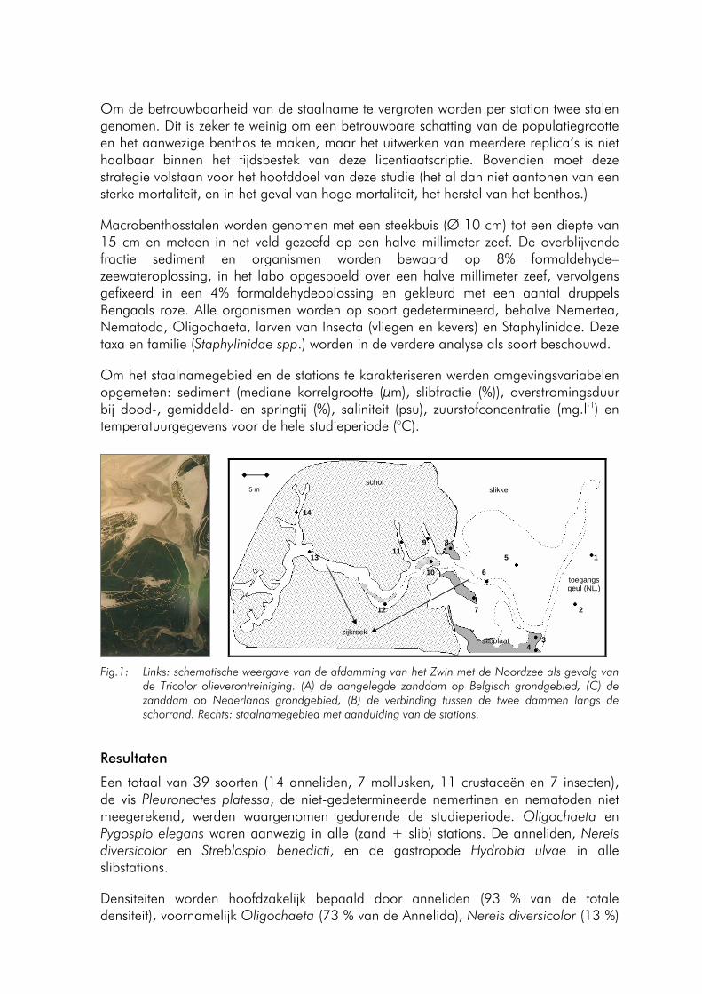
Om de betrouwbaarheid van de staalname te vergroten worden per station twee stalen genomen. Dit is zeker te weinig om een betrouwbare schatting van de populatiegrootte en het aanwezige benthos te maken, maar het uitwerken van meerdere replica’s is niet haalbaar binnen het tijdsbestek van deze licentiaatscriptie. Bovendien moet deze strategie volstaan voor het hoofddoel van deze studie (het al dan niet aantonen van een sterke mortaliteit, en in het geval van hoge mortaliteit, het herstel van het benthos.)
Macrobenthosstalen worden genomen met een steekbuis (Ø 10 cm) tot een diepte van 15 cm en meteen in het veld gezeefd op een halve millimeter zeef. De overblijvende fractie sediment en organismen worden bewaard op 8% formaldehyde–zeewateroplossing, in het labo opgespoeld over een halve millimeter zeef, vervolgens gefixeerd in een 4% formaldehydeoplossing en gekleurd met een aantal druppels Bengaals roze. Alle organismen worden op soort gedetermineerd, behalve Nemertea, Nematoda, Oligochaeta, larven van Insecta (vliegen en kevers) en Staphylinidae. Deze taxa en familie (Staphylinidae spp.) worden in de verdere analyse als soort beschouwd.
Om het staalnamegebied en de stations te karakteriseren werden omgevingsvariabelen opgemeten: sediment (mediane korrelgrootte (μm), slibfractie (%)), overstromingsduur bij dood-, gemiddeld- en springtij (%), saliniteit (psu), zuurstofconcentratie (mg.l-1) en temperatuurgegevens voor de hele studieperiode (°C).
14
13
12
11 9
10
8
7
6
5
4 3
2
1
schor
toegangs geul (NL.)
zijkreek
slikke
slibplaat
5 m
Fig.1: Links: schematische weergave van de afdamming van het Zwin met de Noordzee als gevolg van
de Tricolor olieverontreiniging. (A) de aangelegde zanddam op Belgisch grondgebied, (C) de zanddam op Nederlands grondgebied, (B) de verbinding tussen de twee dammen langs de schorrand. Rechts: staalnamegebied met aanduiding van de stations.
Resultaten
Een totaal van 39 soorten (14 anneliden, 7 mollusken, 11 crustaceën en 7 insecten), de vis Pleuronectes platessa, de niet-gedetermineerde nemertinen en nematoden niet meegerekend, werden waargenomen gedurende de studieperiode. Oligochaeta en Pygospio elegans waren aanwezig in alle (zand + slib) stations. De anneliden, Nereis diversicolor en Streblospio benedicti, en de gastropode Hydrobia ulvae in alle slibstations.
Densiteiten worden hoofdzakelijk bepaald door anneliden (93 % van de totale densiteit), voornamelijk Oligochaeta (73 % van de Annelida), Nereis diversicolor (13 %)
- 97 -
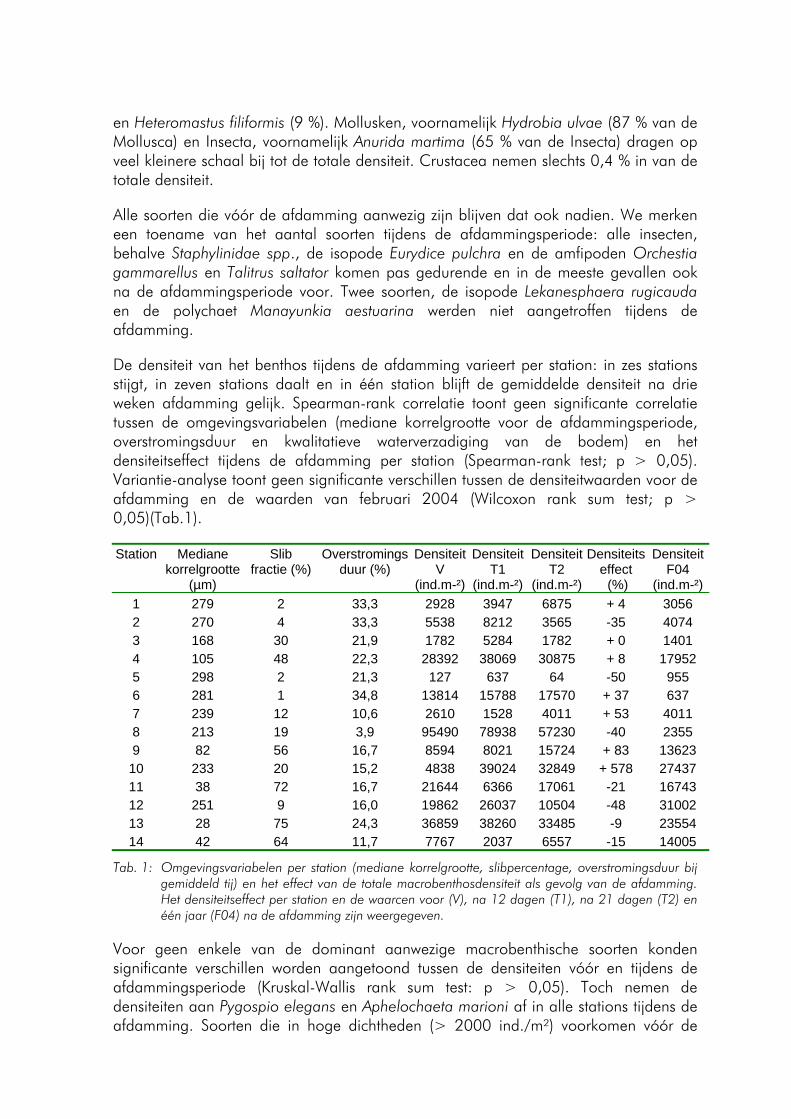
en Heteromastus filiformis (9 %). Mollusken, voornamelijk Hydrobia ulvae (87 % van de Mollusca) en Insecta, voornamelijk Anurida martima (65 % van de Insecta) dragen op veel kleinere schaal bij tot de totale densiteit. Crustacea nemen slechts 0,4 % in van de totale densiteit.
Alle soorten die vóór de afdamming aanwezig zijn blijven dat ook nadien. We merken een toename van het aantal soorten tijdens de afdammingsperiode: alle insecten, behalve Staphylinidae spp., de isopode Eurydice pulchra en de amfipoden Orchestia gammarellus en Talitrus saltator komen pas gedurende en in de meeste gevallen ook na de afdammingsperiode voor. Twee soorten, de isopode Lekanesphaera rugicauda en de polychaet Manayunkia aestuarina werden niet aangetroffen tijdens de afdamming.
De densiteit van het benthos tijdens de afdamming varieert per station: in zes stations stijgt, in zeven stations daalt en in één station blijft de gemiddelde densiteit na drie weken afdamming gelijk. Spearman-rank correlatie toont geen significante correlatie tussen de omgevingsvariabelen (mediane korrelgrootte voor de afdammingsperiode, overstromingsduur en kwalitatieve waterverzadiging van de bodem) en het densiteitseffect tijdens de afdamming per station (Spearman-rank test; p > 0,05). Variantie-analyse toont geen significante verschillen tussen de densiteitwaarden voor de afdamming en de waarden van februari 2004 (Wilcoxon rank sum test; p > 0,05)(Tab.1).
Station Mediane korrelgrootte
(µm)
Slib fractie (%)
Overstromingsduur (%)
Densiteit V
(ind.m-²)
DensiteitT1
(ind.m-²)
Densiteit T2
(ind.m-²)
Densiteits effect (%)
Densiteit F04
(ind.m-²)1 279 2 33,3 2928 3947 6875 + 4 3056 2 270 4 33,3 5538 8212 3565 -35 4074 3 168 30 21,9 1782 5284 1782 + 0 1401 4 105 48 22,3 28392 38069 30875 + 8 17952 5 298 2 21,3 127 637 64 -50 955 6 281 1 34,8 13814 15788 17570 + 37 637 7 239 12 10,6 2610 1528 4011 + 53 4011 8 213 19 3,9 95490 78938 57230 -40 2355 9 82 56 16,7 8594 8021 15724 + 83 13623 10 233 20 15,2 4838 39024 32849 + 578 27437 11 38 72 16,7 21644 6366 17061 -21 16743 12 251 9 16,0 19862 26037 10504 -48 31002 13 28 75 24,3 36859 38260 33485 -9 23554 14 42 64 11,7 7767 2037 6557 -15 14005
Tab. 1: Omgevingsvariabelen per station (mediane korrelgrootte, slibpercentage, overstromingsduur bij gemiddeld tij) en het effect van de totale macrobenthosdensiteit als gevolg van de afdamming. Het densiteitseffect per station en de waarcen voor (V), na 12 dagen (T1), na 21 dagen (T2) en één jaar (F04) na de afdamming zijn weergegeven.
Voor geen enkele van de dominant aanwezige macrobenthische soorten konden significante verschillen worden aangetoond tussen de densiteiten vóór en tijdens de afdammingsperiode (Kruskal-Wallis rank sum test: p > 0,05). Toch nemen de densiteiten aan Pygospio elegans en Aphelochaeta marioni af in alle stations tijdens de afdamming. Soorten die in hoge dichtheden (> 2000 ind./m²) voorkomen vóór de
- 98 -
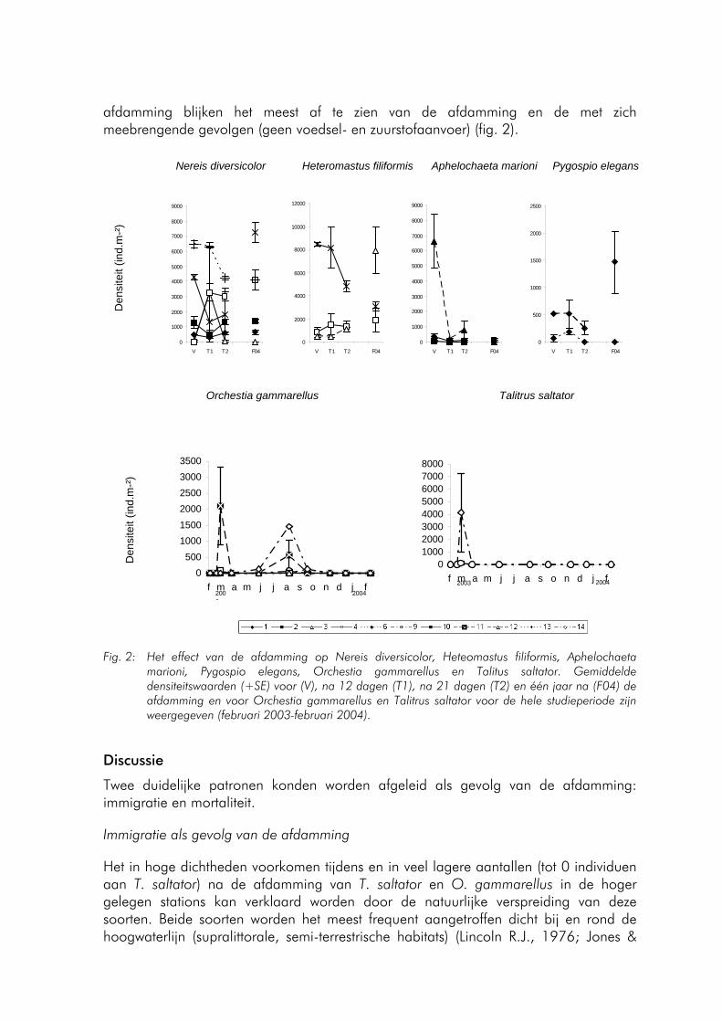
afdamming blijken het meest af te zien van de afdamming en de met zich meebrengende gevolgen (geen voedsel- en zuurstofaanvoer) (fig. 2).
Nereis diversicolor Heteromastus filiformis Aphelochaeta marioni Pygospio elegans
0
1000
2000
3000
4000
5000
6000
7000
8000
9000
V T1 T2 F04
0
2000
4000
6000
8000
10000
12000
V T1 T2 F04
0
1000
2000
3000
4000
5000
6000
7000
8000
9000
V T1 T2 F04
0
500
1000
1500
2000
2500
V T1 T2 F04
Den
site
it (in
d.m
-²)
Orchestia gammarellus Talitrus saltator
0500
100015002000250030003500
f m a m j j a s o n d j f2004200
3
010002000300040005000600070008000
f m a m j j a s o n d j f20042003
Den
site
it (in
d.m
-²)
Fig. 2: Het effect van de afdamming op Nereis diversicolor, Heteomastus filiformis, Aphelochaeta marioni, Pygospio elegans, Orchestia gammarellus en Talitus saltator. Gemiddelde densiteitswaarden (+SE) voor (V), na 12 dagen (T1), na 21 dagen (T2) en één jaar na (F04) de afdamming en voor Orchestia gammarellus en Talitrus saltator voor de hele studieperiode zijn weergegeven (februari 2003-februari 2004).
Discussie
Twee duidelijke patronen konden worden afgeleid als gevolg van de afdamming: immigratie en mortaliteit.
Immigratie als gevolg van de afdamming
Het in hoge dichtheden voorkomen tijdens en in veel lagere aantallen (tot 0 individuen aan T. saltator) na de afdamming van T. saltator en O. gammarellus in de hoger gelegen stations kan verklaard worden door de natuurlijke verspreiding van deze soorten. Beide soorten worden het meest frequent aangetroffen dicht bij en rond de hoogwaterlijn (supralittorale, semi-terrestrische habitats) (Lincoln R.J., 1976; Jones &
- 99 -
Wigham, 1993). Een immigratie van deze soorten tijdens de afdamming in het studiegebied (alle stations liggen beneden de gemiddeld laag water – lijn) vanuit hun hoger gelegen habitats lijkt waarschijnlijk. Het feit dat variantie-analyse deze enorme verschillen in densiteit niet als signifcant aantoont is te verklaren door de gebruikte staalnametechniek. Beide amfipoden kwamen tijdens de afdamming zéér geaggregeerd voor in de scheuren in de bodem en het nemen van slechts twee replica’ s ter hoogte van de stations is ruim onvoldoende om uiteindelijk tot een precieze schatting van de densiteit te komen (zie methodologie).
Rekening houdend met het laag aantal waargenomen individuen vóór en na augustus 2003 kan de hoge dichtheid aan O.gammarellus in augustus 2003 in het studiegebied louter aan het gevolg van de waargenomen recrutering tijdens de zomer worden toegeschreven. Juvenielen worden volgens Jones & Wigham (1993) over het hele jaar aangetroffen maar piekrecrutering gebeurt bij O. gammarellus in de zomer. Onderzoeken tonen aan dat juveniele en ‘zwakke’ amphipoden vaak meer naar de kust toe, en lager dan hun preferentieel habitat, voorkomen (Scapini et al., 1992; Williams, 1995; Tsubokura et al. 1997) en is mogelijk een gevolg van competitie voor bronnen.
Mortaliteit als gevolg van de afdamming
Het niet voorkomen van Manayunkia aestuarina en Lekanosphaera rugicauda tijdens de afdamming is opvallend maar kon niet gelinkt worden aan teruggevonden literatuur. Mogelijks kan seizoenale variatie met lage waarden in de late winter (februari) de afwezigheid van deze twee soorten tijdens de afdamming verklaren: hoe minder talrijk een soort voorkomt, hoe groter de kans op het ‘missen’ van deze soort wordt.
Hoewel voor geen enkele van de dominant aanwezige macrobenthische soorten en de totale densiteit per station significante verschillen konden aangetoond worden tussen de densiteiten vóór en tijdens de afdammingsperiode (Kruskal-Wallis rank sum test: p > 0,05) nemen de densiteiten aan Pygospio elegans en Aphelochaeta marioni af in alle stations tijdens de afdamming. Deze twee soorten blijken in de wintermaanden erg gevoelig voor periodes van droogstand (Fortuin et al., 1989). Na de afdamming worden beide soorten terug in hogere dichtheden waargenomen. Soorten die in hoge dichtheden (> 2000 ind./m²) voorkomen vóór de afdamming blijken het meest af te zien van de afdamming en de dit met zich meebrengende gevolgen (geen voedsel –en zuurstofaanvoer). Hoewel bodemdieren een lage stofwisseling hebben in de winter, kan dit vermoedelijk verklaard worden door de uitputting van de beperkt voorhanden zijnde bronnen (zuurstof en voedsel) door consumptie van het hoge aantal individuen. De in de meeste gevallen hogere densiteit aan de dominant aanwezige soorten in deze stations bij de laatste staalname tijdens de afdamming is veeleer een rechtstreeks gevolg van het feit dat deze soorten, tengevolge van de vrieskou en hun temperatuursgebonden diepte van voorkomen in de bodem, werden waargenomen onder het staal dan een herstel tijdens de laatste week van de afdamming.
Met betrekking tot het bodemleven, mag, gezien de hoge overleving van het macrobenthos en de afscherming van het reservaat met de olie, de keuze voor de zanddam (en de daarmee verbonden volledige afsluiting van de getijdenwerking) als beschermingsoptie, positief geëvalueerd worden. Deze hoge overleving kan
- 100 -
toegeschreven worden aan de periode van drooglegging: de winter. Benthische invertebraten zijn koudbloedige organismen. Gedurende de zomer worden ze gekenmerkt door een hoog metabolisme, in de winter hebben ze een lage stofwisseling. Als gevolg van de afdamming wordt de voedsel- en zuurstoftoevoer gelimiteerd. De winterperiode is het rustseizoen voor deze macrobenthische mariene soorten en ze hebben dan slechts weinig zuurstof en voedsel nodig.
Referenties
Fortuin A.W., A. Meijboom en L. de Wolf. 1989. Het gebruik van de stormvloedkering bij de afbouwwerkzaamheden in de Oosterschelde: effecten van een aantal sluitingsscenario’ s op bodemdieren. Rapporten en verslagen 1989 – 2, 79 pp.
Jones M.B. en G.D. Wigham. 1993. Reproductive-biology of Orchestia-gammarellus (Crustacea, Amphipoda) living in a sewage-treatmant works. Journal of the marine biological association of the United Kingdom. 73 (2): pp.405 – 416.
Lincoln R.J. 1976. British Marine Amphipoda: Gammaridae, deel 1. 654 pp.
Scapini F., L. Chelazzi, I. Colomini en M. Fallaci. 1992. Surface-activity, zonation and migrations of Talitrus saltator on a mediterranean beach. Marine Biology 112 (4): pp. 573–581.
Tsubokura T, S. Goshima en S. Nakao. 1997. Seasonal horizontal and vertical distribution patterns of the supralittoral amphipod Trinorchestia trinitatis in relation to environmental variables. Journal of Crustacean Biology 17 (4): pp.674–686.
Williams J.A. 1995. Burrow-zone distribution of the supralittoral amphipod Talitrus saltator on Derbyhaven Beach, Isle-of-Man – A possible mechanism for regulating dessiciation stress. Journal of Crustacean Biology 15 (3): pp. 466–475.
- 101 -
BIOLOGISCHE EVALUATIE VAN DE BELGISCHE STRANDEN AAN DE HAND VAN TERRESTRISCHE INVERTEBRATEN
Van den Broeck Koen
Onderzoekseenheid Terrestrische Ecologie, Universiteit Gent K.L. Ledeganckstraat 35, B-9000 Gent Huidig adres: Roeveld 4, B-9320 Erembodegem (Aalst) E-mail: [email protected]
De scriptie werd gemaakt binnen het kader van het B.E.S.T. – project (Biologische Evaluatie van Elf Strandzones langs de Vlaamse Kust), waaraan meerdere partners meewerkten, elk gespecialiseerd in hun eigen vakgebied (www.vliz.be/projects/beachsup). De ecologie van de Vlaamse zandstranden kreeg totnogtoe weinig aandacht en werd voornamelijk fragmentarisch bestudeerd. Daarom had het project de algemene doelstelling om een geïntegreerd overzicht te verkrijgen van het Vlaamse strandecosysteem, waarin deze scriptie het luik “Terrestrische Arthropoda” vertegenwoordigt.
Zandstranden vormen een zeer dynamisch en hoog energetisch milieu, ten gevolge van sterke fysiochemische en biologische interacties tussen de mariene en terrestrische omgeving, waaraan slechts een beperkt aantal hoog gespecialiseerde organismen is aangepast. Bovendien worden geëxposeerde zandstranden gekenmerkt door een zeer lage primaire productie, waardoor de organismen die in dit habitat leven, sterk afhankelijk zijn van het dood organisch materiaal dat door de getijdenwerking op het strand, ter hoogte van de vloedmerk, wordt afgezet. Uit oude museumgegevens (collecties KBIN, sedert 1850) blijkt dat de specifieke, terrestrische arthropoden fauna in het begin van de 20ste eeuw nog zeer algemeen was langs onze Vlaamse stranden. Door de sterke socio-economische exploitatie van onze kust sinds de jaren 1950 - ‘60 en de daardoor sterke ontwikkeling van het massatoerisme, zijn de meeste van onze stranden onderhevig aan activiteiten zoals machinale strandreiniging en zandsuppletie. Deze worden verwacht verantwoordelijk te zijn voor de degradatie van het originele habitat, maar onderzoek en documentatie hieromtrent was schaars en bewijzen in verband met de mogelijke negatieve effecten op de lokale biodiversiteit ontbraken.
De hoofddoelstelling van de scriptie bestond er daarom in de soortenrijkdom aan terrestrische arthropoden langsheen elf Vlaamse stranden te inventariseren, zowel ter hoogte van de vloedmerk, als ter hoogte van de embryonale duinen. Uit de verzamelde data werden de spatiale en temporele variatie in soortenrijkdom, -abundantie en -samenstelling nagegaan, in functie van verschillende omgevingsvariabelen (geomorfologie, bedekkingsgraad door Cakile maritima, aan-of afwezigheid van dijken en golfbrekers, mate van recreatie en machinale strandreiniging,…). Tenslotte werd een vergelijking gemaakt in abundantie en diversiteit van de gecollecteerde Diptera (Brachycera), met de oude data van deze groep die voorhanden waren in het KBIN sinds 1850, om aldus te kunnen nagaan welke soorten sterk bedreigd of (lokaal) uitgestorven waren en of er eventueel nieuwe soorten (exoten) werden aangetroffen.
- 102 -
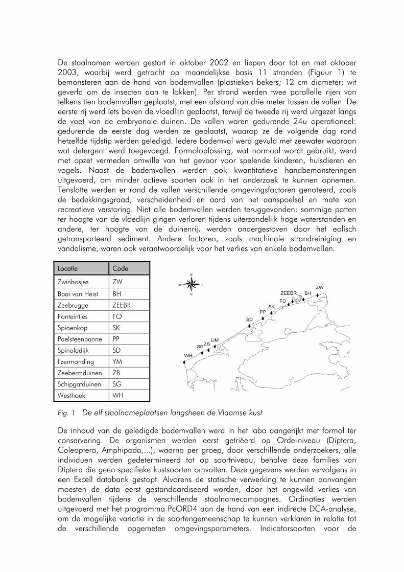
De staalnamen werden gestart in oktober 2002 en liepen door tot en met oktober 2003, waarbij werd getracht op maandelijkse basis 11 stranden (Figuur 1) te bemonsteren aan de hand van bodemvallen (plastieken bekers; 12 cm diameter; wit geverfd om de insecten aan te lokken). Per strand werden twee parallelle rijen van telkens tien bodemvallen geplaatst, met een afstand van drie meter tussen de vallen. De eerste rij werd iets boven de vloedlijn geplaatst, terwijl de tweede rij werd uitgezet langs de voet van de embryonale duinen. De vallen waren gedurende 24u operationeel: gedurende de eerste dag werden ze geplaatst, waarop ze de volgende dag rond hetzelfde tijdstip werden geledigd. Iedere bodemval werd gevuld met zeewater waaraan wat detergent werd toegevoegd. Formoloplossing, wat normaal wordt gebruikt, werd met opzet vermeden omwille van het gevaar voor spelende kinderen, huisdieren en vogels. Naast de bodemvallen werden ook kwantitatieve handbemonsteringen uitgevoerd, om minder actieve soorten ook in het onderzoek te kunnen opnemen. Tenslotte werden er rond de vallen verschillende omgevingsfactoren genoteerd, zoals de bedekkingsgraad, verscheidenheid en aard van het aanspoelsel en mate van recreatieve verstoring. Niet alle bodemvallen werden teruggevonden: sommige potten ter hoogte van de vloedlijn gingen verloren tijdens uiterzondelijk hoge waterstanden en andere, ter hoogte van de duinenrij, werden ondergestoven door het eolisch getransporteerd sediment. Andere factoren, zoals machinale strandreiniging en vandalisme, waren ook verantwoordelijk voor het verlies van enkele bodemvallen.
Locatie Code
Zwinbosjes ZW
Baai van Heist BH
Zeebrugge ZEEBR
Fonteintjes FO
Spioenkop SK
Paelsteenpanne PP
Spinoladijk SD
Ijzermonding YM
Zeebermduinen ZB
Schipgatduinen SG
Westhoek WH
Fig. 1 De elf staalnameplaatsen langsheen de Vlaamse kust
De inhoud van de geledigde bodemvallen werd in het labo aangerijkt met formol ter conservering. De organismen werden eerst getriëerd op Orde-niveau (Diptera, Coleoptera, Amphipoda,...), waarna per groep, door verschillende onderzoekers, alle individuen werden gedetermineerd tot op soortniveau, behalve deze families van Diptera die geen specifieke kustsoorten omvatten. Deze gegevens werden vervolgens in een Excell databank gestopt. Alvorens de statische verwerking te kunnen aanvangen moesten de data eerst gestandaardiseerd worden, door het ongewild verlies van bodemvallen tijdens de verschillende staalnamecampagnes. Ordinaties werden uitgevoerd met het programma PcORD4 aan de hand van een indirecte DCA-analyse, om de mogelijke variatie in de soortengemeenschap te kunnen verklaren in relatie tot de verschillende opgemeten omgevingsparameters. Indicatorsoorten voor de
- 103 -
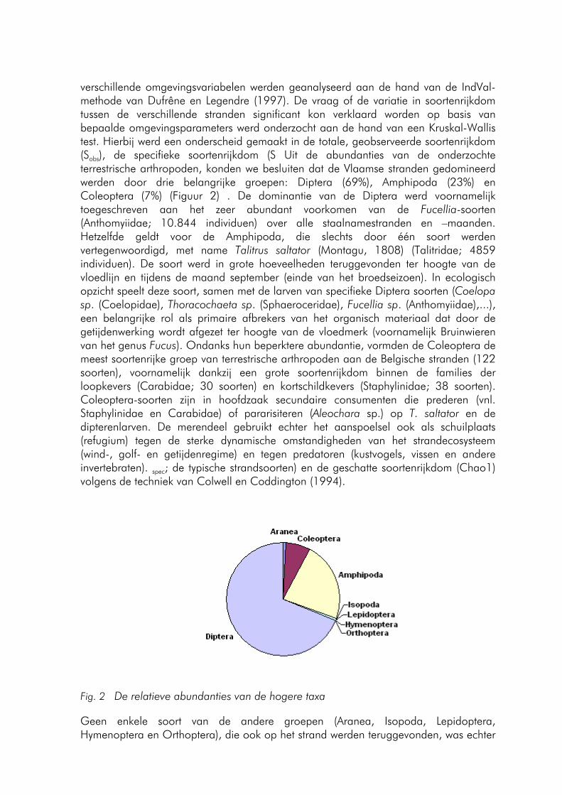
verschillende omgevingsvariabelen werden geanalyseerd aan de hand van de IndVal-methode van Dufrêne en Legendre (1997). De vraag of de variatie in soortenrijkdom tussen de verschillende stranden significant kon verklaard worden op basis van bepaalde omgevingsparameters werd onderzocht aan de hand van een Kruskal-Wallis test. Hierbij werd een onderscheid gemaakt in de totale, geobserveerde soortenrijkdom (Sobs), de specifieke soortenrijkdom (S Uit de abundanties van de onderzochte terrestrische arthropoden, konden we besluiten dat de Vlaamse stranden gedomineerd werden door drie belangrijke groepen: Diptera (69%), Amphipoda (23%) en Coleoptera (7%) (Figuur 2) . De dominantie van de Diptera werd voornamelijk toegeschreven aan het zeer abundant voorkomen van de Fucellia-soorten (Anthomyiidae; 10.844 individuen) over alle staalnamestranden en –maanden. Hetzelfde geldt voor de Amphipoda, die slechts door één soort werden vertegenwoordigd, met name Talitrus saltator (Montagu, 1808) (Talitridae; 4859 individuen). De soort werd in grote hoeveelheden teruggevonden ter hoogte van de vloedlijn en tijdens de maand september (einde van het broedseizoen). In ecologisch opzicht speelt deze soort, samen met de larven van specifieke Diptera soorten (Coelopa sp. (Coelopidae), Thoracochaeta sp. (Sphaeroceridae), Fucellia sp. (Anthomyiidae),...), een belangrijke rol als primaire afbrekers van het organisch materiaal dat door de getijdenwerking wordt afgezet ter hoogte van de vloedmerk (voornamelijk Bruinwieren van het genus Fucus). Ondanks hun beperktere abundantie, vormden de Coleoptera de meest soortenrijke groep van terrestrische arthropoden aan de Belgische stranden (122 soorten), voornamelijk dankzij een grote soortenrijkdom binnen de families der loopkevers (Carabidae; 30 soorten) en kortschildkevers (Staphylinidae; 38 soorten). Coleoptera-soorten zijn in hoofdzaak secundaire consumenten die prederen (vnl. Staphylinidae en Carabidae) of pararisiteren (Aleochara sp.) op T. saltator en de dipterenlarven. De merendeel gebruikt echter het aanspoelsel ook als schuilplaats (refugium) tegen de sterke dynamische omstandigheden van het strandecosysteem (wind-, golf- en getijdenregime) en tegen predatoren (kustvogels, vissen en andere invertebraten). spec; de typische strandsoorten) en de geschatte soortenrijkdom (Chao1) volgens de techniek van Colwell en Coddington (1994).
Fig. 2 De relatieve abundanties van de hogere taxa
Geen enkele soort van de andere groepen (Aranea, Isopoda, Lepidoptera, Hymenoptera en Orthoptera), die ook op het strand werden teruggevonden, was echter
- 104 -
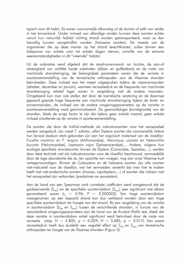
typisch voor dit habit. Ze waren voornamelijk afkomstig uit de duinen of zelfs van verder in het binnenland. Onder invloed van aflandige winden kunnen deze soorten echter vanuit hun natuurlijk habitat richting strand worden getransporteerd, waar ze dan toevallig kunnen aangetroffen worden (haloxene soorten). De meeste van de organismen die op deze manier op het strand terechtkomen, zullen binnen een tijdspanne van enkele uren tot enkele dagen sterven, omwille van de extreme weersomstandigheden in dit “vreemde” habitat.
Uit de ordinaties werd afgeleid dat de staalnamemaand- en locatie, de aan-of afwezigheid van artifiële harde substraten (dijken en golfbrekers) en de mate van machinale strandreiniging, de belangrijkste parameters waren die de variatie in soortensamenstelling van de terrestrische arthropoden aan de Vlaamse stranden beïnvloeden. Deze invloed was het meest uitgesproken tijdens de najaarsmaanden (oktober, december en januari), wanneer recreatiedruk en de frequentie van machinale strandreiniging relatief lager waren in vergelijking met de andere maanden. Omgekeerd kon men ook stellen dat door de toeristische verstoring en de daarmee gepaard gaande hoge frequentie aan machinale strandreiniging tijdens de lente- en zomermaanden, de invloed van de andere omgevingsparameters op de variatie in soortensamenstelling werd geminimaliseerd. De geomorfologie (korrelgrootte) van de stranden, bleek de enige factor te zijn die tijdens geen enkele maand, geen enkele invloed uitoefende op de variatie in soortensamenstelling.
De soorten die door de IndVal-methode als indicatorsoorten voor het aanspoelsel werden aangeduid, zijn naast T. saltator, allen Diptera soorten die voornamelijk tijdens hun larvaal stadium sterk gebonden zijn aan het organisch materiaal van de vloedlijn: Fucellia maritima en F. tergina (Anthomyiidae), Helcomyza ustulata en Heterochila buccata (Helcomyzidae), Leptocera nigra (Sphaeroceridae),... Andere, volgens hun ecologie specifieke strandsoorten binnen de Diptera (Canacidae, Sepsidae,...), werden door deze techniek niet als indicatorsoorten voor de vloedlijn beschouwd, vermoedelijk door de lage abundantie die ze, ten opzichte van vroeger, nog aan onze Vlaamse kust vertegenwoordigen. Binnen de Coleoptera en de haloxene soorten zijn alle soorten niet-indicatief voor de vloedlijn, wat het vermoeden versterkt dat men hier te maken heeft met niet-endemische soorten (Aranea, Lepidoptera,...) of soorten die indirect met het aanspoelsel zijn verbonden (predatoren en parasieten).
Aan de hand van een Spearman rank correlatie coëfficiënt werd aangetoond dat de geobserveerde (Sobs) en de specifieke soortenrijkdom (Sspec) zeer significant met elkaar gecorreleerd waren (rs = 0.96; P = 0.000003). Een hoge soortenrijkdom waargenomen op een bepaald strand kon dus verklaard worden door een hoge specifieke soortenrijkdom ter hoogte van dat strand. Bij een vergelijking van de variatie in soortenrijkdom (Sobs en Sspec) tussen de verschillende stranden, in functie van de verscheidene omgevingsparameters aan de hand van de Kruskal-Wallis test, bleek dat deze variatie in soortenrijkdom enkel significant werd beïnvloed door de mate van recreatie (resp. H = 4.800, p = 0.029; H = 5.685, p = 0.017). Een zware recreatiedruk heeft dus duidelijk een negatief effect op Sobs en Sspec van terrestrische arthropoden ter hoogte van de Vlaamse stranden (Figuur 3).
- 105 -
Geobserveerde soortenrijkdom
020406080
100120140160
licht zwaarMate van recreatie
Aan
tal s
oorte
nSpecifieke soortenrijkdom
020406080
100120140160
licht zwaarMate van recreatie
Aan
tal s
oorte
n
Fig. 3 Sobs (links) en Sspec (rechts) in functie van de mate van recreatie.
Uit een vergelijking tussen de recente data (scriptie) en de oude data (KBIN) van Diptera, merkte men een achteruitgang van de soortenrijkdom van deze groep met 25%. Voornamelijk de soortenrijkdom binnen de Tethinidae (-50%), de Ephydridae (-44%) en de Hybotidae (-38%) kende een zeer sterke terugval. Vele van de specifieke strandvliegensoorten zijn dus sterk bedreigd en vermoedelijk zijn reeds vele soorten lokaal uitgestorven ter hoogte van de Vlaamse stranden. Het gaat hier vooral om de soorten waarvan de larven voor hun ontwikkeling sterk afhankelijk zijn van de aangespoelde, rottende wieren (Fucus sp.): Coelopidae, Sepsidae, Canacidae en Scathophagidae. Enkel de Fucellia-soorten, Helcomyza ustulata en bepaalde soorten van de Tethinidae en Ephydridae, waren niet bedreigd.
Als besluit konden we stellen dat het aanspoelsel ter hoogte van de vloedlijn een belangrijke primaire voedselbron vormt voor heel wat terrestrische arthropoden (T. saltator en larven van Diptera). Daarnaast gebruiken heel wat insecten deze biotoop als refugium tegen het sterke windregime, golfdynamiek en predatoren (Coelopidae, Sepsidae, Staphylinidae en Carabidae). Ook heel wat predatoren (kustvogels, vissen en andere invertebraten) en parasieten (Aleochara sp., Acari), zijn voor hun dieet sterk afhankelijk van de fauna die in het aanspoelsel huist. Het vernietigen of verwijderen van het aanspoelsel leidt dus tot een verstoring van deze voedselketen en ligt vermoedelijk aan de basis van de achteruitgang van de soortenrijkdom- en abundantie van terrestrische arthropoden ter hoogte van de Vlaamse stranden.
Om te verhinderen dat in de toekomst deze trend zich blijft voortzetten, is het duidelijk dat beheersmaatregelen dienen vooropgesteld te worden. Ten minste een reductie van de mate van recreatie (door de aanleg van reservaten) en in de intensiteit van machinale strandreiniging (door bepaalde strandzones enkel manueel te reinigen) langs bepaalde strandsecties, kan leiden tot het behoud van het aangespoeld organisch materiaal ter hoogte van de vloedlijn en dus ook tot het behoud en/of herstel van de geassocieerde strandfauna.
- 106 -
VERANDERINGEN IN TRADITIONELE EN COMMERCIËLE MENS-ECOSYSTEEMRELATIES IN DE MANGROVEBAAI VAN GAZI (KENIA): ETNOBIOLOGIE, PERCEPTIES VAN DE LOKALE GEMEENSCHAP EN ECOTOERISTISCHE ACTIVITEITEN
Van Tendeloo Anneleen
Laboratorium voor Algemene Plantkunde en Natuurbeheer, Vrije Universiteit Brussel, Pleinlaan 2, B-1050 Brussel Huidig adres: Eglegemweg 1, B-2811 Hombeek E-mail: [email protected]
Via 100 mondelinge interviews en 116 schriftelijke vragenlijsten werd etnobiologisch onderzoek verricht in 3 Keniaanse kustdorpen (Gazi, Makongeni en Msambweni). Hierbij werd gekeken naar het plaatselijke gebruik van de mangroven (etnobotanie), de percepties van de lokale bevolking op veranderingen in de omgeving (etno-ecologie) en naar de plaatselijke visserij (etnozoölogie).
Voor de etnobotanie werd vastgesteld dat de mangroven zeer belangrijk zijn voor de plaatselijke bevolking, ze werden door 100% van de geïnterviewden gebruikt. Mangrovehout wordt vooral gebruikt voor constructie (100%) en als brandhout (89%). De 2 soorten meest gebruikte soorten zijn Rhizophora mucronata en Ceriops tagal. Er werd vastgesteld dat de lokale bevolking chemische en medicinale toepassingen van mangrovehout en andere mangroveproducten (propagulen, bladeren, etc.) kennen. Hoewel deze toepassingen wel gekend zijn, gaat men liever naar de dokter dan deze te gebruiken. De resultaten van het huidige onderzoek werden vergeleken met onderzoeken op andere plaatsen in Kenia en met andere internationale onderzoeken (Mexico, Tanzania, Vietnam en India). Daarbij viel vooral op dat in de andere landen mangroveproducten wel als voeding voor mens en dier gebruikt worden terwijl dit in de onderzochte dorpen niet het geval was.
In de onderzochte dorpen zei meer dan 90% van de geïnterviewden afhankelijk te zijn van de mangroven. Hoewel de mangroven dus zeer belangrijk en misschien onvervangbaar lijken, denkt meer dan 50% van de bevolking dat vervanging van de mangroveproducten mogelijk is. Er werd waargenomen dat de visie op vervangbaarheid onafhankelijk is van de levensstandaard, waarschijnlijk zijn het vooral de goede kwaliteiten van het hout die ervoor zorgen dat het mangrovehout niet vervangen wordt.
Veranderingen in de omgeving werden door de lokale bevolking waargenomen. Zo werd de daling in mangrove-oppervlakte vastgesteld door Dahdouh-Guebas et al. (2004) ook door de plaatselijke bevolking waargenomen. De informatie die over vegetatiedynamiek verkregen werd, wordt gebruikt in een breder onderzoek op spatio-temporele veranderingen.
Daarnaast meldde de lokale bevolking ook een daling in mangrovefauna, een stijging in zeeniveau en een verandering in klimaat. De daling in mangrovefauna werd vooral
- 107 -
waargenomen door personen ouder dan 45 jaar. Bij de overige veranderingen was er geen verband met de leeftijd van de geïnterviewden.
Voor het beheer van de mangroven bestond op het moment van onderzoek een volledig verbod op het kappen van mangroven. In dit onderzoek wordt aangetoond dat de bevolking het niet eens is met deze beheermaatregel en deze ook niet altijd volgt. Men blijft het mangrovehout gebruiken ook al vinden sommigen dit vervangbaar. Dit is een extra aanduiding dat men het mangrovehout vooral gebruikt om zijn goede kwaliteiten. Het beheer van de mangroven moet dus op een andere manier aangepakt worden. Alternatieve beheermaatregelen zijn: aanplantingbeheer, bewustmakingscam-pagnes en het verder uitwerken van een gepland ecotoeristisch project (dit kan voor alternatieve inkomstenbronnen zorgen).
Een ecotoeristisch project heeft een veel grotere slaagkans indien de plaatselijke bevolking dit project steunt. In de interviews werd een deel ingelast om de mening van de bevolking van Gazi over een gepland ecotoeristisch project (een wandelbrug door de mangroven) te onderzoeken. Hieruit blijkt dat men vooral positief tegenover de komst van dit project staat. Verschillende voordelen worden gezien zoals werkvoorziening, betere economie, schoolhulp voor kinderen, etc.. Nadelen aan dit project werden door veel minder mensen genoemd, de voornaamste hierbij waren een verandering in kledingsregels en een verandering van religieuze gewoonten.
Het laatste onderzoeksonderdeel paste in de etnozoölogie. Voor de visserij werd de vangst van de vissers besproken en de evolutie hiervan de afgelopen 10 jaar. De vissers vangen vooral vis maar ook garnalen, kreeften en krabben worden regelmatig gevangen. De vissers hebben de afgelopen 10 jaar een daling in vangst opgemerkt. Deze daling werd ook bij de commercieel belangrijke vissen waargenomen. De vissers gaven ook specifieke visplaatsen op waarbij gekeken werd naar de plaats (in mangroven, in de baai of voorbij de baai) en de begroeiing (onbegroeid, zeegras, aanwezige mangrovesoorten). Hierbij duidden ze enkele specifieke mangrovesoorten aan die van belang zijn voor bepaalde vissoorten.
Referentie
Dahdouh-Guebas F., I. Van Pottelbergh, J.G. Kairo, S. Cannicci and N. Koedam. 2004. Human-impacted mangroves in Gazi (Kenya): predicting future vegetation based on retrospective remote sensing, social surveys, and distribution of trees. Marine Ecology Progress Series 279: 77-92.
- 108 -
BEREIKEN GROTE VISSEN DE PAAIGRONDEN EERST EN PAAIEN ZE VOOR KLEINE VISSEN: MALLOTUS VILLOSUS PAAIEND OP DE STRANDEN LANGSHEEN DE KUST VAN NEWFOUNDLAND
Vandeperre Frederic
Afdeling Mariene Biologie, Vakgroep Biologie, Universiteit Gent Krijgslaan 281/S8, B-9000 Gent Huidig adres: Ridder Dessainlaan 13, B-2800 Mechelen E-mail: [email protected]
Migratie is een vaak voorkomende en intrigerende eigenschap van vele pelagische en demersale vissoorten die zich bewegen tussen broedkamergebieden, voedingsgronden en paaigronden. Verschillende studies van zowel pelagische als niet-pelagische vissoorten die migreren om zich voort te planten beschreven reeds een relatie tussen lichaamslengte en paaitijdstip. De huidige studie onderzoekt deze relatie voor M. villosus, een pelagische, spieringachtige soort die zich voortplant op de stranden van Newfoundland. Enkelvoudige lineaire regressies werden afzonderlijk uitgevoerd voor drie groepen, rijpe, eierdragende wijfjes, wijfjes die hun eieren net hebben afgezet en mannetjes en dit voor drie opeenvolgende jaren (1982-1984). Gedurende elk van de 3 opeenvolgende jaren bereikten de grote vissen de paaigronden eerst in elk van de drie groepen en was deze relatie meer uitgesproken voor de wijfjes. Analyses van de maaginhoud van Atlantische kabeljauw (Gadus morhua), een belangrijke predator van M. villosus, toonden een gelijkaardige daling van de gemiddelde lengte van M. villosus gedurende de paaiperiode. Verder suggereerden t-tests dat Atlantisch kabeljauw vroeg in de paaiperiode, wanneer de abundantie van M. villosus hoog was, selecteerde voor grotere prooien, terwijl ze laat in de paaiperiode, wanneer de abundantie van M. villosus lager was, geen lengtevoorkeur vertoonde. De bekomen resultaten worden besproken en geïnterpreteerd en belangrijke vragen naar de mechanismen die aan de basis liggen van deze verschijnselen worden kritisch belicht aan de hand van de huidige studie en de wetenschappelijke literatuur.
- 109 -
INTRA- EN INTERSPECIFIEKE VARIATIE IN FENOTYPE EN GENOTYPE BIJ ESTUARIENE NAVICULA SOORTEN
Vanelslander Bart
Laboratorium Protistologie en Aquatische Ecologie, Vakgroep Biologie, Universiteit Gent Krijgslaan 281/S8, B-9000 Gent Huidig adres: Bierenbos 14, B-8200 Sint-Michiels (Brugge) E-mail: [email protected]
Vaak wordt verondersteld dat estuariene epipelische diatomeeën euryhalien te zijn (Krammer & Lange-Bertalot, 1986). Morfospecies van estuariene epipelische diatomeeën komen vaak voor langsheen een saliniteitsgradiënt gaande van marien tot zoetwater. Het is echter onduidelijk of deze soorten werkelijk euryhalien zijn, dan wel bestaan uit verschillende entiteiten die elkaar langsheen een saliniteitsgradiënt opvolgen.
Om dit te onderzoeken werd de intra- en interspecifieke variatie bij enkele algemene estuariene epipelische diatomeeën nagegaan. Stammen behorende tot het traditionele (brede) morfologische soortsconcept van Navicula phyllepta werden geïsoleerd langsheen de estuariene saliniteitsgradiënt van de Westerschelde. Ook stammen van N. flanatica en N. gregaria werden geïsoleerd. Deze stammen werden morfologisch en genetisch (ITS1) onderzocht. In cultuurexperimenten werd bovendien de groei in functie van saliniteit bepaald om na te gaan of deze soort bestaat uit één euryhaliene groep verspreid langsheen de Westerschelde, dan wel uit een heterogene groep met intraspecifieke variatie in saliniteitsrange en -optimum. Er werden eveneens kruisingsexperimenten opgezet. Er wordt dus onderzocht of eco-, feno-, geno- en gamodemen binnen soorten onderscheiden kunnen worden. (Een deme is een groepering van individuen waarbij het prefix de basis voor het groeperen aanduidt) We gaan de convergentie na tussen de verschillende variatiepatronen. Wegens tijdsgebrek werd enkel N. phyllepta uitgebreid onderzocht.
Onze analyses toonden aan dat er (minstens) twee verschillende sympatrische groepen van N. phyllepta S.L. aanwezig zijn in de Westerschelde. Deze groepen vertoonden congruente verschillen in morfologische, moleculaire en ecofysiologische kenmerken. Een groep van isolaten bevatte grotere, bredere diatomeeën met een lagere striaedensiteit (10-28μm L; 6-7μm B; 17-19 striae in 10μm), terwijl de andere groep van isolaten kleinere en smallere diatomeeën met een hogere striaedensiteit bevatte (6,8-19,7μm L; 4,5-5,3 μm B; 21-22,5 striae in 10μm).
Deze opsplitsing in twee groepen vonden we ook terug bij het moleculair onderzoek. Op basis van ITS1 sequenties werden fylogenetische verwantschappen bepaald. De indeling van de stammen in twee sterk verschillende claden is reeds erg duidelijk. De verschillen tussen beide claden zijn vrij groot (32 nucleotidesubstituties en 9 indels).
Ook op basis van de saliniteitsexperimenten werden de isolaten van N. phyllepta in gelijkaardige groepen ingedeeld.
- 110 -
Eén groep van isolaten kon groeien bij 0,5 psu en hogere saliniteiten. Deze isolaten werden voornamelijk uit het stroomopwaarts deel van de Westerschelde geïsoleerd en behoren tot de morfologisch kleinere en smallere groep. Een tweede groep van isolaten kon niet groeien onder 5 psu. Deze isolaten werden voornamelijk uit het stroomafwaarts deel van de Westerschelde geïsoleerd en behoren tot de morfologisch grotere en bredere groep. Een derde groep van isolaten kon overleven bij 2 psu, maar kon pas groeien (delen) bij 5 psu. Tot deze groep behoren isolaten van beide morfologische groepen.
Geen enkele kruising kon geïnitieerd worden. De saliniteit bij deze experimenten werd verlaagd tot 5 en 10 psu, maar ook dat leverde geen positieve resultaten op, zodat we niet weten of de verschillende groepen al dan niet reproductief geïsoleerd zijn.
We zien dus een sterke congruentie tussen de groepsafbakeningen gebaseerd op morfologische, fysiologische en moleculaire kenmerken. De groepsafbakeningen op basis van ITS 1 sequenties komen volledig overeen met de groepsafbakeningen op basis van morfologie en ook de fysiologische opsplitsing is ongeveer dezelfde.
Congruenties tussen groepen binnen soorten gebaseerd op meer dan twee types kenmerken (zoals bij deze studie) zijn schaars. Bij diatomeeën is er slechts één voorbeeld waarbij eveneens drie types kenmerken in een gecombineerd onderzoek gebruikt werden: het Sellaphora pupula soortscomplex. Daar vond men een gelijkaardige congruentie tussen gamo-, geno- en fenodemen (Mann, 1999).
Als besluit kunnen we stellen dat de diversiteit onder diatomeeën bij de traditionele morfo-taxonomie waarschijnlijk sterk onderschat wordt. Bij het beperkte aantal studies met combinaties van morfologisch, fysiologisch, genetisch en reproductief onderzoek blijken morfospecies vaak te bestaan uit verschillende groepen.
Het beperkt aantal fysiologische en genetische studies over intraspecifieke variatie heeft vaak aanleiding gegeven tot een nauwkeuriger morfologisch onderzoek. Bij dit laatste werden vaak discontinuïteiten in kenmerken gevonden waarvan voorheen de variatie als gewone variabiliteit binnen soorten beschouwd werd.
- 111 -
EXPERIMENTELE STUDIE VAN DE VEGETATIEVE EN SEKSUELE REPRODUCTIE VAN TWEE POTENTIEEL TOXISCHE DIATOMEEËN, PSEUDO-NITZSCHIA FRAUDULENTA (CLEVE) HASLE EN P. PUNGENS (GRUNOW EX CLEVE) HASLE (BACILLARIOPHYCEAE)
Vannerum Katrijn
Laboratorium Protistologie en Aquatische Ecologie, Vakgroep Biologie, Universiteit Gent Krijgslaan 281/S8, B-9000 Gent Huidig adres: Burggravenlaan 323, B-9000 Gent E-mail: [email protected]
In deze scriptie werden aan de hand van morfometrie en licht- en rasterelektronenmicroscopie de morfologische variatiepatronen binnen Pseudo-nitzschia fraudulenta en P. pungens, twee potentieel toxische diatomeeënsoorten uit de Noordzee bestudeerd. Accurate identificatie is immers van primair belang bij monitoringsprogramma’s. De voornaamste doelstelling was echter de gedetailleerde studie van het seksuele voortplantingsproces van beide soorten aan de hand van kruisingsexperimenten met monoklonale culturen van verschillende locaties. Studie van auxosporulatie en de levenscyclus leveren naast data voor de systematiek ook essentiële gegevens om de populatiebiologie van diatomeeën te begrijpen in relatie tot bloeidynamiek en toxiciteit.
De voornaamste doelstelling was echter de gedetailleerde studie van het seksuele voortplantingsproces van beide soorten aan de hand van kruisingsexperimenten met monoklonale culturen van verschillende locaties. Studie van auxosporulatie en de levenscyclus leveren naast data voor de systematiek ook essentiële gegevens om de populatiebiologie van diatomeeën te begrijpen in relatie tot bloeidynamiek en toxiciteit. De gemiddelde afnamesnelheid in cellengte bedraagt 4,36 ± 0,87 μm/maand voor P. fraudulenta en 5,06 ± 1,33 μm/maand voor P. pungens. Er is een significant effect van de apicale cellengte op de afnamesnelheid, grotere cellen nemen namelijk sneller af in lengte dan kleinere. Abrupte reductie in celgrootte werd bij beide soorten vastgesteld, zelfs al bij de initiële cellen in hun perizonium. De afname in cellengte varieerde van 20% tot 50% van de apicale cellengte bij één deling. De verschillende stappen van het proces werden beschreven.
Het auxosporulatieproces van beide soorten is nagenoeg identiek. Seksuele reproductie gebeurt enkel interklonaal. Tijdens de gametangiogamie zijn verschillende configuraties mogelijk. De gametangia zijn niet omgeven door een slijmomhulsel. Per gametangium worden 2 morfologisch identieke ongeflagelleerde gameten geproduceerd. Er is sprake van fysiologische anisogamie, namelijk cis-anisogamie. De gameten versmelten 2 per 2 tot een zygote. De zygotes expanderen bipolair tot auxosporen waarin een initiële cel gevormd wordt. De chloroplastdynamiek gedurende de vorming van de initiële cel is zeer gelijkaardig aan deze gedurende de vegetatieve celdeling. Uit de beschikbare gegevens kan besloten worden dat het genus Pseudo-nitzschia het type Ia2 patroon van seksuele reproductie vertoont. Interspecifieke verschillen situeren zich in het feit of vooral paring tussen individuele cellen of tussen kolonies plaatsvindt, in de graad van
- 112 -
vasthechting van gameten en auxosporen aan de parentale theca en in de uitgesprokenheid van de centrale uitstulping in het transversale perizonium.
Vorming van haploïde, triploïde en tetraploïde auxosporen werd bij beide soorten waargenomen. Door hun isolatie is getracht om hun ontwikkeling te volgen, maar ze bleken te kwetsbaar. Hetzelfde is geprobeerd op het niveau van de zygotes die een resistente organische wand hebben. Zo werd succesvol een vermoedelijk tetraploïde kloon bekomen, waarvan de ploïdie cytofotometrisch werd nagegaan. De kloon is waarschijnlijk diploïd, maar dit kan niet met zekerheid gesteld worden, aangezien de resolutie van de gebruikte methode vrij laag bleek te zijn.
- 113 -
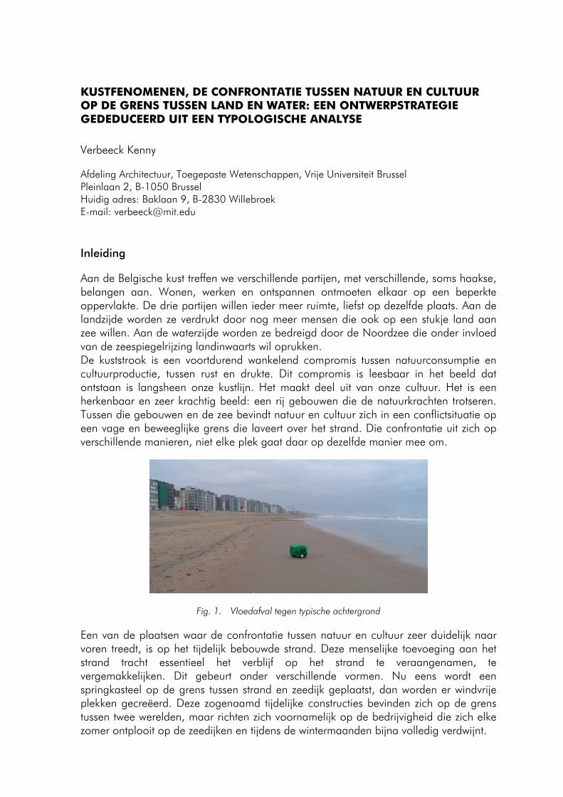
KUSTFENOMENEN, DE CONFRONTATIE TUSSEN NATUUR EN CULTUUR OP DE GRENS TUSSEN LAND EN WATER: EEN ONTWERPSTRATEGIE GEDEDUCEERD UIT EEN TYPOLOGISCHE ANALYSE
Verbeeck Kenny
Afdeling Architectuur, Toegepaste Wetenschappen, Vrije Universiteit Brussel Pleinlaan 2, B-1050 Brussel Huidig adres: Baklaan 9, B-2830 Willebroek E-mail: [email protected]
Inleiding
Aan de Belgische kust treffen we verschillende partijen, met verschillende, soms haakse, belangen aan. Wonen, werken en ontspannen ontmoeten elkaar op een beperkte oppervlakte. De drie partijen willen ieder meer ruimte, liefst op dezelfde plaats. Aan de landzijde worden ze verdrukt door nog meer mensen die ook op een stukje land aan zee willen. Aan de waterzijde worden ze bedreigd door de Noordzee die onder invloed van de zeespiegelrijzing landinwaarts wil oprukken. De kuststrook is een voortdurend wankelend compromis tussen natuurconsumptie en cultuurproductie, tussen rust en drukte. Dit compromis is leesbaar in het beeld dat ontstaan is langsheen onze kustlijn. Het maakt deel uit van onze cultuur. Het is een herkenbaar en zeer krachtig beeld: een rij gebouwen die de natuurkrachten trotseren. Tussen die gebouwen en de zee bevindt natuur en cultuur zich in een conflictsituatie op een vage en beweeglijke grens die laveert over het strand. Die confrontatie uit zich op verschillende manieren, niet elke plek gaat daar op dezelfde manier mee om.
Fig. 1. Vloedafval tegen typische achtergrond
Een van de plaatsen waar de confrontatie tussen natuur en cultuur zeer duidelijk naar voren treedt, is op het tijdelijk bebouwde strand. Deze menselijke toevoeging aan het strand tracht essentieel het verblijf op het strand te veraangenamen, te vergemakkelijken. Dit gebeurt onder verschillende vormen. Nu eens wordt een springkasteel op de grens tussen strand en zeedijk geplaatst, dan worden er windvrije plekken gecreëerd. Deze zogenaamd tijdelijke constructies bevinden zich op de grens tussen twee werelden, maar richten zich voornamelijk op de bedrijvigheid die zich elke zomer ontplooit op de zeedijken en tijdens de wintermaanden bijna volledig verdwijnt.
- 114 -
Op het strand zelf worden jaarlijks duizenden strandcabines geplaatst. Deze staan in de eerste linie, blootgesteld aan de kracht van de natuur. De wijze waarop we deze capsules op het strand positioneren en gebruiken, kan als het ware bekeken worden als een metafoor voor de huidige houding ten opzichte van de gehele kuststrook inzake omgang met de natuurlijke fenomenen en processen. De cabines houden geen rekening met de natuurlijke gang van zaken. Ze bestaan omwille van de natuur, maar maken er geen gebruik van, laat staan dat ze de natuurlijke groei zouden bevorderen.
In dit onderzoek wordt er gezocht op welke manier een verantwoorde koppeling kan gevormd worden tussen de natuurlijke en culturele fenomenen op het strand. Het strand wordt benaderd als natuurgebied dat in meer of mindere mate is vervormd volgens de noden en grillen van de mens. Om dit onderzoek te beperken werd er gekozen om 6 punten langs de Belgische kustlijn te analyseren vanaf de zeereep tot aan de vooroever. De systematisch gekozen sites worden kwalitatief onderzocht op basis van fotoreportages. Deze reportages zijn gemaakt op verschillende ogenblikken, wat toelaat om een vergelijking te maken van elke site tussen de verschillende seizoenen. Tegelijk kunnen uiteraard de specifieke sites op verschillende niveaus met elkaar vergeleken worden. De nadruk in dit onderzoek ligt op de diversiteit van de natuurlijke en culturele fenomenen op het Belgische strand.
Om te kunnen komen tot enerzijds een vergelijking van de verschillende sites en een architectonische ontwerpstrategie anderzijds, wordt er eerst een woordenschat opgebouwd, toegespitst op het nauw lijkende onderzoeksgebied. Deze woordenschat maakt gebruik van zichtbare fenomenen als aanleiding tot verder onderzoek, wat uiteindelijk het beeld van de onderzoeker verandert, wat dan weer aanleiding geeft tot een nieuwe blik op het strand. Deze werkwijze brengt een lexicon tot stand dat uiteindelijk kan worden ingezet om de verschillende sites langs de Belgische kustlijn te deconstrueren tot basiselementen.
Allereerst werd de geschiedenis van de Belgische kust onderzocht. Er werd voornamelijk aandacht besteed aan de ontwikkeling van de badplaats en de verschijning van nieuwe elementen op het strand zelf. Enerzijds werd de geschiedenis van het kuuroord bekeken en anderzijds welke sporen nog terug te vinden zijn in het huidige landschap van deze geschiedenis.
Nieuwe badplaatsen ontstonden in de 19e eeuw. Zowel de stedebouwkundige als architectonische vormgeving was afgestemd op de nieuwe fenomenen, zoals baden in zee. De eerste plaatsen in België waar kuuroorden ontstonden langs de zee waren Blankenberge en Oostende, een havenstad met een omvangrijk deel Britten. Het waren deze Britten die een deel van het strand van de nodige uitrusting voorzagen naar Engels model. Dit Engelse model had een eigen beeldentaal, opgebouwd uit elementen zoals pier, badkoets, wandelpromenade, etc…
- 115 -
Fig. 2 Badkoets te Oostende
In de tweede helft van de 19e eeuw zorgde de industrialisering en de verbetering van de transportmogelijkheden voor de verdere evolutie van de badplaatsen. Een nieuwe, ondernemingsgezinde klasse wilde er de verworven rijkdom op ondubbelzinnige wijze etaleren.
De sensatie van de beginperiode was verdrongen door een nieuwe sensatie, de badplaats werd een kermis. Het was een concentratieplaats van alle mogelijke attracties. In het aanbod van die attracties is de culturele differentiatie langs de kust ontstaan. We hebben nu een breed spectrum aan soms subtiel, soms drastisch verschillende badplaatsen.
Natuurlijke fenomenen op het strand
Bij het beschrijven van kustlandschappen kunnen we er niet omheen dat duinlandschappen uniek zijn. Het is de enige kustlijnvorm die wordt bepaald door de wind, eerder dan door het aanwezige water.
Hoewel het basisproces hetzelfde is (eolisch zandtransport), verschillen de kustduinen toch sterk van de woestijnduinen. Dit verschil wordt voornamelijk bepaald door de aanwezigheid van vegetatie. De interactie tussen het zandtransport en de begroeiing karakteriseert de vormgeving van de duinen.
Hij stelt ook dat dit landschapstype zich enerzijds zeer eenvoudig voordoet, maar anderzijds zeer complex en onvoorspelbaar is. Het onvoorspelbare manifesteert zich vooral in de bepaling van het kritieke punt van de duin. Dit punt bepaalt wanneer de aanwezige begroeiing onvoldoende vat heeft op de duin, waardoor deze zal beginnen verstuiven. Hierbij worden grote zandvolumes door de wind verplaatst. De duin wordt laag per laag ontbonden.
De wind bepaalt echter niet alleen de mogelijke vorming van de duin. Ook het strandprofiel speelt hierin een belangrijke rol. Wanneer we te maken hebben met een zeer zacht hellend strand of een zeer breed droog strand zijn de omstandigheden ideaal voor de voorduin om zich te ontwikkelen. De wind heeft dan immers voldoende ruimte om vat te krijgen op het droge zand.
- 116 -
Bij de beschrijving van het zandtransport onderscheiden we twee hoofdrichtingen: enerzijds dwarstransport, loodrecht op de kustlijn, en anderzijds langstransport, parallel aan de kustlijn. Deze twee richtingen worden beschouwd als karakteristiek voor het strandlandschap. Het gedrag van zowel cultuur als natuur wordt voor het verdere verloop van het onderzoek teruggekoppeld aan deze twee richtingen. Aan de hand van deze richtingen worden fenomenen als zandtransport, plantengroei en duinvorming behandeld. Het begrip van de werking en het belang van deze fenomenen zal zich later uiten in de formulering van de mogelijke ontwerpstrategieën op de variabele grens tussen land en water.
Culturele fenomenen op het strand
In het volgende deel van het onderzoek wordt er gekeken naar de aanwezige culturele artefacten op het strand. Er wordt een onderscheid gemaakt tussen fenomenen die dienen tot de instandhouding van het strand, het bouwprofiel, de kuststrookvorm, etc. Deze categorieën zijn ontstaan op basis van doorgedreven bezoeken aan de verschillende sites. De nadruk wordt hier gelegd op de verschillende ‘bebouwing’ van het strand tijdens winter- of zomermaanden.
Elk van de beschouwde culturele aspecten wordt meteen teruggekoppeld naar de eerder opgebouwde kennis over het natuurlijke luik van het strand. Hierbij wordt de fragiele wisselwerking tussen natuur en cultuur in haar huidige vorm blootgelegd.
Wanneer we aan de hand van deze zorgvuldig opgebouwde woordenschat de 6 sites met elkaar vergelijken, blijkt dat de sites na veralgemening kunnen onderverdeeld worden in sterk cultureel of sterk natuurlijk. Uiteraard vallen enkele van de beschouwde sites in de spreekwoordelijke grijze zone. Het belang van deze categorisering is niet zozeer de categorisering zelf, maar het besef dat plaatsen die volgens een opsomming van aanwezige elementen zeer gelijkend zijn, in realiteit een zeer verschillend zijn. Dit besef is de rechtstreekse aanleiding om bij het uitzetten van een masterplan voor de Belgische strandstrook uit te gaan van verschil in gelijkenis. De mogelijke individualisering van de voorgestelde ontwerpstrategieën wordt beschouwd als premisse.
Gededuceerde ontwerpstrategieën
Het strand is een lege ruimte die elk jaar opnieuw gevuld wordt, laag na laag, functie na functie. Tijdens de winter zijn de meeste stranden gereduceerd tot wandelpad of langgerekt sportgebied. Deze functies vinden niet allemaal tegelijk hun plek op het strand. Men kan het strand lezen als een opeenstapeling van lagen. De natuur is de eerste laag die over de oercontext wordt gelegd. Door over de natuurlijke laag een culturele laag te leggen, wordt meteen ook een transformatie in gang gezet. Er ontstaat een wisselwerking tussen de beide lagen. Binnen een enkele laag bestaan verschillen tussen de seizoenen, tussen week en weekeinde, tussen dag en nacht. Het is net de bedoeling in dit onderzoek een brug te slaan tussen de verschillende lagen. Om de verschillende aspecten, die nu individueel worden behandeld, als een geheel te zien, als een enkele, oplosbare situatie.
- 117 -
Het strand is een openbare ruimte die nood heeft aan leesbaarheid. Het strand verandert dagelijks van vorm. Elke dag opnieuw wordt een deel van het strand op een andere manier bevolkt, gedreven door individuele initiatieven. Het kiezen van een plek gebeurt op een onnavolgbare manier, vluchtig gebaseerd op de relatie tot een mogelijke buur, de afstand tot de zee, de aanwezigheid van douches en tal van andere persoonlijke motieven. In deze chaotische en tijdelijke omgeving is nood aan duidelijke herkenningspunten die vervat zijn in een woordenschat die door iedereen kan gelezen worden (J.A. Hobbs, 1980).
Het vertrekpunt is telkens de verweving van culturele fenomenen met natuurlijke. Op die manier worden de verschillende facetten van het strand met elkaar verbonden. Het is een creatieve uitdaging die niet langer leidt tot oplossingen die naast elkaar bestaan of elkaar gewoon tegenwerken. Er wordt telkens gezocht naar de integratie van verschillende aspecten, eigen aan de grens tussen land en water. De uitdaging is de complementariteit of de overlapping van de verschillende processen te zien en samen te voegen.
De toepassing van een enkel basisconcept voor een strand staat de lokale chaos niet in de weg. Het ontworpen masterplan moet voldoende flexibiliteit bezitten, zodat binnen deze uitgezette krijtlijnen opnieuw plaats is voor individualisering van de ruimte. Zodat de bezoeker telkens bezit kan nemen van een deel van het geheel. Dit gebeurt door in de uiteindelijke detaillering van de concepten voldoende ruimte te laten voor individualisering van de plek.
Binnen de intentie om de verweving van natuur en cultuur te verwezenlijken worden hier vier mogelijke strategieën voorgesteld. Het zijn telkens concrete voorstellen die vertrekken vanuit een probleemstelling, waarna een logische redenering wordt opgebouwd en een vraag geformuleerd. Een mogelijk antwoord op deze randvoorwaarden wordt dan gegenereerd en geïllustreerd.
Sommige voorstellen worden al onbewust toegepast. In dat geval is het slechts een kwestie van de beide aspecten te intensifiëren. In andere voorstellen worden verschillende functies en benaderingen van het strand gecombineerd. Het doel is het stimuleren van de wisselwerking tussen cultuur en natuur.
Een eerste strategie is het verweven van culturele fenomenen in de natuurlijke omgeving. Dit wordt geïllustreerd aan de hand van de combinatie tussen de zandvang en het windscherm. Deze twee elementen gebruiken complementaire ruimte en kunnen versmolten worden tot een enkel cultureel element dat de interactie tussen begroeiing en zandtransport imiteert.
Een andere optie is het verweven van natuurlijke fenomenen in de natuurlijke omgeving. Hiervoor wordt in de eindverhandeling een conservatieve oplossing aangereikt voor de strandcabine. In een werkstuk, geschreven in het kader van ondersteunend onderzoek voor de eindverhandeling, wordt echter een radicalere oplossing, gebaseerd op stranddynamiek, voorgesteld. Hierbij wordt de opstelling van de strandcabines aangepast aan de hoofdwindrichting, wordt de vormgeving gericht op duinvorming en plantengroei.
- 118 -
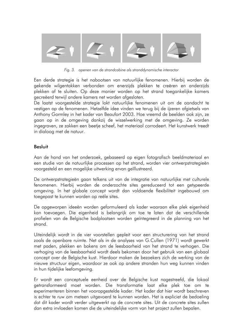
Fig. 3. openen van de strandcabine als stranddynamische interactor
Een derde strategie is het nabootsen van natuurlijke fenomenen. Hierbij worden de gekende wilgentakken verbonden om enerzijds plekken te creëren en anderzijds plekken af te sluiten. Op deze manier worden op het strand toegankelijke kamers gecreëerd terwijl andere kamers net worden afgesloten. De laatst voorgestelde strategie lokt natuurlijke fenomenen uit om de aandacht te vestigen op de fenomenen. Hetzelfde idee vinden we terug bij de ijzeren afgietsels van Anthony Gormley in het kader van Beaufort 2003. Hoe vreemd de beelden ook zijn, ze gaan op in de omgeving dankzij de wisselwerking met de omgeving. Ze worden ingegraven, ze zakken een beetje scheef, het materiaal corrodeert. Het kunstwerk treedt in dialoog met de natuur.
Besluit
Aan de hand van het onderzoek, gebaseerd op eigen fotografisch beeldmateriaal en een studie van de natuurlijke processen op het strand, worden vier ontwerpstrategieën voorgesteld en een mogelijke uitwerking ervan geïllustreerd.
De ontwerpstrategieën gaan telkens uit van de integratie van natuurlijke met culturele fenomenen. Hierbij worden de onderzochte sites gereduceerd tot een getypeerde omgeving. In het globale concept wordt dan voldoende flexibiliteit ingebouwd om toegepast te kunnen worden op reële sites.
De opgeworpen ideeën worden geformuleerd als kader waaraan elke plek eigenheid kan toevoegen. Die eigenheid is belangrijk om toe te laten dat de verschillende profielen van de Belgische badplaatsen worden geïntegreerd in de planning van het strand.
Uiteindelijk wordt in de vier voorstellen gepleit voor een structurering van het strand zoals de openbare ruimte. Net als in de analyses van G.Cullen (1971) wordt gewerkt met paden, plekken en bakens om de leesbaarheid van het strand te verhogen. Die verhoging van de leesbaarheid wordt deels bekomen door het gebruik van een globaal concept over de Belgische kust. Hierdoor maken de bezoekers zich de werking van de nieuwe structuur eigen, waardoor ze ook op andere stranden hun weg kunnen vinden in hun tijdelijke leefomgeving.
Er wordt een conceptuele eenheid over de Belgische kust nagestreefd, die lokaal getransformeerd moet worden. Die transformatie laat elke plek toe om te experimenteren binnen het vooropgestelde kader. Het kader dat hier wordt beschreven is echter te ruw om meteen uitgevoerd te kunnen worden. Het is expliciet de bedoeling dat dit kader wordt verder uitgewerkt op de concrete sites. Uit de concrete sites zullen dan extra invloeden komen die de uiteindelijke vorm van het project zullen bepalen.
- 119 -
Het uiteindelijke doel van de voorgestelde ontwerpstrategieën is een hernieuwde belangstelling voor het natuurlijke aspect van het strand, zowel in het ontwerpproces als in het gebruik van het strand. Op die manier wordt evenwicht nagestreefd tussen natuur en cultuur.
- 120 -
APPLICANTS ANNUAL VLIZ NORTH SEA AWARD 2004
MODELLING THE IMPACT OF THE RIVERS SCHELDT AND RHINE/MEUSE ON THE SALINITY DISTRIBUTION IN BELGIAN WATERS (SOUTHERN NORTH SEA)
Lacroix Geneviève, Kevin Ruddick, José Ozer, Christiane Lancelot
Management Unit of the North Sea Mathematical Models, Royal Belgian Institute for Natural Sciences, Gulledelle 100, B-1200 Brussels, Belgium E-mail: [email protected]
Abstract
In order to manage effectively eutrophication problems in the Belgian Exclusive Economic Zone (EEZ), it is necessary to establish a scientific understanding of cause-effect relationships between changing human activities and ecosystem response. In particular, it is crucial to know the relative contribution of each river (in terms of both magnitude and spatial distribution) on the nutrient stock in order to design and legislate appropriate measures for nutrient reduction in this area. One preliminary approach to such a sustainable development preoccupation consists in answering to the question "where does Belgian water come from?" To answer this question a 3D hydrodynamical model has been set up to describing the distribution and variability of the salinity of Belgian coastal waters. Particular attention was paid to determining the relative impact of the Scheldt and Rhine/Meuse freshwater plumes and testing the hypothesis that the salinity of Belgian waters is primarily a mix between salty offshore water and freshwater from the Scheldt Estuary. Attention was also paid to determining whether the Seine has significant impact on the Belgian zone. The 3D hydrodynamical model has been applied to the Channel and the Southern Bight of the North Sea for the period 1993-2002. Real river runoffs have been taken into account for the main rivers within the domain: the Scheldt, the Rhine/Meuse, the Seine and the Thames. Model tracers were used to characterise the signature of water masses in terms of Atlantic and riverine waters. Results indicate that the salinity of Belgian waters is dominated by inflow of the Channel water mass which mixes with freshwater originating mainly from the Rhine/Meuse with a much smaller contribution from the Scheldt Estuary. Thus, the "generally accepted" hypothesis of a “continental coastal river” with fresher coastal water flowing North-eastward up the French-Belgian-Dutch coast and picking up freshwater from successive outflows seems inappropriate for Belgian waters. This new view of the water masses considers not just the North-eastward residual current, which would advect Rhine water away from the Belgian EEZ, but also the horizontal diffusion of freshwater induced by tidal advection, which acts both north-eastward and south-westward and over a considerable distance.
Introduction
For most coastal regions, there is little transfer of salinity across the air-sea and sea-bottom interfaces and negligible change in salinity from biological or chemical interactions. Salinity is, thus, referred to as a conservative quantity, which is merely transported by advection and diffusion processes and hence provides a good tracer of
- 122 -
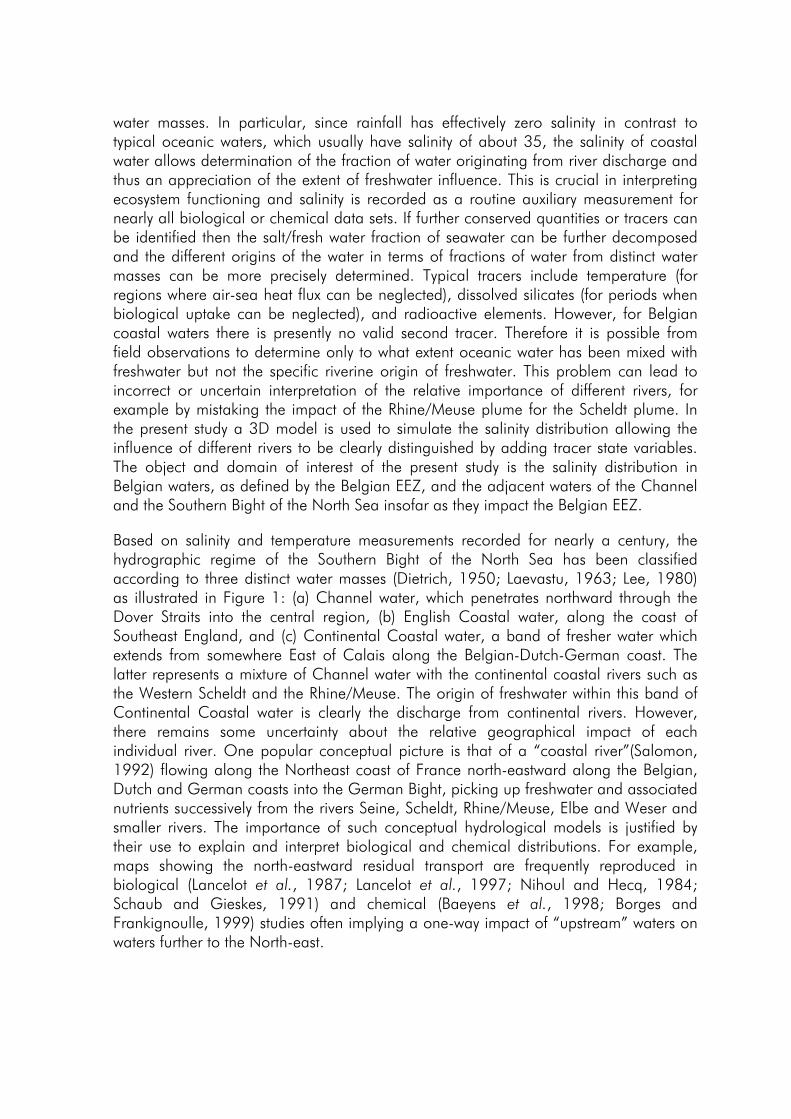
water masses. In particular, since rainfall has effectively zero salinity in contrast to typical oceanic waters, which usually have salinity of about 35, the salinity of coastal water allows determination of the fraction of water originating from river discharge and thus an appreciation of the extent of freshwater influence. This is crucial in interpreting ecosystem functioning and salinity is recorded as a routine auxiliary measurement for nearly all biological or chemical data sets. If further conserved quantities or tracers can be identified then the salt/fresh water fraction of seawater can be further decomposed and the different origins of the water in terms of fractions of water from distinct water masses can be more precisely determined. Typical tracers include temperature (for regions where air-sea heat flux can be neglected), dissolved silicates (for periods when biological uptake can be neglected), and radioactive elements. However, for Belgian coastal waters there is presently no valid second tracer. Therefore it is possible from field observations to determine only to what extent oceanic water has been mixed with freshwater but not the specific riverine origin of freshwater. This problem can lead to incorrect or uncertain interpretation of the relative importance of different rivers, for example by mistaking the impact of the Rhine/Meuse plume for the Scheldt plume. In the present study a 3D model is used to simulate the salinity distribution allowing the influence of different rivers to be clearly distinguished by adding tracer state variables. The object and domain of interest of the present study is the salinity distribution in Belgian waters, as defined by the Belgian EEZ, and the adjacent waters of the Channel and the Southern Bight of the North Sea insofar as they impact the Belgian EEZ.
Based on salinity and temperature measurements recorded for nearly a century, the hydrographic regime of the Southern Bight of the North Sea has been classified according to three distinct water masses (Dietrich, 1950; Laevastu, 1963; Lee, 1980) as illustrated in Figure 1: (a) Channel water, which penetrates northward through the Dover Straits into the central region, (b) English Coastal water, along the coast of Southeast England, and (c) Continental Coastal water, a band of fresher water which extends from somewhere East of Calais along the Belgian-Dutch-German coast. The latter represents a mixture of Channel water with the continental coastal rivers such as the Western Scheldt and the Rhine/Meuse. The origin of freshwater within this band of Continental Coastal water is clearly the discharge from continental rivers. However, there remains some uncertainty about the relative geographical impact of each individual river. One popular conceptual picture is that of a “coastal river”(Salomon, 1992) flowing along the Northeast coast of France north-eastward along the Belgian, Dutch and German coasts into the German Bight, picking up freshwater and associated nutrients successively from the rivers Seine, Scheldt, Rhine/Meuse, Elbe and Weser and smaller rivers. The importance of such conceptual hydrological models is justified by their use to explain and interpret biological and chemical distributions. For example, maps showing the north-eastward residual transport are frequently reproduced in biological (Lancelot et al., 1987; Lancelot et al., 1997; Nihoul and Hecq, 1984; Schaub and Gieskes, 1991) and chemical (Baeyens et al., 1998; Borges and Frankignoulle, 1999) studies often implying a one-way impact of “upstream” waters on waters further to the North-east.
- 123 -
UK
B
F
NL
Scheldt
Rhine-Meuse
Thames
Engl
ish c
oast
al
Cha
nnel
Cont
inent
al coasta
l
Fig. 1. The Southern Bight of the North Sea showing the classification of water types suggested by (Laevastu, 1963) and many subsequent studies (Hill, 1973; Lee, 1980; Otto et al., 1990), demarcated here by the dashed lines. The coastal states of the United Kingdom, France, Belgium and the Netherlands are denoted by capital letters and the main river estuaries are located by arrows. The Belgian EEZ is delimited by the dotted line
Proximity to the Scheldt Estuary mouth has also been cited (Warnock et al., 1999) as a reason for supposing that freshwater influence on coastal waters is dominated by the Scheldt discharge. With one notable exception (Van Bennekom and Wetstijn, 1990), it is generally assumed that the salinity of Belgian waters is influenced primarily by Channel water from the South-west and by the Scheldt “plume” presumably on the basis of the appeal of the “coastal river” conceptual model and on the proximity of the region to the Scheldt discharge. In the present study, this hypothesis is tested directly by numerical model simulations. These simulations allow a clearer distinction between freshwater originating from different rivers than has been possible before by analysis of salinity measurements alone.
Model description
The salinity in the Southern Bight of the North Sea (SNS) and the Channel is modelled here using a 3D hydrodynamic model based on the COHERENS model (Luyten et al., 1999). The model has been set up for the region between 48.5°N and 52.5°N using a 109x97 horizontal grid with resolution 5’ longitude (approx. 5.6 km) by 2.5’ latitude (approx. 4.6 km) and with 5 vertical sigma coordinate layers. A simulation is carried out for the period 1993-2002. All details concerning implementation, forcing, initial and boundary conditions can be found in Lacroix et al.(2004). For the four main rivers, the Rhine/Meuse (two different sources: Maassluis and Haringvlietsluis), the Scheldt, the Seine and the Thames the transport is imposed by temporal interpolation of daily measurements of flow rate for the Rhine/Meuse, Seine and Thames and 10-day measurements of flow rate for the Scheldt. To ensure salt conservation the incoming salinity at the river boundaries is set to zero. In addition to salinity and temperature, further transport equations are solved for 7 passive tracers, corresponding to water initially within the domain and water from the open boundaries as follows: Channel, Central North Sea boundary, and the Scheldt, Rhine/Meuse, Seine and Thames river boundaries. Each tracer is governed by an advection-diffusion equation identical to that for salinity except that for inflow open boundaries the tracer corresponding to that boundary is set to 1.0, while all other tracers are set to zero. Thus, for example, a Channel tracer concentration of 0.5 corresponds to 50% Channel water. Within the domain, and throughout the duration of the simulations, the sum of all tracers present at any point is equal to 1.0 to within the truncation error of the numerical method.
- 124 -
Results
Results are presented for the salinity field averaged over the period 1993-2002 and for corresponding tracers showing the contribution of freshwater from the Scheldt, the Rhine, the Seine and the Thames to this salinity distribution.
Figure 2 shows the modelled surface salinity averaged over the years 1993-2002. The band of lower salinity water along the Belgian and Dutch coasts identified by previous investigators (Lee, 1980) is clearly reproduced here. However, as with previous studies, such information alone does not allow a clear determination of the origin of this freshwater. Conceptually one could hypothesise that this salinity field results from two plumes, one from the Scheldt and one from the Rhine, of comparable extent with a slight overlap of the two plumes somewhere between the two estuary mouths. This hypothesis would imply that the freshwater in the Belgian EEZ originates primarily from the Scheldt Estuary. Similarly on the basis of Figure 2 alone the saltier origin of offshore water might originate from the Channel or the Central North Sea. In situ surface salinity measurements averaged over the period 1993-2002 from the BMDC1 and the RIKZ2 and averaged over the period 06/98-10/99 from MAREL3 are also shown in Figure 2 for comparison with the model results. The observed inshore-offshore salinity gradient and salinity increase going South-west along the coast from the Scheldt Estuary mouth are clearly reproduced by the model. Globally, model results are in good agreement with data except close to the Rhine mouth and further North where predicted salinity is lower than observations. Small differences are not unusual for modelled salinity distributions in coastal waters, where simulations are sensitive to both the parameterisation of mixing processes and to the salinity boundary data which is generally not well-known. In the results shown here, the main discrepancies are restricted to the area close to the northeast boundary (Figure 2). A more detailed time series validation of model results, not shown here, can be found in Lacroix et al. (2004).
Fig. 2. Surface salinity (psu) averaged over the duration of the 1993-2002 simulation for model results (background colouring) together with in situ measurements averaged over the period 1993-2002 (BMDC1 and RIKZ2 data) and over the period 06/98-10/99 (MAREL3 data) superimposed as coloured circles. The Belgian EEZ is delimited by the solid line.
1 Belgian Marine Data Centre, http://www.mumm.ac.be/datacentre/ 2 Rijks Instituut voor Kust en Zee, http://www.waterbase.nl 3 MAREL-NORMANDIE, http://www.ifremer.fr/lern/Pages/Programme/marel.htm
- 125 -
Figure 3 shows the 1993-2002 averaged seasonal variation of the water masses at station 330 of the Belgian water quality monitoring network (51° 26.00' N, 2° 48.50' E, shown on Figure 4) as computed from simulated tracer fractions for water originating from the Channel, the Central North Sea and the Rhine, Scheldt and Seine Estuaries. Clearly Channel water dominates (0.955 in average ±0.024) with negligible contribution (0.002 in average ±0.003) of Central North Sea water. In this simulation the contribution of Thames water fraction, typically of order 10-4 is negligible compared to the Seine fraction (0.008 in average ±0.003) and the Scheldt fraction (0.013 in average ±0.008), and is not shown here. Comparing the river water fractions indicates that the freshwater influence at station 330 is mainly due to the Rhine estuary (0.019 in average ±0.016) with the fraction arising from the Scheldt generally smaller (except during February-March) with a ratio Rhine:Scheldt which varies between about 0.5 and 2.5 (1.5 in average) depending on wind strength and direction. The Rhine, Scheldt and Central water contributions at station 330 vary seasonally and reach a minimum during the winter period when south-westerly winds are stronger. In contrast, the Seine water fraction is relatively constant. Because of the greater distance from the Seine to the Belgian EEZ, horizontal mixing causes lower horizontal gradients of Seine water fraction in the far-field of this plume and consequently less temporal fluctuation from horizontal advection.
Fig. 3. Time series of the daily-averaged tracers for Channel water (solid line), Central North Sea water (dash-dot-dot-dot line), Rhine/Meuse water (dotted line), Scheldt water (dashed line) and Seine water (dash-dot line) presented here as an average over the period 1993-2002 at station 330 of the Belgian water quality monitoring network (51° 26.00' N, 2° 48.50' E, shown on Figure 4).
Figure 4 shows the 1993-2002 average horizontal distributions of the Channel, the Central North Sea, the Rhine, Scheldt, Seine and Thames water fractions. Clearly (Figure 4, upper panel) the Channel water spreads well into the Southern Bight of the North Sea, as found by Jones and Howarth (1995), with only a slight reduction of the Channel water fraction along the Belgian and Dutch coasts because of river water but a more significant reduction at the North boundary of the model domain due to the inflow of Central North Sea water. In this respect it is noted that the impact of Central North Sea water may well be under- or overestimated in this model particularly close to the Northern open sea boundary. However, such model weakness should not affect significantly results obtained for the Belgian EEZ which forms the focus of this study. Figure 4 (lower panel) suggests that the Rhine water spreads a considerable distance southward from the estuary mouth, reaching both the nearshore and the central parts of the Belgian EEZ. On the other hand Scheldt water is limited mainly to the estuary mouth
- 126 -
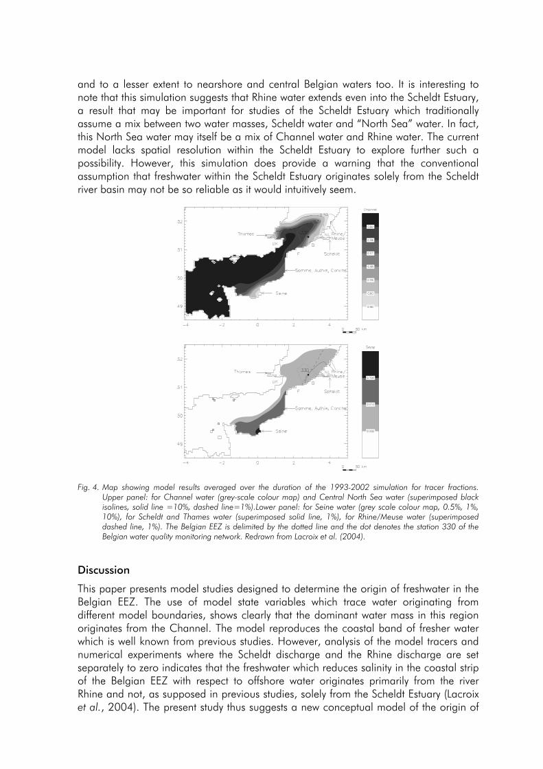
and to a lesser extent to nearshore and central Belgian waters too. It is interesting to note that this simulation suggests that Rhine water extends even into the Scheldt Estuary, a result that may be important for studies of the Scheldt Estuary which traditionally assume a mix between two water masses, Scheldt water and “North Sea” water. In fact, this North Sea water may itself be a mix of Channel water and Rhine water. The current model lacks spatial resolution within the Scheldt Estuary to explore further such a possibility. However, this simulation does provide a warning that the conventional assumption that freshwater within the Scheldt Estuary originates solely from the Scheldt river basin may not be so reliable as it would intuitively seem.
Fig. 4. Map showing model results averaged over the duration of the 1993-2002 simulation for tracer fractions. Upper panel: for Channel water (grey-scale colour map) and Central North Sea water (superimposed black isolines, solid line =10%, dashed line=1%).Lower panel: for Seine water (grey scale colour map, 0.5%, 1%, 10%), for Scheldt and Thames water (superimposed solid line, 1%), for Rhine/Meuse water (superimposed dashed line, 1%). The Belgian EEZ is delimited by the dotted line and the dot denotes the station 330 of the Belgian water quality monitoring network. Redrawn from Lacroix et al. (2004).
Discussion
This paper presents model studies designed to determine the origin of freshwater in the Belgian EEZ. The use of model state variables which trace water originating from different model boundaries, shows clearly that the dominant water mass in this region originates from the Channel. The model reproduces the coastal band of fresher water which is well known from previous studies. However, analysis of the model tracers and numerical experiments where the Scheldt discharge and the Rhine discharge are set separately to zero indicates that the freshwater which reduces salinity in the coastal strip of the Belgian EEZ with respect to offshore water originates primarily from the river Rhine and not, as supposed in previous studies, solely from the Scheldt Estuary (Lacroix et al., 2004). The present study thus suggests a new conceptual model of the origin of
- 127 -
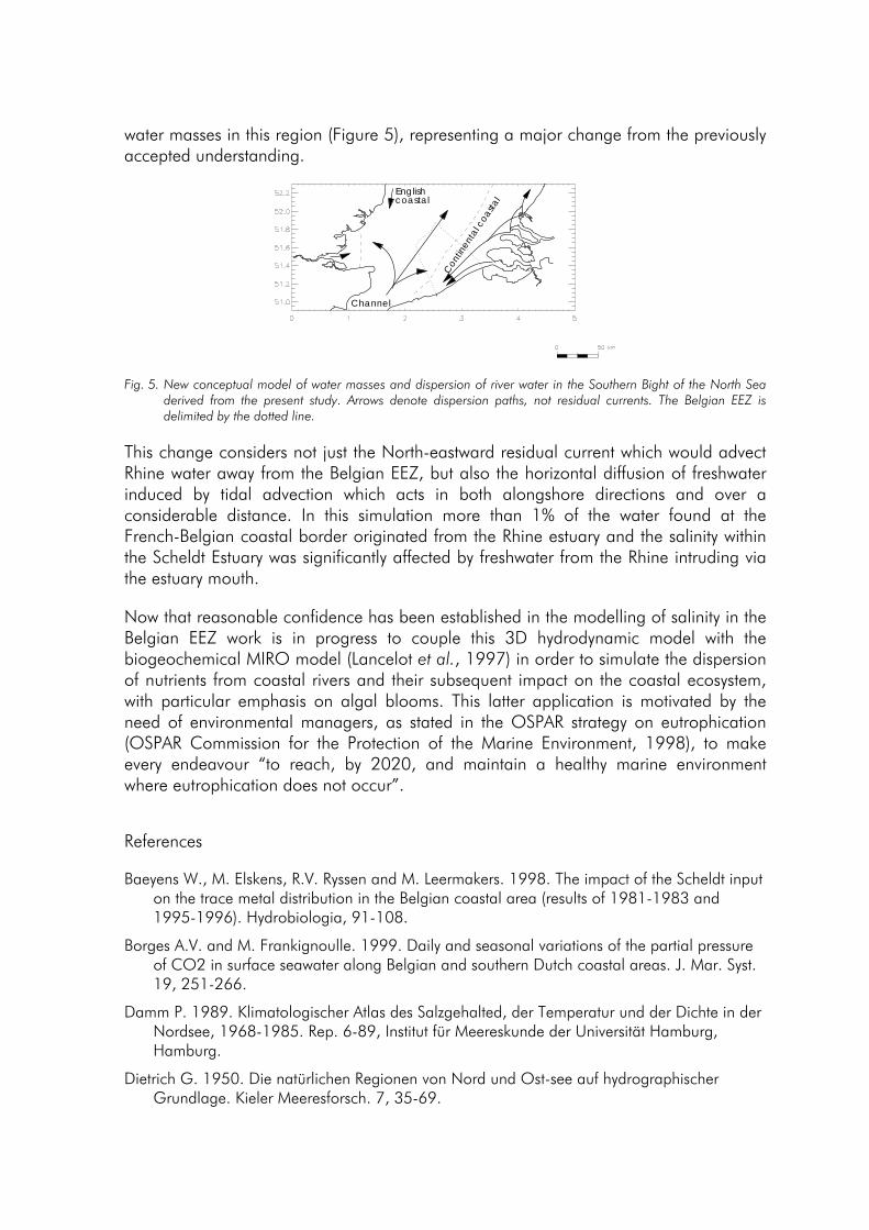
water masses in this region (Figure 5), representing a major change from the previously accepted understanding.
coastal
Channel
Con
tinen
tal c
oast
al
English
Fig. 5. New conceptual model of water masses and dispersion of river water in the Southern Bight of the North Sea derived from the present study. Arrows denote dispersion paths, not residual currents. The Belgian EEZ is delimited by the dotted line.
This change considers not just the North-eastward residual current which would advect Rhine water away from the Belgian EEZ, but also the horizontal diffusion of freshwater induced by tidal advection which acts in both alongshore directions and over a considerable distance. In this simulation more than 1% of the water found at the French-Belgian coastal border originated from the Rhine estuary and the salinity within the Scheldt Estuary was significantly affected by freshwater from the Rhine intruding via the estuary mouth.
Now that reasonable confidence has been established in the modelling of salinity in the Belgian EEZ work is in progress to couple this 3D hydrodynamic model with the biogeochemical MIRO model (Lancelot et al., 1997) in order to simulate the dispersion of nutrients from coastal rivers and their subsequent impact on the coastal ecosystem, with particular emphasis on algal blooms. This latter application is motivated by the need of environmental managers, as stated in the OSPAR strategy on eutrophication (OSPAR Commission for the Protection of the Marine Environment, 1998), to make every endeavour “to reach, by 2020, and maintain a healthy marine environment where eutrophication does not occur”.
References
Baeyens W., M. Elskens, R.V. Ryssen and M. Leermakers. 1998. The impact of the Scheldt input on the trace metal distribution in the Belgian coastal area (results of 1981-1983 and 1995-1996). Hydrobiologia, 91-108.
Borges A.V. and M. Frankignoulle. 1999. Daily and seasonal variations of the partial pressure of CO2 in surface seawater along Belgian and southern Dutch coastal areas. J. Mar. Syst. 19, 251-266.
Damm P. 1989. Klimatologischer Atlas des Salzgehalted, der Temperatur und der Dichte in der Nordsee, 1968-1985. Rep. 6-89, Institut für Meereskunde der Universität Hamburg, Hamburg.
Dietrich G. 1950. Die natürlichen Regionen von Nord und Ost-see auf hydrographischer Grundlage. Kieler Meeresforsch. 7, 35-69.
- 128 -
Hill H.W. 1973. Currents and Water Masses. In: ED Goldberg (Eds.), North Sea Science, Massachusetts Institute of Technology, pp. 17-42.
Jones J.E. and M.J. Howarth. 1995. Salinity models of the southern North Sea. Continental Shelf Research, 15(6), 705-727.
Lacroix G., K. Ruddick, J. Ozer and C. Lancelot. 2004. Modelling the impact of the Scheldt and Rhine/Meuse plumes on the salinity distribution in Belgian waters (southern North Sea). Journal of Sea Research, 52, 149-163.
Laevastu T. 1963. Surface water types of the North Sea and their characteristics. Serial Atlas of the Marine Environment Folio 4. New York: American Geographical Society
Lancelot C., G. Billen, A. Sournia, T. Weisse, F. Colijn, M.J.W. Veldhuis, A. Davies and P. Wassmann. 1987. Phaeocystis blooms and nutrient enrichment in the continental coastal zones of the North Sea. Ambio. 16, 38-46.
Lancelot C., V. Rousseau, G. Billen and D.V. Eeckhout. 1997. Coastal eutrophication of the Southern Bight of the North Sea: Assessment and modelling. In: Ozsoy,E. , Mikaelyan, A. (Eds.), Sensitivity to change: Black Sea, Baltic Sea and North Sea, Kluwer, Netherlands, pp. 437-454.
Lee A.J. 1980. North Sea: Physical Oceanography. In: Banner, F.T., Collins, M.B. and Massie, K.S. (Eds.), The North-West European Shelf Sea: The seabed and the sea in motion II. Physical and Chemical Oceanography, and Physical resources, Elsevier, Amsterdam, pp. 467-493.
Luyten P.J., J.E. Jones, R. Proctor, A. Tabor, P. Tett and K. Wild-Allen. 1999. COHERENS documentation: A coupled hydrodynamical-ecological model for regional and shelf seas: user documentation, MUMM, Brussels.
Nihoul J.C.J. and J.H. Hecq. 1984. Influence of the residual circulation on the physico-chemical characteristics of water masses and the dynamics of ecosystems in the Belgian coastal zone. Continental Shelf Research 3, 167-174.
OSPAR Commission for the Protection of the Marine Environment, 1998. OSPAR strategy to combat eutrophication. Rep. OSPAR reference 1998-18, Available at www.ospar.org
Otto L., J.T.F. Zimmerman, G.K. Furnes, M. Mork, R. Saetre and G. Becker. 1990. Physical Oceanography of the North Sea. Neth. J. Sea Res. 26, 161-238.
Salomon J.C. 1992. The North West European Coastal River. In: Coastal systems studies and sustainable development. Proceedings of the COMAR Interregional Scientific Conference UNESCO, Paris, 21-25 May 1991. UNESCO technical papers in marine science, 64, 213-224.
Schaub B.E.M. and W.W.C. Gieskes. 1991. Eutrophication of the North Sea: the relation between Rhine river discharge and chlorophyll-a concentration in Dutch coastal waters. In: Elliot, M., Ducrotoy, J.-P. (Eds.), Estuaries and Coasts: Temporal and Spatial Intercomparisons. Olsen & Olsen, Fredensborg. pp. 85-90.
Van Bennekom A.J. and F.J. Wetstijn. 1990. The winter distribution of nutrients in the Southern Bight of the North Sea (1961-1978) and in the estuaries of the Scheldt and the Rhine/Meuse. Neth. J. Sea Res. 25, 75-87.
Warnock R.E., W.W.C. Gieskes and S.V. Laar. 1999. Regional and seasonal differences in light absorption by yellow substance in the Southern Bight of the North Sea. Journal of Sea Research 42, 169-178.
- 129 -