Embed Size (px)
Citation preview
Bridge Scour Mitigation and Rehabilitation Project
State Route 65 in Yuba County, California District 3-YUB-65 PM 2.21
EA: 03-0F270 EFIS: 0300000076
Initial Study with Proposed Mitigated Negative Declaration
Prepared by the State of California Department of Transportation
July 2012
General Information About This Document What’s in this document? The California Department of Transportation (Caltrans) has prepared this Initial Study, which examines the potential environmental impacts of the proposed project located in Yuba County, California. The document tells you why the project is being proposed, what alternatives we have considered for the project, how the existing environment could be affected by the project, the potential impacts, and the proposed avoidance, minimization, and/or mitigation measures. What should you do?
Please read this Initial Study. Additional copies of this document are available along with the supporting technical reports and studies at the Caltrans District 3 Office of Environmental Management 703 B Street, Marysville, CA 95901. The Initial Study is also available at the Yuba County Library 303 at 2nd Street, Marysville, CA 95901.
The document is also available at the following website: http://www.dot.ca.gov/dist3/departments/envinternet/envdoc.htm.
We welcome your comments. If you have any comments regarding the proposed project, please send your written comments to Caltrans at the following address:
Sandra Rosas, Senior Environmental Planner Office of Environmental Management California Department of Transportation 703 B Street, Marysville, CA 95901
Or submit comments via email to: [email protected] Submit comments by the deadline: August 30, 2012
What happens next?
After comments are received from the public and the reviewing agencies, Caltrans may 1) give environmental approval of the proposed project, 2) conduct additional environmental studies, or 3) abandon the project. If the project is given environmental approval and funding is appropriated, Caltrans could proceed with design and construct all or part of the project.
For individuals with sensory disabilities, this document is available in Braille, large print, on audiocassette, or computer disk. To obtain a copy in one of these alternate formats, please call or write to Caltrans, Attn: Sandra Rosas at (530) 741-4017, or use the California Relay Service TTY number, 1-800-735-2929
Proposed Mitigated Negative Declaration
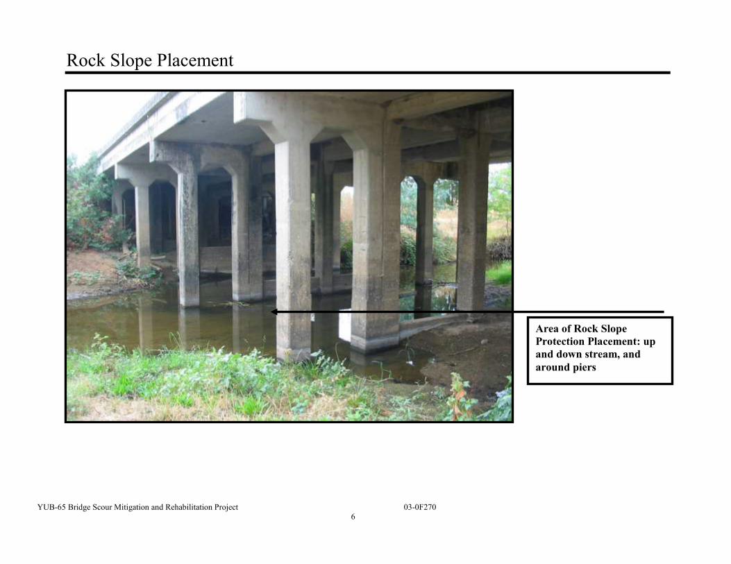
Pursuant to: Division 13, Public Resources Code Project Description The California Department of Transportation (Caltrans) proposes to perform scour mitigation at Dry Creek Bridge (Br. # 16-0002) on State Route (SR) 65 in Yuba County near the city of Wheatland at Post Mile (PM) 2.21. The project proposes to place Rock Slope Protection (RSP) under the structure. In addition, on the roadway, the deck would be replaced with concrete deck overlay.
Determination Caltrans has prepared an Initial Study for this project and, pending public review and comments, expects to determine from this Initial Study that the proposed project would not have a significant effect on the environment for the following reasons:
The proposed project would have minimal or no impact on aesthetics, agricultural
resources, air quality, cultural resources, hazardous materials, geology/soils, land use and planning, mineral resources, noise, population/housing, public services, recreation, transportation, traffic patterns, and utilities.
Potential impacts to protected fish species, Central Valley steelhead (Oncorhynchus
mykiss), Central Valley winter and spring-run chinook salmon (Oncorhynchus
tshawytscha) would be avoided, minimized, and/or mitigated through the implementation of work windows and habitat and/or revegetation replacement.
Potential impacts to protected bat species, Mexican free-tailed (Tadarida brasiliensis), Big Brown bats (Eptesicus fuscus), Myotis bats (Myotis sp), and bird species (cliff swallows (Petrochelidon pyrrhonota) would be avoided or minimized through the implementation of work windows outside the bird’s nesting season and bat exclusionary devices that avoid impacts.
Potential impacts to waters of the U.S. and waters of the State would be offset through
the restoration of the project area to pre-project conditions, implementing construction work windows, and permit conditions.
___________________________ ___________________________ Date of Approval John D. Webb, Chief
North Region Environmental Services California Department of Transportation
YUB-65 Bridge Scour Mitigation and Rehabilitation Project 03-0F270
1
Initial Study
Project Title Bridge Scour Mitigation and Rehabilitation Project Lead Agency Name and Address California Department of Transportation (Caltrans) North Region Office of Environmental Management 703 B Street Marysville 95901 Contact Person Sandra Rosas, Senior Environmental Planner Environmental Management Branch M2 (530) 741-4017
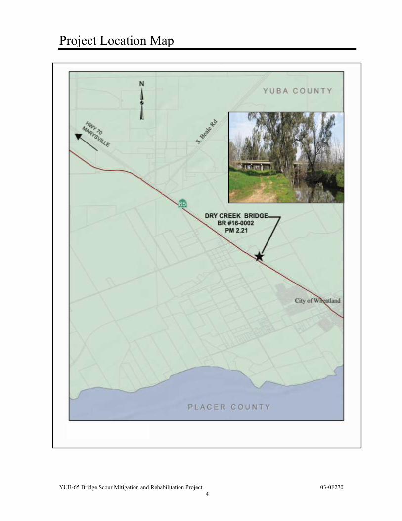
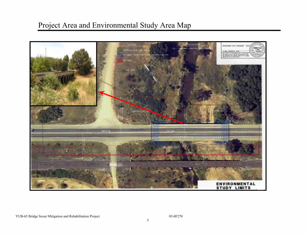
Project Location The proposed project is located in Yuba County on State Route (SR) 65 at Post Mile (PM) 2.21 at the Dry Creek Bridge (Br. # 16-0002) near the City of Wheatland. See the project location map on page 7. Project Sponsor’s Name and Address California Department of Transportation (Caltrans) 703 B Street Marysville, CA 95901 Description of Project This project proposes to perform scour mitigation on Dry Creek Bridge (Br. # 16-0002) on SR 65 in Yuba County near the city of Wheatland at PM 2.21 by placing RSP under the structure. Other proposed work includes constructing new approach slabs, removing existing bridge deck asphalt concrete (AC) surfacing and unsound concrete, placing a ¾-inch polyester concrete deck overlay, and replacing the bridge deck joint seals (see map on page 9). Temporary construction easements (TCE) will be required on two parcels (on the north side and south side of the bridge) and right of entry may be required for access to the railroad right of way.
YUB-65 Bridge Scour Mitigation and Rehabilitation Project 03-0F270
2
Alternative 1 – Perform scour mitigation by placing RSP along the full length and width of the structure. Rehabilitate the bridge deck by removing asphalt concrete surfacing and unsound concrete and placing a ¾-inch polyester concrete overlay. Construct new approach slabs and replace deck joint seals. Alternative 2 – No build. This alternative would not address the scour issues at the structure and could result in more expensive mitigation measures.
Purpose and Need This structure has been identified by the Caltrans Structures Hydraulics Office as scour critical. At column 4, minor loss of concrete cover exists near the base of the column. The project will preserve the integrity of this section of the SR and delay additional maintenance or replacement, which would be at a much greater cost. Surrounding Land Uses and Setting The project is located in Yuba County at the Dry Creek Bridge (Br. #16-0002), which is 204 feet (ft) in length and carries traffic on SR 65 near Wheatland (see map on page 7). The project area is surrounded by agricultural areas including walnut orchards, rice fields, and cattle grazing (see map on page 6).
State Route 65 is on Interregional Road System (IRRS). It is on the Truck Network and designated as a Terminal Access Route for Surface Transportation Assistance Act, STAA Trucks. The structure carries two lanes between the Yuba City/Marysville area and the Roseville/Rocklin area. The concept facility is a two–lane expressway (Wheatland Bypass), and the ultimate facility is a four-lane expressway on a bypass alignment. Permits and Approvals Needed The following permits and/or approvals are required for this project:
Section 404 Nationwide permit from U. S. Army Corps of Engineers (USACE).
Section 401 Water Quality Certification from the Regional Water Quality Control Board (RWQCB).
National Pollutant Discharge Elimination System (NPDES) N0. CAS000002: General Permit for Storm Water Discharges Associated with Construction and Land Disturbance Activities (Order No. 2009-0009-DWQ).
Caltrans Statewide Stormwater Permit: NPDES No. CAS000003 (Order No. 99-06-
DWQ).
YUB-65 Bridge Scour Mitigation and Rehabilitation Project 03-0F270
3
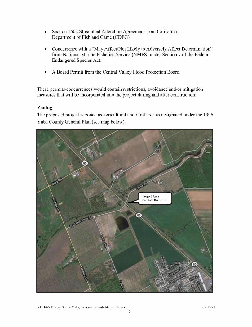
Section 1602 Streambed Alteration Agreement from California Department of Fish and Game (CDFG).
Concurrence with a “May Affect/Not Likely to Adversely Affect Determination”
from National Marine Fisheries Service (NMFS) under Section 7 of the Federal Endangered Species Act.
A Board Permit from the Central Valley Flood Protection Board.
These permits/concurrences would contain restrictions, avoidance and/or mitigation measures that will be incorporated into the project during and after construction. Zoning The proposed project is zoned as agricultural and rural area as designated under the 1996 Yuba County General Plan (see map below).
Project Area on State Route 65
YUB-65 Bridge Scour Mitigation and Rehabilitation Project 03-0F270
4
Project Location Map
YUB-65 Bridge Scour Mitigation and Rehabilitation Project 03-0F270
5
Project Area and Environmental Study Area Map
YUB-65 Bridge Scour Mitigation and Rehabilitation Project 03-0F270
6
Rock Slope Placement
Area of Rock Slope Protection Placement: up and down stream, and around piers
YUB-65 Bridge Scour Mitigation and Rehabilitation Project 03-0F270
7
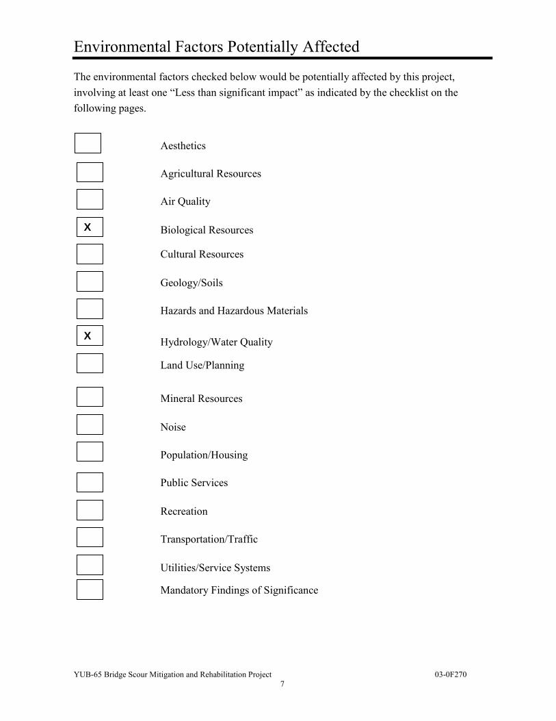
Environmental Factors Potentially Affected
The environmental factors checked below would be potentially affected by this project, involving at least one “Less than significant impact” as indicated by the checklist on the following pages.
Aesthetics
Agricultural Resources
Air Quality
Biological Resources
Cultural Resources
Geology/Soils
Hazards and Hazardous Materials
Hydrology/Water Quality
Land Use/Planning
Mineral Resources
Noise
Population/Housing
Public Services
Recreation
Transportation/Traffic
Utilities/Service Systems
Mandatory Findings of Significance
X
X
YUB-65 Bridge Scour Mitigation and Rehabilitation Project 03-0F270
8
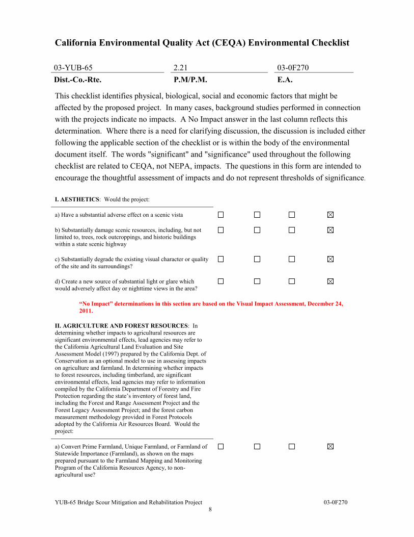
California Environmental Quality Act (CEQA) Environmental Checklist
03-YUB-65 2.21 03-0F270 Dist.-Co.-Rte. P.M/P.M. E.A. This checklist identifies physical, biological, social and economic factors that might be affected by the proposed project. In many cases, background studies performed in connection with the projects indicate no impacts. A No Impact answer in the last column reflects this determination. Where there is a need for clarifying discussion, the discussion is included either following the applicable section of the checklist or is within the body of the environmental document itself. The words "significant" and "significance" used throughout the following checklist are related to CEQA, not NEPA, impacts. The questions in this form are intended to encourage the thoughtful assessment of impacts and do not represent thresholds of significance.
I. AESTHETICS: Would the project:
a) Have a substantial adverse effect on a scenic vista
b) Substantially damage scenic resources, including, but not limited to, trees, rock outcroppings, and historic buildings within a state scenic highway
c) Substantially degrade the existing visual character or quality of the site and its surroundings?
d) Create a new source of substantial light or glare which would adversely affect day or nighttime views in the area?
“No Impact” determinations in this section are based on the Visual Impact Assessment, December 24, 2011.
II. AGRICULTURE AND FOREST RESOURCES: In determining whether impacts to agricultural resources are significant environmental effects, lead agencies may refer to the California Agricultural Land Evaluation and Site Assessment Model (1997) prepared by the California Dept. of Conservation as an optional model to use in assessing impacts on agriculture and farmland. In determining whether impacts to forest resources, including timberland, are significant environmental effects, lead agencies may refer to information compiled by the California Department of Forestry and Fire Protection regarding the state’s inventory of forest land, including the Forest and Range Assessment Project and the Forest Legacy Assessment Project; and the forest carbon measurement methodology provided in Forest Protocols adopted by the California Air Resources Board. Would the project:
a) Convert Prime Farmland, Unique Farmland, or Farmland of Statewide Importance (Farmland), as shown on the maps prepared pursuant to the Farmland Mapping and Monitoring Program of the California Resources Agency, to non-agricultural use?
Potentially significant
impact
Less than significant
impact with mitigation
Less than significant
impact No
impact
YUB-65 Bridge Scour Mitigation and Rehabilitation Project 03-0F270
9
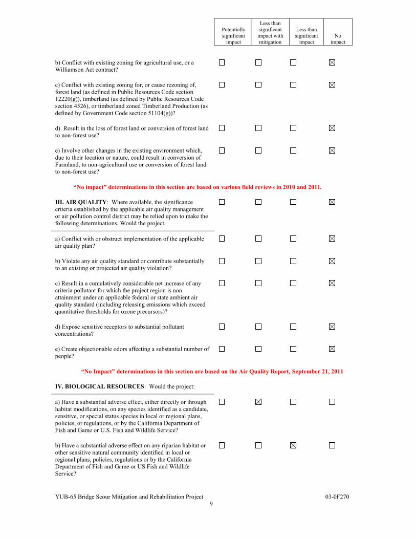
b) Conflict with existing zoning for agricultural use, or a Williamson Act contract?
c) Conflict with existing zoning for, or cause rezoning of, forest land (as defined in Public Resources Code section 12220(g)), timberland (as defined by Public Resources Code section 4526), or timberland zoned Timberland Production (as defined by Government Code section 51104(g))?
d) Result in the loss of forest land or conversion of forest land to non-forest use?
e) Involve other changes in the existing environment which, due to their location or nature, could result in conversion of Farmland, to non-agricultural use or conversion of forest land to non-forest use?
“No impact” determinations in this section are based on various field reviews in 2010 and 2011.
III. AIR QUALITY: Where available, the significance criteria established by the applicable air quality management or air pollution control district may be relied upon to make the following determinations. Would the project:
a) Conflict with or obstruct implementation of the applicable air quality plan?
b) Violate any air quality standard or contribute substantially to an existing or projected air quality violation?
c) Result in a cumulatively considerable net increase of any criteria pollutant for which the project region is non- attainment under an applicable federal or state ambient air quality standard (including releasing emissions which exceed quantitative thresholds for ozone precursors)?
d) Expose sensitive receptors to substantial pollutant concentrations?
e) Create objectionable odors affecting a substantial number of people?
“No Impact” determinations in this section are based on the Air Quality Report, September 21, 2011.
IV. BIOLOGICAL RESOURCES: Would the project:
a) Have a substantial adverse effect, either directly or through habitat modifications, on any species identified as a candidate, sensitive, or special status species in local or regional plans, policies, or regulations, or by the California Department of Fish and Game or U.S. Fish and Wildlife Service?
b) Have a substantial adverse effect on any riparian habitat or other sensitive natural community identified in local or regional plans, policies, regulations or by the California Department of Fish and Game or US Fish and Wildlife Service?
Potentially significant
impact
Less than significant
impact with mitigation
Less than significant
impact No
impact
YUB-65 Bridge Scour Mitigation and Rehabilitation Project 03-0F270
10
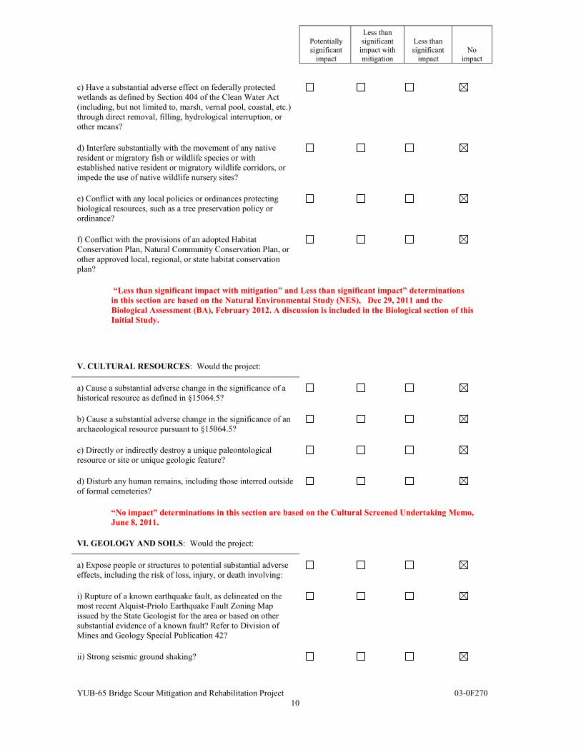
c) Have a substantial adverse effect on federally protected wetlands as defined by Section 404 of the Clean Water Act (including, but not limited to, marsh, vernal pool, coastal, etc.) through direct removal, filling, hydrological interruption, or other means?
d) Interfere substantially with the movement of any native resident or migratory fish or wildlife species or with established native resident or migratory wildlife corridors, or impede the use of native wildlife nursery sites?
e) Conflict with any local policies or ordinances protecting biological resources, such as a tree preservation policy or ordinance?
f) Conflict with the provisions of an adopted Habitat Conservation Plan, Natural Community Conservation Plan, or other approved local, regional, or state habitat conservation plan?
“Less than significant impact with mitigation” and Less than significant impact” determinations in this section are based on the Natural Environmental Study (NES), Dec 29, 2011 and the Biological Assessment (BA), February 2012. A discussion is included in the Biological section of this Initial Study.
V. CULTURAL RESOURCES: Would the project:
a) Cause a substantial adverse change in the significance of a historical resource as defined in §15064.5?
b) Cause a substantial adverse change in the significance of an archaeological resource pursuant to §15064.5?
c) Directly or indirectly destroy a unique paleontological resource or site or unique geologic feature?
d) Disturb any human remains, including those interred outside of formal cemeteries?
“No impact” determinations in this section are based on the Cultural Screened Undertaking Memo, June 8, 2011.
VI. GEOLOGY AND SOILS: Would the project:
a) Expose people or structures to potential substantial adverse effects, including the risk of loss, injury, or death involving:
i) Rupture of a known earthquake fault, as delineated on the most recent Alquist-Priolo Earthquake Fault Zoning Map issued by the State Geologist for the area or based on other substantial evidence of a known fault? Refer to Division of Mines and Geology Special Publication 42?
ii) Strong seismic ground shaking?
Potentially significant
impact
Less than significant
impact with mitigation
Less than significant
impact No
impact
YUB-65 Bridge Scour Mitigation and Rehabilitation Project 03-0F270
11
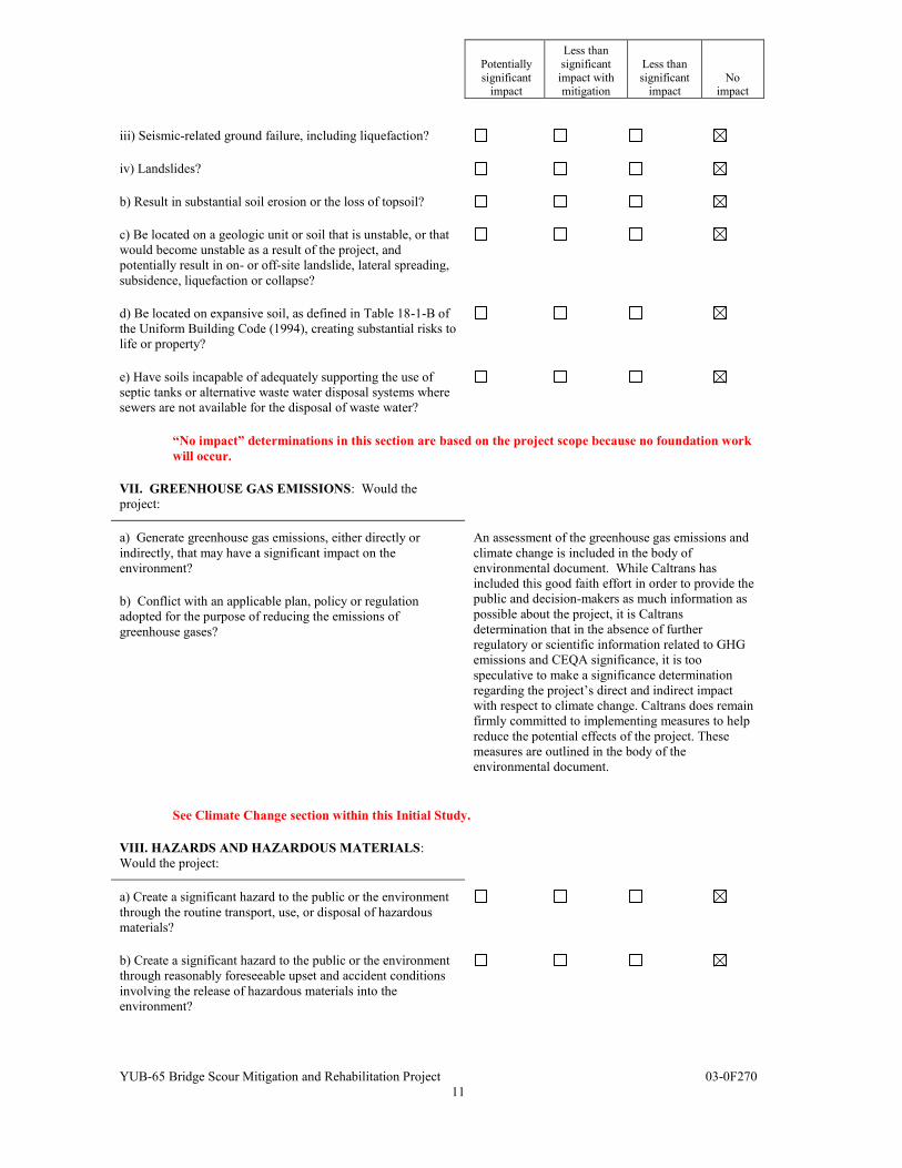
iii) Seismic-related ground failure, including liquefaction?
iv) Landslides?
b) Result in substantial soil erosion or the loss of topsoil?
c) Be located on a geologic unit or soil that is unstable, or that would become unstable as a result of the project, and potentially result in on- or off-site landslide, lateral spreading, subsidence, liquefaction or collapse?
d) Be located on expansive soil, as defined in Table 18-1-B of the Uniform Building Code (1994), creating substantial risks to life or property?
e) Have soils incapable of adequately supporting the use of septic tanks or alternative waste water disposal systems where sewers are not available for the disposal of waste water?
“No impact” determinations in this section are based on the project scope because no foundation work will occur.
VII. GREENHOUSE GAS EMISSIONS: Would the project:
a) Generate greenhouse gas emissions, either directly or indirectly, that may have a significant impact on the environment?
An assessment of the greenhouse gas emissions and climate change is included in the body of environmental document. While Caltrans has included this good faith effort in order to provide the public and decision-makers as much information as possible about the project, it is Caltrans determination that in the absence of further regulatory or scientific information related to GHG emissions and CEQA significance, it is too speculative to make a significance determination regarding the project’s direct and indirect impact with respect to climate change. Caltrans does remain firmly committed to implementing measures to help reduce the potential effects of the project. These measures are outlined in the body of the environmental document.
b) Conflict with an applicable plan, policy or regulation adopted for the purpose of reducing the emissions of greenhouse gases?
See Climate Change section within this Initial Study.
VIII. HAZARDS AND HAZARDOUS MATERIALS: Would the project:
a) Create a significant hazard to the public or the environment through the routine transport, use, or disposal of hazardous materials?
b) Create a significant hazard to the public or the environment through reasonably foreseeable upset and accident conditions involving the release of hazardous materials into the environment?
Potentially significant
impact
Less than significant
impact with mitigation
Less than significant
impact No
impact
YUB-65 Bridge Scour Mitigation and Rehabilitation Project 03-0F270
12
c) Emit hazardous emissions or handle hazardous or acutely hazardous materials, substances, or waste within one-quarter mile of an existing or proposed school?
d) Be located on a site which is included on a list of hazardous materials sites compiled pursuant to Government Code Section 65962.5 and, as a result, would it create a significant hazard to the public or the environment?
e) For a project located within an airport land use plan or, where such a plan has not been adopted, within two miles of a public airport or public use airport, would the project result in a safety hazard for people residing or working in the project area?
f) For a project within the vicinity of a private airstrip, would the project result in a safety hazard for people residing or working in the project area?
g) Impair implementation of or physically interfere with an adopted emergency response plan or emergency evacuation plan?
h) Expose people or structures to a significant risk of loss, injury or death involving wildland fires, including where wildlands are adjacent to urbanized areas or where residences are intermixed with wildlands?
“No impacts” determinations in this section are based on the Hazardous Waste Initial Site Assessment, March 23, 2011.
IX. HYDROLOGY AND WATER QUALITY: Would the project:
a) Violate any water quality standards or waste discharge requirements?
b) Substantially deplete groundwater supplies or interfere substantially with groundwater recharge such that there would be a net deficit in aquifer volume or a lowering of the local groundwater table level (e.g., the production rate of pre-existing nearby wells would drop to a level which would not support existing land uses or planned uses for which permits have been granted)?
c) Substantially alter the existing drainage pattern of the site or area, including through the alteration of the course of a stream or river, in a manner which would result in substantial erosion or siltation on- or off-site?
d) Substantially alter the existing drainage pattern of the site or area, including through the alteration of the course of a stream or river, or substantially increase the rate or amount of surface runoff in a manner which would result in flooding on- or off-site?

Potentially significant
impact
Less than significant
impact with mitigation
Less than significant
impact No
impact
YUB-65 Bridge Scour Mitigation and Rehabilitation Project 03-0F270
13
e) Create or contribute runoff water which would exceed the capacity of existing or planned stormwater drainage systems or provide substantial additional sources of polluted runoff?
f) Otherwise substantially degrade water quality?
g) Place housing within a 100-year flood hazard area as mapped on a federal Flood Hazard Boundary or Flood Insurance Rate Map or other flood hazard delineation map?
h) Place within a 100-year flood hazard area structures which would impede or redirect flood flows?
i) Expose people or structures to a significant risk of loss, injury or death involving flooding, including flooding as a result of the failure of a levee or dam?
j) Inundation by seiche, tsunami, or mudflow
“No impact” determinations in this section are based on the Floodplain Hydraulic Study, January 3, 2012. “Less than significant impact” determines in this sections are based on the Natural Environmental Study (NES), December 2011, and the Water Quality Assessment, October 24, 2011, and a discussion is included under Water Quality.
X. LAND USE AND PLANNING: Would the project:
a) Physically divide an established community?
b)Conflict with any applicable land use plan, policy, or regulation of an agency with jurisdiction over the project (including, but not limited to the general plan, specific plan, local coastal program, or zoning ordinance) adopted for the purpose of avoiding or mitigating an environmental effect?
c) Conflict with any applicable habitat conservation plan or natural community conservation plan?
“No impact” determinations in this section are based on the scope and location of the project.
XI. MINERAL RESOURCES: Would the project:
a) Result in the loss of availability of a known mineral resource that would be of value to the region and the residents of the state?
b) Result in the loss of availability of a locally-important mineral resource recovery site delineated on a local general plan, specific plan or other land use plan?
“No impact” determinations in this section are based on the scope and location of the project.
Potentially significant
impact
Less than significant
impact with mitigation
Less than significant
impact No
impact
YUB-65 Bridge Scour Mitigation and Rehabilitation Project 03-0F270
14
XII. NOISE: Would the project result in:
a) Exposure of persons to or generation of noise levels in excess of standards established in the local general plan or noise ordinance, or applicable standards of other agencies?
b) Exposure of persons to or generation of excessive groundborne vibration or groundborne noise levels?
c) A substantial permanent increase in ambient noise levels in the project vicinity above levels existing without the project?
d) A substantial temporary or periodic increase in ambient noise levels in the project vicinity above levels existing without the project?
e) For a project located within an airport land use plan or, where such a plan has not been adopted, within two miles of a public airport or public use airport, would the project expose people residing or working in the project area to excessive noise levels?
f) For a project within the vicinity of a private airstrip, would the project expose people residing or working in the project area to excessive noise levels?
“No impact” determinations in this section are based on the Noise Analysis Report, September 21, 2011.
XIII. POPULATION AND HOUSING: Would the project:
a) Induce substantial population growth in an area, either directly (for example, by proposing new homes and businesses) or indirectly (for example, through extension of roads or other infrastructure)?
b) Displace substantial numbers of existing housing, necessitating the construction of replacement housing elsewhere?
c) Displace substantial numbers of people, necessitating the construction of replacement housing elsewhere?
“No impact” determinations in this section are based on the scope and location of the project.
Potentially significant
impact
Less than significant
impact with mitigation
Less than significant
impact No
impact
YUB-65 Bridge Scour Mitigation and Rehabilitation Project 03-0F270
15
XIV. PUBLIC SERVICES:
a) Would the project result in substantial adverse physical impacts associated with the provision of new or physically altered governmental facilities, need for new or physically altered governmental facilities, the construction of which could cause significant environmental impacts, in order to maintain acceptable service ratios, response times or other performance objectives for any of the public services:
Fire protection?
Police protection?
Schools?
Parks?
Other public facilities?
“No impact” determinations in this section are based on the scope and location of the project.
XV. RECREATION:
a) Would the project increase the use of existing neighborhood and regional parks or other recreational facilities such that substantial physical deterioration of the facility would occur or be accelerated?
b) Does the project include recreational facilities or require the construction or expansion of recreational facilities which might have an adverse physical effect on the environment?
“No impact” determinations in this section are based on the scope and location of the project.
Potentially significant
impact
Less than significant
impact with mitigation
Less than significant
impact No
impact
YUB-65 Bridge Scour Mitigation and Rehabilitation Project 03-0F270
16
XVI. TRANSPORTATION/TRAFFIC: Would the project:
a) Conflict with an applicable plan, ordinance or policy establishing measures of effectiveness for the performance of the circulation system, taking into account all modes of transportation including mass transit and non-motorized travel and relevant components of the circulation system, including but not limited to intersections, streets, highways and freeways, pedestrian and bicycle paths, and mass transit?
b) Conflict with an applicable congestion management program, including, but not limited to level of service standards and travel demand measures, or other standards established by the county congestion management agency for designated roads or highways?
c) Result in a change in air traffic patterns, including either an increase in traffic levels or a change in location that results in substantial safety risks?
d) Substantially increase hazards due to a design feature (e.g., sharp curves or dangerous intersections) or incompatible uses (e.g., farm equipment)?
e) Result in inadequate emergency access?
f) Conflict with adopted policies, plans or programs regarding public transit, bicycle, or pedestrian facilities, or otherwise decrease the performance or safety of such facilities?
“No impact” determinations in this section are based on the scope and location of the project.
XVII. UTILITIES AND SERVICE SYSTEMS: Would the project:
a) Exceed wastewater treatment requirements of the applicable Regional Water Quality Control Board?
b) Require or result in the construction of new water or wastewater treatment facilities or expansion of existing facilities, the construction of which could cause significant environmental effects?
c) Require or result in the construction of new storm water drainage facilities or expansion of existing facilities, the construction of which could cause significant environmental effects?
d) Have sufficient water supplies available to serve the project from existing entitlements and resources, or are new or expanded entitlements needed?
Potentially significant
impact
Less than significant
impact with mitigation
Less than significant
impact No
impact
YUB-65 Bridge Scour Mitigation and Rehabilitation Project 03-0F270
17
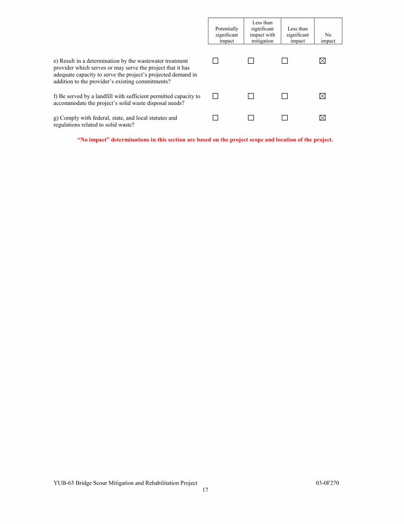
e) Result in a determination by the wastewater treatment provider which serves or may serve the project that it has adequate capacity to serve the project’s projected demand in addition to the provider’s existing commitments?
f) Be served by a landfill with sufficient permitted capacity to accommodate the project’s solid waste disposal needs?
g) Comply with federal, state, and local statutes and regulations related to solid waste?
“No impact” determinations in this section are based on the project scope and location of the project.
Potentially significant
impact
Less than significant
impact with mitigation
Less than significant
impact No
impact
YUB-65 Bridge Scour Mitigation and Rehabilitation Project 03-0F270
18
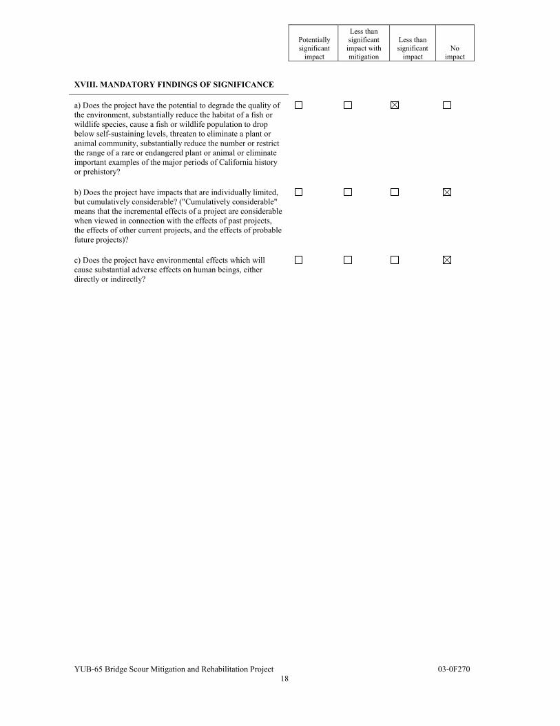
XVIII. MANDATORY FINDINGS OF SIGNIFICANCE
a) Does the project have the potential to degrade the quality of the environment, substantially reduce the habitat of a fish or wildlife species, cause a fish or wildlife population to drop below self-sustaining levels, threaten to eliminate a plant or animal community, substantially reduce the number or restrict the range of a rare or endangered plant or animal or eliminate important examples of the major periods of California history or prehistory?
b) Does the project have impacts that are individually limited, but cumulatively considerable? ("Cumulatively considerable" means that the incremental effects of a project are considerable when viewed in connection with the effects of past projects, the effects of other current projects, and the effects of probable future projects)?
c) Does the project have environmental effects which will cause substantial adverse effects on human beings, either directly or indirectly?
YUB-65 Bridge Scour Mitigation and Rehabilitation Project 03-0F270
19
Affected Environment, Environmental Consequences, and Mitigation Measures
BIOLOGICAL ENVIRONMENT THREATENED AND ENDANGERED SPECIES Regulatory Setting Many state and federal laws regulate impacts to wildlife. The primary federal law protecting threatened and endangered species is the Federal Endangered Species Act (FESA). This Act and subsequent amendments provide for the conservation of endangered and threatened species and the ecosystems upon which they depend. Under Section 7 of this Act, federal agencies, such as the Federal Highway Administration, including Caltrans, are required to consult with the National Marine Fisheries Service (NMFS) to ensure that they are not undertaking, funding, permitting or authorizing actions likely to jeopardize the continued existence of listed species or destroy or adversely modify designated critical habitat. Critical habitat is defined as geographic locations critical to the existence of a threatened or endangered species. For this project, Caltrans has initiated informal consultation with the NMFS as required under Section 7. California has enacted a similar law at the state level, the California Endangered Species Act (CESA), California Fish and Game Code, Section 2050, et seq. CESA emphasizes early consultation to avoid potential impacts to rare, endangered, and threatened species and to develop appropriate planning to offset project- caused losses of listed species populations and their essential habitats. The California Department of Fish and Game (CDFG) is the agency responsible for implementing CESA. Section 2081 of the Fish and Game Code prohibits “take” of any species determined to be an endangered species or a threatened species. “Take” is defined in the Fish and Game Code as “hunt, pursue, catch, capture, or kill, or attempt to hunt, pursue, catch, capture, or kill”. Both regulations will require dual consultation with NMFS and CDFG. If CDFG determines that the conditions specified by NMFS are not consistent with CESA, then Caltrans will be required to obtain an Incidental Take Statement from CDFG under Section 2081(b) and (c) of the CDFG Codes. However, a 2081(b) and (c) Incidental Take Statement is unlikely for this project.
YUB-65 Bridge Scour Mitigation and Rehabilitation Project 03-0F270
20
Affected Environment Steelhead and Central Valley Chinook Salmon The project area is located on Dry Creek, a tributary of the Bear River. Dry Creek is suitable habitat for the Central Valley steelhead (Oncorhynchus mykiss) and the Central Valley spring-run chinook salmon (Oncorhynchus tshawytscha). Bear River is designated critical habitat by NMFS, which further places Dry Creek under consideration as habitat for these fish species.
Dry Creek passes under the bridge and contains a muddy bottom and gravel of various sizes that provides habitat for fish species. Dry Creek has not been designated as critical habitat for protected chinook and steelhead fish species. However, suitable fish habitat exists that provide shade to the creek, which affects the water temperature, and in turn affects the use of the creek by the salmonids.
The project area includes Central Valley steelhead and the Central Valley spring-run chinook salmon, which are listed by NMFS as sensitive fish species. The chinook is listed by the federal and state regulatory agencies as a threatened species. The steelhead is federally listed as a threatened species. Both fish species and Essential Fish Habitat (EFH) for chinook salmon are considered as part of the Section 7 consultation with NMFS.
Green Sturgeon and Delta Smelt The U.S. Fish and Wildlife Service (USFWS) lists the green sturgeon (Acipenser medirostris) as occurring in Yuba County, the delta smelt (Hypomesus transpacificus) as occurring in the County and Wheatland quad, and the winter-run chinook salmon, Sacramento River (Oncorhynchus tshawytscha), as occurring in both the County and the Wheatland quad. For these species, the California Natural Diversity Database (CNDDB) does not list any documented sightings of these fish species in Dry Creek.
YUB-65 Bridge Scour Mitigation and Rehabilitation Project 03-0F270
21
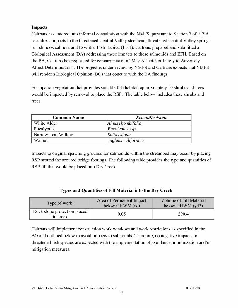
Impacts Caltrans has entered into informal consultation with the NMFS, pursuant to Section 7 of FESA, to address impacts to the threatened Central Valley steelhead, threatened Central Valley spring-run chinook salmon, and Essential Fish Habitat (EFH). Caltrans prepared and submitted a Biological Assessment (BA) addressing these impacts to these salmonids and EFH. Based on the BA, Caltrans has requested for concurrence of a “May Affect/Not Likely to Adversely Affect Determination”. The project is under review by NMFS and Caltrans expects that NMFS will render a Biological Opinion (BO) that concurs with the BA findings. For riparian vegetation that provides suitable fish habitat, approximately 10 shrubs and trees would be impacted by removal to place the RSP. The table below includes these shrubs and trees.
Impacts to original spawning grounds for salmonids within the streambed may occur by placing RSP around the scoured bridge footings. The following table provides the type and quantities of RSP fill that would be placed into Dry Creek.
Types and Quantities of Fill Material into the Dry Creek
Type of work: Area of Permanent Impact below OHWM (ac)
Volume of Fill Material below OHWM (yd3)
Rock slope protection placed in creek 0.05 290.4
Caltrans will implement construction work windows and work restrictions as specified in the BO and outlined below to avoid impacts to salmonids. Therefore, no negative impacts to threatened fish species are expected with the implementation of avoidance, minimization and/or mitigation measures.
Common Name Scientific Name White Alder Alnus rhombifolia
Eucalyptus Eucalyptus ssp.
Narrow Leaf Willow Salix exigua
Walnut Juglans californica
YUB-65 Bridge Scour Mitigation and Rehabilitation Project 03-0F270
22
Avoidance, Minimization, and/or Mitigation Measures
Before any work begins, Environmentally Sensitive Area (ESA) fencing will be installed around sensitive areas to prevent inadvertent construction related impacts. The ESA fencing location will be identified when the permits are prepared.
Construction of a temporary stream crossing/work platform is proposed to keep the stream free from mud and silt while work is performed within the stream channel. Stream flow will be passed through the work site to prevent roiling and allows fish movement. It is proposed to use a series of 18”- 36” diameter metal pipes installed at grade within the stream. The pipes will be long enough to provide a working surface. A plastic sheeting layer will be placed over these pipes before placing a layer of gravel or finer material to complete the work pad. All temporary fill required for stream crossing/work platform will be removed upon completion of in-stream work activities.
Work Windows & Restrictions Work within Dry Creek will be conducted during July 15 - October 15. Silt curtains will be used around in-water work to minimize turbidity and
sedimentation. Erosion control will be applied to disturbed soil areas prior to October 15.
Re-vegetation To avoid loss of suitable fish habitat or potential EFH, mitigation will occur by replanting the same species on-site at a 3:1 ratio. The anticipated species identified for replanting are white alder, eucalyptus, narrow leaf willow, and walnut.
The riparian habitat is marginal due to the sparseness of the existing vegetation, the dominant non-native vegetation, and agriculture use of the area. Consultation with NMFS and CDFG is on-going to determine re-vegetation mitigation methods as the project develops and permits are prepared.
YUB-65 Bridge Scour Mitigation and Rehabilitation Project 03-0F270
23
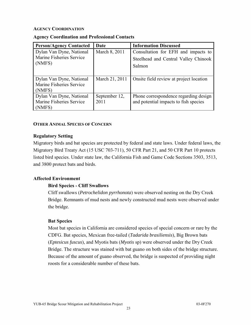
AGENCY COORDINATION Agency Coordination and Professional Contacts
Person/Agency Contacted Date Information Discussed Dylan Van Dyne, National Marine Fisheries Service (NMFS)
March 8, 2011 Consultation for EFH and impacts to Steelhead and Central Valley Chinook Salmon
Dylan Van Dyne, National Marine Fisheries Service (NMFS)
March 21, 2011 Onsite field review at project location
Dylan Van Dyne, National Marine Fisheries Service (NMFS)
September 12, 2011
Phone correspondence regarding design and potential impacts to fish species
OTHER ANIMAL SPECIES OF CONCERN
Regulatory Setting Migratory birds and bat species are protected by federal and state laws. Under federal laws, the Migratory Bird Treaty Act (15 USC 703-711), 50 CFR Part 21, and 50 CFR Part 10 protects listed bird species. Under state law, the California Fish and Game Code Sections 3503, 3513, and 3800 protect bats and birds. Affected Environment
Bird Species - Cliff Swallows Cliff swallows (Petrochelidon pyrrhonota) were observed nesting on the Dry Creek Bridge. Remnants of mud nests and newly constructed mud nests were observed under the bridge. Bat Species Most bat species in California are considered species of special concern or rare by the CDFG. Bat species, Mexican free-tailed (Tadarida brasiliensis), Big Brown bats (Eptesicus fuscus), and Myotis bats (Myotis sp) were observed under the Dry Creek Bridge. The structure was stained with bat guano on both sides of the bridge structure. Because of the amount of guano observed, the bridge is suspected of providing night roosts for a considerable number of these bats.
YUB-65 Bridge Scour Mitigation and Rehabilitation Project 03-0F270
24
Impacts Work on the bridge deck and at the bridge piers may impact bat and bird species. The avoidance and minimization measures described below will reduce impacts to both these species. Avoidance, Minimization, and/or Mitigation Measures Bird Species - Cliff Swallows To avoid or minimize impacts to cliff swallows on the bridge, construction below the bridge deck will be limited by implementing a work window (September 1through February 14) when the birds are not nesting on the bridge. Or, to eliminate the work window restriction, old mud nests, after the nesting season (February 15 through August 31) must be removed. And, throughout the construction of the project, the contractor must continue to maintain absence of the nests to prevent birds from returning to the nest that are located under the bridge deck, thus avoiding impacts these bird species. Work on or above the bridge deck on the roadway can occur anytime without work window restrictions. Bats Species To avoid impacts to bats, exclusionary devices will be installed so the bats cannot use the bridge and will relocate. These devices should be installed during September 1 through February 28 (when they are not utilizing the bridge). After the exclusionary devices have been installed, Caltrans and the contractor must wait seven days before work can commence. By waiting the seven days, the bats can exit the bridge and relocate. Once these devices have been installed, they must be maintained by the contractor and kept in good working order. Work on the bridge deck can occur anytime without work window restrictions. NATURAL COMMUNITIES WETLANDS AND OTHER WATERS
Regulatory Setting Wetlands and other waters are protected under a number of laws and regulations. At the federal level, the Clean Water Act (CWA), (33 U.S.C 1344), is the primary law regulating wetlands and waters. The CWA regulates the discharge of dredged or fill material into waters of the United States, including wetlands. Waters of the U.S. include navigable waters, interstate waters, territorial seas, and other waters that may be used in interstate or foreign commerce.
YUB-65 Bridge Scour Mitigation and Rehabilitation Project 03-0F270
25
Section 404 of the CWA establishes a regulatory program, which provides that no discharge of dredged or fill material be permitted if a practicable alternative exists that is less damaging to the aquatic environment or if the nation’s waters would be significantly degraded. The Section 404 permit program is run by the U. S. Army Corps of Engineers (USACE) with oversight by the Environmental Protection Agency (EPA). Under Section 404 of the CWA, waters of the U.S. include the following: territorial seas, coastal and inland waters, lakes, rivers and streams that are navigable and their adjacent wetlands, tributaries to navigable waters and their adjacent wetlands, interstate waters and their tributaries including adjacent wetlands, and all other waters of the U. S. (intermittent streams and prairie potholes). As determined, this project will require a Section 404 permit (Nationwide) for work in the waters of the U.S. and other waters. At the state level, wetlands and waters are regulated primarily by the CDFG and the Regional Water Quality Control Board (RWQCB). Under Sections 1600-1607 of the California Fish and Game Code, the CDFG requires any agency that proposes a project, which will substantially divert or obstruct the natural flow of or substantially change the bed or bank of a river, stream, or lake to notify them before construction. During the permitting phase of the project, if the CDFG determines that the project substantially and adversely affects fish or wildlife resources, a Section 1602, Streambed Alteration Agreement will be required. The CDFG jurisdictional limits are usually defined by the tops of the stream or lake banks, or the outer edge of riparian vegetation, whichever is wider. As anticipated, this project will require this Agreement from CDFG due to RSP placement in the streambed. The RWQCBs were established by the Porter-Cologne Water Quality Control Act to oversee water quality protection. The RWQCB also issues water quality certifications in compliance with Section 401 of the CWA. The RWQCB also has jurisdiction over waters of the State which include any surface water or groundwater, including saline waters, within the boundaries of the state. As determined, this project will require a Section 401 water quality certification. Affected Environment Wetlands and other waters surveys were conducted in the environmental study limits (see map on page 8). At Dry Creek, no wetlands were observed; however, waters of the U. S. and waters of the state were located in the project area.
YUB-65 Bridge Scour Mitigation and Rehabilitation Project 03-0F270
26
Impacts Caltrans will continue to consult with the USACE for methods to avoid potential impacts to waters of the U.S., pursuant to Section 404 of the CWA. For waters of the state, pursuant to Section 401 of the CWA, consultation with the RWQCB continues to reduce potential impacts. A Section 404 permit and Section 401 certification will include conditions to reduce, minimize, and avoid impacts for state and U.S. waters. For impacts to Dry Creek streambed, a Section 1602 Streambed Alteration Agreement will be required by the CDFG for the work within creek. Two hundred ninety cubic yards of fill material below the original high water mark (OHWM) will be placed in the streambed, impacting 0.05 acres in the streambed (see table below).
Types and Quantities of Fill Material into the Dry Creek
Type of work: Area of Permanent Impact below Original High Water
Mark (acre)
Volume of Fill Material below Original High Water
Mark (yard3) Rock Slope Protection placed
in creek 0.05 290.4
The following measures will be implemented to reduce impacts to waters. Avoidance, Minimization, and/or Mitigation Measures
Waters of the U.S, Waters of the State, & Streambed Impacts to waters of the U. S. and waters of the State would be minimized and offset through restoration at the project area to pre-project conditions. Areas disturbed for access to the project area and construction would be stabilized and re-vegetated at the completion of construction in order to minimize erosion and restore functions and habitat value. Activities conducted in the active channel of the creek will be limited to occur between July 15 and October 15. The creek flow would be temporarily diverted around the work area during construction and returned to the stream below the work site. Any temporary artificial obstruction within the creek would be built from materials with no potential to increase siltation within the stream. Silt curtains will be used around in-water work areas to minimize turbidity and sedimentation. Construction temporary and/or Best Management Practices (BMPs) will also be used to reduce impacts.
YUB-65 Bridge Scour Mitigation and Rehabilitation Project 03-0F270
27
WATER QUALITY AND STORM WATER Regulatory Setting
Caltrans has a Statewide National Pollutant Discharge Elimination System (NPDES) Permit (permit) issued by the State Water Resources Control Board. This permit regulates the storm water and non-storm water discharges associated with construction activity.
During construction, compliance with the permit requires selection and deployment of the appropriate Caltrans Best Management Practices (BMPs) to achieve the performance standards of Best Available Technology Economically Achievable/Best Conventional Pollutant Technology (BAT/BCT) to reduce or eliminate storm water pollution.
Affected Environment
The project is located on Dry Creek, which is a tributary to the Bear River (tributary to the Feather River) and located within the Marysville Hydrologic Unit, Lower Bear River Hydrologic Area.
There are no “Drinking Water Reservoirs and Recharge Facilities” where spills from the
Caltrans’ owned right- of -way, activities, or facilities could discharge directly to municipal or domestic water supply reservoirs or ground water percolation facilities.
Hydrologic Information
1. Office of Water Programs, California State University Sacramento, http://www.stormwater.water-programs.com140/wqpt.htm.
2. Section 2.4.2.2, Project Planning and Design Guide, May 2007. Impacts
No permanent water quality impacts are expected from the project. Potential temporary water quality impacts will be avoided and minimized through the following measures.
County Route Post Mile
Regional Water Quality Control Board
Hydrologic Sub-Area Number
Hydrologic Sub-Area Name
Elevation in (Feet)
Average1 An Annual
Rainfall (Inches)
Ra Rainfall2 Intensity (Inches)
YYuba Yuba 65 2.21 Central Valley 515.10 Unidentified ~75 21.6 0.16
YUB-65 Bridge Scour Mitigation and Rehabilitation Project 03-0F270
28
Avoidance and Minimization Measures
Construction site BMPs will be selected to protect water bodies within or near the project limits from potential water pollution runoff that could result from construction activities. The contractor will implement Caltrans Temporary Construction Site BMPs that will be identified in the Water Pollution Control Program (WPCP) for this project as well as the BMPs included in the project Contract.
YUB-65 Bridge Scour Mitigation and Rehabilitation Project 03-0F270
29
CLIMATE CHANGE Climate change refers to long-term changes in temperature, precipitation, wind patterns, and other elements of the earth's climate system. An ever-increasing body of scientific research attributes these climatological changes to greenhouse gases (GHGs), particularly those generated from the production and use of fossil fuels. While climate change has been a concern for several decades, the establishment of the Intergovernmental Panel on Climate Change (IPCC) by the United Nations and World Meteorological Organization’s in 1988, has led to increased efforts devoted to greenhouse gas (GHG) emissions reduction and climate change research and policy. These efforts are primarily concerned with the emissions of GHGs related to human activity that include carbon dioxide (CO2), methane, nitrous oxide, tetrafluoromethane, hexafluoroethane, sulfur hexafluoride, HFC-23 (fluoroform), HFC-134a (s, s, s, 2 –tetrafluoroethane), and HFC-152a (difluoroethane).
There are typically two terms used when discussing the impacts of climate change. "Greenhouse Gas (GHG) Mitigation" is a term for reducing GHG emissions in order to reduce or "mitigate" the impacts of climate change. “Adaptation," refers to the effort of planning for and adapting to impacts due to climate change (such as adjusting transportation design standards to withstand more intense storms and higher sea levels)1.
Transportation sources (passenger cars, light duty trucks, other trucks, buses and motorcycles) in the state of California make up the largest source (second to electricity generation) of greenhouse gas emitting sources. Conversely, the main source of GHG emissions in the United States (U.S.) is electricity generation followed by transportation. The dominant GHG emitted is CO2, mostly from fossil fuel combustion.
There are four primary strategies for reducing GHG emissions from transportation sources: 1) improve system and operation efficiencies, 2) reduce growth of vehicle miles traveled (VMT) 3) transition to lower GHG fuels and 4) improve vehicle technologies. To be most effective all four should be pursued collectively. The following regulatory setting section outlines state and federal efforts to comprehensively reduce GHG emissions from transportation sources.
1 http://climatechange.transportation.org/ghg_mitigation/
YUB-65 Bridge Scour Mitigation and Rehabilitation Project 03-0F270
30
Regulatory Setting
State With the passage of several pieces of legislation including State Senate and Assembly Bills and Executive Orders, California launched an innovative and pro-active approach to dealing with greenhouse gas emissions and climate change at the state level. Assembly Bill 1493 (AB 1493), Pavley. Vehicular Emissions: Greenhouse Gases (AB 1493), 2002: requires the California Air Resources Board (ARB) to develop and implement regulations to reduce automobile and light truck greenhouse gas emissions. These stricter emissions standards were designed to apply to automobiles and light trucks beginning with the 2009-model year. In June 2009, the U.S. Environmental Protection Agency (U.S. EPA) Administrator granted a Clean Air Act waiver of preemption to California. This waiver allowed California to implement its own GHG emission standards for motor vehicles beginning with model year 2009. California agencies will be working with Federal agencies to conduct joint rulemaking to reduce GHG emissions for passenger cars model years 2017-2025. Executive Order S-3-05: (signed on June 1, 2005, by Governor Arnold Schwarzenegger) the goal of this Executive Order is to reduce California’s GHG emissions to: 1) 2000 levels by 2010, 2) 1990 levels by 2020, and 3) 80 percent below the 1990 levels by the year 2050. In 2006, this goal was further reinforced with the passage of Assembly Bill 32. AB32 (AB 32), the Global Warming Solutions Act of 2006: AB 32 sets the same overall GHG emissions reduction goals as outlined in Executive Order S-3-05, while further mandating that CARB create a plan, which includes market mechanisms, and implement rules to achieve “real, quantifiable, cost-effective reductions of greenhouse gases.” Executive Order S-20-06 further directs state agencies to begin implementing AB 32, including the recommendations made by the State’s Climate Action Team. Executive Order S-01-07: Governor Schwarzenegger set forth the low carbon fuel standard for California. Under this Executive Order, the carbon intensity of California’s transportation fuels is to be reduced by at least ten percent by 2020. Senate Bill 97 (Chapter 185, 2007): required the Governor's Office of Planning and Research (OPR) to develop recommended amendments to the State CEQA Guidelines for addressing greenhouse gas emissions. The Amendments became effective on March 18, 2010.
YUB-65 Bridge Scour Mitigation and Rehabilitation Project 03-0F270
31
Federal Although climate change and GHG reduction is a concern at the federal level; currently there are, no regulations or legislation that have been enacted specifically addressing GHG emissions reductions and climate change at the project level. Neither the United States Environmental Protection Agency (U.S. EPA) nor Federal Highway Administration (FHWA) has promulgated explicit guidance or methodology to conduct project-level greenhouse gas analysis. As stated on FHWA’s climate change website (http://www.fhwa.dot.gov/hep/climate/index.htm), climate change considerations should be integrated throughout the transportation decision-making process–from planning through project development and delivery. Addressing climate change mitigation and adaptation up front in the planning process will facilitate decision-making and improve efficiency at the program level, and will inform the analysis and stewardship needs of project level decision-making. Climate change considerations can easily be integrated into many planning factors, such as supporting economic vitality and global efficiency, increasing safety and mobility, enhancing the environment, promoting energy conservation, and improving the quality of life. The four strategies set forth by FHWA to lessen climate change impacts do correlate with efforts that the State has undertaken and is undertaking to deal with transportation and climate change; the strategies include improved transportation system efficiency, cleaner fuels, cleaner vehicles, and reduction in the growth of vehicle hours travelled. Climate change and its associated effects are also being addressed through various efforts at the federal level to improve fuel economy and energy efficiency, such as the “National Clean Car Program” and Executive Order 13514- Federal Leadership in Environmental, Energy and Economic
Performance.
Executive Order 13514 is focused on reducing greenhouse gases internally in federal agency missions, programs and operations, but also direct federal agencies to participate in the interagency Climate Change Adaptation Task Force, which is engaged in developing a U.S. strategy for adaptation to climate change. On April 2, 2007, in Massachusetts v. EPA, 549 U.S. 497 (2007), the Supreme Court found that greenhouse gases are air pollutants covered by the Clean Air Act and that the U.S. EPA has the authority to regulate GHG. The Court held that the U.S. EPA Administrator must determine whether or not emissions of greenhouse gases from new motor vehicles cause or contribute to air pollution which may reasonably be anticipated to endanger public health or welfare, or whether the science is too uncertain to make a reasoned decision.
YUB-65 Bridge Scour Mitigation and Rehabilitation Project 03-0F270
32
On December 7, 2009, the U.S. EPA Administrator signed two distinct findings regarding greenhouse gases under section 202(a) of the Clean Air Act: Endangerment Finding: The Administrator found that the current and projected
concentrations of the six key well-mixed greenhouse gases--carbon dioxide (CO2), methane (CH4), nitrous oxide (N2O), hydrofluorocarbons (HFCs), perfluorocarbons (PFCs), and sulfur hexafluoride (SF6)--in the atmosphere threaten the public health and welfare of current and future generations.
Cause or Contribute Finding: The Administrator found that the combined emissions of these well-mixed greenhouse gases from new motor vehicles and new motor vehicle engines contribute to the greenhouse gas pollution which threatens public health and welfare.
Although these findings did not themselves impose any requirements on industry or other entities, this action was a prerequisite to finalizing the U.S. EPA’s Proposed Greenhouse Gas
Emission Standards for Light-Duty Vehicles, which was published on September 15, 20092. On May 7, 2010 the final Light-Duty Vehicle Greenhouse Gas Emissions Standards and Corporate
Average Fuel Economy Standards was published in the Federal Register. U.S. EPA and the National Highway Traffic Safety Administration (NHTSA) are taking coordinated steps to enable the production of a new generation of clean vehicles with reduced GHG emissions and improved fuel efficiency from on-road vehicles and engines. These next steps include developing the first-ever GHG regulations for heavy-duty engines and vehicles, as well as additional light-duty vehicle GHG regulations. These steps were outlined by President Obama in a memorandum on May 21, 2010.3 The final combined U.S. EPA and NHTSA standards that make up the first phase of this national program apply to passenger cars, light-duty trucks, and medium-duty passenger vehicles, covering model years 2012 through 2016. The standards require these vehicles to meet an estimated combined average emissions level of 250 grams of carbon dioxide per mile, equivalent to 35.5 miles per gallon (MPG) if the automobile industry were to meet this carbon dioxide level solely through fuel economy improvements. Together, these standards will cut GHG emissions by an estimated 960 million metric tons and 1.8 billion barrels of oil over the lifetime of the vehicles sold under the program (model years 2012-2016). On January 24, 2011, the U.S. EPA along with the U.S. Department of Transportation and the State of California announced a single timeframe for proposing fuel economy and greenhouse
2 http://www.epa.gov/climatechange/endangerment.html
3 http://epa.gov/otaq/climate/regulations.htm
YUB-65 Bridge Scour Mitigation and Rehabilitation Project 03-0F270
33
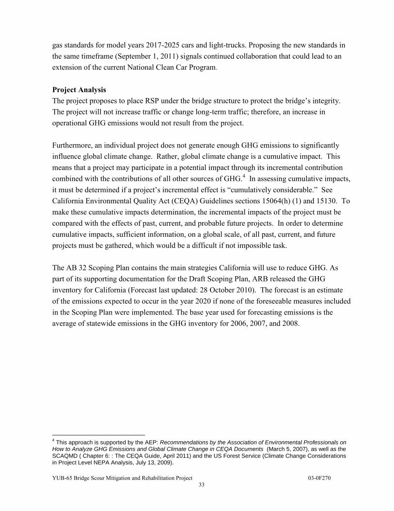
gas standards for model years 2017-2025 cars and light-trucks. Proposing the new standards in the same timeframe (September 1, 2011) signals continued collaboration that could lead to an extension of the current National Clean Car Program. Project Analysis The project proposes to place RSP under the bridge structure to protect the bridge’s integrity. The project will not increase traffic or change long-term traffic; therefore, an increase in operational GHG emissions would not result from the project. Furthermore, an individual project does not generate enough GHG emissions to significantly influence global climate change. Rather, global climate change is a cumulative impact. This means that a project may participate in a potential impact through its incremental contribution combined with the contributions of all other sources of GHG.4 In assessing cumulative impacts, it must be determined if a project’s incremental effect is “cumulatively considerable.” See California Environmental Quality Act (CEQA) Guidelines sections 15064(h) (1) and 15130. To make these cumulative impacts determination, the incremental impacts of the project must be compared with the effects of past, current, and probable future projects. In order to determine cumulative impacts, sufficient information, on a global scale, of all past, current, and future projects must be gathered, which would be a difficult if not impossible task. The AB 32 Scoping Plan contains the main strategies California will use to reduce GHG. As part of its supporting documentation for the Draft Scoping Plan, ARB released the GHG inventory for California (Forecast last updated: 28 October 2010). The forecast is an estimate of the emissions expected to occur in the year 2020 if none of the foreseeable measures included in the Scoping Plan were implemented. The base year used for forecasting emissions is the average of statewide emissions in the GHG inventory for 2006, 2007, and 2008.
4 This approach is supported by the AEP: Recommendations by the Association of Environmental Professionals on
How to Analyze GHG Emissions and Global Climate Change in CEQA Documents (March 5, 2007), as well as the
SCAQMD ( Chapter 6: : The CEQA Guide, April 2011) and the US Forest Service (Climate Change Considerations in Project Level NEPA Analysis, July 13, 2009).
YUB-65 Bridge Scour Mitigation and Rehabilitation Project 03-0F270
34
CALIFORNIA GREENHOUSE GAS FORECAST
Source: http://www.arb.ca.gov/cc/inventory/data/forecast.htm
Caltrans and its parent agency, the Business, Transportation, and Housing Agency, have taken an active role in addressing GHG emission reduction and climate change. Recognizing that 98 percent of California’s GHG emissions are from the burning of fossil fuels and 40 percent of all human made GHG emissions are from transportation, Caltrans has created and is implementing the Climate Action Program at Caltrans that was published in December 2006 (see Climate Action Program at Caltrans (December 2006).5 Construction Emissions Greenhouse gas emissions for transportation projects can be divided into those produced during construction and those produced during operations. Construction GHG emissions include emissions produced as a result of material processing, emissions produced by onsite construction equipment, and emissions arising from traffic delays due to construction. These emissions will be produced at different levels throughout the construction phase; their frequency and occurrence can be reduced through innovations in plans and specifications and by implementing better traffic management during construction phases.
5 Caltrans Climate Action Program is located at the following web address:
http://www.dot.ca.gov/hq/tpp/offices/ogm/key_reports_files/State_Wide_Strategy/Caltrans_Climate_Action_Program.pdf
YUB-65 Bridge Scour Mitigation and Rehabilitation Project 03-0F270
35
In addition, with innovations such as longer pavement lives, improved traffic management plans, and changes in materials, the GHG emissions produced during construction can be mitigated to some degree by longer intervals between maintenance and rehabilitation events. For this project, GHG emissions during construction would be unavoidable but temporary. Thus, construction related impacts on GHG emission would not be considered long-term. Caltrans Best Management Practices would be implemented to reduce GHG emissions during construction to include limiting one-way traffic wait time to no more than 10 minutes (thereby reducing idle time). CEQA Conclusion While construction would result in a slight increase in greenhouse gas emissions during construction, Caltrans expects that there would be no operational increase in GHG emissions associated with this proposed project. However, it is Caltrans’ determination that in the absence of further regulatory or scientific information related to greenhouse gas emissions and California Environmental Quality Act significance, it is too speculative to make a determination on the project’s direct impact and its contribution on the cumulative scale to climate change. Nonetheless, Caltrans is taking further measures to help reduce energy consumption and greenhouse gas emissions. These measures are outlined in the following section. Greenhouse Gas Reduction Strategies AB 32 Compliance Caltrans continues to be actively involved on the Governor’s Climate Action Team as ARB works to implement the Executive Orders S-3-05 and S-01-07 and help achieve the targets set
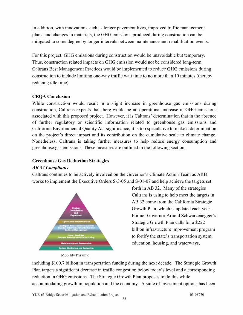
forth in AB 32. Many of the strategies Caltrans is using to help meet the targets in AB 32 come from the California Strategic Growth Plan, which is updated each year. Former Governor Arnold Schwarzenegger’s Strategic Growth Plan calls for a $222 billion infrastructure improvement program to fortify the state’s transportation system, education, housing, and waterways,
including $100.7 billion in transportation funding during the next decade. The Strategic Growth Plan targets a significant decrease in traffic congestion below today’s level and a corresponding reduction in GHG emissions. The Strategic Growth Plan proposes to do this while accommodating growth in population and the economy. A suite of investment options has been
Mobility Pyramid
YUB-65 Bridge Scour Mitigation and Rehabilitation Project 03-0F270
36
created that combined together are expected to reduce congestion. The Strategic Growth Plan relies on a complete systems approach to attain CO2 reduction goals: system monitoring and evaluation, maintenance and preservation, smart land use and demand management, and operational improvements as depicted in the Mobility Pyramid above. The Caltrans is supporting efforts to reduce vehicle miles traveled by planning and implementing smart land use strategies: job/housing proximity, developing transit-oriented communities, and high density housing along transit corridors. Caltrans is working closely with local jurisdictions on planning activities; however, Caltrans does not have local land use planning authority. The Department is also supporting efforts to improve the energy efficiency of the transportation sector by increasing vehicle fuel economy in new cars, light and heavy-duty trucks; Caltrans is doing this by supporting on-going research efforts at universities, by supporting legislative efforts to increase fuel economy, and by its participation on the Climate Action Team. It is important to note, however, that the control of the fuel economy standards is held by U.S. EPA and ARB. Lastly, the use of alternative fuels is also being considered; Caltrans is participating in funding for alternative fuel research at the UC Davis. The following Climate Change table summarizes Caltrans and statewide efforts that Caltrans is implementing in order to reduce GHG emissions. More detailed information about each strategy is included in the Climate Action Program at Caltrans (December 2006).
YUB-65 Bridge Scour Mitigation and Rehabilitation Project 03-0F270
37
Climate Change/CO2 Reduction Strategies
Strategy Program Partnership
Method/Process Estimated CO2 Savings (MMT)
Lead Agency 2010 2020
Smart Land Use
Intergovernmental Review (IGR) Caltrans Local
Governments
Review and seek to mitigate development proposals
Not Estimated
Not Estimated
Planning Grants Caltrans
Local and regional agencies & other stakeholders
Competitive selection process
Not Estimated
Not Estimated
Regional Plans and Blueprint Planning
Regional Agencies Caltrans Regional plans and
application process .975 7.8
Operational Improvements & Intelligent Trans. System (ITS) Deployment
Strategic Growth Plan Caltrans Regions State ITS; Congestion
Management Plan .07 2.17
Mainstream Energy & GHG into Plans and Projects
Office of Policy Analysis & Research; Division of Environmental Analysis
Interdepartmental effort Policy establishment, guidelines, technical assistance
Not Estimated
Not Estimated
Educational & Information Program
Office of Policy Analysis & Research
Interdepartmental, CalEPA, CARB, CEC
Analytical report, data collection, publication, workshops, outreach
Not Estimated
Not Estimated
Fleet Greening & Fuel Diversification
Division of Equipment
Department of General Services
Fleet Replacement B20 B100
.0045 .0065 .045 .0225
Non-vehicular Conservation Measures
Energy Conservation Program
Green Action Team Energy Conservation Opportunities .117 .34
Portland Cement
Office of Rigid Pavement
Cement and Construction Industries
2.5 % limestone cement mix 25% fly ash cement mix > 50% fly ash/slag mix
1.2 .36
4.2 3.6
Goods Movement
Office of Goods Movement
Cal EPA, CARB, BT&H, MPOs
Goods Movement Action Plan
Not Estimated
Not Estimated
Total 2.72 18.18
YUB-65 Bridge Scour Mitigation and Rehabilitation Project 03-0F270
38
Adaptation Strategies
“Adaptation strategies” refer to how Caltrans and others can plan for the effects of climate change on the state’s transportation infrastructure and strengthen or protect the facilities from damage. Climate change is expected to produce increased variability in precipitation, rising temperatures, rising sea levels, storm surges and intensity, and the frequency and intensity of wildfires. These changes may affect the transportation infrastructure in various ways, such as damaging roadbeds by longer periods of intense heat; increasing storm damage from flooding and erosion; and inundation from rising sea levels. These effects will vary by location and may, in the most extreme cases, require that a facility be relocated or redesigned. There may also be economic and strategic ramifications as a result of these types of impacts to the transportation infrastructure. At the Federal level, the Climate Change Adaptation Task Force, co-chaired by the White House Council on Environmental Quality (CEQ), the Office of Science and Technology Policy (OSTP), and the National Oceanic and Atmospheric Administration (NOAA), released its interagency report October 14, 2010 outlining recommendations to President Obama for how Federal Agency policies and programs can better prepare the United States (U.S.) to respond to the impacts of climate change. The Progress Report of the Interagency Climate Change Adaptation Task Force recommends that the Federal Government implement actions to expand and strengthen the Nation’s capacity to better understand, prepare for, and respond to climate change. Climate change adaption must also involve the natural environment as well. Efforts are underway on a statewide-level to develop strategies to cope with impacts to habitat and biodiversity through planning and conservation. The results of these efforts will help California agencies plan and implement mitigation strategies for programs and projects. On November 14, 2008, Governor Schwarzenegger signed Executive Order S-13-08 which directed a number of state agencies to address California’s vulnerability to sea level rise caused by climate change. This Executive Order set in motion several agencies and actions to address the concern of sea level rise. The California Natural Resources Agency (Resources Agency) was directed to coordinate with local, regional, state and federal public and private entities to develop the California Climate
Adaptation Strategy (Dec 2009)6, which summarizes the best known science on climate change impacts to California, assesses California's vulnerability to the identified impacts, and then 6 http://www.energy.ca.gov/2009publications/CNRA-1000-2009-027/CNRA-1000-2009-027-F.PDF
YUB-65 Bridge Scour Mitigation and Rehabilitation Project 03-0F270
39
outlines solutions that can be implemented within and across state agencies to promote resiliency. The strategy outline is in direct response to Executive Order S-13-08 that specifically asked the Resources Agency to identify how state agencies can respond to rising temperatures, changing precipitation patterns, sea level rise, and extreme natural events. Numerous other state agencies were involved in the creation of the Adaptation Strategy document, including Environmental Protection; Business, Transportation and Housing; Health and Human Services; and Caltrans of Agriculture. The document is broken down into strategies for different sectors that include: Public Health; Biodiversity and Habitat; Ocean and Coastal Resources; Water Management; Agriculture; Forestry; and Transportation and Energy Infrastructure. As data continues to be developed and collected, the state's adaptation strategy will be updated to reflect current findings. The resources agency was also directed to request the National Academy of Science to prepare a Sea Level Rise Assessment Report by December 20107 to advise how California should plan for future sea level rise. The report is to include:
Relative sea level rise projections for California, Oregon and Washington taking into account coastal erosion rates, tidal impacts, El Niño and La Niña events, storm surge and land subsidence rates;
The range of uncertainty in selected sea level rise projections; A synthesis of existing information on projected sea level rise impacts to state
infrastructure (such as roads, public facilities and beaches), natural areas, and coastal and marine ecosystems;
A discussion of future research needs regarding sea level rise. Prior to the release of the final Sea Level Rise Assessment Report, all state agencies that are planning to construct projects in areas vulnerable to future sea level rise were directed to consider a range of sea level rise scenarios for the years 2050 and 2100 in order to assess project vulnerability and, to the extent feasible, reduce expected risks and increase resiliency to sea level rise. Sea level rise estimates should also be used in conjunction with information regarding local uplift and subsidence, coastal erosion rates, predicted higher high water levels, storm surge and storm wave data Until the final report from the National Academy of Sciences is released, interim guidance has been released by The Coastal Ocean Climate Action Team (CO-CAT) as well as Caltrans as a 7 The Sea Level Rise Assessment report is currently due to be completed in 2012 and will include
information for Oregon and Washington State as well as California.
YUB-65 Bridge Scour Mitigation and Rehabilitation Project 03-0F270
40
method to initiate action and discussion of potential risks to the states infrastructure due to projected sea level rise. All projects that have filed a Notice of Preparation (NOP), and/or are programmed for construction funding from 2008 through 2013, or are routine maintenance projects as of the date of Executive Order S-13-08 may, but are not required to consider these planning guidelines. This project is located in an area not expected to be vulnerable to inundation from future sea level rise projections. Furthermore Executive Order S-13-08 directed the Business, Transportation, and Housing Agency to prepare a report to assess vulnerability of transportation systems to sea level rise affecting safety, maintenance and operational improvements of the system and economy of the state. The Department continues to work on assessing the transportation system vulnerability to climate change, including the effect of sea level rise. Currently, Caltrans is working to assess which transportation facilities are at greatest risk from climate change effects. However, without statewide planning scenarios for relative sea level rise and other climate change impacts, Caltrans has not been able to determine what change, if any, may be made to its design standards for its transportation facilities. Once statewide planning scenarios become available, Caltrans will be able review its current design standards to determine what changes, if any, may be warranted in order to protect the transportation system from sea level rise. Climate change adaptation for transportation infrastructure involves long-term planning and risk management to address vulnerabilities in the transportation system from increased precipitation and flooding; the increased frequency and intensity of storms and wildfires; rising temperatures; and rising sea levels. The Department is an active participant in the efforts being conducted in response to Executive Order S-13-08 and is mobilizing to be able to respond to the National Academy of Science report on Sea Level Rise Assessment, which is due to be released in 2012.
YUB-65 Bridge Scour Mitigation and Rehabilitation Project 03-0F270
41
LIST OF PREPARERS
The following Caltrans North Region staff contributed to the preparation of this Initial Study:
Darla Tate, Associate Environmental Planner. Contribution: Environmental Studies Coordinator and Document Writer
Sandra Rosas, Senior Environmental Planner. Contribution: Environmental Branch Chief
John Holder, Project Manager. Contribution: Project Manager
Jeff Haney, Associate Environmental Planner (Archaeology). Contribution: Cultural Resource Report & Finding/Screened Undertaking Assessment
Allison Kunz, Associate Environmental Planner (Natural Science). Contribution: Project Biologist, Natural Environment Study (NES)
Rabindra Gaji, Project Engineer. Contribution: Project Design and Project Report
Alicia Beyer, Civil Engineer. Contribution: Hazardous Waste Initial Site Investigation
Michael L. DeWall, Hydraulics Engineer. Contribution: Floodplain Hydraulic Study
Saeid Zandian, Transportation Engineering. Contribution: Air Quality and Noise Assessment
Kevin Evarts, Transportation Engineer. Contribution: Water Quality Assessment
Lesley Phillips, Landscape Associate. Contribution: Visual Impact Assessment
YUB-65 Bridge Scour Mitigation and Rehabilitation Project 03-0F270
42
TECHNICAL STUDIES
Air Quality Evaluation
Noise Analysis Report
Cultural Resource Report & Finding/Screened Undertaking Assessment
Natural Environment Study
Biological Assessment
Hazardous Waste Initial Site Assessment
Visual Impact Assessment
Water Quality Assessment
Floodplain Hydraulic Study