Embed Size (px)
Citation preview

Fish Passage, Stream Design, Bridge Scour
Heather Pittman, P.E. Assistant State Hydraulic Engineer
[email protected] 360‐705‐7495

Fish Passage
Top: SR 542 High Creek, built 2016 Bottom: SR 9 Lake Creek, built 2015

Fish Passage—Why is it Important?
• Improves fish access
• Helps in protecting and restoring fish populations
• Federal Court Injunction
3
SR 532 Secret Creek, built 2016

Fish Passage—Why is it Important?
4

What is a Fish Barrier? • Anything that hinders any life
stage of fish from moving through a water way
• Types: – Velocity
– Water depth
– Water Surface drop
– Slope
– Tidegate or Floodgate
5
WSDOT-Redrawn from Fish Passage Short Course, John Runyon

What is a Fish Barrier? Parameter Value Range Passability
Water Surface Drop
≥ 0.8 ft ≥ 0.8 ft to < 1.6 ft 0.67
≥ 1.6 ft to < 3.3 ft 0.33
≥ 3.3 ft 0
Slope (Culverts ≤ 60 feet length)
≥ 1% ≥ 1% to < 2% 0.67
≥ 2% to < 4% 0.33
≥ 4% 0
Slope (Culverts ≥ 60 feet length)
≥ 1% ≥ 1% to < 2% 0.33
≥ 2% 0
Velocity (Level B Results)
< 2 ft/s over criterion for 6 in trout 0.67
≥ 2 ft/s over criterion for 6 in trout 0.33
Depth (Level B Results) ≤ 1 ft
≥ 0.5 ft to < 1.0 ft 0.67
≥ 0.16 ft to < 0.5 ft 0.33
≥ 0.16 ft 0
Converted from metric. Table 3.3 from WDFW Fish Passage Barrier and Surface Water Diversion Screening Assessment and Prioritization Manual
6

By the numbers… • Statewide 1,989 culverts are
barriers on the highway system
• 1,530 are fish barriers with more than 200m of upstream habitat
• As of 2016 WSDOT completed 301 projects statewide and improved access to 1,000 miles of upstream habitat
SR 522 Lyon Creek, built 2015
7

Who does the work? • Stream Design: HQ
Hydraulics or an engineer approved by HQ Hydraulics (Region or consultant)
• Roadway Geometrics: Project Offices
– Burlington PEO (Mikkel Lamay) – Sno-King Design (John Chi) – Olympia PEO (Kim Mueller) – Chehalis PEO (Colin Newell) – Wenatchee PEO (Dan Lewis)
8
SR 112 Trib to Pysht River

So my project has a barrier… • Contact HQ ESO/Hydraulics
at the beginning of the project (scoping phase if possible)
• A Hydraulic Design Report (PHD/FHD) will be needed.
• HQ Hydraulics will work with you to create a design that meets the WAC and injunction
9
SR 112 Jansen Creek, built 2016

We need to put in what? • New structures are often much
larger than existing
• Stream simulation min: 1.2*bankfull width+2 ft.
• Unconfined floodplains can yield structures larger than stream simulation
10
SR 542 Anderson Creek, unaffected reach

SR 542 Anderson Creek Before
11

SR 542 Anderson Creek After
12
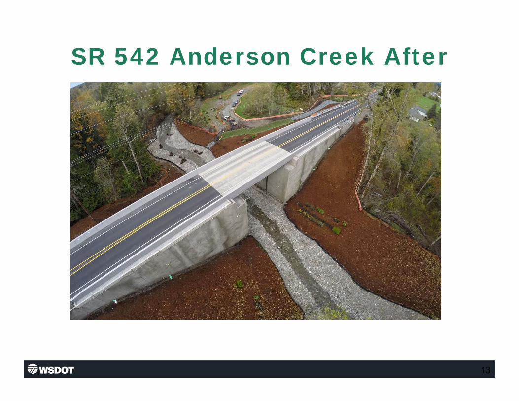
SR 542 Anderson Creek After
13

Anderson Creek Hydrograph
14

Anderson Creek Gage Depth
15

Queets River Gage Depths
16

Anderson Creek Hydrograph
17

Anderson Creek Gage Depth
18

Anderson Creek Downstream
19
Above: 10/2/15, Below: 11/18/15 Above: 11/2/15, Below: 12/14/15

Anderson Creek Upstream
20
Above: 10/6/15, Below: 11/14/15 Above: 11/2/15, Below: 12/14/15

Stream Design

.... ~WSDOT
PEO/AEO Roles
• Work with hydraulics office to identify constraints
• Provide CAD/InRoads Support – HQ Hydraulics has training material, standard
templates, and cells for modeling streams
– Working with CAE to get the Plans Prep manual updated
– For support contact Catherine LaPointe
• Lead in coordination between Tribes, Agencies, Property Owners, support groups, Etc.
• Roadway geometrics/construction planning
22

.... ~WSDOT
Guidance Documents
• FHWA HEC 18
• FHWA HEC 20
• FHWA HEC 23
• WSDOT HM Chapter 7 (major update coming soon) • WDFW Water Crossing Design Guidelines (WCDG) • WDFW Integrated Stream Protection Guidelines (ISPG)
23

.... ~WSDOT
Overview
• Methods to assess site conditions and reference reach (Stream Survey, Stream Gaging, Pebble Count/Grab Samples, etc)
• Understanding basin hydrology, stream/river hydrodynamics, and sediment supply
• Importance of understanding design is site specific
• Hydraulic Modeling
• Methods used to design streambed gradation
• Methods for constructing design
24

.... ~WSDOT
Methods to Assess Site Conditions
• Reference Reach
• Stream Gaging/Hydrology Investigation
• Stream Survey (i.e. Longitudinal Profile, Cross Sections, Geomorphic Features, etc)
• Wolman Pebble Count/ Grab Samples
• Photographs
• Site Visits

.... ~WSDOT
Appropriate Reference Reach
• Stream simulation is meant to mimic natural conditions in a unaffected reach
• Reference reach assists the designer in determining the appropriate slope, sediment size, and channel shape
• Reference reach should have a basin size that is similar to the crossing in question

Basin Hydrology
27

Site Conditions

Wolman Pebble Count/Grab Samples

Stream Survey
0 10000 20000 30000 40000 50000 60000 70000 80000 1180
1200
1220
1240
1260
1280
1300
1320
1340
MTB Flood Elev Analysis Plan: MTB Existing Conditions 6/2/2009
Main Channel Di stance (f t)
Elev
atio
n (ft
)
Legend
Cri t Max WS
EG Max WS
WS Max WS
Ground
CHEHALIS REACH 1
0 500 1000 1500 2000 2500 3000 1250
1255
1260
1265
1270
1275
1280
1285
1290
1295
MT B Flood Elev Analysis Plan : MT B Existi ng Co ndi tions 6/2/2009 Channel data below El. 260 from USACE sur vey of Feb. 2001, range
Station (ft)
Elev
atio
n (ft
)
Legend
EG Max WS
WS Max WS
Crit Max WS
Ground
Bank Sta
.13 .05 .11
Profile
Cross Section

.... ~WSDOT
Channel Alignment
• Review As-builts and RoW plans
• Review project geometric constraints • Bend severity vs. length of structure
• Local topography
• Reduce impacts to vegetation/sensitive areas when possible

Channel Alignment

Channel Alignment

Channel Shape
Identify existing key features: • Overbank areas
• Thalweg
• Bankfull

Channel Shape

Proposed Section
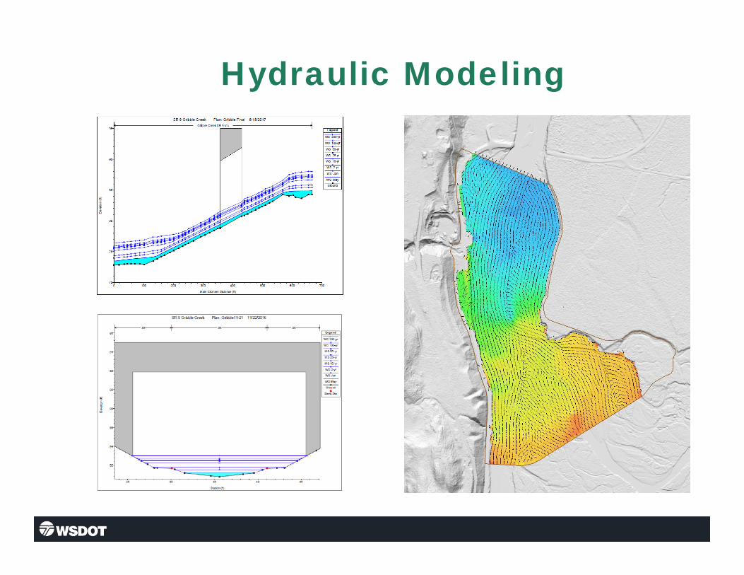
Hydraulic Modeling 2D model of the Sauk-Suiattle confluence with water elevation contours and velocity vectors
Bank stabilization project on SR 530

Sediment Movement
38

Sediment Supply
39

Sediment Supply
40
Aggradation Degradation

.... ~WSDOT
Methods to Size Sediment
• Critical Unit Discharge (Bathurst) • Modified Shields Equation • Pebble Counts

Materials
Sieve Size Percent Passing
2 1/2" square 100 2" square 65 – 100 1" square 50 – 85
No. 4 26 – 44 No. 40 16 max. No. 200 5.0 – 9.0
9-01.11(1) Streambed Sediment
0
10
20
30
40
50
60
70
80
90
100
0.001 0.01 0.1 1 10
Perc
ent
Fine
r
Particle Size (Inches)
Standard Specification 9-03.11(1)

Materials 9-03.11(2) Streambed Cobbles
Approx. Size
Percent Passing
4" Cobbles
6" Cobbles
8" Cobbles
10" Cobbles
12" Cobbles
12" 100
10" 100
8" 100 70 max. 6" 100 70 max. 5" 70 max. 40 max. 4" 100 70 max. 40 max. 3" 40 max. 2" 40 max.
1 ½" 40 max. ¾" 10 max. 10 max. 10 max. 10 max. 10 max.
Standard Specification 9-03.11(2) 100
90
80
70
60
50
40
30
20
10
0 0.5 5
Particle Size (Inches) 4" Cobbles 6" Cobbles 8" Cobbles 10" Cobbles 12" Cobbles
Perc
ent
Fine
r

Materials

Sediment—Final Product

Bridge Scour

Why is it Important?
47
Location: SR 542 Gallup Creek Cause: Flood washed out abutment, dropped 4’6”; 1962
• Most common cause of bridge failure
• Determines the necessary depth of foundation

Types of Scour
48
• Contraction Scour • Local Scour • Long Term
Degradation • Lateral Migration

Types of Scour
49

50
Lateral Migration/Degradation
P5
P6 P7
P8
140
150
160
170
180
190
200
210
220
230
240
0 50 100 150 200 250 300 350 400 450
ELWHA RIVER, 101/334
RAIL ELEV. BOTT. OF FTG. ELEV. 1928 G/L ELEV. 1948 G/L ELEV. 1996 G/L 500-YR WATER SURFACE ELEVATION 500-YR ESTIMATED SCOUR ELEV. 1991 U/W G/L ELEV. 2009 G/L ELEV. 2011 G/L ELEV. 1999 G/L ELEV. 2001 FATHO-METRIC SURVEY 2011 UW G/L ELEV. 2013 G/L ELEV. 2012 UW G/L ELEV. 2013 UW G/L ELEV. 2014 UW G/L ELEV. 2014 U/S G/L ELEV. 2014 D/S G/L ELEV. 2012 D/S G/L ELEV. 2015 G/L ELEV.
Viewing Downstream

What Causes It?
51
Location: SR 508 Bear Creek Cause: Flood/Debris bent center and 2 trusses
Water around an obstruction (foundation, debris, etc) removes sediment and leaves behind a hole.

What can be done?
52
• Existing Structures: – Regular inspections
– Monitor (Plan of Action) – Apply countermeasures
• New Structures: – Plan for scour and design
appropriately

.... ~WSDOT
Questions?
53