Embed Size (px)
Citation preview
Geomorphology 264 (2016) 29–40
Contents lists available at ScienceDirect
Geomorphology
j ourna l homepage: www.e lsev ie r .com/ locate /geomorph
Buried marine-cut terraces and submerged marine-built terraces:The Carchuna-Calahonda coastal area (southeast Iberian Peninsula)
Manuel Martinez-Martos a,b,⁎, Jesus Galindo-Zaldivar a,b, Francisco José Lobo b, Antonio Pedrera c,Patricia Ruano a,b, Manuel Lopez-Chicano a, Miguel Ortega-Sánchez d
a Departamento de Geodinámica, Sala 7. Facultad de Ciencias, Universidad de Granada, Campus de Fuentenueva S/N, 18071 Granada, Spainb Instituto Andaluz de Ciencias de la Tierra, CSIC-Universidad de Granada, Avenida de las Palmeras, n° 4, 18100 Armilla, Spainc Instituto Geológico y Minero de España, Urbanización Alcázar del Genil, 4-Edificio Zulema, Bajo, 18006 Granada, Spaind Instituto Interuniversitario de Investigación del Sistema Tierra en Andalucía, Avenida del Mediterráneo S/N, 18006 Granada, Spain
⁎ Corresponding author at: Departamento de GeodinámUniversidad de Granada, Campus de Fuentenueva S/N, 18
E-mail address: [email protected] (M. Martinez-Mar
http://dx.doi.org/10.1016/j.geomorph.2016.04.0100169-555X/© 2016 Elsevier B.V. All rights reserved.
a b s t r a c t
a r t i c l e i n f oArticle history:Received 31 July 2015Received in revised form 8 April 2016Accepted 10 April 2016Available online 16 April 2016
The Carchuna-Calahonda coastal area is located between the onshore Betic Cordillera and the Alboran Sea. Itsonshore sector is formedby detrital sediments that cover ametamorphic basementmostly composed ofmarbles,contiguous to an offshore shelf setting. New onshore gravity data allow us to characterize the location of flatmarine-cut terraces carved into the metamorphic bedrock, which are covered by detrital sediments. In addition,multibeam bathymetry data, 3.5 kHz and sparker reflection seismic profiles, reveal offshore flat features linked tomarine terraces that are related with the onshore buried marine-cut terraces. Gravity data are newly used todetect marine-cut terraces covered by sediments, enhancing the integration of onshore and offshore data. Themarine terraces are distinguished based on the relative sea-level trend (regressive versus transgressive) andon the dominant sedimentary regime (erosional versus depositional). These data help constrain the ages of themarine terraces younger than 150 ka, using available Late Quaternary sea-level curves. Although previousgeodetic research suggests a rapid sinking of the Carchuna-Calahonda coast, the heights of the marine-cut ter-races and depositional terraces are mainly driven by sea-level changes, not tectonics.
© 2016 Elsevier B.V. All rights reserved.
Keywords:Gravity prospectionMarine terracesSea-level changeBathymetry
1. Introduction
Marine terraces are flat to gently inclined surfaces of marine originbounded by a distinctive break in slope. In temperate regions, mostterraces are related to erosion processes, forming marine-cut terracesor shore platforms along rocky coasts (Pirazzoli, 2005). Erosionalprocesses linked to marine terrace formation are usually driven bywaves, and secondarily by coastal currents (Passaro et al., 2011). Theaccumulation ofmaterials derived from shore erosion alsomay formde-positional features known as marine-built terraces (Pirazzoli, 2005).These coastal geomorphological features are reliable sea-level indica-tors, recording periods of stationary sea-levels (Bradley and Griggs,1976; Passaro et al., 2011). The position of marine terraces is controlledby eustatism and/or tectonics. Thus, they may emerge on upliftedcoasts, where sets of terraces are genetically linked to past interglacialhighstands of sea level (Masselink and Hughes, 2003; Pirazzoli, 2005).Emergedmarine terraces are essentially used to constrain tectonic upliftrates (Merritts and Bull, 1989; Zazo et al., 1999; Rostami et al., 2000;
ica, Sala 7. Facultad de Ciencias,071 Granada, Spain.tos).
Pirazzoli et al., 2004; Choi et al., 2008), or as markers of active tectonictilting (Kelsey, 1990; Muhs et al., 1990; Berryman, 1993).
Additional sets of features can be found submerged on continentalshelves, where submarine terraces have been linked to periods of de-creased rates of sea-level rise during the postglacial transgression(e.g., Collina-Girard, 1999, 2002). However, some recent interpretationspoint to more complex geomorphological responses to fluctuatingsea-levels; e.g. seafloor scarps have been interpreted as paleo shelfedges related to regressive sea-levels previous to the Last GlacialMaximum (Goff et al., 2013; Reis et al., 2013). Such submarine featuresmay therefore result from multiple transient sea-levels, and theircorrect interpretation is critical for constraining the past evolution ofshallow continental margins.
In coastal areas, marine-cut terraces may be buried by the fastaccumulation of sediments, especially when they are below sea-level(Alvarez-Marrón et al., 2008). The usually high density contrastbetween sediments and basement makes gravity research a reliablegeophysical technique to constrain the thickness of the sedimentaryinfill and to highlight the presence of buried marine terraces. Thisnon-invasive technique makes it possible to study large areas in a rela-tively short time because it is less dependent than other geophysicalmethods on the location ofmeasurement sites. As far aswe know, how-ever, gravity data have not been applied to buried marine terraces.
30 M. Martinez-Martos et al. / Geomorphology 264 (2016) 29–40
In the Mediterranean region, sets of submergedmarine terraces andrelated features of (mostly) erosional origin have been described atwater depths up to 120 m, where they are generally interpreted as therecord of postglacial sea-level stillstands (Ulzega et al., 1986; Mart andBelknap, 1991; Lagares, 2008; Passaro et al., 2011). In some casesthese features are related with older sea-level highstands (Rovereet al., 2011). In certain Mediterranean settings, the record of transgres-sive still stands is represented by depositional terraces, boundedseaward by abrupt increases of slope gradients (Chiocci and Orlando,1996). In the Alboran Sea, emerged terraces have been reported alongthe cordillera coasts of both the Betic (Lario et al., 1993; Zazo et al.,1999; Sanz de Galdeano, 2006) and the Rif (Poujol et al., 2014). Thisregion allows us to study the different effects of uplifted, subsidentand stable sectors (Groupe de Recherche Néotectonique de l'Arc deGibraltar, 1977; El Kadiri et al., 2010). Multiple submerged terraceshave also been described on the Alboran Shelf east of the Strait ofGibraltar (Hernández-Molina et al., 1996).
The aim of this research is to reconstruct the morphology of bothburied and submerged marine terraces developed in the Carchuna-Calahonda area in a coastal to shallow-marine sector off the BeticCordillera, northern Alboran Sea, in order to integrate their genesisinto a wider context of recent tectonics and sea-level changes. We ac-quired new onshore gravity data and combined it with an updated inter-pretation of available multibeam bathymetry and seismic reflection data.
2. Geological setting of the study area
2.1. Emerged coastal plain
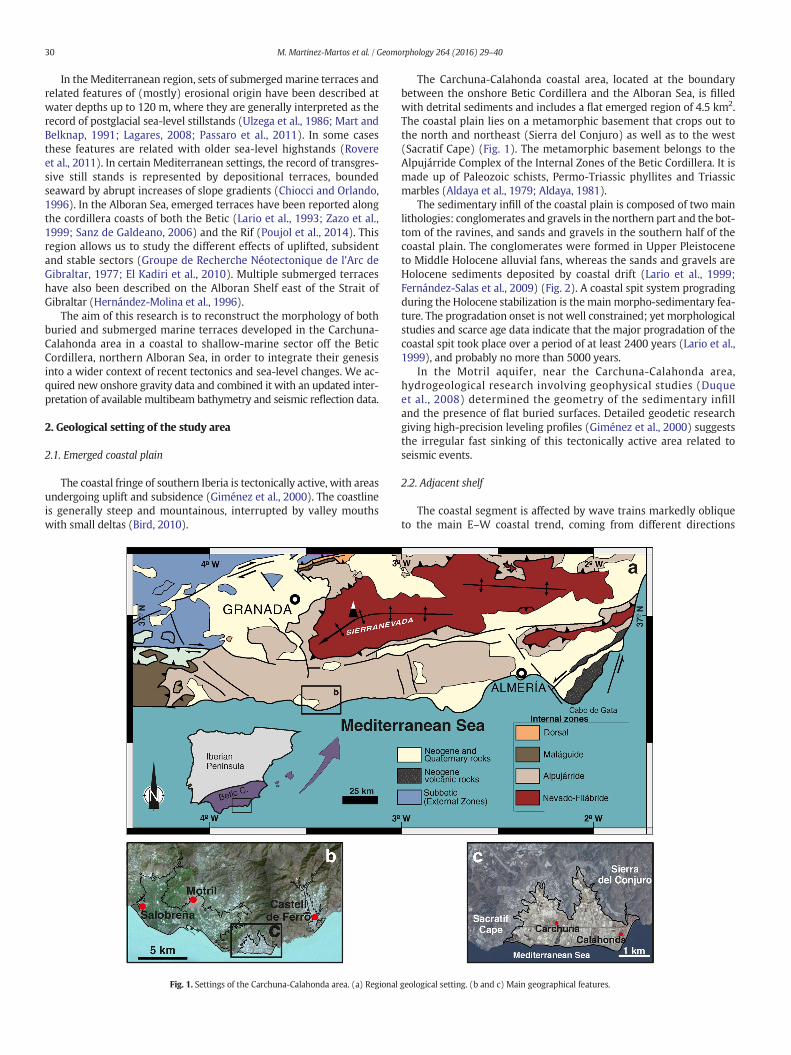
The coastal fringe of southern Iberia is tectonically active, with areasundergoing uplift and subsidence (Giménez et al., 2000). The coastlineis generally steep and mountainous, interrupted by valley mouthswith small deltas (Bird, 2010).
Fig. 1. Settings of the Carchuna-Calahonda area. (a) Regional
The Carchuna-Calahonda coastal area, located at the boundarybetween the onshore Betic Cordillera and the Alboran Sea, is filledwith detrital sediments and includes a flat emerged region of 4.5 km2.The coastal plain lies on a metamorphic basement that crops out tothe north and northeast (Sierra del Conjuro) as well as to the west(Sacratif Cape) (Fig. 1). The metamorphic basement belongs to theAlpujárride Complex of the Internal Zones of the Betic Cordillera. It ismade up of Paleozoic schists, Permo-Triassic phyllites and Triassicmarbles (Aldaya et al., 1979; Aldaya, 1981).
The sedimentary infill of the coastal plain is composed of two mainlithologies: conglomerates and gravels in the northern part and the bot-tom of the ravines, and sands and gravels in the southern half of thecoastal plain. The conglomerates were formed in Upper Pleistoceneto Middle Holocene alluvial fans, whereas the sands and gravels areHolocene sediments deposited by coastal drift (Lario et al., 1999;Fernández-Salas et al., 2009) (Fig. 2). A coastal spit system progradingduring the Holocene stabilization is themain morpho-sedimentary fea-ture. The progradation onset is not well constrained; yet morphologicalstudies and scarce age data indicate that the major progradation of thecoastal spit took place over a period of at least 2400 years (Lario et al.,1999), and probably no more than 5000 years.
In the Motril aquifer, near the Carchuna-Calahonda area,hydrogeological research involving geophysical studies (Duqueet al., 2008) determined the geometry of the sedimentary infilland the presence of flat buried surfaces. Detailed geodetic researchgiving high-precision leveling profiles (Giménez et al., 2000) suggeststhe irregular fast sinking of this tectonically active area related toseismic events.
2.2. Adjacent shelf
The coastal segment is affected by wave trains markedly obliqueto the main E–W coastal trend, coming from different directions
geological setting. (b and c) Main geographical features.
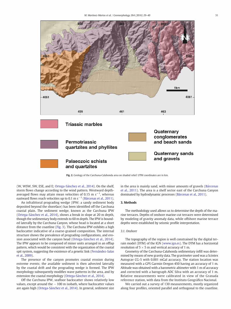
Fig. 2. Geology of the Carchuna-Calahonda area on shaded relief. UTM coordinates are in km.
31M. Martinez-Martos et al. / Geomorphology 264 (2016) 29–40
(W, WSW, SW, ESE, and E; Ortega-Sánchez et al., 2014). On the shelf,storm flows change according to the wind pattern. Westward depth-averaged flows may attain mean velocities of 0.15 m s−1, whereaseastward flows reach velocities up to 0.1 m s−1 (Bárcenas et al., 2011).
An infralittoral prograding wedge (IPW; a sandy sediment bodydeposited beyond the shoreface) has been identified off the Carchunacoastal plain. The sediment wedge, known as the Carchuna IPW(Ortega-Sánchez et al., 2014), shows a break in slope at 20 m depth,though the sedimentary body extends to 60mdepth. The IPW is bound-ed laterally by the Carchuna Canyon, whose head is located at a shortdistance from the coastline (Fig. 3). The Carchuna IPW exhibits a highbackscatter indicative of a coarse-grained composition. The internalstructure shows the prevalence of prograding configurations, and ero-sion associated with the canyon head (Ortega-Sánchez et al., 2014).The IPW appears to be composed of minor units arranged in an offlappattern, which would be consistent with the organization of the coastalspit system, suggesting the existence of a genetic link (Fernández-Salaset al., 2009).
The presence of the canyon promotes coastal erosion duringextreme events; the available sediment is then advected laterallyby the coastal drift and the prograding wedge is formed. The IPWmorphology subsequently modifies wave patterns in the area, and byextension the coastal morphology (Ortega-Sánchez et al., 2014).
Off the Carchuna IPW, seafloor backscatter shows relatively lowvalues, except around the −100 m isobath, where backscatter valuesare again high (Ortega-Sánchez et al., 2014). In general, sediment size
in the area is mainly sand, with minor amounts of gravels (Bárcenaset al., 2011). The area is a shelf sector east of the Carchuna Canyondominated by hydrodynamic processes (Bárcenas et al., 2011).
3. Methods
The methodology used allows us to determine the depth of the ma-rine terraces. Depths of onshore marine-cut terraces were determinedby modeling of gravity anomaly data, while offshore marine terracedepths were established by seismic profile interpretation.
3.1. Onshore
The topography of the region is well constrained by the digital ter-rain model (DTM) of the IGN (www.ign.es). The DTM has a horizontalresolution of 5 × 5 m and vertical accuracy of 1 m.
Geometry of the Carchuna-Calahonda sedimentary infill was deter-mined bymeans of new gravity data. The gravimeter usedwas a ScintexAutograv CG-5 with 0.001 mGal accuracy. The station location wasmeasured with a GPS Garmin Oregon 450 having an accuracy of 1 m.Altitude was obtained with a barometric altimeter with 1m of accuracyand corrected with a barograph ADC Silva with an accuracy of 1 m.Relative measurements were calibrated in view of the Granadareference station, with data from the Instituto Geográfico Nacional.
We carried out a survey of 130 measurements, mostly organizedalong four profiles, oriented parallel and orthogonal to the coastline.
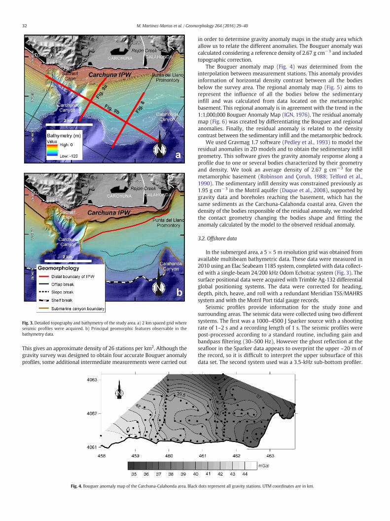
Fig. 3. Detailed topography and bathymetry of the study area. a) 2 km spaced grid whereseismic profiles were acquired. b) Principal geomorphic features observable in thebathymetry data.
32 M. Martinez-Martos et al. / Geomorphology 264 (2016) 29–40
This gives an approximate density of 26 stations per km2. Although thegravity survey was designed to obtain four accurate Bouguer anomalyprofiles, some additional intermediate measurements were carried out
Fig. 4. Bouguer anomaly map of the Carchuna-Calahonda area. Black
in order to determine gravity anomaly maps in the study area whichallow us to relate the different anomalies. The Bouguer anomaly wascalculated considering a reference density of 2.67 g cm−3 and includedtopographic correction.
The Bouguer anomaly map (Fig. 4) was determined from theinterpolation between measurement stations. This anomaly providesinformation of horizontal density contrast between all the bodiesbelow the survey area. The regional anomaly map (Fig. 5) aims torepresent the influence of all the bodies below the sedimentaryinfill and was calculated from data located on the metamorphicbasement. This regional anomaly is in agreement with the trend in the1:1,000,000 Bouguer Anomaly Map (IGN, 1976). The residual anomalymap (Fig. 6) was created by differentiating the Bouguer and regionalanomalies. Finally, the residual anomaly is related to the densitycontrast between the sedimentary infill and the metamorphic bedrock.
We used Gravmag 1.7 software (Pedley et al., 1993) to model theresidual anomalies in 2D models and to obtain the sedimentary infillgeometry. This software gives the gravity anomaly response along aprofile due to one or several bodies characterized by their geometryand density. We took an average density of 2.67 g cm−3 for themetamorphic basement (Robinson and Çoruh, 1988; Telford et al.,1990). The sedimentary infill density was constrained previously as1.95 g cm−3 in the Motril aquifer (Duque et al., 2008), supported bygravity data and boreholes reaching the basement, which has thesame sediments as the Carchuna-Calahonda coastal area. Given thedensity of the bodies responsible of the residual anomaly, we modeledthe contact geometry changing the bodies shape and fitting theanomaly calculated by the model to the observed residual anomaly.
3.2. Offshore data
In the submerged area, a 5 × 5 m resolution grid was obtained fromavailable multibeam bathymetric data. These data were measured in2010 using an Elac Seabeam 1185 system, completed with data collect-ed with a single-beam 24/200 kHz Odom Echotrac system (Fig. 3). Thesurface positional data were acquired with Trimble Ag-132 differentialglobal positioning systems. The data were corrected for heading,depth, pitch, heave, and roll with a redundant Meridian TSS/MAHRSsystem and with the Motril Port tidal gauge records.
Seismic profiles provide information for the study zone andsurrounding areas. The seismic data were collected using two differentsystems. The first was a 1000–4500 J Sparker source with a shootingrate of 1–2 s and a recording length of 1 s. The seismic profiles werepost-processed according to a standard routine, including gain andbandpass filtering (30–500 Hz), However the ghost reflection at theseafloor in the Sparker data appears to overprint the upper ~20 m ofthe record, so it is difficult to interpret the upper subsurface of thisdata set. The second system used was a 3.5-kHz sub-bottom profiler.
dots represent all gravity stations. UTM coordinates are in km.
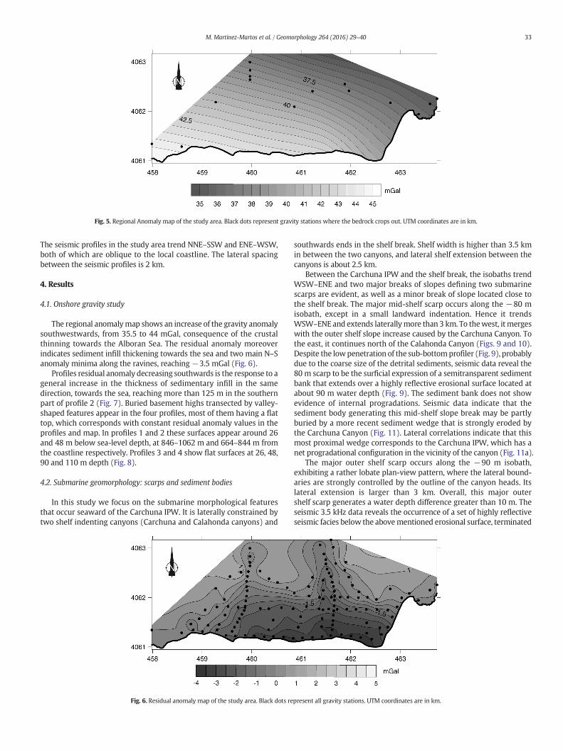
Fig. 5. Regional Anomaly map of the study area. Black dots represent gravity stations where the bedrock crops out. UTM coordinates are in km.
33M. Martinez-Martos et al. / Geomorphology 264 (2016) 29–40
The seismic profiles in the study area trend NNE–SSW and ENE–WSW,both of which are oblique to the local coastline. The lateral spacingbetween the seismic profiles is 2 km.
4. Results
4.1. Onshore gravity study
The regional anomalymap shows an increase of the gravity anomalysouthwestwards, from 35.5 to 44 mGal, consequence of the crustalthinning towards the Alboran Sea. The residual anomaly moreoverindicates sediment infill thickening towards the sea and two main N–Sanomaly minima along the ravines, reaching−3.5 mGal (Fig. 6).
Profiles residual anomaly decreasing southwards is the response to ageneral increase in the thickness of sedimentary infill in the samedirection, towards the sea, reaching more than 125 m in the southernpart of profile 2 (Fig. 7). Buried basement highs transected by valley-shaped features appear in the four profiles, most of them having a flattop, which corresponds with constant residual anomaly values in theprofiles and map. In profiles 1 and 2 these surfaces appear around 26and 48 m below sea-level depth, at 846–1062 m and 664–844 m fromthe coastline respectively. Profiles 3 and 4 show flat surfaces at 26, 48,90 and 110 m depth (Fig. 8).
4.2. Submarine geomorphology: scarps and sediment bodies
In this study we focus on the submarine morphological featuresthat occur seaward of the Carchuna IPW. It is laterally constrained bytwo shelf indenting canyons (Carchuna and Calahonda canyons) and
Fig. 6. Residual anomaly map of the study area. Black dots re
southwards ends in the shelf break. Shelf width is higher than 3.5 kmin between the two canyons, and lateral shelf extension between thecanyons is about 2.5 km.
Between the Carchuna IPW and the shelf break, the isobaths trendWSW–ENE and two major breaks of slopes defining two submarinescarps are evident, as well as a minor break of slope located close tothe shelf break. The major mid-shelf scarp occurs along the −80 misobath, except in a small landward indentation. Hence it trendsWSW–ENE and extends laterallymore than 3 km. To thewest, it mergeswith the outer shelf slope increase caused by the Carchuna Canyon. Tothe east, it continues north of the Calahonda Canyon (Figs. 9 and 10).Despite the lowpenetration of the sub-bottomprofiler (Fig. 9), probablydue to the coarse size of the detrital sediments, seismic data reveal the80 m scarp to be the surficial expression of a semitransparent sedimentbank that extends over a highly reflective erosional surface located atabout 90 m water depth (Fig. 9). The sediment bank does not showevidence of internal progradations. Seismic data indicate that thesediment body generating this mid-shelf slope break may be partlyburied by a more recent sediment wedge that is strongly eroded bythe Carchuna Canyon (Fig. 11). Lateral correlations indicate that thismost proximal wedge corresponds to the Carchuna IPW, which has anet progradational configuration in the vicinity of the canyon (Fig. 11a).
The major outer shelf scarp occurs along the −90 m isobath,exhibiting a rather lobate plan-view pattern, where the lateral bound-aries are strongly controlled by the outline of the canyon heads. Itslateral extension is larger than 3 km. Overall, this major outershelf scarp generates a water depth difference greater than 10 m. Theseismic 3.5 kHz data reveals the occurrence of a set of highly reflectiveseismic facies below the abovementioned erosional surface, terminated
present all gravity stations. UTM coordinates are in km.
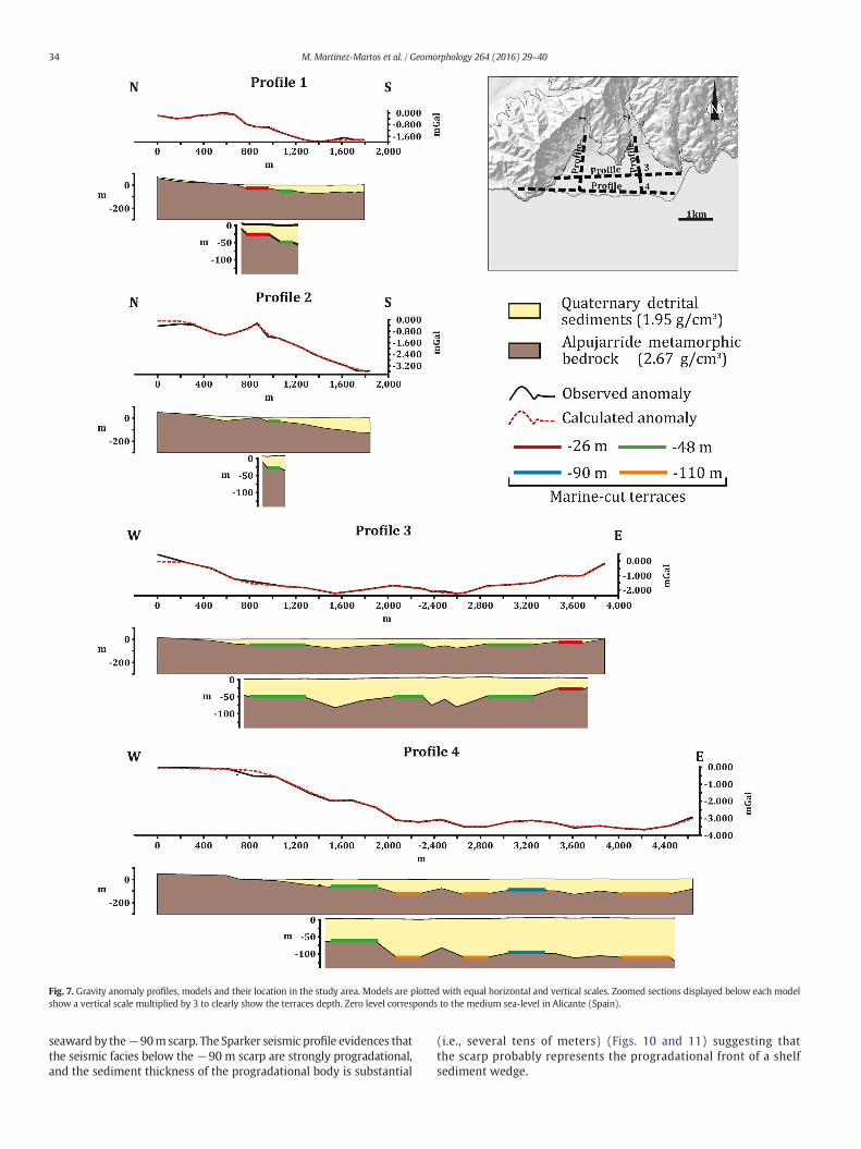
Fig. 7. Gravity anomaly profiles, models and their location in the study area. Models are plotted with equal horizontal and vertical scales. Zoomed sections displayed below each modelshow a vertical scale multiplied by 3 to clearly show the terraces depth. Zero level corresponds to the medium sea-level in Alicante (Spain).
34 M. Martinez-Martos et al. / Geomorphology 264 (2016) 29–40
seaward by the−90m scarp. The Sparker seismic profile evidences thatthe seismic facies below the −90 m scarp are strongly progradational,and the sediment thickness of the progradational body is substantial
(i.e., several tens of meters) (Figs. 10 and 11) suggesting thatthe scarp probably represents the progradational front of a shelfsediment wedge.
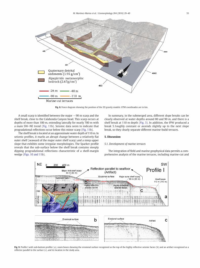
Fig. 8. Fence diagram showing the position of the 2D gravity models. UTM coordinades are in km.
35M. Martinez-Martos et al. / Geomorphology 264 (2016) 29–40
A small scarp is identified between the major −90 m scarp and theshelf break, close to the Calahonda Canyon head. This scarp occurs atdepths of more than 100 m, extending laterally for nearly 700 m witha main SW–NE trend (Fig. 11b). Seismic data seem to indicate thatprogradational reflections occur below this minor scarp (Fig. 11b).
The shelf break is located at an approximatewater depth of 110m. Inseismic profiles, it marks an abrupt change between a relatively flatouter shelf (seaward of the major outer shelf scarp) and a steep upperslope that exhibits some irregular morphologies. The Sparker profilereveals that the sub-surface below the shelf break contains steeplydipping progradational reflections characteristic of a shelf-marginwedge (Figs. 10 and 11b).
Fig. 9. Profile I with sub-bottom profiler (a), zoom boxes showing the erosional surface recogreflector parallel to the surface (c), and its location in the study area.
In summary, in the submerged area, different slope breaks can beclearly observed at water depths around 80 and 90 m, and there is ashelf break at 110 m depth (Fig. 3). In addition, the IPW produced abreak 5.1oughly constant or ascends slightly up to the next slopebreak, so they clearly separate different marine-build terraces.
5. Discussion
5.1. Development of marine terraces
The integration of field and marine geophysical data permits a com-prehensive analysis of the marine terraces, including marine-cut and
nized as the top of the highly reflective seismic facies (b) and an artifact recognized as a

Fig. 10. Sparker profile I (a), zoom box showing the progradational shelf wedges (b) and their location in the study area.
36 M. Martinez-Martos et al. / Geomorphology 264 (2016) 29–40
marine-built terraces. Although previous geodetic studies based onhigh precision leveling indicated quick subsidence in the study area(Giménez et al., 2000), there is no geomorphically accurate studies inthis region that clearly determine the evidence of tectonic uplifting orsubsidence. Our data reveal a roughly stable littoral, meaning thedifferent heights of the marine terraces are mainly due to sea-levelchanges operating during the last 150 ka, as suggested by other studies(Sanz de Galdeano, 2006, and references therein).
In this work we distinguish marine-cut terraces and marine-builtterraces. Among the last ones, it is important to divide the ones formed
Fig. 11. Sparker profiles II (a) and III (b)
in a generally transgressive period from those formed in a generallyregressive period. Marine-cut terraces may be perfectly distinguishedsince they are formed as a result of wave erosion in hard rocks. Weobserve these terraces with gravity data because of the density contrastbetween the bedrock and the sedimentary infill. After the formation ofmarine-cut terraces, detrital deposits buried them and preserved themfrom erosion. This observation suggests that the cut terraces in thisarea were generally formed during transgressive periods when sea-level was rising, together with constant sediment supply that allowedthe burial of these geomorphic features before they were eroded. The
and their location in the study area.
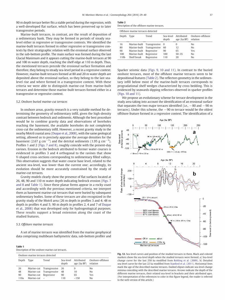
Table 2Description of the offshore marine terraces.
Offshore marine terraces detected
Depth Type Trend Sea-leveldepth
Attributedage (ka BP)
Onshore-offshorerelation
16 Marine-built Transgressive 0 0 No80 Marine-built Transgressive 60 12 No90 Marine-built Regressive 90 65 Yes100 Marine-built Regressive 100 50–35 No110b Shelf break Regressive 110 20 No
37M. Martinez-Martos et al. / Geomorphology 264 (2016) 29–40
90mdepth terrace better fits a stable period during the regression,witha well-developed flat surface, which has been preserved up to latertransgressive periods.
Marine-built terraces, in contrast, are the result of deposition ofa sedimentary bank. They may be formed in periods of steady sea-level either in regressive or transgressive contexts. We identified themarine-built terraces formed in either regressive or transgressive con-texts by their stratigraphic relation with the erosional surface observedin the sub-bottom profile. The main surface was formed during the lastGlacial Maximum and it appears cutting the marine-built terraces at 90and 100 m water depth, reaching the shelf edge at 110 m depth. Thus,the mentioned terraces precede the erosional surface formation andtherefore, they belong to steady sea-level period in a regressive context.However, marine-built terraces formed at 80 and 20mwater depth aredeposited above the erosional surface, so they belong to the last sea-level rise and where formed in a transgressive context. With thesecriteria we were able to distinguish marine-cut from marine-builtterraces and determine those marine-built terraces formed either in atransgressive or regressive context.
5.2. Onshore buried marine-cut terraces
In onshore areas, gravity research is a very suitable method for de-termining the geometry of sedimentary infill, given the high-densitycontrast between bedrock and sediments. Although the best procedurewould be to combine gravity data and observations of boreholesreaching the basement, the available boreholes do not completelycross-cut the sedimentary infill. However, a recent gravity study in thenearbyMotril coastal area (Duque et al., 2008),with the same geologicalsetting, allowed us to precisely appraise the average densities for thebasement (2.67 g cm−3) and the detrital sediments (1.95 g cm−3).Profiles 1 and 2 (Figs. 7 and 8), roughly coincide with the present-dayravines. Erosion in the bedrock attributed to former water courses isevidenced in profiles 3 and 4 orthogonal to the ravines that showV-shaped cross-sections corresponding to sedimentary filled valleys.This observation suggests that water course base level, related to theancient sea-level, was lower than the current one; accordingly, itsevolution should be more accurately constrained by the study ofmarine-cut terraces.
Gravity models clearly show the presence of flat surfaces located at26, 48, 90 and 110 m water depth indicating bedrock erosion (Figs. 7and 8 and Table 1). Since these planar forms appear in a rocky coastand accordingly with the previous mentioned criteria, we interpretthem as basement marine-cut terraces that were buried by subsequentsedimentary bodies. Some of these terraces are also recognized in thegravity study of the Motril area (26 m depth in profiles 3 and 4; 48 mdepth in profiles 4 and 5; 90 m depth in profiles 2, 4 and 7 of Duqueet al., 2008) that was developed only for hydrogeological purposes.These results support a broad extension along the coast of thestudied features.
5.3. Offshore marine terraces
A set of marine terraces was identified from the marine geophysicaldata comprising multibeam bathymetric data, sub-bottom profiler and
Table 1Description of the onshore marine-cut terraces.
Onshore marine terraces detected
Depth Type Trend Sea-leveldepth
Attributedage (ka BP)
Onshore-offshorerelation
26 Marine-cut Transgressive 26 9 No48 Marine-cut Transgressive 48 10 No90 Marine-cut Regressive 90 65 Yes110a Marine-cut – 110 ~150 No
Sparker seismic data (Figs. 9, 10 and 11). In contrast to the buriedonshore terraces, most of the offshore marine terraces seem to bedepositional features (Table 2). The reflectors geometry in the sedimen-tary infill below most of the marine-built terraces corresponds toprogradational shelf wedges characterized by cross bedding. This isevidenced by seawards dipping reflectors observed in sparker profiles(Figs. 10 and 11).
We propose an evolutionary scheme for terrace development in thestudy area taking into account the identification of an erosional surfacethat separates the two major terraces identified (i.e., −80 and −90 mterraces). Under this scheme, the −90 m terrace would be the oldestoffshore feature formed in a regressive context. The identification of a
Fig. 12. Sea-level curves and position of the studied terraces in them. Black and coloredmarkers show the sea-level depth when the studied terraces were formed. a) Sea-levelchange curve for the last 250 ka modified from Rohling et al. (2009). b) Detailedsea-level curve for the last 22 ka modified from Stanford et al. (2011). Horizontal linesmark the age of the described marine terraces. Dashed elipses indicate sea-level changeminima coinciding with the described marine terraces. Arrows indicate the depth of thedifferent marine terraces, their related sea-level in brackets and their attributed ages.(For interpretation of the references to color in this figure legend, the reader is referredto the web version of this article.)
38 M. Martinez-Martos et al. / Geomorphology 264 (2016) 29–40
forestepping pattern of progradational wedges in the outer shelf sup-ports our interpretation; in this sense, the−90m terrace is interpretedas a scarp marking the seaward edge of an offlapping forced-regressivewedge, and therefore should be regarded as a depositional terrace.Similar terrace-built features developed within regressive contextshave been observed in the Mid-Atlantic Bight (Goff et al., 2013) or theBrazilian Shelf (Reis et al., 2013). The successive development ofterrace-built features seaward, including the minor outer shelf terraceat about 100 m water depth and the shelf break at about 110 m waterdepth, would have occurred within a regressive context during fallingsea-level or lowstand conditions, taking into account the stackingpattern of outer shelf wedges. The correlation between water depthsof depositional terraces and the Late Quaternary sea-level curvesimplies that the−90m terrace could be related with the Marine Isoto-pic Stage (MIS) 4 (65 ka), whereas the shelf break would be linked toMIS 2 (20 ka). Therefore, the set of depositional terraces documentedon the outer shelf of the study area would record an overall sea-levelchange between MISs 4 and 2 (e.g., Rohling et al., 2009; Siddall et al.,2010; Grant et al., 2012).
The−80mmarine terrace should also be regarded as amarine-builtterrace, as it is the surface expression of a sediment bank. However,its stratigraphic position, overlying an erosional surface and cappedby the regressive facies of the most recent Carchuna IPW, would becompatible with a transgressive context. Therefore, we postulate thatthe −80 m depositional terrace is a postglacial feature. In attempting
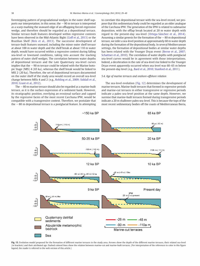
Fig. 13. Evolution model proposed for the formation of different marine terraces in the stud(in brackets) and their attributed age. Dashed colored lines show the relation between marinelegend, the reader is referred to the web version of this article.)
to correlate this depositional terrace with the sea-level record, we pro-pose that this sedimentary body could be regarded as an older analogueof the Carchuna IPW. The generation of the IPW is related to submarinedeposition, with the offlap break located at 20 m water depth withregard to the present-day sea-level (Ortega-Sánchez et al., 2014).Assuming a similar genesis for the formation of the−80m depositionalterrace, we infer a sea-level position at approximately 60mwater depthduring the formation of the depositional body. In severalMediterraneansettings, the formation of depositional bodies at similar water depthshas been related with the Younger Dryas event (Berne et al., 2007;Schattner et al., 2010). The correlation of water depths with postglacialsea-level curves would be in agreement with those interpretations.Indeed, a deceleration in the rate of sea-level rise linked to the YoungerDryas event apparently occurred when sea-level was 60–65 m belowthe present-day level (e.g., Bard et al., 2010; Stanford et al., 2011).
5.4. Age of marine terraces and onshore-offshore relation
The sea-level evolution (Fig. 12) determines the development ofmarine terraces. Marine-built terraces that formed in regressive periodsand marine-cut terraces in either transgressive or regressive periodsindicate a paleo sea-level position at the same depth. However, wesurmise that marine-built terraces formed during transgressive periodsindicate a 20m shallower paleo sea-level. This is because the tops of themost recent sedimentary bodies off the coasts of Mediterranean Iberia,
y area. Arrows show the depth of the different marine terraces, their related sea-level-cut and marine-built terraces. (For interpretation of the references to color in this figure
39M. Martinez-Martos et al. / Geomorphology 264 (2016) 29–40
assumed to have been deposited during theHolocenehighstand, appearto be levelled by the base of storm waves (Hernández-Molina et al.,2000; Fernández-Salas et al., 2009). In the study area, the top surfaceof the most recent IPW occurs at approximately 20 m water depth(Ortega-Sánchez et al., 2014). Therefore, we infer that a similar waterdepth correction should be made when estimating paleo sea-levelsfrom older marine-built terraces.
We observe that the 90 m depth marine-cut terrace detected withgravity data is found offshore at the same depth in the multibeambathymetry, sub-bottom profiler and Sparker seismic data (Figs. 7 to11). This allows us to relate marine terraces detected offshore andonshore and present a relative timing of events (Fig. 13).
An absolute age can be assigned to all the terraces identified (Figs. 12and 13). A basement marine-cut terrace at 110 m depth (110a) is theoldest and was formed at approximately 150 ka (Fig. 12). This terraceis only detected by gravity data (Figs. 7 and 8). The next recognizableterrace is the one located at 90 m depth and detected buried onshore(Figs. 7 and 8) as well as offshore (Figs. 9 to 11). This terrace formedat 65 ka during a regressive period (Fig. 12). Later on, in the next regres-sive period, themarine terrace at 100m depth was formed at 50–35 ka.It can be identified offshore (Fig. 11), but there are no evidences of thisterrace in thebedrock since it is not detected by gravity data. The regres-sive period finished with the formation of the shelf break at 110 mdepth (110b) at about 20 ka (Fig. 12). The following terrace was formedunder a transgressive trend at 80 m water depth, when the sea-levelwas 60 m lower than at present. This terrace does not have expressionas a marine-cut terrace in the basement, and is not detected by gravitydata. This terrace would have formed at about 12 ka. Gravity datapoint to new marine-cut terraces appearing as flat surfaces in the bed-rock at 48 and 26 m (Figs. 7 and 8) that formed after the one at 80 mdepth. The age attributed to thesemarine-cut terraces is 10 and 9 ka, re-spectively, and coincides with low rates of sea-level change (Fig. 12).These terraces remained unknown, as did the one at 110 m depth(110a), until gravity data were acquired. Themarine-terraces evolutionmodel proposed in this study provides a reliable explanation of thetectono-eustatic history in this sector of Betic Coast since it solves the lo-cation of the newly founded buried marine-cut terraces without invok-ing uplift or subsidence. It is also in agreementwith geomorphic studiespointing to a marine terraces position dependent in sea-level changesrather than tectonics since the Pliocene (Sanz de Galdeano, 2006; ElKadiri et al., 2010). The data presented here shed new light on the re-cent tectono-eustatic relations between the Western Mediterraneanand the Betic Cordillera coast. In addition,we arrive at new relations be-tween the erosional geomorphic features of marine-cut terraces withdepositional marine terraces at the same depth. Moreover, buriedmarine-cut terraces are described inland, highlighting their importancefor tectono-eustatic studies.
6. Conclusions
Four buried marine-cut terraces at 26, 48, 90 and 110 m below thecurrent sea-level were detected using gravity data. They are integratedwith depositional marine terraces offshore at 20, 80, 90 and 100; andwith the shelf break at 110 m depths. The terrace located at 90 mwater depth, which shows erosional features, is the only one identifiedboth onshore and offshore. These data lead us to propose ages for thedifferent marine terraces in view of different sea-level curves (Table 1and Fig. 13). At approximately 150 ka the marine-cut terrace at 110 mdepth (110a) was formed. After that, at 65 ka, the marine terrace at90 m depth was formed. The marine-built terrace at 100 m depthand the shelf break at 110 m depth (110b) were formed at 50–35and 20 ka, respectively. Terraces at 80, 48, 26 and 16 m depth formedafter 20–12 ka during short stable periods. All these data suggest atectonically stable coastal condition.
Gravity studies are a quick and useful means of finding and describ-ingmarine-cut terraces and other structural surfaces in the bedrock that
may be hidden by sedimentary bodies inland. Consequently, they standas a useful tool to support studies on the recent geological history of aregion by revealing key aspects of the geomorphology that remainburied in sediments.
Acknowledgements
We acknowledge the comments from two anonymous reviewersand the editor Prof. Takashi Oguchi, which improved the quality ofthis paper. The field assistance of Mr. Guillermo is recognized. Thisresearch was funded by the projects CGL2010-21048, P09-RNM-5388and RNM148.
References
Aldaya, F., 1981. Mapa Geológico y Memoria Explicativa de la Hoja 1056 (Albuñol) delMapa Geológico de España. IGME, Madrid.
Aldaya, F., García-Dueñas, V., Navarro-Vilá, F., 1979. Los Mantos Alpujárrides del terciocentral de las Cordilleras Béticas. Ensayo de la correlación tectónica de losAlpujárrides. Acta Geol. Hisp. 14 (1), 154–166.
Alvarez-Marrón, J., Hetzel, R., Niedermann, S., Menéndez, R., Marquínez, J., 2008. Origin,structure and exposure history of a wave-cut platform more than 1 Ma in age at thecoast of northern Spain: a multiple cosmogenic nuclide approach. Geomorphology93 (3), 316–334.
Bárcenas, P., Lobo, F.J., Macías, J., Fernández-Salas, L.M., del Río, V.D., 2011. Spatialvariability of surficial sediments on the northern shelf of the Alboran Sea: theeffects of hydrodynamic forcing and supply of sediment by rivers. J. Iber. Geol. 37(2), 195–214.
Bard, E., Hamelin, B., Delanghe-Sabatier, D., 2010. Deglacial meltwater pulse 1B andYounger Dryas sea levels revisited with boreholes at Tahiti. Science 327 (5970),1235–1237.
Berne, S., Jouet, G., Bassetti, M.A., Dennielou, B., Taviani, M., 2007. Late GLacial to Preborealsea-level rise recorded by the Rhône deltaic system (NW Mediterranean). Mar. Geol.245 (1), 65–88.
Berryman, K., 1993. Age, height, and deformation of Holocene marine terraces at MahiaPeninsula, Hikurangi subduction margin, New Zealand. Tectonics 12 (6), 1347–1364.
Bird, E., 2010. Spain. In: Eric, C.F., Bird, M. (Eds.), Encyclopedia of the World's CoastalLandforms. Springer, Netherlands.
Bradley, W.C., Griggs, G.B., 1976. Form, genesis, and deformation of central Californiawave-cut platforms. Geol. Soc. Am. Bull. 87 (3), 433–449.
Groupe de Recherche Néotectonique de l'Arc de Gibraltar, 1977. L'histoire tectoniquerécente (Tortonien à Quaternaire) de l'Arc de Gibraltar et des bordures de la merd'Alboran. Bull. Soc. Geol. Fr. 19 (3), 575–614.
Chiocci, F.L., Orlando, L., 1996. Lowstand terraces on Tyrrhenian Sea steep continentalslopes. Mar. Geol. 134 (1), 127–143.
Choi, S.J., Merritts, D.J., Ota, Y., 2008. Elevations and ages of marine terraces and lateQuaternary rock uplift in southeastern Korea. J. Geophys. Res. Solid Earth 113(B10), 1978–2012.
Collina-Girard, J., 1999. Observation en plongée de replats d'érosion eustatique à l'îled'Elbe (Italie) et à Marie-Galante (Antilles): une séquence bathymétrique mondiale?C.R. Acad. Sci., Ser. IIa: Earth Planet. Sci. 328 (12), 823–829.
Collina-Girard, J., 2002. Underwater mapping of Late Quaternary submerged shorelines inthe Western Mediterranean Sea and the Caribbean Sea. Quat. Int. 92 (1), 63–72.
Duque, C., Calvache, M.L., Pedrera, A., Martín-Rosales, W., López-Chicano, M., 2008. Com-bined time domain electromagnetic soundings and gravimetry to determine marineintrusion in a detrital coastal aquifer (Southern Spain). J. Hydrol. 349 (3), 536–547.
El Kadiri, K., Sanz de Galdeano, C., Pedrera, A., Chalouan, A., Galindo-Zaldívar, J., Julià, R.,Akil, M., Rachid, H., Ahmamou, M., 2010. Eustatic and tectonic controls on QuaternaryRas Leona marine terraces (Strait of Gibraltar, northern Morocco). Quat. Res. 74 (2),277–288.
Fernández-Salas, L.M., Dabrio, C.J., Goy, J.L., Del Río, V.D., Zazo, C., Lobo, F.J., Sanz, J.L., Lario,J., 2009. Land–sea correlation between Late Holocene coastal and infralittoraldeposits in the SE Iberian Peninsula (Western Mediterranean). Geomorphology 104(1), 4–11.
Giménez, J., Suriñach, E., Goula, X., 2000. Quantification of vertical movements in theeastern Betics (Spain) by comparing levelling data. Tectonophysics 317 (3), 237–258.
Goff, J.A., Austin, J.A., Fulthorpe, C.S., 2013. Reinterpretation of the Franklin “Shore” in theMid-Atlantic bight as a paleo-shelf edge. Cont. Shelf Res. 60, 64–69.
Grant, K.M., Rohling, E.J., Bar-Matthews, M., Ayalon, A., Medina-Elizalde, M., Ramsey, C.B.,Satow, C., Roberts, A.P., 2012. Rapid coupling between ice volume and polar temper-ature over the past 150,000 years. Nature 491 (7426), 744–747.
Hernández-Molina, F.J., Gracia, F.J., Somoza, L., Rey, J., 1996. Distribución batimétrica delas terrazas submarinas en la plataforma continental de Málaga Gibraltar.Implicaciones eustáticas durante el Cuaternario terminal. Geogaceta 20 (2), 416–419.
Hernández-Molina, F.J., Fernández-Salas, L.M., Lobo, F., Somoza, L., Díaz-del-Río, V., Dias,J.A., 2000. The infralittoral prograding wedge: a new large-scale progradationalsedimentary body in shallow marine environments. Geo-Mar. Lett. 20 (2), 109–117.
Kelsey, H.M., 1990. Late Quaternary deformation of marine terraces on the Cascadiasubduction zone near Cape Blanco, Oregon. Tectonics 9 (5), 983–1014.
Lagares, F., 2008. Relevés de profils bathymétriques en Croatie du Nord: Indices de pausesholocènes du niveau marin. Compt. Rendus Geosci. 340 (1), 49–56.
40 M. Martinez-Martos et al. / Geomorphology 264 (2016) 29–40
Lario, J., Zazo, C., Somoza, L., Goy, J.L., Hoyos, M., Silva, P.G., Hernández-Molina, F.J., 1993.Los episodios marinos cuaternarios de la costa de Málaga (España). Rev. Soc. Geol.Esp. 6 (3–4), 41–46.
Lario, J., Zazo, C., Goy, J.L., 1999. Fases de progradación y evolución morfosedimentaria dela flecha litoral de Calahonda (Granada) durante el Holoceno. Estud. Geol. 55 (5–6),247–250.
I.G.N., 1976. Mapa de anomalías de Bouguer. I.G.N, Madrid.Mart, Y., Belknap, D.F., 1991. Origin of late Pleistocene submerged marine terraces on the
outer continental shelf, northern Israel. Geo-Mar. Lett. 11 (2), 66–70.Masselink, G., Hughes, M., 2003. Introduction to Coastal Processes and Geomorphology
(368 pp.) Hodder Education Publishers, London, UK.Merritts, D., Bull, W.B., 1989. Interpreting Quaternary uplift rates at the Mendocino triple
junction, northern California, from uplifted marine terraces. Geology 17 (11),1020–1024.
Muhs, D.R., Kelsey, H.M., Miller, G.H., Kennedy, G.L.,Whelan, J.F., McInelly, G.W., 1990. Ageestimates and uplift rates for late pleistocene marine terraces' Southern Oregon por-tion of the Cascadia forearc. J. Geophys. Res. 95 (6685), 6698.
Ortega-Sánchez, M., Lobo, F.J., López-Ruiz, A., Losada, M.A., Fernández-Salas, L.M., 2014.The influence of shelf-indenting canyons and infralittoral prograding wedges oncoastal morphology: the Carchuna system in Southern Spain. Mar. Geol. 347,107–122.
Passaro, S., Milano, G., Sprovieri, M., Ruggieri, S., Marsella, E., 2011. Quaternary still-standlandforms and relations with flank instability events of the Palinuro Bank(southeastern Tyrrhenian Sea). Quat. Int. 232 (1), 228–237.
Pedley, R., Busby, J., Dabek, Z., 1993. GRAVMAG user manual-interactive 2.5 D gravity andmagnetic modelling. British Geological Survey, pp. Technical Report WK/93/26/R, 73.
Pirazzoli, P.A., 2005. Marine terraces. In: Schwartz, M. (Ed.), Encyclopedia of CoastalScience. Springer, Nederlands.
Pirazzoli, P.A., Stiros, S.C., Fontugne, M., Arnold, M., 2004. Holocene and Quaternary upliftin the central part of the southern coast of the Corinth Gulf (Greece). Mar. Geol. 212(1), 35–44.
Poujol, A., Ritz, J.F., Tahayt, A., Vernant, P., Condomines, M., Blard, P.H., Billant, J., Vacher, L.,Tibari, B., Hni, L., Idrissi, A.K., 2014. Active tectonics of the Northern Rif (Morocco)from geomorphic and geochronological data. J. Geodyn. 77, 70–88.
Reis, A.T., Maia, R.M.C., Silva, C.G., Rabineau, M., Guerra, J.V., Gorini, C., Ayres, A., Arantes-Oliveira, R., Benabdellouahed, M., Simões, I., Tardin, R., 2013. Origin of step-like and
lobate seafloor features along the continental shelf off Rio de Janeiro State, Santosbasin-Brazil. Geomorphology 203, 25–45.
Robinson, E.S., Çoruh, C., 1988. Basic Exploration Geophysics. Wiley, New York.Rohling, E.J., Grant, K., Bolshaw, M., Roberts, A.P., Siddall, M., Hemleben, C., Kucera, M.,
2009. Antarctic temperature and global sea level closely coupled over the past fiveglacial cycles. Nat. Geosci. 2 (7), 500.
Rostami, K., Peltier, W.R., Mangini, A., 2000. Quaternary marine terraces, sea-levelchanges and uplift history of Patagonia, Argentina: comparisons with predictions ofthe ICE-4G (VM2) model of the global process of glacial isostatic adjustment. Quat.Sci. Rev. 19 (14), 1495–1525.
Rovere, A., Vacchi, M., Firpo, M., Carobene, L., 2011. Underwater geomorphology of therocky coastal tracts between Finale Ligure and Vado Ligure (western Liguria, NWMediterranean Sea). Quat. Int. 232 (1), 187–200.
Sanz de Galdeano, C., 2006. Formas de erosión marinas en el sector comprendido entreMaro y Castell de Ferro (costa de Málaga y Granada). Geogaceta 39, 139–142.
Schattner, U., Lazar, M., Tibor, G., Ben-Avraham, Z., Makovsky, Y., 2010. Filling up theshelf—a sedimentary response to the last post-glacial sea rise. Mar. Geol. 278 (1),165–176.
Siddall, M., Kaplan, M.R., Schaefer, J.M., Putnam, A., Kelly, M.A., Goehring, B., 2010.Changing influence of Antarctic and Greenlandic temperature records on sea-levelover the last glacial cycle. Quat. Sci. Rev. 29 (3), 410–423.
Stanford, J.D., Hemingway, R., Rohling, E.J., Challenor, P.G., Medina-Elizalde, M., Lester, A.J.,2011. Sea-level probability for the last deglaciation: a statistical analysis of far-fieldrecords. Glob. Planet. Chang. 79 (3), 193–203.
Telford, W.M., Geldart, L.P., Sheriff, R.E., 1990. Applied Geophysics 1. CambridgeUniversity Press.
Ulzega, A., Leone, F., Orrù, P., 1986. Geomorphology of submerged late Quaternaryshorelines on the south Sardinian continental-shelf. J. Coast. Res. 1 (1), 73–82.
Zazo, C., Silva, P.G., Goy, J.L., Hillaire-Marcel, C., Ghaleb, B., Lario, J., Bardaji, T., González, A.,1999. Coastal uplift in continental collision plate boundaries: data from the LastInterglacial marine terraces of the Gibraltar Strait area (south Spain). Tectonophysics301 (1), 95–109.