Embed Size (px)
Citation preview
S U S TA I N A B L E N E I G H B O R H O O D A S S E S S M E N T
June 25 - 27, 2013 www.globalgreen.org/greencities
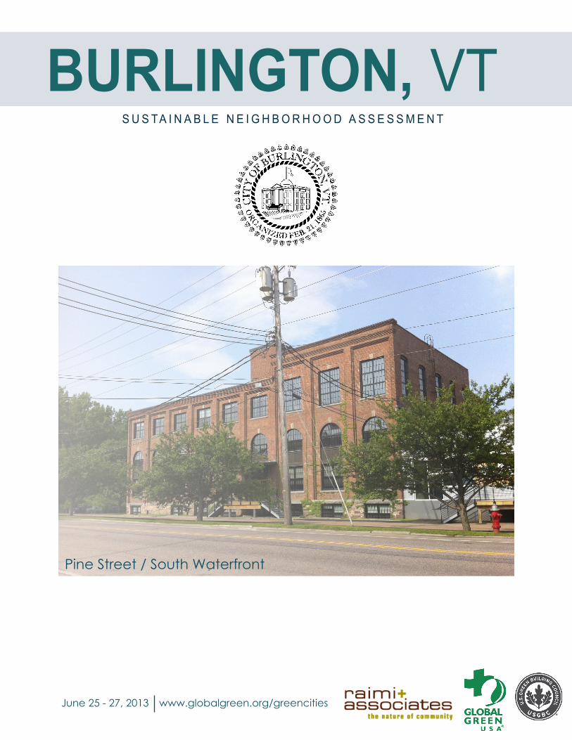
Pine Street / South Waterfront
BURLINGTON, VT

T h r o u g h t h e S u s t a i n a b l e N e i g h b o r h o o d A s s e s s m e n t T o o l d e v e l o p e d b y G l o b a l G r e e n U S A , p u b l i c o f f i c i a l s a n d l o c a l g o v e r n m e n t s t a f f a r e u s i n g t h e L E E D f o r N e i g h b o r h o o d D e v e l o p m e n t ( L E E D - N D ) r a t i n g s y s t e m t o d e t e r m i n e w a y s f o r f u t u r e d e v e l o p m e n t i n t h e i r c o m m u n i t i e s t o a c h i e v e h i g h l e v e l s o f e n v i r o n m e n t a l , e c o n o m i c , a n d s o c i a l s u s t a i n a b i l i t y . L E E D - N D i n t e g r a t e s t h e p r i n c i p l e s o f s m a r t g r o w t h , w a l k a b l e u r b a n i s m a n d g r e e n b u i l d i n g i n t o t h e f i r s t n a t i o n a l r a t i n g s y s t e m f o r n e i g h b o r h o o d d e s i g n . I n B u r l i n g t o n , G l o b a l G r e e n u s e d t h e t o o l a s a m e a n s t o e v a l u a t e e x i s t i n g c o n d i t i o n s i n t h e P i n e S t r e e t / S o u t h W a t e r f r o n t a r e a , a s w e l l a s t o i d e n t i f y o p p o r t u n i t i e s t o a u g m e n t f u t u r e r e v i t a l i z a t i o n , a n d t o d e v e l o p r e c o m m e n d a t i o n s t h a t i n c r e a s e o v e r a l l l e v e l s o f s u s t a i n a b i l i t y . G l o b a l G r e e n w a s a s s i s t e d b y R a i m i + A s s o c i a t e s a n d U . S . G r e e n B u i l d i n g C o u n c i l d u r i n g t h e v i s i t t o B u r l i n g t o n .
T e c h n i c a l A s s i s t a n c e p r o v i d e d b y G l o b a l G r e e n U S A w i t h t h e U S G r e e n B u i l d i n g C o u n c i l t o t h e C i t y o f B u r l i n g t o n w a s m a d e p o s s i b l e t h r o u g h f u n d i n g f r o m t h e U S E P A ’ s O f f i c e o f S u s t a i n a b l e C o m m u n i t i e s B u i l d i n g B l o c k s f o r S u s t a i n a b l e C o m m u n i t i e s G r a n t P r o g r a m .
S U S T A I N A B L E N E I G H B O R H O O D A S S E S S M E N T U S I N G L E E D - N D
E N V I R O N M E N T A L P R O T E C T I O N A G E N C Y

C O N T E N T S
A s s e s s m e n t P r o c e s s P . 1N e i g h b o r h o o d B a c k g r o u n d & C a t a l y t i c P r o j e c t s P . 2
1 . P l a n n i n g t h e E m e r g i n g D i s t r i c t P . 32 . S h a r e d A c c e s s & I n f r a s t r u c t u r e P . 53 . P i n e S t r e e t I m p r o v e m e n t s P . 7
S u s t a i n a b i l t y A s s e s s m e n t & C h e c k l i s t P . 1 0W o r k s h o p N o t e s P . 1 4
Pine Street/South Waterfront Assessment Area
R a i l y a r d E n t e r p r i s e A r e a
L a k e C h a m p l a i n
B a r g e C a n a l
L a k e s i d e N e i g h b o r h o o d
C h a m p l a i n P a r k w a y
A l i g n m e n t
PIN
E ST
1
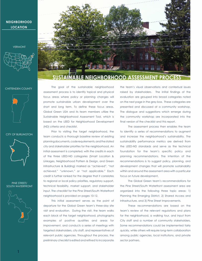
VERMONT
CHITTENDEN COUNTY
CITY OF BURLINGTON
PINE STREET/SOUTH WATERFRONT
The goal of the sustainable neighborhood
assessment process is to identify topical and physical
focus areas where policy or planning changes will
promote sustainable urban development over the
short and long term. To define these focus areas,
Global Green USA and its team members utilize the
Sustainable Neighborhood Assessment Tool, which is
based on the LEED for Neighborhood Development
(ND) criteria and checklist.
Prior to visiting the target neighborhood, the
team conducts a thorough baseline review of existing
planning documents, code requirements, and the stated
city and stakeholder priorities for the neighborhood. An
initial assessment is completed, with the credits in each
of the three LEED-ND categories (Smart Location &
Linkages, Neighborhood Pattern & Design, and Green
Infrastructure & Building) marked as “achieved”, “not
achieved,” “unknown,” or “not applicable.” Each
credit is further ranked for the degree that it correlates
to regional or local policy priorities, regulatory support,
technical feasibility, market support, and stakeholder
input. The checklist for the Pine Street/South Waterfront
neighborhood is provided on pages 10-12.
This initial assessment serves as the point of
departure for the Global Green team’s three-day site
visit and evaluation. During the visit, the team walks
each block of the target neighborhood, photographs
examples of positive qualities and areas for
improvement, and conducts a series of meetings with
targeted stakeholders, city staff, and representatives of
relevant public agencies. Throughout the process, the
preliminary checklist is edited and refined to incorporate
the team’s visual observations and contextual issues
raised by stakeholders. The initial findings of the
evaluation are grouped into broad categories noted
on the next page in the grey box. These categories are
presented and discussed at a community workshop.
The dialogue and suggestions which emerge during
the community workshop are incorporated into the
final version of the checklist and this report.
The assessment process then enables the team
to identify a series of recommendations to augment
and increase the neighborhood’s sustainability. The
sustainability performance metrics are derived from
the LEED-ND standards and serve as the technical
foundation for the team’s specific policy and
planning recommendations. The intention of the
recommendations is to suggest policy, planning, and
development changes that will promote sustainablity
within and around the assessment area with a particular
focus on future development.
The Global Green team’s recommendations for
the Pine Street/South Waterfront assessment area are
organized into the following three topic areas: 1)
Planning the Emerging District, 2) Shared Access and
Infrastructure, and 3) Pine Street Improvements.
These recommendations are based on the
team’s review of the relevant regulations and plans
for the neighborhood, a walking tour, and input from
City staff and a number of community stakeholders.
Some recommendations could be implemented fairly
quickly, while others will require long-term collaboration
among public agencies, local institutions, and private
sector partners.
NEIGHBORHOOD LOCATION
SUSTAINABLE NEIGHBORHOOD ASSESSMENT PROCESS

2
The Pine Street / South Waterfront assessment
area lies just south of Burlington’s downtown along
the eastern shore of Lake Champlain. The assessment
area is bounded by Maple Street to the north; the back
lot line of Pine Street parcels to the east; Flynn Ave to
the south; and the Lake Champlain to the west. It
encompasses a number of distinct sub-areas including
the Railyard Enterprise Project Area in the north; the
Pine Street Arts District corridor; the Barge Canal
Superfund Site; the Lakeside/Sears Lane industrial area
in the center; the Lakeside neighborhood to the west;
and the Flynn Ave industrial area in the south.
At present the area has a mix of industrial,
residential and commercial land uses, a rail yard, and
a historic canal. The City has received a separate
EPA Brownfield Area Wide Planning Grant to advance
planning in the area. Some portions of the assessment
area- particularly in the Barge Canal area- have legal
Institutional Controls (ICs) that serve as deed restrictions
that run with the land, imposing groundwater and land
use restrictions on the site and on parcels adjacent to
the site, thus limiting its development potential.
The Pine Street corridor is a hub for Burlington’s arts
and creative culture community. With the exception of
the historic Lakeside residential neighborhood in the
southwest, the majority of the area is zoned as an
enterprise area intended to serve a variety of non-
residential uses.
Improved multi-modal access is critical to the
continuing emergence of the district. The long planned
Champlain Parkway project aims to reduce truck traffic
on South End neighborhood streets by connecting
the mixed use areas along Pine Street and Lakeside
with I-189, while establishing Pine Street as an urban
street. In the northern portion of the assessment area,
the Railyard Enterprise Project (REP) aims to support
economic development and improved livability by
expanding the urban street grid with complete street,
multi-modal connections. The REP sits just south of the
Battery-King Historic District and is bounded by Maple
Street (north); Pine Street (east); Marble Ave (south)
and the Lake (west).
Additionally, the City recently completed
PlanBTV- Downtown and Waterfront. Funded through
HUD’s Sustainable Communities Challenge Grant (2010),
PlanBTV is the land use and development plan for the
northern segment of this assessment area. Currently
there is not a set vision for the remaining portion
of the Pine Street/South Waterfront area, although
ideas about an EcoDistrict have been discussed. This
assessment and recommendations aims create a vision
for the area.
Pine StreetCategory: Smart Location & Linkages Bicycle Network & Storage (credit 4)Category: Neighborhood Pattern & Design Walkable Streets (prerequisite & credit 1) Connected and Open Community (prerequisite 2) Street Network (credit 6) Mixed-Use Neighborhood Center (credit 3) Transit Facilities (credit 7) Access to Civic and Public Spaces (credit 9) Access to Recreational Facilities (credit 10) Community Outreach and Involvement (credit 12) Neighborhood Schools (credit 15)
HousingCategory: Neighborhood Pattern & Design
Mixed-Income Diverse Communities (credit 4) Access to Civic and Public Spaces (credit 9) Access to Recreation Facilities (credit 10) Community Outreach and Involvement (credit 12) Tree-Lined & Shaded Streets (credit 14)
Housing cont’dCategory: Green Infrastructure & Building Certified Green Building (prerequisite & credit 1) Building Energy Efficiency (credit 2) Water Efficient Landscape (credit 4) Solar Orientation (credit 10)
Parks & WaterfrontCategory: Green Infrastructure & Building Certified Green Building (prerequisite & credit 1) Construction Activity Pollution Prevention (prerequisite) Water Efficient Landscape (credit 4) Min. Site Disturbance in Design and Construction (credit 7) Solar Orientation (credit 10) Infrastructure Energy Efficiency (credit 13) Wastewater Management (credit 14) Recycled Content in Infrastructure (credit 15) Solid Waste Management Infrastructure (credit 16) Light Pollution Reduction (credit 17)
NEIGHBORHOOD ASSESSMENT FOCUS AREAS Related LEED-ND Credits
NEW INVESTMENT
NEIGHBORHOOD HIGHLIGHTS
CREATIVE CULTURE
MATURE STREET TREES
JOBS
NATURAL FEATURES
The team concentrated on these three focus areas during the community workshop. The related LEED-ND criteria influenced the specific recommendations found on the following pages.
NEIGHBORHOOD BACKGROUND & CATALYTIC PROJECT

3
South Waterfront
Recom
mendation
R E S P O N S I B L E D E P A R T M E N T SLead by DPZ; support from
CEDO, and DPW
1Continue planning for the south waterfront
The southern end of the study area, from the
edge of the Superfund site down to Flynn Avenue,
represents Burlington’s biggest infill development
opportunity. It is in close proximity to downtown and
has regional connections that will be enhanced with
the construction of the new Champlain Parkway to
I-189. Its prime location, large parcels, and adjacency
to the emerging Pine Street Corridor give it the kind of
economic and cultural cache that entices developers
to move quickly on a parcel-by-parcel basis.
A parcel-by-parcel strategy, particularly with
in area where housing is prohibited, is likely to end
up with a hodge-podge of large single use buildings.
The opportunity to create a lively, walkable mixed
use district would be lost for decades. Therefore it
is important for the City to “get out in front” of
development, be pro-active, and provide leadership
in Place Making, with both a philosophy and a process
centered around viewing this place in its entirety, rather
than zeroing in on isolated fragments of the whole.
LEED-ND provides several clues as to what
elements should be incorporated into a complete
neighborhood – a mix of uses at sufficient densities
to support local businesses and amenities, attention
to walkability in the public realm, a connected
street network, overt inclusion of green infrastructure
and buildings – but does not provide a planning
process for implementing these concepts. A detailed
and comprehensive planning process like PlanBTV
would provide these missing links, but is unlikely to be
completed in time to respond to growing development
pressures and key district building opportunities due
to the typical planning time-frame and uncertain
project funding. Therefore the Global Green team
suggests a short but intensive planning process, taking
a maximum of six months, and structured to include the
action items on the following page.
1. PLANNING THE EMERGING DISTRICT

4Pine Street / South Waterfront planning area
• Short, Intensive Planning Process. Implement a week-
long charrette that strongly adheres to National
Charrette Institute principles and guided by planning
and design professionals who have experience in
General Urban and Urban Center type places (T-4
and T-5 respectively, in the New Urbanist Transect
Typologies).
• Temporary Development Moratorium. Consider an
interim moratorium on any development in the this
area end until this expedited planning process is
complete.
• Community Representation. Ensure that the
community-based charrette explicitly include
two groups who the Global Green team senses
are under-represented in the planning process
in Burlington – the Resettlement Community and
major landowners/developers. This will ensure that
the outcome of the process will be inclusive but
grounded in market-based reality.
• Shared Infrastructure Planning. Ensure that the shared
infrastructure proposals for parking and stormwater
management detailed elsewhere in this document
are fully explored. They need to be embedded in
planning outcomes, not added on later.
• Specific Outcomes. Include a street network and
hierarchy within the plan area, a designed activity
hub, locations of public open space, housing
diversity considerations and multiple safe pedestrian
routes to area schools, parks, open space, and job
centers.
• Incorporate Arts. Include high-visibility art installations
into the planning and design process, either as
stand alone pieces or as part of functional elements
such as signs, streetscape, neighborhood gateways,
wayfinding, and pedestrian crossings.
Recommendation 1 - Action Items
1. PLANNING THE EMERGING DISTRICT

5
2R
ecomm
endation
Existing conditions of Englesby creek
There are a number of communal assets in
the study area, particularly Lake Champlain, waterfront
beaches, and the lakeside bike trail. A number of
low-cost opportunities for increased access to these
assets are identified. Over the longer-term, creating
new communal assets such as shared infrastructure
for parking and storm water management will also be
critical to a sustainable future.
Focusing on these two areas – shared access
to community assets and shared infrastructure – would
only enhance the desirability of the area and connect
it to the broader Burlington community. It would also
begin to put in place the kind of communally managed
infrastructure that is the necessary backbone of an
EcoDistrict. By identifying specific LEED-ND metrics
that call for shared infrastructure, the City can identify
tangible targets and monitor progress towards general
EcoDistrict elements.
Shared approaches to stormwater
management deserves some particular attention in
the southern portion of the assessment area. Because
the area is largely impervious, development of
individual parcels will likely lead to some small increase
in perviousness, thus making stormwater permitting
relatively simple – and relatively ineffective in improving
water quality and the health of Englesby Creek. A shared
stormwater management strategy on a district scale-
where the City would build one or more centralized
water catchment locations and require developers to
use it and pay fees in lieu of on-site strategies- could be
both more cost effective and have a greater impact
on water quality.
R E S P O N S I B L E D E P A R T M E N T SLead by DPW, P&R,
CEDO; support from DPZ
2. SHARED ACCESS & INFRASTRUCTURE

6
Improve access to Oakledge Park by completing the sidewalk network and increasing pedes-trian scale lighting
Existing conditions on Flynn Avenue with incomplete sidewalk network
• Recreation Facilities. Invest in programming and
small-scale child-friendly recreational infrastructure
at the terminus of Maple Street at Perkins Pier in the
north part of the study area.
• Pedestrian Amenities. Complete the sidewalk
network, on the south side of Flynn Avenue between
Briggs Street and Island Line Trail to increase
accessibility to the Oakledge Park, and Blanchard
Beach. Additional pedestrian improvements could
include street lighting if budget is available.
• District Parking. Develop a district-wide parking
plan for the area. This plan would include not only
shared parking solutions, but modified parking
standards for new and renovated buildings,
requirements for bicycle parking, and integration
with the traffic demand management policies of
the large employers in the area.
• Stormwater. Identify and acquire parcels for district
scale stormwater management infrastructure.
These parcel acquisitions could be done in
conjunction with the land acquisition and parcel
reconfiguration effort that will take place with the
engineering and construction of the Champlain
Parkway.
• Street Network. Enhance interconnected street
network where possible to increase mobility, parcel
access, and multiple route choices between
district locations.
• District Energy Strategy. Work with Burlington
Electric Department to find opportunities for
energy efficiency, efficient and creative lighting,
shared heating and cooling, renewable energy,
and demonstration projects.
• Demonstration Projects. Implement demonstration
projects in front of public buildings fronting Pine
Street to both introduce new shared stormwater
strategies and to reduce runoff into nearby
combined storm and sewer system or at the central
treatment plant.
Recommendation 2 - Action Items
2. SHARED ACCESS & INFRASTRUCTURE 2. SHARED ACCESS & INFRASTRUCTURE

7
3Existing conditions on Pine Street inhibiting comfortable and efficient bike and pedestrian access
R E S P O N S I B L E D E P A R T M E N T SL e a d b y D P W
w i t h s u p p o r t f r o m
C E D O , D P Z , B E D ,
B C A a n d
C C T A
The future of the Pine Street/South Waterfront
area is largely dependent on the character and
function of Pine Street. As the main thoroughfare it will
continue to provide vehicular access to downtown and
to southern portions of the City, but a redesigned Pine
Street could create a neighborhood identity while also
serving multi-modal needs within the community.
LEED-ND provides a number of standards
that can help to create a safe and comfortable street
for its surrounding uses and users. At present the street
is conducive to speeding cars. In order to discontinue
this trend, the Global Green teams feels it is imperative
to rethink phasing of Pine Streets redesign as it relates
to the Champlain Parkway. Rather than waiting for
the Champlain Parkway improvements to establish the
character of Pine Street in the northern portion, the
Team believes that the City should make short term
improvements starting in the north in order to carry more
of the downtown, pedestrian character into the heart
of the Pine Street Corridor. This north-to-south phased
approach to the streets redesign will encourage the City
to visualize what elements the street should have, identify
what can be done in the short term (within 12 months)
to improve the pedestrian and bicyclist experience, and
coordinate construction schedules with the parkway
project for longer term (1-3 years) capital improvements.
Once the vision for the street is set, the City
should secure funding for additional improvements
to be done in coordination with Champlain Parkway
construction to minimize disruption to area businesses.
Any added improvements would, of course, need to be
carefully advanced so as not to jeopardize the permits
and funding for the current Champlain Parkway project.
The short and long term improvements
recommended herein are based on LEED-ND principles
of walkability and urban design and can help with
placemaking and delivery of long-awaited investments
into Pine Street.
Recom
mendation
3. PINE STREET IMPROVEMENTS
8
• Pedestrian Crossings. Add pedestrian crosswalks
(ideally every 400 – 500 feet) to establish a walkable
block length and increase safe pedestrian crossing
on Pine Street.
• Separated Multi-Modal Path. Construct a separated
bike and multi-modal path approximately 10 feet
wide on the west side of Pine Street and within the
existing public right of way (see image on next
page).
• Outdoor Seating. Encourage outdoor seating
for restaurants, bars, eateries, etc., in large front
setbacks of adaptively reused buildings along the
corridor. This will activate the street, reduce traffic
speeds, and attract customers during the warm
weather months. This element of urban design
should be triggered during design review.
• Creative Lighting. Install decorative lighting along
the corridor, thus instilling a sense of arrival and a
sense of place for adjacent business owners and
patrons of neighborhood amenities.
• Calahan Park Visibility. Increase visibility of the
Calahan Park adjacent to Pine Street through
signage, lighting, landscape maintenance, and
by creating an entry to the park from Pine Street.
• Activity Hub. Identify where the hub of activity will
be for the corridor and implement or commission
public art from local artists within the Pine Street
corridor. Include additional art pieces along the
corridor and the bike path.
• Arts and Artisan Culture. Preserve the organic
creative arts and artisan culture of the area by
incentivizing affordable space, creating more
flexible, artful, active public spaces, and promoting
innovative local businesses (consider a ban or
other restrictions on chain stores).
• Safe Routes to Schools. Identify eligible on-road
improvements for Pine Street as a Safe Routes
to Schools project, availing the area to federal
funding through the Transportation Alternative
Program. Improvements can include sidewalks,
bicycle infrastructure, pedestrian and bicycle
signals, traffic calming techniques, lighting and
other safety –related infrastructure projects.
• Transit Facilities. Work with CCTA (the local transit
agency) to install transit shelters with lighting, seats,
coverage from the elements, and bicycle racks.
• Transit Service. Identify funding to extend transit
service hours in the area for residents that are
transit dependent.
• Traffic-Calming and Intersection Treatments.
Investigate intersection and traffic calming
improvements. For example consider a traffic
circle or other alternative design to address sub-
standard conditions at Pine Street and Lakeside
Avenue. Or consider some type of traffic calming
on the streets adjoining Calahan Park.
Recommendation 3 - Action Items
Short Term: Long Term:
3. PINE STREET IMPROVEMENTS

9
Rendering of Pine Street perspective showing separated multi-modal path, bus shelters, pedestrian crossings and stop lights
Existing condition of Pine Street without separated multi-modal path
3. PINE STREET IMPROVEMENTS

10
LEED-N
D C
hecklist
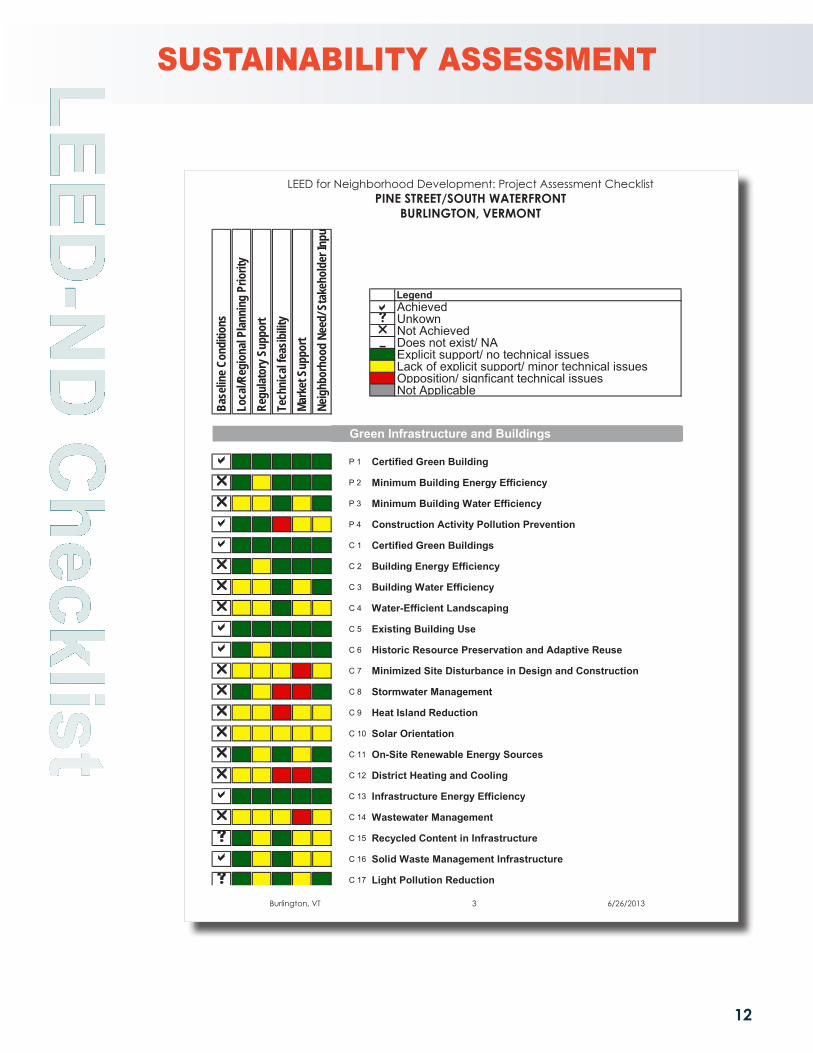
The Sustainable Neighborhood Assessment tool includes an annotated LEED-ND checklist created by
Global Green. It is a key component of the process used to document and compare the assessment area against
the LEED-ND prerequisites and credits. Each credit within the three credit categories (Smart Location & Linkage,
Neighborhood Pattern & Design, and Green Infrastructure & Building) is marked as “achieved,” “not achieved,”
“unknown,” or “not applicable” under baseline conditions. Additional analysis has been done based on local
planning policy, regulatory support, technical feasibility, market support and stakeholder input. The preliminary
checklist analysis was edited and augmented during our site visit, stakeholder meetings, and after the community
workshop. This information was then translated into an overall assessment of sustainable neighborhood performance.
Burlington, VT 1 6/26/2013
LEED for Neighborhood Development: Project Assessment Checklist
2 8/20/2013
Legend Achieved Unkown Not Achieved Does not exist/ NA
Explicit support/ no technical issuesLack of explicit support/ minor technical issuesOpposition/ signficant technical issuesNot Applicable
Smart Location and Linkage
P 1 Smart Location
P 2 Imperiled Species and Ecological Communities
P 3 Wetland and Water Body Conservation
P 4 Agricultural Land Conservation
P 5 Floodplain Avoidance
C 1 Preferred Locations
C 2 Brownfield Redevelopment
C 3 Locations with Reduced Automobile Dependence
C 4 Bicycle Network
C 4 Bicycle Storage
C 5 Housing and Jobs Proximity
C 6 Steep Slope Protection
C 7 Site Design for Habitat or Wetland and Water Body Conservation
C 8 Restoration of Habitat or Wetlands and Water Bodies
C 9 Long-Term Conservation Management of Habitat or Wetlands an
Total 0
Total Points
Required
Required
Required
Required
Required
Neig
hbor
hood
Nee
d/ S
take
hold
er In
put
Tech
nica
l fea
sibilit
y
Base
line C
ondi
tions
Loca
l/Reg
iona
l Plan
ning
Prio
rity
Regu
lator
y Sup
port
Mark
et S
uppo
rt
SUSTAINABILITY ASSESSMENT
LEED for Neighborhood Development: Project Assessment ChecklistPINE STREET/SOUTH WATERFRONT
BURLINGTON, VERMONT

11
LEED-N
D C
hecklist
Burlington, VT 2 6/26/2013
LEED for Neighborhood Development: Project Assessment Checklist
3 8/20/2013
Legend Achieved Unkown Not Achieved Does not exist/ NA
Explicit support/ no technical issuesLack of explicit support/ minor technical issuesOpposition/ signficant technical issuesNot Applicable
Neighborhood Pattern and Design
P 1 Walkable Streets- Principal Entries
P 1 Walkable Streets- Building Height to Street Width Ratio
P 1 Walkable Streets-Continuous Sidewalks
P 1 Walkable Streets-Garage and Service Bays
P 2 Compact Development
P 3 Connected and Open Community
C 1a Walkable Streets : Facades and Entries
C 1b Walkable Streets: Ground-Level Use and Parking
C 1c Walkable Streets:Design Speed for Safe Ped and Bike Travel
C 1d Walkable Streets: Sidewalk Intrusions
C 2 Compact Development
C 3 Mixed-Use Neighborhood Centers
C 4 Affordable Housing
C 4 Housing Diversity
C 5 Reduced Parking Footprint
C 6 Street Network
C 7 Transit Facilities
C 8 Transportation Demand Management
C 9 Access to Civic and Public Spaces
C 10 Access to Recreation Facilities
C 11 Visitability and Universal Design
C 12 Community Outreach and Involvement
C 13 Local Food Production
C 14 Tree-Lined and Shaded Streets
C 15 Neighborhood Schools
Required
Required
Required
Required
Required
Required
Base
line C
ondi
tions
Loca
l/Reg
iona
l Plan
ning
Prio
rity
Regu
lator
y Sup
port
Tech
nica
l fea
sibilit
yMa
rket
Sup
port
Neig
hbor
hood
Nee
d/ S
take
hold
er In
put
LEED for Neighborhood Development: Project Assessment ChecklistPINE STREET/SOUTH WATERFRONT
BURLINGTON, VERMONT
SUSTAINABILITY ASSESSMENT
12
LEED-N
D C
hecklist
Burlington, VT 3 6/26/2013
LEED for Neighborhood Development: Project Assessment Checklist
4 8/20/2013
Legend Achieved Unkown Not Achieved Does not exist/ NA
Explicit support/ no technical issuesLack of explicit support/ minor technical issuesOpposition/ signficant technical issuesNot Applicable
Green Infrastructure and Buildings
P 1 Certified Green Building
P 2 Minimum Building Energy Efficiency
P 3 Minimum Building Water Efficiency
P 4 Construction Activity Pollution Prevention
C 1 Certified Green Buildings
C 2 Building Energy Efficiency
C 3 Building Water Efficiency
C 4 Water-Efficient Landscaping
C 5 Existing Building Use
C 6 Historic Resource Preservation and Adaptive Reuse
C 7 Minimized Site Disturbance in Design and Construction
C 8 Stormwater Management
C 9 Heat Island Reduction
C 10 Solar Orientation
C 11 On-Site Renewable Energy Sources
C 12 District Heating and Cooling
C 13 Infrastructure Energy Efficiency
C 14 Wastewater Management
C 15 Recycled Content in Infrastructure
C 16 Solid Waste Management Infrastructure
C 17 Light Pollution Reduction
Project Totals (Certification estimates)Certified: 40-49 points, Silver: 50-59 points, Gold: 60-79 points, Platinum: 80+ points
Required
Required
Required
Required
Loca
l/Reg
iona
l Plan
ning
Prio
rity
Regu
lator
y Sup
port
Tech
nica
l fea
sibilit
yMa
rket
Sup
port
Neig
hbor
hood
Nee
d/ S
take
hold
er In
pu
Base
line C
ondi
tions
LEED for Neighborhood Development: Project Assessment ChecklistPINE STREET/SOUTH WATERFRONT
BURLINGTON, VERMONT
SUSTAINABILITY ASSESSMENT

13
LEED-N
D Score
Based on in-field assessment, planning document review, various stakeholder meetings, and the
community workshop, the Global Green team estimated which LEED-ND credits were “Likely,” “Possible with Effort,”
“Unlikely” to be achieved, or “Not Applicable,” considering existing conditions, technical feasibility, policy readiness,
financial burden, and applicability to neighborhood conditions. The bar graph summary identifies the overall level
of sustainable neighborhood performance for the Pine Street/South Waterfront area, while a high percentage of
credits fall into the “Likely” category. Of the remaining credits, a significant percentage fall within the “Possible with
Effort” category, which shows the large potential for improving the sustainability of the South Waterfront specifically
by pursuing the high-priority recommendations described in this report.
The summary table below shows the numeric values extrapolated from the percentage of credits
identified as “Likely” below. While these values do not correlate exactly to specific LEED-ND points, they provide
an estimate of the neighborhood’s potential level of future achievement. It should be noted that this is a rough
measure of performance and not an exact representation of the project’s level of possible certification. It should
also be noted that all the prerequisites need to be achieved if certification will be pursued.
“Likely”
“Possible with Effort”
“Unlikely”
Legend
“Not Applicable”
Point Requirements for LEED-NDCertificationCertified: 40-49
Silver: 50-59
Gold: 60-79
Platinum: 80+
Smart Location and Linkages
Neighborhood Pattern and Design
Green Infrastructure and Building
City of Burlington
LEED for Neighborhood Development
Total Achievable Possible27 13 11
44 25 16
29 13 13
100 51 40
Green Building and Infrastructure
Neighborhood Pattern and Design
Smart Location and Linkage
48% 40% 12%
SLL
56% 37% 7%
NPD
46% 46% 8%
GIB
SUSTAINABILITY ASSESSMENT

14
Com
munity Input
An evening Public Workshop was held on June 27th in the VEIC “Town Hall” meeting room at 128 Lakeside Avenue.
About 50 attendees split up into self-selected groups focusing on 1) access to the waterfront; 2) integrating housing
into the district; and 3) improving Pine Street as a neighborhood asset. The following notes represent the summary
report of each of the three groups.
WORKSHOP NOTES

This Page Is Intentionally Left Blank

Greenurbanism program
2218 Main StreetSecond FloorSanta Monica, CA 90405310.581.2700 ph310.581.2702 faxwww.globalgreen.org
Sustainable Neighborhood
Assessment Team
Global Green USA
Ted BardackeHagu Solomon
Raimi +Associates
Aaron Welch
US Green Bui lding Council
Robyn Eason