Embed Size (px)
Citation preview
RECOVERY OF BYPASSED OIL IN THE DUNDEE FORMATION USING HORIZONTAL DRAINS
Cooperative Agreement No. : DE-FC22-94BC 14983
Contractor Name and Address: Michigan Technological University, 1400 Townsend Drive, Houghton, MI 4993 1-1295
Date of Report: 1 January 1997
Award Date: 28 April 1994
Anticipated Completion Date: 27 April 1997
Government Award for Current Fiscal Year: $800,000. (-J$TI Principal Investigator: James R. Wood (906) 487-2894
Project Manager: Chandra Nautiyal, Bartlesville Project Office (9 18) 337-44 1 8
Reporting Period: October 1, 1996 - December 3 1, 1996
:-.. . .< _I
t? \:
1
DISCLAIMER
This report was prepared as an account of work sponsored by an agency of the United States Government Neither the United States Government nor any agency thereof, nor any of their employees, make any warra~ty, express or implied, or assumes any legal %ab%- ty or mpon6bility for the accuracy, completeness, or usefulness of any information, appa- ratus, product, or process disdosed, or reprewits that its use would not infringe privately owned rigbtc Refmnce herein to any specitlc commercial product, process, or service by trade oame, trademark, manufacturer, or otbenvise does not necessarily constitute or imply its endorsement, recommendation, or favoring by the United States Government or any agency thereof. The views and opinions of authors expressed herein do not necessar- ily state or reflect those of the United States Government or any agency thereof.
Portions of this document may be illegible in electronic image products. Smages are produced from the best available original document.
OBJECTIVE
The principal objective of this project is to demonstrate the feasibility and economic success of producing oil from abandoned or nearly abandoned fields in the Dundee Formation of Central Michigan using horizontal drilling technology.
A site for a horizontal well was selected in Crystal Field, a nearly-abandoned Dundee oil field in Michigan. This field had produced over 8 million barrels of oil, mostly in the 1930's and 1940's. At the height of development, Crystal Field produced from 193 wells, but by 1995, only seven producing wells remained, each producing less than 10 bblslday.
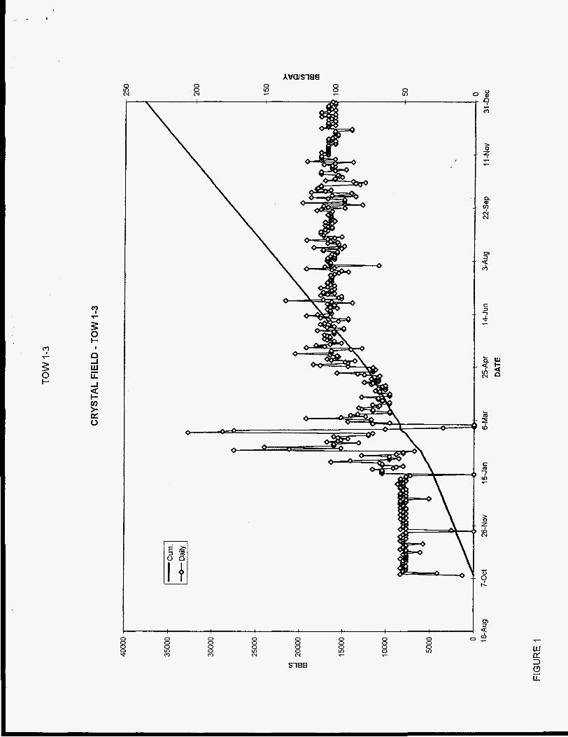
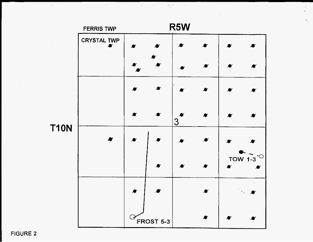
A horizontal well was drilled as a field demonstration pilot, hnded through this DOE project, and was successhl. It has produced over 37.000 bbls of oil as of December 3 1, 1996 at sustained rate of -100 bbls/dav (Figure 1). At a nominal wellhead price of $20/bbl, this well has made about $750,000 and is still going strong. Two additional horizontal wells have just been completed and are on test (Figure 2). Core and logs from the Dundee intervd were recovered from a vertical borehole at the same surface location. The horizontal well was brought on production at a rate of 100 bbls/day and is probably capable of producing at a higher rate. The addition of several horizontal wells, similar to the demonstration well, will likely add another 2 million bbls (or more) to the cumulative production of the field over the next few years. The presence of untapped oil in this Dundee field was dramatically demonstrated and the favorable economics were made clearly evident. If other abandoned Dundee fields are re-developed in a similar manner, the additional oil produced could exceed 80 million barrels. Horizontal drilling will likely revolutionize the development of old carbonate fields such as those in the Dundee of Michigan.
Additional project work comprises characterization of 30 other Dundee fields in Michigan to aid in determining appropriate candidates for development through horizontal drilling. Further quantification of reservoir parameters such as importance of fracturing, fracture density, and irregularity of the dolomitized surface at the top of the reservoir will help in designing the optimal strategy for horizontal drilling.
Technology transfer takes place continuously, through the Michigan Oil Field Research Consortium (MOFRC) and its Newsletter. Reviews in the popular press have helped reach additional audiences. The success of the demonstration well has been recognized by independent operators, who have requested copies of information published the Newsletter, and who have expressed interest in attending workshops which are being planned for this year. The creation of an electronic "Atlas of Michigan Dundee Reservoirs" is planned as a addition to this project. The Atlas will greatly enhance the capability of small operators in the state to independently explore and develop this neglected resource.
SUMMARY OF TECHNICAL PROGRESS BY TASK BUDGET PERIOD
TASK 1 PROJECT MANAGEMENT
1.1 COORDINATION
In October, J. Wood and W. Pennington from MTU and W. Harrison and graduate student H. Wines from WMtr gave a workshop on the TOW 1-3 demonstration well, Crystal Field, at the monthly meeting of the Michigan Oil and Gas Association (MOGA) in downstate Michigan. Various members of the project staff attend the MOGA MFeting each month.
1.2 BUDGET AND REPORTS
M. Gruener and A. Hein are responsible for daily management of the budget and expenditures. A. Hein is responsible for preparation of quarterly financial reports and for distribution of all reports to DOE. J. R. Wood has taken over responsibility for the quarterly and annual reports from J. R. Allen. Allen has terminated his relationship with the project to concentrate on consulting activities. Jack did an excellent job for the project and we wish him well.
TASK 2 RESERVOIR CHARACTERIZATION During the fall of 1995, the demonstration well for this project, the TOW No. 1-3 well in Crystal Field has continued to produce from about 75 to 120 BOPD. Currently the well is producing at the 100 BOPD level and has produced 37,528 bbl of oil through December, 1996. The water cut remains at 0% and pressure has been maintained at 1445 psi by an active water drive.
Cronus Development Co. drilled another horizontal well at Crystal Field, the Frost 5-3, as a follow-up to the TOW 1-3. This well achieved the planned lateral length of 1900 feet and is currently being tested, Plans are in progress to drill 2 additional horizontal wells in the Dundee in Crystal Field in the January-February timeframe. Some lost circulation occurred in the Frost 1-3 and this fluid is currently being returned on test. Underbalanced drilling, in which the formation is allowed to flow during driIling, was not used although we strongly recommended this technology be used. We will continue to press for this in kture wells. Coiled tubing technology, which minimizes time-consuming trips in and out of the hole, is also being considered. Given that 4-7 more wells are scheduled for Crystal, the chances are good that at Ieast one of these will be drilled underbalanced and with coiled tubing.
The DOE $20,000 supplementary grant awarded MTU a to perform additional technical evaluation work on one of these wells was not be spent on the Frost 5-3, but will be spent on one of the next wells.
2.1 CORE AND LOG ANALYSIS
3
Graduate student €I. Wines at WMU completed X-ray diffraction analyses of samples from the TOW 1-3 core collected on a foot-by-foot basis during this quarter. She also X- rayed selected core samples of dolomitized Dundee reservoir recovered from other fields in central Michigan. She is currently comparing mineralogical data to thin section petrography and plans to complete her M.S. thesis on the Dundee at the end of this semester.
2.2 DATA MEASUREMENT AND ANALYSIS
Seismic Data over Dundee Fields:
We have received several seismic (2-D) lines over the Crystal field, run in 1987 by a major oil company, for research and teaching use. Although the use of seismic data was not considered in the original contract, we felt, with the encouragement of the operators in the Michigan basin, that it was worth pursuing in any case. We also retrieved the COCORP data obtained in Michigan in the late 1970’s (public domain data, originally funded by NSF). The COCORP lines do not cross Crystal field, but at least one intersects the proprietary data we have received, so we should be able to calibrate the lines to each other.
MTU is still developing the capability to process and interpret seismic data, using the Colorado School of Mines processing package, Seismic UNIX, and the GeoGraphix interpretation package, SeisVision. In the meantime, we have cooperated with other groups for investigations with these data. Of most interest to date is a visit to the Urals State Academy of Mining and Geology in Ekaterinburg, Russia (funded by the National Research Council) by Wayne Pennington to work with Dr. Vladimir Pisetski. We jointly examined two data sets, using techniques developed by Dr. Pisetski to reveal the presence of overpressured fractured zones at depth. The techniques involve the use of Hilbert- transform attributes such as instantaneous frequency, normalized along each reflecting horizon to reveal differences that may be related to fracturing and fluid pressure. The datasets studied were from Western Siberia and Michigan. The results from one of the COCORP lines are shown in an attached color figure, where the red areas in the uppermost one second (of two-way travel time) should be expected to indicate the presence of fractured rock in the Dundee and Traverse formations; the correlation, at first glance, appears good.
We look forward to continuing the investigations into the usehlness of seismic data for identifying fractured zones in the carbonate rocks of Michigan.
Production data for the 30 project fields is now available to the public on the Internet at either:
http://www.geo.mtu.edu/svllmichproj/
or
http://www. wmich. edu/geology/corelablcoreres. html.
TASK 3 DATABASE MANAGEMENT DATABASE MANAGEMENT
During this quarter, we started to make our research presentations available on the Internet. We found that Asymetrix Toolbook had a plug-in for viewing Toolbook applications online, but too many of the features would not work correctly. Instead of duplicating our efforts by bringing data into Toolbook and also constructing a Web page with the same data, we made the decision to drop Toolbook and Put everything on the Web page using. HTML codin?.
For our end users who do not have Internet access, we can put all of our files and HTML code onto a CD-ROM with Microsoft’s Internet Explorer as a browser. Microsoft Internet Explorer is available for us to re-distribute royalty-free as long as we register the number of copies we distribute on a quarterly basis and we must use the Microsoft Internet Explorer Logo on our Web page.
The direct address to our Michigan Project data is
http://www.geo.mtu.edu/svl/michproj/
The following information is now available on our Web site above:
1.
2.
3 .
4.
5 .
6.
7.
8.
9.
The quarterly and annual reports to date.
Maps of the project study area.
Table of general information of all the oil fields in our project.
Autocad Maps, production graphs and tables for 14 of the 30 fields in the project.
structure contour and isopach maps of Michigan
Stratigraphic column of the Michigan formations.
Example Driller’s Log
Charts, graphs, diagrams, and core photos for the horizontal well, TOW 1-3
A Download section where project data files are available for downloading.
3.1 TOPICAL REPORTS
We are continuing to acquire data on Michigan Gas and Oil Fields and as the data come in they are reformatted and put out on the Internet. See above for addresses.
3.2 DUNDEE ATLAS
of isopach maps was produced encompassing all the formations in the Michigan Basin. Of the 50 formation isopachs produced, only nine were made using data from fewer than 1000 wells. A second series of isopach maps was produced based on formation ages. Of the 13 isopachs produced, four were created using data from fewer than 1000 wells. Underway is 4 project to produce a complete series of structure contour maps for all the formations in the basin. At this time roughly 50% of the structure maps have been completed,
Using GeoGraphix software and the Aangstrom Precision Corp. database, a series
The planned electronic “Atlas of Michigan Dundee Reservoirs” is now underway. This Atlas presently includes a regional overview of Dundee structure, thickness and production history for about 20 fields. A paper copy of the atlas may be produced if there is sufficient interest; if so, the Michigan Basin Geological Society has expressed interest in publishing it.
3.3 PSEUDO-SEISMIC VISUALIZATION
MatLab programs to visualize the Michigan Basin in 2D and 3D continue to be deveioped. This past quarter two “M-files” have been written that do the following:
1 . hzst2D subdivides an area bounded by given lat-long coordinates into a user-controlled grid size and determines the number of elements in grid element as well as the minimum, median and maximum values. This is useful for taking the lat-long coordinates of a large number of wells and determining the number of wells in a specified lat-long box as well as the minimum, median and maximum values of, say, formation tops.
2. interp2D takes the output from hist2D and fills in missing data by 2D interpolation.
In this manner we are able to reduce the large Aangstrom dataset (50,000-t well) which tends to be severely clustered (i.e. many wells in small region) to a more manageable subset that covers the entire state and permits rapid construction of structure and isopach maps in programs such as GeoGraphix as well as MatLab.
The MatLab “pseudo-seismic” project is well underway. MatLab code has been written which import SP and gamma ray-logs and plots arrays logs whose amplitudes have been
6
color-coded to resemble seismic amplitude traces (“pseudo-seismic” log arrays). These logs can easily be selected from a map-view window and then displayed as individual well-log or pseudo-seismic cross sections. This capability adds another useful dimension to our visualization capabilities. We are still trying to write MatLab code to take in LAS and well-location data so that log data in any form from any area can be input to the program..
TASK 4 MODELING I
,/‘
4.1 GEOCHEMICAL MODELING
The geochemical modeling program is currently concentrating on waterhrine compositions for the Michigan oil fields.
4.2 BASIN MODELING
Modeling of thermal and burial histories in the Michigan Basin is proceeding. A finite-difference solution to the one-dimensional heat conduction equation is being debugged. This program will produce the thermal histories consisting of burial vs. time, temperature vs. time, Time Temperature Indices, vitrinite reflectance data, and the maturation index of type IJI, and 111 kerogens. Data from several wells has been formatted for use in the program.
TASK 5 TECHNOLOGY TRANSFER This task involves the transfer of information and useful products derived from this study to our target audience, the oil industry.
Internet Homepaee
The Dundee Project Internet Homepages for Michigan Tech and Western Michigan University can be reached at:
Project data and figures on the Homepage can be downloaded by interested parties.
Both the Michigan Tech and WMU have set up servers for the Michigan DOE Project as an FTP site. At present, it contains zipped files which include all Autocad maps generated
7
by the project as well as Excel spreadsheet files containing production information and other data . The Western Michigan address is FTP://141.218.61.24. The Michigan Tech address is the same as above for the Internet Homepage.
5.1 MICHIGAN OIL FIELD RESEARCH CONSORTIUM (MOFRC)
A new issue of the MOFRC NewsZetter is being prepared for release in the ls* quarter of 1997.
5.2 REPORTS
PROFESSIONAL PAPERS AND PRESENTATIONS
A poster titled "Subsurface Databases: Graphical Display and Error Detection for Stratigraphic Interpretation in the Michigan Basin" was presented at the 1996 GSA Annual meeting in Denver, CO. October 28'h. The poster included the graphical display of information derived from the FORTRAN lithology extraction program (LithLog) written previously. The poster included sections on the utility of this type of lithology display for detecting errors in the database as well as its usefulness in correlating sequences in the basin. Further, the lithology log display was combined with more conventional logs, e.g. gamma ray and neutron density, resulting in a vivid graphical display which would prove quite useful as a tool to facilitate the recognition of conventional log responses to different lithologies.
In the March, 1997 issue of The Leading Edge (Society of Exploration Geophysics), Wayne D. Pennington will have an article "Seismic Petrophysics: An Applied Science for Reservoir Geophysics". This 4-page paper is written in non-technical language, and introduces a new term, seismic petrophysics, to the geophysical community, referring to "the careful and purposeful use of rock physics data and theory in the interpretation of seismic observations". The paper compares this approach with "seismic alchemy" and "metaphysics" and includes examples, one involving a scam to get rich quick from predicting the stock market as an analogy. It is a somewhat light-headed paper with a serious intent: to emphasize the practical aspects of fitting theory with observation in seismic interpretation.
5.3 CD ROM AND MEETINGS
As mentioned above, J. E. Huntoon and W. Everham presented a paper and a poster at the annual GSA meeting in October.
5.4 WORKSHOPS
8
A Workshop was held at the Michigan Oil and Gas Association’s (MOGA) monthly meeting on October 17, 1996 to present the results of this Class 2 Reservoir Project to the Michigan independent oil and gas community. J. Wood and W. Harrison made oral presentations. Two different poster displays were also presented, one by J. Wood and W. Pennington of MTU and a second by W. Harrison and H. Wines of WMU. The core fiom the TOW 1-3 welI, which has been preserved in wooden boxes, was brought down fiom MTU and put on display. More than 40 representatives of the Michigan independent petroleum industry attended. A handout which contained a project overview and, information on Crystal Field was distributed. Notebooks containing field maps, ’ production history data, and well statistics were on display and were examined closely by many of the independents. Chandra Nautiyal, our DOE program officer, who encouraged us to hold this Workshop, attended the meeting.
9
FIGURE CAPTIONS Figure 1. Production history for the TOW 1-3 horizontal well at Crystal Field showing
daily and cumulative production for the period October 7, 1995 to December 31, 1996.
Figure 2.Location map showing sites for the new horizontal well drilled at Crystai Field in December, 1996. The first horizontal well , the TOW 1-3, is shown by the dashed line in the block labeled “TOW 1-3”. Symbols show locations df development wells.
10
0 Ln 0 8
c!
0 0 0 m
0 0 0
0 0 0 m
0 0 0 0 N
0 0 0 0
0 m 0 m 0 0 z
0 0 0 m
F
0 0 0 s 0
SlHH
R5W FERRIS TWP ~~
CRYSTAL NVP Y # x Y Y Y Y
Y Y
Y Y Y
# Y Y Y Y Y
Y Y Y #
3 II #
T I ON Y II Y #
Y
k
%OST 5-3
Y Y Y
0- - '0 TOW 1-3
Y Y Y Y
Y '-. ry
Y Y Y


![Effect of Horizontal Drains on Upstream Slope Stability ... · upstream slope and making the equipotential lines tend to become horizontal. This effect is shown in figure 5. [5] Duncan](https://img.pdfslide.net/doc/110x75/600eca95e86f657b4b16071a/effect-of-horizontal-drains-on-upstream-slope-stability-upstream-slope-and-making.jpg)