Embed Size (px)
Citation preview

Suffolk
NHNH
RIRI
L a k e n t a r i o
L a k e E r i e
Seneca
Chen
ango
Washington
Livingston
Herkimer
Clinton
St. FranklinC A N A D A Lawrence VV TT Heritage Trail Sites NN YY
French and Indian Jefferson EssexAbraham Lincoln AdirondackRevolutionary War Park Theodore Roosevelt Underground Railroad O
Lewis Warren
HamiltonWomen Oswego OneidaMonroe 81Niagara Orleans
Fulton SaratogaWayneGenesee 90290
Onondaga Madison MontgomerySchenectady
Ontario CayugaCortland OtsegoYatesErie Wyoming Rensselaer
Tompkins Schoharie AlbanyChautauqua 390Cattaraugus MM AA
Schuyler 88
587Steuben86 Allegany Broome GreeneChemung Delaware
Ti Cat sk i l lPa rk
Columbiaoga Ulster
Trails DutchessExisting Long Distance Trails Sullivan 87 CC TTProposed Long Distance Trails Existing Greenway Trails
PutnamPPAA Proposed Greenway Trails Orange Existing Water Trails Proposed Water Trails Westchester Signed On-road Bicycle Route Rockland
0 12.5 25 50Miles
NN JJ Boundary of Area of National Park System Properties Figure 2.12: Parks and Recreational ResourcesInterest for Visual Resources National ForestCounty Boundary that May be Visually SensitiveState ParkState BoundaryMajor Water Bodies Source: ESRI, 2010; USGS, 2002; NYCSCIC, 2005; NPS, 2010;
National Atlas US and USGS, 2010; OPRHP, 2011; NYSDOT, 2011
Final SGEIS 2015, Page 2-125

Final SGEIS 2015, Page 2-126
Table 2.94 - Select Trails Located within the Area Underlain by the Marcellus and Utica Shales in New York (New August 2011)
Name of Trail Type of Trail North County National Scenic Trail* • Long-distance trail of national significance Long Path* • Long-distance trail of statewide significance Finger Lakes Trail* • Long-distance trail of statewide significance Canalway Trail* • Long-distance trail of statewide significance Hudson River Valley Greenway Trail System* • Long-distance trail of statewide significance Hudson River Greenway Water Trail* • Long-distance trail of statewide significance Genesee Valley Greenway* • Long-distance trail of statewide significance The statewide Snowmobile Trail System* • Long-distance trail of statewide significance Conservation Trail* • Long-distance hiking trail of regional significance Letchworth Trail* • Long-distance hiking trail of regional significance Bristol Hills Trail* • Long-distance hiking trail of regional significance Link Trail* • Long-distance hiking trail of regional significance Shawangunk Ridge Trail • Long-distance hiking trail of regional significance
Abraham Lincoln Heritage Trail • State-designated Heritage Trail consisting of resources in Chautauqua, Onondaga, and Albany Counties
Women Heritage Trail • State-designated Heritage Trail consisting of resources in Chautauqua, Wyoming, Ontario, Seneca, and Cayuga Counties
Underground Railroad Heritage Trail • State-designated Heritage Trail consisting of resources in Wyoming, Chemung, Seneca, Cayuga, Onondaga, and Madison Counties
Revolutionary War Heritage Trail • State-designated Heritage Trail consisting of resources in Chemung, Broome Madison, Otsego Schoharie, Sullivan and Orange Counties
French and Indian Heritage Trail • State-designated Heritage Trail consisting of resources in Sullivan County
Catherine Valley Trail • Multi-use trail located within linear corridors of open space in Chemung and Schuyler Counties
Catskill Scenic Trail • Multi-use trail located within linear corridors of open space in Delaware County
Delaware & Hudson Canal Trail • Multi-use trail located within linear corridors of open space in Sullivan and Ulster Counties
Erie Canalway Trail* • Multi-use trail located within linear corridors of open space Genesee Valley Greenway* • Multi-use trail located within linear corridors of open space
Ontario Pathways Rail Trail • Multi-use trail located within linear corridors of open space in Ontario County
Orange Heritage Trail • Multi-use trail located within linear corridors of open space in Orange County
Pat McGee Trail • Multi-use trail located within linear corridors of open space in Cattaraugus County
Wallkill Valley Rail Trail • Multi-use trail located within linear corridors of open space in Ulster County Marden Cobb Waterway Trail • Recreational water route Cayuga-Seneca Canal Trail, which is a component of the larger NYS Canalway Water Trail* • Recreational water route
Chemung Basin River Trail* • Recreational water route Headwaters River Trail(s)* • Recreational water route Upper Delaware Scenic and Recreational River* • Recreational water route Proposed Triple Divide Water Trail* • Proposed recreational water route
Sources: ESRI 2010; OPRHP 2007, 2010; NPS 2010a, 2010b. * Trail traverses one or more counties

Final SGEIS 2015, Page 2-127
2.3.12.3 Natural Areas This section discusses natural areas that are considered visual resources per NYSDEC Program Policy
DEP-00-2, including state forest preserve areas; state nature and historic preserves; state or national wild,
scenic and recreational rivers (designated and potential); national wildlife refuges, state game refuges, and
state wildlife management areas; and national natural landmarks (NYSDEC 2000). These natural areas
often contain scenic areas and/or are developed partly because of their associated visual or aesthetic
qualities.
The State Forest Preserve (NYS Constitution Article XIV)
The State Forest Preserve consists of lands included in the Adirondack Forest Preserve (approximately 2.6
million acres) and the Catskill Forest Preserve (approximately 290,000 acres). These lands, which
represent the majority of all state-owned property within the Adirondack and Catskill Parks, are protected
as “forever wild” under Article XIV of the New York State Constitution. They are recognized as having
exceptional scenic, recreational, and ecological value (NYSDEC 2011a, 2011b, 2011c).
The Adirondack Forest Preserve, located entirely within the Adirondack Park boundaries, is outside the
area underlain by the Marcellus and Utica Shales in New York. The Catskill Forest Preserve, located
entirely within the Catskill Park boundaries, is located within the eastern part of this area in portions of
Delaware, Greene, Ulster, and Sullivan Counties (Figure 2.12). Lands included in the Catskill Forest
Preserve are likely to contain scenic or aesthetic areas that may be considered visual resources or visually
sensitive.
State Nature and Historic Preserves (Section 4 of Article XIV of State Constitution)
State nature and historic preserves are parcels of land owned by the state that were acquired to protect the
biological diversity of plants, animals, and natural communities, and which may provide a field laboratory
for the observation of and education in these relationships. These areas may also provide for the protection
of places of historical and natural interest, and may be used by the public for passive recreational pursuits
that are compatible with protection of the ecological significance, historic features, and/or natural character
of the areas designated as state nature and historic preserves (NYSDEC 2011d).
Eight state nature and historic preserves are located in the counties within the area underlain by the
Marcellus and Utica Shales in New York (Table 2.95). These state nature and historic preserves may
contain scenic or aesthetic areas that may be considered visual resources or visually sensitive.

L a k e n t a r i o
L a k e E r i e
Washington
Livingston
Herkimer
Clinton
FranklinC A N A D A St. VV TTLawrence
NN YY EssexJefferson
NN HHLewis
O Hamilton Warren
Oswego
Niagara Orleans 81 Oneida SaratogaMonroe FultonWayne
290 Genesee 90Ontario Onondaga Madison Montgomery
CayugaErie Wyoming Seneca SchenectadyYates RensselOtsego aerCortland Chenango
Schoharie Albany390 MM AATompkins
Schuyler 88Chautauqua Cattaraugus All 587egany Steuben Greene
86 Ti Broome Delaware ColumbiChemung oga a
PPAA Sullivan
Ulster
Orange
87 Dutchess
Putnam
CC TT RR II
Rockland Westchester
NN JJ Suffolk
0 12.5 25 50Miles
National Wildlife RefugeMajor Water Bodies National Natural Landmark Figure 2.13: Natural Areas that MayState Forest PreserveCounty Boundary National Wild and Scenic River be Visually SensitiveState Boundary State Unique Area Boundary of Area of State Wildlife Management AreaInterest for Visual Resources Source: ESRI, 2010; USGS, 2002; NYDEC, 2010; NPS, 2011;
National Atlas US and USGS, 2010
Final SGEIS 2015, Page 2-128

Final SGEIS 2015, Page 2-129
Table 2.95 - State Nature and Historic Preserves in Counties Located within the Area Underlain by the Marcellus and Utica Shales in New York (New August 2011)
County Name*
Number of State Nature and
Historic Preserves within County
Names of State Nature and Historic Preserves
Allegany 1 • Showy Lady Slipper Parcel (Town of New Hudson) Cattaraugus 1 • Zoar Valley Unique Area (Towns of Otto and Persia) Cortland 2 • Bog Brook (Towns of Southeast and Patterson)
• Labrador Hollow (Town of Truxton) Erie** 2 • Reinstein Woods (Town of Cheektowaga)
• Zoar Valley Unique Area (Town of Collins) Onondaga** 1 • Labrador Hollow (Town of Fabius) Ontario** 1 • Squaw Island (Town of Canandaigua) Yates 2 • Parish Gully (Town of Italy)
• Clark Gully (Towns of Middlesex and Italy) Total 8***
Sources: ESRI 2010; OPRHP 2008; NYSDEC 2011d. * There are no State Nature and Historic Preserves within other counties located entirely or partially within the area underlain
by the Marcellus and Utica Shales in New York. ** Only a portion of the county is located within the area underlain by the Marcellus and Utica Shales in New York. *** Labrador Hollow is in two counties (Onondaga and Cortland); Zoar Valley Unique Area is in two counties (Cattaraugus and
Erie).
Rivers designated as National or State Wild, Scenic or Recreational (16 U.S.C. Chapter 28, ECL
15-2701 et seq.)
National Wild, Scenic or Recreational Rivers are those rivers designated by Congress or the
Secretary of the Interior in accordance with the Wild and Scenic Rivers Act of 1968. The purpose
of such designation is to preserve those rivers with outstanding natural, cultural, and recreational
values in a free-flowing condition for the enjoyment of present and future generations. Wild
rivers are those rivers or sections of rivers that are free of impoundments and generally
inaccessible except by trail, with watershed or shorelines essentially primitive and waters
unpolluted. These represent vestiges of primitive America. Scenic rivers are those rivers or
sections of rivers that are free of impoundments, with shorelines or a watershed still largely
primitive and shorelines largely undeveloped, but accessible in places by roads. Recreational
rivers are those rivers or sections of rivers that are readily accessible by road or railroad, that may
have some development along their shorelines, and that may have undergone some impoundment
or diversion in the past (National Wild and Scenic Rivers System 2011a).

Final SGEIS 2015, Page 2-130
A portion of only one river, the Delaware River (also known as the Upper Delaware Scenic and
Recreational River), has been designated a National Wild and Scenic River in New York State
(National Wild and Scenic Rivers System 2011b, 2011c; NPS 2010c). This portion of the
Delaware River, located in Delaware County along the New York-Pennsylvania border, is within
the area underlain by the Marcellus and Utica Shales in New York (see Table 2.96 and Figure
2.13). Designated in part for its scenic qualities, this portion of the Delaware River contains
scenic areas that may be considered visual resources or visually sensitive.
A portion of one other water body in New York State, the East Branch of Fish Creek, located in
Lewis County, was studied for its potential for inclusion in the National Wild and Scenic Rivers
System (National Wild and Scenic Rivers System 2011d). This portion of Fish Creek is located
in Oneida County, which is partially located within the area underlain by the Marcellus and Utica
Shales in New York (Table 2.96).
Section 5(d) of the National Wild and Scenic Rivers Act of 1968 requires federal agencies to
consider the effects of planned use and development on potential national wild and scenic river
areas. In partial fulfillment of this requirement, the NPS has compiled and maintains a
Nationwide Rivers Inventory (NRI), which is a register of river segments that potentially qualify
as National Wild, Scenic or Recreational River areas (NPS 2008a).
In order to be listed on the NRI, a river must be free-flowing and possess one or more
Outstanding Remarkable Values (ORVs). In order to be assessed as outstandingly remarkable, a
river-related value must be a unique, rare, or exemplary feature that is significant at a comparative
regional or national scale. Such values must be directly river-related: located in the river or on its
immediate shorelands (generally within 0.25 mile on either side of the river); contribute
substantially to the function of the river ecosystem; and/or owe their location or existence to the
presence of the river. ORVs may involve values associated with scenery, recreation, geology,
fish, wildlife, prehistory, history, cultural, or other values (e.g., hydrology, paleontology, or
botany resources) (NPS 2008a).

Final SGEIS 2015, Page 2-131
Portions of 17 NRI-listed rivers or water bodies are located partially or entirely within the area
underlain by the Marcellus and Utica Shales in New York (Table 2.96). Many of these rivers or
water bodies have been designated in part for their scenic qualities, and all of these rivers or water
bodies may contain scenic areas that may be considered visual resources or visually sensitive.
State-designated Wild, Scenic and Recreational Rivers are those rivers or portions of rivers of the
state of New York protected by the state’s Wild Scenic and Recreational Rivers Act. This act
protects those rivers of the state that possess outstanding scenic, ecological, recreational, historic,
and scientific values. Attributes of these rivers may include value derived from fish and wildlife
and botanical resources, aesthetic quality, archaeological significance, and other cultural and
historic features. State policy is to preserve designated rivers in a free-flowing condition,
protecting them from improvident development and use, and to preserve the enjoyment and
benefits derived from these rivers for present and future generations (NYSDEC 2011e).
Portions of two state-designated Wild, Scenic and Recreational Rivers - the Genesee River and
the Upper Delaware River - flow within counties located partially or entirely within the area
underlain by the Marcellus and Utica Shales in New York (Table 2.96). These rivers have been
designated, in part, for their scenic qualities, and both of these rivers may contain scenic areas that
may be considered visual resources or visually sensitive.

Final SGEIS 2015, Page 2-132
Table 2.96 - National and State Wild, Scenic and Recreational Rivers (designated or potential) Located within the Area Underlain by the Marcellus and Utica Shales in New York (New August 2011)
County Name* Name of River or Water Body Designation Status Albany** • Portion of Catskill Creek*** • Listed in NRI in 1982
Allegany • Portions of Genesee River*** • Listed in NRI in 1982; updated in 1995 • Designated a State Wild, Scenic and
Recreational River Cattaraugus • Portions of Allegheny River
• Portions of Cattaraugus Creek*** • Portion of Conewango Creek ***
• Listed in NRI in 1982, updated in 1995 • Listed in NRI in 1982; updated in 1995 • Listed in NRI in 1982
Cayuga** • Portion of Fall Creek*** • Designated a State Wild, Scenic and Recreational River
Chautauqua • Portion of Cattaraugus Creek*** • Portion of Chautauqua Creek • Portion of Conewango Creek***
• Listed in NRI in 1982; updated in 1995 • Listed in 1982 • Listed in NRI in 1982
Chemung • Portion of Chemung River • Listed in NRI in 1982
Delaware • Delaware River (Upper)*** • Portions of Delaware River, East Branch
• Designated a National Wild & Scenic River in 1978
• Listed in NRI in 1982 and 1995 Erie** • Portions of Cattaraugus Creek*** • Listed in NRI in 1982; updated in 1995
Greene** • Portion of Batavia Kill • Listed in NRI in 1982
Livingston** • Portions of Genesee River*** • Listed in NRI in 1982; updated in 1995 • Designated a State Wild, Scenic and
Recreational River Orange** • Portion of Basher Kill *** • Listed in NRI in 1995 Steuben • Portion of Canisteo River
• Portion of Cohocton River • Listed in NRI in 1995 • Listed in NRI in 1995
Sullivan** • Delaware River (Upper)*** • Portion of Basher Kill*** • Portion of Beaver Kill*** • Portions of Neversink River, including East
and West Branches • Portion of Mongaup Creek
• Designated a National Wild and Scenic River in 1978
• Listed in NRI in 1995 • Listed in NRI in 1992; updated in 1995 • Listed in 1982 and 1995 • Listed in NRI in 1995
Tompkins • Portion of Fall Creek*** • Designated a State Wild, Scenic and Recreational River
Ulster** • Portion of Beaver Kill*** • Portion of Esopus Creek • Portions of Neversink River, including East
and West Branches
• Listed in NRI in 1992; updated in 1995 • Listed in NRI in 1995 • Listed in 1982 and 1995
Wyoming • Portions of Genesee River*** • Listed in NRI in 1982; updated in 1995 • Designated a State Wild, Scenic and
Recreational River Sources: ESRI 2010; NPS 2008a, 2009a, 2010c; OPRHP 2008; NYSDEC 2011f. * There are no national or state Wild, Scenic and Recreational Rivers within other counties located entirely or partially within
the area underlain by the Marcellus and Utica Shales in New York. ** Only a portion of the county is located within the area underlain by the Marcellus and Utica Shales in New York. *** Portions of the Genesee River are in three counties (Allegany, Wyoming, and Livingston); portions of the Beaver Kill are in
two counties (Ulster and Sullivan); portions of Cattaraugus Creek are in three counties (Erie, Cattaraugus, and Chautauqua); Conewango Creek is in two counties (Chautauqua and Cattaraugus); Basher Kill is in two counties (Orange and Sullivan); the Upper Delaware River is in two counties (Delaware and Sullivan); Fall Creek is in two counties (Cayuga and Tompkins).

Final SGEIS 2015, Page 2-133
National Wildlife Refuges (16 U.S.C. 668dd), State Game Refuges and State Wildlife Management
Areas (ECL 11-2105)
National Wildlife Refuges (NWRs) are a network of lands and waters included in the National
Wildlife Refuge system and managed by the U.S. Fish and Wildlife Service. These lands and
waters are set aside for the conservation, management and, where appropriate, restoration of fish,
wildlife, and plant resources and their habitats. In addition to the task of conserving wildlife,
NWRs may also be managed for six wildlife-dependent recreational uses: hunting, fishing,
wildlife observation, photography, and environmental education and interpretation. There are
three NWRs in counties that are partially within the area underlain by the Marcellus and Utica
Shales of New York: The Iroquois NWR in Genesee and Orleans Counties; the Montezuma
NWR in Seneca and Wayne Counties; and the Shawangunk Grasslands NWR in Ulster County
(USFWS 2011). However, none of the NWRs are located within the area underlain by the
Marcellus and Utica Shales in New York (Figure 2.13).
New York State’s ECL (11-2105) defines state game refuges as lands set aside or established for
the protection of wildlife and fish. Such lands remain game refuges until the state permits the
taking of wildlife or fish within these lands. State Wildlife Management Areas (WMAs) are lands
owned by New York State that have been acquired primarily for the production and use of
wildlife, including research on wildlife species and habitat management. WMAs are under the
control and management of the Department’s DFWMR. While fishing, hunting and trapping are
the most widely practiced recreational activities on many WMAs, most also provide opportunities
for hiking, cross-country skiing, bird watching, or enjoying nature (NYSDEC 2011g).
There are 42 state game refuges or WMAs within the area underlain by the Marcellus and Utica
Shales in New York (Table 2.97 and Figure 2.13). Many of the lands included in state game
refuges or WMAs contain scenic areas that may be considered visual resources or visually
sensitive.

Final SGEIS 2015, Page 2-134
Table 2.97 - State Game Refuges and State Wildlife Management Areas Located within the Area Underlain by the Marcellus and Utica Shales in New York (New August 2011)
County Name* Number of State Game
Refuges and WMAs Name of State Game Refuges or WMA Albany** 2 • Louise E. Keir WMA
• Partridge Run WMA Allegany 4 • Alma Pond
• Genesee Valley WMA • Hanging Bog WMA • Keeney Swamp WMA
Cattaraugus 2 • Conewango Swamp WMA • Harwood Lake MUA
Chautauqua 8 • Alder Bottom WMA • Canadaway Creek WMA • Clay Pond WMA • Hartson Swamp WMA • Jacquins Pond WMA • Kabob WMA • Tom’s Point WMA • Watts Flats WMA
Chenango 1 • Pharsalia WMA Delaware 2 • Bear Spring Mountain WMA
• Wolf Hollow WMA Erie** 1 • Hampton Brook Woods WMA Greene** 1 • Vinegar Hill WMA Livingston** 2 • Conesus Inlet WMA
• Rattlesnake Hill WMA Madison** 1 • Tioughnioga WMA Ontario** 2 • Honeoye Creek WMA
• Stid Hill MUA Orange** 1 • Cherry Island WMA Otsego** 2 • Crumhorn Mountain WMA
• Hooker Mountain WMA Schoharie** 1 • Franklinton Vlaie WMA Schuyler 2 • Catharine Creek WMA
• Waneta-Lamoka WMA Seneca** 1 • Willard WMA Steuben 4 • Cold Brook WMA
• Erwin WMA • Helmer Creek WMA • West Cameron WMA
Sullivan** 2 • Bashakill WMA • Mongaup Valley WMA
Tompkins 1 • Connecticut Hill WMA Wyoming 1 • Silver Lake Outlet WMA Yates 1 • High Tor WMA
Total 42 Source: ESRI 2010; NYSDEC 2011g, 2011h; USFWS 2011. * No other NWRs or state game refuges or wildlife management areas in New York State are located within the area
underlain by the Marcellus and Utica Shales in New York. ** Only a portion of the county is located within the area underlain by the Marcellus and Utica Shales in New York State.

Final SGEIS 2015, Page 2-135
National Natural Landmarks [36 CFR Part 62]
National Natural Landmarks (NNLs) are sites that contain outstanding biological and/or
geological resources, regardless of land ownership, and are selected for their outstanding
condition, illustrative value, rarity, diversity, and value to science and education. NNL sites are
designated by the Secretary of the Interior, with landowner concurrence (NPS 2008b, 2009b,
2011e). Five NNLs are located within the area underlain by the Marcellus and Utica Shales in
New York (Figure 2.13 and Table 2.98). These NNLs are a combination of unique ecological
settings such as bogs or marshes and geological features (NPS 2011f). They are likely to contain
aesthetic areas that may be considered visual resources or visually sensitive.
Table 2.98 - National Natural Landmarks Located within the Area Underlain by the Marcellus and Utica Shales in New York (New August 2011)
County Name* Name of National
Natural Landmark Description Albany • Bear Swamp • Designated in 1973
• Low, swampy woodland with relict stands of great laurel
Allegany • Moss Lake Bog • Designated in 1973 • Post-glacial sphagnum bog in a small kettle lake
Cattaraugus • Deer Lick Nature Sanctuary
• Designated in 1967 • Gorge and mature northern hardwood forest
Livingston • Fall Brook Gorge • Designated in 1970 • Gorge exposing Upper and Middle Devonian Age
geological strata with fossil remains and a waterfall • Series of ecological communities developed in
response to sharply contrasting microclimates Tompkins • McLean Bogs • Designated in 1973
• Two spring-fed bogs, one acidic and one alkaline • Rare plant species and one of the best examples of
a northern deciduous forest in New York Sources: ESRI 2010; NPS 2011f. * None of the other NNLs in New York State, including those in Genesee, Onondaga, Seneca, and Ulster Counties, are
located within the area underlain by the Marcellus and Utica Shales in New York

Final SGEIS 2015, Page 2-136
2.3.12.4 Additional Designated Scenic or Other Areas
This section discusses additional designated scenic or other areas that are considered visual
resources or visually sensitive per NYSDEC Program Policy DEP-00-2, including sites, areas,
lakes, reservoirs, or highways designated or eligible for designation as scenic; scenic areas of
statewide significance; Adirondack Park scenic vistas; Palisades Park system components; and
national heritage areas (NYSDEC 2000). These areas often contain scenic areas and/or are
developed partly because of their associated visual or aesthetic qualities.
A site, area, lake, reservoir, or highway designated or eligible for designation as scenic (ECL
Article 49 or DOT equivalent and APA), Designated State Highway Roadside (Article 49 Scenic
Road)
Resources designated or eligible for designation as scenic can include sites, areas, lakes,
reservoirs, or highways. Many of these types of resources are discussed in other areas of the
Visual Resources section. This subsection focuses on designated scenic roads.
New York State Scenic Byways are transportation corridors that are of particular statewide
interest. They are representative of a region’s scenic, recreational, cultural, natural, historic, or
archaeological significance (NYSDOT 1999-2011). There are nine state-designated and three
proposed scenic byways within the area underlain by the Marcellus and Utica Shales in New York
(see Table 2.99). The locations of many of these are shown on Figure 2.14. There are also a
number of state-designated scenic roads in New York (NYSDOT 1999-2011). While there are 28
roads in portions of Orange and Greene Counties, these are all located outside the area underlain
by the Marcellus and Utica Shales in New York.
The Great Lakes Seaway Trail, one of the state-designated scenic byways, is also a designated
National Scenic Byway (Table 2.99 and Figure 2.14). The National Scenic Byways Program is
managed by the U.S. Department of Transportation, Federal Highway Administration. National
Scenic Byways are roads that are recognized based on one or more archaeological, cultural,
historic, natural, recreational, and scenic qualities (USDOT 2011). State and national scenic
byways and roads are resources designated specifically for scenic or aesthetic areas or qualities
and which would be considered visual resources or visually sensitive.

L a k e n t a r i o
L a k e E r i e
Washington
Livingston
Herkimer
Clinton
FranklinC A N A D A St. VV TTLawrence
NN YY EssexJefferson
NN HHLewis
O Hamilton Warren
Oswego
Niagara Orleans 81 Oneida SaratogaMonroe FultonWayne
290 Genesee 90Ontario Onondaga Madison Montgomery
CayugaErie Wyoming Seneca SchenectadyYates RensselOtsego aerCortland Chenango
Schoharie Albany390 MM AATompkins
Schuyler 88Chautauqua Cattaraugus All 587egany Steuben Greene
DelawareChemung Tioga Broome Columbi86 a
Ulster
PPAA Sullivan
Orange
87 Dutchess
Putnam
CC TT RR II
Rockland Westchester
NN JJ Suffolk
0 2512.5 50Miles
Major Water Bodies County BoundaryState Boundary
Boundary of Area ofInterest for Visual Resources State Scenic Byway
National Scenic BywayScenic Areas ofStatewide Significance
Figure 2.14: Additional Designated Scenicor other Areas that May be Visually Sensitive
Source: ESRI, 2010; USGS, 2002; NYDEC, 2010; NPS, 2011;National Atlas US and USGS, 2010
Final SGEIS 2015, Page 2-137

Final SGEIS 2015, Page 2-138
Table 2.99 - Designated and Proposed National and State Scenic Byways, Highways, and Roads Located within the Area Underlain by the Marcellus and Utica Shales in New York (New August 2011)
Name Description Great Lakes Seaway Trail • National Scenic Byway
• State-designated scenic byway • Great Lakes/Canadian border • Scenic, recreational, historic, and natural themes
Western New York Southtowns Scenic Byway
• State-designated scenic byway • Lake Erie • Scenic, historical, natural, recreational themes
Cayuga Lake Scenic Byway • State-designated scenic byway • Finger Lakes region of New York State • Scenic and recreational themes
Scenic Route 90 • State-designated scenic byway • Finger Lakes region of New York State • Scenic, recreational, natural, and historic themes
Route 417/36 Scenic Byway • State-designated scenic byway • Finger Lakes region of New York State • Scenic, recreational, natural, and historical themes
Seneca Lake, Hector and Lodi Scenic Byway
• State-designated scenic byway • Finger Lakes region of New York State • Scenic, historical, recreational, and natural themes
Route Twenty Scenic Byway (U.S. Route 20)
• State-designated scenic byway • Central New York State • Scenic, natural and historic themes
Shawangunk Mountains Scenic Byway* • State-designated scenic byway • Shawangunk Mountains • Scenic and natural themes
Route 28 Central Catskills Scenic Byway • Proposed scenic byway • Catskill Mountains
Mountain Cloves Scenic Byway • Proposed scenic byway • Catskill Mountains
Durham Valley Scenic Byway • Proposed scenic byway • Catskill Mountains
Upper Delaware Scenic Byway • State-designated scenic byway • Delaware River Valley • Scenic, natural, historic, and recreational themes
Sources: NYSDOT 1999-2011; USDOT 2011; Catskill Center for Conservation and Development 2011; Durham Valley Scenic Byway Corridor Coordinating Committee (undated); Mountain Cloves Scenic Byway Steering Committee 2011. * Shawangunk Mountains Scenic Byway is adjacent to and immediately outside of the western edge of the area underlain by
the Marcellus and Utica Shales in New York.

Final SGEIS 2015, Page 2-139
Scenic Areas of Statewide Significance (Article 42 of Executive Law)
Scenic Areas of Statewide Significance (SASS) are areas designated by the Department of State
based on a scenic assessment program developed by the Division of Coastal Resources. This
program identifies the scenic qualities of coastal landscapes, evaluates them against criteria for
determining aesthetic significance, and recommends areas for designation. An SASS designation
protects scenic landscapes through the review of projects requiring state or federal actions,
including direct actions, permits, or funding (NYSDOS 2004).
Six areas within the Hudson River Valley coastal regions in Columbia, Greene, Dutchess, and
Ulster Counties were designated as SASSs in 1993. All six of these areas are outside the area
underlain by the Marcellus and Utica Shales in New York (Figure 2.14).
Adirondack Park Scenic Vistas (Adirondack Park Land Use and Development Map)
The Adirondack Park was created in 1892 by the State of New York and is the largest publicly
protected area in the contiguous United States. The boundary of the Park encompasses
approximately 6 million acres in northern New York State, including portions of Saint Lawrence,
Franklin, Clinton, Lewis, Herkimer, Hamilton, Essex, Oneida, Fulton, Warren, Saratoga, and
Washington Counties. Nearly half of the Adirondack Park is publicly-owned and belongs to the
people of New York State; this public land is constitutionally protected to remain “forever wild”
forest preserve (Adirondack Park Agency 2003). No Adirondack Park Scenic Vistas are located
within the boundary of the area underlain by the Marcellus and Utica Shales in New York (State
of New York 2001).
Palisades Park (Palisades Interstate Park Commission)
The Palisades are a unique geological feature consisting of cliffs extending from southeastern
New York State to northwestern New Jersey. While there is no Palisades Park in New York
State, there are a number of state, county, and town parks in Orange and Rockland Counties, New
York, that are located along the Palisades, many of which are operated in conjunction with the
Palisades Interstate Park Commission. These parks include: Bear Mountain Park, Blauvelt State
Park, Bristol Beach Park, Buttermilk Falls County Park, Clausland Mountain County Park,
Franny Reese State Park, Goosepond Mountain Park, Harriman Park, Haverstraw Park, High Tor
State Park, Highland Lakes Park, Hook Mountain State Park, Lake Superior Park, Minnewaska

Final SGEIS 2015, Page 2-140
Preserve, Mountain View Nature County Park, Nyack Beach State Park, Rockland Lake State
Park, Schunnemunk Ridge Park, Sean Hunter Ryan Memorial County Park, Sterling Forest Park,
Storm King Mountain Park, Tackamack Town Park (North and South), and Tallman State Park
(New York-New Jersey Trails Conference 1999-2011, Palisades Parks Conservancy 2003-2007).
None of these parks are located within the area underlain by the Marcellus and Utica Shales in
New York.
Bond Act Properties purchased under Exceptional Scenic Beauty or Open Space category
Bond Act Properties are properties purchased under the “Exceptional Scenic Beauty” or “Open
Space” categories of the Environmental Bond Act of 1986. Properties included in the
“Exceptional Scenic Beauty” category are defined as land forms, water bodies, geologic
formations, and vegetation that possess significant scenic qualities or significantly contribute to
scenic value. Properties included in the “Open Space” category are defined as open or natural
land in or near urban or suburban areas necessary to serve the scenic or recreational needs thereof.
Such properties are purchased by individual municipalities using grants from New York State;
grants consist of moneys raised through the sale of environmental bonds. Municipalities can
include cities; counties, towns, villages, and public benefit corporations; school districts or
improvement districts within a city, county, town or village; or Indian tribes residing within New
York state; or any combination thereof (FindLaw 2011).
The OPRHP’s Open Space Conservation Plan identifies 38 regional priority conservation projects
within the area underlain by the Marcellus and Utica Shales in New York (Table 2.100). These
projects represent the unique and irreplaceable open-space resources that encompass exceptional
ecological, wildlife, recreational, scenic, and historical values. They were identified as a result of
extensive analysis of New York State’s open-space conservation needs by nine Regional
Advisory Committees, in consultation with NYSDEC and OPRHP (OPRHP 2009). If acquired,
these projects would be considered Bond Act properties purchased under the Open Space
category. Additional previous Bond Act Properties may be located throughout the counties
located entirely or partially within the area underlain by the Marcellus and Utica Shales in New
York. Bond Act Properties purchased under the “Exceptional Scenic Beauty” or “Open Space”
categories contain, or may contain, scenic or aesthetic qualities that may be considered visual
resources or visually sensitive.

Final SGEIS 2015, Page 2-141
Table 2.100 - Recommended Open Space Conservation Projects Located in the Area Underlain by the Marcellus and Utica Shales in New York (New August 2011)
County Name*
Number of Recommended Conservation
Projects in County Name of Recommended Conservation Project Albany** 3 • Black Creek Marsh/Vly Swamp (Project 44) – expand protection of wetland complex
• Five Rivers Environmental Education Center (Project 46) – protect Phillipinkill stream corridor to north and east of education center
• Helderberg Escarpment (Project 48) – protect southern extent of this natural feature Allegany 1 • Inland Lakes (Project 124)*** – protect undeveloped shoreline associated with
wetlands and critical tributary habitat; protect water quality and important fish and wildlife habitat; and secure adequate public access for recreational opportunities
Cattaraugus 3 • Allegheny River Watershed (Project 117) – protect areas for conservation, recreational, educational, and public access purposes
• Cattaraugus Creek and Tributaries (Project 119)*** – protect fisheries, recreational access, and unique geological areas
• Significant wetlands (Project 127)*** – protect significant natural wetland communities and provide recreational, educational, and ecological enhancement opportunities (e.g., Keeney Swamp, Bird Swamp, and Hartland Swamp)
Cayuga** 2 • Carpenter Falls/Bear Swamp Corridor (Project 91)*** – protect water quality, preserve scenic resources, and expand the trail system in Bear Swamp State Forest
• Summerhill Fen and Forest Complex (Project 102) – secure upland forests, wetlands, and adjacent upland buffers along Fall Creek that are recognized for biological and recreational significance
Chautauqua 5 • Cattaraugus Creek and Tributaries (Project 119)*** – protect fisheries, recreational access, and unique geological areas
• Chautauqua Lake Access, Vistas, Shore Lands and Tributaries (Project 120) – secure public access for recreational fishing and boating, preserve undeveloped shoreline, and protect water quality
• Lake Erie Tributary Gorges (Project 125)*** – acquire public access to various gorges along tributaries to Lake Erie
• Trails and Trailways (Project 126) – protect existing trail corridors and acquire new corridor for trails
• Inland Lakes (Project 124)*** – protect undeveloped shoreline associated with wetlands and critical tributary habitat; protect water quality and important fish and wildlife habitat; and secure adequate public access for recreational opportunities
Chemung 2 • Catharine Valley Complex (Project 108) – preserve unique geological and ecological areas and acquire land for recreational use of historic Chemung Canal towpath
• Chemung River Greenbelt (Project 109)*** – expand and enhance significant recreational resources in a unique scenic landscape and protect important wildlife habitat
Chenango 1 • Genny Green Trail/Link Trail (Project 94) – acquire land for major trail connections Cortland 1 • Develop a State Park in Cortland County (Project 92) – develop a state park

Final SGEIS 2015, Page 2-142
County Name*
Number of Recommended Conservation
Projects in County Name of Recommended Conservation Project Delaware 3 • Catskill River and Road Corridors (Project 36)*** – protect lands that serve as
riparian buffers, preserve or restore floodplain areas, protect scenic areas and vistas along principal road corridors and on visible ridgelines, protect flood-prone areas, and enhance public access and recreational opportunities in the following areas: Beaverkill/Willowemoc/Route 17 (future Interstate 86) Corridor; Delaware River Branches and Main Stem Corridors; Mongaup Valley WMA; and Route 28 Corridor (Blue Stone Wild Forest, Ticeteneyck Mt./Tonshi Mt./Kenozia Lake, Catskill Interpretive Center area, and Meade Hill/Fleischmann Mountain)
• Upper Delaware Highlands (Project 42)*** – provide contiguous natural resource protection for one of key remaining ecological regions in the continental U.S through easements for forestland and farmlands and along the Upper Delaware Scenic Byway.
• Susquehanna River Valley Corridor (Project 53)*** - protect areas within the Chesapeake Bay drainage basin for water quality, fisheries, public recreation, public access, birding, and agricultural conservation
Erie** 2 • Buffalo River Watershed (Project 118)*** – protect the Buffalo River corridor and three of its tributaries and improve access for recreational users
• Lake Erie Tributary Gorges (Project 125)***– acquire public access to various gorges along tributaries to Lake Erie
Livingston** 2 • Genesee River Corridor (Project 107)*** – protect various habitats and landscapes along the Genesee River
• Western Finger Lakes: Conesus, Hemlock, Canadice and Honeoye (Project 113)*** - protect Finger Lakes shorelines that are wholly or largely undeveloped
Madison** 2 • Nelson Swamp (Project 95) – reduce ownership fragmentation of swamp, protect biologically significant swamp, further management objective of perpetual protection, and enhance compatible public use opportunities
• Central Leatherstocking – Mohawk Grasslands Area (Project 87)*** – multi-regional project for conservation of habitat for grassland birds (grasslands occur in portions of Schoharie, Otsego, Oneida, Madison, and Onondaga Counties)
Oneida** 1 • Central Leatherstocking – Mohawk Grasslands Area (Project 87)*** – multi-regional project for conservation of habitat for grassland birds (grasslands occur in portions of Schoharie, Otsego, Oneida, Madison and Onondaga Counties)
Onondaga** 2 • Camillus Valley/Nine Mile Creek (Project 90) – buffer important attributes of the Nine Mile Creek Valley from development and provide public waterway access
• Carpenter Falls/Bear Swamp Corridor (Project 91)*** – protect water quality, preserve scenic resources, and expand the trail system in Bear Swamp State Forest
Ontario** 2 • Hi Tor/Bristol Hills (Project 110)*** – ensure that key tracts of land remain as open space in this area
• Western Finger Lakes: Conesus, Hemlock, Canadice and Honeoye (Project 113)*** - protect Finger Lakes shorelines that are wholly or largely undeveloped
• Wolf Gully (Project 114) – protect for its exceptional biological diversity Orange** 1 • Catskill River and Road Corridors (Project 36)*** – protect lands that serve as
riparian buffers, preserve or restore floodplain areas, protect scenic areas and vistas along principal road corridors and on visible ridgelines, protect flood-prone areas, and enhance public access and recreational opportunities in the following areas: Beaverkill/Willowemoc/Route 17 (future Interstate 86) Corridor; Delaware River Branches and Main-stem Corridors; Mongaup Valley WMA; and Route 28 Corridor (Blue Stone Wild Forest, Ticeteneyck Mt./Tonshi Mt./Kenozia Lake, Catskill Interpretive Center area and Meade Hill/Fleischmann Mountain)
Otsego** 2 • Susquehanna River Valley Corridor (Project 53)*** - protect areas within the Chesapeake Bay drainage basin for water quality, fisheries, public recreation, public access, birding and agricultural conservation

Final SGEIS 2015, Page 2-143
County Name*
Number of Recommended Conservation
Projects in County Name of Recommended Conservation Project • Central Leatherstocking – Mohawk Grasslands Area (Project 87)*** – multi-regional
project for conservation of habitat for grassland birds (grasslands occur in portions of Schoharie, Otsego, Oneida, Madison, and Onondaga Counties)
Schoharie** 1 • Central Leatherstocking – Mohawk Grasslands Area (Project 87)*** – multi-regional project for conservation of habitat for grassland birds (grasslands occur in portions of Schoharie, Otsego, Oneida, Madison, and Onondaga Counties)
Seneca** 1 • Seneca Army Depot Conservation Area (Project 111) – protect a unique population of white deer
Steuben 1 • Chemung River Greenbelt (Project 109)*** – expand and enhance significant recreation resources in a unique scenic landscape and protect important wildlife habitat
Sullivan** 4 • Neversink Highlands (Project 28) – protect significant natural attractions and resources, hunting and fishing opportunities, and wildlife habitat in the following areas: Tomsco Falls, Neversink Gorge vicinity, Basha Kill vicinity and Harlen Swamp Wetland Complex
• Catskill River and Road Corridors (Project 36)*** – protect lands that serve as riparian buffers, preserve or restore floodplain areas, protect scenic areas and vistas along principal road corridors and on visible ridgelines, protect flood-prone areas, and enhance public access and recreational opportunities in the following areas: Beaverkill/Willowemoc/Route 17 (future Interstate 86) Corridor; Delaware River Branches and Main-stem Corridors; Mongaup Valley WMA; and Route 28 Corridor (Blue Stone Wild Forest, Ticeteneyck Mt./Tonshi Mt./Kenozia Lake, Catskill Interpretive Center area and Meade Hill/Fleischmann Mountain)
• New York City Watershed Lands (Project 39) – identify and protect high-priority sites on land that have potential for development, for forestry, or for fisheries and relatively large and/or link area already protected by private or public entities and/or allow for improved long-term management of land and water resources
• Upper Delaware Highlands (Project 42)*** – provide contiguous natural resource projection for one of key remaining ecological regions in the continental U.S through easements for forestland and farmlands and along the Upper Delaware Scenic Byway
Tioga 2 • Two Rivers State Park (Project 103) – develop a state park • Emerald Necklace (Project 104) – consolidate existing state holdings while ensuring
linkage between public land in the vicinity of Ithaca, conserve lands, and enhance recreational opportunities
Tompkins 2 • State Parks Greenbelt/Tompkins County (Project 101) – protect valuable open-space recreational resources between four state park facilities connected by the Black Diamond Trail Corridor
• Finger Lakes Shorelines (Project 105) – preserve portions of the shoreline of the Finger Lakes for public access or wildlife in the following areas or projects: Finger Lakes Water Trails, Owasco Flats, Camp Barton, On Cayuga Lake, B&H Railroad property at the south end of Keuka Lake in Hammondsport, extending the eastern terminus of the Outlet Trail to the Seneca Lake shoreline at Dresden, and undeveloped shoreline on Seneca Lake
Ulster** 3 • Great Rondout Wetlands (Project 24) – protect several large wetlands in the following areas: Great Pacama Vly, Cedar Swamp and Beer Kill Wetlands/Cape Pond
• Catskill River and Road Corridors (Project 36)*** – protect lands that serve as riparian buffers, preserve or restore floodplain areas, protect scenic areas and vistas along principal road corridors and on visible ridgelines, protect flood-prone areas, and enhance public access and recreational opportunities in the following areas: Beaverkill/Willowemoc/Route 17 (future Interstate 86) Corridor; Delaware River Branches and Main-stem Corridors; Mongaup Valley WMA; and Route 28 Corridor (Blue Stone Wild Forest, Ticeteneyck Mt./Tonshi Mt./Kenozia Lake, Catskill Interpretive Center area, and Meade Hill/Fleischmann Mountain)

Final SGEIS 2015, Page 2-144
County Name*
Number of Recommended Conservation
Projects in County Name of Recommended Conservation Project • Catskills Unfragmented Forest (Project 37) – securing additional large unfragmented
areas of forestlands in the Catskill High Peaks areas, including the following sites : Overlook Mountain; Guardian Mountain; Indian Head Wilderness Consolidation; Balsam, Graham and Doubletop Mountains/Dry Brook Valley; Peekamoose Gorge; Frost Valley; Fir Brook/Round Pond/Black Bear Road Vicinity; West Shokan/Sampsonville Area Lands; Bearpen/Vly/Roundtop Mountains; Catskill Escarpment North and Windham High Peak; Rusk Mountain Wild Forest; Hunter West Kill Wilderness; and Catskill Mountain Heritage Trail
Wyoming 3 • Buffalo River Watershed (Project 118)*** – protect the Buffalo River corridor and three of its tributaries and improve access for recreational users
• Inland Lakes (Project 124)*** – protect undeveloped shoreline associated with wetlands and critical tributary habitat; protect water quality and important fish and wildlife habitat; and secure adequate public access for recreational opportunities
• Inland Lakes (Project 124)*** – protect undeveloped shoreline associated with wetlands and critical tributary habitat; protect water quality and important fish and wildlife habitat; and secure adequate public access for recreational opportunities
Yates 1 • Hi Tor/Bristol Hills (Project 110)*** – ensure that key tracts of land remain as open space in this area
Total 38*** Source: OPRHP 2009. * No other recommended conservation projects are located within the area underlain by the Marcellus and Utica Shales in New
York. ** Only a portion of the county is located within the area underlain by the Marcellus and Utica Shales. *** Susquehanna River Valley Corridor (Project 53) is in two counties (Otsego and Delaware); Cattaraugus Creek and Tributaries
(Project 119) is in two counties (Cattaraugus and Chautauqua); Carpenter Falls/Bear Swamp Corridor (Project 91) may be in two counties (Cayuga and Onondaga); Lake Erie Tributary Gorges (Project 125) may be in two counties (Chautauqua and Erie); Central Leatherstocking – Mohawk Grasslands Area (Project 87) may occur in multiple counties (Schoharie, Otsego, Oneida, Madison and Onondaga); Catskill River and Road Corridors (Project 36) may occur in multiple counties (Delaware, Sullivan, Orange and Ulster); Catskill River and Road Corridors (Project 36) may occur in two counties (Delaware and Sullivan); Buffalo River Watershed (Project 118) will occur in two counties (Erie and Wyoming); Genesee River Corridor (Project 107) may occur in multiple counties from the New York/Pennsylvania state line to Lake Ontario; Western Finger Lakes: Conesus, Hemlock, Canadice and Honeoye (Project 113) will occur in two counties (Livingston and Ontario); Chemung River Greenbelt (Project 109) will occur in two counties (Chemung and Steuben); Inland Lakes (Project 124) is in three counties (Allegany, Chautauqua, and Wyoming); Hi Tor/Bristol Hills (Project 110) is in two counties (Yates and Ontario); Significant wetlands (Project 127) may occur in numerous counties.
2.3.13 Noise47
2.3.13.1 Noise Fundamentals
Noise is defined as any unwanted sound. Sound is defined as any pressure variation that the
human ear can detect. Humans can detect a wide range of sound pressures, but only the pressure
variations occurring within a particular set of frequencies are experienced as sound. However, the
acuity of human hearing is not the same at all frequencies. Humans are less sensitive to low
frequencies than to mid-frequencies, and so noise measurements are often adjusted (or weighted)
to account for human perception and sensitivities. The unit of noise measurement is a decibel
47 Subsection 2.4.13, in its entirety, was provided by Ecology and Environment Engineering, P.C., August 2011 and was adapted
by the Department.

Final SGEIS 2015, Page 2-145
(dB). The most common weighting scale used is the A-weighted scale, which was developed to
allow sound-level meters to simulate the frequency sensitivity of human hearing. Sound levels
measured using this weighting are noted as dBA (A-weighted decibels). (“A” indicates that the
sound has been filtered to reduce the strength of very low and very high frequency sounds, much
as the human ear does.) The A-weighted scale is logarithmic, so an increase of 10 dB actually
represents a sound that is 10 times louder. However, humans do not perceive a 10-dBA increase
as 10 times louder but as only twice as loud.
The following is typical of human responses to changes in noise level:
• A 3-dBA change is the threshold of change detectable by the human ear;
• A 5-dBA change is readily noticeable; and
• A 10-dBA change is perceived as a doubling (or halving) of noise level.
The decrease in sound level from any single noise source normally follows the “inverse square
law.” That is, sound pressure level (SPL) changes in inverse proportion to the square of the
distance from the sound source. At distances greater than 50 feet from a sound source, every
doubling of the distance produces a 6-dB reduction in the sound level. Therefore, a sound level of
70 dB at 50 feet would have a sound level of approximately 64 dB at 100 feet. At 200 feet, sound
from the same source would be perceived at a level of approximately 58 dB.
The total sound pressure created by multiple sound sources does not create a mathematical
additive effect. For example, two proximal noise sources that are 70 dBA each do not have a
combined noise level of 140 dBA. In this case the combined noise level is 73 dBA. As the
difference between the two sound levels is 0 dB, 3 dB are added to the sound level to compensate
for the additive effects of the sound.
To characterize the average ambient noise (“noise”) environment in a given area, noise level
descriptors are commonly used. The Leq (sound level equivalent) is generally used to
characterize the average sound energy that occurs during a relatively short period, such as an
hour. The Ldn (day-night level) would be used for an entire 24-hour period. To account for
peoples’ greater sensitivity to sound during nighttime hours, the Ldn noise metric descriptor

Final SGEIS 2015, Page 2-146
places a stronger emphasis on noise that occurs during nighttime hours (10 p.m. to 7 a.m.) by
applying a 10-dB “penalty” to those hours. The Lmax refers to the maximum A-weighted noise
level recorded for a single noise event during a given period.
Although both the sound power and sound pressure characteristic of sound share the same unit of
measure, the decibel (dB), and the term “sound level” is commonly substituted for each, they
have different properties. Sound power is the acoustical energy emitted by the sound source, and
is an absolute value; it is not affected by the environment. The SPL is the varying difference, at a
fixed point, between the pressure caused by a sound wave and atmospheric pressure. Sound
pressure is what our ears hear and what sound level meters measure. The sound power level is
always considerably higher than the sound pressure level near a source because it takes into
account the effective radiating surface area of the source.
2.3.13.2 Common Noise Effects
Common noise effects include speech interference, sleep disturbance, and annoyance.
Speech Interference
The interference with speech comprehension is a masking process in which environmental noise
curtails or prevents speech perception. The United States Environmental Protection Agency
(USEPA) established the relationship between percent speech intelligibility and continuous noise
level (USEPA 1974). This relationship is presented in Figure 2.15
Final SGEIS 2015, Page 2-147
Figure 2.15 - Level of Continuous Noise Causing Speech Interference (New August 2011)
Source: USEPA 1974.
Sleep Disturbance
Exposure to noise can produce disturbances of sleep in terms of difficulty to fall asleep,
alterations of sleep pattern and depth, and awakening. It should be noted that the adverse effect of
noise on sleep partly depends on the nature of the noise source, and there are considerable
differences in individual reactions to the same noise. To avoid sleep disturbance, the World
Health Organization (WHO) recommends an indoor level in bedrooms of 30 dBA for continuous
noise and an Lmax of 45 dBA for single sound events (WHO 2000).
Annoyance
The capacity of noise to induce annoyance depends upon many of its physical characteristics,
including its SPL and spectral characteristics, as well as the variations of these properties over
time. Numerous studies have been conducted to assess community annoyance in response to
transportation noise sources. A summary of community annoyance is presented in Table 2.101.
0
10
20
30
40
50
60
70
80
90
100
50 55 60 63 65 67 68 69 70.5 72 71.5 74 75
Pe
rce
nta
ge S
en
ten
ce In
terf
ere
nce
Ldn Level of Continuous Noise (dB)

Final SGEIS 2015, Page 2-148
Table 2.101 - Effects of Noise on People (New August 2011)
Ldn (dBA) Percent
Annoyance
Average Community
Reaction General Community Attitude Towards Area > 75 37 Very Severe Noise is likely to be the most important of all
adverse aspects of the community environment. 70 22 Severe Noise is one of the most important adverse
aspects of the community environment. 65 12 Significant Noise is one of the important adverse aspects of
the community environment. 60 7 Moderate Noise may be considered an adverse aspect of
the community environment. < 55 3 Slight Noise is considered no more important than
various other environmental factors. Source: Cowan 1994.
2.3.13.3 Noise Regulations and Guidance
Federal
In 1974 the USEPA published Information on Levels of Environmental Noise Requisite to Protect
Public Health and Welfare with an Adequate Margin of Safety (USEPA 1974). This publication
evaluates the effects of environmental noise with respect to health and safety. The document
provides information for state and local governments to use in developing their own ambient
noise standards. The USEPA has determined that in order to protect the public from activity
interference and annoyance outdoors in residential areas, noise levels should not exceed an Ldn of
55 dBA (Table 2.102). The USEPA considers an Ldn of 55 dBA to be the maximum sound level
that will not adversely affect public health and welfare by interfering with speech or other
activities in outdoor areas.

Final SGEIS 2015, Page 2-149
Table 2.102 - Summary of Noise Levels Identified as Requisite to Protect Public Health and Welfare with an Adequate Margin of Safety (New August 2011)
Effect Level Area Hearing Loss Leq(24) =< 70 dB All areas Outdoor activity interference and annoyance
Ldn =< 55 dB Outdoors in residential areas and farms and other outdoor areas where people spend widely varying amounts of time and other places in which quiet is a basis for use
Leq(24) =< 55 dB Outdoor areas where people spend limited amounts of time, such as school yards, playgrounds, etc.
Indoor activity interference and annoyance
Ldn =< 45 dB Indoor residential areas Leq(24) =< 45 dB Other indoor areas with human
activities such as schools, etc. Source: USEPA 1974.
New York State
The Department has issued Program Policy DEP-00-1, Assessing and Mitigating Noise Impacts,
which is intended to provide direction to Department staff for the evaluation of sound levels and
characteristics generated from proposed or existing facilities. Under this policy, in the review of
an application for a permit, the Department is to evaluate the potential for adverse impacts of
sound generated and emanating to receptors outside of the facility or property. When a sound
level evaluation indicates that receptors may experience sound levels or characteristics that
produce significant noise impacts or impairment of property use, the Department is to require the
permittee or applicant to employ reasonable and necessary measures to either eliminate or
mitigate adverse noise effects.
In the Department policy, noise is defined as any loud, discordant, or disagreeable sound or
sounds. More commonly, in an environmental context, noise is defined simply as unwanted
sound. The environmental effects of sound and human perceptions of sound can be described in
terms of the following four characteristics:
1. SPL, or perceived loudness, as expressed in decibels (dB) or A-weighted decibel scale dBA, which is weighted towards those portions of the frequency spectrum, between 20 and 20,000 Hertz, to which the human ear is most sensitive. Both measure sound pressure in the atmosphere.

Final SGEIS 2015, Page 2-150
2. Frequency (perceived as pitch), the rate at which a sound source vibrates or makes the air vibrate.
3. Duration, i.e., recurring fluctuation in sound pressure or tone at an interval; sharp or startling noise at recurring interval; the temporal nature (continuous vs. intermittent) of sound.
4. Pure tone, which is comprised of a single frequency. Pure tones are relatively rare in nature but, if they do occur, they can be extremely annoying.
The initial evaluation for most facilities should determine the maximum amount of sound created
at a single point in time by multiple activities for the proposed project. All facets of the
construction and operation that produce noise should be included, such as land-clearing activities
(chain saw and equipment operation), drilling, equipment operation for excavating, hauling or
conveying materials, pile driving, steel work, material processing, and product storage and
removal. Land clearing and construction may be only temporary noise at the site, whereas the
ongoing operation of a facility would be considered permanent noise.
The Department Noise Guidelines state that increases ranging from 0 to 3 dB will have no
appreciable effect on receptors, and that increases from 3 to 6 dB have potential for adverse noise
impact only in cases where the most sensitive receptors are present. Sound pressure increases of
more than 6 dB may require additional analysis of impact potential, depending on existing sound
pressure levels and the character of surrounding land uses and receptors, and an increase of 6
dB(A) may cause complaints. Therefore, a cumulative increase in the total ambient sound level
of 6 dBA or less is unlikely to constitute an adverse community impact.
To aid staff in its review of a potential noise impact, Program Policy DEP-00-1 identifies three
major categories of noise sources:
• Fixed equipment or process operations,
• Mobile equipment or process operations, and
• Transport movements of products, raw material or waste.

Final SGEIS 2015, Page 2-151
2.3.13.4 Existing Noise Levels
The ambient sound level of a region is defined by the total noise generated, including sounds from
natural and man-made sources. The magnitude and frequency of environmental noise may vary
considerably over a day and throughout the week because of changing weather conditions and the
effects of seasonal vegetative cover. Table 2.103 presents SPLs that are characteristic for the land
use described. Most of the high-volume hydraulic fracturing would occur in quiet rural areas
where the noise levels are typically as low as 30 dBA, depending on weather conditions and
natural noise sources.
Table 2.103 - Common Noise Levels (New August 2011)
Description SPL
(dBA) Rural area at night 30 Quiet suburban area at night 40 Typical suburban area 50 Typical urban area 60
Source: Cowan 1994. SPL = sound pressure level.
2.3.14 Transportation - Existing Environment48
This section presents a general overview of the vehicle and road classification system, major
roadways and roadway use in the regional areas, and the primary funding sources for the roadway
improvements. Although roadways would be the primary transportation system used to access
well sites, railroads and airports may also be used to transport equipment and supplies. These
other transportation modes are also briefly discussed.
2.3.14.1 Terminology and Definitions
The following terms are defined at the federal level to describe roadway classifications and
vehicle classes and are used by transportation planners and engineers at the state and local levels.
48 Subsection 2.4.14, in its entirety, was provided by Ecology and Environment Engineering, P.C., August 2011 and was adapted
by the Department.

Final SGEIS 2015, Page 2-152
Federal Functional Classification Codes
The federal functional classification (FC) codes group streets, roads, and highways into several
classes based on the construction type and the type of service the roads provide. This discussion
focuses on the roads prevalent in rural areas, where most of the horizontal drilling and high-
volume hydraulic fracturing is assumed to occur.
Rural areas have five basic classifications of roads:
• FC01/FC02 - Principal Arterial (Interstate or Other);
• FC06 - Minor Arterial;
• FC07 – Major Collector;
• FC08 – Minor Collector; and
• FC09 – Local.
Typically, the higher the road classification, the higher the level of service a road can supply to
vehicles, whether measured by vehicle class/weight or number of vehicle trips.
The arterial system of roadways provides the highest level of mobility at the highest speed, for
long, uninterrupted travel. The construction of roads in the arterial system follows stringent
guidelines, and high-grade materials are used. These roads can support more of the heavy vehicle
truck traffic than smaller, local roads. The minor collectors (FC08) and, to a larger extent, the
local roads (FC09) show signs of deterioration with an increase in heavy-truck traffic.
• Principal Arterial. The Principal Arterial categories are often divided into Principal Arterial - Interstate, and Principal Arterial - Other. Arterials generally are constructed according to higher design standards than other roads, often have multiple lanes traveling in the same direction, and have some degree of access control, such as on ramps.
The rural principal arterial highway network is an interstate and inter-county roadway that connects developed areas with an urban population typically greater than 50,000 people.
• Minor Arterial. A rural minor arterial highway is a roadway that is considered serving an urban area if it comes within 2 miles of the urban boundary.

Final SGEIS 2015, Page 2-153
Collector roadways provide a lower degree of mobility than arterials and are not designed for long-distance or high-speed travel. They typically consist of two-lane roads that collect and distribute traffic from the arterial system. They are divided into two categories in the rural setting - Major Collectors and Minor Collectors.
• Major Collector. Major Collectors provide service to any county seat not on an arterial route and can also connect or serve larger towns that are not provided services by their arterial roads.
• Minor Collector. Minor Collectors are roadways that are spaced consistently and proportional to population densities present in the rural community. They collect traffic from local roads and provide access to higher-level roads.
Local roads are the largest category of roads in terms of mileage in the road network. In rural areas, they include all public roads below the collector system, including basic residential and commercial roads.
There is an inverse relationship between the speeds and distances traveled on roads versus the
actual existing mileage of the various road systems. The arterial systems account for higher
average vehicle miles per trip (VMT), while local road systems account for the vast majority of
actual roads (Table 2.104).
Table 2.104 - Guidelines on Extent of Rural Functional Systems (New August 2011)
System
Range (Average Vehicle
Miles per Trip [VMT]) Miles of Road
(percent) Principal Arterial System 30-55 2-4 Principal Arterial plus Minor Arterial Road System
45-75 6-121
Collector Road System 20-35 20-25 Local Road System 5-20 65-75 Source: FHWA 2011. 1 Most states fall in the 7-10% range.
The FC codes have recently been updated; however, the codes presented in this section
correspond to the codes used in data compilations that are currently available.
Final SGEIS 2015, Page 2-154
FHWA Vehicle Classes with Definitions
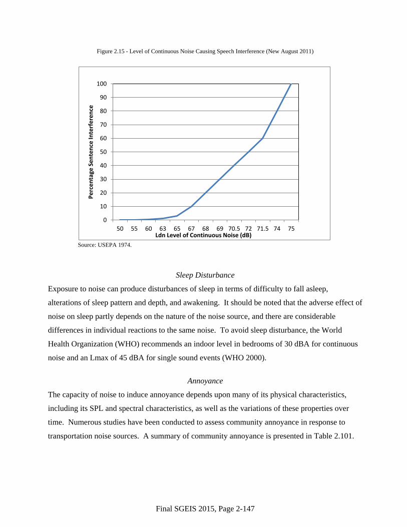
Figure 2.16 presents the Federal Highway Administration’s (FHWA) vehicle class definitions
(FHWA 2011). Table 2.105 provides descriptions of the 13 vehicle classes designated by the
FHWA.
Figure 2.16 - FHWA Vehicle Classifications (New August 2011)
Source: Diamond Traffic Products 2011.

Final SGEIS 2015, Page 2-155
Table 2.105 - Descriptions of the Thirteen FHWA Vehicle Classification Categories (New August 2011)
Vehicle Class Description 1 Motorcycles. All two- or three-wheeled motorized vehicles. Typical vehicles in this
category have saddle-type seats and are steered by handlebars rather than steering wheels. This category includes motorcycles, motor scooters, mopeds, motor-powered bicycles, and three-wheel motorcycles. This vehicle type may be reported at the option of the state.
2 Passenger Cars. All sedans, coupes, and station wagons manufactured primarily for the purpose of carrying passengers and including those passenger cars pulling recreational or other light trailers.
3 Other Two-Axle, Four-Tire Single Unit Vehicles. All two-axle, four-tire vehicles other than passenger cars. Included in this classification are pickup and panel trucks, vans, and other vehicles such as campers, motor homes, ambulances, hearses, carryalls, and minibuses. Other two-axle, four-tire single-unit vehicles pulling recreational or other light trailers are included in this classification. (Note: Because automatic vehicle classifiers have difficulty distinguishing class 3 from class 2, these two classes may be combined into class 2).
4 Buses. All vehicles manufactured as traditional passenger-carrying buses with two axles and six tires or three or more axles. This category includes only traditional buses (including school buses) functioning as passenger-carrying vehicles. Modified buses should be considered to be a truck and should be appropriately classified.
5 Two-Axle, Six-Tire, Single-Unit Trucks. All vehicles on a single frame, including trucks, camping and recreational vehicles, motor homes, etc., with two axles and dual rear wheels.
6 Three-Axle, Single-Unit Trucks. All vehicles on a single frame, including trucks, camping and recreational vehicles, motor homes, etc., with three axles.
7 Four or More Axle, Single-Unit Trucks. All trucks on a single frame with four or more axles.
8 Four or Fewer Axle, Single-Trailer Trucks. All vehicles with four or fewer axles, consisting of two units, one of which is a tractor or straight truck power unit.
9 Five-Axle, Single-Trailer Trucks. All five-axle vehicles consisting of two units, one of which is a tractor or straight truck power unit.
10 Six or More Axle, Single-Trailer Trucks. All vehicles with six or more axles, consisting of two units, one of which is a tractor or straight truck power unit.
11 Five or Fewer Axle, Multi-Trailer Trucks. All vehicles with five or fewer axles, consisting of three or more units, one of which is a tractor or straight truck power unit.
12 Six-Axle, Multi-Trailer Trucks. All six-axle vehicles consisting of three or more units, one of which is a tractor or straight truck power unit.
13 Seven or More Axle, Multi-Trailer Trucks. All vehicles with seven or more axles, consisting of three or more units, one of which is a tractor or straight truck power unit.
Source: FHWA 2001. Notes: In reporting information on trucks, the following criteria should be used:
- Truck tractor units traveling without a trailer will be considered single-unit trucks. - A truck tractor unit pulling other such units in a “saddle mount” configuration will be considered one single-unit
truck and will be defined only by the axles on the pulling unit. - Vehicles are defined by the number of axles in contact with the road. Therefore, “floating” axles are counted only
when in the down position. - The term “trailer” includes both semi- and full trailers.
Final SGEIS 2015, Page 2-156
Not included in the FHWA Vehicle Classification Categories are farm and agricultural
equipment, which are common in the rural areas. Many of the rural roads are shared by passenger
traffic, truck traffic, and farm and agricultural equipment.
2.3.14.2 Regional Road Systems
New York State
The NYSDOT, acting through the Commissioner of Transportation, has general supervision of
roads, highways, and bridges in the State of New York. The functions, powers and duties of the
Commissioner of Transportation and the NYSDOT, respectively, are more fully described in
Article II of the Highway Law and Article 2 of the Transportation Law. It is the mission of the
NYSDOT to ensure that those who live, work, and travel in New York State have a safe, efficient,
balanced, and environmentally sound transportation system.
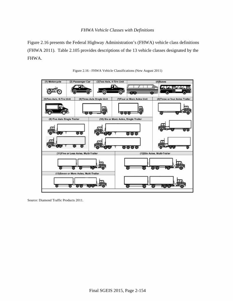
The NYSDOT is divided into 11 regions to better manage the roadways, duties, and users (Figure
2.17).
Figure 2.17 - New York State Department of Transportation Regions (New August 2011)
Source: NYSDOT 2011a
The network of roads within New York State consists of federal, state, county, local, and private
roads. Overall, there are an estimated 114,546 miles of highway roads in the state. This includes
32 interstate highways (principal arterials) totaling 1,705 miles, which are primarily maintained
by the NYSDOT.

Final SGEIS 2015, Page 2-157
Figure 2.18 depicts the main interstate highways in New York State. The New York State
Thruway, also known as the Governor Thomas E. Dewey Thruway (Interstate (I-) 90) is the main
east-west route that crosses the midsection of the state, linking Buffalo, Rochester, Syracuse, and
Albany. The New York State Thruway is a system of limited-access highways in New York State
operated by the New York State Thruway Authority (NYSTA). It includes a total of
approximately 570 miles (that is comprised of portions of I-87, I-90, I-95, I-190, and I-287). The
Southern Tier Expressway, I-86, also is a major east-west route that services that southern portion
of the state, connecting Jamestown, Olean, Elmira, and Binghamton. From Binghamton, I-86
runs southeast, providing access to New York City, and I-88 runs northeast providing access to
Albany. Major north-south routes include I-81, which extends from Pennsylvania north through
Binghamton and Syracuse to the border crossing with Canada, and I-87, which extends from New
York City north to Montreal.
The state’s transportation and road network also includes over 15,000 miles of state routes and
97,000 miles of county and local roads (NYSDOT 2009a). Each region examined as part of this
analysis is discussed individually below.
The NYSDOT has specific, statutory authority to regulate work within the state highway rights-
of-way (ROWs) (see Highway Law Section 52). This authority extends to granting, conditioning,
or denying permits for, among many other things, curb cuts or breaks in access to state highways,
utility work within the state ROWs that would be necessary for the operation of hydraulic
fracturing facilities, and design approval for any new culverts, bridges, access roads, etc., on state
ROWs that may become necessary for the construction or operation of hydraulic fracturing
facilities.
Region A
Region A comprises Chemung, Tioga, and Broome Counties, which are within NYSDOT
Regions 6 (Chemung) and 9 (Tioga and Broome). Table 2.106 presents a summary of the
mileage of highways within each county. The Highway Mileage Report developed by NYSDOT
provides current information on the public highway mileage in New York State by county
(NYSDOT 2009a).