Embed Size (px)
Citation preview
CAA201421st century Archeaology
concepts, methods and tools
Proceedings of the 42nd Annual Conference on Computer
Applications and Quantitative
Methods in Archaeology
Edited by
F. Giligny, F. Djindjian, L. Costa, P. Moscatiand S. Robert
Archaeopress Archaeology
ArchaeopressGordon House
276 Banbury RoadOxford OX2 7ED
www.archaeopress.com
ISBN 978 1 78491 100 3ISBN 978 1 78491 101 0 (e-Pdf)
© Archaeopress and the individual authors 2015
Cover photograph © Emilie Lesvignes
All rights reserved. No part of this book may be reproduced, stored in retrieval system, or transmitted, in any form or by any means, electronic, mechanical, photocopying or otherwise,
without the prior written permission of the copyright owners.
Printed in England by Oxuniprint, Oxford
This book is available direct from Archaeopress or from our website www.archaeopress.com
Contents
Foreword ������������������������������������������������������������������������������������������������������������������������������������������������������������������� v
Computers and mathematics in Archaeology, anatomy of an ineluctable success! ���������������������������������������������������� 1François DJINDJIAN
Chapter 1 Historiography
Towards a History of Archaeological Computing: An Introduction ������������������������������������������������������������������������������ 9Paola MOSCATI
A retrospective on GIS and AIS platforms for Public Archaeology in Italy� Searching backward for roots and looking onwards for new methodological road-maps ����������������������������������������������������������������������������������������������������������� 17Mirella SERLORENZI, Ilaria JOVINE, Giorgia LEONI, Andrea DE TOMMASI, Andrea VARAVALLO
Art History of the Ancient Near East and Mathematical Models� An Overview ��������������������������������������������������������� 29Alessandro DI LUDOVICO and Sergio CAMIZ
Archaeology and Computer Applications: the automatic cataloging of Italian archaeological heritage ��������������������� 35Alessandra CARAVALE
Chapter 2 Field and laboratory data recording
Practical Assessment of a Multi-Frequency Slingram EMI for Archaeological Prospection ���������������������������������������� 43François-Xavier SIMON, Alain TABBAGH, Apostolos SARRIS
Utilizing Magnetic Prospection and GIS to Examine Settlement Organization in Neolithic Southeastern Europe ������ 53Alexis NIEKAMP, Apostolos SARRIS
Historic Forest Change: New approaches to Land Use Land Cover ���������������������������������������������������������������������������� 65Charlotte E. STANCIOFF, Robert G. PONTIUS Jr, Scott MADRY, Elizabeth JONES
Challenges and Perspectives of Woodland Archaeology Across Europe �������������������������������������������������������������������� 73Hauke KENZLER, Karsten LAMBERS
Archaeological Mapping of Large Forested Areas, Using Semi-Automatic Detection and Visual Interpretation of High-Resolution Lidar Data ���������������������������������������������������������������������������������������������������������������������������������������������� 81Øivind Due TRIER, Lars HOLGER PILØ
Laser scanning and Automated Photogrammetry for Knowledge and Representation of the Rupestrian Architecture in Cappadocia: Sahinefendi and the Open Air Museum of Goreme �������������������������������������������������������������������������� 87Marco CARPICECI, Carlo INGLESE
Advantages and Disadvantages of Digital Approach in Archaeological Fieldwork ����������������������������������������������������� 95Carlo BIANCHINI, Francesco BORGOGNI, Alfonso IPPOLITO
From Survey to Representation of the Model� A Documentation of Typological and Chronological Sequences of Archaeological Artefacts: Traditional and Innovative Approach ����������������������������������������������������������������������������� 107Alfonso IPPOLITO, Luca J. SENATORE, Barbara BELELLI MARCHESINI, Gabriella CEROLI
Archaeology in the Third and Fourth Dimensions: A Case Study of 3D Data Collection and Analysis From Prince Rupert, BC, Canada ������������������������������������������������������������������������������������������������������������������������������������������������ 115Alyssa PARKER, Morley ELDRIDGE
Integrated RTI Approaches for the Study of Painted Surfaces ��������������������������������������������������������������������������������� 123Eleni KOTOULA, Graeme EARL
Survey, Documentation and Analysis of the Archeological Architecture: the House of the Knights of Rhodes in the Forum of Augustus ������������������������������������������������������������������������������������������������������������������������������������������������ 135Carlo BIANCHINI, Gaia Lisa TACCHI
Digital Research Strategies for Ancient Papyri: A Case Study on Mounted Fragments of The Derveni Papyrus �������� 145 Eleni Kotoula, Graeme Earl
i
Chapter 3� Ontologies and Standards
Towards Linked-Data in Numismatics: How the DIANA Approach can Improve the Diachrony Integrating Heterogeneous Pieces of Data ������������������������������������������������������������������������������������������������������������������������������� 157Maria CALTABIANO, Mariangela PUGLISI, Antonio CELESTI, Grazia SALAMONE
Celtic Coins in context, a new database ����������������������������������������������������������������������������������������������������������������� 165Katherine GRUEL, Agnes TRICOCHE, Philippe CHARNOTET
Uncertainty handling for ancient coinage �������������������������������������������������������������������������������������������������������������� 171Karsten TOLLE, David WIGG-WOLF
Interoperability of the ArSol (Archives du Sol) database based on the CIDOC-CRM ontology���������������������������������� 179Emeline LE GOFF, Olivier MARLET, Xavier RODIER, Stéphane CURET, Philippe HUSI
Find the balance - Modelling aspects in Archaeological Information Systems ��������������������������������������������������������� 187Franz SCHWARZBACH, Felix F. SCHÄFER, Alexander SCHULZE
Integration of Archaeological Datasets through the Gradual Refinement of Models ����������������������������������������������� 193Cesar GONZALEZ-PEREZ, Patricia MARTÍN-RODILLA
Linked Open Greek Pottery ������������������������������������������������������������������������������������������������������������������������������������ 205Ethan GRUBER, T.J. SMITH
The Digital Archaeological Workflow: A Case Study from Sweden �������������������������������������������������������������������������� 215Marcus J. SMITH
Exploring time and space in the annotation of museum catalogues: The Sloane virtual exhibition experience ������� 221Stephen STEAD, Dominic OLDMAN, Jonathan Whitson CLOUD
Building comprehensive management systems for cultural – historical information ����������������������������������������������� 227Chryssoula BEKIARI, Martin DOERR, Dimitris ANGELAKIS, Flora KARAGIANNI
Managing Time Dimension in the Archaeological Urban Information System of the Historical Heritage of Rome and Verona ������������������������������������������������������������������������������������������������������������������������������������������������������������������ 235Alberto BELUSSI, Sara MIGLIORINI, Piergiovanna GROSSI
Towards an Archaeological Information System: Improving the Core Data Model �������������������������������������������������� 245Muriel van RUYMBEKE, Cyril CARRÉ, Vincent DELFOSSE, Pierre HALLOT, Michelle PFEIFFER, Roland BILLEN
Chapter 4� Internet and Archaeology
Archaeological open access journals: the case of ‘Archeologia e Calcolatori’ ���������������������������������������������������������� 257Alessandra CARAVALE, Alessandra PIERGROSSI
Massive Open Online Opportunity: MOOCs and Internet–Based Communities of Archaeological Practice ������������� 265Jeffrey P. EMANUEL
Moving Instruction Beyond the Museum’s Walls: Priorities in Online Public Education at the Oriental Institute ���� 271Kathryn GROSSMAN, Catherine Kenyon, Megaera LORENZ, Brittany HAYDEN
Crowd- and Community-Fuelled Archaeology� Early Results from the MicroPasts Project �������������������������������������� 279Chiara BONACCHI, Andrew BEVAN, Daniel PETT, Adi KEINAN-SCHOONBAERT
The ACCORD project: Archaeological Community Co-Production of Research Resources ���������������������������������������� 289Stuart JEFFREY, Alex HALE, Cara JONES, Sian JONES, Mhairi MAXWELL
Chapter 5� Archaeological Information Systems
12000 years of human occupation, 3 meters deep stratigraphy, 12 hectares… A geographical information system (GIS) for the preventive archaeology operation at Alizay (Normandie, France) ������������������������������������������������������� 299S. MAZET, C. MARCIGN, B. AUBRY, I. COMTE, P. BOULINGUIEZ
Records and spatial representations in the context of a rescue excavation: the case of Quincieux (Rhône-Alpes, France) ������������������������������������������������������������������������������������������������������������������������������������������������������������������ 305Ellebore SEGAIN, Veronique VACHON, Bernard MOULIN, Cécile RAMPONI, Wojciech WIDLAK
ii
Cartography and heritage: past practice and future potential for mapping Scotland’s cultural heritage������������������ 315Peter MCKEAGUE
Visualization based on the Norwegian University Museum Database �������������������������������������������������������������������� 323Espen ULEBERG, Mieko MATSUMOTO
An Inventory of Lucanian Heritage ������������������������������������������������������������������������������������������������������������������������� 333Alain DUPLOUY, Vincenzo CAPOZZOLI, Alessia ZAMBON
Integrating complex archaeological datasets from the Neolithic in a web-based GIS ���������������������������������������������� 341Kai-Christian BRUHN, Thomas ENGEL, Tobias KOHR, Detlef GRONENBORN
Enhanced 3D-GIS: Documenting Insula V 1 in Pompeii ������������������������������������������������������������������������������������������� 349Giacomo LANDESCHI, Nicolò DELL’UNTO, Daniele FERDANI, Stefan LINDGREN, Anne-Marie LEANDER TOUATI
MAPPA Open Data Metadata� The importance of archaeological background� ������������������������������������������������������� 361Francesca ANICHINI, Gabriele GATTIGLIA
A simple way to formalize the dating of stratigraphic units ������������������������������������������������������������������������������������ 365 Bruno DESACHY
Recognizing temporalities in urban units from a functional approach: three case studies �������������������������������������� 371 Julie GRAVIER
OH_FET: A Computer Application for Analysing Urban Dynamics Over Long Time Spans �������������������������������������� 381Laure SALIGNY, Ludovic GRANJON, Thomas HUET, Gaël SIMON, Xavier RODIER, Bastien LEFEBVRE
An ‘alphabet’ to describe the spatio-temporal dynamics of settlement systems: a relevant representation of time? �� 393Marie-Jeanne OURIACHI, Frédérique BERTONCELLO, with the collaboration of Pierre NOUVEL, Laure NUNINGER, Elise FOVET, Stephane ALIX
Chapter 6� GIS and spatial analysis
ArkeoGIS, Merging Geographical and Archaeological Datas OnlineLoup BERNARD, Damien ERTLEN, Dominique SCHWARTZ
Counting Sheep Without Falling Asleep: Using Gis to Calculate the Minimum Number of Skeletal Elements (Mne) And Other Archaeozoological Measures At Schöningen 13Ii-4 ‘Spear Horizon’ ������������������������������������������������������� 407Alejandro GARCÍA-MORENO, Jarod M. HUTSON, Aritza VILLALUENGA, Elaine TURNER, Sabine GAUDZINSKI-WINDHEUSER
Looking for the best� A comparison between GIS and PageRank based algorithms for preventive archaeology in urban areas ����������������������������������������������������������������������������������������������������������������������������������������������������������� 413Dubbini NEVIO, Gabriele GATTIGLIA, Augusto PALOMBINI
Analyses of bone modifications on human remains: a GIS approach ���������������������������������������������������������������������� 423Elsa CIESIELSKI, Hervé BOHBOT
Territorial organisation of the Terramare culture (Bronze Age, Italy): use of GIS methodology to tackle societal issues ����431Julie BOUDRY
From the excavation to the territory: contributions of GIS tools to the study of the spatial organization of the archaeological site of Argentomagus (France, Indre, Saint-Marcel/Argenton-sur-Creuse) ��������������������������������������� 443Emeline LE GOFF, Laure LAÜT, Yoann RABASTÉ, Françoise DUMASY
The integration of landscape processes in archaeological site prediction in the Mugello basin (Tuscany/Italy) ������ 451Elmar SCHMALTZ, Michael MÄRKER, Hans-Joachim ROSNER, Adrew-Williams KANDEL
The use of Burgundy stone from ancient times to the present day ������������������������������������������������������������������������� 459Stéphane BÜTTNER, Delphine MONTANGE, Laure SALIGNY, Marion FOUCHER with the collaboration of Eric LECLERCQ, Marinette SAVONNET
Exploring Intervisibility Networks: A Case Study From Bronze and Iron Age Istria (Croatia and Slovenia) ��������������� 469Zoran ČUČKOVIĆ
iii
Chapter 7� Mathematics and statistics in archaeology
Intentional Process Modeling of Statistical Analysis Methods �������������������������������������������������������������������������������� 481Charlotte HUG, Rebecca DENECKÈRE, Ammar AYMEN
Ancient Mesopotamian Glyptic Products, Statistics and Data Mining: A Research Proposal ����������������������������������� 489Alessandro DI LUDOVICO, Sergio CAMIZ
Intrasite spatial analysis applied to the Neolithic sites of the Paris Basin: from the archaeological feature to global analysis ����������������������������������������������������������������������������������������������������������������������������������������������������������������� 497François GILIGNY
Statistical and mathematical models for archaeological data mining: a comparison ����������������������������������������������� 509Nevio DUBBINI, Adam LODOEN
Chapter 8� 3D Archaeology and virtual Archaeology
Measuring and describing 3D texture �������������������������������������������������������������������������������������������������������������������� 519Vera MOITINHO DE ALMEIDA, Juan Antonio BARCELÓ
Old versus new – introducing image-based 3D modeling into the general documentation workflow of archaeological rescue excavations. Case studies: the Čachtice and Bratislava castles, Slovakia ������������������������������������������������������ 529Jan ZACHAR, Seta ŠTUHEC
Beyond spreadsheets: digitising the archaeological artefact inventory process ����������������������������������������������������� 541Arianna TRAVIGLIA, Stephen WHITE, Andrew WILSON
Potentialities of 3D Reconstruction in Maritime Archaeology �������������������������������������������������������������������������������� 549Elisa COSTA, Carlo BELTRAME, Francesco GUERRA
Cultural Heritage Documentation in Cave Environnement Using Low-Cost Means for Archaeologists� Case Study of the Larchant Caves in the Fontainebleau Forest in France �������������������������������������������������������������������������������������� 557Aurelia LUREAU, Mehdi BELARBI, Pascal RAYMOND, Régis TOUQUET
Forum Romanum: A 3D Model For Self-Service Educational Purposes �������������������������������������������������������������������� 569Philippe FLEURY, Sophie MADELEINE, Nicolas LEFÈVRE
The Virtual Reconstruction of a Small Medieval Town: The Case of Briviesca (Spain) ��������������������������������������������� 575Mario ALAGUERO, Andres BUSTILLO, Blanca GUINEA, Lena IGLESIAS
25 Years of Experience in Virtual Reconstructions - Research Projects, Status Quo of Current Research and Visions for the Future ������������������������������������������������������������������������������������������������������������������������������������������������������������� 585Mieke PFARR-HARFST
Chapter 9� Multi-agent systems and complex system modelling
A Density-Based Simulation Approach for Evaluating Prehistoric Population Fluctuations in Finland ��������������������� 595Tarja SUNDELL, Juhana KAMMONEN
Multi-Agent Modelling of the Neolithic LBK ����������������������������������������������������������������������������������������������������������� 595Jean-Pierre BOCQUET-APPEL, Richard MOUSSA, Jérôme DUBOULOZ
Explaining the Adoption of ‘Innovations’ in Western Europe during Bronze Age: Towards an Agent-Based Simulation ����613Juan A. BARCELÓ, Florencia DEL CASTILLO BERNAL, Giacomo CAPUZZO, Berta MORELL, Joan NEGRE
Spatial Interaction Simulation Methods for Ancient Settlement Distributions in Central Italy �������������������������������� 621Taylor OSHAN, Carson FARMER, Eoin O’DONOGHUE
Interactions and network analysis of a rock art site in Morro do Chapéu, Bahia, Brazil ������������������������������������������ 631Carlos ETCHEVARNE, Grégoire VAN HAVRE
iv
365
Proceedings of the 42nd Annual Conference on Computer Applications and Quantitative Methods in ArchaeologyCAA 2014 - 21st Century Archaeology/F. Giligny, F. Djindjian, L. Costa, P. Moscati, S. Robert (eds.)
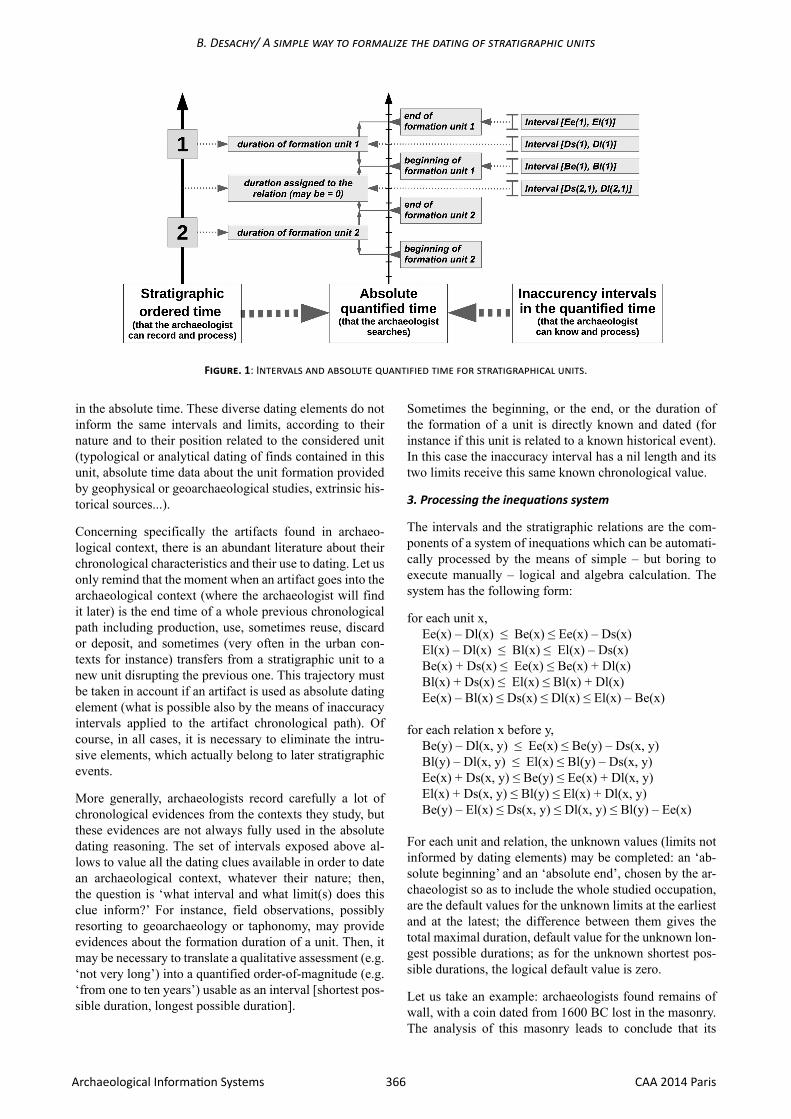
1. From stratigraphic time to quantified time: intervals of inaccuracy
A stratigraphic unit is defined at first in a relative time. It necessary exists also in the absolute time: it has a beginning of formation, an end of formation, and a duration between these two endpoints. The formation duration may be seen as a segment on the absolute time line; the beginning and the end are just moments, i.e. points on this line. Another duration must be taken into account: the duration ‘masked’ by a stratigraphic relationship when there is a discontinuity of absolute time between two successive stratigraphic units; more exactly, between the end of the formation of the previous unit and the beginning of the formation of the next unit.
These two moments (beginning and end of the formation of a unit) and these two durations (formation duration of a unit, and duration between two successive units) are the absolute dating framework of a stratigraphic sequence. Most frequently, the archaeologists do not have direct indication about those moments and durations. However, it is always possible to define an interval of inaccuracy for each of these moments and durations.
The [TPQ, TAQ] interval is traditionally used by the archaeologists to date the deposits. According to the most common definition of the TPQ (as the date provided by the later dated find in the deposit), this time slot is actually an inaccuracy interval for the end of the formation of the considered unit (so that this end time cannot be older than the TPQ nor more recent than the TAQ), but not for the duration of this formation. Indeed, it is worth emphasizing that a TPQ provides an earliest limit for the end, and not for the beginning of the duration formation.
The same principle of interval of inaccuracy may be applied to the whole dating framework of a stratigraphic sequence. So, besides the [TPQ, TAQ] interval, we can consider 3 others intervals of inaccuracy: one interval [earliest date, latest date] including the beginning of the unit formation; and two intervals [shortest duration, longest duration] to include the unit formation duration, and to include the duration between two successive units. Those four intervals involve height limits in the absolute (quantified) time (figure 1):
– Be(x): earliest date for the formation beginning of a unit x;
– Bl(x): latest date for the formation beginning of a unit x;
– Ee(x): earliest date for the formation end of a unit x (corresponding to the common notion of terminus post quem);
– El(x): latest date for the formation end of a unit x (corresponding to the common notion of terminus ante quem);
– Ds(x): shortest possible duration for the formation of a unit x;
– Dl(x): longest possible duration for the formation of a unit x;
– Ds(x, y): shortest possible duration assignable to the order relation between units x and y;
– Dl(x, y): longest possible duration assignable to the order relation between units x and y;
Of course, all these quantified values must use the same time measuring unit (usually, this unit is the year).
2. Taking into account the diversity of the dating clues
As every archaeologist knows, different kinds of dating el-ements may be available to localize the stratigraphic units
Keywords: stratigraphy, chronology, absolute time.
Bruno DESACHY
UMR 7041 équipe archéologies environnementalesMinistère de la Culture et de la Communication, France
A simple way to formalize the dating of stratigraphic units
AbstractBuilding the stratigraphic relative chronology from field observations is at present a quite clear intellectual task, thanks to Edward Harris (Harris 1979). However, the following step – placing stratigraphic units in the absolute time by means of dated materials, his-torical indications, and stratigraphic observations – is far from being always totally explicit. The frequently used notions of terminus post quem (TPQ) and terminus ante quem (TAQ) do not define all the aspects of this dating reasoning. In particular, the formation durations of the stratigraphic units are rarely taken into account in a quantified way. So, even the basic notion of ‘dating a layer’ may be ambiguous. This paper briefly presents some developments (from previous works about formalized stratigraphic data process and tool - Desachy 2010, 2012) in order to formalize and to computerize this basic but no so clear process of absolute dating of the stratigraphic units.
366 CAA 2014 ParisArchaeological Information Systems
B. Desachy/ A simple way to formalize the dating of stratigraphic units
Sometimes the beginning, or the end, or the duration of the formation of a unit is directly known and dated (for instance if this unit is related to a known historical event). In this case the inaccuracy interval has a nil length and its two limits receive this same known chronological value.
3. Processing the inequations system
The intervals and the stratigraphic relations are the com-ponents of a system of inequations which can be automati-cally processed by the means of simple – but boring to execute manually – logical and algebra calculation. The system has the following form:
for each unit x, Ee(x) – Dl(x) ≤ Be(x) ≤ Ee(x) – Ds(x) El(x) – Dl(x) ≤ Bl(x) ≤ El(x) – Ds(x) Be(x) + Ds(x) ≤ Ee(x) ≤ Be(x) + Dl(x)Bl(x) + Ds(x) ≤ El(x) ≤ Bl(x) + Dl(x)Ee(x) – Bl(x) ≤ Ds(x) ≤ Dl(x) ≤ El(x) – Be(x)
for each relation x before y,Be(y) – Dl(x, y) ≤ Ee(x) ≤ Be(y) – Ds(x, y)Bl(y) – Dl(x, y) ≤ El(x) ≤ Bl(y) – Ds(x, y)Ee(x) + Ds(x, y) ≤ Be(y) ≤ Ee(x) + Dl(x, y)El(x) + Ds(x, y) ≤ Bl(y) ≤ El(x) + Dl(x, y)Be(y) – El(x) ≤ Ds(x, y) ≤ Dl(x, y) ≤ Bl(y) – Ee(x)
For each unit and relation, the unknown values (limits not informed by dating elements) may be completed: an ‘ab-solute beginning’ and an ‘absolute end’, chosen by the ar-chaeologist so as to include the whole studied occupation, are the default values for the unknown limits at the earliest and at the latest; the difference between them gives the total maximal duration, default value for the unknown lon-gest possible durations; as for the unknown shortest pos-sible durations, the logical default value is zero.
Let us take an example: archaeologists found remains of wall, with a coin dated from 1600 BC lost in the masonry. The analysis of this masonry leads to conclude that its
in the absolute time. These diverse dating elements do not inform the same intervals and limits, according to their nature and to their position related to the considered unit (typological or analytical dating of finds contained in this unit, absolute time data about the unit formation provided by geophysical or geoarchaeological studies, extrinsic his-torical sources...).
Concerning specifically the artifacts found in archaeo-logical context, there is an abundant literature about their chronological characteristics and their use to dating. Let us only remind that the moment when an artifact goes into the archaeological context (where the archaeologist will find it later) is the end time of a whole previous chronological path including production, use, sometimes reuse, discard or deposit, and sometimes (very often in the urban con-texts for instance) transfers from a stratigraphic unit to a new unit disrupting the previous one. This trajectory must be taken in account if an artifact is used as absolute dating element (what is possible also by the means of inaccuracy intervals applied to the artifact chronological path). Of course, in all cases, it is necessary to eliminate the intru-sive elements, which actually belong to later stratigraphic events.
More generally, archaeologists record carefully a lot of chronological evidences from the contexts they study, but these evidences are not always fully used in the absolute dating reasoning. The set of intervals exposed above al-lows to value all the dating clues available in order to date an archaeological context, whatever their nature; then, the question is ‘what interval and what limit(s) does this clue inform?’ For instance, field observations, possibly resorting to geoarchaeology or taphonomy, may provide evidences about the formation duration of a unit. Then, it may be necessary to translate a qualitative assessment (e.g. ‘not very long’) into a quantified order-of-magnitude (e.g. ‘from one to ten years’) usable as an interval [shortest pos-sible duration, longest possible duration].
Figure. 1: Intervals and absolute quantified time for stratigraphical units.
F. Giligny, F. Djindjian, L. Costa, P. Moscati, S. Robert (eds.) / Proceedings of CAA 2014 Paris
367 CAA 2014 ParisArchaeological Information Systems
building was quite fast, certainly less than one year. This masonry was set in a foundation trench, itself excavated and filled in a short time (deduced, for instance, from vertical edges in a loose ground), certainly also less than one year. Furthermore, an old photo and later documents indicate that in 1860 BC, this wall was no more visible, thus it was already destroyed. If we consider the two stratigraphic units: ‘x’ for the foundation trench, ‘y’ for the masonry of the wall, and the relation x before (filled by) y, we can write these limits (with year as time unit):
Dl(x) = 1Dl(x, y) = 1Ee(y) = 1600El(y) = 1860Dl(y) = 1
The aim of the process is to reduce the initial intervals by deducing increased earliest limits and shortest duration, and reduced latest limits and longest durations. So we can use only the corresponding parts of the inequations exposed above to deduce, as far as possible, the new more accurate limits:
Ee(y) – Dl(y) = Be(y) thus Be(y) = 1600 – 1 = 1599 (beginning at the earliest for the formation of y)Bl(y) = El(y) – Ds(y) thus Bl(y) = 1860 – 0 = 1860 (be-ginning at the latest for the formation of y)El(x) = Bl(y) – Ds(x, y) thus El(x) = 1860 – 0 = 1860 (end at the latest for the formation of x)Be(y) – Dl(x, y) = Ee(x) thus Ee(x) = 1599 – 1 = 1598 (end at the earliest for the formation of x)Bl(x) = El(x) – Ds(x) thus Bl(x) = 1860 – 0 = 1860 (beginning at the latest for the formation of x)Ee(x) – Dl(x) = Be(x) thus Be(x) = 1598 – 1 = 1597 (beginning at the earlier for the formation of x)
Figure 2: Uncertainity in the formation time of a stratigraphical unit.
The new deduced values provide absolute time intervals for each unit with the best (or the least bad) accuracy ac-cording to the whole available dating elements and strati-graphic relations. This deducing process uses the whole stratigraphic partial order, including transitively deduct-ible relations, so that the deduced duration interval of each relation gives the critical path duration between the two units. Logical faults due to contradictory dating elements are detectable by the deduction of negative intervals of time.
4. Results: the times of a stratigraphic sequence and their display
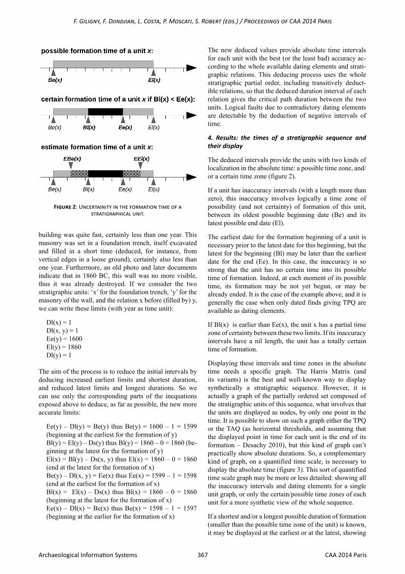
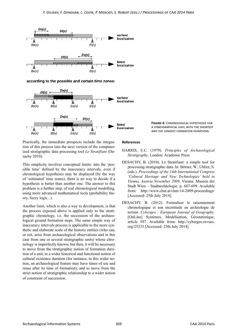
The deduced intervals provide the units with two kinds of localization in the absolute time: a possible time zone, and/or a certain time zone (figure 2).
If a unit has inaccuracy intervals (with a length more than zero), this inaccuracy involves logically a time zone of possibility (and not certainty) of formation of this unit, between its oldest possible beginning date (Be) and its latest possible end date (El).
The earliest date for the formation beginning of a unit is necessary prior to the latest date for this beginning, but the latest for the beginning (Bl) may be later than the earliest date for the end (Ee). In this case, the inaccuracy is so strong that the unit has no certain time into its possible time of formation. Indeed, at each moment of its possible time, its formation may be not yet begun, or may be already ended. It is the case of the example above, and it is generally the case when only dated finds giving TPQ are available as dating elements.
If Bl(x) is earlier than Ee(x), the unit x has a partial time zone of certainty between these two limits. If its inaccuracy intervals have a nil length, the unit has a totally certain time of formation.
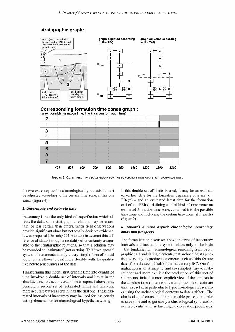
Displaying these intervals and time zones in the absolute time needs a specific graph. The Harris Matrix (and its variants) is the best and well-known way to display synthetically a stratigraphic sequence. However, it is actually a graph of the partially ordered set composed of the stratigraphic units of this sequence, what involves that the units are displayed as nodes, by only one point in the time. It is possible to show on such a graph either the TPQ or the TAQ (as horizontal thresholds, and assuming that the displayed point in time for each unit is the end of its formation – Desachy 2010), but this kind of graph can’t practically show absolute durations. So, a complementary kind of graph, on a quantified time scale, is necessary to display the absolute time (figure 3). This sort of quantified time scale graph may be more or less detailed: showing all the inaccuracy intervals and dating elements for a single unit graph, or only the certain/possible time zones of each unit for a more synthetic view of the whole sequence.
If a shortest and/or a longest possible duration of formation (smaller than the possible time zone of the unit) is known, it may be displayed at the earliest or at the latest, showing
368 CAA 2014 ParisArchaeological Information Systems
B. Desachy/ A simple way to formalize the dating of stratigraphic units
the two extreme possible chronological hypothesis. It must be adjusted according to the certain time zone, if this one exists (figure 4).
5. Uncertainty and estimate time
Inaccuracy is not the only kind of imperfection which af-fects the data: some stratigraphic relations may be uncer-tain, or less certain than others, when field observations provide significant clues but not totally decisive evidence. It was proposed (Desachy 2010) to take in account this dif-ference of status through a modality of uncertainty assign-able to the stratigraphic relations, so that a relation may be recorded as ‘estimated’ (not certain). This ‘two-speeds’ system of statements is only a very simple form of modal logic, but it allows to deal more flexibly with the qualita-tive heterogeneousness of the data.
Transforming this modal stratigraphic time into quantified time involves a double set of intervals and limits in the absolute time: the set of certain limits exposed above, and, possibly, a second set of ‘estimated’ limits and intervals, more accurate but less certain than the first one. These esti-mated intervals of inaccuracy may be used for less certain dating elements, or for chronological hypothesis testing.
If this double set of limits is used, it may be an estimat-ed earliest date for the formation beginning of a unit x – EBe(x) – and an estimated latest date for the formation end of x – EEl(x), defining a third kind of time zone: an estimated formation time zone, contained into the possible time zone and including the certain time zone (if it exists) (figure 2)
6. Towards a more explicit chronological reasoning: limits and prospects
The formalization discussed above in terms of inaccuracy intervals and inequations system relates only to the basic – but fundamental – chronological reasoning from strati-graphic data and dating elements, that archaeologists prac-tise every day to produce statements such as ‘this feature dates from the second half of the 1st century BC’. Our for-malization is an attempt to find the simplest way to make sounder and more explicit the production of this sort of statements. Indeed, a more explicit view of the contexts in the absolute time (in terms of certain, possible or estimate time) is useful, in particular to typochronological research-es using the archaeological contexts to date artifacts. The aim is also, of course, a computerizable process, in order to save time and to get easily a chronological synthesis of available data as an archaeological excavation progresses.
Figure 3: Quantified time scale graph for the formation time of a stratigraphical unit.
F. Giligny, F. Djindjian, L. Costa, P. Moscati, S. Robert (eds.) / Proceedings of CAA 2014 Paris
369 CAA 2014 ParisArchaeological Information Systems
Practically, the immediate prospects include the integra-tion of this process into the next version of the computer-ized stratigraphic data processing tool Le Stratifiant (De-sachy 2010).
This simplicity involves conceptual limits: into the ‘pos-sible time’ defined by the inaccuracy intervals, even if chronological hypotheses may be displayed (by the way of ‘estimated’ time zones), there is no way to decide if a hypothesis is better than another one. The answer to this problem is a further step, of real chronological modelling, using more advanced mathematical tools (probability the-ory, fuzzy logic...).
Another limit, which is also a way to development, is that the process exposed above is applied only to the strati-graphic chronology, i.e. the succession of the archaeo-logical ground formation steps. The same simple way of inaccuracy intervals process is applicable to the more syn-thetic and elaborate scale of the historic entities (who can, or not, arise from archaeological observations and in this case from one or several stratigraphic units) whose chro-nology is imperfectly known; but then, it will be necessary to move from the stratigraphic notion of formation dura-tion of a unit, to a wider historical and functional notion of cultural existence duration (for instance, in this wider no-tion, an archaeological feature may have times of use and reuse after its time of formation); and to move from the strict notion of stratigraphic relationship to a wider notion of constraint of succession.
References
HARRIS, E.C. (1979). Principles of Archaeological Stratigraphy. London: Academic Press
DESACHY, B. (2010). Le Stratifiant: a simple tool for processing stratigraphic data. In: Börner, W., Uhlirz, S. (eds.). Proceedings of the 14th International Congress ‘Cultural Heritage and New Technologies’ held in Vienna, Austria November 2009. Vienna: Museen der Stadt Wien – Stadtarchäologie. p. 687-699. Available from: http://www.chnt.at/chnt-14-2009-proceedings/ [Accessed: 25th July 2014].
DESACHY, B. (2012). Formaliser le raisonnement chronologique et son incertitude en archéologie de terrain. Cybergeo : European Journal of Geography. [OnLine] Systèmes, Modélisation, Géostatistique, article 597. Available from: http://cybergeo.revues.org/25233 [Accessed: 25th July 2014].
Figure 4: Chronological hypotheses for a stratigraphical unit, with the shortest and the longest formation durations.