Embed Size (px)
Citation preview

Caernarfon Waterfront: Understanding Urban Character

1
CaernarfonWaterfront: Understanding UrbanCharacter

2
AcknowledgementIn undertaking this study, Cadw has drawn on work carried out by Gwynedd Archaeological Trust in 2005: Ports and Harbours of Gwynedd: A Threat-Related Assessment. This work, carried outfor Cadw, summarized the historical developmentof the harbours of Caernarfon, and provided adetailed gazetteer and map of sites in the vicinity of the waterfront. The gazetteer has not beenreplicated in full in the present report but isavailable from Gwynedd Archaeological Trust, who should be contacted for further advice on the archaeology of the area.

3
Contents
Introduction 5
Aims of the Study 5
Historical Development 7
Urban Origins 7
Medieval Castle and Town 9
Land and Water: The Urban Economy 9
Two Rivers and the Sea 12
Beyond the Walls 16
Historical Topography 19
The Medieval Town 19
The Nineteenth Century: Civil Engineering and Urban Growth 21
The Character of Building 24
Character Areas 25
1 The Promenade (The Medieval Quay) 25
2 Bank Quay and Victoria Dock 27
3 The Slate Quay 30
4 The Maes 33
5 Segontium Terrace and Tre’r Gof 34
6 Coed Helen 36
The Seiont and Menai Waterfronts: Design Parameters for Redevelopment 38
Design Vocabulary and Materials 40
Statement of Significance 41
Selected Sources 42
Maps 42
Endnotes 43
List of Maps pages 44–51
1 All Character Areas
2 All Character Areas with Historic Environment Designations
3 The Promenade (The Medieval Quay) Area (1)
4 Bank Quay and Victoria Dock Area (2)
5 The Slate Quay Area (3)
6 The Maes Area (4)
7 Segontium Terrace and Tre’r Gof (5)
8 Coed Helen Area (6)

4

5
Introduction
CAERNARFON WATERFRONT: UNDERSTANDING URBAN CHARACTER
Aims of the Study
Urban characterization aims to describe andexplain the historic character of towns to give a focus to local distinctiveness and to serve as a tool for the sustainable management of thehistoric environment. It seeks to inform andsupport positive conservation and regenerationprogrammes, help improve the quality of planning advice, and contribute to localinterpretation and education strategies.
Urban characterization defines the distinctivehistorical character of individual towns, andidentifies the variety of character within them,recognizing that this character is fundamental tolocal distinctiveness and pride of place, and is anasset in regeneration. It looks at how the historyof a town is expressed in its plan and topography,in areas of archaeological potential, and in its
architectural character. The survey is not just an audit of features, but a reconstruction of the themes and processes which have shaped the town.
The immediate purpose of this study is to informemerging proposals for the regeneration of the Caernarfon waterfront, a critical part of the setting of the World Heritage Site of castleand town walls. The study has therefore focussedon the Menai and Seiont waterfronts, togetherwith the immediately adjacent urban areas. In order to understand these areas in context, it has also considered the historical backgroundto the establishment and development of thetown as a whole. It is intended that this study willprovide a baseline for strategic planning as well as local management.
The Slate Quay providesthe foreground to thecastle at the mouth of the river Seiont.

CAERNARFON WATERFRONT: UNDERSTANDING URBAN CHARACTER
6

CAERNARFON WATERFRONT: UNDERSTANDING URBAN CHARACTER
7
Historical Development
Caernarfon has a long and distinguished urbanhistory. The establishment of the medieval castle and town was preceded by Roman and Welshsettlements in the vicinity. From these originsemerged an urban culture which has endured for many centuries. Key to the long-term successof the town was the provision of a reliableeconomic infrastructure. Throughout its history, in changing circumstances, the waterfront hasbeen a mainstay in the economic life of the town.
Urban Origins
‘And at the river mouth he saw a great castle, the fairest that mortal had ever seen, and the gate of the castle he saw open, and he came to the castle’. 1
The Roman Legacy
On the summit of the ridge between the riversCadnant and Seiont, the Romans established the auxiliary fort of Segontium in about AD 77.Segontium became the base for a largeadministrative district subordinate to Chester, andwas occupied until the late fourth century. This longhistory of occupation may partly be explained byits strategic position in fertile coastal country, andperhaps by the exploitation of the mineral wealthof the area. West of Segontium, just above the riverSeiont at its closest point to the fort, is a secondRoman site, Hen Waliau. This walled compound hasbeen dated to the fourth century and interpretedas a storage depot. The remains of ‘an immensewooden bridge’ 2 across the Seiont, also thought to be Roman, were discovered in 1817, a shortdistance upstream of Hen Waliau.
Opposite: The castle onthe water’s edge wherethe river Seiont meets the Menai Strait.
Below: The Roman fortof Segontium, with thecastle at the river mouth beyond.

CAERNARFON WATERFRONT: UNDERSTANDING URBAN CHARACTER
8
The castle and walledtown, strung out alongthe shore on apromontory between the rivers Seiont andCadnant, as depicted bySamuel and NathanielBuck in 1742 (TheNorth West View ofCaernarvon Castle, The National Library of Wales).
Although the existence of a Roman settlementclose to the site later chosen for the town ofCaernarfon had little direct impact on thetopography of the town, it was influential in the culture and history of the later settlement.The first certain reference to a settlement down on the shoreline was the castle of Hughd’Avranches, Earl of Chester, who built a motteand bailey in 1090. In a late twelfth-century text(The History of Gruffydd ap Cynan), this castle was described as built in the old city of theemperor Constantine.3 Although Hugh’s castle was not literally in the ruins of Segontium, theimperial association dignified it and gave it agrandeur which in turn was seized by the Welshwhen they regained the area from the Normansin 1115. This imperial past is also suggested in the iconography of Edward I’s castle. It wascommemorated, too, in the reburial of what wasclaimed to be the body of Magnus Maximus in1283. There is a tradition (not supported byarchaeological evidence) that Magnus Maximuswas based at Segontium as regional commanderin the late fourth century — he was the MacsenWledig of Welsh legend, father of Constantineand Peblig; several old Welsh families traced theirancestry back to him.
It is possible that the earl of Chester may havebeen the first to settle close to the waterfront.
However, the Romans would almost certainlyhave exploited (and defended) the seaways, and it is surely significant that Hen Waliau wassited immediately above the Seiont. Love Lane,which descends towards the river from SouthRoad, close to the south-west corner of the site, may even respect the line of a Roman route from Hen Waliau.
After the departure of the Romans, the nucleusof settlement may have remained on the higherground close to the fort, and it is perhapssignificant that the church at Llanbeblig lay closeto Segontium. Ecclesiastically, the later medievaltown of Caernarfon fitted into an earlierparochial structure, and remained a chapelrywithin the parish of Llanbeblig.
Welsh Settlement
The first Norman settlement here wasshort-lived: when the Welsh regained the area in1115, they probably occupied Hugh d’Avranches’scastle, and certainly established a small civilsettlement with a port and a court. WhenEdward I’s officials arrived in 1283, they found allys here, with a garden in the old castle bailey.Although the motte and bailey were once again

retained — the motte incorporated in theEdwardian castle, and the bailey surviving as thearea now known as the Maes (Castle Square) —the rest of the Welsh settlement was swept away.Twenty men spent five days clearing away thetimbers of demolished houses to make way forthe defences of the new town. Although we donot know very much about the Welsh settlement,documentary references suggest that it was aplace of some importance. In 1188, GiraldusCambrensis passed through ‘Caernarfon, that isArfon Castle’. 4 In 1215, a poet, Prydydd y Moch,referred to ‘yg caer yn aruon’ as one of the fourcornerstones of Llywelyn the Great’s dominionover Wales.5 Documents associated with theprinces of Gwynedd frequently referred toCaernarfon thereafter, but there were alsoreferences in vernacular sources to CaerAbersein, the Welsh-language equivalent ofSegontium. This Welsh ancestry, coupled with the Roman imperial past, is resonant in thehistory of the later town, for ‘out of the ruins of this city rose the present town, justly the boast of North Wales’.6
Medieval Castle and Town
The Edwardian castle and town of Caernarfonwere the result of a swift building campaigninitiated following the fall of Llywelyn ap Gruffyddin 1282, which opened up the lands west of theriver Conwy to the Crown. Work on the castleand town proceeded in tandem, together withthe construction of the quay and mill pool, themainstays of the urban economy. The town wallswere built during 1284–85. They enclosed an areaof 10 acres, within which some sixty-five toseventy burgages (each measuring 80 x 60feet/24 x 18 metres) had been laid out by 1287.Of these, fifty-nine had been taken up by 1298,and sixty-three by 1309. Although there was asetback in 1294, when the castle and town wallswere severely damaged during Madog apLlywelyn’s revolt, repairs were put in hand in1295, and improvement of the town walls, bridge,quay and castle went on until about 1330.
Alongside the physical work of building, the legaland administrative frameworks for the new townwere established. Caernarfon received a charter
in 1284: under its terms, and to encouragesettlement, burgesses were given autonomy inadministration, with the right to hold land freelyby burgage tenure, immunity from tolls andconviction, and the right to regulate trade in theborough. To further support the town, everyonefor 8 miles (13 km) around had to trade there.
Caernarfon was conceived from the outset as the capital of the principality of north Wales (a status it retained until 1536). The appropriateadministrative and commercial institutions werehoused within the town, including an exchequeroffice (located above the east gate), and ajustice’s house with the shire hall over it (near the junction of Castle Ditch and Shire HallStreet). For local administration, the burgesseswere given the right to build a town hall, and theydid so at the junction of what became knownlater as Market Street and High Street.
Land and Water : The Urban Economy
Farms and Markets
If it was to flourish, the new town needed a viable economy. The burgesses had land on which they lived inside the town, but they werealso supported by extensive holdings outside it: nearly 1,500 acres were reserved for them,including the vill of Llanbeblig and other landsaround. Most of the burgesses were activelyengaged in agriculture — in 1298, according to a rental of that year, five out of six burgesses held some agricultural land. The record showsthem storing their valuable grain inside the walls, but keeping their beasts outside them. Much later, a thousand beasts belonging to thetownsmen were amongst the casualties of Owain Glyndwr’s rebellion. However, the townwas not self-sufficient — the burgesses alsoneeded permits to buy grain from Anglesey and Ireland in 1316 and 1331, for instance, andthe town was heavily dependent on importsthroughout the Middle Ages. The town was still maintaining ‘a brisk trade with London, Bristol, Liverpool and Ireland for the severalnecessities of life’ at the end of the eighteenth century.7
CAERNARFON WATERFRONT: UNDERSTANDING URBAN CHARACTER
9

CAERNARFON WATERFRONT: UNDERSTANDING URBAN CHARACTER
10
Above: The Maes,traditionally the town’smarketplace, and a fineurban square, liesimmediately outside thewalled town.
Opposite: The threewaterfronts — thepromenade along theMenai, Victoria Dock atthe mouth of the riverCadnant, and the SlateQuay on the river Seiont.
Although the walls contained most of the town’sbuildings at least in the early period, the economyof the town depended on maintaining arelationship between the land enclosed by thewalls, and the land outside them. In Caernarfon, it was not only the agriculturally productive landwhich lay outside the town walls, but also themarket itself. A rental document of 1298 suggeststhat burgesses had stalls outside the walls onmarket days, and it is generally agreed that theMaes (the area formerly occupied by the bailey of the eleventh-century castle) was the originalmarketplace. Here, burgesses were free to trade,both with each other and with other Englishmerchants, and they had the privilege of erectingshops and sheds in which to store saleable goods in safety. On payment of a fee, foreignerscould also set up or hire stalls for the display of merchandise.
By the early nineteenth century, the Maes hadbegun to acquire new status as a formal square— ‘perhaps the largest and best square in thewhole principality’.8 Meanwhile, new marketbuildings were erected within the town walls. By 1813, ‘a new market house has lately beenerected with excellent shambles and stalls… over and under which are warerooms for housing grain and other unsold commodities’.9
In 1832, a new corn market was built on landbelonging to the Vaenol estate — on the site of Plas Mawr on Palace Street. In the same period,many small shops were built within the town.

CAERNARFON WATERFRONT: UNDERSTANDING URBAN CHARACTER
11
The three waterfronts1 The promenade (the medieval quay)2 Bank Quay and Victoria Dock
(river Cadnant)3 The Slate Quay (river Seiont)
This map is reproduced from Ordnance Survey material with the permission of Ordnance Survey on behalf of the Controller of Her Majesty’s Stationery Office © Crown Copyright. Unauthorised reproduction infringes Crown copyright and may lead toprosecution or civil proceedings. Licence Number 100021874.

Two Rivers and the Sea
The castle and its town occupied a strategiclocation, being bounded by the sea and situatedbetween two rivers — the Seiont and theCadnant. Both rivers and the Menai Strait wereinstrumental in the successful development of thetown in the medieval period and after. The Menaiwaterfront offered the first quayside associatedwith the thirteenth-century castle and town, and a quay here was part of the original buildingcampaign. It was constructed to assist in thebuilding operation itself, enabling large quantities of materials to be imported. But the quay alsoensured the safety and supply of the castle, andunderpinned the economy of the new town.Caernarfon was provisioned with imports comingby sea, and in order to derive additional benefitfrom this trade, a toll was levied on every shipentering the port.
In the layout of the town, the west gate gavedirect access onto quays that ran to its north and south, along the Menai waterfront. There may
CAERNARFON WATERFRONT: UNDERSTANDING URBAN CHARACTER
12
also have been a small postern gate near the base of the Eagle Tower. The original quay was built of earth and timber (the earth was probably taken from the ditch to the north and east of the castle), but this was apparently destroyedduring Madog’s revolt of 1294. The repair andmaintenance of the quay was the responsibility of the Crown, and documents record furtherworks on the quay between 1297 and 1301. It was rebuilt in stone some time after 1316,according to a contract which referred to 300feet (91 metres) of walling. In a further order forrepair in 1322 a quarry at Aberpwll was specifiedas the source of stone. We know little about theform of this early quay, but there are records for a new watergate and outer postern besidethe Eagle Tower, built in 1434–35. This is probablythe arrangement shown on John Speed’s map of 1610, which shows a small gate alongside the Eagle Tower (at the foot of Castle Ditch), and a gateway onto the quay from the shorelineto the south. This watergate was eventuallyreplaced by a slipway, shown in someeighteenth-century prints of the castle. Notable amongst later repairs to the quay were those of 1538–39 in which stone taken from the former friary at Bangor was used.
Above: The medievalquays — later thepromenade — followedthe Menai shore beneaththe town walls.
Opposite, top right: The early quays extendedno further than the footof Castle Ditch, withinformal moorings in the mouth of the Seiont(John Boydell, A North West View of Caernarvon Castle,1749, The NationalLibrary of Wales).

At some time in the eighteenth century (possibly1736), the Custom House was built outside thetown walls, on the quay to the north of the EagleTower. By 1852 it had become a hotel — TheAnglesey Arms — and was duly remodelled andextended for the purpose. The displacement of the Custom House was a mark of the changingfunction of the original quay. By the late eighteenthcentury, its amenity as a promenade was coming to the fore. Thomas Pennant considered it ‘the mostbeautiful walk alongside the Menai, and commandsthe most agreeable view’.10 By the early nineteenthcentury, as quays were developed under the castlewalls and along the Seiont, it was firmly establishedprincipally as a promenade and presumablyremodelled for the purpose — Edmund Hyde Halldescribed ‘a very handsome terrace, parapetted and protected against the sea’.11 ‘A wide terraceextending from the quay to the north end of the town walls, forms a most charming walk, thefashionable promenade, in fine weather, for alldescriptions of people, who, while they inhale the salubrious breeze, may be agreeably amused by the moving varieties of the port’.12
By the early nineteenth century, works were also in hand to extend the quay to the north,
CAERNARFON WATERFRONT: UNDERSTANDING URBAN CHARACTER
13
and build a pier or jetty, according to the terms of an Act obtained in 1809. The jetty wasn’tcompleted until 1830 — perhaps this was thequay which Edmund Hyde Hall saw in the courseof construction in 1809–11: ‘as far as myobservation has gone, its progress is very slow’.13
This new quay was part of a process in which theriver mouths to the north and south of the townwere established as the principal working quaysduring the nineteenth century.
Above: The Menaiwaterfront, showing thejetty built to the north of the quay, as depictedby William Bartlett,about 1840 (Carnarvon,The National Library of Wales).

CAERNARFON WATERFRONT: UNDERSTANDING URBAN CHARACTER
14
Right: The new harbourand patent slip at themouth of the Cadnant,shown in John Wood’smap of the town, 1834(Gwynedd ArchivesService).
Opposite: Until the earlynineteenth century, thefoot of Castle Ditchmarked the limit offormal moorings, asshown in this view of thecastle by Paul Sandby,about 1778 (CaernarvonCastle, The NationalLibrary of Wales).
River Cadnant
Of the two rivers, it was the Cadnant which hadthe most prominent role in the early history of thenew town. It was a working river, harnessed formilling as well as for wharfage. As part of theoriginal works associated with the castle and town,the King’s Mill Pool was created in 1285 (to thenorth-east of the Maes), and by 1304–05, it wasserving two mills in the vicinity of the east gate.
Like the quays along the Menai Strait, theCadnant harbour was kept in repair by theCrown. Together, these quays served the needs of the town, and it was through them that theconsiderable import trade was directed. JohnSpeed’s map of 1610 suggests the continuedexistence of a quay at the mouth of the Cadnant. It also shows the extent of suburbandevelopment to the north-east of the town bythe early seventeenth century: this gives us someindication that the economic powerhouse of the town lay in that direction in this period.Representations of the castle during theeighteenth century also clearly show a wharf wallreturning to run in parallel to the north wall ofthe town, and confirm the existence of a sizeablesuburb along the shore of the Cadnant.
But by the end of the eighteenth century, radicalchanges to the geography of water in this part ofthe town had been set in train: the mouth of theriver Cadnant was blocked off to enable a new
harbour and patent slip to be constructed forshipbuilding and repair. They are shown on JohnWood’s map of 1834, on either side of the mouthof the Cadnant. By this time, the river had beenconfined to a narrow channel (or even culverted),and its banks extensively built on — only thestreet name Bank Quay betrayed the formerexistence of a significant watercourse. In the early1860s, ambitious plans for harbour expansionwere put forward, possibly encouraged by theproximity of the Caernarvon and Bangor Railwaywhich, as a branch of the Chester and HolyheadRailway, linked the town with the wider railnetwork. Construction of a new dock — NewBasin — was begun in 1868, and completed in1875. By 1888 the mill pool had also entirelydisappeared and the Cadnant put in only anoccasional appearance to the north of WilliamStreet and alongside Mill Lane, before discretelyissuing into the New Basin (later known asVictoria Dock).
River Seiont
In eighteenth-century images boats are mooredin the wide mouth of the Seiont. It is clear from these images, and from those earlynineteenth-century paintings and engravingswhich favoured a view of the castle from thesouth, that there were no formal wharfages onthe Seiont. Pressure to develop on this side of thetown was fuelled by industrial activity elsewhere:

pre-eminent was the rapid rise of the slatequarrying industry, which was hungry for portfacilities. The Vaenol and Penrhyn estatesestablished ports at Y Felinheli and Penrhyn, butthe independent quarrying areas further westwere better served by Caernarfon. The rapidlygrowing quarrying enterprises in the Nantlle areademanded port facilities capable of handling largequantities of bulky materials. The east bank of theSeiont was readily accessible from the south-east,and offered substantial space without competinguses. In 1793, an Act of Parliament was obtainedfor ‘enlarging, deepening, cleansing, improving the harbour of Caernarvon’.14 In addition toimprovements to the Cadnant, this also includedworks to deepen the channel of the Seiont,increasing the space available for moorings.
The first formal structures alongside the riverSeiont were probably built in the early years ofthe nineteenth century, by which time engravingsalso show a wharf underneath the Eagle Tower of the castle. The Slate Quay itself was probablybegun in about 1803, with further improvementsin about 1809. Other works of improvementfollowed: in 1817 an earthen bank by the Maeswas removed, partly by subscription and partly atthe expense of the corporation and parish, who
employed the poor in removing the earth toimprove the quay. By 1834, the entire waterfrontas far as the site later occupied by the UnionIronworks had been developed as wharves, and more wharves were built upstream in theyears that followed.
CAERNARFON WATERFRONT: UNDERSTANDING URBAN CHARACTER
15
Quays extended beneaththe Eagle Tower in the early nineteenthcentury (Thomas Girtin, CaernarvonCastle, The National Library of Wales).

CAERNARFON WATERFRONT: UNDERSTANDING URBAN CHARACTER
16
Above: The Slate Quay— a working waterfrontbeneath the castle walls and along the river Seiont.
Opposite, top right: The horse-drawn railwaywhich brought slate fromthe quarries to the quay,as depicted by DavidCox, about 1840(Caernarvon, TheNational Library of Wales).
Opposite, bottom right:A suburb crowding thenorth-east shore of theCadnant, as depicted bySamuel and NathanielBuck in 1742 (TheNorth West View ofCaernarvon Castle,The National Library of Wales).
The Slate Quay was sited to be convenient forthe hinterland, not the town itself, and directaccess from the quarrying areas was essential. At first slates were transported using carts, but asthe volume of slates increased, pressure mountedfor a cheaper and more efficient form oftransport. In 1813 a group of quarry owners metto consider applying for an Act of Parliament for‘an iron tram or railway from their respectivequarries to the Port of Caernarvon, for thepurpose of carrying their slate to market to avoidthe present exorbitant prices paid for carriage by carts’.15 An Act for this scheme was eventuallyobtained in 1825, and the Nantlle Railway openedto traffic in 1828. It had a chequered history, andwas ultimately replaced by the CaernarvonshireRailway, initiated in 1862. This railway in turn waslinked with the Caernarvon and Bangor Railway,completed in 1852, via a tunnel under the town,constructed in 1869.
The Slate Quay, linked by railway to the quarries,was well suited for a specialist function, though in
practice its utility was by no means confined tothe slate trade. Industry also fuelled the growth ofthe town during the nineteenth century, and withthis came increasing pressure for general trade.However, imports were best handled on the westside of the town, along the Menai Strait, just asthey had been in the medieval period. It was inthis area that the Harbour Trust concentrated thedevelopment of general harbour facilities bybuilding the New Basin.
Beyond the Walls
‘The town was originally contained within its presentwalls, but the suburbs are become of greater extentthan the town’. 16
Caernarfon was divided by its walls into twodistinct territories, and whilst most building wasconfined to the 10 acres within the walls, there

was some development outside them. It may be surmised that from a very early date buildingoutside the walls was limited, as this was wherethe town’s mills were located. The first certainrecord of suburbs comes in accounts of OwainGlyndwr’s rebellion, when some sixty houseswere destroyed. However, by the time Speedmade his map of the town in 1610, there wasextensive development in the area of modernBangor Street, Penrallt, and Mill Lane, as well as along the road to Llanbeblig. The suburbs wereonce again destroyed in the civil war, but hadbeen re-established by the mid-eighteenthcentury. A detail from Samuel and NathanielBuck’s The North West View of Caernarvon Castle clearly shows a crowded suburb on thenorth-east bank of the river Cadnant, whilst JohnBoydell’s view (page 13) shows building along theroad to Llanbeblig and Penrallt.
It was only in the nineteenth century, with rapidurban growth fuelled principally by quarrying inthe hinterland of the town, that attempts were
CAERNARFON WATERFRONT: UNDERSTANDING URBAN CHARACTER
17

CAERNARFON WATERFRONT: UNDERSTANDING URBAN CHARACTER
18
The Maes — medievalmarketplace transformedinto formal urbansquare, depicted by W. Wood in 1850 (The National Library of Wales).
made to change the relationship between theparts of the town inside and outside the walls.New gates were formed in the walls — ChurchGate in 1812 and Market Street Gate in 1828–30.Hole in the Wall or Green Gate was blocked, andthe wall at the east end of Castle Ditch breached,in order to link the town with the Maes.
In the same period, the Maes was transformed:‘what was called the Maes, near the castle, long a nuisance to the place, now forms the site of a handsome row of buildings’.17 This was theorigin of the terrace on the east side of the square.Further works followed, including the removal ofan earthen bank that enhanced the view from thisterrace and improved the quay at the same time.Perhaps it was this that paved the way for yetmore ambitious development here, in the shape of The Castle Hotel and its terrace, built by 1834.
The town continued to expand in successivebuilding projects throughout the nineteenthcentury. As we have seen, the river Cadnant
was culverted and built over, and housingeventually covered the redundant mill pool.Meanwhile, on the other side of town, Segontium Terrace was already visible on a map of 1810, and an area to the south of PoolLane — called Caemaesglas— was sold forbuilding in 1824. Development was mostly carried out by private individuals using fundsraised by money clubs and building clubs. This was probably the first systematicencroachment of the town onto the agriculturalland which surrounded it. The process ofexpansion took hold to such an extent that by 1890 the walled town was dwarfed by its suburbs.
At the same time, the walled town itself was not immune to the winds of change.Considerable building projects were set in train. Some of these were civic — the shire halland the markets — and others were private. But the face of the town now is largely the result of this enterprise.

CAERNARFON WATERFRONT: UNDERSTANDING URBAN CHARACTER
19
Historical Topography
The Medieval Town
The natural topography of the site chosen for the building of Caernarfon Castle and townoffered a dramatic defensible position. Boundedto the west by the Menai Strait, the site was apeninsula on a narrow neck of land between two rivers. The river Seiont formed a naturalboundary to the south, where it lapped at thewalls of the castle until wharves were built here in the late eighteenth/early nineteenth century.The river Cadnant lay to the north and east: itwas spanned by a bridge leading to the east gate of the town, and its narrow valley offeredboth an opportunity to exploit water power for milling, and a defensive barrier.
The east gate was the main entrance to the town,sited at one end of its through street. With theexception of a small postern giving access to the Maes, this was the only landward entrance tothe town. At the other end of the main street, thewest gate led out onto the quays along the Menaiwaterfront. Although the quays were successivelyrepaired, reconstructed to form a promenade inthe nineteenth century, and widened at the northend to link with the New Basin, it is neverthelesslikely that medieval masonry survives within thepresent structure of the promenade.
The town was laid out according to a regular gridplan, with the main street bisected by a series ofthree cross streets, effectively dividing the area intoeight sections. These in turn were laid out withburgages. Speed’s plan of the town in 1610 shows
John Speed’s plan of 1610 records thelayout of the medievaltown (The NationalLibrary of Wales).

CAERNARFON WATERFRONT: UNDERSTANDING URBAN CHARACTER
20
John Wood’s map of thetown in 1834 (GwyneddArchives Service).
buildings lining most of these streets, with theexception of the north-west block which remainedlargely undeveloped. The main entrance to thecastle lay at the south end of the central crossstreet. This layout has proved remarkably resilient.
Although the preceding settlement was sweptaway for the creation of the walled town, theNorman motte and bailey, which had beenappropriated by the Welsh in 1115, was retained.The motte was incorporated into the castle, and the bailey became the Maes, serving as thechief marketplace for the new town.
Not least amongst the substantial engineeringprojects associated with laying out the new townwas the construction of a millpond in the valley
of the Cadnant. We know that this was beingexcavated in 1285, and there are references inthe documentary record to the repair of the damand the construction of a bridge. The King’s MillPool survived into the nineteenth century, butwas finally abandoned and built over, probablyafter 1869, when the railway was cut throughadjacent to the dam. It had occupied the areabetween Pool Hill and Pool Side. Bridge Streetfollows the line of the dam, and one arch of theoriginal bridge survives beneath the junction ofBridge Street and Pool Hill.

The Nineteenth Century:Civil Engineering and Urban Growth
By the 1830s the river Cadnant had lost itsprimary purpose as a working river. Theconstruction of a patent slip and harbour across its mouth in 1830 was the beginning of a process culminating in the formation ofVictoria Dock (originally known as New Basin),which pushed the operational waterfront ontothe Menai shore. Effectively redundant, the line of the Cadnant was built over. This is now thearea between Bank Quay and Glan Ucha
(formerly Crown Street). Any sense of the town occupying a peninsula between the two rivers was thus eroded.
The final remnants of the peninsula were lost when Victoria Dock was built in 1868. On John Wood’s map of 1834 the shoreline to the north of the town is shown taking the line now represented by Bank Quay and BalaclavaRoad, with only the patent slip and harbour wall projecting beyond it into the Menai. The area to the north-west of this line was consolidated as part of the construction of Victoria Dock,effectively filling in the angle between the spur on which the town had been built, and theshoreline further north.
CAERNARFON WATERFRONT: UNDERSTANDING URBAN CHARACTER
21
ved
2010
).se
rou
p Lt
d’ (
All
righ
ts r
eor
mat
ion
Gr
righ
t an
d La
ndm
ark
Inf
n C
opy
w©
and
dat
abas
e ri
ght
‘Cro
The New Basin andquayside, radicallyaltering the shoreline tothe north of the town —First Edition OrdnanceSurvey, 1888 (1:2,500).

Segontium Terrace and the streets behind it (Tre’rGof) represent a significant example of planneddevelopment, and are symbolic of a new-foundconfidence in the prosperity of the town.
Unlike The Castle Hotel terrace, which faced the town, Segontium Terrace overlooked the river, though separated from the quayside by a steep natural slope. It was probably only when the Nantlle Railway was replaced by the Caernarvonshire Railway that significantengineering works were required here: the high retaining wall was built as part of theconstruction of the railway, which diverted from the line of its predecessor beneathSegontium Terrace, passing under the Maes in a tunnel, and insinuating itself below Bridge Streetand Bangor Street before joining the Caernarfonbranch of the Chester–Holyhead Railway to thenorth-east of the town.
Meanwhile, on the river Seiont, furtherengineering works were put in hand during the early years of the nineteenth century.Construction of the Slate Quay consolidated the shoreline here, and, as the quays were built under the walls of the castle, a continuouswalkway was established for the first time. Earth taken from a rough bank in the area of the Maes in 1817 was used to improve the SlateQuay. Early prints and paintings show roughground sloping up alongside the castle, and it was probably this moving of earth that created a more amenable access route from the town via the Maes to the new quays. It also favouredthe development of the Maes as a formal square,opened to the town by breaching the wall at theeast end of Castle Ditch. In turn, developmentbeyond the Maes became an attractiveproposition, and an area of fields was formally set out for development in about 1824.
CAERNARFON WATERFRONT: UNDERSTANDING URBAN CHARACTER
22
The Slate Quayconsolidated theinformal shore of theSeiont in the earlynineteenth century(Henry Gastineau,Caernarvon Castle,about 1830–40, The National Library of Wales).
Opposite: The town andits quays in 1888, FirstEdition Ordnance Survey(1:2,500).

CAERNARFON WATERFRONT: UNDERSTANDING URBAN CHARACTER
23
ved
2010
).se
rou
p Lt
d’ (
All
righ
ts r
eor
mat
ion
Gr
righ
t an
d La
ndm
ark
Inf
n C
opy
w©
and
dat
abas
e ri
ght
‘Cro

CAERNARFON WATERFRONT: UNDERSTANDING URBAN CHARACTER
24
The Character of Building
The waterfront areas are essentially open spacescreated as a series of wharves and quays. Thequays were constructed with a purely functionalpurpose in mind, and varying dates of buildingand repair are reflected in the stonework. Thestructures immediately associated with them areworking buildings, either warehouses, workshopsor offices. Most belong to an industrial vernaculartradition, but with a variety of form and finishreflecting original purpose and status. Some ofthe smallest buildings (to the rear of the HarbourOffice) seemingly paradoxically display thegreatest refinement of finish — that is becausethey were built for display by the quarrycompanies using the Slate Quay. Elsewhere, a similar use of architectural detail for display can be seen at the former Union Ironworks site. By contrast, the warehouses were intended to be secure storehouses — they are well built butwith little embellishment.
Overlooking the Slate Quay, the residentialdevelopment alongside the Maes and in thestreets beyond it is indicative of the newprosperity of the town as it expanded in the early decades of the nineteenth century. There is a clear hierarchy here, with the houses frontingthe view being of a higher status than those onthe streets behind.
The great variety in the character of building isdiscussed in more detail for each of the characterareas identified below.
Small buildings in avariety of styles on theSlate Quay.
Architecture as display at the former offices ofthe Union Ironworks.
Right: Formality and fine finish at theHarbour Offices.
Far right: Contrastingscales in housing.

CAERNARFON WATERFRONT: UNDERSTANDING URBAN CHARACTER
25
Character Areas
1 The Promenade (The Medieval Quay)
Historical Background
The promenade — from the gate at the foot ofCastle Ditch to the north-west angle of the townwall — follows the line of the medieval quay,which was built as an integral part of Edward I’scastle and town in 1283–85. It is possible that theharbour of the Welsh settlement preceding theEdwardian town also occupied this site. Theoriginal Edwardian quay was built of timber, butwas rebuilt in stone following its destruction in anuprising of 1290–91. There are many referencesto its subsequent repair, including one referring to
the use of stone taken from the former friary atBangor in 1535. The quay had a single principalpoint of access from the landward side via thewest gate of the town. There was also a smallpostern at the foot of Castle Ditch, though thismay not have been provided until 1434–35, whenaccounts refer to timber and stone being used fora new watergate and postern. Speed’s map of1610 shows a watergate at the southern end ofthe quay, but by the mid-eighteenth century thishad been demolished and replaced by a slipway. A small jetty was also built here, probably when a ferry across to Coed Helen was established in1822. Both of these survive, albeit repaired orpartially reconstructed.
The small jetty marks the limit of the medievalquay — the continuouswalkway beneath thecastle walls was notcreated until the earlynineteenth century.

New Basin or Victoria Dock was constructed in 1868–74, the quay was widened at its northern end.
A detail from John Boydell’s A North West View of Caernarvon Castle of 1749 shows the Custom House just to the north of the posternat the foot of Castle Ditch. The building had an enclosed yard to its rear, which terminated at the first tower in the town wall. The AngleseyArms replaced the Custom House by 1852, but it is probable that the yard wall belongs to its predecessor. Boydell also showed a clusterof small buildings against the wall immediatelynorth of the Eagle Tower, also visible in earlynineteenth-century prints and paintings. Thesebuildings survived into the twentieth century.
CAERNARFON WATERFRONT: UNDERSTANDING URBAN CHARACTER
26
The original quay asdepicted by John Boydellin 1749 (A North WestView of CaernarvonCastle, The NationalLibrary of Wales).
In the early nineteenth century, the focus of trade was shifting to the Slate Quay and theimproved harbour at the mouth of the Cadnant.As a direct result, the original quays took on anew role as a promenade — a key attraction for visitors to the town. In this capacity, the quays were reconstructed, and an earlynineteenth-century description refers to theparapet walls as defence against the sea.
During the nineteenth century, too, the originalquay was extended to the north and south,eventually creating a continuous walkway beneath the castle and town walls. Earlynineteenth-century prints and paintings showquays beneath the Eagle Tower of the castle, andas the Slate Quay was developed, so too was a link to the original quays established. When the

Archaeological Potential
The promenade may contain remains of the medievalquay, and the southern end, where a postern andwatergate were once sited, is an area of particularinterest. Archaeological work elsewhere on thepromenade in 2006 found no medieval deposits, butdid reveal evidence relating to quay construction inthe eighteenth and nineteenth centuries, and to theconstruction techniques used in the foundations ofthe town wall.
Character of Building
Different phases in the development or repair of the quay walls are discernible in different typesof stonework — in the vicinity of the Eagle Tower,for example, rock-faced masonry suggests late-nineteenth-century reconstruction. This contrastswith the stonework of the earlier slipway and jetty,both of which have random stone surfaces withgood vernacular character.
The Anglesey Arms was remodelled and extended inthe late nineteenth century, with large function-roomwindows overlooking the waterfront, but mayincorporate elements of the eighteenth-centuryCustom House which preceded it. The boundarywall of its yard is constructed of rough stoneworkand is almost certainly a survival from the period ofthe Custom House.
2 Bank Quay and Victoria Dock
Historical Background
The mouth of the river Cadnant was probablydeveloped as a wharf from the early days ofEdward I’s town. It may have an even older history,as we know that the earlier Welsh settlementincluded a port, though its precise whereabouts isunknown. We know little about this early wharf,though it is clearly shown in eighteenth-centuryrepresentations of the castle. It effectively ceased tofunction when a new harbour and patent slip werebuilt across the mouth of the Cadnant in 1830. Theriver was culverted, probably at the same time, andthe former wharves built over. Bank Quay and GlanUcha follow the banks of the Cadnant.
The harbour and patent slip of 1830 signalled thestart of substantial development on this side of the
CAERNARFON WATERFRONT: UNDERSTANDING URBAN CHARACTER
27
Jetty and slipway at the limit of themedieval quay.
Robust functionaldetailing in quay walls.
Bank Quay marks theline of the river Cadnant,culverted in the earlynineteenth century.
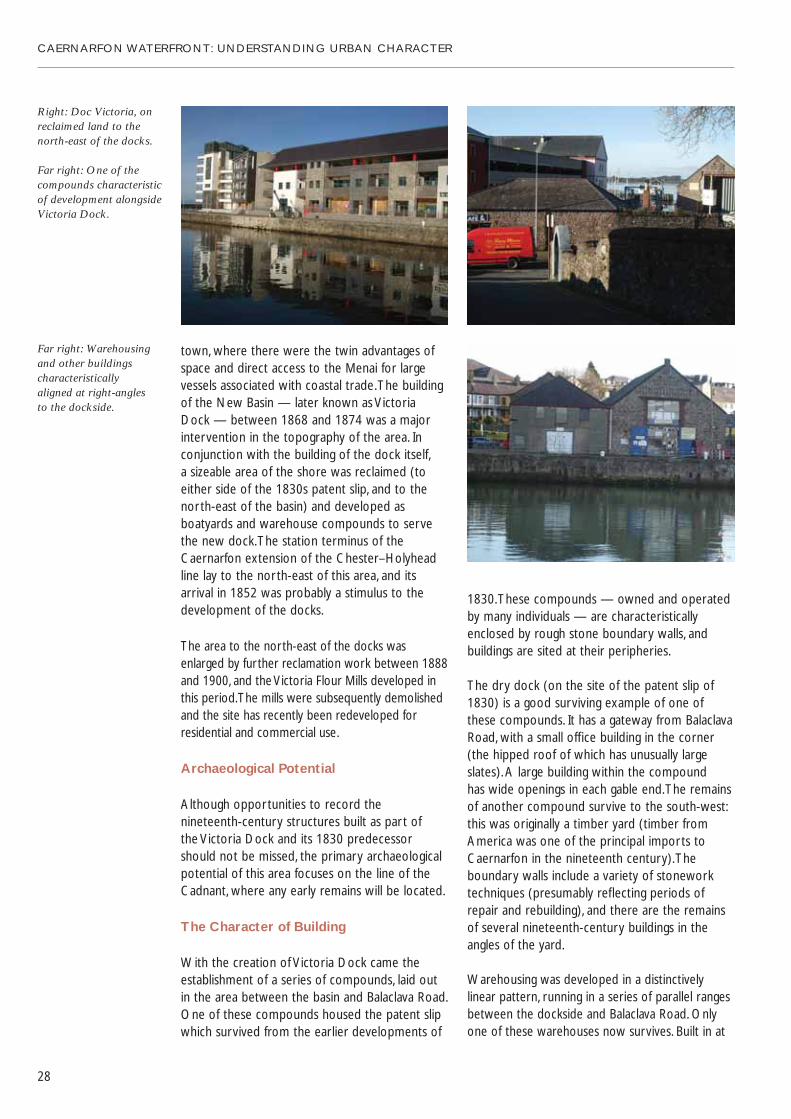
town, where there were the twin advantages ofspace and direct access to the Menai for largevessels associated with coastal trade. The buildingof the New Basin — later known as Victoria Dock — between 1868 and 1874 was a majorintervention in the topography of the area. Inconjunction with the building of the dock itself, a sizeable area of the shore was reclaimed (toeither side of the 1830s patent slip, and to thenorth-east of the basin) and developed asboatyards and warehouse compounds to servethe new dock. The station terminus of theCaernarfon extension of the Chester–Holyheadline lay to the north-east of this area, and itsarrival in 1852 was probably a stimulus to thedevelopment of the docks.
The area to the north-east of the docks wasenlarged by further reclamation work between 1888and 1900, and the Victoria Flour Mills developed inthis period. The mills were subsequently demolishedand the site has recently been redeveloped forresidential and commercial use.
Archaeological Potential
Although opportunities to record thenineteenth-century structures built as part of the Victoria Dock and its 1830 predecessorshould not be missed, the primary archaeologicalpotential of this area focuses on the line of theCadnant, where any early remains will be located.
The Character of Building
With the creation of Victoria Dock came theestablishment of a series of compounds, laid outin the area between the basin and Balaclava Road.One of these compounds housed the patent slipwhich survived from the earlier developments of
CAERNARFON WATERFRONT: UNDERSTANDING URBAN CHARACTER
28
1830. These compounds — owned and operatedby many individuals — are characteristicallyenclosed by rough stone boundary walls, andbuildings are sited at their peripheries.
The dry dock (on the site of the patent slip of1830) is a good surviving example of one ofthese compounds. It has a gateway from BalaclavaRoad, with a small office building in the corner(the hipped roof of which has unusually largeslates). A large building within the compound has wide openings in each gable end. The remainsof another compound survive to the south-west:this was originally a timber yard (timber fromAmerica was one of the principal imports toCaernarfon in the nineteenth century). Theboundary walls include a variety of stoneworktechniques (presumably reflecting periods ofrepair and rebuilding), and there are the remainsof several nineteenth-century buildings in theangles of the yard.
Warehousing was developed in a distinctivelylinear pattern, running in a series of parallel rangesbetween the dockside and Balaclava Road. Onlyone of these warehouses now survives. Built in at
Right: Doc Victoria, onreclaimed land to thenorth-east of the docks.
Far right: One of thecompounds characteristicof development alongsideVictoria Dock.
Far right: Warehousingand other buildingscharacteristically aligned at right-angles to the dockside.

least two phases, it has rubble walls with butteredpointing. The frontage onto Balaclava Road has distinctive polygonal random rubble. Thewarehouse bounds the dry dock, but presents an almost blind elevation onto the dockside,suggesting that it was an independent concern.
The archives and car park building now occupythe site of a timber yard and pond, and respectthese earlier boundaries. The original lineardevelopment pattern to the north-east has beenlost. The Galeri is built on a different orientation,running counter to the original pattern.
Doc Fictoria, the recently completed newdevelopment on the north side of the dock, hasproved to be a controversial addition to thetownscape. Concerns focussed on its impact onthe setting of the World Heritage Site of castleand town walls: this is a sensitive site whereexcellence in design and careful attention to scaleand massing is of paramount importance. Scaledback from the original proposals, and with itsmass somewhat broken by the choice of formsand materials, the resultant scheme avoidsexcessive damage to the character and setting of the castle and walled town, but still dominatesthe dock area. The scale and simple detail of theGaleri, with its adoption of a modern ‘take’ on ahistorically authentic dockside vernacular style,represents a more a appropriate model fordevelopment here.
On the south side of the dock, the Royal NavalReserve Battery (now the yacht club premises)was built between 1872 and 1888.
Important examples of dockside fixtures survive— a swing bridge, bollards, and a crane — andshould be retained either in situ, or sensitivelyrelocated within the immediate area.
CAERNARFON WATERFRONT: UNDERSTANDING URBAN CHARACTER
29
A traditional stoneworkfinish survives on adockside warehouse.
The street frontageemploys a moredecorative finish.
Modern development hasnot always reflected thescale and orientation ofearly development alongthe dockside.
Far left: The Galeri, a modern interpretation of dockside vernacular.
Left: Doc Victoria.
3 The Slate Quay
Historical Background
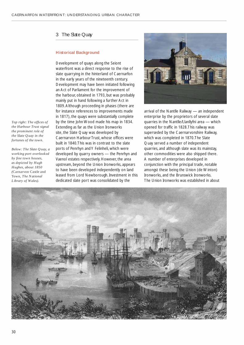
Development of quays along the Seiontwaterfront was a direct response to the rise ofslate quarrying in the hinterland of Caernarfon in the early years of the nineteenth century.Development may have been initiated following an Act of Parliament for the improvement of the harbour, obtained in 1793, but was probablymainly put in hand following a further Act in 1809. Although proceeding in phases (there arefor instance references to improvements made in 1817), the quays were substantially complete by the time John Wood made his map in 1834.Extending as far as the Union Ironworks site, the Slate Quay was developed byCaernarvon Harbour Trust, whose offices werebuilt in 1840. This was in contrast to the slateports of Penrhyn and Y Felinheli, which weredeveloped by quarry owners — the Penrhyn andVaenol estates respectively. However, the areaupstream, beyond the Union Ironworks, appearsto have been developed independently on landleased from Lord Newborough. Investment in thisdedicated slate port was consolidated by the
CAERNARFON WATERFRONT: UNDERSTANDING URBAN CHARACTER
30
arrival of the Nantlle Railway — an independententerprise by the proprietors of several slatequarries in the Nantlle/Llanllyfni area — whichopened for traffic in 1828. This railway wassuperseded by the Caernarvonshire Railway,which was completed in 1870. The Slate Quay served a number of independent quarries, and although slate was its mainstay, other commodities were also shipped there. A number of enterprises developed inconjunction with the principal trade, notableamongst these being the Union (de Winton)Ironworks, and the Brunswick Ironworks. The Union Ironworks was established in about
Top right: The offices ofthe Harbour Trust signalthe prominent role of the Slate Quay in thefortunes of the town.
Below: The Slate Quay, aworking port overlookedby fine town houses, as depicted by HughHughes, about 1850(Carnarvon Castle andTown, The NationalLibrary of Wales).

1844 on land leased from Lord Newborough. An independent quay or graving dock on LordNewborough’s land was filled in and built over asthe Union Ironworks developed after 1844. Earlywork contracts included producing componentsfor the Britannia Bridge and girders for the Housesof Parliament. J. P. de Winton joined the company in 1854. The company specialized in producingmachinery for the slate quarrying industry,including locomotives, wagons, turntables, windingdrums, saw tables and weighting machines. By 1889the site was extensive and comprised severalranges of warehouses and workshops (the onlygroup to survive are the buildings now occupied
by Gwynedd Tyres), an erecting shop (substantiallyintact), and an office and showroom (intact). The works closed in 1901–02.
Upriver from the Union Ironworks was a series of smaller enterprises: slateworks, lime kilns andlimeworks, and timber yards. All of these (with theexception of one of the timber yards) had directaccess to a wharf. Downstream of the ironworkswas the Slate Quay proper. The Ordnance Surveymap of 1889 shows the area demarcated as aseries of compounds, each let to an individualquarry. Originally these yards had access to shipsvia ramps, but all except two of the ramps hadbeen filled in by 1889. The compounds weredemarcated by walls, some of which survive.
Between the line of the railway and theembankment below the Maes and SegontiumTerrace lay a discrete area divided into a series ofsmall plots, which were probably set out in 1829. In 1834, these were copper ore and coal yards(copper ore was exported from Caernarfon, andcoal was imported). In 1840, the Harbour Officeswere built across the north-western boundary ofthis site, which by 1844 also included a foundry. Thefrontage of this ‘island’ site overlooking the SlateQuay was gradually developed with a series ofbuildings, including the offices of quarry companiesand independent agents in the slate trade.
Archaeological Potential
The sequence of building and repair of the quaywalls may be visible in changes in masonry style.The Slate Quay area is made ground and it isknown that some of the fill came from levelling at the Maes in the early nineteenth century.Embedded in the surface are remnants of thestandard gauge line installed in 1870.
CAERNARFON WATERFRONT: UNDERSTANDING URBAN CHARACTER
31
Top left: The erectingshop of the UnionIronworks is a reminderof an important local industry.
Above: The Slate Quay,ordered by the demandsof its trade, in the latenineteenth century(Carnarvon Slate Quayand Harbour, GwyneddArchives Service).
The varied pattern of building on the quay reflects the many enterprises thatoperated here.
The original layout ofthe Slate Quay as a seriesof yards is perpetuated inthe modern use of space.

The recording of surviving buildings at the variousworking compounds that occupied the ‘island’ siteand the river frontage would help establish thesequence of development and may reveal evidencefor a more detailed understanding of building use.Several of the buildings associated with the UnionIronworks have already been demolished, butsurviving boundary walls and potentially floorsurfaces may retain details of archaeological interestthat should be recorded as opportunity arises.
The Character of Building
The organizational structure of the quays is directlyreflected in the character of building. Individualenterprises leased areas of the quay for their ownbusiness needs: slate quarries hired compounds forthe storage of slate in the open area belowSegontium Terrace and, along with other companies,they let small yards in the ‘island’ site at the back ofthe quay. Upriver, a series of enterprises establishedtheir own distinct premises. All of these neededsome form of demarcation, and the area is stillcharacterized as a series of separate compounds.This historical layout is apparent both in survivingboundary walls, and in the structure of more recentdevelopment. Surviving nineteenth-century buildingsare confined to the ‘island’ area on the Slate Quaysthemselves and the warehouse behind, and theUnion (de Winton) Ironworks and the adjoining site.
At the Slate Quay, the buildings in the ‘island’ site yards are as varied as were their tenancies
CAERNARFON WATERFRONT: UNDERSTANDING URBAN CHARACTER
32
The characteristicalignments of the smallbuildings occupying the‘island’ site on the quay,shown in this engravingby Newman and Co. (Caernarvon Castle,The National Library of Wales).
Industrial vernacular at the rear of the ‘island’ site.

in the nineteenth century. Some of them wereclearly built as display buildings, and though small,have a degree of refinement in their façadetreatment — slate-hanging, scribed render, andpolychrome brickwork. Others — notably thoseto the rear of the site — have more of anindustrial vernacular character, using mainly rubblestone or corrugated iron. The large warehousebuilt against the slope below the Maes wasconstructed between 1834 and 1844 for MorganLloyd and Son, wine and spirit merchants. Thehigh quality of its stonework provides a clue tothe value of its original content.
The Union (de Winton) Ironworks encompass a range of styles from the formality of the office building and the distinctive detailing of the erecting shop, to the rougher industrialvernacular of the buildings in the yard beyond.
4 The Maes
Historical Development
The Maes probably originated as the bailey of theNorman castle built in 1090. The Welsh took thecastle in 1115, and the bailey is thought to havebecome the garden of a llys of the Welsh princes.When the Edwardian castle and town were laidout the area was retained as the marketplace of the town, and thus it remained until recreated
as a formal town square when Caernarfon began to expand in the early nineteenth century.The first major building project here was theterrace on the north side of the square, whichhad been built by 1817. The Castle Hotel and its associated terrace followed in about 1830, and the east side of the square was also built up by 1834. Preparations for the investiture of the Prince of Wales in 1911 included thedemolition of the north end of The CastleHotel’s terrace opposite the Queen’s Gate. The south end of the terrace remaineduncompleted until the 1990s.
Archaeological Potential
The Maes has a history pre-dating theestablishment of the Edwardian castle and townand its subsequent use as the main marketplace,but archaeological work in 2008 showedtruncated natural deposits and bedrock acrossmuch of the area, suggesting potential is limited.Building recording and especially investigation ofany cellars should be considered.
CAERNARFON WATERFRONT: UNDERSTANDING URBAN CHARACTER
33
The Maes — outside thewalls, but at the heart oftown life.

The Character of Building
The terrace comprising nos 32–37 on the southside of the square towers above the waterfront. It presents a polite and well-maintainedarchitectural frontage to the square, but the rear, whilst prominent from the quays, has not fared well: its render finish is largely atwentieth-century modification, and there aresigns of neglect. The buildings were provided with yards at quay level: their boundary wallsinclude a variety of materials including beachboulders. The remains of earlier stabling etcsurvive in some of the existing garages. From thelower level, the modern extension to the terraceappears over-scaled and heavy. At the lower angle of the road connecting the Maes and thequay, the Castle Gift Shop occupies a small corner plot which existed in 1834, but was not developed until about 1850. Although small, it is very polite, with sash windows, scribedrender, and a sophisticated roof.
5 Segontium Terrace and Tre’r Gof
Historical Background
This area probably comprised fields until about1824, when there is a reference to a piece of land called Caemaesglas being sold for building.The regular grid of streets suggests that the landwas set out for building by the original owner, but the variety in building suggests thatdevelopment lay in many hands. There is areference to the use of building or money clubsto enable this work to go ahead. Garnons Street
CAERNARFON WATERFRONT: UNDERSTANDING URBAN CHARACTER
34
Right: This terracepresents a formalfrontage onto the Maes.
Far right: From the SlateQuay, the terrace is aprominent butdisregarded feature of the townscape.
A mixture of materials in the wall of a domesticyard at the rear of theSlate Quay.
The pattern ofsmall-scale outbuildingsand yards competes forattention with moderndevelopment beneathhouses fronting onto the Maes.
Contrasting scales arecharacteristic of thetownscape beneath the Maes.
and Snowdon Street were a slightly laterdevelopment (between 1834 and 1844) on another plot of land belonging to Richard Garnons.
Archaeological Potential
Where later disturbance has not removeddeposits, there may be evidence for medieval and post-medieval activity outside the town walls, and even discrete Roman activity.
The Character of Building
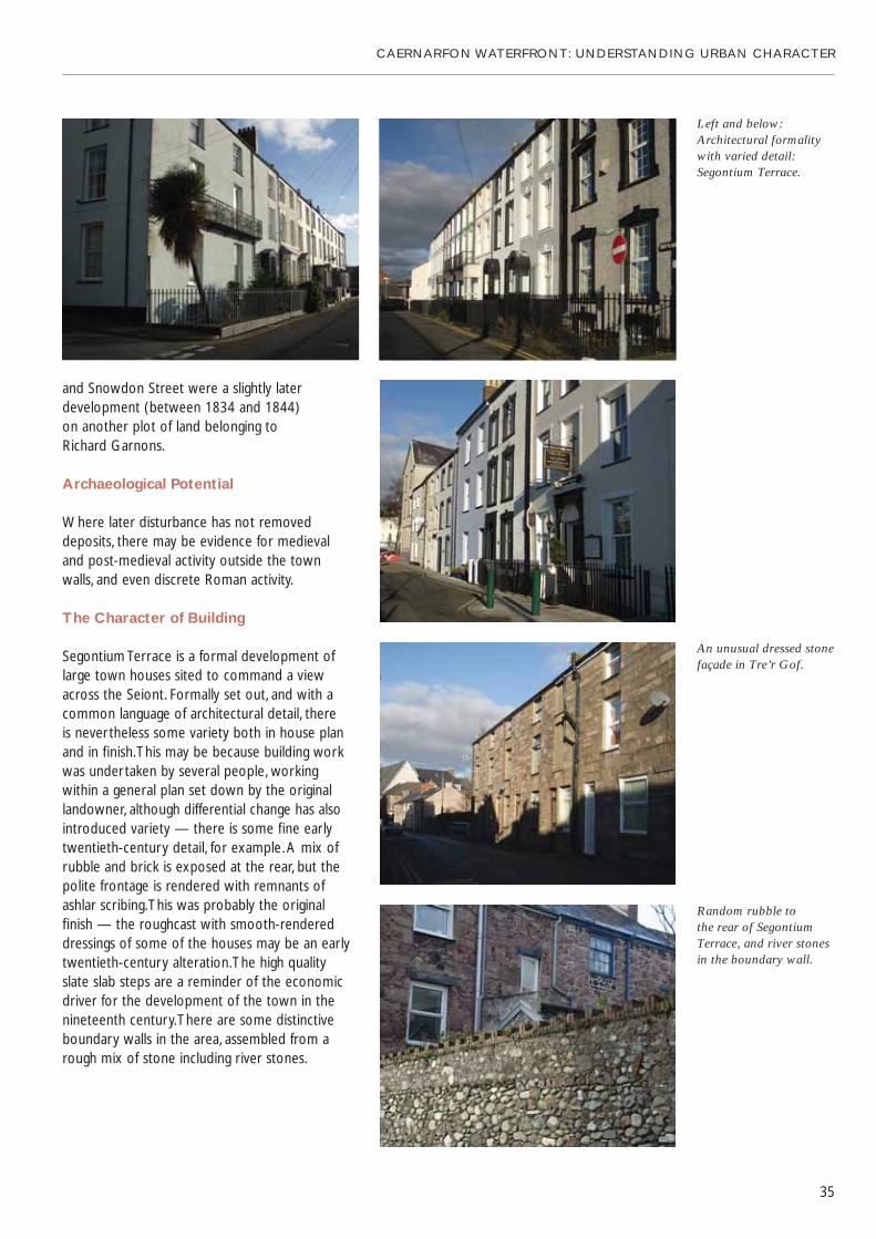
Segontium Terrace is a formal development oflarge town houses sited to command a viewacross the Seiont. Formally set out, and with acommon language of architectural detail, there is nevertheless some variety both in house planand in finish. This may be because building workwas undertaken by several people, working within a general plan set down by the originallandowner, although differential change has alsointroduced variety — there is some fine earlytwentieth-century detail, for example. A mix ofrubble and brick is exposed at the rear, but thepolite frontage is rendered with remnants ofashlar scribing. This was probably the originalfinish — the roughcast with smooth-rendereddressings of some of the houses may be an earlytwentieth-century alteration. The high quality slate slab steps are a reminder of the economicdriver for the development of the town in thenineteenth century. There are some distinctiveboundary walls in the area, assembled from arough mix of stone including river stones.
CAERNARFON WATERFRONT: UNDERSTANDING URBAN CHARACTER
35
Left and below:Architectural formalitywith varied detail:Segontium Terrace.
An unusual dressed stonefaçade in Tre’r Gof.
Random rubble to the rear of SegontiumTerrace, and river stonesin the boundary wall.

6 Coed Helen
Historical Background
Until the development of the Slate Quay in theearly nineteenth century, the south-west bank ofthe river Seiont had no real connection with thetown. The land belonged to the Coed Helenestate whose park ran down to the river, and thefirst evidence of a link with the town is the AberFerry House, built in 1822. In 1900, a swing bridgewas built here, but demolished in 1969 when thepresent bridge was built.
At the end of Ffordd Coed, the lane leading downto the shore, a small group of buildings was inexistence in 1834 — they were described asboathouses in 1844, and by 1888, there was asmall quay here, adjacent to a boatbuilder’s yard.The quay survives, as does a boat shed and achandlery. The current park (and at one time anopen-air swimming pool) was established in theearly twentieth century.
CAERNARFON WATERFRONT: UNDERSTANDING URBAN CHARACTER
36
Archaeological Potential
Remains of quays and structures associated with the former boatyard would be worthy of recording. The geomorphology of the area, and recorded remains in the surroundinglandscape, suggest there is a high potential for evidence relating to prehistoric or Romanactivity here.
Above: Coed Helen hasremained quite distinctfrom the town.
Right: Small-scalevernacular buildingsclose to the shore.

Character of Building
The stone quay and the vernacular timber andcorrugated-iron sheds contrast with the politecharacter of the ferry house.
The markedly rural character of this bank of theriver provides a dramatic foil to the intenselyurban and built-up area of the town opposite.
CAERNARFON WATERFRONT: UNDERSTANDING URBAN CHARACTER
37
Above: The river Seionthas always effectivelyseparated town fromcountry.
The small scale of thequay at Coed Helencontrasts with theindustrial scale of theSlate Quay (left).

CAERNARFON WATERFRONT: UNDERSTANDING URBAN CHARACTER
38
The Seiont and Menai Waterfronts: Design Parameters forRedevelopment
General Character
The Caernarfon waterfronts were working andtrading areas. They may be overlooked by residentialdevelopments, but the character of the quays isessentially simple and rugged. Any redevelopment ofthese areas should avoid gentrification or prettiness— polite residential detailing would appear alienand contrary to the historical development andsocial history that are outlined in this study.
Whilst demolition of many of the existingstructures along the quays is probably inevitable,since neither their constructional quality orfacilities is adequate, the principle of salvage and reuse of features and materials should be accepted in any proposals from the outset.This would assist the integration of new
development into the townscape and embodythe principle of sustainability. Materials such asstone and slate, and items of historic interest such as the iron gateway of the BrunswickIronworks, should be identified at the earliestopportunity in the development of any schemes,and their careful salvage and reuse embeddedinto planning approvals and contractspecifications. Detailed archaeological recordingshould precede any demolition.
Forms of Development
The Menai waterfront, north of the town, ischaracterized principally by large industrialstructures contained in a series of compounds.Recognition of this in the design of moderndevelopment is one of the crucial factors in
Industrial buildingsoccupy a series ofenclosed compoundsalong the water’s edge of the Slate Quay.

its successful integration into the townscape. Any further redevelopment proposals in this area should seek to follow the original pattern of development, in which buildings were alignedto run back from the quayside, rather than parallel to it.
The Seiont waterfront is more varied, both in its forms of development and in its topography.The ‘island’ site at the northern end of the Slate Quay is a dense huddle of small individualstructures, characterized by differing heights,materials and orientation. This is a directreflection of the establishment of this area as a series of small plots or compounds. Any reconstruction here needs to perpetuate this essential nature but, even accepting theprinciple of reuse of salvaged materials, this canbe achieved without recourse to any period style. The southern end of the Slate Quay has a different character and consists, broadly, of aseries of enclosed compounds. These aresurrounded by relatively high stone walls andcontain a number of simple structures, eachcompound having both access to the street and a frontage to the river. This form ofdevelopment has a variety and flexibility thatcould form the basic module for reconstruction
CAERNARFON WATERFRONT: UNDERSTANDING URBAN CHARACTER
39
along the east bank of the Seiont. There are fewlisted buildings along this part of the river — the Harbour Offices, the Union IronworksAssembly Shop, and the Union Ironworks Offices comprise the total — and there shouldbe no doubt about their retention andincorporation in any redevelopment proposals.But in contemplating the possible clearance ofmuch else along St Helen’s Road, it should beaccepted that the granting of full planningpermission and the letting of a contract forreconstruction should be the prerequisites of commencing any demolition.
We have noted that the waterfronts arecharacterized by vernacular and industrialstructures of generally bold simplicity. Decorativeeffects are the exception rather than the rule. The existing buildings provide a vocabulary of details and materials that should form thelanguage of reconstruction.
Each waterfront area has its own character, buttogether they form an important series of linkedspaces. Public realm design should reflect thedistinctive character of each area, as well asencouraging their connection.
Small buildings of variedcharacter crowd togetherin the ‘island’ site on the Slate Quay.

CAERNARFON WATERFRONT: UNDERSTANDING URBAN CHARACTER
40
Design Vocabulary and Materials
There is considerable variety in height, but threestoreys provide a maximum, and in some areas(such as the ‘island’ site on the Slate Quay) less will be appropriate. Buildings are articulatedinto generally small component parts, with ridgelines often set at 90 degrees. Roofs are invariablyslated and gabled, with slightly overhanging orflush verges. There are very few hipped roofs.Modern roof lights would look alien in suchindustrial structures, but the vocabulary oftraditional industrial design provides severalsolutions for roof-level glazing — glazed ridges,raised and glazed ridge lanterns, even whollyglazed sections of roof. Roofscape features suchas chimneys, vents and turrets are rare features in the area, but provide useful accents or markersif required. Walls are constructed generally of rubble stonework, though there are somesignificant examples of brickwork, usually red.Brick is often used for the quoins to windowopenings in rubble walls. Boundary walls areinvariably of rubble stone, sometimes limewashedor painted. Some slate-hanging of walls survives, in the local vernacular tradition, and profiledmetal sheets are found as cladding on both roofs and external walls. Lime render, as arelatively polite finish, was also employed at thenorthern end of the Seiont where the presenceof the ashlar-built Harbour Offices gave an air of refinement to be emulated. Renders weretraditionally never belled outwards over theheads of openings or at the bases of walls, andmodern details such as these should be avoided.In terms of decoration, the predominant colourpalette is quite muted. The vocabulary of wallfinishes should be used with caution — it isadvisable not to mix several finishes on the samebuilding, but to emphasize and reinforce theboldness and simplicity of the massing ofstructures by limiting the disposition of materials.As for doors and windows, we have noted thatconsciously domestic detailing would be alien to the quays. And twee period styling would be a mistake here. The best approach is probablygoing to be simple, modern and efficient.
Buildings that seek to draw attention tothemselves will be out of place on both theSeiont and Menai waterfronts. The castle providesdrama enough in views of this area. So this is notthe opportunity for diva designers. It is subtletythat is needed here, underpinned by anappreciation of the significance of the quays in the development of Caernarfon. It is the existingcharacter of the waterfronts that will provide aspringboard for the visibly successful regenerationof the area.

CAERNARFON WATERFRONT: UNDERSTANDING URBAN CHARACTER
41
Statement of Significance
Caernarfon’s waterfront has been integral to the fortunes of the town throughout its history.The Romans may have had a harbour here — theearly Welsh settlement certainly included a port.The success of the medieval foundation wasowed in large measure to its siting, providing itwith a working river and essential trade links. The town profited from this favourable siting in the nineteenth century, reinventing itself as aport for the slate industry, and flourishing andexpanding as a confident county town.
The peninsula site at the junction of two rivers and the Menai Strait equipped the town with anextensive waterfront, variously used and exploitedat different periods in its history. The Menaishoreline was the original quay, reanimated as apromenade in the nineteenth century. There werealso early quays along the Cadnant, which was aworking river powering the town’s mills. But newharbours were built across its mouth in thenineteenth century, and the Cadnant becameCaernarfon’s lost river. Meanwhile, in the earlynineteenth century, the shores of the Seiont wereexploited for the first time, under the stimulus ofindustrial activity — the quarrying of slate and the
mining of copper — in the hinterland of the town. Each part of the waterfront has a distinctivecharacter, highlighting different elements in thehistory of the town. The original quays, rebuilt as a promenade, hug the town walls and face theMenai, which represented the supply line for themedieval town, and provided a picturesque viewfor visitors in the nineteenth century. The SlateQuay was the terminus of another supply linewhich lead from the slate quarries of the Nantllevalley. Between the railway and the waterfront,small enterprises occupied a series of carefullydelineated spaces, overlooked by handsomesuburban development. The extensive docksestablished to the north of the town wereflanked by other private enterprises, but on alarger scale.
The waterfronts hold the key to understandinghow Caernarfon has been sustained throughoutits long history, and clearly record differentchapters in the story of the town. They couldonce again play a leading role in its fortunes,adding a new chapter whilst retaining a tangibleconnection to the dynamic history of this, ‘thefirst town in North Wales.’18
The waterfront of theriver Seiont and theMenai Strait dominatethe historic town and castle.

Selected Sources
R. Abbott, ‘Chronicles of a CaernarvonIronworks’, Transactions of the CaernarvonshireHistorical Society, Vol. 17 (Caernarvon 1956).
Maurice Beresford, New Towns of the Middle Ages(Gloucester, 1988).
J. I. C. Boyd, Narrow Gauge Railways in NorthCaernarvonshire, Vol. 1: The West (Oxford, 1981).
Bye-gones: Relating to Wales and the Border Counties 1907–08 (Oswestry).
Cadw, World Heritage Site Management Plan:The Castles and Town Walls of Edward I inGwynedd (2004).
The Cambrian Tourist Guide and Companion(London, 1813).
Harold Carter, The Towns of Wales: A Study inUrban Geography (Cardiff, 1965).
Reverend J. Evans, A Tour Through Part of NorthWales in the Year 1798, and at Other Times(London, 1802).
Gerald of Wales, The Journey Through Wales/TheDescription of Wales (Harmondsworth, 1978).
R. A. Griffiths (ed.), Boroughs of Mediaeval Wales(Cardiff, 1978).
Gwynedd Archaeological Trust, Ports and Harboursof Gwynedd: A Threat-Related Assessment(Unpublished, 2005).
J. Hemingway, Panorama of the Beauties, Curiositiesand Antiquities of North Wales (London, 1835).
D. Hopewell, Hafan, Lon Parc, Caernarfon WatchingBrief Gwynedd Archaeological Trust ReportNo. 249 (Unpublished, 1997).
Edmund Hyde Hall, A Description of Caernarvonshire1809–1811 (Caernarfon, 1952).
‘The Dream of Macsen Wledig’, in G. Jones and T. Jones (trans.), The Mabinogion (London, 1974).
CAERNARFON WATERFRONT: UNDERSTANDING URBAN CHARACTER
42
W. H. Jones, Old Karnarvon: A Historical Account ofthe Town of Carnarvon (Caernarvon, 1882).
E. A. Lewis, The Medieval Boroughs of Snowdonia(London, 1912).
Samuel Lewis, A Topographical Dictionary of Wales(London, 1833).
M. D. Lobel, Historic Towns: Maps and Plans ofTowns and Cities in the British Isles, withHistorical Commentaries, from Earliest Times to 1800, Vol. 1 (London, 1969).
Edward Parry, Cambrian Mirror, or A New Tourist Companion Through North Wales(London, 1848).
Thomas Pennant, A Tour in Wales (London, 1778).
Thomas Pennant, A Tour Through North Wales in the Year 1798 (London, 1802).
Thomas Roscoe, Wanderings and Excursions in North Wales (London, 1836).
Royal Commission on the Ancient and HistoricalMonuments in Wales, An Inventory of theAncient Monuments in Caernarvonshire, Vol. 2,Central: The Cantref of Arfon and the Commoteof Eifionydd (London, 1960).
Ian Soulsby, The Towns of Medieval Wales: A Study oftheir History, Archaeology and Early Topography(Chichester, 1983).
A. J. Taylor, ‘The King’s Works in Wales’ in H. M.Colvin (ed.), The History of the King’s Works, Vol. I (London, 1963).
P. B. Williams, The Tourist’s Guide Through the Countyof Caernarvon (Caernarvon, 1821).
Maps
John Speed, Caernarvon both Shyre and Shire-townewith the Ancient Citie Bangor Described. AnnoDomini 1610 (The National Library of Wales).
John Wood, Plan of the Town of Caernarvon FromActual Survey, 1834 (Gwynedd Archives Service).
First Edition Ordnance Survey, 1888 (1:2,500).

Endnotes
1 ‘The Dream of Macsen Wledig’, in G. Jonesand T. Jones (trans.), The Mabinogion(London, 1974).
2 Bye-gones: Relating to Wales and the BorderCounties 1907–08 (Oswestry).
3 R. A. Griffiths (ed.), Boroughs of MediaevalWales (Cardiff, 1978).
4 Giraldus Cambrensis, The Journey ThroughWales/The Description of Wales(Harmondsworth, 1978).
5 R. A. Griffiths (ed.), Boroughs of MediaevalWales (Cardiff, 1978).
6 Thomas Pennant, A Tour Through North Wales in the Year 1798 (London, 1802).
7 Thomas Pennant, A Tour Through North Wales inthe Year 1798 (London, 1802).
8 W. H. Jones, Old Karnarvon: A Historical Accountof the Town of Carnarvon (Caernarvon, 1882).
9 The Cambrian Tourist Guide and Companion(London, 1813).
10 Thomas Pennant, A Tour Through North Wales inthe Year 1798 (London, 1802).
11 Edmund Hyde Hall, A Description ofCaernarvonshire 1809–1811(Caernarfon, 1952).
12 The Cambrian Tourist Guide and Companion(London, 1813).
13 Edmund Hyde Hall, A Description ofCaernarvonshire 1809–1811 (Caernarfon, 1952).
14 Gwynedd Archaeological Trust, Ports andHarbours of Gwynedd: A Threat-RelatedAssessment (Unpublished, 2005).
15 J. I. C. Boyd, Narrow Gauge Railways in North Caernarvonshire, Vol. 1: The West(Oxford, 1981).
16 Reverend J. Evans, A Tour Through Part of NorthWales in the Year 1798, and at Other Times(London, 1802).
17 The Cambrian Tourist Guide and Companion(London, 1813).
18 The Cambrian Tourist Guide and Companion(London, 1813).
CAERNARFON WATERFRONT: UNDERSTANDING URBAN CHARACTER
43

CAERNARFON WATERFRONT: UNDERSTANDING URBAN CHARACTER
44
1 All Character Areas
This map is reproduced from Ordnance Survey material with the permission of Ordnance Survey on behalf of the Controller of Her Majesty’s Stationery Office © Crown Copyright. Unauthorised reproduction infringes Crown copyright and may lead toprosecution or civil proceedings. Licence Number 100021874.

CAERNARFON WATERFRONT: UNDERSTANDING URBAN CHARACTER
45
2 All Character Areas with Historic Environment Designations
This map is reproduced from Ordnance Survey material with the permission of Ordnance Survey on behalf of the Controller of Her Majesty’s Stationery Office © Crown Copyright. Unauthorised reproduction infringes Crown copyright and may lead toprosecution or civil proceedings. Licence Number 100021874.

CAERNARFON WATERFRONT: UNDERSTANDING URBAN CHARACTER
46
3 The Promenade (The Medieval Quay) Area (1)
This map is reproduced from Ordnance Survey material with the permission of Ordnance Survey on behalf of the Controller of Her Majesty’s Stationery Office © Crown Copyright. Unauthorised reproduction infringes Crown copyright and may lead toprosecution or civil proceedings. Licence Number 100021874.

CAERNARFON WATERFRONT: UNDERSTANDING URBAN CHARACTER
47
4 Bank Quay and Victoria Dock Area (2)
This map is reproduced from Ordnance Survey material with the permission of Ordnance Survey on behalf of the Controller of Her Majesty’s Stationery Office © Crown Copyright. Unauthorised reproduction infringes Crown copyright and may lead toprosecution or civil proceedings. Licence Number 100021874.

CAERNARFON WATERFRONT: UNDERSTANDING URBAN CHARACTER
48
5 The Slate Quay Area (3)
This map is reproduced from Ordnance Survey material with the permission of Ordnance Survey on behalf of the Controller of Her Majesty’s Stationery Office © Crown Copyright. Unauthorised reproduction infringes Crown copyright and may lead toprosecution or civil proceedings. Licence Number 100021874.

CAERNARFON WATERFRONT: UNDERSTANDING URBAN CHARACTER
49
6 The Maes Area (4)
This map is reproduced from Ordnance Survey material with the permission of Ordnance Survey on behalf of the Controller of Her Majesty’s Stationery Office © Crown Copyright. Unauthorised reproduction infringes Crown copyright and may lead toprosecution or civil proceedings. Licence Number 100021874.

CAERNARFON WATERFRONT: UNDERSTANDING URBAN CHARACTER
50
7 Segontium Terrace and Tre’r Gof (5)
This map is reproduced from Ordnance Survey material with the permission of Ordnance Survey on behalf of the Controller of Her Majesty’s Stationery Office © Crown Copyright. Unauthorised reproduction infringes Crown copyright and may lead toprosecution or civil proceedings. Licence Number 100021874.

CAERNARFON WATERFRONT: UNDERSTANDING URBAN CHARACTER
51
8 Coed Helen Area (6)
This map is reproduced from Ordnance Survey material with the permission of Ordnance Survey on behalf of the Controller of Her Majesty’s Stationery Office © Crown Copyright. Unauthorised reproduction infringes Crown copyright and may lead toprosecution or civil proceedings. Licence Number 100021874.

CAERNARFON WATERFRONT: UNDERSTANDING URBAN CHARACTER
52

CadwWelsh Assembly GovernmentPlas CarewUnit 5/7 Cefn CoedParc NantgarwCardiff CF15 7QQ
Telephone: 01443 33 6000Fax: 01443 33 6001
First published by Cadw 2010.ISBN 978-1-85760-277-7Crown Copyright 2010.
Cadw is the Welsh Assembly Government’s historic environment service, working for an accessible and well-protected historic environment for Wales.

Cadw is the Welsh Assembly Government’s historic environment service, working for an accessible and well-protected historic environment for Wales.
CadwWelsh Assembly GovernmentPlas CarewUnit 5/7 Cefn CoedParc NantgarwCardiff CF15 7QQ