Embed Size (px)
Citation preview
Zhang et al.: Calculation of wetlands ecological water requirement
- 463 -
APPLIED ECOLOGY AND ENVIRONMENTAL RESEARCH 14(3): 463-478.
http://www.aloki.hu ● ISSN 1589 1623 (Print) ● ISSN 1785 0037 (Online)
DOI: http://dx.doi.org/10.15666/aeer/1403_463478
2016, ALÖKI Kft., Budapest, Hungary
CALCULATION OF WETLANDS ECOLOGICAL WATER
REQUIREMENT IN CHINA’S WESTERN JILIN PROVINCE
BASED ON REGIONALIZATION AND GRADATION
TECHNIQUES
ZHANG, L.1 – HOU, G. L.
1 – ZHANG, G. X.
1* – LIU, Z. L.
1 – SUN, G. Z.
1,2 – LI, M. N.
3
1Northeast Institute of Geography and Agroecology, Chinese Academy of Sciences, Changchun,
130102, P. R. China
2School of Engineering, Edith Cowan University, Joondalup, WA 6027, Australia
3JILIN Province Water Resource and Hydropower Consultative Company,Changchun,
130026,P.R. China
*Corresponding author
e-mail:[email protected]
(phone:+86-431-85542210; fax:+86-431-85542298)
(Received 16th Nov 2015; accepted 25
th Apr 2016)
Abstract. In this study a method for measuring the regional hydrological connectivity and water supply
requirement of wetlands in Western Jilin Province (WJL) is defined and verified. The ecological water
requirements of 216 wetlands, under various guarantee frequencies, were calculated and analyzed. In
addition, twelve indicators were used to establish an evaluation index system, to characterize their
ecological water requirements. The results showed that 12 hydrologically connected regions were
delineated in WJL, and the 216 wetlands can be classified to six grades by AHP (Analytic Hierarchy
Process) method. The annual minimum, suitable, and maximum ecological water requirements of these
wetlands were found to be 7.72×10⁸ m3, 13.76×10⁸ m3, 26.15×10⁸ m3 respectively, with 50% guarantee
frequency. The primary water supply to the lakes and marshes was found to be from regional sources that
provided a scientific basis for the allocation of water resources from the interconnected river-lake system
network (IRLSN) in WJL.
Keywords: Western Jilin Province, hydrological connectivity regionalization, AHP, ecological water
demand.
Introduction
Western Jilin Province (WJL) is located in the hinterland of Songnen Plain, an
ecological fragile region in the transitional zone from semi-humid to semi-arid climate.
The region has the largest, and one of the most important, wetland ecosystems in Songhua
River Basin (Pan et al., 2006; Ren et al., 2007). At present, maintaining the ecological
health of these wetlands is hampered by insufficient knowledge of their water supply
requirements.
Geographically, the WJL region is flat and situated mainly on an alluvial plain, making
the discharge of surface waters into the region difficult. In recent decades, the influence of
climate change (rising temperatures and declining rainfall) and human activities
Zhang et al.: Calculation of wetlands ecological water requirement
- 464 -
APPLIED ECOLOGY AND ENVIRONMENTAL RESEARCH 14(3): 463-478.
http://www.aloki.hu ● ISSN 1589 1623 (Print) ● ISSN 1785 0037 (Online)
DOI: http://dx.doi.org/10.15666/aeer/1403_463478
2016, ALÖKI Kft., Budapest, Hungary
(engineered hydraulic structures, such as reservoir) have weakened and damaged existing
river-lake connection networks, causing a sharp decline of streamflows into two major
rivers in the region, Huolin River and Tao’er River. As a result, the wetlands are showing
clear signs of deteriorating ecological functions and acreage losses (Yue et al., 2008).
The amount of river water flowing across WJL (in particular, Nenjiang River, Songhua
River) is still abundant for sustaining agricultural activities and wetland ecosystem, if the
water resource is appropriately connected and allocated. A large-scale water management
scheme, namely “Interconnected River-Lake System Network” (IRLSN), is being
planned in WJL. It aims to coordinate the use of various water resources, to replenish
lakes of significant ecological or economic values, provide water storage, and restore
some ecologically important natural wetlands, such as Xianghia, Momoge, Chagan Lake
Nature Reserve Wetlands (Dong et al., 2014). The IRLSN must be guided by a scientific
approach of analyzing water supply-demand relation in hydrologically connected or
separated regions, as it would be reckless to link waterways and storages without careful
research and design.
Hydrology regime is the driving force behind the formation of wetlands (Zhang et al.,
2014). Hydrological connectivity is the basis of water supply and allocation; it should be
the first to be analyzed in quantitative studies of how waterways in neighboring regions
can be connected in water management. Bracken et al. (2013) classified the research
around hydrological connectivity into five broad themes based on: i) soil moisture; ii)
flow processes; iii) terrain; iv) models; and v) indices. This classification yielded a
definition of hydrological connectivity, and laid a foundation of conceptualization and
methodology of different research approaches. Many researchers studied regional water
resources based on hydrology, bio-ecology, nutrient migration and material deposited
(Freeman et al., 2007; Lexartza-Artza and Wainwright, 2009; Lesschen et al., 2009; Luo
et al., 2011; Shore et al., 2013). The boundary of their studies were individual catchments,
as it is relatively easier to carry out research on a single catchment compared with studies
on a vast region with numerous rivers, scattered lakes and marsh wetlands. In China,
studies on hydrological connections need to be based on functional structures of regional
water network, with evaluation standards and methods that suit the regional conditions
(Zang et al., 2014; Li et al., 2014); such approach is used in this study.
After studying hydrological connectivity, the evaluation of water requirement of
wetlands needs to be carried out, for protecting and restoring different wetlands and
meeting their ecological water requirement according, especially when managed flood is
the main source of water connection. While the method of calculating wetland ecological
water requirement is well known (Li et al., 2009), only limited studies have been carried
out on the wetland water requirement for sustaining ecological functions. Zhang et al.
(2013) used the Analytic Hierarchy Process (AHP) approach to determine weighted
indices of different factors that affect wetland ecosystem values, incorporating
environmental constraints and socio-economic value in each index (Wang et al., 2003;
Herath, 2004). Jiang and Lee (2013) proposed a method to simplify the selection of
Zhang et al.: Calculation of wetlands ecological water requirement
- 465 -
APPLIED ECOLOGY AND ENVIRONMENTAL RESEARCH 14(3): 463-478.
http://www.aloki.hu ● ISSN 1589 1623 (Print) ● ISSN 1785 0037 (Online)
DOI: http://dx.doi.org/10.15666/aeer/1403_463478
2016, ALÖKI Kft., Budapest, Hungary
wetlands for priority management. Four types of evaluation categories were proposed:
areas with a high value for the conservation of the ecosystem; areas with a high potential
impact on biodiversity; wetland size; and eco-networks. Then, the overall wetland water
requirement was classified via an overlay analysis performed using the analytical results
for each evaluation indicator. These previously studies divided the wetlands in WJL to
Class 1 and 2 wetlands.
The objectives of this study are to: (1) determine the water supply domain of wetlands
in WJL through hydrological connection analyses, (2) establish a more refined grading
system of wetland water requirements, using AHP method, and (3) calculate the
ecological water requirements of wetlands under different guarantee frequencies. In
addition, this study aims to contribute to formulating water resource management
strategies for wetland eco-system protection and flood management in the IRLSN
scheme.
Materials and Methods
Study Area
Located between 43°22′N–46°18′N and 121°36′E–126°12′E, Western Jilin has an area
of 55,340 km2 that consists of 11 counties (cities): Baicheng, Zhenlai, Taonan, Tongyu,
Daan, Songyuan, Qianguo, Qian’an, Changling, Fuyu, Nong’an (Figure 1). It is the
transitional zone between arid climate in inner-Mongolia and semi-humid in Eastern Jilin.
Based on data collected from 20 meteorological stations in WJL, the mean annual rainfall
during 1975-2010 was 350-500 mm, while the temperature ranged -30 to -2 °C in January
and 12 to 33 °C in July (Li et al., 2015).
Major rivers merging in WJL include Tao’er River, Huolin River. Major rivers
crossing WJL include Nenjiang River and the Second Songhua River. As illustrated in
Figure 1, Nenjiang River is located in northern border of WJL, the Second Songhua River
is located in the northeast border, Tao’er River in western WJL, and Huolin River (in
central WJL) are tributaries of Nenjiang River.
According to survey data, the total area of natural wetlands in WJL decreased 1100
km2 from 1980 to 2002. The current area of wetlands is only 22% of the original size (Li,
2011). Three major objectives of IRLSN scheme include: (a) effectively utilizing the
flood waters of Songhua River, Nenjiang River, Tao’er River and Huolin River to
connect the main wetlands, lakes, ponds and reservoirs in the region, (b) building four
core ecological plates on Xianghai, Momoge, Chagan and Boluo Lake, and (c) through
effective management of flood water, improving the existing, or creating new, ecological
communities in Xianghai, Momoge, Chagan and Boluo Lake areas (Jilin Daily, 2015). As
such, the existing 216 wetlands were selected as the main research objects in this study.

Zhang et al.: Calculation of wetlands ecological water requirement
- 466 -
APPLIED ECOLOGY AND ENVIRONMENTAL RESEARCH 14(3): 463-478.
http://www.aloki.hu ● ISSN 1589 1623 (Print) ● ISSN 1785 0037 (Online)
DOI: http://dx.doi.org/10.15666/aeer/1403_463478
2016, ALÖKI Kft., Budapest, Hungary
Figure 1. Distribution of wetlands in Western Jilin province
Hydrological connectivity analysis
Flood inundation method for analyzing the hydrological connectivity of lakes in WJL
Some flood waters are considered water resources in the IRLSN scheme. A
source-flood method (Wang et al., 2010) can be used for flood inundation analysis. In this
study, when flood level (H) is given, the flood inundation area has been calculated by
seed filling algorithm used in a previous study (Wang et al., 2010), as follows:
a) With known starting grid unit (grid unit with dike break position) and flood level
(H), initial a queue structure, add starting grid unit to the queue;
b) Pop first element (grid unit) of the queue, check “up, down, left, right” four
nearby grid units in DEM, if grid unit elevation is lower than flood level(H), then
add this grid unit to the queue;
c) If the queue is not null, go to step 2, else go to step 4;
d) Output queue, all grid units in queue compose the submerged area.
Watershed delineation method
Watershed delineation is one of the most commonly performed activities in
hydrological analyses. Digital elevation models (DEMs) provide good terrain
representation, from which watersheds can be derived automatically using GIS
Zhang et al.: Calculation of wetlands ecological water requirement
- 467 -
APPLIED ECOLOGY AND ENVIRONMENTAL RESEARCH 14(3): 463-478.
http://www.aloki.hu ● ISSN 1589 1623 (Print) ● ISSN 1785 0037 (Online)
DOI: http://dx.doi.org/10.15666/aeer/1403_463478
2016, ALÖKI Kft., Budapest, Hungary
technology. In this study 1:50000 scale DEM was used for watershed delineation,
followed by merging sub-watersheds in WJL according to different water supply
resources; allowing different regional hydrological connectivity to be determined.
Grading of wetland water supply requirements by AHP method
The Analytic Hierarchy Process (AHP) (Saaty, 1980) was used to establish the indexed
grading system for wetlands. The procedure of using the AHP method, as described by
Wang et al. (2003) , included: (a) establishing the index system; (b) constructing the
judgment matrix and single permutation of layer; (c) sequencing the al layers; and (d)
drading of single element and comprehensive evaluation. Then the natural breaks
classification method in the Arcgis technique was used to assign the grades of water
supply requirements of the wetlands.
In WJL, the calculation range of wetland ecological water requirement was the
wetland in different hydrological connectivity and grading regions. The sum of ecological
water requirement of lake, reservoir, and other open water and water requirement of
marsh wetland is shown below:
D=∑Ai(ETi-P)×10-3
(Eq.1)
Where: D represents ecological water requirement (m3); Ai is the area of each part
(m2); ETi represents the evapotranspiration of each part (mm); and P represents the
precipitation of each part (mm).
Results and Discussion
The hydrological connectivity regionalization
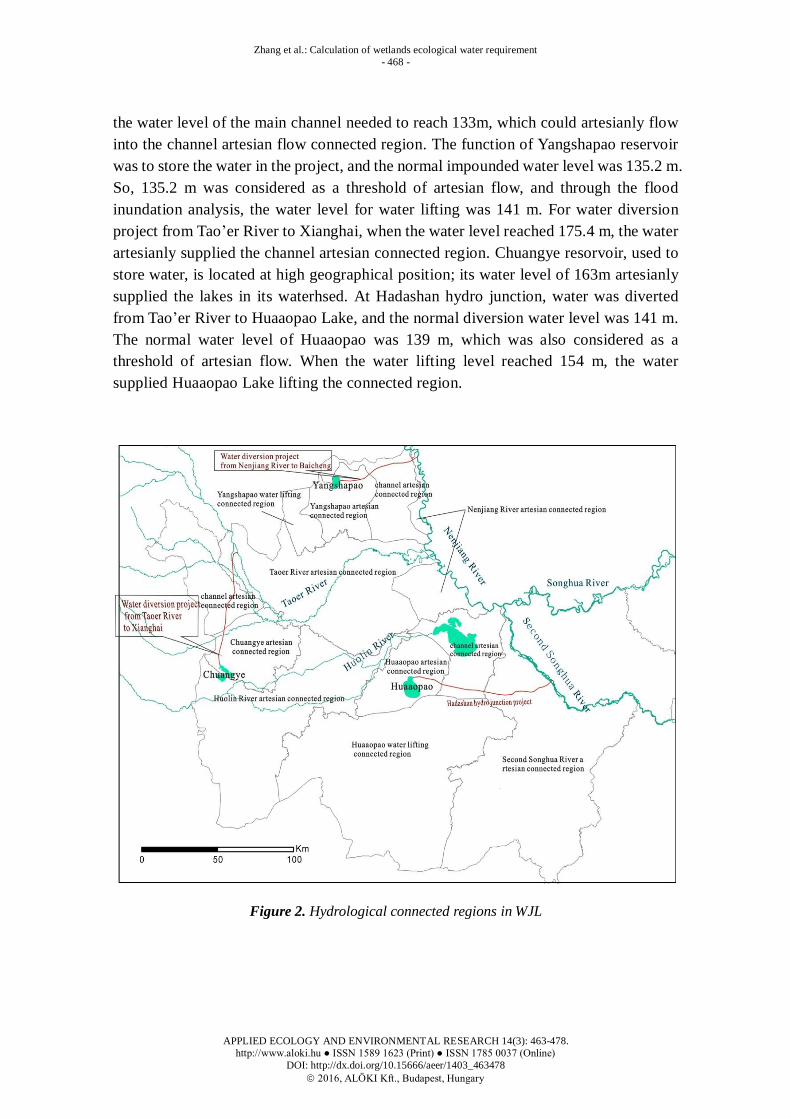
Considering different sources of water supply, and combining flood inundation
analysis with subwatershed delineation results, the regions that are hydrologically
connected have been identified, as shown in Figure 2. Flood waters that generated flow
into the 216 wetlands in WJL has also been identified (Table 1).
The flood water from Nenjiang River artesian flow connected region, Tao’er River
artesian flow connected region, Huolin River artesian flow connected region and
Second Songhua River artesian flow connected region were found to be Nenjiang River,
Tao’er River, Huolin River and Second Songhua River, respectively. Additionally, the
water levels corresponding to each of these water supply sources were 131 m, 141.2 to
221.6 m, 152 m, and 175 m, respectively. In addition to flood waters, water sources to
the wetland included water diversion from Nenjiang River to Baicheng, and water
diversion from Tao’er River to Xianghai and Hadashan hydro junction. The water
diversion project from Nenjiang River to Baicheng was dependant on water lifting, and
Zhang et al.: Calculation of wetlands ecological water requirement
- 468 -
APPLIED ECOLOGY AND ENVIRONMENTAL RESEARCH 14(3): 463-478.
http://www.aloki.hu ● ISSN 1589 1623 (Print) ● ISSN 1785 0037 (Online)
DOI: http://dx.doi.org/10.15666/aeer/1403_463478
2016, ALÖKI Kft., Budapest, Hungary
the water level of the main channel needed to reach 133m, which could artesianly flow
into the channel artesian flow connected region. The function of Yangshapao reservoir
was to store the water in the project, and the normal impounded water level was 135.2 m.
So, 135.2 m was considered as a threshold of artesian flow, and through the flood
inundation analysis, the water level for water lifting was 141 m. For water diversion
project from Tao’er River to Xianghai, when the water level reached 175.4 m, the water
artesianly supplied the channel artesian connected region. Chuangye resorvoir, used to
store water, is located at high geographical position; its water level of 163m artesianly
supplied the lakes in its waterhsed. At Hadashan hydro junction, water was diverted
from Tao’er River to Huaaopao Lake, and the normal diversion water level was 141 m.
The normal water level of Huaaopao was 139 m, which was also considered as a
threshold of artesian flow. When the water lifting level reached 154 m, the water
supplied Huaaopao Lake lifting the connected region.
Figure 2. Hydrological connected regions in WJL
Zhang et al.: Calculation of wetlands ecological water requirement
- 469 -
APPLIED ECOLOGY AND ENVIRONMENTAL RESEARCH 14(3): 463-478.
http://www.aloki.hu ● ISSN 1589 1623 (Print) ● ISSN 1785 0037 (Online)
DOI: http://dx.doi.org/10.15666/aeer/1403_463478
2016, ALÖKI Kft., Budapest, Hungary
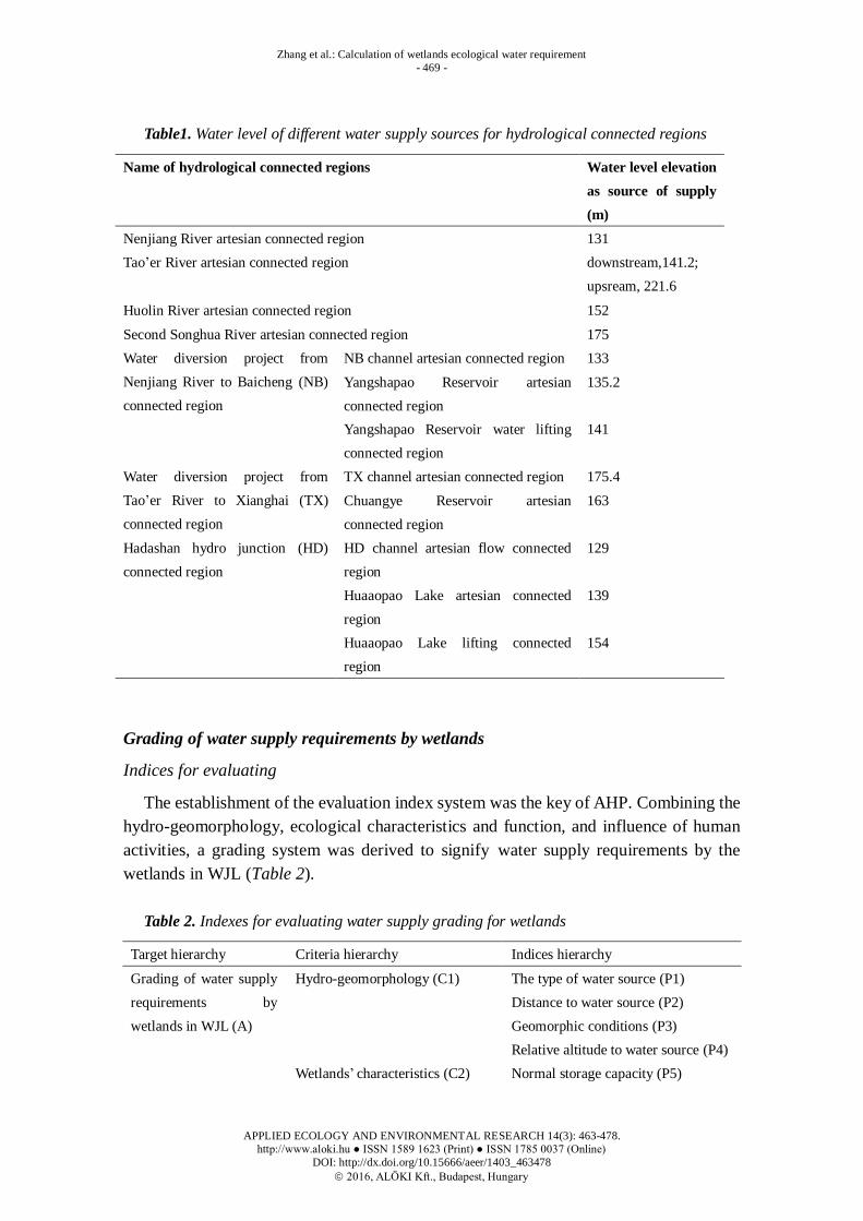
Table1. Water level of different water supply sources for hydrological connected regions
Name of hydrological connected regions Water level elevation
as source of supply
(m)
Nenjiang River artesian connected region 131
Tao’er River artesian connected region downstream,141.2;
upsream, 221.6
Huolin River artesian connected region 152
Second Songhua River artesian connected region 175
Water diversion project from
Nenjiang River to Baicheng (NB)
connected region
NB channel artesian connected region 133
Yangshapao Reservoir artesian
connected region
135.2
Yangshapao Reservoir water lifting
connected region
141
Water diversion project from
Tao’er River to Xianghai (TX)
connected region
TX channel artesian connected region 175.4
Chuangye Reservoir artesian
connected region
163
Hadashan hydro junction (HD)
connected region
HD channel artesian flow connected
region
129
Huaaopao Lake artesian connected
region
139
Huaaopao Lake lifting connected
region
154
Grading of water supply requirements by wetlands
Indices for evaluating
The establishment of the evaluation index system was the key of AHP. Combining the
hydro-geomorphology, ecological characteristics and function, and influence of human
activities, a grading system was derived to signify water supply requirements by the
wetlands in WJL (Table 2).
Table 2. Indexes for evaluating water supply grading for wetlands
Target hierarchy Criteria hierarchy Indices hierarchy
Grading of water supply
requirements by
wetlands in WJL (A)
Hydro-geomorphology (C1) The type of water source (P1)
Distance to water source (P2)
Geomorphic conditions (P3)
Relative altitude to water source (P4)
Wetlands’ characteristics (C2) Normal storage capacity (P5)
Zhang et al.: Calculation of wetlands ecological water requirement
- 470 -
APPLIED ECOLOGY AND ENVIRONMENTAL RESEARCH 14(3): 463-478.
http://www.aloki.hu ● ISSN 1589 1623 (Print) ● ISSN 1785 0037 (Online)
DOI: http://dx.doi.org/10.15666/aeer/1403_463478
2016, ALÖKI Kft., Budapest, Hungary
Normal storage level (P6)
water surface area (P7)
Wetlands’ function (C3) regulation capacity of flood (P8)
Water supply capacity (P9)
Matter production capacity (P10)
Influence of human activities (C4) Distance to residential area (P11)
Distance to farmland (P12)
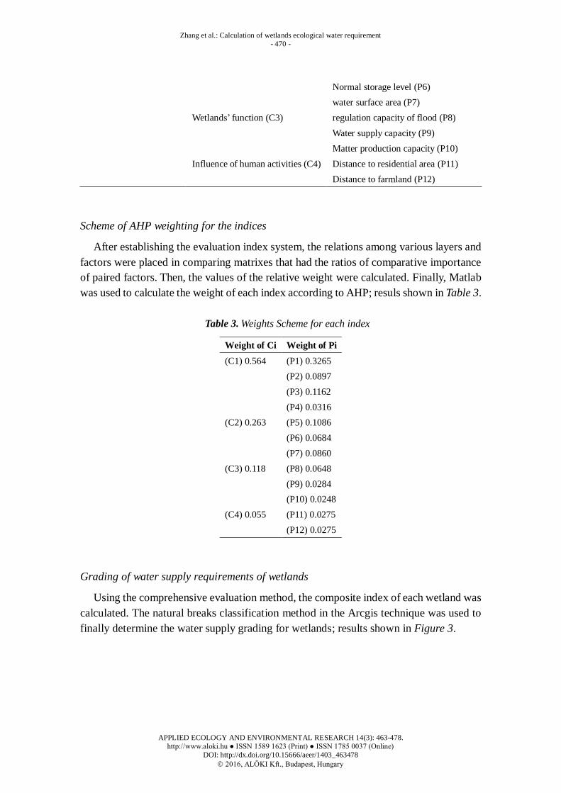
Scheme of AHP weighting for the indices
After establishing the evaluation index system, the relations among various layers and
factors were placed in comparing matrixes that had the ratios of comparative importance
of paired factors. Then, the values of the relative weight were calculated. Finally, Matlab
was used to calculate the weight of each index according to AHP; resuls shown in Table 3.
Table 3. Weights Scheme for each index
Weight of Ci Weight of Pi
(C1) 0.564 (P1) 0.3265
(P2) 0.0897
(P3) 0.1162
(P4) 0.0316
(C2) 0.263 (P5) 0.1086
(P6) 0.0684
(P7) 0.0860
(C3) 0.118 (P8) 0.0648
(P9) 0.0284
(P10) 0.0248
(C4) 0.055 (P11) 0.0275
(P12) 0.0275
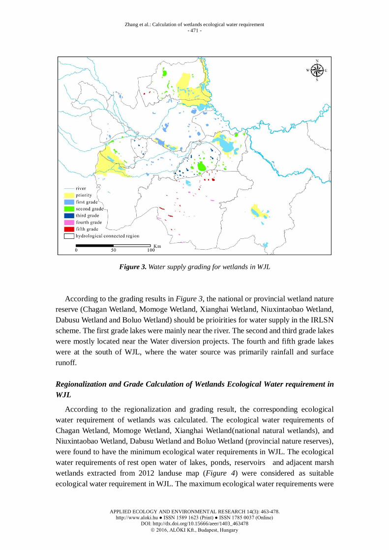
Grading of water supply requirements of wetlands
Using the comprehensive evaluation method, the composite index of each wetland was
calculated. The natural breaks classification method in the Arcgis technique was used to
finally determine the water supply grading for wetlands; results shown in Figure 3.
Zhang et al.: Calculation of wetlands ecological water requirement
- 471 -
APPLIED ECOLOGY AND ENVIRONMENTAL RESEARCH 14(3): 463-478.
http://www.aloki.hu ● ISSN 1589 1623 (Print) ● ISSN 1785 0037 (Online)
DOI: http://dx.doi.org/10.15666/aeer/1403_463478
2016, ALÖKI Kft., Budapest, Hungary
Figure 3. Water supply grading for wetlands in WJL
According to the grading results in Figure 3, the national or provincial wetland nature
reserve (Chagan Wetland, Momoge Wetland, Xianghai Wetland, Niuxintaobao Wetland,
Dabusu Wetland and Boluo Wetland) should be prioirities for water supply in the IRLSN
scheme. The first grade lakes were mainly near the river. The second and third grade lakes
were mostly located near the Water diversion projects. The fourth and fifth grade lakes
were at the south of WJL, where the water source was primarily rainfall and surface
runoff.
Regionalization and Grade Calculation of Wetlands Ecological Water requirement in
WJL
According to the regionalization and grading result, the corresponding ecological
water requirement of wetlands was calculated. The ecological water requirements of
Chagan Wetland, Momoge Wetland, Xianghai Wetland(national natural wetlands), and
Niuxintaobao Wetland, Dabusu Wetland and Boluo Wetland (provincial nature reserves),
were found to have the minimum ecological water requirements in WJL. The ecological
water requirements of rest open water of lakes, ponds, reservoirs and adjacent marsh
wetlands extracted from 2012 landuse map (Figure 4) were considered as suitable
ecological water requirement in WJL. The maximum ecological water requirements were

Zhang et al.: Calculation of wetlands ecological water requirement
- 472 -
APPLIED ECOLOGY AND ENVIRONMENTAL RESEARCH 14(3): 463-478.
http://www.aloki.hu ● ISSN 1589 1623 (Print) ● ISSN 1785 0037 (Online)
DOI: http://dx.doi.org/10.15666/aeer/1403_463478
2016, ALÖKI Kft., Budapest, Hungary
the sum of suitable ecological water requirements and the ecological water requirements
of adjacent marsh wetlands extracted from 1950s landuse map (Figure 4), and the
adjacent mash wetlands were only the the area of marsh wetlands (in 1950s’ landuse map)
that were converted to saline-alkali soil lands in 2012 landuse map (Figure 4).
Through the statictical analysis of monthly precipitation and evaporation from 1960 to
2014 in 10 counties (cities), the monthly precipitation and evaporation under 25%, 50%,
75%, and 90% guarantee rate in each counties (cities) were determined. Sheng et al.
(2007) found that the conversion coefficient between evaporation measured by a small
evaporation pan and water surface evaporation was 0.5-0.6. In this study, the conversion
coefficient was found to be 0.6. In marsh wetlands, the main vegetation was found to be
Phragmites that typically grow between April and September in WJL. Thus, the
ecological water requirement of marsh wetlands were only calculated between April and
September. The evaporation was calculated by the 2.5 times of water surface evaporation
from June to August, and 1.3 times in April, May and September (Tang et al., 2005). The
ecological water requirement of lakes and marshes in each region and grading calculated
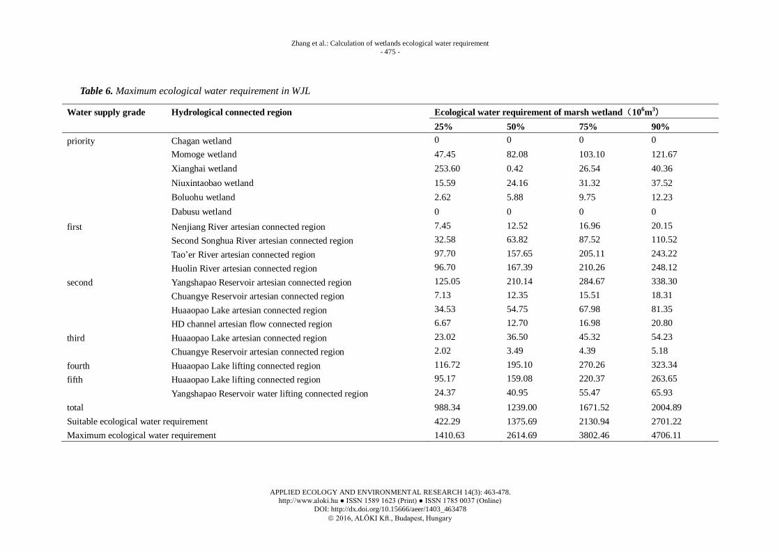
in this study are shown in Tables 4, 5 and 6.
Figure 4. Distribution of existing and potential restoring wetlands of WJL

Zhang et al.: Calculation of wetlands ecological water requirement
- 473 -
APPLIED ECOLOGY AND ENVIRONMENTAL RESEARCH 14(3): 463-478.
http://www.aloki.hu ● ISSN 1589 1623 (Print) ● ISSN 1785 0037 (Online)
DOI: http://dx.doi.org/10.15666/aeer/1403_463478
2016, ALÖKI Kft., Budapest, Hungary
Table 4. Minimum ecological water requirements in WJL
Water
supply
grade
name Hydrological
connected region
Ecological water requirement of open water
(106m
3)
Ecological water requirement of marsh
wetland(106m
3)
25% 50% 75% 90% 25% 50% 75% 90%
priority Chagan
wetland
HD channel artesian
flow connected
region
-34.16 55.28 115.57 168.10 11.57 22.03 29.45 36.08
Momoge
wetland
NB channel artesian
connected region
-0.52 74.66 136.72 178.30 156.96 263.77 357.31 424.62
Xianghai
wetland
TX channel artesian
connected region
0.42 26.54 40.36 52.11 41.58 71.98 90.42 106.69
Niuxintaobao
wetland
Tao’er River artesian
connected region
0.33 10.64 18.37 24.95 9.23 14.31 18.55 22.22
Boluohu
wetland
Second Songhua
River artesian
connected region
-24.47 82.66 178.80 241.82 -24.49 82.66 178.80 241.82
Dabusu
wetland
Huaaopao Lake
lifting connected
region
0.72 8.60 13.46 18.23 36.96 58.62 72.78 87.10
subtotal -57.70 258.38 503.28 683.51 231.83 513.36 747.31 918.54
total 174.13 771.74 1250.60 1602.06

Zhang et al.: Calculation of wetlands ecological water requirement
- 474 -
APPLIED ECOLOGY AND ENVIRONMENTAL RESEARCH 14(3): 463-478.
http://www.aloki.hu ● ISSN 1589 1623 (Print) ● ISSN 1785 0037 (Online)
DOI: http://dx.doi.org/10.15666/aeer/1403_463478
2016, ALÖKI Kft., Budapest, Hungary
Table 5. Suitable ecological water requirement in WJL
Water supply
grade
Hydrological connected region Ecological water requirement of open water
(106m
3)
Ecological water requirement of marsh wetland
(106m
3)
25% 50% 75% 90% 25% 50% 75% 90%
first Nenjiang River artesian connected region 0.26 1.19 20.73 28.20 11.43 19.20 26.01 30.92
Second Songhua River artesian connected
region
-6.13 2.46 10.95 16.49 17.70 34.66 47.54 60.03
Tao’er River artesian connected region 10.73 64.74 104.42 137.49 41.13 66.38 86.36 102.41
Huolin River artesian connected region 0.20 12.19 18.71 24.25 73.00 126.38 158.74 187.32
second Yangshapao Reservoir artesian connected
region
-0.15 21.79 39. 90 52.03 23.45 39.41 53.39 63.45
Chuangye Reservoir artesian connected
region
2.85 9.41 13.88 17.84 2.56 4.43 5.56 6.56
Huaaopao Lake artesian connected region -1.43 19.59 31.07 41.98 14.16 22.46 27.89 33.37
HD channel artesian flow connected region -0.89 9.77 16.58 22.97 9.61 18.28 24.44 29.95
third Huaaopao Lake artesian connected region -0.95 13.06 20.71 27.99 9.44 14.98 18.59 22.25
Chuangye Reservoir artesian connected
region
1.48 4.76 7.01 9.01 3.92 6.78 8.52 10.08
fourth Huaaopao Lake lifting connected region -2.17 16.08 29.49 40.21 24.63 41.16 57.02 68.22
fifth Huaaopao Lake lifting connected region -1.17 8.66 15.88 21.65 13.26 22.16 30.70 36.74
Yangshapao Reservoir water lifting
connected region
-0.01 1.85 3.39 4.42 1.23 2.08 2.81 3.34
subtotal 2.62 185.57 332.74 444.53 245.53 418.38 547.60 654.63
total 248.16 603.95 880.34 1099.16
Minimum ecological water requirement 174.13 771.74 1250.60 1602.06
Suitable ecological water requirement 422.29 1375.69 2130.94 2701.22
Zhang et al.: Calculation of wetlands ecological water requirement
- 475 -
APPLIED ECOLOGY AND ENVIRONMENTAL RESEARCH 14(3): 463-478.
http://www.aloki.hu ● ISSN 1589 1623 (Print) ● ISSN 1785 0037 (Online)
DOI: http://dx.doi.org/10.15666/aeer/1403_463478
2016, ALÖKI Kft., Budapest, Hungary
Table 6. Maximum ecological water requirement in WJL
Water supply grade Hydrological connected region Ecological water requirement of marsh wetland(106m
3)
25% 50% 75% 90%
priority Chagan wetland 0 0 0 0
Momoge wetland 47.45 82.08 103.10 121.67
Xianghai wetland 253.60 0.42 26.54 40.36
Niuxintaobao wetland 15.59 24.16 31.32 37.52
Boluohu wetland 2.62 5.88 9.75 12.23
Dabusu wetland 0 0 0 0
first Nenjiang River artesian connected region 7.45 12.52 16.96 20.15
Second Songhua River artesian connected region 32.58 63.82 87.52 110.52
Tao’er River artesian connected region 97.70 157.65 205.11 243.22
Huolin River artesian connected region 96.70 167.39 210.26 248.12
second Yangshapao Reservoir artesian connected region 125.05 210.14 284.67 338.30
Chuangye Reservoir artesian connected region 7.13 12.35 15.51 18.31
Huaaopao Lake artesian connected region 34.53 54.75 67.98 81.35
HD channel artesian flow connected region 6.67 12.70 16.98 20.80
third Huaaopao Lake artesian connected region 23.02 36.50 45.32 54.23
Chuangye Reservoir artesian connected region 2.02 3.49 4.39 5.18
fourth Huaaopao Lake lifting connected region 116.72 195.10 270.26 323.34
fifth Huaaopao Lake lifting connected region 95.17 159.08 220.37 263.65
Yangshapao Reservoir water lifting connected region 24.37 40.95 55.47 65.93
total 988.34 1239.00 1671.52 2004.89
Suitable ecological water requirement 422.29 1375.69 2130.94 2701.22
Maximum ecological water requirement 1410.63 2614.69 3802.46 4706.11
Zhang et al.: Calculation of wetlands ecological water requirement
- 476 -
APPLIED ECOLOGY AND ENVIRONMENTAL RESEARCH 14(3): 463-478.
http://www.aloki.hu ● ISSN 1589 1623 (Print) ● ISSN 1785 0037 (Online)
DOI: http://dx.doi.org/10.15666/aeer/1403_463478
2016, ALÖKI Kft., Budapest, Hungary
Overall, results from this study demonstrate that the minimum ecological water
requirement in WJL was 174.13, 771.74, 1250.60, 1602.06 million m3 under the
precipitation guarantee rate of 25%, 50%, 75%, 90%, respectively. The suitable
ecological water requirement in WJL was 422.29, 1375.69, 2130.94, 2701.22 million m3
under the precipitation guarantee rate of 25%, 50%, 75%, 90%, respectively. The
maximum ecological water requirement in WJL was 1410.63, 2614.69, 3802.46, 4706.11
million m3 under the precipitation guarantee rate of 25%, 50%, 75%, 90%, respectively.
Among the wetlands being studied, 54% were identified as priorities for water supply ,
first grade was about 24%. Among the first grade of suitable ecological water
requirements, the Tao’er River artesian connected region accounted for about 39%, and
Huolin River artesian connected region accounted for about 41%. The critical sources of
water supply to most lakes and marsh wetlands were Tao’er River and Huolin River.
Currently, water supplies from these two rivers are rapidly decreasing; this poses a
significant risk to the ecological function of the wetlands in WJL.
Conclusion
This study proposed and tested a method for determining the hydrological
connectivity and grades of water supply requirements by wetlands in WJL. The
ecological water requirement of wetlands in WJL can be classified into three categories:
minimum, suitable, maximum. In a hydrological connectivity analysis, WJL was found to
consist of 12 hydrological connected regions. Twelve indicators were selected to
establish the evaluation index system of wetlands water supply grading in WJL, and 6
grades were determined. The minimum ecological water requirement in WJL was
1.74×10⁸, 7.72×10
8, 12.51×10
8, 16.02×10
8 m
3 with precipitation guarantee rate of 25%,
50%, 75%, 90%, respectively. The suitable ecological water requirement in WJL was
4.22×10⁸, 13.76×10
8, 21.31×10
8, 27.01×10
8 m
3 with precipitation guarantee rate of 25%,
50%, 75%, 90%, respectively. The maximum ecological water requirement in WJL was
14.11×10⁸, 26.15×10
8, 38.02×10
8, 47.06×10
8 m
3. Effective utilization of flood water, as a
resource, was found to be essential for supplying water to sustain the lakes and marsh
wetlands in WJL.
Acknowledgements. This study was supported by the Scientific Research Project of Public Welfare
Industry of the Ministry of Water Resources, China (No.201401014), National Natural Science Foundation
of China (Grant No. 41301086 and No. 41371108). Mrs Muriel Vaughan at Edith Cowan University is
thanked for revising English spellings and grammar.
REFERENCE
[1] Bracken, L.J., Wainwright, J., Ali, G.A., Tetzlaff, D., Smith, M.W., Reaney, S.M., Roy,
A.G. (2013): Concepts of hydrological connectivity: Research approaches, pathways and
future agendas. - Earth-Science Reviews 119: 17-34.
Zhang et al.: Calculation of wetlands ecological water requirement
- 477 -
APPLIED ECOLOGY AND ENVIRONMENTAL RESEARCH 14(3): 463-478.
http://www.aloki.hu ● ISSN 1589 1623 (Print) ● ISSN 1785 0037 (Online)
DOI: http://dx.doi.org/10.15666/aeer/1403_463478
2016, ALÖKI Kft., Budapest, Hungary
[2] Dong, J.W., Yang, J.Y., Yang, W.P., Zhang, S.J. (2014): Eco-environmental issues related to
river-lake connection in western part of Jilin Province. - China Water Resources 22:
26-30.(in Chinese)
[3] Jilin Daily. (2015): West Jilin Province's "River and Lake Connectivity" Describes a
Beautiful Scene of Thriving Fishery and Animal Husbandry and Exuberant Grass and
Abundant Grains. http://english.jl.gov.cn/News/GeneralNews/201504/t20150414_
1974448. html. Accessed 10 April 2015.
[4] Li, F., Zhang, S.W., Bu, K., Yang, J.C., Wang, Q., Chang, L.P. (2015): The relationships
between land use change and demographic dynamics in western Jilin province. - Journal of
Geographical Sciences 25(5): 617-636.
[5] Li, L.J., Li, J.Y., Liang, L.Q., Liu, Y.M. (2009): Method for calculating ecological water
storage and ecological water requirement of marsh. - Journal of Geographical Sciences 19:
427-436.
[6] Freeman, M.C., Pringle, C.M., Jackson, C.R. (2007): Hydrologic connectivity and the
contribution of stream headwaters to ecological integrity at regional scales. - JAWRA
Journal of the American Water Resources Association 43(1): 5-14.
[7] Herath, G. (2004): Incorporating community objectives in improved wetland management:
the use of the analytic hierarchy process. - Journal of Environmental Management 70(3):
263-273.
[8] Jang, H.J., Lee, G.G. (2013): A Study on National Wetland Evaluation for the Selection of
Priority Control Target Wetlands in South Korea. - KSCE Journal of Civil Engineering
17(7): 1603-1613.
[9] Lesschen, J.P., Schoor, J.M., Cammeraat, L.H. (2009): Modelling runoff and erosion for a
semi-arid catchment using a multi-scale approach based on hydrological connectivity. -
Geomorphology 109: 174-183.
[10] Lexartza-Artza, I., Wainwright. J. (2009): Hydrological Connectivity: Linking Concepts
with Practical Implications. - Catena 79: 146-152.
[11] Li, Y.Y., Li, Z.L., Huang, H.J., Wang, Z.G., Chen, M. (2014): Analyzing the Evolution of
the Interconnected River System Network and Driving Factors. - Resources Science 36(6):
1152-1157.(in Chinese)
[12] Luo, W., Grudzinski, B., Pederson, D. (2011): Estimating hydraulic conductivity for the
Martian subsurface based on drainage patterns - A case study in the Mare Tyrrhenum
Quadrangle. - Geomorphology 125: 414-420.
[13] Pan, X.L., Zhang, D.Y., Quan L. (2006): Interactive factors leading to dying-off Carex tato
in Momoge wetland polluted by crude oil, Western Jilin, China. - Chemosphere 65:
1772-1777.
[14] Ren, C.Y., Zhang, B., Wang, Z.M., Song, K.S., Liu, D.W., Liu, Z.M. (2007): A GIS-based
Tupu Analysis of Dynamics of Saline-alkali Land in Western Jilin Province. - Chinese
Geographical Science 17(4): 333-340.
[15] Saaty, T.L. (1980): The Analytic Hierarchy Process. - McGraw Hill, New York.
[16] Sheng, Q., Shen, S.H., Gu, Z. (2007): Conversion Coefficient between Small Evaporation
Pan and Theoretically Calculated Water Surface Evaporation in China. -Journal of Nanjing
Institute of Meteorology 30(4): 561-565.
[17] Shore, M., Murphy, P.N.C., Jordan, P., Mellander, P-E., Kelly-Quinn, M., Cushen, M.,
Mechan, S., Shine, O., Melland, A.R. (2013): Evaluation of a surface hydrological
connectivity index in agricultural catchments. - Environmental Modelling & Software 47:
7-15.
Zhang et al.: Calculation of wetlands ecological water requirement
- 478 -
APPLIED ECOLOGY AND ENVIRONMENTAL RESEARCH 14(3): 463-478.
http://www.aloki.hu ● ISSN 1589 1623 (Print) ● ISSN 1785 0037 (Online)
DOI: http://dx.doi.org/10.15666/aeer/1403_463478
2016, ALÖKI Kft., Budapest, Hungary
[18] Tang, Y., Wang, H., Yan, D.H. (2005): Wetland Ecological Water Demand in Xianghai
Natural Reserve. - Resources Science 27(5): 101-106.
[19] Wang, X.L., Ning, L.M., Hu, W.B. (2003): Application of analytic hierarchy process to
assessing the ecological vulnerability of wetlands in the Jianghan plain. - Chinese
Geographical Science 13(3): 272-276.
[20] Wang, Y.F., Zhong, Y.S., Cui, W.H., Lv, P. (2010): Flood inundation and disaster prediction
based on DEM. - 2010 Second IITA International Conference on Geoscience and Remote
Sensing, 54-57.
[21] Wang, Z.Q., Zhang, B., Yu, L., Zhang, S.Q., Wang, Z.M. (2006): Study on LUCC and the
ecological security response of wetlands in Western Jilin Province. - Arid Zone Research
23(3): 419-426.
[22] Yue, S.P., Zhang, S.W., Yan, Y.C. (2008): Analysis of wetland landscape pattern change
and its driving mechanism in Jilin western part. - China Environmental Science 28(2):
163-167.(in Chinese)
[23] Zang, C., Zou, Q.T., Ma, J.X. (2014): Vulnerability analysis of regional interconnected
river system network and its applications. - Water Resources & Power 32(9): 28-31.(in
Chinese)
[24] Zhang, G.X., Zhang, L., Fan, W., Feng, X.Q., Dong, L.Q. (2014): Wetland ecohydrology
and water resource management.- Beijing: science press.
[25] Zhang, R.Q., Zhang, X.D., Yang, J.Y., Yuan, H. (2013): Wetland ecosystem stability
evaluation by using Analytical Hierarchy Process (AHP) approach in Yinchuan Plain,
China. - Mathematical and Computer Modelling 57(3–4): 366-374.