Embed Size (px)
Citation preview
California’s Flood Future Recommendations for Managing the State’s Flood Risk
FINAL November 2013
California’s Flood Future is provided to help inform local, State, and Federal decisions about policies and financial investments to improve public safety, foster environmental stewardship, and support economic stability
Attachment B:Glossary
STATE OF CALIFORNIA THE NATURAL RESOURCES AGENCY UNITED STATES ARMY CORPS OF ENGINEERS DEPARTMENT OF WATER RESOURCES FLOOD PLAIN MANAGEMENT SERVICES PROGRAM
FINAL
Attachment B: Glossary
November 2013

This page intentionally left blank
Flood Future Report I Attachment B: Glossary B-1
Attachment B: Glossary 2-year event 50 percent chance of exceedance in a given year 20-year event 5 percent chance of exceedance in a given year 50-year event 2 percent chance of exceedance in a given year 100-year event (also known as a base flood) 1 percent chance of exceedance in a
given year 200-year event 0.5 percent chance of exceedance in a given year 500-year event 0.2 percent chance of exceedance in a given year A-Zone The A-zone is an area of special flood hazard without water surface
elevations determined. Flood insurance is mandatory in areas with a 1 percent annual chance of flooding.
Actions Informed by tools and guided by plans, actions include activities that fund, manage, and oversee implementation of the projects. Actions also include fostering innovation and developing agency alignment to improve flood management policies, planning, governance, and investments. Actions based on IWM principles and thorough planning efforts will provide the most benefit to Californians.
Alluvial Fan Flooding
Flows of shallow depth and high velocity, with sediment transport, along uncertain flow paths on the surface and at the toe of alluvial fans. Typically caused by localized rainstorms, often with snowmelt.
Atmospheric River
A weather pattern that forms a narrow corridor of concentrated moisture in the atmosphere that drops torrential rains as it passes over land.
Base Flood Elevation
The elevation of surface water resulting from a flood that has a 1 percent chance of equaling or exceeding that level in any given year. The base flood elevation is shown on Flood Insurance Rate Maps for zones AE, AH, A1-A30, AR, AR/A, AR/AE, AR/A1–A30, AR/AH, AR/AO, V1–V30, and VE.
Benefit-to-Cost (B/C) Analysis
The B/C analysis is a formalized procedure for estimating the benefits that a project is expected to generate and the costs necessary to produce the project, and then comparing project alternatives. When planning for flood protection, there will be construction and implementation costs, as well as flood risk reduction benefits.
California Data Exchange Center (CDEC)
The CDEC provides a centralized location to store and process real-time hydrologic information gathered from different contributors statewide.
California Water Plan (CWP)
The CWP provides a collaborative planning framework for elected officials, agencies, tribes, water and resource managers, businesses, academia, stakeholders, and the public to develop findings and recommendations and make informed decisions for California's water future. The plan, updated every 5 years, presents the status and trends of California's water-dependent natural resources; water supplies; and agricultural, urban, and environmental water demands for a range of plausible future scenarios. The CWP also evaluates different combinations of regional and statewide resource management strategies to reduce water demand, increase water supply, reduce flood risk, improve water quality, and enhance environmental and resource stewardship.
ATTACHMENT B: GLOSSARY
B-2 Flood Future Report I Attachment B: Glossary
Capacity Exceedance
Capacity exceedance implies exceedance of the capacity of a water conveyance, storage facility, or damage-reduction measure. This includes levee or reservoir capacity exceeded before overtopping, channel capacity exceedance, or rise of water above the level of raised structures.
Central Valley Flood Management Planning (CVFMP) Program
CVFMP is one program within FloodSAFE California, a multi-year initiative led and managed by the California Department of Water Resources. Primary products of the CVFMP Program are the State Plan of Flood Control Descriptive Document, the State Plan of Flood Control History Document, the Flood Control System Status Report, and the Central Valley Flood Protection Plan.
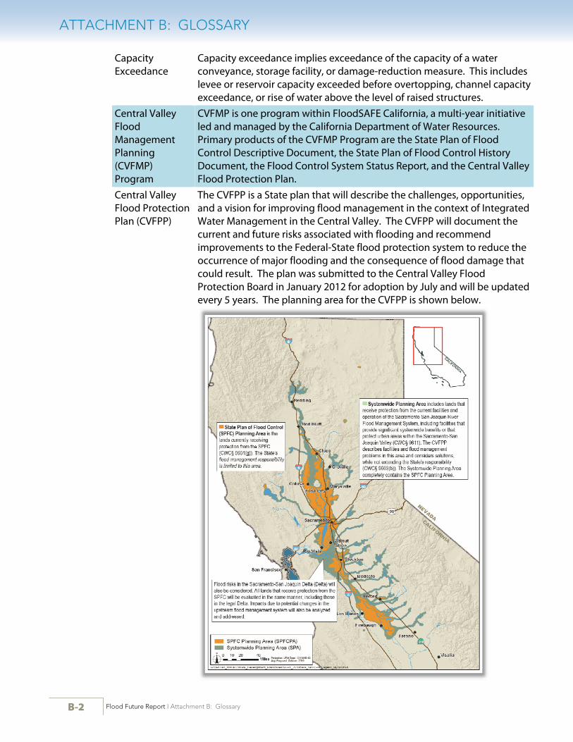
Central Valley Flood Protection Plan (CVFPP)
The CVFPP is a State plan that will describe the challenges, opportunities, and a vision for improving flood management in the context of Integrated Water Management in the Central Valley. The CVFPP will document the current and future risks associated with flooding and recommend improvements to the Federal-State flood protection system to reduce the occurrence of major flooding and the consequence of flood damage that could result. The plan was submitted to the Central Valley Flood Protection Board in January 2012 for adoption by July and will be updated every 5 years. The planning area for the CVFPP is shown below.
ATTACHMENT B: GLOSSARY
Flood Future Report I Attachment B: Glossary B-3
Central Valley Flood Protection Plan (CVFPP) Floodplain
The floodplains used for the SFMP risk characterization within portions the Central Valley are the CVFPP No Action depth grid floodplains with the addition of the flood bypasses. SFMP received the draft CVFPP floodplains on October 4, 2011. The CVFPP floodplains were based on the floodplains of the Sacramento and San Joaquin River Basins Comprehensive Study (USACE, 2002) and modified by the CVFPP to reflect current hydrologic, hydraulic, and geotechnical information. For the SFMP analysis, the Yolo, East Side, Upper Sacramento, Mariposa, Sutter, and Tisdale bypasses were added to the CVFPP floodplains.
Coastal Flooding Inundation at locations normally above the level of high tide. Often caused by storm surges occurring with high tides. Impacts include property damage and beach erosion.
Community A political entity that has the authority to adopt and enforce floodplain ordinances for the area under its jurisdiction.
Consequences Consequences are the quantitative measures of loss, such as direct tangible monetary loss or number of lives lost, when water inundates the people and property exposed.
Critical Facilities Essential, high potential loss, lifeline, and transportation facilities, as defined by HAZUS-point shapefiles
Debris Flow Flooding
Flows made up of water, liquefied mud, and debris. Can form and accelerate quickly, reach high velocities, and travel great distances. Commonly caused by heavy localized rainfall on hillsides denuded of vegetation.
Economic Risk Economic risk is the likelihood of flood damage to an identified area under a given climate and land use condition.
Engineered Structure Failure Flooding
Flooding as a result of dam failure or levee failure presents the potential of catastrophic impact, depending on amount of water impounded and location of populated areas downstream.
Essential Facilities
Care facilities, emergency centers, fire stations, police stations, and schools, as defined by HAZUS-point shapefiles.
Expected Annual Damage (EAD)
EAD is the value that measures the severity of flood loss in any given year. EAD does not mean that this amount of damage will occur in any particular year, but rather that over a long period, the average damages will tend to approach that amount.
Exposure Exposure is a description of who or what is in harm’s way. Fetch The distance along open water or land over which the wind blows, or the
distance waves can traverse unobstructed. Flash Flooding Quickly forming floods with high-velocity flows. Often caused by
stationary or slow-moving storms. Typically occurs on steep slopes and impermeable surfaces, and in areas adjacent to local streams and creeks.
ATTACHMENT B: GLOSSARY
B-4 Flood Future Report I Attachment B: Glossary
Flood Emergency Response Information System (FERIS)
FERIS is a geospatial information system that allows for integration of existing California Data Exchange Center (CDEC) systems with real-time data collection and data exchange.
Flood Hazard The Federal Emergency Management Agency defines a flood hazard as any flood event or condition with the potential to cause fatalities, injuries, property damage, infrastructure damage, agricultural loss, environmental damage, business interruption, or other loss.
Flood Insurance Rate Map (FIRM)
A FIRM is the official map of a community on which the Federal Emergency Management Agency has delineated the Special Flood Hazard Areas, the Base Flood Elevations, and the risk premium zones applicable to the community.
Flood Management
See flood risk management. Generally, the terms flood management and flood risk management are used interchangeably throughout the Flood Future Report.
Flood Risk Flood risk is the likelihood of consequence of inundation within an identified area, given a specified climate condition, land use condition, and flood management system (existing or planned) in place. The consequence may be direct or indirect economic cost, loss of life, environmental impact, or other specified measure of flood effect. Flood risk is a function of the following components:
Loading, which is the frequency and magnitude of flooding Performance of flood management measures Exposure and vulnerability, which are the relationship between the
flood hazard (rising or flowing water) and its effect on life loss, property, and/or environmental resources
Consequence Therefore, flood management actions may reduce risk by changing loading, performance, exposure, vulnerability, or consequence.
Flood Risk Management
Flood risk management seeks to reduce flood risks by managing the floodwaters to reduce the probability of flooding (including by levees and dams) and by managing the floodplains to reduce the consequences of flooding. Flood risk management requires integrating and synchronizing programs at various levels of government designed to reduce flood risk. Source: USACE, Institute for Water Resources, a dynamic resource at http://nfrmp.us/frm_terminology.cfm#def17 (accessed March 11, 2013).
Floodplain The extent of the flood hazard for a 100-year (1 percent chance of exceedance in a given year) or 500-year (0.2 percent chance of exceedance in a given year) event, as determined by the Central Valley Flood Protection Plan, Federal Emergency Management Agency, or U.S. Army Corps of Engineers.
ATTACHMENT B: GLOSSARY
Flood Future Report I Attachment B: Glossary B-5
FloodSAFE California
FloodSAFE California refers to the California Department of Water Resources multi-faceted initiative launched in 2006 to improve public safety through flood management in the context of Integrated Water Management and to reduce potential flood damages in areas of the state with the highest risk. Although led at the State level and initially funded by bond money from Propositions 1E (2006) and 84 (2006), FloodSAFE implementation relies on the cooperation and assistance of Federal partners, Tribal entities, local sponsors, and other stakeholders. The FloodSAFE vision is a sustainable system of flood management with an IWM approach and emergency response throughout California that improves public safety, protects and enhances environmental and cultural resources, and supports economic growth by reducing the probability of destructive floods, promoting beneficial floodplain processes, and lowering the damages caused by flooding.
Hazard Mitigation Plan (HMP)
A community's long-term strategy to reduce disaster losses and break the cycle of disaster damage, reconstruction, and repeated damage is described in an HMP. Results are accomplished through hazard mitigation, which is any sustained action taken to reduce or eliminate the long-term risk to human life and property from hazards.
Hazards United States (HAZUS) – Federal Emergency Management Agency (FEMA)
FEMA has developed a Geographic Information System-based U.S. multihazard assessment software, which contains a Flood Loss Estimation Model with flood hazard analysis and flood loss estimation modules for riverine and coastal analyses. The flood hazard analysis module (HAZUS) uses characteristics such as frequency, discharge, and ground elevation to estimate flood depth, flood elevation, and flow velocity.
High Potential-Loss Facility
Facilities such as dams and hazardous material sites, as defined by HAZUS-point shapefiles.
Hydrologic Engineering Center-Flood Damage Analysis (HEC-FDA)
The U.S. Army Corps of Engineers, Hydrologic Engineering Center (HEC) Flood Damage Analysis (FDA) model is designed to perform risk analysis as part of a flood risk study. The approach explicitly incorporates descriptions of uncertainty of key parameters and functions into project benefit and performance analyses.
Hydrologic Unit Code 8 (HUC8)
A Hydrologic Unit Code 8 is a watershed address consisting of a name and a number (for example, Lower James watershed, 02080206). The 8-digit number is a Hydrologic Unit Code or HUC. The Hydrologic Unit system is a standardized watershed classification system developed by the U.S. Geological Survey in the mid-1970s. Hydrologic units are watershed boundaries organized in a nested hierarchy by size. They range in size from regions to the smaller cataloging units, which are roughly equivalent to local watersheds.
Impact Area Impact area is a term used for convenience to describe a geographic area for which risk is assessed.
Improvement Project
A project that will improve or add facilities to the State Plan of Flood Control to increase levels of flood protection for urban areas. Funding for improvement projects is authorized by California Public Resources Code section 5096.821(b).
ATTACHMENT B: GLOSSARY
B-6 Flood Future Report I Attachment B: Glossary
Integrated Regional Water Management (IRWM)
IRWM promotes the coordinated development and management of water, land, and related resources to maximize the resultant economic and social welfare in an equitable manner without compromising the sustainability of vital ecosystems.
Integrated Water Management (IWM)
IWM is a strategic approach to planning and implementation that combines specific flood management, water supply, and ecosystem actions to deliver multiple benefits. IWM relies on blending knowledge from a variety of disciplines, including engineering, economics, environmental sciences, public policy, and public information. This approach also promotes system flexibility and resiliency to accommodate changing conditions such as regional preferences, ecosystem needs, climate change, flood or drought events, and financing capabilities.
Life-Safety Risk Life-safety risk represents the number of lives in jeopardy in an identified portion of the state, considering a given climate and land use condition, with a specified plan of flood management in place.
Loading In the context of flood risk, loading describes the likelihood of occurrence of conditions that lead to loss of life or damage to property if the conditions are not controlled or the consequence is not managed. Loading commonly is described with a discharge-frequency function, which identifies the probability that discharge at a specified location will exceed a specified value.
Local Maintaining Agency (LMA)
LMAs include reclamation districts, State maintaining agencies, improvement districts, and individual districts like American River Flood Control District or Lower San Joaquin Levee District.
Long-Term Average (or Expected) Annual Inundation Damage
See Expected Annual Damage (EAD).
Maintenance and Inspection
Actions required for the proper care and efficient operation of various project elements. These actions may be combined or separated, as best suits the particular project. The guidance for proper maintenance and inspection are contained in ER 1130-2-303. Adaptations needed to satisfy conditions not covered in the ER are encouraged. Outlines of the maintenance and inspection records are be maintained and available for Government inspection. Government inspections will be performed in consultation with the project’s sponsor. (Source: ER 1110-2-401)
Management Action
A management action is a specific structural or nonstructural strategy, action, or tactic that contributes to stated goals and addresses identified problems. Management actions could range from potential policy or institutional changes to operational and physical changes to the flood management system. Management actions are broad (not location-specific), and they vary in their level of detail.

ATTACHMENT B: GLOSSARY
Flood Future Report I Attachment B: Glossary B-7
Modification Project modifications include changes in project operation, changes in real estate interests, the physical change of a project feature, addition of project features, or changes in the purposes of a project. (Source: ER 1165-2-119)
National Flood Insurance Program (NFIP)
The NFIP is a Federal program created by the U.S. Congress to mitigate future flood losses nationwide. The NFIP requires local communities to enforce building and zoning ordinances in exchange for access to affordable, Federally backed, flood insurance protection for property owners.
Operation Actions that are necessary for the safe and efficient functioning of a project to produce the benefits set forth in the project authorization. The operational requirements for nonreservoir projects are to be presented as operation plans covering essentially the who, what, where, when, and how of the various project operations. An outline of operation records is to be maintained and available for inspection. The operation of reservoirs, covered in water control manuals shall be separate from this operation and maintenance manual. (Source: ER 1110-2-401)
Operation, Maintenance, Repair, Rehabilitation, and Replacement (OMRR&R)
For Federally funded projects the definition of operation and maintenance (O&M) includes the local entity's financial obligation to operate, maintain, repair, rehabilitate, and replace (OMRR&R) the implemented project. OMRR&R is a non-Federal responsibility when local, regional and/or State entities partner on a Federal project. References to O&M provided in the Flood Future Report include OMRR&R responsibilities when the project is a Federal/non-Federal partnership.
Performance Performance refers to the effectiveness of flood or floodplain management measures.
Plans Plans utilize information provided by tools, as well as input from stakeholders to guide the development of the flood management strategies. Plans take into account near- and long-term actions, as well as any additional considerations, such as multiple benefits, environmental concerns, overall water management, and climate change, to formulate long-lasting resilient strategies. Plans include identifying and evaluating possible multibenefit projects and the most effective means of implementing projects using an integrated, collaborative approach.
Project Management Plan
A project management plan defines how a project is executed, monitored, and controlled. It is used to define the approach, scope, and delivery of a project.
ATTACHMENT B: GLOSSARY
B-8 Flood Future Report I Attachment B: Glossary
Public Law 84-99 (33 U.S.C. 701n)
USACE has authority under Public Law (PL) 84-99, Flood Control and Coastal Emergencies (33 U.S.C. 701n) (69 Stat. 186) for emergency management activities to protect human life and improved property, reduce human suffering, help communities recover from the effects of disasters, and mitigate damage and future threats. Under PL 84-99, the Chief of Engineers, acting for the Secretary of the Army, is authorized to undertake activities, including disaster preparedness, advance measures, emergency operations (flood response and post-flood response), rehabilitation of flood control works threatened or destroyed by flood, protection or repair of Federally authorized shore-protective works threatened or damaged by coastal storm, and provisions of emergency water due to drought or contaminated source.
California Public Resources Code section 75003.5
The people of California further find and declare that the growth in population of the State and the impacts of climate change pose significant challenges. These challenges must be addressed through careful planning and through improvements in land use and water management that both reduce contributions to global warming and improve the adaptability of our water and flood control systems. Improvements include better integration of water supply, water quality, flood control and ecosystem protection, as well greater water use efficiency and conservation to reduce energy consumption.
California Public Resources Code section 75032(a)
California Public Resources Code section 75032(a) provides funds for: The inspection and evaluation of the integrity and capability of existing flood control project facilities and the development of an economically viable flood control rehabilitation plan.
Reconstruction Reconstruction consists of addressing the major performance deficiencies caused by a long-term degradation of the foundation, construction materials, and engineering systems that have exceeded their expected service lives and the resulting inability of the project to perform its authorized project functions. (Source: USACE, Program Guidance Letter on Reconstruction, August 16, 2005, http://planning.usace.army.mil/ toolbox/library/MemosandLetters/reconstruction.pdf)
Rehabilitation Rehabilitation refers to a set of activities necessary to bring a deteriorated project back to its original condition. (Source: ER 1110-2-401)
Repair Repair refers to those activities of a routine nature that maintain the project in a well kept condition. (Source: ER 1110-2-401)
Replacement Replacement covers those activities taken when a worn-out element or portion of a project is replaced. (Source: ER 1110-2-401)
Residual Risk Residual risk is the likelihood of damage or other adverse consequence remaining after flood management actions are taken.
Results Robust tools, thorough planning, and integrated actions deliver results that provide value to California’s residents, environment, and economy. Results are tracked using performance measures and sustainability indicators that help improve investment performance and increase flood management benefits.
ATTACHMENT B: GLOSSARY
Flood Future Report I Attachment B: Glossary B-9
Severe Repetitive Loss (SRL)
Any NFIP-insured residential property that has met at least one of the following paid flood loss criteria since 1978, regardless of ownership:
Four or more separate claim payments of more than $5,000 each (including building and contents payments)
Two or more separate claim payments (building payments only) where the total of the payments exceeds the current value of the property
In either case, two of the claim payments must have occurred within 10 years of each other. Multiple losses at the same location within 10 days of each other are counted as one loss, with the payment amounts added together. The loss history includes all ownership of the property since 1978 or since the building’s construction if built after 1978.
Slow Rise Flooding
Slow rise flooding occurs as a gradual inundation as waterways or lakes overflow their banks. Most often caused by heavy precipitation, especially with heavy snowmelt. Includes riverine flooding in deep floodplains and ponding of water in low-lying urban areas, as well as gradual flooding in areas adjacent to local streams and creeks.
Special Flood Hazard Area (SFHA)
SFHAs are areas subject to inundation from a flood that has a 1 percent chance of being equaled or exceeded in a given year.
State Plan of Flood Control (SPFC)
Collectively, the facilities, lands, programs, conditions, and mode of operation and maintenance for the State-Federal flood protection system in the Central Valley. This area is shown in the figure provided under CVFPP definition.
Tools Tools include data, models, and assessments needed for decision making in all aspects of flood management. DWR continues enhancing and sharing technical resources (tools) across all programs and projects. This includes flood, environmental, and water management data gathering, modeling, and the technical aspects of flood readiness and emergency response. Technical and modeling information help inform thorough and thoughtful planning, along with accurate design of flood management facilities.
Transportation Facility
Runways, railway bridges, rail facilities, port facilities, light-rail facilities, highway bridges, ferry facilities, bus facilities, and airport facilities, as defined by HAZUS-point shapefiles.
Tsunami Flooding
Tsunami flooding occurs as a result of high-speed ocean waves triggered by mass movement that displaces a large volume of water. Causes include earthquakes and underwater landslides. Impact on land depends on wave height and inundation area.
Utilities Wastewater, potable water, oil, natural gas, electric power, and communications facilities, as defined by HAZUS-point shapefiles.
V-Zone The V-zone is an area inundated by 1 percent annual chance (100-year) flooding with velocity hazard (wave action); no base flood elevations have been determined.
ATTACHMENT B: GLOSSARY
B-10 Flood Future Report I Attachment B: Glossary
Vulnerability Vulnerability is the susceptibility to loss or damage of people and property exposed to the flood hazard.
Water Data Library (WDL)
The WDL is a searchable Geographic Information System (GIS) interface on the Internet. WDL allows users to access information about monitoring gauges, groundwater data, and water quality.


Flood Future Report I Attachment B: Glossary
STATE OF CALIFORNIA THE NATURAL RESOURCES AGENCY UNITED STATES ARMY CORPS OF ENGINEERS DEPARTMENT OF WATER RESOURCES FLOOD PLAIN MANAGEMENT SERVICES PROGRAM
The complete report, California’s Flood Future: Recommendations for Managing the State’s Flood Risk, including technical attachments and other supporting information is available for review at:
http://www.water.ca.gov/SFMP