Embed Size (px)
Citation preview
magisterial, Science and Civilization in China,7 vols. in 27 (Cambridge, Eng.: CambridgeUniversity Press, 1954-), alchemy is coveredin vol. 5, pts. 2-5; medicine in vol. 6, pt. 6. Onthe importance of paper in the Islamic worldsee Jonathan M. Bloom, “Silk Road or PaperRoad?” The Silk Road 3/2 (2005): 21-26, whichsummarizes his elegant book Paper Before Print:The History and Impact of Paper in the IslamicWorld (New Haven: Yale Univ. Pr., 2001). A goodmany (but by no means all) of the importantArabic sources are available in English
translation. Note in particular the translationof The History of al-Tabari / Ta‘rikh al-rusul wa‘lmuluk, 40 vols. (Albany: State University of NewYork Pr., 1985-); The Fihrist of al-Nadim: aTenth-Century Survey of Muslim Culture, BayardDodge, ed. and tr. (New York: Columbia Univ.Pr., 1970); The Travels of Ibn Battuta, A.D.1325-1354, tr. H.A.R. Gibb [Works issued bythe Hakluyt Society, 2nd ser., nos. 110, 117, 141,178, 190], 5 vols. (Cambridge, Eng.: CambridgeUniv. Pr., 1958-2000).
For travelers and merchants of the middle ages,Iran was unavoidable. The great caravan roadsthat linked China and India to Rome orConstantinople passed through Persian lands,and the sea-lanes terminated at ports in thePersian Gulf. Iranian rulers took full advantageof their geographical opportunities: they taxedforeign trade, and made every effort to keepEast and West from making direct contact.Merchants chafed at the exorbitant tolls, butthere was little they could do about it; effortsto by-pass Iranian spaces, either by land northof the Caucasus Mountains, or via the Red Sea,had only limited success. Iran’s relativeprosperity from medieval times through the 17th
century was due, in no small measure, torevenue from trade.
Iran is a large country, with a continuoushistory of some 2500 years as a nation and astate. The major caravan routes, which traceback far into antiquity, remained in use intothe 20th century, and geography dictates thatmodern roads must generally run parallel tothose of the past. In consequence, Iran’sabundant legacy of art and architecture is quiteaccessible, or would be but for recurrent politicalfrictions. The present article is the fruit of a
long road journey in 2000, when tensionsabated for a time, which took us diagonallyacross Iran from northwest to southeast,roughly following the route of Marco Polo’sjourney in 1273 CE. The world of the caravansis vanishing fast, but those who look can stillfind places where the roar of automobile traffichas not yet drowned out “the whispers of thedesert-wind, the tinkling of the camels’ bell.”
The world of the Arab geographers
We are remarkably well informed concerningthe historical geography of Iran, thanks chieflyto a small band of Muslim scholars, writingmostly in Arabic, who recorded in detail thestate of the region in the 10th and 11th centuriesCE. At that time, Iran was at least nominallypart of the Abbasid Empire (though in practicemuch of the country was ruled by local dynastiesor by the Seljuk Turks), and Baghdad was thecenter of the universe. This was the city glorifiedin “The Thousand and One Nights” (known inEnglish as “The Arabian Nights”), a glitteringmetropolis of palaces, mosques and schools,hospitals and bazaars, that covered some fivesquare miles and held more than a million souls.
On the Road:
Caravan Routes of IranFrank HaroldUniversity of Washington, Seattle (USA)Photographs by Ruth Harold
The Silk Road 6/1 (2008), pp. 17-28 17
As the focal point of an empire that stretchedfrom China to Spain, Baghdad was a magnetthat drew luxury goods from all over the world,and the Caliph’s court had no equal for wealth,prestige and display.
The Arab geographers were a much moresober lot than the brilliant fabulists whoinvented Aladdin and his lamp. In the earlyyears of the 10th century Estakhri, a native ofIran, traveled extensively and recorded hisjourney, with emphasis on Fars and westernIran. This pioneering work was augmented andincorporated into that of his successor, EbnHawkal, a native of Nusaibin in Syria, whoroamed the Abbasid world for thirty years as amerchant and missionary, and compiled hisobservations in a book entitled “Configurationsof the Earth.” The grand master of geographicalscience of that day was their youngercontemporary Muqaddasi, a well-educated son
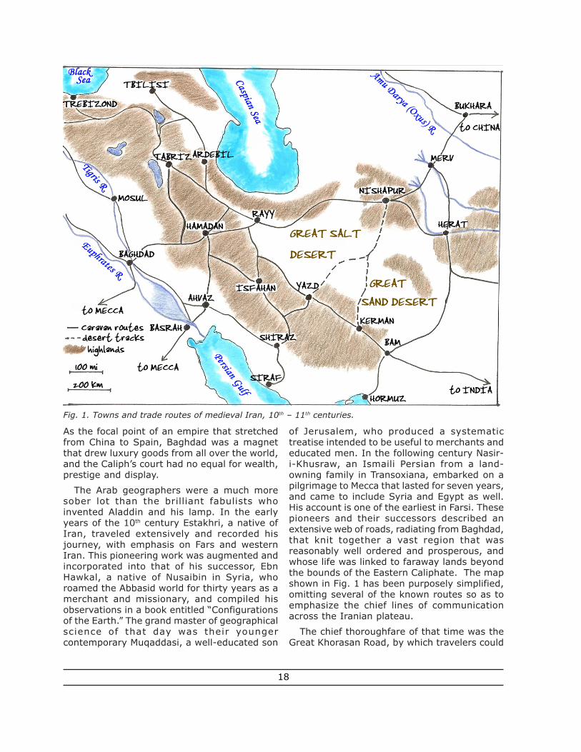
of Jerusalem, who produced a systematictreatise intended to be useful to merchants andeducated men. In the following century Nasir-i-Khusraw, an Ismaili Persian from a land-owning family in Transoxiana, embarked on apilgrimage to Mecca that lasted for seven years,and came to include Syria and Egypt as well.His account is one of the earliest in Farsi. Thesepioneers and their successors described anextensive web of roads, radiating from Baghdad,that knit together a vast region that wasreasonably well ordered and prosperous, andwhose life was linked to faraway lands beyondthe bounds of the Eastern Caliphate. The mapshown in Fig. 1 has been purposely simplified,omitting several of the known routes so as toemphasize the chief lines of communicationacross the Iranian plateau.
The chief thoroughfare of that time was theGreat Khorasan Road, by which travelers could
Fig. 1. Towns and trade routes of medieval Iran, 10th – 11th centuries.
18
proceed to northern Iran, across Central Asia(a region Iranian in speech and culture, andpart of Khorasan, land of the sunrise), andeventually to China. The route was alreadyancient, antedating the coming of Islam by morethan a millennium. The armies of Cyrus andDarius had marched that way, extending therule of the Great King across Afghanistan as faras the Indus River. Alexander the Great followedin their footsteps. Goods from China had comeby the Khorasan Road since the time of the Han,the Parthians and the Romans in the firstcenturies CE. So long as strong government wasentrenched in Chang-an, and the rambunctiousTurks were under control, the Khorasan Roadwas the premier artery of long-distance tradeand matches our common perception of the SilkRoad. And after the Arab conquest, pilgrimsfrom the cities of Central Asia took the KhorasanRoad on the annual Hajj to Mecca in Arabia.
Going eastward, the Khorasan Road climbedonto the Iranian Plateau, crossing countryinhabited chiefly by Kurds, and passed throughcities that have endured triumph and disasterfrom antiquity to the present day. Then as now,Kermanshah was the chief city of Kurdistan,noted for its many trees, abundant fruit andthe rock-cut alcoves of Tagh-e-Bostan with theirspectacular Sasanian sculptures. Darius’triumphal inscription on the cliff of Bisitun waswell known, though perhaps not fullyunderstood: Ebn Hawkal read the paneldepicting Darius with the tributary kings as therepresentation of a school-house, with themaster and his boys. Hamadan, once capital ofthe Medes, was described as a fine and largecity that had recovered from the destructioninflicted during the Arab conquest. The roadthen went by the important center of Rayy (seebelow), today a suburb of sprawling, smoggyTehran. It then followed the southern foot ofthe Alborz Mountains to Nishapur, the chief cityof Khorasan, described in detail by both EbnHawkal and Muqaddasi. Like other large townsof that time, Nishapur consisted of a fortress,the town proper and a suburb. All three weredefended with walls, pierced by numerous gatesthat gave access to the extensive markets. Notown in all of Khorasan was healthier or morepopulous than Nishapur, or more celebrated forits rich stores of merchandise and the wealthof its merchants.
Continuing east, the road passed through Tus,a few miles north of today’s Mashad (which didnot yet exist), an important regional center thatwas home to the poet Ferdowsi who flourishedaround 1000 CE. Here, on the fault-line betweenIran and Turan, Ferdowsi composed theShahname, Iran’s national epic. Nothing of Tusremains, except for the bleak ruins of its citadel.Turning northward, the Khorasan Road droppeddown into the Kara Kum desert, making for theoasis city of Merv. Watered by an extensivenetwork of canals, Merv is believed to have helda million inhabitants when the Mongols took it,and butchered every one. Of the splendors ofMerv, only confused ruins and the mausoleumof a Seljuk sultan survive today. Beyond layBukhara, Samarkand and eventually, across thehigh Pamirs, half-legendary China.
Well-traveled branches diverged from theKhorasan Road at many points, of which onlythe chief ones are shown on the map. FromHamadan one could journey southward onto theMesopotamian plain, or southeast to the ancientcity of Isfahan, several times the capital of Iran.One could also head north for Qazvin, there topick up a western branch of the Silk Road forTabriz, Dabil (not far from today’s Yerevan inArmenia) and eventually the port of Trebizondon the Black Sea. A further branch led northwardto Ardebil, Tbilisi and the Caucasus. Nishapurwas the point of departure for a track southward,between the parched basins shown on the mapas the Great Salt Desert and the Great SandDesert. And from Merv, routes led to Balkh,Herat, Kandahar and India.
Little enough remains today of Rayy, theGreeks’ Rhages, which was a major hub ofcommerce and transport, and considered bysome the finest city east of Baghdad. Rayy wasthe starting point for the major caravan routethat skirted the western and southern side ofthe central deserts, on the way to the PersianGulf or to India. Way stations still featured onmaps include Qom, Kashan, Na’in, Yazd, Kermanand Bam, several of which we shall visit below.From this road, also, branches led forth. Severalroutes led to Isfahan and Shiraz; the latterbegan as an Arab foundation that grew into animportant center, and today rules the South.Shiraz could also be reached from Baghdad, viaAhvaz. Several routes led northeast, across thecentral desert. Most important, here was the
19
access to ports on the Persian Gulf. Much of thetrade with India and China was conducted bysea. Basrah has been the key to this commercefrom antiquity to the present, with direct linksby water to Baghdad and destinations to thewest. Even the Iranian Plateau receivedimported goods via Baghdad, though it did alsohave ports of its own. In the 10th century CE,the chief harbor on the eastern shore of thePersian Gulf was Siraf; that town was utterlydestroyed in 977 by a powerful earthquake,from which it never recovered. Siraf’s place wastaken by Hormuz, and eventually (in the 17th
century) by nearby Bandar Abbas, whichremains an important harbor to this day.
Caravans
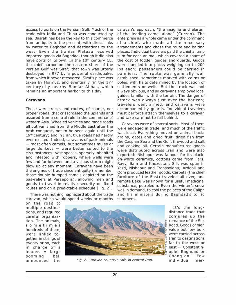
Those were tracks and routes, of course, notproper roads, that crisscrossed the uplands andassured Iran a central role in the commerce ofwestern Asia. Wheeled vehicles and made roadsall but vanished from the Middle East after theArab conquest, not to be seen again until the19th century; and in Iran, true roads had hardlyever existed. Indeed, caravans of pack animals— most often camels, but sometimes mules orlarge donkeys — were better suited to thecircumstances: vast spaces, sparsely inhabitedand infested with robbers, where wells werefew and far between and a vicious storm mightblow up at any moment. Caravans have beenthe engines of trade since antiquity (rememberthose double-humped camels depicted on thebas-reliefs at Persepolis), allowing men andgoods to travel in relative security on fixedroutes and on a predictable schedule [Fig. 2].
There was nothing haphazard about the tradecaravan, which would spend weeks or monthson the road tomultiple destina-tions, and requiredcareful organiza-tion. The animals,s o m e t i m e shundreds of them,were linked to-gether in strings oftwenty or so, eachin charge of aleader. A largebooming bellannounced the
caravan’s approach, “the insignia and alarumof the leading camel alone” (Curzon). Theenterprise as a whole came under the commandof a chief, who made all the necessaryarrangements and chose the route and haltingplaces. Individual travelers paid the chief a lumpsum for each animal, which covered a share ofthe cost of fodder, guides and guards. Goodswere bundled into packs weighing up to 200lbs each; passengers could be carried inpanniers. The route was generally wellestablished, sometimes marked with cairns orpoles, with halts determined by the location ofsettlements or wells. But the track was notalways obvious, and so caravans employed localguides familiar with the terrain. The danger ofattack was always just over the horizon;travelers went armed, and caravans wereaccompanied by guards. Individual travelersmust perforce attach themselves to a caravanand take care not to fall behind.
Caravans were of several sorts. Most of themwere engaged in trade, and much of the trafficwas local. Everything moved on animal-back:grains, dates and dried fruit, dried fish fromthe Caspian Sea and the Gulf, firewood and saltand cooking oil. Certain manufactured goodswere distributed across Iran and were alsoexported: Nishapur was famous for its black-on-white ceramics, cottons came from Fars,Rayy, Bam and Khuzestan. Silk was spun inYazd, Nishapur and Transoxiana; Ardebil andQom produced leather goods. Carpets (the chieffurniture of the East) traveled all over, andremote Baku was known for a useful medicinalsubstance, petroleum. Even the winter’s snowwas in demand, to cool the palaces of the Caliphand his ministers during Baghdad’s torridsummers.
It’s the long-distance trade thatconjures up theromance of the SilkRoad. Goods of highvalue but low bulkwere carried acrossIran to destinationsfar to the west oreast — Constantin-ople, Baghdad orChang-an. Fewindividual mer-Fig. 2. Caravan country: Taft, in central Iran.
Cop
yrig
ht ©
200
0 R
uth
Har
old
20
chants ever traveled the whole route; instead,goods changed hands many times along theway. From China came silk, of course, but alsoporcelain and paper; turquoise and lapis lazuliwere shipped from the oasis cities of CentralAsia. In exchange, the West sent woolens,brocades and colored glass, but much of whatEurope imported was paid for in gold. Therewas active trade with the Volga basin and pointsnorth, from whence came furs, amber, honey(the sweetener of antiquity), beeswax forcandles and especially slaves. Iran paid chieflyin silver coins, which have been found in largenumbers in both Russia and Scandinavia. Tradewith India and Southeast Asia was conductedby sea. Arab dhows brought rubies, musk andperfumes, indigo and a miscellany of spices tothe port cities of Siraf and Hormuz; pearls, coral,weapons and even horses traveled the otherway.
Pilgrims made a large contribution to thetraffic on the caravan routes. Muslims areenjoined to make pilgrimage to Mecca once ina lifetime, and many thousands did so everyyear. One caravan that left Isfahan for Mecca in1715 CE was said to number 30,000 men andwomen, plus an untold complementof beasts! Pilgrims from Central Asiaand Iran made their way to Baghdad,and thence to Aleppo and Damascus,where they were joined by anotherstream from Anatolia and Istanbul.Shiites also traveled to the holy citiesof Najaf and Kerbala on the plains ofIraq, sites of the martyrdom andburial of the Caliph Ali and his sonHussein. Shah Abbas, in the 17th
century, promoted the pilgrimage tothe shrine of the Imam Reza inMashad, and to that of Shaikh Safi inArdebil, as alternatives that avoided theterritories of his chief rival, the Sunni Ottomansultan. In the 19th century, the pursuit ofsalvation took a macabre turn: it becamefashionable for pious Shiites to be buried nearthe holy precincts, and huge caravans wereformed to transport corpses from one end ofIran to the other.
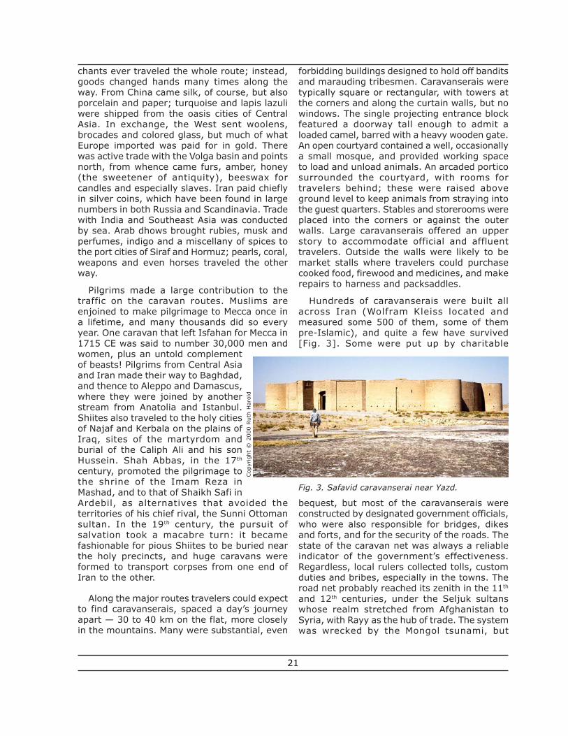
Along the major routes travelers could expectto find caravanserais, spaced a day’s journeyapart — 30 to 40 km on the flat, more closelyin the mountains. Many were substantial, even
forbidding buildings designed to hold off banditsand marauding tribesmen. Caravanserais weretypically square or rectangular, with towers atthe corners and along the curtain walls, but nowindows. The single projecting entrance blockfeatured a doorway tall enough to admit aloaded camel, barred with a heavy wooden gate.An open courtyard contained a well, occasionallya small mosque, and provided working spaceto load and unload animals. An arcaded porticosurrounded the courtyard, with rooms fortravelers behind; these were raised aboveground level to keep animals from straying intothe guest quarters. Stables and storerooms wereplaced into the corners or against the outerwalls. Large caravanserais offered an upperstory to accommodate official and affluenttravelers. Outside the walls were likely to bemarket stalls where travelers could purchasecooked food, firewood and medicines, and makerepairs to harness and packsaddles.
Hundreds of caravanserais were built allacross Iran (Wolfram Kleiss located andmeasured some 500 of them, some of thempre-Islamic), and quite a few have survived[Fig. 3]. Some were put up by charitable
bequest, but most of the caravanserais wereconstructed by designated government officials,who were also responsible for bridges, dikesand forts, and for the security of the roads. Thestate of the caravan net was always a reliableindicator of the government’s effectiveness.Regardless, local rulers collected tolls, customduties and bribes, especially in the towns. Theroad net probably reached its zenith in the 11th
and 12th centuries, under the Seljuk sultanswhose realm stretched from Afghanistan toSyria, with Rayy as the hub of trade. The systemwas wrecked by the Mongol tsunami, but
Fig. 3. Safavid caravanserai near Yazd.
Cop
yrig
ht ©
200
0 R
uth
Har
old
21
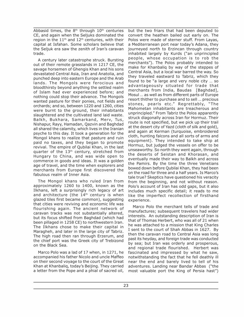
recovered in the 14th and 15th centuries. Strongcentral rule under the Safavids stimulatedcommerce, and construction boomed. If you askthe age of a bridge, fort or caravanserai [Figs.3, 4 and 5], you may well be told that it was
built by Shah Abbas the Great (1587 – 1629CE). However, since the caravan tradecontinued into the 20th century, much of whatone sees is likely to date to more recent times.
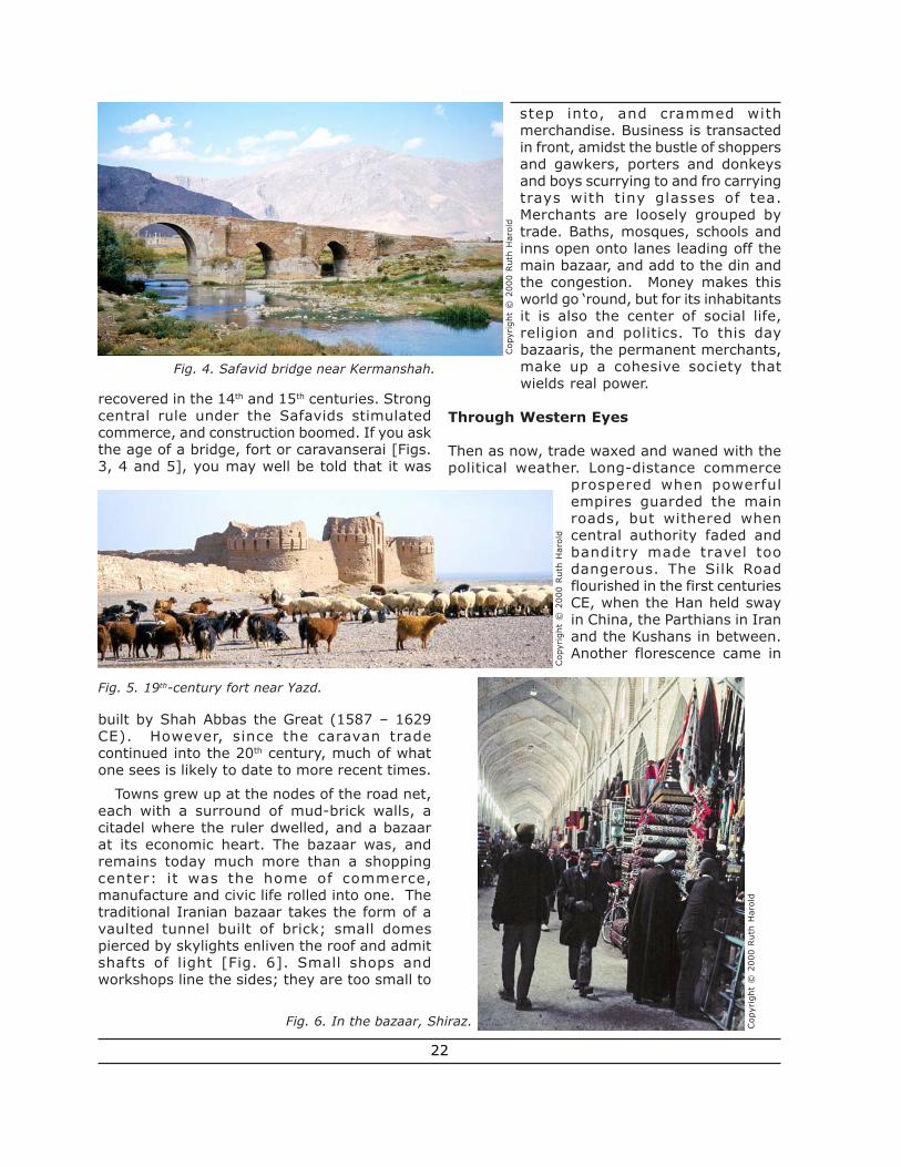
Towns grew up at the nodes of the road net,each with a surround of mud-brick walls, acitadel where the ruler dwelled, and a bazaarat its economic heart. The bazaar was, andremains today much more than a shoppingcenter: it was the home of commerce,manufacture and civic life rolled into one. Thetraditional Iranian bazaar takes the form of avaulted tunnel built of brick; small domespierced by skylights enliven the roof and admitshafts of light [Fig. 6]. Small shops andworkshops line the sides; they are too small to
step into, and crammed withmerchandise. Business is transactedin front, amidst the bustle of shoppersand gawkers, porters and donkeysand boys scurrying to and fro carryingtrays with tiny glasses of tea.Merchants are loosely grouped bytrade. Baths, mosques, schools andinns open onto lanes leading off themain bazaar, and add to the din andthe congestion. Money makes thisworld go ‘round, but for its inhabitantsit is also the center of social life,religion and politics. To this daybazaaris, the permanent merchants,make up a cohesive society thatwields real power.
Through Western Eyes
Then as now, trade waxed and waned with thepolitical weather. Long-distance commerce
prospered when powerfulempires guarded the mainroads, but withered whencentral authority faded andbanditry made travel toodangerous. The Silk Roadflourished in the first centuriesCE, when the Han held swayin China, the Parthians in Iranand the Kushans in between.Another florescence came in
Fig. 4. Safavid bridge near Kermanshah.
Cop
yrig
ht ©
200
0 R
uth
Har
old
Fig. 5. 19th-century fort near Yazd.
Fig. 6. In the bazaar, Shiraz.
Cop
yrig
ht ©
200
0 R
uth
Har
old
Cop
yrig
ht ©
200
0 R
uth
Har
old
22
Abbasid times, the 8th through 10th centuriesCE, and again when the Seljuks dominated theregion in the 11th and 12th centuries, with theircapital at Isfahan. Some scholars believe thatthe Seljuk era saw the zenith of Iran’s caravantrade.
A century later catastrophe struck. Burstingout of their remote grasslands in 1217 CE, thesavage horsemen of Ghengis Khan and his sonsdevastated Central Asia, Iran and Anatolia, andpunched deep into eastern Europe and the Arablands. The Mongols were ferocious andbloodthirsty beyond anything the settled realmof Islam had ever experienced before; andnothing could stop their advance. The Mongolswanted pasture for their ponies, not fields andorchards; and so, between 1220 and 1260, citieswere burnt to the ground, their inhabitantsslaughtered and the cultivated land laid waste.Balkh, Bukhara, Samarkand, Merv, Tus,Nishapur, Rayy, Hamadan, Qazvin and Baghdadall shared the calamity, which lives in the Iranianpsyche to this day. It took a generation for theMongol khans to realize that pasture and ruinpaid no taxes, and they began to promoterevival. The empire of Qubilai Khan, in the lastquarter of the 13th century, stretched fromHungary to China, and was wide open tocommerce in goods and ideas. It was a goldenage of travel, and the time when explorers andmerchants from Europe first discovered thefabulous realm of Inner Asia.
The Mongol khans who ruled Iran fromapproximately 1260 to 1400, known as theIlkhans, left a surprisingly rich legacy of artand architecture (the 14th century is whenglazed tiles first became common), suggestingthat cities were reviving and economic life wasflourishing again. The ancient network ofcaravan tracks was not substantially altered,but its focus shifted from Baghdad (which hadbeen pillaged in 1258 CE) to northwestern Iran.The Ilkhans chose to make their capital inMaragheh, and later in the large city of Tabriz.The high road then ran through Erzerum, andthe chief port was the Greek city of Trebizondon the Black Sea.
Marco Polo was a lad of 17 when, in 1271, heaccompanied his father Nicolo and uncle Maffeoon their second voyage to the court of the GreatKhan at Khanbaliq, today’s Beijing. They carrieda letter from the Pope and a phial of sacred oil,
but the two friars that had been deputed toconvert the heathen bailed out early on. ThePolos were made of sterner stuff. From Layas,a Mediterranean port near today’s Adana, theyjourneyed north to Erzincan through countryinhabited largely by Kurds (“an unprincipledpeople, whose occupation is to rob themerchants”). The Polos probably intended tomake for Khanbaliq by way of the steppes ofCentral Asia, but a local war barred the way. Sothey traveled eastward to Tabriz, which theyfound to be “a large and very noble city … soadvantageously situated for trade thatmerchants from India, Baudas [Baghdad],Mosul … as well as from different parts of Europeresort thither to purchase and to sell … preciousstones, pearls etc.” Regrettably, “TheMahometan inhabitants are treacherous andunprincipled.” From Tabriz the Polos apparentlystruck diagonally across Iran for Hormuz. Theirroute is not specified, but we pick up their trailat the desert city of Yazd (cloth of silk and gold),and again at Kerman (turquoise, embroideredcloth, hunting falcons and all sorts of arms andequipment). They intended to take ship atHormuz, but judged the vessels on offer to beunseaworthy. So north they went again, throughthe deserts of Seistan and Khorasan, andeventually made their way to Balkh and acrossthe Pamirs. By the time the three Venetiansbowed down before Qubilai Khan, they had beenon the road for three and a half years. Is Marco’stale true? Skeptics have questioned his veracityfrom the beginning, and not without reason.Polo’s account of Iran has odd gaps, but it alsoincludes much specific detail; it reads to melike the imperfect recollection of firsthandexperience.
Marco Polo the merchant tells of trade andmanufactures; subsequent travelers had widerinterests. An outstanding description of Iran isthat of Thomas Herbert, who was all of 21 whenhe was attached to a mission that King CharlesI sent to the court of Shah Abbas in 1627. Bythen the caravan road to Central Asia was longpast its heyday, and foreign trade was conductedby sea; but Iran was orderly and prosperous,and regional trade flourished. Herbert wasfascinated and impressed by what he saw,notwithstanding the fact that he fell deathly illnear the end and barely lived to tell of hisadventures. Landing near Bandar Abbas (“themost valuable port the King of Persia hast”)
23
they rode to Shiraz (“pleasantest of Asiaticcities”), visited Persepolis and continued on toIsfahan — a journey of three months. Herbert,like later travelers, was enchanted by Isfahan:“most pleasant in its situation, elegant as tobuilding, populous for inhabitants, rich in trade,and noble by being the usual residence of thecourt.” It is also blessed with “air pure andquick.” The Shah had decamped to the CaspianSea, and the embassy followed him there.Politically, the mission was a failure, but itinspired an engaging and informative accountof the country and its people, which became abestseller in England. And Herbert noticedsomething that would become important later:there was not a fortress or a regiment in theKing’s domain that would stand up to an Englishforce, and no navy to speak of.
The late nineteenth century was when thegoing really got good, especially for Britishtravelers who could contemplate adding Iranto their vast holdings. Indeed, Colonels CharlesM. MacGregor and Charles E. Yate, traveling inthe border regions of Seistan and Khorasan in1875/6 and 1893 – 1898, respectively, seemto be reconnoitering the country with a view toa future campaign. The most impressivecontribution to that literature is Lord Curzon’smagisterial opus, Persia and the PersianQuestion (1892). With the security of India atstake, the Great Game is never far from hismind (the eastern countries are “pieces on achessboard upon which is being played out agame for the dominion of the world”), butCurzon’s account of Persia’s geography andcurrent realities has never been surpassed. Lesslofty but more in sympathy with Iran’s long-suffering people is Edward G. Browne’s accountof his Year amongst the Persians (1893). Hereis a traveler with a curious and wide–open mind,ready to immerse himself in the literary andreligious culture of a country that he came tolove, and willing to put up cheerfully with itshazards and discomforts.
The contemporary adventurer, apt to blanchin horror at the thought of brigands and bedbugsalike, can only admire the fortitude of ourpredecessors of a century ago. They all got theirlumps — from the execrable roads, the decrepitand verminous caravanserais, the broken-backed horses and the thieving muleteers. Evensympathetic observers, such as Browne and theAmerican scholar Williams Jackson (1906),
describe a country of dirt-poor people dwellingin half-ruined towns huddled within crumblingwalls (“ruin added to ruin”; Browne). Corruptguards and officials fleece everyone, and banditsskulk in the passes and the dark. The KhorasanRoad between Mashad and Tehran wasespecially at risk from slave raiders, until theRussians crushed the Turkomans in 1881.Fanatical and bigoted mullahs, often flagrantlydeceitful (especially in the matter of liquor) stirup ignorant folk to violence against nativeminorities such as Zoroastrians and Ba’bis(Bahai), and foreigners are their favorite prey.You set foot inside a mosque or shrine at therisk of your life. As to the romance of thejourney, “no greater misery can be conceivedthan that of travelling with a caravan, thede’sagre’mens of which are many and various”(Ferrier, 1857).
Lord Curzon, who knew the state of the Shah’sgovernance intimately, wrote scathingly of therapacity of a system based largely on corruption,intrigue, extortion and embezzlement (histerms). The results were plain to see in thetotal absence of public works, and in thedilapidated state of all buildings, fromcaravanserais to mosques, except in the majorcities. To be sure, we are reading Europeantravelers whose critical perceptions weresharpened by the certitude that their owncivilization was both materially and morallysuperior. But they do not mislead us: the latternineteenth century was a low point in Iran’sfortunes, which ultimately spawned theupheavals that would roil Iran in the nextcentury, and spill over into our own time.
Travelers’ notebook
The modernization of Iran during the pastcentury has swept away that world of medievalcommerce. You may still see an occasionalcamel, but caravans are no more. Goods go bylorry, pilgrims travel by bus or ‘plane and lodgein hotels, not caravanserais. The city walls haveall been demolished, because improved securitymade them redundant and they got in the wayof automobile traffic. Even in the thirty yearsthat lay between our yearlong residence in Iran(1969/70) and our return as visitors, theambience changed quite noticeably. Villagesonce accessible only by mule track are nowlinked to the wider world by asphalted road.
24
Muddy streets have been paved, crumblingedifices spruced up, things are tidier and moresalubrious. The bazaars continue to function butthe craftsmen have gone, and the shops sellcheap mass-produced stuff. Better goods areincreasingly found in standard walk-in stores,lining streets choked with traffic. The IslamicRepublic takes a distinctly non-Western viewof liberty and has a reputation for hard-fistedpolitics and corruption, but seems also to havedone much good. It all looks a lot less like themiddle ages, and while the antiquarian in medeplores change, it would be churlish to grumbleat what must, by all reasonable standards, countas progress.
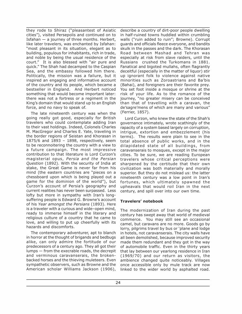
This is not to imply that there is nothing leftto see in Iran! The country is extraordinarilyrich in monuments of the past, and the caravantrade itself has left many traces. Caravanseraisare not uncommon by the roadside and in thetowns, where they have been converted intoworkshops, warehouses and occasionallyrestaurants. Here and there an ancient bridgestill spans its stream. Some of the castles thatonce stood guard over the trade routes stillstand. Until recently, the mud-brick fortress ofBam in southeastern Iran was the mostspectacular [Fig. 7], but in 2003 a monstrousearthquake snuffed out 26,000 lives in the townand brought the walls tumbling down. Thevaulted bazaars are stil l evocative andphotogenic, and the carpets and block-printedcloth as tempting as ever. But what chiefly drawstravelers to Iran is the lavish architectural
heritage in brick,stucco and glazed tile.Only in the Iranianworld (including itsperiphery, Iraq andCentral Asia) do youfind architecture incolor. Iran’s manymosques and shrinesinclude some of themost glorious buildingsever erected; theirti led domes andminarets glow likejewels amidst the dullduns and browns oftheir surroundings.And unlike thesituation a century
ago, most of them admit non-Muslim visitors.
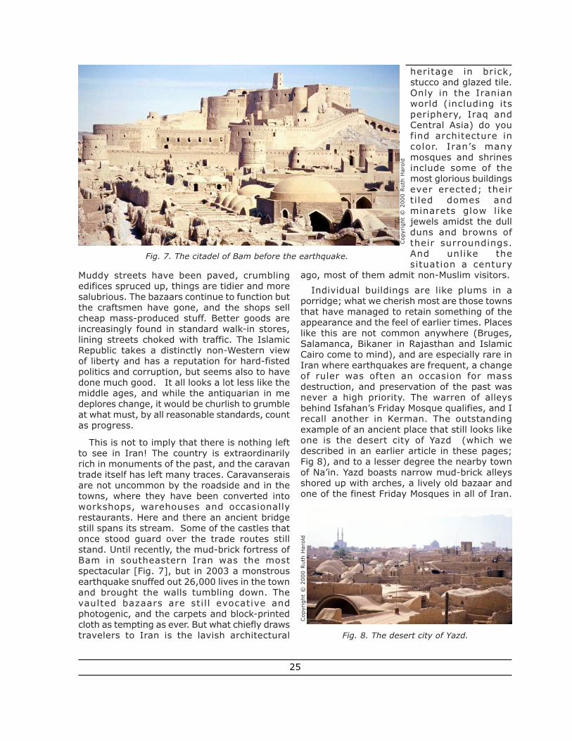
Individual buildings are like plums in aporridge; what we cherish most are those townsthat have managed to retain something of theappearance and the feel of earlier times. Placeslike this are not common anywhere (Bruges,Salamanca, Bikaner in Rajasthan and IslamicCairo come to mind), and are especially rare inIran where earthquakes are frequent, a changeof ruler was often an occasion for massdestruction, and preservation of the past wasnever a high priority. The warren of alleysbehind Isfahan’s Friday Mosque qualifies, and Irecall another in Kerman. The outstandingexample of an ancient place that still looks likeone is the desert city of Yazd (which wedescribed in an earlier article in these pages;Fig 8), and to a lesser degree the nearby townof Na’in. Yazd boasts narrow mud-brick alleysshored up with arches, a lively old bazaar andone of the finest Friday Mosques in all of Iran.
Fig. 7. The citadel of Bam before the earthquake.
Cop
yrig
ht ©
200
0 R
uth
Har
old
Fig. 8. The desert city of Yazd.
Cop
yrig
ht ©
200
0 R
uth
Har
old
25
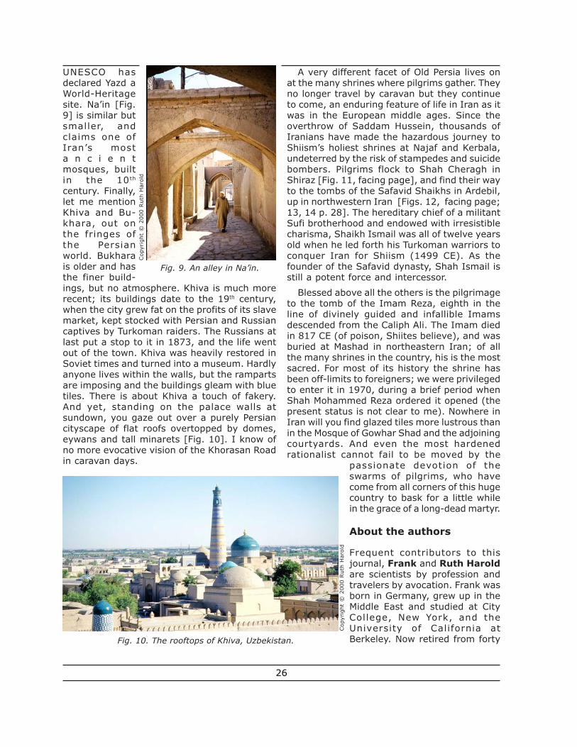
UNESCO hasdeclared Yazd aWorld-Heritagesite. Na’in [Fig.9] is similar butsmaller, andclaims one ofIran’s mosta n c i e n tmosques, builtin the 10th
century. Finally,let me mentionKhiva and Bu-khara, out onthe fringes ofthe Persianworld. Bukharais older and hasthe finer build-ings, but no atmosphere. Khiva is much morerecent; its buildings date to the 19th century,when the city grew fat on the profits of its slavemarket, kept stocked with Persian and Russiancaptives by Turkoman raiders. The Russians atlast put a stop to it in 1873, and the life wentout of the town. Khiva was heavily restored inSoviet times and turned into a museum. Hardlyanyone lives within the walls, but the rampartsare imposing and the buildings gleam with bluetiles. There is about Khiva a touch of fakery.And yet, standing on the palace walls atsundown, you gaze out over a purely Persiancityscape of flat roofs overtopped by domes,eywans and tall minarets [Fig. 10]. I know ofno more evocative vision of the Khorasan Roadin caravan days.
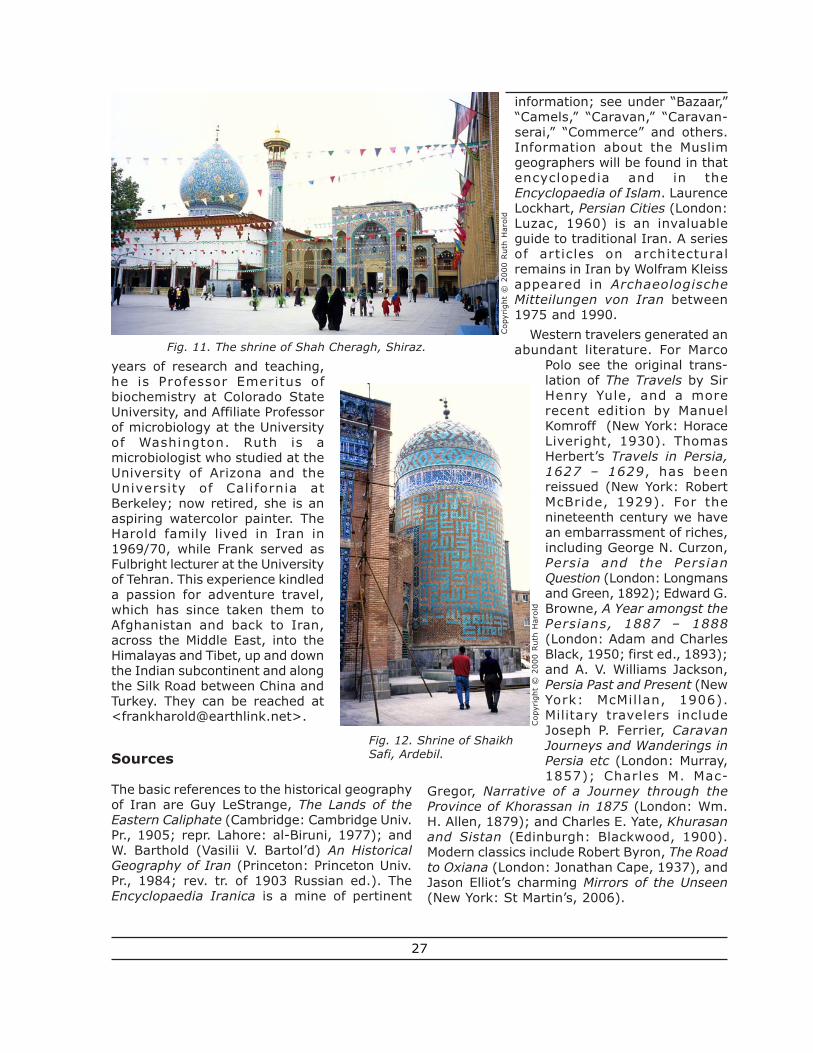
A very different facet of Old Persia lives onat the many shrines where pilgrims gather. Theyno longer travel by caravan but they continueto come, an enduring feature of life in Iran as itwas in the European middle ages. Since theoverthrow of Saddam Hussein, thousands ofIranians have made the hazardous journey toShiism’s holiest shrines at Najaf and Kerbala,undeterred by the risk of stampedes and suicidebombers. Pilgrims flock to Shah Cheragh inShiraz [Fig. 11, facing page], and find their wayto the tombs of the Safavid Shaikhs in Ardebil,up in northwestern Iran [Figs. 12, facing page;13, 14 p. 28]. The hereditary chief of a militantSufi brotherhood and endowed with irresistiblecharisma, Shaikh Ismail was all of twelve yearsold when he led forth his Turkoman warriors toconquer Iran for Shiism (1499 CE). As thefounder of the Safavid dynasty, Shah Ismail isstill a potent force and intercessor.
Blessed above all the others is the pilgrimageto the tomb of the Imam Reza, eighth in theline of divinely guided and infallible Imamsdescended from the Caliph Ali. The Imam diedin 817 CE (of poison, Shiites believe), and wasburied at Mashad in northeastern Iran; of allthe many shrines in the country, his is the mostsacred. For most of its history the shrine hasbeen off-limits to foreigners; we were privilegedto enter it in 1970, during a brief period whenShah Mohammed Reza ordered it opened (thepresent status is not clear to me). Nowhere inIran will you find glazed tiles more lustrous thanin the Mosque of Gowhar Shad and the adjoiningcourtyards. And even the most hardenedrationalist cannot fail to be moved by the
passionate devotion of theswarms of pilgrims, who havecome from all corners of this hugecountry to bask for a little whilein the grace of a long-dead martyr.
About the authors
Frequent contributors to thisjournal, Frank and Ruth Haroldare scientists by profession andtravelers by avocation. Frank wasborn in Germany, grew up in theMiddle East and studied at CityCollege, New York, and theUniversity of California atBerkeley. Now retired from forty
Fig. 9. An alley in Na’in.
Fig. 10. The rooftops of Khiva, Uzbekistan.
Cop
yrig
ht ©
200
0 R
uth
Har
old
Cop
yrig
ht ©
200
0 R
uth
Har
old
26
years of research and teaching,he is Professor Emeritus ofbiochemistry at Colorado StateUniversity, and Affiliate Professorof microbiology at the Universityof Washington. Ruth is amicrobiologist who studied at theUniversity of Arizona and theUniversity of California atBerkeley; now retired, she is anaspiring watercolor painter. TheHarold family lived in Iran in1969/70, while Frank served asFulbright lecturer at the Universityof Tehran. This experience kindleda passion for adventure travel,which has since taken them toAfghanistan and back to Iran,across the Middle East, into theHimalayas and Tibet, up and downthe Indian subcontinent and alongthe Silk Road between China andTurkey. They can be reached at<[email protected]>.
Sources
The basic references to the historical geographyof Iran are Guy LeStrange, The Lands of theEastern Caliphate (Cambridge: Cambridge Univ.Pr., 1905; repr. Lahore: al-Biruni, 1977); andW. Barthold (Vasilii V. Bartol’d) An HistoricalGeography of Iran (Princeton: Princeton Univ.Pr., 1984; rev. tr. of 1903 Russian ed.). TheEncyclopaedia Iranica is a mine of pertinent
information; see under “Bazaar,”“Camels,” “Caravan,” “Caravan-serai,” “Commerce” and others.Information about the Muslimgeographers will be found in thatencyclopedia and in theEncyclopaedia of Islam. LaurenceLockhart, Persian Cities (London:Luzac, 1960) is an invaluableguide to traditional Iran. A seriesof articles on architecturalremains in Iran by Wolfram Kleissappeared in ArchaeologischeMitteilungen von Iran between1975 and 1990.
Western travelers generated anabundant literature. For Marco
Polo see the original trans-lation of The Travels by SirHenry Yule, and a morerecent edition by ManuelKomroff (New York: HoraceLiveright, 1930). ThomasHerbert’s Travels in Persia,1627 – 1629, has beenreissued (New York: RobertMcBride, 1929). For thenineteenth century we havean embarrassment of riches,including George N. Curzon,Persia and the PersianQuestion (London: Longmansand Green, 1892); Edward G.Browne, A Year amongst thePersians, 1887 – 1888(London: Adam and CharlesBlack, 1950; first ed., 1893);and A. V. Williams Jackson,Persia Past and Present (NewYork: McMillan, 1906).Military travelers includeJoseph P. Ferrier, CaravanJourneys and Wanderings inPersia etc (London: Murray,1857); Charles M. Mac-
Gregor, Narrative of a Journey through theProvince of Khorassan in 1875 (London: Wm.H. Allen, 1879); and Charles E. Yate, Khurasanand Sistan (Edinburgh: Blackwood, 1900).Modern classics include Robert Byron, The Roadto Oxiana (London: Jonathan Cape, 1937), andJason Elliot’s charming Mirrors of the Unseen(New York: St Martin’s, 2006).
Fig. 11. The shrine of Shah Cheragh, Shiraz.
Fig. 12. Shrine of ShaikhSafi, Ardebil.
Cop
yrig
ht ©
200
0 R
uth
Har
old
Cop
yrig
ht ©
200
0 R
uth
Har
old
27
For the Silk Road see Luce Boulnois, SilkRoad: Monks, Warriors and Merchants on theSilk Road (Hong Kong: Odyssey Books, n.d.,ca 2004); and Jonathan M. Bloom, “Silk Roador Paper Poad?” The Silk Road 3/2 (2005): 21-26.
An article on Yazd by the present authorsappeared in The Silk Road 3/2 (2005): 34 -37.A description of the Shrine of the Imam Rezahas been posted on the website of Silk RoadSeattle, <http://depts.washington.edu/
silkroad/cities/iran/mashad.html>. The map isbased on several sources, especially AnHistorical Atlas of Islam, William C. Brice, ed(Leiden: E.J. Brill, 1981); and the Tübinger Atlasdes Vorderen Orients (Wiesbaden: Dr LudwigReichert Verlag, 1994).
Quotations: “The whispers of the desert wind”etc, from The Kasidah of Haji Abdu el Yezdi, byRichard Burton (1880). Others were taken fromthe sources cited.
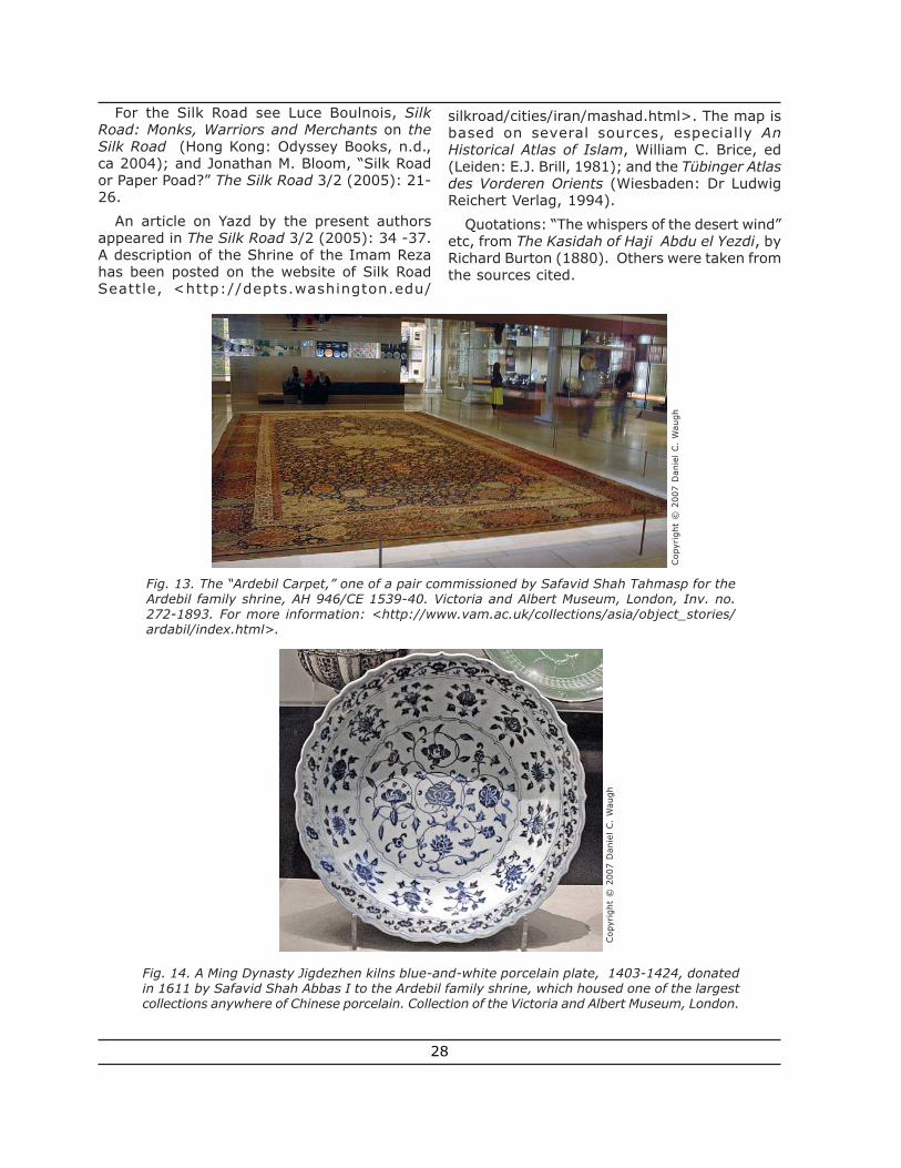
Fig. 13. The “Ardebil Carpet,” one of a pair commissioned by Safavid Shah Tahmasp for theArdebil family shrine, AH 946/CE 1539-40. Victoria and Albert Museum, London, Inv. no.272-1893. For more information: <http://www.vam.ac.uk/collections/asia/object_stories/ardabil/index.html>.
Fig. 14. A Ming Dynasty Jigdezhen kilns blue-and-white porcelain plate, 1403-1424, donatedin 1611 by Safavid Shah Abbas I to the Ardebil family shrine, which housed one of the largestcollections anywhere of Chinese porcelain. Collection of the Victoria and Albert Museum, London.
Cop
yrig
ht ©
200
7 D
anie
l C
. W
augh
Cop
yrig
ht ©
200
7 D
anie
l C
. W
augh
28