Embed Size (px)
Citation preview
Catastrophic 1638 earthquakes in Calabria (southern Italy):
New insights from paleoseismological investigation
Paolo Galli and Vittorio BosiCivil Protection Department, Seismic Survey of Italy, Rome, Italy
Received 14 December 2001; revised 6 June 2002; accepted 7 October 2002; published 3 January 2003.
[1] The reanalyses of all the primary historical sources of the catastrophic March–June1638 Calabrian earthquakes permitted to split up the seismic sequence in different eventsthat occurred in conterminous areas and to direct our geological surveys of the June shockinside the Sila massif (northern Calabria). We carried out paleoseismological analysesalong the Lakes fault (LF), a previously unknown fault. LF (trending NW-SE) cuts theeastern sector of the Sila massif and dips southwestward, damming the drainage networkthat runs toward the Ionian Sea. We opened four trenches close to or inside some of thesmall marshes and ponds created by the footwall uplift, finding evidence of severaldisplacement events, the last one being the June 1638 earthquake (M = 6.7). The faultlocation fits with the historical description of a long fracture opened during the event, ourtrenching area being still named by the natives ‘‘the earthquake sag.’’ The younggeomorphic expression of LF recalls that of the 1980 Irpinia fault, suggesting its relativelyrecent activation within the extensional regime characterizing the Calabrian arc.Conversely, the northern continuation of LF (Cecita Lake fault), which we argue to beactive too, is not associated to any historical earthquake of the Italian seismic catalogue,this fact evidencing a long, at least 1000 years, elapsed time. Our study permits (1) therelocation of the June 1638 earthquake inside the Sila massif, the epicenter being shiftedwith respect to the macroseismically derived one, (2) the revision of the whole 1638sequence, (3) the discovery of the LF, (4) the recognition of the evidence of the June 1638surface faulting plus four previous paleoearthquakes, and (5) the evaluation of its slip ratesand return interval. Finally, the relationship of LF with the neighboring faults casts light tothe seismotectonic of the region, providing a new insight to the seismic hazardanalysis. INDEX TERMS: 7221 Seismology: Paleoseismology; 7230 Seismology: Seismicity and
seismotectonics; 7223 Seismology: Seismic hazard assessment and prediction; 8107 Tectonophysics:
Continental neotectonics; 8010 Structural Geology: Fractures and faults; KEYWORDS: active tectonics,
historical seismicity, paleoseismology, seismic hazard, Italy
Citation: Galli, P., and V. Bosi, Catastrophic 1638 earthquakes in Calabria (southern Italy): New insights from
paleoseismological investigation, J. Geophys. Res., 108(B1), 2004, doi:10.1029/2001JB001713, 2003.
1. Introduction
[2] A crossroad of both people and earthquakes, theCalabrian region is rich with stories of cultures accommo-dating themselves to a violent seismic landscape. Half of the10 M � 6.9 earthquakes that occurred in Italy during thepast centuries had their epicenters in the long and narrowCalabrian peninsula (Figure 1). Their scenario of death anddestruction often extended from coast to coast, as theabandonment of dozen of villages and the exodus of thesurvivors toward safer lands recurred each time.[3] While some of these earthquakes have been related to
known or studied active structures of the area, mostly bymeans of their reciprocal geometric relationships (i.e.,epicentral area versus fault location) [Monaco and Tortorici,
2000], but also of paleoseismological analyses [Galli andBosi, 2002], other strong earthquakes are still lacking theidentification of their causative fault. In northern Calabria,as exception to this rule, the Castrovillari fault (1 in Figure 1)[Bousquet, 1973] surely ruptured during the historicalperiod [Cinti et al., 1997], although its effects were notrecorded by any primary source.[4] As for the sector resting between the Catanzaro and
the Sibari straits (Figure 1), a strong seismic sequenceoccurred between March and June 1638, with 2 mainshocks on 27 March and 9 June (see top of Table 1). Thecatastrophic 27 March event struck a thickly populated areabetween the high Crati Valley and the Catanzaro strait area,while the second one devastated the Ionian hillslope of theSila massif. Until now, no conclusive data have beenprovided to relate these M ffi 7 earthquakes to possiblyactive structures, even though Moretti [2000] links theMarch shock to the Lamezia-Catanzaro fault (6 in Figure 1).
JOURNAL OF GEOPHYSICAL RESEARCH, VOL. 108, NO. B1, 2004, doi:10.1029/2001JB001713, 2003
Copyright 2003 by the American Geophysical Union.0148-0227/03/2001JB001713$09.00
ETG 1 - 1
[5] In this paper we focus mainly on the June shock area,both reanalyzing all the available historical sources and bymeans of geological and geomorphological field survey.Inside a wide area indicated by the contemporary sources,we individuated a previously unknown fault, whose footwalldams small and large streams, creating lakes and ponds(Lakes fault (LF)). We opened four trenches across this fault,which show evidence for repeated displacement events datedback to the 1638 and to previous unknown earthquakes.
2. Geological and Seismotectonic Framework ofCalabria
[6] Calabria is the southern termination of the Apenninepeninsular chain, resting in the toe of the Italian ‘‘boot.’’
The Apennines formed above a west-dipping subductionzone and consist of a thrust belt–foredeep system whichmigrated eastward as a response to the flexure-hinge retreatof the subducting foreland lithosphere. This retreat wascharacterized by slip vectors largely exceeding the averageplate convergence rate in the Central Mediterranean regionduring Neogene and Quaternary times [Patacca and Scan-done, 2001, and references therein]. Specifically, the Cala-brian arc lies above a NW-dipping subduction slab (i.e.,Ionian oceanic lithosphere), well characterized by a Benioffplane [Amato et al., 1993], and extending at least 500 kminto the astenosphere below the southern Tyrrhenian Basin.The latter is commonly considered the back arc basin of theApenninic subduction, its ages being younger when movingeastward [Gueguen et al., 1997, and references therein]. TheNeogene–Quaternary evolution of the Calabrian arcinduced a zone of crustal disequilibrium at the boundarybetween the uplifting Aspromonte–Sila mountain chain(25–45 km thick continental crust) [Ghisetti and Vezzani,1982] and the subsiding Tyrrhenian basin (10 km thick crustof suboceanic composition) (Figure 2) [Finetti and Morelli,1973], causing extensional faulting in the imbricate systemsof the thrust belt since lower Pliocene time. As a result, aseries of elongate N-S and NE-SW trending basins formedon the inner margin of the belt (Crati Valley, Mesima Valley,Gioia Tauro, Santa Eufemia, and Messina Strait basins)(Figure 1), bordered, respectively, by primary east and NW-dipping high-angle normal faults along the Tyrrhenian westcoast of southern Italy [Tortorici et al., 1995; Galli andBosi, 2002]. On the other hand, active thrusting is restrictedin a narrow band along the eastern Apenninic front (inset Ain Figure 2) as suggested by geophysical profiles [Finettiand Morelli, 1973; Barchi et al., 1998] and instrumentalseismicity.[7] Starting from middle Pleistocene, Calabria was rap-
idly uplifted, as suggested by the deposition of thick sandyand conglomeratic bodies of deltaic or littoral environmentdirectly overlaying marine clays [Moretti and Guerra,1997]. These deposits are found at elevation of 400 masl within the extensional basins (i.e., Crati half-grabenbasin), whereas Pliocene–Pleistocene sediments and con-temporary continental paleosurfaces may reach 1400 m aslin the raised blocks of Sila, Serre, and Aspromonte.According to some authors [Westaway, 1993; van Dijkand Scheepers, 1995], the rapid uplift and the extensional
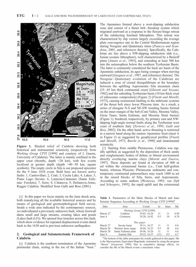
Figure 1. Shaded relief of Calabria showing bothhistorical and instrumental seismicity (respectively fromWorking Group CPTI [1999] and courtesy of I. Guerra,University of Calabria). The latter is mainly confined in theupper crust (rhombs, depth <20 km), with few eventslocalized at greater depth (depth >40–50 km, squaresymbols). The empty circle in Sila is our proposed epicenterfor the 9 June 1638 event. Bold lines are known activefaults: 1, Castrovillari; 2, Crati; 3, Cecita Lake; 4, Lakes; 5,Piano Lago–Savuto; 6, Lamezia-Catanzaro (Santa Eufe-mia–Feroleto); 7, Serre; 8, Cittanova; 9, Delianova-Armo,Reggio Calabria. Modified from Galli and Bosi (2001).
Table 1. Parameters of the Main Shocks of March and June
Seismic Sequence According to Working Group CPTI [1999]a
Date Area Coord. Io Imax Me
Working Group CPTI [1999]March 27 Calabria 39.03, 16.28 11 11 6.98June 8 Crotonese 39.28, 16.82 9.5 10 6.78
This paperMarch 27 Savuto basin 39.11, 16.27 11 11 6.8March 28 Western Serre range 38.68, 16.23 9.5 10 6.6March 28 Santa Eufemia plain 38.96, 16.26 11 11 6.6June 9 Eastern Sila 39.22, 16.57 (11) 9.5 6.7
aThe bottom of the table anticipates the results gathered in this paper. Meis the Macroseismic Equivalent Magnitude, estimated by using the program‘‘Boxer’’ [Gasperini, 1999]. Due to cumulative damage effects, weconsider the Me of the March events a maximum value.
ETG 1 - 2 GALLI AND BOSI: PALEOSEISMOLOGY OF LAKES FAULT (1638 EARTHQUAKE, ITALY)

faulting in the Calabrian Arc during late Pleistocene toRecent are a result of the isostatic rebound that occurredwhen the detached remnants of the ruptured slab started tosink, whereas the nondetached portion rapidly unbent, andelastically bounced upwards (e.g., Figure 2). For thisdebated issue, see also criticism in the study of Giunchiet al. [1996].
2.1. Overview of Seismicity and Seismogenetic Faultsof Northern Calabria
[8] Calabria is one of the most seismic areas of theMediterranean region, and has been struck in the past bythe most catastrophic earthquakes ever occurred in Italy. Infact, at least 19 earthquakes with M � 6 occurred since 91B.C. between the Messina Strait and the Crati Valley, thelast ones being the disruptive 1905 (Ms = 7.5) Mt. Poro and1908 (Ms = 7.3) Messina earthquakes (parameters derivedfrom Working Group CPTI [1999, Figure 1]). Although theItalian seismic catalogue spans over the past 2 ka (beingroughly complete, for destructive earthquakes, in the past7–10 centuries) [Stucchi and Albini, 2000], almost all theCalabrian recorded events are concentrated in less than 3centuries between 1638 and 1908, and they often occurredwithin a few months or years of one another (e.g., Marchand June 1638, February–March 1783, and 1905–1908) orwithin 1 century (southward migrating sequence of CratiValley of 1767, 1835, 1854, and 1870) (see triangle-headarrow in Figure 1). Differently from southern Calabria,where all major earthquakes have been related to primaryNE-SW normal faults (7–9 in Figure 1) [see Tortorici et al.,1995; Jacques et al., 2001; Galli and Bosi, 2002], thenorthern Calabria seismogenetic framework is still poorlyconstrained and debated.2.1.1. Western Sector[9] As shown in Figure 1, the sector resting between the
Catanzaro and the Sibari straits is affected by a M � 6seismicity, which is commonly linked to the Crati basinnormal faults (2 in Figure 1). See also focal mechanisms 1and 6 in Figure 3. For the Crati faults (total length about40 km) (1–3 in Figure 3) [Tortorici et al., 1995], which drovethe opening of the Crati ‘‘half-graben’’ basin during lowermiddle Pleistocene, no displacements of any upper Pleisto-
cene–Holocene deposits are known. High rates of UpperPleistocene vertical slip (0.6–0.9 mm/yr) [Tortorici et al.,1995] are mainly inferred from geomorphic features, con-sisting of deeply eroded relict fault facets, that were likelyformed during an earlier time of higher rates of activity. Onthe other hand, the lack of conclusive evidence of activetectonic along these faults could be explained by theirmoderate historical seismicity (M � 6), although we mighthave lost a strong event in the ‘‘short’’ historical record.[10] Major problems arise in the southern prosecution of
the Crati plain (high Crati-high Savuto basins), where M > 6earthquakes did occur (27 March 1638 and 10 April 1870),but no active structures have been yet clearly identified(Piano Lago and Savuto–Decollatura normal faults?) (7 inFigure 3) [Moretti, 2000].2.1.2. Central and Eastern Sector[11] As for the eastern side of the region, few strong
events occurred along the Ionian slopes of Sila. Apart fromthe 9 June 1638 (the epicenter of which has been shiftedwestward in this paper), they are the 1832 (Me = 6.5) and1836 (Me = 6.2) earthquakes (Me is the MacroseismicEquivalent Magnitude evaluated by Working Group CPTI[1999] by using the ‘‘Boxer’’ program in the study ofGasperini [1999]). At present, no hypotheses concerningtheir causative faults exist, although the Highest IntensityDatapoints Distribution (HIDD) and some historicalaccounts could suggest a relationship between the 1836event and an E-W lineament (dashed line 4 in Figure 3) (seealso Corigliano-Rossano lineament in the study of Moretti[2000]).[12] The Sila massif is instead a historically silent, closed
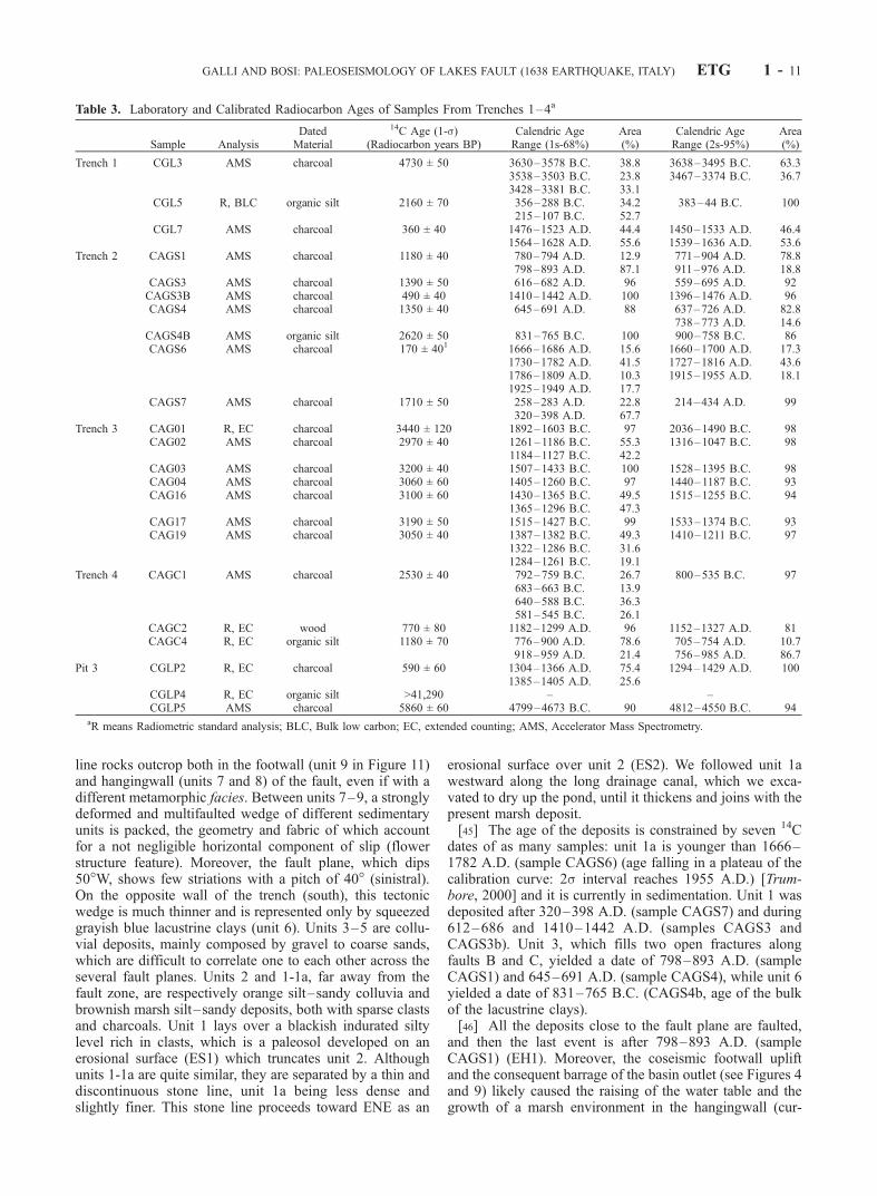
window on the seismotectonics of the region. Only recentlythe distribution of the instrumental seismicity (Figure 1,courtesy of Prof. I. Guerra, University of Calabria) showedscattered M < 4.5 events even inside the massif itself.Nevertheless, the lack of historical seismicity in the Silamassif should not imply the nonexistence of active struc-tures. An example is given by the NNW-striking CecitaLake fault (CLF) (5 in Figure 3), newly ‘‘appeared’’ in theliterature [Sorriso-Valvo and Tansi, 1997], and definedactive during the Pleistocene by Moretti [2000], or by the‘‘unknown’’ LF (6 in Figure 3), which is responsible for
Figure 2. Interpretative W-E geological cross section through northern Calabria, from the TyrrhenianSea to the Ionian Sea. Black stars indicate the possible hypocenters of the two 1638 main shocks,occurred within the extending upper crust of the Calabrian arc (see inset A for location [modified afterVan Dijk and Scheepers, 1995]).
GALLI AND BOSI: PALEOSEISMOLOGY OF LAKES FAULT (1638 EARTHQUAKE, ITALY) ETG 1 - 3
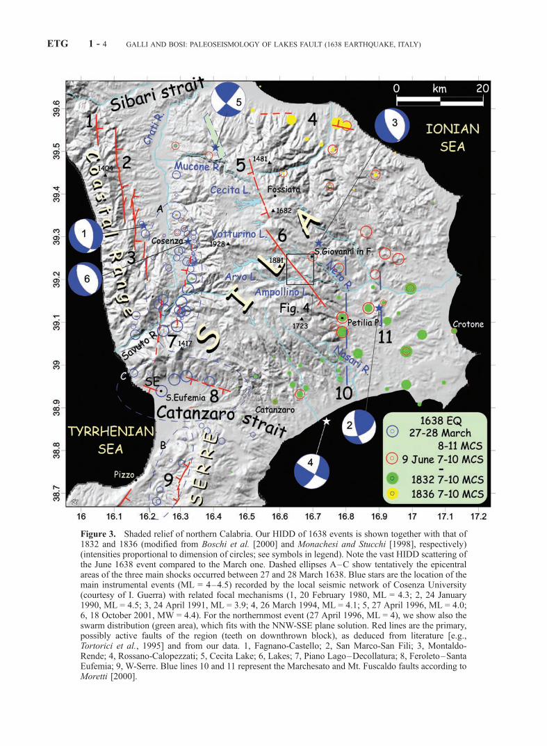
Figure 3. Shaded relief of northern Calabria. Our HIDD of 1638 events is shown together with that of1832 and 1836 (modified from Boschi et al. [2000] and Monachesi and Stucchi [1998], respectively)(intensities proportional to dimension of circles; see symbols in legend). Note the vast HIDD scattering ofthe June 1638 event compared to the March one. Dashed ellipses A–C show tentatively the epicentralareas of the three main shocks occurred between 27 and 28 March 1638. Blue stars are the location of themain instrumental events (ML = 4–4.5) recorded by the local seismic network of Cosenza University(courtesy of I. Guerra) with related focal mechanisms (1, 20 February 1980, ML = 4.3; 2, 24 January1990, ML = 4.5; 3, 24 April 1991, ML = 3.9; 4, 26 March 1994, ML = 4.1; 5, 27 April 1996, ML = 4.0;6, 18 October 2001, MW = 4.4). For the northernmost event (27 April 1996, ML = 4), we show also theswarm distribution (green area), which fits with the NNW-SSE plane solution. Red lines are the primary,possibly active faults of the region (teeth on downthrown block), as deduced from literature [e.g.,Tortorici et al., 1995] and from our data. 1, Fagnano-Castello; 2, San Marco-San Fili; 3, Montaldo-Rende; 4, Rossano-Calopezzati; 5, Cecita Lake; 6, Lakes; 7, Piano Lago–Decollatura; 8, Feroleto–SantaEufemia; 9, W-Serre. Blue lines 10 and 11 represent the Marchesato and Mt. Fuscaldo faults according toMoretti [2000].
ETG 1 - 4 GALLI AND BOSI: PALEOSEISMOLOGY OF LAKES FAULT (1638 EARTHQUAKE, ITALY)
the June 1638 earthquake, as described in detail in thefollowing chapters.[13] On the other hand, according to Moretti [2000], the
primary faults of the Ionian slope of Sila are the Marchesatoand Mount Fuscaldo faults (10 and 11 in Figure 3), whichdrove the lowering of Ionian block and which would havebeen also the causative structures of the June 1638 event.However, apart from the 100 m offset of Lower Pleistocenedeposits along the Mt. Fuscaldo fault [Moretti, 1993], nodisplacements of any upper Pleistocene–Holocene depositsare known.2.1.3. Southern Sector[14] The southern edge of both Sila massif and of Coastal
Range is the Feroleto–Santa Eufemia fault (8 in Figure 3),highlighted by a prominent south-facing fault scarp, com-posed by several discontinuous E-W and ESE-WNWstrands with a sinistral en echelon arrangement. Accordingto Moretti [2000], the fault is related to a deep transformstructure (Catanzaro fault) [Finetti and Del Ben, 1986], andit offsets Upper Pleistocene–Holocene terraces, beingresponsible for the northernmost main shock of the 1783catastrophic sequence (28 March, Me = 7).
3. The 1638 Earthquake Sequence
[15] As mentioned before, the 1638 earthquakes hit theUpper Crati–Savuto valleys, the Catanzaro Strait and theUpper Mesima Valley in March, whereas in June struckthe Ionian side of Sila Massif (Figures 1, 2, and 3).Although our geological investigation concerns mainly theJune shocks area, we reexamined the whole historicalaccounts of the seismic sequence, the complexity ofwhich has been interpreted as due to rupture of differentfaults.
3.1. The March 1638 Earthquake
[16] The earthquake of 27 March 1638 (Io = 11 MCS,Mercalli Cancani Sieberg scale, and Me = 7) is surely themost catastrophic event which hit this portion of Calabriaduring the historical period (Figure 3), its disruption echoesreaching the farthest country of Europe [e.g., Parker, 1638;Descriptive relation, 1638; Dreadfull newes, 1638]. In thewhole the earthquake destroyed more than 100 amongvillages and hamlets, causing between 10,000 and 30,000casualties, while several surface breaks, landslides, lique-factions and sinking have been reported by many primarysources to have occurred in different places.[17] Actually, the analysis of all the most significant
contemporary sources [e.g., Bianchi, 1638; Capecelatro,1640a, 1640b, 1640c; D’Amato, 1670; D’Orsi, 1640;Kircher, 1665; Recupito, 1638; Vera relatione, 1638; Com-passionevole relazione, 1638] allowed us to define at leastthree separated epicentral areas (Table 1). The northern andmost severe one (Io = 11 MCS) (ellipse A in Figure 3) islocated between the upper Crati and the Savuto valleys; thesecond one (Io = 9.5 MCS) (ellipse C in Figure 3), lessdefined although greatly elongated, between the southernpart of the Catanzaro strait and the western slope of theSerre range; the third one (Io = 11 MCS) (ellipse B inFigure 3) could be drawn along the northwestern sector ofthe Catanzaro strait. According to the account of the JesuitAthanasius Kircher [Kircher, 1665], who was travelling
over the zone struck by the earthquakes, while the firstand main shock occurred effectively at the sunset of 27March, the second and third area were hit only on the PalmSunday (28 March), when he personally witnessed thedisruption and the sinking of Santa Eufemia (see locationin Figure 3): ‘‘The day after [the earthquakes of 27], PalmSunday, [between Pizzo and Santa Eufemia]. . .we heard arumbling sound like a thunder, quite hollow, which seemedcoming from a far place, but that was growing louder asapproaching nearer, until it stopped in the underground ofthe place on which we stood. And just there it struck theEarth with a so violent shake that everyone, being unable tostand, was compelled to catch hold of a branch, or a seashrub. . .And there, exactly in that moment, occurred theruin of the celebrated town of Santa Eufemia. . .As theNature’s fury lessened, and we cast a glance around, wesaw the aforementioned town surrounded by a greatcloud. . .But, at three of the afternoon, after the cloud lazilypassed away, we turned to look for the city, but did not seeit: nothing, but a dismal and putrid lake was seen where itstood. We looked about to find some one that could tell usof this sad catastrophe, but could see no person. . .Only anastonished child, sitting on the shore,. . .refusing the foodthat we offered him,. . .seemed to point out with his fingersthe catastrophe of Santa Eufemia’’ [Kircher, 1665, trans-lated from Latin by the authors].[18] Consequently, the magnitude of each shock is obvi-
ously smaller than the one provided by Working GroupCPTI [1999] (the parametric earthquake catalogue of Italy).In particular, on the basis of the HIDD of the upper Crati–Savuto area event (27 March) we estimated Me = 6.6 (byusing the ‘‘Boxer’’ program) [Gasperini, 1999]. Neverthe-less, this magnitude should be considered a maximumvalue, since the used HIDD contains also the cumulatedeffects of the two 28 March events.[19] Summarizing, on the basis of the HIDD we can
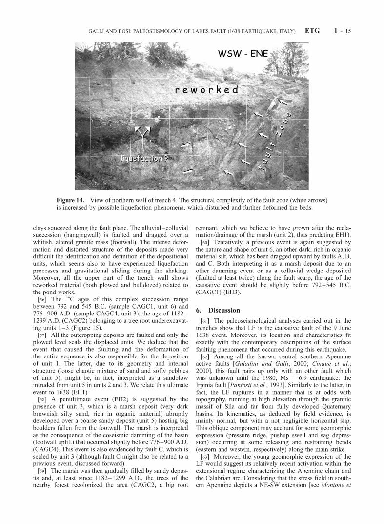
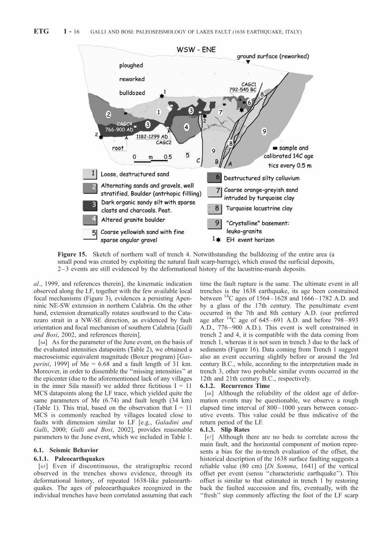
hypothesize that three different fault systems ruptured fromnorth to south between 27 and 28 March: these could behypothetically related to the Piano Lago and Savuto–Decollatura faults (7 in Figure 3) [e.g., Moretti, 2000], theSanta Eufemia–Feroleto fault (8 in Figure 3, which is partof the Lamezia-Catanzaro fault in the study of Moretti[2000]) and the northern prosecution of the Mesima fault(9 in Figure 3) [see Monaco and Tortorici, 2000; Galli andBosi, 2002]. Nevertheless, no conclusive field data havebeen yet collected concerning the causative faults of theMarch events.
3.2. The June 1638 Earthquake
[20] ‘‘During the night [of 9 June 1638; this event isreported on 8 June on Working Group CPTI, 1999; see alsoChiodo et al., 1995] a horrible earthquake struck towns,lands and castles, lowering mountains, rupturing the Earthsurface and opening long fractures.’’ This is the roughtranslation from Lutio D’Orsi [D’Orsi, 1640], whodescribed the effects of the June event, the catastrophicearthquake which struck an area located few dozen kilo-meters away from the epicentral region of 27 March, on theopposite, eastern slope of Sila. This event has been recentlystudied by Chiodo [1993] and Scaccianoce [1993].[21] The 9 June earthquake was preceded at dawn and
noon of the day before by two strong foreshocks that
GALLI AND BOSI: PALEOSEISMOLOGY OF LAKES FAULT (1638 EARTHQUAKE, ITALY) ETG 1 - 5
alerted the population, convincing those few still sleepingin their home (since March the Earth was tremblingcontinuously) to get a safe shelter far away from thevillages, in the country. Therefore, in spite of the damagelevel, the official death toll is cited as just over a fewdozens.[22] On the basis of all the known primary historical
sources, we reevaluated the MCS intensity for each village(Table 2 and Figure 3), estimating an Imax = 9.5 (MCS)(Table 1). Six villages were almost completely destroyed,whereas about twenty scattered in a vast area elongatedabout 60 km from south to north had I � 8 MCS. The HIDDsurrounds at north, east, and south the Sila massif, reflectingthe absence of villages in the mountainous area, a wild andinhospitable plateau with elevations ranging between 1300and 1900 m asl. It is worth to note that while part of thedamage could be interpreted as cumulative on that caused bythe March event, part could be underestimated (e.g., southand western sector) due to the previous level of disruption ofbuildings which did not allowed to ‘‘record’’ further dam-ages (‘‘if it did not cause a new slaughter it was because itfound few places to beat down on’’) [Bernaudo, 1639]. Inany case, due to the location of the epicenter in a mountain-ous and uninhabited area, the Io value should be reasonablyhigher than the evaluated Imax.[23] In contrast to the 27 March event and to several
studied case histories [e.g., Galli and Galadini, 1999], theJune HIDD does not depict any particular trend whichcould highlight the causative fault. It is our feeling thatmany factors contributed to the complexity and difficultunderstanding of the 9 June HIDD: (1) site effects (due tothe extremely varied geology and to the scarce geotechnicalproperties of the Tertiary and Quaternary rocks of theeastern coast), (2) gravity-driven phenomena (triggered byshaking, as reported by many historical sources), (3) vastuninhabited areas, and (4) cumulative damage with the twostrong foreshocks of 8 June (and with the 27 and 28 Marchevents).[24] Anyway, the most important issue highlighted by the
contemporary sources is the opening of an impressivefracture across the Sila massif, the description of whichwe translated from Latin and the old Italian as:1. ‘‘. . . in the mountain named Sila in that day a very
long and deep fracture opened due to the earthquake. . .’’[Relazione del terremoto, 1638].2. ‘‘. . . in the land of San Giovanni in Fiore the ground
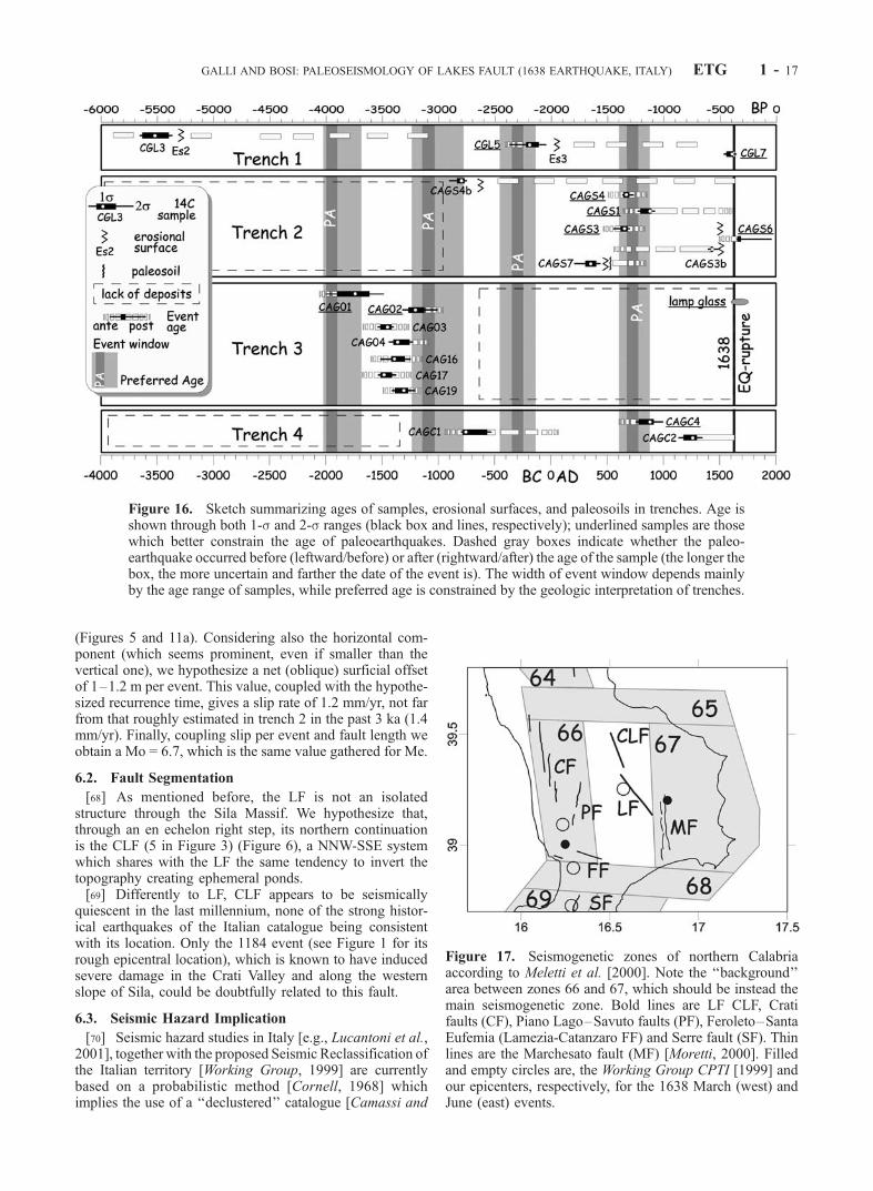
ruptured for a width of 2 palms [about 50 cm], for the lengthof many miles toward the Sila. . .’’ [D’Orsi, 1640].3. ‘‘. . . from the border of Policastro to the extreme side
of the mountain [Sila], northward, the ground lowered 3palms [about 80 cm] by one side, along a 60 miles longstraight line, and what is wonderful, it did ruptured with thesame entity both in the lowermost valley and in the highestmountain. . .’’ [Di Somma, 1641].4. ‘‘. . . the earthquake. . .opened chasms. . .in the most
uninhabited mountains of the Sila, which sent outflames. . .’’ [Paragallo, 1689].5. ‘‘. . . the ground was offset by 3 palms along a 60
miles long space from the Policastro border to the Sila ofCosenza [see Di Somma, 1641], and it happened to me tosee it again, after many years, in the Sila in a place namedCagno. . .’’ [Martire, 1704].
[25] These descriptions are the oldest detailed, and self-consistent historical descriptions of surface faulting aroundthe globe. Actually, the length of the fracture cited as 60miles (110 km!) by Di Somma [1641, and just referred bylate authors] appears unexpectedly long for a Me = 6.7earthquake; it could be exaggerated or, more probably, badtypeset from Di Somma’s original manuscript (e.g., in1600s Italian manuscripts we ascertained that the cursive‘‘2’’ and ‘‘6’’ are quite similar).[26] Even if the true length may remain questionable, the
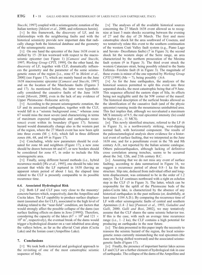
overall information reported by all the eye witnesses aboutlocation, offset and continuity, both in the valleys and acrossthe ridges, is a robust indication of the tectonic origin of thefracture. Moreover, the persistence of the step after 60 years[Martire, 1704] corroborate this impression.[27] Another convincing fact is that during our field
survey along a lineament (LF) seen on the 1954 air-photocoverage, we found that the local place–name of one areawhere we were selecting potential trenching site was‘‘Cagno,’’ the same cited and visited by Martire [1704](see Figure 4 for location). Moreover, the intriguing circum-stance was that the natives, although they have no memoryof any earthquakes in the area, still today call this area ‘‘acolla u terremotu’’ (the sag of the earthquake, in the localCalabrian dialect). Similarly, few kilometers away along thesame lineament, it exists an area called ‘‘Trepido di luce,’’which literally means ‘‘it trembled with light’’ (old Italiantrepidare = to tremble) (Figure 4).[28] In the whole, while the vastly scattered HIDD of this
event, with several irregularities (i.e., high and low MCSintensities mixed in the same areas) does not show anyparticular trend that can reflect the bearing of the seismo-genetic structure, the existence of the long coseismic
Table 2. Highest Intensity Datapoints (I � 7–8) of the 8 June
1638 Event Evaluated on the Basis of All the Primary Historical
Sourcesa
Locality I (MCS)
Casabona 9.5Mesoraca 9.5Policastro 9.5Verzino 9.5Zinga 9.5Belvedere di Spinello 9.0Calciviti (Caloveto) 9.0Calopezzati 9.0Crosia 9.0San Giovanni in Fiore 9.0Scala Coeli 9.0Simeri 9.0Acri 8.5Bisignano 8.5Bocchigliero 8.5Longobucco 8.5Rocca di Neto Vecchia 8.5Sant’Angelo di Frigillo 8.5Cutro 8.5Belcastro 8.0Cotrone 8.0Santa Severina 8.0Catanzaro 7.5Zumpano 7.5
aIntensities slightly differs (±1� MCS) from other compilations [e.g.,Scaccianoce 1993; Chiodo, 1993; Monachesi and Stucchi, 1998; Boschi etal., 2000]. Acri was not included in the previous studies.
ETG 1 - 6 GALLI AND BOSI: PALEOSEISMOLOGY OF LAKES FAULT (1638 EARTHQUAKE, ITALY)
fracture crossing the inner Sila massif (which we identifiedwith the lineament/fault discussed in the following) (seeFigures 3 and 4) casts light both on the littered HIDD andon the causative fault of the June 1638 earthquake.
4. Geomorphology of the Investigated Area
[29] The area is characterized mainly by crystalline units(quarz-diorites, monzonites and granodiorites, togetherwith gneisses and metamorphic limestones) which over-thrusted the Apennine sedimentary nappes since Miocene.The crystalline rocks are affected by deep and variableweathering profiles, which probably developed duringPliocene and lower Pleistocene, when a vast paleosurfacewas carved all over the emerged Sila massif [Dramis etal., 1990]. The erosional processes of late Pleistocene–Present (emphasized by the rapid tectonic uplift of Cala-bria), although prevailing on the weathering ones, were notenough to completely remove the exposed weatheredmantle [Matano and Di Nocera, 1999]. The presentmorphology is then dominated by flies of these remnantsurfaces, mantled by thick saprolite and smoothly carvedby a complex paleodrainage, which is truncated, reen-
trenched and captured by the present upstream-downcut-ting network.[30] The area is also characterized by the presence of
several barrier lakes (built since the first half of the 20thcentury) that occupies ancient lacustrine basins (e.g., CecitaLake, Arvo Lake, and Ampollino Lake) and by sparseintermountain plains mantled by recent alluvial, colluvialand lacustrine deposits.
4.1. Geomorphological Investigation Along the LF
[31] We restricted our research in the area where thehistorical descriptions concerning the June event reportedthe most severe effects and the existence of surficial breaks,that is the eastern Sila massif region, between the riversNasari and Neto (Figure 3) [see D’Orsi, 1640]. Sila (fromLatin silva = forest) since the Greek and Roman times hasbeen one of the most thickly forested region of Europe.Thus, rock outcrops are very rare, making geomorphicanalyses difficult.[32] We focused our attention on the lineament seen on
air-photos and passing through the Cagno area, a prominentN40�W trending feature, which is transverse to the drainagepattern, and runs both ‘‘in the lowermost valley and in the
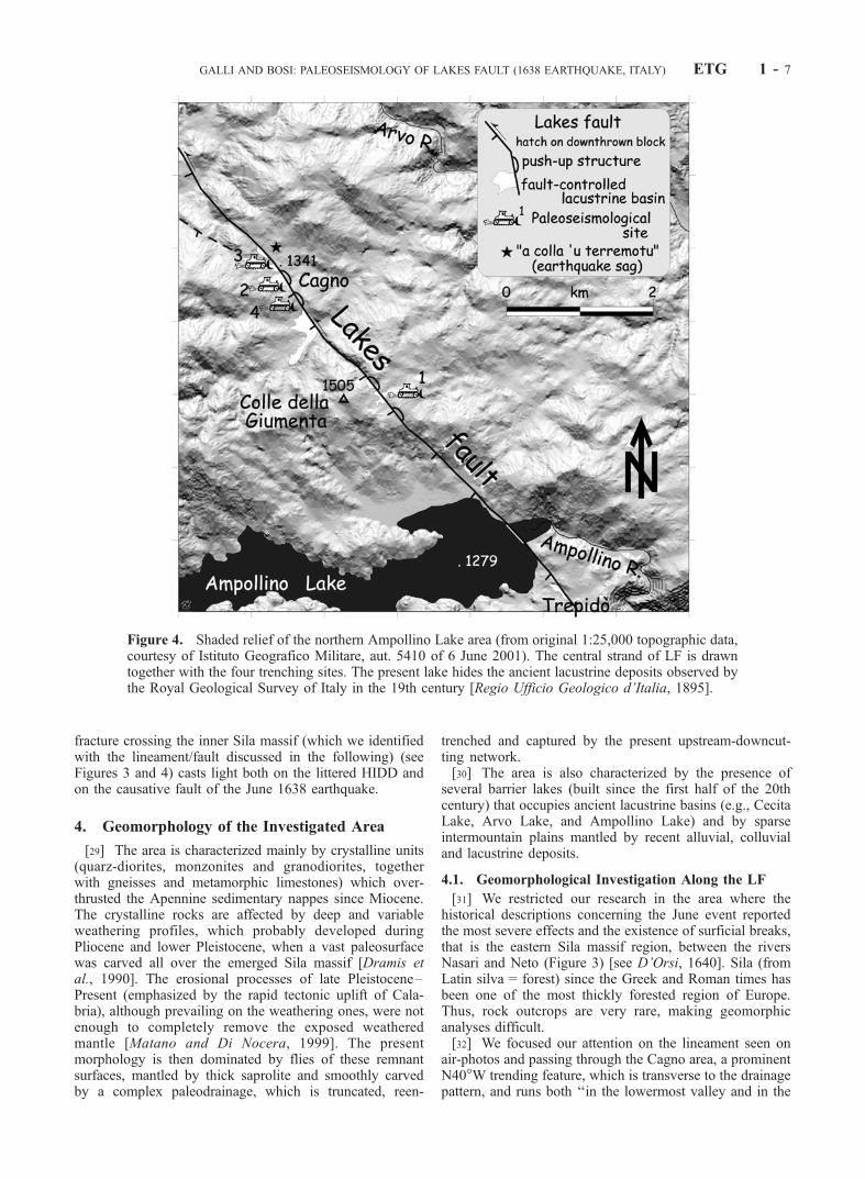
Figure 4. Shaded relief of the northern Ampollino Lake area (from original 1:25,000 topographic data,courtesy of Istituto Geografico Militare, aut. 5410 of 6 June 2001). The central strand of LF is drawntogether with the four trenching sites. The present lake hides the ancient lacustrine deposits observed bythe Royal Geological Survey of Italy in the 19th century [Regio Ufficio Geologico d’Italia, 1895].
GALLI AND BOSI: PALEOSEISMOLOGY OF LAKES FAULT (1638 EARTHQUAKE, ITALY) ETG 1 - 7
highest mountain,’’ between the borders of the municipalityof Petilia Policastro and San Giovanni in Fiore [see DiSomma, 1641]. Its surficial expression is visible along about25 km, being mainly evidenced by a west-facing scarp and/or small ridges, which border (and dam) the eastern edge ofseveral intermountain basins scattered along its hangingwall(Figures 3 and 4). In the southern sector the scarp crossesthe head of the Ampollino Lake (formed in 1923 with acapacity of 67 � 106 m3), few meters upstream of themasonry dam, whereas in the northern part it crosses theeastern edge of an other small artificial lake (VotturinoLake, 3 � 106 m3, gravity concrete dam), created on aswampy area. The artificial Ampollino Lake fills the basinof the paleo-Ampollino lake, and entirely hides the ancientlacustrine deposits mapped by the Royal Geological Surveyof Italy in the 19th century [Regio Ufficio Geologicod’Italia, 1895].[33] The fault presents smooth bendings with curvature
radius <1 km, which are marked by narrow elongate ridgesand depressions. These features commonly join up with ahorizontal component of the motion (pressure ridge andpull-apart) [e.g., Galli, 1999], which we do not exclude tobe substantial (Figure 4). On the other hand, there were noclear geomorphic evidence of a long term tectonic controlof the landscape, apart from a general deepening of thefluvial network eastward of the fault and the existence ofsome secondary streams entrenched along the lineamentitself.[34] All over its length, on the field, the fault appears as a
scarp carved both in the crystalline rocks and in thealluvial–colluvial deposits, commonly (central sector ofLF) (Figure 4) marked by a steep fresh scarplet at the baseof the main feature (about 1 m) (Figure 5). The few rockyoutcrops in the quarz-diorite units show an intensive tec-
tonic fabric approaching to the scarp, with milonite andargillitic lithons packed between the shear planes.
4.2. Geological Observations Along the CLF
[35] Northwestward to the LF area, another barrier lakeexists within the paleo-Cecita lacustrine basin (late lower
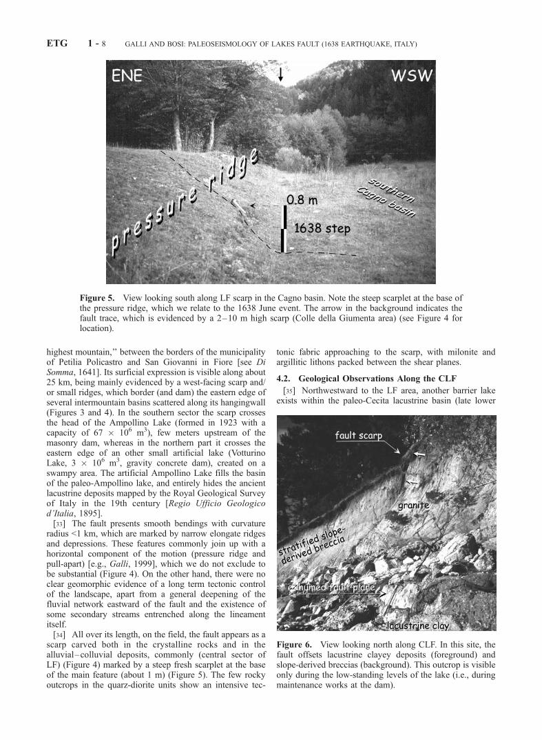
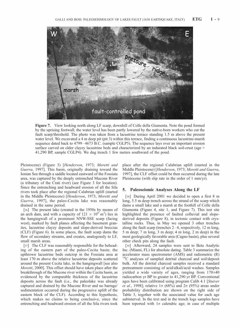
Figure 5. View looking south along LF scarp in the Cagno basin. Note the steep scarplet at the base ofthe pressure ridge, which we relate to the 1638 June event. The arrow in the background indicates thefault trace, which is evidenced by a 2–10 m high scarp (Colle della Giumenta area) (see Figure 4 forlocation).
Figure 6. View looking north along CLF. In this site, thefault offsets lacustrine clayey deposits (foreground) andslope-derived breccias (background). This outcrop is visibleonly during the low-standing levels of the lake (i.e., duringmaintenance works at the dam).
ETG 1 - 8 GALLI AND BOSI: PALEOSEISMOLOGY OF LAKES FAULT (1638 EARTHQUAKE, ITALY)
Pleistocene) (Figure 3) [Henderson, 1973; Moretti andGuerra, 1997]. This basin, originally draining toward theIonian Sea through a saddle located eastward of the Fossiataarea, was captured by the deeply entrenched Mucone River(a tributary of the Crati river) (see Figure 3 for location).Since the entrenching and headward erosion of all the Silarivers took place after the regional Calabrian uplift (startedin the Middle Pleistocene) [Henderson, 1973; Moretti andGuerra, 1997], the paleo-Cecita lake was reasonablydrained in the same period.[36] The present lake (created in the 1950s by means of
an arch dam, and with a capacity of 121 � 106 m3) lies inthe hangingwall of a prominent NNW-SSE scarp (facingwest), marked by fault planes affecting the basement gran-ites, lacustrine clayey deposits and slope-derived breccias(CLF) (Figure 6). In some places, the fault scarp dams theflow of secondary streams, and creates, analogously to LF,small marsh areas.[37] The CLF was reasonably responsible for the behead-
ing of the eastern part of the paleo-Cecita basin; theupthrown lacustrine beds outcrop in the Fossiata area atleast 170 m above the relative lacustrine deposits scatteredaround the present Cecita lake, in the hangingwall [see alsoMoretti, 2000]. This offset should have taken place after thebreakthrough of the Mucone river within the Cecita basin, asevidenced by the comparable thickness of the lacustrinedeposits across the fault (i.e., the paleolake was alreadycaptured and drained by the Mucone River and no barrage/sedimentation occurred during the progressive uplift of theeastern block of the CLF). According to this hypothesis,which makes no claims to being conclusive, since theentrenching and headward erosion of all the Sila rivers took
place after the regional Calabrian uplift (started in theMiddle Pleistocene) [Henderson, 1973;Moretti and Guerra,1997], the CLF offset could be then occurred during the latePleistocene (with slip rate in the order of 1 mm/yr).
5. Paleoseismic Analyses Along the LF
[38] During April 2001 we decided to open a first 8 mlong, 5.5 m deep trench across the strand of the scarp whichdams a small lake and a marsh at the foothill of Colle dellaGiumenta (Figure 4, site 1, and Figure 7). This test sitehighlighted the presence of faulted colluvial and slope-derived deposits (Figure 8), in tectonic contact with crys-talline rocks. Thus, in May we opened 3 other trenchesalong the fault scarp (trenches 2–4, respectively, 12 m long,5 m deep; 7 m long, 3 m deep; 4 m long, 2 m deep) in themost geologically favorable area (Cagno basin), plus severalother check pits along the fault.[39] Afterward, 24 samples were sent to Beta Analytic
Inc. (Miami, FL) for absolute dating. Table 3 summarize theaccelerator mass spectrometer (AMS) and radiometric (R)14C analyses of sampled detrital charcoal and soil/depositbulk. All the detrital charcoal samples received a standardpretreatment consisting of acid/alkali/acid washes. Samplesyielded a wide variety of ages, ranging from 170±40radiocarbon yr BP to greater to 41,290 yr BP. Conventionalages have been calibrated using program Calib 4.1 [Stuiveret al., 1998]; relative 1s (68%) and 2s (95%) areas underprobability distribution are shown on the right side ofTable 3, together with the associated value for each agesubinterval. In the text and in the trench logs samples havebeen reported with 1s calendric age; in case of multiple
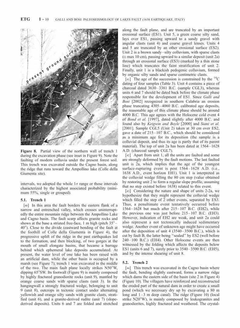
Figure 7. View looking north along LF scarp, downhill of Colle della Giumenta. Note the pond formedby the uprising footwall; the water level has been partly lowered by the native-born workers who cut thefault scarp/threshold. The photo was taken from a lacustrine terrace standing 1.5 m above the presentwater level. We excavated a 4 m deep pit (pit 3) within this terrace, finding a continuous lacustrine-marshsequence dated back to 4799–4673 B.C. (sample CGLP5). The sequence lays over an important erosionsurface carved on older clayey lacustrine beds and characterized by an indurated black soil-crust (age >41,290 BP, sample CGLP4). We dug trench 1 few meters southward of the pond.
GALLI AND BOSI: PALEOSEISMOLOGY OF LAKES FAULT (1638 EARTHQUAKE, ITALY) ETG 1 - 9
intervals, we adopted the whole 1s range or those intervalscharacterized by the highest associated probability (mini-mum 55%, single or grouped).
5.1. Trench 1
[40] In this area the fault borders the eastern flank of anarrow and entrenched valley, which crosses uninterrupt-edly the entire mountain ridge between the Ampollino Lakeand Cagno basin. The fault scarp affects granite rocks andshows at the base a striated free-face, 1 m high (pitch 35�–40�). Close to the divide (eastward bending of the fault atthe foothill of Colle della Giumenta in Figure 4), theprogressive uplift of the ridge in the past earthquakes ledto the formation, and then blocking, of two gorges at themouth of small elongate basins, that became a barragebehind which ephemeral lake deposits accumulated. Atpresent, the water level of one lake has been raised withan artificial dam, while the other basin is occupied by amarsh (see Figure 7); trench 1 was excavated in the middleof the two. The main fault plane locally strikes N50�W,dipping 65�SW. Its footwall (Figure 9) is mainly composedby highly fractured granodiorite rocks (unit 9), mantled byorange coarse sands with sparse clasts (unit 3). In thehangingwall a strongly fractured wedge, belonging to unit9 (unit 8), outcrops in tectonic contact under alternatingyellowish and orange silty sands with granite clasts, strati-fied (unit 6), and a granite-derived rudite (unit 7) (slope-derived deposits). Units 6 and 7 are folded and stretched
along the fault plane, and are truncated by an importanterosional surface (ES1). Unit 5, a green coarse silty sand,lays over ES1, passing upward to a sandy gravel withangular clasts (unit 4) and coarse gravel lenses. Units 4and 5 are truncated by an other erosional surface (ES2).Unit 2 is a brown sandy–silty colluvium, with sparse clasts(f max 10 cm), passing upward to a similar deposit (unit 2a)through an erosional surface (ES3) (marked by a thin stoneline) which truncates the faint stratification of unit 2.Finally, unit 1 is a blackish pedogenic colluvium, formedby organic silty sands and sparse centimetric clasts.[41] The age of the succession is constrained by the 14C
dating of four samples (Table 3). Unit 4 contains a piece ofcharcoal dated 3630–3381 B.C. (sample CGL3), whereasunits 6 and 7 should be dated back before the climate phaseresponsible for the development of ES1. Since Galli andBosi [2002] recognized in southern Calabria an erosionphase truncating 4305–4060 B.C. calibrated age deposits,the reasonable age of this climate phase should be around4000 B.C. This age agrees with the Holocene cold event 4of Bond et al. [1997], dated slightly after 4000 B.C. andfound also by Keigwin and Boyle [2000] and Siani et al.[2001]. Sample CGL5 (Unit 2) taken at 30 cm over ES2,gave a date of 215–107 B.C., which should be consideredas a minimum age for its deposition (the sample is acolluvial deposit, and thus its age is partly that of its parentmaterial). The top of unit 2a has been dated at 1564–1628A.D. (charcoal sample CGL7).[42] Apart from unit 1, all the units are faulted and some
are strongly deformed by the fault motions. The last faultedunit is 2a, which implies that the age of the youngestsurface-rupturing event is post 1564–1628 A.D. (i.e.,1638 A.D., event horizon EH1). Unit 1 is interpreted asthe colluvial wedge filling the 80 cm step (value obtainedby restoring unit 2 to form a regular slope profile, assumingthat no step existed before 1638) related to this event.[43] Considering the nature and shape of units 2-2a, we
hypothesize that they might represent the colluvial wedgewhich filled the step of 2 other events, separated by ES3.Thus, a penultimate event tentatively occurred before1564–1628 but much after 215–107 B.C. (EH2), whilethe previous one was just before 215–107 B.C. (EH3).However, indication of EH2 are weak, and unit 2a couldalso represent a not tectonically induced sedimentarywedge. Another event of unknown age might have occurredafter the deposition of unit 4 (3540–3500 B.C.), which iscut by fault B, the latter being ‘‘sealed’’ by ES2 (well before240–100 B.C.) (EH4). Other Holocene events are thenwitnessed by the folding which affects the deposits belowES1 (units 6 and 7), surely prior to 3540–3500 B.C. (EH5),and by the intense shearing of unit 8.
5.2. Trench 2
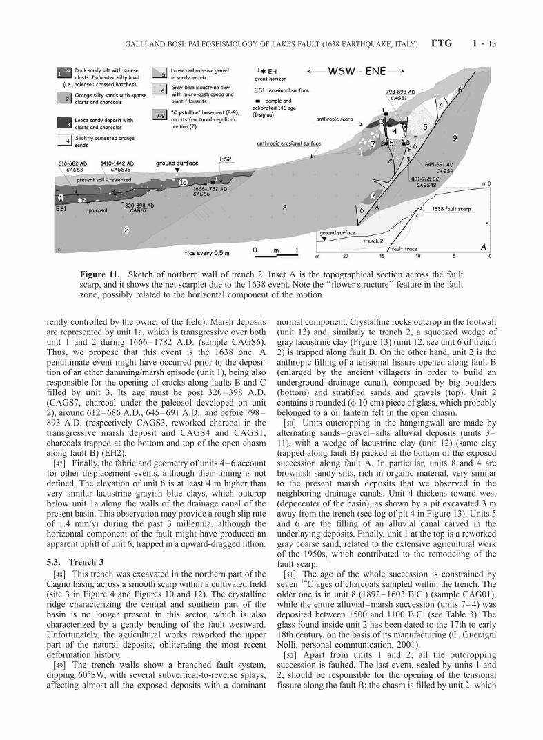
[44] This trench was excavated in the Cagno basin wherethe fault, bending slightly eastward, forms a narrow ridgewhich dams the eastern side of the basin (site 2 in Figure 4)(Figure 10). The villagers have reinforced and reconstructedthe eroded part of the natural dam in order to create a smallpond (which we necessary dry up by excavating a 80 mlong and 1–3 m deep canal). The ridge (Figure 10) (localstrike N20�W), is mainly composed by leukogranites andgranodiorites, highly fractured and weathered. The crystal-
Figure 8. Partial view of the northern wall of trench 1during the excavation phase (see inset in Figure 9). Note thefaulting of modern colluvia under the present forest soil.This trench was excavated outside the Cagno basin, alongthe ridge that runs toward the Ampollino lake (Colle dellaGiumenta site).
ETG 1 - 10 GALLI AND BOSI: PALEOSEISMOLOGY OF LAKES FAULT (1638 EARTHQUAKE, ITALY)
line rocks outcrop both in the footwall (unit 9 in Figure 11)and hangingwall (units 7 and 8) of the fault, even if with adifferent metamorphic facies. Between units 7–9, a stronglydeformed and multifaulted wedge of different sedimentaryunits is packed, the geometry and fabric of which accountfor a not negligible horizontal component of slip (flowerstructure feature). Moreover, the fault plane, which dips50�W, shows few striations with a pitch of 40� (sinistral).On the opposite wall of the trench (south), this tectonicwedge is much thinner and is represented only by squeezedgrayish blue lacustrine clays (unit 6). Units 3–5 are collu-vial deposits, mainly composed by gravel to coarse sands,which are difficult to correlate one to each other across theseveral fault planes. Units 2 and 1-1a, far away from thefault zone, are respectively orange silt–sandy colluvia andbrownish marsh silt–sandy deposits, both with sparse clastsand charcoals. Unit 1 lays over a blackish indurated siltylevel rich in clasts, which is a paleosol developed on anerosional surface (ES1) which truncates unit 2. Althoughunits 1-1a are quite similar, they are separated by a thin anddiscontinuous stone line, unit 1a being less dense andslightly finer. This stone line proceeds toward ENE as an
erosional surface over unit 2 (ES2). We followed unit 1awestward along the long drainage canal, which we exca-vated to dry up the pond, until it thickens and joins with thepresent marsh deposit.[45] The age of the deposits is constrained by seven 14C
dates of as many samples: unit 1a is younger than 1666–1782 A.D. (sample CAGS6) (age falling in a plateau of thecalibration curve: 2s interval reaches 1955 A.D.) [Trum-bore, 2000] and it is currently in sedimentation. Unit 1 wasdeposited after 320–398 A.D. (sample CAGS7) and during612–686 and 1410–1442 A.D. (samples CAGS3 andCAGS3b). Unit 3, which fills two open fractures alongfaults B and C, yielded a date of 798–893 A.D. (sampleCAGS1) and 645–691 A.D. (sample CAGS4), while unit 6yielded a date of 831–765 B.C. (CAGS4b, age of the bulkof the lacustrine clays).[46] All the deposits close to the fault plane are faulted,
and then the last event is after 798–893 A.D. (sampleCAGS1) (EH1). Moreover, the coseismic footwall upliftand the consequent barrage of the basin outlet (see Figures 4and 9) likely caused the raising of the water table and thegrowth of a marsh environment in the hangingwall (cur-
Table 3. Laboratory and Calibrated Radiocarbon Ages of Samples From Trenches 1–4a
Sample AnalysisDatedMaterial
14C Age (1-s)(Radiocarbon years BP)
Calendric AgeRange (1s-68%)
Area(%)
Calendric AgeRange (2s-95%)
Area(%)
Trench 1 CGL3 AMS charcoal 4730 ± 50 3630–3578 B.C. 38.8 3638–3495 B.C. 63.33538–3503 B.C. 23.8 3467–3374 B.C. 36.73428–3381 B.C. 33.1
CGL5 R, BLC organic silt 2160 ± 70 356–288 B.C. 34.2 383–44 B.C. 100215–107 B.C. 52.7
CGL7 AMS charcoal 360 ± 40 1476–1523 A.D. 44.4 1450–1533 A.D. 46.41564–1628 A.D. 55.6 1539–1636 A.D. 53.6
Trench 2 CAGS1 AMS charcoal 1180 ± 40 780–794 A.D. 12.9 771–904 A.D. 78.8798–893 A.D. 87.1 911–976 A.D. 18.8
CAGS3 AMS charcoal 1390 ± 50 616–682 A.D. 96 559–695 A.D. 92CAGS3B AMS charcoal 490 ± 40 1410–1442 A.D. 100 1396–1476 A.D. 96CAGS4 AMS charcoal 1350 ± 40 645–691 A.D. 88 637–726 A.D. 82.8
738–773 A.D. 14.6CAGS4B AMS organic silt 2620 ± 50 831–765 B.C. 100 900–758 B.C. 86CAGS6 AMS charcoal 170 ± 401 1666–1686 A.D. 15.6 1660–1700 A.D. 17.3
1730–1782 A.D. 41.5 1727–1816 A.D. 43.61786–1809 A.D. 10.3 1915–1955 A.D. 18.11925–1949 A.D. 17.7
CAGS7 AMS charcoal 1710 ± 50 258–283 A.D. 22.8 214–434 A.D. 99320–398 A.D. 67.7
Trench 3 CAG01 R, EC charcoal 3440 ± 120 1892–1603 B.C. 97 2036–1490 B.C. 98CAG02 AMS charcoal 2970 ± 40 1261–1186 B.C. 55.3 1316–1047 B.C. 98
1184–1127 B.C. 42.2CAG03 AMS charcoal 3200 ± 40 1507–1433 B.C. 100 1528–1395 B.C. 98CAG04 AMS charcoal 3060 ± 60 1405–1260 B.C. 97 1440–1187 B.C. 93CAG16 AMS charcoal 3100 ± 60 1430–1365 B.C. 49.5 1515–1255 B.C. 94
1365–1296 B.C. 47.3CAG17 AMS charcoal 3190 ± 50 1515–1427 B.C. 99 1533–1374 B.C. 93CAG19 AMS charcoal 3050 ± 40 1387–1382 B.C. 49.3 1410–1211 B.C. 97
1322–1286 B.C. 31.61284–1261 B.C. 19.1
Trench 4 CAGC1 AMS charcoal 2530 ± 40 792–759 B.C. 26.7 800–535 B.C. 97683–663 B.C. 13.9640–588 B.C. 36.3581–545 B.C. 26.1
CAGC2 R, EC wood 770 ± 80 1182–1299 A.D. 96 1152–1327 A.D. 81CAGC4 R, EC organic silt 1180 ± 70 776–900 A.D. 78.6 705–754 A.D. 10.7
918–959 A.D. 21.4 756–985 A.D. 86.7Pit 3 CGLP2 R, EC charcoal 590 ± 60 1304–1366 A.D. 75.4 1294–1429 A.D. 100
1385–1405 A.D. 25.6CGLP4 R, EC organic silt >41,290 – –CGLP5 AMS charcoal 5860 ± 60 4799–4673 B.C. 90 4812–4550 B.C. 94
aR means Radiometric standard analysis; BLC, Bulk low carbon; EC, extended counting; AMS, Accelerator Mass Spectrometry.
GALLI AND BOSI: PALEOSEISMOLOGY OF LAKES FAULT (1638 EARTHQUAKE, ITALY) ETG 1 - 11
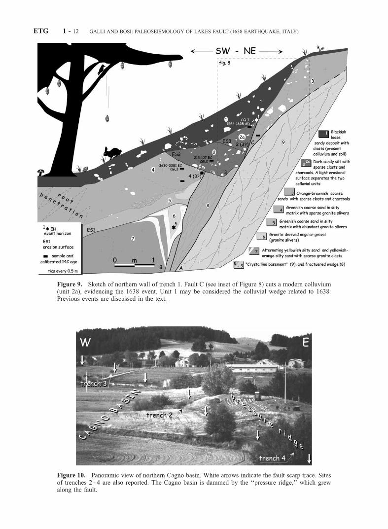
Figure 9. Sketch of northern wall of trench 1. Fault C (see inset of Figure 8) cuts a modern colluvium(unit 2a), evidencing the 1638 event. Unit 1 may be considered the colluvial wedge related to 1638.Previous events are discussed in the text.
Figure 10. Panoramic view of northern Cagno basin. White arrows indicate the fault scarp trace. Sitesof trenches 2–4 are also reported. The Cagno basin is dammed by the ‘‘pressure ridge,’’ which grewalong the fault.
ETG 1 - 12 GALLI AND BOSI: PALEOSEISMOLOGY OF LAKES FAULT (1638 EARTHQUAKE, ITALY)
rently controlled by the owner of the field). Marsh depositsare represented by unit 1a, which is transgressive over bothunit 1 and 2 during 1666–1782 A.D. (sample CAGS6).Thus, we propose that this event is the 1638 one. Apenultimate event might have occurred prior to the deposi-tion of an other damming/marsh episode (unit 1), being alsoresponsible for the opening of cracks along faults B and Cfilled by unit 3. Its age must be post 320–398 A.D.(CAGS7, charcoal under the paleosol developed on unit2), around 612–686 A.D., 645–691 A.D., and before 798–893 A.D. (respectively CAGS3, reworked charcoal in thetransgressive marsh deposit and CAGS4 and CAGS1,charcoals trapped at the bottom and top of the open chasmalong fault B) (EH2).[47] Finally, the fabric and geometry of units 4–6 account
for other displacement events, although their timing is notdefined. The elevation of unit 6 is at least 4 m higher thanvery similar lacustrine grayish blue clays, which outcropbelow unit 1a along the walls of the drainage canal of thepresent basin. This observation may provide a rough slip rateof 1.4 mm/yr during the past 3 millennia, although thehorizontal component of the fault might have produced anapparent uplift of unit 6, trapped in a upward-dragged lithon.
5.3. Trench 3
[48] This trench was excavated in the northern part of theCagno basin, across a smooth scarp within a cultivated field(site 3 in Figure 4 and Figures 10 and 12). The crystallineridge characterizing the central and southern part of thebasin is no longer present in this sector, which is alsocharacterized by a gently bending of the fault westward.Unfortunately, the agricultural works reworked the upperpart of the natural deposits, obliterating the most recentdeformation history.[49] The trench walls show a branched fault system,
dipping 60�SW, with several subvertical-to-reverse splays,affecting almost all the exposed deposits with a dominant
normal component. Crystalline rocks outcrop in the footwall(unit 13) and, similarly to trench 2, a squeezed wedge ofgray lacustrine clay (Figure 13) (unit 12, see unit 6 of trench2) is trapped along fault B. On the other hand, unit 2 is theanthropic filling of a tensional fissure opened along fault B(enlarged by the ancient villagers in order to build anunderground drainage canal), composed by big boulders(bottom) and stratified sands and gravels (top). Unit 2contains a rounded (f 10 cm) piece of glass, which probablybelonged to a oil lantern felt in the open chasm.[50] Units outcropping in the hangingwall are made by
alternating sands–gravel–silts alluvial deposits (units 3–11), with a wedge of lacustrine clay (unit 12) (same claytrapped along fault B) packed at the bottom of the exposedsuccession along fault A. In particular, units 8 and 4 arebrownish sandy silts, rich in organic material, very similarto the present marsh deposits that we observed in theneighboring drainage canals. Unit 4 thickens toward west(depocenter of the basin), as shown by a pit excavated 3 maway from the trench (see log of pit 4 in Figure 13). Units 5and 6 are the filling of an alluvial canal carved in theunderlaying deposits. Finally, unit 1 at the top is a reworkedgray coarse sand, related to the extensive agricultural workof the 1950s, which contributed to the remodeling of thefault scarp.[51] The age of the whole succession is constrained by
seven 14C ages of charcoals sampled within the trench. Theolder one is in unit 8 (1892–1603 B.C.) (sample CAG01),while the entire alluvial–marsh succession (units 7–4) wasdeposited between 1500 and 1100 B.C. (see Table 3). Theglass found inside unit 2 has been dated to the 17th to early18th century, on the basis of its manufacturing (C. GueragniNolli, personal communication, 2001).[52] Apart from units 1 and 2, all the outcropping
succession is faulted. The last event, sealed by units 1 and2, should be responsible for the opening of the tensionalfissure along the fault B; the chasm is filled by unit 2, which
Figure 11. Sketch of northern wall of trench 2. Inset A is the topographical section across the faultscarp, and it shows the net scarplet due to the 1638 event. Note the ‘‘flower structure’’ feature in the faultzone, possibly related to the horizontal component of the motion.
GALLI AND BOSI: PALEOSEISMOLOGY OF LAKES FAULT (1638 EARTHQUAKE, ITALY) ETG 1 - 13
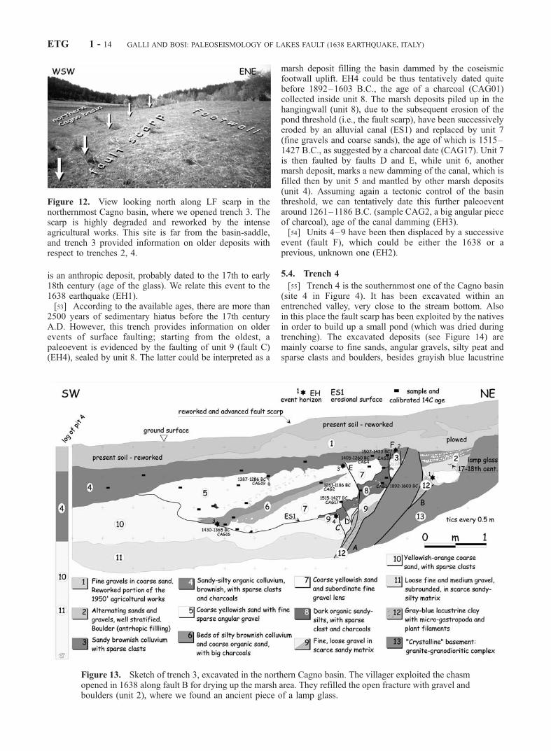
is an anthropic deposit, probably dated to the 17th to early18th century (age of the glass). We relate this event to the1638 earthquake (EH1).[53] According to the available ages, there are more than
2500 years of sedimentary hiatus before the 17th centuryA.D. However, this trench provides information on olderevents of surface faulting; starting from the oldest, apaleoevent is evidenced by the faulting of unit 9 (fault C)(EH4), sealed by unit 8. The latter could be interpreted as a
marsh deposit filling the basin dammed by the coseismicfootwall uplift. EH4 could be thus tentatively dated quitebefore 1892–1603 B.C., the age of a charcoal (CAG01)collected inside unit 8. The marsh deposits piled up in thehangingwall (unit 8), due to the subsequent erosion of thepond threshold (i.e., the fault scarp), have been successivelyeroded by an alluvial canal (ES1) and replaced by unit 7(fine gravels and coarse sands), the age of which is 1515–1427 B.C., as suggested by a charcoal date (CAG17). Unit 7is then faulted by faults D and E, while unit 6, anothermarsh deposit, marks a new damming of the canal, which isfilled then by unit 5 and mantled by other marsh deposits(unit 4). Assuming again a tectonic control of the basinthreshold, we can tentatively date this further paleoeventaround 1261–1186 B.C. (sample CAG2, a big angular pieceof charcoal), age of the canal damming (EH3).[54] Units 4–9 have been then displaced by a successive
event (fault F), which could be either the 1638 or aprevious, unknown one (EH2).
5.4. Trench 4
[55] Trench 4 is the southernmost one of the Cagno basin(site 4 in Figure 4). It has been excavated within anentrenched valley, very close to the stream bottom. Alsoin this place the fault scarp has been exploited by the nativesin order to build up a small pond (which was dried duringtrenching). The excavated deposits (see Figure 14) aremainly coarse to fine sands, angular gravels, silty peat andsparse clasts and boulders, besides grayish blue lacustrine
Figure 12. View looking north along LF scarp in thenorthernmost Cagno basin, where we opened trench 3. Thescarp is highly degraded and reworked by the intenseagricultural works. This site is far from the basin-saddle,and trench 3 provided information on older deposits withrespect to trenches 2, 4.
Figure 13. Sketch of trench 3, excavated in the northern Cagno basin. The villager exploited the chasmopened in 1638 along fault B for drying up the marsh area. They refilled the open fracture with gravel andboulders (unit 2), where we found an ancient piece of a lamp glass.
ETG 1 - 14 GALLI AND BOSI: PALEOSEISMOLOGY OF LAKES FAULT (1638 EARTHQUAKE, ITALY)
clays squeezed along the fault plane. The alluvial–colluvialsuccession (hangingwall) is faulted and dragged over awhitish, altered granite mass (footwall). The intense defor-mation and distorted structure of the deposits made verydifficult the identification and definition of the depositionalunits, which seems also to have experienced liquefactionprocesses and gravitational sliding during the shaking.Moreover, all the upper part of the trench wall showsreworked material (both plowed and bulldozed) related tothe pond works.[56] The 14C ages of this complex succession range
between 792 and 545 B.C. (sample CAGC1, unit 6) and776–900 A.D. (sample CAGC4, unit 3), the age of 1182–1299 A.D. (CAGC2) belonging to a tree root underexcavat-ing units 1–3 (Figure 15).[57] All the outcropping deposits are faulted and only the
plowed level seals the displaced units. We deduce that theevent that caused the faulting and the deformation ofthe entire sequence is also responsible for the depositionof unit 1. The latter, due to its geometry and internalstructure (loose chaotic mixture of sand and softy pebblesof unit 5), might be, in fact, interpreted as a sandblowintruded from unit 5 in units 2 and 3. We relate this ultimateevent to 1638 (EH1).[58] A penultimate event (EH2) is suggested by the
presence of unit 3, which is a marsh deposit (very darkbrownish silty sand, rich in organic material) abruptlydeveloped over a coarse sandy deposit (unit 5) hosting bigboulders fallen from the footwall. The marsh is interpretedas the consequence of the coseismic damming of the basin(footwall uplift) that occurred slightly before 776–900 A.D.(CAGC4). This event is also evidenced by fault C, which issealed by unit 3 (although fault C might also be related to aprevious event, discussed forward).[59] The marsh was then gradually filled by sandy depos-
its and, at least since 1182–1299 A.D., the trees of thenearby forest recolonized the area (CAGC2, a big root
remnant, which we believe to have grown after the recla-mation/drainage of the marsh (unit 2), thus predating EH1).[60] Tentatively, a previous event is again suggested by
the nature and shape of unit 6, an other dark, rich in organicmaterial silt, which has been dragged upward by faults A, B,and C. Both interpreting it as a marsh deposit due to another damming event or as a colluvial wedge deposited(faulted at least twice) along the fault scarp, the age of thecausative event should be slightly before 792–545 B.C.(CAGC1) (EH3).
6. Discussion
[61] The paleoseismological analyses carried out in thetrenches show that LF is the causative fault of the 9 June1638 event. Moreover, its location and characteristics fitexactly with the contemporary descriptions of the surfacefaulting phenomena that occurred during this earthquake.[62] Among all the known central southern Apennine
active faults [Galadini and Galli, 2000; Cinque et al.,2000], this fault pairs up only with an other fault whichwas unknown until the 1980, Ms = 6.9 earthquake: theIrpinia fault [Pantosti et al., 1993]. Similarly to the latter, infact, the LF ruptures in a manner that is at odds withtopography, running at high elevation through the graniticmassif of Sila and far from fully developed Quaternarybasins. Its kinematics, as deduced by field evidence, ismainly normal, but with a not negligible horizontal slip.This oblique component may account for some geomorphicexpression (pressure ridge, pushup swell and sag depres-sion) occurring at some releasing and restraining bends(eastern and western, respectively) along the main strike.[63] Moreover, the young geomorphic expression of the
LF would suggest its relatively recent activation within theextensional regime characterizing the Apennine chain andthe Calabrian arc. Considering that the stress field in south-ern Apennine depicts a NE-SW extension [see Montone et
Figure 14. View of northern wall of trench 4. The structural complexity of the fault zone (white arrows)is increased by possible liquefaction phenomena, which disturbed and further deformed the beds.
GALLI AND BOSI: PALEOSEISMOLOGY OF LAKES FAULT (1638 EARTHQUAKE, ITALY) ETG 1 - 15
al., 1999, and references therein], the kinematic indicationobserved along the LF, together with the few available localfocal mechanisms (Figure 3), evidences a persisting Apen-ninic NE-SW extension in northern Calabria. On the otherhand, extension dramatically rotates southward to the Cata-nzaro strait in a NW-SE direction, as evidenced by faultorientation and focal mechanism of southern Calabria [Galliand Bosi, 2002, and references therein].[64] As for the parameter of the June event, on the basis of
the evaluated intensities datapoints (Table 2), we obtained amacroseismic equivalent magnitude (Boxer program) [Gas-perini, 1999] of Me = 6.68 and a fault length of 31 km.Moreover, in order to dissemble the ‘‘missing intensities’’ atthe epicenter (due to the aforementioned lack of any villagesin the inner Sila massif) we added three fictitious I = 11MCS datapoints along the LF trace, which yielded quite thesame parameters of Me (6.74) and fault length (34 km)(Table 1). This trial, based on the observation that I = 11MCS is commonly reached by villages located close tofaults with dimension similar to LF [e.g., Galadini andGalli, 2000; Galli and Bosi, 2002], provides reasonableparameters to the June event, which we included in Table 1.
6.1. Seismic Behavior
6.1.1. Paleoearthquakes[65] Even if discontinuous, the stratigraphic record
observed in the trenches shows evidence, through itsdeformational history, of repeated 1638-like paleoearth-quakes. The ages of paleoearthquakes recognized in theindividual trenches have been correlated assuming that each
time the fault rupture is the same. The ultimate event in alltrenches is the 1638 earthquake, its age been constrainedbetween 14C ages of 1564–1628 and 1666–1782 A.D. andby a glass of the 17th century. The penultimate eventoccurred in the 7th and 8th century A.D. (our preferredage after 14C age of 645–691 A.D. and before 798–893A.D., 776–900 A.D.). This event is well constrained intrench 2 and 4, it is compatible with the data coming fromtrench 1, whereas it is not seen in trench 3 due to the lack ofsediments (Figure 16). Data coming from Trench 1 suggestalso an event occurring slightly before or around the 3rdcentury B.C., while, according to the interpretation made intrench 3, other two probable similar events occurred in the12th and 21th century B.C., respectively.6.1.2. Recurrence Time[66] Although the reliability of the oldest age of defor-
mation events may be questionable, we observe a roughelapsed time interval of 800–1000 years between consec-utive events. This value could be thus indicative of thereturn period of the LF.6.1.3. Slip Rates[67] Although there are no beds to correlate across the
main fault, and the horizontal component of motion repre-sents a bias for the in-trench evaluation of the offset, thehistorical description of the 1638 surface faulting suggests areliable value (80 cm) [Di Somma, 1641] of the verticaloffset per event (sensu ‘‘characteristic earthquake’’). Thisoffset is similar to that estimated in trench 1 by restoringback the faulted succession and fits, eventually, with the‘‘fresh’’ step commonly affecting the foot of the LF scarp
Figure 15. Sketch of northern wall of trench 4. Notwithstanding the bulldozing of the entire area (asmall pond was created by exploiting the natural fault scarp-barrage), which erased the surficial deposits,2–3 events are still evidenced by the deformational history of the lacustrine-marsh deposits.
ETG 1 - 16 GALLI AND BOSI: PALEOSEISMOLOGY OF LAKES FAULT (1638 EARTHQUAKE, ITALY)
(Figures 5 and 11a). Considering also the horizontal com-ponent (which seems prominent, even if smaller than thevertical one), we hypothesize a net (oblique) surficial offsetof 1–1.2 m per event. This value, coupled with the hypothe-sized recurrence time, gives a slip rate of 1.2 mm/yr, not farfrom that roughly estimated in trench 2 in the past 3 ka (1.4mm/yr). Finally, coupling slip per event and fault length weobtain a Mo = 6.7, which is the same value gathered for Me.
6.2. Fault Segmentation
[68] As mentioned before, the LF is not an isolatedstructure through the Sila Massif. We hypothesize that,through an en echelon right step, its northern continuationis the CLF (5 in Figure 3) (Figure 6), a NNW-SSE systemwhich shares with the LF the same tendency to invert thetopography creating ephemeral ponds.[69] Differently to LF, CLF appears to be seismically
quiescent in the last millennium, none of the strong histor-ical earthquakes of the Italian catalogue being consistentwith its location. Only the 1184 event (see Figure 1 for itsrough epicentral location), which is known to have inducedsevere damage in the Crati Valley and along the westernslope of Sila, could be doubtfully related to this fault.
6.3. Seismic Hazard Implication
[70] Seismic hazard studies in Italy [e.g., Lucantoni et al.,2001], together with the proposed Seismic Reclassification ofthe Italian territory [Working Group, 1999] are currentlybased on a probabilistic method [Cornell, 1968] whichimplies the use of a ‘‘declustered’’ catalogue [Camassi and
Figure 17. Seismogenetic zones of northern Calabriaaccording to Meletti et al. [2000]. Note the ‘‘background’’area between zones 66 and 67, which should be instead themain seismogenetic zone. Bold lines are LF CLF, Cratifaults (CF), Piano Lago–Savuto faults (PF), Feroleto–SantaEufemia (Lamezia-Catanzaro FF) and Serre fault (SF). Thinlines are the Marchesato fault (MF) [Moretti, 2000]. Filledand empty circles are, the Working Group CPTI [1999] andour epicenters, respectively, for the 1638 March (west) andJune (east) events.
Figure 16. Sketch summarizing ages of samples, erosional surfaces, and paleosoils in trenches. Age isshown through both 1-s and 2-s ranges (black box and lines, respectively); underlined samples are thosewhich better constrain the age of paleoearthquakes. Dashed gray boxes indicate whether the paleo-earthquake occurred before (leftward/before) or after (rightward/after) the age of the sample (the longer thebox, the more uncertain and farther the date of the event is). The width of event window depends mainlyby the age range of samples, while preferred age is constrained by the geologic interpretation of trenches.
GALLI AND BOSI: PALEOSEISMOLOGY OF LAKES FAULT (1638 EARTHQUAKE, ITALY) ETG 1 - 17
Stucchi, 1997] coupled with a seismogenetic zonation of theItalian territory [Meletti et al., 2000, and references herein].[71] In this framework, the discovery of LF, and its
relationships with the neighboring faults and with thehistorical seismicity provide new important data that radi-cally change both the historical database and the geometryof the seismogenetic zones.[72] On one hand the epicenter of the June 1638 event is
shifted by 15–20 km westward with respect to the macro-seismic epicenter (see Figure 1) [Camassi and Stucchi,1997; Working Group CPTI, 1999]. On the other hand, thediscovery of LF, together with CLF, dramatically influen-ces the geometry and the parameter of the some seismo-genetic zones of the region [i.e., zone 67 in Meletti et al.,2000] (see Figure 17), which are mainly based on the June1638 macroseismic epicenter [Camassi and Stucchi, 1997]and on the location of the Marchesato faults (Figures 3and 17). As mentioned before, the latter were hypotheti-cally considered the causative faults of the June 1638event [Moretti, 2000], even in the lack of any evidence ofUpper Pleistocene–Holocene activity.[73] According to the present seismogenetic zonation, the
LF and its associated earthquakes, together with the CLF,would fall in a ‘‘seismic background zone,’’ whereas zone67 would miss the most severe (and characterizing in termsof maximum expected magnitude and earthquake recur-rence) event within its boundary (Figure 17). Seismichazard would dramatically change also in the western partof the region, where the 27 March event has now been splitinto three events (M � 6.6), which fall in three differentzones (66, 68, and 69 in Figure 17).[74] Concluding, while new parameters should be eval-
uated for zone 66 and neighbors (Figure 17), a new zoneshould be drawn between 66 and 67, or new borders shouldbe considered for zone 67, in order to include the Silaseismogenetic area.[75] Finally, using different hazard methods (i.e., hybrid
recurrence model) [Wu et al., 1995], one should be take intoaccount that while the LF ruptured in 1638 (having anapparent return period of about 1 ka), the elapsed timerelated to the CLF is presently comparable to its possiblerecurrence time.
6.4. Associated Hydrological Risk
[76] Both LF and CLF pass very close to the masonry/concrete barriers which, respectively, dam the Ampollino andCecita lakes. The LF capability to produce surface displace-ment (assumed also for CLF), associated to the high level ofshaking related to the ‘‘near-field’’ condition, are factors thatwould strongly affect the possible collapse of the dams (seesurface faulting effects on dams in Seno [1999]). Therefore,considering the capacity of the lakes (67 � 106 and 121 �106 m3, respectively), the eventual break of the dams wouldtrigger a hydrological disaster on a vast inhabited area alongthe valleys below, as far as the alluvial Crati plain (CecitaLake) and the Ionian coast (Ampollino Lake).
7. Conclusions
[77] We took both a historical and geological approach tothe revisiting of one of the most catastrophic seismicsequence of Italy.
[78] The analyses of all the available historical sourcesconcerning the 27 March 1638 event allowed us to recog-nize at least 3 main shocks occurring between the eveningof 27 and the day of 28 March. The first and morecatastrophic shock hit the area southward of Cosenza, andwe tentatively relate this event to the southern continuationof the western Crati Valley fault system (e.g., Piano Lagoand Savuto–Decollatura faults) (7 in Figure 3); the secondshock hit the western slope of the Serre range, an areacharacterized by the northern prosecution of the Mesimafault system (9 in Figure 3). The third event struck thewestern Catanzaro strait, being possibly related to the SantaEufemia–Feroleto fault (8 in Figure 3). The magnitude ofthese events is minor of the one reported by Working GroupCPTI [1999] (Me = 7), being possibly �6.6.[79] As for the June earthquakes, the analyses of the
historical sources permitted to split this event into threeseparated shocks, the most catastrophic being that of 9 June.This sequence affected the eastern slope of Sila, its effectsbeing not negligible until the far NW corner of the massif.The historical description of the surficial breaks allowed usthe identification of the causative fault (and of the physicepicenter) running inside the mountainous uninhabited area.This fact implies that, although we reevaluated a maximumMCS intensity of 9.5, the real epicentral intensity (Io) couldbe higher (i.e., 11 MCS).[80] This newly identified structure, referred to the LF (6
in Figure 3), is a northwesterly striking, west-dippingnormal fault, with horizontal component. The results ofthe paleoseismological analysis show evidence for a histor-ical event of surface faulting, that we interpreted as the June1638 one, and for a penultimate event in the 7th and 8thcentury A.D., not reported by the Italian seismic catalogue.Others paleoearthquakes, although lacking of definitivecross correlation among trenches, seems to be occurredabout the 3rd, 12th, and 21th century B.C.[81] Assuming that we do not miss any event of surface
faulting, according to data summarized in Figure 16, wesuggest a recurrence period of about 0.8–1 ka for thisstructure. Slip rate, deduced from individual offset and long-term displacement, was estimated to be in the order of 1.2mm/yr. The LF continues northward with a right en echelonstep in the CLF (5 in Figure 3). The latter, which can beresponsible for the uplift of the Pleistocene beds of thepaleo-Cecita lake, is characterized by the absence of anyhistorical earthquakes in the past millenia (or, doubtfully, atleast since 1184 A.D.). By comparing the recurrence time ofLF with other seismogenetic faults of central and southernApennines (1.4–2 ka) [Pantosti et al., 1993; Galadini andGalli, 2000; Galli and Bosi, 2002], we may tentativelyassume that the CLF shares the same seismic behavior too.If this is the case, with such an average time recurrencerange (i.e., 1–2 ka), the CLF contains a high potential forproducing an earthquake in the near future.[82] The data presented in this paper imply the necessity to
reassess the seismic hazard of the region, the local seismo-genetic zones currently mismatching the real epicenters (theJune one being shifted westward) and the associated seismo-genetic faults (Figure 17).[83] Finally, the presence of important barrier lakes across
LF and CLF are a further element of hydrological risk in caseof earthquake. The collapse of the dams of the Ampollino and
ETG 1 - 18 GALLI AND BOSI: PALEOSEISMOLOGY OF LAKES FAULT (1638 EARTHQUAKE, ITALY)
Cecita lakes, due to their impressive capacity, would trigger ahydrological disaster in a vast inhabited area downstreamboth basins.
[84] Acknowledgments. We are grateful to Salvatore Loria whoallowed trenching in his properties. We are also grateful to GiovannaChiodo who supported our historical researches and to Antonio Moretti andIgnazio Guerra who provided useful geologic and instrumental data. Wealso thank Paolo De Martini, Marco Moro, and Daniela Pantosti whostrengthened our paleoseismological interpretation within the trenches.Mario Perri dug with consummate skill all trenches. Costanza GueragniNolli kindly examined the lamp glass. Criticism of the Associate Editor, ofDaniela Pantosti, and of an anonymous referee strongly improved themanuscript. Field survey was performed during 2000–2001. The view andconclusion contained in this paper are those of the authors and should notbe interpreted as necessarily representing the official policies, eitherexpressed or implied, of the Italian Government.
ReferencesAmato, A., B. Alessandrini, G. B. Cimini, A. Frepoli, and G. Selvaggi,Active and remnant subducted slabs beneath Italy: Evidence from seismictomography and seismicity, Ann. Geofis., 36, 201–214, 1993.
Barchi, M., G. Minelli, and P. Pialli, The Crop 03 profile: A synthesis ofresults on deep structures of the Northern Apennines,Mem. Soc. Geol. It.,52, 383–405, 1998.
Bernaudo, F., Il tremuoto di Calabria. Discorso, Napoli, 1639.Bianchi, P., Relazione di Paolino Bianchi al segretario di stato sui dannicausati dal terremoto delle due Calabrie, Napoli, 1638.
Bond, G., W. Showers, M. Cheseby, R. Lotti, P. Almasi, P. deMenocal,P. Priore, H. Cullen, I. Hajdas, and G. Bonani, A pervasive millennial-scale cycle in North Atlantic Holocene and glacial climates, Science, 278,1257–1266, 1997.
Boschi, E., E. Guidoboni, G. Ferrari, D. Mariotti, G. Valensise, andP. Gasperini (Eds.), Earthquakes of 27 March and 8 June 1638, in Cata-logue of Strong Italian Earthquakes From 461 BC to 1997, Ann. Geofis.,43, 835–841, 2000.
Bousquet, J. C., La tectonique recent de l’Apennin Calabro-Lucanien dansson cadre geologique et geophysique, Geol. Rom., 12, 1–103, 1973.
Camassi, R., and M. Stucchi, NT4.1.1 un catalogo parametrico di terremotidi area italiana al di sopra della soglia del danno, 95 pp., GNDT, Milan,1997. (Available at http://emidius.itim.mi.cnr.it).
Capecelatro, E., Relazione (breve) al Vicere del Regno di Napoli duca diMedina di Las Torres fatta consigliere Hettore Capece-Latro, a rivedere idanni nelle provincie di Calabria, cagionati dal terremoto succeduto a 27di marzo 1638, per applicarci i rimedi necessarii, per la sollevazione diquelle Citta, Terre, e Castelli, che hanno patito, Napoli, 1640a.
Capecelatro, E., Danno succeduto per lo terremoto de gli otto del correntemese di giugno, Appendix in D’Orsi [1640], Napoli, 1640b.
Capecelatro, E., Relazione al Vicere del regno di Napoli duca di Medina diLas Torres, de’ danni c’han patito l’infrascritte universita per cagion de’terremoti il di’ 27 di marzo 1638 con nota distinta de’ morti, e casecascate nella provincia di calabria ultra, napoli 20 giugno 1638, Appendixin D’Orsi [1640], Napoli, 1640c.
Chiodo, G., I terremoti calabri del 1638, Relazione finale, Educ. grant EDISCalabria, 1993.
Chiodo, G., I. Guerra, and J. Trumper, The 1638 earthquakes, migratoryphenomena and geolinguistic consequences in Calabria, Ann. Geofis., 38,515–521, 1995.
Cinque, A., A. Ascione, and C. Caiazzo, Distribuzione spazio-temporale ecaratterizzazione della fagliazione quaternaria in Appennino meridionale,in Le ricerche del GNDT nel campo della pericolosita sismica, edited byF. Galadini et al., pp. 203–218, CNR-GNDT, Rome, 2000.
Cinti, F. R., L. Cucci, D. Pantosti, G. D’Addezio, and M. Meghraoui, Amajor seismogenic fault in a ‘‘silent area’’: The Castrovillari fault (south-ern Apennines, Italy), Geophys. Int., 130, 595–605, 1997.
Compassionevole relazione delli spaventosi terremoti occorsi nella Calab-ria, & altri luoghi. Col nome delle citta, e terre sommerse, e rounate dadetti terremoti. Seguiti questo presente anno 1638, alli 27 di marzo, PietroNesti, Firenze, 1638.
Cornell, C. A., Engineering seismic risk analysis, Bull. Seismol. Soc. Am.,58, 1583–1606, 1968.
D’Amato, V., Memorie historiche dell’illustrissima, famosissima e fedelis-sima citta di Catanzaro, Napoli, 1670.
Descriptive relation of the terrible earthquake of Calabria of the 27 March1638 (in Polish), Varszawa, 1638.
D’Orsi, L., I terremoti delle due Calabrie fedelissimamente descritti dal Si.Lutio D’Orsi di Belcastro come testimonio di vedute, Napoli, 1640.
Di Somma, A., Historico racconto dei terremoti della Calabria dell’anno1638 fin’anno 1641, Napoli, 1641.
Dramis, F., and B. Gentili, G. Pambianchi, Geomorphological scheme ofthe River Trionto basin, in Symposium on Geomorphology of ActiveTectonics Areas, edited by M. Sorriso Valvo, IGU-COMTAG andCNR, Excursion Guidebook, IRPI, Cosenza, Geodata 39, pp. 63–66,1990.
Dreadfull newes: or a true relation of the great, violent and late earthquake.Hapned the 27 day of March, stilo romano, last, at Calabria, in the King-dome of Naples, about the houres of three and foure in the afternoone, totthe over-trow and mine of many Cities, Townes, and Castles, and thedeath of about fifty thousand persone, edited by I. Okes, for R. Mab, 17pp., London, 1638.
Finetti, I., and A. Del Ben, Geophysical study of the Tyrrhenian opening,Bol. Geofis. Teor. Appl., 28, 75–155, 1986.
Finetti, I., and C. Morelli, Geophysical exploration of the MediterraneanSea, Bol. Geofis. Teor. Appl., 15, 263–344, 1973.
Galadini, F., and P. Galli, Active tectonics in the central Apennines (Italy):Input data for seismic hazard assessment, Nat. Hazards, 22, 202–223,2000.
Galli, P., Active tectonics along the Wadi Araba–Jordan Valley transformfault, J. Geophys. Res., 104, 2777–2796, 1999.
Galli, P., and V. Bosi, Paleoseismology along the Cittanova fault: Implica-tions for seismotectonics and earthquake recurrence in Calabria (southernItaly), J. Geophys. Res., 107(B3), 2044, doi:10.1029/2001JB000234,2002.
Galli, P., and F. Galadini, Seismotectonic framework of the 1997–98 Um-bria-Marche (Central Italy) earthquakes, Seismol. Res. Lett., 70, 404–414, 1999.
Gasperini, P., The Boxer program, 1999. (Available at http://ibogfs.df.unibo.it/user2/paolo/www/boxer/boxer.html).
Ghisetti, F., and L. Vezzani, Different styles of deformation in the CalabrianArc (Southern Italy): Implication for a seismotectonic zoning, Tectono-physics, 25, 149–165, 1982.
Giunchi, C., R. Sabadini, E. Boschi, and P. Gasperini, Dynamic models ofsubduction: Geophysical and geological evidence in the Tyrrhenian Sea,Geophys. J. Int., 126, 555–578, 1996.
Gueguen, E., C. Doglioni, and M. Fernandez, Lithospheric boudinage in thewestern Mediterranean back-arc basins, Terra Nova, 9, 184–187, 1997.
Henderson, G., Carta Geologica della Calabria alla scala di 1:25.000, sheet230, CASMEZ, 1973.
Jacques, E., C. Monaco, P. Tapponnier, T. Tortorici, and T. Winter, Faultingand earthquake triggering during the 1783 Calabria seismic sequence,Geophys. J. Int., 147, 499–516, 2001.
Keigwin, L. D., and E. A. Boyle, Detecting Holocene changes in thermoha-line circulation, Proc. Natl. Acad. Sci. U.S.A., 97, 1343–1346, 2000.
Kircher, A., Mundus subterraneus in XII libros digestus, Calabria, Am-sterdam, 1665.
Lucantoni, A., V. Bosi, F. Bramerini, R. De Marco, T. Lo Presti, G. Naso,and F. Sabetta, Seismic risk in Italy, Ing. Sismica, 18, 5–36, 2001.
Martire, D., Calabria Sacra e Profana, manuscript of the 18th century,Bibl. Civ. Cosenza, 1704.
Matano, F., and S. Di Nocera, Weathering patterns in the Sila massif (north-ern Calabria, Italy), Ital. J. Quat. Sci., 12, 141–148, 1999.
Meletti, C., E. Patacca, and P. Scandone, Construction of a seismotectonicmodel: The case of Italy, Pure Appl. Geophys., 157, 11–35, 2000.
Monachesi, G., and M. Stucchi, DOM 4.1 an intensity database of dama-ging earthquakes in the Italian area, 1998. (Available as http://emidius.itim.mi.cnr.it/DOM/home.html).
Monaco, C., and L. Tortorici, Active faulting in the Calabrian arc andeastern Sicily, J. Geodyn., 29, 407–424, 2000.
Montone, P., A. Amato, and S. Pondrelli, Active stress map of Italy,J. Geophys. Res., 104, 2595–2610, 1999.
Moretti, A., Note sull’evoluzione tettono-stratigrafica del Bacino Crotonesedopo la fine del Miocene, Bol. Soc. Geol. Ital., 112, 845–867, 1993.
Moretti, A., Il database delle faglie capaci della Calabria, in Le ricerchedel GNDT nel campo della pericolosita sismica (1996–1999), edited byF. Galadini et al., pp. 219–226, CNR-Gruppo Nazionale per la Difesadai Terremoti, Rome, 2000.
Moretti, A., and I. Guerra, Tettonica dal Messiniano ad oggi in Calabria:Implicazioni sulla geodinamica del sistema Tirreno-Arco Calabro, Bol.Soc. Geol. Ital., 116, 125–142, 1997.
Pantosti, D., G. D’Addezio, and F. Cinti, Paleoseismological evidence ofrepeated large earthquakes along the 1980 Irpinia earthquake fault, Ann.Geofis., 36, 321–330, 1993.
Paragallo, G., Ragionamento intorno alla cagione de’ tremuoti, Ed. FasuloGeronimo, Napoli, 1689.
Parker, M., A True and Terrible Narration of a horrible Earthquake whichhappened in the Province of Calabria. . .upon the 27 of March last pastaccording to Foraigne account, and by our English computation the
GALLI AND BOSI: PALEOSEISMOLOGY OF LAKES FAULT (1638 EARTHQUAKE, ITALY) ETG 1 - 19
17. . .From pregnant atestation written in English verse by M. Parker.With a . . . list of some other Earthquakes and horrible accidents whichhave heretofore happened in England, T. Cotes for R. Mabb and F. Grove(Editors), London, 1638.
Patacca, E., and P. Scandone, Late thrust propagation and sedimentaryresponse in the thrust-belt – foredeep system of the Southern Apennines(Pliocene–Pleistocene) in Anatomy of an Orogen: The Apennines andAdjacent Mediterranean Basins, edited by G. B. Vai and I. P. Martini, pp.401–440, Kluwer Acad., Norwell, Mass., 2001.
Recupito, G. C., De novo in universa Calabriae terraemotu congeminatusnuncius, Napoli, 1638.
Regio Ufficio Geologico d’Italia, Geological Map of Italy, sheet 237, scale1:100,000, Rome, 1895.
Relazione del terremoto successo nelle province di Calabria di 8 giugno1638, Biblioteca Apostolica Vaticana, ms. Barberini Latini 4336, 1638.
Scaccianoce, A., Il terremoto del 9 giugno 1638: analisi delle fonti storicheed interpretazione sismotettonica, degree thesis, Univ. of Calabria, Co-senza, 1993.
Seno, T., Report on the surface ruptures of the Taiwan earthquake on Sept.20, 1999, 1999. (Available as http://www.eri.u-tokyo.ac.jp/seno/taiwan.report.eng.html).
Siani, G., M. Paterne, E. Michel, R. Sulpizio, A. Sbrana, M. Arnold, andG. Haddad, Mediterranean sea surface radiocarbon reservoir agechanges since the last glacial maximum, Science, 294, 1917–1920,2001.
Sorriso-Valvo, M., and C. Tansi, Grandi frane e deformazioni gravitativeprofonde di versante della Calabria. Note illustrative della carta al250.000, Geogr. Fis. Din. Quat., 19, 395–408, 1997.
Stucchi, M., and P. Albini, Quanti terremoti distruttivi abbiamo personell’ultimo millennio? Spunti per la definizione di un approccio storicoalla valutazione della completezza, in Le ricerche del GNDT nel campo
della pericolosita sismica (1996–1999), edited by F. Galadini et al., pp.333–344, CNR-Gruppo Nazionale per la Difesa dai Terremoti, Rome,2000.
Stuiver, M., P. Reimer, E. Bard, W. Beck, G. S. Burr, K. Hughen, B. Kromer,G. McCormac, J. van deer Plicht, and M. Spurk, INTCAL98 radiocarbonage calibration, 24,000-0 cal, Radiocarbon, 40, 1041–1084, 1998.
Tortorici, L., C. Monaco, C. Tansi, and O. Cocina, Recent and activetectonics in the Calabrian arc (Southern Italy), Tectonophysics, 243,37–55, 1995.
Trumbore, S. E., Radiocarbon Geochronology, Quaternary Geochronol-ogy: Methods and Applications, AGU Ref. Shelf 4, 2000.
Van Dijk, J. P., and P. J. J. Scheepers, Neotectonic rotations in the CalabrianArc: Implication for a Pliocene–Recent geodynamic scenario for theCentral Mediterranean, Earth Sci. Rev., 39, 207–246, 1995.
Vera relatione del spaventevole terremoto successo alli 27 di marzo su le 21hore, nelle provincie di Calabria Citra, & Ultra, Ludovico Grignani,Roma, 1638.
Westaway, R., Quaternary uplift of southern Italy, J. Geophys. Res., 98,21,741–21,772, 1993.
Working Group, Proposal for the National Seismic Reclassification, Ing.Sismica, 1, 5–14, 1999.
Working Group CPTI, Catalogo Parametrico Terremoti Italiani, 92 pp.,ING, GNDT, SGA, SSN, Bologna, 1999.
Wu, S. C., C. A. Cornell, and S. R. Winterstein, A hybrid recurrence modeland its implication on seismic hazard, Bull. Seismol. Soc. Am., 85, 1–16,1995.
�����������������������V. Bosi and P. Galli, Civil Protection Department, Seismic Survey of Italy,
Via Curtatone 3, I-00185, Rome, Italy. ( [email protected])
ETG 1 - 20 GALLI AND BOSI: PALEOSEISMOLOGY OF LAKES FAULT (1638 EARTHQUAKE, ITALY)


![Sport [broj 1638, 25.10.2011]](https://img.pdfslide.net/doc/110x75/577d24ef1a28ab4e1e9dbd57/sport-broj-1638-25102011.jpg)


![Signed Copy [.pdf 1638 KB]](https://img.pdfslide.net/doc/110x75/5868c2141a28ab5e1d8b5cb5/signed-copy-pdf-1638-kb.jpg)