Embed Size (px)
Citation preview
FINAL GUIDANCE ON DESIGNATION OFCLASSIFICATION EXCEPTION AREAS
Regulatory Basis
The New Jersey Ground Water Quality Standards (GWQS), N.J.A.C. 7:9-6, provide thebasis for the protection of the ambient ground water quality of the State through the establishmentof constituent standards for ground water pollutants. The Standards impact all Site Remediationcases where ground water contamination exceeds the standards applicable to the Classification Areain which the site is located.
The GWQS recognize the different natural utility of ground waters in various parts of NewJersey and classify ground water according to a combination of natural characteristics and actual orpotential uses. For each classification area, designated uses that will be protected are specified. The Standards do include a provision for the Department to designate areas of exception to strictapplication of the GWQS in certain, specific situations. These circumstances are identified underN.J.A.C. 7:9-6.6, which states that the Department may designate a CEA only when constituentstandards are not or will not be met due to (1) natural ground water quality; (2) localized effects of apermitted discharge (e.g., effluent limits above the constituent standards with discharge outside theplume/capture zone); (3) part of a pollution remedy conducted pursuant to an ACO or otherDepartment oversight mechanism or program; or (4) an Alternate Concentration Limit approvedpursuant to the New Jersey Pollutant Discharge Elimination System (NJPDES).
As stated in the GWQS, a CEA cannot be established for purposes of sanctioning violationsof or achieving compliance with the constituent standards for a given aquifer classification. Indesignating a CEA, the Department does not condone any violation which resulted in pollutantconcentrations above applicable GWQS, but does acknowledge that primary aquifer uses based onclassification cannot be met within a given area as a result of the permitted discharge or pollutionproblem. Unless a CEA is established for an area in which ground water quality criteria are (or willbe) exceeded in one of the four circumstances identified above, the permitted discharge or approvedremediation must meet the constituent standards applicable to the aquifer classification.
Purpose of Establishing CEAs
The Response to Comments document provides insight into the various purposes ofestablishing CEAs, particularly with respect to the role of the CEA as a public notificationmechanism. In the Response to Comments, it is stated that CEAs are established in order toprovide notice that the constituent standards for a given aquifer classification are not or will not bemet in a localized area due to natural water quality or anthropogenic influences, and that designatedaquifer uses are suspended in the affected area for the term of the CEA. The intent of suchDepartmental action is to ensure that the uses of the aquifer are restricted until standards areachieved.
CEA Guidance Document (11/98)
2
Cataloguing CEAs as defined areas of non-compliance with GWQS, particularly on theGeographic Information System, will greatly enhance the ability of the Department to conductregional ground water studies, perform assessments of the cumulative impacts of industrialpollution on ground water and provide the regional data needed to reclassify some currentlydesignated Class IIA aquifers to Class IIB, designate Wellhead Protection Areas, geographicallyrepresent the impact of contaminated sites on ground water, and assist in our long-termenvironmental planning efforts. Mapping the known and expected pathways of contaminantplumes in relation to source areas and potential receptors also can reduce the future number of IECcases handled by the Department Site Remediation Program (SRP). In addition, the ability toexcept contaminated portions of an aquifer from application of the GWQS for the term of a cleanupwill allow the SRP to move forward with remediation of contaminated sites where immediatecompliance with the Standards by a given discharge may be infeasible.
Components of a CEA
Whenever the Department approves a discharge to ground water through a NJPDES permit,or approves a ground water pollution remedy at a privately or publicly funded contaminated siteunder an applicable regulatory program, a CEA must be established and notice of the CEAdesignation provided if the constituent standards are not or will not be met by a discharge andduring implementation of an approved remedy, irrespective of the type of remediation (active orpassive) implemented. Formal designation of the CEA is effected pursuant to the authority of anoversight document or regulatory program, or as part of a permit approval (see N.J.A.C. 7:9-6.6(a)). SRP will establish CEAs under NJPDES-Discharge to Ground Water (DGW) permits only when adischarge is outside a capture zone.
The three fundamental elements of a CEA are described below. Appendix A provides someexamples of equations and models that can be used to delineate CEA plume areas and to calculatethe time expected before contaminant concentrations degrade to acceptable standards. It should benoted that the examples in Appendix A, which use a simple analytical model to calculate CEAboundaries and longevity, are intended to illustrate how CEAs involving readily degradablecontaminants (e.g., BTEX) and relatively simple geologic settings can be determined. Cases whereground water is contaminated by more persistent pollutants (e.g., chlorinated compounds) and/orwhere geologic settings are more complex (e.g., bedrock aquifers) may require the use of moresophisticated numerical models.
A CEA consists of a written and mapped description of the area in which constituentstandards are not or will not be met in any of the four circumstances outlined above (see“Regulatory Basis”); an identification of the contaminants for which the CEA has been established;and an estimate of the longevity of the CEA. Additional information related to the CEA (such aspresent and projected future property and surrounding land use, and presence or absence ofreceptors) should be incorporated into the narrative description based on case particulars.
CEA Boundaries: As specified in N.J.A.C. 7:9-6.6(a), the appropriate boundaries for eachCEA shall be determined or described by the Department in the context of an applicable regulatoryprogram. CEA boundaries for permitted discharges must include only the area affected by the
CEA Guidance Document (11/98)
3
permitted discharge, not the entire plume or site. Pursuant to the Technical Requirements for SiteRemediation, N.J.A.C. 7:26E, the horizontal and vertical extent of contamination in all media mustbe delineated as part of the remedial investigation. In cases where active or natural remediation of aground water plume is being proposed, the CEA boundaries must include both the current andprojected future extent of the plume. If the plume is not expected to migrate offsite, the extent ofthe CEA can be defined by the site boundaries. The description of the CEA boundaries mustinclude an identification of roads, streams, and other natural and manmade borders, and the lot andblock numbers of all impacted properties.
The CEA vertical boundaries should also be defined by an identification of the affectedformation(s). For example, if ground water monitoring has verified that contaminantconcentrations exceed constituent standards only in the uppermost, unconfined aquifer, then onlythis unit should be included in the CEA. This does not imply that installation and monitoring of“deeper” wells should be automatically required to verify the absence of contamination at depth. As discussed in “Ground Water Monitoring Requirements,” below, ground water monitoringprograms should be based on the Technical Requirements for Site Remediation, N.J.A.C. 7:26E,which allow for implementation of more extensive ground water and delineation programs whenwarranted by site-specific conditions.
N.J.A.C. 7:26E-6.2(a)17 requires submittal of a map of the proposed area of the CEA,compatible with the Department Geographic Information System (see N.J.A.C. 7:1 Appendix A),both as a paper hard copy and electronically by means of computer disk. Further informationrelated to electronic data submissions may be found on the Site Remediation Program home page atthe following internet address: http://www.state.nj.us/dep/srp/. The “Regulations and Guidance”page of this web site has a section dedicated to HazSite which includes downloadable files, anexplanation of how to use these files to comply with Department requirements, the SRP ElectronicData Interchange (EDI) manual, and the document “Guidance for the Submission and Use of DataIn GIS Compatible Formats Pursuant to “Technical Requirements for Site Remediation” .”
Contaminants: N.J.A.C. 7:9-6.6(a) requires that a CEA description specify the groundwater contaminants to which the exception applies. CEAs may be developed to include all or someof the ground water quality criteria within a given aquifer classification, and obviously will bedependent on the site-specific pollutants exceeding respective criteria. Each of the constituents forwhich the CEA is established must be identified. Contaminants which have not been specificallyidentified as part of the CEA must meet constituent standards within the CEA. Constituentstandards of the surrounding classification area are applicable at the boundaries of, and outside, theCEA.
Longevity: CEAs are typically of limited duration and are related to the term of a permitapproval or estimated time for completion of a remediation. In some cases (e.g., sites where groundwater has been contaminated by metals from historic fill or other discharges), the Department mayaccept a proposal for an “indeterminate” CEA longevity. If necessary, the term of a CEA also canbe renewed or extended in the context of the permit or program providing regulatory oversight.
N.J.A.C. 7:9-6.6(c) states that CEAs established under NJPDES permits shall have thesame life as the approved permit action. Since NJPDES-DGW permits are issued for a five (5) year
CEA Guidance Document (11/98)
4
period, a CEA incorporated into a permit action will remain in effect for five years. Pursuant toN.J.A.C. 7:14A-2.8, permits may be administratively continued beyond five years provided that thepermittee submits a timely and complete application for renewal. Designated aquifer uses withinthe CEA are suspended for the term of the permit. Upon expiration of the permit, the constituentstandards must be met and the water quality in the affected portion of the aquifer restored so thatprimary designated uses are viable. In the event that constituent standards are not met at the end ofthe permit span, the Department has the option to (1) “extend” the longevity of the CEA throughthe permit renewal process, or (2) require that an active treatment system be modified so that theeffluent meets constituent standards.
N.J.A.C. 7:9-6.6(d) states that regulatory actions other than NJPDES permits shall specifythe longevity of the exception. Therefore, CEAs established as part of a pollution remedy approvedpursuant to a Department oversight document or program will remain in effect for the projectedterm of the cleanup. If natural remediation is proposed, the responsible party must provide anestimate of the time that will be required for the pollutants to degrade to concentrations belowapplicable water quality criteria or Practical Quantitation Limits (PQLs) (refer to N.J.A.C. 7:26E-6.2(a)17 and 6.3(d)). This estimate can be based on such criteria as historical ground watermonitoring and statistical data (showing decreasing concentrations and trends over time); casestudies where similar remedial techniques have been successfully employed for similar pollutantclasses; pollutant degradation rates; results of pilot tests; and ground water modeling.
CEAs established as part of an active remediation or under a plan of natural remediationprior to the decision to issue a conditional No Further Action (NFA) approval (see “Ground WaterMonitoring Requirements” for a discussion of NFAs with CEAs) should be reevaluatedperiodically to determine whether the time frame originally projected for contaminants within thearea to degrade to acceptable standards needs to be adjusted. The time frame within which a CEAremains in effect can be indeterminate, but not permanent. The only exception to this is when theGWQS are exceeded due to natural water quality. Since the Department will not require anyone toenhance natural water quality in an aquifer, permanent CEAs can be established in such areas.
Responsibility for providing adequate documentation that the constituent standards in theCEA have been met and the CEA designation can be removed rests with the responsible party. Refer to the section entitled “Ground Water Monitoring Requirements” for a discussion of thecircumstances under which the Department will require the person responsible for conducting theremediation to perform confirmatory sampling. Following review of data demonstrating that theconstituent standards of the designated aquifer classification have been met, the Department willterminate the CEA using, in most cases, the same regulatory/oversight mechanism under which theCEA was established. Constituent standards are met when the least restrictive of the ground waterquality criteria or PQLs have been achieved. For example, if the CEA was designated as part of aNJPDES-DGW permit, CEA termination would also be effected under a NJPDES-DGW permit. The Department will also amend the Known Contaminated Site List (KCSL) and GeographicInformation System (GIS) to reflect removal of the CEA designation.
CEA Guidance Document (11/98)
5
Well Restriction Areas
As discussed previously, a CEA designation is required as part of a permit or pursuant to anoversight mechanism or regulatory program whenever compliance with the GWQS is notimmediately feasible. In effect, the CEA describes the impact that the ground water contaminationhas on the aquifer classification. In areas where the risk of impact to a potable receptor is low, theCEA will primarily be a means of notifying the Division of Watershed Management and localofficials that water quality criteria are not being met within the designated area. Refer to the sectionon “Public Notice Requirements” to determine the appropriate level of notice required based oncurrent and projected ground water use within a CEA.
Pursuant to N.J.A.C. 7:9-6.6(d), the Department is obligated to restrict or require therestriction of potable ground water uses within any CEA where there is or will be an exceedance ofthe Primary Drinking Water Standards (N.J.A.C. 7:10). Therefore, when contaminantconcentrations in a CEA exceed Maximum Contaminant Levels (MCLs), and designated aquiferuse based on classification includes potable use, the Department will identify the CEA as a WellRestriction Area (WRA). The WRA functions as the institutional control by which potable userestriction can be effected.
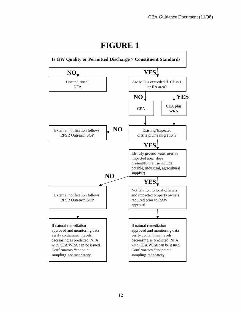
The Department ordinarily will not prohibit installation of wells in WRAs but will identifyany special installation and construction requirements (for example, installation of double-casedwells below the first confining layer) through the well permit program administered by the Bureauof Water Allocation. Prohibition of well installation may be warranted if installation and pumpingof a proposed well would negatively impact an approved remediation. For example, wellinstallation may be prohibited if use of a proposed industrial supply well would draw a portion of acontaminant plume into its cone of influence and alter the configuration of the plume, potentiallycontaminating a previously clean portion of the aquifer. Although WRAs will be the mechanism bywhich the Department primarily will protect potable users, restrictions on installation and use ofother types of wells (e.g., irrigation, industrial, recovery) also can be required. Figure 1 presents aflow chart to assist in determining when a CEA must be identified as a WRA and the appropriatelevel of public notice required based on ground water use within an impacted area.
Department Responsibilities
Although the Case Manager, with assistance from support staff, upon request by the leadprogram, will formally designate an area of non-compliance with the GWQS as a CEA, theinformation that is needed to develop the CEA should be provided by the responsible party. Pursuant to the Technical Requirements for Site Remediation, N.J.A.C. 7:26E-4.1(b), the horizontaland vertical extent of contamination in all media must be delineated as part of the remedialinvestigation. The data and information needed to establish CEAs therefore should be collectedduring and as part of the overall site investigation and remedial decision process.
The Department can require this information under the authority of an oversight documentor during the UST or ISRA review and approval process, or as part of the NJPDES-DGW permitapplication process. The CEA designation can then be incorporated into the appropriate document.
CEA Guidance Document (11/98)
6
CEAs and WRAs will be developed by the Department for publicly-funded sites. The equationsand models referenced in Appendix A, provided as examples of methods available to determine theextent and projected longevity of a CEA, are also applicable to WRAs.
The Remedial Lead will be responsible for providing notifications of CEA designationsinternally within the DEP. For each CEA established, the Fact Sheet presented as Appendix B mustbe completed by the case manager (or support geologist, upon request by the lead program). ThisFact Sheet and a map on which the CEA has been identified should be sent to the Division ofWatershed Management, the Bureau of Water Allocation, and the Environmental ClaimsAdministration. The Bureau of Safe Drinking Water should be notified if the CEA is within onemile upgradient of a public community supply well or wellfield, and there is hydrauliccommunication between the contaminated water-bearing zone and the portion of the aquifer fromwhich the public community water supply is drawn. Although CEA locations are being cataloguedon the Department GIS, separate internal notifications to each of these programs are necessary onan interim basis until current initiatives to integrate the various databases within the Departmentwith the GIS have been completed.
The lead program is responsible for updating the KCSL by indicating that a CEA has beenestablished for a site and the downgradient plume extent. The Division of Watershed Managementwill track CEAs throughout the State using the GIS and will utilize this information in developingWellhead Protection Areas. Restrictions on installation of any wells within a CEA will beimplemented by the Bureau of Water Allocation whenever application for a permit to drill a wellwithin a CEA is made. Information on CEAs can be used by the Environmental ClaimsAdministration in establishing liability for damages claims which may be filed by affected partieswithin a CEA.
Public Notice Requirements
As described in the preceding section, the Remedial Lead will provide internal notificationsof CEA designations to appropriate programs within the Department. As specified in N.J.A.C.7:26E-6.2(a)17v, the Department will require the person responsible for conducting the remediationto notify external agencies/affected parties of these designations according to the guidelinesestablished below. By requiring responsible parties to notify appropriate municipal authorities,health agencies, and, when necessary, individual property owners, the Department can ensure thatpresent and potential ground water users are made aware that constituent standards within thedesignated area have been contravened and that the use of this portion of the aquifer is restricted forthe duration of the CEA. Since the Department is primarily concerned with protecting present andfuture potable users in these areas, the degree of public notice required for a CEA will depend uponboth current and projected ground water use in a given area.
The need to establish a CEA for a contaminated area is determined based on theclassification of an aquifer pursuant to the GWQS, N.J.A.C. 7:9-6.1 et seq. CEAs must beestablished under a permit or Department oversight mechanism whenever constituent standards fora given aquifer classification are exceeded, irrespective of present or projected ground water useswithin that classification area. At present, there are no portions of the State that are designated
CEA Guidance Document (11/98)
7
Class II-B areas. Until such time as Class II-B areas are formally established pursuant to thereclassification procedures outlined in the GWQS, CEAs are required when Class II-A standardsare exceeded, even in heavily industrialized areas where ground water is not being used for potableor other purposes. No distinction between Class II-A and “probable future” Class II-B areas shouldbe made in deciding whether a CEA is needed.
Present and future ground water use in the impacted area will dictate the appropriate level ofpublic notice required when a CEA is established. Therefore, existing and planned uses of groundwater supplies (potable, industrial, agricultural, etc.) within the contaminated area must beidentified. N.J.A.C. 7:26E-6.2(a)17iv identifies sources of information that will aid in determiningwhether the CEA is in a ground water use area. Detailed information on current ground water usecan be obtained by reviewing the Department Bureau of Water Allocation records, by consultingthe New Jersey Water Supply Master Plan (copies are available for review in the Division ofWatershed Management), and by contacting the municipal or regional water purveyor. Bureau ofWater Allocation records are less certain for older wells than new wells, and it may be necessary toaugment a records review with a door-to-door well search. The best source of informationregarding future ground water supplies can be obtained from the municipal or regional waterpurveyors, who are required to consider issues such as system growth, replacement and new wellsor surface water supplies, and the potential locations for such supplies. Since many rural towns donot have municipal or regional water purveyors, both the local planning board and board of healthcan assist in providing this information in these areas. The New Jersey Water Supply Master Planalso provides information relative to projected ground water use in a given area.
Once ground water use in the affected area has been determined, public notice to theappropriate agencies and affected parties must be provided as specified in N.J.A.C. 7:26E-6.2(a)17vand explained further below.
If the CEA is established under a NJPDES permit, a description of the CEA should beincluded in the permit Fact Sheet and Public Notice which are routinely distributed to local orcounty health offices and municipal governing bodies and planning boards. No additional, separatenotifications to local officials by responsible parties will be necessary. In a current or planned(based on a 25-year planning horizon) ground water use area, the person responsible for conductingthe remediation should document that impacted offsite property owners are individually notified ofthe CEA designation by the start of the public comment period (30 days), since publication of anewspaper notice does not guarantee that all affected parties are made aware of, and afforded theopportunity to comment on, the proposed permit action.
If the CEA is established pursuant to the authority of an oversight document or regulatoryprogram, the responsible party must provide documentation that appropriate external agencies(local and county health departments, municipal governing bodies, municipal planning board) and,if necessary, impacted property owners have been informed of the CEA designation and groundwater use restrictions within the area.
In non-ground water use areas it will be sufficient to provide notice to local authorities only,even if the contaminant plume has migrated offsite. For cases managed by the Division ofResponsible Party Site Remediation, notification procedures should follow the RPSR Outreach
CEA Guidance Document (11/98)
8
SOP. For publicly funded sites, notice must be provided to the municipal governing body andboard of health.
In a ground water use area, if a CEA impacts property not owned by the party conductingthe remediation, the responsible party must notify individual property owners within the affectedarea as well as local officials before the Department can approve a RAW (or other cleanupproposal). Should the information and data necessary to identify the boundaries or project the termof the CEA be incomplete at the time of RAW submittal, the Department will be flexible to allowremedial work for the defined plume area to proceed while the additional data are collected. Forexample, if a plume is split during active remediation and a portion of the plume is allowed tomigrate offsite and naturally attenuate, additional ground water monitoring or modeling may berequired before a CEA can be designated for the offsite plume. In this case, the Department canapprove the RAW for onsite contamination and establish a CEA for the pump-and-treat area, whileground water monitoring data are collected or modeling is performed to project the migration pathof the offsite plume and length of time it will take before contaminant concentrations decrease toacceptable standards. Once the data needed to characterize the offsite plume are complete, a secondCEA is designated following public notification procedures based on aquifer use in the area, asdescribed above.
Ground Water Monitoring Requirements
It should be emphasized that a CEA will not specify ground water monitoring requirementssince it functions as a notification mechanism, not as a “stand alone” enforcement or regulatorydocument. A CEA is not a remedy, but is an institutional control established in conjunction with anapproved remedy, either under a NJPDES permit, or pursuant to the authority of an oversightmechanism or regulatory program. The need for and extent of ground water monitoring requiredduring the term of the CEA should be determined as part of the overall remedial decision processfor each site and should be based on the Technical Requirements for Site Remediation, N.J.A.C.7:26E.
Generally, an approved RAW will include provisions for scheduled ground watermonitoring during and, if appropriate, after active remediation has been terminated. For activepump and treat programs, ground water monitoring typically is required to verify that the treatmentsystem is successfully capturing the plume and reducing contaminant concentrations. Ground watermonitoring and performance requirements for natural remediation are outlined under N.J.A.C.7:26E-6.3(e). For natural remediation, ground water monitoring data are used to show thatcontaminant sources have been contained or removed, plume migration will not impact anyreceptors before contaminants degrade to acceptable concentrations, and pollutant concentrationsare declining over time as predicted. For example, in natural remediation scenarios, the Mann-Whitney U-Test should be applied to eight consecutive rounds of ground water sampling data todocument whether a decreasing trend in contaminant concentrations is occurring over time. Theneed for imposition of requirements to collect eight rounds of ground water monitoring data as partof this demonstration will be determined on a case-specific basis, depending on the presence orabsence of historical ground water monitoring data for the site. If at least eight quarters of validdata already exist at the time of RAW approval, for example, the case team will determine theappropriate number and frequency of additional future sampling episodes to verify continuing
CEA Guidance Document (11/98)
9
contaminant decreases. Since GWQS must be met at the boundaries of and outside the CEA,plume fringe and sentinel well ground water monitoring data can be used to demonstrate that thearea in which standards are temporarily exceeded has not increased beyond the original boundariesof the CEA.
Cases where the responsible parties have completed the investigative and active remedialphases under an Administrative Consent Order or a regulatory program (ISRA or UST) but arerequired to maintain long-term containment and/or ground water monitoring programs for someperiod of time because it is not expected that constituent standards will be achieved prior to thattime, will remain listed on the KCSL although active case management may no longer benecessary. In these situations, the Department must designate a CEA under the authority of theoversight document or regulatory program, and identify any additional ground watermonitoring/reporting requirements as part of the remedial oversight mechanism.
Ground water pollution cases in which contaminant concentrations exceed constituentstandards should not be given unconditional NFA approval or removed from the KCSL untilcompliance with the applicable standards has been demonstrated. However, conditional NFAs(NFA with CEA and/or WRA) may be given in cases where ground water contaminantconcentrations within a CEA are not expected to meet standards for some time, but active remedialwork and continued Department oversight are not needed. For example, in very specificcircumstances, leaking UST cases involving petroleum-based ground water contamination may begiven a conditional NFA with a CEA following implementation of a natural remediation plan oradequate ground water monitoring to insure that natural remediation has, and continues, to reducecontaminant concentrations such that the GWQS will be met. The criteria which must be met inorder for the conditional NFA with a CEA to be given in these UST cases are as follows:
1) Source and source area are remediated (i.e., no soil contamination above the site-specific impact to ground water criteria and no product remaining);
2) Decreasing ground water contaminant trends are established based upon site-specific ground water monitoring and a sound technical decision can be made to predict theduration it will take to meet the GWQS;
3) Monitoring of ground water clearly indicates that contaminants have not and willnot migrate beyond given boundaries; and
4) No receptors are at risk and public water supply is available.
A conditional NFA can specify any requirements necessary to ensure continued stability ofthe site, or require collection of confirmatory samples at the end of the time projected for naturalprocesses to restore ground water quality.
As stated in the “Components of a CEA” section above, responsibility for documenting thatcontaminant concentrations have achieved the higher of the PQLs or constituent standards restswith the person responsible for conducting the remediation. However, the Department will notrequire responsible parties to perform confirmatory sampling and submit results for Departmental
CEA Guidance Document (11/98)
10
review unless the CEA is in a ground water use area (see the preceding section on “Public NoticeRequirements” for a discussion on determining ground water use). Although confirmatorysampling will only be required in ground water use areas, the Department will not remove a CEAdesignation or give an unconditional NFA unless confirmatory ground water sampling indicatesthat standards have been achieved, and that primary aquifer uses can be restored within the formerlycontaminated area (see N.J.A.C. 7:26E-6.1(g)). Refer to N.J.A.C. 7:26E-6.4(a)6 for theconfirmatory sampling requirements in ground water use areas.
In present or future ground water use areas, verification that contaminant concentrationshave decreased to concentrations below applicable constituent standards should be based on aminimum of two rounds of sampling (N.J.A.C. 7:26E-6.4(a)6). The time between sampling eventsshould ensure that seasonal fluctuations are accounted for. If this demonstration is being madefollowing termination of active remediation, the sampling must be performed after the ground waterpumping system has been shut off. Following evaluation of information supporting attainment ofthe standard, the Department will remove the CEA designation. This review could be conductedunder a Memorandum of Agreement (MOA) for cases not assigned to a lead bureau.
CEA Guidance Document (11/98)
11
FIGURE 1
CEA Guidance Document (11/98)
12
Is GW Quality or Permitted Discharge > Constituent Standards
UnconditionalNFA
Are MCLs exceeded if Class Ior IIA area?
YESNO
CEACEA plus
WRA
Identify ground water uses inimpacted area (doespresent/future use includepotable, industrial, agriculturalsupply?)
NO
Existing/Expectedoffsite plume migration?
YESNO
NOExternal notification followsRPSR Outreach SOP
Notification to local officialsand impacted property ownersrequired prior to RAWapproval
External notification followsRPSR Outreach SOP
If natural remediationapproved and monitoring dataverify contaminant levelsdecreasing as predicted, NFAwith CEA/WRA can be issued.Confirmatory “endpoint”sampling mandatory.
FIGURE 1
YES
YES
If natural remediationapproved and monitoring dataverify contaminant levelsdecreasing as predicted, NFAwith CEA/WRA can be issued.Confirmatory “endpoint”sampling not mandatory.

CEA Guidance Document (11/98)
13
APPENDIX A
CEA Guidance Document (11/98)
14
METHODS OF CLASSIFICATION EXCEPTION AREA DELINEATION
I. PURPOSE OF THE PROCEDURE
The CEA delineation procedures outlined below should be used to identify the kinds of dataneeded to project the extent and longevity of an area within which GWQS (Ground Water QualityStandards) are exceeded, and to assist staff in consistent, reproducible CEA determinations. It isnot the intent of the Department to require that additional investigative activities be initiated whenexisting information and data can be used in CEA determinations. The bulk of the input data andinformation needed for delineation of the CEA should be generated during the remedialinvestigation phase, as discussed in the text of this guidance document.
Sources of information used in CEA delineations should be, in order of preference, asfollows: site-specific data; data from nearby sites; regional studies (the New Jersey GeologicalSurvey is a good source of regional ground water information); and literature values. The methodsoutlined below also can be used to delineate Well Restriction Areas (WRAs), which areinstitutional controls implemented by the Department whenever Primary Drinking Water standards(N.J.A.C. 7:10) are violated. When calculating or modeling the extent of a WRA, MCLs should beused in lieu of GWQS (less restrictive of the Ground Water Quality Criteria or PQLs).
II. WATER QUALITY ASSESSMENT REQUIREMENTS
A. TIME FACTOR1. The designation of water quality at each well location shall be based upon the most recentsamples collected and confirmed within the two years prior to the CEA determination. It should benoted that for some cases, it may be more appropriate to use historical “worst-case” data whenmaking CEA determinations. This issue is addressed in Section III-C of this Appendix.
2. Water quality data older than two years should not be included in the CEA determinationunless more recent data are not available and it is judged by the Department that these datarepresent existing ground water quality conditions.
B. CONFIRMATORY WELL SAMPLINGConfirmatory or additional well sampling shall be required if:
1. A significant portion of the data is more than two years old; and/or
2. The full extent of existing ground water contamination has not been determined in a groundwater use area (see “Public Notice Requirements” in main text of this guidance for discussion ondetermining ground water use).
III. DETERMINATION OF CLASSIFICATION EXCEPTION AREA
CEA Guidance Document (11/98)
15
A. GENERALIn general, two problems must be solved in order to calculate a CEA. First, the amount of time thatthe contaminant concentration will take to reach the GWQS must be determined. Second, thedistance that the contamination will migrate must be established. Because the purpose of themodeling/calculations is to project the boundaries of the CEA and approximate the time necessaryto achieve the GWQS, where multiple pollutant classes are represented in the plume, pollutantswith the greatest mobility and persistence should be used in the models/calculations.
B. NUMERICAL MODELING OPTION1. Numerical ground water flow and contaminant transport models (e.g., BIOTRANS,BIOPLUME2, MOC, MODFLOW, etc.) may be used to determine the duration and boundariesof the CEA. The numerical model technique uses an approximate solution to solve an equation. The approximation usually incorporates the finite difference approximation of the flow equation.
Hydrogeologic data, such as hydraulic conductivity (K), Storativity (S), aquifer thickness (b), andground water head elevations (h), need to be entered for each grid of the model. Sufficient andaccurate data must be collected in order to properly model the site. In addition, verification andcalibration of the model must be performed to ensure accurate results (prevents “garbage in garbageout”). Numerical models are very powerful and can be used to evaluate very complicatedhydrogeologic problems.
2. If this option is chosen, only properly documented models shall be used.
3. If this option is chosen, all data inputs, assumptions and references shall be properlydocumented.
C. ANALYTICAL SOLUTION OPTION1. April 1995 Classification Exception Area Guidance Document ModelThe model included in the April 1995 version of the Classification Exception Area (CEA)guidance document was initially developed to address cases with “de minimus” volumes ofBTEX ground water contamination. The model was an attempt to quickly estimate how farcontamination might migrate from a source area. It was a simple solution to a simplisticproblem, which applied to a small population of remediation sites. It was not intended to be orpresented as a solution for all cases. However, the Department has received numerous submittalsusing this model to establish a CEA for cases other than those with “de minimus” concentrationsof BTEX contamination. In order to apply the model to other cases, the Department hasdetermined that certain clarifications and changes in this Appendix are required, as outlinedbelow.
Geology: The model was developed for uniform sites (i.e., isotropic and homogeneous). Thelack of sophistication of this model may make it unsuitable for complex geological regimes, suchas a bedrock aquifers or heterogeneous aquifers. Use of this model for these geologicalconditions will likely yield inaccurate fate and transport results.

CEA Guidance Document (11/98)
16
Contaminant(s) of concern: The model was developed for gasoline constituents that undergoaerobic degradation. In addition, the model assumes that the site conditions are conducive toaerobic degradation (available oxygen and nutrients).
The model assumes that the compound is degradable and the degradation of the compound is notpart of a series (i.e., there are no daughter products). Because of this, the model may not beappropriate for other types of contaminants, especially chlorinated solvents, gasoline additives,and metals.
a. When calculating a CEA duration for a chlorinated solvent, the entire degradation seriesmust be evaluated, including all daughter products.
b. At the present time, the degradation of gasoline additives has not been fully documented,and it is assumed that MTBE and TBA do not degrade. Therefore, the model included in theguidance document should not be used for these additives.
c. In order to establish a CEA for gasoline additives and/or metals, an advection-dispersionmodel should be used. As a rule, if the compound does not degrade, this model should notbe used.
Half-life or Degradation Rate: As stated in the April 1995 guidance document, thedegradation rate (k) is equal to 0.693 divided by the half-life (t1/2). The Department requires thata site specific degradation rate be determined, if possible. Equation 1, which was included in theApril 1995 CEA guidance document, can be used to determine a site-specific half-life based onhistorical sampling data. This approach, although correct, does not account for possiblevariations in the data set.
t
CoC )/ln(k = (1)
In order to establish a more representative value for the site, the degradation rate should bedetermined by a linear regression method. The degradation rate is equal to the slope of the best-fit line of the natural log of the sampling data plotted over time (i.e., the slope of concentrationvs. time plotted on log normal paper). The correlation coefficient (R) of the best fit line, which isan estimate of how well the data ‘fits’ a straight line, should also be calculated. The correlationcoefficient will assist the Department in the review of the CEA submittal, as well as in determiningwhether the calculated degradation rate is meaningful. These issues are discussed in more detailbelow.
Initial Concentration: In the April 1995 guidance document, the initial concentration wasdefined as the concentration during the most recent ground water sampling event. However, ifthe plume has already migrated some distance away from the source area, using the most recentconcentration will underestimate the duration and travel distance of the CEA. Therefore, forsome cases, the highest historical concentration should be used to determine the CEA. Inaddition, if the discharge occurred significantly before the initial sampling round, the historical
CEA Guidance Document (11/98)
17
sampling may not represent the highest concentration and may also underestimate the CEA. However, if the ground water contamination has not migrated away from the source area, it maybe appropriate to use the most recent sampling data (the model was developed for this scenario).
Using the historical ground water data will also allow the fate and transport model/calculations tobe evaluated. For example, if the model predicted that the contaminant plume would migrate 10feet, but ground water data indicate that the plume has actually migrated 100 feet, then the modelshould be recalibrated to match the actual site data. In general, the results of the model shouldalways be compared to the actual site data. Using the greatest contaminant concentration canalso be used to calibrate the model.
Lastly, the model also assumes that the discharge is a slug release. Therefore, use of this modelmay yield inaccurate results if the discharge was (or still is) an ongoing discharge.
Partition coefficient: The April 1995 guidance document stated that the octanol–water partitioncoefficient (Kow) should be used in determining the partition coefficient. In general, the organiccarbon partition coefficient (Koc) should be used in calculating the partition coefficient. The Kow
should be used only when the Koc is unknown.
2. Modeling GuidanceThe following modeling guidance is similar to that included in the April 1995 CEA guidancedocument. As noted, the differences are in the application of the modeling, and some minorchanges to the equations.
As before, the CEA calculation procedure is a two step process. The first step is to determine theduration of the CEA, and the second step is to determine how far the contamination will travelduring that time. The following is a description of how to use this model in order to establish aCEA.
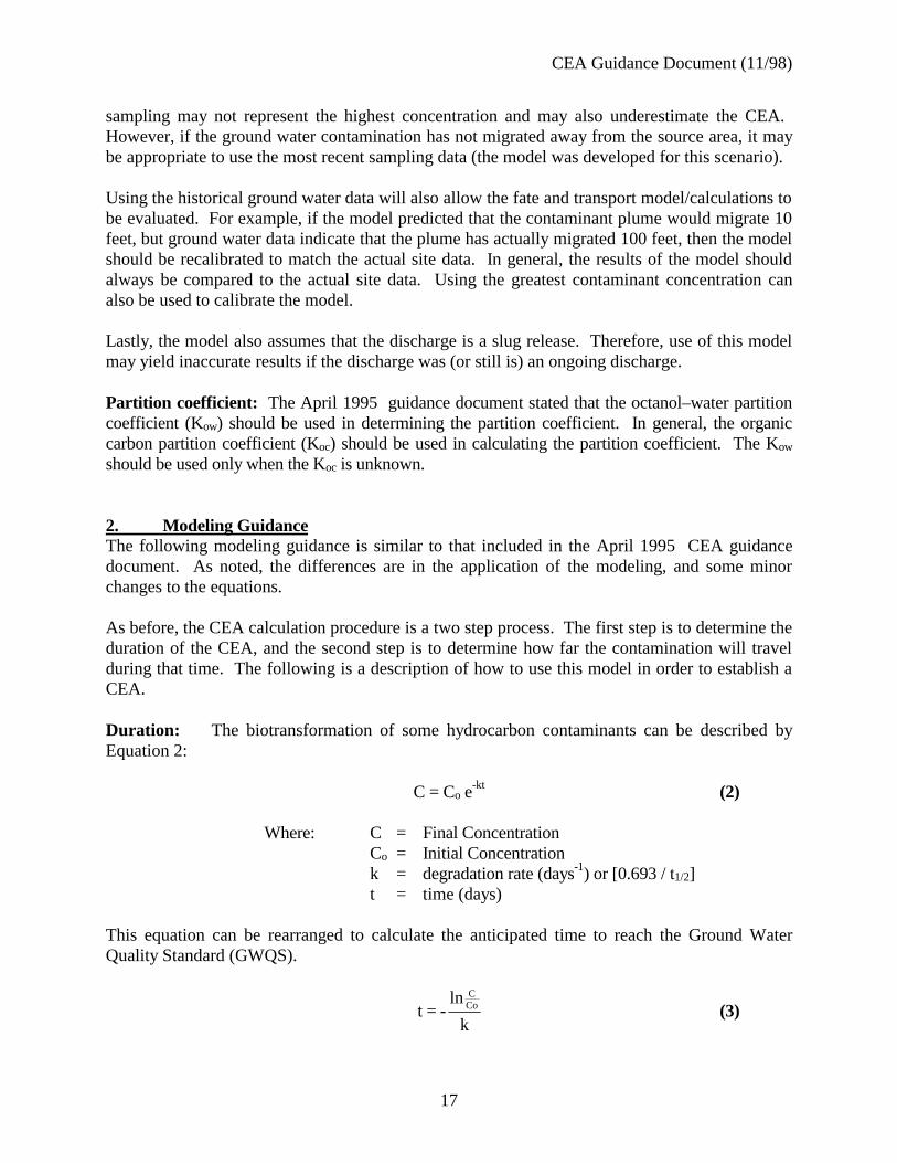
Duration: The biotransformation of some hydrocarbon contaminants can be described byEquation 2:
C = Co e-kt (2)
Where: C = Final ConcentrationCo = Initial Concentrationk = degradation rate (days-1) or [0.693 / t1/2]t = time (days)
This equation can be rearranged to calculate the anticipated time to reach the Ground WaterQuality Standard (GWQS).
k
ln- =t Co
C
(3)
CEA Guidance Document (11/98)
18
As noted above, for some cases, the greatest historical concentration should be substituted intoEquation 3. However, the most recent sampling data may be used if the contamination has notmigrated from the source area.
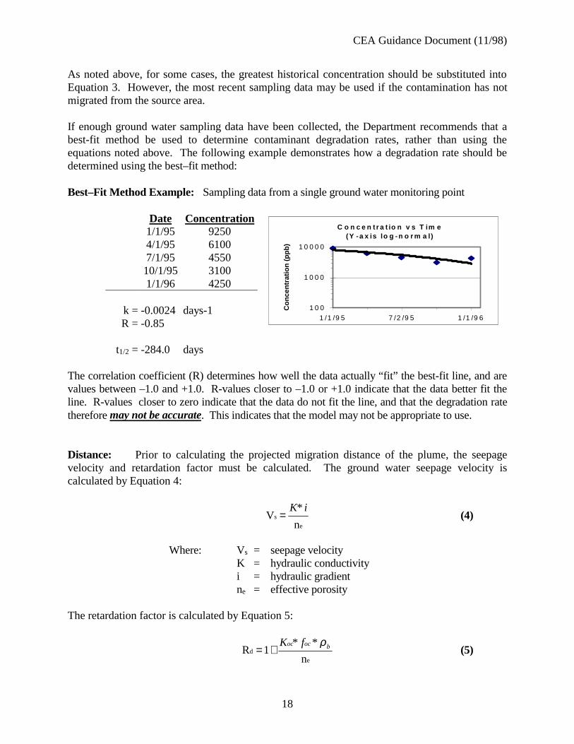
If enough ground water sampling data have been collected, the Department recommends that abest-fit method be used to determine contaminant degradation rates, rather than using theequations noted above. The following example demonstrates how a degradation rate should bedetermined using the best–fit method:
Best–Fit Method Example: Sampling data from a single ground water monitoring point
Date Concentration1/1/95 92504/1/95 61007/1/95 455010/1/95 31001/1/96 4250
k = -0.0024 days-1R = -0.85
t1/2 = -284.0 days
The correlation coefficient (R) determines how well the data actually “fit” the best-fit line, and arevalues between –1.0 and +1.0. R-values closer to –1.0 or +1.0 indicate that the data better fit theline. R-values closer to zero indicate that the data do not fit the line, and that the degradation ratetherefore may not be accurate. This indicates that the model may not be appropriate to use.
Distance: Prior to calculating the projected migration distance of the plume, the seepagevelocity and retardation factor must be calculated. The ground water seepage velocity iscalculated by Equation 4:
e
s
n
*V
iK= (4)
Where: Vs = seepage velocityK = hydraulic conductivityi = hydraulic gradientne = effective porosity
The retardation factor is calculated by Equation 5:
ed
n
**1R bococ fK ρ
+= (5)
C o n c e n t r a t io n v s T im e(Y -a x is lo g -n o r m a l)
1 0 0
1 0 0 0
1 0 0 0 0
1 /1 /9 5 7 /2 /9 5 1 /1 /9 6
Con
cent
ratio
n (p
pb)
CEA Guidance Document (11/98)
19
Where: Rd = retardation factorKoc= organic carbon partition coefficientfoc = fraction of organic carbonρb = dry bulk density of aquifer matrix
As noted above, the organic carbon partition coefficient (Koc) should be used in calculating theretardation factor, rather than the n-octanol/water partition coefficient (Kow). If the Koc of acompound is unknown, then it can be calculated from the Kow for that compound. Commonly, theequation Koc = 0.63 * Kow is used (Karichoff et al., 19791). However, there are other algorithmsthat can be used to calculate Koc from Kow (Fetter, 19932).
The pollutant transport rate is determined by dividing the seepage velocity by the retardation factor(Equation 6):
dpt
RV
sV= (6)
Where: Vpt = pollutant transport rateVs = seepage velocityRd = retardation factor
Finally, the distance that the plume might travel is calculated by Equation 7:
tVpt *D = (7)
AssumptionsThis model is not applicable for all sites. There are several major assumptions that have beenmade in establishing the CEA as shown above, and this method should only be applied when thefollowing assumptions are met:
1. All of the contaminant mass is in the aqueous phase; hence, no mass is contributed by thedesorption of contaminants from the soil matrix (unsaturated in addition to saturated),
2. The environment is aerobic (not anaerobic),3. The only variable governing the degradation of a contaminant is biotic. The nutrients, O2,
and hydrocarbon metabolizing bacteria that are needed for this process are present insufficient quantities as to not limit the contaminant breakdown.
4. The biodegradation of the contaminant is first-order,
1 Karichoff, S. W., D. S. Brown, and T. A. Scott. 1979. Sorption of hydrophobic pollutantson natural sediments. Water Resources 13:241-248.2 Fetter, C. W. 1993. Contaminant Hydrogeology. New York: MacMillan PublishingCompany, p. 134.
CEA Guidance Document (11/98)
20
5. Advection is the major component of ground water transport (dispersion is negligible),and
6. The formation is homogeneous and isotropic.
CEA Guidance Document (11/98)
21
Attachment 1
CEA Guidance Document (11/98)
22
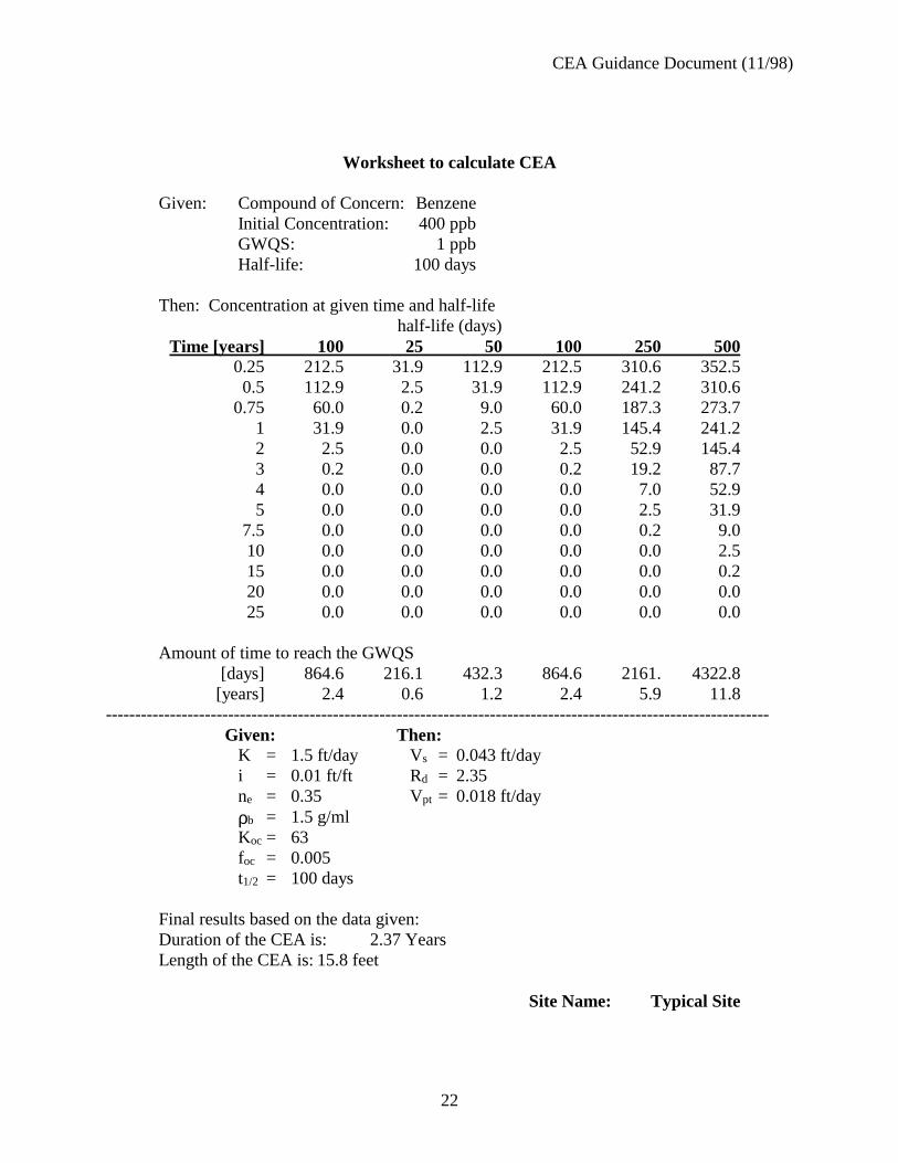
Worksheet to calculate CEA
Given: Compound of Concern: BenzeneInitial Concentration: 400 ppbGWQS: 1 ppbHalf-life: 100 days
Then: Concentration at given time and half-lifehalf-life (days)
Time [years] 100 25 50 100 250 5000.25 212.5 31.9 112.9 212.5 310.6 352.50.5 112.9 2.5 31.9 112.9 241.2 310.6
0.75 60.0 0.2 9.0 60.0 187.3 273.71 31.9 0.0 2.5 31.9 145.4 241.22 2.5 0.0 0.0 2.5 52.9 145.43 0.2 0.0 0.0 0.2 19.2 87.74 0.0 0.0 0.0 0.0 7.0 52.95 0.0 0.0 0.0 0.0 2.5 31.9
7.5 0.0 0.0 0.0 0.0 0.2 9.010 0.0 0.0 0.0 0.0 0.0 2.515 0.0 0.0 0.0 0.0 0.0 0.220 0.0 0.0 0.0 0.0 0.0 0.025 0.0 0.0 0.0 0.0 0.0 0.0
Amount of time to reach the GWQS[days] 864.6 216.1 432.3 864.6 2161. 4322.8[years] 2.4 0.6 1.2 2.4 5.9 11.8
------------------------------------------------------------------------------------------------------------------Given: Then:
K = 1.5 ft/day Vs = 0.043 ft/dayi = 0.01 ft/ft Rd = 2.35ne = 0.35 Vpt = 0.018 ft/dayρb = 1.5 g/mlKoc = 63foc = 0.005t1/2 = 100 days
Final results based on the data given:Duration of the CEA is: 2.37 YearsLength of the CEA is: 15.8 feet
Site Name: Typical Site
CEA Guidance Document (11/98)
23
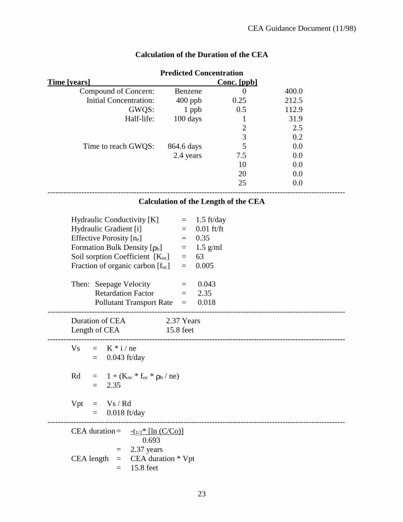
Calculation of the Duration of the CEA
Predicted ConcentrationTime [years] Conc. [ppb]
Compound of Concern: Benzene 0 400.0Initial Concentration: 400 ppb 0.25 212.5
GWQS: 1 ppb 0.5 112.9Half-life: 100 days 1 31.9
2 2.53 0.2
Time to reach GWQS: 864.6 days 5 0.02.4 years 7.5 0.0
10 0.020 0.025 0.0
------------------------------------------------------------------------------------------------------------------Calculation of the Length of the CEA
Hydraulic Conductivity [K] = 1.5 ft/dayHydraulic Gradient [i] = 0.01 ft/ftEffective Porosity [ne] = 0.35Formation Bulk Density [ρb] = 1.5 g/mlSoil sorption Coefficient [Koc] = 63Fraction of organic carbon [foc] = 0.005
Then: Seepage Velocity = 0.043Retardation Factor = 2.35Pollutant Transport Rate = 0.018
------------------------------------------------------------------------------------------------------------------Duration of CEA 2.37 YearsLength of CEA 15.8 feet
------------------------------------------------------------------------------------------------------------------Vs = K * i / ne
= 0.043 ft/day
Rd = 1 + (Koc * f oc * ρb / ne)= 2.35
Vpt = Vs / Rd= 0.018 ft/day
------------------------------------------------------------------------------------------------------------------CEA duration = -t1/2* [ln (C/Co)]
0.693= 2.37 years
CEA length = CEA duration * Vpt= 15.8 feet
CEA Guidance Document (11/98)
24
APPENDIX B
CEA Guidance Document (11/98)
25
CLASSIFICATION EXCEPTION AREA/WELL RESTRICTION AREAFACT SHEET
Site Name: DATE:Location: (Include Address Municipality and County):Block(s):Lot(s):See Exhibit A (Site Location Map)
Site Contact Person:Address:Phone Number:
Case Number: Site Identification # (if applicable - i.e., ISRA or UST Case #, NJPDES permit #,etc.)
DEP Lead Program (Include Phone Number):
DEP (Remedial Action Workplan or No Further Action) Approval Document dated:
Description of CEA:
- Identification of impacted aquifer
Example: Pursuant to N.J.A.C. 7:9-6.5, this area is presently designated as Class II-A. The primarydesignated use for Class II-A ground water is potable water; secondary uses include agricultural andindustrial water. Any proposed ground water use within the CEA will require Department reviewfor feasibility of well installation and modifications that would be protective of any impacts fromthese contaminants for the duration of the CEA.
- Contaminants exceeding constituent standards and applicable standards
This CEA/WRA applies only to the contaminants listed in the table below. The ground waterquality criteria/ primary drinking water standards for these contaminants are listed in parts perbillion (ppb). All constituent standards (N.J.A.C. 7:9-6) apply at the designated boundary.
CEA Guidance Document (11/98)
26
(Note: add MCLs as appropriate)
Contaminant Ground Water QualityCriteria (ppb)
- CEA boundaries
Horizontal Boundaries - See Exhibit B (CEA/WRA Location Map)Vertical Boundaries - Include appropriate narrative or exhibit
- Projected term of CEA
Note: (Include as applicable) Since ground water quality data indicates exceedance of contaminantsabove the Primary Drinking Water Standards, and the designated uses of Class IIA aquifers includepotable use, the CEA established for this site is also a Well Restriction Area. The extent of WellRestriction Area shall coincide with the boundaries of the CEA.
If any general or specific recommendations regarding well installation or construction can begiven at this time, include them in the fact sheet. For example, if there are known or suspectedDNAPL pools which could be mobilized and migrate if a clay layer is breached, this should bementioned.
CEA Guidance Document (11/98)
27
APPENDIX C
This is a “hot-link” to the document “Guidance for the Submission and Use of Data In GISCompatible Formats Pursuant to "Technical Requirements for Site Remediation" (TECHGIS2),”available on the Site Remediation Web page.
To access the electronically, either click on the underlined portion of the above paragraph, ortype the following internet address into the web browser:
http://www.state.nj.us/dep/srp/regs/guidance.htm#techgis2