Embed Size (px)
Citation preview

Bulletin Board compiled by The Resource Referral Program at Everywoman’s Center. More kits are available at www.umass.edu/mycenter
How to get there? From East or West take Mass Pike (Rte. I-90) to exit 5, Rte. 33 north to Rt
116 north to Rt 47 north approximately four miles. Park entrance is on right.
390-acre Skinner State Park on top of Mount Holyoke offers breathtaking
views of the Connecticut River Valley. The summit is accessible by road
from April through November, and by hiking trails year-round.
The park is named after Joseph Allen Skinner, a wealthy industrialist who
donated the hotel and land to the state in 1940. There are 20 picnic sites on
the grounds, many with fine views and charcoal grills. Restrooms are
available.
Hawk watching is popular in spring and fall. Hang-gliding is allowed by
special permit. Paths from the Summit House connect with marked trails
that traverse the Holyoke Range. Fall foliage viewing is popular in the
park, and the masses of flowering mountain laurel present a lovely
spectacle in June.
The mountain formed some 200 million years ago when lava flowed from
the valley floor, cooled and was upended. More recently, glaciers left their
signature, scouring the mountain's jagged edges smooth in some places,
exposing bedrock or leaving till, sand, clay or muck in others.

Bulletin Board compiled by The Resource Referral Program at Everywoman’s Center. More kits are available at www.umass.edu/mycenter

Bulletin Board compiled by The Resource Referral Program at Everywoman’s Center. More kits are available at www.umass.edu/mycenter
How to get there? From East or West take the Massachusetts Turnpike (I-90) to exit 5, Rte. 33
north to Rte. 116 north to the Amherst town line.
Rising roughly 1,000 feet in elevation, Mt. Holyoke Range State Park
straddles the seven-mile ridge that runs from Hadley to Belchertown.
The ridge is a patchwork of state, town and private lands. Parcels
acquired by the state since the 1970's bring the park to over 3,000
acres.
The Mt. Holyoke Range formed some 200 million years ago when
lava flowed from the valley floor, cooled and was upended. More
recently, glaciers left their signature, scouring the ridge's jagged
edges smooth in some places, exposing bedrock, or depositing till,
sand, clay or muck in others.
Over 30 miles of marked trails provide a variety of outdoor
experiences including hiking, walking, viewing vistas, cross-country
skiing, snowmobiling, horseback riding and hunting. The Notch
Visitor Center, located on Route 116 in Amherst, is open daily.
Displays and interpretive programs are available in season.

Bulletin Board compiled by The Resource Referral Program at Everywoman’s Center. More kits are available at www.umass.edu/mycenter

Bulletin Board compiled by The Resource Referral Program at Everywoman’s Center. More kits are available at www.umass.edu/mycenter
How to get there? From the south: Rte. 91 north, take exit #17-B, go 4 miles on Rte 141 west.
Reservation entrance is on the right.
From the north: Rte. 91 south, take exit #18, onto Rte 5 south about 1.5
miles, right on to East St. for 3 miles, left onto 141 East (up the hill),
reservation entrance on your left.
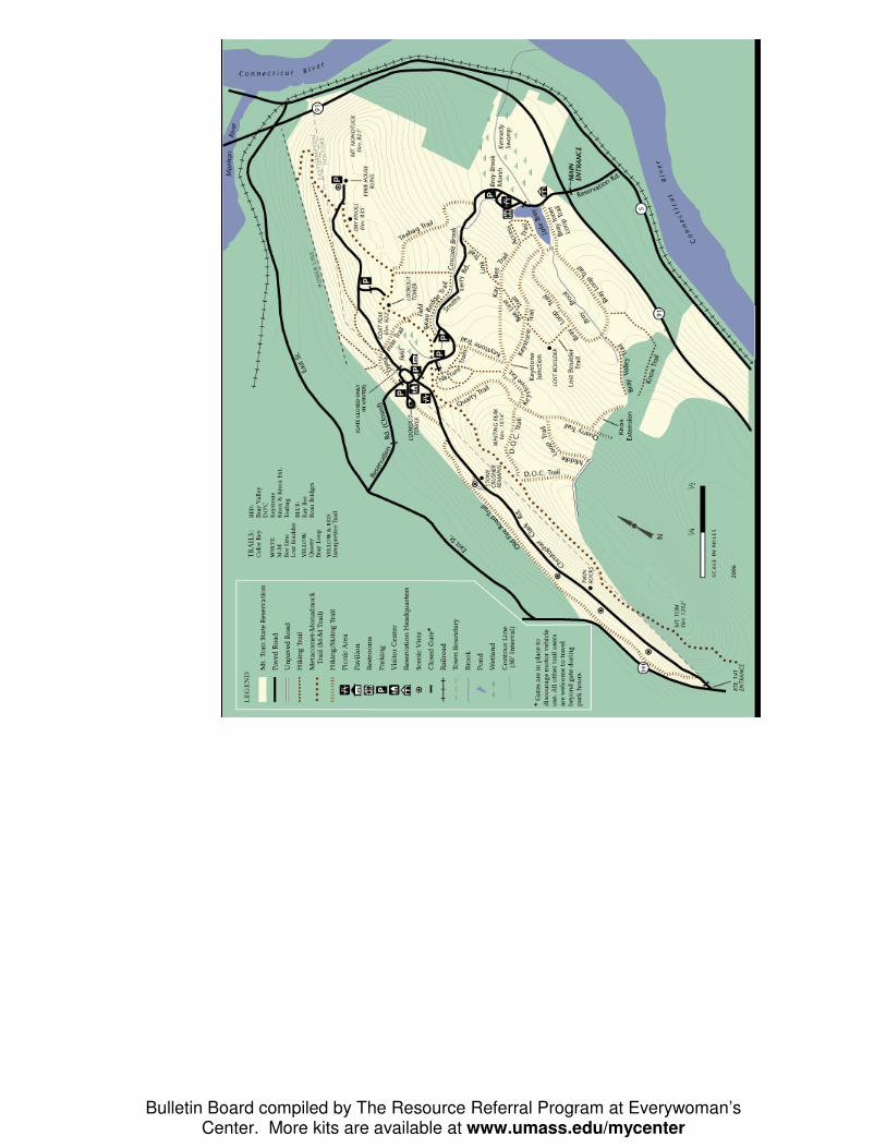
Mt. Tom boasts an unparalleled view of the Connecticut Valley north
and south, the Berkshire mountains to the west and the Pelham hills to
the east.
This 2,082 acre facility offers 20 miles of hiking and walking trails;
picnicking; canoeing and fishing on Lake Bray; and cross country
skiing and ice skating in the winter. Mt. Tom also offers a children's
play area.
Today the Reservation includes about 47 of the 80 tree species found
naturally in Hampshire County. Mt. Tom is one of the premier hawk
watching spots in New England. Each fall, thousands of hawks and
other birds fly past the mountain.
Bulletin Board compiled by The Resource Referral Program at Everywoman’s Center. More kits are available at www.umass.edu/mycenter

Bulletin Board compiled by The Resource Referral Program at Everywoman’s Center. More kits are available at www.umass.edu/mycenter
How to get there? From Elwell Recreation Area, Northampton: Damon Road at Route 9 and I-
91. Canoe and rowing access only. Paved access ramp to a wheelchair
accessible dock on the river. Limited parking.
From Oxbow Ramp, Easthampton: take Rte. I-91 to exit 18 south on Rte. 5
in Easthampton. Thirty-five parking spaces and a paved ramp. Customary
use by high powered recreational craft and larger fishing boats.
The Connecticut River Greenway is one of Massachusetts' newest
State Parks. It connects open spaces, parks, scenic vistas, and
archaeological and historic sites along the length of the
Connecticut River as it passes through the state.
There are over 12 miles of permanently protected shoreline, and
numerous access points to the river. Like jewels along a necklace,
several larger properties such as Mt. Sugarloaf State Reservation,
Norwottuck Rail Trail and the Great Falls Discovery Center
(located in Turner's Falls) provide added visitor amenities.

Bulletin Board compiled by The Resource Referral Program at Everywoman’s Center. More kits are available at www.umass.edu/mycenter
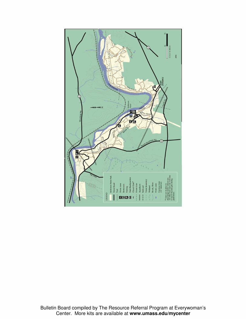
How to get there? From east or west: Mass Pike (Rte. I-90) to exit 4, Rte. 91 south, Rte. 57
west, Rte. 187 north, to North St. Follow signs.
Robinson State Park serves as a major day use area for its region.
Donated to the state in 1934, the facility includes over 800 acres with
five miles of frontage on the Westfield River.
In addition to several good vantage points on the Westfield River near
the bend at White Brook, the park offers tables and fireplaces at the
Trestle and Proven Mountain picnic areas. The 17 acre island west of
the falls at Mittineague is one of the park's most picturesque spots.
The rough terrain of the park is unexpected in the fertile Connecticut
River Valley. A small demonstration logging area, located on the site,
adds to the diversity and importance of this urban park.
Bulletin Board compiled by The Resource Referral Program at Everywoman’s Center. More kits are available at www.umass.edu/mycenter

Bulletin Board compiled by The Resource Referral Program at Everywoman’s Center. More kits are available at www.umass.edu/mycenter
How to get there? From east to west: take the Massachusetts Turnpike (Rte. I-90) to exit 4 to
Rte. I-91 north; continue to the second Holyoke exit (Exit 16, Route 202);
follow Rte. 202 north for a mile and a half; take a right onto Rte. 141 east
(Appleton Street), then continue one-half mile to the park.
The park's Visitors' Center features exhibits about paper manufacturing
and Holyoke's industrial history. A slide show celebrates the city's rich
blend of cultures and people. Special programs are offered year-round.
The Children's Museum, the restored antique Holyoke Merry-Go-Round
and the Volleyball Hall of Fame are also located within the park.
Outside the Visitors' Center, relax and have a picnic in the beautifully
landscaped park overlooking Holyoke's three water power canals and
several of the mill buildings. The historic railroad is not running at
present, but when in operation it takes passengers on a 10 mile route
through Holyoke and the surrounding countryside.

Bulletin Board compiled by The Resource Referral Program at Everywoman’s Center. More kits are available at www.umass.edu/mycenter
How to get there? From North, South and East/I-91: From I-91 take Exit 26 in Greenfield and
follow Rte. 2 west for 21 miles. The park entrance is on the right, 4 miles
west of Charlemont center.
A clear, cold river cascades through Mohawk Trail State Forest along a
rocky streambed. One of the most scenic woodland areas in
Massachusetts, the state forest offers visitors a taste of real wilderness
in a rustic setting.
Over 6,000 acres of mountain ridges, deep gorges and tall old-growth
trees support a diversity of plant and animal life. 56 wooded campsites
are available seasonally, and six overnight log cabins are available
year-round.
Discover miles of rivers and streams for excellent trout fishing, a
swimming area, and a day-use picnic area. The state forest is located
along and named for the Mohawk Trail a historic Native American foot
path that connected the Connecticut and Hudson River Valleys.
Sections of this route are open for hiking today as the Mohican-
Mohawk Trail.

Bulletin Board compiled by The Resource Referral Program at Everywoman’s Center. More kits are available at www.umass.edu/mycenter

Bulletin Board compiled by The Resource Referral Program at Everywoman’s Center. More kits are available at www.umass.edu/mycenter
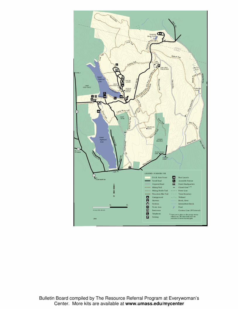
How to get there? From South/Rte. I-91: Take Exit 19 in Northampton and follow MA Rte. 9
west for 15 miles to Goshen. Turn right onto MA Rte. 112 north and
continue for 0.7 miles. Park entrance is on the right.
The Daughters of the American Revolution (DAR) donated 1,020 acres to
the Commonwealth for a state forest in 1929. Since then more than 750
additional acres have been acquired to include Upper and Lower
Highland Lakes, which offer a popular swimming beach, shady picnic
area and a group picnic pavilion.
Located in the eastern foothills of the Berkshires, discover 15 miles of
mixed-use trails through northern hardwood-conifer forest. Climb the
Goshen fire tower for spectacular views of the Connecticut River Valley
and into five states. The campground offers 51 wooded campsites
featuring modern comfort stations with showers and a private beach.
Wheelchair accessible campsites are also available.
In summer other activities include: non-motorized boating, hiking,
fishing, and horseback riding (bring your horse), and mountain biking. In
winter ice fishing, skating, cross-country skiing, snowshoeing and
snowmobiling are popular.
Bulletin Board compiled by The Resource Referral Program at Everywoman’s Center. More kits are available at www.umass.edu/mycenter

Bulletin Board compiled by The Resource Referral Program at Everywoman’s Center. More kits are available at www.umass.edu/mycenter
How to get there?
From the East/Mass Pike (I-90): Follow I-91 north to Exit 19 in
Northampton. Follow MA Rte. 9 west to for 27.8 miles to West
Cummington. Turn right onto West Main Street, continue for 0.1 mile then
take an immediate left onto River Road and follow for 2.9 miles to the day-
use area entrance on the left, or campground on the right.
Deep in the rolling hills of the Berkshire highlands, Windsor State
Forest’s cascading waterfall at Windsor Jambs stands out for its
spectacular beauty. Windsor Jambs Brook plunges through a 25-
foot-wide gorge, with 80-foot-high granite walls rising on either
side; a beautiful and refreshing place to visit.
The popular day-use area along the Westfield River offers a 100-
foot sandy beach for swimming with wooded picnic sites. 24
limited-service campsites are also available (no showers or flush
toilets). Trails and old dirt roads that wind through the “The Bush”
are favored by hikers, cross-country skiers and snowmobiles.
Fishermen and hunters are also welcome.

Bulletin Board compiled by The Resource Referral Program at Everywoman’s Center. More kits are available at www.umass.edu/mycenter

Bulletin Board compiled by The Resource Referral Program at Everywoman’s Center. More kits are available at www.umass.edu/mycenter

Bulletin Board compiled by The Resource Referral Program at Everywoman’s Center. More kits are available at www.umass.edu/mycenter

Bulletin Board compiled by The Resource Referral Program at Everywoman’s Center. More kits are available at www.umass.edu/mycenter

Bulletin Board compiled by The Resource Referral Program at Everywoman’s Center. More kits are available at www.umass.edu/mycenter

Bulletin Board compiled by The Resource Referral Program at Everywoman’s Center. More kits are available at www.umass.edu/mycenter

Bulletin Board compiled by The Resource Referral Program at Everywoman’s Center. More kits are available at www.umass.edu/mycenter

Bulletin Board compiled by The Resource Referral Program at Everywoman’s Center. More kits are available at www.umass.edu/mycenter

Bulletin Board compiled by The Resource Referral Program at Everywoman’s Center. More kits are available at www.umass.edu/mycenter

Bulletin Board compiled by The Resource Referral Program at Everywoman’s Center. More kits are available at www.umass.edu/mycenter

Bulletin Board compiled by The Resource Referral Program at Everywoman’s Center. More kits are available at www.umass.edu/mycenter

Bulletin Board compiled by The Resource Referral Program at Everywoman’s Center. More kits are available at www.umass.edu/mycenter

Bulletin Board compiled by The Resource Referral Program at Everywoman’s Center. More kits are available at www.umass.edu/mycenter

Bulletin Board compiled by The Resource Referral Program at Everywoman’s Center. More kits are available at www.umass.edu/mycenter