Embed Size (px)
Citation preview
Central City Transformation Plan
April 2021
Hamilton Kirikiriroa 2021 - 2051
2 Central City Transformation Plan l April 2021
Hamilton City Council
Hamilton City Council Private Bag 3010 Hamilton 3240 New Zealand
www.hamilton.govt.nz+64 7 838 [email protected]
Arup
205-209 Queen StreetAuckland 1010New Zealand
www.arup.com+64 9 301 [email protected]
Document information
Document Title Hamilton Central City Transformation Plan Refresh
File Name Hamilton Central City Transformation Plan
Date Issued April 2021
Revision Date Issued Details
Review 21 January 2021 Workshop with HCC
Final Draft_v1 10 February 2021 Final draft issued to HCC
Final Draft_v2 5 March 2021 Final draft issued to HCC
Final Draft_v3 14 April 2021 Final draft issued to Council Report's Attachment
Final 27 April 2021 Final
Central City Transformation Plan l April 2021 3
Contents
Executive Summary 5
Importance of iwi in the CCTP 6
Part A - Introduction
Introduction 7
Strategic context 9
Existing Context 10
Existing Context Map 11
Central City Snapshot 12
Challenges and Opportunities 13
Part B - Vision and Outcomes
Vision 16
Outcomes Summary 17
Hamilton Kirikiriroa - Te Ao Maaori 19
A Place to Call Home 20
A Playful City 22
A Home for Diversity 24
A Well-Connected Central City 26
Blue-Green Central City 28
Prosperous Economy 30
Part C
Introduction 34
Overall Initiatives - Transport & Streets 35
Overall Initiatives - Built Environment 36
Short Term Projects 37
Medium Term Projects 41
Long Term Projects 48
Implementation 50
Appendices
Hamiton City Council Strategies
Hamilton Kirikiriroa CCTP Baseline Analysis
Document One - Central City Transformation Plan
Document Two - Project Initiatives Next 30 Years
Central City Transformation Plan l April 2021 5
Executive Summary
We want our central city to be the beating heart of Hamilton Kirikiriroa which always has something going on for our diverse communities to come together and enjoy. The Central City Transformation Plan (CCTP) highlights all of the work we’re planning to do over the next 30 years to make this goal a reality.
We’re investing in our central city, opening it up to the Waikato River, encouraging people to live and work here and making it easy to access and move around in. We are delivering Council’s vision of shaping a central city where people love to be.
We have to say – our future looks very exciting!
The last CCTP, created in 2015, included key projects such as Victoria on the River which have helped transform the central city into a vibrant, prosperous hub. But over the last six years the central city has changed.
Residential populations are on the rise, and significant investment has gone into infrastructure and development projects. The CCTP 2021 refocuses and refines the CCTP 2015 to establish a new vision and outcomes to successfully guide the transformation of the central city.
The CCTP is a key part of making sure we have – what we need within our central city for people and businesses thrive. We want a well-connected city that is easy to explore and live in, as well as to attract business and investments.
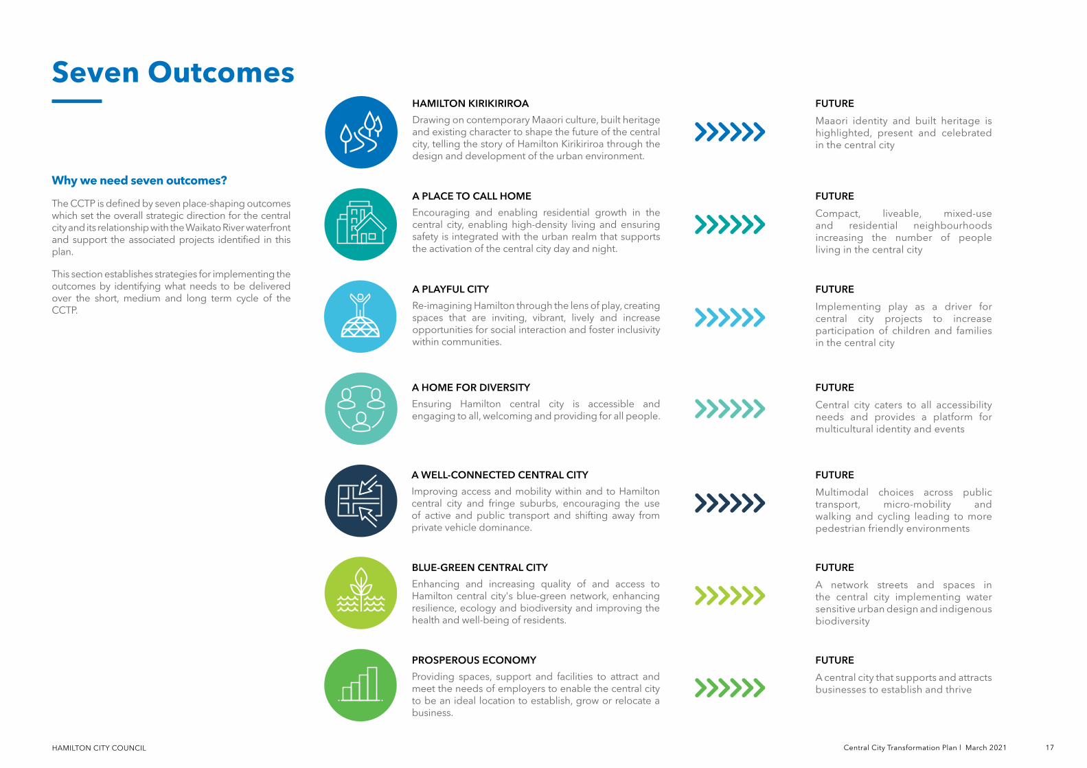
The CCTP aspires towards seven place-shaping outcomes:
• Hamilton Kirikiriroa: Drawing on contemporary Maaori culture, built heritage and existing character to shape the future of the central city, telling the story of Hamilton Kirikiriroa through the design and development of the urban environment.
• A Place to Call Home: Encouraging and enabling residential growth in the central city, ensuring high-density living and safety is integrated with the urban realm that supports the activation of the central city across the day and night.
• A Playful City: Re-imagining Hamilton through the lens of play, creating spaces that are inviting, vibrant, lively and increase opportunities for social interaction and foster inclusivity within communities.
• A Home for Diversity: Ensuring Hamilton central city is accessible and engaging to all, welcoming and providing for all people.
• A Well-connected Central City: Improving access and mobility within and to Hamilton central city and fringe suburbs, encouraging the use of active and public transport and shifting away from private vehicle dominance.
• Blue-Green Central City: Enhancing and increasing quality of and access to Hamilton central city's blue-green network, enhancing resilience, ecology and biodiversity and improving the health and well-being of residents.
• Prosperous Economy: Providing spaces, support, and facilities to attract and meet the needs of employers to enable the central city to be an ideal location to establish, grow or relocate a business.
We’re shaping a city that’s easy to live in, explore and connect. The central city will be a place where children and young people are just as welcome as adults, with time and spaces to play and meet, and safe routes and spaces for people of all ages and abilities.
People will be welcomed into lively, safe, urban communities with shared identities and public facilities such as libraries, playgrounds and community hubs. There will be more housing, more business opportunities and more events. Our city centre will be a hive of activity – day and night.
By utilising our beautiful surroundings, the central city environment will make it easy for us all to look after our mental and physical health and allow us to support biodiversity and sustainable waste management.
We can’t wait to make Hamilton even better!
Importance of iwi in the CCTPEnabling and supporting the environmental, economic and social aspirations of mana whenua is fundamental to the success of the CCTP. Embedding Maaori cultural and wellbeing considerations and the Principles of Te Tiriti o Waitangi in the development of Council strategies, plans and polices and the inclusion of Maatauranga Maaori considerations in reports and recommendations will help achieve better environmental, social, cultural and economic outcomes for all Hamiltonians.
Waikato Tainui alongside the five hapuu of Ngaati Maahanga, Ngaati Tamainupoo, Ngaati Wairere, Ngaati Korokii Kahukura and Ngaati Hauaa have traditional historic ties to Hamilton Kirikiriroa. Hamilton City Council is committed to honouring the Principles of Te Tiriti o Waitangi through a relationship with Kiingitanga, Waikato-Tainui, mana whenua and maataa waka underpinned by partnership, participation, protection and prosperity.
Engagement and working in partnership with mana whenua is instrumental to celebrating Hamilton-Hamilton Kirikiriroa's rich history, special Maaori heritage and natural environment. The city’s Maaori history and stories connecting the Waikato River, the landscape and the people can be woven into the design of spaces and places.
Through a partnership approach the natural and phsyical resources of the city can be better managed for future generations, better health and wellbeing outcomes can be realised and Maaori art, culture and te reo can be seen, celebrated and heard throughout Hamilton-Hamilton Kirikiriroa. Iwi and mana whenua already provide advice to Council on a broad range of planning and cultural issues that contribute to city growth, attract visitors, protect the city's heritage and enhance the environment. As the city and it's Maaori population grows engagement with iwi and mana whenua will only increase.
Mana whenua have economic, social, cultural and environmental interests and opportunities associated with development and urban design in Hamilton’s central city. Involvment early and regularly in projects is instrumental in protecting and enabling mana whenua and maataa waka interests in a holistic manager and facilitating long-lasting collaborative relationships.
Central City Transformation Plan l April 2021 7
Transforming the heart of Hamilton The Hamilton Central City Transformation Plan (CCTP) is an exciting 30 year vision for our central city. It brings a fresh perspective and adds new ideas to the wealth of possibilities for the central city, and builds on the last CCTP to look at what we can begin to plan for, design and implement today.
The CCTP identifies seven outcomes to create an inclusive, vibrant and prosperous central city, and also considers the opportunities and challenges and existing context for change.
The CCTP should be read in conjunction with the Hamilton City River Plan, which focuses on the Waikato River’s part in enhancing the central city, and the central city’s relationship with the river. Together these plans shape the transformation of Hamilton’s central city into the future.
What's shaping our central cityThe key drivers shaping Hamilton central city include:
• Increased population growth in Hamilton city and the Waikato region
• Aligning urban development with the National Policy Statement on Urban Development (NPSUD)
• Improving connectivity with Auckland and Tauranga (Golden Triangle) through faster and reliable regional transport options
• Celebrating the Waikato River and improving water quality and biodiversity
• Protecting and preserving existing open spaces while introducing better quality public spaces for everyone to enjoy
• Responding and improving urban resilience to climate change
• Responding to inequities such as rising unemployment and housing affordability
• Working with iwi as a key partner for shaping the central city, underpinned by te ao Maaori
• Responding to transport issues such as access, congestion and safety to ensure a sustainable transport system
• Encouraging getting around the central city through
pedestrian and cyclist-friendly mode shifts
• Infrastructure costs and planning infrastructure requirements for the future
• Responding to ongoing regional competitiveness and enhancing opportunities for business and tourism
What's newThe last CCTP, created in 2015, included key projects such as Victoria on the River which have helped transform the central city into a vibrant, prosperous hub.
But over the last six years the central city has changed. Residential populations are on the rise, and significant investment has gone into infrastructure and development projects.
The CCTP 2021 refocuses and refines the CCTP 2015 to establish a new vision and outcomes to successfully guide transformation of the central city. The plan:
• Has mana whenua and te ao Maaori present as a key driver for outcomes and reflected in its values and principles
• Remains focused on ‘people first’, with a continuing conversation around increasing economic prosperity for Hamiltonians to benefit from, and contribute to
• Shows where change needs to occur and how everything fits together as a transformation programme to invest in
• Supports and uses a 20-minute neighbourhood concept as a guiding principle for access to and around the central city
• Sees social, cultural and environmental wellbeings as significant as economic wellbeing
Assumptions The plan is based on the following assumptions:
• An increase in central city workers
• Increased demand for housing in the central city
• Adequate stormwater, wastewater infrastructure and water supply for the central city
• Alignment with the Access Hamilton Transport Strategy (as it is developed)
Introduction
Part A Introduction
HAMILTON CITY COUNCIL
Part A Introduction
Strategic Context
Four WellbeingsThe Four Wellbeings take a broad role in promoting the social, economic, environment and cultural wellbeing of communities and embedding a sustainable development approach. The CCTP recognises the four wellbeings - social, economic, environment and cultural – for communities, and the Council’s role in lifting people’s quality of life and improving the health of our environment.
Hamilton Waikato Metropolitan Spatial PlanThe Hamilton Waikato Metropolitan Spatial Plan (MSP) is a vision and framework for how Hamilton City and the neighbouring communities within Waipaa and Waikato districts will grow and develop over the next 100 + years. The plan identifies Hamilton central city as the regional centre for the metro area. A regional centre’s role is defined as “a primary commercial, employment, recreational and civic hub with a strong residential function which is provided at a regional scale.” It has the greatest diversity, scale and intensity of activities in the metro area.
A 20-Minute CityA 20-minute city is about creating livable neighbourhoods with local access to amenity that is important to residents. It’s also about linking existing destinations, facilities, places of work and education with safe walking, cycling and public transport connections so our residents can safely access most of the things they need within 20 minutes.
For the CCTP, this means considering how people access and move around the central city as well as planning for new inner city neighbourhoods that support livability, community and wellbeing. Given the central city is located within many Hamiltonians' 20-minute catchment, well located, reliable, efficient transport and networks are important.
Long Term PlanThe Long Term Plan (LTP) sets out five, long-term priorities for Hamilton over the next decade, reflecting what the Hamilton community has said is important to them, their families and neighbourhoods.
1. Shaping a city that's easy to live in2. Shaping a city where people thrive3. Shaping a central city where people love to be4. Shaping a fun city with lots to do5. Shaping a green city
While the LTP timeframe of 10 years is shorter than the CCTP timeframe of 30 years, it is important to recognise the alignment and ongoing influence of both of these plans for the central city.
He Pou Manawa Ora - Pillars of WellbeingThe He Pou Manawa Ora – Pillars of Wellbeing is a strategy which outlines Hamilton City Council's vision for a city that celebrates its special Maaori heritage, rich history, natural environmental wonders and ensures everyone has a voice in developing its future. The pillars are:
1. History2. Unity3. Prosperity4. Restoration
Its aim is to use these pillars to build a proud and inclusive city for the wellbeing of all its people, while recognising the special relationship that Iwi and mana whenua have to Hamilton Kirikiriroa. The CCTP reflects this in our outcomes to enhance the Hamiltonian heritage and identity.
It has been funded though Council's 2020/21 Annual Plan and developed with input from local Iwi, hapuu, maataa waka (Urban Maaori), Council's Maangai Maaori (Maaori representatives), Waikato-Tainui, Te Haa O te Whenua O Kirikiriroa and Te Rūnanga Ō Kirikiriroa.
HAMILTON CITY COUNCIL 10 Central City Transformation Plan l April 2021
Existing Context
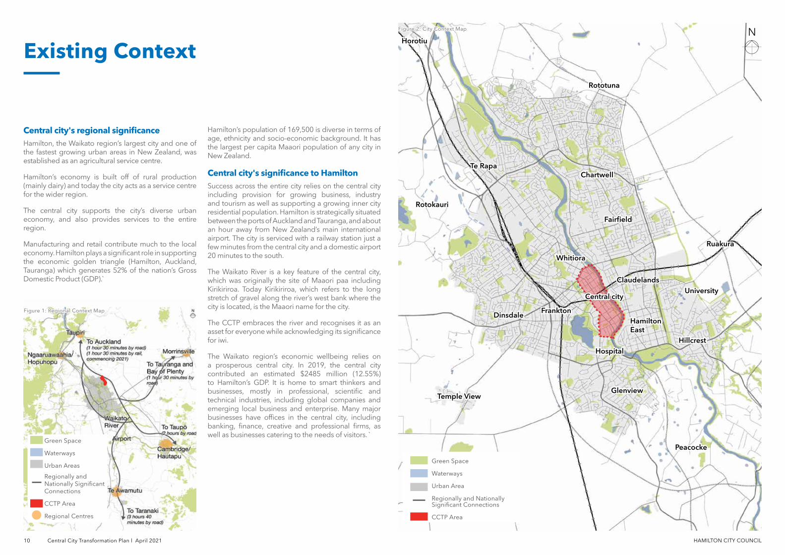
Figure 1: Figure 1: Regional Context MapRegional Context Map
Figure 2: Figure 2: City Context MapCity Context Map
Green Space
Waterways
Urban Area
Regionally and Nationally Significant Connections
CCTP Area
HorotiuHorotiu
RotokauriRotokauri
Te RapaTe Rapa
RototunaRototuna
ChartwellChartwell
FairfieldFairfield
Central cityCentral city
FranktonFrankton
RuakuraRuakura
PeacockePeacocke
HospitalHospital
UniversityUniversity
WhitioraWhitiora
ClaudelandsClaudelands
Hamilton Hamilton EastEast
Green Space
Waterways
Urban Areas
Regionally and Nationally Significant Connections
CCTP Area
Regional Centres
Central city's regional significanceHamilton, the Waikato region’s largest city and one of the fastest growing urban areas in New Zealand, was established as an agricultural service centre.
Hamilton’s economy is built off of rural production (mainly dairy) and today the city acts as a service centre for the wider region.
The central city supports the city’s diverse urban economy, and also provides services to the entire region.
Manufacturing and retail contribute much to the local economy. Hamilton plays a significant role in supporting the economic golden triangle (Hamilton, Auckland, Tauranga) which generates 52% of the nation’s Gross Domestic Product (GDP).`
Hamilton’s population of 169,500 is diverse in terms of age, ethnicity and socio-economic background. It has the largest per capita Maaori population of any city in New Zealand.
Central city's significance to HamiltonSuccess across the entire city relies on the central city including provision for growing business, industry and tourism as well as supporting a growing inner city residential population. Hamilton is strategically situated between the ports of Auckland and Tauranga, and about an hour away from New Zealand’s main international airport. The city is serviced with a railway station just a few minutes from the central city and a domestic airport 20 minutes to the south.
The Waikato River is a key feature of the central city, which was originally the site of Maaori paa including Kirikiriroa. Today Kirikiriroa, which refers to the long stretch of gravel along the river’s west bank where the city is located, is the Maaori name for the city.
The CCTP embraces the river and recognises it as an asset for everyone while acknowledging its significance for iwi.
The Waikato region’s economic wellbeing relies on a prosperous central city. In 2019, the central city contributed an estimated $2485 million (12.55%) to Hamilton’s GDP. It is home to smart thinkers and businesses, mostly in professional, scientific and technical industries, including global companies and emerging local business and enterprise. Many major businesses have offices in the central city, including banking, finance, creative and professional firms, as well as businesses catering to the needs of visitors. `
Temple ViewTemple ViewGlenviewGlenview
DinsdaleDinsdale
HillcrestHillcrest
HAMILTON CITY COUNCIL Central City Transformation Plan l April 2021 11
Existing Context Map
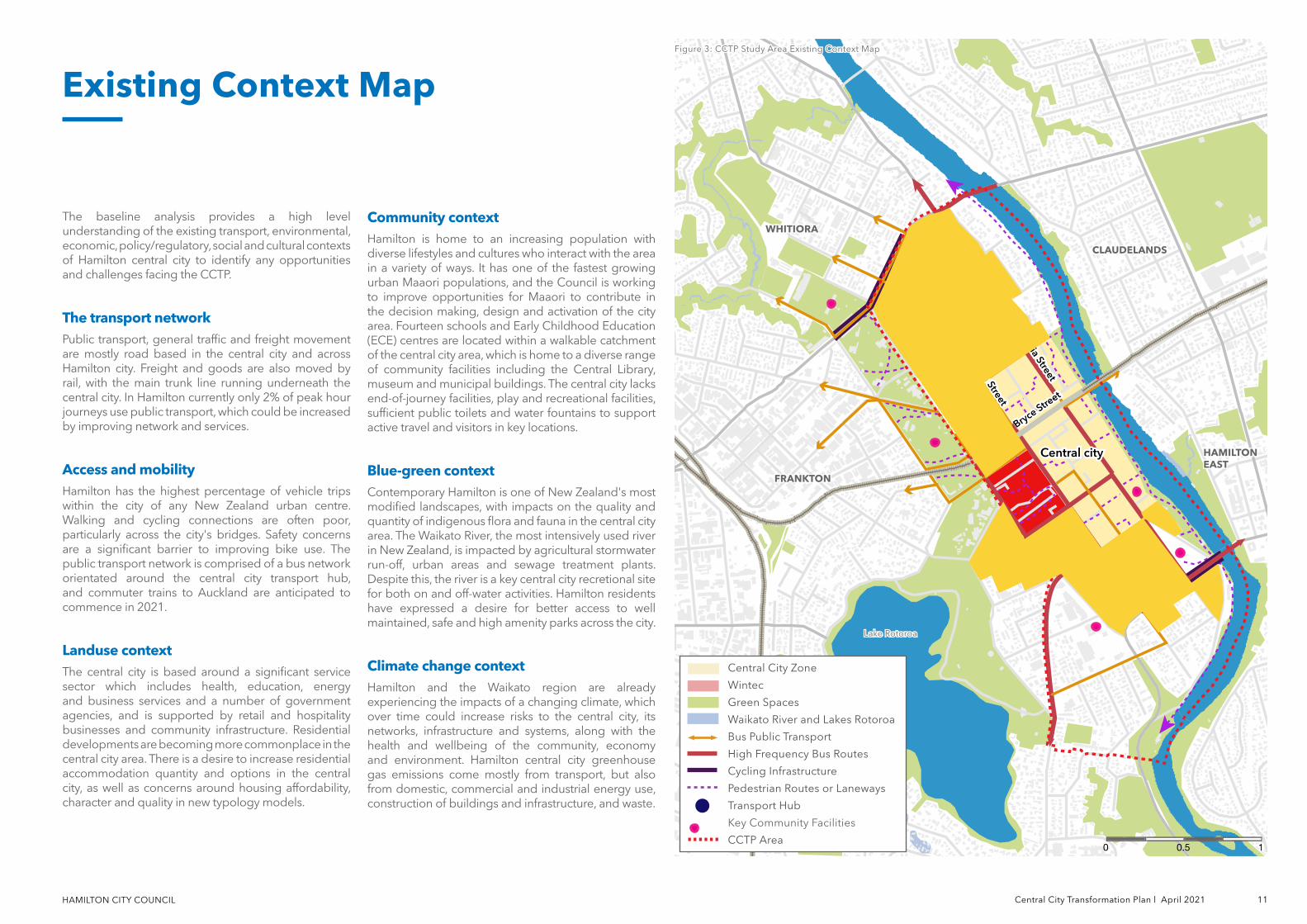
The baseline analysis provides a high level understanding of the existing transport, environmental, economic, policy/regulatory, social and cultural contexts of Hamilton central city to identify any opportunities and challenges facing the CCTP.
The transport networkPublic transport, general traffic and freight movement are mostly road based in the central city and across Hamilton city. Freight and goods are also moved by rail, with the main trunk line running underneath the central city. In Hamilton currently only 2% of peak hour journeys use public transport, which could be increased by improving network and services.
Access and mobilityHamilton has the highest percentage of vehicle trips within the city of any New Zealand urban centre. Walking and cycling connections are often poor, particularly across the city's bridges. Safety concerns are a significant barrier to improving bike use. The public transport network is comprised of a bus network orientated around the central city transport hub, and commuter trains to Auckland are anticipated to commence in 2021.
Landuse contextThe central city is based around a significant service sector which includes health, education, energy and business services and a number of government agencies, and is supported by retail and hospitality businesses and community infrastructure. Residential developments are becoming more commonplace in the central city area. There is a desire to increase residential accommodation quantity and options in the central city, as well as concerns around housing affordability, character and quality in new typology models.
Community contextHamilton is home to an increasing population with diverse lifestyles and cultures who interact with the area in a variety of ways. It has one of the fastest growing urban Maaori populations, and the Council is working to improve opportunities for Maaori to contribute in the decision making, design and activation of the city area. Fourteen schools and Early Childhood Education (ECE) centres are located within a walkable catchment of the central city area, which is home to a diverse range of community facilities including the Central Library, museum and municipal buildings. The central city lacks end-of-journey facilities, play and recreational facilities, sufficient public toilets and water fountains to support active travel and visitors in key locations.
Blue-green contextContemporary Hamilton is one of New Zealand's most modified landscapes, with impacts on the quality and quantity of indigenous flora and fauna in the central city area. The Waikato River, the most intensively used river in New Zealand, is impacted by agricultural stormwater run-off, urban areas and sewage treatment plants. Despite this, the river is a key central city recretional site for both on and off-water activities. Hamilton residents have expressed a desire for better access to well maintained, safe and high amenity parks across the city.
Climate change context Hamilton and the Waikato region are already experiencing the impacts of a changing climate, which over time could increase risks to the central city, its networks, infrastructure and systems, along with the health and wellbeing of the community, economy and environment. Hamilton central city greenhouse gas emissions come mostly from transport, but also from domestic, commercial and industrial energy use, construction of buildings and infrastructure, and waste.
Figure 3: Figure 3: CCTP Study Area Existing Context MapCCTP Study Area Existing Context Map
Central cityCentral city
Victoria Street
Victoria Street
Anglesea Street
Anglesea Street
Tristram Street
Tristram Street Bryce Stre
et
Bryce Street
Central City Zone
Wintec
Green Spaces
Waikato River and Lakes Rotoroa
Bus Public Transport
High Frequency Bus Routes
Cycling Infrastructure
Pedestrian Routes or Laneways
Transport Hub
Key Community Facilities
CCTP Area10.50
FRANKTONFRANKTON
WHITIORAWHITIORA
Lake RotoroaLake Rotoroa
CLAUDELANDSCLAUDELANDS
HAMILTON HAMILTON EASTEAST
HAMILTON CITY COUNCIL 12 Central City Transformation Plan l April 2021
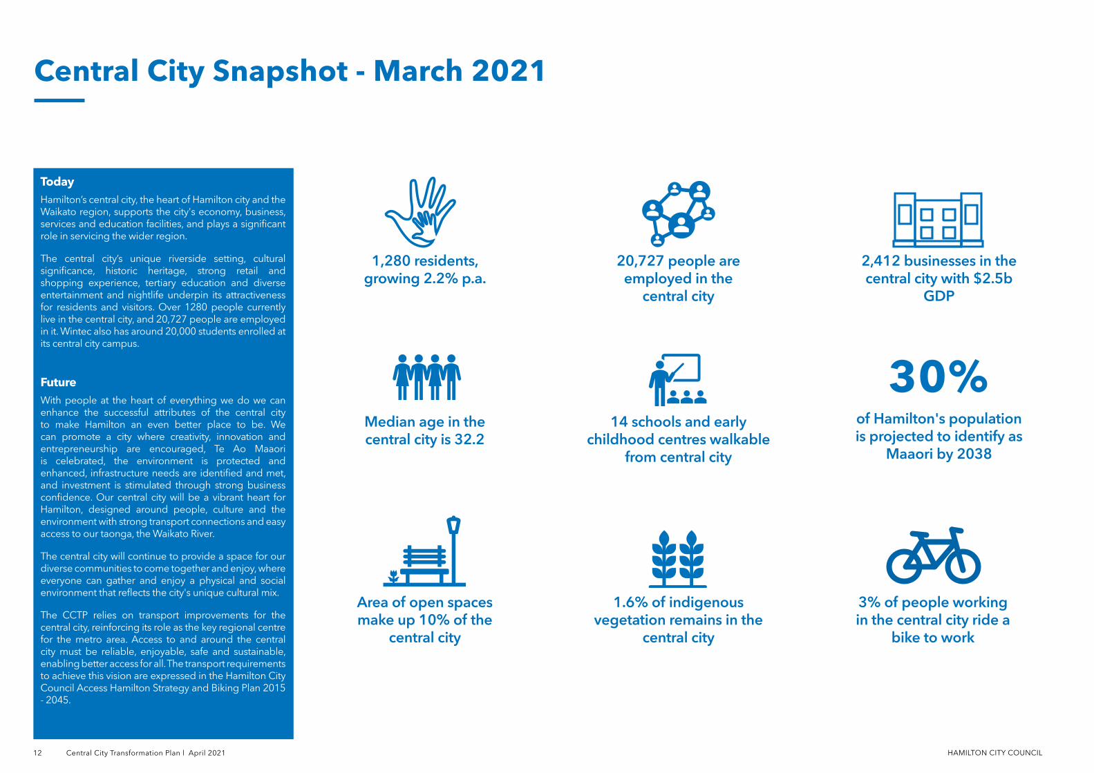
TodayHamilton’s central city, the heart of Hamilton city and the Waikato region, supports the city's economy, business, services and education facilities, and plays a significant role in servicing the wider region.
The central city’s unique riverside setting, cultural significance, historic heritage, strong retail and shopping experience, tertiary education and diverse entertainment and nightlife underpin its attractiveness for residents and visitors. Over 1280 people currently live in the central city, and 20,727 people are employed in it. Wintec also has around 20,000 students enrolled at its central city campus.
FutureWith people at the heart of everything we do we can enhance the successful attributes of the central city to make Hamilton an even better place to be. We can promote a city where creativity, innovation and entrepreneurship are encouraged, Te Ao Maaori is celebrated, the environment is protected and enhanced, infrastructure needs are identified and met, and investment is stimulated through strong business confidence. Our central city will be a vibrant heart for Hamilton, designed around people, culture and the environment with strong transport connections and easy access to our taonga, the Waikato River.
The central city will continue to provide a space for our diverse communities to come together and enjoy, where everyone can gather and enjoy a physical and social environment that reflects the city's unique cultural mix.
The CCTP relies on transport improvements for the central city, reinforcing its role as the key regional centre for the metro area. Access to and around the central city must be reliable, enjoyable, safe and sustainable, enabling better access for all. The transport requirements to achieve this vision are expressed in the Hamilton City Council Access Hamilton Strategy and Biking Plan 2015 - 2045.
Central City Snapshot - March 2021
1,280 residents, growing 2.2% p.a.
Median age in the central city is 32.2
Area of open spaces make up 10% of the
central city
2,412 businesses in the central city with $2.5b
GDP
of Hamilton's population is projected to identify as
Maaori by 2038
1.6% of indigenous vegetation remains in the
central city
20,727 people are employed in the
central city
14 schools and early childhood centres walkable
from central city
3% of people working in the central city ride a
bike to work
30%
HAMILTON CITY COUNCIL Central City Transformation Plan l April 2021 13
Legend
CBD Intensification/Core
Victoria Street Heritage Precinct
Potential Mixed-Use and/or High Density Development
Proposed Ferrybank and Theatre Development
Potential Green Connections
Existing Visual Connectivity to the River
Existing Shared Street
Potential Shared Street
Priority Corridors for Mixed Mode Transport
Existing Rail Line under Central city
CCTP Area
Transport Centre
Challenges and Opportunities
Kilometers
10.50
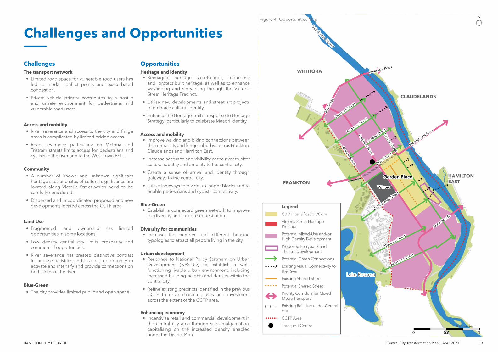
Figure 4: Opportunities Map
Garden PlaceGarden Place
WintecWintec
Victoria Street
Victoria Street
Anglesea Street
Anglesea Street
Tristram Street
Tristram Street Bryce Stre
et
Bryce Street
Lake RotoroaLake Rotoroa
HAMILTON HAMILTON EASTEASTFRANKTONFRANKTON
WHITIORAWHITIORA
CLAUDELANDSCLAUDELANDS
Waikato River
Waikato River
ChallengesThe transport network
• Limited road space for vulnerable road users has led to modal conflict points and exacerbated congestion.
• Private vehicle priority contributes to a hostile and unsafe environment for pedestrians and vulnerable road users.
Access and mobility• River severance and access to the city and fringe
areas is complicated by limited bridge access.
• Road severance particularly on Victoria and Tristram streets limits access for pedestrians and cyclists to the river and to the West Town Belt.
Community• A number of known and unknown significant
heritage sites and sites of cultural significance are located along Victoria Street which need to be carefully considered.
• Dispersed and uncoordinated proposed and new developments located across the CCTP area.
Land Use• Fragmented land ownership has limited
opportunities in some locations.
• Low density central city limits prosperity and commercial opportunities.
• River severance has created distinctive contrast in landuse activities and is a lost opportunity to activate and intensify and provide connections on both sides of the river.
Blue-Green• The city provides limited public and open space.
OpportunitiesHeritage and identity
• Reimagine heritage streetscapes, repurpose and protect built heritage, as well as to enhance wayfinding and storytelling through the Victoria Street Heritage Precinct.
• Utilise new developments and street art projects to embrace cultural identity.
• Enhance the Heritage Trail in response to Heritage Strategy, particularly to celebrate Maaori identity.
Access and mobility• Improve walking and biking connections between
the central city and fringe suburbs such as Frankton, Claudelands and Hamilton East.
• Increase access to and visibility of the river to offer cultural identity and amenity to the central city.
• Create a sense of arrival and identity through gateways to the central city.
• Utilise laneways to divide up longer blocks and to enable pedestrians and cyclists connectivity.
Blue-Green• Establish a connected green network to improve
biodiversity and carbon sequestration.
Diversity for communities• Increase the number and different housing
typologies to attract all people living in the city.
Urban development• Response to National Policy Statment on Urban
Development (NPS-UD) to establish a well-functioning livable urban environment, including increased building heights and density within the central city.
• Refine existing precincts identified in the previous CCTP to drive character, uses and investment across the extent of the CCTP area.
Enhancing economy• Incentivise retail and commercial development in
the central city area through site amalgamation, capitalising on the increased density enabled under the District Plan.
Anzac Parade
Anzac Parade
Collingwood Stre
et
Collingwood Stre
et
London Street
London Street
Claudelands Road
Claudelands Road
Boundary RoadBoundary Road
Mill
Stre
et
Mill
Stre
et
Palmerston Street
Palmerston Street
Restrevor S
treet
Restrevor S
treetLiverpool S
treet
Liverpool Stre
et
Clarence Street
Clarence Street
Part B Vision and Outcomes
HAMILTON CITY COUNCIL
CCTP 2021 Vision
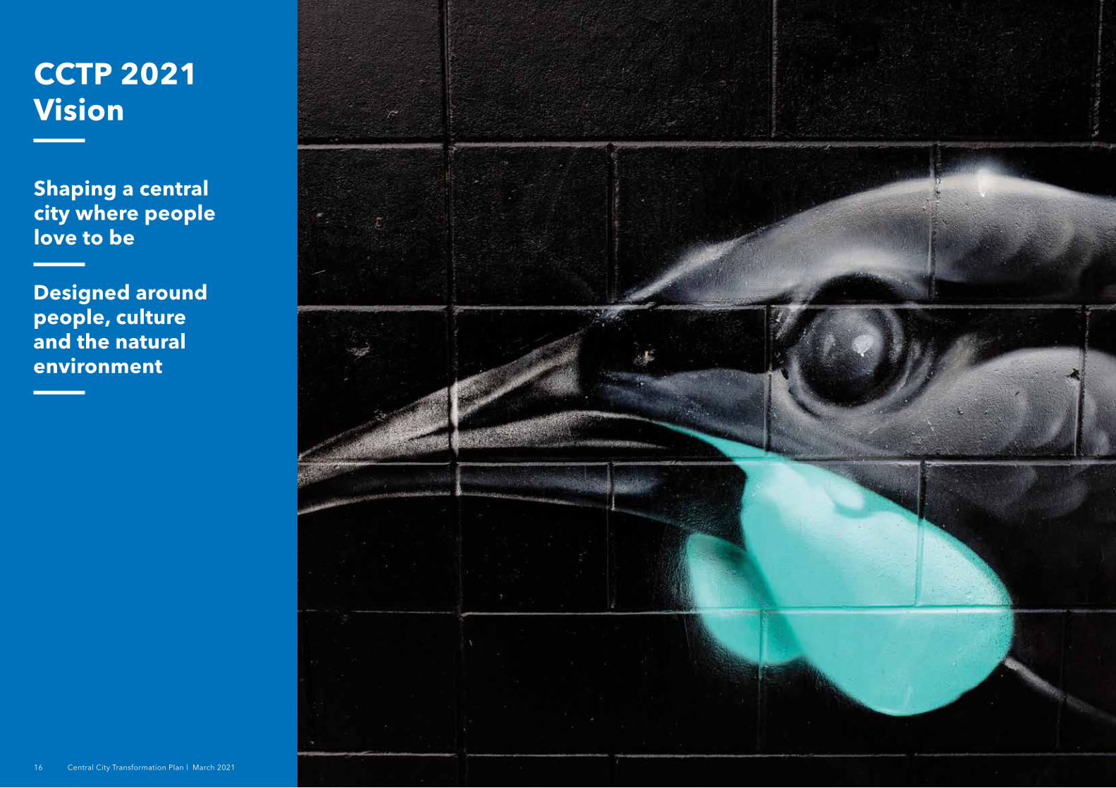
Shaping a central city where people love to be
Designed around people, culture and the natural environment
16 Central City Transformation Plan l March 2021
HAMILTON CITY COUNCIL Central City Transformation Plan l March 2021 17
A WELL-CONNECTED CENTRAL CITY
Improving access and mobility within and to Hamilton central city and fringe suburbs, encouraging the use of active and public transport and shifting away from private vehicle dominance.
BLUE-GREEN CENTRAL CITY
Enhancing and increasing quality of and access to Hamilton central city's blue-green network, enhancing resilience, ecology and biodiversity and improving the health and well-being of residents.
PROSPEROUS ECONOMY
Providing spaces, support and facilities to attract and meet the needs of employers to enable the central city to be an ideal location to establish, grow or relocate a business.
A HOME FOR DIVERSITY
Ensuring Hamilton central city is accessible and engaging to all, welcoming and providing for all people.
A PLAYFUL CITY
Re-imagining Hamilton through the lens of play, creating spaces that are inviting, vibrant, lively and increase opportunities for social interaction and foster inclusivity within communities.
A PLACE TO CALL HOME
Encouraging and enabling residential growth in the central city, enabling high-density living and ensuring safety is integrated with the urban realm that supports the activation of the central city day and night.
HAMILTON KIRIKIRIROA
Drawing on contemporary Maaori culture, built heritage and existing character to shape the future of the central city, telling the story of Hamilton Kirikiriroa through the design and development of the urban environment.
Seven Outcomes
Why we need seven outcomes?
The CCTP is defined by seven place-shaping outcomes which set the overall strategic direction for the central city and its relationship with the Waikato River waterfront and support the associated projects identified in this plan.
This section establishes strategies for implementing the outcomes by identifying what needs to be delivered over the short, medium and long term cycle of the CCTP.
FUTURE
Maaori identity and built heritage is highlighted, present and celebrated in the central city
FUTURE
Implementing play as a driver for central city projects to increase participation of children and families in the central city
FUTURE
Central city caters to all accessibility needs and provides a platform for multicultural identity and events
FUTURE
Multimodal choices across public transport, micro-mobility and walking and cycling leading to more pedestrian friendly environments
FUTURE
A network streets and spaces in the central city implementing water sensitive urban design and indigenous biodiversity
FUTURE
A central city that supports and attracts businesses to establish and thrive
FUTURE
Compact, liveable, mixed-use and residential neighbourhoods increasing the number of people living in the central city
HAMILTON CITY COUNCIL 18 Central City Transformation Plan l April 2021
Actively recognising and celebrating the unique cultural and built heritage of Hamilton central city is key to shaping the place identity of Hamilton Kirikiriroa. While Pasifikaa and European heritage is a dominant part of the Hamilton Kirikiriroa identity, Maaori, the taangata whenua of Hamilton Kirikiriroa is key to driving this outcome through partnership with Council to shape places and spaces that build on the long term identity of Hamilton Kirikiriroa.
Identification and appropriate acknowledgment of built heritage and archaeological sites will help us all recognise and realise Hamilton Kirikiriroa's past, present and future. It is an opportunity to bring all people of Hamilton Kirikiriroa together for mutual benefit and to ensure Maaori, along with all Hamiltonians are a key part of that voice. The celebration of Maaori names, through places, events, resources and articulating the role of taangata whenua is also a critical component of making sense of place connections and for the development of broader understanding and identity through honouring key figures, places, associations and practices.
The CCTP will shape the future by looking to the past, drawing on Te Ao Maaori world views, built heritage and existing character through the design and development of the public realm to tell the story of Hamilton Kirikiriroa and shape the future identity of the central city.
WHAT WE WANT TO ACHIEVE:
• Enhance and shape the identity of the central city to be long lasting and representative of people and place.
• Promote a prosperous, authentic and visible Maaori culture in the central city through increased products, services and employment.
• Deliver engaging spaces and public realm that increase the number of people using and engaging with the central city.
• Encourage retention of adaptive reuse of built heritage in the central city.
HOW WE CAN ACHIEVE THIS:
• Increase the use of Te reo Maaori within our central city.
• Plan for Maaori focused facilities and cultural tourism.
• Enhance environmental design outcomes harnessing maatauranga Maaori with a focus on the recognition of the Waikato River as taonga.
• Adopt cultural design considerations unique to Hamilton Kirikiriroa which is founded in Maaori design and engagement that puts Maaori at the centre of planning and design.
• Plan for places and spaces that are welcoming and designed for tamariki and young whaanau to kaumaatua.
• Increase the number of events, festivals and opportunities for community gathering.
Hamilton Kirikiriroa
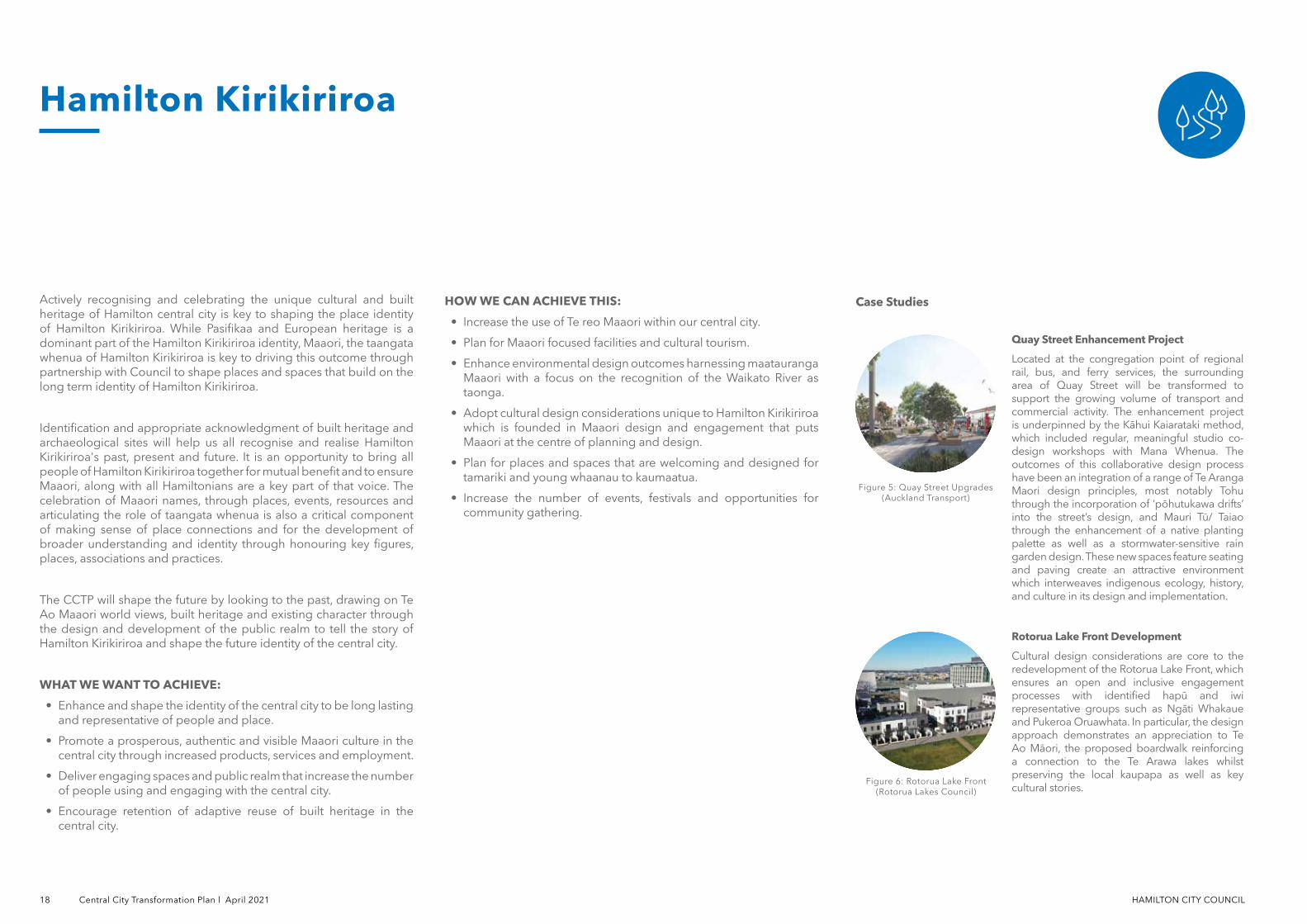
Rotorua Lake Front Development
Cultural design considerations are core to the redevelopment of the Rotorua Lake Front, which ensures an open and inclusive engagement processes with identified hapū and iwi representative groups such as Ngāti Whakaue and Pukeroa Oruawhata. In particular, the design approach demonstrates an appreciation to Te Ao Māori, the proposed boardwalk reinforcing a connection to the Te Arawa lakes whilst preserving the local kaupapa as well as key cultural stories.
Quay Street Enhancement Project
Located at the congregation point of regional rail, bus, and ferry services, the surrounding area of Quay Street will be transformed to support the growing volume of transport and commercial activity. The enhancement project is underpinned by the Kāhui Kaiarataki method, which included regular, meaningful studio co-design workshops with Mana Whenua. The outcomes of this collaborative design process have been an integration of a range of Te Aranga Maori design principles, most notably Tohu through the incorporation of ‘pōhutukawa drifts’ into the street’s design, and Mauri Tū/ Taiao through the enhancement of a native planting palette as well as a stormwater-sensitive rain garden design. These new spaces feature seating and paving create an attractive environment which interweaves indigenous ecology, history, and culture in its design and implementation.
Case Studies
Figure 6: Rotorua Lake Front (Rotorua Lakes Council)
Figure 5: Quay Street Upgrades (Auckland Transport)

HAMILTON CITY COUNCIL Central City Transformation Plan l April 2021 19
Figure 7: Acknowledgment of significant paa sites, shaped through engagement with taangata whenua is essential in developing central city's identity.
SHORT-TERM:
• Regular forum for engagement on CCTP and relevant strategies with taangata whenua.
• Work closely with taangata whenua to identify sites of significance within the central city and undertake plan changes if needed.
• Develop and implement our Nature in the City Strategy and indigenous planting guidelines alongside iwi - working in partnership to increase native planting throughout the city and to restore and protect the health of the river through Green Streets.
• Plan and implement stage one of the city wide cultural trail with iwi that connects and celebrates Hamilton Kirikiriroa.
• Celebrate local Maaori history/stories and archaeological sites throughout the city by engaging with taangata whenua on how to embed and celebrate these within the built environment.
• Create Maaori Design Principles for matauranga Maaori for developments in the central city.
MEDIUM-TERM:
• Work with taangata whenua to create a forum for Maaori design and review for the central city.
• Celebrate and enhance our built heritage including the Victoria Heritage Precinct and heritage buildings.
LONG-TERM:
• Plan and implement stage two of the city wide cultural trail with iwi that connects and celebrates Hamilton Kirikiriroa.
• Water sensitive urban design and native planting upgrades to streets.
• Plan for and support ongoing kaitiaki for river, streets and open spaces.
• Create formal process and systems alongside tangata whenua for co-designing with Maaori for projects within the central city.
Figure 8: Strengthening the presence of built heritages in the central city. Celebrating historical heritage and cultural importances to develope a sense of place.
Hamilton KirikiriroaFigure 9: Built Heritage and Archaeological SitesFigure 9: Built Heritage and Archaeological Sites
Lake RotoroaLake Rotoroa
Liverpool St
Liverpool St
Bryce St
Bryce St
Palmerston St
Palmerston St
HAMILTON EASTHAMILTON EAST
FRANKTONFRANKTON
WHITIORAWHITIORA CLAUDELANDSCLAUDELANDS
Collingwood St
Collingwood St
Waikato River
Waikato River
10.50
Garden PlaceGarden PlaceTristram
St
Tristram St
Anglesea St
Anglesea St
Victoria St
Victoria St
*Hamilton City Council District Plan Historic Heritage Schedule 8
Legend
Potential Central City Cultural Trail
Potential Hamilton Kirikiriroa Cultural Trail
Built Heritage - Rank A*
Built Heritage - Rank B*
Archaeological Sites - Group 1*
Arhcaeological Sites - Group 2*
Native Revegetation
Potential Green Streets
Anzac Parade
Anzac Parade
Clarence St
Clarence St
HAMILTON CITY COUNCIL 20 Central City Transformation Plan l April 2021
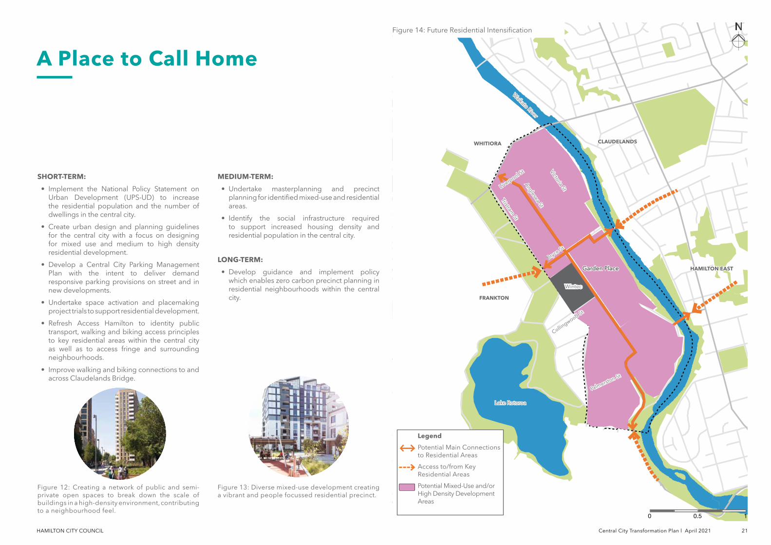
The CCTP study area is currently home to 1,280 residents, with 169,500 residents in the wider Hamilton city area. Increasing the number of people living in the central city, and providing great places and services to support them is a key driver for Council.
It is also important to provide our communities and neighbourhoods with their needs and wants within close proximity, as well as supporting opportunities for different typologies and tenure to improve housing affordability.
In addition to an increasing residential population, it is also expected this increase will change the demographic profile of the central city. Traditionally, residential accommodation has been located on the periphery and fringe of the central city. A key part of the CCTP will be to locate and design for potential new residential areas that help support the activation of the central city.
WHAT WE WANT TO ACHIEVE:
• Increase in the number of residential dwellings and residential population in the central city.
• Increase housing supply and improve housing affordability through encouragement of a range of housing typologies within the central city.
• Plan for community and social infrastructure that reflects the diverse needs of central city residents and which supports the activation of the central city across day and night.
• Encourage retention and adaptive reuse of built heritage in the central city.
• Neighbourhoods are designed in ways that are welcoming, feels safe and easy to navigate.
HOW WE CAN ACHIEVE THIS:
• Encourage and enable new mixed use development and high density residential development throughout the central city.
• Increase central city community and social infrastructure, open space and amenity to provide for the needs of residents.
• Ensuring the right regulatory frameworks and design guidelines in place to enable a vibrant, safe and accessible central city during the day and night.
• Plan and design existing and new developments guided by Crime Prevention Through Environmental Design (CPTED) principles from the start to prevent potential safety risks.
• Improve connections to fringe areas where residential intensification will occur.
• Shape guidance for increased residential density based on the key documents such as National Policy Statement-Urban Development District Plan Change, Housing Strategy and Metropolitan Spatial Plan.
A Place to Call Home
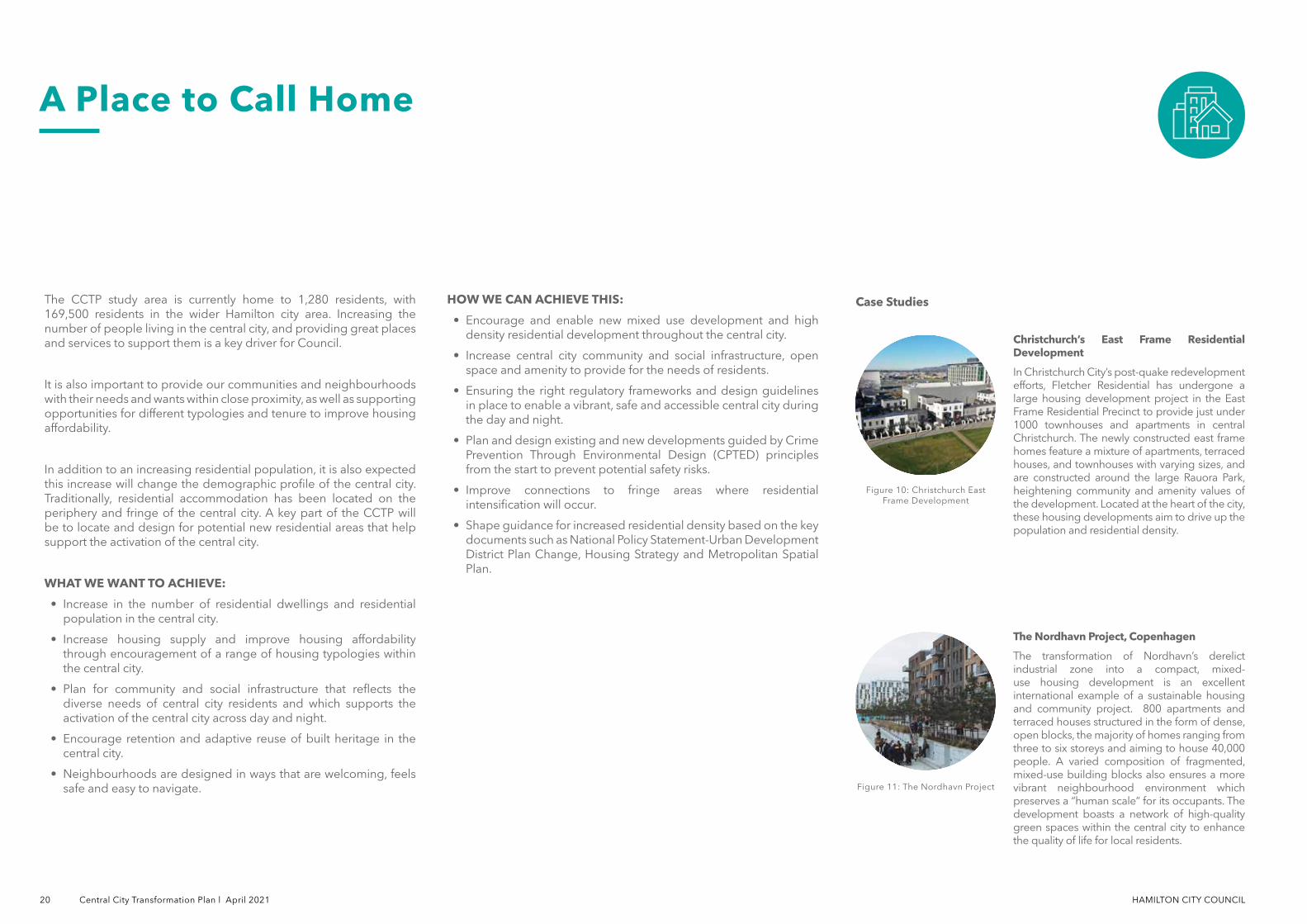
The Nordhavn Project, Copenhagen
The transformation of Nordhavn’s derelict industrial zone into a compact, mixed-use housing development is an excellent international example of a sustainable housing and community project. 800 apartments and terraced houses structured in the form of dense, open blocks, the majority of homes ranging from three to six storeys and aiming to house 40,000 people. A varied composition of fragmented, mixed-use building blocks also ensures a more vibrant neighbourhood environment which preserves a “human scale” for its occupants. The development boasts a network of high-quality green spaces within the central city to enhance the quality of life for local residents.
Figure 11: The Nordhavn Project
Figure 10: Christchurch East Frame Development
Case Studies
Christchurch’s East Frame Residential Development
In Christchurch City’s post-quake redevelopment efforts, Fletcher Residential has undergone a large housing development project in the East Frame Residential Precinct to provide just under 1000 townhouses and apartments in central Christchurch. The newly constructed east frame homes feature a mixture of apartments, terraced houses, and townhouses with varying sizes, and are constructed around the large Rauora Park, heightening community and amenity values of the development. Located at the heart of the city, these housing developments aim to drive up the population and residential density.
HAMILTON CITY COUNCIL Central City Transformation Plan l April 2021 21
A Place to Call Home
SHORT-TERM:
• Implement the National Policy Statement on Urban Development (UPS-UD) to increase the residential population and the number of dwellings in the central city.
• Create urban design and planning guidelines for the central city with a focus on designing for mixed use and medium to high density residential development.
• Develop a Central City Parking Management Plan with the intent to deliver demand responsive parking provisions on street and in new developments.
• Undertake space activation and placemaking project trials to support residential development.
• Refresh Access Hamilton to identity public transport, walking and biking access principles to key residential areas within the central city as well as to access fringe and surrounding neighbourhoods.
• Improve walking and biking connections to and across Claudelands Bridge.
MEDIUM-TERM:
• Undertake masterplanning and precinct planning for identified mixed-use and residential areas.
• Identify the social infrastructure required to support increased housing density and residential population in the central city.
LONG-TERM:
• Develop guidance and implement policy which enables zero carbon precinct planning in residential neighbourhoods within the central city.
Figure 13: Diverse mixed-use development creating a vibrant and people focussed residential precinct.
Figure 12: Creating a network of public and semi-private open spaces to break down the scale of buildings in a high-density environment, contributing to a neighbourhood feel.
WintecWintec
Lake RotoroaLake Rotoroa
Anglesea St
Anglesea St
Liverpool St
Liverpool St
Bryce St
Bryce St
Palmerston St
Palmerston St
Tristram St
Tristram St
Victoria St
Victoria St
HAMILTON EASTHAMILTON EAST
FRANKTONFRANKTON
WHITIORAWHITIORA CLAUDELANDSCLAUDELANDS
Garden PlaceGarden Place
Waikato River
Waikato River
Collingwood St
Collingwood St
10.50
Figure 14: Future Residential IntensificationFigure 14: Future Residential Intensification
Legend
Potential Main Connections to Residential Areas
Access to/from Key Residential Areas
Potential Mixed-Use and/or High Density Development Areas
HAMILTON CITY COUNCIL 22 Central City Transformation Plan l April 2021
Providing opportunities for play within the public realm promotes people and community physical and mental wellbeing. Studies have also shown that where there are opportunities to play or for recreational activities, people are more likely to gather which can have positive economic benefits for surrounding businesses.
Embedding play within our central city environment will promote active street life, foster social connections and encourage communities which are more likely to actively participate in their neighbourhoods.
WHAT WE WANT TO ACHIEVE:
• Hamilton Central City is known as the most playful urban environment in New Zealand.
• Safe, connected and exciting play and recreation opportunities are accessible to all ages and abilities.
• Increase number of formal play spaces in the central city, particularly connecting the river edge and the opportunities for interactive play spaces.
• Increase opportunities for pop-up play and place activation that is free or comes with minimal cost.
• Investment in parks, streets, education and public spaces reflect the needs of all ages and abilities.
• Encourage play fields to offer informal and formal recreation and exercise opportunities as well as to provide community benefits.
HOW WE CAN ACHIEVE THIS:
• Encourage developers to consider embedding play and recreational aspects in their designs through the use of design guidelines.
• Investment in public space and public realm that improves how people interact and play there.
• Increased opportunities for play and recreation that is free or comes with minimal cost.
• Investment in public space and public realm that improves amenity provsion, how people interact and play there.
• Change how we plan for traffic to make streets and general infrastructure as an extension of public spaces as well as integrate play and recreation design whenever it is suitable.
• Encouraging future public space projects to embed playful features.
A Playful City
Bicentennial Children’s Park, Chile
Utilising the old agricultural canal traversing through the foot of the San Cristobal Hill, the Bicentennial Children’s Park provides an accessible and safe playground featuring treehouses, swings, water forests, and 60 toboggans. The park design innovatively optimises the topography using playful climbing structures to the top of the tree canopy, creating a play experience that fosters exploration and discovery for children. Central to the design is the safety consideration, ensuring the creation of a public space which had sufficient height to be exciting without threatening children’s safety.
Figure 16: Barcelona Superblock Model
Figure 15: Bicentennial Children's Park
Case Studies
Barcelona Superblock Model
Barcelona’s Superblock strategy is a radical response to the city’s scarce green spaces as well as issues of safety and pollution. The strategy restricts vehicular traffic to primary roads around 400m-by-400m city blocks, reclaiming internal streets as safe “citizen spaces” and activating recreation opportunities for its residents. For Barcelona, the definition of play encompasses the use of open spaces for all ages.
HAMILTON CITY COUNCIL Central City Transformation Plan l April 2021 23
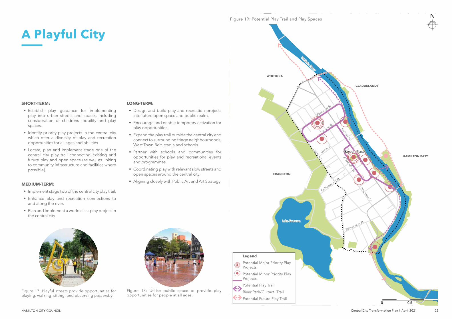
A Playful City
SHORT-TERM:
• Establish play guidance for implementing play into urban streets and spaces including consideration of childrens mobility and play spaces.
• Identify priority play projects in the central city which offer a diversity of play and recreation opportunities for all ages and abilities.
• Locate, plan and implement stage one of the central city play trail connecting existing and future play and open space (as well as linking to community infrastructure and facilities where possible).
MEDIUM-TERM:
• Implement stage two of the central city play trail.
• Enhance play and recreation connections to and along the river.
• Plan and implement a world class play project in the central city.
LONG-TERM:
• Design and build play and recreation projects into future open space and public realm.
• Encourage and enable temporary activation for play opportunities.
• Expand the play trail outside the central city and connect to surrounding fringe neighbourhoods, West Town Belt, stadia and schools.
• Partner with schools and communities for opportunities for play and recreational events and programmes.
• Coordinating play with relevant slow streets and open spaces around the central city.
• Aligning closely with Public Art and Art Strategy.
Lake RotoroaLake Rotoroa
Anglesea St
Anglesea St
Alexandra St
Alexandra St
Rostrevor S
t
Rostrevor S
t
Bryce St
Bryce St
Palmerston St
Palmerston St
Tristram St
Tristram St
Victoria St
Victoria St
HAMILTON EASTHAMILTON EAST
FRANKTONFRANKTON
WHITIORAWHITIORA
CLAUDELANDSCLAUDELANDS
London St
London St
Waikato River
Waikato River
Collingwood St
Collingwood St
Figure 17: Playful streets provide opportunities for playing, walking, sitting, and observing passersby.
Figure 18: Utilise public space to provide play opportunities for people at all ages.
Figure 19: Potential Play Trail and Play SpacesFigure 19: Potential Play Trail and Play Spaces
10.50
Garden PlaceGarden Place
Legend
Potential Major Priority Play Projects
Potential Minor Priority Play Projects
Potential Play Trail
River Path/Cultural Trail
Potential Future Play Trail
HAMILTON CITY COUNCIL 24 Central City Transformation Plan l April 2021
Cities that welcome diversity provide comfortable and interesting spaces and places that are accessible for all. Creating environments where cultures, diversity and differences are welcome allows different people to come together and brings various functions into a city.
Hamilton central city is already home to a wide range of land uses and activities which will attract people from different cultures and backgrounds, with different interests and abilities. This CCTP will continue the central city to be a place that is accessible and engaging to those that live in Hamilton and those who visit.
In addition, providing friendly experiences and safe spaces will attract diverse user groups and offer unique opportunities. This will support a central city to become more inclusive and welcoming.
WHAT WE WANT TO ACHIEVE:
• Cater to the needs of all people.
• Enhance diverse cultures in the central city.
• Welcome the participation and engagement for a diverse population and provide opportunities and spaces that support this.
• Improve the safety of central city spaces for all users and promote a safer environment for all people.
• Harness the energy and creativity of the Hamilton design and arts scene.
HOW WE CAN ACHIEVE THIS:
• Create opportunities for meaningful and authentic engagement for all Hamiltonians to participate.
• Spaces and buildings are designed with people at the centre adopting universal design principles which enable access for all people of all abilities.
• Attract more people to live and visist through enabling and encouraging diverse uses and activities to take place within the central city area.
• Increase safety measures including lighting, active and passive surveillance to reduce crime as well as to improve perceived safety in the central city.
A Home for Diversity
Christchurch Rebuild Accessibility
Canterbury earthquake recovery legislation requires recovery plans for the greater Christchurch area to give effect to the New Zealand Disability Strategy. In 2011, the Government announced its intention to ensure that disabled people are involved in the earthquake recovery process and that their needs are acknowledged and responded to and established the Earthquake Disability Leadership Group (ELDG). Together with Barrier Free NZ Trust, they have attracted signatures from all major players in the Christchurch rebuild to challenge development and regeneration projects to go beyond minimum accessibility compliance.
Figure 20: Matariki
Figure 21: Christchurch Rebuild and Accessibility
Case Studies
Matariki
Matariki is celebrated across the country, including in Hamilton, in late June every year. Hamilton City Libraries will celebrate the Maaori New Year with its Matariki in the City, a fun and free event bringing together communities to perform and involve cultural performances, markets, exhibitions, kai and koorero and are an opportunity for the community to come together and enjoy Maaori culture.
HAMILTON CITY COUNCIL Central City Transformation Plan l April 2021 25
SHORT-TERM:
• Work with the community to develop guidelines for universal access specific to the CCTP area.
• Curate central city events throughout the year that celebrate diversity in the central city.
• Develop a platform to engage with artists from Hamilton and the wider Waikato region to include and showcase art and culture in central city.
• Invest in public spaces and street upgrades to accommodate needs for all people.
• Improve walking and biking connections to and across the central city for all people.
MEDIUM-TERM:
• Upgrade and create more opportunities for safer lane ways for all users.
• Co-design of future public spaces with the community.
• Fund and implement art and design projects both permanent and temporary in the public realm.
• Support and maintain ongoing events that celebrates diversity.
LONG-TERM:
• Identify locations to attract and draw interest towards Victoria Street to create places of destinations and activities.
Lake RotoroaLake Rotoroa
Anglesea St
Anglesea St
Liverpool St
Liverpool St
Bryce St
Bryce St
Collingwood St
Collingwood St
Palmerston St
Palmerston St
Tristram St
Tristram St
Victoria St
Victoria St
HAMILTON EASTHAMILTON EAST
FRANKTONFRANKTON
WHITIORAWHITIORA
CLAUDELANDSCLAUDELANDS
Garden PlaceGarden Place
Waikato River
Waikato River
Figure 23: Create a safe and friendly environment for all ages to spend time in central city at all time.
Figure 22: Accessible community infrastructure, including playground equipment, ensures everyone has access to opportunities and amenities.
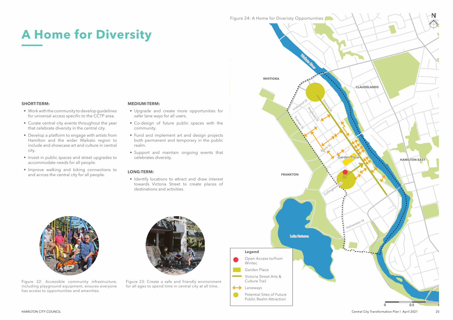
Figure 24: A Home for Diveristy OpportunitiesFigure 24: A Home for Diveristy Opportunities
A Home for Diversity
10.50
Legend
Open Access to/from Wintec
Garden Place
Victoria Street Arts & Culture Trail
Laneways
Potential Sites of Future Public Realm Attraction
HAMILTON CITY COUNCIL 26 Central City Transformation Plan l April 2021
A well-connected central city will be the primary experience where Hamiltonian's live, work and play. Developing a cohesive, integrated, and holistic approach that is people-centric to all aspects of transport in the central city is a key objective. Improving access and mobility will also enhance how surrounding and outer suburbs connect with the central city and connects employment, educational, recreational and other opportunities that the central city offers.
The CCTP aims to enable safe, comfortable, convenient and sustainable travel options that connects the central city and surrounding suburbs such as Claudelands, Hamilton East and Frankton, as well as landmarks such as Lake Rotoroa. Enabling a range of safe, responsive and flexible travel options for all walking, bking, micro-mobility and public transport need to increase, while private motor vehicle trips need to decrease. Integrating movement and place can enhance the central city's wellbeing through fostering interaction between people and the environment, and better reflect Hamilton's character and identity.
CENTRAL CITY TRANSPORT ASPIRATIONS AND PRINCIPLES
We would like transport that:
• Puts people at the heart
• Provides choice and is inclusive
• Is responsive and flexible and resilient
• Is safe, pleasant, appealing, comfortable and convenient
• Creates connection
• Supports health and well-being (people, environment and landscape)
• Contributes to the identity of the place
• Supports the city centre being the primary experience where people want to be part of the energy of the place (live, work and play)
Our transport network and corridors:
• Reinforce the central city as the key metro-destination
• Integrate movement and place to reflect character and identity
• Are functional, resilient and enjoyable
• Provide a range of viable, accessible travel options
• Enhance the wellbeing of the city centre, its people and the environment
• Foster social interaction and makes good places for people
• Supports Central City businesses
WHAT WE AIM TO ACHIEVE:
• Walking, biking, micro-mobility and public transport is better enabled within the central city and is supported by healthier and accessible streets for all people.
• An integrated transport network that is safe, pleasant, responsive and easy to navigate within the central city and surrounding suburbs.
• Manage freight traffic traveling into and through the central city to enhance efficiency without impacting the quality of the urban realm.
HOW WE CAN ACHIEVE THIS:
• Provide a variety of walking, biking, micro-mobility and public transport options to and within the central city.
• Integrate movement and place to reflect character and identity.
• Support investment (planned and future) in public transport, walking and biking infrastructure.
• Target a reduction of at least 25% of cars in the central city during morning peak by 2030.
• Better management of parking as per Central City Parking Management Plan through Parking Precincts.
• Reducing road speeds to 30km/h at areas of high numbers of pedestrians and cyclists.
• Enhance laneways as mid-block connections and creating places for pedestrian movement and social interaction.
• Coordinate and integrate with Access Hamilton as it develops.
A Well-Connected Central City
Figure 25 : Fort Street
Case Studies Fort Street
When Fort Street in downtown Auckland was transformed into a shared space, there were huge benefits including a 54% increase in pedestrian volumes and a 47% increase in consumer spending.
The goals of the project were to prioritise pedestrians and create a distinctive public space that supports businesses and residents. More space was given over to pedestrians and driving was discouraged through the removal of parking and reduced speed limits. 80% of pedestrians and cyclists reported feeling safer when travelling in the space and allocation for outdoor seating and hospitality has improved the vibe of the area throughout the day and evening.
HAMILTON CITY COUNCIL Central City Transformation Plan l April 2021 27
Figure 27: The Transport Centre in Hamilton connects the primary transport routes with the wider city network. It is a point of arrival and key movement hub that can expand shared mobility and end-of-destination options.
A Well-Connected Central City
SHORT-TERM:
• Identify potential conflict on key streets informed by the Hamilton Mode Shift Plan and Access Hamilton.
• Manage parking on central city streets according to the updated Central City Parking Management Plan and Parking Precincts.
• Improve walking and biking access across river to fringe neighbourhoods and surrounding suburbs.
• Improve walkability to and from the central city so that walking trips under 2km will increase from 26% to 50% in the next 10 years.
• Develop a Biking and Micro-Mobility Business Case.
• Improve wayfinding and signage to key locations across the central city.
• Identify and resolve barriers to access the river edge shared path and resolve.
• Encourage travel plan use by businesses in the central city.
• Implement 30km/h or lower speed zones in central city in alignment with the Hamilton Speed Management Plan.
MEDIUM-TERM:
• Expand Victoria Street public realm and pedestrian priority north to Boundary Road.
• Implement Green Streets through restricting vehicle speeds and access.
LONG-TERM:
• Explore viability of central city station as transport interchange as a transit-oriented development.
• Expand walking and biking and public transport network (NZ Road Safety Strategy).
• Zero emissions zone for the central city.
• Implement electric-vehicle charging stations throughout central city.
• Expand shared mobility and end-of-destination options.
Figure 26: Shared space in Garden Place is an example that prioritises pedestrians and cyclists. The ground floor businesses elevates the street and is used as a place rather than a route.
Boun
dary
Rd
Boun
dary
Rd
Anzac Parade
Anzac Parade
Transport CentreTransport CentreAnglesea St
Anglesea St
Liverpool St
Liverpool St
Bryce St
Bryce St
Collingwood St
Collingwood St
Palmerston St
Palmerston St
Tristram St
Tristram St
Victoria St
Victoria St
HAMILTON EASTHAMILTON EAST
FRANKTONFRANKTON
WHITIORAWHITIORA
CLAUDELANDSCLAUDELANDS
Garden PlaceGarden Place
Waikato River
Waikato River
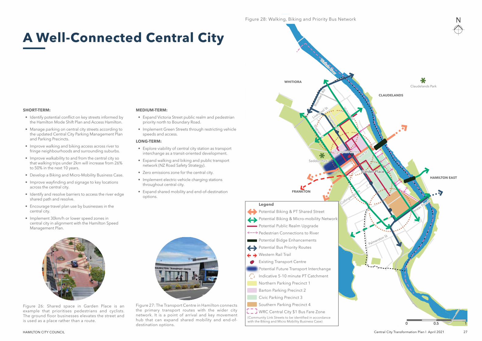
Figure 28: Walking, Biking and Priority Bus NetworkFigure 28: Walking, Biking and Priority Bus Network
10.50
Seddon ParkSeddon Park
Claudelands ParkClaudelands Park
Legend
Potential Biking & PT Shared Street
Potential Biking & Micro-mobility Network
Potential Public Realm Upgrade
Pedestrian Connections to River
Potential Bidge Enhancements
Potential Bus Priority Routes
Western Rail Trail
Existing Transport Centre
Potential Future Transport Interchange
Indicative 5-10 minute PT Catchment
Northern Parking Precinct 1
Barton Parking Precinct 2
Civic Parking Precinct 3
Southern Parking Precinct 4
WRC Central City $1 Bus Fare Zone(Community Link Streets to be identified in accordance with the Biking and Micro Mobility Business Case)
HAMILTON CITY COUNCIL 28 Central City Transformation Plan l April 2021
Green and blue spaces in central cities serve multiple purposes for people and contribute to the amenity of the city by bringing green infrastructure and water management together, as well as providng eco-corridors.
Green spaces including parks, open spaces, rooftop gardens, rainwater collection ponds and other nature-based solutions offer innovative approaches to increase the quality of urban settings, enhance local resilience, ecology and biodiversity, and promote sustainable lifestyles, improving both the health and the wellbeing of urban residents.
An integrated blue-green network will have a positive environmental impact through improving water quality, enhancing biodiversity and bringing native ecologies into central city neighbourhoods.
WHAT WE AIM TO ACHIEVE:• Improve connections between the city and the river and create
new natural connections between the West Town Belt and the river.
• Create a network of quality public spaces and increase the percentage of open and public space in the central city, working towards achieving the goal of 10% native vegetation cover by 2050 aligned with the Nature in the City Strategy.
• Design for regenerative natural systems and green infrastructure within the urban environment.
HOW WE CAN ACHIEVE THIS:• Enhance access to the river from Victoria Street and draw the
natural environment from the river and riverbank further into the Central City urban realm.
• Utilise streets as key green network and biodiversity connectors between the river and the West Town Belt.
• Implement new public green spaces and improve existing spaces.
• Require new streets or street upgrades to implement regenerative infrastructure such as rain gardens.
• Review CBD waste services to identify and implement opportunities for improved waste minimisation in the central city.
Blue-Green Central City
Waiwhakareke Natural Heritage Park, Hamilton
Waiwhakareke Natural Heritage Park (WHNP) is the flagship project for biodiversity in our city. WHNP is an award-winning, inter-generational ecological restoration project. Intensive predator control will allow vulnerable species to flourish in an urban environment and spill over to other parts of the city. The 65.5ha park will serve as a focus for Hamilton’s wider biodiversity restoration, including lakes and lakeshores, the Waikato River, its banks and unique gullies, and other parks with current or potential natural values (estimated to be 750 hectares).
Figure 29: Wild West End, London
Figure 30: Waiwhakareke Natural Heritage Park
Case Studies
Wild West End
Wild West End is creating green “stepping-stones” between the existing areas of surrounding parkland, through a combination of green roofs, green walls, planters, street trees, flower boxes and pop-up spaces. The priority is to attract birds once common throughout London such as the black redstart and the house sparrow and encourage biodiversity and ecological connectivity through reintroduction of wildflowers and bees to the urban realm.
Links to green space are proven to positively influence people through lowering stress and increasing wellbeing. Wild West End is intended to increase access to green space for people who come to the area to live, work, study or visit.
HAMILTON CITY COUNCIL Central City Transformation Plan l April 2021 29
Figure 32: Increasing the tree canopy will improve local air quality, biodiversity and amenity.
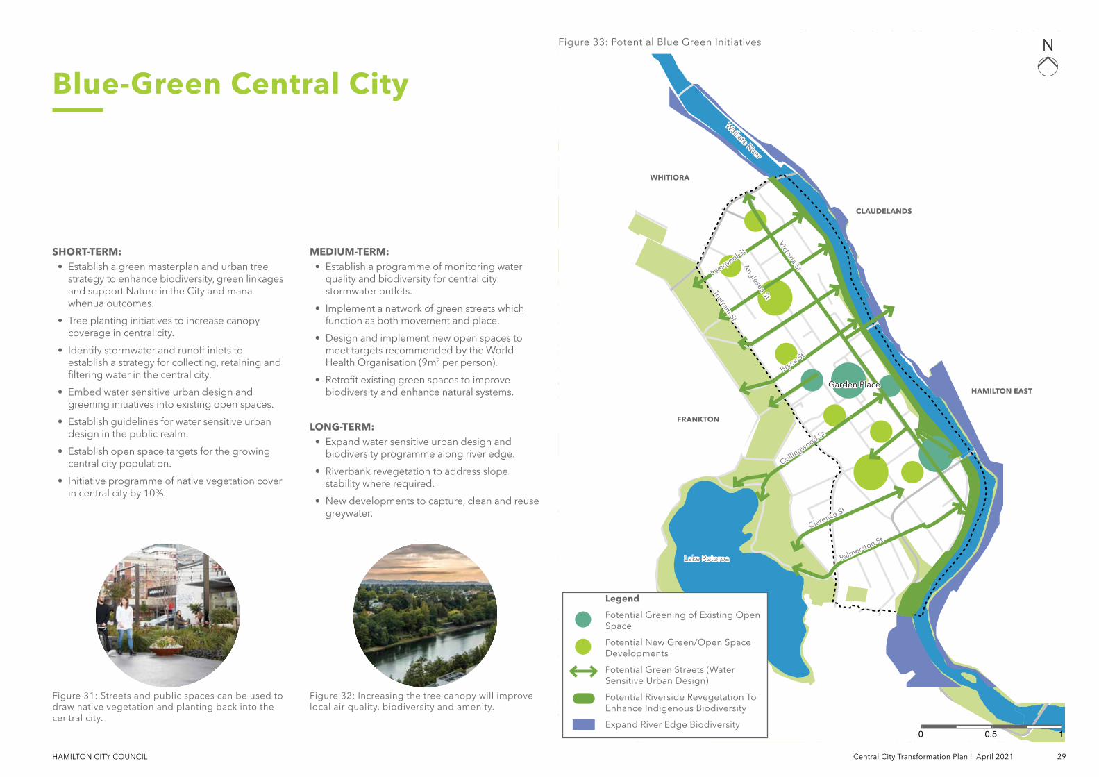
Figure 33: Potential Blue Green InitiativesFigure 33: Potential Blue Green Initiatives
Blue-Green Central City
SHORT-TERM:• Establish a green masterplan and urban tree
strategy to enhance biodiversity, green linkages and support Nature in the City and mana whenua outcomes.
• Tree planting initiatives to increase canopy coverage in central city.
• Identify stormwater and runoff inlets to establish a strategy for collecting, retaining and filtering water in the central city.
• Embed water sensitive urban design and greening initiatives into existing open spaces.
• Establish guidelines for water sensitive urban design in the public realm.
• Establish open space targets for the growing central city population.
• Initiative programme of native vegetation cover in central city by 10%.
MEDIUM-TERM:• Establish a programme of monitoring water
quality and biodiversity for central city stormwater outlets.
• Implement a network of green streets which function as both movement and place.
• Design and implement new open spaces to meet targets recommended by the World Health Organisation (9m2 per person).
• Retrofit existing green spaces to improve biodiversity and enhance natural systems.
LONG-TERM:• Expand water sensitive urban design and
biodiversity programme along river edge.
• Riverbank revegetation to address slope stability where required.
• New developments to capture, clean and reuse greywater.
Figure 31: Streets and public spaces can be used to draw native vegetation and planting back into the central city.
Lake RotoroaLake Rotoroa
Anglesea St
Anglesea St
Liverpool St
Liverpool St
Bryce St
Bryce St
Collingwood St
Collingwood St
Palmerston St
Palmerston St
Tristram St
Tristram St
Victoria St
Victoria St
HAMILTON EASTHAMILTON EAST
FRANKTONFRANKTON
WHITIORAWHITIORA
CLAUDELANDSCLAUDELANDS
Garden PlaceGarden Place
Waikato River
Waikato River
10.50
Clarence St
Clarence St
Legend
Potential Greening of Existing Open Space
Potential New Green/Open Space Developments
Potential Green Streets (Water Sensitive Urban Design)
Potential Riverside Revegetation To Enhance Indigenous Biodiversity
Expand River Edge Biodiversity
HAMILTON CITY COUNCIL 30 Central City Transformation Plan l April 2021
Hamilton’s central city is the economic heart of the Waikato region, serving as a hub of employment and related commercial activity. It is expected the central city will continue to play a significant role in business and population growth. The vision outlined in the CCTP would strengthen this dynamic by supporting existing commercial developments while enabling future investments that support employment growth and a growing Maaori economy.
Providing spaces, support, inspiration and community is key in driving a strong and vibrant innovative culture. Planning and design of the central city should reflect the values, culture, and dynamic nature of high-impact sectors that Hamilton’s economic development efforts will seek to retain, attract, and grow.
WHAT WE AIM TO ACHIEVE:
• Increase employment and commercial activity within the central city though the expansion and attraction of businesses.
• Enhance a growing economy that support investments that increase restaurant, hospitality, retail, entertainment and community activity during daytime and evening hours.
• Accommodate business growth while incorporating mixed-use and residential opportunities into the built environment through increased building densities and high-quality design.
• Support a prosperous and visible Maaori economy as a driver for economic growth.
HOW WE CAN ACHIEVE THIS:
• Define a city core to localise new commercial development within the central city, rather than in competing urban centres or industrial areas.
• Design streets and public spaces to support connectivity, job density and quality of life.
• Require ground floor businesses to have an active street front in key locations.
• Encourage and enable maximum building heights in the central city core through use of Building Code and Urban Design Panel.
• Continue to support the primacy of the central city at the top of the city business hierarchy in the District Plan.
Prosperous Economy
Heart of the City
Heart of the City Auckland is an association of central city businesses who work together to promote activities and events and encourage people to visit the central city and support local businesses. They aspire to promote Auckland as a thriving commercial centre with a strong community that is easy to get around in and provides unique experiences 24/7. Heart of the City advocates on behalf of businesses and supports events through marketing and promotions and regularly runs promotions to encourage people to live, work and play in the central city.
Figure 34: Auckland waterfront and Commercial Bay
Figure 35: Heart of the City
Case Studies
Auckland Waterfront + Commercial Bay
The Auckland waterfront is undergoing major transformation to cement itself as the focal point of the city for visitors, workers and residents alike. Beginning with the Britomart train station and precinct and continuing with Commercial Bay, the area is growing in contribution to the economy with new retail, hospitality, accommodation and office spaces. Commercial Bay has brought an additional 150 shops and has created over 10,000 jobs to the downtown area.
HAMILTON CITY COUNCIL Central City Transformation Plan l April 2021 31
Lake RotoroaLake Rotoroa
Anglesea St
Anglesea St
Rostrevor S
t
Rostrevor S
t
Bryce St
Bryce St
Collingwood St
Collingwood St
Palmerston St
Palmerston St
Tristram St
Tristram St
Victoria St
Victoria St HAMILTON EASTHAMILTON EAST
FRANKTONFRANKTON
WHITIORAWHITIORA
CLAUDELANDSCLAUDELANDS
Garden Garden PlacePlace
Waikato River
Waikato River
Figure 36: Central City can attract retail, food and beverage. Commercial businesses will be supported by high-amenity and vibrant urban realm. Enhancing public realm and a network of parks, plazas, streets and lanes can breathe life and vitality.
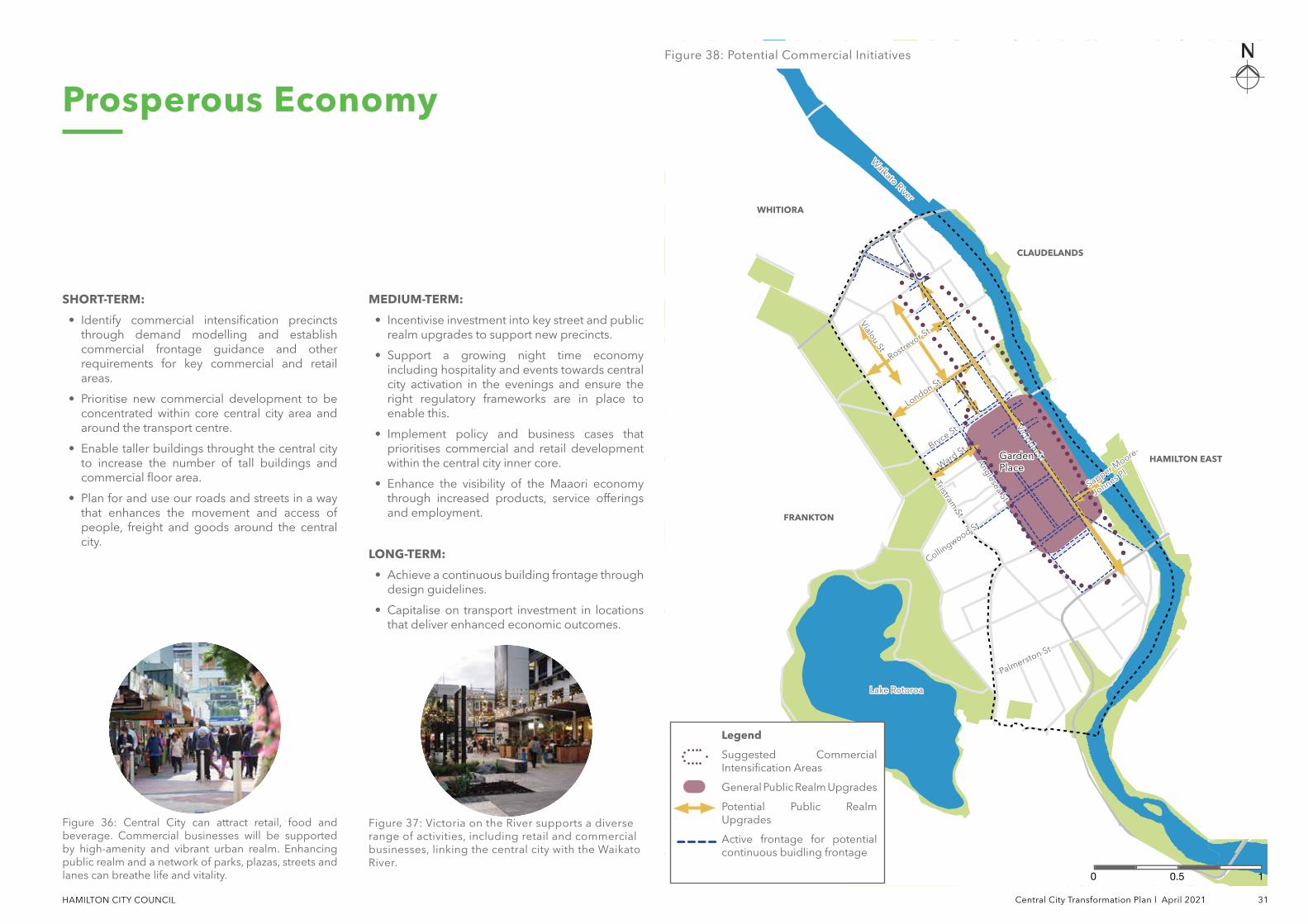
Figure 38: Potential Commercial InitiativesFigure 38: Potential Commercial Initiatives
Prosperous Economy
Ward St
Ward StVialou St
Vialou St
London St
London St
SHORT-TERM:
• Identify commercial intensification precincts through demand modelling and establish commercial frontage guidance and other requirements for key commercial and retail areas.
• Prioritise new commercial development to be concentrated within core central city area and around the transport centre.
• Enable taller buildings throught the central city to increase the number of tall buildings and commercial floor area.
• Plan for and use our roads and streets in a way that enhances the movement and access of people, freight and goods around the central city.
MEDIUM-TERM:
• Incentivise investment into key street and public realm upgrades to support new precincts.
• Support a growing night time economy including hospitality and events towards central city activation in the evenings and ensure the right regulatory frameworks are in place to enable this.
• Implement policy and business cases that prioritises commercial and retail development within the central city inner core.
• Enhance the visibility of the Maaori economy through increased products, service offerings and employment.
LONG-TERM:
• Achieve a continuous building frontage through design guidelines.
• Capitalise on transport investment in locations that deliver enhanced economic outcomes.
Figure 37: Victoria on the River supports a diverse range of activities, including retail and commercial businesses, linking the central city with the Waikato River.
Sapper Moore-
Sapper Moore-
Johnes Pl
Johnes Pl
10.50
Legend
Suggested Commercial Intensification Areas
General Public Realm Upgrades
Potential Public Realm Upgrades
Active frontage for potential continuous buidling frontage
Part C Project Initiatives
HAMILTON CITY COUNCIL
The CCTP recognises and prioritises projects identified within the Hamilton City Council LTP in the next 10 years (2021 – 2031) along with development and upgrade opportunities in the next 20 and 30 years.
This CCTP is a living document and it should be referred to on a frequent basis to guide Hamilton City Council. This is to ensure the outcomes and the overall vision is achieved within the planned timeframes.
It is the intention that this Section C of the document identifying projects and proposed implementation timeframes will be updated more regularly to reflect successive Annual Plan or additional funding streams as they arise.
This section is to be read in conjuction with the 'Hamilton CCTP Part B Vision and Outcomes' section.
Introduction
HAMILTON CITY COUNCIL Central City Transformation Plan l April 2021 35
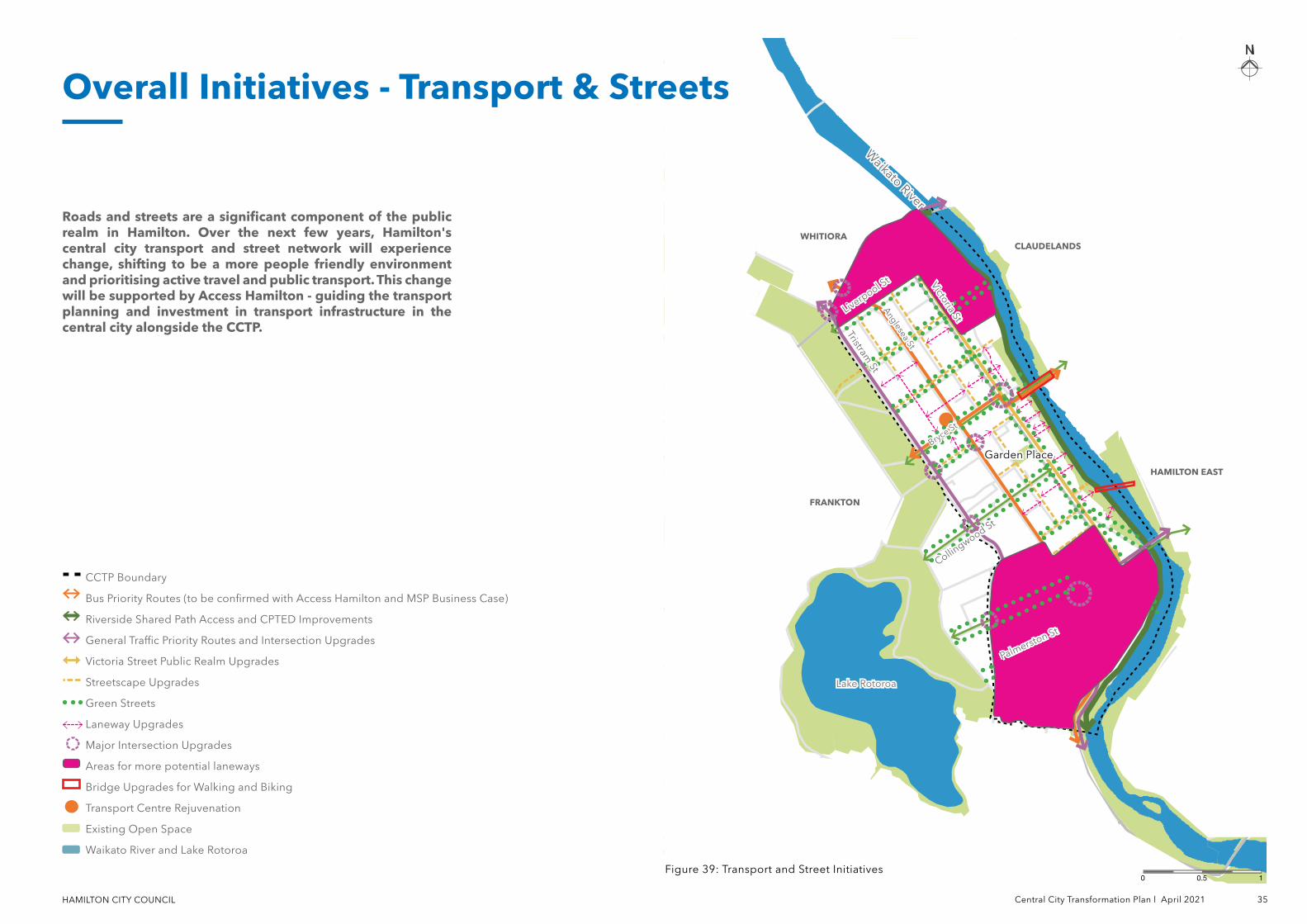
Introduction Overall Initiatives - Transport & Streets
CCTP Boundary
Bus Priority Routes (to be confirmed with Access Hamilton and MSP Business Case)
Riverside Shared Path Access and CPTED Improvements
General Traffic Priority Routes and Intersection Upgrades
Victoria Street Public Realm Upgrades
Streetscape Upgrades
Green Streets
Laneway Upgrades
Major Intersection Upgrades
Areas for more potential laneways
Bridge Upgrades for Walking and Biking
Transport Centre Rejuvenation
Existing Open Space
Waikato River and Lake Rotoroa
Figure 39: Transport and Street InitiativesFigure 39: Transport and Street Initiatives10.50
Roads and streets are a significant component of the public realm in Hamilton. Over the next few years, Hamilton's central city transport and street network will experience change, shifting to be a more people friendly environment and prioritising active travel and public transport. This change will be supported by Access Hamilton - guiding the transport planning and investment in transport infrastructure in the central city alongside the CCTP.
Lake RotoroaLake Rotoroa
Anglesea St
Anglesea St
Liverpool St
Liverpool St
Bryce St
Bryce St
Palmerston St
Palmerston St
Tristram St
Tristram St
Victoria St
Victoria St
HAMILTON EASTHAMILTON EAST
FRANKTONFRANKTON
WHITIORAWHITIORA
Garden PlaceGarden Place
Collingwood St
Collingwood St
Waikato River
Waikato River
CLAUDELANDSCLAUDELANDS
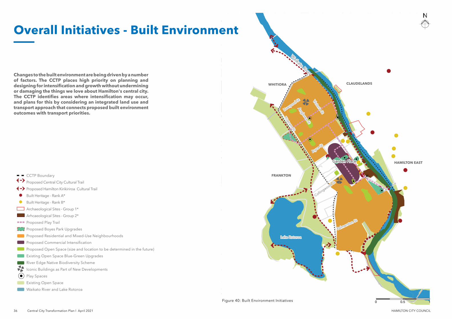
36 Central City Transformation Plan l April 2021 HAMILTON CITY COUNCIL
Overall Initiatives - Built Environment
Waikato River
Waikato River
CCTP Boundary
Proposed Central City Cultural Trail
Proposed Hamilton Kirikiriroa Cultural Trail
Built Heritage - Rank A*
Built Heritage - Rank B*
Archaeological Sites - Group 1*
Arhcaeological Sites - Group 2*
Proposed Play Trail
Proposed Boyes Park Upgrades
Proposed Residential and Mixed-Use Neighbourhoods
Proposed Commercial Intensification
Proposed Open Space (size and location to be determined in the future)
Existing Open Space Blue-Green Upgrades
River Edge Native Biodiversity Scheme
Iconic Buildings as Part of New Developments
Play Spaces
Existing Open Space
Waikato River and Lake Rotoroa
Figure 40: Built Environment InitiativesFigure 40: Built Environment Initiatives 10.50
Changes to the built environment are being driven by a number of factors. The CCTP places high priority on planning and designing for intensification and growth without undermining or damaging the things we love about Hamilton's central city. The CCTP identifies areas where intensification may occur, and plans for this by considering an integrated land use and transport approach that connects proposed built environment outcomes with transport priorities.
Lake RotoroaLake Rotoroa
Anglesea St
Anglesea St
Liverpool St
Liverpool St
Bryce St
Bryce St
Palmerston St
Palmerston St
Tristram St
Tristram St
Victoria St
Victoria St
HAMILTON EASTHAMILTON EAST
FRANKTONFRANKTON
WHITIORAWHITIORA CLAUDELANDSCLAUDELANDS
Garden PlaceGarden Place
Collingwood St
Collingwood St
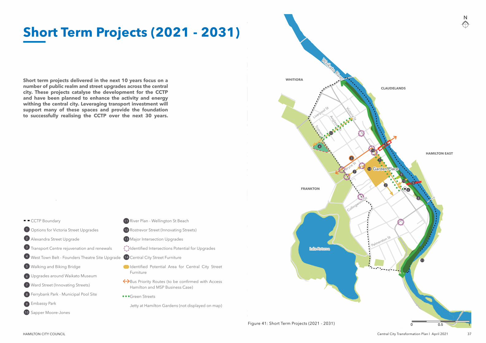
HAMILTON CITY COUNCIL Central City Transformation Plan l April 2021 37
CCTP Boundary
Options for Victoria Street Upgrades
Alexandra Street Upgrade
Transport Centre rejuvenation and renewals
West Town Belt - Founders Theatre Site Upgrade
Walking and Biking Bridge
Upgrades around Waikato Museum
Ward Street (Innovating Streets)
Ferrybank Park - Municipal Pool Site
Embassy Park
Sapper Moore-Jones
River Plan - Wellington St Beach
Rostrevor Street (Innovating Streets)
Major Intersection Upgrades
Identified Intersections Potential for Upgrades
Central City Street Furniture
Identified Potential Area for Central City Street Furniture
Bus Priority Routes (to be confirmed with Access Hamilton and MSP Business Case)
Green Streets
Jetty at Hamilton Gardens (not displayed on map)
1
2
4
3
5
6
7
10
11
12
11
8
9
13
14
Waikato River
Waikato River
Figure 41: Short Term Projects (2021 - 2031)Figure 41: Short Term Projects (2021 - 2031) 10.50
Short term projects delivered in the next 10 years focus on a number of public realm and street upgrades across the central city. These projects catalyse the development for the CCTP and have been planned to enhance the activity and energy withing the central city. Leveraging transport investment will support many of these spaces and provide the foundation to successfully realising the CCTP over the next 30 years.
Short Term Projects (2021 - 2031)
Lake RotoroaLake Rotoroa
Anglesea St
Anglesea St
Liverpool St
Liverpool St
Bryce St
Bryce St
Palmerston St
Palmerston St
Tristram St
Tristram St
Victoria St
Victoria St
HAMILTON EASTHAMILTON EAST
FRANKTONFRANKTON
WHITIORAWHITIORA
CLAUDELANDSCLAUDELANDS
Garden PlaceGarden Place
Collingwood St
Collingwood St
1
2
3
4
6
7
10
9
5
8
13
12
5
14
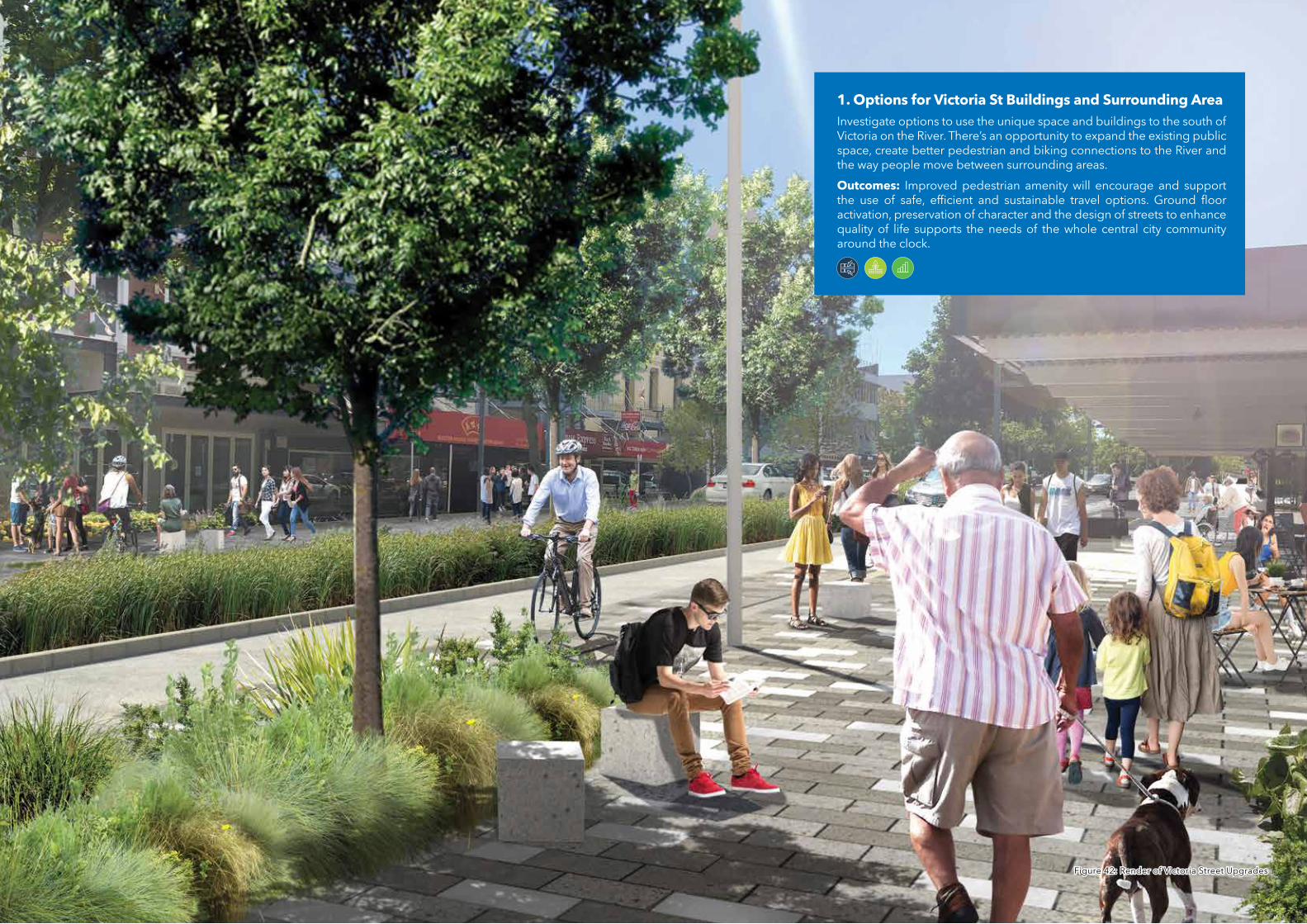
1. Options for Victoria St Buildings and Surrounding AreaInvestigate options to use the unique space and buildings to the south of Victoria on the River. There’s an opportunity to expand the existing public space, create better pedestrian and biking connections to the River and the way people move between surrounding areas.
Outcomes: Improved pedestrian amenity will encourage and support the use of safe, efficient and sustainable travel options. Ground floor activation, preservation of character and the design of streets to enhance quality of life supports the needs of the whole central city community around the clock.
Figure 42: Render of Victoria Street UpgradesFigure 42: Render of Victoria Street Upgrades
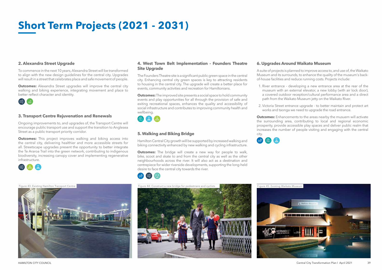
HAMILTON CITY COUNCIL Central City Transformation Plan l April 2021 39
2. Alexandra Street Upgrade
To commence in the next 10 years, Alexandra Street will be transformed to align with the new design guidelines for the central city. Upgrades will result in a street that celebrates place and safe movement of people.
Outcomes: Alexandra Street upgrades will improve the central city walking and biking experience, integrating movement and place to better reflect character and identity.
3. Transport Centre Rejuvenation and Renewals
Ongoing improvements to, and upgrades of, the Transport Centre will encourage public transport use and support the transition to Anglesea Street as a public transport priority corridor.
Outcomes: This project improves walking and biking access into the central city, delivering healthier and more accessible streets for all. Streetscape upgrades present the opportunity to better integrate the Te Araroa Trail into the green network, contributing to indigenous biodiversity, increasing canopy cover and implementing regenerative infrastructure.
4. West Town Belt Implementation - Founders Theatre Site Upgrade
The Founders Theatre site is a significant public green space in the central city. Enhancing central city green spaces is key to attracting residents to housing in the central city. The upgrade will create a better place for events, community activities and recreation for Hamiltonians.
Outcomes: The improved site presents a social space to hold community events and play opportunities for all through the provision of safe and exiting recreational spaces, enhances the quality and accessibility of social infrastructure and contributes to improving community health and wellbeing.
5. Walking and Biking Bridge
Hamilton Central City growth will be supported by increased walking and biking connectivity enhanced by new walking and cycling infrastructure.
Outcomes: The bridge will create a new way for people to walk, bike, scoot and skate to and from the central city as well as the other neighbourhoods across the river. It will also act as a destination and centrepiece for wider riverside developments, supporting the long-held desire to face the central city towards the river.
Figure 44: Construct a new bridge for pedestrians and cyclistsFigure 44: Construct a new bridge for pedestrians and cyclists Figure 45: Existing Waikato MuseumFigure 45: Existing Waikato Museum
Short Term Projects (2021 - 2031)
Figure 43: Existing Hamilton Transport CentreFigure 43: Existing Hamilton Transport Centre
6. Upgrades Around Waikato Museum
A suite of projects is planned to improve access to, and use of, the Waikato Museum and its surrounds, to enhance the quality of the museum's back-of-house facilities and reduce running costs. Projects include:
1. River entrance - developing a new entrance area at the rear of the museum with an external elevator, a new lobby (with air lock door), a covered outdoor reception/cultural performance area and a direct path from the Waikato Museum jetty on the Waikato River.
2. Victoria Street entrance upgrade - to better maintain and protect art works and taonga we need to upgrade the road entrance.
Outcomes: Enhancements to the areas nearby the musuem will activate the surrounding area, contributing to local and regional economic prosperity, provide accessible play spaces and deliver public realm that increases the number of people visiting and engaging with the central city.
40 Central City Transformation Plan l April 2021 HAMILTON CITY COUNCIL
7. Ward Street (Innovating Streets)
Through the Innovating Streets funding programme there is a drive to develop Ward Street to better use the space, provide places for people to gather and be safe to move around. This is necessary to cater for increasing numbers of pedestrian and cyclists moving along Ward Street and surrounding areas.
Outcomes: Streetscape upgrades support and encourage increased walking and biking through the provision of high quality urban realm, improving safety for all and ensuring spaces are accessible for a diverse range of users.
8. Ferrybank Park Enhancement - Municipal Pool Site
Develop a park area on the current Municipal Pool site (additional to proposed parks development and playground programmes).
Outcomes: The improvements to the site will provide a play and recreational facility in the central city area.
9. Embassy Park
To support the Waikato Regional Theatre development, we’re also making some improvements to the public spaces in the area. This will create a better connection between Victoria Street, the Theatre and the Waikato River.
Outcomes: Upgrading Embassy Park will further develop a sense of local identity and character, creating a place that is engaging to spend time in and caters to the needs of all people.
10. Sapper Moore-Jones
To support the Waikato Regional Theatre development, we’re making some improvements to vehicle and pedestrian access to the area. These improvements will make sure the spaces are safe and accessible to a wide range of users and make it a more enjoyable space to spend time in.
• Victoria and Bryce Streets
• Victoria and London Streets
• Victoria Street and Claudelands Road
• Tristram and Collingwood Streets
• Tristram and Bryce Streets
• Anglesea Street and Anzac Parade
• Ward Street
Outcomes: Safer and healthier streets will encourage increased active transport use, and ensure the efficient and reliable movement of public transport, freight and general vehicle traffic throughout the central city area.
14. Central City Street Furniture
Functional and attractive street furniture is an important part of creating a central city where people love to be. Upgraded street furniture will be designed to incorporate best practice urban design, Maaori design outcomes, crime prevention and universal design principles.
Outcomes: New additions around the central city would include furnitures such as new benches, end-of-journey facilities, bus stop shelters, public toilets and water fountains that create spaces to relax and rest at different times of day.
15. Jetty at Hamilton Gardens
This project will create a second jetty for Hamilton Gardens and moving boat activities to the new location, separate from the area favoured by swimmers.
Outcomes: The new jetty will connect Hamilton Gardens to the Central City area through the Waikato River. People can relax by the river and appreciate the space as well as our Maaori heritage. It will also feature Maaori carvings that celebrates the historic significance of the area to local hapuu.
Outcomes: Streetscape upgrades support and encourage increased walking through the provision of high quality urban realm, improving safety for all and ensuring spaces are accessible for a diverse range of users while enabling ongoing vehicle access.
11. River Plan - Wellington Street Beach
The Wellington Street Beach is well used in summer and important for the wellbeing of our community. Historically, it was also an important waka landing site for early Maaori traders, and therefore holds important heritage and identity values for Hamilton. We’re planning for some upgrades to protect the beach from erosion and provide better access to the water for people. This work will be in line with our Play Strategy and River Plan.
Outcomes: The upgrades at Wellington Street Beach will add to the liveliness and attractiveness of the beach as well as promoting the Maaori heritage and identity. Protecting the water and soil quality also protects native vegetation and strengthens the natural environment along the Waikato River.
12. Rostrevor Street Upgrades (Innovating Streets)
Making permanent improvements recommended by the Innovating Streets project to support an expected increase in pedestrian and cyclist numbers along the street and in the surrounding park spaces.
Outcomes: Streetscape upgrades will make Rostrevor Street a safer and more inviting biking and pedestrian connections. Encouraging and enabling increased walking and biking within the central city area will create healthier streets for all and support a vibrant and dynamic urban environment.
13. Major Intersection Upgrades
Intersection upgrades are essential to deliver a safer, more efficient transport network for all users. Intersections which have been identified for potential upgrades are:
Short Term Projects (2021 - 2031)
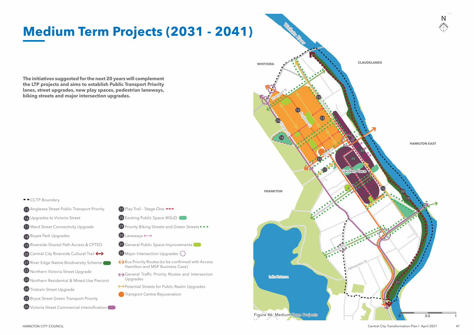
HAMILTON CITY COUNCIL Central City Transformation Plan l April 2021 41
CCTP Boundary
Anglesea Street Public Transport Priority
Upgrades to Victoria Street
Ward Street Connectivity Upgrade
Boyes Park Upgrades
Riverside Shared Path Access & CPTED
Central City Riverside Cultural Trail
River Edge Native Biodiversity Scheme
Northern Victoria Street Upgrade
Northern Residential & Mixed-Use Precinct
Tristram Street Upgrade
Bryce Street Green Transport Priority
Victoria Street Commercial Intensification
Play Trail - Stage One
Existing Public Space WSUD
Priority Biking Streets and Green Streets
Laneways
General Public Space Improvements
Major Intersection Upgrades
Bus Priority Routes (to be confirmed with Access Hamilton and MSP Business Case)
General Traffic Priority Routes and Intersection Upgrades
Potential Streets for Public Realm Upgrades
Transport Centre Rejuvenation
15
16
17
18
19
21
20
22
23
24
26
25
27
30
28
29
31
32
Waikato River
Waikato River
The initiatives suggested for the next 20 years will complement the LTP projects and aims to establish Public Transport Priority lanes, street upgrades, new play spaces, pedestrian laneways, biking streets and major intersection upgrades.
Figure 46: Medium Term ProjectsFigure 46: Medium Term Projects 10.50
Medium Term Projects (2031 - 2041)
Collingwood St
Collingwood St
Lake RotoroaLake Rotoroa
Anglesea St
Anglesea St
Liverpool St
Liverpool St
Bryce St
Bryce St
Palmerston St
Palmerston St
Tristram St
Tristram St
Victoria St
Victoria StHAMILTON EASTHAMILTON EAST
FRANKTONFRANKTON
WHITIORAWHITIORA CLAUDELANDSCLAUDELANDS
Garden PlaceGarden Place
16
2324
25 26
30
20
22
21
19
18
17
15
Clarence St
Clarence St
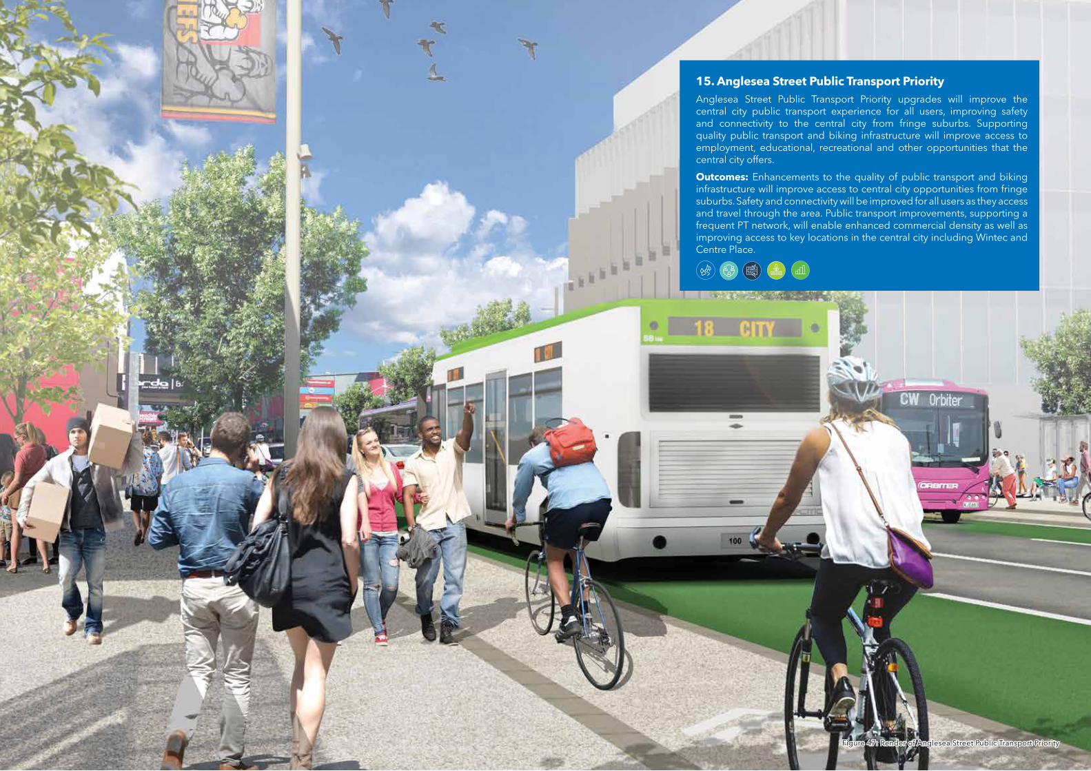
15. Anglesea Street Public Transport PriorityAnglesea Street Public Transport Priority upgrades will improve the central city public transport experience for all users, improving safety and connectivity to the central city from fringe suburbs. Supporting quality public transport and biking infrastructure will improve access to employment, educational, recreational and other opportunities that the central city offers.
Outcomes: Enhancements to the quality of public transport and biking infrastructure will improve access to central city opportunities from fringe suburbs. Safety and connectivity will be improved for all users as they access and travel through the area. Public transport improvements, supporting a frequent PT network, will enable enhanced commercial density as well as improving access to key locations in the central city including Wintec and Centre Place.
Figure 47: Render of Anglesea Street Public Transport Priority Figure 47: Render of Anglesea Street Public Transport Priority
HAMILTON CITY COUNCIL Central City Transformation Plan l April 2021 43
21. River Edge Native Biodiversity Scheme
The River Edge Native Biodiversity Scheme will build on the Nature in the City Strategy to enhance indigenous biodiversity in the central city, focused on the river edge. The scheme will include indigenous planting strategies developed with iwi and will identify techniques and opportunities to support and protect native flora and fauna.
Outcomes: The scheme will bring native ecologies into central city neighbourhoods, contributing towards achieving the goal of 10% native vegetation cover and helping to strengthen the natural environment along the Waikato River.
22. Northern Victoria Street Upgrade
An extension of upgrades made to the southern end of Victoria Street will focus on providing better spaces and connections to the River for pedestrians and cyclists, as well as to the mixed use and residential precinct to the north of the central city area.
Outcomes: Improved pedestrian amenity will encourage and support the use of safe, efficient and sustainable travel options. Upgrading Victoria Street will strengthen its social and economic function for Hamilton.
16. Upgrades to Victoria Street (Garden Place to Anzac Parade)
This will provide better spaces for pedestrians and cyclists, celebrate the heritage and character of the area and improve the quality of stormwater from the street.
Outcomes: Urban realm upgrades from Garden Place to Anzac Parade will encourage increased walking and biking in the area through improved connectivity, safety and accessibility. Integration of the streets movement and place functions will reflect the heritage and character of the area while providing safe and accessible connection for all users. The quality of water run off entering the Waikato River catchment will be improved through the use of water sensitive design including rain gardens, which will also contribute to the streets amenity.
17. Ward Street Connectivity Upgrade
Upgrades to the connectivity for Ward Street will encourage walking and biking between Wintec and the central city. This will also add to the vibrancy, character and culture of the area.
Outcomes: This project improves walking and biking access into the central city, delivering healthier and more accessible streets for all. Streetscape upgrades present the opportunity to integrate the cultural design consideration into the green network, contributing to indigenous biodiversity, increasing canopy cover and implementing regenerative infrastructure.
18. Boyes Park Upgrades
The upgrade of southern half of Hinemoa Park and Boyes Park will create a safer, more inviting, accessible, fun and well-connected destination park space. It will increase the quality of existing open space to inner city residents and add family-friendly activities in the central city such as new play spaces. This project complements the potential Founders Theatre site upgrade.
Outcomes: Upgrades to Boyes Park will provide play opportunities for all through the provision of safe and exiting recreational spaces, enhances
the quality and accessibility of social infrastructure and contributes to improving community health and wellbeing.
19. Riverside Shared Path Access and Crime Prevention Improvements
Improvements will make sure that the shared path is a safer, more accessible place for all users throughout the day and night. We can do this by improving wayfinding signage which will also contribute to strengthening the path's sense of place and strong relationship to the river through signage, celebration of Te Ao Maaori and Te Reo Maaori and connectivity to the central city.
Outcomes: Improving accessibility to and along the river will shape and enhance the identity of the central city, promoting a thriving Maaori culture, encouraging walking and biking and improving real and perceived safety along the path.
20. Central City Riverside Cultural Trail
Actively recognising and celebrating the unique cultural and historical heritage of Hamilton Kirikiriroa through art and design. Retention of built heritage and adaptive reuse of sites and buildings is to be encouraged. The indicative cultural trail will showcase the historic and existing character of the central city, acknowledging sites of significance and traditional practices alongside contemporary art and design interventions.
Outcomes: Aspiration to be developed in partnership with iwi and mana whenua, the indicative Cultural Trail will help shaping the future of Hamilton Kirikiriroa's Central City, telling the story of the area.
Medium Term Projects (2031 - 2041)
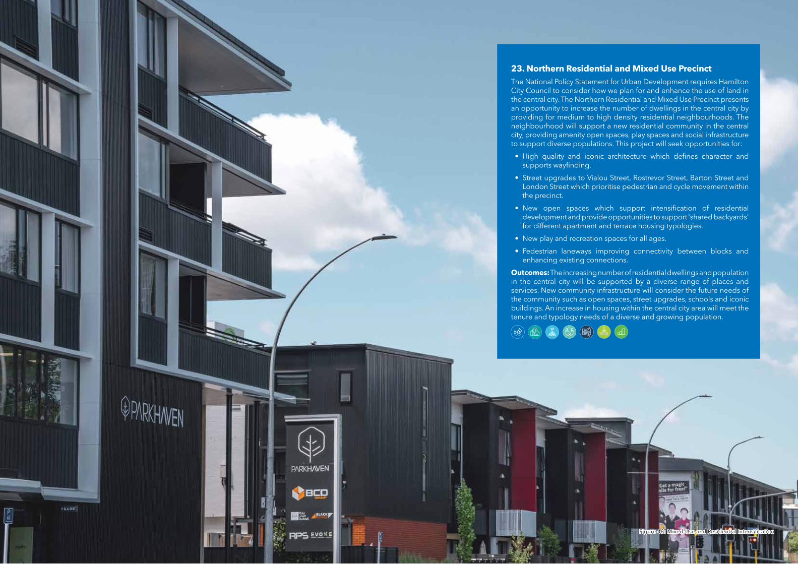
23. Northern Residential and Mixed Use PrecinctThe National Policy Statement for Urban Development requires Hamilton City Council to consider how we plan for and enhance the use of land in the central city. The Northern Residential and Mixed Use Precinct presents an opportunity to increase the number of dwellings in the central city by providing for medium to high density residential neighbourhoods. The neighbourhood will support a new residential community in the central city, providing amenity open spaces, play spaces and social infrastructure to support diverse populations. This project will seek opportunities for:
• High quality and iconic architecture which defines character and supports wayfinding.
• Street upgrades to Vialou Street, Rostrevor Street, Barton Street and London Street which prioritise pedestrian and cycle movement within the precinct.
• New open spaces which support intensification of residential development and provide opportunities to support 'shared backyards' for different apartment and terrace housing typologies.
• New play and recreation spaces for all ages.
• Pedestrian laneways improving connectivity between blocks and enhancing existing connections.
Outcomes: The increasing number of residential dwellings and population in the central city will be supported by a diverse range of places and services. New community infrastructure will consider the future needs of the community such as open spaces, street upgrades, schools and iconic buildings. An increase in housing within the central city area will meet the tenure and typology needs of a diverse and growing population.
Figure 48: Mixed-Use and Residential IntensificationFigure 48: Mixed-Use and Residential Intensification
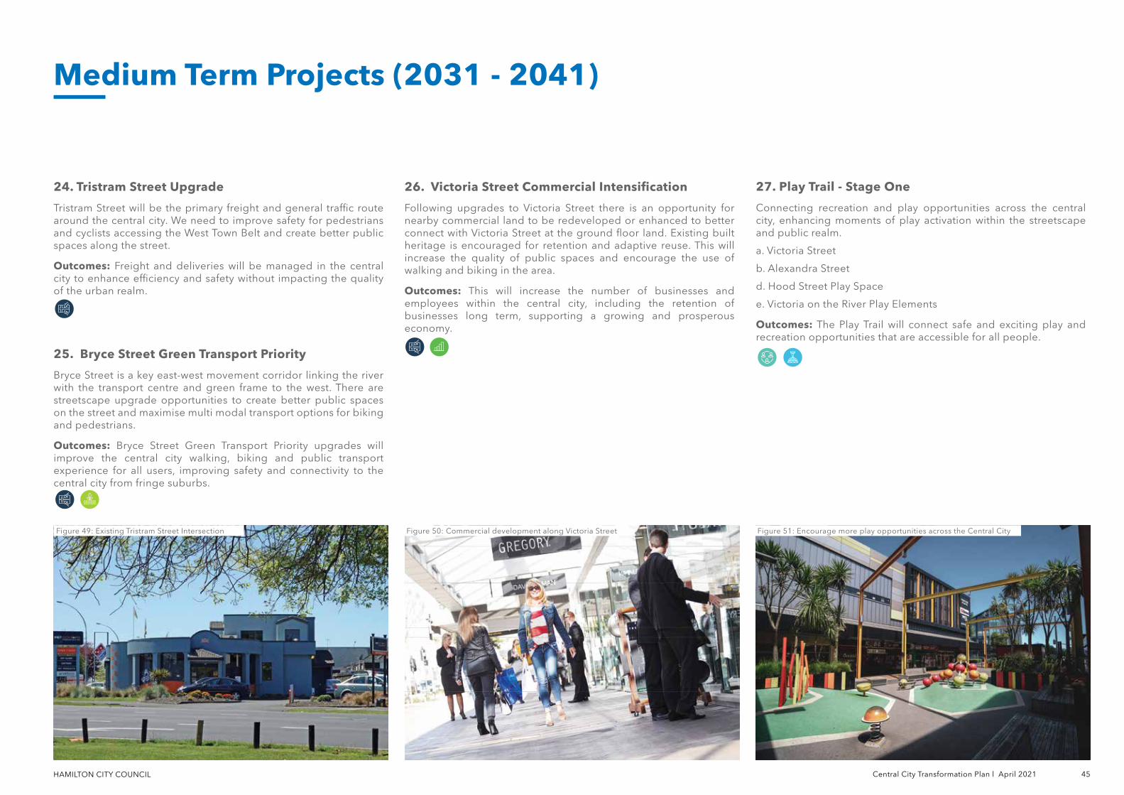
HAMILTON CITY COUNCIL Central City Transformation Plan l April 2021 45
24. Tristram Street Upgrade
Tristram Street will be the primary freight and general traffic route around the central city. We need to improve safety for pedestrians and cyclists accessing the West Town Belt and create better public spaces along the street.
Outcomes: Freight and deliveries will be managed in the central city to enhance efficiency and safety without impacting the quality of the urban realm.
25. Bryce Street Green Transport Priority
Bryce Street is a key east-west movement corridor linking the river with the transport centre and green frame to the west. There are streetscape upgrade opportunities to create better public spaces on the street and maximise multi modal transport options for biking and pedestrians.
Outcomes: Bryce Street Green Transport Priority upgrades will improve the central city walking, biking and public transport experience for all users, improving safety and connectivity to the central city from fringe suburbs.
26. Victoria Street Commercial Intensification
Following upgrades to Victoria Street there is an opportunity for nearby commercial land to be redeveloped or enhanced to better connect with Victoria Street at the ground floor land. Existing built heritage is encouraged for retention and adaptive reuse. This will increase the quality of public spaces and encourage the use of walking and biking in the area.
Outcomes: This will increase the number of businesses and employees within the central city, including the retention of businesses long term, supporting a growing and prosperous economy.
Figure 49: Existing Tristram Street Intersection Figure 50: Commercial development along Victoria Street Figure 51: Encourage more play opportunities across the Central City
Medium Term Projects (2031 - 2041)
27. Play Trail - Stage One
Connecting recreation and play opportunities across the central city, enhancing moments of play activation within the streetscape and public realm.
a. Victoria Street
b. Alexandra Street
d. Hood Street Play Space
e. Victoria on the River Play Elements
Outcomes: The Play Trail will connect safe and exciting play and recreation opportunities that are accessible for all people.
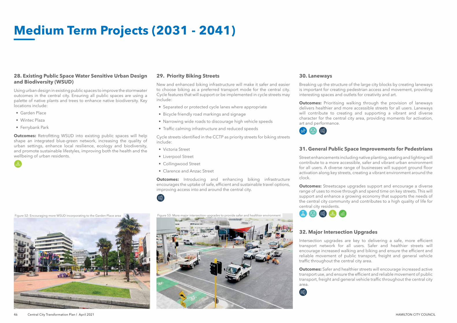
46 Central City Transformation Plan l April 2021 HAMILTON CITY COUNCIL
30. Laneways
Breaking up the structure of the large city blocks by creating laneways is important for creating pedestrian access and movement, providing interesting spaces and outlets for creativity and art.
Outcomes: Prioritising walking through the provision of laneways delivers healthier and more accessible streets for all users. Laneways will contribute to creating and supporting a vibrant and diverse character for the central city area, providing moments for activation, art and performance.
31. General Public Space Improvements for Pedestrians
Street enhancements including native planting, seating and lighting will contribute to a more accessible, safer and vibrant urban environment for all users. A diverse range of businesses will support ground floor activation along key streets, creating a vibrant environment around the clock.
Outcomes: Streetscape upgrades support and encourage a diverse range of uses to move through and spend time on key streets. This will support and enhance a growing economy that supports the needs of the central city community and contributes to a high quality of life for central city residents.
32. Major Intersection Upgrades
Intersection upgrades are key to delivering a safe, more efficient transport network for all users. Safer and healthier streets will encourage increased walking and biking and ensure the efficient and reliable movement of public transport, freight and general vehicle traffic throughout the central city area.
Outcomes: Safer and healthier streets will encourage increased active transport use, and ensure the efficient and reliable movement of public transport, freight and general vehicle traffic throughout the central city area.
28. Existing Public Space Water Sensitive Urban Design and Biodiversity (WSUD)
Using urban design in existing public spaces to improve the stormwater outcomes in the central city. Ensuring all public spaces are using a palette of native plants and trees to enhance native biodiversity. Key locations include:
• Garden Place
• Wintec Plaza
• Ferrybank Park
Outcomes: Retrofitting WSUD into existing public spaces will help shape an integrated blue-green network, increasing the quality of urban settings, enhance local resilience, ecology and biodiversity, and promote sustainable lifestyles, improving both the health and the wellbeing of urban residents.
29. Priority Biking Streets
New and enhanced biking infrastructure will make it safer and easier to choose biking as a preferred transport mode for the central city. Cycle features that will support or be implemented in cycle streets may include:
• Separated or protected cycle lanes where appropriate
• Bicycle friendly road markings and signage
• Narrowing wide roads to discourage high vehicle speeds
• Traffic calming infrastructure and reduced speeds
Cycle streets identified in the CCTP as priority streets for biking streets include:
• Victoria Street
• Liverpool Street
• Collingwood Street
• Clarence and Anzac Street
Outcomes: Introducing and enhancing biking infrastructure encourages the uptake of safe, efficient and sustainable travel options, improving access into and around the central city.
Figure 52: Encouraging more WSUD incorporating to the Garden Place area Figure 53: More major intersection upgrades to provide safer and healthier environment
Medium Term Projects (2031 - 2041)
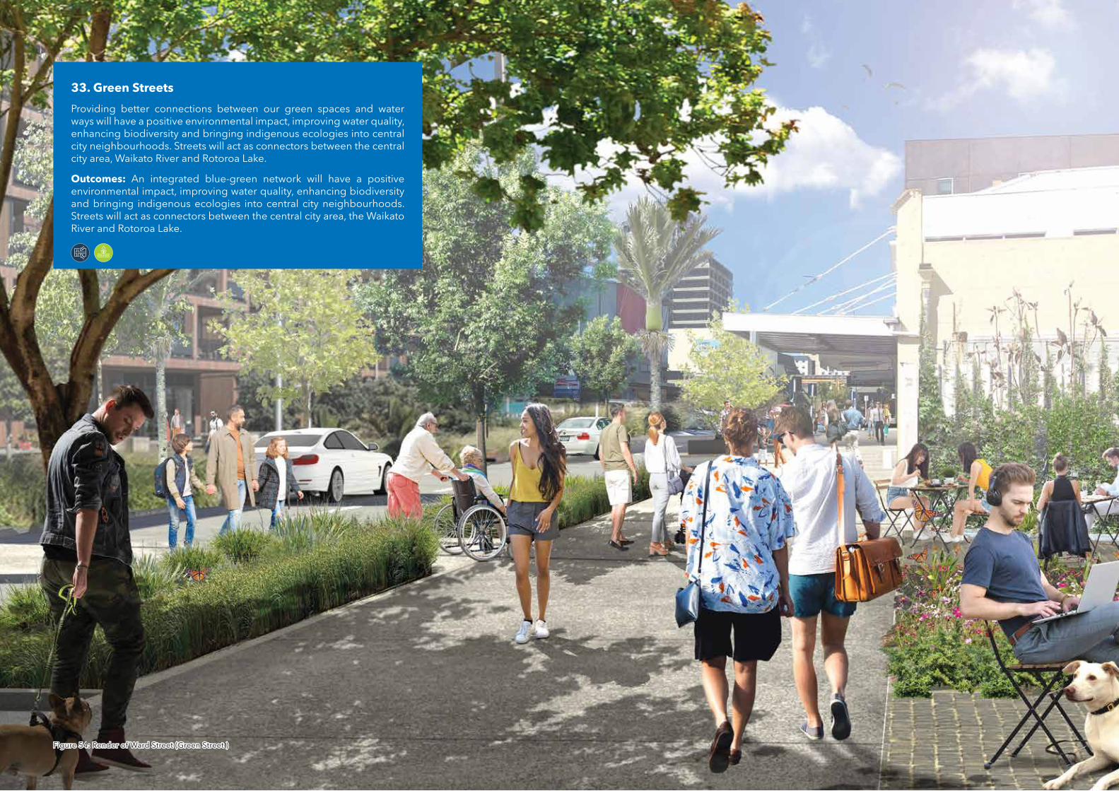
33. Green Streets
Providing better connections between our green spaces and water ways will have a positive environmental impact, improving water quality, enhancing biodiversity and bringing indigenous ecologies into central city neighbourhoods. Streets will act as connectors between the central city area, Waikato River and Rotoroa Lake.
Outcomes: An integrated blue-green network will have a positive environmental impact, improving water quality, enhancing biodiversity and bringing indigenous ecologies into central city neighbourhoods. Streets will act as connectors between the central city area, the Waikato River and Rotoroa Lake.
Figure 54: Render of Ward Street (Green Street )Figure 54: Render of Ward Street (Green Street )
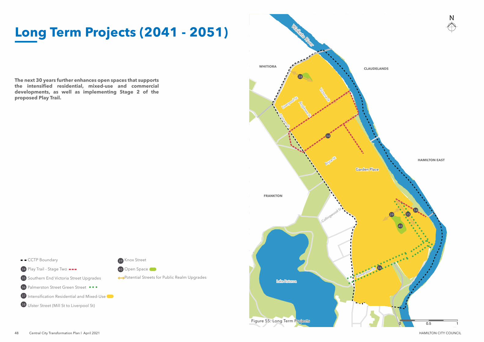
48 Central City Transformation Plan l April 2021 HAMILTON CITY COUNCIL
CCTP Boundary
Play Trail - Stage Two
Southern End Victoria Street Upgrades
Palmerston Street Green Street
Intensification Residential and Mixed-Use
Ulster Street (Mill St to Liverpool St)
Knox Street
Open Space
Potential Streets for Public Realm Upgrades
Waikato River
Waikato River
34
35
36
37
38
39
40
The next 30 years further enhances open spaces that supports the intensified residential, mixed-use and commercial developments, as well as implementing Stage 2 of the proposed Play Trail.
Figure 55: Long Term ProjectsFigure 55: Long Term Projects10.50
Long Term Projects (2041 - 2051)
Lake RotoroaLake Rotoroa
Anglesea St
Anglesea St
Liverpool St
Liverpool St
Bryce St
Bryce St
Palmerston St
Palmerston St
Tristram St
Tristram St
Victoria St
Victoria St
HAMILTON EASTHAMILTON EAST
FRANKTONFRANKTON
WHITIORAWHITIORACLAUDELANDSCLAUDELANDS
Garden PlaceGarden Place
Collingwood St
Collingwood St
34
35
36
40
38
3934
HAMILTON CITY COUNCIL Central City Transformation Plan l April 2021 49
36. Palmerston Street Green Street
The Palmerston Street green street connects the central city to Lake Rotoroa and Waikato River through promoting walking and cycling. Using urban design to improve stormwater outcomes, increase indigenous biodiversity and provide ecological pathways for birds and insects. General public space improvements to footpaths, furniture, lighting and provision of cycle paths on key streets.
Outcomes: As part of an integrated blue-green network Palmerston Street Green Street will contribute to achieving the goal of 10% native vegetation cover in the central city. The improved connection between Rotoroa Lake and the central city will embed regenerative infrastructure, enhancing biodiversity and improving the health and wellbeing of residents.
37. Residential Intensification and Mixed Use
The National Policy Statement for Urban Development requires Hamilton City Council to consider how we plan for and enhance the use of land in the central city. The Central City presents an opportunity to increase the number of dwellings in the central city by providing for medium to high density residential development as well as mixed use development. The neighbourhood will support a new residential community in the central city, providing amenity open spaces, play spaces and social infrastructure to support diverse populations.
Outcomes: Increased availability of houses as well as a diverse range of typologies can accommodate for different people. The increasing number of residential dwellings and population in the central city will be supported by a diverse range of places and services. New community infrastructure will consider the future needs of the community such as open spaces, street upgrades, schools and iconic buildings. Improved connections to the central city will ensure residential intensification contributes to activation of the central city area.
38. Ulster Street (Mill Street to Liverpool Street)
Improvements to public realm and streetscape along Ulster Street (Mill Street to Liverpool Street) to improve pedestrian amenity. Pedestrians and cyclists given modal priority of the street through interventions such as low speed zones or shared spaces. Movement and place will be better integrated to reflect the character and identity of the area to the north of the central city. Raingardens and increased tree canopy will improve the quality of water run off from Ulster Street.
Outcomes: Improved pedestrian amenity will encourage and support the use of safe, efficient and sustainable travel options. Ground floor activation, high quality pedestrian amenity and the design of streets to enhance quality of life supports the needs of the whole central city community around the clock.
39. Knox Street
Improvements to public spaces and streets along Knox Street to prioritise pedestrians and cyclists. Street enhancements include native planting, seating and lighting will contribute to a more accessible, safer and vibrant urban environment for all users.
Outcomes: Streetscape upgrades support and encourage increased walking through the provision of high quality urban realm, improving safety for all and ensuring spaces are accessible for a diverse range of users.
40. Open Space
Accessible open space is instrumental to creating places that people want to live in, meeting the needs of diverse users with different interests and abilities. Residential intensification will support opportunities for different housing typologies within the central city through encouragement of more affordable housing typologies.
Outcomes: Creating new open spaces in areas of anticipated residential and mixed-use intensification such as Southern Residential and Mixed-Use Precinct provides the increased residential density opportunities for recreation and social interaction between neighbours.
34. Play Trail - Stage Two
Stage Two of the Play Trail builds on the initiative of Stage One and further connects recreation and play opportunities across the central city, enhances moments of play activation within the streetscape and public realm.
• Rostrevor Street
• London Street
• Grantham Street
• River Path Play Space
• Grantham Street Play Space
Outcomes: Increased investment in play and recreation facilities in Hamilton will reflect the needs of the resident population, contributing to Hamilton becoming known as the most playful urban environment in New Zealand.
35. Southern End Victoria Street Upgrade
Upgrades to the Southern End of Victoria Street are an extension of interventions carried out in Phase 1 of the Victoria Street upgrades, reflecting a focus on improved amenity for and priority of active modes. In addition to supporting east west pedestrian movements between the central city and riverfront this phase will improve walking and biking connectivity to the mixed use and residential precinct to the north of the central city area.
Outcomes: Urban realm upgrades will encourage walking and biking, improving connections between Victoria Street, neighbouring precincts and the central city. Integration of movement and place will reflect the character and identity of the street and provide safe and accessible connections for all users.
Long Term Projects (2041 - 2051)
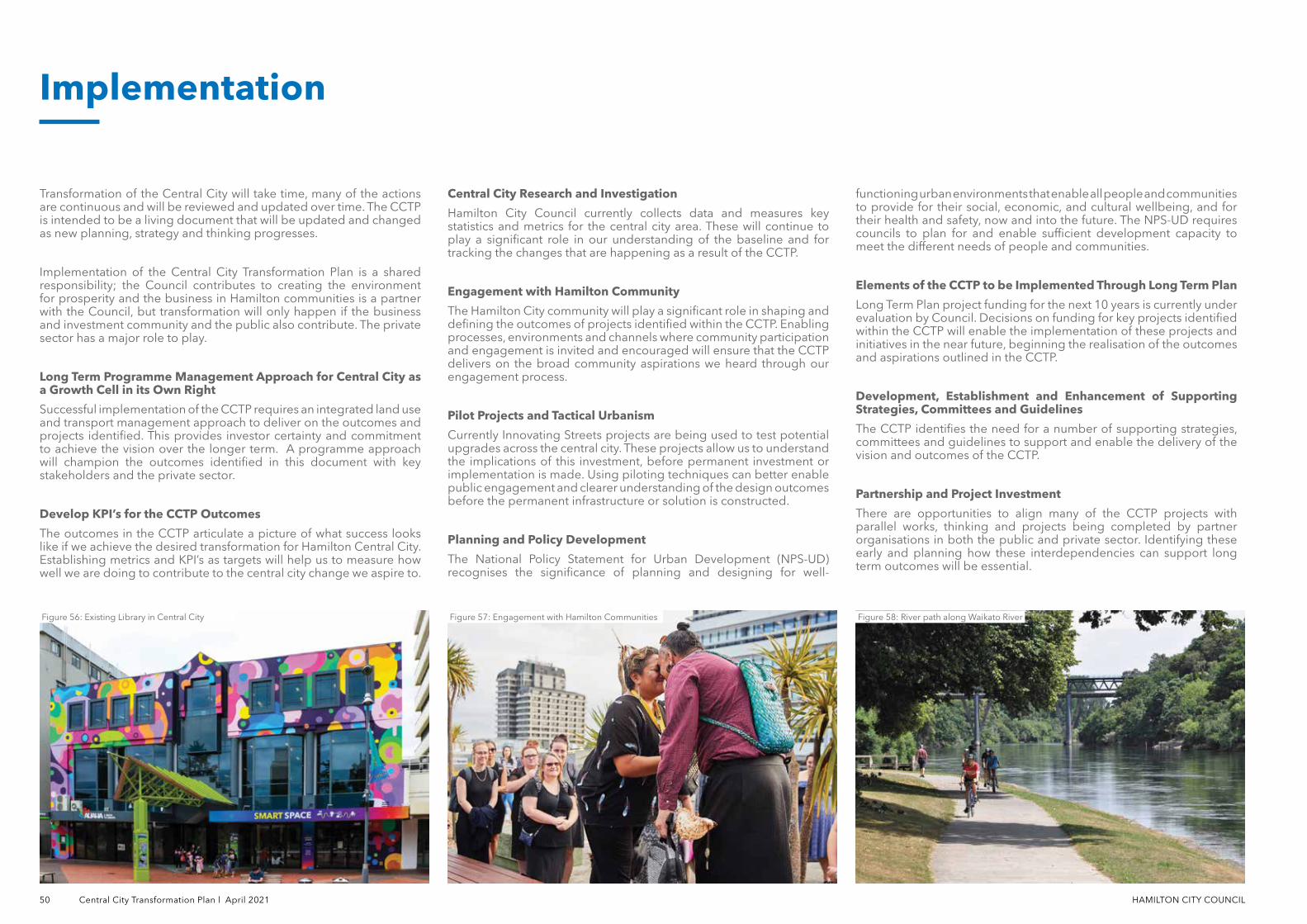
50 Central City Transformation Plan l April 2021 HAMILTON CITY COUNCIL
Implementation
Transformation of the Central City will take time, many of the actions are continuous and will be reviewed and updated over time. The CCTP is intended to be a living document that will be updated and changed as new planning, strategy and thinking progresses.
Implementation of the Central City Transformation Plan is a shared responsibility; the Council contributes to creating the environment for prosperity and the business in Hamilton communities is a partner with the Council, but transformation will only happen if the business and investment community and the public also contribute. The private sector has a major role to play.
Long Term Programme Management Approach for Central City as a Growth Cell in its Own Right
Successful implementation of the CCTP requires an integrated land use and transport management approach to deliver on the outcomes and projects identified. This provides investor certainty and commitment to achieve the vision over the longer term. A programme approach will champion the outcomes identified in this document with key stakeholders and the private sector.
Develop KPI’s for the CCTP Outcomes
The outcomes in the CCTP articulate a picture of what success looks like if we achieve the desired transformation for Hamilton Central City. Establishing metrics and KPI’s as targets will help us to measure how well we are doing to contribute to the central city change we aspire to.
Central City Research and Investigation
Hamilton City Council currently collects data and measures key statistics and metrics for the central city area. These will continue to play a significant role in our understanding of the baseline and for tracking the changes that are happening as a result of the CCTP.
Engagement with Hamilton Community
The Hamilton City community will play a significant role in shaping and defining the outcomes of projects identified within the CCTP. Enabling processes, environments and channels where community participation and engagement is invited and encouraged will ensure that the CCTP delivers on the broad community aspirations we heard through our engagement process.
Pilot Projects and Tactical Urbanism
Currently Innovating Streets projects are being used to test potential upgrades across the central city. These projects allow us to understand the implications of this investment, before permanent investment or implementation is made. Using piloting techniques can better enable public engagement and clearer understanding of the design outcomes before the permanent infrastructure or solution is constructed.
Planning and Policy Development
The National Policy Statement for Urban Development (NPS-UD) recognises the significance of planning and designing for well-
functioning urban environments that enable all people and communities to provide for their social, economic, and cultural wellbeing, and for their health and safety, now and into the future. The NPS-UD requires councils to plan for and enable sufficient development capacity to meet the different needs of people and communities.
Elements of the CCTP to be Implemented Through Long Term Plan
Long Term Plan project funding for the next 10 years is currently under evaluation by Council. Decisions on funding for key projects identified within the CCTP will enable the implementation of these projects and initiatives in the near future, beginning the realisation of the outcomes and aspirations outlined in the CCTP.
Development, Establishment and Enhancement of Supporting Strategies, Committees and Guidelines
The CCTP identifies the need for a number of supporting strategies, committees and guidelines to support and enable the delivery of the vision and outcomes of the CCTP.
Partnership and Project Investment
There are opportunities to align many of the CCTP projects with parallel works, thinking and projects being completed by partner organisations in both the public and private sector. Identifying these early and planning how these interdependencies can support long term outcomes will be essential.
Figure 56: Existing Library in Central City Figure 57: Engagement with Hamilton Communities Figure 58: River path along Waikato River

Appendices
The CCTP also supports other similar, direction-setting Hamilton City Council strategies, including:
• Hamilton City River Plan
• Ferrybank Development Plan
• West Town Belt Masterplan
• Metro Spatial Plan
• Hamilton Urban Growth Strategy
• Access Hamilton Strategy
• Mode Shift Plan
• Biking and Micro-mobility Plan
• Heritage Plan
• Economic Development Agenda
• Central City Safety Strategy
• Play Strategy 2019
• Open Spaces Plan
• Nature in the City Strategy
• Hamilton Arts Agenda and Public Art Plan
• Hamilton Age Friendly Plan
• Disability Action Plan
• Hamilton Speed Management Plan
• Smart City Plan
• Waste Management and Minimisation Plan
• Community and Social Development Plan
Hamilton City Council Strategies
Appendix A
Hamilton KirikiriroaCentral City Transformation Plan Baseline Analysis
Appendix B

hamilton.govt.nz
Hamilton City CouncilGarden Place, Private Bag 3010, Hamilton