Embed Size (px)
Citation preview

Central Pine Barrens Comprehensive Land Use Plan
Volume 1: Policies, Programs and Standards
Central Pine Barrens Comprehensive Land Use PlanVolume 1: Policies, Programs and Standards
Note:This scanned copy of Volume 1 contains:
1. Volume 1 (originally issued 1995) as amendedthrough 5/1/1996),
2. Volume 1 amendments of 2/21/2001, and3. Volume 1 amendments as of 10/20/20044. Volume 1 amendments as of 5/16/20125. Volume 1 amendments as of 11/21/2012
Page numbers in the text may not coincide with page numbers in thisAcrobat pdf file, due to illustration inserts.
The following chart illustrates the sequence of Plan changes andstatutory changes from 1995 to the present.
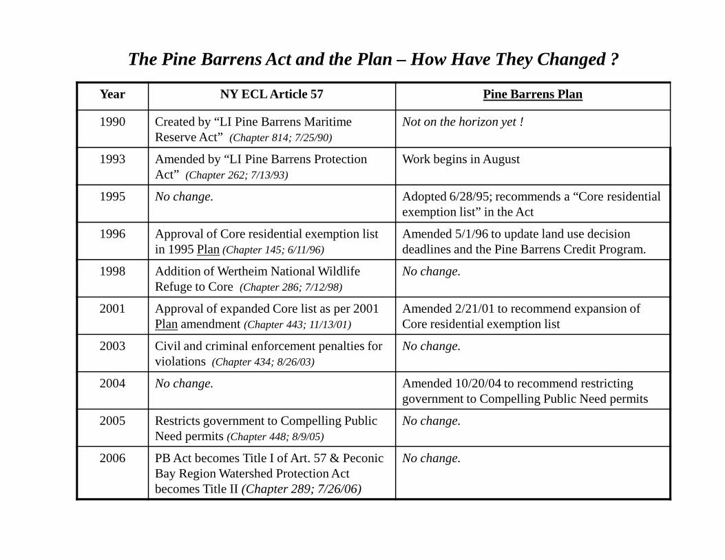
The Pine Barrens Act and the Plan – How Have They Changed ?
Year NY ECL Article 57 Pine Barrens Plan
1990 Created by “LI Pine Barrens Maritime Reserve Act” (Chapter 814; 7/25/90)
Not on the horizon yet !
1993 Amended by “LI Pine Barrens Protection Act” (Chapter 262; 7/13/93)
Work begins in August
1995 No change. Adopted 6/28/95; recommends a “Core residential exemption list” in the Act
1996 Approval of Core residential exemption list in 1995 Plan(Chapter 145; 6/11/96)
Amended 5/1/96 to update land use decision deadlines and the Pine Barrens Credit Program.
1998 Addition of Wertheim National Wildlife Refuge to Core
No change.Refuge to Core (Chapter 286; 7/12/98)
2001 Approval of expanded Core list as per 2001 Planamendment (Chapter 443; 11/13/01)
Amended 2/21/01 to recommend expansion of Core residential exemption list
2003 Civil and criminal enforcement penalties for violations (Chapter 434; 8/26/03)
No change.
2004 No change. Amended 10/20/04 to recommend restricting government to Compelling Public Need permits
2005 Restricts government to Compelling Public Need permits (Chapter 448; 8/9/05)
No change.
2006 PB Act becomes Title I of Art. 57 & Peconic Bay Region Watershed Protection Act becomes Title II(Chapter 289; 7/26/06)
No change.
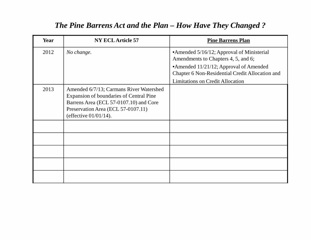
The Pine Barrens Act and the Plan – How Have They Changed ?
Year NY ECL Article 57 Pine Barrens Plan
2012 No change. •Amended 5/16/12; Approval of MinisterialAmendments to Chapters 4, 5, and 6;
•Amended 11/21/12; Approval of Amended
2013 Amended 6/7/13; Carmans River Watershed Expansion of boundaries of Central Pine Barrens Area (ECL 57-0107.10) and Core Preservation Area (ECL 57-0107.11) (effective 01/01/14).
Chapter 6 Non-Residential Credit Allocation and
Limitations on Credit Allocation
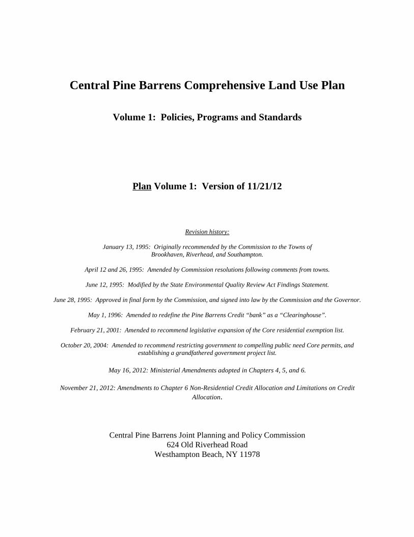
Central Pine Barrens Comprehensive Land Use Plan
Volume 1: Policies, Programs and Standards
Plan Volume 1: Version of 11/21/12
Revision history:
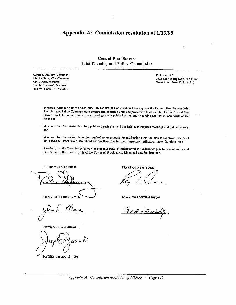
January 13, 1995: Originally recommended by the Commission to the Towns ofBrookhaven, Riverhead, and Southampton.
April 12 and 26, 1995: Amended by Commission resolutions following comments from towns.
June 12, 1995: Modified by the State Environmental Quality Review Act Findings Statement.
June 28, 1995: Approved in final form by the Commission, and signed into law by the Commission and the Governor.
May 1, 1996: Amended to redefine the Pine Barrens Credit “bank” as a “Clearinghouse”.
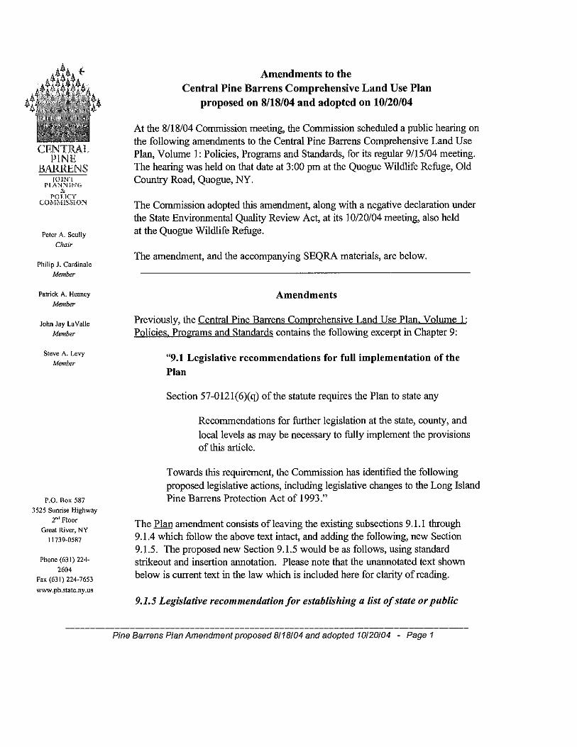
February 21, 2001: Amended to recommend legislative expansion of the Core residential exemption list.
October 20, 2004: Amended to recommend restricting government to compelling public need Core permits, andestablishing a grandfathered government project list.
May 16, 2012: Ministerial Amendments adopted in Chapters 4, 5, and 6.
November 21, 2012: Amendments to Chapter 6 Non-Residential Credit Allocation and Limitations on CreditAllocation.
Central Pine Barrens Joint Planning and Policy Commission624 Old Riverhead Road
Westhampton Beach, NY 11978


4. Review Procedures and Jurisdiction
4.1 Introduction*
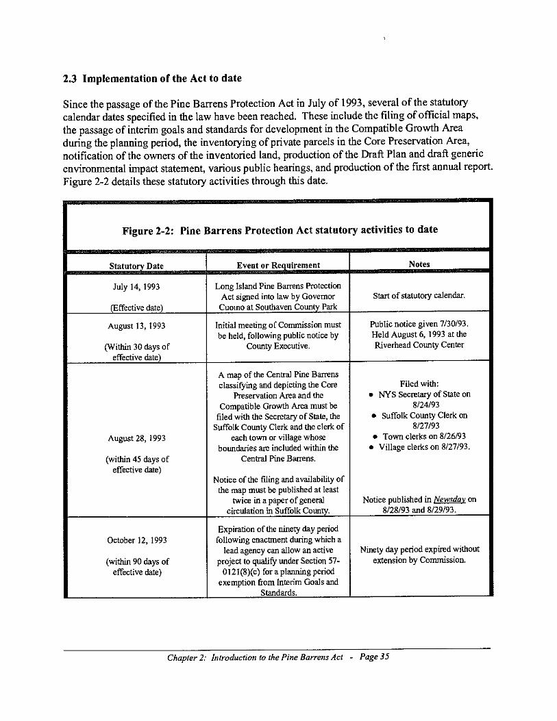
The following sets forth the procedures to be used by the Central Pine Barrens Joint Planning andPolicy Commission for review of development in the Central Pine Barrens as provided for in theLong Island Pine Barrens Protection Act.
This process does not exempt any development project from the provisions of the New YorkState Environmental Quality Review Act, the National Environmental Policy Act and otherregulatory requirements and applicable federal, state, county, or local laws. For development thatadheres to the standards for land use contained herein and the Statement of Findings adoptedupon completion of the Generic Environmental Impact Statement prepared pursuant to the Act,the cumulative impact analysis pursuant to the State Environmental Quality Review Act will bedeemed to be satisfied.
4.2 Intent
It is the intent of the Central Pine Barrens Joint Planning and Policy Commission to provide foreffective environmental review of proposed development in the Central Pine Barrens, and toavoid duplicate reporting and review requirements and unnecessary delays. Municipalities areencouraged to develop streamlined review procedures for development proposals that conformwith the land use and development standards contained herein. It is the further intent of theCommission to provide timely reviews and input which are concurrent with the New York StateEnvironmental Quality Review Act, the National Environmental Policy Act and other regulatoryrequirements and applicable federal, state, county, or local laws.
These procedures are intended to coordinate Commission guidance and provide regulatoryreview of development located in the Central Pine Barrens area as defined and delineated in theNew York State Environmental Conservation Law, Article 57. The Central Pine Barrens is a"critical environmental area" pursuant to New York State Environmental Conservation LawArticle 8 and its implementing regulations.
For development subject to review pursuant to the Act and defined in this Plan, the Commissionshall hold only one (1) hearing on a development proposal, unless the Commission by majorityvote deems it necessary to hold an additional hearing.
4.3 Definitions
For the purposes of these procedures, the following terms and phrases shall have the meaninglisted.
Chapter 4: Review Procedures and Jurisdiction - Page 1
4.3.1 Complete application
A "complete application" shall consist of the following:
1. a completed standard application form, as supplied by the Commission;2. a copy of the local municipal application package with all supporting materials, and anyapprovals that have been issued as of the date of the application; and,3. as required and accepted with respect to scope and content, a Long Form EnvironmentalAssessment or Draft Supplemental draft supplementalEnvironmental Impact Statement, in addition to any other documentation prepared or issuedpursuant to the State Environmental Quality Review Act or equivalent local laws, as of the dateof the application.
4.3.2 Plan
"Plan" shall mean the Central Pine Barrens Comprehensive Land Use Plan, Volume 1.
4.3.3 Commission*
"Commission" shall mean the Central Pine Barrens Joint Planning and Policy Commission asdefined within the New York Environmental Conservation Law Article 57.
4.3.4 Act*
"Act" shall mean New York State Environmental Conservation Law, Article 57 as may beamended from time to time.
4.3.5 Development
"Development" shall have the meaning set forth in Section 57-0107 (13) of the Act.
4.3.6 Central Pine Barrens*
"Central Pine Barrens" shall have the meaning set forth in Section 57-0107 (10) of the Act.
4.3.7 Core Preservation Area*
"Core Preservation Area" shall have the meaning set forth in Section 57-0107 (11) of the Act.
4.3.8 Compatible Growth Area*
"Compatible Growth Area" shall have the meaning set forth in Section 57-0107 (12) of the Act.
Chapter 4: Review Procedures and Jurisdiction - Page 2
4.4 Development subject to review by the Commission
The following types of development shall be the subject of review by the Commission asprovided for in the Act:
4.4.1 Development located within the Core Preservation Area
This includes all development proposed within the Core Preservation Area.
4.4.2 Nonconforming development within the Compatible Growth Area
This includes all development within the Compatible Growth Area that does not conform to thestandards for land use set forth in Volume 1, Chapter 5 of this Plan.
4.4.3 Compatible Growth Area development over which the Commission assertsjurisdiction
This includes development within the Compatible Growth Area for which the Commission, by anindividual Commissioner's petition and a majority vote, asserts review jurisdiction as providedfor in the Act.
4.4.4 Compatible Growth Area development within Critical Resource Areas
This includes all development within the Compatible Growth Area which is also within a CriticalResource Area as provided for in the Act and defined in this Plan.
4.4.5 Developments of Regional Significance
This includes development within the Compatible Growth Area which constitutes a Developmentof Regional Significance as provided for in the Act and defined in this Plan.
4.5 Review procedures
4.5.1 Development located within the Core Preservation Area (“Core development”)*
The Act requires the prohibition or redirection of development in the Core Preservation Area andsets forth the jurisdiction of the Commission over, and certain requirements for processing,hardship exemptions. The Act authorizes the Commission, by majority vote, to waive strictcompliance with this Plan upon finding that such waiver is necessary to alleviate hardshipaccording to the conditions and finding of extraordinary hardship or compelling public needpursuant to subdivision 10 of Section 57-0121 of the Act.
Chapter 4: Review Procedures and Jurisdiction - Page 3

4.5.1.1 Core development: Lead agency assertion*
The Commission shall seek lead agency status for development proposed in the CorePreservation Area pursuant to the State Environmental Quality Review Act.
4.5.1.2 Core development: Filing of an application*
The application shall be filed with the Commission by the project sponsor. A municipalapplication to the Town is not required for an application under this subsection.
4.5.1.3 Core development: Hearing*
Within thirty (30) days of an application being submitted to the Commission, a public hearing onthe development shall be held. At this time, the project sponsor and any other person shall havean opportunity to comment on the development proposal.
4.5.1.4 Core development: Statutory basis for the Commission's decision*
The decision by the Commission on the application shall be based upon the standards insubdivision 10 of Section 57-0121 of the Act, which describes the criteria for determining that ahardship has been demonstrated.
4.5.1.5 Core development: Decisions, default decisions and extensions of decisions*
The time within which the Commission must decide a Core Preservation Area hardshipapplication for which a negative declaration has been made by the Commission pursuant toEnvironmental Conservation Law Article 8 is one hundred twenty (120) days from receipt ofsuch application. The time within which the Commission must decide a Core Preservation Areahardship application for which a positive declaration has been made by the Commission pursuantto Environmental Conservation Law Article 8 is sixty (60) days from issuance of a findingsstatement by the Commission pursuant to Environmental Conservation Law Article 8. If theCommission fails to make a decision within the aforesaid time periods, the development shall bedeemed to be approved by the Commission, unless such time periods are extended by mutualagreement of the applicant and the Commission.
4.5.2 Development located within the Compatible Growth Area which does not conform tothe standards contained in Volume 1, Chapter 5 of the Plan
The Act sets forth the jurisdiction for the Commission's review of development within theCompatible Growth Area of the Central Pine Barrens area. Such review includes developmentthat does not conform to the standards in Volume 1, Chapter 5 of this plan. The Act alsoauthorizes the Commission, by majority vote, to waive strict compliance with the standards uponfinding that such waiver is necessary to alleviate a demonstrated hardship. The Commission
Chapter 4: Review Procedures and Jurisdiction - Page 4
shall not review conformance or nonconformance with guidelines in Volume 1, Chapter 5 inevaluating hardship provisions under this section.
4.5.2.1 Filing of an application
For projects that are not consistent with the standards, a complete application shall be filed withthe Commission by the project sponsor.
4.5.2.2 Nonconforming development: Changes in consistent projects*
If, during the local review, a proposed development project is modified such that the localmunicipality finds that it becomes inconsistent with any standard in Volume 1, Chapter 5, thelocal municipality shall notify the Commission and the project sponsor immediately. Uponreceipt of said notice, the project sponsor shall be notified that an application for hardship reliefas provided herein shall be required. Alternatively, the project sponsor shall be afforded anopportunity to revise the development project so that it is consistent with the standards.
4.5.2.3 Completeness determination deadline
The Commission shall make a determination as to whether an application is complete withinthirty (30) days of receipt of the application.
4.5.2.4 Nonconforming development: Review standards*
The Commission's standard for review pursuant to this section shall be the hardship standardprovided in Section 57-0123(3) of the Act, as amended from time to time.
4.5.2.5 Nonconforming development: Hearing*
Within thirty (30) days of the application being deemed complete, a public hearing on thedevelopment proposal shall be held. The Commission shall provide the project sponsor and anyother person an opportunity to be heard as provided for, and in accordance with the proceduresprovided in the Act.
4.5.2.6 Nonconforming development: Decisions, default decisions and extensions ofdecisions*
The time within which the Commission must make a decision on a Compatible Growth Areaapplication which does not conform to the standards contained within Volume 1, Chapter 5 ofthe Plan is one hundred twenty (120) days from said application being deemed complete. If theCommission fails to make a decision within the aforesaid time period, the application shall bedeemed to be approved by the Commission, unless such time period is extended by mutualagreement of the applicant and the Commission.
Chapter 4: Review Procedures and Jurisdiction - Page 5

4.5.3 Development located within the Compatible Growth Area which has been subjectedto a petition by the Commission pursuant to ECL Section 57-0123(2)
The Act sets forth the jurisdiction for the Commission's review of development within theCompatible Growth Area of the Central Pine Barrens. The Act authorizes the Commission,through petition by an individual commissioner and an affirmative vote of the Commission, toreview any project which has a significant adverse impact on the goals of the Plan.
4.5.3.1 Assertion of jurisdiction by the Commission over the project*
Upon a majority vote of the commissioners, the Commission may assert review jurisdiction oversaid project.
4.5.3.2 Hearings and assertion of review jurisdiction
Assertion of review jurisdiction by the Commission shall not be deemed to require a publichearing unless the Commission, by a majority vote, so specifies.
4.5.3.3 Review standards
Should the Commission assert review jurisdiction pursuant to this subdivision, the jurisdiction ofthe Commission shall be limited to the standards and guidelines set forth in Volume 1, Chapter 5of this Plan which the Commission identified in the vote on jurisdictional assertion. TheCommission shall review conformance with guidelines set forth in Volume 1, Chapter 5 of thisPlan.
4.5.3.4 Assertion development: Hearing*
The Commission shall request necessary information from the project sponsor. Within sixty (60)days of the Commission asserting review jurisdiction, a public hearing on the developmentproposal shall be held, unless the Commission by majority vote deems a hearing unnecessary, inaccordance with the procedures provided in the Act. If a hearing is held, the Commission shallprovide the project sponsor and any other person an opportunity to be heard as provided for, andin accordance with, the procedures provided in the Act.
4.5.3.5 Assertion development: Decision on projects over which jurisdiction is asserted bythe Commission*
The decision of the Commission on any project which is before it by virtue of the assertion ofjurisdiction by the Commission shall be made within one hundred twenty (120) days of the dateof said assertion of jurisdiction.
Chapter 4: Review Procedures and Jurisdiction - Page 6
4.5.3.6 Assertion development: Default decisions*
In the event that the Commission fails to make a decision within one hundred twenty (120) days,the development proposal shall be deemed to be approved by the Commission.
4.5.4 Development located within the Compatible Growth Area which is also locatedwithin a Critical Resource Area
The Act sets forth the jurisdiction for the Commission's review of development within theCompatible Growth Area of the Central Pine Barrens. Such review includes development that islocated in Critical Resource Areas. The Act also authorizes the Commission, by majority vote,to waive strict compliance with this Plan upon finding that such waiver is necessary to alleviate ademonstrated hardship.
4.5.4.1 Definition of Critical Resource Areas
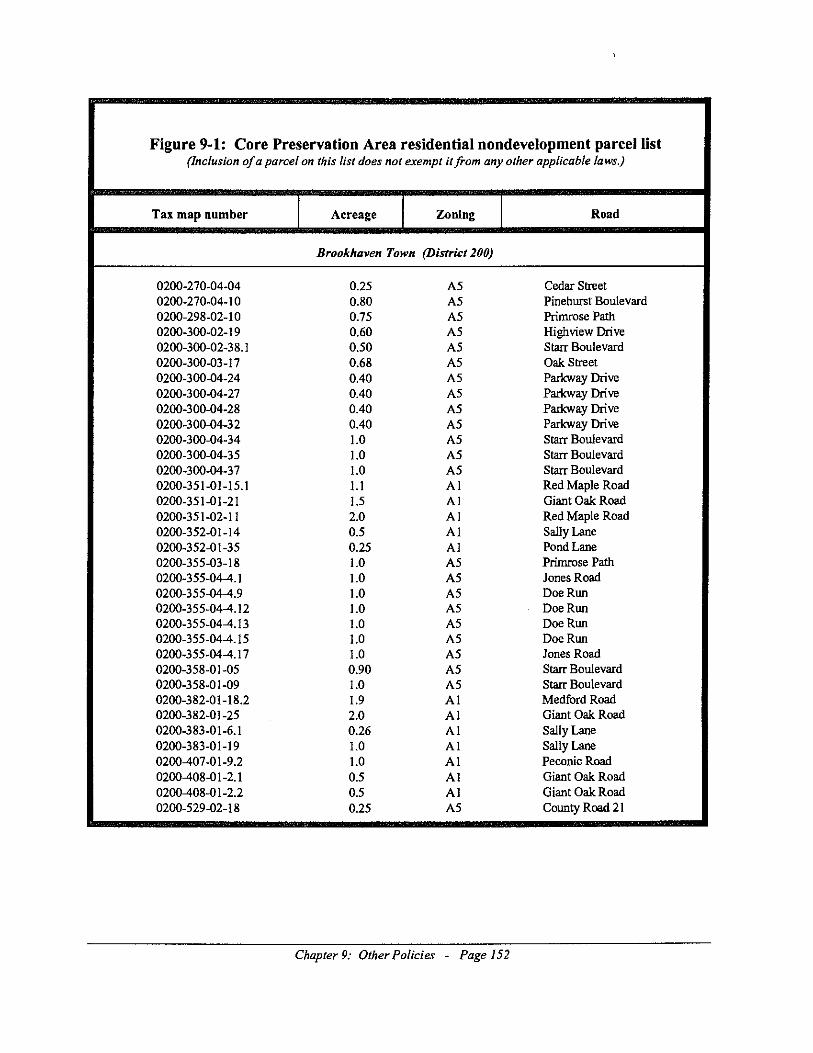
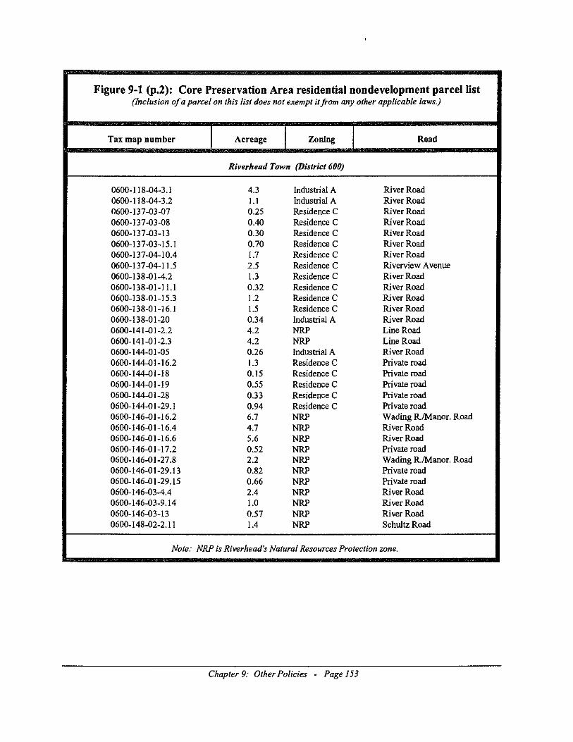
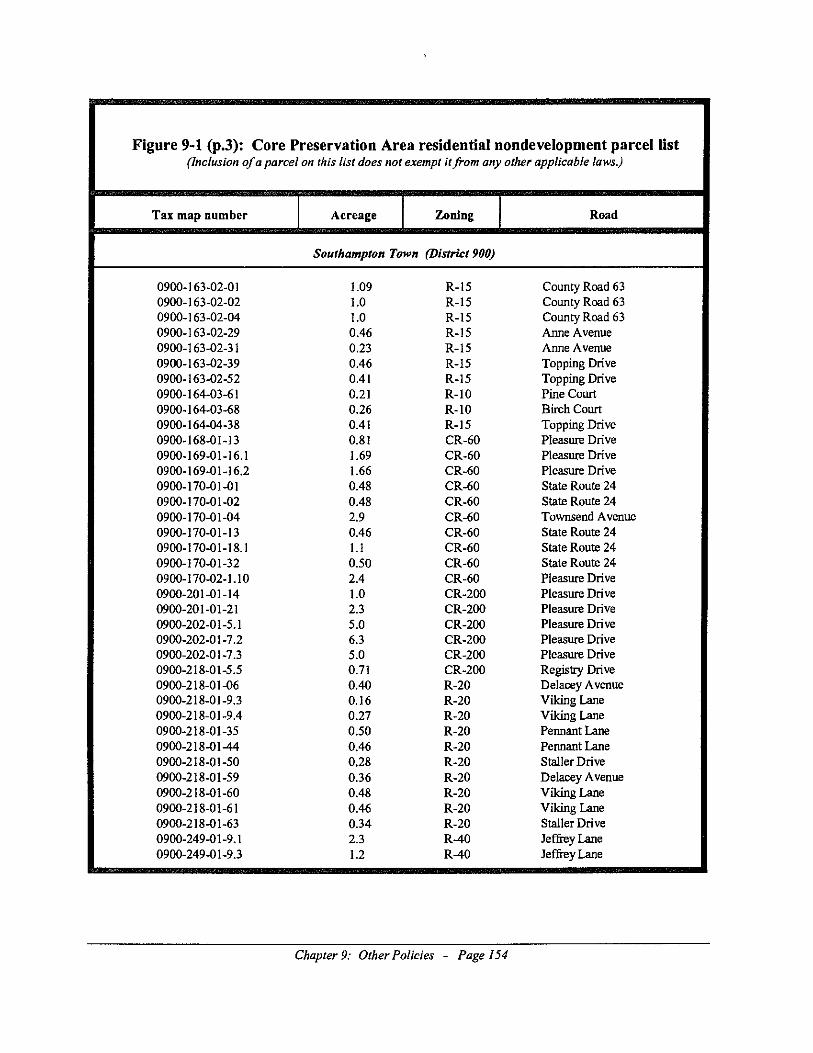
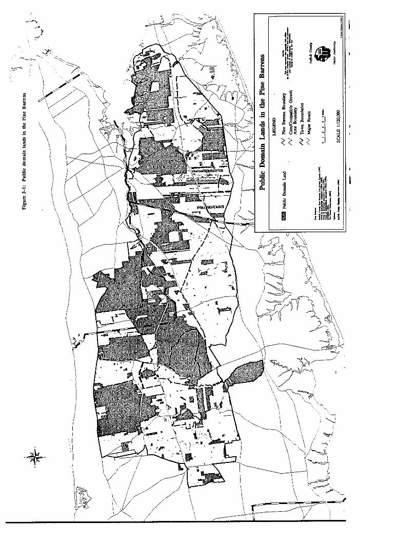
Commission review pursuant to this section shall apply only to the Critical Resource Areasidentified in Figures 4-1 through 4-6.
Chapter 4: Review Procedures and Jurisdiction - Page 7

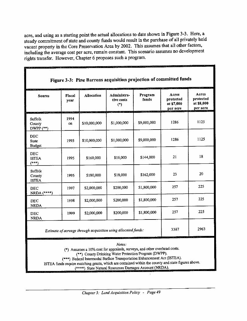
Figure 4-1: Summary of Critical Resource Areas in the Central Pine Barrens
(Resolved by the Commission at its 12/14/94 meeting. All sites are within the Compatible Growth Area.)
Name andDescription
Tax Map Number andApproximate Size
Feature(s)
Carmans River WestMiddle IslandWest bank of Carmans River,opposite Carmans River East site.See B1 on Figure 4-2
0200-528-06-16Approx. 24.5 acres.
Sending area.Steep slopes (entire site), culturalresources, atypical wetlandvegetation association on uplandportion, exploitably vulnerablespecies (e.g., prickly pear, spottedwintergreen, trailing arbutus,mountain laurel), large hardwoodforest, DEC freshwater wetland (B-3), riverfront open space.
Carmans River EastMiddle IslandEast bank of Carmans River, oppositeCarmans River West site.See B2 on Figure 4-2
0200-548-02-1.4 and 1.6Approx. 28 acres.
Sending area.Steep slopes (especially from 60 footcontour to the west and the river,steeply sloped swales (possibly anearly Holocene drainage formation),cultural resources with higharchaeological potential, andextensive freshwater wetlands withassociated vegetation (e.g.,pepperbush, red maple, black gum)exist on this site.
South Manorville Site 1South of Hot Water Street, west ofCR 111.See B3 on Figure 4-3
0200-510-02-01, 2.2, 3,4Approx. 82 acres.
The partially county-ownedCranberry Pond to the immediatenorth of this site is a documentedtiger salamander habitat, and this sitecontains much of the upland portionof that habitat (generally estimated asapproximately 1000 feet from thesouthern shore). This hilly site alsocontains the area known as Punk'sHole, a Revolutionary War bivouacsite.
South Manorville Site 2South of Hot Water Street, west ofCR 111.See B4 on Figure 4-3
0200-561-01-12, 13Approx. 18 acres.
This site enhances the adjacent openspace tracts.
Flanders PondsSouthwest corner of CR 105 andNYS Rt 24See S1 on Figure 4-4
0900-142-01-1.42, 53, 54.3Approx. 90 acres
Extensive surface waters.
Chapter 4: Review Procedures and Jurisdiction - Page 8
Pleasure Drive WestFlandersSouth of NYS Rt 24, west of PleasureDrive.See S2 on Figure 4-4
0900-166-04-010900-167-03-09Approx. 128 acres.
Archaeological and wetland areas.
Red Creek Site 1: Wehrman PondSouth side of Red Creek Rd, oppositeRed Creek Pond.See S3 on Figure 4-5
0900-151-01-06, 10.2Approx. 19 acres.
Sending area.Wehrman Pond and the adjacentuplands comprise an eastern mudturtle habitat.
Red Creek Site 2North side of Old Squires Rd, west ofRed Creek Road.See S4 on Figure 4-5
0900-173-02-1.2Approx. 46 acres.
Mixed deciduous forest complementsexisting open space on adjacentparcels.
Red Creek Site 3West of Red Creek RoadSee S5 on Figure 4-5
0900-173-02-8.1Approx. 41 acres.
Part of the corridor for the proposedPaumanok Path segment headingtowards Squire Pond.
Red Creek Site 4North of NYS Rt 24 and South ofOld Squires Road.See S6 on Figure 4-5
0900-173-01-010900-205-01-01Approx. 79 acres.
Open space area complementingadjacent parkland.
Munns Pond VicinityHampton BaysNorth side of Montauk Highway,adjacent to east side of Munn's Pondparkland, west of Bellows PondRoad.See S7 on Figure 4-5
0900-221-02-10Approx. 10 acres.
Open space area buffering theadjacent Munn's Pond site.
Henry's Hollow RegionEast QuogueLies between Sunrise Highway andthe railroad tracksSee S8 on Figure 4-5
0900-220-01-40-860900-220-01-p/o 87, 88.1, 920900-220-01-p/o 98.1, 99.240900-220-01-99.1-99.220900-220-03-1-820900-220-04-1-70900-251-01-680900-251-01-p/o 90, 91.1, 920900-251-01-980900-289-02-1-38(p/o refers to that part located inCGA)Approx. 985 acres.
Buck moth habitat generally north of100 foot contour.
Dwarf PinesGabreski AirportWesthamptonContains the northwesternmostcorner of Gabreski Airport.See S9 on Figure 4-6
0900-312-01-p/o 01Approx. 34 acres.
Dwarf pine plains.
Chapter 4: Review Procedures and Jurisdiction - Page 9
Upland ForestWesthamptonEast of Speonk-Riverhead Rd and 5thAve., north of Montauk Highway.See S10 on Figure 4-6
0900-276-03-p/o 01, 02, 5.10900-305-01-6,70900-329-01-01, 1.2, 3, 3.1, 4, 5,6, 7, 8.10900-329-01-p/o 9, 100900-330-01-02, 4.1(p/o refers to that part located inCGA and not in a receiving area)Approx. 153 acres.
Open space on northerly portion ofsite complements adjacent openspace.
Chapter 4: Review Procedures and Jurisdiction - Page 10
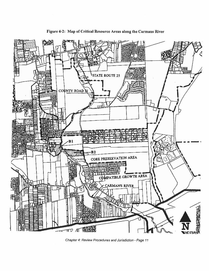
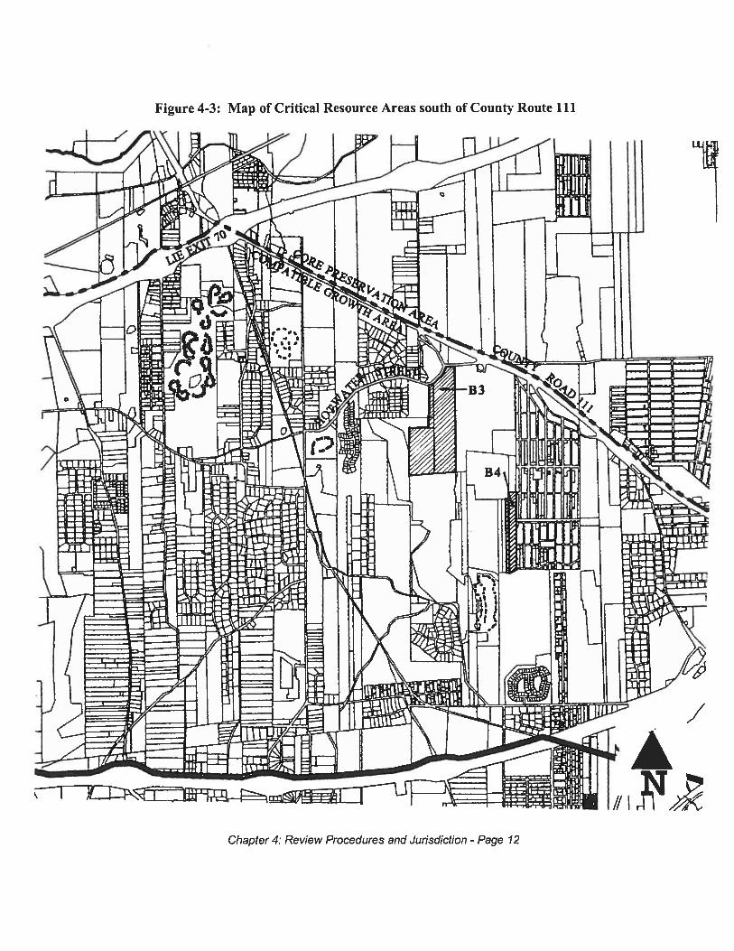
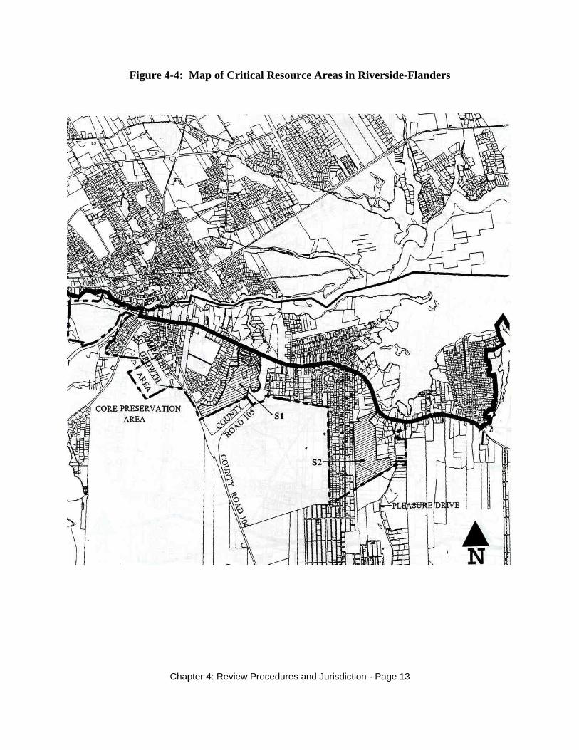
Figure 4-4: Map of Critical Resource Areas in Riverside-Flanders
Chapter 4: Review Procedures and Jurisdiction - Page 13

Figure 4-5: Map of Critical Resource Areas in Red Creek vicinity
Chapter 4: Review Procedures and Jurisdiction - Page 14
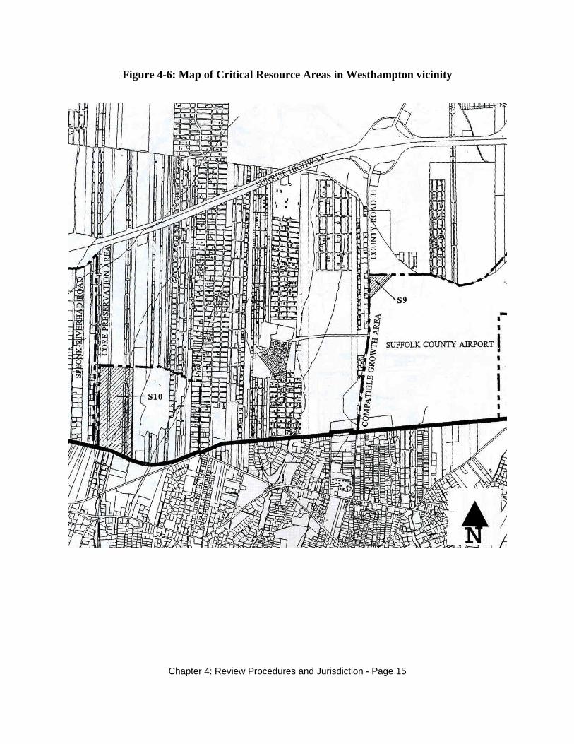
Figure 4-6: Map of Critical Resource Areas in Westhampton vicinity
Chapter 4: Review Procedures and Jurisdiction - Page 15
4.5.4.2 Review standards
The Commission's review pursuant to this section shall be limited to compliance with thestandards and guidelines set forth in Volume 1, Chapter 5 of this Plan and the protection for thecritical resource feature(s) designated in the Plan. The Commission shall review conformancewith guidelines set forth in Volume 1, Chapter 5 of this Plan.
4.5.4.3 Application and hearing
A complete application shall be filed by the project sponsor as defined in 4.3.1. Within sixty(60) days of the application being deemed complete, a public hearing on the developmentproposal shall be held, unless the Commission by majority vote deems a hearing unnecessary, inaccordance with the procedures specified in the Act. If a hearing is held, the Commission shallprovide the project sponsor and any other person an opportunity to be heard as provided for, andin accordance with the procedures provided in the Act.
4.5.4.4 Decision on the application
A decision on the application shall be made by the Commission within one hundred twenty (120)days of said application being deemed complete.
4.5.4.5 Default decisions
In the event that the Commission fails to make a decision within one hundred twenty (120) days,the proposal shall be deemed to be approved by the Commission.
4.5.5 Developments of Regional Significance located within the Compatible Growth Area
The Act sets forth the jurisdiction for the Commission's review of development within theCompatible Growth Area of the Central Pine Barrens. This includes the review of developmentthat meets the threshold(s) constituting a Development of Regional Significance as enumeratedin the Plan. The Act also authorizes the Commission, by majority vote, to waive strictcompliance with this Plan upon finding that such waiver is necessary to alleviate a demonstratedhardship.
4.5.5.1 Definition of a Development of Regional Significance
The following developments are defined as Developments of Regional Significance.
1. A commercial, industrial or office development project exceeding 300,000 square feet ofgross floor area, or an addition to an existing commercial, industrial or office development wherethe addition is 100,000 square feet or more and that addition causes the total square footage toexceed 300,000 square feet.
Chapter 4: Review Procedures and Jurisdiction - Page 16
2. A multifamily residential development project consisting of three hundred (300) or moreunits.3. A single family, detached residential development project consisting of two hundred (200) ormore units.4. A development project resulting in a traffic impact which would reduce service by two (2)levels below existing conditions or to a level of service of D or below.
Development projects which meet all of the following three criteria are not Developments ofRegional Significance:
1. the development project is situated within a designated receiving area pursuant to thisPlan, and
2. the development project results from a transfer of development rights from a sendingarea as defined in this Plan, and
3. the development project contains a minimum of fifteen percent (15%) of residentialunits, or a minimum of fifteen percent (15%) of commercial, industrial or officeuse square footage, which is a direct result of the transfer of development rights.
Additionally, the Calverton redevelopment project described in Chapter 9 is defined to not be aDevelopment of Regional Significance.
4.5.5.2 Review standards
The Commission's review pursuant to this section shall be limited to compliance with thestandards and guidelines set forth in Volume 1, Chapter 5 of this Plan. The Commission shallreview conformance with guidelines set forth in Volume 1, Chapter 5 of this Plan.
4.5.5.3 Application and hearing
A complete application shall be filed by the project sponsor as defined in 4.3.1. Within sixty(60) days of the application being deemed complete, a public hearing on the developmentproposal shall be held unless the Commission by majority vote deems a hearing unnecessary, inaccordance with the procedures provided in the act. If a hearing is held, the Commission shallprovide the project sponsor and any other person an opportunity to be heard as provided for, andin accordance with the procedures provided in the Act.
4.5.5.4 Decision on the application
A decision on the application shall be made by the Commission within one hundred twenty (120)days of said application being deemed complete.
4.5.5.5 Default decisions
Chapter 4: Review Procedures and Jurisdiction - Page 17
In the event that the Commission fails to make a decision within one hundred twenty (120) days,the proposal shall be deemed to be approved by the Commission.
4.5.6 Adoption of sense resolutions by the Commission for development projects*
With respect to a development project undergoing review pursuant to the State EnvironmentalQuality Review Act (SEQRA) by another government agency and which is also a pendingapplication being processed and reviewed by the Commission, the Commission may elect toadopt a sense resolution expressing its review and evaluation to date of such project and forwardthe same to those other agencies. The primary purpose of such a sense resolution shall be tofacilitate the completion of the other agencies’ SEQRA review and thereby enable theCommission to make a final decision on such a development project.
* Denotes May 16, 2012 Ministerial CLUP Amendments adopted by the Commission
Chapter 4: Review Procedures and Jurisdiction - Page 18
__________________________________________________________________________________Chapter 5: Standards and Guidelines for Land Use - Page 1
5. Standards and Guidelines for Land Use
5.1 Central Pine Barrens overall area
The following sets forth the standards and guidelines for land use within the Central PineBarrens.
Standards are to be implemented, and are enforceable, by municipalities, municipal agencies andthe Commission, or any other agency with enforcement powers within the Central Pine Barrens. Discretionary decisions regarding standards are to be made by the Commission, under theprovisions set forth in Volume I, Chapter 4 of this Plan. These standards are in addition to allother regulatory requirements and do not exempt any entity from complying with applicablefederal, state, county, or local laws.
Guidelines are to be utilized by municipalities and municipal agencies with discretionarydecisions determined at the municipal level, unless a project is before the Commission due to itslocation within a Critical Resource Area, because it is a Development of Regional Significanceor because there was an assertion of jurisdiction as described in Volume I, Chapter 4 of this Plan.
The municipalities may adopt standards and guidelines which are more restrictive than thosecontained in this Plan.
Present land uses that comply with existing laws may be continued in accordance with theircurrent approved use.
5.2 Core Preservation Area
The Core Preservation Area is to be preserved by a strategy of government land acquisition, thetransfer of development rights, conservation easements, gifts, land swaps, and donations. Development in the Core Preservation Area shall be prohibited or redirected, and hardshipexemptions granted by this Commission as provided for in the Act.
Allowable uses within the Core Preservation Area shall be limited to those operations or useswhich do not constitute development, or hardship exemptions granted by this Commissionpursuant to the Act.
Any existing, expanded, or new activity involving agriculture or horticulture in the CorePreservation Area is an allowable use if it does not involve material alteration of nativevegetation. The erection of agricultural buildings, including but not limited to barns,greenhouses and farm stands, required for the production of plants or animals as reflected underECL Section 57-0107(14), shall consitute an allowable use. If such activity does involve

__________________________________________________________________________________Chapter 5: Standards and Guidelines for Land Use - Page 2
material alteration of native vegetation, the use will require a hardship exemption from theCommission.
5.3 Compatible Growth Area
5.3.1 Applicability
The Central Pine Barrens Joint Planning and Policy Commission adopts the following standardsand guidelines for development in the Compatible Growth Area in accordance with applicablestate law.
These standards shall be incorporated into local land use and development review procedures,ordinances and laws by the local municipalities. The Commission shall also apply thesestandards to those projects that it directly reviews within the Compatible Growth Area.
These guidelines shall be incorporated into land use and development procedures, and utilized bymunicipalities and municipal agencies on a discretionary basis.
All standards and guidelines for land use in this section are based on the best available scientificevidence and municipal laws and practices.
5.3.2 State Environmental Quality Review Act (SEQRA)
A generic environmental impact statement (GEIS) has been completed for the Plan, including thestandards and guidelines for land use set forth in this section.
A supplemental environmental impact statement may be required for individual projects by theappropriate town or other governmental agency, if a significant environmental effect is identifiedthat is outside the scope of the standards and guidelines set forth in this chapter. If a potentiallysignificant environmental effect is not identified, a Supplemental Environmental ImpactStatement or an Environmental Impact Statement should not be required.
The scope of the supplemental EIS should be limited to subjects that are not addressed by thestandards or guidelines or the GEIS.
5.3.3 Intent and Compatible Growth Area standards*
The Commission recognizes the need for balanced growth and development consistent with thewater resource protection and habitat preservation goals provided for in the Act.
Development projects in the Compatible Growth Area are required to meet all of the standards inthis chapter unless a permit has been issued under the provisions of Volume I, Chapter 4 of this
__________________________________________________________________________________Chapter 5: Standards and Guidelines for Land Use - Page 3
Plan.
Where standards contained in the Plan differ from state, county, or local law, the stricterstandard(s) shall apply.
5.3.3.1 Nitrate-nitrogen
Nitrate-nitrogen, a contaminant that emanates from numerous types of land uses, is a recognizedindicator of groundwater quality. The Suffolk County Department of Health Services abides bythe New York State nitrate-nitrogen standard for drinking water.
Standards
5.3.3.1.1 Suffolk County Sanitary Code Article 6 complianceAll development proposals subject to Article 6 of the Suffolk County SanitaryCode shall meet all applicable requirements of the Suffolk County Department ofHealth Services. Projects which require variances from the provisions of Article6 shall meet all requirements of the Suffolk County Department of HealthService's Board of Review in order to be deemed to have met the requirements ofthis standard.
5.3.3.1.2 Sewage treatment plant dischargeWhere deemed practical by the County or State, sewage treatment plant dischargeshall be outside and downgradient of the Central Pine Barrens. Denitrificationsystems that are approved by the New York State Department of EnvironmentalConservation or the Suffolk County Department of Health Services may be usedin lieu of a sewage treatment plant.
Guideline
5.3.3.1.3 Nitrate-nitrogen goalA more protective goal of two and one half (2.5) ppm may be achieved for newprojects through an average residential density of one (1) unit per two (2) acres(or its commercial or industrial equivalent), through clustering, or through othermechanisms to protect surface water quality for projects in the vicinity of pondsand wetlands.
5.3.3.2 Other chemical contaminants of concern
In addition to the specific standards for nitrate-nitrogen above, other contaminants of concernmay be relevant in specific applications or in specific areas. This is particularly true for organiccontaminants of anthropogenic origin.

__________________________________________________________________________________Chapter 5: Standards and Guidelines for Land Use - Page 4
Standard
5.3.3.2.1 Suffolk County Sanitary Code Articles 7 and 12 complianceAll development projects must comply with the provisions of Articles 7 and 12 ofthe Suffolk County Sanitary Code, including any provisions for variances orwaivers if needed, and all applicable state laws and regulations in order to ensurethat all necessary water resource and wastewater management infrastructure shallbe in place prior to, or as part of, the commencement of construction.
5.3.3.3 Wellhead protection
The New York State Department of Health advocates the exclusion of potentially contaminatingactivities from an area extending for 200 feet in all directions from a well site. Although thismay have been considered adequate to prevent the rapid drawdown of bacterial contamination orits entry into groundwater through poorly constructed wells, it does not necessarily ensure anadequate level of protection against the suite of organic and inorganic pollutants that maythreaten community water supplies.
Standard
5.3.3.3.1 Significant discharges and public supply well locationsThe location of nearby public supply wells shall be considered in all applicationsinvolving significant discharges to groundwater, as required under the New YorkState Environmental Conservation Law Article 17.
Guideline
5.3.3.3.2 Private well protectionThe Suffolk County Department of Health Services' guidelines for private wellsshould be used for wellhead protection.
5.3.3.4 Wetlands and surface waters
Freshwater wetlands that exist within the Central Pine Barrens are considered to be an importantnatural resource, providing flood and erosion control, the filtering of contaminants and sedimentsfrom stormwater runoff, and habitat for plants and wildlife.
Tidal wetlands existing within the marine environment bordering portions of the Central PineBarrens are equally valuable natural resources. These wetlands support the reproduction offinfish and shellfish, provide habitat for waterfowl, and contribute a scenic quality that supportsrecreational economies.
Surface waters, including freshwater ponds, lakes, streams, rivers, and creeks, occur throughout
__________________________________________________________________________________Chapter 5: Standards and Guidelines for Land Use - Page 5
the Central Pine Barrens. These are considered to be resources of significant value in economic,aesthetic and ecological terms. Their protection is judged to be vital to the dynamics of the pinebarrens.
Standards
5.3.3.4.1 Nondisturbance buffersDevelopment proposals for sites containing or abutting freshwater or tidalwetlands or surface waters must be separated by a nondisturbance buffer areawhich shall be no less than that required by the New York State Tidal Wetland,Freshwater Wetland, or Wild, Scenic and Recreational Rivers Act or localordinance. Distances shall be measured horizontally from the wetland edge asmapped by the New York State Department of Environmental Conservation, fielddelineation or local ordinance. Projects which require variances or exceptionsfrom these state laws, local ordinances and associated regulations, shall meet allrequirements imposed in a permit by the New York State Department ofEnvironmental Conservation or a municipality in order to be deemed to have metthe requirements of this standard.
5.3.3.4.2 Buffer delineations, covenants and conservation easementsBuffer areas shall be delineated on the site plan, and covenants and/orconservation easements, pursuant to the New York State EnvironmentalConservation Law and local ordinances, shall be imposed to protect these areas asdeemed necessary.
5.3.3.4.3 Wild, Scenic and Recreational Rivers Act complianceDevelopment shall conform to the provisions of the New York State Wild, Scenicand Recreational Rivers Act, where applicable. Projects which require variancesor exceptions under the New York State Wild, Scenic and Recreational RiversAct shall meet all requirements imposed by the New York State Department ofEnvironmental Conservation in order to be deemed to have met the requirementsof this standard.
Guideline
5.3.3.4.4 Additional nondisturbance buffersStricter nondisturbance buffer areas may be established for wetlands asappropriate.
5.3.3.5 Stormwater runoff
Development of lands within the pine barrens inevitably results in an increase of runoff waterfollowing precipitation. Runoff water originating from the roofs of buildings and from
__________________________________________________________________________________Chapter 5: Standards and Guidelines for Land Use - Page 6
driveways is usually discharged directly to subsurface dry wells situated on the building lot. However, the great volume of runoff water originating from paved streets and roads is usuallydischarged by pipes into large open recharge basins or sumps. These basins may cover severalacres and require the removal of considerable native vegetation to the detriment of the site'secology and aesthetics.
Standard
5.3.3.5.1 Stormwater rechargeDevelopment projects must provide that all stormwater runoff originating fromdevelopment on the property is recharged on site unless surplus capacity exists inan off site drainage system.
Guidelines
5.3.3.5.2 Natural recharge and drainageNatural recharge areas and/or drainage system designs that cause minimaldisturbance of native vegetation should be employed, where practical, in lieu ofrecharge basins or ponds that would require removal of significant areas of nativevegetation.
5.3.3.5.3 PondsPonds should only be created if they are to accommodate stormwater runoff, notsolely for aesthetic purposes.
5.3.3.5.4 Natural topography in lieu of recharge basinsThe use of natural swales and depressions should be permitted and encouragedinstead of excavated recharge basins, whenever feasible.
5.3.3.5.5 Soil erosion and stormwater runoff control during constructionDuring construction, the standards and guidelines promulgated by the New YorkState Department of Environmental Conservation pursuant to state law, which aredesigned to prevent soil erosion and control stormwater runoff, should be adheredto.
5.3.3.6 Natural vegetation and plant habitat
Clearing is defined, for the purposes of this standard, as the removal of any portion of the naturalvegetation found on a site exclusive of any vegetation associated with active agricultural orhorticultural activity or formalized landscape and turf areas. Excessive clearing of naturalvegetation can result in severe soil erosion, excessive stormwater runoff, and the destruction orreduction of pine barrens plant and wildlife habitat.

__________________________________________________________________________________Chapter 5: Standards and Guidelines for Land Use - Page 7
Further, the Long Island Comprehensive Waste Treatment Management Plan (the "208 Study";Long Island Regional Planning Board, Hauppauge, NY, 1978) indicated that fertilizers are asignificant source of nitrogen and phosphorous contamination to ground and surface waters. Due to the low fertility, soils common to the pine barrens (e.g., Carver, Haven, Plymouth andRiverhead) require both irrigation and fertilizer application for establishment and maintenance ofturf and nonnative vegetation. As native pine barrens vegetation is replaced with turf throughdevelopment, increased contamination and a general change in the ecosystem may be expected.
Standards
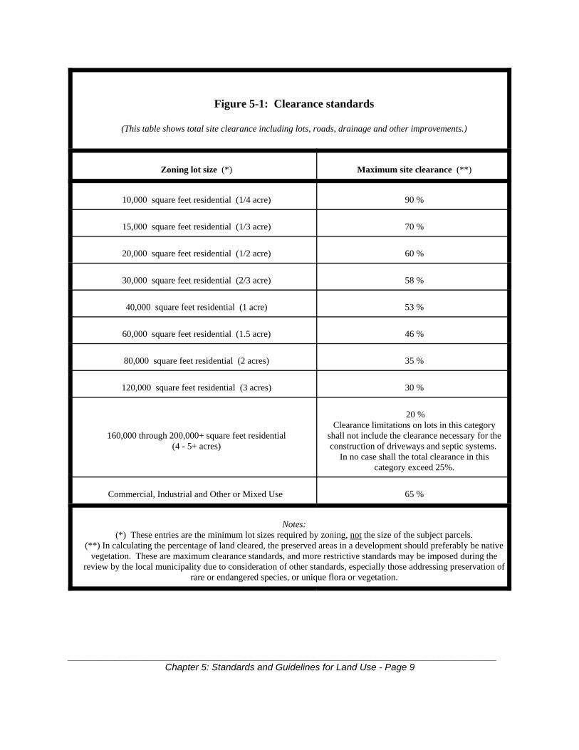
5.3.3.6.1 Vegetation Clearance LimitsThe clearance of natural vegetation shall be strictly limited. Site plans, surveysand subdivision maps shall delineate the existing naturally vegetated areas andcalculate those portions of the site that are already cleared due to previousactivities.
Areas of the site proposed to be cleared combined with previously cleared areasshall not exceed the percentages in Figure 5-1. These percentages shall be takenover the total site and shall include, but not be limited to, roads, building sites anddrainage structures. The clearance standard that would be applied to a project siteif developed under the existing residential zoning category may be applied if theproposal involves multi-family units, attached housing, clustering or modified lotdesigns. Site plans, surveys and subdivision maps shall be delineated with aclearing limit line and calculations for clearing to demonstrate compliance withthis standard.
To the extent that a portion of a site includes Core property, and for the purposeof calculating the clearance limits, the site shall be construed to be the combinedCore and CGA portions. However, the Core portion may not be cleared except inaccordance with Section 5.2 of the Plan.
5.3.3.6.2 Unfragmented open spaceSubdivision and site design shall support preservation of natural vegetation inlarge unbroken blocks that allow contiguous open spaces to be established whenadjacent parcels are developed. Subdivision and site designs should also beconfigured in such a way so as to prioritize the preservation of native pine barrensvegetation to the maximum extent practicable.
For the purpose of this paragraph, native pine barrens vegetation shall includepitch pines and various species of oak trees, understory and ground cover plantssuch as blueberry, wintergreen, bearberry and bracken fern, grasses and sedgessuch as little bluestem, Pennsylvania sedge and indian grass as well as thoseecological communities listed in sections 5.6 and 5.7 in Chapter 5, Volume 2 of
__________________________________________________________________________________Chapter 5: Standards and Guidelines for Land Use - Page 8
the Plan.
It is recognized that the preservation of nonnative but ecologically importanthabitats may be consistent with the intent and goals of the plan when such actionwould result in the creation of large contiguous natural open space areas and orthe protection of rare, threatened or endangered species or their habitat.
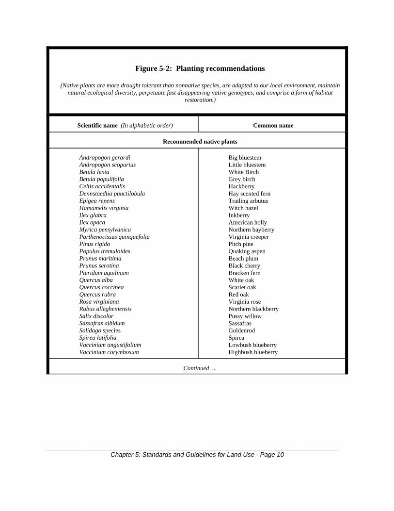
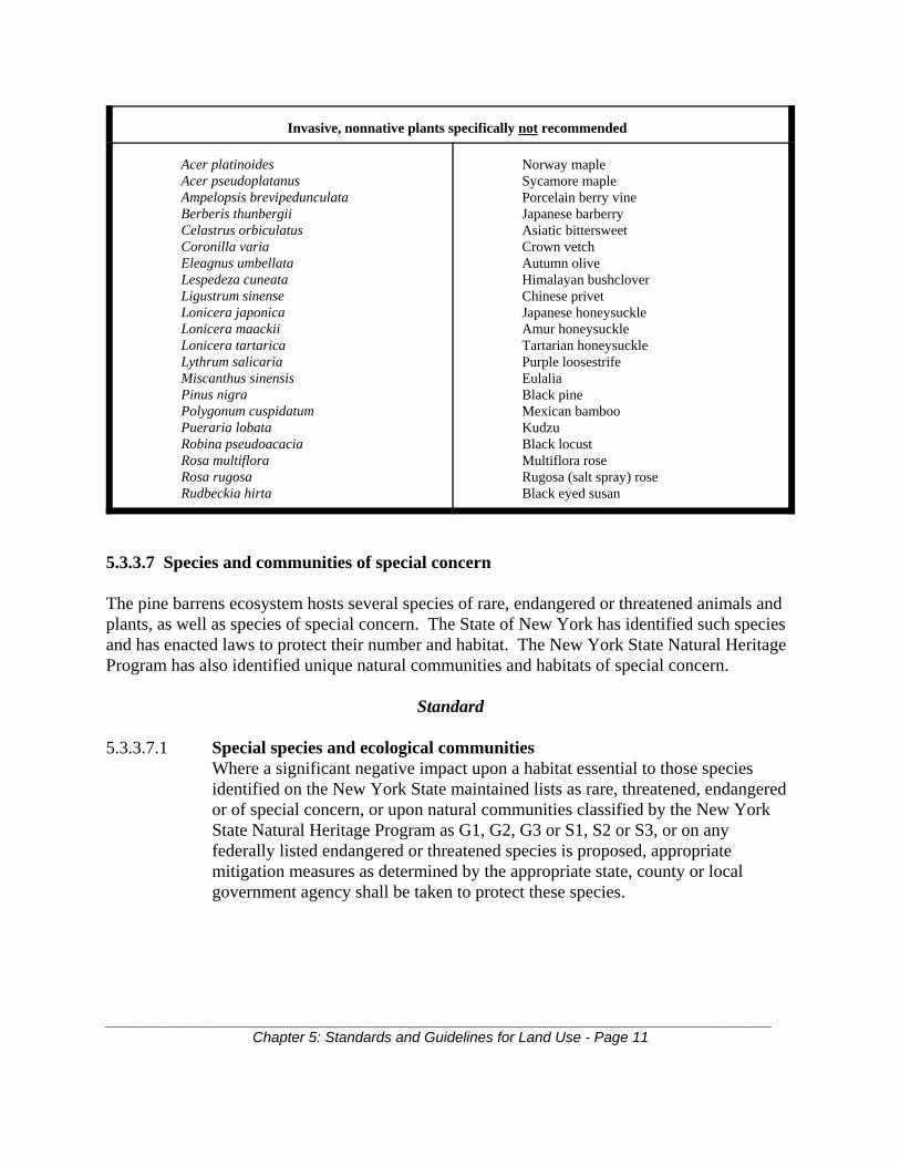
5.3.3.6.3 Fertilizer-dependent vegetation limitNo more than 15% of an entire development project site shall be established infertilizer-dependant vegetation including formalized turf areas. Generally,nonnative species require fertilization therefore, planting of such nonnativespecies shall be limited to the maximum extent practicable. The use of thenonnative plants in Figure 5-2 is specifically not recommended.
5.3.3.6.4 Native PlantingsDevelopment designs shall consider the native planting suggestions contained inFigure 5-2.
__________________________________________________________________________________Chapter 5: Standards and Guidelines for Land Use - Page 9
Figure 5-1: Clearance standards
(This table shows total site clearance including lots, roads, drainage and other improvements.)
Zoning lot size (*) Maximum site clearance (**)
10,000 square feet residential (1/4 acre) 90 %
15,000 square feet residential (1/3 acre) 70 %
20,000 square feet residential (1/2 acre) 60 %
30,000 square feet residential (2/3 acre) 58 %
40,000 square feet residential (1 acre) 53 %
60,000 square feet residential (1.5 acre) 46 %
80,000 square feet residential (2 acres) 35 %
120,000 square feet residential (3 acres) 30 %
160,000 through 200,000+ square feet residential(4 - 5+ acres)
20 %Clearance limitations on lots in this category
shall not include the clearance necessary for theconstruction of driveways and septic systems.
In no case shall the total clearance in thiscategory exceed 25%.
Commercial, Industrial and Other or Mixed Use 65 %
Notes:(*) These entries are the minimum lot sizes required by zoning, not the size of the subject parcels.
(**) In calculating the percentage of land cleared, the preserved areas in a development should preferably be nativevegetation. These are maximum clearance standards, and more restrictive standards may be imposed during the
review by the local municipality due to consideration of other standards, especially those addressing preservation ofrare or endangered species, or unique flora or vegetation.
__________________________________________________________________________________Chapter 5: Standards and Guidelines for Land Use - Page 10
Figure 5-2: Planting recommendations
(Native plants are more drought tolerant than nonnative species, are adapted to our local environment, maintainnatural ecological diversity, perpetuate fast disappearing native genotypes, and comprise a form of habitat
restoration.)
Scientific name (In alphabetic order) Common name
Recommended native plants
Andropogon gerardiAndropogon scopariusBetula lentaBetula populifoliaCeltis occidentalisDennstaedtia punctilobulaEpigea repensHamamelis virginiaIlex glabraIlex opacaMyrica pensylvanicaParthenocissus quinquefoliaPinus rigidaPopulus tremuloidesPrunus maritimaPrunus serotinaPteridum aquilinumQuercus albaQuercus coccineaQuercus rubraRosa virginianaRubus allegheniensisSalix discolorSassafras albidumSolidago speciesSpirea latifoliaVaccinium angustifoliumVaccinium corymbosum
Big bluestemLittle bluestemWhite BirchGrey birchHackberryHay scented fernTrailing arbutusWitch hazelInkberryAmerican hollyNorthern bayberryVirginia creeperPitch pineQuaking aspenBeach plumBlack cherryBracken fernWhite oakScarlet oakRed oakVirginia roseNorthern blackberryPussy willowSassafrasGoldenrodSpireaLowbush blueberryHighbush blueberry
Continued ...
__________________________________________________________________________________Chapter 5: Standards and Guidelines for Land Use - Page 11
Invasive, nonnative plants specifically not recommended
Acer platinoidesAcer pseudoplatanusAmpelopsis brevipedunculataBerberis thunbergiiCelastrus orbiculatusCoronilla variaEleagnus umbellataLespedeza cuneataLigustrum sinenseLonicera japonicaLonicera maackiiLonicera tartaricaLythrum salicariaMiscanthus sinensisPinus nigraPolygonum cuspidatumPueraria lobataRobina pseudoacaciaRosa multifloraRosa rugosaRudbeckia hirta
Norway mapleSycamore maplePorcelain berry vineJapanese barberryAsiatic bittersweetCrown vetchAutumn oliveHimalayan bushcloverChinese privetJapanese honeysuckleAmur honeysuckleTartarian honeysucklePurple loosestrifeEulaliaBlack pineMexican bambooKudzuBlack locustMultiflora roseRugosa (salt spray) roseBlack eyed susan
5.3.3.7 Species and communities of special concern
The pine barrens ecosystem hosts several species of rare, endangered or threatened animals andplants, as well as species of special concern. The State of New York has identified such speciesand has enacted laws to protect their number and habitat. The New York State Natural HeritageProgram has also identified unique natural communities and habitats of special concern.
Standard
5.3.3.7.1 Special species and ecological communitiesWhere a significant negative impact upon a habitat essential to those speciesidentified on the New York State maintained lists as rare, threatened, endangeredor of special concern, or upon natural communities classified by the New YorkState Natural Heritage Program as G1, G2, G3 or S1, S2 or S3, or on anyfederally listed endangered or threatened species is proposed, appropriatemitigation measures as determined by the appropriate state, county or localgovernment agency shall be taken to protect these species.
__________________________________________________________________________________Chapter 5: Standards and Guidelines for Land Use - Page 12
5.3.3.8 Soils
Disturbance of, and construction on, steep slopes within the pine barrens involves considerableremoval of native vegetation resulting in excessive surface water runoff and severe soil erosion. Steeply sloped areas are also subject to more rapid spread of wildfire than flat ground.
Guidelines
5.3.3.8.1 Clearing envelopesClearing envelopes should be placed upon lots within a subdivision so as tomaximize the placement of those envelopes on slopes less than ten percent (10%).
5.3.3.8.2 Stabilization and erosion controlConstruction of homes, roadways and private driveways on slopes greater thanten percent (10%) may be approved if technical review shows that sufficient carehas been taken in the design of stabilization measures, erosion control practicesand structures so as to mitigate negative environmental impacts.
5.3.3.8.3 Slope analysesProject review is facilitated if submissions contain a slope analysis showingslopes in the ranges 0-10%, 11-15% and 15% and greater. In areas with steepslopes, slope analysis maps should be required. This can be satisfied with crosshatching or shading on the site plan for the appropriate areas.
5.3.3.8.4 Erosion and sediment control plansErosion and sediment control plans should be required in areas of fifteen percent(15%) or greater slopes.
5.3.3.8.5 Placement of roadwaysRoads and driveways should be designed to minimize the traversing of slopesgreater than ten percent (10%) and to minimize cuts and fills.
5.3.3.8.6 Retaining walls and control structuresDetails of retaining walls and erosion control structures should be provided forroads and driveways which traverse slopes greater than ten percent (10%).
5.3.3.9 Coordinated design for open space management
Comprehensive, coordinated planning and design of development proposals within the pinebarrens is essential to ensure maximum preservation of open space and habitat linkages. Developments should not be designed without adequate consideration of the existingdevelopment and known future plans for the adjacent parcels. Otherwise, inefficient roadpatterns may require unnecessary clearing and lot layout that may hinder or prevent the

__________________________________________________________________________________Chapter 5: Standards and Guidelines for Land Use - Page 13
preservation of large, unbroken blocks of open space.
The use of the clustering technique within the Central Pine Barrens preserves open space,preserves habitat, protects important resource areas, improves infrastructure efficiency andfurthers the statute's goals of compact, efficient and orderly development in the Central PineBarrens.
Additionally, proper management of these areas is essential in order to protect open spaces fromillegal dumping, clearing, motor vehicle trespass and other abuses.
Standard
5.3.3.9.1 Receiving entity for open space dedicationsApplications must specify the entity to which dedicated open space will betransferred.
Guidelines
5.3.3.9.2 ClusteringMunicipalities are strongly urged to maximize the use of the clustering techniquewhere its usage would enhance adjacent open space or provide contiguous openspace connections with adjacent open space parcels.
5.3.3.9.3 Protection of dedicated open spaceProposed open space should be protected with covenants, conservation easementsor dedications that specify proper restrictions on its use and contingencies for itsfuture management.
5.3.3.10 Agriculture and horticulture
Scattered throughout the pine barrens are parcels devoted to agricultural and horticultural uses.
Guideline
5.3.3.10.1 Best management practicesAny existing, expanded, or new activity involving agriculture or horticulture inthe Compatible Growth Area should comply with best management practices, asdefined herein, and relevant requirements including local law. Best managementpractices are, for purposes of this Plan, the same practices stated in the mostrecent version of Controlling Agricultural Nonpoint Source Water Pollution inNew York State (Bureau of Technical Services and Research, Division of Water,New York State Department of Environmental Conservation, 1991 and as lateramended).
__________________________________________________________________________________Chapter 5: Standards and Guidelines for Land Use - Page 14
5.3.3.11 Scenic, historic and cultural resources
The Long Island Pine Barrens Protection Act specifies that the Plan shall consider and protectunique scenic, cultural or historic features. The Plan includes an inventory of many of theseresources, and separate inventories for these items exist in local, state, county, federal or privateinventories.
The Commission's policy is to protect and enhance those landscape based features of acommunity which define it, provide for its distinction from neighboring communities, providefor natural areas among the communities which complement the protection of the pine barrensecosystem, and contribute to a regional diversity, both natural and cultural.
Guidelines
5.3.3.11.1 Cultural resource considerationDevelopment proposals should account for, review, and provide protectionmeasures for:
1. Established recreational and educational trails and trail corridors, including butnot limited to those trail corridors inventoried elsewhere in this Plan.
2. Active recreation sites, including existing sites and those proposed as part of adevelopment.
3. Scenic corridors, roads, vistas and viewpoints located in Critical ResourceAreas, and along the Long Island Expressway, Sunrise Highway, CountyRoad 111 and William Floyd Parkway.
4. Sites of historical or cultural significance, including historic districts, sites onthe State or National Registers of Historic Places, and historic structureslisted on the State or National Registers of Historic Places, or recognizedby local municipal law or statute.
5. Sensitive archaeological areas as identified by the New York State HistoricPreservation Office or the New York State Museum.
5.3.3.11.2 Inclusion of cultural resources in applicationsDevelopment proposals should note established recreation and educational trailsand trail corridors; active recreation sites; scenic corridors, roads, vistas andviewpoints located in Critical Resource Areas and undisturbed portions of theroadsides of the Long Island Expressway, Sunrise Highway, County Road 111and William Floyd Parkway; sites on the State or National Register of HistoricPlaces, and historic structures and landmarks recognized by municipal law orstatute, or listed on the State or National Registers of Historic Places; andsensitive archaeological areas as identified by the New York State HistoricPreservation Office or the New York State Museum within a five hundred (500)foot radius of the outside perimeter of the project site, including any project
__________________________________________________________________________________Chapter 5: Standards and Guidelines for Land Use - Page 15
parcels which are physically separate from the bulk of the proposed developmentarea.
A development proposal may be disapproved or altered if the local municipalitydetermines that the development proposal, in its current form, may have asignificant negative impact on any of the above resources.
5.3.3.11.3 Protection of scenic and recreational resourcesProtection measures for scenic and recreational resources should include, but notbe limited to, retention of visually shielding natural buffers, replacement ofdegraded or removed natural visual buffers using native species, use of signswhich are in keeping in both style and scale with the community character, andsimilar measures.
5.3.3.11.4 Roadside design and managementUndisturbed portions of the roadside should be maintained in a manner thatprotects the scenic features of these areas. Clearing (including that for aisles,driveways, access and parking) is not precluded within these roadside areas,provided that appropriate buffers are maintained, and that manmade structuresmeet standards consistent with the character of the area.
5.3.3.12 Commercial and industrial development
Throughout the Compatible Growth Area, there are parcels of land that are zoned for commercialor industrial use. Future development of these parcels should occur in a manner which isconsistent with the goals and objectives of the Act.
Standard
5.3.3.12.1 Commercial and industrial compliance with Suffolk County Sanitary CodeAll commercial and industrial development applications shall comply with theprovisions of the Suffolk County Sanitary Code as applied by the Suffolk CountyDepartment of Health Services, and all other applicable federal, state or locallaws. Projects which require variances from the provisions of the Suffolk CountySanitary Code shall meet all requirements of the Department of Health Service'sBoard of Review in order to be deemed to have met the requirements of thisstandard.
* Denotes May 16, 2012 Ministerial CLUP Amendments adopted by the Commission
6. Pine Barrens Credit Program
6.1 Purpose of the Pine Barrens Credit Program
As required in the Long Island Pine Barrens Protection Act, the Plan is designed to preserve thepine barrens ecology and to ensure the high quality of surface and groundwater within the CentralPine Barrens. The Act states that the Plan shall discourage piecemeal and scattered development,and accommodate development in a manner consistent with the long term integrity of the pinebarrens ecosystem. The Act further states that the Plan should ensure a compact, efficient andorderly plan of development. The Legislature recognized that the Plan may restrict the use ofsome lands currently in private ownership and that these restrictions are necessary and desirableto protect and preserve the hydrologic and ecologic integrity of the Central Pine Barrens area, aswell as the public health and welfare of future generations.
It is the primary purpose of the Pine Barrens Credit Program to maintain value in landsdesignated for preservation or protection under the Plan by providing for the allocation and useof Pine Barrens Credits (PBCs). The Pine Barrens Credit Program will also promotedevelopment which is compact, efficient and orderly, and which is designed to protect the qualityand quantity of surface water and groundwater and the long term integrity of the pine barrensecosystem.
6.2 Pine Barrens Credit Certificate defined
A Pine Barrens Credit (PBC) Certificate is a document issued on behalf of the Commissionwhich indicates the number of Pine Barrens Credits to which the owner of a particular parcel ofland is entitled and which attests to the fact that the development rights of a particular parcel ofland in a sending district of the Central Pine Barrens have been severed from the land by therecording of a conservation easement, and that these rights are available for sale or use.
6.3 Allocation of Pine Barrens Credits*
For the purpose of computing the allocation of Pine Barrens Credits, a parcel of land is definedas a separately assessed Suffolk County Real Property Tax Parcel which is within the CorePreservation Area and existed on the Central Pine Barrens Comprehensive Land Use Plan initialadoption date of June 28, 1995.
6.3.1 Method of allocation
One (1) Pine Barrens Credit shall be allocated for each single family dwelling permitted on aresidentially zoned parcel of land located within the Core Preservation Area or a designated
Chapter 6: Pine Barrens Credit Program - Page 1
sending area designated within this Plan, based upon the development yield set forth in Sections6.3.1.1.1 through 6.3.1.1.9 of this Plan under the zoning regulations in existence when this Planis adopted in June, 1995. Development yield is established by multiplying the gross lot area ofthe parcel by the development yield factor for each residential zoning category. The developmentyield factors for the various residential zoning categories are enumerated in Section 6.3.1.1below, in which one acre equals 43,560 square feet.
6.3.1.1 Development yield factors and computation for single family residentially zonedproperty
6.3.1.1.1 If zoning allows one (1) dwelling unit per ten thousand (10,000) square feet, thedevelopment yield factor is 2.70 Pine Barrens Credits per acre.
6.3.1.1.2 If zoning allows one (1) dwelling unit per fifteen thousand (15,000) square feet, thedevelopment yield factor is 2.00 Pine Barrens Credits per acre.
6.3.1.1.3 If zoning allows one (1) dwelling unit per twenty thousand (20,000) square feet, thedevelopment yield factor is 1.60 Pine Barrens Credits per acre.
6.3.1.1.4 If zoning allows one (1) dwelling unit per forty thousand (40,000) square feet, thedevelopment yield factor is 0.80 Pine Barrens Credit per acre except for SouthamptonTown old filed map parcels for which it is 1.00 PBC per acre.
6.3.1.1.5 If zoning allows one (1) dwelling unit per sixty thousand (60,000) square feet, thedevelopment yield factor is 0.60 Pine Barrens Credit per acre except for SouthamptonTown old filed map parcels for which it is 0.66 PBC per acre.
6.3.1.1.6 If zoning allows one (1) dwelling unit per eighty thousand (80,000) square feet, thedevelopment yield factor is 0.40 Pine Barrens Credit per acre except for SouthamptonTown old filed map parcels for which it is 0.50 PBC per acre.
6.3.1.1.7 If zoning allows one (1) dwelling unit per one hundred twenty thousand (120,000)square feet, the development yield factor is 0.27 Pine Barrens Credit per acre except forSouthampton Town old filed map parcels for which it is 0.33 PBC per acre.
6.3.1.1.8 If zoning allows one (1) dwelling unit per one hundred sixty thousand (160,000) squarefeet, the development yield factor is 0.20 Pine Barrens Credit per acre.
6.3.1.1.9 If zoning allows one (1) dwelling unit per two hundred thousand (200,000) square feet,the development yield factor is 0.16 Pine Barrens Credit per acre except for SouthamptonTown old filed map parcels for which it is 0.20 PBC per acre.
6.3.1.1.10 If zoning allows one (1) dwelling unit per four hundred thousand (400,000) squarefeet, the development yield factor is 0.08 Pine Barrens Credit per acre.
6.3.1.1.11 One (1) acre as used in 6.3.1.1.1 through 6.3.1.1.10 equals forty three thousand fivehundred sixty (43,560) square feet.
6.3.1.1.12 A fractional allocation of a Pine Barrens Credit shall be rounded upward to the nearestone hundredth (1/100th = 0.01) of a Pine Barrens Credit..
6.3.1.1.13 If zoning allows one (1) dwelling unit per thirty thousand (30,000) square feet, thedevelopment yield factor is 1.20 Pine Barrens Credits per acre.
These development yield factors and sample computations are summarized in Figure 6-1 andFigure 6-1a.
Chapter 6: Pine Barrens Credit Program - Page 2
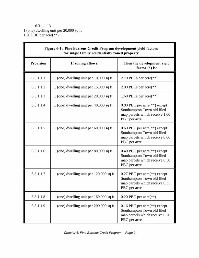
6.3.1.1.131 (one) dwelling unit per 30,000 sq ft1.20 PBC per acre(**)
Figure 6-1: Pine Barrens Credit Program development yield factorsfor single family residentially zoned property
Provision If zoning allows: Then the development yieldfactor (*) is:
6.3.1.1.1 1 (one) dwelling unit per 10,000 sq ft 2.70 PBCs per acre(**)
6.3.1.1.2 1 (one) dwelling unit per 15,000 sq ft 2.00 PBCs per acre(**)
6.3.1.1.3 1 (one) dwelling unit per 20,000 sq ft 1.60 PBCs per acre(**)
6.3.1.1.4 1 (one) dwelling unit per 40,000 sq ft 0.80 PBC per acre(**) exceptSouthampton Town old filedmap parcels which receive 1.00PBC per acre
6.3.1.1.5 1 (one) dwelling unit per 60,000 sq ft 0.60 PBC per acre(**) exceptSouthampton Town old filedmap parcels which receive 0.66PBC per acre
6.3.1.1.6 1 (one) dwelling unit per 80,000 sq ft 0.40 PBC per acre(**) exceptSouthampton Town old filedmap parcels which receive 0.50PBC per acre
6.3.1.1.7 1 (one) dwelling unit per 120,000 sq ft 0.27 PBC per acre(**) exceptSouthampton Town old filedmap parcels which receive 0.33PBC per acre
6.3.1.1.8 1 (one) dwelling unit per 160,000 sq ft 0.20 PBC per acre(**)
6.3.1.1.9 1 (one) dwelling unit per 200,000 sq ft 0.16 PBC per acre(**) exceptSouthampton Town old filedmap parcels which receive 0.20PBC per acre
Chapter 6: Pine Barrens Credit Program - Page 3
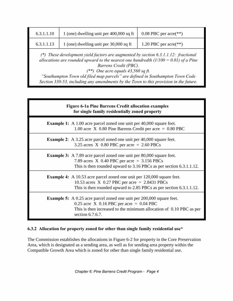
6.3.1.1.10 1 (one) dwelling unit per 400,000 sq ft 0.08 PBC per acre(**)
6.3.1.1.13 1 (one) dwelling unit per 30,000 sq ft 1.20 PBC per acre(**)
(*) These development yield factors are augmented by section 6.3.1.1.12: fractionalallocations are rounded upward to the nearest one hundredth (1/100 = 0.01) of a Pine
Barrens Credit (PBC).(**) One acre equals 43,560 sq ft.
“Southampton Town old filed map parcels” are defined in Southampton Town CodeSection 330-53, including any amendments by the Town to this provision in the future.
Figure 6-1a Pine Barrens Credit allocation examplesfor single family residentially zoned property
Example 1: A 1.00 acre parcel zoned one unit per 40,000 square feet.1.00 acre X 0.80 Pine Barrens Credit per acre = 0.80 PBC
Example 2: A 3.25 acre parcel zoned one unit per 40,000 square feet.3.25 acres X 0.80 PBC per acre = 2.60 PBCs
Example 3: A 7.89 acre parcel zoned one unit per 80,000 square feet.7.89 acres X 0.40 PBC per acre = 3.156 PBCsThis is then rounded upward to 3.16 PBCs as per section 6.3.1.1.12.
Example 4: A 10.53 acre parcel zoned one unit per 120,000 square feet.10.53 acres X 0.27 PBC per acre = 2.8431 PBCsThis is then rounded upward to 2.85 PBCs as per section 6.3.1.1.12.
Example 5: A 0.25 acre parcel zoned one unit per 200,000 square feet.0.25 acre X 0.16 PBC per acre = 0.04 PBCThis is then increased to the minimum allocation of 0.10 PBC as persection 6.7.6.7.
6.3.2 Allocation for property zoned for other than single family residential use*
The Commission establishes the allocations in Figure 6-2 for property in the Core PreservationArea, which is designated as a sending area, as well as for sending area property within theCompatible Growth Area which is zoned for other than single family residential use.
Chapter 6: Pine Barrens Credit Program - Page 4

Figure 6-2*: Pine Barrens Credit Program development yield factorsfor property zoned for other than single family residential use.
(Note: Although some of the following zoning classes are now obsolete, those have beenretained here in the event that a parcel in a sending area had one of those zoning categorieson its relevant record date listed in Section 6.3.)
Zoning Class Pine Barrens Credits per acre
Defense Institutional District 1.00 PBC per acre*
Industrial A District 1.00 PBC per acre*
Highway Business 1.00 PBC per acre*
J Business 2 District 1.00 PBC per acre*
J Business 3 District 0.20 PBC per acre*
J Business 4 District 1.00 PBC per acre*
J Business 5 District 1.00 PBC per acre*
Light Industrial 1 District 1.00 PBC per acre*
Light Industrial 3 District 0.27 PBC per acre*
Light Industrial 200 District 0.20 PBC per acre*
Light Industrial 40 District 1.00 PBC per acre*
Brookhaven Multi-Family 1 District 0.27 PBC per acre*
Brookhaven PRC 0.10 PBC per acre*
Riverhead Natural Resource PreservationDistrict
0.20 PBC per acre*
Riverhead Open Space Conservation District 0.25 PBC per acre*
All Other Districts 0.10 PBC per acre*
*One acre equals 43,560 square feet; fractional allocations are rounded upward to the nearestone hundredth (1/100 = 0.01) of a Pine Barrens Credit (PBC). No fewer than 0.10 (one tenth)Pine Barrens Credit shall be allocated by the Clearinghouse for any parcel of land, regardlessof its size or road accessibility.
6.3.3 Limitations on allocation*
The following limitations shall apply to the allocation of Pine Barrens Credits:
Chapter 6: Pine Barrens Credit Program - Page 5
6.3.3.1 No allocation shall be made for any property owned or held by a public agency,municipal corporation or governmental subdivision, including property held by reason oftax default.
6.3.3.2 No allocation shall be made for any property for which the development rights havepreviously been fully used, or allocated for use, under this Plan or any other program.
6.3.3.3 No allocation shall be made for any property owned or held for the purpose of landprotection, preservation or conservation.
6.3.3.4* Partially improved parcels shall receive a decreased allocation based upon the extent ofimprovement. Furthermore, there shall be a proportional decrease in allocation basedupon the receipt of all discretionary permits for improvement of a parcel or hardshippermits issued by the Commission. The Pine Barrens Credit allocation for a parcel ofland shall be reduced by one (1) Pine Barrens Credit for each existing single family uniton the parcel or equivalent as such equivalent is described in the document entitledStandards for Approval of Plans and Construction for Sewage Disposal Systems forOther Than Single Family Residences, approved by the Suffolk County Department ofHealth Services, Division of Environmental Quality, on June 15, 1982, revised March 5,1984 and December 1, 2009, and as implemented prior to February 5, 1988, as amendedfrom time to time (hereinafter referred to as the "Suffolk County Health DepartmentStandards").
6.3.3.5* In situations where a development project site contains a parcel that is split between theCore Preservation Area and Compatible Growth Area, and where the entire project site’sacreage (i.e., Core and Compatible Growth Area acreage added together) was used fordetermining the amount of clearing that can occur on the Compatible Growth Areaportion, then no Pine Barrens Credits can be obtained on the Core Preservation Areaportion.
6.3.3.6* Pine Barrens Credits can only be allocated to partially developed parcels when theparcel size is at least twice the minimum lot size for the zoning district to which thatparcel belongs and the parcel is otherwise eligible for a Credit allocation under this Plan.
6.3.3.7* In allocating Credits to portion(s) of an otherwise eligible parcel, the Clearinghouseshall consider the extent of any prior public acquisition of that parcel or any portionthereof.
6.3.3.8* No allocation of Credits shall be made to any parcel or portion thereof upon which anownership overlap condition exists among more than one competing owners unless anduntil such ownership overlap condition is resolved by the applicant to the satisfaction ofthe Commission. In addition, applications for Credits on such parcels where the overlapcondition includes as one of the competing owners any governmental agency or body, theCommission shall communicate in writing to the relevant governmental agency or body arequest for guidance on resolving the overlap condition.
6.4 Designated receiving districts for Pine Barrens Credits
6.4.1 Definitions
For the purposes of Chapter 6 of this Plan, the following definitions shall apply.
Chapter 6: Pine Barrens Credit Program - Page 6

6.4.1.1 As of right Pine Barrens Credit redemption
"As of right" means that the redemption of Pine Barrens Credits entitles a person to an increasein intensity or density in accordance with this Plan. Town Planning Boards, and, in the Town ofRiverhead, the Riverhead Town Board performing the function of site plan review, maydetermine compliance with this Plan as part of the subdivision or site plan review procedures,and shall approve such use of Pine Barrens Credits with no additional special permit required.
Pine Barrens Credits generated in any area in the Central Pine Barrens within any town shall beredeemable for any as of right Pine Barrens Credit uses in each respective town as described inthis Plan subject only to the restrictions expressed herein.
6.4.1.2 Increased density and increased intensity
"Increased density" means an increase in the number of residential units. "Increased intensity"means an increase in the gross floor area of a nonresidential structure and/or use. Developmentin accordance with existing zoning regulations is not considered an increase in permitted land useintensity or density.
6.4.2 Town of Brookhaven designated Pine Barrens Credit receiving districts
6.4.2.1 Brookhaven Pine Barrens Credit Program overview
The Pine Barrens Credit Program for the Town of Brookhaven is designed to redirectdevelopment for residentially zoned lands within the Core Preservation Area to receivingdistricts throughout the Town utilizing two basic approaches. These are:
1. The transfer of development rights through Residential Overlay Districts (RODs) toone (1) and two (2) acre residentially zoned lands with increased density throughapproval of the Planning Board pursuant to the definition in Section 6.4.1.1 of thisPlan, and
2. The use of innovative planning techniques such as Planned Development Districts(PDDs), Planned Retirement Communities (PRCs), and other zoning incentives.
6.4.2.2 Brookhaven Residential Overlay District specifications
The Town of Brookhaven has identified Residential Overlay Districts to receive Pine BarrensCredits from the Core Preservation Area where increased density may be allowed in thoseresidential districts set forth in a map contained in Figure 6-3.
6.4.2.2.1 Brookhaven density increase
Under the Brookhaven transfer of development rights program, a single Pine Barrens Credit shallpermit an increase in density equal to one (1) single family dwelling as defined in the
Chapter 6: Pine Barrens Credit Program - Page 7
Brookhaven Town Code.
6.4.2.2.2 Brookhaven total yield
Under the Brookhaven transfer of development rights program, the total yield in all eligible one(1) and two (2) acre residentially zoned receiving districts shall be equal to the square footage ofthe total parcel contained within the receiving site divided by the minimum square footageallowed under the Brookhaven Town Code in the appropriate residential zone. The minimum lotsize in such eligible residentially zoned receiving districts shall allow for the construction ofnecessary roads and recharge basins, and the possible dedication of open space.
Notwithstanding the above, the minimum lot size shall be as necessary to assure compliance withSection 6.5.2 of this Plan. However, such decrease in the minimum lot size below the formulaset forth above shall only be authorized where absolutely necessary to comply with Section 6.5.2of this Plan, and in no instance shall the average lot size be less than 30,000 square feet in A-1zoning districts and 60,000 square feet in A-2 zoning districts.
6.4.2.2.3 Brookhaven approval subject to criteria
This “as of right” increase shall be allowed, subject to the approval of the Town of BrookhavenPlanning Board during the subdivision and site plan approval processes, based upon the criteriaset forth below and those contained within Section 85-450(D) of the Brookhaven Town Code.
6.4.2.2.4 Brookhaven criteria
The following two criteria shall apply:
1. An area of a parcel shall be constituted ineligible as a Residential Overlay District where thearea of the parcel is located within:
a. five hundred (500) feet of any stream, bluff, surface water, or wetlands regulated bythe New York State Department of Environmental Conservation or the Town ofBrookhaven;
b. the one hundred (100) year flood plain; c. the South Setauket Special Groundwater Protection Area (South Setauket SGPA);d. the state's Wild, Scenic and Recreational River corridorse. existing public lands
2. A parcel shall be ineligible as a Residential Overlay District where forty percent (40%) ormore of the land area of the parcel contains steep slopes of fifteen percent (15%) orgreater.
6.4.2.3 Innovative strategies for the redemption of Brookhaven Pine Barrens Credits
Chapter 6: Pine Barrens Credit Program - Page 8
In addition to the Planning Board approval process as described in Section 6.4.1.1 of this Plan,the Town of Brookhaven intends to use creative techniques to provide additional mechanisms forthe use of Pine Barrens Credits during the life of the Pine Barrens Credit Program. The use ofPlanned Development Districts, subject to the approval of the Town Board, will allow for theconversion of residential development rights into commercial, industrial and/or other uses, whichwill serve to limit the final number of residential dwelling units to be built while avoiding anegative tax impact.
In addition, the Town of Brookhaven will seek to utilize the following initiatives, throughapproval of the Brookhaven Town Board, for redemption of Pine Barrens Credits whereappropriate:
1. Use of "R” districts, consisting of currently residentially zoned parcels, which are too smallfor Planned Development District use, but which are more appropriately zoned forcommercial and industrial use;
2. The use of Planned Retirement Communities as already set forth in the current BrookhavenTown Code;
3. Other innovative zoning incentives.
6.4.2.4 Additional Brookhaven Pine Barrens Credit Program policies
6.4.2.4.1 Transfers from Hydrogeologic Zone 3 to Hydrogeologic Zone 6
The Town of Brookhaven may also seek the support of the Commission to obtain a ruling fromthe Suffolk County Board of Health to allow for the transfer of development rights from the CorePreservation Area, which is located in Hydrogeologic Zone 3, to selected portions ofHydrogeologic Zone 6. This transfer would utilize the increased bonus density formula set forthabove, and transfer Pine Barrens Credits to the northern portions of Hydrogeologic Zone 6 so asnot to increase nitrogen loadings to the Great South Bay, Moriches Bay or their tributary streamsor wetlands.
6.4.2.4.2 Brookhaven acquisition priorities
The Town of Brookhaven, in addition, requests that the Commission prioritize acquisition ofBrookhaven residential parcels within the Core Preservation Area in those school districts whichare most adversely impacted by the Plan.
6.4.2.4.3 Brookhaven townwide policy
It is the intent of the Town of Brookhaven to utilize transfers of development rights in a mannerwhich will allow for the preservation of the Core Preservation Area without a significantnegative environmental or economic impact on the rest of the Town.
Chapter 6: Pine Barrens Credit Program - Page 9
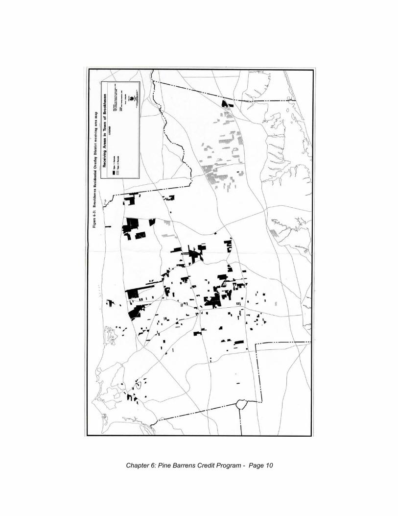
Chapter 6: Pine Barrens Credit Program - Page 10
6.4.3 Town of Riverhead designated Pine Barrens Credit receiving districts
The Town of Riverhead has identified receiving districts which are eligible to receive PineBarrens Credits in an as of right manner from the Core Preservation Area, and in which increasedintensity shall be allowed. These receiving districts are described in Figures 6-4 and 6-5.
6.4.3.1 Riverhead intensity increase
A single Pine Barrens Credit shall permit an increase in intensity equal to three hundred (300)gallons per day per acre or the equivalent rated sewage flow as described in the Suffolk CountyHealth Department Standards.
6.4.3.2 Riverhead as of right policy
The increased intensity shall be available as of right for those receiving districts identified inFigures 6-4 and 6-5.
Chapter 6: Pine Barrens Credit Program - Page 11
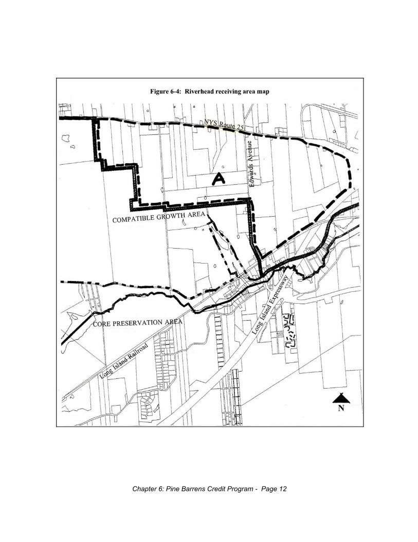
Chapter 6: Pine Barrens Credit Program - Page 12
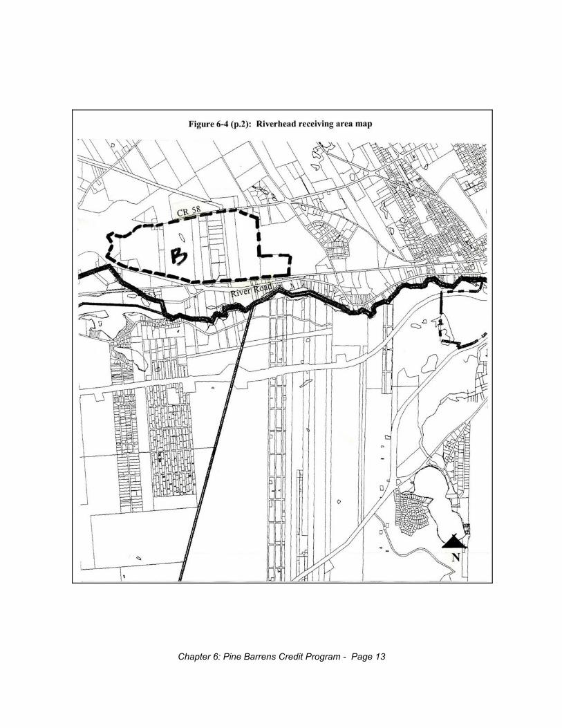
Chapter 6: Pine Barrens Credit Program - Page 13
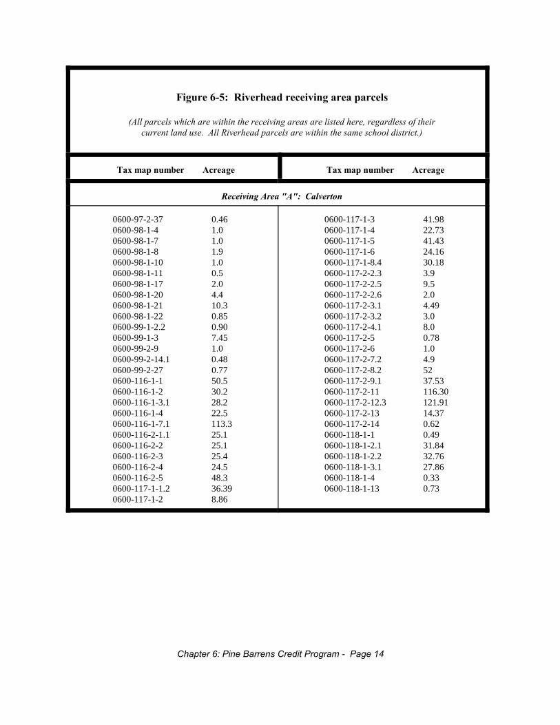
Figure 6-5: Riverhead receiving area parcels
(All parcels which are within the receiving areas are listed here, regardless of theircurrent land use. All Riverhead parcels are within the same school district.)
Tax map number Acreage Tax map number Acreage
Receiving Area "A": Calverton
0600-97-2-37 0.460600-98-1-4 1.00600-98-1-7 1.00600-98-1-8 1.90600-98-1-10 1.00600-98-1-11 0.50600-98-1-17 2.00600-98-1-20 4.40600-98-1-21 10.30600-98-1-22 0.850600-99-1-2.2 0.900600-99-1-3 7.450600-99-2-9 1.00600-99-2-14.1 0.480600-99-2-27 0.770600-116-1-1 50.50600-116-1-2 30.20600-116-1-3.1 28.20600-116-1-4 22.50600-116-1-7.1 113.30600-116-2-1.1 25.10600-116-2-2 25.10600-116-2-3 25.40600-116-2-4 24.50600-116-2-5 48.30600-117-1-1.2 36.390600-117-1-2 8.86
0600-117-1-3 41.980600-117-1-4 22.730600-117-1-5 41.430600-117-1-6 24.160600-117-1-8.4 30.180600-117-2-2.3 3.90600-117-2-2.5 9.50600-117-2-2.6 2.00600-117-2-3.1 4.490600-117-2-3.2 3.00600-117-2-4.1 8.00600-117-2-5 0.780600-117-2-6 1.00600-117-2-7.2 4.90600-117-2-8.2 520600-117-2-9.1 37.530600-117-2-11 116.300600-117-2-12.3 121.910600-117-2-13 14.370600-117-2-14 0.620600-118-1-1 0.490600-118-1-2.1 31.840600-118-1-2.2 32.760600-118-1-3.1 27.860600-118-1-4 0.330600-118-1-13 0.73
Chapter 6: Pine Barrens Credit Program - Page 14
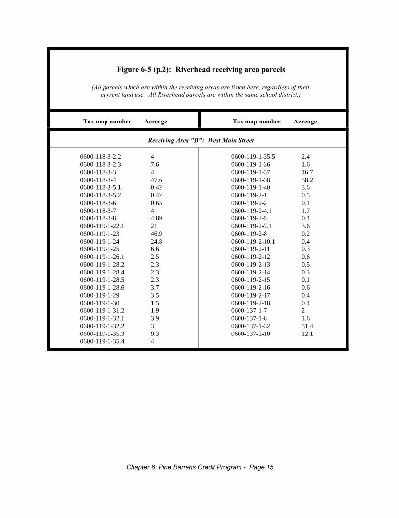
Figure 6-5 (p.2): Riverhead receiving area parcels
(All parcels which are within the receiving areas are listed here, regardless of theircurrent land use. All Riverhead parcels are within the same school district.)
Tax map number Acreage Tax map number Acreage
Receiving Area "B": West Main Street
0600-118-3-2.2 40600-118-3-2.3 7.60600-118-3-3 40600-118-3-4 47.60600-118-3-5.1 0.420600-118-3-5.2 0.420600-118-3-6 0.650600-118-3-7 40600-118-3-8 4.890600-119-1-22.1 210600-119-1-23 46.90600-119-1-24 24.80600-119-1-25 6.60600-119-1-26.1 2.50600-119-1-28.2 2.30600-119-1-28.4 2.30600-119-1-28.5 2.30600-119-1-28.6 3.70600-119-1-29 3.50600-119-1-30 1.50600-119-1-31.2 1.90600-119-1-32.1 3.90600-119-1-32.2 30600-119-1-35.3 9.30600-119-1-35.4 4
0600-119-1-35.5 2.40600-119-1-36 1.60600-119-1-37 16.70600-119-1-38 58.20600-119-1-40 3.60600-119-2-1 0.50600-119-2-2 0.10600-119-2-4.1 1.70600-119-2-5 0.40600-119-2-7.1 3.60600-119-2-8 0.20600-119-2-10.1 0.40600-119-2-11 0.30600-119-2-12 0.60600-119-2-13 0.50600-119-2-14 0.30600-119-2-15 0.10600-119-2-16 0.60600-119-2-17 0.40600-119-2-18 0.40600-137-1-7 20600-137-1-8 1.60600-137-1-32 51.40600-137-2-10 12.1
Chapter 6: Pine Barrens Credit Program - Page 15
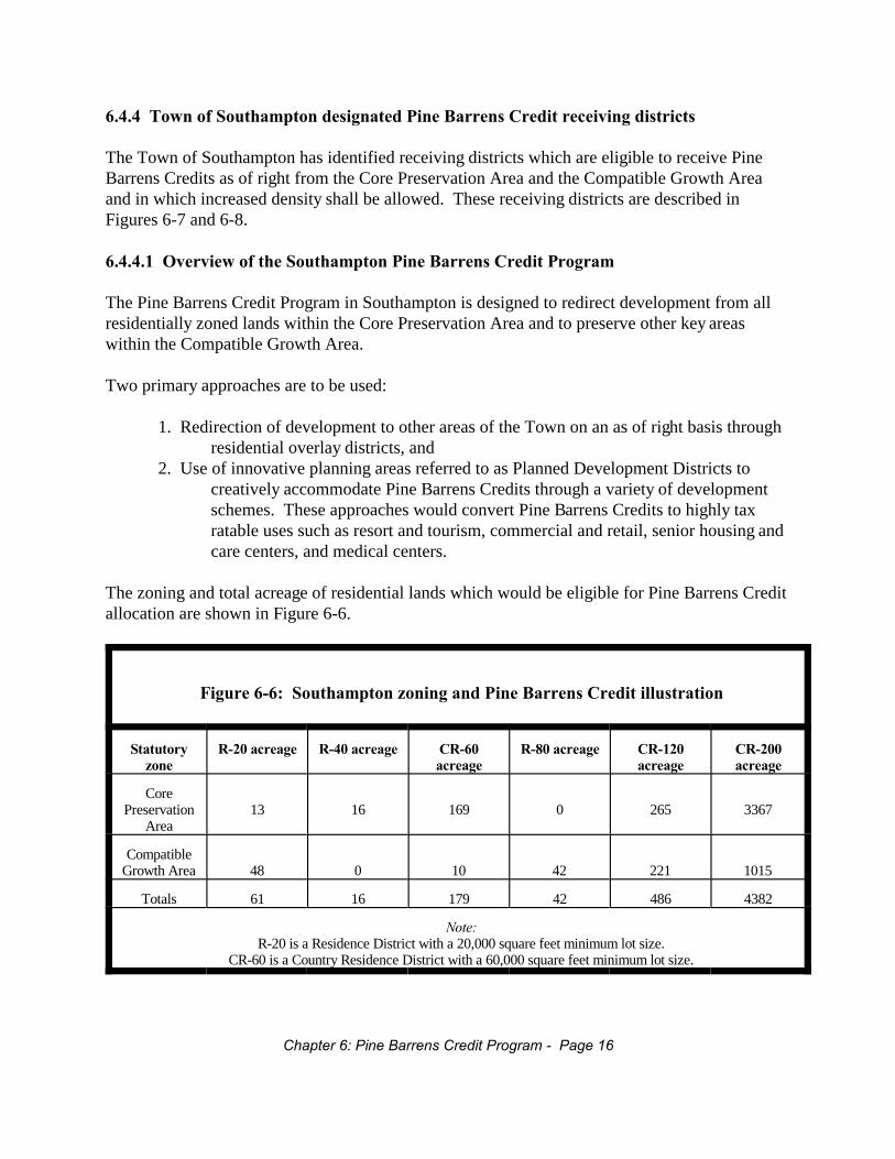
6.4.4 Town of Southampton designated Pine Barrens Credit receiving districts
The Town of Southampton has identified receiving districts which are eligible to receive PineBarrens Credits as of right from the Core Preservation Area and the Compatible Growth Areaand in which increased density shall be allowed. These receiving districts are described inFigures 6-7 and 6-8.
6.4.4.1 Overview of the Southampton Pine Barrens Credit Program
The Pine Barrens Credit Program in Southampton is designed to redirect development from allresidentially zoned lands within the Core Preservation Area and to preserve other key areaswithin the Compatible Growth Area.
Two primary approaches are to be used:
1. Redirection of development to other areas of the Town on an as of right basis throughresidential overlay districts, and
2. Use of innovative planning areas referred to as Planned Development Districts tocreatively accommodate Pine Barrens Credits through a variety of developmentschemes. These approaches would convert Pine Barrens Credits to highly taxratable uses such as resort and tourism, commercial and retail, senior housing andcare centers, and medical centers.
The zoning and total acreage of residential lands which would be eligible for Pine Barrens Creditallocation are shown in Figure 6-6.
Figure 6-6: Southampton zoning and Pine Barrens Credit illustration
Statutoryzone
R-20 acreage R-40 acreage CR-60acreage
R-80 acreage CR-120acreage
CR-200acreage
CorePreservation
Area13 16 169 0 265 3367
CompatibleGrowth Area 48 0 10 42 221 1015
Totals 61 16 179 42 486 4382
Note:R-20 is a Residence District with a 20,000 square feet minimum lot size.
CR-60 is a Country Residence District with a 60,000 square feet minimum lot size.
Chapter 6: Pine Barrens Credit Program - Page 16

Pine Barrens Credits would be allocated to owners of these lands using the method outlined inthis chapter of this Plan. However, in the case of old filed map lots, allocation of Pine BarrensCredits does not include a yield factor, since these lots were platted with infrastructureallowances. This coincides with the Town's existing old filed map regulations and results in aslightly higher allocation of Pine Barrens Credits for these lots, as defined within Section 6.3.1.1and Figure 6-1. Southampton Town old filed map parcels are defined in Southampton TownCode Section 330-53, and that definition is adopted in this Plan for purposes of the Pine BarrensCredit Program, including any amendments by the Town to this provision in the future.
Within the Core Preservation Area, is it vital to have as much of the Towns' industrially zonedland protected by acquisition as possible, due to the difficulty in allocating Pine Barrens Credits. The Town therefore requests the prioritization of these lands for acquisition through the presentstate and county programs, especially since many of these parcels fall within ecologicallysensitive areas such as the dwarf pine plains. However, the Town does recognize that someowners of industrially zoned land may wish to sell or utilize Pine Barrens Credits for suchdevelopment. In such cases, the Commission may exercise the right to allocate Pine BarrensCredits on a plan basis.
6.4.4.2 As of right redemption of Southampton Pine Barrens Credits
The primary strategy for the redirection of development from the Core Preservation Area isthrough Residential Overlay Districts. In these districts, a single Pine Barrens Credit shall allowan increase in density equal to one (1) dwelling unit, as defined by the Southampton Town Code. The end result is an incremental increase in density in selected residentially zoned areas of theTown.
This does not result in a net gain of dwelling units or population within the Town, but simplyredirects development and channels growth in order to preserve more ecologically sensitivelands. The as of right receiving areas are designed to accommodate those Pine Barrens Creditsfrom the Core Preservation Area within the same school district. In no case will it be necessaryto cross school district boundaries on an as of right basis.
In Southampton, where most of the receiving areas are presently zoned one (1) unit per fiveacres, the creation of Residential Overlay Districts will allow the redemption of Pine BarrensCredits through an average of one (1) unit per acre. In certain school districts, in order toaccommodate all Pine Barrens Credits, the Southampton Town Planning Board may need torequire lot sizes less than one (1) unit per acre, though not lower than one (1) unit per one half(0.5) acre.
Where it was necessary to designate receiving sites within areas that are presently zoned one (1)unit per acre, the establishment of densities higher than one (1) unit per one half (0.5) acre maybe essential for full redemption of Pine Barrens Credits within that school district. For thosesites, incorporation of a sewage treatment plant would be required by the Suffolk CountySanitary Code.
Chapter 6: Pine Barrens Credit Program - Page 17
The net result of these Southampton Town policies is compact and efficient development thatwill protect Central Pine Barrens lands without significant public expenditure. The designationof receiving sites coincides with those areas where infrastructure and municipal services alreadyexist. Thus, the cost to municipalities and taxpayers with regard to new road construction, watermain extension and the provision of police, fire and other services is thereby lowered.
6.4.4.3 Other strategies for the redemption of Southampton Pine Barrens Credits
The redemption of Pine Barrens Credits through mechanisms other than as of right uses may bepossible through the many strategies that were outlined in The Comprehensive Plan Initiative forGroundwater and Pine Barrens Forest Preservation (the Southampton "Western GenericEnvironmental Impact Statement" or WGEIS; 1993), and which continue to be outlined throughthe update of the Town Comprehensive Plan. An overview of possible strategies which will begiven future consideration by the Town is listed below, along with the potential areas where suchredemption may take place.
These areas would serve to provide more opportunities for future use of Pine Barrens Credits. Furthermore, the use of Planned Development Districts would allow for the conversion ofresidential development rights into commercial, industrial, tourism, or other uses. These wouldserve to limit the ultimate amount of residential dwelling units that could be built while stillproviding for a strong tax base.
The following potential strategies may be employed in the future by Southampton Town, asapproved by the Town Board, for the redemption of Pine Barrens Credits. Geographical areasthat may be suitable for such redemption mechanisms are also noted.
1. Use of Pine Barrens Credits could permit density increases for senior citizen housing andelder care facilities.
2. Overlay districts along the Montauk Highway and Long Island Railroad corridors couldpromote revitalization and concentrated development patterns within existing hamletcenters. Potential locations for such activity include, but are not limited to, areas L, Rand S.
3. Use of Pine Barrens Credits could allow accessory apartments within existing residentialzoning districts.
4. Mixed use overlay districts along existing commercial corridors could allow for alternativeuses to counteract strip development. Locations that could be suitable for these receivingdistricts are Q, T, R and 2.
5. Appropriate industrial development areas have been identified at the Suffolk County airportfor the redirection of Pine Barrens Credits from industrially zoned land located in theCore Preservation Area, and for the conversion of residential Pine Barrens Credits.
6. Use of Pine Barrens Credits could promote tourism uses and related facilities. Areas M, I, P,EQ, and RS are identified as suitable for this.
7. Use of Pine Barrens Credits could allow multifamily, or more compact, residentialdevelopment. Sites that could accommodate this activity include K, J, 2, E, and the
Chapter 6: Pine Barrens Credit Program - Page 18
county's Bomarc site along Old Country Road in Westhampton.
Chapter 6: Pine Barrens Credit Program - Page 19
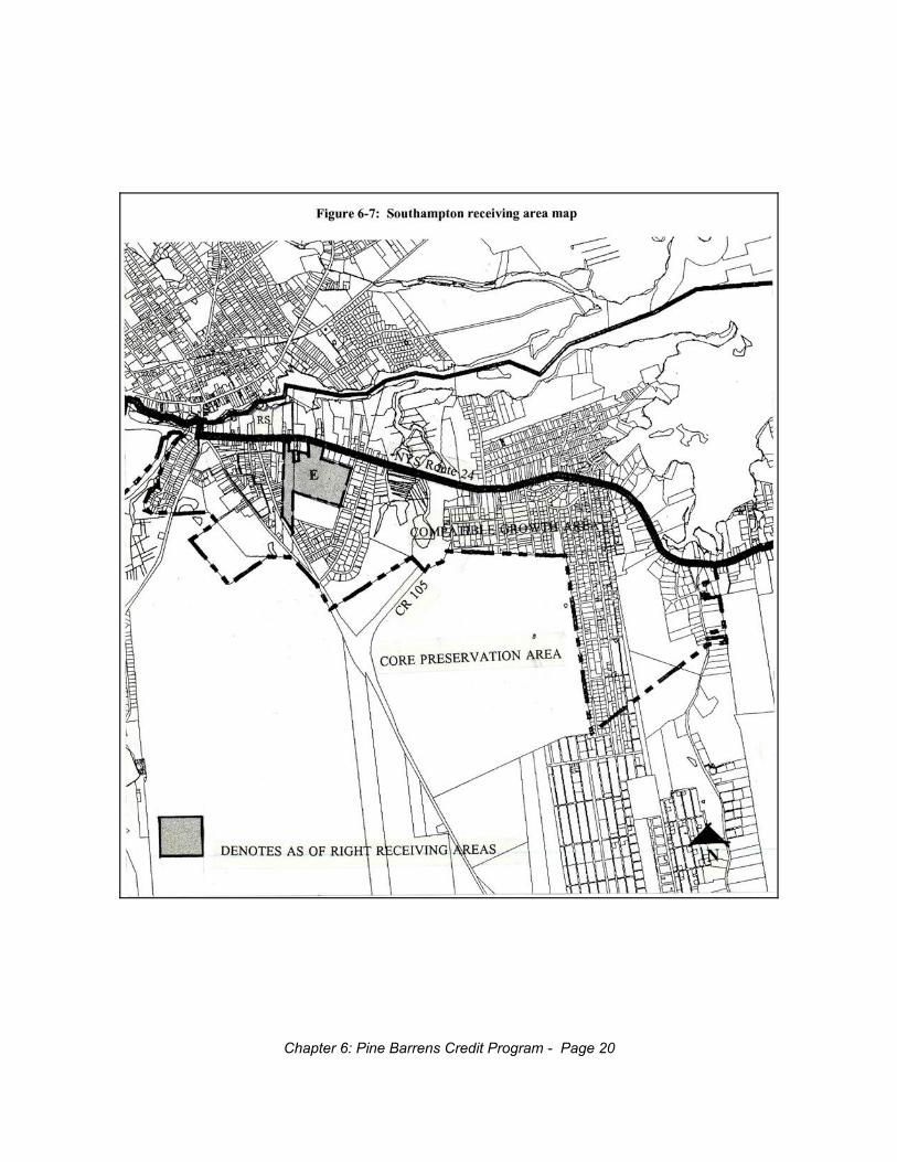
Chapter 6: Pine Barrens Credit Program - Page 20
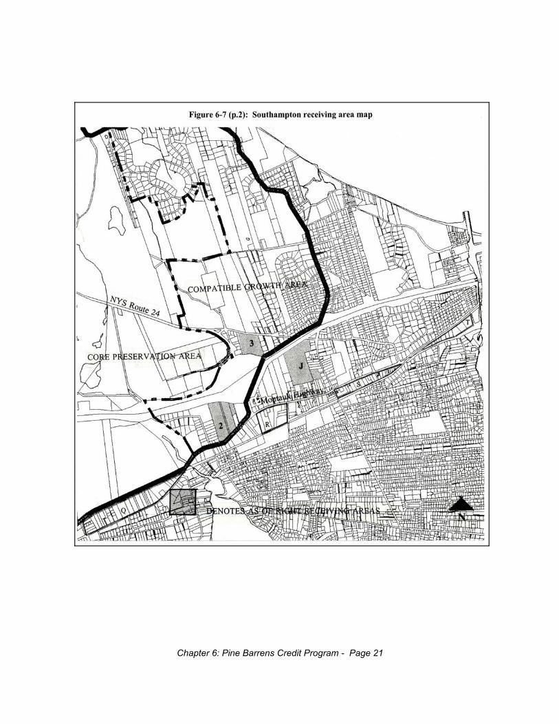
Chapter 6: Pine Barrens Credit Program - Page 21
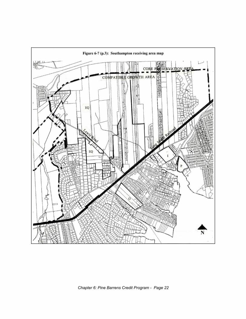
Chapter 6: Pine Barrens Credit Program - Page 22
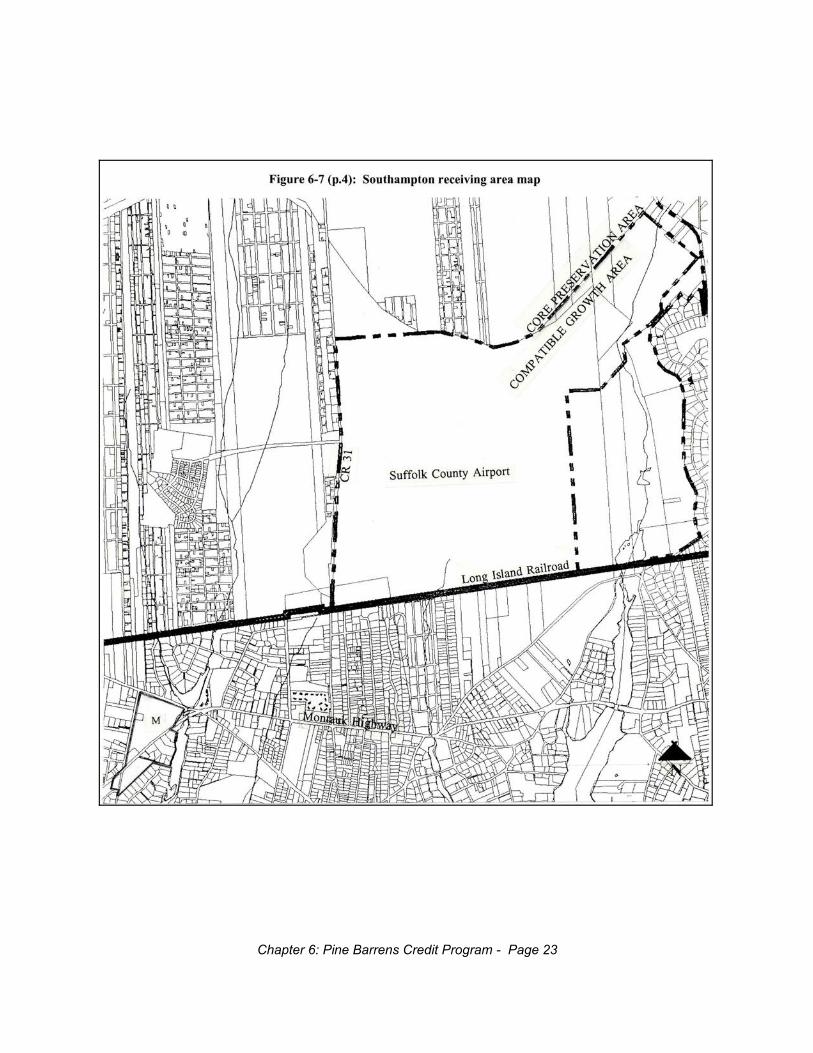
Chapter 6: Pine Barrens Credit Program - Page 23

Chapter 6: Pine Barrens Credit Program - Page 24
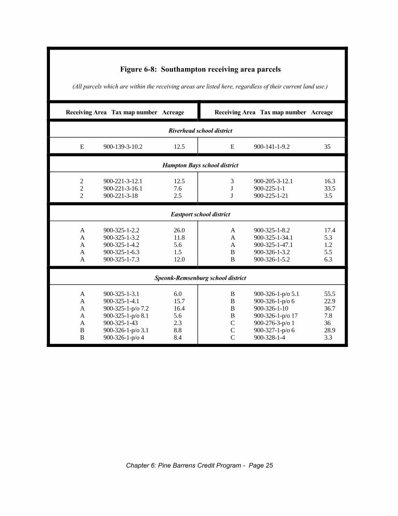
Figure 6-8: Southampton receiving area parcels
(All parcels which are within the receiving areas are listed here, regardless of their current land use.)
Receiving Area Tax map number Acreage Receiving Area Tax map number Acreage
Riverhead school district
E 900-139-3-10.2 12.5 E 900-141-1-9.2 35
Hampton Bays school district
2 900-221-3-12.1 12.52 900-221-3-16.1 7.62 900-221-3-18 2.5
3 900-205-3-12.1 16.3J 900-225-1-1 33.5J 900-225-1-21 3.5
Eastport school district
A 900-325-1-2.2 26.0A 900-325-1-3.2 11.8A 900-325-1-4.2 5.6A 900-325-1-6.3 1.5A 900-325-1-7.3 12.0
A 900-325-1-8.2 17.4A 900-325-1-34.1 5.3A 900-325-1-47.1 1.2B 900-326-1-3.2 5.5B 900-326-1-5.2 6.3
Speonk-Remsenburg school district
A 900-325-1-3.1 6.0A 900-325-1-4.1 15.7A 900-325-1-p/o 7.2 16.4A 900-325-1-p/o 8.1 5.6A 900-325-1-43 2.3B 900-326-1-p/o 3.1 8.8B 900-326-1-p/o 4 8.4
B 900-326-1-p/o 5.1 55.5B 900-326-1-p/o 6 22.9B 900-326-1-10 36.7B 900-326-1-p/o 17 7.8C 900-276-3-p/o 1 36C 900-327-1-p/o 6 28.9C 900-328-1-4 3.3
Chapter 6: Pine Barrens Credit Program - Page 25
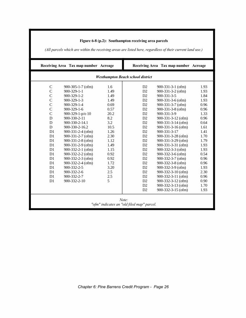
Figure 6-8 (p.2): Southampton receiving area parcels
(All parcels which are within the receiving areas are listed here, regardless of their current land use.)
Receiving Area Tax map number Acreage Receiving Area Tax map number Acreage
Westhampton Beach school district
C 900-305-1-7 (ofm) 1.6C 900-329-1-1 1.49C 900-329-1-2 1.49C 900-329-1-3 1.49C 900-329-1-4 0.69C 900-329-1-6 0.57C 900-329-1-p/o 10 20.2D 900-330-2-11 8.2D 900-330-2-14.1 3.2D 900-330-2-16.2 10.5D1 900-331-2-4 (ofm) 1.26D1 900-331-2-7 (ofm) 2.30D1 900-331-2-8 (ofm) 1.12D1 900-331-2-9 (ofm) 1.49D1 900-332-2-1 (ofm) 1.15D1 900-332-2-2 (ofm) 0.92D1 900-332-2-3 (ofm) 0.92D1 900-332-2-4 (ofm) 1.72D1 900-332-2-5 3.20D1 900-332-2-6 2.5D1 900-332-2-7 2.5D1 900-332-2-10 5
D2 900-331-3-1 (ofm) 1.93D2 900-331-3-2 (ofm) 1.93D2 900-331-3-5 1.84D2 900-331-3-6 (ofm) 1.93D2 900-331-3-7 (ofm) 0.96D2 900-331-3-8 (ofm) 0.96D2 900-331-3-9 1.33D2 900-331-3-12 (ofm) 0.96D2 900-331-3-14 (ofm) 0.64D2 900-331-3-16 (ofm) 1.61D2 900-331-3-17 1.41D2 900-331-3-28 (ofm) 1.70D2 900-331-3-29 (ofm) 1.79D2 900-331-3-31 (ofm) 1.93D2 900-332-3-3 (ofm) 1.93D2 900-332-3-6 (ofm) 0.54D2 900-332-3-7 (ofm) 0.96D2 900-332-3-8 (ofm) 0.96D2 900-332-3-9 (ofm) 1.93D2 900-332-3-10 (ofm) 2.30D2 900-332-3-11 (ofm) 0.96D2 900-332-3-12 (ofm) 0.90D2 900-332-3-13 (ofm) 1.70D2 900-332-3-15 (ofm) 1.93
Note:"ofm" indicates an "old filed map" parcel.
Chapter 6: Pine Barrens Credit Program - Page 26

6.4.5 Suffolk County Sanitary Code
The Suffolk County Health Department has proposed amendments to Article 6 of the SuffolkCounty Sanitary Code to permit the Department of Health to perform functions heretoforeperformed by the Board of Review. Insofar as it applies to the Central Pine Barrens, thisamendment should be applied so as to facilitate implementation of each town's Pine BarrensCredit program in accordance with this Plan and should sunset no later than the date when thelast Pine Barrens Credit allocated in that town is extinguished unless the Commission endorsesan earlier sunset date during the five year Plan update as provided in 57-0121(13). Each town, inits Findings Statement, may designate a more restrictive standard, i.e., less than 600 gallons perday per acre.
6.5 Pine Barrens Credit use planning
6.5.1 Amendment of zoning and land use regulations
In order for a town to comply with ECL Section 57-0123, it must amend its land use and zoningregulations to conform to this Plan within three (3) months of the Commission's adoption of thisPlan. Such amendments shall include the final adoption by each town of a Planned DevelopmentDistrict ordinance designed to accommodate Pine Barrens Credits. Each town shall propose adraft Planned Development District ordinance by June 30, 1995.
6.5.2 Establishment of a receiving capacity plan by each town
Each town shall, within three (3) months of the Commission's adoption of this Plan, submit aplan to the Commission demonstrating the manner in which each town will identify Pine BarrensCredit uses of sufficient quantity and quality within such town to accommodate at least two andone half (2.5) times the number of Pine Barrens Credits available for allocation within the townat that time.
6.5.2.1 One to one receiving capacity to sending credit ratio requirement
Each town shall include enough absorption capacity in receiving districts that meet the as of rightdefinition set forth in Section 6.4 of this Plan so as to absorb all of the Pine Barrens Credits on aone to one (1:1) ratio that the Commission estimates it may allocate in that town pursuant to thisPlan. The Commission recognizes that a change in zoning upon a town board's own motion thatwould decrease the receiving capacity so as to reduce this ratio below 1:1 would have an adverseeffect on the Pine Barrens Credit program.
6.5.2.2 Review by the Commission of the absorption capacity estimates
Each town shall present to the Commission its best estimate of the number of Pine BarrensCredits that could be transferred to, and absorbed in, its as of right Residential Overlay Districts,
Chapter 6: Pine Barrens Credit Program - Page 27
Planned Development Districts, or other kinds of receiving districts, or through incentive zoningstrategies with a supporting analysis. The Commission shall review, and then confirm or modify,such estimates based upon the best evidence available to it. In reviewing and approving thisplan, the Commission shall consider each town's compliance with Section 6.5.2 of this Planbased upon such estimates.
6.5.3 Establishment of additional receiving districts
In addition to the receiving districts identified above and the approaches identified by each townfor adding additional receiving districts, each town may adopt additional receiving districts toaccommodate Pine Barrens Credits as set forth below:
6.5.3.1 Planned Development Districts
The following policies shall apply to the use of Planned Development Districts for theredemption of Pine Barrens Credits.
6.5.3.1.1 Designation of Planned Development Districts as receiving districts
Each town may designate receiving districts that are Planned Development Districts (PDDs). Each PDD shall be mapped by the municipality, or otherwise designated by criteria that the towndescribes in its PDD regulations. Pine Barrens Credits may be redeemed for residential,commercial and other uses in PDDs. Each plan or scheme must include a redemption schedule, atable of densities or a change of use schedule, as appropriate.
6.5.3.1.2 Requirements of the Suffolk County Sanitary Code
Each PDD must conform to the requirements of the Suffolk County Sanitary Code.
6.5.3.1.3 Regulations regarding the timing of development
Each town may establish regulations regarding the timing of development within each PDD inorder to minimize any adverse fiscal impacts on any taxing jurisdiction, except that any suchphasing should not apply to any development allowed under existing zoning. To offset theimpact of residential development, commercial and industrial development should occur firstwhenever possible.
6.5.3.1.4 Inclusion of Planned Development District capacity within townwide PineBarrens Credit absorption capacity estimate
A town may include the absorption capacity of its Planned Development Districts as part of theplan that must be submitted to the Commission under section 6.5.2 above by estimating thenumber of Pine Barrens Credits that it reasonably expects may be absorbed in its PDDs. However, the estimate must be based upon a local PDD ordinance that shall have been fully
Chapter 6: Pine Barrens Credit Program - Page 28
adopted in final form within three (3) months of the Commission's adoption of this Plan.
6.5.3.2 Residential Overlay Districts
The following policies shall apply to the use of Residential Overlay Districts for the redemptionof Pine Barrens Credits.
6.5.3.2.1 Designation of additional Residential Overlay Districts as receiving districts
Each town may establish additional receiving districts that are residential overlay districts(RODs) within the town.
6.5.3.2.2 Requirements for designation of additional Residential Overlay Districts
Each ROD shall be mapped or otherwise designated based on objective geographic criteria.
6.5.3.2.3 Criteria for restricting locations of Residential Overlay District density increases
No ROD may include any land within the Core Preservation Area or any Critical Resource Area.
6.5.3.2.4 Types of projects in which the Residential Overlay District increase applies
The ROD yield would apply to subdivisions, land divisions, flag lot clusters, and mother anddaughter units.
6.5.3.2.5 Requirements of the Suffolk County Sanitary Code
The ROD must conform to the requirements of the Suffolk County Sanitary Code.
6.5.3.2.6 Prohibition of unreasonable school district burdens
Redemption of Pine Barrens Credits in RODs may not produce an unreasonable burden on thereceiving school district.
6.5.3.2.7 Inclusion of the Residential Overlay Districts' capacity within the townwide PineBarrens Credit absorption capacity estimate
A town may include the absorption capacity of its RODs as part of the plan that must besubmitted to the Commission under Section 6.5.2.1 of this Plan only if the ROD meets thedefinition "as of right" set forth above.
6.5.3.3 Incentive Zoning districts
The following policies shall apply to the use of Incentive Zoning Districts for the redemption of
Chapter 6: Pine Barrens Credit Program - Page 29
Pine Barrens Credits.
6.5.3.3.1 Designation of receiving districts pursuant to incentive zoning or municipal homerule laws
Each town may establish receiving districts pursuant to the incentive zoning provisions containedin New York Town Law Section 261-b or pursuant to New York Municipal Home Rule Law. Pine Barrens Credits may be redeemed for a change in land use, or an increase in intensity ordensity in such receiving districts.
6.5.3.3.2 Requirements for incentive zoning or municipal home rule receiving districts
For each incentive zoning district designated under Section 6.5.3 of this Plan, the town shallestablish a redemption schedule, a table of densities or a change of use schedule, as appropriate. Pine Barrens Credits shall be redeemable in accordance with the specified incentive zoning foreach receiving district designated. Upon application to the appropriate jurisdiction(s), additionalPine Barrens Credits may be used to exceed the incentive zoning of a receiving district with theredemption of these additional Pine Barrens Credits.
6.5.3.3.3 Requirements of the Suffolk County Sanitary Code
Each incentive zoning district must conform to the requirements of the Suffolk County SanitaryCode.
6.5.3.3.4 Increases above incentive zoning
As part of its incentive zoning ordinance, a town may provide that any additional increases overand above that provided by the incentive zoning schedule may be conditional upon the purchaseof additional Pine Barrens Credits.
6.5.3.4 Additional Overlay Districts, Special Permit Uses or Special Exemption Uses
Additional overlay districts, special permit uses, or special exemption uses may be adopted bythe towns to accommodate Pine Barrens Credits.
6.6 Establishment of the Pine Barrens Credit Clearinghouse and the Board of Advisors
The Commission finds that in order to implement the Pine Barrens Credit Program, steps must betaken to promote the use and sale of the Pine Barrens Credits established under the program andthat the best means of providing this assurance is through the establishment of a Pine BarrensCredit Clearinghouse that will purchase, sell, and track Pine Barrens Credits. The Commissionfurther finds that it is appropriate to establish a board to perform the functions of a clearinghouse,subject to the provisions set forth below.
Chapter 6: Pine Barrens Credit Program - Page 30
6.6.1 Structure and operation of the Board of Advisors
The Pine Barrens Credit Clearinghouse, referred to as the "Clearinghouse", shall be governed bya Board of Advisors (the "Board") consisting of five (5) members. Each ex officio member ofthe Commission, and the Governor, shall each appoint one (1) member of the Board. Themembers of the Board shall serve without compensation. The Commission shall appoint one (1)of these five members as Chairperson of the Board and shall also appoint one (1) other memberas a Vice-chair. Four (4) members of the Board shall constitute a quorum for the transaction ofservices or the exercise of any Board function. An affirmative vote of three (3) or more Boardmembers shall be required to pass a resolution or exercise a function of the Board.
6.6.2 Authority of the Board of Advisors
The Board shall have the authority:
6.6.2.1 To advise and make recommendations to the Commission as to the monetary value ofPine Barrens Credits to be purchased by the Clearinghouse.
6.6.2.2 To purchase Pine Barrens Credits from owners of eligible sending area parcels whichhave received Credits and from successive owners of Credits to further the objectives ofthe Pine Barrens Protection Act.
6.6.2.3 To sell, exchange or convey Pine Barrens Credits previously purchased by theClearinghouse to entities willing to purchase such Pine Barrens Credits from theClearinghouse, and to establish the monetary value of those Pine Barrens Credits whichare sold by the Clearinghouse.
6.6.2.4 To adopt and, from time to time, amend and repeal suitable bylaws for the managementof its affairs;
6.6.2.5 To apply for, receive, accept, and utilize, with the approval of the Commission, from anyfederal, state, or other public or private source, grants or loans for, or in aid of, theBoard's authorized purposes;
6.6.2.6 To utilize funds allocated for Clearinghouse purposes and to implement appropriatefiscal and accounting practices;
6.6.2.7 To appoint such officers, employees and agents as the Board may require for theperformance of its duties;
6.6.2.8 To call to its assistance, and to avail itself of the services of, employees of any state,county or municipal department, board, commission or agency as may be required andmay be made available for these purposes;
6.6.2.9 To issue Letters of Interpretation (LOIs) to owners of eligible sending area parcels, and toestablish appropriate administrative procedures for such issuance, including, but notlimited to, defining what documentation is acceptable for LOI application information.
6.7 Pine Barrens Credit Certificates
The following procedures shall apply to the issuance of Pine Barrens Credit Certificates by the
Chapter 6: Pine Barrens Credit Program - Page 31
Clearinghouse.
6.7.1 Issuance of Pine Barrens Credit Certificates by the Clearinghouse
All Pine Barrens Credit Certificates shall be issued by the Clearinghouse.
6.7.2 Overview of the issuance procedure
Issuance of a Pine Barrens Credit Certificate encompasses the following three steps:
1. A property owner obtains a Letter of Interpretation from the Clearinghouse stating the numberof Pine Barrens Credits allocated to the parcel of land.
2. The property owner applies to the Clearinghouse for a Pine Barrens Credit Certificate bysubmitting a valid Letter of Interpretation, a standard title report, and other necessarydocuments as determined by the Clearinghouse.
3. A Pine Barrens Credit Certificate is issued when the Clearinghouse receives proof of filingand recording of the conservation easement from the title insurance company.
6.7.3 Detail of Step 1: Obtaining a Letter of Interpretation
The Clearinghouse will utilize a current survey made in the last ten (10) years, if such a survey isavailable and provided, to establish the acreage figure to be utilized in the formula determiningCredit allocation. If such a survey is available, the survey’s acreage figure shall be used,regardless of the acreage shown on the tax bills. If such a survey is unavailable, the acreagefigure will be obtained from the publicly available tax bill information.
6.7.3.1 A property owner requests a Letter of Interpretation on a form to be supplied by theClearinghouse.
6.7.3.2 The Clearinghouse staff may conduct an analysis of the property and will allocate PineBarrens Credits based upon the allocation formula and any unique features of a particularparcel of land. The Clearinghouse staff mails the Letter of Interpretation to the propertyowner.
6.7.3.3 The property owner has thirty (30) days from the date of the Letter of Interpretation toappeal the allocation to the Commission in writing. Extensions of this deadline for filingan appeal may be granted at the Commission’s discretion upon written request of theproperty owner.
6.7.3.4 The Commission shall consider the appeal within sixty (60) days of receipt of an appeal,and may schedule a hearing. The Commission shall decide the appeal within sixty (60)days of receipt of the appeal. The Commission may confirm, increase, or decrease theallocation to be received from the Clearinghouse.
6.7.4 Detail of Step 2: Applying for a Pine Barrens Credit Certificate
6.7.4.1 After receiving a Letter of Interpretation, a property owner may request a Pine Barrens
Chapter 6: Pine Barrens Credit Program - Page 32
Credit Certificate from the Clearinghouse by submitting:1. The Letter of Interpretation, and2. A title report, and3. A completed Pine Barrens Credit Certificate Application Form, which shall be
supplied by the Clearinghouse.6.7.4.2 If the title report indicates that the applicant does not have marketable title, that the
applicant is not qualified to encumber the property with a conservation easement, or thatthere are liens on the property, a Pine Barrens Credit Certificate may not be issued untilthese matters are resolved by the applicant.
6.7.4.3 The Clearinghouse will provide to the applicant a conservation easement to sign onceclear title has been established to the satisfaction of the Clearinghouse.
6.7.4.4 The Commission will issue, and update as necessary, a policy on titles and title insurancefor use by the Clearinghouse.
6.7.5 Detail of Step 3: Recording a conservation easement and obtaining a Pine BarrensCredit Certificate
6.7.5.1 The conservation easement may not be recorded until all title issues are resolved andClearinghouse staff has approved the conservation easement as to its form.
6.7.5.2 The Clearinghouse will issue a preliminary approval concerning the title report and theproposed conservation easement.
6.7.5.3 The conservation easement will then be recorded with the Suffolk County Clerk, and acopy of it submitted along with proof of its recording, to the Clearinghouse. The titlereport must be updated to ensure that there has been no conveyance of the property sincethe report was received and that no liens have been placed upon the property.
6.7.5.4 The Clearinghouse will then issue a Pine Barrens Credit Certificate certifying that theholder of the Certificate is entitled to a specified number of Pine Barrens Credits.
6.7.6 Other provisions relating to the issuance of Pine Barrens Credit Certificates
6.7.6.1 Expiration of the Letters of Interpretation
A Letter of Interpretation shall expire three(3) years following its issuance. A property owner isnot required to apply for a Pine Barrens Credit Certificate upon receipt of a Letter ofInterpretation. However, if such application is not made within three(3) years, the Letter ofInterpretation will expire and the property owner will be required to reapply for a new Letter ofInterpretation.
6.7.6.2 Delayed issuance of a Pine Barrens Credit Certificate
After receipt of a Letter of Interpretation, a property owner may seek to negotiate the sale of thePine Barrens Credits described in the letter, and delay obtaining the Pine Barrens CreditCertificate until after reaching an agreement with a prospective buyer of the Pine Barrens Credits.
Chapter 6: Pine Barrens Credit Program - Page 33
6.7.6.3 Notification of the Clearinghouse of Pine Barrens Credit usage
A Pine Barrens Credit Certificate shall state that the recipient of the certificate and any partypurchasing the Pine Barrens Credits described in the certificate must notify the Clearinghouse ofany transaction involving the sale of the Pine Barrens Credits or utilization of the Pine BarrensCredits as security for a loan. The original Certificate must be sent to the Clearinghouse when allor any portion of the Credits associated with that Certificate are conveyed, transferred, or soldprior to redemption. The Clearinghouse shall then issue one or more new Certificate(s), asappropriate, in the name(s) of the new Credit owner(s).
6.7.6.4 Tax status of the subject property
No Pine Barrens Credit Certificates shall be issued for any parcel of land until all real propertytaxes and ad valorem levies have been paid in full as certified by the town's tax receiver. Specifically, this section requires that taxes are due for the current half of the tax year when aneasement is placed upon a parcel for the purpose of issuing Pine Barrens Credits.
6.7.6.5 Liability for real property taxes on subject property
If a transferor of Pine Barrens Credits owns Pine Barrens Credits on the tax status date under theSuffolk County Tax Act, and such Pine Barrens Credits are transferred subsequent to the taxstatus date, the transferor shall be liable for all real property taxes on such property from the taxstatus date until the date of transfer of the Pine Barrens Credits.
6.7.6.6 Issuance of a full Pine Barrens Credit for certain roadfront parcels
The Pine Barrens Credit Clearinghouse may elect to allocate one (1) full Pine Barrens Credit fora parcel of land consisting of at least 4,000 square feet with frontage on an existing publicimproved road. Parcel frontage on the main lines (as opposed to any improved service roads) ofSunrise Highway (NY State Route 27), the Long Island Expressway (Interstate 495), andsimilarly limited access highways shall not qualify a parcel for this provision.
6.7.6.7 Minimum Pine Barrens Credit allocation
No fewer than 0.10 (one tenth) Pine Barrens Credit shall be allocated by the Clearinghouse or theCommission for any parcel of land which is eligible for a Credit allocation, regardless of its sizeor road accessibility.
6.8 Registry, Reports, and Other Publicly Accessible Information for Pine Barrens Credits
6.8.1 Establishment and maintenance of the Pine Barrens Credit Registry
The Board shall establish and maintain a registry of Pine Barrens Credits and a publicly available
Chapter 6: Pine Barrens Credit Program - Page 34
set of reports, which shall include, at a minimum, the following information:
1. The name, property, contact, and address of every owner to whom a Pine Barrens Creditcertificate is issued pursuant to the Plan, the date of its issuance, the tax district, section,block and lot identification of the parcel of land to which the Pine Barrens Credit hasbeen assigned, the number of Pine Barrens Credits or fraction thereof assigned to eachparcel, the total number of Pine Barrens Credits assigned, and the total acreage to whichPine Barrens Credits have been assigned, and
2. The name and address of every person to whom a Pine Barrens Credit is sold or otherwiseconveyed, the date of the conveyance, and the consideration, if any, received therefore,and
3. The name and address of any person who pledged a Pine Barrens Credit as security on anyloan or other obligation, and the name and address of the lender, and
4. The name and address of any person who has sold or otherwise transferred a Pine BarrensCredit, the purchaser(s) to whom the Pine Barrens Credit was transferred, and the date ofthe sale; and
5. A record of every redemption of a Pine Barrens Credit including, at a minimum, the person(s)redeeming the Credit(s), the tax district, section, block and lot identification of theparcel(s) of land on which the Credits have been redeemed, the school district(s) fromwhich and to which the transfer occurred, the redeeming agency, and the date ofredemption; and
6. The total number of Pine Barrens Credits purchased and transferred. This report shall list themunicipality and school district of each tract of land for which Pine Barrens Credits wereissued and the municipality and school district to which the Pine Barrens Credits weretransferred.
6.8.2 Notification of the Board of certain actions involving Pine Barrens Credits
No person shall purchase or otherwise acquire, encumber, or sell any Pine Barrens Credit withoutnotifying the Board in writing within ten business days thereof.
6.8.3 Distribution of the annual report
The Board shall make available an annual report of the Pine Barrens Credit Program and theactivities of the Board as part of the Commission’s annual report required under ECL Article 57.
6.9 Municipal functions exclusive of state financial assistance
Nothing in this section shall be construed to prohibit, or in any other way interfere with, thecarrying out by any municipality of functions substantially similar to those described andauthorized in this Chapter of this Plan.
Chapter 6: Pine Barrens Credit Program - Page 35
6.10 Other development rights transfer programs
Nothing herein shall serve to limit, affect or prohibit the establishment or continuance of anyother municipal program for transferring or redirecting development rights.
* Denotes November 21, 2012 Chapter 6 CLUP Amendments adopted by the Commission.
Chapter 6: Pine Barrens Credit Program - Page 36