Embed Size (px)
Citation preview

Change in Peri-urban Australia: Implications for Land Use Policies
Michael Buxton 1 and Darryl Low Choy 2 1School of Global Studies, Social Science and Planning, RMIT University
2Urban Research Program, Environmental Planning Program, Griffith University Abstract: Peri-urban areas have commonly been defined in relation to a nearby metropolitan area on their inner boundary, a rural area on their outer boundary, or as the land in between. Peri-urban areas usually are not homogenous but are dynamic areas and the focus of significant non-metropolitan growth, both in Australia and internationally. A functional analysis requires an examination of the reciprocal relations of interacting systems as well as the characteristics, extent and impacts of cities and rural areas on peri-urban areas. Typologies of peri-urban development must address this heterogeneity. An examination of two Australian peri-urban case study areas applies an enhanced typology and reveals a disorderly pattern of existing subdivision with little discernible pattern and reflecting historical subdivision approvals. The development of these fragmented lots is leading to clusters of dwellings on small lots and individual houses not related to farming practice across many parts of peri-urban landscapes. Governance and institutional arrangements are equally fragmented with little evidence of long term sectoral strategic planning or cross-sectoral policy and management. This lack of integrated planning threatens the future of Australian peri-urban areas at a time when their values are becoming increasingly important for Australian cities and regional areas. Introduction The notion of a transitional zone between traditional urban and rural areas is not new although it has defied precise and universally acceptable definition. This has led in many respects to its vague attention in regional and metropolitan planning and policy development. However, the impacts from contemporary drivers of change that are rapidly transforming and defining the nature and composition of these peri-urban (in between) spaces suggest that a range of different challenges now confront our traditional approaches to land use policy and planning for these areas. Increasingly rapid change has become a characteristic feature of Australia’s peri-urban landscape. However, a review of the international and national literature reveals that there is neither clear focus nor understanding of these processes of change that are affecting these areas. Similarly, there is no universally accepted definition of peri-urban landscapes as a distinct form of urban settlement and conventional management practices have tended to rely on traditional urban planning approaches. This paper examines these definitional debates and the issues that arise from them and reviews typologies and proposes an enhanced typology for application to the Australian context. It then presents the results of recent research into two peri-urban case study areas – both located with the most rapidly urbanising metropolitan regions in Australia – South East Queensland (SEQ) and the greater Melbourne region. In response to these research findings, the paper concludes by proposing some implications for governance and land use policies. The paper seeks to contribute to our understanding of areas situated beyond the urban footprints of Australian cities and to ascertain whether their contemporary characteristic peri-urban attributes distinguish them from past experience and consequently present different or unique landscape management challenges. Specifically, what are the implications of contemporary peri-urban change for future land use policies? The Concept of the Peri-urban Landscape For some time now, a section of the literature has argued that peri-urban areas are a new and distinct form of settlement. Nelson and Dueker (1990, p. 91), for example, state that “There is emerging across the continental United States a new form of urban development. It extends far into the rural countryside but within the limits of commuting range to urban and suburban employment opportunities”. A peri-urban area can be defined in relation to a nearby metropolitan area on its inner boundary, a rural area on its outer boundary, or as the land in between. There are difficulties with all three approaches. Peri-urban land can be seen simply as urbanising land adjacent to the edge of an urban area into which it physically and functionally expands (Burnley and Murphy 1995). This city orientation therefore results in a peri-urban area being defined in relation to an expanding city which “constantly absorbs its fringe area and creates a ‘new’ fringe further from the city centre” (Golledge, 1960, p. 243).
ISBN 978-0-646-48194-4 SOAC 2007291
Alternatively, the focus may be on that area of land existing in a perpetually unstable state between inner and outer boundaries. Nelson (1999, p. 137) defines ‘exurbia’ as “a landscape situated between the built up urban areas and their suburbs, and the truly rural hinterland”. Conzen (1969, p. 125) defined a ‘fringe-belt’ as “a belt-like zone originating from the temporarily stationary or very slowly advancing fringe of a town and composed of a characteristic mixture of land-use units initially seeking peripheral location”. Hart (1991) proposed that metropolitan bow waves operated so that the outer edge of the urban fringe (or peri-urban zone) pushed outward into rural land, and the inner edge similarly moved constantly outward. This bow wave, he proposed, could not be halted. However, it may be difficult to identify the characteristics and boundaries of the peri-urban zone as the space between urban and rural land, or bands or sectors within this zone. The peri-urban area may contain a disorderly jumble of residential, commercial, rural-residential, often interspersed or alternatively following radial highways and varied agricultural uses. Peri-urban areas usually are not homogenous and may have differing characteristics and dynamics. They are dynamic areas and the focus of significant non-metropolitan growth, both in Australia and internationally (Bunker and Houston, 2003; Nelson, 1999). Daniels (1990) argues that the haphazard and discontinuous nature of land use in peri-urban areas renders the model of clear concentric rings obsolete. The notion of the peri-urban area as a concentric ring with migrating inner and outer boundaries need not contradict proposals of its haphazard nature, but would contradict the model of orderly, clearly defined inner bands within this broad peri-urban ring. To further complicate the spatial identification of this intermediate zone and its inner and outer boundaries, deciding where many cities end can be difficult. To Lapping and Furuseth (1999, p. 1) writing of North American cities, “not only has time-travel distance shrunk but the clearly identifiable edge separating the city from the countryside has eroded into a blur”. The blurring of uses and occupations is one of the dominating characteristics of much of the peri-urban area. Nelson (1999, p. 137) argues that the exurban area is “a polyglot of landscapes”. Audirac (1999, p. 13) describes “a jumble of rural, urban and suburban, light industrial and high-tech landscapes … mixed-use-developments featuring hotels, office and recreation space, convenience retail, shopping malls and cultural centres, and undeveloped farmland”, along with warehouses, motels, franchised outlets, hobby farmers, gated communities and mobile home parks. As a result, the distinction between city and countryside may be indistinct. Transitional urban related uses can eliminate the distinction between town and countryside leading to undifferentiated sameness and regional placelessness (Healy, 1985). Alternatively, many cities, through traditional practices or a historical legacy of state intervention, end with a clear boundary, or ‘hard edge’, which distinguishes between the urban and the rural. Even these cities influence a belt of land closest to the urban area. Crops are cultivated, animals enclosed or grazed and other agricultural activities occur right up to the boundaries of housing, businesses and factories. The strict urban boundary can also lead abruptly to a range of other non-urban uses, such as resource extraction, recreation and open space, protected landscape and uses that embody other environmental values. Just as it may be difficult to decide where metropolitan areas end, the outer boundary of the peri-urban zone may be equally unclear, making it difficult also to decide how to define the peri-urban area in relation to its outer rural belt. Using the spatial characteristics of land, the peri-urban area is often referred to as superficially rural. Different definitions of peri-urban all convey, to various extents, the interface nature of these areas as neither urban nor rural. A peri-urban area is commonly defined as a “zone of transition from urban to rural land uses” existing between the outer limits of the urban area and the beginning of the truly rural. Seen this way, it is a distinct settlement pattern, an identifiable “middle landscape” between the boundary of an urban area and rural pursuits (Davis et.al, 1994, p. 46). The notion of transition implies that a peri-urban area is an urban land bank awaiting use (Friedberger, 2000, Audirac, 1999), a “residual zone” (Pryor 1968, p. 205) subject to an “impermanence syndrome” (Bunker and Houston, 1992). Two fundamentally important contrasting perspectives on peri-urban regions and growth are held between advocates of separating cities from rural hinterlands, and those who desire rural-urban unification. A rural perspective regards urban expansion primarily as a threat, although at times, by introducing new income and skills into areas outside cities, as an opportunity. An urban perspective will concentrate on the needs of the city, and will regard nearby non-urban areas as the means to
292

satisfy urban needs by providing land and resources. These perspectives underpin much debate on peri-urban issues, for example, between advocates of urban dispersal and containment. A notable example of a rural perspective is the conceptual framework proposed by Bunce and Walker (1992). Walker (1987) refers to the peri-urban zone as invaded countryside threatened by urban expansion in much the same way as Pahl (1956 in Lapping and Furuseth 1999) describes peri-urban change as like a new population invading traditional local communities. But Bunce and Walker (1992, p. 54) later challenge the view that a rural environment is “a fragile shell just waiting for the impact of urban invasion”. They argue that rural life is resilient and urbanization is a weak force which only moves into rural areas because the emptying countryside and agricultural transformations create a near vacuum and present opportunities for encroachment. The underlying cause of change in peri-urban areas, they argue, is not the pressure exerted by the nearby city but declining returns from agricultural activity. In contrast, peri-urban areas are often regarded as those areas within the sphere of influence of adjacent urban centres (Houston, 2003, 2005). The types of influence may vary greatly and includes the effect of cities on the productivity of land, land prices, habitat and the maintenance of biological diversity, landscapes, and commuting patterns. Houston (2005, p. 209) has pointed out that ‘peri-urban’ usually means ‘peri-metropolitan’, as the term is most commonly applied to the fringes of large metropolitan centres, but the term can also be applied to large regional centres and, “in theory at least, all but the smallest urban centres have a discernible peri-urban sphere of influence”. Australian regional centres, particularly in the fringe zones of Melbourne and Sydney, are exerting their own influence on smaller towns in their periphery. Bunce and Walker (1992) recognise that amenity landscapes close to cities are subject to the greatest pressure for residential development, a view shared by Barr (2003, 2005) and many others. They also recognise the contribution of land speculation as a major cause of the conversion of rural land. In Australia, proximity to cities along with sought after amenity features are the critical factors affecting the development of peri-urban land. Declining financial returns from agricultural production are not the major factor affecting the transformation of rural land to urban purposes because, although such decline is a feature of agricultural land generally, only rural land close to cities generally is sought by city dwellers. Argent (2002) contends that many peri-urban areas are now similar to inner metropolitan areas in that they are undergoing a form of gentrification based on promotion of lifestyle and good living. Hugo and Smailes (1992), commenting on the identification of peri-urban areas, found that such areas should be described on the basis of the wide range of social and economic roles that they play. These bases of definition, together with the characteristics of the people who reside in the peri-urban area, are just as important as the land uses that are found there. Overall little attention appears to have been given to the long term planning and management of the land and resource base in peri-urban areas, and certainly not on any consistent or integrated basis (Allen 2003). Consequently the governance arrangements are generally found to be poorly defined in terms of roles and responsibilities (Margerum 2005). Possible policy responses to the range of issues peri-urban areas face are little understood (Daniels 1990; Nelson 1999).
Structure and Function in Peri-urban Analysis A structural analysis of peri-urban regions is concerned with locational elements such as population distribution, employment patterns, settlement structure and dwelling density, the location and types of land uses, and the physical extent and spatial characteristics of the peri-urban area. A functionalist analysis examines the uses of structural elements and proposes that the impacts and meaning of characteristics is understood through an examination of their relationships with other elements, and their function within a larger entity or a whole. Functional processes exert reciprocal relationships with each other, and with structural elements. Commonly studied functional processes in land use planning are consumption and production processes and flows, means of communication, rural and urban systems of production and exchange and their reciprocal impacts. Structural elements are often regarded as relatively stable, and functional processes as more changeable over time, but this may not necessarily be so. Extremely rapid redevelopment is fundamentally altering urban structural elements in many cities across the world in very short time periods. Nevertheless, a reliance on functional definitions can readily lead to changes in meaning. For example, defining a peri-urban region according to commuting distance (McKenzie, 1996) or
293
accessibility to urban areas may lead to rapid definitional change. The construction of a new major highway may increase accessibility, commuting and workplace connections, and in turn lead to structural change by raising population and leading to new land uses. New migrants to peri-urban areas demand better services, including improved transport provision, and these lead to further population increases, which rapidly change the landscape. Cities draw from a range of natural resources and environmental services provided by their hinterlands, and commonly affect and degrade these resources and services. Urban hinterlands commonly provide food, water, timber, stone and sand, fish, land for recreational and other human activities, and biological services. The human use of these resources affects soil, water, air quality, and ecosystems, changes landscapes, and in turn is affected by limits to these resources and by the carrying capacity of the land. Cities establish complex systems in their hinterlands. A functional analysis requires an examination of the reciprocal relations of interacting systems as well as the characteristics, extent and impacts of cities and rural areas on peri-urban areas, that is, those spatial zones which exist on either side of peri-urban areas under study. Different emphases will provide different definitions and interpretations, for example, from generalised statements of urban suburbanisation, to regional analyses which recognise complex interacting environmental, social and economic systems within peri-urban areas, and relationships between peri-urban, urban and rural areas.
Structural Elements - physical structure and form A number of researchers have developed structural conceptualisations to facilitate an analysis of peri-urban landscapes. Ilbery (1985) identifies four distinct zones - inner fringe, outer fringe, urban shadow and rural hinterland - which comprise peri-urban areas in the United States. Land is progressively converted to urban uses in an inner fringe. An outer fringe combines rural and urban land uses, with much land remaining idle as landowners speculate on conversions to urban uses. The urban shadow is land affected by commuting patterns, and the rural hinterland is land used for recreational activities by city dwellers. Burnley and Murphy (1995, p. 248-9, 245) proposed that the peri-metropolitan region could be divided into two categories. Their first category, Edge Statistical Local Area, refers to land on the edge of the metropolitan area that is being “colonized by the expanding suburbs”. These areas can be further divided into Edge Urban, which are suburbanized, and Edge Rural, which still contain some traditionally rural pursuits such as agriculture. Their second category, Peripheral Area, refers to land beyond the edge areas. Peripheral areas are divided into Peripheral Rural, which contain a range of rural activities, and Peripheral Urban, which are “freestanding urban centres set in a matrix of rural land”. This typology identifies the strong influence of the established city on the adjacent area, and the lessening urban influence with distance from the urban fringe. Murphy and Burnley (1996, p. 242-3) slightly altered this typology to categorise the peri-metropolitan region into “outer suburban” where most new housing is constructed immediately adjacent to the established city, “peri-urban”, suburbs which are not contiguous with the city, and “exurbia”, consisting of large suburban lots, rural residential lots, and farms used as holiday houses by the affluent. This categorisation is superficially attractive, as all these elements can be readily identified on the edges of Australian cities. Limiting the use of the term ‘peri-urban’ to non-contiguous suburbs such as Melton, on the fringe of Melbourne, or towns such as Laidley on the fringe of Brisbane, defies conventional usage of the term. This aside, the categorisation is simplistic, ignoring the heterogeneous nature of both the ‘exurban’ and non-contiguous urban areas. Non-urban (‘exurban’) areas usually comprise a broad range of people beyond suburbanites on large lots or absentee “Pitt or Collins Street Farmers” and their land uses. And peri-urban townships comprise more than “sociologically distinctive….sites of retirement migration and tourism”. Barr (2003, 2005) broadly defines peri-urban landscapes in terms of the impact of metropolitan areas on land uses, particularly on agriculture. He defines four types of social landscapes in Victoria: Rural Amenity, Agricultural Production, Irrigation Landscapes and Rural Transitional. Amenity landscapes are those with higher amenity, defined generally in terms of landscape amenity, benign climate, water availability and accessibility to major urban centres. In these areas, the demand for land, as expressed in terms of environmental preferences by urbanites, competes with agricultural pursuits, leading to higher land prices, and limiting the competitiveness of many agricultural businesses by reducing their capacity to expand. Viable farming businesses in these areas must intensify through horticulture and viticulture, for example, or diversify into entrepreneurial activities, such as niche agriculture, tourism or environmental services. Not all peri-urban areas would be classified as amenity landscapes, and not all amenity landscapes are peri-urban.
294
The subdivision of rural land into progressively smaller lot sizes tends to progressively destroy the capacities for diverse and viable agricultural production. Many agricultural land uses do not require land areas of productive land, and productivity correlates to soil type, climate and water availability. However, the potential for diversity and total productive capacity is enhanced by larger lot sizes. Agricultural protection zoning is a well established technique in developed countries to designate agricultural uses and restrict other uses of land by statute (Sinclair et al, 2003; American Farmland Trust, 2002). Generally, researchers have concentrated on proximity to large urban areas, and the presence of environmental features, such as water availability, attractive landscapes, accessibility, and coastal landscapes, to explain demand for rural land. By concentrating on demand, many researchers have understated the impacts of subdivisional and development rights, that is, land supply, on land prices. Barr opposes using large minimum lot sizes to help maintain agriculture because minimum lot sizes do not necessarily relate to viable farm size. Kelleher (2001) argues that limiting subdivision of agricultural land might inhibit the emergence of new forms of agriculture and that high value agriculture might only develop when subdivision is permitted. These arguments ignore the potential for land use planning controls to help maintain agricultural land and production by limiting new lot creation and preventing an influx of non-agricultural uses. The liberalisation of subdivision and development controls can lead to a mutually reinforcing process of increased land supply and demand. Conversely, limitations on subdivision and development in amenity areas will restrict the supply of smaller rural lots, limit land speculation, and may also lower land values. These factors can reinforce the expression in price of the suitability of land for agricultural production, increase the comparative rate of return from agriculture, and facilitate land purchase for the creation of larger agricultural lots, while not inhibiting diversity and innovation in production on holdings. The effects of land speculation on the price of land have been long recognised. It can lead to the inefficient conversion of rural land to urban uses, with landowners withholding land from the market in order to gain an increase in value. However, it has also been demonstrated that this can generate social costs to the community. The phenomenon of “out-of-sequence” development is still characteristic of much development occurring on the fringes of many metropolitan areas today. Application of Typologies An enhanced set of typologies have been applied to the two case studies which formed the basis for the scoping study of peri-urban issues funded by Land and Water Australia and the Commonwealth Department of Environment and Water Resources. The case studies were the Bendigo regional corridor in Victoria investigated by a team from RMIT University and Latrobe University (Bendigo) (Buxton et.al., 2007); and a Queensland study of the Extended Western Corridor to the west of Brisbane by Griffith University’s Urban Research Program (Low Choy et. al., 2007) - see Figures 1 and 2. In applying these typologies a number of conclusions can be drawn. The case study areas appear to exhibit “hard urban edges” clearly delineating the urban from the rural. Outside the metropolitan statistical boundaries, townships of various sizes in the study area are dotted throughout rural areas. Belts of rural-residential development border some townships. This suggests that an orderly gradation occurs in land uses from urban to rural-residential to rural in clearly delineated belts and that uses within these belts is relatively homogeneous. However, closer inspection reveals a somewhat different story. A disorderly pattern of existing subdivision exists over much of the study area with little discernible pattern and reflecting historical subdivision approvals. The development of these fragmented lots is leading to clusters of dwellings on small lots and individual houses not related to farming practice across many parts of the study corridor. The non urban areas are experiencing higher growth rates than the urban areas in many parts of the study corridor. Rural zones add to heterogeneity.
295
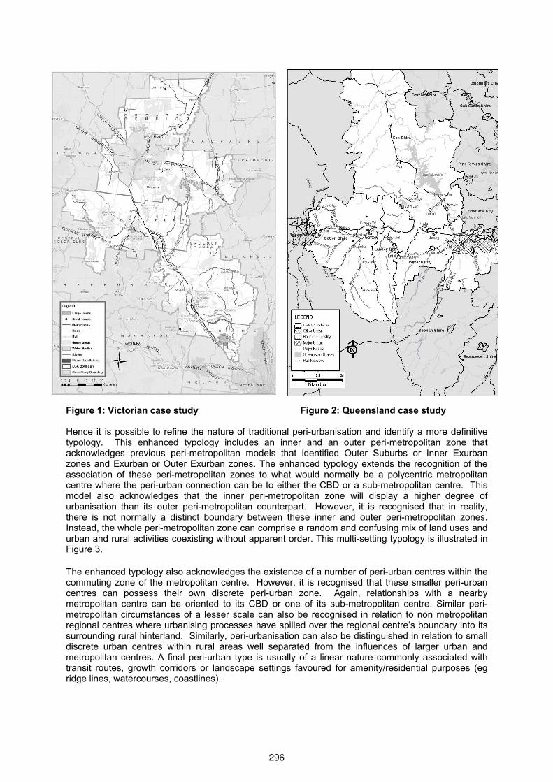
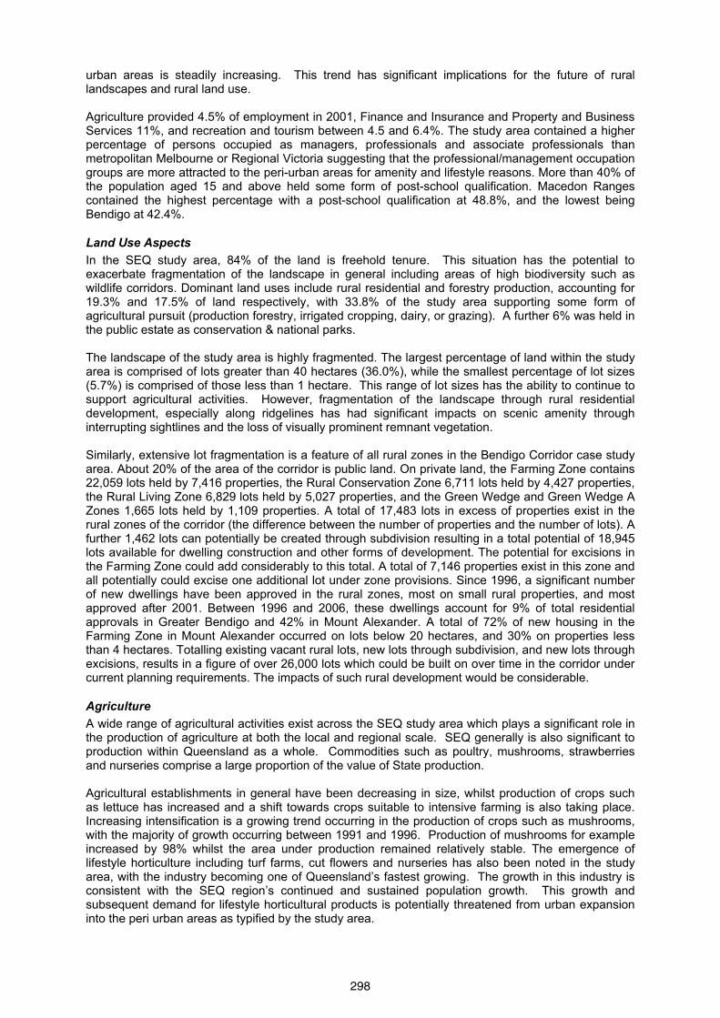
Figure 1: Victorian case study Figure 2: Queensland case study Hence it is possible to refine the nature of traditional peri-urbanisation and identify a more definitive typology. This enhanced typology includes an inner and an outer peri-metropolitan zone that acknowledges previous peri-metropolitan models that identified Outer Suburbs or Inner Exurban zones and Exurban or Outer Exurban zones. The enhanced typology extends the recognition of the association of these peri-metropolitan zones to what would normally be a polycentric metropolitan centre where the peri-urban connection can be to either the CBD or a sub-metropolitan centre. This model also acknowledges that the inner peri-metropolitan zone will display a higher degree of urbanisation than its outer peri-metropolitan counterpart. However, it is recognised that in reality, there is not normally a distinct boundary between these inner and outer peri-metropolitan zones. Instead, the whole peri-metropolitan zone can comprise a random and confusing mix of land uses and urban and rural activities coexisting without apparent order. This multi-setting typology is illustrated in Figure 3. The enhanced typology also acknowledges the existence of a number of peri-urban centres within the commuting zone of the metropolitan centre. However, it is recognised that these smaller peri-urban centres can possess their own discrete peri-urban zone. Again, relationships with a nearby metropolitan centre can be oriented to its CBD or one of its sub-metropolitan centre. Similar peri-metropolitan circumstances of a lesser scale can also be recognised in relation to non metropolitan regional centres where urbanising processes have spilled over the regional centre’s boundary into its surrounding rural hinterland. Similarly, peri-urbanisation can also be distinguished in relation to small discrete urban centres within rural areas well separated from the influences of larger urban and metropolitan centres. A final peri-urban type is usually of a linear nature commonly associated with transit routes, growth corridors or landscape settings favoured for amenity/residential purposes (eg ridge lines, watercourses, coastlines).
296

Figure 3: Peri-Urban Typologies Case Study Results - sectoral trends The two case studies have identified and analysed spatial, land use, environmental, social and economic trends; governance, institutional, policy and management arrangements and evaluated their adequacy whilst examining the implications of change for future land use and land management. The case studies have revealed the prevalence of a number of major interrelated elements including demographic, socio-economic, spatial, agricultural, biophysical, and natural resource issues as outlined below.
Demographic and Socio-Economic Aspects Dynamic changes have characterised the South East Queensland (SEQ) study area, with strong growth experienced during the early 1980s and 1990s. Over the period 1980 to 1990 an average annual rate of growth of 3.7% occurred, a figure that declined to 1.2% between 1991 and 2001, indicating that the primary wave of peri-urbanism occurred nearly two decades ago. During the period 1981 to 2001 a significant outflow occurred of youth (aged 24-35 years) from the study area, notably from the non-urban areas. Conversely, the population aged with increases in people aged over 60 years. In addition, the non urban portion of the study area contained a relatively high proportion of people aged less than 19 years for this 20 year period. Employment within the study area generally included occupations such as labourers and tradespeople, and industries of employment such as manufacturing and agriculture, fishing and forestry. Traditional areas of disadvantage within the study area compared to the remainder of the SEQ region showed improvements from 1996 to 2001, with the population becoming less disadvantaged in terms of low income, finishing high school and unemployment. Population growth in the Victorian study area has accelerated since the year 2000, with growth for the four year period 2001-2005 equal to or greater than that of the previous decade. The population in Rural Balance Areas increased from 21,035 in 1981 to 29,365 in 2001, most in the period 1981-1991. Most growth occurred at the Melbourne and Bendigo ends of the study area with average annual growth rate of 1.4%. As a proportion of the total area population and new dwellings, growth in the non-
PolycentricMetropolitan Centre
Urban Centre
Urban Centre
Urban Centre
Regional Centre
PU4a
PU2
PU3b
PU1aPU1b
PU3a
PU2
PU2
PU4a
PU4a
PU4b
KEY
PU1a
PERI URBAN TYPES
MetropolitanGrowth Corridor
PU4b
PU4b
297
urban areas is steadily increasing. This trend has significant implications for the future of rural landscapes and rural land use. Agriculture provided 4.5% of employment in 2001, Finance and Insurance and Property and Business Services 11%, and recreation and tourism between 4.5 and 6.4%. The study area contained a higher percentage of persons occupied as managers, professionals and associate professionals than metropolitan Melbourne or Regional Victoria suggesting that the professional/management occupation groups are more attracted to the peri-urban areas for amenity and lifestyle reasons. More than 40% of the population aged 15 and above held some form of post-school qualification. Macedon Ranges contained the highest percentage with a post-school qualification at 48.8%, and the lowest being Bendigo at 42.4%.
Land Use Aspects In the SEQ study area, 84% of the land is freehold tenure. This situation has the potential to exacerbate fragmentation of the landscape in general including areas of high biodiversity such as wildlife corridors. Dominant land uses include rural residential and forestry production, accounting for 19.3% and 17.5% of land respectively, with 33.8% of the study area supporting some form of agricultural pursuit (production forestry, irrigated cropping, dairy, or grazing). A further 6% was held in the public estate as conservation & national parks. The landscape of the study area is highly fragmented. The largest percentage of land within the study area is comprised of lots greater than 40 hectares (36.0%), while the smallest percentage of lot sizes (5.7%) is comprised of those less than 1 hectare. This range of lot sizes has the ability to continue to support agricultural activities. However, fragmentation of the landscape through rural residential development, especially along ridgelines has had significant impacts on scenic amenity through interrupting sightlines and the loss of visually prominent remnant vegetation. Similarly, extensive lot fragmentation is a feature of all rural zones in the Bendigo Corridor case study area. About 20% of the area of the corridor is public land. On private land, the Farming Zone contains 22,059 lots held by 7,416 properties, the Rural Conservation Zone 6,711 lots held by 4,427 properties, the Rural Living Zone 6,829 lots held by 5,027 properties, and the Green Wedge and Green Wedge A Zones 1,665 lots held by 1,109 properties. A total of 17,483 lots in excess of properties exist in the rural zones of the corridor (the difference between the number of properties and the number of lots). A further 1,462 lots can potentially be created through subdivision resulting in a total potential of 18,945 lots available for dwelling construction and other forms of development. The potential for excisions in the Farming Zone could add considerably to this total. A total of 7,146 properties exist in this zone and all potentially could excise one additional lot under zone provisions. Since 1996, a significant number of new dwellings have been approved in the rural zones, most on small rural properties, and most approved after 2001. Between 1996 and 2006, these dwellings account for 9% of total residential approvals in Greater Bendigo and 42% in Mount Alexander. A total of 72% of new housing in the Farming Zone in Mount Alexander occurred on lots below 20 hectares, and 30% on properties less than 4 hectares. Totalling existing vacant rural lots, new lots through subdivision, and new lots through excisions, results in a figure of over 26,000 lots which could be built on over time in the corridor under current planning requirements. The impacts of such rural development would be considerable.
Agriculture A wide range of agricultural activities exist across the SEQ study area which plays a significant role in the production of agriculture at both the local and regional scale. SEQ generally is also significant to production within Queensland as a whole. Commodities such as poultry, mushrooms, strawberries and nurseries comprise a large proportion of the value of State production. Agricultural establishments in general have been decreasing in size, whilst production of crops such as lettuce has increased and a shift towards crops suitable to intensive farming is also taking place. Increasing intensification is a growing trend occurring in the production of crops such as mushrooms, with the majority of growth occurring between 1991 and 1996. Production of mushrooms for example increased by 98% whilst the area under production remained relatively stable. The emergence of lifestyle horticulture including turf farms, cut flowers and nurseries has also been noted in the study area, with the industry becoming one of Queensland’s fastest growing. The growth in this industry is consistent with the SEQ region’s continued and sustained population growth. This growth and subsequent demand for lifestyle horticultural products is potentially threatened from urban expansion into the peri urban areas as typified by the study area.
298
Similarly, agriculture remains an important economic activity in the Victorian case study area. Extensive grazing is the predominant agricultural use but investment in intensive high capital forms of agriculture is increasing. The retention of larger lots is a significant factor supporting the retention of agricultural businesses and retaining future options for agricultural diversification and production. At present, 67% of all properties in the Farming Zone in the corridor are below 20 hectares in size, and over 25% less than 4 hectares. Only 628 lots are large enough to be subdivided, and only 2,168 lots are greater than the minimum subdivision size but unable to be subdivided. Nevertheless, the area covered by these larger lots is significant. Lots 100 hectares or more in size cover 85,387 hectares, including 69,743 hectares in the farming zone comprising 19% of the zone area, and 10,361 hectares in the Rural Conservation Zone comprising 13% of the zone area. Lots between 40-100 hectares in size cover 156,218 hectares including 117,880 hectares in the Farming Zone or 33% of the zone area, and 23,291 hectares in the rural Conservation Zone or 29% of the zone area.
Biophysical Threats In the SEQ case study area, peri-urban development for rural residential purposes is occurring on land which is not viable for agriculture and has remained largely undeveloped until recently. These areas of remnant vegetation represent significant pockets of biodiversity which is undermined by their development for residential uses. Vegetation clearing for settlement has led to the fragmentation of remnant vegetation and loss of habitat and wildlife corridors. The peri-urban area contains ecologically significant flora and fauna, a number identified as endangered or vulnerable. Further land fragmentation and increased densities may result in biodiversity losses. Clearing of woody vegetation for pasture or settlement has been high with minimal efforts undertaken towards revegetation. Competition and demand for land, especially for lifestyle properties, have resulted in subdivisions being approved in locations which are valued for their scenic amenity value but also having a high bushfire hazard rating. The uncontrolled spread of pests and weeds can result in unnecessary economic, social and environmental losses. The impacts from growing peri-urban activities such as those related to the equine industry and horse relayed leisure activities, including the breeding, training, spelling and keeping of horses, have to date been underestimated. In the Victorian case study area, broad-scale native vegetation clearance has effectively been halted, with a reduction between 1989 - 2005 of 220 hectares of tree cover on private land and 620 hectares on public land, indicating the effectiveness of vegetation clearance legislation introduced in 1989. However, the most depleted vegetation types continue to experience loss on both private and public land. Gains in vegetation are modest (105 hectares on private land and 230 hectares on public land) and are concentrated in the least depleted vegetation types. Efforts to restore vegetation through Landcare programs and the like have not made substantial inroads to restoring vegetation in the region, suggesting that additional approaches are required to achieve significant vegetation restoration in the region. Native grasslands continue to experience rapid depletion, with over 4,000 hectares lost since 1989. The majority of loss is on larger property sizes, however considerable amounts of tree and grassland loss have occurred on small to medium-sized properties. This continuing loss can be explained by the failure of the planning system to appropriately zone threatened vegetation. Zoning of vegetation in the study area appears to be unrelated to the conservation value of remnants, with large proportions of endangered and vulnerable vegetation types zoned inappropriately in rural, rural living, residential, business or industrial zones. Trends in protection appear to favour least threatened vegetation, with the proportion of vegetation in conservation, public or environmental rural zones increasing with decreasing conservation concern. A low proportion of the total area of remnant vegetation in the region is protected by Vegetation Protection Overlay, with the lowest levels of protection for the vegetation with the highest bioregional significance. The Shire of Mount Alexander does not use the VPO. The City of Hume applies it to 1.3 square kilometres or 0.56% of the municipality, and the Shire of Macedon Ranges to roadside vegetation and three areas comprising 42 square miles or 2.40% of the municipality. The City of Greater Bendigo makes greatest use of the VPO applying it to 140.4 square kilometres or 5.6% of the municipality, principally to patches of land generally classed as depleted or of least concern under the Victorian government zoning of bioregional significance (Government of Victoria, 2002) so generally applying it inadequately to vegetation types. Of endangered vegetation, for example, the City of Hume protects less than one%, the Shire of Macedon Ranges less than 4% and City of Greater Bendigo less than 8%.
299
Threats to Water Resources A pattern common to both case study areas is evidence of an increasing demand for water but development not being adequately integrated with water availability or cost. Environmental allocations have borne a disproportionate reduction in water availability as supply is diminished. The growth of farm dams, particularly from rural residential development, is causing significant water loss from streams and storages. Altered natural flow rates have led to permanent losses in aquatic and riparian flora and fauna and created conditions for algal blooms and the growth in incidences of non-native pest and weed species. Groundwater is being over-extracted with insufficient control being exercised. Water quality is deteriorating.
Governance arrangements and policy responses Australia’s peri-urban areas, particularly the perimetropolitan areas have been valued traditionally for their functions as green belts. They were seen as measures to prevent uncontrolled urban dispersal, and to protect landscape and biodiversity values, agricultural production, water supply sources, natural resources and cultural and recreational values. Potentially radical influences such as climate change and the peak-oil phenomenon could increase their importance in the coming decades. Australia’s peri-urban areas appear to have responded differently to global restructuring. But these emerging pressures may increase uncertainty and cause non-linear, unpredictable physical, social and economic changes. These emerging pressures increase the importance of long term integrated strategic planning for the peri-urban areas. However, the case studies demonstrated the dominance of sectoral decision making and the relative absence of cross-sectoral policy development. Little sectoral integration was apparent between local, state and commonwealth governments, or between state government agencies. Within sectors, planning agencies exhibited a lack of long term strategic planning on such matters as the potential impact of land fragmentation on the viability of agriculture, landscapes, water supply, infrastructure provision and social impacts. Institutional structures are primarily sectoral. Land use planning and the all elements of natural resource management, for example, are governed by separate legislation and different administrative arrangements. Recently however, in a strategic policy context, both state governments have initiated statutory regional planning in attempts to manage the growth that characterises these regions. In the Victorian case this has resulted in the 2002 Melbourne 2030 Plan, and in the Queensland case it was the SEQ Regional Plan 2005-2026 which was released in June 2005. The Melbourne plan returns to an interventionist planning approach based on demographic predictions through the delineation of urban growth corridors, the introduction of a legislated urban growth boundary, protection of a green belt, and the attempt to locate development into defined mixed use activity centres. The SEQ Regional Plan introduces directive planning to the peri urban area of Brisbane for the first time by defining an urban footprint, areas for investigation, and a Regional Landscape and Rural Production Area. It is based similarly on demographic and social predictions. Both plans also recognise the importance of protecting the natural resource base including agricultural land, landscapes and environmental features, and are strongly influenced by limitations on water availability. Conclusions It was shown that the peri-urbanisation of the case study areas was characterised by dynamic urbanising processes that led to the closer subdivision, fragmentation and land use conversation of former rural lands. It involved high levels of non metropolitan growth and often resulted in a blurred transitional zone comprising temporary and jumbled mixes of urban and rural activities and functions. The resulting peri-urban landscape comprised a range of land use activities that exhibited a high degree of heterogeneity, continual change and conflicting values. These contemporary peri-urban areas exhibited a range of unique landscape management challenges that differed in many respects from previous fringe attributes and their particular management responses. This raises the question as to whether the recently introduced statutory regional planning initiatives have the necessary basis to address these new sets of peri-urban landscape management challenges. These metropolitan strategic plans for the SEQ and Melbourne regions have proposed increased state regulation over such issues as land supply and the further subdivision of lands beyond the urban footprints. They also acknowledge a regional landscape and rural production area and introduced metropolitan green belts or similar. The challenge for these initiatives is to achieve an integrated holistic approach and a higher degree of integration across existing areas of discrete sectoral policy than has been achieved to date.
300
However, a renewed debate is needed over the potential of stronger regulatory land use planning tools and practices to assist in the retention of such peri-urban features as agriculture, biodiversity and landscapes. Without such a re-examination of governance, the lack of long term strategic planning, the relatively unregulated nature of decision making, the failure to use increasingly important principles such as the Precautionary Principles, and the lack of sectoral integration in planning is likely to lead to the continued unplanned development of many of Australia’s peri-urban areas with high environmental, economic and social costs.
References Allen, A. (2003) "Environmental planning and management of the peri-urban interface: perspectives on
an emerging field", Environment & Urbanization, 15(1), 135-147. American Farmland Trust (2002) Fact Sheet: The Farmland Protection Toolbox, Farmland Information
Center, American Farmland Trust. Argent, N. (2002) "From Pillar to Post? In seach of the post-productivist countryside in Australia",
Australian Geographer, 33(1), 97-114. Audirac. I (1999) "Unsettled views about the fringe: rural-urban or urban-rural frontiers?" in O. J.
Furuseth and M. B. Lapping (Eds.) Contested Countryside: The Rural Urban Fringe in North America, Ashgate, Aldershot, UK.
Barr, N. (2003) "Future Agricultural Landscapes", Australian Planner, 40(2), 123-127. Barr, N. (2005) The Changing Social Landscape of Rural Victoria, Department of Primary Industries,
Tatura, Victoria. Bunce, M. and Walker, G. (1992) "The Transformation of Rural Life", in I. Bowler, B. C and C. M. Nellis
(Eds.) Contemporary Rural Systems in Transition, Volume 2, Economy and Society, Redwood Press, Melksham, pp. 49-61.
Bunker, R. and Houston, P. (1992) "At and beyond the fringe: planning around the Australian city with particular reference to Adelaide", Urban Policy and Research, 10, 23-32.
Bunker, R. and Houston, P. (2003) "Prospects for the Rural-Urban Fringe in Australia: Observations from a Brief History of the Landscapes around Sydney and Adelaide", Australian Geographical Studies, 41, 233-247.
Burnley, I. H. and Murphy, P. A. (1995) "Exurban Development in Australia and the United States: Through a Glass Darkly", Journal of Planning and Education Research, 14, 245-254.
Buxton, M. Tieman, G. Bekessy, S. Budge, T. Butt, A. Coote, M. Lechner, A. Mercer, D. O’Neill, D. Riddington, C. (2007) Change and Continuity in Peri-urban Australia. Peri-urban Case Study: Bendigo Corridor, Land and Water Australia, Department of Environment and Heritage.
Coleman, A. (1969) "A geographical model for land use", Geography, 54(1), 43-55. Conzen, M (1969) Alnwick Northumberland: A Study in Town Plan Analysis, Institute of British
Geographers, London. Daniels, T. (1990) "Policies to preserve prime farmland in the USA: a comment", Journal of Rural
Studies, 6(3), 331-336. Davis, J. S., Nelson, A. C. and Dueker, K. J. (1994) "The new burbs. The exburbs and their
implications for planning policy", Journal of the American Planning Association, 60(1), 45-59. Friedberger, M. (2000) "The Rural-Urban Fringe in the Late Twentieth Century", Agricultural History,
74(2), 502-514. Golledge, R. G. (1960) "Sydney's Metropolitan Fringe: A Study in Urban-Rural Relations", Australian
Geograper, 7(6), 243-255. Hall, P. (1984) The World Cities, Weidenfeld and Nicolson, London. Hart, J. (1991) "The perimetropolitan bow wave", The Geographical Review, 81, 35-51. Healy, R. (1985) Competition for Land in the American South, The Conservation Foundation,
Washington D.C. Houston, P. (2003) "The National Audit of Peri-Urban Agriculture", Australian Planner, 40(3), 43-45. Houston, P. (2005) "Revaluing the Fringe: Some Findings on the Value of Agricultural Production in
Australia's Peri-Urban Regions", Geographical Research, 43(2), 209-223. Hugo, G. J. and Smailes, P. J. (1992) "Population dynamics in rural South Australia: a process view
of the turnaround", Journal of Rural Studies, 8(1), 29-51. Ilbery, B. (1985) Agricultural Geography, Oxford University Press, Oxford. Kelleher, F. (2001) Urban encroachment and loss of prime agricultural land, Centre for Farming
Research, University of Western Sydney, Hawkesbury. Lapping, M. B. and Furuseth, O. J. (1999) "Introduction and overview", in O. J. Furuseth and M. B.
Lapping (Eds.) Contested Countryside: The Rural Urban Fringe in North America, Ashgate, Aldershot, UK, pp. 1-5.
301
Low Choy, D. Sutherland, C. Scott, S. Rolley, K. Gleeson, B. Sipe, N. Dodson, J. (2007) Change and Continuity in Peri-urban Australia. Peri-urban case Study: South East Queensland, Land and Water Australia, Department of Environment and Heritage.
Margerum, R. D. (2005) "Collaborative growth management in metropolitan Denver: "Fig leaf or valiant effort?"", Land Use Policy, 22, 373-386.
McKenzie, F. (1996) Beyond the Suburbs: Population Change in the Major Exurban Regions of Australia, Bureau of Immigration Multicultural and Population Research, Australian Government Publishing Service, Canberra.
Murphy, P. and Burnley, I. (1996) "Exurban Migration", in P. Newton and M. Bell (Eds.) Population Shift - Mobility and Change in Australia, Australian Government Publishing Service, Canberra, pp. 242-258.
Nelson, A. C. (1999) "The exurban battleground", in O. J. Furuseth and M. B. Lapping (Eds.) Contested Countryside: The Rural Urban Fringe in North America, Ashgate, Aldershot, UK.
Nelson, A. C. and Dueker, K. J. (1990) "The Exurbanization of America and its Planning Policy Implications", Journal of Planning and Education Research, 9(2), 91-100.
Pryor, R. J. (1968) "Defining the Rural-Urban Fringe", Social Forces, 47(2), 202-215. Sinclair, R. (1967) "Von Thunen and urban sprawl", Annals of the Association of American Geographers, 57, 72-87.
Sinclair, I., Bunker, R. and Holloway, D. (2003) From the outside looking in - planning and land management in Sydney's fringe, State of Australian Cities National Conference 2003, Parramatta, Sydney.
Walker, G. (1987) An Invaded Countryside: Structures of Life on the Toronto Fringe, Geographical monograph no. 17, Atkinson College, York University, Toronto.
302