Embed Size (px)
Citation preview

Notice to ASX
Page 1 of 6
Changes to Simandou Ore Reserves and Mineral Resources
2 March 2018
Rio Tinto’s 2017 annual report, released to the market today, includes a write back of Ore Reserves to Mineral Resources at the Simandou iron ore project, in Guinea.
The updated Mineral Resources are reported in accordance with the Australasian Code for Reporting of Exploration Results, Mineral Resources and Ore Reserves, 2012 (JORC Code) and the ASX Listing Rules. Supporting information relating to the change is set out in this release and its appendix. Mineral Resources are quoted on a 100 per cent basis. Rio Tinto’s interest in the Simandou iron ore project is 45.05 per cent, with Chinalco (39.95 per cent) and the Republic of Guinea (15 per cent).
On 28 October 2016, Rio Tinto and Chinalco signed a non-binding agreement to sell Rio Tinto’s entire stake in the Simandou project, in Guinea, to Chinalco. The Heads of Agreement (HOA) set out the proposed principal terms of the sale with the aim of signing a binding agreement.
Considering current uncertainties in timing of development and potential variations to project scope under future project ownership, the project Ore Reserves have been written back to Mineral Resources.
Accordingly, estimates of Mineral Resources at Simandou have been increased, compared to the previous estimate in the 2016 annual report. The Simandou Mineral Resources have increased by 1922 Mt, from 835 Mt to 2757 Mt.
Tenure under the Simandou Mining Concession is held by Simfer SA, which is owned jointly by Rio Tinto, Chinalco and the Republic of Guinea. The Concession duration is 25 years, renewed automatically for a further period of 25 years followed by further 10 year periods in accordance with the Guinean Mining Code, provided Simfer has complied with its obligations under the Amended and Consolidated Basic Convention entered into with the Republic of Guinea, dated 26 May 2014.

Page 2 of 6
Schedule – Simandou Ore Reserves
Proved ore
reserves at end 2017
Probable ore
reserves at end 2017
Total ore reserves 2017
compared with 2016 Average
Rio Tinto
share
Type of mine
(a) Tonnage Grade Tonnage Grade Tonnage Grade
mill
recovery Interest
% Marketable
product
2017 2016 2017 2016 %
Iron Ore (v) (b)
millions millions millions millions millions
of tonnes % Fe of tonnes % Fe of tonnes of tonnes % Fe % Fe of tonnes
Reserves at development projects
Simandou (Guinea) (gg) O/P - 1,844 - 65.5 45.1 - Notes
(a) Type of mine: O/P = open pit, O/C = open cut, U/G = underground, D/O = dredging operation. (b) Reserves of bauxite, diamonds and iron ore are shown as recoverable Reserves of marketable product after accounting for all mining and processing losses. Mill recoveries are therefore not shown (v) Australian and Guinean iron ore Reserves tonnes are reported on a dry weight basis. As Rio Tinto only markets blended iron ore products from multiple mine sources, a detailed breakdown of constituent elements by individual deposit is not reported. (gg) All of Simandou's Reserves have been written down to Resources as a result of Rio Tinto's previously announced divestment process and uncertainty around development timing. Rio Tinto's interest in Simandou increased from 42.8 per cent to 45.1 per cent in 2017.
Schedule – Simandou Mineral Resources
Measured resources Indicated resources Inferred resources Total resources 2017
at end 2017 at end 2017 at end 2017 compared with 2016 Rio Tinto
Likely mining Tonnage Grade Tonnage Grade Tonnage Grade Tonnage Grade interest
method (a) 2017 2016 2017 2016 %
Iron Ore (w)
millions millions millions millions millions
of tonnes % Fe of tonnes % Fe of tonnes % Fe of tonnes of tonnes % Fe % Fe
Simandou (Guinea) (ee) O/P 324 66.8 1,709 65.3 723 65.1 2,757 835 65.5 65.0 45.05
Notes
(a) Likely mining method: O/P = open pit; O/C = open cut; U/G = underground; D/O = dredging operation. (w) Iron ore Resources tonnes are reported on a dry weight basis. As Rio Tinto only markets blended iron ore products from multiple mine sources, a detailed breakdown of constituent elements by individual deposit is not reported. (ee) All of Simandou's Reserves have been written down to Resources as a result of Rio Tinto's previously announced divestment process and uncertainty around development timing. Rio Tinto's interest in Simandou increased from 42.8 per cent to 45.1 per cent in 2017. A JORC Table 1 in support of these changes will be released to the market contemporaneously with the release of this Annual report and can be viewed at riotinto.com/JORC.

Page 3 of 6
Summary of information to support the Mineral Resource estimate The Simandou Mineral Resource Estimate is supported by a JORC Table 1 (Sections 1 to 3) document provided as the appendix to this release and also located at www.riotinto.com/investors/reserves-and-resources. On 28 October 2016, Rio Tinto and Chinalco signed a non-binding agreement to sell Rio Tinto’s entire stake in the Simandou project in Guinea to Chinalco. The Heads of Agreement (HOA) set out the proposed principal terms of the sale with the aim of signing a binding agreement. Considering uncertainties in timing of development and potential variations to project scope under future project ownership, the project Ore Reserves have been written back to Mineral Resources. The following summary of information for Mineral Resource Estimates is provided in accordance with Chapter 5.8 of ASX Listing Rules. Geology and geological interpretation The Ouéléba and Pic de Fon supergene-enriched itabirite iron ore deposits are located in the southern part of the Simandou Range in south-eastern Guinea. The Simandou Range is part of the Kénéma-Man Domain of the West African Craton. The deposits are hosted within the Simandou Group with the Itabirite Formation overlying the Phyllites and Schist Formations. The deposits have undergone intense multi-phase deformation and are deeply weathered. The Ouéléba and Pic de Fon deposits extend for 7.8 km and 7.5 km along strike with widths of 0.8 km and 1 km respectively. The mineralisation interpreted for the Mineral Resources extends from surface to a vertical depth of approximately 500 m. Geological interpretation was completed by Rio Tinto Simandou and consultant geologists. The method involved the use of surface geological mapping, lithological logging data, assay data and down-hole geophysical data. The high-grade haematite-goethite (Ouéléba) or haematite-martite (Pic de Fon) mineralisation transitions with increasing depth to partially enriched itabirites and then into unenriched itabirites. Geological domains within the itabirites have been interpreted reflecting the degree of mineralisation and weathering. Geological domains within the phyllites are interpreted based on competency and dominant mineralogy. Drilling techniques Drilling at the deposits used reverse circulation and diamond drilling techniques. In total 682 holes (135,496 m) have been used for the Ouéléba Mineral Resource and 576 holes (117,830 m) have been used for the Pic de Fon Mineral Resource. Reverse circulation drilling has been used for 69% of the total metres at Ouéléba and 70% for the total metres at Pic de Fon. Drilling was carried out between 1999 and 2011. Geophysical logging was completed for the majority of the holes using downhole tools. Core orientation has been measured for competent core since 2009 using a core orientation tool. Core holes have been geotechnically logged since 2008. Sampling, sub-sampling method and sample analysis method Sampling of diamond core or reverse circulation drilling was over a nominal 2 m sample interval. Pulp samples were prepared at site and then sent to an external independent ISO 9001 accredited laboratory in Western Australia for analysis by X-Ray fluourescence (XRF) for 24 variables. Loss on ignition (LOI) is determined for three temperatures using a thermo-gravimetric analyser.

Page 4 of 6
For diamond core drilling half-core samples are oven-dried and crushed to less than 31.5 mm and:
• riffle-split and pulverised to a particle size of 95 per cent passing 106 microns from which a 60 g pulp sample was collected (for samples collected pre-2008)
• screened using eight sieve sizes which are then combined to create three size fraction samples which are each riffle-split to a minimum weight of 300 g and pulverised to a particle size of 95 per cent passing 106 microns from which a 60 g pulp sample was collected for each size fraction (for samples collected pre-2008).
For reverse circulation drilling the samples have been collected via rotating or static cone splitters, or riffle splitters to achieve a 2 kg primary sample. The samples are oven-dried, crushed to a a top size of 2 mm, then riffle split to a minimum weight of 300 g and then pulverised to a particle size of 95 per cent passing 106 microns from which a 60 g pulp sample was collected. Criteria used for classification The Mineral Resources have been classified into the categories of Measured, Indicated and Inferred. The determination of the applicable category has considered relevant factors (geological complexity and confidence, mineralisation continuity, data quality, block grade estimation confidence, sample spacing and others as appropriate). Estimation methodology Ordinary kriging algorithims were used for estimating block grades for twelve variables into parent blocks of 60 by 60 by 12 m cell size using the drillhole data composited to 2 m downhole intervals. The parent block size corresponds to approximately half the average drill spacing and the assumed mining bench height. Kriging neighbourhood analyses were used to determine appropriate parameters for kriging. Hard boundaries were applied to the geology domains for grade estimation. No top-cuts were applied to the data but a grade-dependent restriction for a sample’s range of influence was used for estimating manganese and sulphur in a small number of domains to manage grade outliers. Block grade estimation was validated using statistical and visual comparisons between the input composited drillhole data and the resultant block grades. Cut-off grades The cut-offs for reporting the Mineral Resources, for both deposits, are greater than or equal to 58% Fe and less than 3% Al2O3. Mining and metallurgical factors or assumptions Development of these Mineral Resources assumes conventional open cut mining with a proposed bench height of 12 m. It is assumed that standard crushing and screening processes will be used to produce directly shippable product. The reporting of Mineral Resources was constrained by an ultimate pit shell selected via pit optimisation of directly shippable material for all resource categories. No other mining or metallurgical factors, or assumptions, have been applied.

Page 5 of 6
Competent Persons’ Statement The information in this report that relates to Mineral Resources is based on information compiled by Ms Michelle Franks, a Competent Person who is a Member of The Australasian Institute of Mining and Metallurgy. Ms Franks is an employee of Workpac. Ms Franks has sufficient experience that is relevant to the style of mineralisation and type of deposit under consideration and to the activity being undertaken to qualify as Competent Persons as defined in the 2012 Edition of the ‘Australasian Code for Reporting of Exploration Results, Mineral Resources and Ore Reserves’. Ms Franks consents to the inclusion in the report of the matters based on the information that she has compiled in the form and context in which it appears.

Page 6 of 6
Contacts
riotinto.com
Follow @RioTinto on Twitter
Media Relations Illtud Harri T +44 20 7781 1152 M +44 7920 503 600
David Outhwaite T +44 20 7781 1623 M +44 7787 597 493
Investor Relations, United Kingdom John Smelt T +44 20 7781 1654 M +44 7879 642 675
David Ovington T +44 20 7781 2051 M +44 7920 010 978
Nick Parkinson T +44 20 7781 1552 M +44 7810 657 556
Media Relations, Australia Jonathan Rose T +61 3 9283 3088 M +61 447 028 913
Investor Relations, Australia Natalie Worley T +61 3 9283 3063 M +61 409 210 462
Rachel Storrs T +61 3 9283 3628 M +61 417 401 018
Rio Tinto plc 6 St James’s Square London SW1Y 4AD United Kingdom
T +44 20 7781 2000 Registered in England No. 719885
Rio Tinto Limited Level 7, 360 Collins Street Melbourne 3000 Australia
T +61 3 9283 3333 Registered in Australia ABN 96 004 458 404
Appendix
Simandou Ouéléba and Pic de Fon Deposits - Table 1
The following table provides a summary of important assessment and reporting criteria used at Simandou Ouéléba and Pic de Fon Deposits for the reporting of mineral resources in accordance with the Table 1 checklist in The Australasian Code for the Reporting of Exploration Results, Mineral Resources and Ore Reserves (The JORC Code, 2012 Edition). Criteria in each section apply to all preceding and succeeding sections.
SECTION 1 SAMPLING TECHNIQUES AND DATA
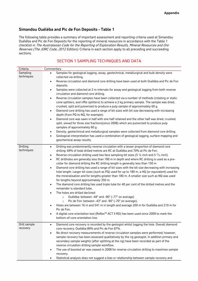
Criteria Commentary Sampling techniques
• Samples for geological logging, assay, geotechnical, metallurgical and bulk density were collected via drilling.
• Reverse circulation and diamond core drilling have been used at both Ouéléba and Pic de Fon deposits.
• Samples were collected at 2 m intervals for assay and geological logging from both reverse circulation and diamond core drilling.
• Reverse circulation samples have been collected via a number of methods (rotating or static cone splitters, and riffle splitters) to achieve a 2 kg primary sample. The sample was dried, crushed, split and pulverized to produce a pulp sample of approximately 60 g.
• Diamond core drilling has used a range of bit sizes with bit size decreasing with increasing depth (from PQ to NQ, for example).
• Diamond core was sawn in half with one half retained and the other half was dried, crushed, split, sieved for three size fractions(since 2008) which are pulverized to produce pulp samples of approximately 60 g.
• Density, geotechnical and metallurgical samples were collected from diamond core drilling • Geological interpretation has used a combination of geological logging, surface mapping and
geochemical assay results.
Drilling techniques
• Drilling was predominantly reverse circulation with a lesser proportion of diamond core drilling: 69% of total drilled metres are RC at Ouéléba and 70% at Pic de Fon.
• Reverse circulation drilling used two face sampling bit sizes (5 ½ inch and 5 3/8 inch). • RC drillholes are generally less than 180 m in depth and where RC drilling is used as a pre-
collar for diamond drilling the RC drilling length is generally less than 150 m • Diamond core drilling has used a range of bit sizes with the bit size decreasing with increasing
hole length. Larger bit sizes (such as PQ) used for up to 180 m, a HQ (or equivalent) used for the mineralisation and for lengths greater than 180 m. A smaller size such as NQ was used for lengths beyond approximately 350 m.
• The diamond core drilling has used triple tube for 40 per cent of the drilled metres and the remainder is standard tube.
• The holes are drilled declined: o Ouéléba: between -44° and -90° (-77° on average) o Pic de Fon: between -43° and -90° (-70° on average).
• Holes are between 16 m and 541 m in length and average 200 m for Ouéléba and 210 m for Pic de Fon.
• A digital core orientation tool (Reflex™ ACT II RD) has been used since 2009 to mark the bottom-of-core orientation line.
Drill sample recovery
• Diamond core recovery is recorded by the geologist whilst logging the hole. Overall diamond core recovery: Ouéléba 89% and Pic de Fon 87%.
• No direct recovery measurements of reverse circulation samples were performed; however, sample recovery has been assessed qualitatively by the rig geologist. In addition primary and secondary sample weights (after splitting at the rig) have been recorded as part of the reverse circulation drilling sample workflow.
• The use of boosted air was ceased in 2008 for reverse circulation drilling to maximise sample recovery.
• Statistical analysis does not suggest a bias or relationship between sample recovery and

2
grade.
Logging • All diamond core and RC chip samples are logged over two metre intervals. Quantitative logging for lithology, stratigraphy, texture and hardness is conducted using defined material type codes based on characterisation studies and mineralogical assessments. Colour and any additional qualitative comments are also recorded. Logging information is stored in the Rio Tinto Simandou acQuire™ database.
• Each tray of core was photographed and half core is retained in a secure storage facility. • Most diamond core drilled holes since 2008 have been geotechnically logged at the drill site
before transporting the core. There have also been a number of holes which have specifically been drilled to enable more detailed logging and destructive testing of core to obtain quantitative geotechnical rock property information. A subset of holes used for geotechnical investigations have also been logged with an acoustic televiewer.
• More than 70% of the holes have been geophysically logged using downhole tools for gamma trace, gamma density, resistivity and magnetic susceptibility.
Sub-sampling techniques and sample preparation
Diamond core:
• The diamond drill core is cut in half using a core saw where the core is competent enough to be sawn or, where the core is friable, a trowel is used to select half of the material in the interval. The nominal sample interval was 2 m.
• Pre-2008, and at times when the crush and screen equipment was unavailable, core was dried for 12 hours at 105°C, crushed to a 2.63 mm top size and then riffle split three times before being pulverised to a particle size that corresponds to a 95% passing at 106 micron. Pulp samples of approximately 60 grams are taken from the pulverised samples.
• Since 2008, a grade by size methodology has been used for preparing the diamond core samples to pulp samples. The core samples are dried at 105°C for at least 24 hours, crushed to a 31.5 mm top size and then screened with eight sieve sizes. The sieved fractions are combined to create three size fraction samples: <0.15 mm, between 0.15 mm and 10 mm; and >10 mm. The size fraction samples are then riffle split (to a minimum weight of 300 grams) and pulverised to a particle size that corresponds to a 95 per cent passing at 106 micron. Pulp samples of approximately 60 grams are taken from the pulverised samples.
Reverse circulation:
• A nominal 2 m sample interval was used for reverse circulation drilling • The reverse circulation samples have been collected via a number of methods to aim for a 2
kg primary sample. The methods include: rotating cone splitter, cyclone and rig mounted rotating splitter, static cone and riffle splitters.
• The primary reverse circulation samples are dried for 24 hours at 105°C then crushed in a jaw crusher to a top size of 2 mm, and then riffle split to a sample with a minimum weight of 300 grams. The samples are pulverised to a particle size that corresponds to a 95% passing at 106 micron. Pulp samples of approximately 60 grams are taken from the pulverised samples.
Quality of assay data and laboratory tests
Assay methods:
• The pulp samples are sent to an external ISO 9001 accredited independent laboratory in Perth, Western Australia for analysis.
• A sub-sample of 0.68 grams is used for preparation of an X-Ray fluorescence (XRF) fusion disc and whole rock analysis is completed for the following variables: Al2O3, As, Ba, CaO, Cl, Co, Cr, Cu, Fe, Pb, MgO, Mn, Ni, P, K2O, SiO2, Na, Sr, S, Sn, TiO2, V, Zn and Zr.
• Loss on ignition (LOI) is measured using a thermo-gravimetric analyser at 371°C, 538°C and 1000°C and then accumulated for total LOI using a 3 to 5 gram sub-sample from the pulp sample.
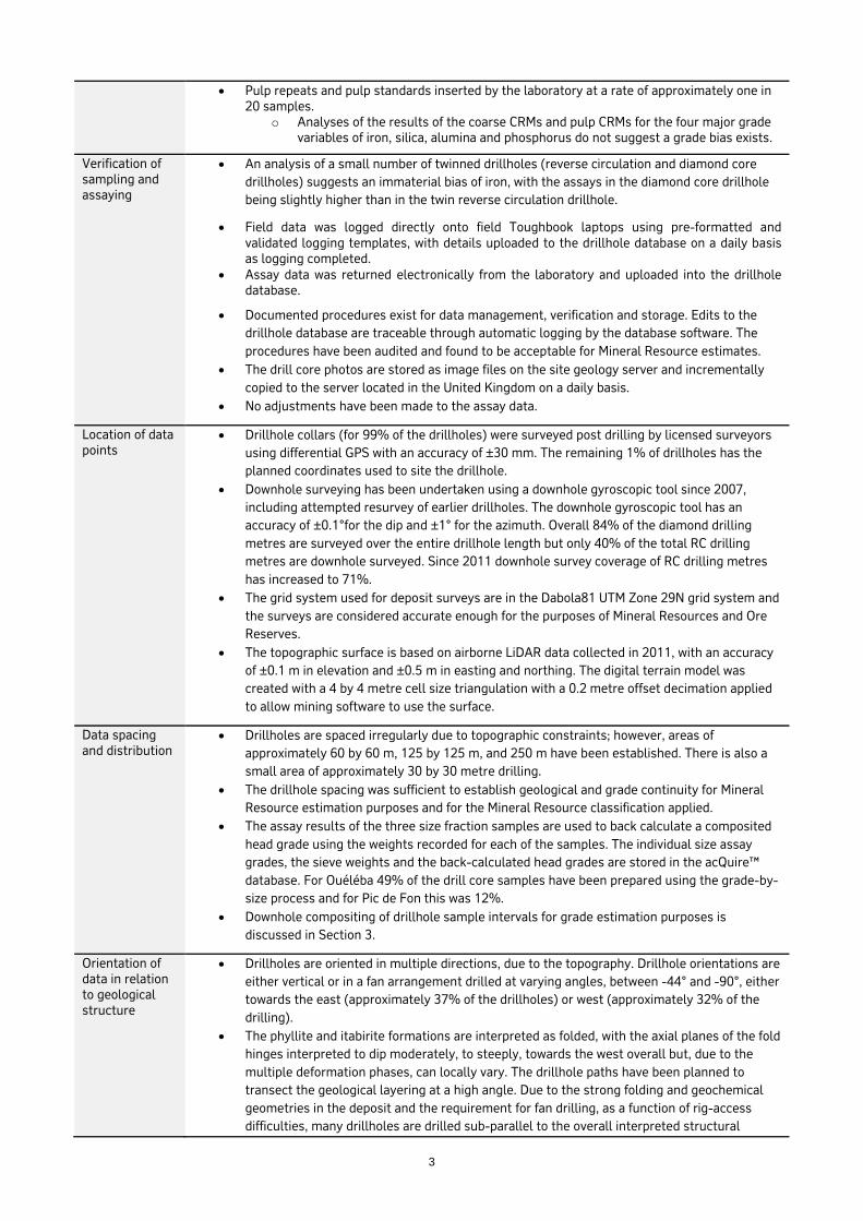
QAQC of the sample preparation and assaying processes is via the following samples:
• Coarse certified reference materials (CRMs) inserted into the drillhole sample sequence at a rate of one in 20, and prepared as per the regular drillhole samples
• Pulp CRMs inserted at the laboratory at the rate of approximately one in 60 • Field duplicates that are inserted at the rate of one in 20 samples • Preparation laboratory duplicates inserted at the rate of one per drillhole
3
• Pulp repeats and pulp standards inserted by the laboratory at a rate of approximately one in 20 samples.
o Analyses of the results of the coarse CRMs and pulp CRMs for the four major grade variables of iron, silica, alumina and phosphorus do not suggest a grade bias exists.
Verification of sampling and assaying
• An analysis of a small number of twinned drillholes (reverse circulation and diamond core drillholes) suggests an immaterial bias of iron, with the assays in the diamond core drillhole being slightly higher than in the twin reverse circulation drillhole.
• Field data was logged directly onto field Toughbook laptops using pre-formatted and validated logging templates, with details uploaded to the drillhole database on a daily basis as logging completed.
• Assay data was returned electronically from the laboratory and uploaded into the drillhole database.
• Documented procedures exist for data management, verification and storage. Edits to the drillhole database are traceable through automatic logging by the database software. The procedures have been audited and found to be acceptable for Mineral Resource estimates.
• The drill core photos are stored as image files on the site geology server and incrementally copied to the server located in the United Kingdom on a daily basis.
• No adjustments have been made to the assay data.
Location of data points
• Drillhole collars (for 99% of the drillholes) were surveyed post drilling by licensed surveyors using differential GPS with an accuracy of ±30 mm. The remaining 1% of drillholes has the planned coordinates used to site the drillhole.
• Downhole surveying has been undertaken using a downhole gyroscopic tool since 2007, including attempted resurvey of earlier drillholes. The downhole gyroscopic tool has an accuracy of ±0.1°for the dip and ±1° for the azimuth. Overall 84% of the diamond drilling metres are surveyed over the entire drillhole length but only 40% of the total RC drilling metres are downhole surveyed. Since 2011 downhole survey coverage of RC drilling metres has increased to 71%.
• The grid system used for deposit surveys are in the Dabola81 UTM Zone 29N grid system and the surveys are considered accurate enough for the purposes of Mineral Resources and Ore Reserves.
• The topographic surface is based on airborne LiDAR data collected in 2011, with an accuracy of ±0.1 m in elevation and ±0.5 m in easting and northing. The digital terrain model was created with a 4 by 4 metre cell size triangulation with a 0.2 metre offset decimation applied to allow mining software to use the surface.
Data spacing and distribution
• Drillholes are spaced irregularly due to topographic constraints; however, areas of approximately 60 by 60 m, 125 by 125 m, and 250 m have been established. There is also a small area of approximately 30 by 30 metre drilling.
• The drillhole spacing was sufficient to establish geological and grade continuity for Mineral Resource estimation purposes and for the Mineral Resource classification applied.
• The assay results of the three size fraction samples are used to back calculate a composited head grade using the weights recorded for each of the samples. The individual size assay grades, the sieve weights and the back-calculated head grades are stored in the acQuire™ database. For Ouéléba 49% of the drill core samples have been prepared using the grade-by-size process and for Pic de Fon this was 12%.
• Downhole compositing of drillhole sample intervals for grade estimation purposes is discussed in Section 3.
Orientation of data in relation to geological structure
• Drillholes are oriented in multiple directions, due to the topography. Drillhole orientations are either vertical or in a fan arrangement drilled at varying angles, between -44° and -90°, either towards the east (approximately 37% of the drillholes) or west (approximately 32% of the drilling).
• The phyllite and itabirite formations are interpreted as folded, with the axial planes of the fold hinges interpreted to dip moderately, to steeply, towards the west overall but, due to the multiple deformation phases, can locally vary. The drillhole paths have been planned to transect the geological layering at a high angle. Due to the strong folding and geochemical geometries in the deposit and the requirement for fan drilling, as a function of rig-access difficulties, many drillholes are drilled sub-parallel to the overall interpreted structural

4
geometries. However, it is considered that there is a very low risk that sampling biases have been introduced due to the orientation of drilling.
Sample security • The Simandou project employs a security team to monitor site security.• Half of the diamond core for each drillhole is stored in a secure fenced compound.• Since 2010, the secondary RC samples have been riffle split and retained as reference
samples in a secure storage facility.• RC drillhole retention pulps, of approximately 120 g, are put in small plastic bags (150 by 250
mm) with around 20 small plastic bags put in larger bags. The retention pulps are stored in asecure shipping container at site.
• Prepared pulps are stored at site inside a secured shipping container. The primary pulps aresent by air freight in a secured metal container to an independent laboratory in Perth forassaying.
Audits or reviews
• An audit of the sample collection and pulp preparation processes was completed in 2011 byRio Tinto Technology and Innovation. Overall, the data collection and assay data qualitycontrols were considered to be industry-standard.
• Reviews of the QAQC data were completed both internally by Rio Tinto Technology andInnovation and externally by Xstract Mining Consultants in 2011. The main finding of thereviews was, overall, there are good spatial and temporal coverage of quality control data andno clear indications of significant grade biases for key grade variables. Recommendationswere also made to improve procedures with respect to a more proactive approach to QAQCresults and work procedures.
• A detailed external audit of the acQuire™ drillhole database was completed in 2010. Theaudit included review of the database structure, the loading and storage of data and checked5% of the data (by laboratory analytical batch) against data sourced directly from thelaboratory. The audit concluded that the drillhole database was structurally sound andcontained valid data. Recommendations from the audit have been implemented by Rio Tintowith completion of all items by 2013.
SECTION 2 REPORTING OF EXPLORATION RESULTS
Criteria Commentary Mineral tenement and land tenure status
• The Ouéléba and Pic de Fon deposits are located within the Simandou Mining Concession(formed 22 April 2011) held by Simfer SA. The Concession duration is 25 years, renewedautomatically for a further period of 25 years followed by further 10 year periods inaccordance with the Guinean Mining Code, provided Simfer has complied with itsobligations under the Amended and Consolidated Basic Convention entered into with theRepublic of Guinea, dated 26 May 2014.
• The tenure boundary is listed within the Government of Guinea decree ‘DecretD/2011/134/PRG/SGG Portant Octroi d'une Concession Minière a la Société Simfer AS surle Mont Simandou’.
• The proposed rail and port infrastructure is also covered by Government legislation as aproject of national interest that was granted in 2012.
• The ownership of Simfer in 2017 is as listed in the table below:
JV Partners 2017 percentage
45.05%
39.95%
Rio Tinto
Chalco Iron Ore Holdings Ltd
Republic of Guinea 15.00%
• Areas of the mining concession sit within the Pic de Fon Classified Forest and as such onekey component of the SEIA is to manage the impacts to this area and establish offset areasdescribed in the SEIA.

5
Exploration done by other parties
• Regional mapping by French (1950s) and Chinese (1970s) technical teams identified the potential in the Simandou deposits.
• All exploration information used in generating the Mineral Resources has been collected by Rio Tinto managed exploration and evaluation programs since 1997.
Geology • The Pic de Fon and Ouéléba deposits are typical of supergene-enriched itabirite hosted iron ore deposits.
• The deposits are located in the Simandou Range on a prominent ridge. The Simandou Range is the result of multi-phase ductile deformation represented by tight synformal fold keels and sheared antiformal structures. The ridge consists of a formation of itabirites (metamorphosed BIF) and phyllites within the Simandou Group overlying basement gneiss and amphibolite. The itabirites and phyllites have been deeply weathered and identifying stratigraphy is difficult, with the only discernible contact being that between the itabirites and phyllites.
• The following domains have been interpreted for the itabirites: laterite, carapace, transitional mineralisation, friable haematite goethite mineralisation, friable enriched itabirite, friable poor itabirite and compact poor itabirite.
• Phyllite domains have been interpreted for very weak phyllite, soil strength phyllite, weak phyllite, compact pyritic phyllite, weak quartzite and compact quartzite.
• Laterite and carapace are sub-horizontal with the laterite overlying all other lithologies and the carapace overlying the mineralisation and enriched itabirite lithologies.
• The itabirites and phyllites are interpreted to be folded with the axial planes of the fold hinges dipping moderately to steeply towards the west.
• The high grade mineralisation at Pic de Fon and Ouéléba is located on the top of the ridge, and typically consists of haematite-martite and haematite-goethite mineralisation respectively. Drilling has confirmed that the high grade mineralisation extends to over 400 m from the surface.
• The high grade mineralisation at both deposits transitions downwards into a partially enriched, generally friable, itabirites and then into unenriched itabirites which also transition from friable to compact with increasing depth away from the mineralisation front.
• A surface covering of weathered mineralisation typically up to 20 m to 30 m in depth is found over the high grade mineralisation at Pic de Fon. At Ouéléba much deeper pervasive weathering is observed with a weathered carapace (goethite, clay and limonite rich) and a transitional weathering/mineralisation zone are observed over the high grade mineralisation. These zones are typically between 30 m to 100 m thick but can be over 300 m thick in some locations.
Drillhole Information
Ouéléba
• Summary of drilling data used for the Ouéléba Mineral Resource estimate:
Year Reverse circulation Diamond core
Reverse circulation pre-collar and diamond core
tail
# Holes Metres # Holes Metres # Holes Metres
2005 23 2,013 - - - -
2006 - - 5 1,437 - -
2007 144 26,023 18 4,657 - -
2008 312 57,976 29 9,625 6 2,148
2009 - - 28 8,226 - -
2010 - - 49 10,211 - -
2011 27 3,926 32 6,769 9 2,485
Total 506 89,938 161 40,925 15 4,633
Pic de Fon
• Summary of drilling data used for the Pic de Fon Mineral Resource estimate:
Year Reverse circulation Diamond core

6
# Holes Metres # Holes Metres
1999 16 1,355 - - 2000 - - 7 1,384 2001 8 970 1 156 2002 97 17,956 2 511 2003 26 5,556 - - 2006 - - 15 3,369 2007 46 10,482 35 6,773 2008 211 44,963 49 12,777 2010 - - 15 4373 2011 - - 1 230 Total 404 81,282 125 29,573
• An additional 47 drillholes (6975 m) were used for geological interpretation only due to holes not being sampled or having unreliable assay information.
Data aggregation methods
• All assay data have been composited to 2 m for Mineral Resource modelling and estimation. • No grade truncations were performed.
Relationship between mineralisation widths and intercept lengths
• The drillhole paths have been planned to transect the geological layering at a high angle but due to complex geometries and rig-access difficulties many drillholes are drilled sub-parallel to the overall interpreted structural geometries.
• Potential differences between downhole and true thickness are mitigated by the use of three-dimensional interpretation of the stratigraphic units using the nominal 2 m samples.
Diagrams Tenure boundary and deposit location map
Drillhole collar locations maps

7
Note: Only one 2011 drillhole from Pic de Fon used for the Mineral Resource (other 2011 drillholes had not been completed at time of data extraction) Ouéléba section – 956650 mN – looking south
Pic de Fon section – 942060 mN – looking south
SECTION
SECTION
Ouéléba Pic de Fon

8
Balanced reporting
• This section of the JORC Code 2012 is designed for reporting early exploration results and, as such, does not apply to the Ouéléba and Pic de Fon advanced exploration projects.
Other substantive exploration data
• Ouéléba and Pic de Fon are advanced exploration projects and, as such, significant exploration data has been collected. In addition to the drilling data the following items have also been completed: metallurgical testwork, structural mapping for engineering geology and geotechnical purposes, geological mapping in potential resource extension areas, surface water studies and geotechnical studies.
Further work • More drilling is recommended to both improve confidence in the Mineral Resources in the more sparsely drilled Mineral Resource areas and to increase potential conversion to Ore Reserves.
• Exploration activities to test for potential resource extensions outside the project mining areas are planned once full production is attained.
SECTION 3 ESTIMATION AND REPORTING OF MINERAL RESOURCES
Criteria Commentary Database integrity
• All drilling data is stored in the Rio Tinto Simandou acQuire™ drillhole database. The system is backed up daily to a server located in the United Kingdom.
• All data is transferred electronic and checked prior to upload to the database. • In-built validation tools are used in the acQuire™ database and data loggers are used to
minimise keying errors, flag potential errors and validate against internal library codes. Data that is found to be in error is investigated and corrected where possible. If the data cannot be corrected it is removed from the data set used for resource modelling and estimation.
• The drillhole database used for the Mineral Resource estimation has been validated. Methods included checking of: QAQC data, duplicate drillhole locations, duplicated intervals, odd total assay values, extreme values, zero values, possible miscoded data based on location within a geodomain and assay value, sample overlaps, the total LOI against the sum of the individual LOI values and inconsistencies in length of drillhole surveyed and length of drillhole logged and sampled.
Site visits • The Competent Person visited site twice during 2011. These visits and some other internal
9
reviews have led to a number of improvements in the QAQC process used at Simandou.
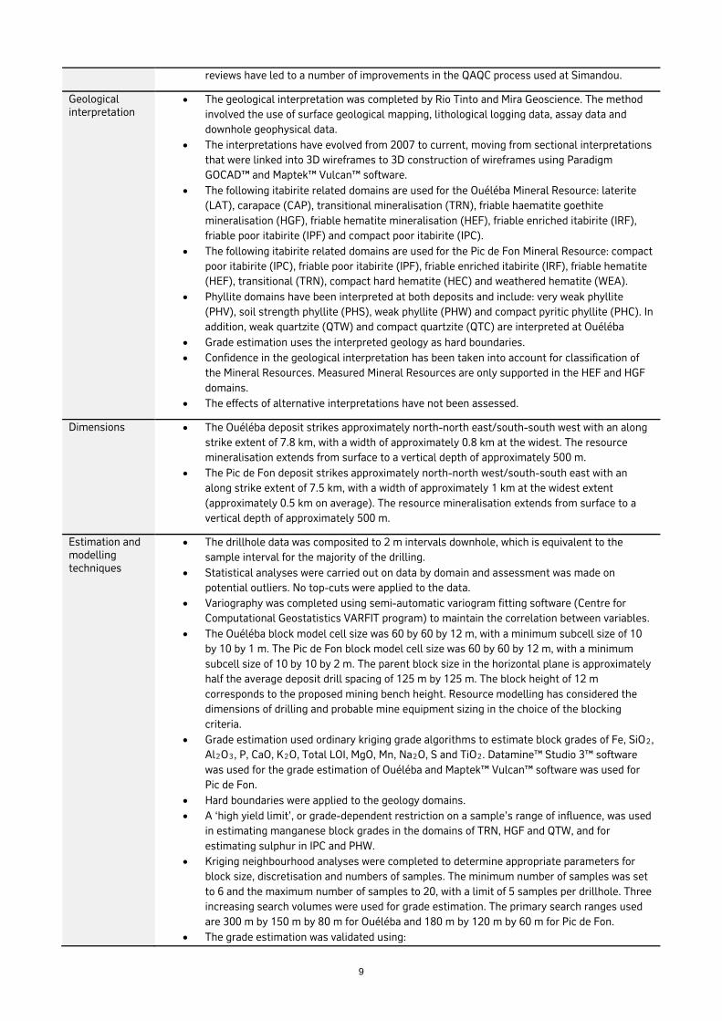
Geological interpretation
• The geological interpretation was completed by Rio Tinto and Mira Geoscience. The method involved the use of surface geological mapping, lithological logging data, assay data and downhole geophysical data.
• The interpretations have evolved from 2007 to current, moving from sectional interpretations that were linked into 3D wireframes to 3D construction of wireframes using Paradigm GOCAD™ and Maptek™ Vulcan™ software.
• The following itabirite related domains are used for the Ouéléba Mineral Resource: laterite (LAT), carapace (CAP), transitional mineralisation (TRN), friable haematite goethite mineralisation (HGF), friable hematite mineralisation (HEF), friable enriched itabirite (IRF), friable poor itabirite (IPF) and compact poor itabirite (IPC).
• The following itabirite related domains are used for the Pic de Fon Mineral Resource: compact poor itabirite (IPC), friable poor itabirite (IPF), friable enriched itabirite (IRF), friable hematite (HEF), transitional (TRN), compact hard hematite (HEC) and weathered hematite (WEA).
• Phyllite domains have been interpreted at both deposits and include: very weak phyllite (PHV), soil strength phyllite (PHS), weak phyllite (PHW) and compact pyritic phyllite (PHC). In addition, weak quartzite (QTW) and compact quartzite (QTC) are interpreted at Ouéléba
• Grade estimation uses the interpreted geology as hard boundaries. • Confidence in the geological interpretation has been taken into account for classification of
the Mineral Resources. Measured Mineral Resources are only supported in the HEF and HGF domains.
• The effects of alternative interpretations have not been assessed.
Dimensions • The Ouéléba deposit strikes approximately north-north east/south-south west with an along strike extent of 7.8 km, with a width of approximately 0.8 km at the widest. The resource mineralisation extends from surface to a vertical depth of approximately 500 m.
• The Pic de Fon deposit strikes approximately north-north west/south-south east with an along strike extent of 7.5 km, with a width of approximately 1 km at the widest extent (approximately 0.5 km on average). The resource mineralisation extends from surface to a vertical depth of approximately 500 m.
Estimation and modelling techniques
• The drillhole data was composited to 2 m intervals downhole, which is equivalent to the sample interval for the majority of the drilling.
• Statistical analyses were carried out on data by domain and assessment was made on potential outliers. No top-cuts were applied to the data.
• Variography was completed using semi-automatic variogram fitting software (Centre for Computational Geostatistics VARFIT program) to maintain the correlation between variables.
• The Ouéléba block model cell size was 60 by 60 by 12 m, with a minimum subcell size of 10 by 10 by 1 m. The Pic de Fon block model cell size was 60 by 60 by 12 m, with a minimum subcell size of 10 by 10 by 2 m. The parent block size in the horizontal plane is approximately half the average deposit drill spacing of 125 m by 125 m. The block height of 12 m corresponds to the proposed mining bench height. Resource modelling has considered the dimensions of drilling and probable mine equipment sizing in the choice of the blocking criteria.
• Grade estimation used ordinary kriging grade algorithms to estimate block grades of Fe, SiO2, Al2O3, P, CaO, K2O, Total LOI, MgO, Mn, Na2O, S and TiO2. Datamine™ Studio 3™ software was used for the grade estimation of Ouéléba and Maptek™ Vulcan™ software was used for Pic de Fon.
• Hard boundaries were applied to the geology domains. • A ‘high yield limit’, or grade-dependent restriction on a sample’s range of influence, was used
in estimating manganese block grades in the domains of TRN, HGF and QTW, and for estimating sulphur in IPC and PHW.
• Kriging neighbourhood analyses were completed to determine appropriate parameters for block size, discretisation and numbers of samples. The minimum number of samples was set to 6 and the maximum number of samples to 20, with a limit of 5 samples per drillhole. Three increasing search volumes were used for grade estimation. The primary search ranges used are 300 m by 150 m by 80 m for Ouéléba and 180 m by 120 m by 60 m for Pic de Fon.
• The grade estimation was validated using:

10
o visual comparisons between the composited drillhole data and block grades o comparisons of declustered composited drillhole global mean grades with block
grades o comparing the composited drillhole and block model mean grades in northing,
easting and elevation slices (grade trend charts) o The Mineral Resources were also compared with the 2010 Mineral Resource
estimates. • The grade estimation and validation techniques are considered appropriate for the Mineral
Resources estimates. • Recovery factors are not applied to the Mineral Resources models. Construction of the Ore
Reserves model is when both recovery and dilution are incorporated. • No mining has occurred that will allow reconciliation of actual and predicted data.
Moisture • All Mineral Resource tonnages are estimated and reported on a dry basis.
Cut-off parameters
• The Mineral Resources cut-offs for reporting are greater than or equal to 58% Fe and less than 3% Al2O3.
• The decision is based on market and economic analysis for the directly shippable product defined in these models.
Mining factors or assumptions
• The proposed mining operation will be open cut mining with a large annual tonnage (after initial production and ramp up). The proposed bench height is 12 m and this has been taken into account for the selection of the resource model block size.
• No other mining factors or assumptions have been applied to the mineral resource model. • The ultimate shell for reporting Mineral Resources has been selected from Whittle™ software
optimisation of direct ship material in the mining models for all resource categories (excluding the unclassified category).
Metallurgical factors or assumptions
• No metallurgical modifying factors have been applied given the mineralisation is of direct shipping grade and it is modelled that 100% of plant feed is recovered as product.
• Processing characteristics, such as abrasiveness, are factored into the operating cost model.
Environmental factors or assumptions
• Drillhole samples with elevated sulphur levels have been identified in the compact phyllites: o Compact phyllites currently account for approximately 1% of the expected waste
rock to be moved during the life of mine. o A planned program to continue testing different potential waste dump mixes for
this material is available for when work recommences to test potential acid rock drainage (ARD) and sediment runoff issues.
o The studies to date have used a conservative approach for the mine plan economics by segregating this waste into standalone dumps with appropriate treatment facilities. It may still be feasible to blend the low quantities of this material with other neutralising wastes.
o The potential for elevated sulphur waste being mined in the first 5 years of production is very low so this gives sufficient time to complete additional drill investigations, field and laboratory testing to confirm if the current plan continues to be appropriate.
• The Social and Environmental Impact Assessment approved in early 2012 comprehensively covers management requirements that apply to the Simandou project. These commitments have been included in the project cost model.
Bulk density • Bulk dry density values were determined by using the Corelok™ system where samples, nominally 15 cm in length, are vacuum sealed and then water displacement is used to determine the density value and the porosity.
• The 3,844 density samples (1,918 from Ouéléba and 1,966 from Pic de Fon) have been selected from 146 diamond drillholes since 2007.
• The domains represented by the density samples are similar in representation to the domains in the resource drilling data.
• The density data was statistically analysed to determine an average bulk dry density value to be used for each geology domain used in the resource model. Itabirite density values range from 2.8 to 3.3 t/m³. Phyllite density values range from 1.7 to 2.4 t/m³.

11
Classification • The resource has been classified as Measured, Indicated and Inferred Mineral Resources. The classification is based on drill spacing, includes consideration of geological confidence, downhole survey risk, kriging variance, grade extrapolation of blocks estimated in the third search pass, blocks estimated with low numbers of samples and areas visually identified by coordinate extents as being of lower confidence.
• Downhole survey risk affects areas at Ouéléba where there are significant geological contacts (both mineralisation and phyllite) supported by drillholes without downhole surveys. These areas are considered to be lower in confidence and this has been reflected in the resource classification. No areas at Pic de Fon were considered to be significantly affected by downhole survey risk to require a downgrade in the resource classification.
• The distance to the nearest samples used for block grade estimation has been determined for the Inferred Mineral Resources. The block grades that were estimated using samples greater than 125 m are considered to be the result of grade extrapolation. The extrapolated block grades represent 14% of the Inferred Mineral Resources tonnage.
Audits or reviews
• The resource interpretation and estimation methodology have been reviewed by an external peer reviewer in 2011. Actions from the findings of this review have been addressed as part of the 2012 modelling process.
• The resource estimation was completed by Xstract. Internal peer reviews were completed at key stages during the resource estimation process by Xstract and Rio Tinto also reviewed the output at key stages during the resource estimation process.
• Coffey reviewed the Minerals Resources in February 2015. They endorsed the processes used and supported the work as fit for purpose.
Discussion of relative accuracy/ confidence
• No specific geostatistical studies have been completed to estimate the local accuracy or degree of grade smoothing in the Mineral Resource estimate.
• The Mineral Resource estimate has good global accuracy and a level of local accuracy that is sufficient to support mine planning studies aimed at preparing Probable Ore Reserves.
• Variances to the tonnage and grade of the Mineral Resource estimate are expected with further definition (and grade control) drilling and additional density data but are not expected to significantly affect the global accuracy.
• No production data is available, as mining has not commenced, to reconcile the Mineral Resource estimates.