Embed Size (px)
Citation preview

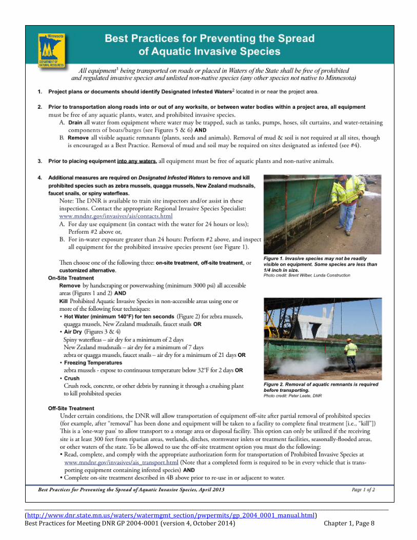
________________________________________________________________________________________________________________________________________________ (http://www.dnr.state.mn.us/waters/watermgmt_section/pwpermits/gp_2004_0001_manual.html) Best Practices for Meeting DNR GP 2004-0001 (version 4, October 2014) Chapter 1, Page 1
Chapter 1. Species Protection
The following pages contain illustrations and notes on Best Practices for protection of gamefish, other aquatic or terrestrial species, and sensitive native vegetation. There are also protocols for preventing the spread of aquatic invasive species. This chapter contains options for ecological enhancement or protection measures. These may be incorporated into final design, special provisions, and construction plans. Much of this guidance is required under DNR permit conditions, and when not, can qualify for mitigation measures for a projects impact to resources in the area.
________________________________________________________________________________________________________________________________________________ (http://www.dnr.state.mn.us/waters/watermgmt_section/pwpermits/gp_2004_0001_manual.html) Best Practices for Meeting DNR GP 2004-0001 (version 4, October 2014) Chapter 1, Page 2
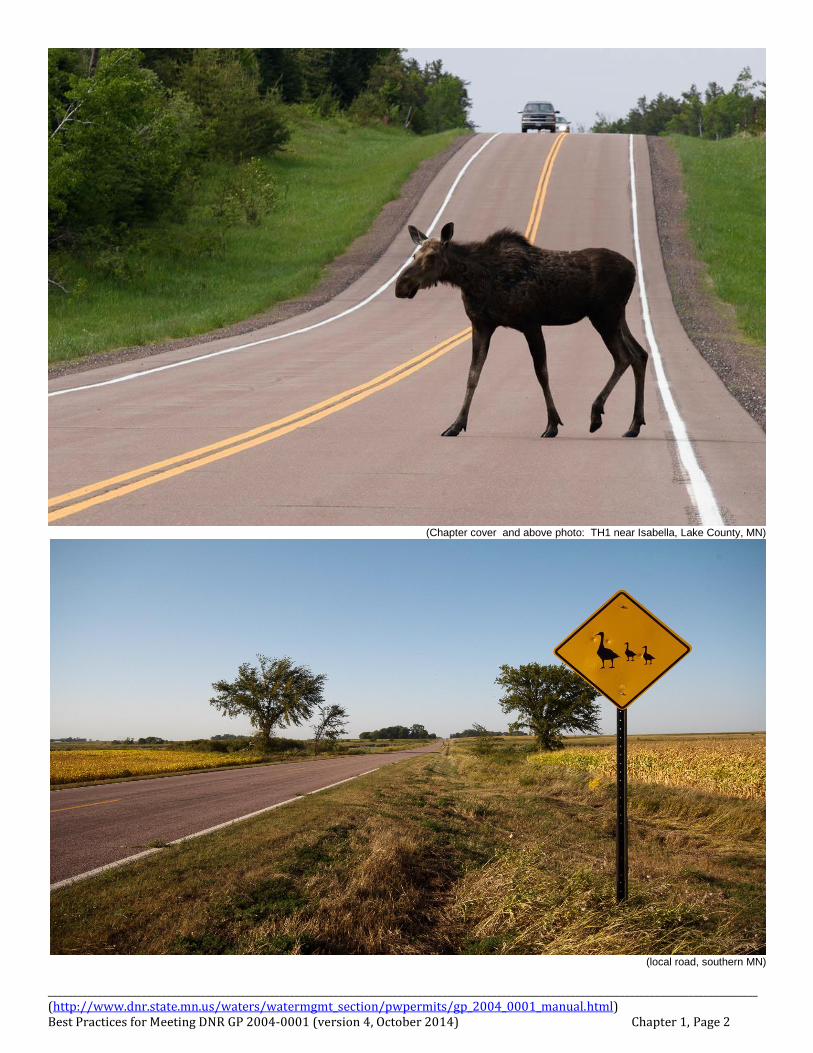
(Chapter cover and above photo: TH1 near Isabella, Lake County, MN)
(local road, southern MN)
________________________________________________________________________________________________________________________________________________ (http://www.dnr.state.mn.us/waters/watermgmt_section/pwpermits/gp_2004_0001_manual.html) Best Practices for Meeting DNR GP 2004-0001 (version 4, October 2014) Chapter 1, Page 3
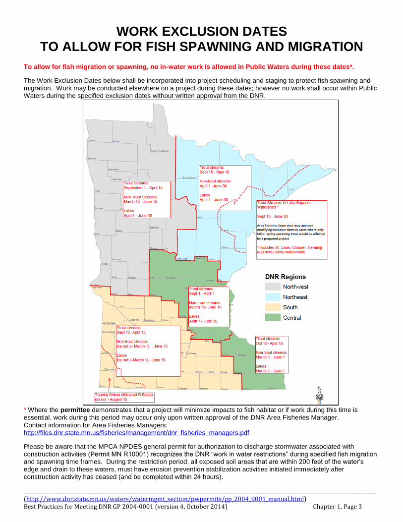
WORK EXCLUSION DATES TO ALLOW FOR FISH SPAWNING AND MIGRATION
To allow for fish migration or spawning, no in-water work is allowed in Public Waters during these dates*.
The Work Exclusion Dates below shall be incorporated into project scheduling and staging to protect fish spawning and migration. Work may be conducted elsewhere on a project during these dates; however no work shall occur within Public Waters during the specified exclusion dates without written approval from the DNR.
* Where the permittee demonstrates that a project will minimize impacts to fish habitat or if work during this time is essential, work during this period may occur only upon written approval of the DNR Area Fisheries Manager. Contact information for Area Fisheries Managers: http://files.dnr.state.mn.us/fisheries/management/dnr_fisheries_managers.pdf
Please be aware that the MPCA NPDES general permit for authorization to discharge stormwater associated with construction activities (Permit MN R10001) recognizes the DNR “work in water restrictions” during specified fish migration and spawning time frames. During the restriction period, all exposed soil areas that are within 200 feet of the water’s edge and drain to these waters, must have erosion prevention stabilization activities initiated immediately after construction activity has ceased (and be completed within 24 hours).
________________________________________________________________________________________________________________________________________________ (http://www.dnr.state.mn.us/waters/watermgmt_section/pwpermits/gp_2004_0001_manual.html) Best Practices for Meeting DNR GP 2004-0001 (version 4, October 2014) Chapter 1, Page 4
Spawning and Migration behavior of various fishes
The following pages have general information on reproductive habits of fish species that are commonly associated to the work exclusion dates set by DNR Area Fisheries Managers. Knowing which species are utilizing the waters where work is proposed is an important factor in determining work exclusion dates. Another important factor is water temperature, as all spawning correlates to water temperature as it warms up each year, or in the case of several trout species, the cooling of the water in the fall. For more information on these and other species, see: http://hatch.cehd.umn.edu/research/fish/fishes/natural_history.html http://www.dnr.state.mn.us/fish/index.html
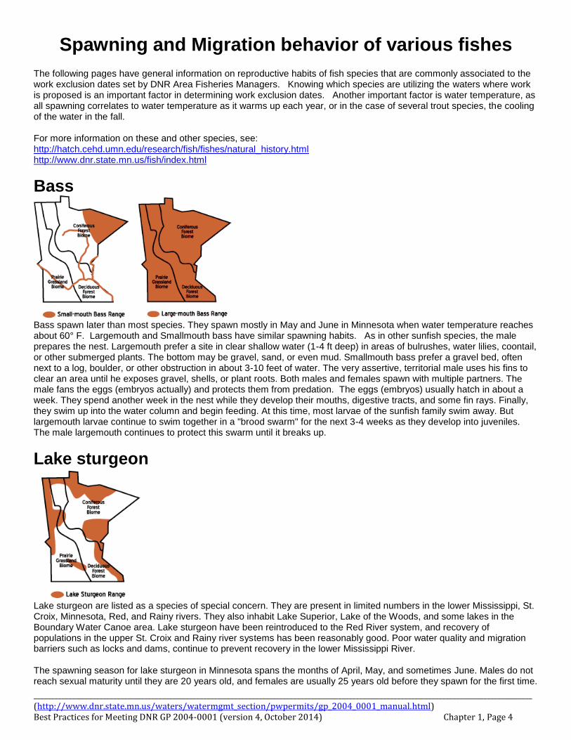
Bass
Bass spawn later than most species. They spawn mostly in May and June in Minnesota when water temperature reaches about 60° F. Largemouth and Smallmouth bass have similar spawning habits. As in other sunfish species, the male prepares the nest. Largemouth prefer a site in clear shallow water (1-4 ft deep) in areas of bulrushes, water lilies, coontail, or other submerged plants. The bottom may be gravel, sand, or even mud. Smallmouth bass prefer a gravel bed, often next to a log, boulder, or other obstruction in about 3-10 feet of water. The very assertive, territorial male uses his fins to clear an area until he exposes gravel, shells, or plant roots. Both males and females spawn with multiple partners. The male fans the eggs (embryos actually) and protects them from predation. The eggs (embryos) usually hatch in about a week. They spend another week in the nest while they develop their mouths, digestive tracts, and some fin rays. Finally, they swim up into the water column and begin feeding. At this time, most larvae of the sunfish family swim away. But largemouth larvae continue to swim together in a "brood swarm" for the next 3-4 weeks as they develop into juveniles. The male largemouth continues to protect this swarm until it breaks up.
Lake sturgeon
Lake sturgeon are listed as a species of special concern. They are present in limited numbers in the lower Mississippi, St. Croix, Minnesota, Red, and Rainy rivers. They also inhabit Lake Superior, Lake of the Woods, and some lakes in the Boundary Water Canoe area. Lake sturgeon have been reintroduced to the Red River system, and recovery of populations in the upper St. Croix and Rainy river systems has been reasonably good. Poor water quality and migration barriers such as locks and dams, continue to prevent recovery in the lower Mississippi River. The spawning season for lake sturgeon in Minnesota spans the months of April, May, and sometimes June. Males do not reach sexual maturity until they are 20 years old, and females are usually 25 years old before they spawn for the first time.
________________________________________________________________________________________________________________________________________________ (http://www.dnr.state.mn.us/waters/watermgmt_section/pwpermits/gp_2004_0001_manual.html) Best Practices for Meeting DNR GP 2004-0001 (version 4, October 2014) Chapter 1, Page 5
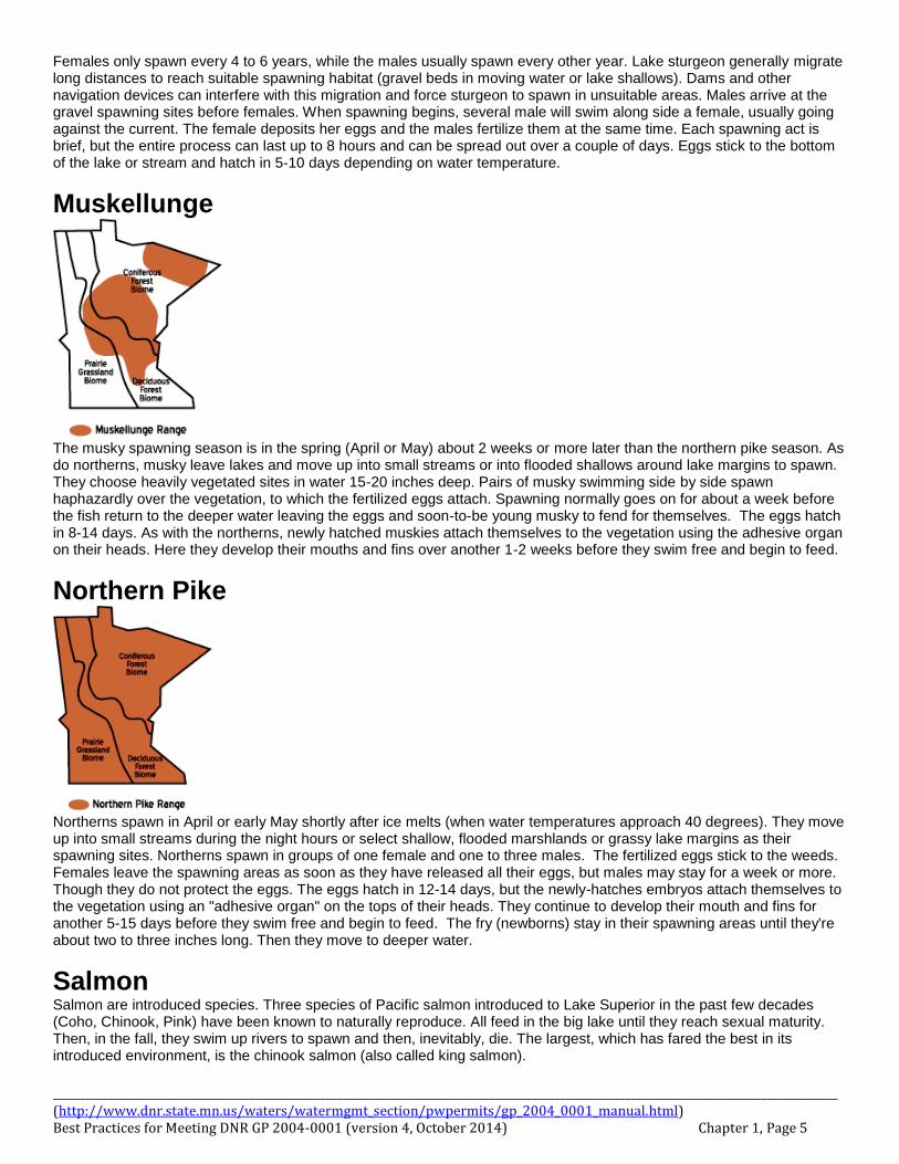
Females only spawn every 4 to 6 years, while the males usually spawn every other year. Lake sturgeon generally migrate long distances to reach suitable spawning habitat (gravel beds in moving water or lake shallows). Dams and other navigation devices can interfere with this migration and force sturgeon to spawn in unsuitable areas. Males arrive at the gravel spawning sites before females. When spawning begins, several male will swim along side a female, usually going against the current. The female deposits her eggs and the males fertilize them at the same time. Each spawning act is brief, but the entire process can last up to 8 hours and can be spread out over a couple of days. Eggs stick to the bottom of the lake or stream and hatch in 5-10 days depending on water temperature.
Muskellunge
The musky spawning season is in the spring (April or May) about 2 weeks or more later than the northern pike season. As do northerns, musky leave lakes and move up into small streams or into flooded shallows around lake margins to spawn. They choose heavily vegetated sites in water 15-20 inches deep. Pairs of musky swimming side by side spawn haphazardly over the vegetation, to which the fertilized eggs attach. Spawning normally goes on for about a week before the fish return to the deeper water leaving the eggs and soon-to-be young musky to fend for themselves. The eggs hatch in 8-14 days. As with the northerns, newly hatched muskies attach themselves to the vegetation using the adhesive organ on their heads. Here they develop their mouths and fins over another 1-2 weeks before they swim free and begin to feed.
Northern Pike
Northerns spawn in April or early May shortly after ice melts (when water temperatures approach 40 degrees). They move up into small streams during the night hours or select shallow, flooded marshlands or grassy lake margins as their spawning sites. Northerns spawn in groups of one female and one to three males. The fertilized eggs stick to the weeds. Females leave the spawning areas as soon as they have released all their eggs, but males may stay for a week or more. Though they do not protect the eggs. The eggs hatch in 12-14 days, but the newly-hatches embryos attach themselves to the vegetation using an "adhesive organ" on the tops of their heads. They continue to develop their mouth and fins for another 5-15 days before they swim free and begin to feed. The fry (newborns) stay in their spawning areas until they're about two to three inches long. Then they move to deeper water.
Salmon Salmon are introduced species. Three species of Pacific salmon introduced to Lake Superior in the past few decades (Coho, Chinook, Pink) have been known to naturally reproduce. All feed in the big lake until they reach sexual maturity. Then, in the fall, they swim up rivers to spawn and then, inevitably, die. The largest, which has fared the best in its introduced environment, is the chinook salmon (also called king salmon).
________________________________________________________________________________________________________________________________________________ (http://www.dnr.state.mn.us/waters/watermgmt_section/pwpermits/gp_2004_0001_manual.html) Best Practices for Meeting DNR GP 2004-0001 (version 4, October 2014) Chapter 1, Page 6
The chinook pink, and coho salmon normally live in the Pacific Ocean and spawn in streams of eastern Asia (Russia) and western North America. In Minnesota, they inhabit Lake Superior and some of its tributaries. Most salmon return to spawning streams in their third year of life. They move shoreward in late September and October and wait for the fall rains before swimming up the streams. Spawning occurs in October and early November. Females use their tails and entire bodies to dig out nests in areas of gravel where they spawn, usually with a single male. The gravel and sand that she removes drifts down and covers adjacent downstream nests. These acts are repeated until the female has deposited all her eggs. Usually both the male and female die shortly after spawning is over. The alevins (free-swimming embryos) hatch in the mid to late winter and remain in the gravel for several weeks or months while their fins develop. They swim up into the current, begin to feed, and shortly afterward migrate to Lake Superior in April or May.
Topeka Shiner Minnesota populations of Topeka shiners seem to be doing well and have a state designation of "special concern" in their limited distribution of the state (Missouri Watershed portions of Pipestone, Murray, Rock and Nobles Counties). In other states the species is doing very poorly. On January 14, 1999, the Topeka shiner was designated an endangered species by the Federal government. Thus, it became Minnesota's first and only Federally endangered fish species. Their spawning season lasts for 8-10 weeks starting in mid-May to early June when water temperature reaches 70° F. They do not build their own nest, but share a nest with orange-spotted or green sunfish. Males establish small territories around the nest and aggressively defend it from all other Topeka shiners. Female may enter a territory only to be chased out repeatedly. If she is persistent she will finally he accepted by the male. The two spawn head to head above the nest. The female releases only a few eggs during each brief spawning episode. Topeka females produce clutches of eggs (groups of eggs that become ready for spawning at about the same time). A single clutch varies from 150-800 eggs depending on the size and condition of the female. We do not know how many clutches a female produces in a season, but we suspect it is several. At 70° F it takes about 5 days for the eggs to hatch and another 4 days before the larvae begin to feed.
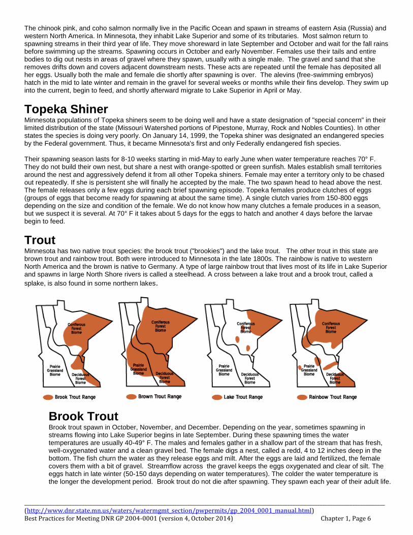
Trout Minnesota has two native trout species: the brook trout ("brookies") and the lake trout. The other trout in this state are brown trout and rainbow trout. Both were introduced to Minnesota in the late 1800s. The rainbow is native to western North America and the brown is native to Germany. A type of large rainbow trout that lives most of its life in Lake Superior and spawns in large North Shore rivers is called a steelhead. A cross between a lake trout and a brook trout, called a
splake, is also found in some northern lakes.
Brook Trout Brook trout spawn in October, November, and December. Depending on the year, sometimes spawning in streams flowing into Lake Superior begins in late September. During these spawning times the water temperatures are usually 40-49° F. The males and females gather in a shallow part of the stream that has fresh, well-oxygenated water and a clean gravel bed. The female digs a nest, called a redd, 4 to 12 inches deep in the bottom. The fish churn the water as they release eggs and milt. After the eggs are laid and fertilized, the female covers them with a bit of gravel. Streamflow across the gravel keeps the eggs oxygenated and clear of silt. The eggs hatch in late winter (50-150 days depending on water temperatures). The colder the water temperature is the longer the development period. Brook trout do not die after spawning. They spawn each year of their adult life.
________________________________________________________________________________________________________________________________________________ (http://www.dnr.state.mn.us/waters/watermgmt_section/pwpermits/gp_2004_0001_manual.html) Best Practices for Meeting DNR GP 2004-0001 (version 4, October 2014) Chapter 1, Page 7
Trout (cont.) Brown Trout Brown trout can live in warmer and more turbid (cloudier) water than brook trout can. This allows them to live in the downstream portions of coldwater streams, while brook trout tend to live in the headwater areas. Brown trout swim up into headwater areas to spawn. They usually choose gravel bottoms often where there are spring seeps and good moving water. Brown trout spawning season begins in October and goes into December. Spawning habits and seasons are similar to the brook trout. They also do not die after spawning. They spawn each year of their adult life.
Lake Trout Lake trout in Minnesota live primarily in Lake Superior and many of the deep, cold lakes of St. Louis, Lake, and Cook counties. They also occur in a few lakes of the upper Mississippi River drainage. They were introduced to Grindstone Lake near Sandstone many years ago. Lake trout only do well in lakes where the water temperature does not exceed 18° C (65° F). Lake trout spawn in the fall, mostly in October though early November, when water temperature falls below 10° C (50° F). They spawn over boulder beds where water currents keep the rocks clear of silt. The embryos develop for 4 to 5 months and hatch into alevins (free swimming embryos) in February and March. The alevins live in the rock crevices for another few weeks while they finish their fin development. Then they disperse into the lake.
Rainbow Trout (steelhead) Stream-dwelling rainbows migrate upstream to spawn. Those in lakes migrate into tributary streams or spawn in shallow areas of rock or gravel if no streams are available. A few may spawn in the fall, but most spawn in the spring when water temperatures rise to the upper 30’s or low 40’s ° F. This rise in water temperature must correspond with a rise in stream elevations (from rain) or they will not spawn. The female scrapes out a nest in the gravel and is joined by one or two males. The female covers the eggs with the gravel she removed to build the nest. There is no parental care of the nest or the eggs, and adults return to their feeding areas. The embryos develop for 20-80 days depending on the water temperature. They hatch into what are called alevins (free-swimming embryos with huge yolk sacs) and stay down in the gravel for another 2-3 weeks while their fins develop. After that time, they swim up and begin feeding in the stream or lake. Migrating rainbows can live and grow in the stream for 2-3 years before they migrate downstream or out into a lake.
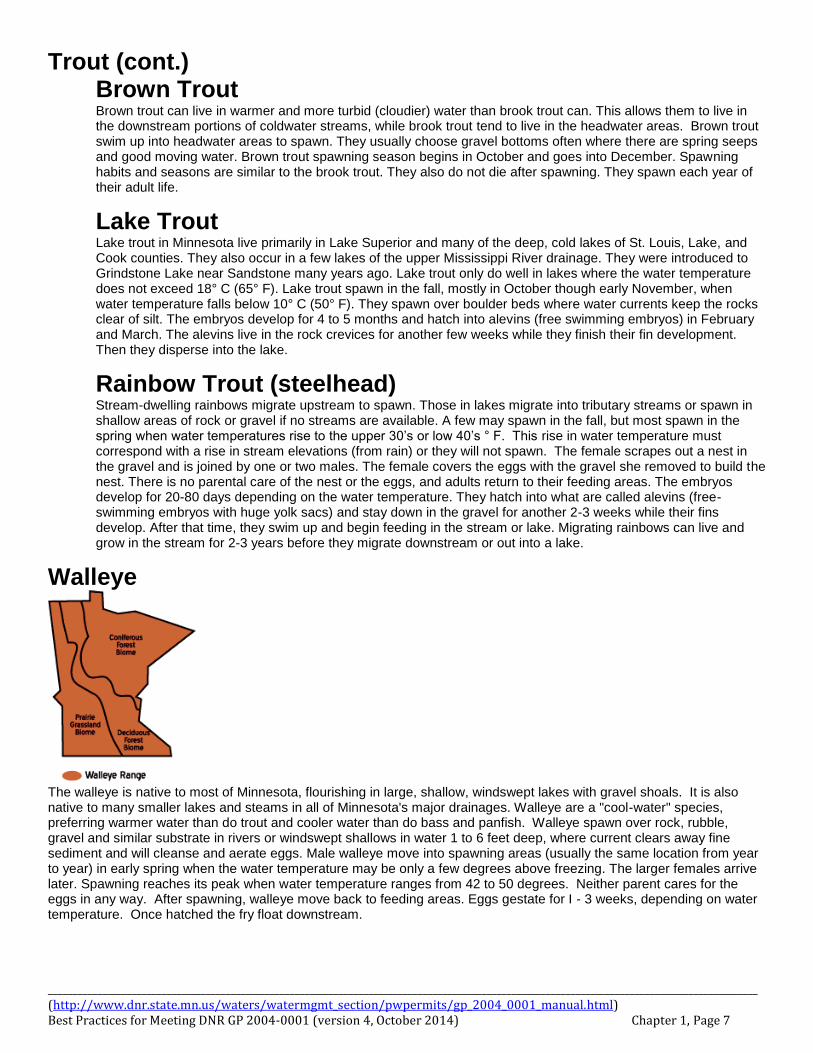
Walleye
The walleye is native to most of Minnesota, flourishing in large, shallow, windswept lakes with gravel shoals. It is also native to many smaller lakes and steams in all of Minnesota's major drainages. Walleye are a "cool-water" species, preferring warmer water than do trout and cooler water than do bass and panfish. Walleye spawn over rock, rubble, gravel and similar substrate in rivers or windswept shallows in water 1 to 6 feet deep, where current clears away fine sediment and will cleanse and aerate eggs. Male walleye move into spawning areas (usually the same location from year to year) in early spring when the water temperature may be only a few degrees above freezing. The larger females arrive later. Spawning reaches its peak when water temperature ranges from 42 to 50 degrees. Neither parent cares for the eggs in any way. After spawning, walleye move back to feeding areas. Eggs gestate for I - 3 weeks, depending on water temperature. Once hatched the fry float downstream.
________________________________________________________________________________________________________________________________________________ (http://www.dnr.state.mn.us/waters/watermgmt_section/pwpermits/gp_2004_0001_manual.html) Best Practices for Meeting DNR GP 2004-0001 (version 4, October 2014) Chapter 1, Page 8
________________________________________________________________________________________________________________________________________________ (http://www.dnr.state.mn.us/waters/watermgmt_section/pwpermits/gp_2004_0001_manual.html) Best Practices for Meeting DNR GP 2004-0001 (version 4, October 2014) Chapter 1, Page 9
________________________________________________________________________________________________________________________________________________ (http://www.dnr.state.mn.us/waters/watermgmt_section/pwpermits/gp_2004_0001_manual.html) Best Practices for Meeting DNR GP 2004-0001 (version 4, October 2014) Chapter 1, Page 10
Protection Measures for Areas of Environmental Sensitivity (AES)
An Area of Environmental Sensitivity (AES) is a generic term to be utilized on plans to identify an area as containing unique characteristics that needs specific protection during construction. These areas may be any area that is identified for added protection due to habitat, wildlife, cultural resources/properties, ecological significance, geological features, visual quality, or its sensitivity to disturbance.
Areas identified on plans as an AES shall not be disturbed during construction. Commonly the actual area to be protected is adjacent to the right of way corridor and the AES identifier is utilized as a buffer. The concern is that soil disturbance, incidental herbicide exposure, hydrologic alterations, tree disturbance, competition from non-native, sod-forming grasses, introduction of weed seeds, or shading by encroaching shrubs can all lead to degradation of these sites.
MnDOT projects must adhere to processes and application of measures consistent with, but limited to, the MnDOT Highway Project Development Process Handbook (HPDP), 2014 Standard Specifications For Construction; Section 2572 (Protection and Restoration of Vegetation), and Section 2101 (Clearing and Grubbing), of which key aspects are listed below:
Examples of an Area of Environmental Sensitivity: Not all Areas of Environmental Sensitivity (AES) are equal. Many may have stringent levels of regulatory protection on their own, such as Threatened and Endangered Species. However, identifying a site as an AES is to be considered as a generic “stay out of this area” for construction purposes and does not have to reveal the reason for the designation. Typical examples are:
Wetlands that are not permitted for construction activities.
Open Water (such as DNR Public Waters, and other perennial streams and waterbodies)
Trout Lakes and Streams along with their source springs.
Calcareous Fens. These are identified in ‘native plant communities’ though due to their unique relationship with groundwater. Impacts to groundwater may also require separate analysis and protection.
Impaired waters, Special Waters, and/or Outstanding Resource Value Waters (ORVW) as designated by the MPCA. http://pca-gis02.pca.state.mn.us/CSW/index.html.
Wooded areas with Specimen Trees, or other permanent vegetation designated for preservation.
Prairie remnants, including but not limited to areas adjacent to Railroad Rights-of-way Prairies.
‘Sites of Biodiversity Significance’ areas designated by the DNR Biological Survey. These sites contain varying levels of native biodiversity such as high quality ‘Native Plant Communities’, rare plants, rare animals, and/or animal aggregations. http://www.dnr.state.mn.us/eco/mcbs/biodiversity_guidelines.html.
‘Native Plant Community’ areas designated by the DNR Biological Survey. Native plant communities are classified and described by considering vegetation, hydrology, landforms, soils, and natural disturbance regimes. http://www.dnr.state.mn.us/npc/index.html.
Federal or State listed species, and their habitat.
Historical sites
Any natural scenic elements, such as geological features not to be disturbed as designated by project planners, project managers, or project inspectors
Best Practices: 1. Design the project to avoid impacts to identified Area of Environmental Sensitivity. 2. Design and construction should incorporate protection and/or enhancement of adjacent AES features. 3. Label identified Areas of Environmental Sensitivity on all plans. 4. Drainage into Areas of Environmental Sensitivity may also have limitations on impacts.
In situations where work in or adjacent to an AES is authorized: 1. Prior to in-water work in an AES, check to see if a Mussel Survey is required. 2. Protect and preserve vegetation from damage in accordance with MnDOT Spec 2572.3 3. Prohibit vehicle and construction activities, including the location of field offices, storage of equipment and other
supplies at least 25 feet outside the dripline of trees or other identified Area of Environmental Sensitivity to be preserved, also in accordance with MnDOT spec 2572.3
4. In areas where there are large or numerous separate of areas to protect, it may be preferred to identify those areas that are OK to be utilized, and have all other areas designated off limits for parking, staging, and/or stockpiling of materials.
________________________________________________________________________________________________________________________________________________ (http://www.dnr.state.mn.us/waters/watermgmt_section/pwpermits/gp_2004_0001_manual.html) Best Practices for Meeting DNR GP 2004-0001 (version 4, October 2014) Chapter 1, Page 11
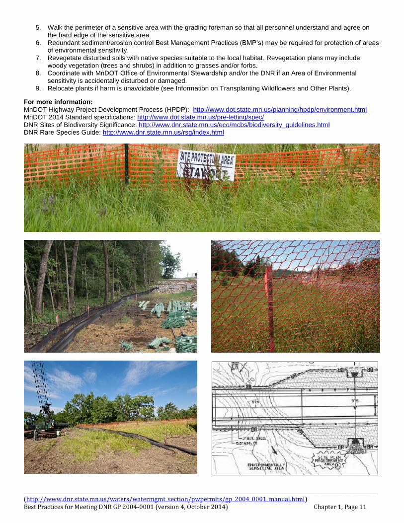
5. Walk the perimeter of a sensitive area with the grading foreman so that all personnel understand and agree on the hard edge of the sensitive area.
6. Redundant sediment/erosion control Best Management Practices (BMP’s) may be required for protection of areas of environmental sensitivity.
7. Revegetate disturbed soils with native species suitable to the local habitat. Revegetation plans may include woody vegetation (trees and shrubs) in addition to grasses and/or forbs.
8. Coordinate with MnDOT Office of Environmental Stewardship and/or the DNR if an Area of Environmental sensitivity is accidentally disturbed or damaged.
9. Relocate plants if harm is unavoidable (see Information on Transplanting Wildflowers and Other Plants).
For more information: MnDOT Highway Project Development Process (HPDP): http://www.dot.state.mn.us/planning/hpdp/environment.html MnDOT 2014 Standard specifications: http://www.dot.state.mn.us/pre-letting/spec/ DNR Sites of Biodiversity Significance: http://www.dnr.state.mn.us/eco/mcbs/biodiversity_guidelines.html DNR Rare Species Guide: http://www.dnr.state.mn.us/rsg/index.html
________________________________________________________________________________________________________________________________________________ (http://www.dnr.state.mn.us/waters/watermgmt_section/pwpermits/gp_2004_0001_manual.html) Best Practices for Meeting DNR GP 2004-0001 (version 4, October 2014) Chapter 1, Page 12
Transplanting Wildflowers and Other Plants (Plants Protected by Minnesota Statutes 2003, Chapter 18H.18)
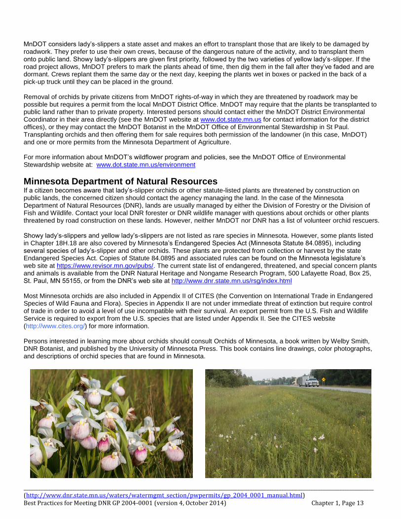
(Prepared by Janet Boe, DNR NW Regional Plant Ecologist; Larry Puchalski and Bob Jacobson, DOT Botanists; and Mark Schreiber, MDA Nursery Inspection & Export Certification Unit Supervisor 5/30/2001. Updated 16 April 2004 by Mark Schreiber, Bob Jacobson, and Janet Boe) Staff of the Minnesota Department of Agriculture, the Minnesota Department of Transportation, and the Minnesota Department of Natural Resources receive numerous calls each summer requesting information about transplanting orchids from locations threatened by construction or road-building. This information sheet was prepared to answer some of the frequently asked questions and direct inquiries to the appropriate agency. Collection and sale of native orchids, trilliums, gentians, lilies, lotus (Nelumbo lutea), coneflowers, bloodroot, mayapple, and trailing arbutus are regulated by Minnesota Statutes 2003, Chapter 18H.18, Conservation of certain wildflowers. Although this section of Chapter 18H covers other species, most transplant requests and inquiries concern orchids, most commonly the showy lady’s-slipper, Minnesota’s state flower.
Minnesota Department of Agriculture The Minnesota Department of Agriculture (MDA) has responsibility for administering the statutes and granting permits for the sale of wildflower species listed in Chapter 18H.18. Wildflower collection by individuals for personal use (that is, transplanted to their own property and not offered for sale) is an issue between the property owner (whether public or private property) and the individual wishing to collect plants from that property. The collector needs the written permission of the landowner to enter the property and collect the plant species listed in the statute. The MDA requires a permit only if the plants are sold. Landowners may transplant species protected by Chapter 18H.18 within their own property without an MDA permit. Wildflowers listed in 18H.18 cannot be collected or dug and immediately sold unless the plants are sold specifically for scientific or herbarium purposes. The individual selling the plants must own the land on which the plants are growing or have written permission of the landowner, and have a permit from the MDA. As part of the permit application, the MDA requires 1) written documentation that plants offered for sale grew naturally on the applicant’s property or that the applicant had permission to collect them from property of another, and 2) the name and address of the organization receiving the plants. If wildflowers are to be sold for purposes other than scientific and herbarium use, they must have been either A) growing naturally on the collectors property, then collected and cultivated by the collector on the collector’s property, or B) collected with written permission from the property of another, then transplanted to the private property of the collector and cultivated on the collector’s property. In either case, one or more permits and inspection by MDA are required prior to sale of the plants. Inspections must take place after the plant emerges from dormancy under cultivation and can be identified to species. As part of the permit application, MDA requires 1) written documentation that plants offered for sale grew naturally on the applicant’s property or that the applicant had permission to collect them from the property of another, 2) a record of the dates they were collected and transplanted, 3) the cultivation techniques used by the applicant, and 4) the intended date of sale. Persons considering sale of these species collected from the wild should contact MDA staff listed below for further information. Mark Schreiber ([email protected]; 651-296-8388) and Steven Shimek ([email protected]; 651-296-8619), of the Agronomy and Plant Protection Division of the MDA, are the persons to contact for more information about MDA nursery certification requirements and to apply for permits. Their mailing address is Minnesota Department of Agriculture, Agronomy and Plant Protection Division, 90 West Plato Boulevard, St. Paul, MN 55107. They can also be reached by fax at 651-296-7386.
Minnesota Department of Transportation The Minnesota Department of Transportation (MnDOT) is the landowner with jurisdiction over all state highways, interstates, and their rights-of-way. Collectors should contact the MnDOT District Permits Office serving their area to discuss collection of statute-listed plants from MnDOT-managed land. For plants adjacent to County State Aid Highways, the county engineer in the county in question is the contact person. Other roads may be under the jurisdiction of townships or cities, and township supervisors or city administrators would be the initial contacts for these ownerships.
________________________________________________________________________________________________________________________________________________ (http://www.dnr.state.mn.us/waters/watermgmt_section/pwpermits/gp_2004_0001_manual.html) Best Practices for Meeting DNR GP 2004-0001 (version 4, October 2014) Chapter 1, Page 13
MnDOT considers lady’s-slippers a state asset and makes an effort to transplant those that are likely to be damaged by roadwork. They prefer to use their own crews, because of the dangerous nature of the activity, and to transplant them onto public land. Showy lady’s-slippers are given first priority, followed by the two varieties of yellow lady’s-slipper. If the road project allows, MnDOT prefers to mark the plants ahead of time, then dig them in the fall after they’ve faded and are dormant. Crews replant them the same day or the next day, keeping the plants wet in boxes or packed in the back of a pick-up truck until they can be placed in the ground. Removal of orchids by private citizens from MnDOT rights-of-way in which they are threatened by roadwork may be possible but requires a permit from the local MnDOT District Office. MnDOT may require that the plants be transplanted to public land rather than to private property. Interested persons should contact either the MnDOT District Environmental Coordinator in their area directly (see the MnDOT website at www.dot.state.mn.us for contact information for the district offices), or they may contact the MnDOT Botanist in the MnDOT Office of Environmental Stewardship in St Paul. Transplanting orchids and then offering them for sale requires both permission of the landowner (in this case, MnDOT) and one or more permits from the Minnesota Department of Agriculture. For more information about MnDOT’s wildflower program and policies, see the MnDOT Office of Environmental Stewardship website at: www.dot.state.mn.us/environment
Minnesota Department of Natural Resources If a citizen becomes aware that lady’s-slipper orchids or other statute-listed plants are threatened by construction on public lands, the concerned citizen should contact the agency managing the land. In the case of the Minnesota Department of Natural Resources (DNR), lands are usually managed by either the Division of Forestry or the Division of Fish and Wildlife. Contact your local DNR forester or DNR wildlife manager with questions about orchids or other plants threatened by road construction on these lands. However, neither MnDOT nor DNR has a list of volunteer orchid rescuers. Showy lady’s-slippers and yellow lady’s-slippers are not listed as rare species in Minnesota. However, some plants listed in Chapter 18H.18 are also covered by Minnesota’s Endangered Species Act (Minnesota Statute 84.0895), including several species of lady’s-slipper and other orchids. These plants are protected from collection or harvest by the state Endangered Species Act. Copies of Statute 84.0895 and associated rules can be found on the Minnesota legislature’s web site at https://www.revisor.mn.gov/pubs/. The current state list of endangered, threatened, and special concern plants and animals is available from the DNR Natural Heritage and Nongame Research Program, 500 Lafayette Road, Box 25, St. Paul, MN 55155, or from the DNR’s web site at http://www.dnr.state.mn.us/rsg/index.html Most Minnesota orchids are also included in Appendix II of CITES (the Convention on International Trade in Endangered Species of Wild Fauna and Flora). Species in Appendix II are not under immediate threat of extinction but require control of trade in order to avoid a level of use incompatible with their survival. An export permit from the U.S. Fish and Wildlife Service is required to export from the U.S. species that are listed under Appendix II. See the CITES website (http://www.cites.org/) for more information. Persons interested in learning more about orchids should consult Orchids of Minnesota, a book written by Welby Smith, DNR Botanist, and published by the University of Minnesota Press. This book contains line drawings, color photographs, and descriptions of orchid species that are found in Minnesota.
________________________________________________________________________________________________________________________________________________ (http://www.dnr.state.mn.us/waters/watermgmt_section/pwpermits/gp_2004_0001_manual.html) Best Practices for Meeting DNR GP 2004-0001 (version 4, October 2014) Chapter 1, Page 14
Selecting a Seed Mix MnDOT and the Board of Water & Soil Resources (BWSR) have revised their previously separate seed mix naming schemes into a single common five-digit nomenclature. This uniform system is now the standard numbering system for all users. New seed mixes have also been developed and are included for typical uses. The components of each mix are provided in the MnDOT Seeding Manual (2014 edition). Mixes considered ‘native’ all start with the numeral three (3x-xxx), and all mixes considered ‘non-native’ start with the numeral two (2x-xxx). For those familiar with the old naming systems, the table on the next page has a column showing the closest and often identical mix.
MnDOT Turf Establishment Recommendations Memo MnDOT’s ‘Turf Establishment Recommendations’ are regularly updated and the most recent update, dated April 14, 2014, include the new seed mix numbering system. The native vegetation options should be considered as the default (primary) option. Though we recognize that other contexts, such as mowing, compatibility with adjacent ownership or land use may rule out native vegetation. Separate letters for each District around the state are found here: http://www.dot.state.mn.us/environment/erosion/seedmixes.html Please follow the native recommendations where your project is located. In addition, for meeting DNR concerns, revegetation plans may include woody vegetation (trees and shrubs) in addition to or in place of grasses and/or forbs.
MnDOT Standard Specifications: Also refer to MnDOT Spec 3876 (Seed), 2014 edition, for additional information on standard seed mix requirements and characteristics.
New MPCA vegetative cover requirements for erosion control and sediment prevention Be aware that the new MPCA NPDES Construction Stormwater General Permit (MN R 100001) has a change from previous versions in the percent vegetative cover required prior to the close out the permit. The previous permit conditions required 70% vegetative cover to be established, regardless of vegetation types. The new permit now requires 70% of the expected cover to be established prior to closeout. This small detail has a large impact on determining suitable permanent seed mix options. MPCA has recognized that some permanent vegetation types, such as grasses that will tolerate sandy soils aren’t intended, nor were ever expected, to achieve 70% cover. This is also true of many of the native vegetation cover types in Minnesota. Rather than wait 3 or more years until maturity, (or bolster seed amounts as is commonly done now), the MPCA permit can now be closed out when we reach 70% of the eventual expected cover at maturity.
Example: A project that utilizes of a permanent mix that is expected to reach 70% cover at maturity can be ‘closed out’ when that mix achieves 50% cover (70% of 70%, which is about 50%). This will reduce the focus on achieving 70% total cover for short term achievements, eliminate bolstering seed mixes to achieve 70%, and re-focus long-term benefits of other vegetation types, such as native vegetation options.
Beneficial use of native vegetation Two primary objectives of roadside maintenance; weed prevention and erosion control, can be aided through the use of native grasses and forbs. The establishment of native plants in an area results in a diverse and strong plant community adapted to local conditions. The mixes have been developed to apply to a wide range of soil types, moisture levels, and climactic conditions. Most native mixes grow well during hot, dry summer months, and they provide excellent erosion control during the fall and spring. Deeper roots also may aid in preventing the invasion of noxious weeds and reduce the number of undesirable and competing shrubs and trees. Additionally, including native mixes creates a more stable and colorful environment throughout the growing season and adds color, texture, and beauty to the roadside.
Native Mixes may be required in certain situations There are many types of areas that can be identified for inclusion of native species in a projects revegetation plan. These can be due to adjacent habitat, ecological significance, geological features in an area, or visual quality. Project design need not be all one type vs another. Projects may include some portions in native mixes, while others can be non-native. An example would be to have native mixes on the backslope and bottom, while the inslope and/or median may be a mow-able non-native mix. In addition, for meeting DNR concerns, revegetation may include woody vegetation (trees and shrubs) in addition to grasses and/or forbs.
The use of native seed mixes should also be utilized for mitigation due to impacts regulated by other agencies, such as within DNR Public Waters (IE when a project requires a Public Waters Work Permit). In fact, this is a standard condition of the DNR General Permit to MnDOT for repair or bridges and culverts (GP2004-0001). The DNR may also require that native vegetation be utilized when projects run through or adjacent to DNR managed lands such as Wildlife Management Areas, Scientific & Natural Areas, Public Access, State Parks, State Forests, etc. Native vegetation suitable to the local habitat is also recommended when projects run through or adjacent to areas that include rare species, in areas identified as a Site of Biodiversity Significance, or in an Area of Environmental Sensitivity (AES).
________________________________________________________________________________________________________________________________________________ (http://www.dnr.state.mn.us/waters/watermgmt_section/pwpermits/gp_2004_0001_manual.html) Best Practices for Meeting DNR GP 2004-0001 (version 4, October 2014) Chapter 1, Page 15
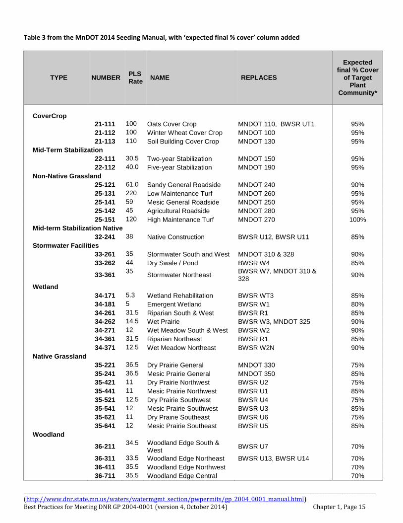
Table 3 from the MnDOT 2014 Seeding Manual, with ‘expected final % cover’ column added
TYPE
NUMBER PLS Rate
NAME REPLACES
Expected
final % Cover of Target
Plant Community*
CoverCrop
21-111 100 Oats Cover Crop MNDOT 110, BWSR UT1 95%
21-112 100 Winter Wheat Cover Crop MNDOT 100 95%
21-113 110 Soil Building Cover Crop MNDOT 130 95%
Mid-Term Stabilization
22-111 30.5 Two-year Stabilization MNDOT 150 95%
22-112 40.0 Five-year Stabilization MNDOT 190 95%
Non-Native Grassland
25-121 61.0 Sandy General Roadside MNDOT 240 90%
25-131 220 Low Maintenance Turf MNDOT 260 95%
25-141 59 Mesic General Roadside MNDOT 250 95%
25-142 45 Agricultural Roadside MNDOT 280 95%
25-151 120 High Maintenance Turf MNDOT 270 100%
Mid-term Stabilization Native
32-241 38 Native Construction BWSR U12, BWSR U11 85%
Stormwater Facilities
33-261 35 Stormwater South and West MNDOT 310 & 328 90%
33-262 44 Dry Swale / Pond BWSR W4 85%
33-361 35
Stormwater Northeast BWSR W7, MNDOT 310 & 328
90%
Wetland
34-171 5.3 Wetland Rehabilitation BWSR WT3 85%
34-181 5 Emergent Wetland BWSR W1 80%
34-261 31.5 Riparian South & West BWSR R1 85%
34-262 14.5 Wet Prairie BWSR W3, MNDOT 325 90%
34-271 12 Wet Meadow South & West BWSR W2 90%
34-361 31.5 Riparian Northeast BWSR R1 85%
34-371 12.5 Wet Meadow Northeast BWSR W2N 90%
Native Grassland
35-221 36.5 Dry Prairie General MNDOT 330 75%
35-241 36.5 Mesic Prairie General MNDOT 350 85%
35-421 11 Dry Prairie Northwest BWSR U2 75%
35-441 11 Mesic Prairie Northwest BWSR U1 85%
35-521 12.5 Dry Prairie Southwest BWSR U4 75%
35-541 12 Mesic Prairie Southwest BWSR U3 85%
35-621 11 Dry Prairie Southeast BWSR U6 75%
35-641 12 Mesic Prairie Southeast BWSR U5 85%
Woodland
36-211 34.5 Woodland Edge South &
West BWSR U7 70%
36-311 33.5 Woodland Edge Northeast BWSR U13, BWSR U14 70%
36-411 35.5 Woodland Edge Northwest 70%
36-711 35.5 Woodland Edge Central 70%
________________________________________________________________________________________________________________________________________________ (http://www.dnr.state.mn.us/waters/watermgmt_section/pwpermits/gp_2004_0001_manual.html) Best Practices for Meeting DNR GP 2004-0001 (version 4, October 2014) Chapter 1, Page 16
More information to aid in planning, design, and maintenance of roadside vegetation: Please contact your Districts representatives for the Erosion Control & Stormwater Management Unit, Roadside Vegetation Management Unit, and the Districts Maintenance staff to assist in determining appropriate permanent
revegetation plans. Information on designing and maintaining permanent roadside vegetation can be found here: http://www.dot.state.mn.us/roadsides/vegetation/index.html Information on planning your vegetation design, see the vegetation section of the Highway Project Development Process (HPDP) at: http://www.dot.state.mn.us/planning/hpdp/environment.html Also refer to the MnDOT Seeding Manual (2014 edition): http://www.dot.state.mn.us/environment/erosion/pdf/seedingmanual.pdf For selecting trees and shrubs, the MnDOT Plant Selector may be utilized: http://dotapp7.dot.state.mn.us/plant/ For additional help selecting appropriate seed mixes for your project; contact the MnDOT Erosion Control & Stormwater Management Unit or Roadside Vegetation Management Unit. http://www.dot.state.mn.us/environment/contactus.html
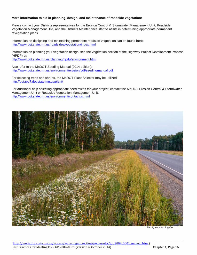
TH11, Koochiching Co
________________________________________________________________________________________________________________________________________________ (http://www.dnr.state.mn.us/waters/watermgmt_section/pwpermits/gp_2004_0001_manual.html) Best Practices for Meeting DNR GP 2004-0001 (version 4, October 2014) Chapter 1, Page 17
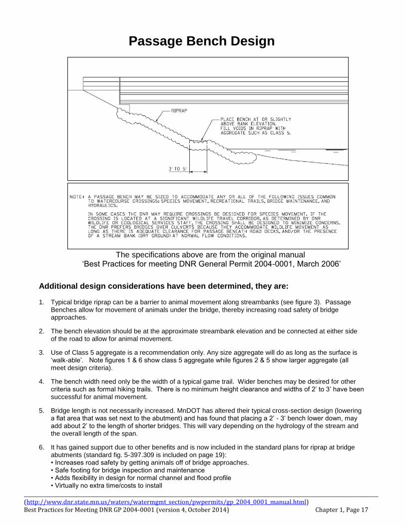
Passage Bench Design
The specifications above are from the original manual
‘Best Practices for meeting DNR General Permit 2004-0001, March 2006’
Additional design considerations have been determined, they are:
1. Typical bridge riprap can be a barrier to animal movement along streambanks (see figure 3). Passage Benches allow for movement of animals under the bridge, thereby increasing road safety of bridge approaches.
2. The bench elevation should be at the approximate streambank elevation and be connected at either side of the road to allow for animal movement.
3. Use of Class 5 aggregate is a recommendation only. Any size aggregate will do as long as the surface is ‘walk-able’. Note figures 1 & 6 show class 5 aggregate while figures 2 & 5 show larger aggregate (all meet design criteria).
4. The bench width need only be the width of a typical game trail. Wider benches may be desired for other criteria such as formal hiking trails. There is no minimum height clearance and widths of 2’ to 3’ have been successful for animal movement.
5. Bridge length is not necessarily increased. MnDOT has altered their typical cross-section design (lowering a flat area that was set next to the abutment) and has found that placing a 2’ - 3‘ bench lower down, may add about 2’ to the length of shorter bridges. This will vary depending on the hydrology of the stream and the overall length of the span.
6. It has gained support due to other benefits and is now included in the standard plans for riprap at bridge abutments (standard fig. 5-397.309 is included on page 19): • Increases road safety by getting animals off of bridge approaches. • Safe footing for bridge inspection and maintenance • Adds flexibility in design for normal channel and flood profile • Virtually no extra time/costs to install
________________________________________________________________________________________________________________________________________________ (http://www.dnr.state.mn.us/waters/watermgmt_section/pwpermits/gp_2004_0001_manual.html) Best Practices for Meeting DNR GP 2004-0001 (version 4, October 2014) Chapter 1, Page 18
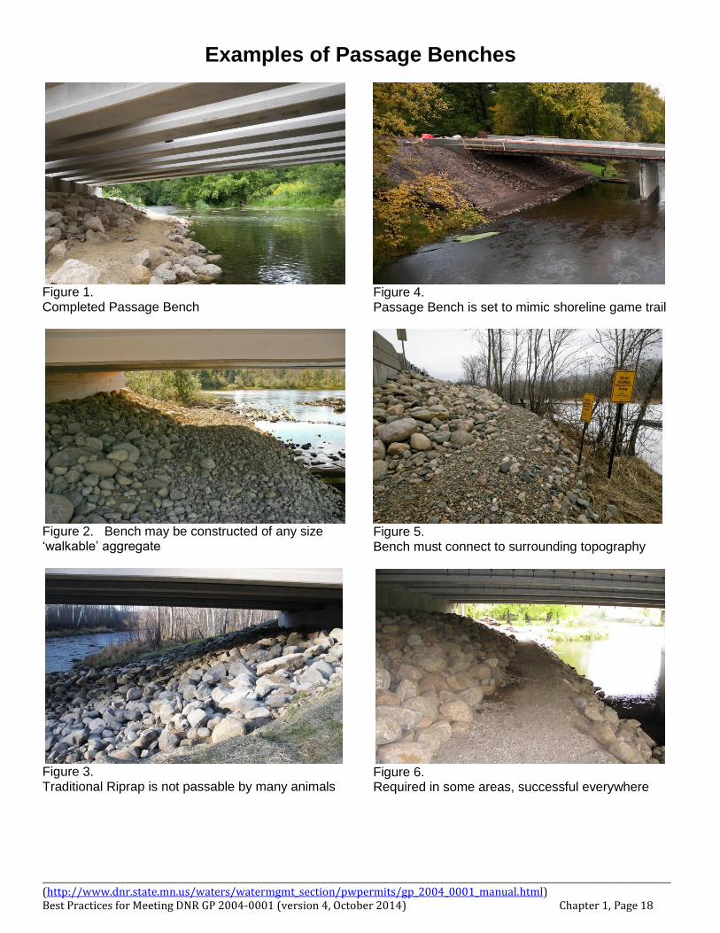
Examples of Passage Benches
Figure 1. Completed Passage Bench
Figure 2. Bench may be constructed of any size ‘walkable’ aggregate
Figure 3. Traditional Riprap is not passable by many animals
Figure 4. Passage Bench is set to mimic shoreline game trail
Figure 5. Bench must connect to surrounding topography
Figure 6. Required in some areas, successful everywhere
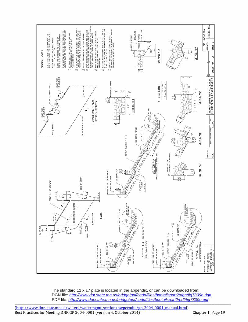
________________________________________________________________________________________________________________________________________________ (http://www.dnr.state.mn.us/waters/watermgmt_section/pwpermits/gp_2004_0001_manual.html) Best Practices for Meeting DNR GP 2004-0001 (version 4, October 2014) Chapter 1, Page 19
The standard 11 x 17 plate is located in the appendix, or can be downloaded from: DGN file: http://www.dot.state.mn.us/bridge/pdf/cadd/files/bdetailspart2/dgn/fig7309e.dgn PDF file: http://www.dot.state.mn.us/bridge/pdf/cadd/files/bdetailspart2/pdf/fig7309e.pdf
________________________________________________________________________________________________________________________________________________ (http://www.dnr.state.mn.us/waters/watermgmt_section/pwpermits/gp_2004_0001_manual.html) Best Practices for Meeting DNR GP 2004-0001 (version 4, October 2014) Chapter 1, Page 20
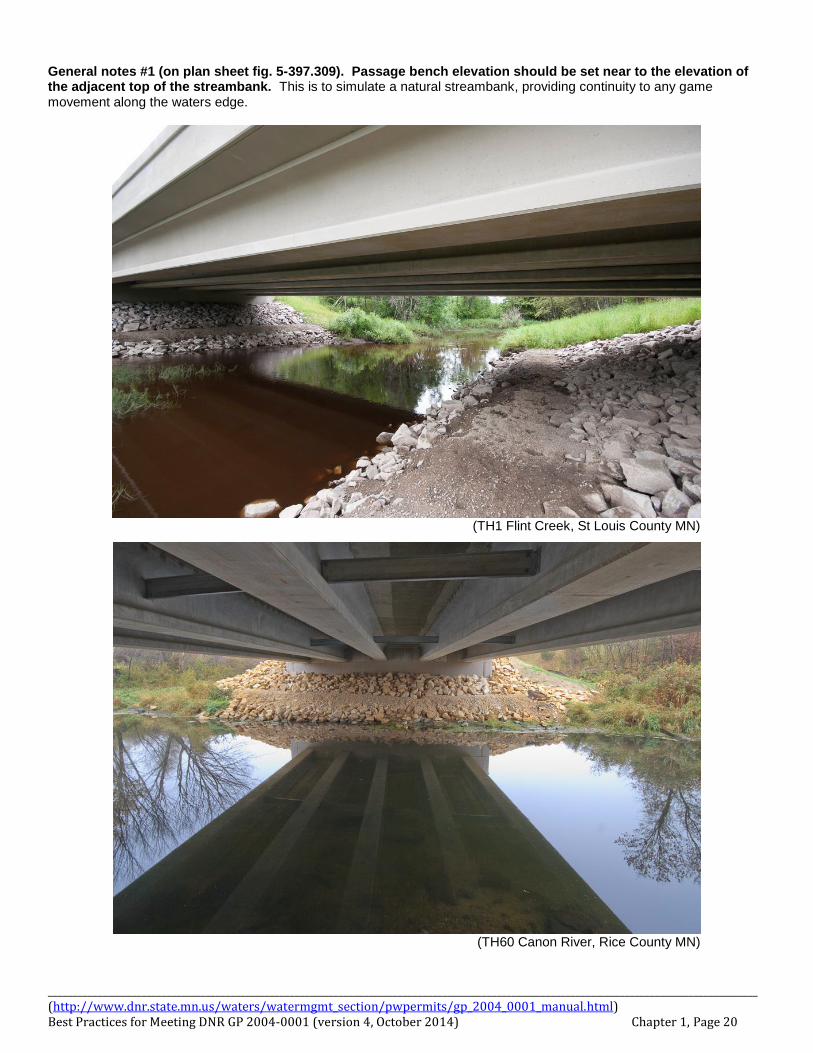
General notes #1 (on plan sheet fig. 5-397.309). Passage bench elevation should be set near to the elevation of the adjacent top of the streambank. This is to simulate a natural streambank, providing continuity to any game movement along the waters edge.
(TH1 Flint Creek, St Louis County MN)
(TH60 Canon River, Rice County MN)
________________________________________________________________________________________________________________________________________________ (http://www.dnr.state.mn.us/waters/watermgmt_section/pwpermits/gp_2004_0001_manual.html) Best Practices for Meeting DNR GP 2004-0001 (version 4, October 2014) Chapter 1, Page 21
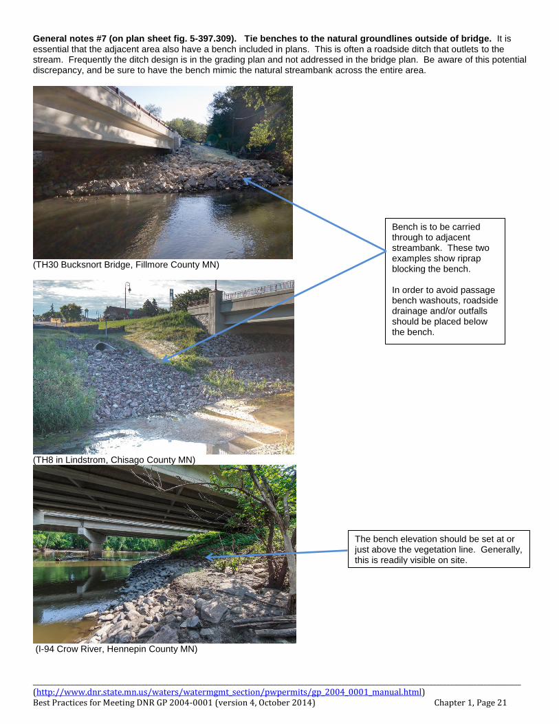
General notes #7 (on plan sheet fig. 5-397.309). Tie benches to the natural groundlines outside of bridge. It is essential that the adjacent area also have a bench included in plans. This is often a roadside ditch that outlets to the stream. Frequently the ditch design is in the grading plan and not addressed in the bridge plan. Be aware of this potential discrepancy, and be sure to have the bench mimic the natural streambank across the entire area.
(TH30 Bucksnort Bridge, Fillmore County MN)
(TH8 in Lindstrom, Chisago County MN)
(I-94 Crow River, Hennepin County MN)
Bench is to be carried through to adjacent streambank. These two examples show riprap blocking the bench. In order to avoid passage bench washouts, roadside drainage and/or outfalls should be placed below the bench.
The bench elevation should be set at or just above the vegetation line. Generally, this is readily visible on site.
________________________________________________________________________________________________________________________________________________ (http://www.dnr.state.mn.us/waters/watermgmt_section/pwpermits/gp_2004_0001_manual.html) Best Practices for Meeting DNR GP 2004-0001 (version 4, October 2014) Chapter 1, Page 22
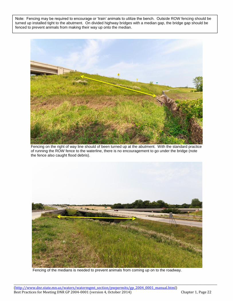
Fencing on the right of way line should of been turned up at the abutment. With the standard practice of running the ROW fence to the waterline, there is no encouragement to go under the bridge (note the fence also caught flood debris).
Fencing of the medians is needed to prevent animals from coming up on to the roadway.
Note: Fencing may be required to encourage or ‘train’ animals to utilize the bench. Outside ROW fencing should be turned up installed tight to the abutment. On divided highway bridges with a median gap, the bridge gap should be fenced to prevent animals from making their way up onto the median.
________________________________________________________________________________________________________________________________________________ (http://www.dnr.state.mn.us/waters/watermgmt_section/pwpermits/gp_2004_0001_manual.html) Best Practices for Meeting DNR GP 2004-0001 (version 4, October 2014) Chapter 1, Page 23
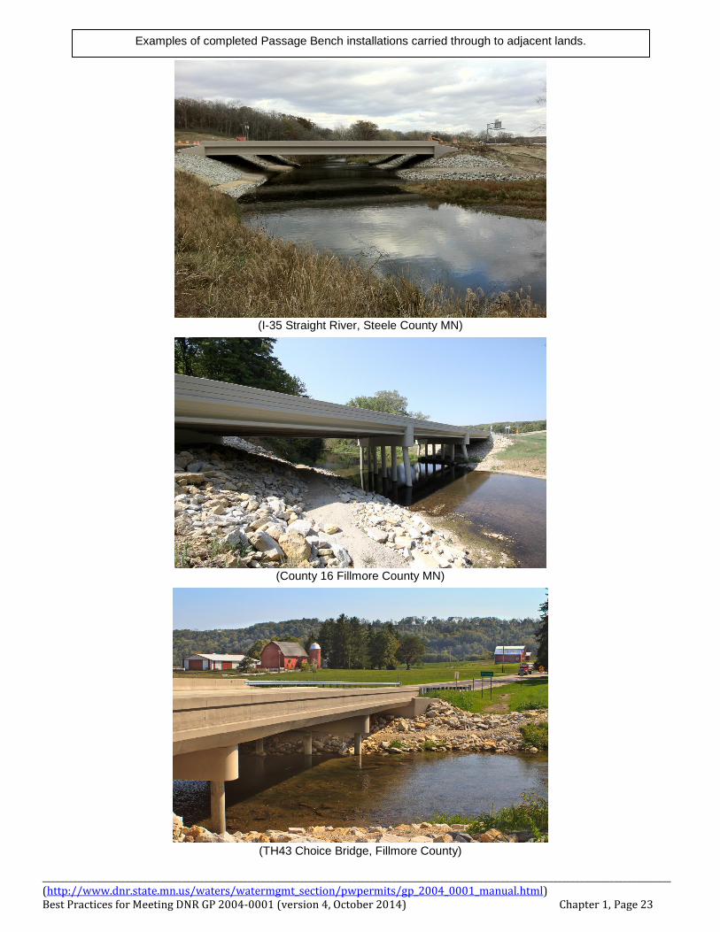
(I-35 Straight River, Steele County MN)
(County 16 Fillmore County MN)
(TH43 Choice Bridge, Fillmore County)
Examples of completed Passage Bench installations carried through to adjacent lands.
________________________________________________________________________________________________________________________________________________ (http://www.dnr.state.mn.us/waters/watermgmt_section/pwpermits/gp_2004_0001_manual.html) Best Practices for Meeting DNR GP 2004-0001 (version 4, October 2014) Chapter 1, Page 24
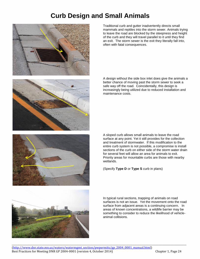
Curb Design and Small Animals
Traditional curb and gutter inadvertently directs small mammals and reptiles into the storm sewer. Animals trying to leave the road are blocked by the steepness and height of the curb and they will travel parallel to it until they find an exit. The storm sewer is the exit they literally fall into, often with fatal consequences. A design without the side box inlet does give the animals a better chance of moving past the storm sewer to seek a safe way off the road. Coincidentally, this design is increasingly being utilized due to reduced installation and maintenance costs. A sloped curb allows small animals to leave the road surface at any point. Yet it still provides for the collection and treatment of stormwater. If this modification to the entire curb system is not possible, a compromise is install sections of the curb on either side of the storm water drain for several feet will allow an area for animals to exit. Priority areas for mountable curbs are those with nearby wetlands. (Specify Type D or Type S curb in plans)
In typical rural sections, trapping of animals on road surfaces is not an issue. Yet the movement onto the road surface from adjacent areas is a continuing concern. In areas of known concentrations, a wildlife barrier may be something to consider to reduce the likelihood of vehicle-animal collisions.
________________________________________________________________________________________________________________________________________________ (http://www.dnr.state.mn.us/waters/watermgmt_section/pwpermits/gp_2004_0001_manual.html) Best Practices for Meeting DNR GP 2004-0001 (version 4, October 2014) Chapter 1, Page 25
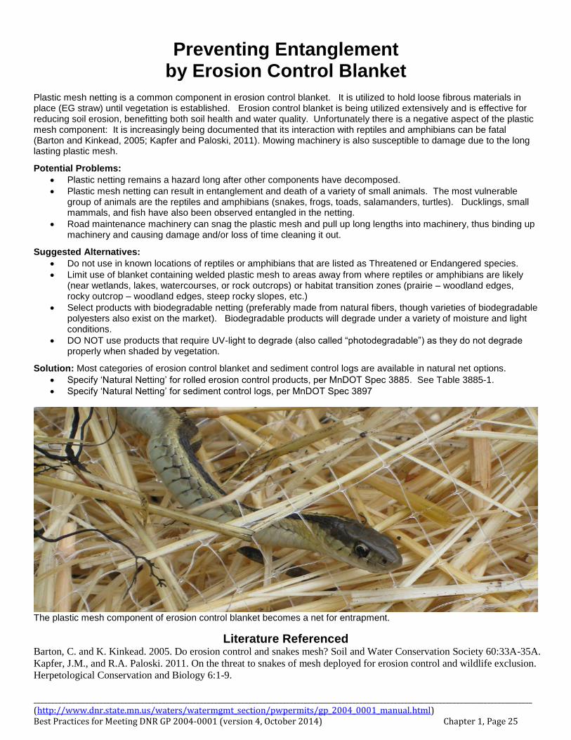
Preventing Entanglement by Erosion Control Blanket
Plastic mesh netting is a common component in erosion control blanket. It is utilized to hold loose fibrous materials in place (EG straw) until vegetation is established. Erosion control blanket is being utilized extensively and is effective for reducing soil erosion, benefitting both soil health and water quality. Unfortunately there is a negative aspect of the plastic mesh component: It is increasingly being documented that its interaction with reptiles and amphibians can be fatal (Barton and Kinkead, 2005; Kapfer and Paloski, 2011). Mowing machinery is also susceptible to damage due to the long lasting plastic mesh.
Potential Problems:
Plastic netting remains a hazard long after other components have decomposed.
Plastic mesh netting can result in entanglement and death of a variety of small animals. The most vulnerable group of animals are the reptiles and amphibians (snakes, frogs, toads, salamanders, turtles). Ducklings, small mammals, and fish have also been observed entangled in the netting.
Road maintenance machinery can snag the plastic mesh and pull up long lengths into machinery, thus binding up machinery and causing damage and/or loss of time cleaning it out.
Suggested Alternatives:
Do not use in known locations of reptiles or amphibians that are listed as Threatened or Endangered species.
Limit use of blanket containing welded plastic mesh to areas away from where reptiles or amphibians are likely (near wetlands, lakes, watercourses, or rock outcrops) or habitat transition zones (prairie – woodland edges, rocky outcrop – woodland edges, steep rocky slopes, etc.)
Select products with biodegradable netting (preferably made from natural fibers, though varieties of biodegradable polyesters also exist on the market). Biodegradable products will degrade under a variety of moisture and light conditions.
DO NOT use products that require UV-light to degrade (also called “photodegradable”) as they do not degrade properly when shaded by vegetation.
Solution: Most categories of erosion control blanket and sediment control logs are available in natural net options.
Specify ‘Natural Netting’ for rolled erosion control products, per MnDOT Spec 3885. See Table 3885-1.
Specify ‘Natural Netting’ for sediment control logs, per MnDOT Spec 3897
The plastic mesh component of erosion control blanket becomes a net for entrapment.
Literature Referenced Barton, C. and K. Kinkead. 2005. Do erosion control and snakes mesh? Soil and Water Conservation Society 60:33A-35A.
Kapfer, J.M., and R.A. Paloski. 2011. On the threat to snakes of mesh deployed for erosion control and wildlife exclusion.
Herpetological Conservation and Biology 6:1-9.

________________________________________________________________________________________________________________________________________________ (http://www.dnr.state.mn.us/waters/watermgmt_section/pwpermits/gp_2004_0001_manual.html) Best Practices for Meeting DNR GP 2004-0001 (version 4, October 2014) Chapter 1, Page 26
Birds and Bridges The Federal Migratory Bird Treaty Act applies whenever protected bird species are involved. Most bird species that live in Minnesota are protected. The current exceptions are house sparrows, pigeons, and starlings. This means that a depredation permit is required to destroy active nests and/or harass nesting birds. Depending on the species involved, the nesting season is approximately from mid-March to August 15. Under the regulations of the Federal Migratory Bird Treaty Act, depredation permits are required for the destruction of any active migratory bird nests. The U.S. Fish and Wildlife Service (USFWS) has formulated a policy that a permit for destruction of nests that are not active is not needed. All permits issued by the USFWS contain the requirement that any young swallows and eggs removed from the bridges must be turned over to a federally licensed rehabilitator for care and subsequent release (see section on depredation permits). The Minnesota DNR also has permit authority over the destruction or possession of protected wildlife. The DNR permits contain the same restrictions and requirements as the USFWS permits.
Swallow Protection
Cliff swallows and barn swallows are the most common migratory birds that build their nests on bridges or highway overpasses. Bank swallows tunnel into open sandy vertical surfaces near wetlands and streams and may try to take advantage of vertical surfaces in borrow sites or construction sites. The practices below apply to other migratory species as well.
Best Practice: Bank Swallows and Vertical Surfaces: Avoidance is emphasized in cases where bank swallows have colonized vertical surfaces because the chances of rescuing birds from the tunnels are slim. The suggested measures to prevent swallows from nesting in bank are as follows:
1) Work may be performed outside of the nesting season, i.e., before May 15th or after September 1st. No permit is required for this activity.
2) Cover up the vertical surface prior to it being excavated for nesting, i.e., before May 15th. 3) Avoid having a vertical surface by leaving a slope at the excavation site.
Best Practice: Cliff and Barn Swallows, Avoidance and Minimization Measures: The following options for dealing with swallows on bridges are acceptable to the USFWS and the DNR. The following measures should be identified in bridge removal and maintenance contracts, depending on how much responsibility is given to the contractor:
1) Bridge work may be performed outside of the nesting season, i.e., before May 15th or after September 1st. No permit is required for this activity.
2) Bridge work may be begun before May 15th and nest completion can be prevented by knocking down or hosing
down the nests (at least three times a week) as they are being built. The success of this measure depends on the number of nests on a bridge. If the bridge contains only a few nests, the birds should be easily deterred from nesting. If the bridge contains a large number of nests, it is an indication that the site is very attractive to the birds and they will not be easily deterred from nesting. Preventing the birds from nesting by knocking down unfinished nests is acceptable to the USFWS, which considers this to be non-lethal harassment. No permits are required for this activity.
________________________________________________________________________________________________________________________________________________ (http://www.dnr.state.mn.us/waters/watermgmt_section/pwpermits/gp_2004_0001_manual.html) Best Practices for Meeting DNR GP 2004-0001 (version 4, October 2014) Chapter 1, Page 27
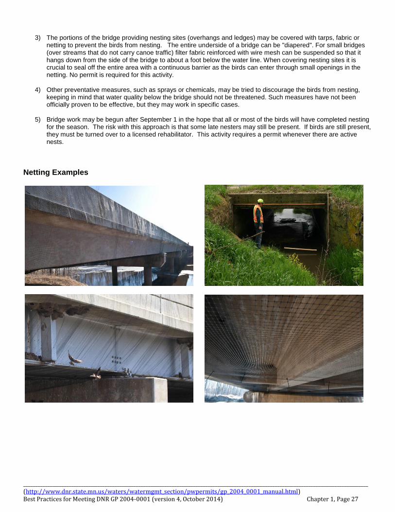
3) The portions of the bridge providing nesting sites (overhangs and ledges) may be covered with tarps, fabric or
netting to prevent the birds from nesting. The entire underside of a bridge can be "diapered". For small bridges (over streams that do not carry canoe traffic) filter fabric reinforced with wire mesh can be suspended so that it hangs down from the side of the bridge to about a foot below the water line. When covering nesting sites it is crucial to seal off the entire area with a continuous barrier as the birds can enter through small openings in the netting. No permit is required for this activity.
4) Other preventative measures, such as sprays or chemicals, may be tried to discourage the birds from nesting,
keeping in mind that water quality below the bridge should not be threatened. Such measures have not been officially proven to be effective, but they may work in specific cases.
5) Bridge work may be begun after September 1 in the hope that all or most of the birds will have completed nesting
for the season. The risk with this approach is that some late nesters may still be present. If birds are still present, they must be turned over to a licensed rehabilitator. This activity requires a permit whenever there are active nests.
Netting Examples

________________________________________________________________________________________________________________________________________________ (http://www.dnr.state.mn.us/waters/watermgmt_section/pwpermits/gp_2004_0001_manual.html) Best Practices for Meeting DNR GP 2004-0001 (version 4, October 2014) Chapter 1, Page 28
Depredation Permits: Applying for a depredation permit and complying with the requirements should be used as a last-resort option because the procedure is costly and can cause project delays. Depredation permits should be applied for under the following circumstances:
1) If the project is scheduled to begin before the end of the nesting season, e.g., August 15th, and birds are still actively nesting on a bridge (see above).
2) If the minimization measures listed above fail to prevent birds from nesting on a bridge (see above). 3) If the bridge contains a small number of nests, (i.e., a small enough number for the federally licensed rehabilitator
to be willing to provide the service of caring for the three to five nestlings that each nest may contain), the timing of bird work need not be restricted.
The two major steps involved in working with depredation permits are A) obtaining the USFWS and DNR permits, and B) obtaining the services of a federally licensed rehabilitator.
1) Obtaining Permits: The permit applicant should be the party responsible for the bridge work, i.e., in most cases the contractor, in some cases the District (if the work is being done by Maintenance Personnel). The permit application (http://www.aphis.usda.gov/ws/ca/news/usfws_migratory_bird_depredation_permit.pdf ) should be sent to USFWS and the DNR (the DNR does not have application forms, but will accept information in the USFWS format). The USFWS maintains its records on a calendar year basis and would prefer that the permit applications be submitted in the same year for which the permits are being requested. The turn-around time for receiving the approved permits is approximately 21 days.
2) Obtaining rehabilitator services: The USFWS and DNR permit issuers should be contacted to determine if there
are any federally licensed rehabilitators in the project area. It is possible that the nearest rehabilitator may be hundreds of miles away. The network of rehabilitators was originally established to take care of limited numbers of orphaned or injured wildlife from the local area. The network, as it is presently set up, is neither able nor willing to commit to handling large numbers of young nestlings on a statewide basis. Most of the rehabilitators have full-time jobs from which they take time off to go and salvage the birds. Therefore the rehabilitators should be contacted at least several weeks in advance to make sure that their services will be available. The rehabilitators charge for their services. In 2002 the estimated rates were as follows (current rates may vary): $20.00/hour for the time spent salvaging and transporting the birds, $0.375/mile for door-to-door travel, and approximately $100.00/bird for subsequent care and release.
________________________________________________________________________________________________________________________________________________ (http://www.dnr.state.mn.us/waters/watermgmt_section/pwpermits/gp_2004_0001_manual.html) Best Practices for Meeting DNR GP 2004-0001 (version 4, October 2014) Chapter 1, Page 29
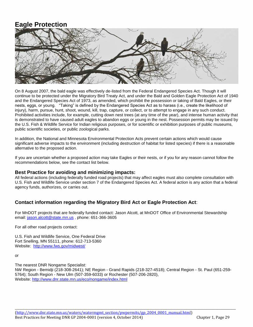
Eagle Protection
On 8 August 2007, the bald eagle was effectively de-listed from the Federal Endangered Species Act. Though it will continue to be protected under the Migratory Bird Treaty Act, and under the Bald and Golden Eagle Protection Act of 1940 and the Endangered Species Act of 1973, as amended, which prohibit the possession or taking of Bald Eagles, or their nests, eggs, or young. “Taking” is defined by the Endangered Species Act as to harass (i.e., create the likelihood of injury), harm, pursue, hunt, shoot, wound, kill, trap, capture, or collect, or to attempt to engage in any such conduct. Prohibited activities include, for example, cutting down nest trees (at any time of the year), and intense human activity that is demonstrated to have caused adult eagles to abandon eggs or young in the nest. Possession permits may be issued by the U.S. Fish & Wildlife Service for Indian religious purposes, or for scientific or exhibition purposes of public museums, public scientific societies, or public zoological parks. In addition, the National and Minnesota Environmental Protection Acts prevent certain actions which would cause significant adverse impacts to the environment (including destruction of habitat for listed species) if there is a reasonable alternative to the proposed action. If you are uncertain whether a proposed action may take Eagles or their nests, or if you for any reason cannot follow the recommendations below, see the contact list below.
Best Practice for avoiding and minimizing impacts: All federal actions (including federally funded road projects) that may affect eagles must also complete consultation with U.S. Fish and Wildlife Service under section 7 of the Endangered Species Act. A federal action is any action that a federal agency funds, authorizes, or carries out.
Contact information regarding the Migratory Bird Act or Eagle Protection Act: For MnDOT projects that are federally funded contact: Jason Alcott, at MnDOT Office of Environmental Stewardship email: [email protected] , phone: 651-366-3605 For all other road projects contact: U.S. Fish and Wildlife Service, One Federal Drive Fort Snelling, MN 55111, phone: 612-713-5360 Website: http://www.fws.gov/midwest/ or The nearest DNR Nongame Specialist: NW Region - Bemidji (218-308-2641); NE Region - Grand Rapids (218-327-4518); Central Region - St. Paul (651-259-5764); South Region - New Ulm (507-359-6033) or Rochester (507-206-2820), Website: http://www.dnr.state.mn.us/eco/nongame/index.html
________________________________________________________________________________________________________________________________________________ (http://www.dnr.state.mn.us/waters/watermgmt_section/pwpermits/gp_2004_0001_manual.html) Best Practices for Meeting DNR GP 2004-0001 (version 4, October 2014) Chapter 1, Page 30
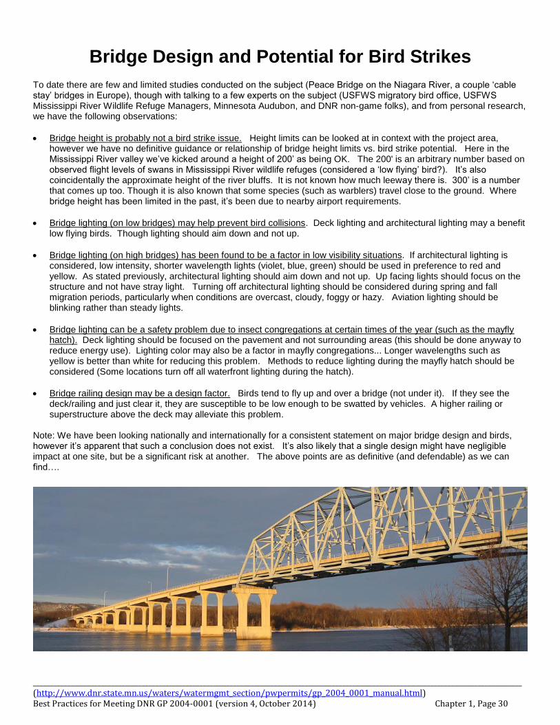
Bridge Design and Potential for Bird Strikes
To date there are few and limited studies conducted on the subject (Peace Bridge on the Niagara River, a couple ‘cable stay’ bridges in Europe), though with talking to a few experts on the subject (USFWS migratory bird office, USFWS Mississippi River Wildlife Refuge Managers, Minnesota Audubon, and DNR non-game folks), and from personal research, we have the following observations:
Bridge height is probably not a bird strike issue. Height limits can be looked at in context with the project area, however we have no definitive guidance or relationship of bridge height limits vs. bird strike potential. Here in the Mississippi River valley we’ve kicked around a height of 200’ as being OK. The 200' is an arbitrary number based on observed flight levels of swans in Mississippi River wildlife refuges (considered a ‘low flying’ bird?). It’s also coincidentally the approximate height of the river bluffs. It is not known how much leeway there is. 300’ is a number that comes up too. Though it is also known that some species (such as warblers) travel close to the ground. Where bridge height has been limited in the past, it’s been due to nearby airport requirements.
Bridge lighting (on low bridges) may help prevent bird collisions. Deck lighting and architectural lighting may a benefit low flying birds. Though lighting should aim down and not up.
Bridge lighting (on high bridges) has been found to be a factor in low visibility situations. If architectural lighting is considered, low intensity, shorter wavelength lights (violet, blue, green) should be used in preference to red and yellow. As stated previously, architectural lighting should aim down and not up. Up facing lights should focus on the structure and not have stray light. Turning off architectural lighting should be considered during spring and fall migration periods, particularly when conditions are overcast, cloudy, foggy or hazy. Aviation lighting should be blinking rather than steady lights.
Bridge lighting can be a safety problem due to insect congregations at certain times of the year (such as the mayfly hatch). Deck lighting should be focused on the pavement and not surrounding areas (this should be done anyway to reduce energy use). Lighting color may also be a factor in mayfly congregations... Longer wavelengths such as yellow is better than white for reducing this problem. Methods to reduce lighting during the mayfly hatch should be considered (Some locations turn off all waterfront lighting during the hatch).
Bridge railing design may be a design factor. Birds tend to fly up and over a bridge (not under it). If they see the deck/railing and just clear it, they are susceptible to be low enough to be swatted by vehicles. A higher railing or superstructure above the deck may alleviate this problem.
Note: We have been looking nationally and internationally for a consistent statement on major bridge design and birds, however it’s apparent that such a conclusion does not exist. It’s also likely that a single design might have negligible impact at one site, but be a significant risk at another. The above points are as definitive (and defendable) as we can find….
________________________________________________________________________________________________________________________________________________ (http://www.dnr.state.mn.us/waters/watermgmt_section/pwpermits/gp_2004_0001_manual.html) Best Practices for Meeting DNR GP 2004-0001 (version 4, October 2014) Chapter 1, Page 31
Reducing Wildlife Vehicle Collisions
The question of how to reduce the likelihood of Wildlife Vehicle Collisions (WVC) is regularly brought to our attention. However we do not have a definitive set of designs for reducing WVC along our roadways. Currently ‘typical’ or ‘standard’ designs in Minnesota are:
1. For small animals, use 5 foot chain-link fence installed tight to the ground. This is one of MnDOTs ‘standard’ or
‘typical’ right of way fence designs. For seasonal fencing to protect reptiles and amphibians, standard erosion control fence may be utilized to hinder movement into construction sites, onto roads, or for redirection to safer crossings (nearby culverts or bridges). Any proposed alternative designs will have to meet MnDOT criteria before they can become incorporated into MnDOT projects.
2. For deer, an 8’ woven wire or chain link fence is being utilized.
3. For crossings at streams and rivers, at bridges see guidance in Chapter 1, page 17 for the ‘passage bench’
design and fencing recomendations. For culverts use ‘off-set’ multiple inverts or ‘floodplain culverts’ to allow for a dry culvert during normal conditions.
4. Single culverts that are installed for topography with intermittent flow may also be incorporated into fencing design
to funnel and ‘train’ wildlife to use them.
5. Curb design can trap small animals on the roadway. See the Curb Design and Small Animals (Chapter 1 page 24) in this chapter for added information on minimizing trapping animals on the road.
In all cases, methods to allow animals off the roadway also need to be incorporated into wildlife exclusion methods. There is also a growing trend to utilize vegetation as a deterrent instead of fence (EG for goose control). When a hazard situation is known, considerations for species specific issues should be incorporated into wildlife exclusion design, such as time of day, time of year, and typical habitat locations. Developing typical methods for preventing wildlife-vehicle collisions will need to take into account the above issues, plus other measures due to site conditions or the occurrence of threatened, endangered or special concern species. Several states are developing standards, and new designs are regularly being proposed. However, there is no ‘one size fits all’ solution. Minnesota DNR will be review designs or situations as they are brought to our attention. Please contact us should you know of a situation that warrants wildlife protection and/or has safety issues due to vehicle-animal collisions. There are numerous publications on this subject, though a comprehensive resource is the recently published FHWA publication ‘Best Practices Manual: The Wildlife Vehicle Collision Reduction Study’ (Report No. FHWA-HEP-09-022) [ http://www.fhwa.dot.gov/environment/hconnect/wvc/index.htm ]. This report covers a range of WVC characteristics and strategies to avoid wildlife vehicle collisions. They found that such collisions occur:
Most often on rural two-lane, low-volume roadways.
Most often in the early morning or evening and in the fall or spring,
Where roadways cross drainages
Are more likely on straight dry roads
The solutions presented in the FHWA manual primarily focus on Wildlife Vehicle Collisions involving species that pose a substantial safety risk (e. g., larger species such as deer and moose), though also provides discussion of measures for threatened and endangered species. The study was conducted to advance the understanding of the causes and impacts of WVCs and identify solutions to this growing safety problem. Design and implementation guidelines are provided for wildlife fencing, wildlife underpasses and overpasses, animal detection systems, vegetation management and wildlife culling. Additionally for a WVC reduction program, information is provided on regional planning, identification of priority areas, alignment and design considerations, guidelines for monitoring effectiveness of mitigations, and potential funding sources.
________________________________________________________________________________________________________________________________________________ (http://www.dnr.state.mn.us/waters/watermgmt_section/pwpermits/gp_2004_0001_manual.html) Best Practices for Meeting DNR GP 2004-0001 (version 4, October 2014) Chapter 1, Page 32
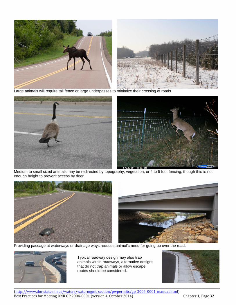
Large animals will require tall fence or large underpasses to minimize their crossing of roads
Medium to small sized animals may be redirected by topography, vegetation, or 4 to 5 foot fencing, though this is not enough height to prevent access by deer.
Providing passage at waterways or drainage ways reduces animal’s need for going up over the road.
Typical roadway design may also trap animals within roadways, alternative designs that do not trap animals or allow escape routes should be considered.
________________________________________________________________________________________________________________________________________________ (http://www.dnr.state.mn.us/waters/watermgmt_section/pwpermits/gp_2004_0001_manual.html) Best Practices for Meeting DNR GP 2004-0001 (version 4, October 2014) Chapter 1, Page 33
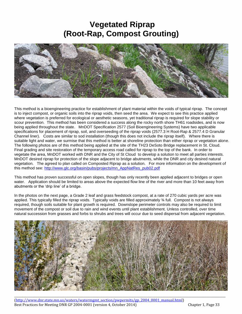
Vegetated Riprap (Root-Rap, Compost Grouting)
This method is a bioengineering practice for establishment of plant material within the voids of typical riprap. The concept is to inject compost, or organic soils into the riprap voids, then seed the area. We expect to see this practice applied where vegetation is preferred for ecological or aesthetic seasons, yet traditional riprap is required for slope stability or scour prevention. This method has been considered a success along the rocky north shore TH61 roadsides, and is now being applied throughout the state. MnDOT Specification 2577 (Soil Bioengineering Systems) have two applicable specifications for placement of riprap, soil, and overseeding of the riprap voids (2577.3 H Root-Rap & 2577.4 D Granular Channel liner). Costs are similar to sod installation (though this does not include the riprap itself). Where there is suitable light and water, we surmise that this method is better at shoreline protection than either riprap or vegetation alone. The following photos are of this method being applied at the site of the TH23 DeSoto Bridge replacement in St. Cloud. Final grading and site restoration of the temporary access road called for riprap to the top of the bank. In order to vegetate the area, MnDOT worked with DNR and the City of St Cloud to develop a solution to meet all parties interests. MnDOT desired riprap for protection of the slope adjacent to bridge abutments, while the DNR and city desired natural vegetation. The agreed to plan called on Composted Riprap as a solution. For more information on the development of this method see: http://www.glc.org/basin/pubs/projects/mn_AppNatRes_pub02.pdf This method has proven successful on open slopes, though has only recently been applied adjacent to bridges or open water. Application should be limited to areas above the expected flow line of the river and more than 10 feet away from abutments or the ‘drip line’ of a bridge. In the photos on the next page, a Grade 2 leaf and grass feedstock compost, at a rate of 270 cubic yards per acre was applied. This typically filled the riprap voids. Typically voids are filled approximately ¾ full. Compost is not always required, though soils suitable for plant growth is required. Downslope perimeter controls may also be required to limit movement of the compost or soil due to rain and wind events until plant establishment. Unless controlled, over time natural succession from grasses and forbs to shrubs and trees will occur due to seed dispersal from adjacent vegetation.
________________________________________________________________________________________________________________________________________________ (http://www.dnr.state.mn.us/waters/watermgmt_section/pwpermits/gp_2004_0001_manual.html) Best Practices for Meeting DNR GP 2004-0001 (version 4, October 2014) Chapter 1, Page 34
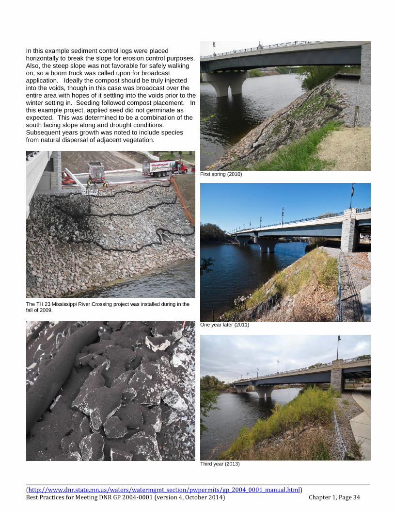
In this example sediment control logs were placed horizontally to break the slope for erosion control purposes. Also, the steep slope was not favorable for safely walking on, so a boom truck was called upon for broadcast application. Ideally the compost should be truly injected into the voids, though in this case was broadcast over the entire area with hopes of it settling into the voids prior to the winter setting in. Seeding followed compost placement. In this example project, applied seed did not germinate as expected. This was determined to be a combination of the south facing slope along and drought conditions. Subsequent years growth was noted to include species from natural dispersal of adjacent vegetation.
The TH 23 Mississippi River Crossing project was installed during in the fall of 2009.
First spring (2010)
One year later (2011)
Third year (2013)