Embed Size (px)
Citation preview
ExamplesofEffectiveTechniquesforImprovingtheQualityofEnvironmentalDocuments
Chapter14.Commitments
MostNEPAdocumentsincludealargenumberofenvironmentalcommitments,whichmayrelatetoprojectdesignelements,measurestomitigateimpacts,orotheractions.Ahigh‐qualityNEPAdocumentclearlydescribesthesecommitmentsandexplainshowtheywillbeimplemented.ThefollowingpracticescanhelptoimprovethediscussionofenvironmentalcommitmentsinaNEPAdocument:
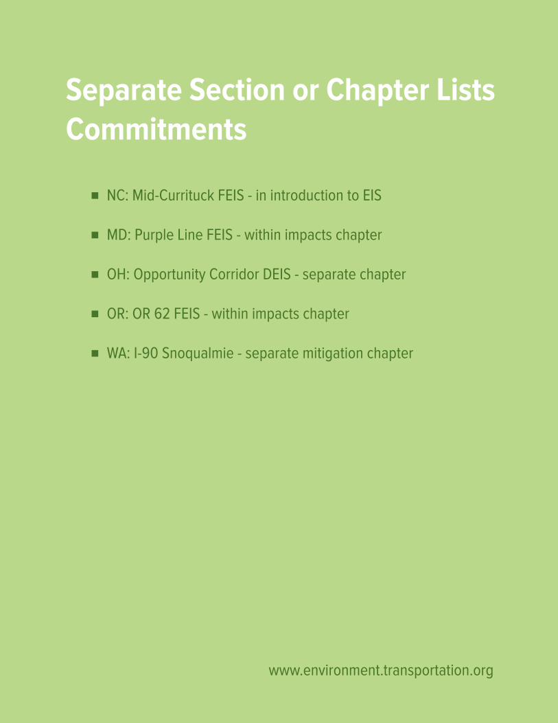
Includeacommitmentslistinthedocument.ManyNEPAdocumentsnowincludeamasterlistofcommitments.Thislistisincludedinvariousplaces:asitsownchapter,asasectionintheenvironmentalconsequenceschapter,aspartofthesummarychapter,orelsewhere.Regardlessoflocation,ithelpsprovidea“one‐stopshop”foranyonewhoseeksaclearandcompletelistoftheprojectcommitments.
Usedefinitelanguage(“will”)whendescribingacommitment.Thewordingofacommitmentisimportant.Wordingthatsimplydescribesapossibility(suchas“may”)doesnotmakeacommitment.Definitewording(suchas“will”)conveysthatacommitmentisbeingmade.
Createanddocumentaprocessforimplementingcommitments.ThecredibilityofthecommitmentsinaNEPAdocumentisenhancedifthedocumentdescribesasystematicprocessforensuringthatthecommitmentsareimplemented.Oneoftheexamplesinthischapterincludedacommitmenttoestablisha“commitmenttrackingdatabase”andtoassignan“independentenvironmentalmonitor”toensurethattheenvironmentalcommitmentsarecarriedout.
Cross‐referencecommitmentsinotherdocuments.ManyofthecommitmentsinaNEPAdocumentarebasedonotherdocuments,suchasaSection106memorandumofagreement(MOA).Thereisalwaysariskoferrorwhenrestatingcommitmentsfromanotherdocument.Thisriskcanbeminimizedbysummarizingandcross‐referencingthecommitmentsintheotherdocument,ratherthanre‐statingthem.
Examples of Effective Techniques for Improving the Quality of Environmental Documents

(Thispageisintentionallyleftblank.)
www.environment.transportation.org
Separate Section or Chapter Lists Commitments
NC: Mid-Currituck FEIS - in introduction to EIS
MD: Purple Line FEIS - within impacts chapter
OH: Opportunity Corridor DEIS - separate chapter
OR: OR 62 FEIS - within impacts chapter
WA: I-90 Snoqualmie - separate mitigation chapter
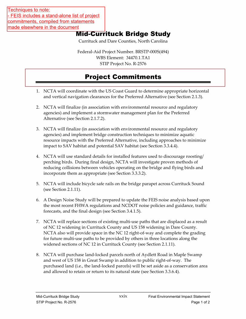
Mid-Currituck Bridge Study Final Environmental Impact Statement STIP Project No. R-2576 Page 1 of 2
xxix
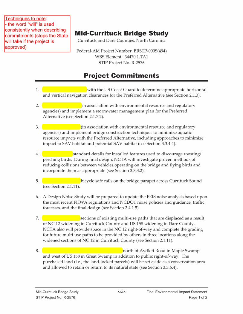
Mid-Currituck Bridge Study Currituck and Dare Counties, North Carolina
Federal‐Aid Project Number. BRSTP‐000S(494) WBS Element: 34470.1.TA1 STIP Project No. R‐2576
Project Commitments
1. NCTA will coordinate with the US Coast Guard to determine appropriate horizontal and vertical navigation clearances for the Preferred Alternative (see Section 2.1.3).
2. NCTA will finalize (in association with environmental resource and regulatory agencies) and implement a stormwater management plan for the Preferred Alternative (see Section 2.1.7.2).
3. NCTA will finalize (in association with environmental resource and regulatory agencies) and implement bridge construction techniques to minimize aquatic resource impacts with the Preferred Alternative, including approaches to minimize impact to SAV habitat and potential SAV habitat (see Section 3.3.4.4).
4. NCTA will use standard details for installed features used to discourage roosting/ perching birds. During final design, NCTA will investigate proven methods of reducing collisions between vehicles operating on the bridge and flying birds and incorporate them as appropriate (see Section 3.3.3.2).
5. NCTA will include bicycle safe rails on the bridge parapet across Currituck Sound (see Section 2.1.11).
6. A Design Noise Study will be prepared to update the FEIS noise analysis based upon the most recent FHWA regulations and NCDOT noise policies and guidance, traffic forecasts, and the final design (see Section 3.4.1.5).
7. NCTA will replace sections of existing multi‐use paths that are displaced as a result of NC 12 widening in Currituck County and US 158 widening in Dare County. NCTA also will provide space in the NC 12 right‐of‐way and complete the grading for future multi‐use paths to be provided by others in three locations along the widened sections of NC 12 in Currituck County (see Section 2.1.11).
8. NCTA will purchase land‐locked parcels north of Aydlett Road in Maple Swamp and west of US 158 in Great Swamp in addition to public right‐of‐way. The purchased land (i.e., the land‐locked parcels) will be set aside as a conservation area and allowed to retain or return to its natural state (see Section 3.3.6.4).
Techniques to note:- FEIS includes a stand-alone list of projectcommitments, compiled from statementsmade elsewhere in the document

Mid-Currituck Bridge Study Final Environmental Impact Statement STIP Project No. R-2576 Page 2 of 2
xxx
9. Construction contracts will require compliance with the US Fish and Wildlife Service’s (USFWS) 2003 Guidelines for Avoiding Impacts to the West Indian Manatee: Precautionary Measures for Construction Activities in North Carolina Waters with the exception of the two guidelines that specify the use of no wake/idle speeds. USFWS agreed to the exceptions.
10. Construction contracts will require compliance with National Marine Fisheries Service’s (NMFS) 2006 Sea Turtle and Smalltooth Sawfish Construction Conditions. NMFS has indicated that the condition related to no wake/idle speeds will not apply to this project.
11. Construction contracts will require compliance with USFWS guidelines for the protection of eagles contained in their 2007 National Bald Eagle Management Guidelines.
The changes in the list of commitments since the DEIS reflect that some DEIS commitments have already been addressed. In addition, some new commitments were noted as expectations or intentions in the body of the DEIS and are in this FEIS. NCTA and FHWA decided to highlight them as Project Commitments in this FEIS. One entirely new commitment (10) was added.
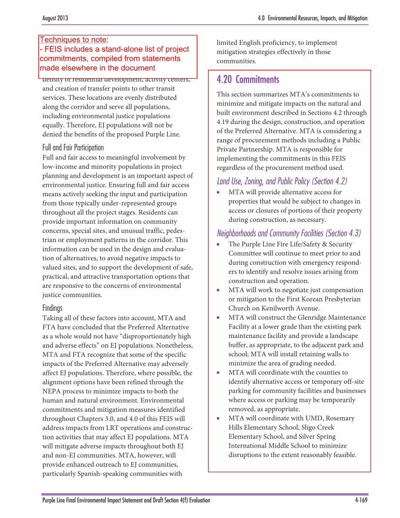
August 2013 4.0 Environmental Resources, Impacts, and Mitigation
Purple Line Final Environmental Impact Statement and Draft Section 4(f) Evaluation 4-169
The Purple Line would provide accessibility to locations throughout the project corridor and to the Metrorail, MARC and Amtrak systems. The Purple Line station locations were selected based upon the density of residential development, activity centers, and creation of transfer points to other transit services. These locations are evenly distributed along the corridor and serve all populations, including environmental justice populations equally. Therefore, EJ populations will not be denied the benefits of the proposed Purple Line.
Full and Fair Participation Full and fair access to meaningful involvement by low-income and minority populations in project planning and development is an important aspect of environmental justice. Ensuring full and fair access means actively seeking the input and participation from those typically under-represented groups throughout all the project stages. Residents can provide important information on community concerns, special sites, and unusual traffic, pedes-trian or employment patterns in the corridor. This information can be used in the design and evalua-tion of alternatives, to avoid negative impacts to valued sites, and to support the development of safe, practical, and attractive transportation options that are responsive to the concerns of environmental justice communities.
Findings Taking all of these factors into account, MTA and FTA have concluded that the Preferred Alternative as a whole would not have “disproportionately high and adverse effects” on EJ populations. Nonetheless, MTA and FTA recognize that some of the specific impacts of the Preferred Alternative may adversely affect EJ populations. Therefore, where possible, the alignment options have been refined through the NEPA process to minimize impacts to both the human and natural environment. Environmental commitments and mitigation measures identified throughout Chapters 3.0, and 4.0 of this FEIS will address impacts from LRT operations and construc-tion activities that may affect EJ populations. MTA will mitigate adverse impacts throughout both EJ and non-EJ communities. MTA, however, will provide enhanced outreach to EJ communities, particularly Spanish-speaking communities with
limited English proficiency, to implement mitigation strategies effectively in those communities.
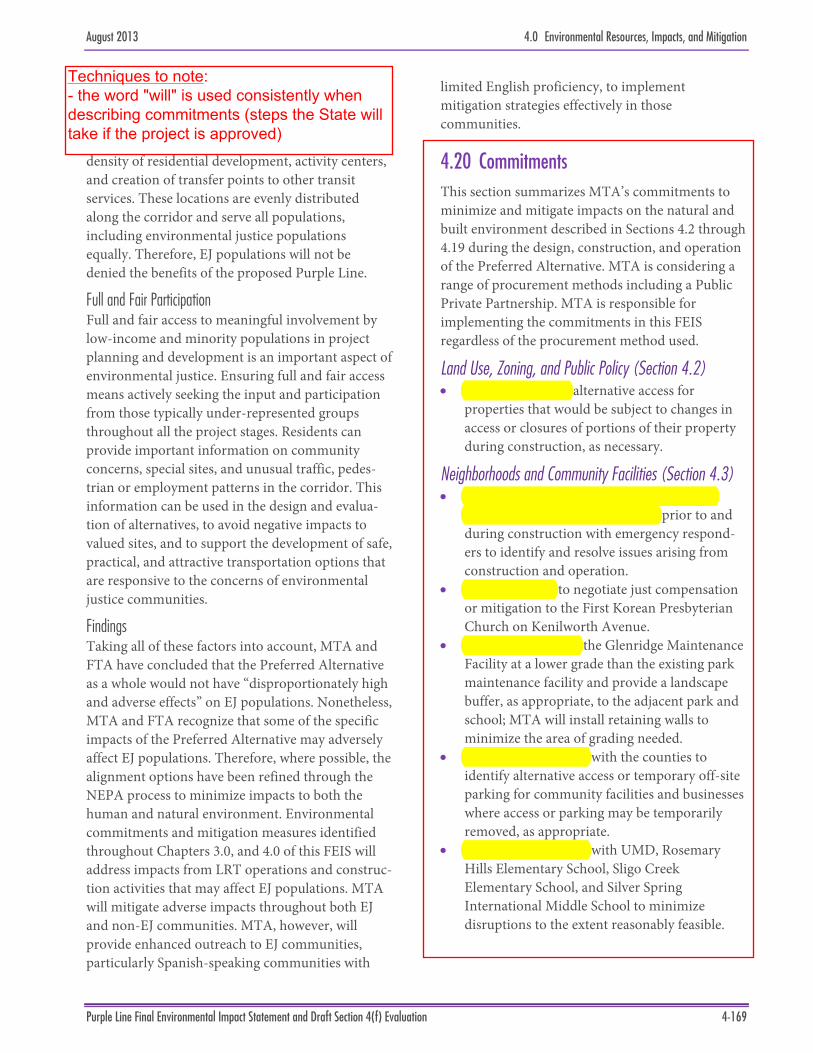
4.20 Commitments This section summarizes MTA’s commitments to minimize and mitigate impacts on the natural and built environment described in Sections 4.2 through 4.19 during the design, construction, and operation of the Preferred Alternative. MTA is considering a range of procurement methods including a Public Private Partnership. MTA is responsible for implementing the commitments in this FEIS regardless of the procurement method used.
Land Use, Zoning, and Public Policy (Section 4.2) MTA will provide alternative access for
properties that would be subject to changes in access or closures of portions of their property during construction, as necessary.
Neighborhoods and Community Facilities (Section 4.3) The Purple Line Fire Life/Safety & Security
Committee will continue to meet prior to and during construction with emergency respond-ers to identify and resolve issues arising from construction and operation.
MTA will work to negotiate just compensation or mitigation to the First Korean Presbyterian Church on Kenilworth Avenue.
MTA will construct the Glenridge Maintenance Facility at a lower grade than the existing park maintenance facility and provide a landscape buffer, as appropriate, to the adjacent park and school; MTA will install retaining walls to minimize the area of grading needed.
MTA will coordinate with the counties to identify alternative access or temporary off-site parking for community facilities and businesses where access or parking may be temporarily removed, as appropriate.
MTA will coordinate with UMD, Rosemary Hills Elementary School, Sligo Creek Elementary School, and Silver Spring International Middle School to minimize disruptions to the extent reasonably feasible.
Techniques to note:- FEIS includes a stand-alone list of projectcommitments, compiled from statementsmade elsewhere in the document
4.0 Environmental Resources, Impacts, and Mitigation August 2013
4-170 Purple Line Final Environmental Impact Statement and Draft Section 4(f) Evaluation
MTA will provide alternative access to community facilities if access is temporarily removed, where practical.
MTA will build traction power substations with landscaping or appropriate architectural treatments to be compatible with adjacent land uses in areas of moderate or high visual sensitivity.
Property Acquisition and Displacements (Section 4.4) MTA will perform property acquisition and
relocation activities in accordance with the Uniform Relocation Assistance and Real Property Acquisition Policies Act of 1970 (Uniform Act) as amended and FTA Circular 5010.1D, Grants Management Requirements and all applicable Maryland State laws that establish the process through which MTA may acquire real property through a negotiated purchase or through condemnation.
For areas that would be subject to construction easements for staging or access areas, MTA will compensate owners based on fair market appraisal.
MTA will use vacant or publicly-owned property, rather than privately-owned, devel-oped property, for temporary construction activities to the greatest extent possible.
MTA will restore properties affected through a temporary easement to an acceptable pre-con-struction condition following construction activities, in accordance with the individual easement agreements.
MTA will provide a parking facility for both County and MTA employees in Lyttonsville.
Economics (Section 4.5) MTA will continue to coordinate with affected
commercial property owners to identify strategies to minimize the effects of temporary construction easements, lane or road closures, and other property restrictions on existing corridor businesses.
MTA will implement a Business Impact Minimization Plan as described in the Environmental Justice section.
Parks, Recreational Facilities, and Open Space (Section 4.6) MTA will include drainage improvements and
water quality facilities in four stream valley parks (Sligo Creek, Long Branch, Northwest Branch, and Anacostia River), Long Branch Local Park, and New Hampshire Estates Neighborhood Park.
MTA, through coordination with M-NCPPC, the NCPC, the NPS, and the public, will implement the following measures: Expand and upgrade facilities and plant
trees in Glenridge Community Park, as well as convert approximately 2 acres of land currently used for the Prince George’s County Parks’ Northern Area Mainte-nance—Glenridge Service Center either to parkland within Glenridge Community Park or to upgrade and expand athletic fields at the Glenridge Elementary School
Restore park properties that are disturbed as a result of construction activities to acceptable conditions through coordination with the park owners
Provide replacement parkland for all park impacts; the amount and location of replacement parkland will be determined by MTA in consultation with park owners
Coordinate selective tree clearing and identification of significant or champion trees with agencies having jurisdiction.
MTA will continue to coordinate with the public and agencies to develop appropriate minimization strategies during construction. Efforts will include the following: Roadway or sidewalk closures will be staged
to maintain pedestrian and vehicular access.
Trail detours needed during construction will be coordinated with the agency having jurisdiction over the trail to identify and develop a plan for a temporary detour route, and the trail routes would be restored at the end of construction.
MTA will continue to coordinate during further design development with the agencies having jurisdiction over the
DRAFT ENVIRONMENTAL IMPACT STATEMENT
Chapter 6 ENVIRONMENTAL COMMITMENTS and MITIGATION
p=6-1
WHAT WILL BE DONE TO REDUCE OR MITIGATE THE IMPACTS OF THE CLEVELAND OPPORTUNITY CORRIDOR PROJECT?
The following sections summarize the steps that will be taken to reduce or mitigate the impacts of the Cleveland Opportunity Corridor project. The project sponsor will make sure that the final plan package includes the necessary engineering drawings, notes and specifications to carry out the environmental commitments outlined in this Draft Environmental Impact Statement (DEIS). It is possible that additional commitments could be identified based on comments received on the DEIS or at the public hearing. If this happens, the additional commitments will be discussed in the Final Environmental Impact Statement (FEIS).
Kenneth L. Johnson (Woodland) Recreational CenterDuring construction, the Cleveland Opportunity Corridor project would need about 0.19 acres (8,420 square feet) of temporary easement from the planned expansion area of the Kenneth L. Johnson (Woodland) Recreational Center, 9206 Woodland Ave. The land would only be needed for about six months for grading and seeding that would take place when Buckeye Road and Woodland Avenue are widened and when the new boulevard is built.
To minimize impacts to the rec center, the following items will be included in the final design plans:
•The plans will require the contractor to protect the rec center areas and users with warnings signs, gates, barricades or fences during construction;
•Access to the rec center will be maintained at all times. The contractor will be required to closely coordinate the construction schedule with the City of Cleveland. Two weeks before the construction starts, the contractor will notify the City, in writing, of the occupation dates;
•Any disturbed areas will be put back to a condition at least as good as or better than what was there before construction started;
•No staging and/or storage of construction equipment will be on the rec center property; and
• If unexpected work on the rec center property is needed, advance notice will be given to the City of Cleveland and ODOT to decide if additional coordination is needed.
During final design, the project sponsor will coordinate with the National Park Service (NPS) through the Ohio Department of Transportation (ODOT) and the Ohio
Techniques to note:- FEIS includes a stand-alone list ofproject commitments, compiled fromstatements made elsewhere in thedocument
CH
AP
TE
R 6
Env
iron
men
tal C
omm
itm
ents
and
Mit
igat
ion
p=6-2
the CLEVELAND OPPORTUNITY CORRIDOR PROJECT
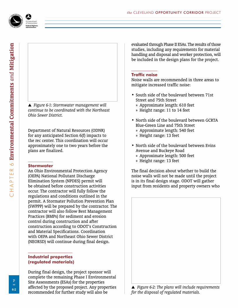
Department of Natural Resources (ODNR) for any anticipated Section 6(f) impacts to the rec center. This coordination will occur approximately one to two years before the plans are finalized.
StormwaterAn Ohio Environmental Protection Agency (OEPA) National Pollutant Discharge Elimination System (NPDES) permit will be obtained before construction activities occur. The contractor will fully follow the regulations and conditions outlined in the permit. A Stormater Pollution Prevention Plan (SWPPP) will be prepared by the contractor. The contractor will also follow Best Management Practices (BMPs) for sediment and erosion control during construction and after construction according to ODOT’s Construction and Material Specifications. Coordination with OEPA and Northeast Ohio Sewer District (NEORSD) will continue during final design.
Industrial properties (regulated materials)
During final design, the project sponsor will complete the remaining Phase I Environmental Site Assessments (ESAs) for the properties affected by the proposed project. Any properties recommended for further study will also be
evaluated through Phase II ESAs. The results of those studies, including any requirements for material handling and disposal and worker protection, will be included in the design plans for the project.
Traffic noiseNoise walls are recommended in three areas to mitigate increased traffic noise:
•South side of the boulevard between 71st Street and 75th Street » Approximate length: 610 feet » Height range: 11 to 14 feet
•North side of the boulevard between GCRTA Blue-Green Line and 75th Street » Approximate length: 540 feet » Height range: 13 feet
•North side of the boulevard between Evins Avenue and Buckeye Road » Approximate length: 500 feet » Height range: 13 feet
The final decision about whether to build the noise walls will not be made until the project is in its final design stage. ODOT will gather input from residents and property owners who
6 Figure 6-1: Stormwater management will continue to be coordinated with the Northeast Ohio Sewer District.
6 Figure 6-2: The plans will include requirements for the disposal of regulated materials.
DRAFT ENVIRONMENTAL IMPACT STATEMENTC
HA
PT
ER
6 Environmental Com
mitm
ents and Mitigation
p=6-3
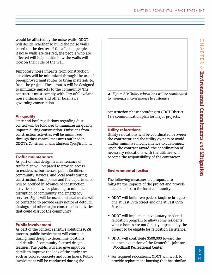
would be affected by the noise walls. ODOT will decide whether to build the noise walls based on the desires of the affected people. If noise walls are desired, the people who are affected will help decide how the walls will look on their side of the wall.
Temporary noise impacts from construction activities will be minimized through the use of pre-approved haul routes to bring materials to/from the project. These routes will be designed to minimize impacts to the community. The contractor must comply with City of Cleveland noise ordinances and other local laws governing construction.
Air qualityState and local regulations regarding dust control will be followed to minimize air quality impacts during construction. Emissions from construction activities will be minimized through dust control measures outlined in ODOT’s Construction and Material Specifications.
Traffic maintenanceAs part of final design, a maintenance of traffic plan will prepared to provide access to residences, businesses, public facilities, community services, and local roads during construction. Local police and fire departments will be notified in advance of construction activities to allow for planning to minimize disruption of community and emergency services. Signs will be used, and local media will be contacted to provide early notice of detours, closings and other major construction activities that could disrupt the community.
Public involvementAs part of the context sensitive solutions (CSS) process, public involvement will continue during final design to determine locations and details of community-focused design features. The public will also give input on details to improve the look of the study area such as colored concrete and form liners. Public involvement will be conducted during the
construction phase according to ODOT District 12’s communication plan for major projects.
Utility relocationsUtility relocations will be coordinated between the contractor and the utility owners to avoid and/or minimize inconvenience to customers. Upon the contract award, the coordination of necessary relocations with the utilities will become the responsibility of the contractor.
Environmental justice
The following measures are proposed to mitigate the impacts of the project and provide added benefits to the local community:
•ODOT will build two pedestrian/bike bridges: one at East 59th Street and one at East 89th Street.
•ODOT will implement a voluntary residential relocation program to allow some residents whose homes are not directly impacted by the project to be eligible for relocation assistance.
•ODOT will contribute $500,000 toward the planned expansion of the Kenneth L. Johnson (Woodland) Recreational Center.
•For required relocations, ODOT will work to provide replacement housing that has similar
6 Figure 6-3: Utility relocations will be coordinated to minimize inconvenience to customers.
CH
AP
TE
R 6
Env
iron
men
tal C
omm
itm
ents
and
Mit
igat
ion
p=6-4
the CLEVELAND OPPORTUNITY CORRIDOR PROJECT
access to public transit, as long as those options are currently available in the housing market. ODOT will also make all reasonable efforts to relocate residents within the same neighborhood, if that is what they desire.
ODOT will present other possible mitigation and enhancement measures during the DEIS review period and at the public hearing (pages 4-29 and 4-30). Based on the comments received, additional measures may be incorporated into the project.
OR 62: Interstate 5 to Dutton Road Final Environmental Impact Statement 3 - 37
3.1.5 Avoidance, Minimization, and/or Mitigation Commitments Incorporated into the Preferred AlternativeODOT makes the following commitments.
3.1.5.1 Project DesignJTA Phase
• To guide access decisions in implementation of the JTA Phase, ODOT will prepare an AMS for the northern terminus intersection, which will be similar to the AMS ODOT has prepared for the southern terminus interchange. The AMS for the southern terminus interchange provides for the closure, consolidation, or modification of most driveway and local street connections to OR 62 at or near the interchange. This will improve mobility and safety to reduce crashes at the southern terminus interchange.
• The project design allows U-turns on OR 62 at Poplar Drive/Bullock Road under the JTA phase.• The project design removes the intersections of Gregory Road and Corey Road with existing
OR 62 and replaces them with an intersection of Fowler Lane and existing OR 62 to increase spacing between OR 62 intersections and reduce congestion between the north terminus intersection of the bypass with existing OR 62 and the intersection of OR 62 with OR 140.
• The project design realigns Crater Lake Avenue near the northern terminus to separate the intersections of Fowler Lane with Crater Lake Avenue and existing OR 62.
• The project design includes gates at the cul-de-sacs where Justice Road terminates on both the east and west sides of the bypass to allow emergency vehicles to enter or leave the bypass, providing for better emergency response times.
• The project design provides for bicycle access to and egress from the bypass at the north and south termini.
JTA Phase and Preferred Alternative Subsequent to Construction of the JTA Phase
• ODOT will allow bicycles and pedestrians on the shoulders of the bypass. The shoulders of the bypass will not be striped because, under Oregon State law, striping for bicycles prohibits pedestrian use and the intent is to allow use by both pedestrians and bicyclists.
• ODOT will convene a committee beginning in early 2013 to discuss implementation of projects recommended by the Transit Subcommittee listed in Appendix M, Recommendations for Transit and Non-Motorized Transportation.
• ODOT will mitigate for operational issues arising from the incursion into the RPZ, including design changes to the Preferred Alternative that will minimize the placement of objects within this zone. ODOT will continue coordination efforts with the FAA and Medford Airport.
Preferred Alternative Subsequent to Construction of the JTA Phase
• ODOT will develop an IAMP for the Vilas Road Interchange before it is constructed, in collaboration with the City of Medford and Jackson County.
3.1.5.2 Project Construction• ODOT will prepare a traffic management plan for project construction. The traffic management
plan will provide for detours, flaggers, time-of-day lane closure restrictions, weekend closure restrictions, staging plans, detour identification, ADA compliance, and provision of local access.
• ODOT will prepare a public involvement plan to inform and engage those affected by project construction. This plan will include a project website to provide current information on construction activities.
3.1.5.3 Mitigation Measures Recommended for the City of Medford
ODOT recommends that the City of Medford install a traffic signal at the intersection of Crater Lake Avenue and Owens Drive. As described in Section 3.1.3.2, the intersection is forecast to have a v/c ratio of over 2.0. A traffic signal at the intersection will substantially lower the v/c ratio.
Techniques to note:- FEIS includes astand-alone list ofproject commitments,compiled fromstatements madeelsewhere in thedocument- commitments arelisted by projectimplementation phase(design, thenconstructon)
Chapter 4 Mitigation Summary
This chapter summarizes FHWA and WSDOT’s commitments for project construction and compensatory mitigation. Commitments for construction include specific BMPs to be used by contractors before, during and after construction to minimize environmental impacts. BMPs are tools or actions designed to achieve a desired result by establishing factors such as the timing of construction, construction methods, or methods to protect specific resources. Commitments for compensatory mitigation include the actions the lead agencies will take to replace or substitute for unavoidable environmental impacts.
Commitments listed in this chapter do not include the many actions that the project has taken to avoid and minimize environmental impacts. These are important elements of environmental mitigation, and they have been incorporated into the project design. They are not included in this chapter because avoidance and minimization measures do not require subsequent commitments from WSDOT other than to build the project as designed.
Mitigation commitments are based on legal requirements and performance standards, which establish specific thresholds for project actions. To meet these commitments, the lead agencies will implement BMPs during construction and carry out specific compensatory mitigation.
4.1 Commitments Related to Best Management Practices
As WSDOT completes the project design and construction plans, it will include and use BMPs designed to meet the project commitments and performance standards for each resource. Some example BMPs are found in each section of Chapter 3. The effectiveness of the BMPs will be monitored as part of WSDOT’s construction compliance program. This will allow WSDOT to adjust
Techniques to note:- FEIS includes a summary of mitigationcommitments made elsewhere in the document
4-2 Mitigation Summary
or replace BMPs in order to assure compliance with performance standards and meet project commitments.
Geology and Soils
BMPs for geology and soils will be designed to meet applicable commitments and performance standards, including:
▪ NPDES General Permit for Construction Activities
▪ NPDES General Permit for Sand and Gravel Operations
▪ Temporary Erosion and Sediment Control Plans
▪ Erosion and sediment control requirements of the WSDOT Design Manual (WSDOT 2007c) and Standard Specifications for Road, Bridge, and Municipal Construction (WSDOT 2008b)
▪ Spill Prevention, Control and Countermeasure Plans
▪ Applicable permit requirements
▪ Conditions imposed by the USFS related to use of federal land for additional easement
▪ Applicable conservation measures included in the NOAA Fisheries’ ESA Consultation Concurrence Letter (NOAA Fisheries 2008)
▪ Applicable parts of the Implementing Agreement between the Washington State Department of Ecology and the Washington State Department of Transportation (Ecology and WSDOT 1998), or as revised
▪ Objectives of the USFS ACS
▪ Construction safety requirements and maintaining operation of the highway during construction, including Occupational Safety
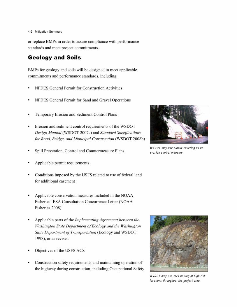
WSDOT may use plastic covering as an erosion control measure.
WSDOT may use rock nett ing at high r isk locations throughout the project area.
I-90 Snoqualmie Pass East Project 4-3
and Health Administration requirements and highway safety standards
Air Quality
BMPs for air quality will be designed to meet applicable commitments and performance standards, including:
▪ Permit conditions from Ecology’s Central Regional Office for temporary exhaust emissions sources and suspended particulates
▪ The NAAQS
▪ Air quality BMPs included as permit requirements or as conditions imposed by the USFS related to use of federal land for additional highway easement
Water Resources
BMPs for water resources will be designed to meet applicable commitments and performance standards, including:
▪ Clean Water Act Section 404 Permit(s)
▪ Clean Water Act Section 401 Water Quality Certification
▪ NPDES General Permit for Construction Activities
▪ NPDES General Permit for Sand and Gravel Operations
▪ Temporary Erosion and Sediment Control Plans
▪ Spill Prevention, Control and Countermeasures Plans
▪ Erosion and sediment control requirements of the WSDOT Design Manual (WSDOT 2007c) and Standard Specifications for Road, Bridge, and Municipal Construction (WSDOT 2008b)
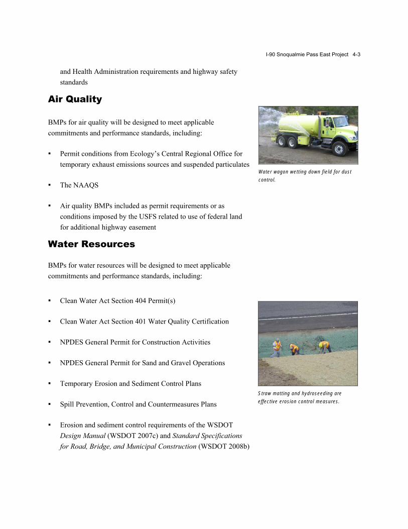
Water wagon wett ing down f ield for dust control.
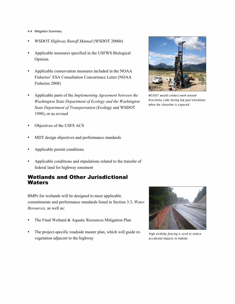
Straw matt ing and hydroseeding are effective erosion control measures.
4-4 Mitigation Summary
▪ WSDOT Highway Runoff Manual (WSDOT 2006b)
▪ Applicable measures specified in the USFWS Biological Opinion
▪ Applicable conservation measures included in the NOAA Fisheries’ ESA Consultation Concurrence Letter (NOAA Fisheries 2008)
▪ Applicable parts of the Implementing Agreement between the Washington State Department of Ecology and the Washington State Department of Transportation (Ecology and WSDOT 1998), or as revised
▪ Objectives of the USFS ACS
▪ MDT design objectives and performance standards
▪ Applicable permit conditions
▪ Applicable conditions and stipulations related to the transfer of federal land for highway easement
Wetlands and Other Jurisdictional Waters
BMPs for wetlands will be designed to meet applicable commitments and performance standards listed in Section 3.3, WaterResources, as well as:
▪ The Final Wetland & Aquatic Resources Mitigation Plan
▪ The project-specific roadside master plan, which will guide re-vegetation adjacent to the highway
WSDOT would conduct work around Keechelus Lake during low pool e levations when the shorel ine is exposed.
High vis ibi l i ty fencing is used to reduce accidental impacts to habitat.
www.environment.transportation.org
Commitments Are Clearly and Consistently Defined(e.g., identify who is responsible; proper use of “will”)
MD: Purple Line FEIS
NC: Mid-Currituck FEIS
Mid-Currituck Bridge Study Final Environmental Impact Statement STIP Project No. R-2576 Page 1 of 2
xxix
Mid-Currituck Bridge Study Currituck and Dare Counties, North Carolina
Federal‐Aid Project Number. BRSTP‐000S(494) WBS Element: 34470.1.TA1 STIP Project No. R‐2576
Project Commitments
1. NCTA will coordinate with the US Coast Guard to determine appropriate horizontal and vertical navigation clearances for the Preferred Alternative (see Section 2.1.3).
2. NCTA will finalize (in association with environmental resource and regulatory agencies) and implement a stormwater management plan for the Preferred Alternative (see Section 2.1.7.2).
3. NCTA will finalize (in association with environmental resource and regulatory agencies) and implement bridge construction techniques to minimize aquatic resource impacts with the Preferred Alternative, including approaches to minimize impact to SAV habitat and potential SAV habitat (see Section 3.3.4.4).
4. NCTA will use standard details for installed features used to discourage roosting/ perching birds. During final design, NCTA will investigate proven methods of reducing collisions between vehicles operating on the bridge and flying birds and incorporate them as appropriate (see Section 3.3.3.2).
5. NCTA will include bicycle safe rails on the bridge parapet across Currituck Sound (see Section 2.1.11).
6. A Design Noise Study will be prepared to update the FEIS noise analysis based upon the most recent FHWA regulations and NCDOT noise policies and guidance, traffic forecasts, and the final design (see Section 3.4.1.5).
7. NCTA will replace sections of existing multi‐use paths that are displaced as a result of NC 12 widening in Currituck County and US 158 widening in Dare County. NCTA also will provide space in the NC 12 right‐of‐way and complete the grading for future multi‐use paths to be provided by others in three locations along the widened sections of NC 12 in Currituck County (see Section 2.1.11).
8. NCTA will purchase land‐locked parcels north of Aydlett Road in Maple Swamp and west of US 158 in Great Swamp in addition to public right‐of‐way. The purchased land (i.e., the land‐locked parcels) will be set aside as a conservation area and allowed to retain or return to its natural state (see Section 3.3.6.4).
Techniques to note:- the word "will" is usedconsistently when describingcommitments (steps the Statewill take if the project isapproved)
August 2013 4.0 Environmental Resources, Impacts, and Mitigation
Purple Line Final Environmental Impact Statement and Draft Section 4(f) Evaluation 4-169
The Purple Line would provide accessibility to locations throughout the project corridor and to the Metrorail, MARC and Amtrak systems. The Purple Line station locations were selected based upon the density of residential development, activity centers, and creation of transfer points to other transit services. These locations are evenly distributed along the corridor and serve all populations, including environmental justice populations equally. Therefore, EJ populations will not be denied the benefits of the proposed Purple Line.
Full and Fair Participation Full and fair access to meaningful involvement by low-income and minority populations in project planning and development is an important aspect of environmental justice. Ensuring full and fair access means actively seeking the input and participation from those typically under-represented groups throughout all the project stages. Residents can provide important information on community concerns, special sites, and unusual traffic, pedes-trian or employment patterns in the corridor. This information can be used in the design and evalua-tion of alternatives, to avoid negative impacts to valued sites, and to support the development of safe, practical, and attractive transportation options that are responsive to the concerns of environmental justice communities.
Findings Taking all of these factors into account, MTA and FTA have concluded that the Preferred Alternative as a whole would not have “disproportionately high and adverse effects” on EJ populations. Nonetheless, MTA and FTA recognize that some of the specific impacts of the Preferred Alternative may adversely affect EJ populations. Therefore, where possible, the alignment options have been refined through the NEPA process to minimize impacts to both the human and natural environment. Environmental commitments and mitigation measures identified throughout Chapters 3.0, and 4.0 of this FEIS will address impacts from LRT operations and construc-tion activities that may affect EJ populations. MTA will mitigate adverse impacts throughout both EJ and non-EJ communities. MTA, however, will provide enhanced outreach to EJ communities, particularly Spanish-speaking communities with
limited English proficiency, to implement mitigation strategies effectively in those communities.
4.20 Commitments This section summarizes MTA’s commitments to minimize and mitigate impacts on the natural and built environment described in Sections 4.2 through 4.19 during the design, construction, and operation of the Preferred Alternative. MTA is considering a range of procurement methods including a Public Private Partnership. MTA is responsible for implementing the commitments in this FEIS regardless of the procurement method used.
Land Use, Zoning, and Public Policy (Section 4.2) MTA will provide alternative access for
properties that would be subject to changes in access or closures of portions of their property during construction, as necessary.
Neighborhoods and Community Facilities (Section 4.3) The Purple Line Fire Life/Safety & Security
Committee will continue to meet prior to and during construction with emergency respond-ers to identify and resolve issues arising from construction and operation.
MTA will work to negotiate just compensation or mitigation to the First Korean Presbyterian Church on Kenilworth Avenue.
MTA will construct the Glenridge Maintenance Facility at a lower grade than the existing park maintenance facility and provide a landscape buffer, as appropriate, to the adjacent park and school; MTA will install retaining walls to minimize the area of grading needed.
MTA will coordinate with the counties to identify alternative access or temporary off-site parking for community facilities and businesses where access or parking may be temporarily removed, as appropriate.
MTA will coordinate with UMD, Rosemary Hills Elementary School, Sligo Creek Elementary School, and Silver Spring International Middle School to minimize disruptions to the extent reasonably feasible.
Techniques to note:- the word "will" is used consistently whendescribing commitments (steps the State willtake if the project is approved)

(Thispageisintentionallyleftblank.)
www.environment.transportation.org
Process for Monitoring Implementation Is Described(e.g., commitments tracking database)
MD: Intercounty Connector FEIS
VII-96 Preferred Alternative
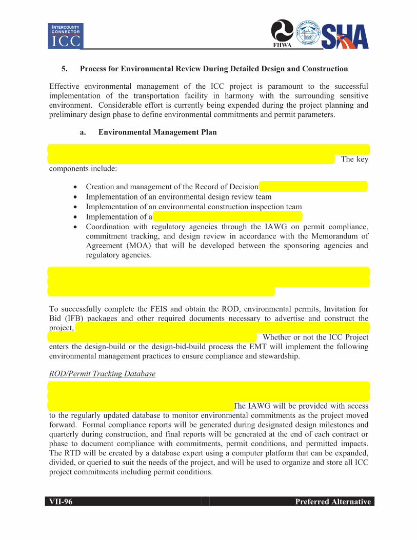
5. Process for Environmental Review During Detailed Design and Construction
Effective environmental management of the ICC project is paramount to the successful implementation of the transportation facility in harmony with the surrounding sensitive environment. Considerable effort is currently being expended during the project planning and preliminary design phase to define environmental commitments and permit parameters.
a. Environmental Management Plan
The Environmental Management Plan, which will be implemented by the Environmental Management Team (EMT), has been created to facilitate success of the ICC project. The key components include:
• Creation and management of the Record of Decision (ROD)/permit tracking database • Implementation of an environmental design review team • Implementation of an environmental construction inspection team • Implementation of a mitigation/stewardship implementation team • Coordination with regulatory agencies through the IAWG on permit compliance,
commitment tracking, and design review in accordance with the Memorandum of Agreement (MOA) that will be developed between the sponsoring agencies and regulatory agencies.
An Independent Environmental Monitor with no affiliation with the design, permitting, or construction aspects of the project will provide quality assurance services and report concurrently to the regulatory agencies and the sponsoring agencies.
To successfully complete the FEIS and obtain the ROD, environmental permits, Invitation for Bid (IFB) packages and other required documents necessary to advertise and construct the project, the EMT will be seamlessly integrated into the on-going environmental efforts for the ICC under the leadership of the ICC-Environmental Manager. Whether or not the ICC Project enters the design-build or the design-bid-build process the EMT will implement the following environmental management practices to ensure compliance and stewardship.
ROD/Permit Tracking DatabaseTo track and ensure compliance with the project commitments and conditions throughout the life of the project (design, construction, and post construction monitoring) a ROD/Permit Tracking Database (RTD) will be generated and implemented. The IAWG will be provided with access to the regularly updated database to monitor environmental commitments as the project moved forward. Formal compliance reports will be generated during designated design milestones and quarterly during construction, and final reports will be generated at the end of each contract or phase to document compliance with commitments, permit conditions, and permitted impacts. The RTD will be created by a database expert using a computer platform that can be expanded, divided, or queried to suit the needs of the project, and will be used to organize and store all ICC project commitments including permit conditions.
Preferred Alternative VII-97
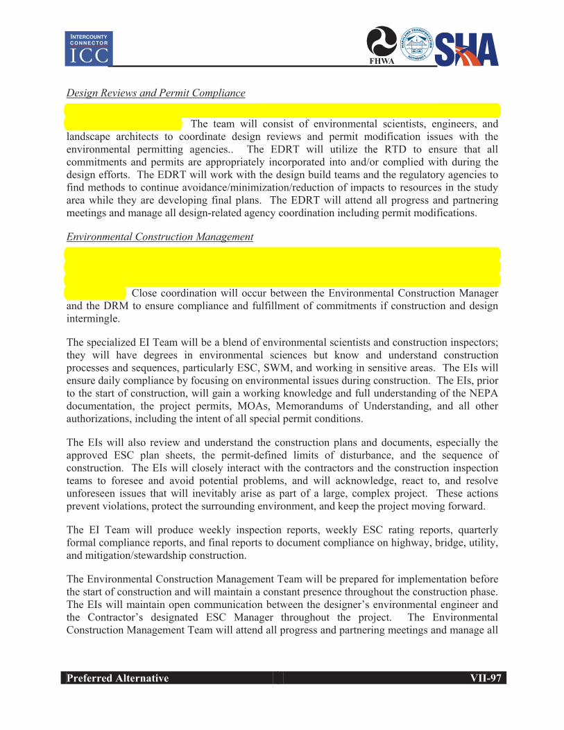
Design Reviews and Permit Compliance An Environmental Design Review Manager (DRM) will lead the Environmental Design Review Team (EDRT). The team will consist of environmental scientists, engineers, and landscape architects to coordinate design reviews and permit modification issues with the environmental permitting agencies.. The EDRT will utilize the RTD to ensure that all commitments and permits are appropriately incorporated into and/or complied with during the design efforts. The EDRT will work with the design build teams and the regulatory agencies to find methods to continue avoidance/minimization/reduction of impacts to resources in the study area while they are developing final plans. The EDRT will attend all progress and partnering meetings and manage all design-related agency coordination including permit modifications.
Environmental Construction ManagementA full-time, on-site, dedicated environmental construction inspection team composed of Environmental Inspectors (EIs) and managed by the Environmental Construction Manager,will be provided to ensure the project commitments and conditions are adhered to during construction. Close coordination will occur between the Environmental Construction Manager and the DRM to ensure compliance and fulfillment of commitments if construction and design intermingle.
The specialized EI Team will be a blend of environmental scientists and construction inspectors; they will have degrees in environmental sciences but know and understand construction processes and sequences, particularly ESC, SWM, and working in sensitive areas. The EIs will ensure daily compliance by focusing on environmental issues during construction. The EIs, prior to the start of construction, will gain a working knowledge and full understanding of the NEPA documentation, the project permits, MOAs, Memorandums of Understanding, and all other authorizations, including the intent of all special permit conditions.
The EIs will also review and understand the construction plans and documents, especially the approved ESC plan sheets, the permit-defined limits of disturbance, and the sequence of construction. The EIs will closely interact with the contractors and the construction inspection teams to foresee and avoid potential problems, and will acknowledge, react to, and resolve unforeseen issues that will inevitably arise as part of a large, complex project. These actions prevent violations, protect the surrounding environment, and keep the project moving forward.
The EI Team will produce weekly inspection reports, weekly ESC rating reports, quarterly formal compliance reports, and final reports to document compliance on highway, bridge, utility, and mitigation/stewardship construction.
The Environmental Construction Management Team will be prepared for implementation before the start of construction and will maintain a constant presence throughout the construction phase. The EIs will maintain open communication between the designer’s environmental engineer and the Contractor’s designated ESC Manager throughout the project. The Environmental Construction Management Team will attend all progress and partnering meetings and manage all
VII-98 Preferred Alternative
construction-related agency coordination including permit modifications and agency compliance inspections.
Mitigation Implementation Team The Mitigation Implementation Team (MIT) will be managed by an Environmental Mitigation Manager (EMM) who will coordinate with the mitigation team, the DRM, the sponsoring agencies, and the regulatory agencies to ensure the project commitments and conditions are adhered to during construction of the mitigation and stewardship sites.
During construction, the EMM will work closely with the mitigation Contractor and the design team to ensure that individual projects are effective in meeting mitigation and stewardship goals established in the Comprehensive Mitigation and Environmental Stewardship Plan.
The EMM is involved in the startup phase of mitigation construction to ensure that an appropriate working environment is developed between the MIT, the mitigation Contractor, the designer, the regulatory agencies, and the landowner.
The EMM will remain involved in the process through completion, and will organize and conduct regular progress and partnering meetings as well as facilitate regulatory approvals, manage staff, provide technical oversight, and guidance during construction. On very specialized projects such as fish passage, the designer-of-record may provide an on-demand design specialist to ensure compliance with design intent.
All changes to project plans that involve impacts to project permits, ESC plans, and sequences of construction will be coordinated with the design specialist, the sponsoring agencies, and the appropriate regulatory compliance department. If the mitigation site is not owned by SHA, the EMM will also provide coordination services to the landowner and local communities to ensure that mutual goals for the project are achieved.
Independent Environmental MonitorAn Independent Environmental Monitor (IEM) with no affiliation with the design, permitting, or construction aspects of the project will be provided to review final design plans and monitor construction to provide added assurance that the project commitments and conditions are adhered to during construction.
The IEM will be a full time extension of regulatory agencies and allow for a compliance office on site. The IEM will concurrently communicate issues to the sponsoring agencies and the regulatory agencies so that all parties are informed and involved in the solution process.
Post Construction MonitorThe EMM will lead the post construction monitoring team. The team will consist of environmental scientists, and/or landscape architects to perform post construction monitoring and submit reports yearly to the sponsoring and regulatory agencies. Theses tasks will ensure SWM systems and mitigation projects are built according to plans and to ensure the success of mitigation projects.

Preferred Alternative VII-99
b. Conclusion
The Environmental Management Plan has successfully worked on the Woodrow Wilson Bridge Project, the design-build US 113 Project, and other high profile, environmentally sensitive projects. The plan has proven to ensure compliance with commitments and permits throughout the project through traditional fundamentals and cutting edge innovation en route to ultimate environmental excellence and success.

(Thispageisintentionallyleftblank.)