Embed Size (px)
Citation preview
Gaviota Coast Plan
Chapter Two – Natural and Cultural Resources Stewardship
2-1
Artist: John Iwerks
Chapter 2: Natural and Cultural Resources Stewardship The Gaviota Coast is Southern California’s largest continuous stretch of rural coastal land and contains its healthiest remaining coastal ecosystem. The coastline features a high concentration of both locally and globally significant, diverse, rare species and habitat. Ecological health can be achieved by planning at the “watershed level” and maintaining and connecting large habitat areas. The Gaviota Coast also contains some of California’s oldest and best-preserved Native American archeological sites, spanning over 10,000 years of history. The preservation and enhancement of native landscapes, habitat and life forms requires taking an integrated and comprehensive approach by committing to sustainable land use and environmental management practices.
2.1 Natural Resources Stewardship
Physical Setting
The Gaviota Coast is a topographically and ecologically diverse area consisting of rolling hills, valleys, coastal terraces, streams, coastal bluffs, estuaries, sandy beach and rocky shorelines transecting the landscape from the Santa Ynez Mountains to the Pacific Ocean. The rural coastline contains extensive open space and agricultural land composed of numerous watersheds. The relatively undisturbed nature of the Gaviota Coast and the Santa Ynez Mountains creates migration corridors between inland, mountainous
and coastal habitat areas as well as offering environmental refuge for plant and animal communities. At Point Conception, the northern and southern ecosystems of the West Coast converge causing the climate, topography, flora, fauna and marine environment to mix and change. Many northern plant species reach their southern geographic limits north of the Santa Ynez Mountains and many southern species reach their geographic limits south of the Santa Ynez Mountains. The Gaviota Coast, east of Point Conception, also borders part of a maritime system called the Southern California Bight (SCB). The SCB is a biologically diverse marine transition zone attributed to the confluence of two major oceanic currents and the shape of the continental shelf at Point Conception. The SCB is the temporary and permanent home to a wide variety of marine organisms, and it functions as a breeding ground for a rich array of marine species including pinnipeds, cetaceans, shorebirds and waterfowl.
a. Terrestrial and Marine Ecosystems The Gaviota Coast is abundant with flora and fauna and a variety of natural habitats are found in the Gaviota Coast Plan Area. The Gaviota Coast Plan Area falls into one ecological section called the Southern California Coast Section of the California Coastal Chaparral Forest and Shrub USDA Ecoregion

Gaviota Coast Plan
Chapter Two – Natural and Cultural Resources Stewardship
2-2
Artist: John Iwerks
Province.1 Two ecoregions, the Southwestern and Central Western Ecoregions, transition at the Santa Ynez Mountains forming a hot spot for biodiversity creating a high level of species endemism. The Jalama Creek and upper Gaviota Creek watersheds are located within the Central Western region. Numerous southerly-flowing creeks and their watersheds make up the Southwestern region, characterized by the Santa Ynez Mountains, the coastal plains of the Cojo-Jalama and Hollister Ranches, and the plains east of Gaviota Creek.
Within the Plan Area, rare and endangered habitat includes bishop pine forest, tanbark oak forest, valley oak woodlands, coastal sage chaparral scrub, central maritime chaparral, native grassland, wetlands, riparian woodlands, coastal dunes and strand, and marine ecosystems such as kelp beds, sea grasses, and rocky marine intertidal zones. These marine and terrestrial environments provide key habitat components that increase habitat value and complexity for a wide variety of wildlife and plant species, including many special-status species. Special-status species include Federal and State-listed threatened, endangered and candidate species or species of special concern. Species of special concern are rare or sensitive plants and animals recognized as having limited distribution and/or have shown significant downward trends in population size or range. Among these special-status species are federally and state listed animal species such as the California red-legged frog, tidewater goby, southwestern willow flycatcher, southern steelhead, western snowy plover, and the state fully protected white-tailed kite. Federally listed threatened and endangered marine mammal species that could potentially be observed in the Santa Barbara Channel and the coastal waters include stellar sea lions, Guadalupe fur seals, sperm whales, blue whales, humpback whales, southern sea otters, and fin whales. Special-status plant species that are federally and state listed include the Gaviota tarplant, Lompoc yerba santa, and Santa Ynez false lupine. This list is not exhaustive, but it is meant to highlight those rare and endangered habitats and special-status species that are prevalent on the Gaviota Coast.
b. Environmentally Sensitive Habitat The Gaviota Coast Plan Area contains many vegetative alliances, wildlife habitats, and Environmentally Sensitive Habitat (ESH) areas based on direct field observation and/or assessment of contract biologists and the County’s Planning and Development staff biologist, as documented in biological reports for Santa Barbara County or for proposed private developments in the County. In determining which habitats warrant consideration as ESH, given the specific criteria in Policy NS-4, and in the absence of specific fieldwork conducted for this purpose, two published habitat
classifications are used:
1 Miles and Goudy 1997, as represented in Sawyer, Keeler-Wolf and Evens, 2009
Ecoregions reflect sections of a landscape classification system developed by the US Forest Service to help define and describe California’s biodiversity. It is based on factors such as climate, physiography, and soils.
Gaviota Coast Plan
Chapter Two – Natural and Cultural Resources Stewardship
2-3
1. The National Vegetation Classification System, represented in California by the Manual of
California Vegetation (MCV) (Sawyer et al, 2009); and
2. The California Wildlife Habitats Relationship (WHR) system (Mayer and Laudenslayer, 1988).
The Manual of California Vegetation is designed to provide a uniform classification of all plant
communities in California using the “Alliance” as the basic fundamental unit. The 2009 Manual of
California Vegetation system identifies 490 various plant community types (alliances, provisional
alliances, special stands, semi-natural stands) in California. It also indicates an alliance’s rarity and threat
in California, based on the California Natural Diversity Database and California Department of Fish and
Wildlife (CDFW) system (CDFW 2010) of ranking plant communities using global and state rankings (e.g.,
G3, S3), which is helpful for determining the ESH areas for the Gaviota Coast Plan Area (see Appendix B:
Table 1 for global and state listings for each alliance, or vegetation type). However, mapping based on
the Manual of California Vegetation approach has not been done in the Gaviota Coast area. In summary,
the Manual of California Vegetation classification is a detailed, hierarchical classification that allows for
identification of rare plant community types using standardized techniques.
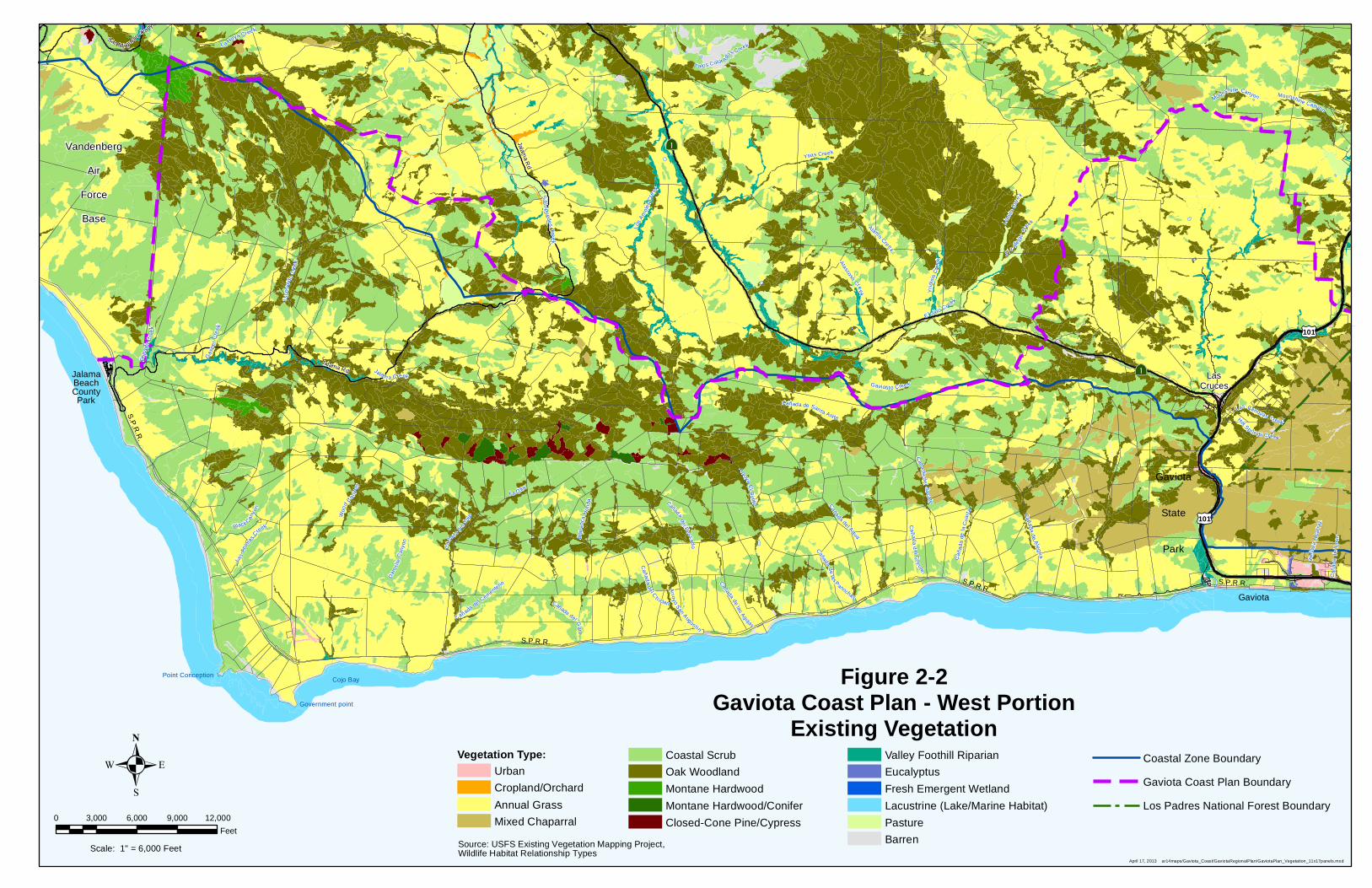
The Wildlife Habitats Relationship system is designed to predict habitat value for the vertebrate animals
in the State. The 1988 Wildlife Habitats Relationship system identifies 59 habitat types in California, and
it does not indicate rarity of the habitat types. However, because the US Forest Service has mapped
portions of the Plan area under the Wildlife Habitats Relationship system, the Gaviota Plan uses these
maps (Figures 2-1 and 2-2), to show the general vegetation patterns in the Plan area. The Wildlife
Habitats Relationship classification is a broad classification, and is not as useful for identifying rare
habitat types, but it does provide information on how wildlife species use certain habitats. Although the
Wildlife Habitats Relationship names are not used in the Gaviota Coast Plan, the descriptions of these
types, and the species occurring within each type, are considered.
The vegetative alliances (Appendix B: Table 1) and wildlife habitats (Appendix B: Table 2) that are
considered environmentally sensitive and are protected and preserved are listed in Policy NS-4. Note
that Policy NS-4: Table 1 is only a partial list; there may be additional as-yet unnamed alliances present
in the Plan area, or there may be already-described alliances that simply have not yet been observed by
local biologists.

Gaviota Coast Plan
Chapter Two – Natural and Cultural Resources Stewardship
2-4
Page Intentionally Left Blank

Solvang
Alisal Rd
Camino Cielo
RefugioR
d
Old C
oast A
ve
£¤101
Ref
ug i
oR
d
Camino Cielo
£¤101
£¤101
£¤101
Aò
Lake Cachuma
Alisal Reservoir
EdwardsPoint
Gaviota
State
Park
LasCruces
NojoquiFalls
CountyPark
Gaviota
Tajiguas
ArroyoHondo
PreserveTajiguasLandfill
BaronRanch
Refugio State Beach El CapitanState Beach
NaplesBacaraResort
SandpiperGolf
Course
S.P.R.R.
S.P.R.R.
Quiota Creek
Ga
toC
an
yon
Nojoq
uiC
reek
Tajiguas Creek
Te
colo
teC
an y
on
Dos
Pue
blo
sC
an
yon
Ca
ñada
del C
apita
n
Calabaza l Creek
Al isa l Creek
Cañ
ada
delR
efu
gio
Arroyo Quem
ado
Hi lton
Can
yon
Cañ
ada
del
Co
rra l
Mi ne
Canyon
Arro
yoH
ond
o
Te q
u epi
sCan
yon
Las
Var
as Ca n
yon
Agu a
ji toC
anyon
DeVaul
Can
yon
Santa Ynez Riv e r
Ca
ña
da
San
On
ofre
Mon
j as
Cre
ek
Las L la
gas
Can
yon
Moonshine Canyon
Ca
ñad
aA
l cat
raz
Leon
Ca
nyo
n
Las Canovas Creek
Cañ
a da
de
l Leo
n
Sw
eetw
ate
r Cre
ek
Bel
l Ca nyon
Hot Sp rings CreekC
añad
a d
e la
Hue
rta
Cañ
ada
de
las
Zor
rilla
s
Las
Lla
gas
Ca
nyo
n
Al isal C
reek
Leon Canyon
Moonshine Canyon
Figure 2-1Gaviota Coast Plan - East Portion
Existing VegetationVegetation Type:
Urban
Cropland/Orchard
Annual Grass
Mixed Chaparral
Coastal Scrub
Oak Woodland
Montane Hardwood
Montane Hardwood/Conifer
Closed-Cone Pine/Cypress
Valley Foothill Riparian
Eucalyptus
Fresh Emergent Wetland
Lacustrine (Lake/Marine Habitat)
Pasture
Barren
Coastal Zone Boundary
Gaviota Coast Plan Boundary
Los Padres National Forest Boundary
April 17, 2013 ar14maps/Gaviota_Coast/GaviotaRegionalPlan/GaviotaPlan_Vegetation_11x17panels.mxd
0 3,000 6,000 9,000 12,000
Feet
.Scale: 1" = 6,000 Feet
Source: USFS Existing Vegetation Mapping Project,Wildlife Habitat Relationship Types

Gaviota Coast Plan
Chapter Two – Natural and Cultural Resources Stewardship
2-6
Page Intentionally Left Blank
?Ò Jalama R
d
San M i guelitoCany
on
£¤101
Jalama Rd ?Ò
£¤101
Point Conception
Government point
Cojo Bay
JalamaBeachCountyPark
Gaviota
State
Park
LasCruces
Gaviota
S.P
.R.R
.
S.P.R.R.
S.P.R.R.S.P.R.R.
Vandenberg
Air
Force
Base
Jalam a Creek
El JaroCre
ek
Ytias Cree k
Esp
ada
Cr e
ek
Gas
per
Cre
ek
La Hoya Creek
Yr i
disi
sC
ree
k
Los
Am
oles
Cre
ek
Woo
dC
a nyon
Sa
ls ipuede
sC
ree
k
Es
c on
dido
Cre
ek
Arroyo
El B
ul ito
La O lla
Alam
oCreek
Dam
sit e
Can
yon
Cañada de Santa Anita
Llan
itoC
reek
Caña
dade
Ale
gria
Black Can
yon
Ca
ñada
del C
ojo
Bar
ranc
aH
on
da
Cañ
ad
ade
laC
uar
t a
Caña
dad
el S
acate
El Cal
lejo
nC
re
ek
Cañada
delas
Agujas
Ar ro
yoS
anAugus tin
Cañada del Ga
t o
Pa los Color ados Creek
Ca
ñadadel Agua
Las
Ani
mas
C
reek
Cañada
de
las
Panochas
Ca
ñ ada
del C
oyote
AtascosoC
reek
Cañadad
e l Pescad
o
Moonshine Canyon
Ca
ñad
aA
lcat
raz
Cañada de l Cementerio
Gavioti t o Creek
Las Canovas Creek
Cañ
ada
de
l Leo
n
Cañad
ad
e l C
h iclan
Hot Springs Creek
Moonshine Canyon
April 17, 2013 ar14maps/Gaviota_Coast/GaviotaRegionalPlan/GaviotaPlan_Vegetation_11x17panels.mxd
0 3,000 6,000 9,000 12,000
Feet
.Scale: 1" = 6,000 Feet
Figure 2-2Gaviota Coast Plan - West Portion
Existing VegetationVegetation Type:
Urban
Cropland/Orchard
Annual Grass
Mixed Chaparral
Coastal Scrub
Oak Woodland
Montane Hardwood
Montane Hardwood/Conifer
Closed-Cone Pine/Cypress
Valley Foothill Riparian
Eucalyptus
Fresh Emergent Wetland
Lacustrine (Lake/Marine Habitat)
Pasture
Barren
Coastal Zone Boundary
Gaviota Coast Plan Boundary
Los Padres National Forest Boundary
Source: USFS Existing Vegetation Mapping Project,Wildlife Habitat Relationship Types
Gaviota Coast Plan
Chapter Two – Natural and Cultural Resources Stewardship
2-8
Page Intentionally Left Blank

Solvang
Goleta
Alisal Rd
Camino Cielo
RefugioR
d
Old C
oast A
ve
£¤101
Ref
ug i
oR
d
Camino Cielo
£¤101
£¤101
£¤101
Aò
Lake Cachuma
Alisal Reservoir
Edwards Point
Gaviota
State
Park
LasCruces
Nojoqui FallsCounty Park
Gaviota
Tajiguas
ArroyoHondo
PreserveTajiguasLandfill
BaronRanch
Refugio State Beach El CapitanState Beach
NaplesBacaraResort
SandpiperGolf
Course
S.P.R.R.
S.P.R.R.
Las Flores CanyonOil & Gas
Processing Plant
Figure 2-3Gaviota Coast Plan - East Portion
Environmentally Sensitive Habitat OverlayEnvironmentally Sensitive Habitat Overlay
Coastal Zone Boundary
Gaviota Coast Plan Boundary
Los Padres National Forest Boundary
Federal Ownership
State of California Ownership
Santa Barbara County Ownership
Land Trust for Santa Barbara County Ownership
Private Ownership With Conservation Easement
Incorporated City
July 5, 2016 ar14maps/Gaviota_Coast/GaviotaRegionalPlan/GaviotaPlan_ESH_Proposed_11x17panels_PCfinal.mxd
0 3,000 6,000 9,000 12,000
Feet
.Scale: 1" = 6,000 Feet

Gaviota Coast Plan
Chapter Two – Natural and Cultural Resources Stewardship
2-10
Page Intentionally Left Blank
?Ò Jalama R
d
San M iguelito
Canyo
n
£¤101
Jalama Rd ?Ò
£¤101
Point Conception
Government point
Cojo Bay
JalamaBeachCountyPark
Gaviota
State
Park
LasCruces
Gaviota
S.P
.R.R
.
S.P.R.R.
S.P.R.R.
July 5, 2016 ar14maps/Gaviota_Coast/GaviotaRegionalPlan/GaviotaPlan_ESH_Proposed_11x17panels_PCfinal.mxd
0 3,000 6,000 9,000 12,000
Feet
.Scale: 1" = 6,000 Feet
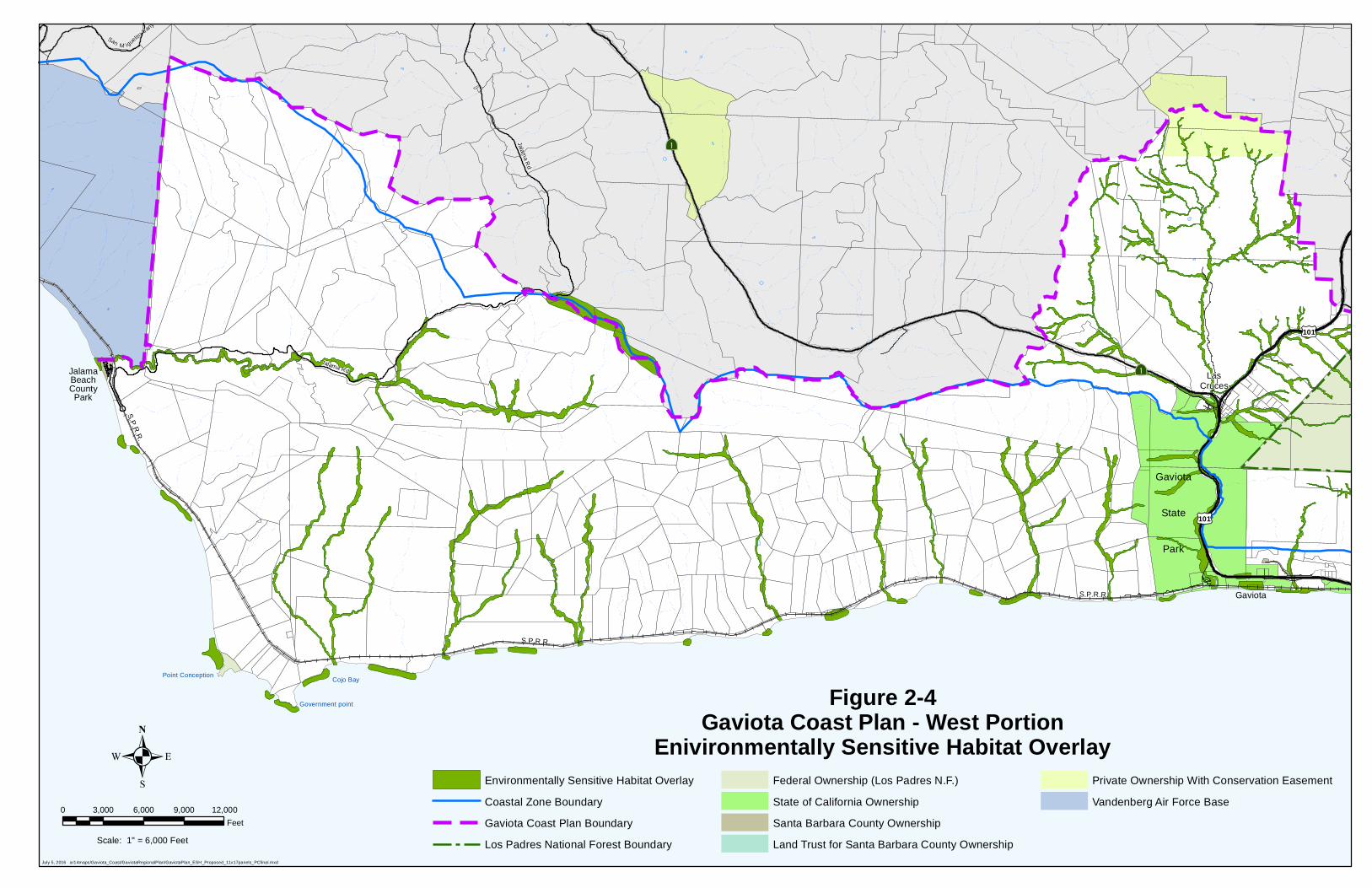
Figure 2-4Gaviota Coast Plan - West Portion
Enivironmentally Sensitive Habitat OverlayEnvironmentally Sensitive Habitat Overlay
Coastal Zone Boundary
Gaviota Coast Plan Boundary
Los Padres National Forest Boundary
Federal Ownership (Los Padres N.F.)
State of California Ownership
Santa Barbara County Ownership
Land Trust for Santa Barbara County Ownership
Private Ownership With Conservation Easement
Vandenberg Air Force Base

Gaviota Coast Plan
Chapter Two – Natural and Cultural Resources Stewardship
2-12
Page Intentionally Left Blank
Gaviota Coast Plan
Chapter Two – Natural and Cultural Resources Stewardship
2-13
Regulatory Setting Several existing Federal, State and local regulations protect important biological communities and sensitive species on the Gaviota Coast, including the Federal Endangered Species Act, California Endangered Species Act, Coastal Act, Clean Water Act, Porter-Cologne Water Quality Control Act, Marine Mammal Protection Act, California Fish and Game Code, Migratory Bird Treaty, and County’s Comprehensive Plan including the Local Coastal Program.
Local Regulation and Policies
The County’s Comprehensive Plan, including the Conservation Element, Open Space Element, Environmental Resource Management Element, Land Use Element and specifically the Coastal Land Use Plan (CLUP) contain policies identifying the protection, preservation and enhancement of biological and natural resources, in particular Environmentally Sensitive Habitat (ESH) areas.
ESH includes areas such as wetlands, intertidal areas, monarch butterfly habitat, streams, riparian corridors, native grasslands and other native plant communities. The intent of these plans and policies is to promote protection of important biological and natural resources and ensure that new development is compatible with these resources and the surrounding environment.
The Conservation Element describes the diversity of ecological systems present within Santa
Barbara County and includes a range of policies designed to preserve the County’s biological
diversity.
The Open Space Element identifies areas within Santa Barbara County where natural resources
such as wetlands and rare and endangered plant and animal species are preserved.
The Environmental Resource Management Element summarizes the various environmental
factors analyzed in the Conservation and Open Space Elements, and identifies policies that
define whether development is appropriate given the severity of constraints.
The Land Use Element lays out the general patterns of development throughout the County,
including the distribution of property improvements, agricultural lands and open space.
In addition to Comprehensive Plan policy guidance, natural resources in the Coastal Zone
receive further protection in the County’s Coastal Land Use Plan (CLUP). Similar to the Land Use
Element, the CLUP lays out the general patterns of development and provides resource
protection policies that address cultural, biological and natural resources, which include ESH
areas and prime agricultural lands, recreational resources, and the aquatic environment (i.e.,
streams, wetlands, and coastal waters).
California Coastal Act The Coastal Act places a high priority on the protection of biological and natural resources. Strict limits are placed on development in ESH areas. The Coastal Act (Section 30107.5) defines Environmentally Sensitive Habitat Area as: “[A]ny area in which plant or animal life or their habitats are either rare or especially valuable because of their special nature or role in an ecosystem and which could be easily disturbed or degraded by human activities and developments.” Very limited types of development are allowed in ESH areas and then only where there is no feasible less environmentally damaging alternative
Gaviota Coast Plan
Chapter Two – Natural and Cultural Resources Stewardship
2-14
and feasible mitigation measures have been adopted. In general, only land uses that are dependent on the habitat resources are allowable within ESH areas.
Planning Issues Numerous regulations protect important sensitive habitat and special status species within the Plan area. However, these resources remain vulnerable to public and private land development that is not well planned and sensitive to the surrounding environment. Consequently, impacts to important biological resources may include:
Degradation and loss or fragmentation of wildlife habitat and ESH areas;
Loss of wetlands and stream health through pollution and sedimentation;
Disturbance of valuable plant communities;
Disruption of important wildlife corridors; and
Degradation of watershed integrity.
All species, including important biological communities and sensitive species face impacts from climate change. Sea level rise and changes in the intensity and frequency of storm events could impact low lying coastlines resulting in beach and bluff erosion and the loss of fresh water resources for fish and wildlife. Salinity, ocean acidification, and temperature changes can impact estuary and marine ecosystems. Temperature and precipitation changes may affect the distribution and composition of terrestrial habitats as researchers are projecting a trend in plant species moving to the north and towards the coast to deal with rising temperatures and altered rainfall.2 Implementation of regulations that protect important sensitive habitat and special status species rely on the use of mapped biological resources, including special status species, wetlands, and streams. These maps are important indicators of the presence of significant biological resources that require protection. Regulations are to be implemented in light of the best available science, including reports, studies, or plans that are currently available or may be available in the future regarding environmental findings. Additional information regarding biological resources will become available through site specific review of proposed projects and updates to biological resource maps. As noted above, the only vegetation maps currently available for the entire Gaviota area are the broad Wildlife Habitats Relationship maps that do not depict rare community types.
2 Sanders, Robert. (2008) Climate change could severely impact California's endemic plants. Berkeley, CA:
University of California, Berkeley Media Relations.

Gaviota Coast Plan
Chapter Two – Natural and Cultural Resources Stewardship
2-15
Policies and Implementation
a. Natural Resources Stewardship Policies
Policy NS-1: Watershed Planning. Planning efforts associated with long-term plans, programs, and projects shall be considered in light of the conditions of, and in context with, the local watershed. Where feasible, watershed health shall be enhanced through implementation of these planning efforts. Policy NS-2: Natural Resources Protection. Environmentally Sensitive Habitat (ESH) areas and important or sensitive biological and natural resources shall be protected to the maximum extent feasible. Where special-status plant and animal species are found pursuant to the review of a discretionary project, the habitat in which the sensitive species is located shall be preserved to the maximum extent feasible. Within the Coastal Zone, Environmentally Sensitive Habitat (ESH) areas shall be protected against any significant disruption of habitat values, and only uses dependent on those resources shall be allowed within those areas. Development in areas adjacent to ESH areas and parks and recreation areas shall be sited and designed to prevent impacts which would significantly degrade those areas, and shall be compatible with the continuance of those habitat and recreation areas.
Policy NS-3: Natural Resources Enhancement. Support voluntary and incentive based efforts to restore and enhance Environmentally Sensitive Habitat (ESH) areas and important or sensitive biological and natural resources within the Gaviota Coast.
Policy NS-4: ESH Criteria and Habitat Types. The following criteria are used in determining which habitats in the Gaviota Coast Plan area warrant the Environmentally Sensitive Habitat Area overlay designation:
1) Unique, rare, or fragile communities which should be preserved to ensure their survival in the future, e.g., dune vegetation, native grasslands.
2) Rare and endangered species habitats that are also protected by Federal and State laws, e.g., harbor seal rookeries and haul out areas.
3) Plant community ranges that are of significant scientific interest because of extensions of range, or unusual hybrid, disjunct, and relict species.
4) Sensitive wildlife habitats which are vital to species survival, e.g., White-tailed Kite habitat, butterfly trees.
5) Outstanding representative natural communities that have values ranging from a particularly rich flora and fauna to an unusual diversity of species.
6) Areas with outstanding educational values that should be protected for scientific research and educational uses now and in the future, e.g., Naples Reef.
7) Areas that are important because of their biological productivity such as wetlands, kelp beds, and intertidal areas.
8) Areas that are structurally important in protecting natural landforms and species, e.g., dunes which protect inland areas, riparian corridors that protect stream banks from erosion and provide shade, kelp beds which provide cover for many species.
Specific biological habitats are considered environmentally sensitive and shall be subject to the provisions of the Environmentally Sensitive Habitat (ESH) and Environmentally Sensitive Habitat Gaviota (ESH GAV) Overlays including qualifying habitat that exists outside of the mapped ESH and ESH GAV overlays. A general guideline for inclusion is those plant communities that have a California Natural

Gaviota Coast Plan
Chapter Two – Natural and Cultural Resources Stewardship
2-16
Diversity Database (CNDDB) rarity ranking of G1, S1, G2, S2, G3, or S3. Two habitat types have been included due to their sensitive nature within the county, although they do not meet the rarity ranking criterion (i.e., Coast Live Oak Woodlands and Western rush marshes). Additional sensitive wildlife habitats are also listed. The list includes, but is not limited to:
1) Native Forests and Woodlands including, but not limited to: madrone forest, tanoak forest, black cottonwood forest, Bishop pine forest, California sycamore woodlands, coast live oak woodland, Valley oak, red willow thickets, and California bay forest;
2) Rare Native Chaparral and Coastal Scrub Habitats, including, but not limited to: Burton Mesa shrubland chaparral, central maritime chaparral, wart leaf Ceanothus chaparral, giant Coreopsis scrub, bush monkeyflower scrub, California brittle bush scrub, sawtooth goldenbush scrub, silver dune lupine-mock heather scrub, lemonade berry scrub, and white sage scrub;
3) Rare Native Grassland and Herbaceous vegetation, including, but not limited to: Dune mats, Western rush marshes, meadow barley patches, giant wildrye grassland, creeping ryegrass turfs, foothill needlegrass grasslands, purple needlegrass grasslands;
4) Coastal Wetlands, including, but not limited to: estuarine, riverine and riparian habitats;
5) Marine mammal haulouts;
6) Monarch butterfly habitat;
7) Raptor nesting and breeding areas; and
8) Special status species habitats.
A table giving the full names of the plant communities mentioned in items 1-3 above, along with rarity rankings per the California Natural Diversity Database 2010 List of Natural Plant Communities and the Wildlife Habitats Relationship community name, is included as Appendix B.
Policy NS-5: Wetlands. The County shall seek opportunities and create incentives for restoration of degraded wetlands.
Policy NS-6: Wildlife Corridors. Development shall avoid to the maximum extent feasible and otherwise minimize disruption of identified wildlife travel corridors.
Policy NS-7: Riparian Vegetation. Riparian vegetation shall be protected to the maximum extent feasible. Riparian vegetation shall not be removed except where clearing is necessary for the maintenance of existing roads and/or free flowing channel conditions, the removal of invasive exotic species, stream/creek restoration, or the provision of essential public services. Any unavoidable riparian vegetation removal conducted in compliance with the activities identified by this policy shall be conducted in compliance with the Environmentally Sensitive Habitat and resource protection policies and provisions of the Gaviota Coast Plan, the Comprehensive Plan, and the Local Coastal Program.
Policy NS-8: Invasive Species Habitat Removal. The County should continue to support efforts to assist landowners in removing invasive or noxious species. This could include evaluating available grant or other funding sources.

Gaviota Coast Plan
Chapter Two – Natural and Cultural Resources Stewardship
2-17
Policy NS-9: Natural Stream Channels. With the exception of local, state, or federal resource agency permitted activities, natural stream channels and conditions shall be maintained in an undisturbed state to the maximum extent feasible in order to protect banks from erosion, enhance wildlife passageways, and provide natural greenbelts.
Policy NS-10: Habitat Buffers. Buffer policies should be flexible and consider the purpose, ecological benefit, and context of the buffer as well as the use of the land next to the buffer.
Policy NS-11: Restoration. Biological impacts shall be avoided to the maximum extent feasible. In cases where adverse impacts to biological resources cannot be avoided after impacts have been minimized, restoration shall be required. A minimum replacement ratio shall be required to compensate for the destruction of native habitat areas or biological resources. The area or units to be restored, acquired, or dedicated for a permanent protective easement shall exceed the biological value of that which is destroyed. Where onsite restoration is infeasible or not beneficial with regard to long-term preservation of habitat, an offsite easement and/or alternative mitigation measures that provide adequate quality and quantity of habitat and will ensure long-term preservation shall be required. b. Natural Resources Stewardship Implementing Actions
Action NS-1: Watershed Management Plan. Develop a watershed management plan that describes the major watersheds of the Gaviota Coast, identifies special species and habitats, identifies major issues in each watershed, and provides goals, policies, and priority actions to guide community organizations, resource managers, policy makers, and County staff to protect the natural functions of the watersheds. The plan should include the following objectives:
Create a voluntary program that allows land owners and/or managers to create individual watershed management plans, restore impacted watersheds, or create watershed monitoring programs for their property.
The County shall consider developing a mandatory program requiring the preparation of a watershed management plan for specific types of discretionary development, such as subdivisions. The mandatory watershed management plan may require such options as creating individual watershed management plans, restoration of impacted watersheds, or watershed monitoring programs and would be implemented by planning tools, including development agreements.
Action NS-2: Wildlife Corridors. Landforms and natural features, between the watersheds and mountain and ocean habitats, that are potential wildlife movement areas for apex species and medium and large mammals should be identified in consultation with State and federal wildlife agencies, and/or through specialized scientific studies.
Action NS-4: Habitat Restoration. Consider policies/programs to support and encourage voluntary habitat restoration efforts by landowners.
Action NS-5: Restoration Priorities. The County, in conjunction with the University of California, Santa Barbara and/or other Resource Land Management organizations, should use economic and environmental considerations to develop a prioritized list of potential voluntary restoration projects for coastal lagoons, coastal watersheds, and removal of barriers along streams and creeks to restore fish passage and wildlife movement.

Gaviota Coast Plan
Chapter Two – Natural and Cultural Resources Stewardship
2-18
Action NS-6: Mitigation Banks. Within the Gaviota Coast Plan area, the County should consider developing mitigation banks or an in lieu fee program as alternative policy approaches. Action NS-7: Vegetation Mapping. Within the Gaviota Coast Area, the County shall seek funding to map biological habitats using Manual of California Vegetation or other ecologically accepted mapping criteria. Action NS-8: Informational Brochure. The County shall prepare an informational brochure for distribution to property owners to increase awareness regarding Gaviota Coast Plan policies addressing sensitive resources and species, Environmentally Sensitive Habitat, and defensible space/fuel management.
c. Natural Resources Stewardship Development Standards
Dev Std NS-1: Wildlife Corridors. Environmental review of development proposals shall evaluate and mitigate for the significant effects on wildlife movement caused by fencing, roads, lighting, and siting.
Dev Std NS-2: ESH Setbacks and Buffers. (INLAND) Mapped riparian ESH-GAV overlay areas shall have a development area setback buffer of 100 feet from the edge of either side of the top-of-bank of creeks or the existing edge of riparian vegetation, whichever is further. Development within other ESH areas shall be required to include setbacks or undeveloped buffer zones from these areas as part of the proposed development, except where setbacks or buffers would preclude reasonable use of the parcel. In determining the location, width and extent of setbacks and/or buffer areas, the County’s biological resources and/or vegetation maps and other available data shall be used (e.g., maps, studies, or observations). Appropriate public recreational trails may be allowed within setbacks or buffer areas.
Required buffers for ESH-GAV may be adjusted upward or downward on a case-by-case basis but shall not preclude reasonable use of a parcel. The buffer shall be established based on an investigation of the following factors and, when appropriate, after consultation with the Department of Fish and Wildlife and Regional Water Quality Control Board, if required, in order to protect the biological productivity and water quality of streams:
Demonstration of a net environmental benefit;
Existing vegetation, soil type and stability of stream corridors;
How surface water filters into the ground;
Slope of the land on either side of the stream;
Location of the 100 year flood plain boundary; and
Consistency with adopted Gaviota Coast Plan and Comprehensive Plan policies. Dev Std NS-2: ESH Setbacks and Buffers. (COASTAL) Mapped riparian ESH overlay areas shall have a development area setback buffer of 100 feet from the edge of either side of the top-of-bank of creeks or the existing edge of riparian vegetation, whichever is further. Wetland ESH areas shall include a minimum development area setback buffer of 100 feet from the edge the wetland. Monarch butterfly trees shall include a minimum development area setback buffer of 50 feet from the edge of the trees. Development within other ESH areas shall be required to include setbacks or undeveloped buffer zones from these areas as part of the proposed development, except where setbacks or buffers would preclude reasonable use of the parcel consistent with applicable law. The buffers shall be determined on a case-by-case basis and be based upon site-specific conditions such as slopes, erosion potential, biological resources, etc. In determining the location, width and extent of setbacks and/or buffer areas, the County’s biological resources and/or vegetation maps and other available data shall be used (e.g.,

Gaviota Coast Plan
Chapter Two – Natural and Cultural Resources Stewardship
2-19
maps, studies, or observations). Appropriate public recreational trails may be allowed within setbacks or buffer areas. Required buffers for riparian ESH may be adjusted upward or downward on a case-by-case basis but shall not preclude reasonable use of a parcel consistent with applicable law. Adjustment of the riparian buffer shall be based on an investigation of the following factors and, when appropriate, after consultation with the Department of Fish and Wildlife and Regional Water Quality Control Board, if required, in order to protect the biological productivity and water quality of streams:
Demonstration of a net environmental benefit;
Existing vegetation, soil type and stability of stream corridors;
How surface water filters into the ground;
Slope of the land on either side of the stream;
Location of the 100 year flood plain boundary; and
Consistency with adopted Gaviota Coast Plan, Coastal Land Use Plan, and Comprehensive Plan policies.
Dev Std NS-3: Rare Plants. Where appropriate and feasible, as determined by County staff, if potentially suitable habitat exists for sensitive plant species, prior to approval of Coastal Development or Land Use Permits for any projects in the Gaviota Coast Plan Area, rare plant surveys focused on the area to be disturbed and/or affected by the project shall be conducted during the appropriate time of year to optimize detection of potentially occurring rare plants. Surveys shall be conducted in accordance with the County’s Environmental Thresholds and Guidelines Manual and applicable resource agency survey protocols to determine the potential for impacts resulting from the project on these species. Dev Std NS-4: Sensitive Wildlife Species. Where appropriate and feasible, as determined by County staff, if potentially suitable habitat or critical habitat exists for sensitive wildlife species on or adjacent to a project site, prior to approval of Coastal Development or Land Use Permits for any projects in the Gaviota Coast Plan Area, presence/absence surveys focused on the area to be disturbed and/or affected by the project shall be conducted in accordance with the County’s Environmental Thresholds and Guidelines Manual to determine the potential for impacts resulting from the project on these species. Dev Std NS-5: Wetlands. If potentially jurisdictional wetlands or waters are found on or adjacent to a project site in the Plan Area and have potential to be impacted by implementation of the project, a formal wetlands delineation of the project site, focused on the area to be disturbed and/or affected by the project, shall be completed following the methods outlined in the United States Army Corps of Engineers (USACE) 1987 Wetlands Delineation Manual and the Regional Supplement to the USACE Delineation Manual for the Arid West Region (USACE 2008). A determination of the presence/absence and boundaries of any Waters of the U.S. and Waters of the State shall also be completed following the appropriate USACE guidance documents for determining Ordinary High Water Mark boundaries. The limits of any riparian habitats on-site under the sole jurisdiction of California Department of Fish and Wildlife shall also be delineated, as well as any special aquatic sites that may not be within the USACE jurisdiction under the Clean Water Act or meet federal jurisdictional criteria but are regulated by Federal Endangered Species Act, California Endangered Species Act, Regional Water Quality Control Board, and/or California Coastal Commission (CCC). In the Coastal Zone, jurisdictional waters and ESH areas as defined by CCC will also be delineated.
Gaviota Coast Plan
Chapter Two – Natural and Cultural Resources Stewardship
2-20
Mitigation for unavoidable impacts to wetlands and waters shall be based on the impacted type of wetland and project design. Mitigation should prevent any net loss of wetland functions and values of the impacted wetland. Plan Policy NS-11 requires a replacement ratio to compensate for the destruction of native habitat and biological resources that exceeds the biological value of that which is destroyed. However, the resource agencies may require higher mitigation ratios depending on the type and quality of resource impacted. Mitigation ratios for impacts to wetlands and riparian habitat are typically around 2:1 or 3:1, but can be as high as 8:1 for especially rare or valuable wetland types such as vernal pools.
Gaviota Coast Plan
Chapter Two – Natural and Cultural Resources Stewardship
2-21
Photo Credit: Bill Dewey
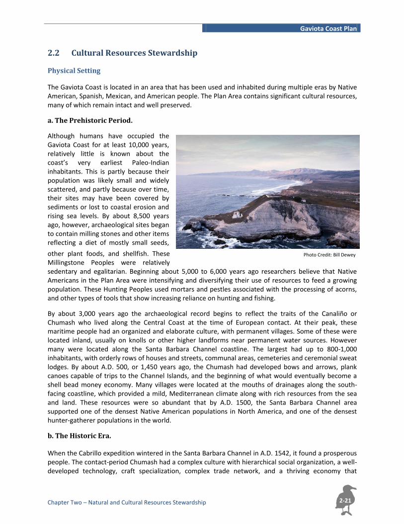
2.2 Cultural Resources Stewardship Physical Setting
The Gaviota Coast is located in an area that has been used and inhabited during multiple eras by Native American, Spanish, Mexican, and American people. The Plan Area contains significant cultural resources, many of which remain intact and well preserved.
a. The Prehistoric Period.
Although humans have occupied the Gaviota Coast for at least 10,000 years, relatively little is known about the coast’s very earliest Paleo-Indian inhabitants. This is partly because their population was likely small and widely scattered, and partly because over time, their sites may have been covered by sediments or lost to coastal erosion and rising sea levels. By about 8,500 years ago, however, archaeological sites began to contain milling stones and other items reflecting a diet of mostly small seeds,
other plant foods, and shellfish. These Millingstone Peoples were relatively sedentary and egalitarian. Beginning about 5,000 to 6,000 years ago researchers believe that Native Americans in the Plan Area were intensifying and diversifying their use of resources to feed a growing population. These Hunting Peoples used mortars and pestles associated with the processing of acorns, and other types of tools that show increasing reliance on hunting and fishing.
By about 3,000 years ago the archaeological record begins to reflect the traits of the Canaliño or Chumash who lived along the Central Coast at the time of European contact. At their peak, these maritime people had an organized and elaborate culture, with permanent villages. Some of these were located inland, usually on knolls or other higher landforms near permanent water sources. However many were located along the Santa Barbara Channel coastline. The largest had up to 800-1,000 inhabitants, with orderly rows of houses and streets, communal areas, cemeteries and ceremonial sweat lodges. By about A.D. 500, or 1,450 years ago, the Chumash had developed bows and arrows, plank canoes capable of trips to the Channel Islands, and the beginning of what would eventually become a shell bead money economy. Many villages were located at the mouths of drainages along the south-facing coastline, which provided a mild, Mediterranean climate along with rich resources from the sea and land. These resources were so abundant that by A.D. 1500, the Santa Barbara Channel area supported one of the densest Native American populations in North America, and one of the densest hunter-gatherer populations in the world.
b. The Historic Era. When the Cabrillo expedition wintered in the Santa Barbara Channel in A.D. 1542, it found a prosperous people. The contact-period Chumash had a complex culture with hierarchical social organization, a well-developed technology, craft specialization, complex trade network, and a thriving economy that
Gaviota Coast Plan
Chapter Two – Natural and Cultural Resources Stewardship
2-22
included use of shell beads as currency. It was not until 227 years later, however, that European settlement of the Santa Barbara Channel area actually began. In fact the name Gaviota, or “seagull” in Spanish, was given to the area in 1769 by soldiers of the overland Portolá expedition whose purpose was to find suitable locations for the Franciscan missions. While none of these missions was located directly within the Plan Area, they had a profound effect on the fate of the Chumash and the history of the Gaviota Coast.
The Plan Area became part of mission lands with the founding of the Mission Santa Barbara in 1786 and Misión La Purísima Concepción De María Santísima in 1787. During the following Mission Period, the missions raised mostly cattle for the marketing of hide and tallow. The missions drew from the Native American population for labor and, as the Chumash were incorporated into the missions in greater and greater numbers, their population decreased dramatically due to European diseases. In the Plan Area, historic resources associated with this period include the remains of agricultural facilities that served the mission’s outlying populations, and harbors and landings used by Spanish, Russian and English traders. The King’s Road, or El Camino Real, was also developed during this time.
Governance of Alta California was taken over from Spain by the Republic of Mexico in 1822. The Mission Period ended in 1834 with the secularization of the missions and the Mexican government’s subsequent granting of large ranchos to locally powerful families. The historic ranchos were used primarily for grazing until the 1870. Their names still feature prominently among the Plan Area’s place names: Punta de la Conception, San Julian, Nuestra Señora del Refugio, Las Cruces, Cañada del Corral and Los Dos Pueblos. The ranchos’ homes and other walled structures from both the Mission Period and subsequent Rancho or Spanish Period were usually constructed of adobe bricks with cobble or quarried stone foundations. Some are still standing, including the Las Cruces Adobe just north of Gaviota Pass, the Orella Adobes at Cañada del Corral, the Pedro Baron Adobe at Arroyo Quemado, the Squat Adobe on Forest Service land near Gaviota and the Pico Adobe, located off of Refugio Road. Others are visible only as mounds of melted adobe or clusters of cobbles and landscape features. Most, however, remain only as long-buried foundations.
In 1848, California became an American territory, and two years later it became the thirty-first state in the Union. The record drought of the early 1860s ruined nearly all the Mexican ranchers, who sold their holdings to Lewis Burton of Santa Barbara, the Dibblee-Cooper-Hollister consortium, and others. The new owners raised sheep and cattle, fruit trees, vegetables, wheat and corn, and developed wharf systems such as Gaviota Landing to ship products out and goods in. The Santa Anita, El Cojo and Sudden ranches are all examples of historic cattle ranches on the Gaviota Coastline. The Edwards Ranch and Naples were both carved from the Los Dos Pueblos grant in the 1880s. Between 1887 and 1901, the railroad gap between Goleta and Santa Margarita was bridged by stagecoach. The Southern Pacific Railroad completed the connecting line in 1901.
The Plan Area experienced steady population and economic growth during the beginning of the 20th century. Agriculture was the main coastal economic activity, and oil development began. In 1897, the Gaviota Rancho, originally part of the Nuestra Señora del Refugio land grant, was sold by the Hollisters to the Alcatraz Company. It would later become the Gaviota Marine Facility. By 1902, crude oil was flowing to the refinery at Alcatraz Landing near Gaviota. By the 1930s, the automobile had replaced the railway as the primary mode of transportation. During World War II, a site near Gato Creek was briefly used as a World War II prisoner of war branch camp for Germans captured in Europe and North Africa. Nearly all physical remains of the facility, with the exception of the Water Tank Tower, were removed in the 1970s. After the war, farming and ranching continued to be the primary economic activity within the Plan Area and the residential population continued to grow, as it does today.

Gaviota Coast Plan
Chapter Two – Natural and Cultural Resources Stewardship
2-23
Artist: Chris Chapman
c. Cultural Resources within the Plan Area. The rich history of the Gaviota Coast Plan area has left behind a number of important cultural resources including buildings and structures, archaeological and historic sites, Traditional Cultural Properties, Tribal Cultural Resources, and Rural Historic Landscapes. The Santa Barbara County Coastal Plan cites the ca. 1850 Vicente Ortega Adobe, located between Goleta and Gaviota in Arroyo Hondo, as “probably the most important site within the coastal zone” (June 2009 Republished edition, p. 142). The Coastal Plan also identifies 10 other resources within the Plan Area. In order from west to east, these are:
Point Conception Lighthouse
Gaviota Landing
Gaviota Pass
Baron Adobe
La Vigia
Vincente Ortega Adobe
Refugio Beach Park
Erro Pepper Tree
Ygnacio Ortega Adobe
Bruno Orella Adobe
El Capitan Beach Park
Dos Pueblos (Historic Site, Cabrillo Anchorage)
Other historic resources in the Plan Area may qualify for historic designation. Examples include the prisoner of war branch camp and the Victorian House on the former Edwards Ranch; ‘Casa Grande’ on Dos Pueblos Ranch; and the ‘Western White House’ on the former Reagan Ranch.
The Plan Area contains one California State Historical Landmark, the Gaviota Pass. In addition, the Santa Barbara County Historical Landmarks Advisory Commission (HLAC) has designated two Plan Area resources as County Landmarks and two as Structures of Historical Merit. Designation as a Landmark recognizes the building or site at a high level of historic, aesthetic or cultural significance. A designated Landmark is preserved and protected by conditions restricting its demolition, removal, alteration or use. Plans for alterations to Landmarks are reviewed by the HLAC. Designation as a Structure or Place of Historic Merit officially
recognizes the building or site as having historic, aesthetic or cultural value, but does not restrict demolition, removal, alteration or use. The designated County Landmarks are the Orella Adobe and the Las Cruces Adobe. The Vista del Mar School and the Point Conception Lighthouse are both Structures of Merit.
Gaviota Coast Plan
Chapter Two – Natural and Cultural Resources Stewardship
2-24
In addition to these historic resources, prehistoric archaeological sites are recorded in the Plan Area. These range from the remains of small, limited activity areas to large villages inhabited by hundreds of individuals over many years.
Other types of cultural resources that may be present within the Plan Area include Tribal Cultural Resources, Traditional Cultural Properties, and Rural Historic Landscapes. Tribal Cultural Resources are those which have cultural value to a California Native American tribe and meet specific criteria defined in CEQA. Traditional Cultural Properties are important due to their association with cultural practices or spiritual beliefs of a living community, including but not limited to Native American communities. A Rural Historic Landscape is a defined geographic area that historically has been used by people, or shaped or modified by human activity, and that possesses thematic linkage in areas such as land use, vegetation, buildings and structures, roads and waterways, and natural features.
Regulatory Setting The treatment of cultural resources within the Plan Area is subject to a number of laws, regulations, guidelines and policies designed to protect significant cultural resources including Coastal Act Section 30244 which states: “Where development would adversely impact archaeological or paleontological resources as identified by the State Historic Preservation Officer, reasonable mitigation measures shall be required.” Additional California statutes intended to protect significant cultural resources include: Codes Governing Human Remains, Santa Barbara County Code, and the County’s Comprehensive Plan. At a broad level, these all require resource inventory, resource evaluation, and avoidance or, if avoidance is not feasible, mitigation of impacts to significant cultural resources along with consultation with Native Americans where appropriate.
Local Regulation and Policies
At the local level, the County of Santa Barbara requires protection of archaeological and historical resources to the greatest extent feasible. The County Coastal Zoning Ordinances have the following standards for the Coastal Zone and the Inland Area:
A. Coastal Zone and Inland area requirements. 1. Development proposed on a lot where archaeological or other cultural sites are located shall
be designed to avoid impacts to the cultural sites if possible.
2. When sufficient planning flexibility does not permit avoiding construction on an
archaeological or other cultural site, adequate mitigation shall be required. Mitigation shall
be designed in compliance with the guidelines of the State Office of Historic Preservation and
the State of California Native American Heritage Commission.
3. Native Americans shall be consulted when development proposals are submitted that impact significant archaeological or cultural sites.
B. Inland area requirements. All available measures, including purchase of the site, tax relief,
purchase of development rights, etc., shall be explored to avoid development on significant
historic, prehistoric, archaeological and other classes of cultural sites.
The Land Use Element (Historical and Archaeology Sites Policy 4) and the Coastal Land Use Plan (Policy 10-4) contain the same policy requirements, also adding, “Off-road vehicle use, unauthorized collection
Gaviota Coast Plan
Chapter Two – Natural and Cultural Resources Stewardship
2-25
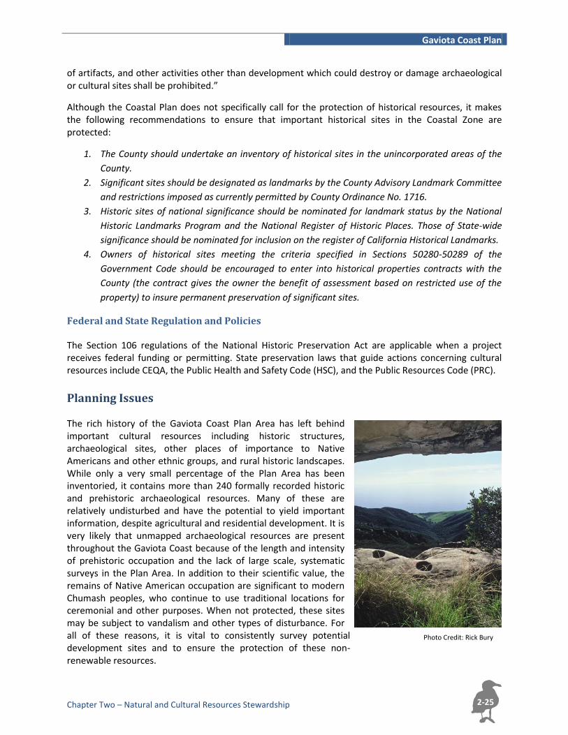
Photo Credit: Rick Bury
of artifacts, and other activities other than development which could destroy or damage archaeological or cultural sites shall be prohibited.”
Although the Coastal Plan does not specifically call for the protection of historical resources, it makes the following recommendations to ensure that important historical sites in the Coastal Zone are protected:
1. The County should undertake an inventory of historical sites in the unincorporated areas of the
County.
2. Significant sites should be designated as landmarks by the County Advisory Landmark Committee
and restrictions imposed as currently permitted by County Ordinance No. 1716.
3. Historic sites of national significance should be nominated for landmark status by the National
Historic Landmarks Program and the National Register of Historic Places. Those of State-wide
significance should be nominated for inclusion on the register of California Historical Landmarks.
4. Owners of historical sites meeting the criteria specified in Sections 50280-50289 of the
Government Code should be encouraged to enter into historical properties contracts with the
County (the contract gives the owner the benefit of assessment based on restricted use of the
property) to insure permanent preservation of significant sites.
Federal and State Regulation and Policies The Section 106 regulations of the National Historic Preservation Act are applicable when a project receives federal funding or permitting. State preservation laws that guide actions concerning cultural resources include CEQA, the Public Health and Safety Code (HSC), and the Public Resources Code (PRC).
Planning Issues The rich history of the Gaviota Coast Plan Area has left behind important cultural resources including historic structures, archaeological sites, other places of importance to Native Americans and other ethnic groups, and rural historic landscapes. While only a very small percentage of the Plan Area has been inventoried, it contains more than 240 formally recorded historic and prehistoric archaeological resources. Many of these are relatively undisturbed and have the potential to yield important information, despite agricultural and residential development. It is very likely that unmapped archaeological resources are present throughout the Gaviota Coast because of the length and intensity of prehistoric occupation and the lack of large scale, systematic surveys in the Plan Area. In addition to their scientific value, the remains of Native American occupation are significant to modern Chumash peoples, who continue to use traditional locations for ceremonial and other purposes. When not protected, these sites may be subject to vandalism and other types of disturbance. For all of these reasons, it is vital to consistently survey potential development sites and to ensure the protection of these non-renewable resources.
Gaviota Coast Plan
Chapter Two – Natural and Cultural Resources Stewardship
2-26
Policies and Implementation
a. Cultural Resources Stewardship Policies
Policy CS-1: Cultural Resources Preservation & Protection. Preserve and protect significant cultural, archaeological and historical resources to the maximum extent feasible.
Policy CS-2: Properties of Concern. Significant cultural resources including historic structures, Rural Historic Landscapes, archaeological sites, Traditional Cultural Properties, and Tribal Cultural Resources shall be protected and preserved to the maximum extent feasible.
Policy CS-3: Cultural Resources Education. The County shall encourage and support measures to educate residents and visitors about the Gaviota Coast’s cultural resources.
b. Cultural Resources Stewardship Implementing Actions
Action CS-1: Landmarking Buildings, Structures & Places. The County and the community should continue to work with willing landowners to identify buildings, structures, and places, including Rural Historic Landscapes, Traditional Cultural Properties, and Tribal Cultural Resources that qualify for listing as a County Landmark or Place of Historical Merit and forward these nominations to the County Historic Landmarks Advisory Commission (HLAC).
Action CS-2: New Development and Rehabilitation Projects. Development resulting in increased building size or demolition of buildings/structures included in a list of historic resources, or buildings and structures over 50 years of age and evaluated as significant at the local, state, or national level, shall be reviewed by Planning & Development for consistency with historic resource preservation policies.
Action CS-3: Community Cultural Center. The County and Gaviota Coast residents shall investigate, consider and pursue options to develop a community cultural center and/or other community cultural research and education opportunities including Native American culture.
Action CS-4: Native American Consultation. The County shall continue its consultations with the tribes identified by the Native American Heritage Commission (NAHC) pursuant to Assembly Bill 52 and Senate Bill 18 to ensure that cultural resources of concern to Native Americans are identified and taken into account in future development planning.
Action CS-5: Confidential Site Locations. The County shall maintain as confidential information about the location of prehistoric cultural resources, including Traditional Cultural Properties and Tribal Cultural Resources.
Action CS-6: Tribal Access. The County, Native American representatives and willing landowners should work together to ensure appropriate tribal access to Traditional Cultural Properties and Tribal Cultural Resources, while still respecting the rights and privileges of property owners.
c. Cultural Resources Stewardship Development Standards
Dev Std CS-1: Phase 1 Archaeological Surveys. A Phase 1 archaeological survey shall be performed when identified as necessary by a County archaeologist or contract archaeologist. The survey shall include all areas of the project that would result in ground disturbance. The content, format, and length of the Phase 1 survey report shall be consistent with the nature and size of the project and findings of the survey.
Gaviota Coast Plan
Chapter Two – Natural and Cultural Resources Stewardship
2-27
Dev Std CS-2: Phase 2 and 3 Archaeological Studies. If archaeological remains are identified and cannot be avoided through project redesign, the proponent shall fund a Phase 2 study to determine the significance of the resource prior to issuance of any permit for development. All feasible mitigation recommendations resulting from the Phase 1 or Phase 2 work, including completion of additional archaeological analysis (Phase 3) and/or project redesign shall be incorporated into any permit issued for development.
Dev Std CS-3: Identification of Traditional Cultural, Historical, and Spiritual Sites. Native Americans shall be consulted when development proposals are submitted that impact significant archaeological or cultural sites. Cultural sites may include Traditional Cultural Properties and Tribal Cultural Resources, as identified through consultation with Native Americans.
Dev Std CS-4: Native American Contact List. When existing documentation or a Phase 1 survey indicates that significant prehistoric cultural resources may be affected by a proposed project, the County shall obtain a Native American Contact List from the NAHC and consult with Native Americans in accordance with Assembly Bill 52 during each stage of cultural resources review.
Dev Std CS-5: Integrity of Historic Resources. No permits shall be issued for any development or activity that would adversely affect the integrity of officially designated County Landmarks and Places of Historical Merit or those eligible for such designation, historical resources eligible for the California Register of Historical Resources, or identified historical resources unless a professional evaluation of the proposed project has been performed by a qualified Architectural Historian pursuant to the County’s most current Regulations Governing Archaeological and Historical Projects. All such professional studies shall be reviewed and approved by the HLAC and Planning and Development and all feasible mitigation measures shall be incorporated into any permit issued for development.
Dev Std CS-6: Historical Resources Studies. A Phase 1, and if required Phase 2, historical resources investigation and report shall be completed when identified as necessary by the Director of Planning and Development. The investigation shall include areas of the project that could result in direct or indirect impacts to historic-age buildings, structures, rural historic landscapes, or districts or that could change the integrity of the setting and context for such resources on adjacent parcels. The content, format, and length of the Phase 1, and if required Phase 2, historic report shall be consistent with the nature and size of the project and findings of the investigation. The investigation shall be performed by a qualified Architectural Historian pursuant to the County’s most current regulations governing archaeological and historical projects. All such professional studies shall be reviewed by the HLAC and approved by the Planning and Development. All feasible recommendations resulting from the Phase 1, and if required Phase 2, shall be incorporated into any permit approved for development.

Gaviota Coast Plan
Chapter Two – Natural and Cultural Resources Stewardship
2-28
Page Intentionally Left Blank