Embed Size (px)
Citation preview

Upper San Joaquin River Basin 2-1 Initial Alternatives Information Report Storage Investigation June 2005
CHAPTER 2. RELATED STUDIES, PROJECTS, AND PROGRAMS
This chapter describes related activities of various Federal and State agencies and numerous local working groups and private organizations in the study area. Many of these entities, including Reclamation, DWR, and several local entities, are performing current studies, projects, and programs that are important to the Investigation.
RECLAMATION PROGRAMS AND STUDIES
As the owner and operator of Friant Dam and Millerton Lake, and various related components of the CVP in the study area, actions by Reclamation have a significant effect on environmental resources in the region. Ongoing projects, continuing programs, and prior studies relevant to the primary study area are described below.
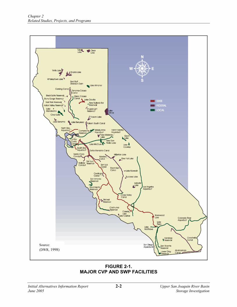
Central Valley Project Operations Friant Dam and Millerton Lake are key elements of the CVP. President Franklin Roosevelt approved the CVP, including the Kennett (Shasta), Friant, and Contra Costa (Delta) divisions, on December 2, 1935. The CVP is the largest surface water storage and delivery system in California, with a geographic area covering 35 of the State’s 58 counties. The project includes 20 reservoirs with a combined storage capacity of approximately 11 million acre-feet (MAF); 8 powerhouses and 2 pump-generating plants, with a combined generation capacity of approximately 2 million kilowatts (kW); and approximately 500 miles of major canals and aqueducts. The CVP supplies water to more than 250 long-term water contractors in the Central Valley, the Santa Clara Valley, and the San Francisco Bay Area. Figure 2-1 shows the locations of major CVP facilities, rivers that are controlled or affected by the operation of CVP facilities, and the CVP service area. The CVP has the potential to supply about 7 MAF annually to agricultural and municipal and industrial (M&I) customers and for environmental purposes. Approximately 90 percent of CVP water is delivered to agricultural users, including prior water rights holders. Friant Dam regulates an average annual inflow of about 1.8 MAF and delivers about 1.4 MAF of water annually on average to water users in the eastern San Joaquin Valley.
Operating Divisions CVP operations are divided into eight divisions. Operations north of the Delta include the Trinity, Shasta, and Sacramento River divisions, known collectively as the Northern CVP System. Those south of the Delta, and the Delta, West San Joaquin, and San Felipe divisions, are known collectively as the Southern CVP System. Both the Eastside and Friant divisions are operated independently of the remainder of the CVP due to the nature of their water supplies and service areas. The Northern and Southern CVP Systems are operated as an integrated system, and demands for water and power can be met by releases from any one of several facilities. Demands in the Delta and south of the Delta can be met by exporting excess water in the Delta, which can result from releases from northern CVP reservoirs. Operational decisions are based on a number of physical and hydrological factors that change depending on conditions.
Chapter 2 Related Studies, Projects, and Programs
Initial Alternatives Information Report 2-2 Upper San Joaquin River Basin June 2005 Storage Investigation
FIGURE 2-1. MAJOR CVP AND SWP FACILITIES
Source: (DWR, 1998)

Chapter 2 Related Studies, Projects, and Programs
Upper San Joaquin River Basin 2-3 Initial Alternatives Information Report Storage Investigation June 2005
CVP Water Users During development of the CVP, the United States entered into two types of long-term agreements with many major water rights holders: the Sacramento River Settlement Contractors, and San Joaquin River Exchange Contractors.
Members of the Sacramento River Settlement Contractors primarily claim water rights on the Sacramento River. Because of the significant influence of Shasta Dam operations on flows in the Sacramento River, these water rights claimants entered into contracts with Reclamation. Most of the agreements established the quantities of water the contractors are allowed to divert from April through October without payment to Reclamation, and a supplemental CVP supply allocated by Reclamation.
The San Joaquin River Exchange Contractors are contractors who receive CVP water from the Delta via the Mendota Pool. Under exchange contracts, the parties agreed not to exercise their San Joaquin River water rights in exchange for a substitute CVP water supply from the Delta. These exchanges allow water to be diverted from the San Joaquin River at Friant Dam for use by water service contractors in the eastern San Joaquin Valley and Tulare Lake basin.
CVP water service contracts were developed with water users in the Central Valley for irrigation and M&I water supplies. For most water users, water service contracts represent a supply supplemental to local sources, including groundwater. In the Friant Division, a two-class contract structure was established to facilitate regional conjunctive water management. Friant Division contracts are described in Chapter 3.
Operational Influences CVP operations are influenced by general operating rules, regulatory requirements, and facility-specific requirements. A complex set of rules, regulations, and policies affect the integrated operation of CVP north-of-Delta (NOD) and SOD facilities. Inflow and release requirements are the principal elements influencing reservoir storage. Operational decisions often consider not only conditions at individual reservoirs, but also downstream flow conditions and conditions at other project reservoirs. SOD storage space that only can be filled with water exported from the Delta is a major operational consideration involving the geographic distribution of water in storage. Other factors that influence the operation of CVP reservoirs include flood control requirements, carryover storage objectives, lake recreation, power production capabilities, coldwater reserves, and pumping costs.
Rivers below some CVP dams support both resident and anadromous fisheries and recreation. While resident fisheries are slightly affected by release fluctuations, anadromous fisheries (e.g., salmon and steelhead) are the most sensitive and are present year-round downstream of some CVP facilities. Maintaining water conditions favorable to spawning, incubation, rearing, and out-migration of juvenile anadromous fish is one of the main objectives of CVP operations. CVP operations are coordinated to anticipate and avoid streamflow fluctuations during spawning and incubation whenever possible.
Operation of CVP NOD and SOD facilities is affected by several regulatory requirements and agreements. Prior to passage of the Central Valley Project Improvement Act (CVPIA), operation of the CVP was affected by State Water Resources Control Board (SWRCB) Decisions 1422 and 1485 (D-1422 and D-1485), and the Coordinated Operations Agreement (COA). D-1422 and

Chapter 2 Related Studies, Projects, and Programs
Initial Alternatives Information Report 2-4 Upper San Joaquin River Basin June 2005 Storage Investigation
D-1485 identify minimum flow and water quality conditions at specified locations that are to be maintained in part through operation of the CVP. COA specifies responsibilities shared by the CVP and California’s State Water Project (SWP) for meeting the requirements of D-1485. In December 1994, representatives of the Federal and State governments and urban, agricultural, and environmental interests agreed to implement a Bay-Delta protection plan through the SWRCB that would protect the ecosystem of the Bay-Delta Estuary. The Bay-Delta Water Quality Control Plan (WQCP), released in May 1995, superseded D-1485.
D-1422, the water rights decision for operation of New Melones Reservoir on the Stanislaus River, requires that some of the water supply developed at New Melones be managed to maintain water quality conditions in the San Joaquin River at Vernalis. The Bay-Delta Water Control Plan specifies salinity levels at Vernalis for irrigation and non-irrigation periods.
Operation of the Friant Division is more straightforward than for many other portions of the CVP. Friant Dam is operated as an annual reservoir, meaning all water supplies available in a given year are allocated with the expectation of delivery. River releases are made to satisfy downstream water rights and contract diversions. Specific releases are not made to the San Joaquin River to maintain fishery conditions downstream of Friant Dam. Consequently, Millerton Lake is not managed for water temperature or to provide carryover to subsequent years. The operations of Friant Dam are described in greater detail in Chapter 3.
Prior Studies of Enlarging Friant Dam Several previous studies examined the potential to provide new water storage at Millerton Lake. In 1952, 10 years after completion of Friant Dam, Reclamation conducted a study to determine the feasibility of raising Friant Dam. The study included designs and costs for raising Friant Dam by 60 feet and constructing four earth saddle dams. Based on a comparison of costs to potential revenue from the sale of increased yield, the study concluded that the raise would be infeasible.
Reclamation revisited the potential cost for a 60-foot raise at a reconnaissance level in 1975, and developed a cost estimate for an approximate 140-foot raise in 1982. In 1997, Reclamation reconsidered the feasibility of raising Friant Dam to provide additional storage capacity in Millerton Lake. Raises of 60 feet and 140 feet were considered. In 2000, a study conducted for the Friant Water Users Authority (FWUA) and Natural Resources Defense Council (NRDC) coalition considered a 20-foot raise of Friant Dam as one of many alternatives for increasing potential water supply to the San Joaquin River (URS).
Central Valley Project Improvement Act The CVPIA was signed into law in October 1992 as Title 34 of PL 102-575. The CVPIA was developed to address conflicts over water rates, irrigation land limitations, and environmental impacts of the CVP. This legislation mandates changes in management of the CVP, particularly for protection, restoration, and enhancement of fish and wildlife. The CVPIA also addresses the operational flexibility of the CVP and methods to expand the use of voluntary water transfers and improved water conservation. The general purposes of the CVPIA, as identified by Congress in Section 3402, include the following:

Chapter 2 Related Studies, Projects, and Programs
Upper San Joaquin River Basin 2-5 Initial Alternatives Information Report Storage Investigation June 2005
• Protect, restore, and enhance fish, wildlife, and associated habitats in the Central Valley and Trinity River basins of California.
• Address impacts of the CVP on fish, wildlife, and associated habitats.
• Improve the operational flexibility of the CVP.
• Increase water-related benefits provided by the CVP to the State of California through expanded use of voluntary water transfers and improved water conservation.
• Contribute to the State of California’s interim and long-term efforts to protect the Bay-Delta.
• Achieve a reasonable balance among competing demands for CVP water, including water requirements for fish and wildlife, agriculture, M&I, and power contractors.
The CVPIA redefined the purposes of the CVP to include protection, restoration, and enhancement of fish, wildlife, and associated habitats and protection of the Bay-Delta at equal priority with other purposes. It identified numerous measures and programs to meet the new project purpose and directed the Secretary to operate the CVP consistent with these purposes.
One of the effects of the CVPIA was the dedication of project yield for fish and wildlife purposes. The combined total amount of water dedicated to the environment by the CVPIA suggests an annual amount of up to 1.2 MAF. This includes reallocation of the 800 thousand acre-feet (TAF) required by Section 3406 (b)(2) of the CVPIA (commonly called (b)(2) water), dedicated deliveries to wildlife refuges of about 250 TAF (called Level 2 Refuge water), and increased flows in the Trinity River, which result in a reduction in imports to the Sacramento Valley of about 150 TAF annually.
Implementation of Section 3406 (b)(2) has been a contentious process, marked by conflict between Federal and State parties, and substantial litigation. The primary dispute has been whether (b)(2) water translates into an automatic reduction in exports under water supply contracts. In May 2003, Reclamation released a final decision on implementation of Section 3406 (b)(2). The intent of the decision was to simplify and clarify the accounting process for (b)(2) water uses and to integrate (b)(2) water dedication and management with CVP operations for other CVP purposes. The decision is divided into sections that address calculations of yield, accounting processes, modifications of CVP operations, water banking and transfers/exchanges of water, water to meet obligations of the 1995 Bay-Delta WQCP and Federal Endangered Species Act (ESA) of 1978, shortage criteria, and coordination.
A primary feature of the CVPIA is the fish, wildlife, and habitat restoration provisions included in Section 3406. One provision requires the Secretary to develop a comprehensive plan that is reasonable, prudent, and feasible to address fish, wildlife, and habitat concerns on the San Joaquin River. The concerns include, but are not limited to, the streamflow, channel, riparian habitat, and water quality improvements that would be needed to reestablish, where necessary, and to sustain naturally reproducing anadromous fisheries in the San Joaquin River from Friant Dam to the Delta. During the time the Secretary is developing such a restoration plan, and until Congress has authorized the Secretary to implement the plan, the Secretary shall not make releases for the restoration of flows between Gravelly Ford and the Mendota Pool for purposes of implementing the CVPIA. Following completion of a restoration plan, the Secretary shall not thereafter make releases from Friant Dam as a measure to implement the CVPIA without a specific Act of Congress authorizing such releases.

Chapter 2 Related Studies, Projects, and Programs
Initial Alternatives Information Report 2-6 Upper San Joaquin River Basin June 2005 Storage Investigation
The CVPIA established a Restoration Fund based on the application of surcharges on the project-wide sales of water and power to provide funding for required restoration actions. The CVPIA also established an additional surcharge in lieu of a requirement to release water from Friant Dam for CVPIA purposes. The Friant surcharge will be in place until such time as flows of sufficient quantity, quality, and timing are provided at and below Gravelly Ford to meet the anadromous fishery needs identified in the San Joaquin River restoration plan, if any.
CVP Water Supply Improvement Plan Section 3408 (j) of the CVPIA authorized the Secretary to prepare a plan to increase the yield of the CVP. This section directs the Secretary to develop a least-cost plan to increase the yield of the CVP equal to the amount dedicated to fish and wildlife purposes by the CVPIA. This plan also was intended to assist the State in meeting its future water needs. Further, appropriate cost-sharing arrangements to implement the CVP Water Supply Improvement Plan were to be recommended. One goal of the plan is to minimize the impacts of the CVPIA on existing CVP Water Service Contractors.
In 1995, Reclamation, in conjunction with the United States Fish and Wildlife Service (USFWS) on behalf of the Department of the Interior, developed and submitted the Least-Cost CVP Yield Increase Plan to Congress, as required by 3408(j). The plan broadly defined least-cost as a plan in which all reasonable options, including supply increase and demand reduction, are assessed against an array of cost and impact considerations. Cost and supply estimates for a wide variety of new water supply and management options were identified, including groundwater storage, land fallowing, conservation and reuse, surface water storage, conveyance, and others. The 1995 report concluded a need exists for “a refined set of options that serve to mitigate any adverse impacts… and that are available at the time of authorization [of the Yield Increase Plan].” The plan did not propose a specific CVP yield increase. An update to the 1995 plan is in progress and will address the loss of system flexibility and reduced water supply reliability as a result of the CVPIA, and actions to assist the State of California in meeting future water needs.
CVPIA Contract Renewal Process In accordance with Section 3404(c) of the CVPIA, Reclamation is negotiating the renewal of long-term water service contracts. It is anticipated that as many as 109 CVP water service contracts in the Central Valley may be renewed at the conclusion of the negotiation process.
Operations Criteria and Plan In March 2004, Reclamation and DWR prepared a Long-Term CVP and SWP Operations Criteria and Plan (OCAP) to address how the CVP and SWP would be operated in the future as several proposed projects come on-line and as water demands increase. The March 2004 document is a revision of the previous 1992 OCAP release. It incorporates numerous additional constraints and criteria that have arisen since 1992. Incorporations include the 2000 Trinity ROD, Anadromous Fish Restoration Program (AFRP) flow objectives, 1993 Winter Run Biological Opinion (BO), revised decision on CVPIA Section 3406(b)(2) water, Environmental Water Account (EWA), and Joint Point of Diversion (JPOD).

Chapter 2 Related Studies, Projects, and Programs
Upper San Joaquin River Basin 2-7 Initial Alternatives Information Report Storage Investigation June 2005
San Luis Drainage Feature Reevaluation In response to a February 2000 U.S. Court of Appeals court order, Reclamation is reevaluating options for providing drainage service to the San Luis Unit. The San Luis Drainage Feature Reevaluation will allow Reclamation to formulate and implement a plan which provides agricultural drainage service to the San Luis Unit and the general area (of which lands served by the San Luis Unit are a part) that achieves long-term, sustainable salt and water balance in the root zone of irrigated lands. Drainage service is defined as managing the regional shallow groundwater table by collecting and disposing of shallow groundwater from the root zone and/or reducing contributions of water to the shallow groundwater table through land retirement. Proposed drainage service alternatives will be selected on the basis of criteria adopted to maintain environmental quality and provide for continued agricultural production in a manner consistent with a Plan of Action filed April 18, 2001, in Sumner Peck Ranch, Inc., et al., v. Reclamation, et al. The Reevaluation is being conducted pursuant to PL 86-488, which authorized the San Luis Unit. A Notice of Intent (NOI) to prepare an EIS, pursuant to the National Environmental Policy Act (NEPA), was published in the Federal Register October 2, 2001.
Millerton Lake Resource Management Plan and General Plan Reclamation is preparing a Millerton Lake Resource Management Plan (RMP) and associated PEIS to establish management objectives, guidelines, and actions to protect water quality, and natural and cultural resources, and to provide recreational opportunities and facilities. Alternatives currently under consideration emphasize more passive recreation opportunities upstream of Fine Gold Creek, while emphasizing more intensive recreation activities downstream of Fine Gold Creek. The alternative selected in the Final EIS will serve as the framework for negotiating a management agreement with the managing partner and provide guidance for resource management and recreation on lands managed by the United States department of the Interior, Bureau of Land Management (BLM), in the San Joaquin River Gorge Management Area. Relevant information developed in this planning effort regarding resources and recreational opportunities and impacts in the areas around and upstream of Millerton Lake will be used in the Investigation.
San Joaquin River Riparian Habitat Restoration Program The purpose of the San Joaquin River Riparian Habitat Restoration Program is to improve riverine and riparian conditions along the San Joaquin River between Friant Dam and the confluence of the Merced River. Specific objectives of the program include developing and implementing activities that would provide or develop information relevant for restoring a continuous riparian corridor along the reach and implementing specific riparian habitat restoration projects. Reclamation undertook this project to support river restoration efforts that are required under Section 3406(c)(1) of the CVPIA, development of a San Joaquin River Comprehensive Plan. Relevant studies and investigations conducted since the inception of this program will be considered by the Investigation.

Chapter 2 Related Studies, Projects, and Programs
Initial Alternatives Information Report 2-8 Upper San Joaquin River Basin June 2005 Storage Investigation
Environmental Water Account (Short-Term EWA) The Environmental Water Account (EWA) was established in the CALFED ROD. The purpose of EWA is to protect at-risk fish species of the Bay-Delta through beneficial operational changes to CVP and SWP operations at no uncompensated water cost to CVP and SWP water users. Reclamation is an EWA Project Agency, having the responsibility of acquiring, storing, managing, and conveying water assets of the EWA and implementing the operational changes recommended by the EWA Management Agencies, which include USFWS, National Marine Fisheries Service (NMFS), and DFG. Reclamation shares this responsibility with DWR, also an EWA Project Agency. More detailed information about the EWA is provided later in this chapter under the CALFED Bay-Delta Program section.
BUREAU OF LAND MANAGEMENT
San Joaquin River Gorge Management Area The BLM San Joaquin River Gorge Management Area straddles the San Joaquin River just upstream from Millerton Lake State Recreation Area State Recreation Area (SRA) and includes lands in both Fresno and Madera counties. BLM management areas are intended to sustain the health, diversity, and productivity of public lands for the use and enjoyment of present and future generations. Several thousand acres of public land are available for public use through access to San Joaquin River Gorge trail. When completed, the San Joaquin River Gorge Trail will allow continuous passage from Friant Dam to the Pacific Crest Trail near Devils Postpile National Monument.
UNITED STATES FOREST SERVICE
Sierra National Forest The United States Forest Service (USFS) manages much of the land in the upper San Joaquin River watershed as part of the Sierra National Forest (SNF). In 1992, USFS developed the Sierra National Forest Land and Resources Management Plan to develop a fully integrated mix of management practices that provide for use and protection of forest resources, satisfy guiding legislation, and address local, regional, and national issues. The plan directs forest management for producing goods and services to maximize long-term net public benefit in an environmentally sound manner.
The Final Environmental Impact Statement (FEIS) for the Sierra National Forest Plan Amendment, issued in January 2001, proposes the establishment of management direction to address five problem areas in the Sierra Nevada region: old forest ecosystems and associated species; aquatic, riparian, and meadow ecosystems and associated species; fire and fuels; noxious weeds; and lower westside hardwood forest ecosystems (USFS, 2001).
The Backbone Creek Research Natural Area (RNA) was established in 1971 within the SNF to be preserved and protected in perpetuity. The Backbone Creek RNA may be used only for non-manipulative research and education, protected against activities that directly or indirectly modify ecological processes (USFS, 2004).

Chapter 2 Related Studies, Projects, and Programs
Upper San Joaquin River Basin 2-9 Initial Alternatives Information Report Storage Investigation June 2005
UNITED STATES GEOLOGICAL SURVEY
National Water Quality Assessment Program As part of the National Water Quality Assessment (NAWQA) program initiated by the United States Geological Survey (USGS) in 1991, the San Joaquin-Tulare basins study unit was a part of the first decadal cycle of investigations into the quality of water resources to establish existing water quality conditions of streams and aquifers across the nation. Long-term goals of the NAWQA program are to assess the status of and trends in the quality of freshwater streams and aquifers, and to provide a sound understanding of the natural and human factors that affect the quality of these resources. NAWQA again will intensively investigate the quality of water resources in the San Joaquin-Tulare basins, as part of the second 10-year cycle of the program. While long-term goals remain the same, the emphasis of these renewed investigations will shift from status of water quality to trends in water quality and understanding of natural and anthropogenic factors affecting water quality.
STATE OF CALIFORNIA DEPARTMENT OF WATER RESOURCES
State Water Project The SWP was authorized in 1959 and designated to readjust geographical imbalances between California’s water resources and water needs. The project extends from Plumas County in the north to Riverside County in the south. Completed project elements include 23 dams and reservoirs, 6 powerhouses, 17 pumping plants, and 533 miles of aqueduct. The principal storage feature of the SWP is Lake Oroville, with a gross pool capacity of 3.5 MAF. Lake Oroville is located on the Feather River about 4 miles northeast of Oroville. Water released from Oroville Dam flows though the Feather and Sacramento rivers to reach the Delta. The SWP delivers water to service areas in the Feather River basin, San Francisco Bay area, central coast, San Joaquin Valley, Tulare basin, and Southern California. Major SWP conveyance facilities in the Central Valley include the North Bay, South Bay, and California aqueducts. The North Bay Aqueduct diverts water from the north Delta near Cache Slough for agricultural and M&I use in Napa and Solano counties. The South Bay and California aqueducts carry water from the Delta to the San Francisco Bay area and to Southern California, respectively. In the southern portion of the Delta, the Harvey O. Banks Delta Pumping Plant lifts water into the California Aqueduct from the Clifton Court Forebay. At 444 miles, the California Aqueduct is the State's largest and longest water conveyance system, beginning at Banks Pumping Plant and extending to Lake Perris, south of Riverside in Southern California. Figure 2-1 shows major SWP facilities.
The SWP has contracted a total of 4.23 MAF for average annual delivery in the San Joaquin River, central coast, and San Francisco and south coast areas. Of this amount, about 2.5 MAF is designated for the Southern California Transfer Area, nearly 1.36 MAF for the San Joaquin Valley, and 370 TAF for San Francisco Bay, the central coast, and Feather River areas. SWP contracts involve the Feather River Settlement Contractors and SWP Contract Entitlements. The Feather River Settlement Contractors are water users who hold riparian and senior appropriative rights on the Feather River. SWP Contract Entitlements are contracts executed in the early 1960s that established the maximum annual water amount (entitlement) that each long-term contractor may request from the SWP.

Chapter 2 Related Studies, Projects, and Programs
Initial Alternatives Information Report 2-10 Upper San Joaquin River Basin June 2005 Storage Investigation
California Water Plan In 1957, DWR published Bulletin 3, The California Water Plan, a comprehensive plan to guide and coordinate beneficial use of California’s water resources. Bulletin 3 became the foundation for a series of water plan updates, now known as the Bulletin 160 series. The Bulletin 160 series assesses California’s agricultural, environmental, and urban water needs and evaluates water supplies to quantify the gap between future water demands and supplies. Seven updates of the plan were published between 1966 and 1998.
DWR, through a highly collaborative process, is currently completing the latest update, Bulletin 160-05. California Water Plan Update 2005 addresses the State’s changing water management and better reflects the roles of the State and federal governments and the growing role of regional and local agencies in California water management. The update goes beyond a forecast of statewide water demand and supply. It will include a strategic plan with goals, recommendations, and actions for meeting the challenges of sustainable water use through the year 2030.
Two key initiatives outline the ways the foundational actions will be achieved. The first is to implement integrated regional water management, which is a comprehensive, systems approach for determining the appropriate mix of demand and supply management options that provide long-term, reliable water supply at lowest reasonable cost and with highest possible benefits to customers, economic development, environmental quality, and other social objectives. The second initiative is to improve statewide water management systems. California depends on vast statewide water management systems to provide clean and reliable water supplies, protect lives and property from flood, withstand drought, and sustain environmental values. To improve the efficiency and flexibility of our water systems, water facilities must be maintained and improved.
The Investigation will contribute to both initiatives by evaluating opportunities that can enhance regional objectives and contribute to statewide system flexibility. Consistent with the Water Plan Update, DWR will consider how Investigation alternatives can contribute to broad regional water management issues and an Integrated Regional Water Management Plan.
San Joaquin River Management Program Assembly Bill 3603 authorized the San Joaquin River Management Program (SJRMP) in 1990. SJRMP has served as a regional forum in the San Joaquin basin for local agencies, environmental groups, agriculture, business, industry, recreation, and other interests and landowners to work directly with Federal and State agencies to identify, discuss, plan, and support projects and programs that address water quality, water supply, flood protection, fisheries, recreation, and wildlife in the San Joaquin River system. The SJRMP (1995) describes and recommends specific projects, studies, and acquisitions that will help revive the San Joaquin River system.
Conjunctive Water Management Program DWR's Conjunctive Water Management Program is working with local water agencies and stakeholders throughout the State, including the San Joaquin Valley, to develop partnerships and provide assistance for planning and developing locally controlled and managed conjunctive use programs and projects. Project proposals to be pursued by these local agencies may be considered in the Investigation or in the without-project conditions.

Chapter 2 Related Studies, Projects, and Programs
Upper San Joaquin River Basin 2-11 Initial Alternatives Information Report Storage Investigation June 2005
CALIFORNIA DEPARTMENT OF PARKS AND RECREATION
Millerton Lake State Recreation Area California Department of Parks and Recreation (CDPR) manages the Millerton Lake SRA, which includes Millerton Lake and adjacent lands, under an operating agreement with Reclamation for recreation, preservation of biological diversity, and protection of natural and cultural resources.
The Millerton Lake SRA offers interpretive programs for wildlife viewing, tours of the historic Millerton County Courthouse, tours of a fish hatchery downstream of Friant Dam, and various campfire programs in addition to high-quality recreational opportunities. The SRA is one of the most popular recreation areas in the San Joaquin Valley.
CENTRAL VALLEY REGIONAL WATER QUALITY CONTROL BOARD
Conditional Waiver of Waste Discharge Requirements for Irrigated Lands Growers with irrigated lands who discharge waste that can degrade surface water quality must now select one of three options to obtain regulatory coverage under the Water Code:
• Elect to join a Coalition Group approved by the Central Valley Regional Water Quality Control Board (RWQCB)
• File for an Individual Discharger Conditional Waiver
• File a Report of Waste Discharge for the purpose of receiving Waste Discharge Requirements, if appropriate
Impaired Waterbodies 303(d) List and TMDLs In 2002, the United States Environmental Protection Agency (USEPA) approved the Central Valley RWQCB’s 2002 303(d) list for portions of the San Joaquin River downstream of Friant Dam that do not meet, or are not expected to meet water quality standards, or are considered impaired. The Clean Water Act further requires development of a total maximum daily load (TMDL) for each listing.
The Central Valley RWQCB is developing TMDLs and amendments to the Sacramento River and San Joaquin River basins WQCP for portions of the San Joaquin River for dissolved oxygen, organophosphate pesticide (diazinon and chlorpyrifos), salinity (electrical conductivity), boron, and selenium.

Chapter 2 Related Studies, Projects, and Programs
Initial Alternatives Information Report 2-12 Upper San Joaquin River Basin June 2005 Storage Investigation
CALFED BAY-DELTA PROGRAM
The CALFED Bay-Delta Program is a cooperative effort among Federal and State agencies and California's environmental, urban, and agricultural communities. The Governor of California and the President of the United States initiated work on the program in 1995 to address environmental and water management problems associated with the Bay-Delta system.
CALFED has taken a broad approach to addressing four problem areas: (1) water quality, (2) ecosystem quality, (3) water supply reliability, and (4) levee system integrity. Many of the problems and solutions in the Bay-Delta system are interrelated. Program implementation began following circulation of the final PEIS/R and signing of the ROD in August 2000.
The Preferred Program Alternative described in the CALFED ROD consists of programmatic elements that set the long-term direction of the CALFED Program to meet the Mission Statement1 and objectives.2 The Preferred Program Alternative includes several interrelated programs and a series of actions to execute the programs.
Implementation of the CALFED programs depends on authorization and funding for participating Federal and State agencies. The Preferred Program Alternative is expected to take 25 to 30 years to complete. Implementation is divided into stages, with Stage 1 lasting 7 years, through Federal fiscal year 2007.
The California Bay-Delta Act of 2003 established the CBDA as the new governance structure and charged it with providing accountability, ensuring balanced implementation, tracking and assessing CALFED Program progress, using sound science, assuring public involvement and outreach, and coordinating and integrating related government programs. The CBDA helps coordinate the actions of and provides general oversight to 23 Federal and State agencies working cooperatively to implement the CALFED Preferred Program Alternative.
1 CALFED Mission Statement - The mission of the CALFED Bay-Delta Program is to develop a long-term comprehensive plan
that will restore ecological health and improve water management for beneficial uses of the Bay-Delta system. 2 CALFED Objectives - CALFED developed the following objectives:
Provide good water quality for all beneficial uses.
Improve and increase aquatic and terrestrial habitats and improve ecological functions in the Bay-Delta to support sustainable populations of diverse and valuable plant and animal species.
Reduce the mismatch between Bay-Delta water supplies and current and projected beneficial uses dependent on the Bay-Delta system.
Reduce the risk to land use and associated economic activities, water supply, infrastructure, and the ecosystem from catastrophic breaching of Delta levees.

Chapter 2 Related Studies, Projects, and Programs
Upper San Joaquin River Basin 2-13 Initial Alternatives Information Report Storage Investigation June 2005
CALFED Program Elements Major CALFED program elements include Storage, Conveyance, Water Use Efficiency, Water Transfers, EWA, Drinking Water Quality, Watershed Management, Levee System Integrity, Ecosystem Restoration, and Science. Each program element is briefly described in the following sections.
Storage The Storage Program seeks to develop additional storage capacity to help meet the needs of California’s growing population and to provide increased system flexibility for helping to improve water quality and restore ecosystems. The first stage of the program consists of increasing the storage capacity at existing reservoirs and strategically located offstream sites by approximately 950 TAF and implementing major expansion of groundwater storage for an additional 0.5 to 1.0 MAF. As described in detail in a later section, the Investigation is one of five surface water storage studies under way in the CALFED Storage Program.
Conveyance The Conveyance Program is aimed primarily at increasing export pumping capacity at SWP facilities in the south Delta from their current limit of 6,680 cubic feet per second (cfs) to 8,500 cfs and eventually to 10,300 cfs. Several major projects include new fish screens at the Clifton Court Forebay and Tracy Pumping Plant; operable barriers to improve south Delta water levels and quality; the Tracy Fish Test Facility; Delta Cross Channel Reoperation; Clifton Court Forebay/Tracy Pumping Plant Intertie; CVP/SWP Aqueduct Intertie; and the San Luis Reservoir Low Point Improvement Project.
Water Use Efficiency The goal of the Water Use Efficiency Program is to aggressively make the best use of existing water supplies through defining appropriate water measurement; certifying urban best management practices (BMP); and refining quantifiable objectives for agricultural water use efficiency. The program supports local water conservation and recycling projects. Savings resulting from the Water Use Efficiency Program will be accomplished through incentive-based, voluntary programs.
Water Transfers Potential water transfers are being evaluated to minimize the effects of a drought. Work is continuing on promoting an effective water transfer market that protects water rights, the environment, and local economies.
Environmental Water Account The CALFED ROD defined the EWA as a short-term, 4-year program (2001 to 2004) to help resolve one of the Bay-Delta's most fundamental conflicts: the competing needs of water management operations and the environment. In September 2004, the EWA agencies extended the program through 2007, in accordance with the CALFED ROD. The EWA provides an institutional framework through which water managers can acquire, store, transfer, and release water strategically to respond to fishery and ecosystem needs in the Delta, and in upstream

Chapter 2 Related Studies, Projects, and Programs
Initial Alternatives Information Report 2-14 Upper San Joaquin River Basin June 2005 Storage Investigation
tributaries. Federal legislation enacted in October 2004 authorized appropriations for six years for the EWA. Reclamation is leading development of an EIS/EIR for a proposed long-term EWA program, which is anticipated for completion in winter 2006/2007. The proposed long-term EWA, if extended beyond 2007, is likely to be an acquisitions-based program similar to the short-term EWA.
Drinking Water Quality The focus of the Drinking Water Quality Program is to improve water quality from source to tap for Californians whose drinking water supplies come from the Bay-Delta watershed. The program includes (1) developing source improvements and drainage management programs, (2) investing in treatment technology projects, (3) developing a Bay Area Blending and Exchange Program, (4) facilitating efforts to develop alternative sources of water supply for Southern California, and (5) improving dissolved oxygen conditions in the San Joaquin River.
Watershed Management The Watershed Management Program promotes locally led watershed management activities and protections that contribute to the achievement of CALFED goals for ecosystem restoration, water quality improvement, and water supply reliability. Watershed plans and actions were developed to achieve the multiple objectives of improved water supply reliability, flood management, environmental restoration, and water quality. The major elements of the Watershed Program included establishment of a grant program to solicit, evaluate and fund local projects that contribute to achieving goals, and development of watershed program performance measures and monitoring protocols.
Levee System Integrity The purpose of the Levee System Integrity Program is to reduce the threat of levee failure and seawater intrusion to protect water supplies, water quality, major roadways, cities, towns, agricultural lands, and environmental and aquatic habitat, primarily in the Delta. The program includes funding for local reclamation districts to reconstruct Delta levees to a base level of protection, develop BMPs for beneficial reuse of dredged material, and refine Delta Emergency Management plans and a Delta Risk Assessment.
Ecosystem Restoration The Ecosystem Restoration Program (ERP) goal is to improve aquatic and terrestrial habitats and natural processes to support stable, self-sustaining populations of diverse and valuable plant and animal species throughout the Bay-Delta’s watershed through an adaptive management process. ERP actions include, but are not limited to (1) implementation of large-scale restoration projects on selected streams and rivers, (2) recovery of species listed under the Federal and State ESAs, (3) fish passage improvements through modification or removal of dams, improved bypasses, and ladders, (4) habitat restoration in the Delta and its tributary watersheds, (5) integration of flood management and ecosystem restoration, (6) stream flow augmentation in upstream areas through voluntary water purchases, (7) implementation of an invasive species program, including prevention, control and eradication, and (8) assistance for existing agency programs to reduce water quality impairments in the Bay-Delta and its tributaries.

Chapter 2 Related Studies, Projects, and Programs
Upper San Joaquin River Basin 2-15 Initial Alternatives Information Report Storage Investigation June 2005
Science The long-term goal of the Science Program is to establish an unbiased, relevant, and authoritative body of knowledge that is integrated across Program elements and communicated to the scientific community, CALFED agency managers, stakeholders, and the public. The program aims to integrate world-class science and peer review into every aspect of CALFED to develop the best scientific information possible to guide decisions and evaluate actions critical to success.
CALFED Surface Water Storage Program As noted previously, the Investigation is being developed consistent with CALFED ROD guidance as part of the CALFED Storage Program. Results of initial evaluations to formulate this program were presented in the Integrated Storage Investigation Report - Initial Surface Water Storage Screening (August 2000), which assessed and screened numerous potential reservoir sites. Of many potential surface water storage projects considered, 12 were retained for more detailed evaluation. For these 12 retained sites, 5 were included in the Preferred Program Alternative for consideration during Phase 1 of CALFED Program implementation. DWR and Reclamation committed to assume lead agency roles for investigation of these sites and to work with other CALFED agencies in pursuing their implementation. The five surface water storage projects include Enlarge Shasta, In-Delta Storage, Los Vaqueros Reservoir Enlargement, Sites Reservoir (a.k.a. North-of-the-Delta Offstream Storage (NODOS)), and Upper San Joaquin River Basin Storage. The first four of these projects are described in the following sections.
Enlarge Shasta Lake The Enlarge Shasta Lake project described in the CALFED ROD consists of expanding Shasta Lake by approximately 300 TAF through raising Shasta Dam 6.5 feet. The ROD indicates that this action would provide potential benefits such as increasing the pool of cold water available in Shasta Lake to maintain lower Sacramento River temperatures needed by certain fish and providing other water management benefits, such as water supply reliability.
In-Delta Storage The In-Delta Storage Project (IDSP) would provide capacity to store approximately 217 TAF of water in the south Delta for a wide array of water supply, water quality, and ecosystem benefits. The project would include two storage islands (Webb Tract and Bacon Island) and two habitat islands (Holland Tract and Bouldin Island), similar to what was proposed by Delta Wetlands over a decade ago, but also would include new embankment design, consolidated inlet and outlet structures, new project operations, and revised Habitat Management Plans. DWR completed the Draft State Feasibility Study and released the Draft Executive Summary Report for the IDSP for stakeholder and public reviews in February 2004. These reviews indicated the need for further analysis of the water quality, risk of failure, operations, and economic viability of the project. The IDSP could provide a variety of benefits and contribute to meeting each of the CALFED Program’s four objectives for water supply reliability, water quality, ecosystem restoration, and levee system integrity. The project could meet the water supply and operational flexibility needs of the SWP and the CVP.

Chapter 2 Related Studies, Projects, and Programs
Initial Alternatives Information Report 2-16 Upper San Joaquin River Basin June 2005 Storage Investigation
Los Vaqueros Reservoir Enlargement The Los Vaqueros Reservoir Enlargement project consists of enlarging the existing 100 TAF reservoir up to 500 TAF. The objectives of the project include improving the quality and reliability of Bay Area drinking water supplies, and improving Delta aquatic resources by reducing the effects of water deliveries from the Delta. The Contra Costa Water District (CCWD), Reclamation, and DWR are conducting feasibility studies and supporting technical evaluations. The focus of current studies is defining alternatives to address identified problems, environmental review, public input and outreach, and operations and water quality modeling.
North-of-the-Delta Offstream Storage The NODOS (identified in the CALFED ROD as Sites Reservoir) investigation focuses on potential projects on the west side of the Sacramento Valley, including Sites Reservoir. Storing water in offstream reservoirs during excess flow periods provides opportunities to increase water storage in an environmentally sensitive manner. The stored water then could be made available for beneficial uses, including enhancing water management flexibility, reducing water diversion on the Sacramento River during critical fish migration periods, increasing the reliability of supplies for a significant portion of the Sacramento Valley, and providing storage and operational benefits for other CALFED programs, including Delta water quality and EWA. Public scoping for NODOS has been completed and planning, environmental, engineering, and other related work is progressing.
LOCAL AGENCY PROGRAMS AND STUDIES
San Joaquin River Exchange Contractors Water Authority Water Transfer Program The San Joaquin River Exchange Contractors Authority recently completed an EIR to support a 10-year program, from 2005 to 2014, to allow the transfer of up to 130 TAF of substitute water from the Exchange Contractors to other water users. A maximum of 80 TAF would developed water from conservation measures, including tailwater recovery and groundwater pumping, and a maximum of 50 TAF would be developed from temporary land fallowing. Potential recipients of the water include CVP contractors, Reclamation for delivery to the San Joaquin Valley wetland habitat areas (wildlife refuges), and Reclamation and/or DWR to support EWA.
Vernalis Adaptive Management Program The Vernalis Adaptive Management Program (VAMP) is an experimental study on the impact of flow, non-flow, and export rates on salmon fisheries in the lower San Joaquin River. The primary objective of VAMP is to implement a pulse flow for a 31-day period in the San Joaquin River at Vernalis during April and May to temporarily enhance the river's assimilative capacity for salt, thereby improving water quality for fisheries, such as spring-run Chinook salmon. Water will be used over the period of 1999 to 2010 and flows will vary annually depending on hydrological and biological conditions.

Chapter 2 Related Studies, Projects, and Programs
Upper San Joaquin River Basin 2-17 Initial Alternatives Information Report Storage Investigation June 2005
Water for achieving the VAMP 31-day pulse flow (April-May) is provided by the San Joaquin River Group Authority (SJRGA) member agencies. Total water supply to support VAMP is capped at 110 TAF in any year. Reclamation and DWR compensate SJRGA to ensure that water supplies are available for instream flows, as needed, up to prescribed limits.
Additional water in excess of 110 TAF can be acquired from willing sellers who are members of the SJRGA. The additional water would be used for ramping around the pulse flow to assist in protecting salmon redds, control any water temperature, and improving water quality. Because the water released would increase instream flows in the lower San Joaquin River, it also would contribute to compliance with the 1995 WQCP Vernalis objectives and with the San Joaquin River component of the Delta Smelt BO (Reclamation and SJRGA, 1999).
San Joaquin River Agreement The San Joaquin River Agreement (SJRA), adopted in 2000, is a water supply program to provide increased instream flows in the San Joaquin River. The water would provide protective measures for fall-run Chinook salmon in the San Joaquin River under VAMP. Parties to the Agreement include the following:
• California Resources Agency departments – DWR, and California Department of Fish and Game (DFG).
• United States Department of the Interior (DOI) agencies – Reclamation and USFWS.
• San Joaquin River Group Authority agencies – SJRGA and its member agencies, including the Modesto Irrigation District, Turlock Irrigation District, Merced Irrigation District, South San Joaquin Irrigation District, and Oakdale Irrigation District; the San Joaquin River Exchange Contractors Water Authority and its member agencies, including the Central California Irrigation District, San Luis Canal Company, Firebaugh Canal Water District, and Columbia Canal Company; the Friant Water Users Authority on behalf of its member agencies; and the City and County of San Francisco (CCSF).
• CVP and SWP Contractors – State Water Contractors, Kern County Water Agency, Tulare Lake Basin Water Storage District, Santa Clara Valley Water District, San Luis and Delta-Mendota Water Authority, Westlands Water District, and Metropolitan Water District of Southern California.
• Environmental Interest Groups – Natural Heritage Institute and The Bay Institute of San Francisco.
Friant Water Users Authority and Natural Resources Defense Council Studies In 2000, FWUA and NRDC jointly began developing a restoration plan to support natural production of a salmon fishery and a water supply replacement plan that would not adversely affect the Friant water users. This work was intended to contribute to settling litigation between Reclamation and a coalition of environmental organizations led by NRDC regarding the operation of Friant Dam. These collaborative efforts were broken off in 2003 without agreement on a suitable restoration plan or water supply strategy.

Chapter 2 Related Studies, Projects, and Programs
Initial Alternatives Information Report 2-18 Upper San Joaquin River Basin June 2005 Storage Investigation
Some of the information developed in this process is relevant to the Investigation. The studies, pilot projects, and investigations were funded by Reclamation to assist Interior in meeting its requirements under the CVPIA; DWR provided support through the state’s Proposition 13 funding. The surface storage sites identified by this process were considered and evaluated during Phase 1 of the Investigation. Ongoing revisions to the restoration plan (now termed “Draft Restoration Strategies for the San Joaquin River Report”) will be considered by the Investigation when the report is completed and released.
Upper San Joaquin River Conceptual Restoration Plan The San Joaquin River Resources Management Coalition, which includes a group of local landowners, water and irrigation districts, the San Joaquin River Exchange Contractors Water Authority (SJRECWA), FWUA, environmental community representatives, farm bureaus, and a USFWS National Wildlife Refuge system representative, is currently developing a restoration plan for the San Joaquin River. The objective of the Upper San Joaquin River Conceptual Restoration Plan is to develop a set of actions that enhance current human and environmental functions of the upper San Joaquin River. This effort, funded in part through USEPA, will be developed in several phases.
The initial phase of study, completed in August 2003, included a description of current ecosystem conditions in the San Joaquin River from Friant Dam to the confluence of the Merced River and a process for developing a restoration plan. The current phase of work is focusing on refining the framework for developing restoration plan goals and identifying restoration actions that could implemented. Model simulations are being conducted to evaluate alternative means to provide the flows necessary to meet life stage requirements for targeted species and fish assemblages in the San Joaquin River.
Friant Water Authority and Metropolitan Water District of Southern California Partnership Studies FWA and Metropolitan Water District of Southern California (MWDSC) have entered into a partnership, based on an approved set of principles, to investigate the potential of enhancing water supply and affordability in eastern San Joaquin Valley while improving water quality for Southern California water users. FWA and MWDSC are studying possible projects that would benefit each region while creating no adverse impacts.
The partnership is based on the desire by both parties to work together in an effort to investigate joint water management projects that can be implemented to benefit both agencies, their members, and water users. To date, a set of technical memoranda have been prepared that present pre-feasibility analysis of existing facilities and potential constraints. Two ongoing studies include potential enlargement of Mammoth Pool Reservoir and exchange opportunities between Friant Division and Delta water supplies.

Chapter 2 Related Studies, Projects, and Programs
Upper San Joaquin River Basin 2-19 Initial Alternatives Information Report Storage Investigation June 2005
Mammoth Pool Enlargement Study FWA and the Metropolitan Water District of Southern California are conducting a reconnaissance-level investigation of enlarging of Mammoth Pool Reservoir. The study entails revisiting a former Southern California Edison (SCE) proposal to enlarge Mammoth Pool by installing eight 25-foot radial gates across the natural rock spillway to raise the maximum lake level, and constructing a 5-foot parapet on top of the existing dam to maintain freeboard under emergency storage conditions. Enlarging of Mammoth Pool would create 30 TAF of additional water storage.
Friant Division and Delta Water Supply Exchange Study Ongoing studies are focusing on operations simulations to accomplish exchanges that would deliver high quality water from the Friant Division to MWDSC in exchange for water supplies delivered from the Delta. Studies are also underway to identify potential long-term effects of Delta water supplies on groundwater quality in the Friant Division. Information from these studies on operational assumptions to support water quality exchanges will be considered by the Investigation as it becomes available.
Millerton Area Watershed Coalition The Millerton Area Watershed Coalition (MAWC) is a collaborative organization that includes property owners and other stakeholders within the upper San Joaquin River watershed area between Friant and Kerckhoff dams. The MAWC was established through a CALFED Watershed Program grant to conduct a comprehensive assessment of the Millerton area watershed. The objective of the watershed assessment is to describe baseline conditions. Other activities required under the grant include administrative and organizational support for the expanded community-based coalition, training and outreach, collaboration and coordination with local, State, and Federal agencies, watershed organizations and others, continuance of the Coalition, development of a comprehensive Watershed Work Plan, and monthly program status reports to CALFED. In fulfillment of CALFED contract requirements, MAWC submitted a Draft Millerton Area Watershed Assessment (Upper San Joaquin River) in December 2003. Relevant information from this and other related studies completed by MAWC will be considered in the Investigation.

Chapter 2 Related Studies, Projects, and Programs
Initial Alternatives Information Report 2-20 Upper San Joaquin River Basin June 2005 Storage Investigation
THIS PAGE LEFT BLANK INTENTIONALLY