Embed Size (px)
Citation preview

Volume 2 (Technical Handbook) Georgia Stormwater Management Manual 2.1-1
CHAPTER 2 STORMWATER MANAGEMENT PLANNING, DESIGN, & IMPLEMENTATION
Table of Contents
SECTION 2.1 THE NEED FOR STORMWATER MANAGEMENT
2.1.1 Impacts of Development and Stormwater Runoff ............................2.1-5 2.1.1.1 Development Changes Land and Runoff .................................2.1-5 ................................................................................................................2.1.1.2 Changes to Stream Flow ...........................................................................................2.1-6 2.1.1.3 Changes to Stream Geometry ..................................................2.1-6 2.1.1.4 Impacts to Aquatic Habitat ........................................................2.1-7 2.1.1.5 Water Quality Impacts ...............................................................2.1-8 2.1.1.6 Stormwater Hotspots.................................................................2.1-10 2.1.1.7 Effects on Lakes, Reservoirs and Estuaries .............................2.1-10 2.1.2 Addressing Stormwater Impacts ...............................................2.1-11
SECTION 2.2 STORMWATER MANAGEMENT STANDARDS & NUMERICAL
SIZING CRITERIA
2.2.1 Overview ...............................................................................................2.2-12 2.2.2 Minimum Recommended Standards for Development ...................2.2-12 2.2.2.1 Applicability ...............................................................................2.2-12 2.2.2.2 Minimum Recommended Stormwater Management Standards 2.2-13 2.2.3 Numerical Sizing Criteria Overview ...................................................2.2-14 2.2.4 Description of Unified Stormwater Sizing Criteria ...........................2.2-16 2.2.4.1 Water Quality Volume ...............................................................2.2-16 2.2.4.2 Channel Protection ....................................................................2.2-18 2.2.4.3 Overbank Flood Protection .......................................................2.2-19 2.2.4.4 Extreme Flood Protection .........................................................2.2-20
2.2.5 Meeting the Unified Stormwater Sizing Criteria Requirements .....2.2-21 2.2.5.1 Introduction ................................................................................2.2-21 2.2.5.2 Site Design as the First Step in Addressing Unified Stormwater Sizing Criteria Requirements ................................2.2-21 2.2.5.3 Recommended Best Management Practices ...........................2.2-22 2.2.5.4 Using Best Management Practices to Meet Unified Stormwater Sizing Criteria Requirements ..................................2.2-24 2.2.5.5 Typical Steps in Addressing the Unified Stormwater Sizing Criteria ............................................................................2.2-24
Commented [RC1]: For ease of viewing, please use “Final” mode in track changes. Some figures do not display in their correct location if viewing in the “Final: Show Markup” mode.
Commented [RC2]: TOC & Page Numbers to be updated at 100%
2.1-2 Georgia Stormwater Management Manual Volume 2 (Technical Handbook)
SECTION 2.3 STORMWATER BETTER SITE DESIGN & TECHNIQUES
2.3.1 Overview ...............................................................................................2.3-25 2.3.1.1 Introduction ..................................................................................2.3-25 2.3.1.2 List of Stormwater Better Site Design Practices and Techniques ...................................................................................2.3-26 2.3.2 Site Design Stormwater Credits .........................................................2.3-27 2.3.2.1 Introduction ..................................................................................2.3-27 2.3.2.2 Stormwater Credits and the Site Planning Process ....................2.3-28 2.3.2.3 Site Design Credit - Natural Area Conservation .........................2.3-29
SECTION 2.4 STORMWATER SITE PLANNING & DESIGN
2.4.1 Stormwater Management and Site Planning ....................................2.4-30 2.4.1.1 Introduction ..................................................................................2.4-30 2.4.1.2 Principles of Stormwater Management Site Planning .................2.4-30 2.4.2 Preparation of Stormwater Management Site Plans ........................2.4-31 2.4.2.1 Introduction ..................................................................................2.4-31 2.4.2.2 Pre-consultation Meeting and Joint Site Visit ..............................2.4-32 2.4.2.3 Review of Local Requirements & Permitting Guidance ..............2.4-32 2.4.2.4 Perform Site Analysis and Inventory ...........................................2.4-34 2.4.2.5 Prepare Stormwater Concept Plan ..............................................2.4-35 2.4.2.6 Prepare Preliminary Stormwater Site Plan ..................................2.4-36 2.4.2.7 Complete Final Stormwater Site Plan ..........................................2.4-37 2.4.2.8 Obtain Non-Local Permits ...........................................................2.4-38 2.4.3 Stormwater Planning in the Development Process ..........................2.4-39 2.4.3.1 General Site Development Process .............................................2.4-39 2.4.3.2 Stormwater Site Planning and Design .........................................2.4-39 ......................................................................................................
REFERENCES
List of Tables 2.1.1-1 Summary of Urban Stormwater Pollutants ......................................................... 2.1-9 2.2.3-1 Summary of the Statewide Stormwater Sizing Criteria for Stormwater Control and Mitigation ....................................................................................... 2.2-20 2.2.5-1 Reductions or “Credits” to the Unified Stormwater Sizing Criteria through the Use of Better Site Design Practices ................................................ 2.2-28 2.3.2-1 Riparian Buffer Management Zones .................................................................. 2.3-37 2.3.2-2 Conventional Minimum Parking Ratios .............................................................. 2.3-52 2.3.4-1 Summary of Better Site Design Practices That Provide for Site Design Stormwater Credits ........................................................................................... 2.3-69 2.3.4-2 Integration of Site Design Credits with Site Development Process ..................... 2.3-70 2.4.2-1 Stormwater Planning in the Site Development Process ..................................... 2.4-75
List of Figures 2.1.1-1 Clearing and Grading Alter the Hydrology of the Land ....................................... 2.1-5 2.1.1-2 Impervious Cover Increases Runoff Peak Flows and Volumes While Reducing Recharge .......................................................................................... 2.1-5 2.1.1-3 Hydrograph Under Pre- and Post-Development Conditions ............................... 2.1-6 2.1.1-4 Changes to a Stream’s Physical Character Due to Watershed Development ..... 2.1-7 2.2.3-1 Representation of the Unified Stormwater Sizing Criteria ................................... 2.2-21
Commented [RC3]: Table list to be updated at 100%
Commented [RC4]: Figure list to be updated at 100%
Volume 2 (Technical Handbook) Georgia Stormwater Management Manual 2.1-3
2.2.3-2 Unified Sizing Criteria Water Surface Elevations in a Stormwater (Wet) Pond .......................................................................................................2.2-21 2.2.4-1 Water Quality Volume versus Percent Impervious Area .....................................2.2-23 2.2.5-2 Typical Stormwater Management System Design Process .................................2.2-30 2.3.1-1 Stormwater Better Site Design Process .............................................................2.3-33 2.3.2-1 Example of Natural Feature Delineation .............................................................2.3-34 2.3.2-2 Delineation of Natural Conservation Areas .........................................................2.3-35 2.3.2-3 Riparian Stream Buffer ......................................................................................2.3-36 2.3.2-4 Three-Zone Stream Buffer System ....................................................................2.3-37 2.3.2-5 Floodplain Boundaries in Relation to a Riparian Buffer .......................................2.3-38 2.3.2-6 Flattening Steep Slopes for Building Sites Uses More Land Area Than Building on Flatter Slopes .........................................................................2.3-39 2.3.2-7 Soil Mapping Information Can Be Used to Guide Development ..........................2.3-40 2.3.2-8 Development Design Utilizes Several Lower Impact Site Design Techniques .......................................................................................................2.3-41 2.3.2-9 Preserving the Natural Topography of the Site ...................................................2.3-42 2.3.2-10 Subdivision Design for Hilly or Steep Terrain Utilizes Branching Streets From Collectors that Preserves Natural Drainageways and Stream Corridors .............2.3-43 2.3.2-11 A Subdivision Design for Flat Terrain Uses a Fluid Grid Layout that is Interrupted by the Stream Corridor ..........................................................2.3-43 2.3.2-12 Guiding Development to Less Sensitive Areas of a Site .....................................2.3-44 2.3.2-13 Establishing Limits of Clearing ...........................................................................2.3-45 2.3.2-14 Example of Site Footprinting .............................................................................2.3-45 2.3.2-15 Open Space Subdivision Site Design Example ..................................................2.3-47 2.3.2-16 Aerial View of an Open Space Subdivision ........................................................2.3-47 2.3.2-17 Example of Reducing Impervious Cover ............................................................2.3-49 2.3.2-18 Potential Design Options for Narrower Roadway Widths ...................................2.3-50 2.3.2-19 Building Up Rather Than Out Can Reduce the Amount of Impervious Cover ......2.3-51 2.3.2-20 Structured Parking at an Office Park Development ............................................2.3-53 2.3.2-21 Grass Paver Surface Used for Parking ..............................................................2.3-53 2.3.2-22 Reduced Impervious Cover by Using Smaller Setbacks .....................................2.3-54 2.3.2-23 Examples of Reduced Frontages and Side Yard Setbacks .................................2.3-55 2.3.2-24 Nontraditional Lot Designs .................................................................................2.3-55 2.3.2-25 Four Turnaround Options for Residential Streets ...............................................2.3-56 2.3.2-26 Parking Lot Stormwater “Island” .........................................................................2.3-57 2.3.2-27 Residential Site Design Using Natural Features for Stormwater Management ....2.3-58 2.3.2-28 Use of a Level Spreader with a Riparian Buffer ..................................................2.3-59 2.3.2-29 Example of a Subdivision Using Natural Drainageways for Stormwater Conveyance and Management ..........................................................................2.3-60 2.3.2-30 Using Vegetated Swales Instead of Curb and Gutter .........................................2.3-61
2.3.2-31 Design Paved Surfaces to Disperse Flow to Vegetated Areas .................2.3-62 2.3.3-1 Comparison of a Traditional Residential Subdivision Design with an Innovative Site Plan Developed Using Better Design Practices .....................2.3-65 2.3.3-2 Comparison of a Traditional Residential Subdivision Design with an Innovative Site Plan Developed Using Better Site Design Practices ...................2.3-66 2.3.3-3 Comparison of a Traditional Commercial Development with an Innovative Site Plan Development Using Better Site Design Practices ...............2.3-67 2.3.3-4 Comparison of a Traditional Office Park Design with an Innovative Site Plan Developed Using Better Site Design Practices ....................................2.3-68 2.4.2-1 Composite Analysis ...........................................................................................2.4-76 2.4.3-1 Typical Site Development Flowchart ..................................................................2.4-81
2.1-4 Georgia Stormwater Management Manual Volume 2 (Technical Handbook)
2.1 THE NEED FOR STORMWATER
MANAGEMENT
2.1.1 Impacts of Development and Stormwater Runoff Land development changes not only the physical, but also the chemical and biological conditions of Georgia’s waterways and water resources. This chapter describes the changes that occur due to development and the resulting stormwater runoff impacts.
2.1.1.1 Development Changes Land and Runoff
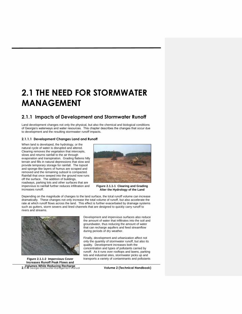
When land is developed, the hydrology, or the natural cycle of water is disrupted and altered. Clearing removes the vegetation that intercepts, slows and returns rainfall to the air through evaporation and transpiration. Grading flattens hilly terrain and fills in natural depressions that slow and provide temporary storage for rainfall. The topsoil and sponge-like layers of humus are scraped and removed and the remaining subsoil is compacted. Rainfall that once seeped into the ground now runs off the surface. The addition of buildings, roadways, parking lots and other surfaces that are impervious to rainfall further reduces infiltration and increases runoff. Depending on the magnitude of changes to the land surface, the total runoff volume can increase dramatically. These changes not only increase the total volume of runoff, but also accelerate the rate at which runoff flows across the land. This effect is further exacerbated by drainage systems such as gutters, storm sewers and lined channels that are designed to quickly carry runoff to rivers and streams.
Development and impervious surfaces also reduce the amount of water that infiltrates into the soil and groundwater, thus reducing the amount of water that can recharge aquifers and feed streamflow during periods of dry weather. Finally, development and urbanization affect not only the quantity of stormwater runoff, but also its quality. Development increases both the concentration and types of pollutants carried by runoff. As it runs over rooftops and lawns, parking lots and industrial sites, stormwater picks up and transports a variety of contaminants and pollutants
Figure 2.1.1-1 Clearing and Grading
Alter the Hydrology of the Land
Figure 2.1.1-2 Impervious Cover Increases Runoff Peak Flows and
Volumes While Reducing Recharge

Volume 2 (Technical Handbook) Georgia Stormwater Management Manual 2.1-5
to downstream waterbodies. The loss of the original topsoil and vegetation removes a valuable filtering mechanism for stormwater runoff. The cumulative impact of development and urban activities, and the resultant changes to both stormwater quantity and quality in the entire land area that drains to a stream, river, lake or estuary determines the conditions of the waterbody. This land area that drains to the waterbody is known as its watershed. Urban development within a watershed has a number of direct impacts on downstream waters and waterways. These impacts include:
Changes to stream flow
Changes to stream geometry
Degradation of aquatic habitat
Water quality impacts The remainder of this section discusses these impacts and why effective stormwater management is needed to address and mitigate them.
2.1.1.2 Changes to Stream Flow
Urban development alters the hydrology of watersheds and streams by disrupting the natural water cycle. This results in:
Increased Runoff Volumes – Land surface changes can dramatically increase the total volume of runoff generated in a developed watershed.
Increased Peak Runoff Discharges – Increased peak discharges for a developed watershed can be two to five times higher than those for an undisturbed watershed.
Greater Runoff Velocities – Impervious surfaces and compacted soils, as well as improvements to the drainage system such as storm drains, pipes and ditches, increase the speed at which rainfall runs off land surfaces within a watershed.
Timing – As runoff velocities increase, it takes less time for water to run off the land and reach a stream or other waterbody.
Increased Frequency of Bankfull and Near Bankfull Events – Increased runoff volumes and peak flows increase the frequency and duration of smaller bankfull and near bankfull events which are the primary channel forming events.
Increased Flooding – Increased runoff volumes and peaks also increase the frequency, duration and severity of out-of-bank flooding.
Lower Dry Weather Flows (Baseflow) – Reduced infiltration of stormwater runoff causes streams to have less baseflow during dry weather periods and reduces the amount of rainfall recharging groundwater aquifers.
Figure 2.1.1-3 Hydrograph under Pre- and Post Development Conditions
10-Year Storm
0
10
20
30
40
50
60
70
80
90
0 25 50 75 100 125
Minutes
Dis
ch
arg
e
Post-
Development Pre- Development
Commented [RC5]: Redundant information found in Volume 1

2.1-6 Georgia Stormwater Management Manual Volume 2 (Technical Handbook)
2.1.2 Addressing Stormwater Impacts The focus of this Manual is how to effectively deal with the impacts of urban stormwater runoff through effective and comprehensive stormwater management. Stormwater management involves both the reduction, prevention, and mitigation of stormwater runoff quantity and quality impacts as described in this chapter through a variety of methods and mechanisms. Volume 2 of this Manual deals with ways that developers in Georgia can effectively implement stormwater management to address the impacts of new development and redevelopment, and reduce, both prevent, and mitigate problems associated with stormwater runoff. This is accomplished by:
Developing land in a way that minimizes its impact on a watershed, and reduces both the amount of runoff and pollutants generated through infiltration, evapotranspiration, and reuse.
Using the most current and effective erosion and sedimentation control practices during the construction phase of development
Reducing and Ccontrolling stormwater runoff peaks, volumes, and velocities to prevent both downstream flooding and streambank channel erosion
Treating post-construction stormwater runoff before it is discharged to a waterway
Implementing pollution prevention practices to prevent stormwater from becoming contaminated in the first place
Using various techniques to maintain groundwater recharge The remainder of Chapter 2 outlines a technical approach for incorporating all of these stormwater management approaches into the development process. The next section (Section 2.2) discusses stormwater management standards and numerical sizing criteria for new development and redevelopment in Georgia that aim to meet the objectives above.
Commented [RC8]: AR-1
Volume 2 (Technical Handbook) Georgia Stormwater Management Manual 2.2-7
2.2 STORMWATER MANAGEMENT
STANDARDS & NUMERICAL
SIZING CRITERIA 2.2.1 Overview This section presents a comprehensive set of minimum recommended performance standards for stormwater management for development activities in the state of Georgia. The overall aim is to provide an integrated approach to address both the water quality and quantity problems associated with stormwater runoff due to development.
The goal of a set of minimum recommended stormwater management standards for areas of new development and significant redevelopment is to reduce the impact of post-construction stormwater runoff on the watershed. This can be achieved by (1) maximizing the use of site design and nonstructural methods such as canopy interception, infiltration, evapotranspiration and reuse to reduce the generation of runoff and pollutants; (2) managing and treating stormwater runoff though the use of best management practices (BMPs); and (3) implementing pollution prevention practices to limit potential stormwater contaminants.
It should be noted that the standards presented here are recommended for all communities in Georgia. They may be adopted by local jurisdictions as stormwater management development requirements and/or may be modified to meet local or watershed-specific stormwater management goals and objectives. Please consult your local review authority for more information.
The minimum recommended standards for development are designed to assist local governments in complying with regulatory and programmatic requirements for various state and Federal programs including the National Pollutant Discharge Elimination System (NPDES) Municipal Separate Storm Sewer System (MS4) permit program and the National Flood Insurance Program under FEMA.
2.2.2 Minimum Recommended Standards for Development
2.2.2.1 Applicability
The following strategies and standards are suitable for most all development and redevelopment sites, however Tthe stormwater management standards for new development and redevelopment are intended to apply to any development site that meets one or more of the following criteria:
(1) New development that includes the creation or addition of 5,000 square feet or greater of new impervious surface area, or that involves land disturbing activity of 1 acre 5,000 square feet of land or greater.
(2) Redevelopment that includes the creation or addition of 5,000 square feet or greater of new impervious surface area, or that involves land disturbing activity of 1 acre or more.
(3) Any commercial or industrial new development or redevelopment, regardless of size, with a Standard Industrial Classification (SIC) code that falls under the NPDES Industrial Stormwater Permit program, or a hotspot land use as defined below.
In addition, redevelopment sites that involve land disturbing activity of 5,000 square feet or greater, but less than 1 acre, must meet Recommended Minimum Standard 10 8 (to meet state
Commented [RC9]: TC203
Commented [RC10]: TC86 & SC2

2.2-8 Georgia Stormwater Management Manual Volume 2 (Technical Handbook)
and NPDES construction erosion and sediment control requirements) and should meet Minimum Recommended Standards 3, 11 9 and 12 10 to the maximum extent practicable. See section 2.2.2.2. Definitions New development is defined as land disturbing activities, structural development (construction, installation or expansion of a building or other structure), and/or creation of imperv ious surfaces on a previously undeveloped site.
Redevelopment is defined as structural development (construction, installation or expansion of a building or other structure), creation or addition of impervious surfaces, replacement of impervious surface not part of routine maintenance, and land disturbing activities associated with structural or impervious development. Redevelopment does not include such activities as exterior remodeling.
A hotspot is defined as a land use or activity on a site that produces higher concentrations of trace metals, hydrocarbons or other priority pollutants than are normally found in urban stormwater runoff. Examples of hotspots include gas stations, vehicle service and maintenance areas, small salvage yards, material storage sites, garbage transfer facilities, and commercial parking lots with high-intensity use. Exemptions
The following development activities are suggested to be exempted from the minimumrecommended stormwater management standards:
(1) Developments that do not disturb more than 5,000 square feet of land; (2) Individual single family residential lots. (Single family lots that are part of a
subdivision or phased development project should not be exempt from the minimumrecommended standards); and
(3) Additions or modifications to existing single-family structures. Additional Requirements
New development or redevelopment in critical or sensitive areas, or as identified through a watershed study or plan, may be subject to additional performance and/or regulatory criteria. Furthermore, these sites may need to utilize or restrict certain structural practices in order to protect a special resource or address certain water quality or drainage problems identified for a drainage area. Off-Site Compliance Alternatives Where site conditions do not permit the achievement of the minimum runoff reduction goals for development or redevelopment onsite, alternatives exist for compliance as follows:
1. Off-Site Mitigation – Runoff reduction practices at a redevelopment or retrofit site are implemented at another location within the same watershed. The off-site project would likely be initiated by the site developer, and the MS4 plays a coordinating and/or project approval role.
2. Payment in Lieu – The developer pays the MS4 (or its assigned entity) an appropriate fee. Fees from multiple sites are aggregated by the MS4 to construct public stormwater projects. This requires an active role for the MS4.
These alternatives are discussed in further detail in Section XX5.7 of Vol. 1.
2.2.2.2 Minimum Recommended Stormwater Management Standards
Recommended stormwater management standards The following standards are the
Commented [RC11]: TC140 & SC21
Commented [RC12]: All “minimum” stormwater standards are now referred to as “recommended” stormwater standards and have been incorporated as they are presented in the 90% version of Volume 1.

Volume 2 (Technical Handbook) Georgia Stormwater Management Manual 2.2-9
recommended minimum stormwater management performance requirements for new development or redevelopment sites falling under the applicability criteria in subsection 2.2.2.1. (The word “shall” in brackets is provided for local jurisdictions that wish to adopt these standards as part of their stormwater management ordinances) A more detailed explanation of each minimum recommended standard is provided in the next subsectionbelow.
Standard #1 – Natural Resource Inventory
Prior to the start of any land disturbing activities (including any clearing and grading activities), acceptable site reconnaissance and surveying techniques shall be used to complete a thorough assessment of the natural resources, both terrestrial and aquatic, found on a development site.
The site’s critical natural features and drainage patterns shall be identified early in the site planning process. The natural resources inventory shall be used to identify and map the natural resources on site, as they exist prior to the start of any land disturbing activities. The identification, and subsequent preservation and/or restoration of these natural resources, through the use of better site design practices, helps reduce the negative impacts of the land development process “by design.” Resources to be identified ad mapped during the natural resources inventory, include, at a minimum, as applicable:
Topography and Steep Slopes
Natural Drainage Divides and Patterns
Natural Drainage Features (e.g., Swales, Basins, Depressional Areas)
Wetlands
Water Bodies
Floodplains
Aquatic Buffers
Shellfish Harvesting Areas
Soils
Erodible Soils
Steep Slopes (i.e., Areas with Slopes Greater Than 15%)
Groundwater Recharge Areas
Wellhead Protection Areas
Trees and Other Existing Vegetation
High Quality Habitat Areas
Protected River Corridors
Protected Mountains
Karst Areas
All relevant resources shall be shown on the Standard #11 Stormwater Site Plan.
Standard #2 –Better Site Design Practices for Stormwater Management
All site designs shall implement a combination of approaches collectively known as stormwater better site design practices to the maximum extent practicable. Through the use of these practices and techniques, the impacts of urbanization on the natural hydrology of the site and water quality can be significantly reduced. The goal is to reduce the amount of stormwater runoff and pollutants that are generated, provide for natural on-site control and treatment of runoff, and optimize the location of stormwater management facilities. Better site design concepts can be viewed as both water quantity and water quality management tools and can reduce the size and cost of required BMPs.
Site designs shall preserve the natural drainage and treatment systems and reduce the generation of additional stormwater runoff and pollutants to the maximum extent practicable.

2.2-10 Georgia Stormwater Management Manual Volume 2 (Technical Handbook)
More information on Better Site Design is provided in section 2.3. The use of certain better site design practices that provide water quality benefits allows for a reduction (known as a “credit”) of the water quality volume. The applicable design practices and stormwater site design credits are covered in section 2.3.2.
Standard #3 – Water Quality
Stormwater management systems should be designed to retain or treat the runoff from 85% of the storms that occur in an average year, and reduce average annual post-development total suspended solids loadings by 80%. Averaged from rainfall events across the state of Georgia, this equates to treating storm events of 1.2 inches or less, as well as the first 1.2 inches of runoff for all larger storm events. This water quality standard can be met using one of two options. A community’s desire or need to require the use of runoff reduction best management practices (BMPs) will determine which option is most appropriate. Only one of the two options should be adopted by an individual community. Option A requires the use of runoff reduction practices to the maximum extent practicable to meet the water quality standard. Option B allows the use of runoff reduction practices to help achieve the water quality standard, but does not require their use. While runoff reduction practices provide important water quality benefits, as described in Chapter 2, certain conditions, such as karst topography, soils with very low infiltration rates, high groundwater, or shallow bedrock, may lead a community to choose the more flexible Option B instead of Option A. These conditions can also be addressed on a site-specific basis if Option A is selected. Option A: Water Quality Runoff Reduction Runoff reduction practices shall be sized and designed to retain the first 1.0 inch of rainfall on the site, or to the maximum extent practicable. Runoff reduction practices are stormwater BMPs used to disconnect impervious and disturbed pervious surfaces from the storm drain system and reduce post-construction stormwater runoff rates, volumes, and pollutant loads. Since runoff reduction practices actually eliminate stormwater runoff (and the pollutants associated with it), rather than simply treating or detaining runoff, they can contribute to several of the other performance standards, while providing many additional benefits as well. Runoff reduction percentages are assigned to applicable BMPs that reduce the amount of stormwater required for treatment, and subsequently reduce the other stormwater management volumes, incentivizing their use. Runoff reduction practices inherently reduce TSS and other pollutants to provide water quality treatment (i.e. 100% pollutant removal for stormwater retention, infiltration, evaporation, transpiration, or rainwater harvesting and reuse). This standard is quantified and expressed in terms of engineering design criteria through the specification of the runoff reduction volume (RRV), which is equal to the runoff generated on a site from 1.0 inches of rainfall. Individual runoff reductions specific to each practice are described in detail in Volume 2, Section 4.1.
If the entire 1.0-inch runoff reduction standard cannot be achieved, the remaining runoff from the 1.2-inch rainfall event must be treated by BMPs to remove at least 80% of the calculated average annual post-development TSS loading from the site. This standard is quantified and expressed in terms of engineering design criteria through the specification of the water quality volume (WQv), which is equal to the runoff generated on a site from 1.2 inches of rainfall. The WQV must be treated to the 80% TSS removal performance goal.
This standard assumes that BMPs will be designed, constructed and maintained according to the criteria in this Manual. Stormwater discharges from land uses or activities with higher or special potential pollutant loadings may require the use of specific structural practices and pollution prevention practices. A detailed overview of BMPs is provided in Volume 2, Section 4.1.
OR

Volume 2 (Technical Handbook) Georgia Stormwater Management Manual 2.2-11
Option B: Water Quality Treatment
Stormwater runoff generated on the development site shall be retained and/or treated by BMPs to remove at least 80% of the calculated average annual post-development total suspended solids (TSS) loading from the site. This can be achieved through the use of BMPs that provide runoff reduction or BMPs that provide treatment This standard is quantified and expressed in terms of engineering design criteria through the specification of the water quality volume (WQv), which is equal to the runoff generated on a site from 1.2 inches of rainfall. The WQV must be treated to the 80% TSS removal performance goal. This standard assumes that BMPs will be designed, constructed and maintained according to the criteria in this Manual. Stormwater discharges from land uses or activities with higher or special potential pollutant loadings may require the use of specific structural practices and pollution prevention practices. A detailed overview of BMPs is provided in Volume 2, Section 4.1.
Standard #4 – Stream Channel Protection
Stream channel protection shall be provided by using all of the following three approaches: (1) 24-hour extended detention storage of the 1-year, 24-hour return frequency storm event; (2) erosion prevention measures such as energy dissipation and velocity control; and (3) preservation of the applicable stream buffer. Stream channel protection requirements are further described in Section 2.2.3. The first method of providing stream bank protection is the extended detention of the 1-year, 24-hour storm for a period of 24 hours using BMPs. It is known that the increase in runoff due to development can dramatically increase stream channel erosion. This standard is intended to reduce the frequency, magnitude and duration of post-development bankfull flow conditions. The volume to be detained is also known as the channel protection volume (Cpv). The use of nonstructural site design practices and runoff reduction BMPs that reduce the total amount of runoff may also reduce Cpv by a proportional amount. This requirement may be waived by a local jurisdiction for sites that discharge directly or through piped stormwater drainage systems into larger streams, rivers, wetlands, lakes, estuaries, tidal waters, or other situations where the reduction in the smaller flows will not have an impact on stream bank or channel integrity. The second stream bank protection method is to implement velocity control, energy dissipation, stream bank stabilization, and erosion prevention practices and structures as necessary in the stormwater management system to prevent downstream erosion and stream bank damage. Energy dissipation and velocity control methods are discussed in Volume 2, Section 5.5. The third method of providing for stream channel protection is through the establishment of riparian stream buffers on the development site. Stream buffers not only provide channel protection but also water quality benefits and protection of streamside properties from flooding. It is recommended that 100-foot buffers be established where feasible.
Standard #5 – Overbank Flood Protection
Overbank flood protection shall be provided by controlling the post-development peak discharge rate to the predevelopment rate for the 25-year, 24-hour return frequency storm event. If control of the 1-year, 24-hour storm (Standard #4) is exempted, then overbank flood protection shall be provided by controlling the post-development peak discharge rate to the predevelopment rate for the 2-year through the 25-year return frequency storm events.

2.2-12 Georgia Stormwater Management Manual Volume 2 (Technical Handbook)
Overbank flood protection requirements are further described in Section 2.2.3. The use of nonstructural site design practices and runoff reduction BMPs that reduce the total amount of runoff will also reduce Qp25 by a proportional amount. Smaller storm events (e.g., 2-year and 10-year) are effectively controlled through the combination of the extended detention for the 1-year, 24-hour event (channel protection criterion) and the control of the 25-year peak rate for overbank flood protection. These design standards, therefore, are intended to be used in unison. This standard may be adjusted by a local jurisdiction for areas where all downstream conveyances and receiving waters have the natural capacity to handle the full build-out 25-year storm through a combination of channel capacity and overbank flood storage without causing flood damage.
Standard #6 – Extreme Flood Protection
Extreme flood protection shall be provided by controlling and/or safely conveying the 100-year, 24-hour storm event (denoted Qf). This is accomplished either by (1) controlling Qf through BMPs to maintain the existing 100-year floodplain, or (2) by sizing the on-site conveyance system to safely pass Qf and allowing it to discharge into a receiving water whose protected floodplain is sufficiently sized to account for extreme flow increases without causing damage. In this case, the extreme flood protection criterion may be waived by a local jurisdiction in lieu of provision of safe and effective conveyance to receiving waters that have the capacity to handle flow increases at the 100-year level. The use of nonstructural site design practices and runoff reduction BMPs that reduce the total amount of runoff will also reduce Qf by a proportional amount. Existing and future floodplain areas shall be preserved as possible. Extreme flood protection requirements are further described in Section 2.2.3.
Standard #7 – Downstream Analysis
Due to peak flow timing and runoff volume effects, some structural practices fail to reduce discharge peaks to predevelopment levels downstream from the development site. A downstream peak flow analysis shall be provided to the point in the watershed downstream of the site or the stormwater management system where the area of the site comprises 10% of the total drainage area. This is to help ensure that there are minimal downstream impacts from the developed site. The downstream analysis may result in the need to resize BMPs, or may allow the waiving of some unnecessary peak flow controls altogether. The use of a downstream analysis and the “ten-percent” rule are discussed in Volume 2, Section 3.1.
Standard #8 – Construction Erosion and Sedimentation Control
Erosion and sedimentation control practices shall be utilized during the construction phase or during any land disturbing activities. All new development and redevelopment sites must meet the regulatory requirements for land disturbance activities under the Georgia Erosion and Sedimentation Control Act and/or the NPDES General Permit for Construction Activities. This involves the preparation and implementation of an approved erosion and sedimentation control plan, including appropriate best management practices, during the construction phase of development. Further guidance on practices for construction site erosion and sedimentation control can be found in the latest version of the Manual for Erosion and Sediment Control in Georgia.
Better site design practices and techniques that can reduce the total amount of area that needs to be cleared and graded should be implemented wherever possible. It is essential that erosion and sedimentation control be considered and implemented in stormwater concept plans and throughout the construction phase to prevent damage to natural stormwater drainage systems and previously constructed best management practices and conveyance

Volume 2 (Technical Handbook) Georgia Stormwater Management Manual 2.2-13
facilities.
Standard #9 – Stormwater Management System Operation and Maintenance
The stormwater management system, including all best management practices and conveyances, shall have an operation and maintenance plan to ensure that it continues to function as designed. See Volume 1, Section 5.2 for more information on stormwater operation and maintenance. ll new development and redevelopment sites are to prepare a comprehensive operation and maintenance plan for the on-site stormwater management system. This is to include all of the stormwater management system components, including drainage facilities, BMPs, and conveyance systems. To ensure that stormwater management systems function as they were designed and constructed, the operation and maintenance plan must provide: (1) a clear assignment of stormwater inspection and maintenance responsibilities; (2) the routine and non-routine maintenance tasks to be undertaken; (3) a schedule for inspection and maintenance; and (4) any necessary legally binding maintenance agreements.
Standard #10 – Pollution Prevention
To the maximum extent practicable, the development project shall implement pollutant prevention practices and have a stormwater pollution prevention plan.
All new development and redevelopment sites are to consider pollution prevention in the design and operation of the site, and prepare a formal stormwater pollution prevention plan. Specific land use types and hotspots may need to implement more rigorous pollution prevention practices. The preparation of pollution prevention plans and the full set of pollution prevention practices are covered in Volume 3 of this Manual.
Standard #11 – Stormwater Management Site Plan
The development project shall prepare a stormwater management site plan for local government review that addresses Standards #1 through 10. All new development and redevelopment sites will require the preparation of a stormwater management site plan for development activities. A stormwater site plan is a comprehensive report that contains the technical information and analysis to allow a local review authority to determine whether a proposed new development or redevelopment project meets the local stormwater regulatory requirements. See, Section 4.3 of Volume 1 and other local stormwater regulatory requirements for specific guidance.
This section presents an integrated approach for meeting the volume-based stormwater runoff quality and quantity management requirements in the minimum standards for development (see the key adverse impacts of stormwater runoff from a development site. The purpose is to provide a framework for designing a stormwater management system to:
Remove stormwater runoff pollutants andI improve water quality through runoff reduction (Minimum Recommended Standards #3 and #4);
Prevent downstream stream bank and channel erosion (Minimum Recommended Standard
Reduce downstream overbank flooding (Minimum Recommended Standard #65); and
Safely pass or reduce the runoff from extreme storm events (Minimum Recommended For these objectives, an integrated set of engineering criteria, known as the Unified Stormwater Sizing Criteria, have been developed which are used to size and design best management practices. Table 2.2.3-1 below briefly summarizes the criteria. Recommended standard #3 (water quality) can be achieved by using one of the two options listed below. The local community will
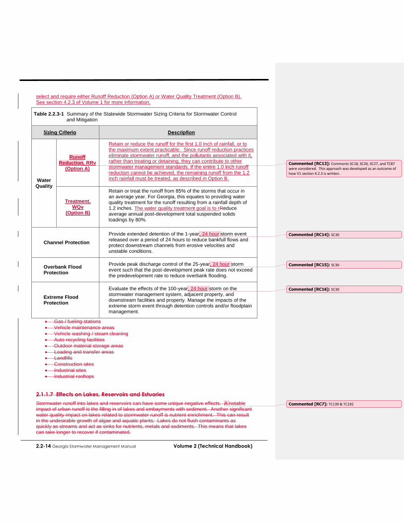
2.2-14 Georgia Stormwater Management Manual Volume 2 (Technical Handbook)
select and require either Runoff Reduction (Option A) or Water Quality Treatment (Option B). See section 4.2.3 of Volume 1 for more information.
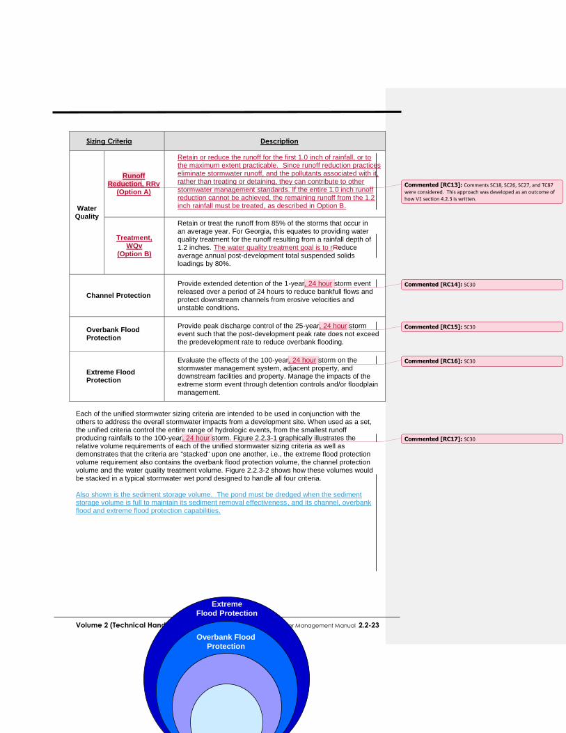
Table 2.2.3-1 Summary of the Statewide Stormwater Sizing Criteria for Stormwater Control and Mitigation
Sizing Criteria
Description
Water Quality
Runoff Reduction, RRv
(Option A)
Retain or reduce the runoff for the first 1.0 inch of rainfall, or to the maximum extent practicable. Since runoff reduction practices eliminate stormwater runoff, and the pollutants associated with it, rather than treating or detaining, they can contribute to other stormwater management standards. If the entire 1.0 inch runoff reduction cannot be achieved, the remaining runoff from the 1.2 inch rainfall must be treated, as described in Option B.
Treatment, WQv
(Option B)
Retain or treat the runoff from 85% of the storms that occur in an average year. For Georgia, this equates to providing water quality treatment for the runoff resulting from a rainfall depth of 1.2 inches. The water quality treatment goal is to rReduce average annual post-development total suspended solids loadings by 80%.
Channel Protection
Provide extended detention of the 1-year, 24 hour storm event released over a period of 24 hours to reduce bankfull flows and protect downstream channels from erosive velocities and unstable conditions.
Overbank Flood Protection
Provide peak discharge control of the 25-year, 24 hour storm event such that the post-development peak rate does not exceed the predevelopment rate to reduce overbank flooding.
Extreme Flood Protection
Evaluate the effects of the 100-year, 24 hour storm on the stormwater management system, adjacent property, and downstream facilities and property. Manage the impacts of the extreme storm event through detention controls and/or floodplain management.
Gas / fueling stations
Vehicle maintenance areas
Vehicle washing / steam cleaning
Auto recycling facilities
Outdoor material storage areas
Loading and transfer areas
Landfills
Construction sites
Industrial sites
Industrial rooftops
2.1.1.7 Effects on Lakes, Reservoirs and Estuaries
Stormwater runoff into lakes and reservoirs can have some unique negative effects. A notable impact of urban runoff is the filling in of lakes and embayments with sediment. Another significant water quality impact on lakes related to stormwater runoff is nutrient enrichment. This can result in the undesirable growth of algae and aquatic plants. Lakes do not flush contaminants as quickly as streams and act as sinks for nutrients, metals and sediments. This means that lakes can take longer to recover if contaminated.
Commented [RC13]: Comments SC18, SC26, SC27, and TC87 were considered. This approach was developed as an outcome of how V1 section 4.2.3 is written.
Commented [RC14]: SC30
Commented [RC15]: SC30
Commented [RC16]: SC30
Commented [RC7]: TC139 & TC192

Volume 2 (Technical Handbook) Georgia Stormwater Management Manual 2.2-15
2.1.2 Addressing Stormwater Impacts The focus of this Manual is how to effectively deal with the impacts of urban stormwater runoff through effective and comprehensive stormwater management. Stormwater management involves both the reduction, prevention, and mitigation of stormwater runoff quantity and quality impacts as described in this chapter through a variety of methods and mechanisms. Volume 2 of this Manual deals with ways that developers in Georgia can effectively implement stormwater management to address the impacts of new development and redevelopment, and reduce, both prevent, and mitigate problems associated with stormwater runoff. This is by:
Developing land in a way that minimizes its impact on a watershed, and reduces both the amount of runoff and pollutants generated through infiltration, evapotranspiration, and reuse.
Using the most current and effective erosion and sedimentation control practices during the construction phase of development
Reducing and Ccontrolling stormwater runoff peaks, volumes, and velocities to prevent both downstream flooding and streambank channel erosion
Treating post-construction stormwater runoff before it is discharged to a waterway
Implementing pollution prevention practices to prevent stormwater from becoming contaminated in the first place
Using various techniques to maintain groundwater recharge The remainder of Chapter 2 outlines a technical approach for incorporating all of these stormwater management approaches into the development process. The next section (Section 2.2) discusses stormwater management standards and numerical sizing criteria for new development and redevelopment in Georgia that aim to meet the objectives above.
Commented [RC8]: AR-1
2.2-16 Georgia Stormwater Management Manual Volume 2 (Technical Handbook)
2.2 STORMWATER MANAGEMENT
STANDARDS & NUMERICAL
SIZING CRITERIA 2.2.1 Overview This section presents a comprehensive set of minimum recommended performance standards for stormwater management for development activities in the state of Georgia. The overall aim is to provide an integrated approach to address both the water quality and quantity problems associated with stormwater runoff due to development.
The goal of a set of minimum recommended stormwater management standards for areas of new development and significant redevelopment is to reduce the impact of post-construction stormwater runoff on the watershed. This can be achieved by (1) maximizing the use of site design and nonstructural methods such as canopy interception, infiltration, evapotranspiration and reuse to reduce the generation of runoff and pollutants; (2) managing and treating stormwater runoff though the use of best management practices (BMPs); and (3) implementing pollution prevention practices to limit potential stormwater contaminants.
It should be noted that the standards presented here are recommended for all communities in Georgia. They may be adopted by local jurisdictions as stormwater management development requirements and/or may be modified to meet local or watershed-specific stormwater management goals and objectives. Please consult your local review authority for more information.
The minimum recommended standards for development are designed to assist local complying with regulatory and programmatic requirements for various state and Federal programs including the National Pollutant Discharge Elimination System (NPDES) Municipal Separate Storm Sewer System (MS4) permit program and the National Flood Insurance Program under FEMA.
2.2.2 Minimum Recommended Standards for
2.2.2.1 Applicability
The following strategies and standards are suitable for most all development and redevelopment sites, however Tthe stormwater management standards for new development and redevelopment are intended to apply to any development site that meets one or more of the following criteria:
(1) New development that includes the creation or addition of 5,000 square feet or greater of new impervious surface area, or that involves land disturbing activity of 1 acre 5,000 square feet
(2) Redevelopment that includes the creation or addition of 5,000 square feet or greater of new impervious surface area, or that involves land disturbing activity of 1 acre or more.
(3) Any commercial or industrial new development or redevelopment, regardless of size, with a Standard Industrial Classification (SIC) code that falls under the NPDES Industrial Stormwater Permit program, or a hotspot land use as defined below.
In addition, redevelopment sites that involve land disturbing activity of 5,000 square feet or greater, but less than 1 acre, must meet Recommended Minimum Standard 10 8 (to meet state construction erosion and sediment control requirements) and should meet Minimum Standards 3, 11 9 and 12 10 to the maximum extent practicable. See section 2.2.2.2.
Commented [RC9]: TC203
Commented [RC10]: TC86 & SC2

Volume 2 (Technical Handbook) Georgia Stormwater Management Manual 2.2-17
Definitions New development is defined as land disturbing activities, structural development (construction, installation or expansion of a building or other structure), and/or creation of imperv ious surfaces on a previously undeveloped site.
Redevelopment is defined as structural development (construction, installation or expansion of a building or other structure), creation or addition of impervious surfaces, replacement of impervious surface not part of routine maintenance, and land disturbing activities associated with structural or impervious development. Redevelopment does not include such activities as exterior remodeling.
A hotspot is defined as a land use or activity on a site that produces higher concentrations of trace metals, hydrocarbons or other priority pollutants than are normally found in urban stormwater runoff. Examples of hotspots include gas stations, vehicle service and maintenance areas, small salvage yards, material storage sites, garbage transfer facilities, and commercial parking lots with high-intensity use. Exemptions
The following development activities are suggested to be exempted from the stormwater management standards:
(1) Developments that do not disturb more than 5,000 square feet of land; (2) Individual single family residential lots. (Single family lots that are part of a
subdivision or phased development project should not be exempt from the standards); and
(3) Additions or modifications to existing single-family structures. Additional Requirements
New development or redevelopment in critical or sensitive areas, or as identified through a watershed study or plan, may be subject to additional performance and/or regulatory criteria. Furthermore, these sites may need to utilize or restrict certain structural practices in order to protect a special resource or address certain water quality or drainage problems identified for a drainage area. Off-Site Compliance Alternatives Where site conditions do not permit the achievement of the minimum runoff reduction goals for development or redevelopment onsite, alternatives exist for compliance as follows:
1. Off-Site Mitigation – Runoff reduction practices at a redevelopment or retrofit site are implemented at another location within the same watershed. The off-site project would likely be initiated by the site developer, and the MS4 plays a coordinating and/or project approval role.
2. Payment in Lieu – The developer pays the MS4 (or its assigned entity) an appropriate fee. Fees from multiple sites are aggregated by the MS4 to construct public stormwater projects. This requires an active role for the MS4.
These alternatives are discussed in further detail in Section XX5.7 of Vol. 1.
2.2.2.2 Minimum Recommended Stormwater Management Standards
Recommended stormwater management standards The following standards are the development or redevelopment sites falling under the applicability criteria in subsection 2.2.2.1. (The word “shall” in brackets is provided for local jurisdictions that wish to adopt these standards as part of their stormwater management ordinances) A more detailed explanation of each minimum recommended standard is provided in the next subsectionbelow.
Commented [RC11]: TC140 & SC21
Commented [RC12]: All “minimum” stormwater standards are now referred to as “recommended” stormwater standards and have been incorporated as they are presented in the 90% version of Volume 1.

2.2-18 Georgia Stormwater Management Manual Volume 2 (Technical Handbook)
Standard #1 – Natural Resource Inventory
Prior to the start of any land disturbing activities (including any clearing and grading activities), acceptable site reconnaissance and surveying techniques shall be used to complete a thorough assessment of the natural resources, both terrestrial and aquatic, found on a development site.
The site’s critical natural features and drainage patterns shall be identified early in the site planning process. The natural resources inventory shall be used to identify and map the natural resources on site, as they exist prior to the start of any land disturbing activities. The identification, and subsequent preservation and/or restoration of these natural resources, through the use of better site design practices, helps reduce the negative impacts of the land development process “by design.” Resources to be identified ad mapped during the natural resources inventory, include, at a minimum, as applicable:
Topography and Steep Slopes
Natural Drainage Divides and Patterns
Natural Drainage Features (e.g., Swales, Basins, Depressional Areas)
Wetlands
Water Bodies
Floodplains
Aquatic Buffers
Shellfish Harvesting Areas
Soils
Erodible Soils
Steep Slopes (i.e., Areas with Slopes Greater Than 15%)
Groundwater Recharge Areas
Wellhead Protection Areas
Trees and Other Existing Vegetation
High Quality Habitat Areas
Protected River Corridors
Protected Mountains
Karst Areas
All relevant resources shall be shown on the Standard #11 Stormwater Site Plan.
Standard #2 –Better Site Design Practices for Stormwater Management
All site designs shall implement a combination of approaches collectively known as stormwater better site design practices to the maximum extent practicable. Through the use of these practices and techniques, the impacts of urbanization on the natural hydrology of the site and water quality can be significantly reduced. The goal is to reduce the amount of stormwater runoff and pollutants that are generated, provide for natural on-site control and treatment of runoff, and optimize the location of stormwater management facilities. Better site design concepts can be viewed as both water quantity and water quality management tools and can reduce the size and cost of required BMPs.
Site designs shall preserve the natural drainage and treatment systems and reduce the generation of additional stormwater runoff and pollutants to the maximum extent practicable. More information on Better Site Design is provided in section 2.3. The use of certain better site design practices that provide water quality benefits allows for a reduction (known as a “credit”) of the water quality volume. The applicable design practices and stormwater site design credits are covered in section 2.3.2.
Standard #3 – Water Quality

Volume 2 (Technical Handbook) Georgia Stormwater Management Manual 2.2-19
Stormwater management systems should be designed to retain or treat the runoff from 85% of the storms that occur in an average year, and reduce average annual post-development total suspended solids loadings by 80%. Averaged from rainfall events across the state of Georgia, this equates to treating storm events of 1.2 inches or less, as well as the first 1.2 inches of runoff for all larger storm events. This water quality standard can be met using one of two options. A community’s desire or need to require the use of runoff reduction best management practices (BMPs) will determine which option is most appropriate. Only one of the two options should be adopted by an individual community. Option A requires the use of runoff reduction practices to the maximum extent practicable to meet the water quality standard. Option B allows the use of runoff reduction practices to help achieve the water quality standard, but does not require their use. While runoff reduction practices provide important water quality benefits, as described in Chapter 2, certain conditions, such as karst topography, soils with very low infiltration rates, high groundwater, or shallow bedrock, may lead a community to choose the more flexible Option B instead of Option A. These conditions can also be addressed on a site-specific basis if Option A is selected. Option A: Water Quality Runoff Reduction Runoff reduction practices shall be sized and designed to retain the first 1.0 inch of rainfall on the site, or to the maximum extent practicable. Runoff reduction practices are stormwater BMPs used to disconnect impervious and disturbed pervious surfaces from the storm drain system and reduce post-construction stormwater runoff rates, volumes, and pollutant loads. Since runoff reduction practices actually eliminate stormwater runoff (and the pollutants associated with it), rather than simply treating or detaining runoff, they can contribute to several of the other performance standards, while providing many additional benefits as well. Runoff reduction percentages are assigned to applicable BMPs that reduce the amount of stormwater required for treatment, and subsequently reduce the other stormwater management volumes, incentivizing their use. Runoff reduction practices inherently reduce TSS and other pollutants to provide water quality treatment (i.e. 100% pollutant removal for stormwater retention, infiltration, evaporation, transpiration, or rainwater harvesting and reuse). This standard is quantified and expressed in terms of engineering design criteria through the specification of the runoff reduction volume (RRV), which is equal to the runoff generated on a site from 1.0 inches of rainfall. Individual runoff reductions specific to each practice are described in detail in Volume 2, Section 4.1.
If the entire 1.0-inch runoff reduction standard cannot be achieved, the remaining runoff from the 1.2-inch rainfall event must be treated by BMPs to remove at least 80% of the calculated average annual post-development TSS loading from the site. This standard is quantified and expressed in terms of engineering design criteria through the specification of the water quality volume (WQv), which is equal to the runoff generated on a site from 1.2 inches of rainfall. The WQV must be treated to the 80% TSS removal performance goal.
This standard assumes that BMPs will be designed, constructed and maintained according to the criteria in this Manual. Stormwater discharges from land uses or activities with higher or special potential pollutant loadings may require the use of specific structural practices and pollution prevention practices. A detailed overview of BMPs is provided in Volume 2, Section 4.1.
OR
Option B: Water Quality Treatment
Stormwater runoff generated on the development site shall be retained and/or treated by

2.2-20 Georgia Stormwater Management Manual Volume 2 (Technical Handbook)
BMPs to remove at least 80% of the calculated average annual post-development total suspended solids (TSS) loading from the site. This can be achieved through the use of BMPs that provide runoff reduction or BMPs that provide treatment This standard is quantified and expressed in terms of engineering design criteria through the specification of the water quality volume (WQv), which is equal to the runoff generated on a site from 1.2 inches of rainfall. The WQV must be treated to the 80% TSS removal performance goal. This standard assumes that BMPs will be designed, constructed and maintained according to the criteria in this Manual. Stormwater discharges from land uses or activities with higher or special potential pollutant loadings may require the use of specific structural practices and pollution prevention practices. A detailed overview of BMPs is provided in Volume 2, Section 4.1.
Standard #4 – Stream Channel Protection
Stream channel protection shall be provided by using all of the following three approaches: (1) 24-hour extended detention storage of the 1-year, 24-hour return frequency storm event; (2) erosion prevention measures such as energy dissipation and velocity control; and (3) preservation of the applicable stream buffer. Stream channel protection requirements are further described in Section 2.2.3. The first method of providing stream bank protection is the extended detention of the 1-year, 24-hour storm for a period of 24 hours using BMPs. It is known that the increase in runoff due to development can dramatically increase stream channel erosion. This standard is intended to reduce the frequency, magnitude and duration of post-development bankfull flow conditions. The volume to be detained is also known as the channel protection volume (Cpv). The use of nonstructural site design practices and runoff reduction BMPs that reduce the total amount of runoff may also reduce Cpv by a proportional amount. This requirement may be waived by a local jurisdiction for sites that discharge directly or through piped stormwater drainage systems into larger streams, rivers, wetlands, lakes, estuaries, tidal waters, or other situations where the reduction in the smaller flows will not have an impact on stream bank or channel integrity. The second stream bank protection method is to implement velocity control, energy dissipation, stream bank stabilization, and erosion prevention practices and structures as necessary in the stormwater management system to prevent downstream erosion and stream bank damage. Energy dissipation and velocity control methods are discussed in Volume 2, Section 5.5. The third method of providing for stream channel protection is through the establishment of riparian stream buffers on the development site. Stream buffers not only provide channel protection but also water quality benefits and protection of streamside properties from flooding. It is recommended that 100-foot buffers be established where feasible.
Standard #5 – Overbank Flood Protection
Overbank flood protection shall be provided by controlling the post-development peak discharge rate to the predevelopment rate for the 25-year, 24-hour return frequency storm event. If control of the 1-year, 24-hour storm (Standard #4) is exempted, then overbank flood protection shall be provided by controlling the post-development peak discharge rate to the predevelopment rate for the 2-year through the 25-year return frequency storm events. Overbank flood protection requirements are further described in Section 2.2.3. The use of nonstructural site design practices and runoff reduction BMPs that reduce the total amount of runoff will also reduce Qp25 by a proportional amount. Smaller storm events (e.g., 2-year and 10-year) are effectively controlled through the combination of the extended detention for the 1-year, 24-hour event (channel protection criterion) and the control of the 25-year peak rate for overbank flood protection. These design

Volume 2 (Technical Handbook) Georgia Stormwater Management Manual 2.2-21
standards, therefore, are intended to be used in unison. This standard may be adjusted by a local jurisdiction for areas where all downstream conveyances and receiving waters have the natural capacity to handle the full build-out 25-year storm through a combination of channel capacity and overbank flood storage without causing flood damage.
Standard #6 – Extreme Flood Protection
Extreme flood protection shall be provided by controlling and/or safely conveying the 100-year, 24-hour storm event (denoted Qf). This is accomplished either by (1) controlling Qf through BMPs to maintain the existing 100-year floodplain, or (2) by sizing the on-site conveyance system to safely pass Qf and allowing it to discharge into a receiving water whose protected floodplain is sufficiently sized to account for extreme flow increases without causing damage. In this case, the extreme flood protection criterion may be waived by a local jurisdiction in lieu of provision of safe and effective conveyance to receiving waters that have the capacity to handle flow increases at the 100-year level. The use of nonstructural site design practices and runoff reduction BMPs that reduce the total amount of runoff will also reduce Qf by a proportional amount. Existing and future floodplain areas shall be preserved as possible. Extreme flood protection requirements are further described in Section 2.2.3.
Standard #7 – Downstream Analysis
Due to peak flow timing and runoff volume effects, some structural practices fail to reduce discharge peaks to predevelopment levels downstream from the development site. A downstream peak flow analysis shall be provided to the point in the watershed downstream of the site or the stormwater management system where the area of the site comprises 10% of the total drainage area. This is to help ensure that there are minimal downstream impacts from the developed site. The downstream analysis may result in the need to resize BMPs, or may allow the waiving of some unnecessary peak flow controls altogether. The use of a downstream analysis and the “ten-percent” rule are discussed in Volume 2, Section 3.1.
Standard #8 – Construction Erosion and Sedimentation Control
Erosion and sedimentation control practices shall be utilized during the construction phase or during any land disturbing activities. All new development and redevelopment sites must meet the regulatory requirements for land disturbance activities under the Georgia Erosion and Sedimentation Control Act and/or the NPDES General Permit for Construction Activities. This involves the preparation and implementation of an approved erosion and sedimentation control plan, including appropriate best management practices, during the construction phase of development. Further guidance on practices for construction site erosion and sedimentation control can be found in the latest version of the Manual for Erosion and Sediment Control in Georgia.
Better site design practices and techniques that can reduce the total amount of area that needs to be cleared and graded should be implemented wherever possible. It is essential that erosion and sedimentation control be considered and implemented in stormwater concept plans and throughout the construction phase to prevent damage to natural stormwater drainage systems and previously constructed best management practices and conveyance facilities.
Standard #9 – Stormwater Management System Operation and Maintenance
The stormwater management system, including all best management practices and conveyances, shall have an operation and maintenance plan to ensure that it continues to
2.2-22 Georgia Stormwater Management Manual Volume 2 (Technical Handbook)
function as designed. See Volume 1, Section 5.2 for more information on stormwater operation and maintenance. ll new development and redevelopment sites are to prepare a comprehensive operation and maintenance plan for the on-site stormwater management system. This is to include all of the stormwater management system components, including drainage facilities, BMPs, and conveyance systems. To ensure that stormwater management systems function as they were designed and constructed, the operation and maintenance plan must provide: (1) a clear assignment of stormwater inspection and maintenance responsibilities; (2) the routine and non-routine maintenance tasks to be undertaken; (3) a schedule for inspection and maintenance; and (4) any necessary legally binding maintenance agreements.
Standard #10 – Pollution Prevention
To the maximum extent practicable, the development project shall implement pollutant prevention practices and have a stormwater pollution prevention plan.
All new development and redevelopment sites are to consider pollution prevention in the design and operation of the site, and prepare a formal stormwater pollution prevention plan. Specific land use types and hotspots may need to implement more rigorous pollution prevention practices. The preparation of pollution prevention plans and the full set of pollution prevention practices are covered in Volume 3 of this Manual.
Standard #11 – Stormwater Management Site Plan
The development project shall prepare a stormwater management site plan for local government review that addresses Standards #1 through 10. All new development and redevelopment sites will require the preparation of a stormwater management site plan for development activities. A stormwater site plan is a comprehensive report that contains the technical information and analysis to allow a local review authority to determine whether a proposed new development or redevelopment project meets the local stormwater regulatory requirements. See, Section 4.3 of Volume 1 and other local stormwater regulatory requirements for specific guidance.
This section presents an integrated approach for meeting the volume-based stormwater runoff quality and quantity management requirements in the minimum standards for development (see the key adverse impacts of stormwater runoff from a development site. The purpose is to provide a framework for designing a stormwater management system to:
Remove stormwater runoff pollutants andI improve water quality through runoff reduction (Minimum Recommended Standards #3 and #4);
Prevent downstream stream bank and channel erosion (Minimum Recommended Standard
Reduce downstream overbank flooding (Minimum Recommended Standard #65); and
Safely pass or reduce the runoff from extreme storm events (Minimum Recommended For these objectives, an integrated set of engineering criteria, known as the Unified Stormwater Sizing Criteria, have been developed which are used to size and design best management practices. Table 2.2.3-1 below briefly summarizes the criteria. Recommended standard #3 (water quality) can be achieved by using one of the two options listed below. The local community will select and require either Runoff Reduction (Option A) or Water Quality Treatment (Option B). See section 4.2.3 of Volume 1 for more information.
Table 2.2.3-1 Summary of the Statewide Stormwater Sizing Criteria for Stormwater Control
and Mitigation
Volume 2 (Technical Handbook) Georgia Stormwater Management Manual 2.2-23
Sizing Criteria
Description
Water Quality
Runoff Reduction, RRv
(Option A)
Retain or reduce the runoff for the first 1.0 inch of rainfall, or to the maximum extent practicable. Since runoff reduction practices eliminate stormwater runoff, and the pollutants associated with it, rather than treating or detaining, they can contribute to other stormwater management standards. If the entire 1.0 inch runoff reduction cannot be achieved, the remaining runoff from the 1.2 inch rainfall must be treated, as described in Option B.
Treatment, WQv
(Option B)
Retain or treat the runoff from 85% of the storms that occur in an average year. For Georgia, this equates to providing water quality treatment for the runoff resulting from a rainfall depth of 1.2 inches. The water quality treatment goal is to rReduce average annual post-development total suspended solids loadings by 80%.
Channel Protection
Provide extended detention of the 1-year, 24 hour storm event released over a period of 24 hours to reduce bankfull flows and protect downstream channels from erosive velocities and unstable conditions.
Overbank Flood Protection
Provide peak discharge control of the 25-year, 24 hour storm event such that the post-development peak rate does not exceed the predevelopment rate to reduce overbank flooding.
Extreme Flood Protection
Evaluate the effects of the 100-year, 24 hour storm on the stormwater management system, adjacent property, and downstream facilities and property. Manage the impacts of the extreme storm event through detention controls and/or floodplain management.
Each of the unified stormwater sizing criteria are intended to be used in conjunction with the others to address the overall stormwater impacts from a development site. When used as a set, the unified criteria control the entire range of hydrologic events, from the smallest runoff producing rainfalls to the 100-year, 24 hour storm. Figure 2.2.3-1 graphically illustrates the relative volume requirements of each of the unified stormwater sizing criteria as well as demonstrates that the criteria are "stacked" upon one another, i.e., the extreme flood protection volume requirement also contains the overbank flood protection volume, the channel protection volume and the water quality treatment volume. Figure 2.2.3-2 shows how these volumes would be stacked in a typical stormwater wet pond designed to handle all four criteria. Also shown is the sediment storage volume. The pond must be dredged when the sediment storage volume is full to maintain its sediment removal effectiveness, and its channel, overbank flood and extreme flood protection capabilities. Extreme
Flood Protection
Overbank Flood
Protection
Commented [RC13]: Comments SC18, SC26, SC27, and TC87 were considered. This approach was developed as an outcome of how V1 section 4.2.3 is written.
Commented [RC14]: SC30
Commented [RC15]: SC30
Commented [RC16]: SC30
Commented [RC17]: SC30
2.2-24 Georgia Stormwater Management Manual Volume 2 (Technical Handbook)
Figure 2.2.3-1 Representation of the Unified Stormwater Sizing Criteria
Figure 2.2.3-2 Unified Sizing Criteria Water Surface Elevations in a Stormwater (Wet) Pond
The following pages describe the four sizing criteria in detail and present guidance on how to properly compute and apply the required storage volumes.
2.2.4 Description of Unified Stormwater Sizing Criteria
2.2.4.1 Water Quality Volume (WQv)
As noted in Recommended Standard #3, the water quality goal can be accomplished either through runoff reduction (Option A) or water quality treatment (Option B) or some combination of the two. For more information on either water quality approach, see Section 2.2.2.2.
The Runoff Reduction approach to the Water Quality sizing criterion, denoted RRv, specifies the reduction or elimination of the total pollution load inherent in stormwater runoff by intercepting and reducing or eliminating the first 1.0 inch of rainfall, or to the maximum extent practicable. The Runoff Reduction Volume is a runoff volume that is directly related to the amount of impervious cover at a site. In numerical terms, it is equivalent to a rainfall depth of 1.0 inches (or other target rainfall amount
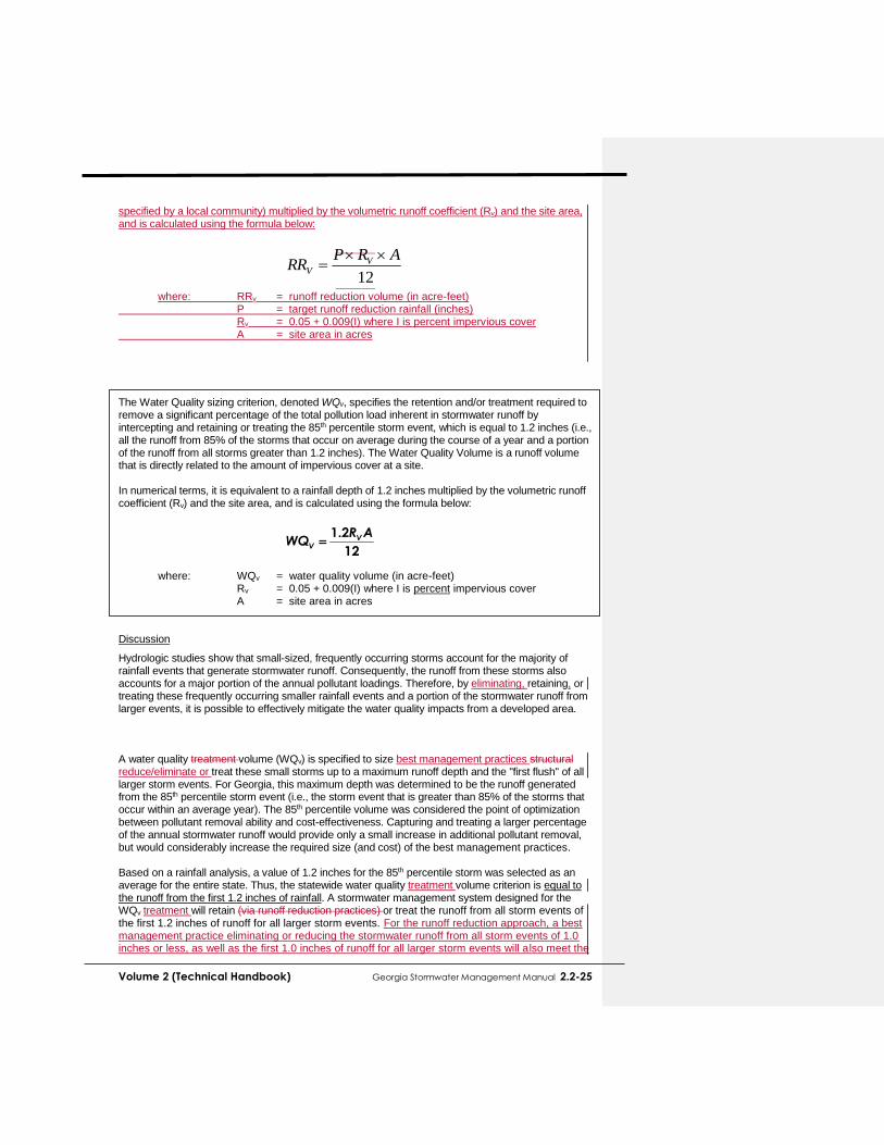
Volume 2 (Technical Handbook) Georgia Stormwater Management Manual 2.2-25
specified by a local community) multiplied by the volumetric runoff coefficient (Rv) and the site area, and is calculated using the formula below:
where: RRv = runoff reduction volume (in acre-feet) P = target runoff reduction rainfall (inches)
Rv = 0.05 + 0.009(I) where I is percent impervious cover A = site area in acres
The Water Quality sizing criterion, denoted WQv, specifies the retention and/or treatment required to remove a significant percentage of the total pollution load inherent in stormwater runoff by intercepting and retaining or treating the 85th percentile storm event, which is equal to 1.2 inches (i.e., all the runoff from 85% of the storms that occur on average during the course of a year and a portion of the runoff from all storms greater than 1.2 inches). The Water Quality Volume is a runoff volume that is directly related to the amount of impervious cover at a site. In numerical terms, it is equivalent to a rainfall depth of 1.2 inches multiplied by the volumetric runoff coefficient (Rv) and the site area, and is calculated using the formula below:
where: WQv = water quality volume (in acre-feet) Rv = 0.05 + 0.009(I) where I is percent impervious cover A = site area in acres Discussion
Hydrologic studies show that small-sized, frequently occurring storms account for the majority of rainfall events that generate stormwater runoff. Consequently, the runoff from these storms also accounts for a major portion of the annual pollutant loadings. Therefore, by eliminating, retaining, or treating these frequently occurring smaller rainfall events and a portion of the stormwater runoff from larger events, it is possible to effectively mitigate the water quality impacts from a developed area. A water quality treatment volume (WQv) is specified to size best management practices structural reduce/eliminate or treat these small storms up to a maximum runoff depth and the "first flush" of all larger storm events. For Georgia, this maximum depth was determined to be the runoff generated from the 85th percentile storm event (i.e., the storm event that is greater than 85% of the storms that occur within an average year). The 85th percentile volume was considered the point of optimization between pollutant removal ability and cost-effectiveness. Capturing and treating a larger percentage of the annual stormwater runoff would provide only a small increase in additional pollutant removal, but would considerably increase the required size (and cost) of the best management practices. Based on a rainfall analysis, a value of 1.2 inches for the 85th percentile storm was selected as an average for the entire state. Thus, the statewide water quality treatment volume criterion is equal to the runoff from the first 1.2 inches of rainfall. A stormwater management system designed for the WQv treatment will retain (via runoff reduction practices) or treat the runoff from all storm events of the first 1.2 inches of runoff for all larger storm events. For the runoff reduction approach, a best management practice eliminating or reducing the stormwater runoff from all storm events of 1.0 inches or less, as well as the first 1.0 inches of runoff for all larger storm events will also meet the
12
2.1 ARWQ V
V
12
ARPRR V
V

2.2-26 Georgia Stormwater Management Manual Volume 2 (Technical Handbook)
Water Quality criterion. The volumetric runoff coefficient (Rv) was derived from a regression analysis performed on rainfall runoff volume data from a number of cities nationwide and is a shortcut method considered adequate for runoff volume calculation for the type of small storms normally considered in stormwater quality calculations. Figure 2.2.4-1 shows a plot of the Water Quality Volume versus impervious area percentage. TSS Reduction Goal
This Manual follows the philosophy of removing pollutants to the “maximum extent practicable” through the use of a percentage removal performance goal. The approach taken in this Manual is to require treatment of the WQv from a site to reduce post-development total suspended solids (TSS) loadings by 80%, as measured on an average annual basis. TSS was chosen as the representative stormwater pollutant for measuring treatment effectiveness for several reasons:
1. The use of TSS as an “indicator” pollutant is well established.
2. Sediment and turbidity, as well as other pollutants of concern that adhere to suspended solids, are a major source of water quality impairment due to urban development in Georgia watersheds.
3. A large fraction of many other pollutants of concern are either removed along with TSS, or at rates proportional to the TSS removal.
4. The 80% TSS removal level is reasonably attainable using well-designed best management practices (for typical ranges of TSS concentration found in stormwater runoff).
TSS is a good indicator for many stormwater pollutants. However, the removal performance for pollutants that are soluble or that cannot be removed by settling will vary depending on the best management practice. For pollutants of specific concern, individual analyses of specific pollutant sources and the appropriate removal mechanisms should be performed.
Figure 2.2.4-1 Water Quality Volume versus Percent Impervious Area Determining the Runoff Reduction (RRV) and Water Quality Volumes (WQv)
Measuring Impervious Area: The area of impervious cover can be taken directly off a set of plans or appropriate mapping. Where this is impractical, NRCS TR-55 land use/impervious cover relationships can be used to estimate impervious cover. I is expressed as a percent value not a fraction (e.g., I = 30 for 30% impervious cover).
Multiple Drainage Areas: When a development project contains or is divided into multiple drainage areas, RRV and WQv should be calculated and addressed separately for each drainage
0
0.2
0.4
0.6
0.8
1
1.2
0 10 20 30 40 50 60 70 80 90 100
Percent Impervious
Wa
ter
Qu
ali
ty V
olu
me
(in
ch
es)

Volume 2 (Technical Handbook) Georgia Stormwater Management Manual 2.2-27
area.
Off-site Drainage Areas: Off-site existing impervious areas may be excluded from the calculation of the RRV and WQv.
Credits for Site Design Practices: The use of certain better site design practices may allow the WQv to be reduced through the subtraction of a site design “credit.” These site design credits are described in Section 2.3.
Determining the Peak Discharge for the Water Quality Storm: When designing off-line structural control facilities, the peak discharge of the water quality storm (Qwq) can be determined using the method provided in Section 3.1.
Extended Detention of the Water Quality Volume: The water quality treatment requirement can be met by providing a 24-hour drawdown of a portion of WQv in a stormwater pond or wetland system (as described in Chapter 4). Referred to as water quality ED (extended detention), it is different than providing extended detention of the 1-year, 24 hour storm for the channel protection volume (CPv). The ED portion of the WQv may be included when routing the CPv.
RRV and WQv can be expressed in cubic feet by multiplying by 43,560.
RRV and WQv can also be expressed in watershed-inches by removing the area (A) and the “12” in the denominator.
2.2.4.2 Channel Protection (CPv)
The Channel Protection sizing criterion specifies that 24 hours of extended detention be provided for runoff generated by the 1-year, 24-hour rainfall event to protect downstream channels. The required volume needed for 1-year extended detention, denoted CPv, is roughly equivalent to the required volume needed for peak discharge control of the 5- to 10-year storm.
CPv control is not required for post-development discharges less than 2.0 cfs.
The use of nonstructural site design practices and runoff reduction practices that reduce the total amount of runoff will also reduce the channel protection volume by a proportional amount.
The channel protection criteria may be waived by a local jurisdiction for sites that discharge directly into larger streams, rivers, wetlands, lakes, estuaries, or tidal waters where the reduction in the smaller flows will not have an impact on stream bank or channel integrity.
Discussion
The increase in the frequency and duration of bankfull flow conditions in stream channels due to urban development is the primary cause of stream bank erosion and the widening and downcutting of stream channels. Therefore, channel erosion downstream of a development site can be significantly reduced by storing and releasing stormwater runoff from the channel-forming runoff events (which corresponds approximately to the 1-year, 24 hour storm event) in a gradual manner to ensure that critical erosive velocities and flow volumes are not exceeded. Determining the Channel Protection Volume (CPv)
CPv Calculation Methods: Several methods can be used to calculate the CPv storage volume required for a site. Subsection 3.1.5 in Chapter 3 and Appendix B illustrate the recommended
Commented [RC19]: SC30
Commented [RC20]: SC30
2.2-28 Georgia Stormwater Management Manual Volume 2 (Technical Handbook)
average outflow method for volume calculation.
Hydrograph Generation: The SCS TR-55 hydrograph methods provided in Section 3.1 can be used to compute the runoff hydrograph for the 1-year, 24-hour storm.
Rainfall Depths: The rainfall depth of the 1-year, 24-hour storm will vary depending on location and can be determined from rainfall data found in the National Oceanic and Atmospheric Administration (NOAA) Atlas 14 publication, or online using the Precipitation Frequency Data Server database for any location across Georgia (http://hdsc.nws.noaa.gov/hdsc/pfds/).
Multiple Drainage Areas: When a development project contains or is divided into multiple drainage areas, CPv may be distributed proportionally to each drainage area.
Off-site Drainage Areas: Off-site drainage areas should be modeled as “present condition” for the 1-year storm event. If there are adequate upstream channel protection controls, then the off-site area can be modeled as “forested” or “natural” condition. A best management practice located “on-line” will need to safely bypass any off-site flows.
Routing/Storage Requirements: The required storage volume for the CPv may be provided above the WQv storage in stormwater ponds and wetlands with appropriate hydraulic control structures for each storage requirement.
Control Orifices: Orifice diameters for CPv control of less than 3 inches are not recommended without adequate clogging protection (see Section 3.3).
2.2.4.3 Overbank Flood Protection (Qp25)
The Overbank Flood Protection criterion specifies that the post-development 25-year, 24-hour storm peak discharge rate, denoted Qp25, not exceed the pre-development (or undisturbed natural conditions) discharge rate. This is achieved through detention of runoff from the 25-year event.
Smaller storm events (e.g., 2-year and 10-year) are effectively controlled through the combination of the extended detention for the 1-year event (channel protection CPv control) and the control of Qp25 for overbank channel protection.
Larger storms (> 25-year) are partially attenuated through the control of Qp25.
The use of nonstructural site design practices and runoff reduction practices that reduce the total amount of runoff will also reduce Qp25 by a proportional amount.
Control of Qp25 is not intended to serve as a stand-alone design standard, but is intended to be used in conjunction with the channel protection AND extreme flood protection criteria. If detention is designed for only the 25-year storm, smaller runoff events will simply pass through the outlet structure with little attenuation. If the channel protection criterion is not used, then for overbank flood protection, peak flow attenuation of the 2-year (Qp2) through the 25-year (Qp25) return frequency storm events must be provided. Discussion
The purpose of overbank flood protection is to prevent an increase in the frequency and magnitude of damaging out-of-bank flooding (i.e., flow events that exceed the capacity of the channel and enter the floodplain). It is intended to protect downstream properties from flooding at middle-frequency storm events. This criterion may be adjusted by a local jurisdiction for areas where all downstream conveyances are designed to handle runoff from the full buildout 25-year storm, or where it can be

Volume 2 (Technical Handbook) Georgia Stormwater Management Manual 2.2-29
demonstrated that no downstream flooding will occur as a result of a proposed development (see Section 3.1.9). In this case, the overbank flood protection criterion may be waived by a local jurisdiction in lieu of provision of safe and effective conveyance to a major river system, lake, wetland, estuary, or tidal waters that have capacity to handle flow increases at the 25-year level. Determining the Overbank Flood Protection Volume (Qp25)
Peak-Discharge and Hydrograph Generation: The SCS TR-55 or USGS hydrograph methods provided in Section 3.1 can be used to compute the peak discharge rate and runoff for the 25-year, 24-hour storm.
Rainfall Depths: The rainfall depth of the 25-year, 24-hour storm will vary depending on location and can be determined from rainfall data found in the National Oceanic and Atmospheric Administration (NOAA) Atlas 14 publication, or online using the Precipitation Frequency Data Server database for any location across Georgia (http://hdsc.nws.noaa.gov/hdsc/pfds/).
Off-site Drainage Areas: Off-site drainage areas should be modeled as “present condition” for the 25-year storm event and do not need to be included in Qp25 estimates, but can be routed through a best management practice.
Downstream Analysis: Downstream areas should be checked to ensure there is no peak flow increase above pre-development conditions to the point where the site area is 10% of the total drainage to that point.
2.2.4.4 Extreme Flood Protection (Qf)
The Extreme Flood Protection criterion specifies that all stormwater management facilities be designed to safely handle the runoff from the 100-year, 24-hour return frequency storm event, denoted Qf. This is accomplished either by:
(1) Controlling Qf through on-site or regional best management practices to maintain the existing 100-year floodplain. This is done where residences or other structures have already been constructed within the 100-year floodplain fringe area; or
(2) By sizing the on-site conveyance system to safely pass Qf and allowing it to discharge into a receiving water whose protected full buildout floodplain is sufficiently sized to account for extreme flow increases without causing damage.
Local flood protection (levees, floodwalls, floodproofing, etc.) and/or channel enlargements may be substituted as appropriate, as long as adequate conveyance and structural safety is ensured through the measure used, and stream environmental integrity is adequately maintained. Discussion
The intent of the extreme flood protection is to prevent flood damage from infrequent but large storm events, maintain the boundaries of the mapped 100-year floodplain, and protect the physical integrity of the best management practices as well as downstream stormwater and flood control facilities. It is recommended that Qf be used in the routing of runoff through the drainage system and stormwater management facilities to determine the effects on the facilities, adjacent property, and downstream. Emergency spillways of best management practices should be designed appropriately to safely pass the resulting flows. Determining the Extreme Flood Protection Criteria (Qp25)

2.2-30 Georgia Stormwater Management Manual Volume 2 (Technical Handbook)
Peak-Discharge and Hydrograph Generation: The SCS TR-55 or USGS hydrograph methods provided in Section 2.1 can be used to compute the peak discharge rate and runoff for the 100-year, 24-hour storm.
Rainfall Depths: The rainfall depth of the 100-year, 24-hour storm will vary depending on location and can be determined from rainfall data found in the National Oceanic and Atmospheric Administration (NOAA) Atlas 14 publication, or online using the Precipitation Frequency Data Server database for any location across Georgia (http://hdsc.nws.noaa.gov/hdsc/pfds/).
Off-site Drainage Areas: Off-site drainage areas should be modeled as “full buildout condition” for the 100-year storm event to ensure safe passage of future flows.
Downstream Analysis: If Qf is being detained, downstream areas should be checked to ensure there is no peak flow increase above pre-development conditions to the point where the site area is 10% of the total drainage to that point.
2.2.5 Meeting the Unified Stormwater Sizing Criteria Requirements
2.2.5.1 Introduction
There are two primary approaches for managing stormwater runoff and addressing the unified stormwater sizing criteria requirements on a development site:
The use of better site design practices to reduce the amount of stormwater runoff and pollutants generated and/or provide for natural runoff reduction, treatment, and control of runoff; and
The use of best management practices to provide runoff reduction, treatment, and control of stormwater runoff
This subsection introduces both of these approaches. Stormwater better site design practices are discussed in-depth in Section 2.3, while best management practices are covered in Chapter 4.
2.2.5.2 Site Design as the First Step in Addressing Unified Stormwater Sizing
Criteria Requirements
Using the site design process to reduce stormwater runoff and pollutants should always be the first consideration of the site designer and engineer in the planning of the stormwater management system for a development. Through the use of a combination of approaches collectively known as stormwater better site design practices and techniques, it is possible to reduce the amount of runoff and pollutants that are generated, as well as provide for at least some nonstructural on-site treatment and control of runoff. Better site design concepts can be viewed as both water quantity and water quality management tools and can reduce the size and cost of required best management practices—sometimes
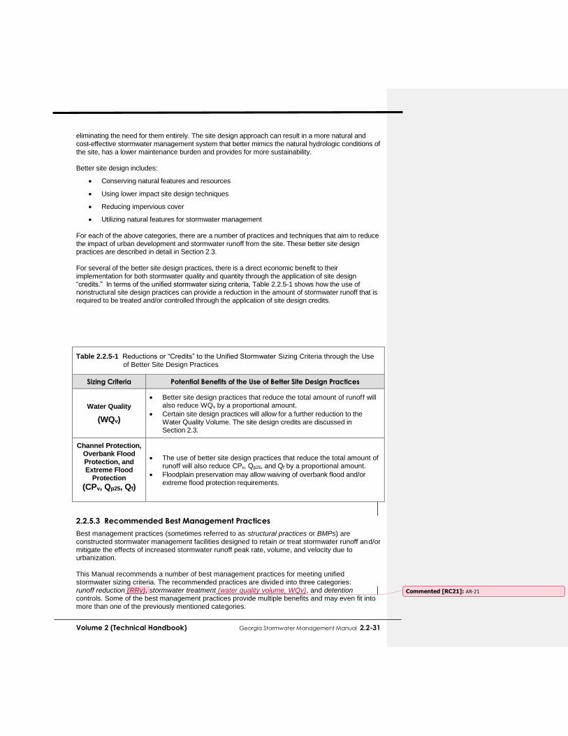
Volume 2 (Technical Handbook) Georgia Stormwater Management Manual 2.2-31
eliminating the need for them entirely. The site design approach can result in a more natural and cost-effective stormwater management system that better mimics the natural hydrologic conditions of the site, has a lower maintenance burden and provides for more sustainability. Better site design includes:
Conserving natural features and resources
Using lower impact site design techniques
Reducing impervious cover
Utilizing natural features for stormwater management For each of the above categories, there are a number of practices and techniques that aim to reduce the impact of urban development and stormwater runoff from the site. These better site design practices are described in detail in Section 2.3. For several of the better site design practices, there is a direct economic benefit to their implementation for both stormwater quality and quantity through the application of site design “credits.” In terms of the unified stormwater sizing criteria, Table 2.2.5-1 shows how the use of nonstructural site design practices can provide a reduction in the amount of stormwater runoff that is required to be treated and/or controlled through the application of site design credits.
Table 2.2.5-1 Reductions or “Credits” to the Unified Stormwater Sizing Criteria through the Use of Better Site Design Practices
Sizing Criteria Potential Benefits of the Use of Better Site Design Practices
Water Quality
(WQv)
Better site design practices that reduce the total amount of runoff will also reduce WQv by a proportional amount.
Certain site design practices will allow for a further reduction to the Water Quality Volume. The site design credits are discussed in Section 2.3.
Channel Protection, Overbank Flood Protection, and Extreme Flood
Protection (CPv, Qp25, Qf)
The use of better site design practices that reduce the total amount of runoff will also reduce CPv, Qp25, and Qf by a proportional amount.
Floodplain preservation may allow waiving of overbank flood and/or extreme flood protection requirements.
2.2.5.3 Recommended Best Management Practices
Best management practices (sometimes referred to as structural practices or BMPs) are constructed stormwater management facilities designed to retain or treat stormwater runoff and/or mitigate the effects of increased stormwater runoff peak rate, volume, and velocity due to urbanization. This Manual recommends a number of best management practices for meeting unified stormwater sizing criteria. The recommended practices are divided into three categories: runoff reduction (RRv), stormwater treatment (water quality volume, WQv), and detention controls. Some of the best management practices provide multiple benefits and may even fit into more than one of the previously mentioned categories.
Commented [RC21]: AR-21

2.2-32 Georgia Stormwater Management Manual Volume 2 (Technical Handbook)
Some stormwater practices are best suited to address runoff quality, while others are best suited to address runoff quantity. However, better site design and runoff reduction practices address both simultaneously. As discussed in Volume 1, Chapter 3, by reducing the impervious cover associated with a development, better site design techniques reduce the amount of runoff being generated by a development in the first place. Runoff reduction practices, on the other hand eliminate some of the runoff after it is generated. Instead of treating the runoff like a typical water quality practice, or detaining it like a typical water quality practice, they remove it – removing the pollutants along with it.
In Georgia, the state requirement for Water Quality is to remove 80% TSS from the 1.2” rainfall event. To comply with this requirement, there are several ways to incorporate better site design, runoff reduction practices, and best management practices in a design. A few possible scenarios are listed below and also depicted in the figures that follow:
3.2. Partial Runoff Reduction Approach: Utilize a best management practice that provides less than 100% runoff reduction, which also provides TSS removal. For example, a practice that reduces runoff by 50% stillis only required to removes 60% of the listed from the remaining volume of stormwater to achieve the 80% TSS removal goal.
INFLOW
1,000 FT3
100 Units of TSS No OUTFLOW
Runoff Reduction
0 FT3
0 Units of TSS
1,000 FT3
100 Units of TSS
BMP
RRV = 100%
Commented [RC22]: TC207 – See Note & Box
Commented [RC23]: The clarification of this approach may not be accurately reflected in all of the BMP design steps. This will be corrected in conjunction with the 90% comments.

Volume 2 (Technical Handbook) Georgia Stormwater Management Manual 2.2-33
4. Traditional Treatment Train TSS Removal Approach: Similar to the previous approach,
but would require multiple practices or BMPs to reach the 80% TSS removal requirement. Generally, these practices: (1) cannot alone achieve the 80% TSS removal target, (2) are intended to address hotspot or specific land use constraints or conditions, and/or (3) may have high or special maintenance requirements that may preclude their use. Some of these practices can be used as a pretreatment measure or in series with other structural practices to meet pollutant removal goals.
INFLOW
1,000 FT3 100 Units of TSS OUTFLOW
No Runoff Reduction
1,000 FT3
20 Units of TSS
BMP
TSS = 80%
500 FT3
20 Units of TSS
500 FT3 50 Units of TSS
1,000 FT3
100 Units of TSS
INFLOW
OUTFLOW
Runoff Reduction
BMP
RRV = 50%
TSS = 80%
NOTE: Effective TSS removal efficiency of example BMP is
80%.
30 Units of TSS Removed

2.2-34 Georgia Stormwater Management Manual Volume 2 (Technical Handbook)
2.2.5.4 Using Best Management Practices to Meet Unified Stormwater Sizing
Criteria Requirements
Best management practices should be considered after all reasonable attempts have been made to minimize stormwater runoff and maximize its control and treatment through the better site design methods. Once the need for structural practices has been established, one or more appropriate best management practices will need to be selected to handle the stormwater runoff storage and treatment requirements calculated using the unified stormwater sizing criteria. Guidance for choosing the appropriate best management practice(s) for a site is provided in Section 4.1.
2.2.5.5 Typical Steps in Addressing the Unified Stormwater Sizing Criteria
Each development site is unique in how stormwater management objectives are met. The type of development, physical site conditions, location in the watershed, and other factors determine how the minimum recommended stormwater management standards and unified stormwater sizing criteria are addressed. Figure 2.2.5-2 provides a flowchart for the typical steps in stormwater management system design using the unified stormwater sizing criteria. This is a subset of the stormwater site planning process detailed in Section 2.4.
INFLOW
1,000 FT3
100 Units of TSS
OUTFLOW
1,000 FT3
20 Units of TSS
BMP #1
TSS = 60%
BMP #2
TSS = 50%
No Runoff Reduction No Runoff Reduction
60 Units of TSS Removed 20 Units of TSS Removed

Volume 2 (Technical Handbook) Georgia Stormwater Management Manual 2.3-35
Figure 2.2.5-2 Typical Stormwater Management System Design Process
2.3.1 Overview
2.3.1.1 Introduction
The first step in addressing stormwater management begins with the site planning and design process. Development projects can be designed to reduce their impact on watersheds when careful efforts are made to conserve natural areas, reduce impervious cover and better integrate stormwater treatment. By implementing a combination of these nonstructural approaches collectively known as stormwater better site design practices, it is possible to reduce the amount of runoff and pollutants that are generated from a site and provide for some nonstructural on-site treatment and control of runoff. The goals of better site design include:
Managing stormwater (quantity and quality) as close to the point of origin as possible and minimizing collection and conveyance
Preventing stormwater impacts rather than mitigating them
Utilizing simple, nonstructural methods for stormwater management that are lower cost and lower maintenance than structural controls (best management practices)
Creating a multifunctional landscape
Using hydrology as a framework for site design Better site design for stormwater management includes a number of site design techniques such as preserving natural features and resources, effectively laying out the site elements to reduce impact, reducing the amount of impervious surfaces, and utilizing natural features on the site for stormwater management. The aim is to reduce the environmental impact “footprint” of the site while retaining and enhancing the owner/developer’s purpose and vision for the site. Many of the better site design concepts can reduce the cost of infrastructure while maintaining or even increasing the value of the property. Reduction of adverse stormwater runoff impacts through the use of better site design should be the first consideration of the design engineer. Operationally, economically, and aesthetically, the

2.3-36 Georgia Stormwater Management Manual Volume 2 (Technical Handbook)
use of better site design practices offers significant benefits over treating and controlling runoff downstream. Therefore, feasibleall opportunities for using these methods should be explored and all options exhausted before considering best management practices. The reduction in runoff and pollutants using better site design can reduce the required runoff peak and volumes that need to be conveyed and controlled on a site and, therefore, the size and cost of necessary drainage infrastructure and best management practices. In some cases, the use of better site design practices may eliminate the need for structural controls entirely. Hence, better site design concepts can be viewed as both a water quantity and water quality management tool.
Commented [RC24]: SC19

Volume 2 (Technical Handbook) Georgia Stormwater Management Manual 2.3-37
SeveralOne of the site design practices described in this section provide a calculable reduction or site design “credit” which can be applied to the unified stormwater sizing criteria requirements. Subsection 2.3.42.3.2 will discusses these practices and provide examples of their application. The use of stormwater better site design can also have a number of other ancillary benefits including:
Reduced construction costs
Increased property values
More open space for recreation
More pedestrian friendly neighborhoods
Protection of sensitive forests, wetlands and habitats
More aesthetically pleasing and naturally attractive landscape
Easier compliance with wetland and other resource protection regulations
2.3.1.2 List of Stormwater Better Site Design Practices and Techniques
The stormwater better site design practices and techniques covered in this Manual are grouped into four categories and are listed below:
Conservation of Natural Features and Resources
Preserve Undisturbed Natural Areas Preserve Riparian Buffers Avoid Floodplains Avoid Steep Slopes Minimize Siting on Porous or Erodible Soils
Lower Impact Site Design Techniques
Fit Design to the Terrain Locate Development in Less Sensitive Areas Reduce Limits of Clearing and Grading Utilize Open Space Development Consider Creative Development Design
Reduction of Impervious Cover
Reduce Roadway Lengths and Widths Reduce Building Footprints Reduce the Parking Footprint Reduce Setbacks and Frontages Use Fewer or Alternative Cul-de-Sacs Create Parking Lot Stormwater "Islands"
Utilization of Natural Features for Stormwater Management
Use Buffers and Undisturbed Areas Use Natural Drainageways Instead of Storm Sewers Use Vegetated Swale Instead of Curb and Gutter Use soil restoration practices to improve native soils Drain Rooftop Runoff to Pervious Areas
More detail on each site design practice is provided in the Stormwater Better Site Design Practice Summary Sheets in subsection 2.3.2. These summaries provide the key benefits of each practice, examples and details on how to apply them in site design.
Commented [RC25]: TC209

2.3-38 Georgia Stormwater Management Manual Volume 2 (Technical Handbook)
2.3.1.3 Using Stormwater Better Site Design Practices
Site design should be done in unison with the design and layout of stormwater infrastructure in attaining stormwater management goals. Figure 2.3.1-1 illustrates the stormwater better site design process that utilizes the four better site design categories.
Figure 2.3.1-1 Stormwater Better Site Design Process
The first step in stormwater better site design involves identifying significant natural features and resources on a site such as undisturbed forest areas, stream buffers and steep slopes that should be preserved to retain some of the original hydrologic function of the site. Next, the site layout is designed such that these conservation areas are preserved and the impact of the development is minimized. A number of techniques can then be used to reduce the overall imperviousness of the development site. Finally, natural features and conservation areas can be utilized to serve stormwater quantity and quality management purposes.
Identify Natural Features and Resources – Delineate Site
Conservation Areas
Design Site Layout to Preserve Conservation Areas and Minimize
Stormwater Impacts
Use Various Techniques to Reduce Impervious
Cover in the Site Design
Utilize Natural Features and Conservation Areas to Manage Stormwater
Quantity and Quality

Volume 2 (Technical Handbook) Georgia Stormwater Management Manual 2.3-39
2.3.2 Better Site Design Practices
2.3.2.1 Conservation of Natural Features and Resources
Conservation of natural features is integral to better site design. The first step in the better site design process is to identify and preserve the natural features and resources that can be used in the protection of water resources by reducing stormwater runoff, providing runoff storage, reducing flooding, preventing soil erosion, promoting infiltration, and removing stormwater pollutants. Some of the natural features that should be taken into account include:
Areas of undisturbed vegetation
Floodplains and riparian areas
Ridgetops and steep slopes
Natural drainage pathways
Intermittent and perennial streams
Wetlands / tidal marshes
Aquifers and recharge areas
Soils
Shallow bedrock or high water table
Other natural features or critical areas Some of the ways used to conserve natural features and resources described over the next several pages include the following methods:
Preserve Undisturbed Natural Areas
Preserve Riparian Buffers
Avoid Floodplains
Avoid Steep Slopes
Minimize Siting on Porous or Erodible Soils Delineation of natural features is typically done through a comprehensive site analysis and inventory before any site layout design is performed (see Section 1.52.4). From this site analysis, a concept plan for a site can be prepared that provides for the conservation and protection of natural features. Figure 2.3.2-1 shows an example of the delineation of natural features on a base map of a development parcel.
Figure 2.3.2-1 Example of Natural Feature Delineation
(Source: MPCA, 1989)
Commented [RC26]: TC 196
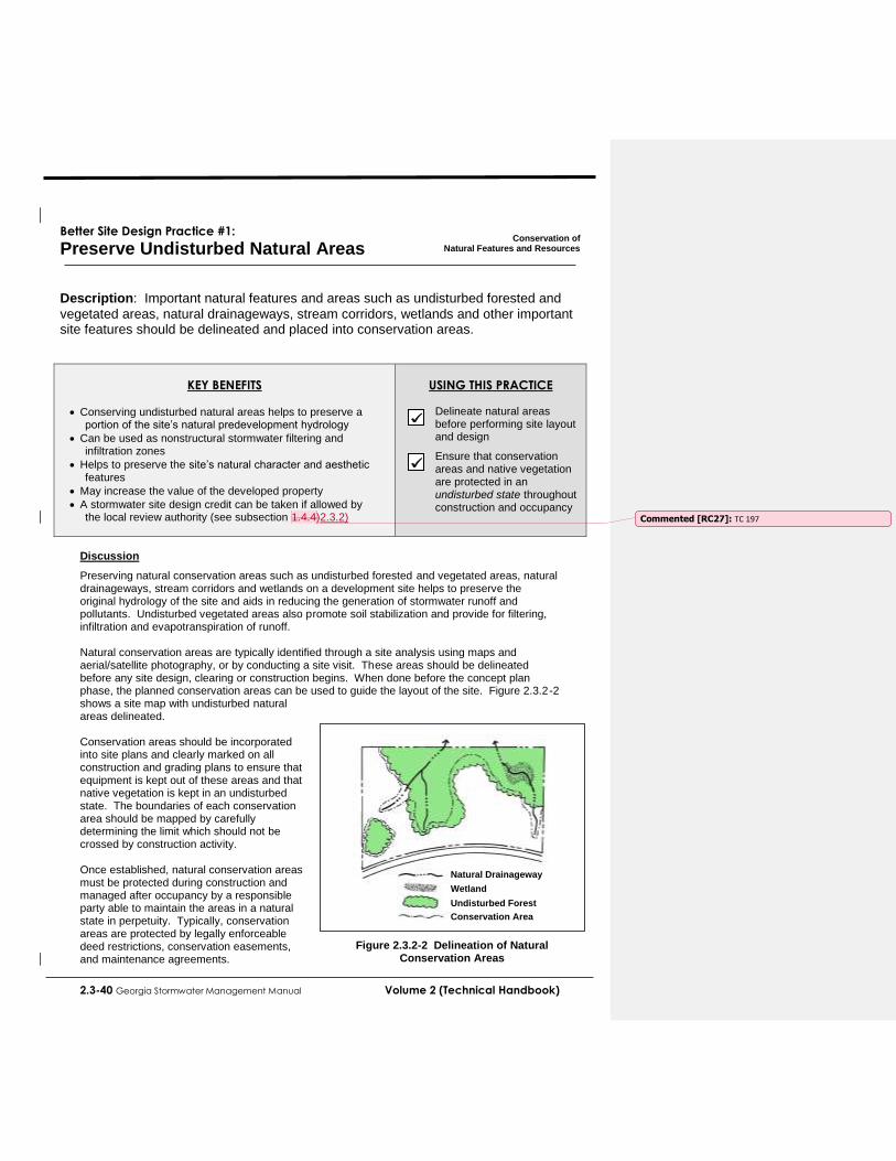
2.3-40 Georgia Stormwater Management Manual Volume 2 (Technical Handbook)
Better Site Design Practice #1:
Preserve Undisturbed Natural Areas
Conservation of
Natural Features and Resources
Description: Important natural features and areas such as undisturbed forested and
vegetated areas, natural drainageways, stream corridors, wetlands and other important site features should be delineated and placed into conservation areas.
KEY BENEFITS
Conserving undisturbed natural areas helps to preserve a portion of the site’s natural predevelopment hydrology
Can be used as nonstructural stormwater filtering and infiltration zones
Helps to preserve the site’s natural character and aesthetic features
May increase the value of the developed property
A stormwater site design credit can be taken if allowed by the local review authority (see subsection 1.4.4)2.3.2)
USING THIS PRACTICE
Delineate natural areas before performing site layout and design
Ensure that conservation areas and native vegetation are protected in an undisturbed state throughout construction and occupancy
Discussion
Preserving natural conservation areas such as undisturbed forested and vegetated areas, natural drainageways, stream corridors and wetlands on a development site helps to preserve the original hydrology of the site and aids in reducing the generation of stormwater runoff and pollutants. Undisturbed vegetated areas also promote soil stabilization and provide for filtering, infiltration and evapotranspiration of runoff. Natural conservation areas are typically identified through a site analysis using maps and aerial/satellite photography, or by conducting a site visit. These areas should be delineated before any site design, clearing or construction begins. When done before the concept plan phase, the planned conservation areas can be used to guide the layout of the site. Figure 2.3.2-2 shows a site map with undisturbed natural areas delineated. Conservation areas should be incorporated into site plans and clearly marked on all construction and grading plans to ensure that equipment is kept out of these areas and that native vegetation is kept in an undisturbed state. The boundaries of each conservation area should be mapped by carefully determining the limit which should not be crossed by construction activity. Once established, natural conservation areas must be protected during construction and managed after occupancy by a responsible party able to maintain the areas in a natural state in perpetuity. Typically, conservation areas are protected by legally enforceable deed restrictions, conservation easements, and maintenance agreements.
Natural Drainageway
Wetland
Undisturbed Forest
Conservation Area
Figure 2.3.2-2 Delineation of Natural Conservation Areas
Commented [RC27]: TC 197

Volume 2 (Technical Handbook) Georgia Stormwater Management Manual 2.3-41
Better Site Design Practice #2:
Preserve Riparian Buffers
Conservation of
Natural Features and Resources
Description: Naturally vegetated buffers should be delineated and preserved along
perennial streams, rivers, lakes, and wetlands.
KEY BENEFITS
Riparian buffers can be used as nonstructural stormwater filtering and infiltration zones
Keeps structures out of the floodplain and provides a right-of-way for large flood events
Helps to preserve riparian ecosystems and habitats
A stormwater site design credit can be taken if allowed by the local review authority (see subsection 2.3.4)
USING THIS PRACTICE
Delineate and preserve naturally vegetated riparian buffers
Ensure that buffers and native vegetation are protected throughout construction and occupancy
Discussion
A riparian buffer is a special type of natural conservation area along a stream, wetland or shoreline where development is restricted or prohibited. The primary function of buffers is to protect and physically separate a stream, lake or wetland from future disturbance or encroachment. If properly designed, a buffer can provide stormwater management functions, can act as a right-of-way during floods, and can sustain the integrity of stream ecosystems and habitats. An example of a riparian stream buffer is shown in Figure 2.3.2-3. Forested riparian buffers should be maintained and reforestation should be encouraged where no wooded buffer exists. Proper restoration should include all layers of the forest plant community, including understory, shrubs and groundcover, not just trees. A riparian buffer can be of fixed or
variable width, but should be continuous and not interrupted by impervious areas that would allow stormwater to concentrate and flow into the stream without first flowing through the buffer. Ideally, riparian buffers should be sized to include the 100-year floodplain as well as steep banks and freshwater wetlands. The buffer depth needed to perform properly will depend on the size of the stream and the surrounding conditions, but a minimum 25-foot undisturbed vegetative buffer is needed for even the smallest perennial streams and a 50-foot or
larger undisturbed buffer is ideal. Even with a 25-foot undisturbed buffer, additional zones can be added to extend the total buffer to at least 75 feet from the edge of the stream. The three distinct
zones within the 75-foot depth are shown in Figure 2.3.2-4. The function, vegetative target and allowable uses vary by zone as described
in Table 2.3.2-1. These recommendations are minimum standards to apply to most streams. Some streams and
Figure 2.3.2-3 Riparian Stream Buffer

2.3-42 Georgia Stormwater Management Manual Volume 2 (Technical Handbook)
watershed may require additional measures to achieve protection. In some areas, specific state laws or local ordinances already require stricter buffers than are described here. The buffer widths discussed are not intended to modify or supercedesupersede deeper or more restrictive buffer requirements that are already in place.
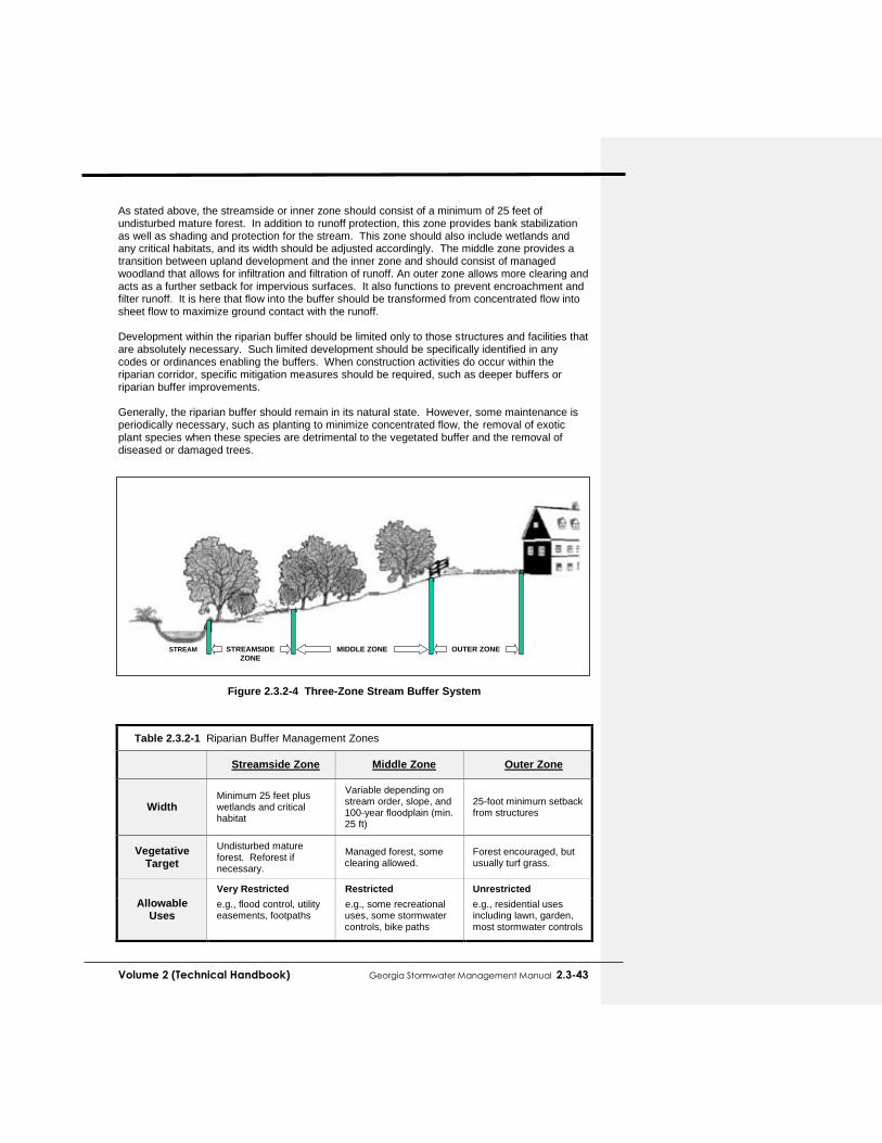
Volume 2 (Technical Handbook) Georgia Stormwater Management Manual 2.3-43
As stated above, the streamside or inner zone should consist of a minimum of 25 feet of undisturbed mature forest. In addition to runoff protection, this zone provides bank stabilization as well as shading and protection for the stream. This zone should also include wetlands and any critical habitats, and its width should be adjusted accordingly. The middle zone provides a transition between upland development and the inner zone and should consist of managed woodland that allows for infiltration and filtration of runoff. An outer zone allows more clearing and acts as a further setback for impervious surfaces. It also functions to prevent encroachment and filter runoff. It is here that flow into the buffer should be transformed from concentrated flow into sheet flow to maximize ground contact with the runoff. Development within the riparian buffer should be limited only to those structures and facilities that are absolutely necessary. Such limited development should be specifically identified in any codes or ordinances enabling the buffers. When construction activities do occur within the riparian corridor, specific mitigation measures should be required, such as deeper buffers or riparian buffer improvements. Generally, the riparian buffer should remain in its natural state. However, some maintenance is periodically necessary, such as planting to minimize concentrated flow, the removal of exotic plant species when these species are detrimental to the vegetated buffer and the removal of diseased or damaged trees.
Figure 2.3.2-4 Three-Zone Stream Buffer System
Table 2.3.2-1 Riparian Buffer Management Zones
Streamside Zone Middle Zone Outer Zone
Width Minimum 25 feet plus wetlands and critical habitat
Variable depending on stream order, slope, and 100-year floodplain (min. 25 ft)
25-foot minimum setback from structures
Vegetative Target
Undisturbed mature forest. Reforest if necessary.
Managed forest, some clearing allowed.
Forest encouraged, but usually turf grass.
Allowable Uses
Very Restricted Restricted Unrestricted
e.g., flood control, utility easements, footpaths
e.g., some recreational uses, some stormwater controls, bike paths
e.g., residential uses including lawn, garden, most stormwater controls
STREAMSIDE
ZONE
MIDDLE ZONE OUTER ZONESTREAM

2.3-44 Georgia Stormwater Management Manual Volume 2 (Technical Handbook)
Better Site Design Practice #3:
Avoid Floodplains
Conservation of
Natural Features and Resources
Description: Floodplain areas should be avoided for homes and other structures to
minimize risk to human life and property damage, and to allow the natural stream corridor to accommodate flood flows.
KEY BENEFITS
Preserving floodplains provides a natural right-of-way and temporary storage for large flood events
Keeps people and structures out of harm's way
Helps to preserve riparian ecosystems and habitats
Can be combined with riparian buffer protection to create linear greenways
USING THIS PRACTICE
Obtain maps of the 100-year floodplain from the local review authority
Ensure that all development activities do not encroach on the designated floodplain areas
Discussion
Floodplains are the low-lying flat lands that border streams and rivers. When a stream reaches its capacity and overflows its channel after storm events, the floodplain provides for storage and conveyance of these excess flows. In their natural state they reduce flood velocities and peak flow rates by the passage of flows through dense vegetation. Floodplains also play an important role in reducing sedimentation and filtering runoff, and provide habitat for both aquatic and terrestrial life. Development in floodplain areas can reduce the ability of the floodplain to convey stormwater, potentially causing safety problems or significant damage to the site in question, as well as to both upstream and downstream properties. Most communities regulate the use of
floodplain areas to minimize the risk to human life as well as to avoid flood damage to structures and property. As such, floodplain areas should be avoided on a development site. Ideally, the entire 100-year full-buildout floodplain should be avoided for clearing or building activities, and should be preserved in a natural undisturbed state where possible. Floodplain protection is complementary to riparian buffer preservation. Both of these better site design practices preserve stream corridors in a natural state and allow for the protection of vegetation and habitat. Depending on the site topography, 100-year floodplain boundaries may lie inside or outside of a preserved riparian buffer corridor, as shown in Figure 2.3.2-5.
Maps of the 100-year floodplain can typically be obtained through the local review authority. Developers and builders should also ensure that their site design comply will any other relevant local floodplain and FEMA requirements.
Figure 2.3.2-5 Floodplain Boundaries in Relation to a Riparian Buffer

Volume 2 (Technical Handbook) Georgia Stormwater Management Manual 2.3-45
Better Site Design Practice #4:
Avoid Steep Slopes
Conservation of
Natural Features and Resources
Description: Steep slopes should be avoided due to the potential for soil erosion and
increased sediment loading. Excessive grading and flattening of hills and ridges should be minimized.
KEY BENEFITS
Preserving steep slopes helps to prevent soil erosion and degradation of stormwater runoff
Steep slopes can be kept in an undisturbed natural condition to help stabilize hillsides and soils
Building on flatter areas will reduce the need for cut-and-fill and grading
USING THIS PRACTICE
Avoid development on steep slope areas, especially those with a grade of 15% or greater
Minimize grading and flattening of hills and ridges
Discussion
Developing on steep slope areas has the potential to cause excessive soil erosion and stormwater runoff during and after construction. Past studies by the SCS (now NRCS) and others have shown that soil erosion is significantly increased on slopes of 15% or greater. In addition, the nature of steep slopes means that greater areas of soil and land area are disturbed to locate facilities on them compared to flatter slopes as demonstrated in Figure 2.3.2-6. Therefore, development on slopes with a grade of 15% or greater should be avoided if possible to limit soil loss, erosion, excessive stormwater runoff, and the degradation of surface water. Excessive grading should be avoided on all slopes, as should the flattening of hills and ridges. Steep slopes should be kept in an undisturbed natural condition to help stabilize hillsides and soils On slopes greater than 25%, no development, regrading, or stripping of vegetation should be considered unless the disturbance is for roadway crossings or utility construction and it can be demonstrated that the roadway or utility improvements are absolutely necessary in the sloped area.
Figure 2.3.2-6 Flattening Steep Slopes for Building Sites Uses More Land
Area Than Building on Flatter Slopes (Source: MPCA, 1989)
Large Impact Area
Small Impact Area
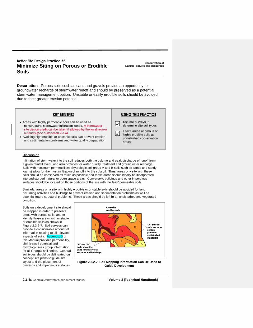
2.3-46 Georgia Stormwater Management Manual Volume 2 (Technical Handbook)
Better Site Design Practice #5:
Minimize Siting on Porous or Erodible Soils
Conservation of
Natural Features and Resources
Description: Porous soils such as sand and gravels provide an opportunity for
groundwater recharge of stormwater runoff and should be preserved as a potential stormwater management option. Unstable or easily erodible soils should be avoided due to their greater erosion potential.
KEY BENEFITS
Areas with highly permeable soils can be used as nonstructural stormwater infiltration zones. A stormwater site design credit can be taken if allowed by the local review authority (see subsection 2.3.4)
Avoiding high erodible or unstable soils can prevent erosion and sedimentation problems and water quality degradation
USING THIS PRACTICE
Use soil surveys to determine site soil types
Leave areas of porous or highly erodible soils as undisturbed conservation areas
Discussion
Infiltration of stormwater into the soil reduces both the volume and peak discharge of runoff from a given rainfall event, and also provides for water quality treatment and groundwater recharge. Soils with maximum permeabilities (hydrologic soil group A and B soils such as sands and sandy loams) allow for the most infiltration of runoff into the subsoil. Thus, areas of a site with these soils should be conserved as much as possible and these areas should ideally be incorporated into undisturbed natural or open space areas. Conversely, buildings and other impervious surfaces should be located on those portions of the site with the least permeable soils. Similarly, areas on a site with highly erodible or unstable soils should be avoided for land disturbing activities and buildings to prevent erosion and sedimentation problems as well as potential future structural problems. These areas should be left in an undisturbed and vegetated condition. Soils on a development site should be mapped in order to preserve areas with porous soils, and to identify those areas with unstable or erodible soils as shown in Figure 2.3.2-7. Soil surveys can provide a considerable amount of information relating to all relevant aspects of soils. Appendix B of this Manual provides permeability, shrink-swell potential and hydrologic soils group information for all Georgia soil series. General soil types should be delineated on concept site plans to guide site layout and the placement of buildings and impervious surfaces.
Figure 2.3.2-7 Soil Mapping Information Can Be Used to
Guide Development
A
A
A
A
B
B
B
C
C
C
D“A” and “B”
soils are more
porous –
preserve
undisturbed
if possible
“C” and “D”
soils should be
used for impervious
surfaces and buildings
Area with
erodible soils
A
A
A
A
B
B
B
C
C
C
D“A” and “B”
soils are more
porous –
preserve
undisturbed
if possible
“C” and “D”
soils should be
used for impervious
surfaces and buildings
Area with
erodible soils

Volume 2 (Technical Handbook) Georgia Stormwater Management Manual 2.3-47
2.3.2.2 Lower Impact Site Design Techniques
After a site analysis has been performed and conservation areas have been delineated, there are numerous opportunities in the site design and layout phase to reduce both water quantity and quality impacts of stormwater runoff. These primarily deal with the location and configuration of impervious surfaces or structures on the site and include the following practices and techniques covered over the next several pages:
Fit the Design to the Terrain
Locate Development in Less Sensitive Areas
Reduce Limits of Clearing and Grading
Utilize Open Space Development
Consider Creative Development Design The goal of lower impact site design techniques is to lay out the elements of the development project in such a way that the site design (i.e. placement of buildings, parking, streets and driveways, lawns, undisturbed vegetation, buffers, etc.) is optimized for effective stormwater management. That is, the site design takes advantage of the site's natural features, including those placed in conservation areas, as well as any site constraints and opportunities (topography, soils, natural vegetation, floodplains, shallow bedrock, high water table, etc.) to prevent both on-site and downstream stormwater impacts. Figure 2.3.2-8 shows a development that has utilized several lower impact site design techniques in its overall layout and design.
Figure 2.3.2-8 Development Design Utilizing Several Lower Impact Site Design Techniques

2.3-48 Georgia Stormwater Management Manual Volume 2 (Technical Handbook)
Better Site Design Practice #6:
Fit Design to the Terrain
Lower Impact
Site Design Techniques
Description: The layout of roadways and buildings on a site should generally conform
to the landforms on a site. Natural drainageways and stream buffer areas should be preserved by designing road layouts around them. Buildings should be sited to utilize the natural grading and drainage system and avoid the unnecessary disturbance of vegetation and soils.
KEY BENEFITS
Helps to preserve the natural hydrology and drainageways of a site
Reduces the need for grading and land disturbance
Provides a framework for site design and layout
USING THIS PRACTICE
Develop roadway patterns to fit the site terrain. Locate buildings and impervious surfaces away from steep slopes, drainageways and floodplains
Discussion
All site layouts should be designed to conform with or "fit" the natural landforms and topography of a site. This helps to preserve the natural hydrology and drainageways on the site, as well as reduces the need for grading and disturbance of vegetation and soils. Figure 2.3.2-9 illustrates the placement of roads and homes in a residential development. Roadway patterns on a site should be chosen to provide access schemes which match the terrain. In rolling or hilly terrain, streets should be designed to follow natural contours to reduce clearing and grading. Street hierarchies with local streets branching from collectors in short loops and cul-de-sacs along ridgelines help to prevent the crossing of streams and drainageways as shown in Figure 2.3.2-10. In flatter areas, a traditional grid pattern of streets or "fluid" grids which bend and may be interrupted by natural drainageways may be more appropriate (see Figure 2.3.2-11). In either case, buildings and impervious surfaces should be kept off of steep slopes, away from natural drainageways, and out of floodplains and other lower lying areas. In addition, the major axis of buildings should be oriented parallel to existing contours.
Figure 2.3.2-9 Preserving the Natural Topography of the Site
(Adapted from Sykes, 1989)
Roads on ridge lines
or upland areas
Vegetated
drainage swales
Natural drainageways
preserved
Houses located on
“brow” of ridge
Undisturbed
vegetation
on slopes
Roads on ridge lines
or upland areas
Vegetated
drainage swales
Natural drainageways
preserved
Houses located on
“brow” of ridge
Undisturbed
vegetation
on slopes

Volume 2 (Technical Handbook) Georgia Stormwater Management Manual 2.3-49
Figure 2.3.2-10 Subdivision Design for Hilly or Steep Terrain Utilizes Branching Streets
From Collectors that Preserves Natural Drainageways and Stream Corridors
2.3.2-11 A Subdivision Design for Flat Terrain Uses a Fluid Grid Layout that is Interrupted
by the Stream Corridor

2.3-50 Georgia Stormwater Management Manual Volume 2 (Technical Handbook)
Better Site Design Practice #7:
Locate Development in Less Sensitive Areas
Lower Impact
Site Design Techniques
Description: To minimize the hydrologic impacts on the existing site land cover, the
area of development should be located in areas of the site that are less sensitive to disturbance or have a lower value in terms of hydrologic function.
KEY BENEFITS
Helps to preserve the natural hydrology and drainageways of a site
Makes most efficient use of natural site features for preventing and mitigating stormwater impacts
Provides a framework for site design and layout
USING THIS PRACTICE
Lay out the site design to minimize the hydrologic impact of structures and impervious surfaces
Discussion
In much the same way that a development should be designed to conform to terrain of the site, a site layout should also be designed so that the areas of development are placed in the locations of the site that minimize the hydrologic impact of the project. This is accomplished by steering development to areas of the site that are less sensitive to land disturbance or have a lower value in terms of hydrologic function using the following methods:
Locate buildings and impervious surfaces away from stream corridors, wetlands and natural drainageways. Use buffers to preserve and protect riparian areas and corridors.
Areas of the site with porous soils should left in an undisturbed condition and/or used as stormwater runoff infiltration zones. Buildings and impervious surfaces should be located in areas with less permeable soils.
Avoid land disturbing activities or construction on areas with steep slopes or unstable soils.
Minimize the clearing of areas with dense tree canopy or thick vegetation, and ideally preserve them as natural conservation areas
Ensure that natural drainageways and flow paths are preserved, where possible. Avoid the filling or grading of natural depressions and ponding areas.
Figure 2.3.2-12 shows a development site where the natural features have been mapped in order to delineate the hydrologically sensitive areas. Through careful site planning, sensitive areas can be set aside as natural open space areas (see Better Site Design Practice #9). In many cases, such areas can be used as buffer spaces between land uses on the site or between adjacent sites.
Figure 2.3.2-12 Guiding Development Away from to Less Sensitive Areas of
a Site (Source: Prince George’s County, MD, 1999)
Commented [RC28]: TC 210

Volume 2 (Technical Handbook) Georgia Stormwater Management Manual 2.3-51
Better Site Design Practice #8:
Reduce Limits of Clearing and Grading
Lower Impact
Site Design Techniques
Description: Clearing and grading of the site should be limited to the minimum amount
needed for the development and road access. Site footprinting should be used to disturb the smallest possible land area on a site.
KEY BENEFITS
Preserves more undisturbed natural areas on a development site
Techniques can be used to help protect natural conservation areas and other site features
USING THIS PRACTICE
Establish limits of disturbance for all development activities
Use site footprinting to minimize clearing and land disturbance
Discussion
Minimal disturbance methods should be used to limit the amount of clearing and grading that takes place on a development site, preserving more of the undisturbed vegetation and natural hydrology of a site. These methods include:
Establishing a limit of disturbance (LOD) based on maximum disturbance zone radii/lengths. These maximum distances should reflect reasonable construction techniques and equipment needs together with the physical situation of the development site such as slopes or soils. LOD distances may vary by type of development, size of lot or site, and by the specific development feature involved.
Using site "footprinting" which maps all of the limits of disturbance to identify the smallest possible land area on a site which requires clearing or land disturbance. Examples of site footprinting is illustrated in Figures 2.3.2-13 and 2.3.2-14.
Fitting the site design to the terrain.
Using special procedures and equipment which reduce land disturbance.
Figure 2.3.2-13 Establishing Limits of Clearing (Source: DDNREC, 1997)
Figure 2.3.2-14 Example of Site Footprinting

2.3-52 Georgia Stormwater Management Manual Volume 2 (Technical Handbook)
Better Site Design Practice #9:
Utilize Open Space Development
Lower Impact
Site Design Techniques
Description: Open space site designs incorporate smaller lot sizes to reduce overall
impervious cover while providing more undisturbed open space and protection of water resources.
KEY BENEFITS
Preserves conservation areas on a development site
Can be used to preserve natural hydrology and drainageways
Can be used to help protect natural conservation areas and other site features
Reduces the need for grading and land disturbance
Reduces infrastructure needs and overall development costs
USING THIS PRACTICE
Use a site design which concentrates development and preserves open space and natural areas of the site
Discussion
Open space development, also known as conservation development or clustering, is a better site design technique that concentrates structures and impervious surfaces in a compact area in one portion of the development site in exchange for providing open space and natural areas elsewhere on the site. Typically smaller lots and/or nontraditional lot designs are used to cluster development and create more conservation areas on the site. Open space developments have many benefits compared with conventional commercial developments or residential subdivisions: they can reduce impervious cover, stormwater pollution, construction costs, and the need for grading and landscaping, while providing for the conservation of natural areas. Figures 2.3.2-15 and 2.3.2-16 show examples of open space developments. Along with reduced imperviousness, open space designs provide a host of other environmental benefits lacking in most conventional designs. These developments reduce potential pressure to encroach on conservation and buffer areas because enough open space is usually reserved to accommodate these protection areas. As less land is cleared during the construction process, alteration of the natural hydrology and the potential for soil erosion are also greatly diminished. Perhaps most importantly, open space design reserves 25 to 50 percent of the development site in conservation areas that would not otherwise be protected. Open space developments can also be significantly less expensive to build than conventional projects. Most of the cost savings are due to reduced infrastructure cost for roads and stormwater management controls and conveyances. While open space developments are frequently less expensive to build, developers find that these properties often command higher prices than those in more conventional developments. Several studies estimate that residential properties in open space developments garner premiums that are higher than conventional subdivisions and moreover, sell or lease at an increased rate. Once established, common open space and natural conservation areas must be managed by a responsible party able to maintain the areas in a natural state in perpetuity. Typically, the conservation areas are protected by legally enforceable deed restrictions, conservation easements, and maintenance agreements.

Volume 2 (Technical Handbook) Georgia Stormwater Management Manual 2.3-53
Figure 2.3.2-15 Open Space Subdivision Site Design Example
Figure 2.3.2-16 Aerial View of an Open Space Subdivision

2.3-54 Georgia Stormwater Management Manual Volume 2 (Technical Handbook)
Better Site Design Practice #10:
Consider Creative Development Design
Lower Impact
Site Design Techniques
Description: Planned Unit Developments (PUDs) allow a developer or site designer
the flexibility to design a residential, commercial, industrial, or mixed-use development in a fashion that best promotes effective stormwater management and the protection of environmentally sensitive areas.
KEY BENEFITS
Allows flexibility to developers to implement creative site designs which include stormwater better site design practices
May be useful for implementing an open space development
USING THIS PRACTICE
Check with your local review authority to determine if the community supports PUDs
Determine the type and nature of deviations allowed and other criteria for receiving PUD approval
Discussion
A Planned Unit Development (PUD) is a type of planning approval available in some communities which provides greater design flexibility by allowing deviations from the typical development standards required by the local zoning code with additional variances or zoning hearings. The intent is to encourage better designed projects through the relaxation of some development requirements, in exchange for providing greater benefits to the community. PUDs can be used to implement many of the other stormwater better site design practices covered in this Manual and to create site designs that maximize natural nonstructural approaches to stormwater management. Examples of the types of zoning deviations which are often allowed through a PUD process include:
Allowing uses not listed as permitted, conditional or accessory by the zoning district in which the property is located
Modifying lot size and width requirements
Reducing building setbacks and frontages from property lines
Altering parking requirements
Increasing building height limits Many of these changes are useful in reducing the amount of impervious cover on a development site (see Better Site Design Practices #11 through #16). A developer or site designer should consult their local review authority to determine whether the community supports PUD approvals. If so, the type and nature of deviations allowed from individual development requirements should be obtained from the review authority in addition to any other criteria that must be met to obtain a PUD approval.
Volume 2 (Technical Handbook) Georgia Stormwater Management Manual 2.3-55
2.3.2.3 Reduction of Impervious Cover
Discussion
2.3..43.1 Introduction
Non-structural stormwater control practices are increasingly recognized as a critical feature in every site design. As such, a set of stormwater “credits” has been developed to provide developers and site designers an incentive to implement better site design practices that can reduce the volume of stormwater runoff and minimize the pollutant loads from a site. The credit system directly translates into cost savings to the developer by reducing the size of best management practices and conveyance facilities. The basic premise of the credit system is to recognize the water quality benefits of certain site design practices by allowing for a reduction in the water quality treatment volume (WQv). If a developer incorporates one or more of the credited practices in the design of the site, the requirement for capture and treatment of the water quality volume will be reduced. The Natural Area Conservation better site design practice provides a s that provide stormwater certain are listed in Table 2.3.4-1. Ssite-specific conditions are metwill determine the cannot be taken on upland sites that do not contain perennial or intermittent streamsprotected by natural areas that are conserved on a site, thereby retaining their pre-development hydrologic and water quality characteristics. It should be noted that better site design practices and techniques that reduce the overall impervious area on a site already implicitly reduce the total amount of stormwater runoff generated by a site (and thus reduce WQv) and are not further credited under this system.
For each potential credit, there is a minimum set of criteria and requirements which identify the conditions or circumstances under which the credit may be applied. The intent of the suggested numeric conditions (e.g., flow length, contributing area, etc.) is to avoid situations that could lead to a credit being granted without the corresponding reduction in pollution attributable to an effective site design modification.

2.3-56 Georgia Stormwater Management Manual Volume 2 (Technical Handbook)
Site designers are encouraged to utilize as many credits as they can on a site. Greater reductions in stormwater storage volumes can be achieved when many credits are combined (e.g., disconnecting rooftops and protecting natural conservation areas). However, credits cannot be claimed twice for an identical area of the site (e.g. claiming credit for natural conservation areas stream buffers and disconnecting rooftops over the same site area). Due to local safety codes, soil conditions, and topography, some of these site design credits may be restricted. Designers are encouraged to consult with the appropriate approval authority to ensure if and when a credit is applicable and to determine restrictions on non-structural strategies.
2.3.43.2 Stormwater Credits and the Site Planning Process
During the site planning process described in Section 2.4 there are several steps involved in site layout and design, each more clearly defining the location and function of the various components of the stormwater management system. The integration of site design credits can be integrated with this process as shown in Table 2.3.43-2.
Table 2.3.43-2 Integration of Site Design Credits with Site Development Process
Site Development Phase Site Design Credit Activity
Feasibility Study Determine stormwater management requirements
Perform site reconnaissance to identify potential areas for and types of credits
Site Analysis Identify and delineate natural feature conservation areas
(natural areas and stream buffers)
Concept Plan
Preserve natural areas and stream buffers during site layout
Reduce impervious surface area through various techniques
Identify locations for use of vegetated channels and groundwater recharge
Look for areas to disconnect impervious surfaces
Document the use of site design credits.
Preliminary and Final Plan
Perform layout and design of credit areas – integrating them into treatment trains
Ensure unified stormwater sizing criteria are satisfied
Ensure appropriate documentation of site design credits according to local requirements.

Volume 2 (Technical Handbook) Georgia Stormwater Management Manual 2.3-57
Construction Ensure protection of key areas
Ensure correct final construction of areas needed for credits
Final Inspection
Develop maintenance requirements and documents
Ensure long term protection and maintenance
Ensure credit areas are identified on final plan and plat if applicable
Description: Roadway lengths and widths should be minimized on a development site
where possible to reduce overall imperviousness.
KEY BENEFITS
Reduces the amount of impervious cover and associated runoff and pollutants generated
Reduces the costs associated with road construction and maintenance
USING THIS PRACTICE
Consider different site and road layouts that reduce overall street length
Minimize street width by using narrower street designs
Discussion
The use of alternative road layouts that reduce the total linear length of roadways can significantly reduce overall imperviousness of a development site. Site designers are encouraged to analyze different site and roadway layouts to see if they can reduce overall street length. The length of local cul-de-sacs and cross streets should be shortened to a maximum of 200 ADT (average trips per day) to minimize traffic and road noise so that shorter setbacks may be employed. In addition, residential streets and private streets within commercial and other development should be designed for the minimum required pavement width needed to support travel lanes, on-street parking, and emergency access. Figure 2.3.2-18 shows a number of different options for narrower street designs. Many times on-street parking can be reduced to one lane or eliminated on local access roads with less than 200 ADT on cul-de-sac streets and 400 ADT on two-way loops. One-way single-lane loop roads are another way to reduce the width of lower traffic streets.
26’ PAVE WIDTH
10’ DRAINAGE SWALE
4’ SIDEWALK
3’ UTILITY
60’ RIGHT OF WAY
18’ PAVE WIDTH
6’ DRAINAGE SWALE
3’ UTILITY
36’ RIGHT OF WAY
2.3-58 Georgia Stormwater Management Manual Volume 2 (Technical Handbook)
Discussion
2.3..43.1 Introduction
Non-structural stormwater control practices are increasingly recognized as a critical feature in every site design. As such, a set of stormwater “credits” has been developed to provide developers and site designers an incentive to implement better site design practices that can reduce the volume of stormwater runoff and minimize the pollutant loads from a site. The credit system directly translates into cost savings to the developer by reducing the size of best management practices and conveyance facilities. The basic premise of the credit system is to recognize the water quality benefits of certain site design practices by allowing for a reduction in the water quality treatment volume (WQv). If a developer incorporates one or more of the credited practices in the design of the site, the requirement for capture and treatment of the water quality volume will be reduced. The Natural Area Conservation better site design practice provides a s that provide stormwater certain are listed in Table 2.3.4-1. Ssite-specific conditions are metwill determine the cannot be taken on upland sites that do not contain perennial or intermittent streamsprotected by natural areas that are conserved on a site, thereby retaining their pre-development hydrologic and water quality characteristics. It should be noted that better site design practices and techniques that reduce the overall impervious area on a site already implicitly reduce the total amount of stormwater runoff generated by a site (and thus reduce WQv) and are not further credited under this system.
For each potential credit, there is a minimum set of criteria and requirements which identify the conditions or circumstances under which the credit may be applied. The intent of the suggested numeric conditions (e.g., flow length, contributing area, etc.) is to avoid situations that could lead to a credit being granted without the corresponding reduction in pollution attributable to an effective site design modification.
Site designers are encouraged to utilize as many credits as they can on a site. Greater reductions in stormwater storage volumes can be achieved when many credits are combined (e.g., disconnecting rooftops and protecting natural conservation areas). However, credits cannot be claimed twice for an identical area of the site (e.g. claiming credit for natural conservation areas stream buffers and disconnecting rooftops over the same site area). Due to local safety codes, soil conditions, and topography, some of these site design credits may be restricted. Designers are encouraged to consult with the appropriate approval authority to ensure if and when a credit is applicable and to determine restrictions on non-structural strategies.

Volume 2 (Technical Handbook) Georgia Stormwater Management Manual 2.3-59
2.3.43.2 Stormwater Credits and the Site Planning Process
During the site planning process described in Section 2.4 there are several steps involved in site layout and design, each more clearly defining the location and function of the various components of the stormwater management system. The integration of site design credits can be integrated with this process as shown in Table 2.3.43-2.
Table 2.3.43-2 Integration of Site Design Credits with Site Development Process
Site Development Phase Site Design Credit Activity
Feasibility Study Determine stormwater management requirements
Perform site reconnaissance to identify potential areas for and types of credits
Site Analysis Identify and delineate natural feature conservation areas
(natural areas and stream buffers)
Concept Plan
Preserve natural areas and stream buffers during site layout
Reduce impervious surface area through various techniques
Identify locations for use of vegetated channels and groundwater recharge
Look for areas to disconnect impervious surfaces
Document the use of site design credits.
Preliminary and Final Plan
Perform layout and design of credit areas – integrating them into treatment trains
Ensure unified stormwater sizing criteria are satisfied
Ensure appropriate documentation of site design credits according to local requirements.
Construction Ensure protection of key areas
Ensure correct final construction of areas needed for credits
Final Inspection
Develop maintenance requirements and documents
Ensure long term protection and maintenance
Ensure credit areas are identified on final plan and plat if applicable
Description: The impervious footprint of commercial buildings and residences can be
reduced by using alternate or taller buildings while maintaining the same floor to area ratio.
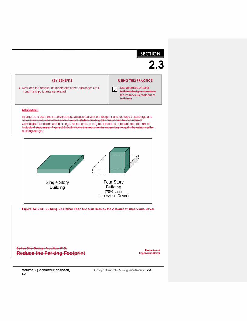
..SECTION..
2.3
Volume 2 (Technical Handbook) Georgia Stormwater Management Manual 2.3-
60
KEY BENEFITS
Reduces the amount of impervious cover and associated runoff and pollutants generated
USING THIS PRACTICE
Use alternate or taller building designs to reduce the impervious footprint of buildings
Discussion In order to reduce the imperviousness associated with the footprint and rooftops of buildings and other structures, alternative and/or vertical (taller) building designs should be considered. Consolidate functions and buildings, as required, or segment facilities to reduce the footprint of individual structures. Figure 2.3.2-19 shows the reduction in impervious footprint by using a taller building design.
Figure 2.3.2-19 Building Up Rather Than Out Can Reduce the Amount of Impervious Cover
Better Site Design Practice #13:
Reduce the Parking Footprint
Reduction of
Impervious Cover
Single Story Building
Four Story Building
(75% Less Impervious Cover)

..SECTION..
2.3
Volume 2 (Technical Handbook) Georgia Stormwater Management Manual 2.3-
61
Description: Reduce the overall imperviousness associated with parking lots by
providing compact car spaces, minimizing stall dimensions, incorporating efficient parking lanes, parking decks, and using porous paver surfaces or porous concrete in overflow parking areas where feasible and possible.
KEY BENEFITS
Reduces the amount of impervious cover and associated runoff and pollutants generated
USING THIS PRACTICE
Reduce the number of parking spaces
Minimize stall dimensions
Consider parking structures and shared parking
Use alternative porous surface for overflow areas
Discussion
Setting maximums for parking spaces, minimizing stall dimensions, using structured parking, encouraging shared parking and using alternative porous surfaces can all reduce the overall parking footprint and site imperviousness. Many parking lot designs result in far more spaces than actually required. This problem is exacerbated by a common practice of setting parking ratios to accommodate the highest hourly parking during the peak season. By determining average parking demand instead, a lower maximum number of parking spaces can be set to accommodate most of the demand. Table 2.3.2-2 provides examples of conventional parking requirements and compares them to average parking demand.
Table 2.3.2-2 Conventional Minimum Parking Ratios (Source: ITE, 1987; Smith, 1984; Wells, 1994)
Land Use Parking Requirement Actual Average
Parking Demand Parking Ratio Typical Range
Single family homes 2 spaces per dwelling
unit 1.5–2.5
1.11 spaces per dwelling unit
Shopping center 5 spaces per 1000 ft2
GFA 4.0–6.5 3.97 per 1000 ft2 GFA
Convenience store 3.3 spaces per 1000 ft2
GFA 2.0–10.0 --
Industrial 1 space per 1000 ft2
GFA 0.5–2.0 1.48 per 1000 ft2 GFA
Medical/ dental office
5.7 spaces per 1000 ft2 GFA
4.5–10.0 4.11 per 1000 ft2 GFA
GFA = Gross floor area of a building without storage or utility spaces.
Another technique to reduce the parking footprint is to minimize the dimensions of the parking spaces. This can be accomplished by reducing both the length and width of the parking stall. Parking stall dimensions can be further reduced if compact spaces are provided. While the trend toward larger sport utility vehicles (SUVs) is often cited as a barrier to implementing stall minimization techniques, stall width requirements in most local parking codes are much larger than the widest SUVs.

2.3-62 Georgia Stormwater Management Manual Volume 2 (Technical Handbook)
Discussion
2.3..43.1 Introduction
Non-structural stormwater control practices are increasingly recognized as a critical feature in every site design. As such, a set of stormwater “credits” has been developed to provide developers and site designers an incentive to implement better site design practices that can reduce the volume of stormwater runoff and minimize the pollutant loads from a site. The credit system directly translates into cost savings to the developer by reducing the size of best management practices and conveyance facilities. The basic premise of the credit system is to recognize the water quality benefits of certain site design practices by allowing for a reduction in the water quality treatment volume (WQv). If a developer incorporates one or more of the credited practices in the design of the site, the requirement for capture and treatment of the water quality volume will be reduced. The Natural Area Conservation better site design practice provides a s that provide stormwater certain are listed in Table 2.3.4-1. Ssite-specific conditions are metwill determine the cannot be taken on upland sites that do not contain perennial or intermittent streamsprotected by natural areas that are conserved on a site, thereby retaining their pre-development hydrologic and water quality characteristics. It should be noted that better site design practices and techniques that reduce the overall impervious area on a site already implicitly reduce the total amount of stormwater runoff generated by a site (and thus reduce WQv) and are not further credited under this system.
For each potential credit, there is a minimum set of criteria and requirements which identify the conditions or circumstances under which the credit may be applied. The intent of the suggested numeric conditions (e.g., flow length, contributing area, etc.) is to avoid situations that could lead to a credit being granted without the corresponding reduction in pollution attributable to an effective site design modification.
Site designers are encouraged to utilize as many credits as they can on a site. Greater reductions in stormwater storage volumes can be achieved when many credits are combined (e.g., disconnecting rooftops and protecting natural conservation areas). However, credits cannot be claimed twice for an identical area of the site (e.g. claiming credit for natural conservation areas stream buffers and disconnecting rooftops over the same site area). Due to local safety codes, soil conditions, and topography, some of these site design credits may be restricted. Designers are encouraged to consult with the appropriate approval authority to ensure if and when a credit is applicable and to determine restrictions on non-structural strategies.

Volume 2 (Technical Handbook) Georgia Stormwater Management Manual 2.3-63
2.3.43.2 Stormwater Credits and the Site Planning Process
During the site planning process described in Section 2.4 there are several steps involved in site layout and design, each more clearly defining the location and function of the various components of the stormwater management system. The integration of site design credits can be integrated with this process as shown in Table 2.3.43-2.
Table 2.3.43-2 Integration of Site Design Credits with Site Development Process
Site Development Phase Site Design Credit Activity
Feasibility Study Determine stormwater management requirements
Perform site reconnaissance to identify potential areas for and types of credits
Site Analysis Identify and delineate natural feature conservation areas
(natural areas and stream buffers)
Concept Plan
Preserve natural areas and stream buffers during site layout
Reduce impervious surface area through various techniques
Identify locations for use of vegetated channels and groundwater recharge
Look for areas to disconnect impervious surfaces
Document the use of site design credits.
Preliminary and Final Plan
Perform layout and design of credit areas – integrating them into treatment trains
Ensure unified stormwater sizing criteria are satisfied
Ensure appropriate documentation of site design credits according to local requirements.
Construction Ensure protection of key areas
Ensure correct final construction of areas needed for credits
Final Inspection
Develop maintenance requirements and documents
Ensure long term protection and maintenance
Ensure credit areas are identified on final plan and plat if applicable
Description: Use smaller front and side setbacks and narrower frontages to reduce
total road length and driveway lengths.
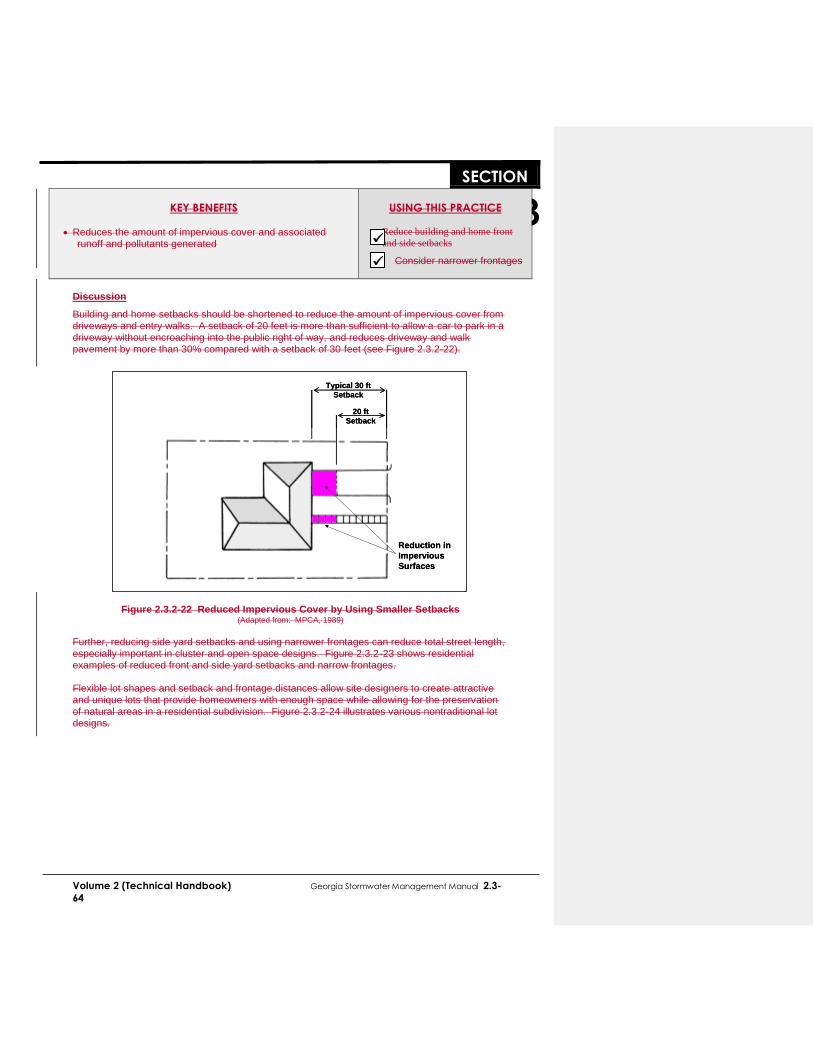
..SECTION..
2.3
Volume 2 (Technical Handbook) Georgia Stormwater Management Manual 2.3-
64
KEY BENEFITS
Reduces the amount of impervious cover and associated runoff and pollutants generated
USING THIS PRACTICE
Reduce building and home front
and side setbacks
Consider narrower frontages
Discussion
Building and home setbacks should be shortened to reduce the amount of impervious cover from driveways and entry walks. A setback of 20 feet is more than sufficient to allow a car to park in a driveway without encroaching into the public right of way, and reduces driveway and walk pavement by more than 30% compared with a setback of 30 feet (see Figure 2.3.2-22).
Figure 2.3.2-22 Reduced Impervious Cover by Using Smaller Setbacks
(Adapted from: MPCA, 1989)
Further, reducing side yard setbacks and using narrower frontages can reduce total street length, especially important in cluster and open space designs. Figure 2.3.2-23 shows residential examples of reduced front and side yard setbacks and narrow frontages. Flexible lot shapes and setback and frontage distances allow site designers to create attractive and unique lots that provide homeowners with enough space while allowing for the preservation of natural areas in a residential subdivision. Figure 2.3.2-24 illustrates various nontraditional lot designs.
Typical 30 ft
Setback
20 ft
Setback
Reduction in
Impervious
Surfaces
Typical 30 ft
Setback
20 ft
Setback
Reduction in
Impervious
Surfaces

Volume 2 (Technical Handbook) Georgia Stormwater Management Manual 2.3-65
Discussion
2.3..43.1 Introduction
Non-structural stormwater control practices are increasingly recognized as a critical feature in every site design. As such, a set of stormwater “credits” has been developed to provide developers and site designers an incentive to implement better site design practices that can reduce the volume of stormwater runoff and minimize the pollutant loads from a site. The credit system directly translates into cost savings to the developer by reducing the size of best management practices and conveyance facilities. The basic premise of the credit system is to recognize the water quality benefits of certain site design practices by allowing for a reduction in the water quality treatment volume (WQv). If a developer incorporates one or more of the credited practices in the design of the site, the requirement for capture and treatment of the water quality volume will be reduced. The Natural Area Conservation better site design practice provides a s that provide stormwater certain are listed in Table 2.3.4-1. Ssite-specific conditions are metwill determine the cannot be taken on upland sites that do not contain perennial or intermittent streamsprotected by natural areas that are conserved on a site, thereby retaining their pre-development hydrologic and water quality characteristics. It should be noted that better site design practices and techniques that reduce the overall impervious area on a site already implicitly reduce the total amount of stormwater runoff generated by a site (and thus reduce WQv) and are not further credited under this system.
For each potential credit, there is a minimum set of criteria and requirements which identify the conditions or circumstances under which the credit may be applied. The intent of the suggested numeric conditions (e.g., flow length, contributing area, etc.) is to avoid situations that could lead to a credit being granted without the corresponding reduction in pollution attributable to an effective site design modification.
Site designers are encouraged to utilize as many credits as they can on a site. Greater storage volumes can be achieved when many credits are combined (e.g., disconnecting rooftops and protecting natural conservation areas). However, credits cannot be claimed twice for an identical area of the site (e.g. claiming credit for natural conservation areas stream buffers and rooftops over the same site area). Due to local safety codes, soil conditions, and topography, some of these site design credits may be restricted. Designers are encouraged to consult with the appropriate approval authority to ensure if and when a credit is applicable and to determine restrictions on non-structural strategies.

2.3-66 Georgia Stormwater Management Manual Volume 2 (Technical Handbook)
2.3.43.2 Stormwater Credits and the Site Planning Process
During the site planning process described in Section 2.4 there are several steps involved in site layout and design, each more clearly defining the location and function of the various components of the stormwater management system. The integration of site design credits can be integrated with this process as shown in Table 2.3.43-2.
Table 2.3.43-2 Integration of Site Design Credits with Site Development Process
Site Development Phase Site Design Credit Activity
Feasibility Study Determine stormwater management requirements
Perform site reconnaissance to identify potential areas for and types of credits
Site Analysis Identify and delineate natural feature conservation areas
(natural areas and stream buffers)
Concept Plan
Preserve natural areas and stream buffers during site layout
Reduce impervious surface area through various techniques
Identify locations for use of vegetated channels and groundwater recharge
Look for areas to disconnect impervious surfaces
Document the use of site design credits.
Preliminary and Final Plan
Perform layout and design of credit areas – integrating them into treatment trains
Ensure unified stormwater sizing criteria are satisfied
Ensure appropriate documentation of site design credits according to local requirements.
Construction Ensure protection of key areas
Ensure correct final construction of areas needed for credits
Final Inspection
Develop maintenance requirements and documents
Ensure long term protection and maintenance
Ensure credit areas are identified on final plan and plat if applicable
Description: Minimize the number of residential street cul-de-sacs and incorporate
landscaped areas to reduce their impervious cover. The radius of cul-de-sacs should be the minimum required to accommodate emergency and maintenance vehicles. Alternative turnarounds should also be considered.

..SECTION..
2.3
Volume 2 (Technical Handbook) Georgia Stormwater Management Manual 2.3-
67
KEY BENEFITS
Reduces the amount of impervious cover and associated runoff and pollutants generated
USING THIS PRACTICE
Consider alternative cul-de-sac designs
Discussion
Alternative turnarounds are designs for end-of-street vehicle turnarounds that replace cul-de-sacs and reduce the amount of impervious cover created in developments. Cul-de-sacs are local access streets with a closed circular end that allows for vehicle turnarounds. Many of these cul-de-sacs can have a radius of more than 40 feet. From a stormwater perspective, cul-de-sacs create a huge bulb of impervious cover, increasing the amount of runoff. For this reason, reducing the size of cul-de-sacs through the use of alternative turnarounds or eliminating them altogether can reduce the amount of impervious cover created at a site. Numerous alternatives create less impervious cover than the traditional 40-foot cul-de-sac. These alternatives include reducing cul-de-sacs to a 30-foot radius and creating hammerheads, loop roads, and pervious islands in the cul-de-sac center (see Figure 2.3.2-25). Sufficient turnaround area is a significant factor to consider in the design of cul-de-sacs. In particular, the types of vehicles entering into the cul-de-sac should be considered. Fire trucks, service vehicles and school buses are often cited as needing large turning radii. However, some fire trucks are designed for smaller turning radii. In addition, many newer large service vehicles are designed with a tri-axle (requiring a smaller turning radius) and many school buses usually do not enter individual cul-de-sacs. Implementing alternative turnarounds will require addressing local regulations and marketing issues. Communities may have specific design criteria for cul-de-sacs and other alternative turnarounds that need to be modified.
Figure 2.3.2-25 Four Turnaround Options for Residential Streets (Source: Schueler, 1995)
Better Site Design Practice #16:
Create Parking Lot Stormwater “Islands”
Reduction of
Impervious Cover
40 ft cul-de sac with
landscaped island
30 ft radius
cul-de-sac
60 by 20 ft T-shaped
turnaround
Loop road
40’30’
60’
20’
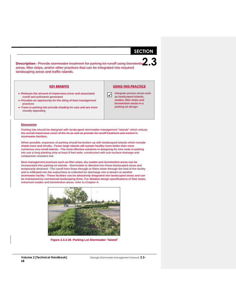
..SECTION..
2.3
Volume 2 (Technical Handbook) Georgia Stormwater Management Manual 2.3-
68
Description: Provide stormwater treatment for parking lot runoff using bioretention
areas, filter strips, and/or other practices that can be integrated into required landscaping areas and traffic islands.
KEY BENEFITS
Reduces the amount of impervious cover and associated runoff and pollutants generated
Provides an opportunity for the siting of best management practices
Trees in parking lots provide shading for cars and are more visually appealing
USING THIS PRACTICE
Integrate porous areas such as landscaped islands, swales, filter strips and bioretention areas in a parking lot design.
Discussion
Parking lots should be designed with landscaped stormwater management “islands” which reduce the overall impervious cover of the lot as well as provide for runoff treatment and control in stormwater facilities.
When possible, expanses of parking should be broken up with landscaped islands which include shade trees and shrubs. Fewer large islands will sustain healthy trees better than more numerous very small islands. The most effective solutions in designing for tree roots in parking lots use a long planting strip at least 8 feet wide, constructed with sub-surface drainage and compaction resistant soil.
Best management practices such as filter strips, dry swales and bioretention areas can be incorporated into parking lot islands. Stormwater is directed into these landscaped areas and temporarily detained. The runoff then flows through or filters down through the bed of the facility and is infiltrated into the subsurface or collected for discharge into a stream or another stormwater facility. These facilities can be attractively integrated into landscaped areas and can be maintained by commercial landscaping firms. For detailed design specifications of filter strips, enhanced swales and bioretention areas, refer to Chapter 4.
Figure 2.3.2-26 Parking Lot Stormwater “Island”

Volume 2 (Technical Handbook) Georgia Stormwater Management Manual 2.3-69
Discussion
2.3..43.1 Introduction
Non-structural stormwater control practices are increasingly recognized as a critical feature in every site design. As such, a set of stormwater “credits” has been developed to provide developers and site designers an incentive to implement better site design practices that can reduce the volume of stormwater runoff and minimize the pollutant loads from a site. The credit system directly translates into cost savings to the developer by reducing the size of best management practices and conveyance facilities. The basic premise of the credit system is to recognize the water quality benefits of certain site design practices by allowing for a reduction in the water quality treatment volume (WQv). If a developer incorporates one or more of the credited practices in the design of the site, the requirement for capture and treatment of the water quality volume will be reduced. The Natural Area Conservation better site design practice provides a s that provide stormwater certain are listed in Table 2.3.4-1. Ssite-specific conditions are metwill determine the cannot be taken on upland sites that do not contain perennial or intermittent streamsprotected by natural areas that are conserved on a site, thereby retaining their pre-development hydrologic and water quality characteristics. It should be noted that better site design practices and techniques that reduce the overall impervious area on a site already implicitly reduce the total amount of stormwater runoff generated by a site (and thus reduce WQv) and are not further credited under this system.
For each potential credit, there is a minimum set of criteria and requirements which identify the conditions or circumstances under which the credit may be applied. The intent of the suggested numeric conditions (e.g., flow length, contributing area, etc.) is to avoid situations that could lead to a credit being granted without the corresponding reduction in pollution attributable to an effective site design modification.
Site designers are encouraged to utilize as many credits as they can on a site. Greater storage volumes can be achieved when many credits are combined (e.g., disconnecting rooftops and protecting natural conservation areas). However, credits cannot be claimed twice for an identical area of the site (e.g. claiming credit for natural conservation areas stream buffers and rooftops over the same site area). Due to local safety codes, soil conditions, and topography, some of these site design credits may be restricted. Designers are encouraged to consult with the appropriate approval authority to ensure if and when a credit is applicable and to determine restrictions on non-structural strategies.

2.3-70 Georgia Stormwater Management Manual Volume 2 (Technical Handbook)
2.3.43.2 Stormwater Credits and the Site Planning Process
During the site planning process described in Section 2.4 there are several steps involved in site layout and design, each more clearly defining the location and function of the various components of the stormwater management system. The integration of site design credits can be integrated with this process as shown in Table 2.3.43-2.
Table 2.3.43-2 Integration of Site Design Credits with Site Development Process
Site Development Phase Site Design Credit Activity
Feasibility Study Determine stormwater management requirements
Perform site reconnaissance to identify potential areas for and types of credits
Site Analysis Identify and delineate natural feature conservation areas
(natural areas and stream buffers)
Concept Plan
Preserve natural areas and stream buffers during site layout
Reduce impervious surface area through various techniques
Identify locations for use of vegetated channels and groundwater recharge
Look for areas to disconnect impervious surfaces
Document the use of site design credits.
Preliminary and Final Plan
Perform layout and design of credit areas – integrating them into treatment trains
Ensure unified stormwater sizing criteria are satisfied
Ensure appropriate documentation of site design credits according to local requirements.
Construction Ensure protection of key areas
Ensure correct final construction of areas needed for credits
Final Inspection
Develop maintenance requirements and documents
Ensure long term protection and maintenance
Ensure credit areas are identified on final plan and plat if applicable
Description: Undisturbed natural areas such as forested conservation areas and
stream buffers can be used to treat and control stormwater runoff from other areas of the site with proper design.

..SECTION..
2.3
Volume 2 (Technical Handbook) Georgia Stormwater Management Manual 2.3-
71
KEY BENEFITS
Riparian buffers and undisturbed vegetated areas can be used to filter and infiltrate stormwater runoff
Natural depressions can provide inexpensive storage and detention of stormwater flows
A stormwater site design credit can be taken if allowed by the local review authority (see subsection 2.3.4)
USING THIS PRACTICE
Direct runoff towards buffers and undisturbed areas using a level spreader to ensure sheet flow Utilize natural depressions for runoff storage
Discussion
Runoff can be directed towards riparian buffers and other undisturbed natural areas delineated in the initial stages of site planning to infiltrate runoff, reduce runoff velocity and remove pollutants. Natural depressions can be used to temporarily store (detain) and infiltrate water, particularly in areas with porous (hydrologic soil group A and B) soils. The objective in utilizing natural areas for stormwater infiltration is to intercept runoff before it has become substantially concentrated and then distribute this flow evenly (as sheet flow) to the buffer or natural area. This can typically be accomplished using a level spreader, as seen in Figure 2.3.2-28. A mechanism for the bypass of higher flow events should be provided to reduce erosion or damage to a buffer or undisturbed natural area. Carefully constructed berms can be placed around natural depressions and below undisturbed vegetated areas with porous soils to provide for additional runoff storage and/or infiltration of flows.
Figure 2.3.2-28 Use of a Level Spreader with a Riparian Buffer
(Adapted from NCDENR, 1998)
Better Site Design Practice #18:
Use Natural Drainageways Instead of Storm Sewers
Utilization of Natural Features
for Stormwater Management
LEVEL
SPREADER
UNDISTURBED
BUFFER

..SECTION..
2.3
Volume 2 (Technical Handbook) Georgia Stormwater Management Manual 2.3-
72
Description: The natural drainage paths of a site can be used instead of constructing
underground storm sewers or concrete open channels.
KEY BENEFITS
Use of natural drainageways reduces the cost of constructing storm sewers or other conveyances, and may reduce the need for land disturbance and grading
Natural drainage paths are less hydraulically efficient than man-made conveyances, resulting in longer travel times and lower peak discharges
Can be combined with buffer systems to allow for stormwater filtration and infiltration
USING THIS PRACTICE
Preserve natural flow paths in the site design Direct runoff to natural drainageways, ensuring that peak flows and velocities will not cause channel erosion
Discussion
Structural drainage systems and storm sewers are designed to be hydraulically efficient in removing stormwater from a site. However, in doing so these systems tend to increase peak runoff discharges, flow velocities and the delivery of pollutants to downstream waters. An alternative is the use of natural drainageways and vegetated swales (where slopes and soils permit) to carry stormwater flows to their natural outlets, particularly for low-density development and residential subdivisions. The use of natural open channels allows for more storage of stormwater flows on-site, lower stormwater peak flows, a reduction in erosive runoff velocities, infiltration of a portion of the runoff volume, and the capture and treatment of stormwater pollutants. It is critical that natural drainageways be protected from higher post-development flows by applying downstream channel protection methods (including the CPv criteria) to prevent erosion and degradation.
Figure 2.3.2-29 Example of a Subdivision Using Natural Drainageways for Stormwater Conveyance and Management
Better Site Design Practice #19:
Use Vegetated Swales Instead of Curb
Utilization of Natural Features
for Stormwater Management
Undisturbed
Vegetation
Undisturbed
Vegetation
Natural Drainageways
Preserved
Natural Drainageways
Preserved
Undisturbed
Vegetation
Undisturbed
Vegetation
Natural Drainageways
Preserved
Natural Drainageways
Preserved

Volume 2 (Technical Handbook) Georgia Stormwater Management Manual 2.3-73
and Gutter
Discussion
2.3..43.1 Introduction
Non-structural stormwater control practices are increasingly recognized as a critical feature in every site design. As such, a set of stormwater “credits” has been developed to provide developers and site designers an incentive to implement better site design practices that can reduce the volume of stormwater runoff and minimize the pollutant loads from a site. The credit system directly translates into cost savings to the developer by reducing the size of best management practices and conveyance facilities. The basic premise of the credit system is to recognize the water quality benefits of certain site design practices by allowing for a reduction in the water quality treatment volume (WQv). If a developer incorporates one or more of the credited practices in the design of the site, the requirement for capture and treatment of the water quality volume will be reduced. The Natural Area Conservation better site design practice provides a s that provide stormwater certain are listed in Table 2.3.4-1. Ssite-specific conditions are metwill determine the cannot be taken on upland sites that do not contain perennial or intermittent streamsprotected by natural areas that are conserved on a site, thereby retaining their pre-development hydrologic and water quality characteristics. It should be noted that better site design practices and techniques that reduce the overall impervious area on a site already implicitly reduce the total amount of stormwater runoff generated by a site (and thus reduce WQv) and are not further credited under this system.
For each potential credit, there is a minimum set of criteria and requirements which identify the conditions or circumstances under which the credit may be applied. The intent of the suggested numeric conditions (e.g., flow length, contributing area, etc.) is to avoid situations that could lead to a credit being granted without the corresponding reduction in pollution attributable to an effective site design modification.
Site designers are encouraged to utilize as many credits as they can on a site. Greater storage volumes can be achieved when many credits are combined (e.g., disconnecting rooftops and protecting natural conservation areas). However, credits cannot be claimed twice for an identical area of the site (e.g. claiming credit for natural conservation areas stream buffers and rooftops over the same site area). Due to local safety codes, soil conditions, and topography, some of these site design credits may be restricted. Designers are encouraged to consult with the appropriate approval authority to ensure if and when a credit is applicable and to determine restrictions on non-structural strategies.
2.3-74 Georgia Stormwater Management Manual Volume 2 (Technical Handbook)
2.3.43.2 Stormwater Credits and the Site Planning Process
During the site planning process described in Section 2.4 there are several steps involved in site layout and design, each more clearly defining the location and function of the various components of the stormwater management system. The integration of site design credits can be integrated with this process as shown in Table 2.3.43-2.
Table 2.3.43-2 Integration of Site Design Credits with Site Development Process
Site Development Phase Site Design Credit Activity
Feasibility Study Determine stormwater management requirements
Perform site reconnaissance to identify potential areas for and types of credits
Site Analysis Identify and delineate natural feature conservation areas
(natural areas and stream buffers)
Concept Plan
Preserve natural areas and stream buffers during site layout
Reduce impervious surface area through various techniques
Identify locations for use of vegetated channels and groundwater recharge
Look for areas to disconnect impervious surfaces
Document the use of site design credits.
Preliminary and Final Plan
Perform layout and design of credit areas – integrating them into treatment trains
Ensure unified stormwater sizing criteria are satisfied
Ensure appropriate documentation of site design credits according to local requirements.
Construction Ensure protection of key areas
Ensure correct final construction of areas needed for credits
Final Inspection
Develop maintenance requirements and documents
Ensure long term protection and maintenance
Ensure credit areas are identified on final plan and plat if applicable
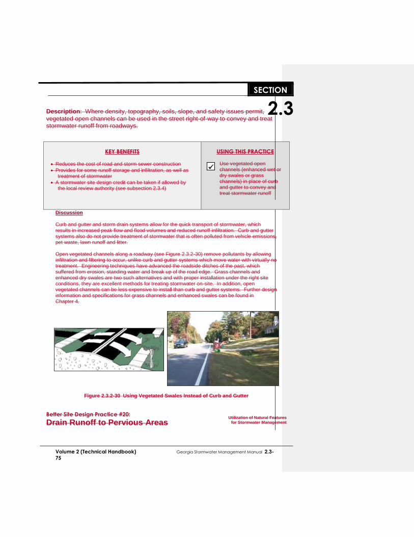
..SECTION..
2.3
Volume 2 (Technical Handbook) Georgia Stormwater Management Manual 2.3-
75
Description: Where density, topography, soils, slope, and safety issues permit,
vegetated open channels can be used in the street right-of-way to convey and treat stormwater runoff from roadways.
KEY BENEFITS
Reduces the cost of road and storm sewer construction
Provides for some runoff storage and infiltration, as well as treatment of stormwater
A stormwater site design credit can be taken if allowed by the local review authority (see subsection 2.3.4)
USING THIS PRACTICE
Use vegetated open channels (enhanced wet or dry swales or grass channels) in place of curb and gutter to convey and treat stormwater runoff
Discussion Curb and gutter and storm drain systems allow for the quick transport of stormwater, which results in increased peak flow and flood volumes and reduced runoff infiltration. Curb and gutter systems also do not provide treatment of stormwater that is often polluted from vehicle emissions, pet waste, lawn runoff and litter. Open vegetated channels along a roadway (see Figure 2.3.2-30) remove pollutants by allowing infiltration and filtering to occur, unlike curb and gutter systems which move water with virtually no treatment. Engineering techniques have advanced the roadside ditches of the past, which suffered from erosion, standing water and break up of the road edge. Grass channels and enhanced dry swales are two such alternatives and with proper installation under the right site conditions, they are excellent methods for treating stormwater on-site. In addition, open vegetated channels can be less expensive to install than curb and gutter systems. Further design information and specifications for grass channels and enhanced swales can be found in Chapter 4.
Figure 2.3.2-30 Using Vegetated Swales Instead of Curb and Gutter
Better Site Design Practice #20:
Drain Runoff to Pervious Areas
Utilization of Natural Features
for Stormwater Management

..SECTION..
2.3
Volume 2 (Technical Handbook) Georgia Stormwater Management Manual 2.3-
76
Description: Where possible, direct runoff from impervious areas such as rooftops,
roadways and parking lots to pervious areas, open channels or vegetated areas to provide for water quality treatment and infiltration. Avoid routing runoff directly to the structural stormwater conveyance system.
KEY BENEFITS
Sending runoff to pervious vegetated areas increases overland flow time and reduces peak flows
Vegetated areas can often filter and infiltrate stormwater runoff
A stormwater site design credit can be taken if allowed by the local review authority (see subsection 2.3.4)
USING THIS PRACTICE
Minimize directly connected impervious areas and drain runoff as sheet flow to pervious vegetated areas
Discussion Stormwater quantity and quality benefits can be achieved by routing the runoff from impervious areas to pervious areas such as lawns, landscaping, filter strips and vegetated channels. Much like the use of undisturbed buffers and natural areas (Better Site Design Practice #17), revegetated areas such as lawns and engineered filter strips and vegetated channels can act as biofilters for stormwater runoff and provide for infiltration in porous (hydrologic group A and B) soils. In this way, the runoff is “disconnected” from a hydraulically efficient structural conveyance such as a curb and gutter or storm drain system. Some of the methods for disconnecting impervious areas include:
Designing roof drains to flow to vegetated areas
Directing flow from paved areas such as driveways to stabilized vegetated areas
Breaking up flow directions from large paved surfaces (see Figure 2.3.2-31)
Carefully locating impervious areas and grading landscaped areas to achieve sheet flow runoff to the vegetated pervious areas
For maximum benefit, runoff from impervious areas to vegetated areas must occur as sheet flow and vegetation must be stabilized. See Chapter 4 for more design information and specifications on filter strips and vegetated channels.

Volume 2 (Technical Handbook) Georgia Stormwater Management Manual 2.3-77
2.3..43.1 Introduction
Non-structural stormwater control practices are increasingly recognized as a critical feature in every site design. As such, a set of stormwater “credits” has been developed to provide developers and site designers an incentive to implement better site design practices that can reduce the volume of stormwater runoff and minimize the pollutant loads from a site. The credit system directly translates into cost savings to the developer by reducing the size of best management practices and conveyance facilities. The basic premise of the credit system is to recognize the water quality benefits of certain site design practices by allowing for a reduction in the water quality treatment volume (WQv). If a developer incorporates one or more of the credited practices in the design of the site, the requirement for capture and treatment of the water quality volume will be reduced. The Natural Area Conservation better site design practice provides a s that provide stormwater certain are listed in Table 2.3.4-1. Ssite-specific conditions are metwill determine the cannot be taken on upland sites that do not contain perennial or intermittent streamsprotected by natural areas that are conserved on a site, thereby retaining their pre-development hydrologic and water quality characteristics. It should be noted that better site design practices and techniques that reduce the overall impervious area on a site already implicitly reduce the total amount of stormwater runoff generated by a site (and thus reduce WQv) and are not further credited under this system.
For each potential credit, there is a minimum set of criteria and requirements which identify the conditions or circumstances under which the credit may be applied. The intent of the suggested numeric conditions (e.g., flow length, contributing area, etc.) is to avoid situations that could lead to a credit being granted without the corresponding reduction in pollution attributable to an effective site design modification.
Site designers are encouraged to utilize as many credits as they can on a site. Greater storage volumes can be achieved when many credits are combined (e.g., disconnecting rooftops and protecting natural conservation areas). However, credits cannot be claimed twice for an identical area of the site (e.g. claiming credit for natural conservation areas stream buffers and rooftops over the same site area). Due to local safety codes, soil conditions, and topography, some of these site design credits may be restricted. Designers are encouraged to consult with the appropriate approval authority to ensure if and when a credit is applicable and to determine restrictions on non-structural strategies.
2.3-78 Georgia Stormwater Management Manual Volume 2 (Technical Handbook)
2.3.43.2 Stormwater Credits and the Site Planning Process
During the site planning process described in Section 2.4 there are several steps involved in site layout and design, each more clearly defining the location and function of the various components of the stormwater management system. The integration of site design credits can be integrated with this process as shown in Table 2.3.43-2.
Table 2.3.43-2 Integration of Site Design Credits with Site Development Process
Site Development Phase Site Design Credit Activity
Feasibility Study Determine stormwater management requirements
Perform site reconnaissance to identify potential areas for and types of credits
Site Analysis Identify and delineate natural feature conservation areas
(natural areas and stream buffers)
Concept Plan
Preserve natural areas and stream buffers during site layout
Reduce impervious surface area through various techniques
Identify locations for use of vegetated channels and groundwater recharge
Look for areas to disconnect impervious surfaces
Document the use of site design credits.
Preliminary and Final Plan
Perform layout and design of credit areas – integrating them into treatment trains
Ensure unified stormwater sizing criteria are satisfied
Ensure appropriate documentation of site design credits according to local requirements.
Construction Ensure protection of key areas
Ensure correct final construction of areas needed for credits
Final Inspection
Develop maintenance requirements and documents
Ensure long term protection and maintenance
Ensure credit areas are identified on final plan and plat if applicable
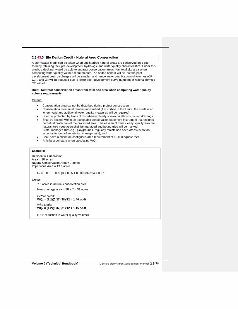
Volume 2 (Technical Handbook) Georgia Stormwater Management Manual 2.3-79
2.3.43.3 Site Design Credit - Natural Area Conservation
A stormwater credit can be taken when undisturbed natural areas are conserved on a site, thereby retaining their pre-development hydrologic and water quality characteristics. Under this credit, a designer would be able to subtract conservation areas from total site area when computing water quality volume requirements. An added benefit will be that the post-development peak discharges will be smaller, and hence water quantity control volumes (CPv, Qp25, and Qf) will be reduced due to lower post-development curve numbers or rational formula “C” values. Rule: Subtract conservation areas from total site area when computing water quality volume requirements.
Criteria:
Conservation area cannot be disturbed during project construction
Conservation area must remain undisturbed (if disturbed in the future, the credit is no longer valid and additional water quality measures will be required)
Shall be protected by limits of disturbance clearly shown on all construction drawings
Shall be located within an acceptable conservation easement instrument that ensures perpetual protection of the proposed area. The easement must clearly specify how the natural area vegetation shall be managed and boundaries will be marked [Note: managed turf (e.g., playgrounds, regularly maintained open areas) is not an acceptable form of vegetation management], and
Shall have a minimum contiguous area requirement of 10,000 square feet
Rv is kept constant when calculating WQv Example:
Residential Subdivision Area = 38 acres Natural Conservation Area = 7 acres Impervious Area = 13.8 acres
Rv = 0.05 + 0.009 (I) = 0.05 + 0.009 (36.3%) = 0.37 Credit:
7.0 acres in natural conservation area
New drainage area = 38 – 7 = 31 acres
Before credit: WQv = (1.2)(0.37)(38)/12 = 1.40 ac-ft
With credit: WQv = (1.2)(0.37)(31)/12 = 1.15 ac-ft (18% reduction in water quality volume)

2.4-80 Georgia Stormwater Management Manual Volume 2 (Technical Handbook)
2.4 STORMWATER SITE
PLANNING & DESIGN 2.4.1 Stormwater Management and Site Planning 2.4.1.1 Introduction
In order to most effectively address stormwater management objectives, consideration of stormwater runoff needs to be fully integrated into the site planning and design process. This involves a more comprehensive approach to site planning and a thorough understanding of the physical characteristics and resources of the site. The purpose of this section is to provide a framework for including effective and environmentally sensitive stormwater management into the site development process and to encourage a greater uniformity in stormwater management site plan preparation. When designing the stormwater management system for a site, a number of questions need to be answered by the site planners and design engineers, including:
How can the stormwater management system be designed to most effectively meet the stormwater management minimum recommended standards (and any additional needs or
What are the opportunities for utilizing better site design practices to minimize the need for best management practices?
What are the development site constraints that preclude the use of certain best management practices?
What best management practices are most suitable and cost-effective for the site?
2.4.1.2 Principles of Stormwater Management Site Planning
The following principles should be kept in mind in preparing a stormwater management plan for a development site: 1. The site design should utilize an integrated approach to deal with stormwater quantity,
quality and streambank (channel) protection requirements.
The stormwater management infrastructure for a site should be designed to integrate drainage and water quantity control, water quality protection, and downstream channel protection. Site design should be done in unison with the design and layout of stormwater infrastructure to attain stormwater management goals. Together, the combination of better site design practices and effective infrastructure layout and design can mitigate the worst stormwater impacts of most urban developments while preserving stream integrity and aesthetic attractiveness.
2. Stormwater management practices should strive to utilize the natural drainage system
and require as little maintenance as possible.
Almost all sites contain natural features which can be used to help manage and mitigate runoff from development. Features on a development site might include natural drainage patterns, depressions, permeable soils, wetlands, floodplains, and undisturbed vegetated areas that can be used to reduce runoff, provide infiltration and stormwater filtering of pollutants and sediment, recycle nutrients, and maximize on-site storage of stormwater. Site design should seek to improve the effectiveness of natural systems rather than to ignore or

Volume 2 (Technical Handbook) Georgia Stormwater Management Manual 2.4-81
replace them. Further, natural systems typically require low or no maintenance, and will continue to function many years into the future.
3. Best management practices should be implemented only after all site design and
nonstructural options have been exhausted.
Operationally, economically, and aesthetically, stormwater better site design and the use of natural techniques offer significant benefits over best management practices. Therefore, all opportunities for utilizing these methods should be explored before implementing best management practices such as wet ponds and sand filters.
4. Structural stormwater solutions should attempt to be multi-purpose and be
aesthetically integrated into a site’s design.
A structural stormwater facility need not be an afterthought or ugly nuisance on a development site. A parking lot, soccer field or city plaza can serve as a temporary storage facility for stormwater. In addition, water features such as ponds and lakes, when correctly designed and integrated into a site, can increase the aesthetic value of a development.
5. “One size does not fit all” in terms of stormwater management solutions.
Although the basic problems of stormwater runoff and the need for its management remain the same, each site, project, and watershed presents different challenges and opportunities. For instance, an infill development in a highly urbanized town center or downtown area will require a much different set of stormwater management solutions than a low-density residential subdivision in a largely undeveloped watershed. Therefore, local stormwater management needs to take into account differences between development sites, different types of development and land use, various watershed conditions and priorities, the nature of downstream lands and waters, and community desires and preferences.
2.4.2 Preparation of Stormwater Management Site Plans 2.4.2.1 Introduction
A stormwater management site plan is a comprehensive report that contains the technical information and analysis to allow a local review authority to determine whether a proposed new development or redevelopment project meets the local stormwater regulatory requirements and/or the minimum recommended stormwater management standards contained in this Manual. Figure 2.2.5-2 for information on the stormwater design process. This section describes the typical contents and general procedure for preparing a stormwater management site plan. The level of detail involved in the plan will depend on the project size and the individual site and development characteristics. The preparation of a stormwater site plan ideally follows these steps:
(1) Pre-consultation Meeting and Joint Site Visit
(2) Review of Local Requirements
(3) Perform Site Analysis
(4) Prepare Stormwater Concept Plan
(5) Prepare Preliminary Stormwater Site Plan
(6) Complete Final Stormwater Site Plan
Commented [RC29]: AR-7
2.4-82 Georgia Stormwater Management Manual Volume 2 (Technical Handbook)
The most important action that can take place at the beginning of the development project is a pre-consultation meeting between the local review authority and the developer and his team to outline the stormwater management requirements and other regulations, and to assist the developer in assessing constraints, opportunities, and potential for stormwater design concepts utilizing green infrastructure and runoff reduction techniques. This recommended step helps to establish a constructive partnership for the entire development process. A joint site visit, if possible, can yield a conceptual outline of the stormwater management plan and strategies. By walking the site, the two parties can identify and anticipate problems, define general expectations and establish general boundaries of natural feature protection and conservation areas. A major incentive for pre-consultation is that permitting and plan approval requirements will become clear at an early stage, increasing the likelihood that the approval process will proceed faster and more smoothly. Prior to the joint site visit, it is helpful for the developer or the developer’s design team to submit the following information for familiarity and review:
Existing conditions plan (boundary information, topography, site features, etc.)
Proposed site plan (proposed site features)
Soil characteristics, infiltration rates, etc. (if available)
Natural resources inventory
Conceptual stormwater management plans
2.4.2.3 Review of Local Requirements & Permitting Guidance
The site developer should be made familiar with the local stormwater management and development requirements and design criteria that apply to the site. These requirements may include:
The minimum recommended standards for stormwater management included in this Section 2.2)
Design storm frequencies
Conveyance design criteria
Floodplain criteria
Buffer/setback criteria
Wetland provisions
Watershed-based criteria
Erosion and sedimentation control requirements
Maintenance requirements
Need for physical site evaluations (infiltration tests, geotechnical evaluations, etc.) Much of this guidance can be obtained at the pre-consultation meeting with the local review authority and should be detailed in various local ordinances (e.g., subdivision codes, stormwater and drainage codes, etc.) Current land use plans, comprehensive plans, zoning ordinances, road and utility plans, watershed or overlay districts, and public facility plans should all be consulted to determine the need for compliance with other local and state regulatory requirements. Opportunities for special types of development (e.g., clustering) or special land use opportunities (e.g., conservation easements or tax incentives) should be investigated. There may also be an ability to partner with a local community for the development of greenways, or other riparian corridor or open space developments. The checklist below (Table 2.4.2-1) provides a condensed summary of current restrictions as they relate to common site features that may be regulated under local, state or federal law. These
Commented [RC30]: AR-9
Commented [RC31]: AR-9

Volume 2 (Technical Handbook) Georgia Stormwater Management Manual 2.4-83
restrictions fall into one of three general categories:
Locating a best management practice within an area that is expressly prohibited by law.
Locating a best management practice within an area that is strongly discouraged, and is only allowed on a case by case basis. Local, state and/or federal permits shall be obtained, and the applicant will need to supply additional documentation to justify locating the stormwater practice within the regulated area.
Best management practices must be setback a fixed distance from the site feature. This checklist is only intended as a general guide to location and permitting requirements as they relate to siting of best management practices. Consultation with the appropriate regulatory agency is the best strategy.
Table 2.4.2-1 Location and Permitting Checklist
Site Feature
Location and Permitting Guidance
Jurisdictional Wetland (Waters of the U.S) U.S. Army Corps of Engineers Section 404 Permit
Jurisdictional wetlands should be delineated prior to siting structural practice.
Use of natural wetlands for stormwater quality treatment is contrary to the goals of the Clean Water Act and should be avoided.
Stormwater should be treated prior to discharge into a natural wetland.
Structural practices may also be restricted in local buffer zones, although they may be utilized as a non-structural filter strip (i.e., accept sheet flow).
Should justify that no practical upland treatment alternatives exist.
Where practical, excess stormwater flows should be conveyed away from jurisdictional wetlands.
Stream Channel (Waters of the U.S) U.S. Army Corps of Engineers Section 404 Permit
All Waters of the U.S. (streams, ponds, lakes, etc.) should be delineated prior to design.
Use of any Waters of the U.S. for stormwater quality treatment is contrary to the goals of the Clean Water Act and should be avoided.
Stormwater should be treated prior to discharge into Waters of the U.S.
In-stream ponds for stormwater quality treatment are highly discouraged.
Must justify that no practical upland treatment alternatives exist.
Temporary runoff storage preferred over permanent pools.
Implement measures that reduce downstream warming.
Georgia Planning Act Groundwater Recharge Areas
Prevention of groundwater contamination
Covers about 23% of State. Detailed mapping available at Regional Development Centers.
Permanent stormwater infiltration devices are prohibited in areas having high pollution susceptibility.
Georgia Planning Act Water Supply Watersheds
Specific stream and reservoir buffer requirements.
May be imperviousness limitations
May be specific best management practice requirements.
100 Year Floodplain
Local Stormwater Review Authority
Grading and fill for structural practice construction is generally discouraged within the ultimate 100 year floodplain, as delineated by FEMA flood insurance rate maps, FEMA flood boundary and floodway maps, or more stringent local floodplain maps.
Floodplain fill cannot raise the floodplain water surface elevation by more than a tenth of a foot.

2.4-84 Georgia Stormwater Management Manual Volume 2 (Technical Handbook)
Table 2.4.2-1 Location and Permitting Checklist
Site Feature
Location and Permitting Guidance
Stream Buffer Check with appropriate review authority whether stream buffers are required
Consult local authority for stormwater policy.
Structural practices are discouraged in the streamside zone (within 25 feet or more of streambank, depending on the specific regulations).
There are specific additional requirements related to River Corridor Protection, the Metropolitan River Protection Act, and the Georgia Scenic Rivers Act (which include wider and more stringent buffers).
Utilities Local Review Authority
Call appropriate agency to locate existing utilities prior to design.
Note the location of proposed utilities to serve development.
Structural practices are discouraged within utility easements or rights of way for public or private utilities.
Roads Local DOT, DPW, or State DOT
Consult local DOT or DPW for any setback requirement from local roads.
Consult DOT for setbacks from State maintained roads.
Approval must also be obtained for any stormwater discharges to a local or state-owned conveyance channel.
Structures Local Review Authority
Consult local review authority for structural practice setbacks from structures.
Septic Drain fields
Local Health Authority
Consult local health authority.
Recommended setback is a minimum of 50 feet from drain field edge.
Water Wells
Local Health Authority
100-foot setback for stormwater infiltration.
50-foot setback for all other structural practices.
2.4.2.4 Perform Site Analysis and Inventory
Using approved field and mapping techniques, the site engineer should collect and review information on the existing site conditions and map the following site features:
Topography
Drainage patterns and basins
Intermittent and perennial streams
Soils
Ground cover and vegetation
Existing development
Existing stormwater facilities
Adjacent areas In addition, the site engineer should identify and map all previously unmapped natural features such as:
Wetlands
Critical habitat areas
Boundaries of wooded areas
Floodplain boundaries
Steep slopes
Required buffers
Figure 2.4.2-1 Composite Analysis
(Source: Marsh, 1983)
(continued)

Volume 2 (Technical Handbook) Georgia Stormwater Management Manual 2.4-85
Proposed stream crossing locations
Other required protection areas (e.g., well setbacks) Some of this information may be available from previously performed studies or from the previous feasibility study. For example, if a development site requires a permit under the Erosion and Sedimentation Act, most of the resource protection features will likely have been mapped as part of the land disturbance activity plan. Other recommended site information to map or obtain includes utilities information, seasonal groundwater levels, and geologic mapping. Individual map or geographic information system (GIS) layers can be designed to facilitate an analysis of the site through what is known as map overlay, or a composite analysis. Each layer (or group of related information layers) is placed on the map in such a way as to facilitate comparison and contrast with other layers. A composite layer is often developed to show all the layers at the same time (see Figure 2.4.2-1). This composite layer can be a useful tool for defining the best buildable areas and delineating and preserving natural feature conservation areas.
2.4.2.5 Prepare Stormwater Concept Plan
Based upon the review of existing conditions and site analysis, the design engineer should develop a concept site layout plan for the project.
During the concept plan stage the site designer will perform most of the layout of the site including the preliminary stormwater management system design and layout. The stormwater concept plan allows the design engineer to propose a potential site layout and gives the developer and local review authority a “first look” at the stormwater management system for the proposed development. The stormwater concept plan should be submitted to the local plan reviewer before detailed preliminary site plans are developed. The following steps should be followed in developing the stormwater concept plan:
(1) Use better site design approaches (see Section 2.3) as applicable to develop the site layout, including:
Preserving the natural feature conservation areas defined in the site analysis
Fitting the development to the terrain and minimizing land disturbance
Reducing impervious surface area through various techniques
Preserving and utilizing the natural drainage system wherever possible (2) Calculate preliminary estimates of the unified stormwater sizing criteria requirements for
water quality, channel protection, overbank flooding protection and extreme flood protection based on the concept plan site layout (Section 2.2)
(3) Determine the site design stormwater credits to be accounted for in the design of best
management practices handling the water quality volume (Section 2.3) (4) Perform screening and preliminary selection of appropriate best management practices
and identification of potential siting locations (Section 4.1). It is extremely important at this stage that stormwater design is integrated into the overall site design concept in order to best reduce the impacts of the development as well as provide for the most cost-effective and environmentally sensitive approach. Using hydrology calculations, the goal of mimicking pre-development conditions can serve a useful purpose in planning the stormwater management system.

2.4-86 Georgia Stormwater Management Manual Volume 2 (Technical Handbook)
For local review purposes, the stormwater concept plan should include the following elements: (1) Common address and legal description of site
(2) Vicinity map
(3) Existing conditions and proposed site layout mapping and plans (recommended scale of 1” = 50’), which illustrate at a minimum:
Existing and proposed topography (minimum of 2-foot contours recommended)
Perennial and intermittent streams
Mapping of predominant soils from USDA soil surveys
Boundaries of existing predominant vegetation and proposed limits of clearing and grading
Location and boundaries of other natural feature protection and conservation areas such as wetlands, lakes, ponds, floodplains, stream buffers and other setbacks (e.g., drinking water well setbacks, septic setbacks, etc.)
Location of existing and proposed roads, buildings, parking areas and other impervious surfaces
Existing and proposed utilities (e.g., water, sewer, gas, electric) and easements
Preliminary estimates of unified stormwater sizing criteria requirements
Identification and calculation of stormwater site design credits
Preliminary selection and location, size, and limits of disturbance of proposed best management practices
Location of existing and proposed conveyance systems such as grass channels, swales, and storm drains
Flow paths
Location of floodplain/floodway limits and relationship of site to upstream and downstream properties and drainages
Preliminary location and dimensions of proposed channel modifications, such as bridge or culvert crossings
(4) Identification of preliminary waiver requests
2.4.2.6 Prepare Preliminary Stormwater Site Plan
The preliminary plan ensures that requirements and criteria are being complied with and that opportunities are being taken to minimize adverse impacts from the development. The preliminary stormwater management site plan should consist of maps, narrative, and supporting design calculations (hydrologic and hydraulic) for the proposed stormwater management system, and should include the following sections: (1) Existing Conditions Hydrologic Analysis Provide an existing condition hydrologic analysis for stormwater runoff rates, volumes, and velocities, which includes:
A topographic map of existing site conditions (minimum 2-foot contour interval recommended) with the basin boundaries indicated
Acreage, soil types and land cover of areas for each subbasin affected by the project
All perennial and intermittent streams and other surface water features
All existing stormwater conveyances and structural practices
Direction of flow and exits from the site
Analysis of runoff provided by off-site areas upstream of the project site
Methodologies, assumptions, site parameters and supporting design calculations used in analyzing the existing conditions site hydrology
Volume 2 (Technical Handbook) Georgia Stormwater Management Manual 2.4-87
(2) Post-Development Hydrologic Analysis Provide a post-development hydrologic analysis for stormwater runoff rates, volumes, and velocities, which includes:
A topographic map of developed site conditions (minimum 2-foot contour interval recommended) with the post-development basin boundaries indicated
Total area of post-development impervious surfaces and other land cover areas for each subbasin affected by the project
Unified stormwater sizing criteria runoff calculations for water quality, channel protection, overbank flooding protection and extreme flood protection for each subbasin
Location and boundaries of proposed natural feature protection and conservation areas
Documentation and calculations for any applicable site design credits that are being utilized
Methodologies, assumptions, site parameters and supporting design calculations used in analyzing the existing conditions site hydrology
(3) Stormwater Management System Provide drawings and design calculations for the proposed stormwater management system, including:
A drawing or sketch of the stormwater management system including the location of non-structural site design features and the placement of existing and proposed best management practices. This drawing should show design water surface elevations, storage volumes available from zero to maximum head, location of inlet and outlets, location of bypass and discharge systems, and all orifice/restrictor sizes.
Narrative describing that appropriate and effective best management practices have been selected
Cross-section and profile drawings and design details for each of the best management practices in the system. This should include supporting calculations to show that the facility is designed according to the applicable design criteria.
Hydrologic and hydraulic analysis of the stormwater management system for all applicable design storms (should include stage-storage or outlet rating curves, and inflow and outflow hydrographs)
Documentation and supporting calculations to show that the stormwater management system adequately meets the unified stormwater sizing criteria
Drawings, design calculations and elevations for all existing and proposed stormwater conveyance elements including stormwater drains, pipes, culverts, catch basins, channels, swales and areas of overland flow
(4) Downstream Analysis Provide the assumptions and calculations from a downstream analysis (when required)
Supporting calculations for a downstream peak flow analysis using the ten-percent rule necessary to show safe passage of post-development design flows downstream
In calculating runoff volumes and discharge rates, consideration may need to be given to any planned future upstream land use changes. Depending on the site characteristics and given design criteria, upstream lands may need to be modeled as “existing condition” or “projected buildout/future condition” when sizing and designing on-site conveyances and stormwater practices.
2.4.2.7 Complete Final Stormwater Site Plan
The final stormwater management site plan adds further detail to the preliminary plan and reflects changes that are requested or required by the local review authority. The f inal stormwater site plan should include all of the revised elements of the preliminary plan as well as the following items:

2.4-88 Georgia Stormwater Management Manual Volume 2 (Technical Handbook)
(1) Erosion and Sedimentation Control Plan
Must contain all the elements specified in the Georgia Erosion and Sediment Control Act and local ordinances and regulations
Sequence/phasing of construction and temporary stabilization measures
Temporary structures that will be converted into permanent best management practices
(2) Landscaping Plan
Arrangement of planted areas, natural areas and other landscaped features on the site plan
Information necessary to construct the landscaping elements shown on the plan drawings
Descriptions and standards for the methods, materials and vegetation that are to be used in the construction
(3) Operations and Maintenance Plan
Description of maintenance tasks, responsible parties for maintenance, funding, access and safety issues
(4) Evidence of Acquisition of Applicable Local and Non-local Permits
(5) Waiver Requests The completed final stormwater site plan should be submitted to the local review authority for final approval prior to any construction activities on the development site.
2.4.2.8 Obtain Non-Local Permits
The developer should obtain any applicable non-local environmental permit such as 404 wetland permits, 401 water quality certification, or construction NPDES permits prior to or in conjunction with final plan submittal. In some cases, a non-local permitting authority may impose conditions that require the original concept plan to be changed. Developers and engineers should be aware that permit acquisition can be a long, time-consuming process.

Volume 2 (Technical Handbook) Georgia Stormwater Management Manual 2.4-89
2.4.3 Stormwater Planning in the Development Process
2.4.3.1 General Site Development Process
Figure 2.4.3-1 depicts a typical site development process from the perspective of the land developer. After an initial site visit the developer assesses the feasibility of the project. If the project is deemed workable, a survey is completed. The design team prepares a concept plan (often called a sketch plan) for consultation with the local review authority. A preliminary plan is then prepared and submitted for necessary reviews and approvals. Federal, state and local permits are applied for at various stages in the process. After review by the local authority and possible public hearings, necessary revisions are made and a final construction plan is prepared. There may be several iterations between plan submittal and plan approval. Bonds are set and placed, contractors are hired, and construction of the project takes place. During and after construction numerous types of inspections take place. At the end of construction, there is a final inspection and a use and occupancy permit is issued for the structure itself.
2.4.3.2 Stormwater Site Planning and Design
Stormwater site planning and design is a subset of overall site development and must fit into the overall process if it is to be successful. Table 2.4.3-1 on the next several pages shows how planning for the stormwater management system fits into the site development process from the perspective of the developer and site planner/engineer. For each step in the development process, the stormwater-related objectives are described, along with the key actions and major activities that are typically performed to meet those objectives.
Table 2.4.3-1 Stormwater Planning in the Site Development Process
Feasibility Study Description:
A feasibility study is performed to determine the factors that may influence the decision to proceed with the site development, including the basic site characteristics, local and other governmental requirements, area information, surrounding developments, etc.
Stormwater-Related Objectives:
Understand major site constraints and opportunities
Understand local and other requirements
Key Actions:
Initiate discussions with local review authority
Pre-consultation between developer and plan reviewer
Determine local stormwater management requirements
Major Activities:
Base map development
Review of project requirements
Review of local development and stormwater management requirements
Review of local stormwater master plans or comprehensive plans
Joint site visit with local review authority
Collection of secondary source information
Determination of other factors or constraints impacting feasibility
Feasibility Study
Preliminary Plan
Concept Plan
Site Analysis
Construction
Final Plan
Final Inspections
Figure 2.4.3-1 Typical Site
Development Flowchart

2.4-90 Georgia Stormwater Management Manual Volume 2 (Technical Handbook)
Table 2.4.3-1 continued
Site Analysis Description:
A site analysis is used to gain an understanding of the constraints and opportunities
associated with the site through identification, mapping and assessment of natural features
and resources. Potential conservation and resource protection areas are identified at this
stage.
Stormwater-Related Objectives:
Identify key site physical, environmental, and other significant resources
Develop preliminary vision for stormwater management system Key Actions:
Site evaluation and delineation of natural feature protection areas Major Activities:
Mapping of natural resources: soils, vegetation, streams, topography, slope, wetlands, floodplains, aquifers
Identification of other key cultural, historic, archaeological, or scenic features, orientation and exposure
Identification of adjacent land uses
Identification of adjacent transportation and utility access
Identification of natural feature protection and conservation areas
Mapping of easements and utilities
Integration of all layers – map overlay
Other constraints and opportunities
Volume 2 (Technical Handbook) Georgia Stormwater Management Manual 2.4-91
Concept Plan Description:
A concept plan is used to provide both the developer and reviewer a preliminary look at the
development and stormwater management concept. Based on the site analysis, a concept plan
should take into account the constraints and resources available on the site. Several alternative
“what if” concept plans can be created.
Stormwater-Related Objectives:
Develop concept for stormwater management system
Gain approval from developer and local review authority of concept plan Key Actions:
Develop site layout concept using better site design techniques where possible
Perform initial runoff characterization based on site layout concept
Determine necessary site design and/or best management practices needed to meet stormwater management requirements
Major Activities:
Prepare sketches of functional land uses including conservation areas
“What if” analysis of different design concepts
Unified stormwater sizing criteria preliminary calculations
Utilization of better site design concepts and crediting mechanisms in layout concept
Preliminary selection and siting of best management practices
Location of drainage/conveyance facilities

2.4-92 Georgia Stormwater Management Manual Volume 2 (Technical Handbook)
Table 2.4.3-1 continued
Preliminary and Final Plan Description:
A preliminary site plan is created for local review, which includes roadways, building and parking locations,
conservation areas, utilities, and stormwater management facilities. Following local approval, a final set of
construction plans are developed.
Stormwater-Related Objectives:
Prepare preliminary and final stormwater management site plan
Secure local and non-local permits Key Actions:
Perform runoff characterization based on preliminary/final site plan
Design best management practices and conveyance systems
Perform downstream analysis Major Activities:
Preliminary/final site layout plan
Unified stormwater sizing criteria calculations
Calculation of site design credit
Selection, siting and design of best management practices
Design of drainage and conveyance facilities
Development of erosion and sedimentation control plan and landscaping plan
Applications for needed permits and waivers
Construction
Summary:
During the construction stage, the site must be inspected regularly to ensure that all elements are being built according to plan, and that all resource or conservation areas are suitably protected during construction.
Stormwater Objectives:
Ensure that stormwater management facilities and site design practices are built as designed
Key Actions:
Pre-construction meeting
Inspection during construction Major Activities:
Execution of bonds
Inspection during key phases or key installations
Protection of best management practices
Protection of conservation areas
Erosion and sedimentation control
Proper sequencing
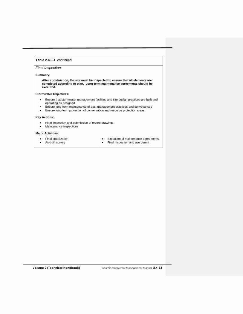
Volume 2 (Technical Handbook) Georgia Stormwater Management Manual 2.4-93
Table 2.4.3-1 continued
Final Inspection Summary:
After construction, the site must be inspected to ensure that all elements are completed according to plan. Long-term maintenance agreements should be executed.
Stormwater Objectives:
Ensure that stormwater management facilities and site design practices are built and operating as designed
Ensure long-term maintenance of best management practices and conveyances
Ensure long-term protection of conservation and resource protection areas Key Actions:
Final inspection and submission of record drawings
Maintenance inspections Major Activities:
Final stabilization
As-built survey
Execution of maintenance agreements
Final inspection and use permit

2.4-94 Georgia Stormwater Management Manual Volume 2 (Technical Handbook)
This page left intentionally blank


![Sieci GSM - cygnus.tele.pw.edu.plcygnus.tele.pw.edu.pl/~zkotulsk/seminarium/prezentacjaGSM.pdfSystem GSM 400 GSM 850 GSM 900 GSM 1800 GSM 1900 Uplink [MHz] 450.4 - 457.6 ... Odpowiedź](https://img.pdfslide.net/doc/110x75/5ae024237f8b9a97518cdd37/sieci-gsm-zkotulskseminariumprezentacjagsmpdfsystem-gsm-400-gsm-850-gsm-900.jpg)