Embed Size (px)
Citation preview
Sterling Highway MP 45–60 Project Final EIS Chapter 3, Affected Environment and Environmental Consequences
March 2018 3-427 Section 3.21 – Fish and Essential Fish Habitat
3 Affected Environment and Environmental Consequences
3.21 Fish and Essential Fish Habitat
3.21.1 Affected Environment
3.21.1.1 Fish in the Project Area Species Occurrence. The project area, as a part of the greater Kenai River system, is home to a variety of vertebrate and invertebrate aquatic species. The Alaska Department of Fish and Game (ADF&G) has documented fish species occurrence within the Kenai River as a whole, primarily to support management of the popular fisheries (Miller, Burwen and Fleischman 2012), and in some tributaries included in the Catalog of Waters Important for the Spawning, Rearing or Migration of Anadromous Fishes (ADF&G 2014c). The Kenai River supports 34 fish species; 30 are native to the Kenai River and 4 are introduced species. Twelve species are residents that spend their entire life cycle in the river; 11 species are anadromous, spending part of their life cycle in the river and part in salt water; and 11 species are found in the lower river associated with the marine or brackish water environment where fresh and salt water mix (DNR, ADF&G, KPB 1997). As of 2012, there have not been specific surveys to determine all of the fish species that are present in the project area and such comprehensive studies are beyond the scope of this Final EIS. Fish species distribution in some of the smaller project area tributaries was unknown prior to fish characterization studies completed along the proposed build alignments during September 2004 and August 2005. These studies documented the occurrence of Chinook salmon, coho salmon, Dolly Varden, and sculpin in several previously uninvestigated streams (HDR 2011a). For detailed locations of captured fish and stream habitat information, refer to the Fisheries Evaluation (HDR 2011a). Within project area waters, there are 18 species of resident and anadromous fish that are known or likely to occur during some part of their life cycle (Table 3.21-1). Salmon species include anadromous Chinook, coho, sockeye, and pink salmon. Chum salmon are present in the Kenai River, but are rarely observed (DNR, ADF&G, KPB 1997). Other salmonids that occur in the Kenai River drainage include rainbow trout, Dolly Varden, Arctic grayling, lake trout, and round whitefish. Although the anadromous form of rainbow trout, steelhead, occur in the Kenai River drainage, it is not known to what extent they occur or how far they migrate above Skilak Lake into the project area (ADF&G 2014c). The ADF&G Anadromous Waters Catalog depicts steelhead in the Kenai River upstream to the Funny River (ADF&G 2014c). Conversely, the catalog depicts eulachon in the lower Kenai to downstream of Beaver Creek; however, eulachon have been observed upstream to lower Skilak Lake (ADF&G 2014c). Anadromous Pacific lamprey and Arctic lamprey inhabit the main-stem of the Kenai River and have been observed in the Moose River, a tributary to the Kenai River, at approximately river mile (RM) 36 (near the town of Sterling, 35 miles west of the project area). Resident longnose sucker inhabit numerous lakes in the drainage, and coastrange sculpin, slimy sculpin, three spine stickleback, and nine spine stickleback are widely distributed throughout the drainage (DNR, ADF&G, KPB 1997).
Sterling Highway MP 45–60 Project Final EIS Chapter 3, Affected Environment and Environmental Consequences
3-428 March 2018 Section 3.21 – Fish and Essential Fish Habitat
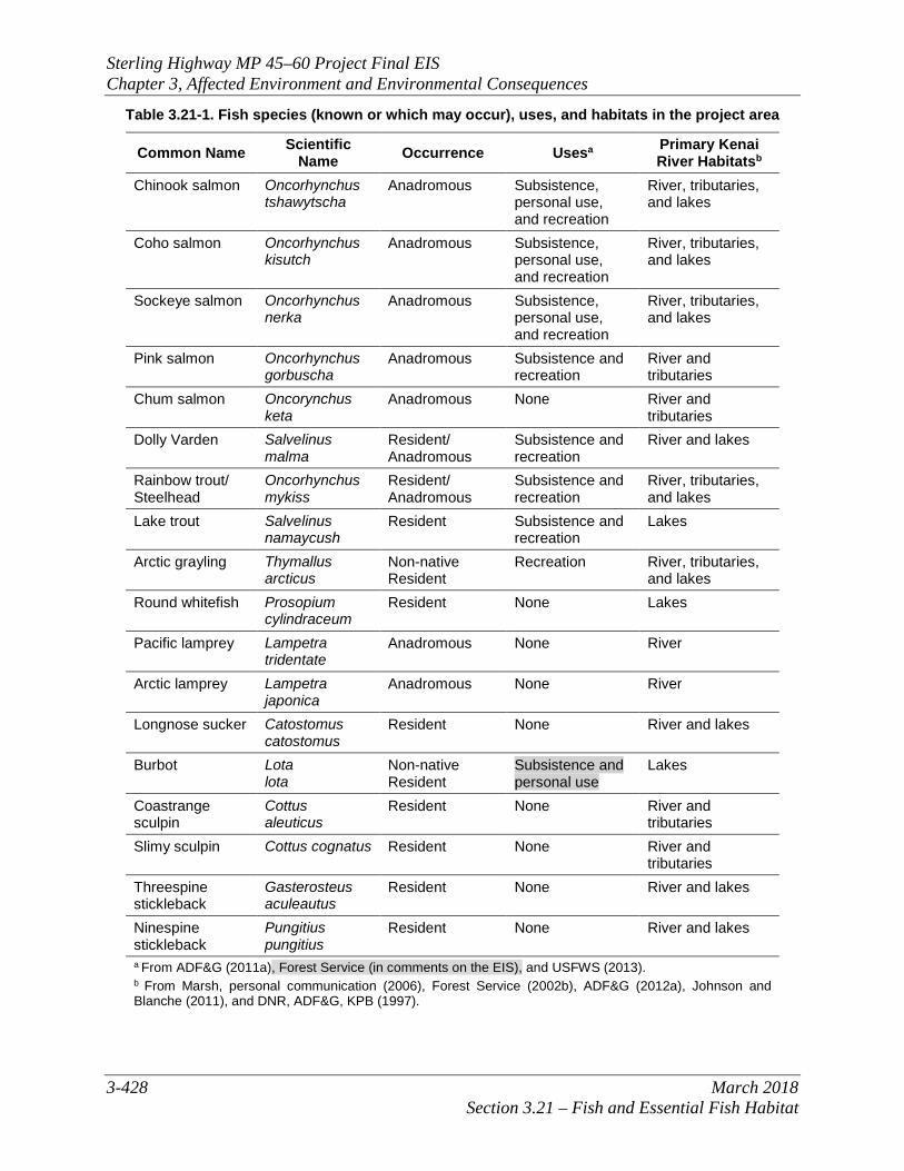
Table 3.21-1. Fish species (known or which may occur), uses, and habitats in the project area
Common Name Scientific Name Occurrence Usesa Primary Kenai
River Habitatsb Chinook salmon Oncorhynchus
tshawytscha Anadromous Subsistence,
personal use, and recreation
River, tributaries, and lakes
Coho salmon Oncorhynchus kisutch
Anadromous Subsistence, personal use, and recreation
River, tributaries, and lakes
Sockeye salmon Oncorhynchus nerka
Anadromous Subsistence, personal use, and recreation
River, tributaries, and lakes
Pink salmon Oncorhynchus gorbuscha
Anadromous Subsistence and recreation
River and tributaries
Chum salmon Oncorynchus keta
Anadromous None River and tributaries
Dolly Varden Salvelinus malma
Resident/ Anadromous
Subsistence and recreation
River and lakes
Rainbow trout/ Steelhead
Oncorhynchus mykiss
Resident/ Anadromous
Subsistence and recreation
River, tributaries, and lakes
Lake trout Salvelinus namaycush
Resident Subsistence and recreation
Lakes
Arctic grayling Thymallus arcticus
Non-native Resident
Recreation River, tributaries, and lakes
Round whitefish Prosopium cylindraceum
Resident None Lakes
Pacific lamprey Lampetra tridentate
Anadromous None River
Arctic lamprey Lampetra japonica
Anadromous None River
Longnose sucker Catostomus catostomus
Resident None River and lakes
Burbot Lota lota
Non-native Resident
Subsistence and personal use
Lakes
Coastrange sculpin
Cottus aleuticus
Resident None River and tributaries
Slimy sculpin Cottus cognatus Resident None River and tributaries
Threespine stickleback
Gasterosteus aculeautus
Resident None River and lakes
Ninespine stickleback
Pungitius pungitius
Resident None River and lakes
a From ADF&G (2011a), Forest Service (in comments on the EIS), and USFWS (2013). b From Marsh, personal communication (2006), Forest Service (2002b), ADF&G (2012a), Johnson and Blanche (2011), and DNR, ADF&G, KPB (1997).
Sterling Highway MP 45–60 Project Final EIS Chapter 3, Affected Environment and Environmental Consequences
March 2018 3-429 Section 3.21 – Fish and Essential Fish Habitat
Agency Status. There are no Federal or State-listed threatened or endangered fish species in Alaska (NOAA 2013, ADF&G 2011b), nor are there species with other special Federal or State status in the project area. The Forest Service, U.S. Department of Agriculture (Forest Service) removed coho and pink salmon and Dolly Varden as management indicator species for the Chugach National Forest in 2012 (Forest Service 2012a). The State of Alaska Policy for the Management of Sustainable Salmon Fisheries (5 AAC 39.222, effective 2000, amended 2001) directs the ADF&G to identify any salmon stock in the state that present a concern; there are currently no Kenai River salmon stocks designated as such (Munro and Volk 2012). Non-native and Invasive Species. Four fish species native to other locations in Alaska have been introduced to the Kenai River watershed: Arctic grayling, burbot, Alaska blackfish, and northern pike. Of these, two (Arctic grayling and burbot) are known to exist in the project area. Arctic grayling were first introduced to Crescent Lake in the 1950s and are established in the upper Kenai River where they are occasionally caught by anglers (DNR, ADF&G, KPB 1997). Burbot are believed to have been first introduced into Juneau Lake. They entered the Kenai River via Juneau Creek and have been documented as being caught by anglers in Skilak Lake (DNR, ADF&G, KPB 1997). Alaska blackfish were first identified from samples taken from fresh water ponds in the lower Kenai watershed (between Cook Inlet and Kenai RM 21), and in their native range they are most commonly found in lakes (DNR, ADF&G, KPB 1997). They have not been documented in the project area. Northern pike were introduced in the Soldotna Creek drainage in the mid-1970s (DNR, ADF&G, KPB 1997, McKinley 2014). Northern pike are considered an invasive species in Southcentral Alaska because they are known to negatively impact resident salmonid populations where they have been introduced. Northern pike use the Kenai River as a migratory corridor and are established in the Soldotna Creek drainage (McKinley 2014), but have not been documented in the project area. Fish Habitat, Life History, and Resources. Major water bodies supporting fish habitat within the project area include Kenai Lake, Kenai River, Bean Creek, Juneau Creek, Cooper Creek, Russian River, and Fuller Creek. The 34 species present in the Kenai River utilize various habitat types depending on the species of fish, time of year, and life cycle stage. The project area contains important migration corridors and spawning, rearing, feeding and overwintering habitats for salmon and other fish species. Essential Fish Habitat (EFH) information for the five Pacific salmon species is detailed below in Section 3.21.1.2. Fish are important biological components in the greater Kenai River system. Fish species in the upper Kenai River system have complicated life histories consisting of early- and late-season runs and intricate migratory and seasonal distributions, much of which biologists are still trying to understand. All five species of Pacific salmon occur in the Kenai River, and over one million salmon return to the Kenai each year to spawn. Because of its high productivity, the Kenai River system contributes to a major commercial fishery and some of the largest recreational fisheries for Chinook, coho, and sockeye salmon. Additionally, fish resources of the Kenai River provide for important personal use and subsistence harvests. In fact, the Kenai River is the most heavily fished river in Alaska, both by rod and reel and by dip net (ADF&G 2013c). Table 3.21-2 lists seasonal information for fish resources in the project area.
Sterling Highway MP 45–60 Project Final EIS Chapter 3, Affected Environment and Environmental Consequences
3-430 March 2018 Section 3.21 – Fish and Essential Fish Habitat
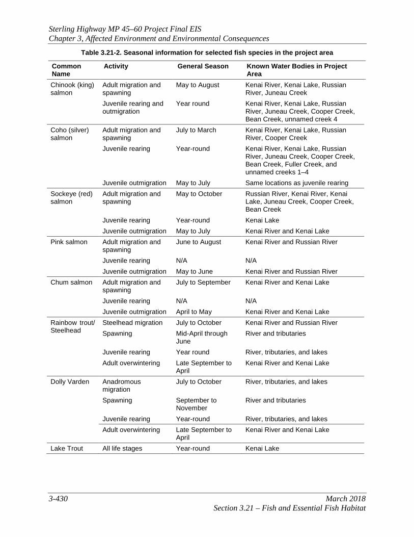
Table 3.21-2. Seasonal information for selected fish species in the project area
Common Name
Activity General Season Known Water Bodies in Project Area
Chinook (king) salmon
Adult migration and spawning
May to August Kenai River, Kenai Lake, Russian River, Juneau Creek
Juvenile rearing and outmigration
Year round Kenai River, Kenai Lake, Russian River, Juneau Creek, Cooper Creek, Bean Creek, unnamed creek 4
Coho (silver) salmon
Adult migration and spawning
July to March Kenai River, Kenai Lake, Russian River, Cooper Creek
Juvenile rearing Year-round Kenai River, Kenai Lake, Russian River, Juneau Creek, Cooper Creek, Bean Creek, Fuller Creek, and unnamed creeks 1–4
Juvenile outmigration May to July Same locations as juvenile rearing Sockeye (red) salmon
Adult migration and spawning
May to October Russian River, Kenai River, Kenai Lake, Juneau Creek, Cooper Creek, Bean Creek
Juvenile rearing Year-round Kenai Lake Juvenile outmigration May to July Kenai River and Kenai Lake
Pink salmon Adult migration and spawning
June to August Kenai River and Russian River
Juvenile rearing N/A N/A Juvenile outmigration May to June Kenai River and Russian River
Chum salmon Adult migration and spawning
July to September Kenai River and Kenai Lake
Juvenile rearing N/A N/A Juvenile outmigration April to May Kenai River and Kenai Lake
Rainbow trout/ Steelhead
Steelhead migration July to October Kenai River and Russian River Spawning Mid-April through
June River and tributaries
Juvenile rearing Year round River, tributaries, and lakes Adult overwintering Late September to
April Kenai River and Kenai Lake
Dolly Varden Anadromous migration
July to October River, tributaries, and lakes
Spawning September to November
River and tributaries
Juvenile rearing Year-round River, tributaries, and lakes Adult overwintering Late September to
April Kenai River and Kenai Lake
Lake Trout All life stages Year-round Kenai Lake
Sterling Highway MP 45–60 Project Final EIS Chapter 3, Affected Environment and Environmental Consequences
March 2018 3-431 Section 3.21 – Fish and Essential Fish Habitat
Common Name
Activity General Season Known Water Bodies in Project Area
Lamprey Anadromous migration and spawning
May to July Kenai River and Kenai Lake
Juvenile rearing Year-round Kenai River and Kenai Lake Juvenile outmigration August to November Kenai River and Kenai Lake
Note: The USFWS in its capacity as a cooperating agency indicated that a 2016 monitoring effort for Cooper Creek completed by the Forest Service in 2017 for Chugach Electric Association found other species in the creek besides the salmon species listed in this table. These included pink salmon, Dolly Varden, rainbow trout, and whitefish. Stages of the life cycle were not given. Sources: ADF&G (2013c); Bethe, et al. (2002); Burger, Wangaard, et al. (1983); Burger, Wilmot and Wangaard (1985); Boggs, Davis and Milner (1997); Bendock and Alexandersdottir (1992); Booth (1990); Davis, King and Tarbox (1994); DNR, ADF&G, KPB (1997); Dodge and MacCrimmon (1970); Lindsey et al. (1959); Miller et al. (2012); Palmer (1998); Scott and Crossman (1973); Lang, personal communication (2014).
Chinook Salmon. Chinook salmon populations in the Kenai River system consist of two distinct spawning runs: an early run and a late run (Burger, Wangaard, et al. 1983, Burger, Wilmot and Wangaard 1985). The early run consists of Chinook salmon that enter the Kenai River prior June 30. Chinook salmon entering the Kenai River after June 30 are considered part of the “late run” (Boggs, Davis and Milner 1997). See Table 3.21-2 for a list of known water bodies in the project area that provide habitat throughout the Chinook salmon life cycle. The majority of early-run Chinook salmon spawn in the lower river tributaries, although early-run Chinook spawning does occur in the upper Kenai River and its tributaries from late July to the middle of August (Burger, Wangaard, et al. 1983, Bendock and Alexandersdottir 1992). In addition to the main stem Kenai River, upper river tributaries used for spawning by Chinook salmon include the Russian River, Juneau Creek, Quartz Creek, Crescent Creek, and Ptarmigan Creek (Begich, et al. 2010, Reimer 2013). The Forest Service, in its role as cooperating agency, indicated that Daves Creek, which joins Quartz Creek, is another upper river tributary that is Chinook salmon spawning habitat. The Kenai River fisheries are managed by the State of Alaska’s respective Sport, Commercial, and Subsistence Fish Divisions. The Chinook salmon sport fishery is very popular because of the large size of the fish harvested. It is also the most controversial because of competition for the fully allocated resource among sport, commercial, subsistence, and personal use fisheries. ADF&G intensively manages the Chinook fishery as two distinct runs with the early run harvested mainly by sport anglers and the late run harvested mainly by commercial, personal use, and sport fisheries (Miller, Burwen and Fleischman 2012). Coho Salmon. Coho salmon, like Chinook salmon, enter the Kenai River in two overlapping runs. The early run of coho enters the river in late July (Booth 1990), and the majority of the late-run fish enter the river by the end of September, extending into November and December (Boggs, Davis and Milner 1997). Coho salmon enter spawning streams in the project area from July to November, usually during periods of high runoff. Adults hold in pools until they ripen, then move into spawning grounds. The eggs develop during the winter, hatch in early spring, and the embryos remain in the gravel utilizing the egg yolk until they emerge in April or May. The emergent fry occupy shallow stream margins, and, as they grow, establish territories that they defend from other salmonids. They live in ponds, lakes, and pools in smaller streams in the project area and in the Kenai and
Sterling Highway MP 45–60 Project Final EIS Chapter 3, Affected Environment and Environmental Consequences
3-432 March 2018 Section 3.21 – Fish and Essential Fish Habitat
Russian rivers, usually among submerged woody debris—quiet areas free of current—from which they dart out to seize drifting insects (ADF&G 1994). Outmigration occurs between May and July. Sockeye Salmon. Sockeye salmon return to freshwater systems from the ocean during the summer months. Similar to coho and Chinook salmon, sockeye salmon enter the Kenai River as two temporally distinct runs (Boggs, Davis and Milner 1997). See Table 3.21-2 for a list of known water bodies in the project area that provide habitat throughout the sockeye salmon life cycle. The early run enters the Kenai River near the middle of May, and 50 percent of the late run has usually entered by the middle of July (Davis, King and Tarbox 1994). Spawning usually occurs in streams associated with lakes or in the lakes themselves where the juveniles rear. Within the project area, this would include the Kenai Lake, Kenai River, Russian River, Juneau Creek and Cooper Creek. Pink Salmon. Pink salmon exhibit strong spawning runs in the Kenai River system during even-numbered years. Spawning and egg development take place in the lower reaches of streams and inter-tidal areas (PSMFC 2002). See Table 3.21-2 for a list of known water bodies in the project area that provide habitat throughout the pink salmon life cycle. Within the project area, pink salmon migrate and spawn in the Kenai and Russian rivers. Pink salmon fry do not overwinter in streams but migrate directly to the sea shortly after emergence. Compared to other salmon species, pink salmon spend the least amount of time in freshwater environments. Chum Salmon. Within the project area, chum salmon migrate and spawn in the Kenai River and Kenai Lake. See Table 3.21-2 for a list of known water bodies in the project area that provide habitat throughout the chum salmon life cycle. Chum salmon often spawn in small side channels and other areas of large rivers where upwelling springs provide excellent conditions for egg survival. Chum salmon fry, similar to pink salmon, do not overwinter in streams but migrate out of the streams directly to the sea shortly after emergence. The range of this out migration can occur between February and June, but most fry leave the streams during April and May. Chum salmon fry tend to linger and forage in the intertidal areas at the head of bays (ADF&G 1994). Rainbow Trout and Steelhead. In Alaska, there are two commonly recognized forms of rainbow trout. Distinction between the two forms is based primarily on where they spend their time feeding and maturing. The most common rainbow trout in Alaska is the stream-resident form that lives its life entirely in freshwater, occasionally spending short periods of time in estuarine or near-shore marine waters. The second form, commonly known as steelhead, leaves freshwater as a juvenile and migrates long distances in the ocean where it grows to maturity before migrating back to its original home waters. See Table 3.21-2 for a list of known water bodies in the project area that provide habitat throughout the rainbow trout and steelhead life cycle. Rainbow trout occur throughout the Kenai River drainage. They spawn in tributaries and lake outlets during the spring, generally from mid-April to late June (Lindsey et al. 1959). Spawning generally occurs on fine gravels located above pool habitats (Dodge and MacCrimmon 1970). Some juveniles may remain in their natal streams, while others may migrate to larger rivers or lakes where feeding and overwintering conditions are likely more favorable (Scott and Crossman 1973). During post-spawning periods, rainbow trout return to feeding areas that are often associated with salmon spawning areas. Upper Kenai River rainbow trout can exhibit strong fidelity to summer feeding and overwintering areas. Rainbow trout have been located in feeding areas in the upper Kenai River (between Kenai and Skilak lakes) from mid-June through late
Sterling Highway MP 45–60 Project Final EIS Chapter 3, Affected Environment and Environmental Consequences
March 2018 3-433 Section 3.21 – Fish and Essential Fish Habitat
September, and adult rainbow trout move to overwintering areas in the upper Kenai River during late September to late November (Palmer, Palmer 1998). The Kenai River is near the northern boundary of steelhead distribution, and Kenai River steelhead are not as abundant as in lower Kenai Peninsula streams (e.g., Anchor River). No specific Kenai River steelhead spawning locations have been identified in the project area. Dolly Varden. Both resident and anadromous Dolly Varden populations occur in Alaska. Dolly Varden occur throughout the Kenai River drainage, and resident populations are likely present in the main river throughout the entire year (ADF&G 2013c). The anadromous population is believed to enter the Kenai River in July. Dolly Varden spawn in the fall, and some anadromous post-spawners begin outmigrating in late September and October. Freshwater-resident Dolly Varden in the project area migrate seasonally between lake and riverine habitats, with Kenai and Skilak lakes providing the majority of their overwinter habitat; this migration strategy is supported by the readily accessible habitat, abundant food supplies, and relatively few competitors found in the project area (Palmer and King 2005). Dolly Varden move to overwintering lake habitat between October and December and return to riverine habitat between June and September. Dolly Varden spawn between late September and October. Spawning aggregates have been identified in Cooper Creek, Quartz Creek, and the upper main stem of the Kenai River (Palmer and King 2005). Other species. Life history information of the other species that occur in the Kenai River is limited to generalized observations. Lake trout spawn and rear in Skilak, Kenai, Hidden, and Trail lakes. Pacific and Arctic lamprey have been observed in the main stem Kenai River, and Pacific lamprey have been observed in spring apparently spawning in the Moose River. See Table 3.21-2 for a list of known water bodies in the project area that provide habitat throughout the lake trout and lamprey life cycles. The longnose sucker, threespine stickleback, and ninespine stickleback spawn in small tributaries and rear in the drainage’s lakes. Round whitefish spawn in the fall and are found throughout the main stem Kenai River and its major lakes. Although specific life history has not been studied in the project area, whitefish are caught in the upper Kenai River by trout anglers and in the Russian River more commonly in the late summer and fall. Whitefish are fall spawners. Life history from glacial rivers of interior areas of Alaska show distinct migrations from glacial rivers in the summer to clear water tributaries during the spawning season. It is not known what upper Kenai River tributaries may be important spawning grounds for round whitefish of the Kenai River. The coastrange and slimy sculpin likely spawn and rear in the main stem as well as tributary streams (DNR, ADF&G, KPB 1997).
3.21.1.2 Essential Fish Habitat EFH is defined under the Magnuson-Stevens Fishery and Conservation Management Act (Pub.L. 94-265), as amended by the Sustainable Fisheries Act of 1996 (Pub.L. 104-297), as “those waters and substrate necessary to fish for spawning, breeding, feeding, or growth to maturity.” EFH is designated by the National Oceanic and Atmospheric Administration’s National Marine Fisheries Service (NMFS) for species of marine, estuarine, and anadromous finfish, as well as certain mollusks and crustaceans, managed under a Federal Fishery Management Plan (FMP). Under the definition of EFH, necessary habitat is that which is required to support a sustainable
Sterling Highway MP 45–60 Project Final EIS Chapter 3, Affected Environment and Environmental Consequences
3-434 March 2018 Section 3.21 – Fish and Essential Fish Habitat
fishery and the managed species’ contribution to a healthy ecosystem. EFH designations emphasize the importance of habitat protection to healthy fisheries. Of the species that occur in the project area, anadromous salmon species are Federally managed. Consultation with NMFS and ADF&G confirmed that the following five species of Pacific salmon occur within the project area (Marsh, personal communication 2006):
• Sockeye (red) salmon (Oncorhynchus nerka)
• Chinook (king) salmon (O. tshawytscha)
• Coho (silver) salmon (O. kisutch)
• Pink salmon (O. gorbuscha)
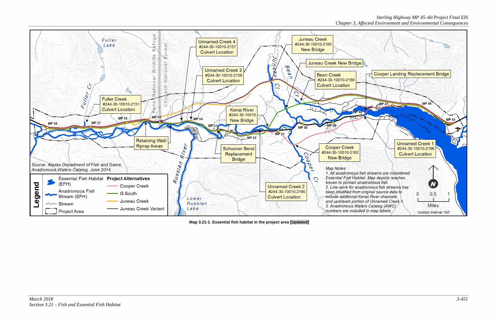
• Chum salmon (O. keta) NMFS considers all waters that support anadromous fish species to be EFH and has designated waters identified as anadromous by ADF&G as EFH. In the project area, 10 streams and one lake are anadromous and thus are designated as EFH for the five species of salmon listed above (ADF&G 2014c). These water bodies are Kenai Lake, the Kenai River, the Russian River, Juneau Creek, Bean Creek, Fuller Creek, Cooper Creek, and four unnamed creeks (see Map 3.21-1). Table 3.21-3 identifies salmon species occurrence in the water bodies in the project area identified as EFH. These water bodies also support populations of Dolly Varden, rainbow trout, and other species, but as these species are not included in a Federal FMP they are not considered in the evaluation of EFH. No marine fish species have EFH in the project area. The Kenai River ecosystem is a productive, diverse system that supports a wide variety of anadromous and non-anadromous fish species. Geographically, this system is contained within a large-scale terrain setting comprised of lakes, streams, wetlands, mountains, and glaciers that are connected to the Cook Inlet and the greater Gulf of Alaska ecosystem. The Kenai River ecosystem has consistent high flows for extended periods that provide salmon species ample time for spawning and migration. Skilak and Kenai lakes, as associated with the Kenai River ecosystem, regulate stream flow fluctuations, reduce sediment movement downstream, and provide excellent rearing and overwintering habitat. Many of the Kenai River’s associated tributaries also provide fish with rearing, overwintering, and spawning habitat (USGS 2001, Dorava and Liepitz 2004). In many areas of the Kenai River ecosystem, the stream banks consist of zones with slower currents and back eddies. These areas provide streamside vegetation of grasses, roots, and overhanging trees. Streamside vegetation serves several important functions, including providing bank stabilization, cover, and feeding zones for juvenile fish.
Sterling Highway MP 45–60 Project Final EIS Chapter 3, Affected Environment and Environmental Consequences
March 2018 3-435 Section 3.21 – Fish and Essential Fish Habitat
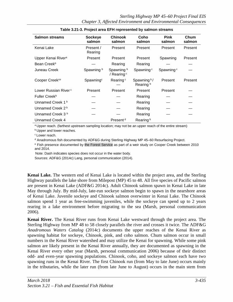
Table 3.21-3. Project area EFH represented by salmon streams
Salmon streams Sockeye salmon
Chinook salmon
Coho salmon
Pink salmon
Chum salmon
Kenai Lake Present / Rearing
Present Present Present Present
Upper Kenai Rivera Present Present Present Spawning Present Bean Creekb — Rearing Rearing — — Juneau Creek Spawning b Spawning b
/ Rearing c Spawning c Spawning c —
Cooper Creekce Spawningc Rearing c —
Spawning b / Rearing b
Present Present
Lower Russian River c Present Present Present Present — Fuller Creekb — — Rearing — — Unnamed Creek 1 b — — Rearing — — Unnamed Creek 2 b — — Rearing — — Unnamed Creek 3 b — — Rearing — — Unnamed Creek 4 Present d Rearing b a Upper reach. (farthest upstream sampling location; may not be an upper reach of the entire stream) b Upper and lower reaches. c Lower reach. d Anadromous fish documented by ADF&G during Sterling Highway MP 45–60 Resurfacing Project. e Fish presence documented by the Forest Service as part of a weir study on Cooper Creek between 2010 and 2014. Note: Dash indicates species does not occur in the water body. Sources: ADF&G (2014c) Lang, personal communication (2014).
Kenai Lake. The western end of Kenai Lake is located within the project area, and the Sterling Highway parallels the lake shore from Milepost (MP) 45 to 48. All five species of Pacific salmon are present in Kenai Lake (ADF&G 2014c). Adult Chinook salmon spawn in Kenai Lake in late May through July. By mid-July, late-run sockeye salmon begin to spawn in the nearshore areas of Kenai Lake. Juvenile sockeye and Chinook salmon overwinter in Kenai Lake. The Chinook salmon spend 1 year as free-swimming juveniles, while the sockeye can spend up to 2 years rearing in a lake environment before migrating to the sea (Marsh, personal communication 2006). Kenai River. The Kenai River runs from Kenai Lake westward through the project area. The Sterling Highway from MP 48 to 58 closely parallels the river and crosses it twice. The ADF&G Anadromous Waters Catalog (2014c) documents the upper reaches of the Kenai River as spawning habitat for sockeye, Chinook, pink, and coho salmon. Chum salmon occur in small numbers in the Kenai River watershed and may utilize the Kenai for spawning. While some pink salmon are likely present in the Kenai River annually, they are documented as spawning in the Kenai River every other year (Marsh, personal communication 2006) because of their distinct odd- and even-year spawning populations. Chinook, coho, and sockeye salmon each have two spawning runs in the Kenai River. The first Chinook run (from May to late June) occurs mainly in the tributaries, while the later run (from late June to August) occurs in the main stem from
Sterling Highway MP 45–60 Project Final EIS Chapter 3, Affected Environment and Environmental Consequences
3-436 March 2018 Section 3.21 – Fish and Essential Fish Habitat
Kenai Lake downstream (Liepitz 1994, Boggs et al. 1997, DNR et al. 1997). The early coho run enters the Kenai River in late July and spawns primarily in tributaries. The late run begins in September, and extends into November and December, with salmon spawning in the main stem of the Kenai River. Spawning coho have been observed at the Sterling Highway Bridge as late as February (Marsh, personal communication 2006). The main stem of the Kenai River near the outlet of Kenai Lake is productive habitat for coho spawning. Sockeye salmon have an early run in the Kenai River from mid-May to mid-July (Davis et al. 1994). Late run sockeye salmon spawn in tributaries and the main stem of the Kenai River from early July through early August (Boggs et al. 1997). Bean Creek. Bean Creek is a small stream originating on the south-facing slopes north of Cooper Landing and occurs almost entirely within the project area. The upper and lower reaches of Bean Creek are documented as rearing habitat for Chinook and coho salmon (ADF&G 2014c). The habitat is mainly riffles and pools, and the stream bed contains small to large gravel and small cobbles. There is abundant overhanging vegetation and woody debris with some undercut bank habitat (HDR 2006c). Juneau Creek. Juneau Creek originates well north of the project area and flows south through a canyon to join the Kenai River just west of the Cooper Landing community. Salmon do not migrate above the 128-foot-high Juneau Creek Falls, located approximately 4.5 miles from the Sterling Highway. The lower reaches of Juneau Creek (below the falls) are within the project area and are documented as spawning habitat for sockeye salmon, and spawning and rearing habitat for Chinook salmon (ADF&G 2014c). The habitat consists of riffles with small to large gravel and small cobbles. There is abundant overhanging vegetation and woody debris with some undercut bank habitat (HDR 2006c). HDR conducted juvenile surveys in 2004 and 2005 in this stream, and no fish were captured during the surveys (2011a). However, later studies conducted by Reimer and Begich found Chinook salmon, both present and spawning, in the project area section of Juneau Creek (Begich, et al. 2010, Reimer 2013). Cooper Creek. Cooper Creek originates south of the project area at Cooper Lake Dam and flows north into the Kenai River, passing under the Sterling Highway near MP 51. The upper and lower reaches of Cooper Creek are documented as spawning and rearing habitat for coho salmon (ADF&G 2014c). Field surveys have documented coho and sockeye salmon spawning in Cooper Creek (HDR 2011a); and the Anadromous Waters Catalog documents sockeye spawning in the lower reach and coho rearing in the upper and lower reaches (ADF&G 2014c). A weir study conducted by the Forest Service between 2010 and 2014 documented the presence of Chinook, pink, and chum salmon in Cooper Creek (Lang, personal communication 2014). Cooper Creek also provides limited spawning habitat for a small number of Chinook salmon (FERC 2006). Stream habitat consists of pools, riffles, and glide. The substrate is comprised primarily of boulder and gravel substrate. Cooper Creek has moderate flow. Since the construction of the Cooper Lake Dam in 1959, normal outflow from Cooper Lake has been directed into Kenai Lake via a tunnel outside the project area. This has significantly reduced flows at the mouth of Cooper Creek (FERC 2006). An approved diversion of Stetson Creek, a primary Cooper Creek tributary, into Cooper Lake and the construction of a bypass structure to allow for the release of warmer water from Cooper Lake into Cooper Creek through the dam, is intended to create stream flows and corresponding fish habitat in Cooper Creek similar to what existed before the construction of the Cooper Lake Dam (USFWS 2011).

Sterling Highway MP 45–60 Project Final EIS Chapter 3, Affected Environment and Environmental Consequences
March 2018 3-437 Section 3.21 – Fish and Essential Fish Habitat
Russian River. Current alternatives do not cross the Russian River; however, it is included because of its proximity and importance for spawning salmon in the Kenai watershed. The Russian River is a major tributary of the Kenai River, flowing north from Upper Russian Lake and joining the Kenai River at approximately MP 55. The Russian River supports runs of Chinook, coho, sockeye, and pink salmon (Marsh, personal communication (2006) and ADF&G (2014c)). The Russian River makes up only 3 percent of the drainage area of the Kenai River, yet it accounts for an average of 25 percent of late-run sockeye escapement to the Kenai River (ADF&G 1994). The other 93 percent of the Kenai River drainage area is responsible for the remaining 75 percent of late-run sockeye escapement. In other words, even though the Russian River is comparatively small, it is extremely productive for early- and late-run sockeyes (approximately 8.5 times more productive than the rest of the entire Kenai River system). The Russian River has tens of thousands of sockeye salmon migrating upstream to the Russian Lakes from mid-June until the end of August (ADF&G 1994). Russian River sockeye salmon use the main stem river as well as the tributary streams to spawn. Coho salmon arrive in the Russian River by late July or early August to spawn. Pink salmon spawn during even-numbered years in the Russian River system (Marsh, personal communication 2006). Chinook salmon are also known to occur in the segment of the Russian River located within the project area. Fuller Creek. Fuller Creek flows south from mountain lakes to the Kenai River and passes under the Sterling Highway near MP 57. The upper and lower reaches of Fuller Creek are documented as rearing habitat for coho salmon (ADF&G 2014c). The streambed is approximately 11 to 12 feet wide and contains large gravel to small cobbles. Fuller Creek has moderate flow consisting of riffles, small pools, and cascades. During unusually dry seasons, it has been known to go dry. Fuller Creek was verified as flowing in September 2003 and is on the list of anadromous fish streams. Fuller Creek was dry during the 2004 field survey, but flowing during the 2005 survey; fish were not captured or observed during either survey (HDR 2011a). Unnamed Creek 1. This small tributary originates along the base of slopes within the community of Cooper Landing. It flows along the Sterling Highway and passes under Snug Harbor Road, just south of the Cooper Landing Bridge near MP 48. This tributary has low flow, running between approximately 1.6 inches to 1 foot deep with a few deeper pools. The site is in close proximity to the Kenai River and provides off-channel rearing habitat for coho salmon fry (ADF&G 2014c). Coho salmon were captured during fisheries surveys conducted in 2004 (HDR 2011a). This tributary was again visited in June 2012 to investigate fish presence in response to proposed construction for the Sterling Highway MP 45–58 resurfacing project. Fish trapping efforts (DOT&PF 2012a) recorded the presence of juvenile Chinook and coho salmon on the east side of Snug Harbor Road as well as about 100 feet west of Snug Harbor Road. Unnamed Creek 2. This small tributary flows in an east-west direction and is located immediately north of the Sterling Highway, at approximately MP 51.5. This tributary is approximately 3 to 4 feet wide and 2 to 9 inches deep, and had moderate flow during a field survey in 2004. The stream bed is comprised of organic materials and silts. The ADF&G Anadromous Waters Catalog (ADF&G 2014c) documents this tributary as rearing habitat for coho salmon. Coho salmon were captured during the fish survey for this project (HDR 2011a). Unnamed Creek 3. This small tributary is located at approximately MP 54 and passes underneath the Sterling Highway before joining the Kenai River. This tributary is approximately 660 feet in length and was documented as anadromous in 2012 (ADF&G 2014c). This tributary is documented as providing rearing habitat for coho salmon.
Sterling Highway MP 45–60 Project Final EIS Chapter 3, Affected Environment and Environmental Consequences
3-438 March 2018 Section 3.21 – Fish and Essential Fish Habitat
Unnamed Creek 4. This tributary is approximately 350 feet long and flows underneath the Sterling Highway at approximately MP 54.3. Field surveys in 2004 and 2005 documented coho and Chinook salmon in this tributary (HDR 2011a); however, the ADF&G Anadromous Waters Catalog (ADF&G 2014c) documents this tributary only as rearing habitat for coho salmon.
3.21.2 Environmental Consequences This section provides an analysis of the potential adverse1 effects of the project alternatives on EFH and the fish that rely on that habitat. Conclusions regarding the effects of the alternatives on EFH and a summary of proposed measures to avoid and minimize adverse effects are provided in this section.
3.21.2.1 No Build Alternative Direct and Indirect Impacts The No Build Alternative would have no new direct or indirect impacts on EFH in the project area. However, increased traffic on the existing highway would result in greater runoff of roadway debris and pollutants, which would adversely affect EFH immediately adjacent to the highway. Existing indirect impacts such as sediment delivery and potential water quality degradation from storm water runoff, potential contamination from spills due to vehicle crashes, and concentrated fishing pressure and associated stream bank erosion would be expected to increase as population and recreational use increased. The projected growth in travelers to the project area could create additional pressures on fish resources and EFH located along the existing Sterling Highway. If poorly managed, additional fishing pressure could adversely affect EFH (primarily through trampling of river banks and riparian vegetation coupled with associated erosion, siltation, and habitat destruction), which could cumulatively affect the sustainability of the fishery. The Kenai River watershed fishery is managed and regulated by the ADF&G to maintain the structural and functional integrity of the riparian habitat along the Kenai River. With proper management, the increase in traffic and associated fishing pressure are not anticipated to cause a long-term adverse effect on EFH. For additional information on indirect effects closely related to EFH, see Section 3.10, Subsistence. Recreational changes related to the numerous sport fish access and recreation facilities are described in Section 3.8, Parks and Recreation Resources, and Section 4(f).
3.21.2.2 Issues Applicable to the Build Alternatives Direct and Indirect Impacts Construction in or near EFH could have permanent impacts to stream habitat. The four build alternatives would impact different parts of the project area, which are detailed in the Alternatives sections below. All alternatives could result in some direct and indirect impacts to fish and EFH as a result of the installation of culverts. The primary impacts of culverts would be 1) permanent changes in stream flow that could affect fish passage under the highway (making it potentially more difficult or easier for fish to pass), and 2) elimination of habitat, including loss
1 Subpart J, Section 600.810, of the Magnuson-Stevens Fishery and Conservation Management Act identifies an adverse effect as “any impact which reduces quality and/or quantity of EFH” and also notes that “adverse effects may include direct (e.g., contamination or physical disruption), indirect (e.g., loss of prey, or reduction in species' fecundity), site-specific, or habitat-wide impacts, including individual, cumulative, or synergistic consequences of actions” (50 CFR § 600.810).
Sterling Highway MP 45–60 Project Final EIS Chapter 3, Affected Environment and Environmental Consequences
March 2018 3-439 Section 3.21 – Fish and Essential Fish Habitat
of riparian vegetation, and reduction of habitat quality where culverts would replace natural habitat. Where old culverts under the existing highway would be replaced with new culverts built to modern standards and often at larger diameter, it is possible that fish passage would be established where it had previously been cut off. See each alternative’s section below for the estimated area of natural stream channel EFH being impacted by the installation of culverts. Under any of the Build alternatives, indirect impacts such as sediment delivery and potential water quality degradation from storm water runoff, and concentrated fishing pressure and associated stream bank erosion would be slightly less than the No Build Alternative, because each of the Build alternatives would route most highway traffic farther away from the Kenai River. Potential contamination from spills due to vehicle crashes and risk of hazardous substance spills from fuel tankers and other vehicles would be substantially reduced; see Section 3.6 regarding crashes and Section 3.17 regarding risk of spills in waterways, many of which are EFH. The number of bridges and culverts crossing streams with resident or anadromous fish is a contributing factor to adverse effects on EFH. Additionally, the area of wetland and vegetation loss and new impermeable surface (area of new roadway) affects the volume of storm water runoff, which may carry accumulated oils, debris, and contaminants. This impact is most pertinent in areas where the roadway intersects with, or is immediately adjacent to, water bodies. Impacts to EFH, as calculated through geographic information systems, were determined by comparing the acreage of overlap between the alignments’ cut-and-fill boundaries and the mapped EFH. The acreage of EFH adversely affected by each alternative is presented in the sections below, and Map 3.21-1 depicts the locations of anadromous fish stream crossings for the various alternatives. Impacts to EFH from bridge replacement would be partially offset by removal of the old bridge piers and any abutments that might be in the water. Additional information related to effects on EFH can be found in Section 3.13, Water Bodies and Water Quality. ADF&G, in its role as cooperating agency, has also indicated concern over impacts of bridges, including:
• Removing important riparian vegetation that provides juvenile fish with shelter from predators.
• Eliminating or reducing complex structure—roots, trunks, and branches of trees and shrubs—that juvenile fish use for resting and rearing habitat.
• Eliminating overhanging and aquatic vegetation that aquatic insects (an important food source for juvenile fish) feed on.
• Eliminating trees and shrubs that shade the river to help keep water temperatures cool and act as a buffer for storm water runoff and high river levels to minimize erosion and sedimentation.
The new bridges and a wider highway road, where located parallel to the Kenai River or other fish streams, would replace natural banks and vegetation with a hardened, unnatural surface. Replacing natural banks would remove vegetation that provides fish habitat, shades the river, and buffers runoff water (including sediments and pollutants) from entering the river. Bridges and hardened surfaces adjacent to the Kenai River and other streams would create a direct vector for sediment and pollutants to enter the water. The impacts of bridges apply to all alternatives, but these impacts would be much reduced for the long, high bridges that occur under each
Sterling Highway MP 45–60 Project Final EIS Chapter 3, Affected Environment and Environmental Consequences
3-440 March 2018 Section 3.21 – Fish and Essential Fish Habitat
alternative. Vegetation would continue to grow, and shading of water surfaces would be a negligible issue. The projected growth in number of travelers to and through the project area could create additional pressures on fish resources and EFH located along the existing Sterling Highway under any alternative, including the No Build Alternative. Proposed actions to improve access and reduce local traffic congestion could create additional demand for vehicle parking and access to fishing resources. Without active management, additional fishing pressure could adversely affect EFH (primarily through trampling of river banks and riparian vegetation coupled with associated erosion, siltation, and habitat destruction), which could cumulatively affect the sustainability of the fishery. The Kenai River watershed fishery is managed and regulated by the ADF&G and adjacent owners of public land (Forest Service and USFWS) to maintain the structural and functional integrity of the riparian habitat along the Kenai River. With proper management, the increase in traffic and associated fishing pressure is not anticipated to cause a long-term adverse effect on EFH. For additional information on indirect effects closely related to EFH, see Section 3.10, Subsistence. Recreational changes related to the numerous sport fish access and recreation facilities are described in Section 3.8, Parks and Recreation Resources, and Section 4(f). Effects to fish and EFH as described above are the same as noted for the No Build Alternative.
Construction Impacts Construction of any build alternative would require permits or other regulatory approvals to provide for the protection of fish and EFH. These include a U.S. Army Corps of Engineers Section 404 and Section 10 Permit, an ADF&G Title 16 Fish Habitat Permit, an Alaska Department of Environmental Conservation (ADEC) Section 401 Certificate of Reasonable Assurance, a Borough Floodplain Development Permit, and requirements of an ADF&G-Department of Transportation and Public Facilities (DOT&PF) Memorandum of Agreement (MOA). The ADF&G Title 16 permit process, in particular, ensures that construction and operation of any build alternative will be conducted using best management practices (BMPs) to minimize the amount of time in-water work is conducted, minimize siltation of water bodies during construction, and provide for fish passage during construction and operation. Additional information can be found in Section 3.24, Permits. For any build alternative, roadway construction would require crossing anadromous and resident fish streams. Temporary diversions of these streams would be required during culvert installation and possibly during construction of small bridges, which would temporarily alter the streambed. Placement of culverts in fish-bearing streams could temporarily affect anadromous fish populations by eliminating eggs incubating in the streambed or by creating turbid water and scour downstream. Deposition of material could suffocate incubating eggs downstream as well as affect rearing and foraging of juvenile salmon. Direct disturbance of habitat from in-water work, and siltation downstream could displace fish temporarily. Construction in or near EFH habitat will temporarily impair the normal habitat functionality of the area. In-water work would be required for the replacement and construction of bridges over the Kenai River. Pile driving, auguring, or both would be necessary for placement of bridge pier foundations. Temporary impacts on the water quality of the Kenai River would occur during construction, including increased turbidity and siltation, which could smother incubating eggs.
Sterling Highway MP 45–60 Project Final EIS Chapter 3, Affected Environment and Environmental Consequences
March 2018 3-441 Section 3.21 – Fish and Essential Fish Habitat
Impacts to EFH from bridge replacement would be partially offset by removal of the old bridge piers and any abutments that might be in the water.
Mitigation Adverse effects to resident and anadromous fish species and EFH are unavoidable and largely associated with temporary construction activities; however, with mitigation, no long-term adverse effects on EFH or species that rely on that habitat are anticipated. Impacts would be minimized through installation criteria, BMPs, and the proposed mitigation measures listed below. These measures were developed in consultation with NMFS. These are general measures that may be modified to specifically address details of the preferred alternative through additional consultation with the agencies during final design and permitting. Additional details on the effects to EFH and proposed conservation measures can be found in the Essential Fish Habitat Assessment (HDR 2013a).
• Based on available preliminary engineering done to date (HDR 2011b, 2014a), all new bridge crossings would be designed to minimize impacts to EFH by placing as few piers as feasible below the ordinary high water line. All replacement bridges would be designed with fewer piers than currently exist, whenever practical, and DOT&PF has committed to using no more piers than currently exist. As engineering design develops, DOT&PF will continue to evaluate bridge designs to reduce impacts to EFH and retain existing hydrology.
• When specific pile driving techniques are known, appropriate mitigation would be developed with the regulatory agencies to minimize impacts. For example, in the spawning areas identified in ADF&G’s Atlas of Waters Important for Spawning, Rearing or Migration of Anadromous Fishes (ADF&G 2014c), pile driving or bridge removal activities may be limited to late October to the end of December to avoid most spawning impacts (per recommendations in Marsh, personal communication (2006) and Popper and Hastings (2009)). If possible and necessary, there may be deviations to the proposed timing windows, which would be coordinated in consultation with NMFS and ADF&G.
• All anadromous fish stream crossings would be designed to minimize impacts on stream function and hydrology, and to provide passage to both anadromous and resident fish. All road structures crossing anadromous fish habitat would be designed to meet the ADF&G-DOT&PF MOA requirements for fish passage. For example, stream culverts would be bottomless arch culverts or would be fully embedded with streambed material where possible.
• At no time would the construction activities result in a migration barrier for adult or juvenile salmonids. Construction would be timed to avoid critical fish spawning and migration. Specific timing windows for in-water work and pile driving would be established during permitting.
• During construction, the contractor may use other methods to re-route streams such as temporary bridging for larger anadromous streams and rivers, or a bypass culvert or pumping for smaller anadromous streams. Temporary diversions within fish-bearing streams would be subject to permitting stipulations and would be designed so that stream flow would not be impeded and fish passage would not be compromised. Stream diversions may be limited to a specific work window depending on species present in
Sterling Highway MP 45–60 Project Final EIS Chapter 3, Affected Environment and Environmental Consequences
3-442 March 2018 Section 3.21 – Fish and Essential Fish Habitat
stream and spawning habitat in the vicinity (Litchfield, personal communication 2014). Any kind of in-stream diversion would be limited to late October through December to avoid salmon spawning and rearing life cycles, although this timing window may be adjusted in permit stipulations (Marsh, personal communication 2006). Following completion of construction, all streams would be restored to natural conditions.
• A number of existing undersized or perched culverts were identified during a field investigation to identify small streams and drainages in the project area, as summarized in the Hydrology and Hydraulics Summary (HDR 2006f). Replacement of existing culverts that are undersized or perched could improve fish passage to upstream habitat on portions of the highway that are reconstructed.
• To minimize and prevent spills or leakage of hazardous materials during construction, standard spill-prevention measures would be implemented in accordance with the contractor’s approved “Spill Prevention, Control, and Countermeasures Plan.”
• No vehicles or equipment would be fueled or serviced within 100 feet of wetlands or fish bearing streams with the exception of “low-mobility” equipment used for pile driving, drilled shaft construction, or other bridge construction. A plan would be provided detailing the process for fueling this equipment within 100 feet of wetlands or fish-bearing streams. Fueling and service vehicles would be equipped with adequate materials (such as sorbent pads, booms, etc.) to immediately contain and commence clean-up of spilled fuels and other petroleum products. Fuel would be stored a minimum of 100 feet from any wetland or water body.
• The contractor would use contaminant-free embankment and surface materials in construction.
• Stream banks at all culverts and bridge crossings would be re-contoured to approximate original conditions and re-seeded with native vegetation to minimize erosion. Seeding of the disturbed areas would conform to Section 618 of the DOT&PF Standard Specifications for Seeding.
• DOT&PF would work with ADF&G to incorporate vegetation to the extent practicable into any areas along anadromous fish streams that would require riprap, with the aim of minimizing long-term habitat loss.
• Design would include standard engineering considerations to avoid and minimize the potential for erosion near surface drainages.
• Temporary material storage piles would not be placed in the 100-year floodplain during the rainy season unless the following conditions are met: (1) storage does not occur when flooding is imminent; and (2) if storage piles consist of erosive material, they are to be covered with plastic tarps (or similar) and surrounded with compost berms or other erosion control devices.
• Slopes with the potential to impact the Kenai River would be stabilized as soon as practicable.
• BMPs developed in accordance with DOT&PF’s Alaska Storm Water Pollution Prevention Plan Guide (DOT&PF 2011d) and ADEC’s Alaska Storm Water Guide
Sterling Highway MP 45–60 Project Final EIS Chapter 3, Affected Environment and Environmental Consequences
March 2018 3-443 Section 3.21 – Fish and Essential Fish Habitat
(ADEC 2011) would be employed to control erosion and capture sediment that is moved by stormwater before it leaves the site into project area streams. Specific BMPs related to anadromous fish habitat would include installing temporary erosion and sediment control measures (e.g., minimizing the amount of soil exposed during construction by preserving native topsoil or phasing construction, maintaining natural buffer areas, controlling storm water discharges and flow rates, and protecting steep slopes until re-vegetated plants can bind the soil and stabilize it), and sustaining predevelopment flow rates to protect stream habitat (ADEC 2011).
• Grassy swales would be part of the roadway design to accept storm water runoff to help maintain water quality in fish habitat by filtering sediments, road salts, and oil residue before entering streams or the Kenai River.
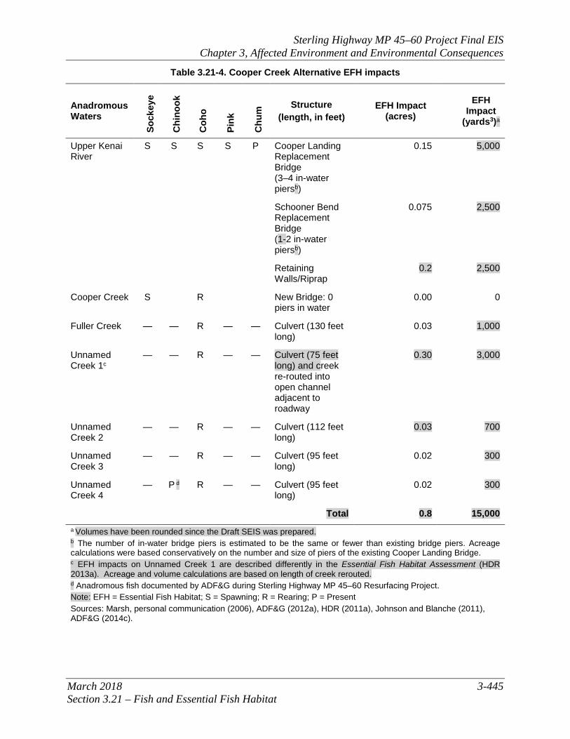
3.21.2.3 Cooper Creek Alternative Direct and Indirect Impacts The Cooper Creek Alternative would affect Cooper Creek, the Kenai River, Fuller Creek, and Unnamed Creeks 1, 2, 3, and 4. Adjacent to impacted EFH are approximately 2 acres of seasonally or permanently flooded wetlands that could also serve as fish habitat. A bridge would be built more than 100 feet above Cooper Creek. Based on preliminary design conducted for bridge structure options (HDR 2011b), because of the narrow creek width, it is anticipated that the bridge structure could be designed so that piers and abutments would not need to be placed in the stream channel. Based on available preliminary engineering to date, no loss of EFH is anticipated at the Cooper Creek bridge crossing. New culverts would be used to cross Fuller Creek and Unnamed Creeks 2, 3, and 4, all of which have been field-verified as EFH for rearing coho salmon. Unnamed Creek 4 is also known to have Chinook salmon present. There would be minimal permanent loss of EFH resulting from these culvert crossings because the required culvert design features for all build alternatives, noted in Section 3.21.2.2 above, would preserve fish passage. Within the culverts, the waterways would be completely shaded and without natural vegetation or meanders, causing a reduction in habitat quality. Unnamed Creek 1 would be placed in a culvert to cross under the “old” highway south of the intersection with Snug Harbor Road and directed into an open channel to the Kenai River. Relocating the existing channel to the west side of the “old” highway would cause a minimal adverse effect on EFH. Routing the creek under the old highway would result in minimal permanent loss of EFH. The Cooper Creek Alternative also includes replacement of the Cooper Landing and Schooner Bend bridges over the Kenai River and identifies approximately three separate locations along the river where installation of riprap or retaining walls may be required to widen and reconstruct segments of the existing roadway to bring the highway up to current standards. These activities would result in temporary impacts to fish and EFH during construction and are the same as the permanent and construction impacts for all build alternatives, as discussed in Section 3.21.2.2. Once project bridges, retaining walls, and riprap were in place, some additional permanent impacts to these fish species would be expected. New construction would be in almost the same locations, and the new bridges would be wider than the existing bridges.
Sterling Highway MP 45–60 Project Final EIS Chapter 3, Affected Environment and Environmental Consequences
3-444 March 2018 Section 3.21 – Fish and Essential Fish Habitat
Existing indirect impacts such as sediment delivery and potential water quality degradation from storm water runoff, potential contamination from spills due to vehicle crashes, risk of hazardous substance spills from fuel tankers and other vehicles, and concentrated fishing pressure and associated stream bank erosion would be slightly less than the No Build Alternative because approximately 44 percent of the highway alignment would be routed away from the Kenai River floodplain and would carry about 70 percent of traffic away from fish habitat. Table 3.21-4 depicts the anticipated construction activities and impacts associated with the Cooper Creek Alternative that would affect EFH. Additional details on the effects to EFH and proposed conservation measures can be found in the Essential Fish Habitat Assessment (HDR 2013a).
Construction Impacts Construction impacts associated with the Cooper Creek Alternative are detailed in Section 3.21.2.2.
Mitigation Construction impacts to salmon are of particular concern. Specific timing windows for in-water work and pile driving would be established during permitting to avoid critical salmon life cycle impacts. Mitigation for fish and EFH that is common to all alternatives can be found in Section 3.21.2.2.
Sterling Highway MP 45–60 Project Final EIS Chapter 3, Affected Environment and Environmental Consequences
March 2018 3-445 Section 3.21 – Fish and Essential Fish Habitat
Table 3.21-4. Cooper Creek Alternative EFH impacts
Anadromous Waters
Sock
eye
Chi
nook
Coh
o
Pink
Chu
m Structure
(length, in feet) EFH Impact
(acres) EFH
Impact (yards3)a
Upper Kenai River
S S S S P Cooper Landing Replacement Bridge (3–4 in-water piersb)
0.15 5,000
Schooner Bend Replacement Bridge (1-2 in-water piersb)
0.075 2,500
Retaining Walls/Riprap
0.2 2,500
Cooper Creek S R New Bridge: 0 piers in water
0.00 0
Fuller Creek — — R — — Culvert (130 feet long)
0.03 1,000
Unnamed Creek 1c
— — R — — Culvert (75 feet long) and creek re-routed into open channel adjacent to roadway
0.30 3,000
Unnamed Creek 2
— — R — — Culvert (112 feet long)
0.03 700
Unnamed Creek 3
— — R — — Culvert (95 feet long)
0.02 300
Unnamed Creek 4
— P d R — — Culvert (95 feet long)
0.02 300
Total 0.8 15,000 a Volumes have been rounded since the Draft SEIS was prepared. b The number of in-water bridge piers is estimated to be the same or fewer than existing bridge piers. Acreage calculations were based conservatively on the number and size of piers of the existing Cooper Landing Bridge. c EFH impacts on Unnamed Creek 1 are described differently in the Essential Fish Habitat Assessment (HDR 2013a). Acreage and volume calculations are based on length of creek rerouted. d Anadromous fish documented by ADF&G during Sterling Highway MP 45–60 Resurfacing Project. Note: EFH = Essential Fish Habitat; S = Spawning; R = Rearing; P = Present Sources: Marsh, personal communication (2006), ADF&G (2012a), HDR (2011a), Johnson and Blanche (2011), ADF&G (2014c).
Sterling Highway MP 45–60 Project Final EIS Chapter 3, Affected Environment and Environmental Consequences
3-446 March 2018 Section 3.21 – Fish and Essential Fish Habitat
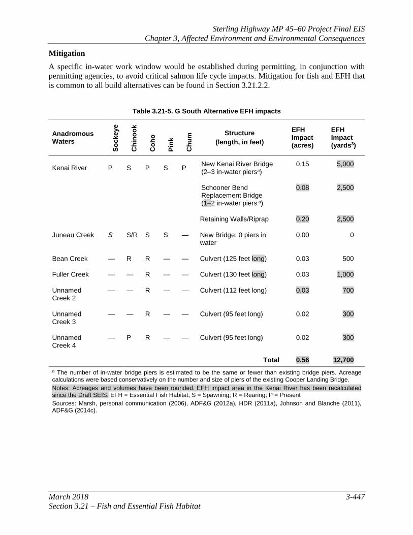
3.21.2.4 G South Alternative Direct and Indirect Impacts The G South Alternative would affect known EFH water bodies including the Kenai River, Bean Creek, Juneau Creek, Fuller Creek, and Unnamed Creeks 2, 3, and 4. Adjacent to impacted EFH are approximately 4 acres of seasonally- or permanently-flooded wetlands that could also serve as fish habitat. Placement of a new bridge across the Kenai River with up to three in-water piers would permanently change the shading, sound/vibration, and in-water and streambank vegetation in the immediate area. The impacts discussed above in Section 3.21.2.2 regarding bridges and roads adjacent to the river would be particularly notable for the new bridge. However, resident fish species are not expected to use the Kenai River for critical life stages such as spawning and rearing, and impacts to anadromous fish species would be minimized by limiting in-water work to a window that would avoid critical life cycle impacts. Still, bridge effects of shading and removal of riparian habitat would be permanent. The existing Schooner Bend Bridge would be replaced, and incremental new permanent impact to fish and riparian habitat would be expected. The new bridge would be in nearly the same location and would be wider. This alternative identifies approximately three separate locations along the river where installation of riprap or retaining walls may be required to widen and reconstruct segments of the existing roadway to bring the highway up to current standards. The impacts to salmon in the Kenai River would be the same as those under the Cooper Creek Alternative (see Section 3.21.2.3). Under the G South Alternative, a bridge would be constructed to cross Juneau Creek. Based on preliminary design conducted for bridge structure options (HDR 2011b), it is anticipated that the bridge structure for the Juneau Creek crossing Section could be designed so that piers would not be placed below ordinary high water and no fill would be placed in the creek. Based on available preliminary engineering to date, no EFH impact is anticipated at the Juneau Creek crossing. Culverts would be used to cross Bean Creek, Fuller Creek, and Unnamed Creeks 2, 3, and 4, which have been field-verified as anadromous and provide rearing habitat for coho salmon. Unnamed Creek 4 is also known to have Chinook salmon present, and Bean Creek provides rearing habitat for Chinook salmon. There would be minimal permanent loss of EFH resulting from these culvert crossings because the required culvert design features for all build alternatives, noted in Section 3.21.2.2 above, would preserve fish passage. Existing indirect impacts such as sediment delivery and potential water quality degradation from storm water runoff, potential contamination from spills due to vehicle crashes, risk of hazardous substance spills from fuel tankers and other vehicles, and concentrated fishing pressure and associated stream bank erosion would be somewhat less than those same impacts under the No Build Alternative. This is because approximately 53 percent of the highway would be routed away from the Kenai River floodplain and would carry about 70 percent of traffic away from fish habitat. Table 3.21-5 depicts the anticipated construction activities and impacts associated with the G South Alternative that would affect EFH.
Construction Impacts Construction impacts associated with the G South Alternative are similar to those for all build alternatives as detailed in Section 3.21.2.2.
Sterling Highway MP 45–60 Project Final EIS Chapter 3, Affected Environment and Environmental Consequences
March 2018 3-447 Section 3.21 – Fish and Essential Fish Habitat
Mitigation A specific in-water work window would be established during permitting, in conjunction with permitting agencies, to avoid critical salmon life cycle impacts. Mitigation for fish and EFH that is common to all build alternatives can be found in Section 3.21.2.2.
Table 3.21-5. G South Alternative EFH impacts
Anadromous Waters
Sock
eye
Chi
nook
Coh
o
Pink
Chu
m Structure
(length, in feet)
EFH Impact (acres)
EFH Impact (yards3)
Kenai River P S P S P New Kenai River Bridge (2–3 in-water piersa)
0.15 5,000
Schooner Bend Replacement Bridge (1–2 in-water piers a)
0.08 2,500
Retaining Walls/Riprap 0.20 2,500
Juneau Creek S S/R S S — New Bridge: 0 piers in water
0.00 0
Bean Creek — R R — — Culvert (125 feet long) 0.03 500
Fuller Creek — — R — — Culvert (130 feet long) 0.03 1,000
Unnamed Creek 2
— — R — — Culvert (112 feet long) 0.03 700
Unnamed Creek 3
— — R — — Culvert (95 feet long) 0.02 300
Unnamed Creek 4
— P R — — Culvert (95 feet long) 0.02 300
Total 0.56 12,700 a The number of in-water bridge piers is estimated to be the same or fewer than existing bridge piers. Acreage calculations were based conservatively on the number and size of piers of the existing Cooper Landing Bridge. Notes: Acreages and volumes have been rounded. EFH impact area in the Kenai River has been recalculated since the Draft SEIS. EFH = Essential Fish Habitat; S = Spawning; R = Rearing; P = Present Sources: Marsh, personal communication (2006), ADF&G (2012a), HDR (2011a), Johnson and Blanche (2011), ADF&G (2014c).
Sterling Highway MP 45–60 Project Final EIS Chapter 3, Affected Environment and Environmental Consequences
3-448 March 2018 Section 3.21 – Fish and Essential Fish Habitat
3.21.2.5 Juneau Creek and Juneau Creek Variant Alternatives Direct and Indirect Impacts The Juneau Creek (preferred alternative) and Juneau Creek Variant alternatives would affect the Kenai River and Fuller Creek. Adjacent to impacted EFH are approximately 4 acres of seasonally or permanently flooded wetlands that could also serve as fish habitat. Preliminary bridge structure options anticipate that the crossing of Juneau Creek could be clear spanned (HDR 2011b). A bridge over Juneau Creek would be more than 260 feet above the stream itself, and piers and abutments are not anticipated to be placed in the water or riparian area (no work would occur below elevation 1,060 feet on the canyon rim); as a result, no EFH impact is anticipated at that crossing. A crossing of Bean Creek would use a fish passage culvert placed above the documented anadromous fish reach. Most of the impacts to the Kenai River and Fuller Creek would be the same as the other build alternatives where they are coincident with the existing highway. Fuller Creek provides rearing habitat for coho salmon and would be crossed with a culvert. There would be minimal permanent loss of EFH resulting from these culvert crossings because the required culvert design features for all build alternatives, noted in Section 3.21.2.2 above, would preserve fish passage. These alternatives identify approximately one (Juneau Creek Alternative) or two (Juneau Creek Variant Alternative) locations along the river where installation of riprap or retaining walls may be required to widen and reconstruct a segment of the existing roadway to bring the highway up to current standards. The Juneau Creek Variant Alternative would require placement of riprap in the Kenai River that other alternatives would not. This is a result of the fact that the Juneau Creek Variant Alternative is higher in elevation, and thus has a wider footprint, than the other alternatives at that location. Existing indirect impacts such as sediment delivery and potential water quality degradation from storm water runoff, potential contamination from spills due to vehicle crashes, risk of hazardous substance spills from fuel tankers and other vehicles, and concentrated fishing pressure and associated stream bank erosion would be slightly less than those same impacts under the No Build Alternative. This is because approximately 75 percent of the highway under the Juneau Creek Alternative would be routed away from the Kenai River floodplain and approximately 74 percent of the highway under the Juneau Creek Variant Alternative would be routed away from the Kenai River. These changes would carry about 70 percent of traffic away from fish habitat in this area. Table 3.21-6 depicts the anticipated construction activities and impacts associated with the Juneau Creek and Juneau Creek Variant alternatives that would affect EFH.
Sterling Highway MP 45–60 Project Final EIS Chapter 3, Affected Environment and Environmental Consequences
March 2018 3-449 Section 3.21 – Fish and Essential Fish Habitat
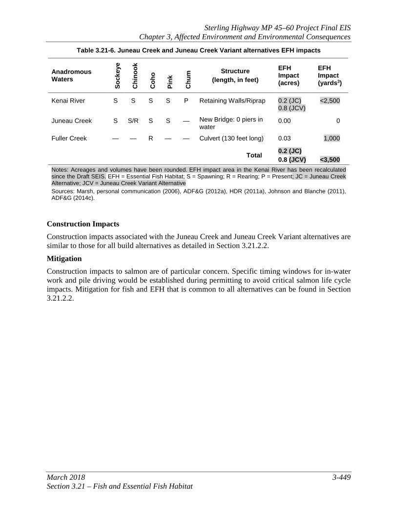
Table 3.21-6. Juneau Creek and Juneau Creek Variant alternatives EFH impacts
Anadromous Waters
Sock
eye
Chi
nook
Coh
o
Pink
Chu
m Structure
(length, in feet)
EFH Impact (acres)
EFH Impact (yards3)
Kenai River S S S S P Retaining Walls/Riprap 0.2 (JC) 0.8 (JCV)
<2,500
Juneau Creek S S/R S S — New Bridge: 0 piers in water
0.00 0
Fuller Creek — — R — — Culvert (130 feet long) 0.03 1,000
Total 0.2 (JC) 0.8 (JCV) <3,500
Notes: Acreages and volumes have been rounded. EFH impact area in the Kenai River has been recalculated since the Draft SEIS. EFH = Essential Fish Habitat; S = Spawning; R = Rearing; P = Present; JC = Juneau Creek Alternative; JCV = Juneau Creek Variant Alternative Sources: Marsh, personal communication (2006), ADF&G (2012a), HDR (2011a), Johnson and Blanche (2011), ADF&G (2014c).
Construction Impacts Construction impacts associated with the Juneau Creek and Juneau Creek Variant alternatives are similar to those for all build alternatives as detailed in Section 3.21.2.2.
Mitigation Construction impacts to salmon are of particular concern. Specific timing windows for in-water work and pile driving would be established during permitting to avoid critical salmon life cycle impacts. Mitigation for fish and EFH that is common to all alternatives can be found in Section 3.21.2.2.

Sterling Highway MP 45–60 Project Final EIS Chapter 3, Affected Environment and Environmental Consequences
3-450 March 2018 Section 3.21 – Fish and Essential Fish Habitat
This page intentionally left blank.
Sterling Highway MP 45–60 Project Final EIS Chapter 3, Affected Environment and Environmental Consequences
March 2018 3-451 Section 3.21 – Fish and Essential Fish Habitat
Map 3.21-1. Essential fish habitat in the project area [Updated]

Sterling Highway MP 45–60 Project Final EIS Chapter 3, Affected Environment and Environmental Consequences
3-452 March 2018 Section 3.21 – Fish and Essential Fish Habitat
This page intentionally left blank.