Embed Size (px)
Citation preview

CHAPTER 5. FLOOD GEOLOGY
Genesis 2:5, 6. For the Lord God had not caused it to rain upon the earth…but there went up a mist from the earth, and watered the whole face of the ground.
A universal flood model, as covered in the last chapter, applies to more than just floating
the ark to the mountains of Ararat. It involves a completely different interpretation of Earth
history than has been developed by geologists over the last 200 years. This Young Earth
Creationist view of Earth history is called “Flood Geology”. Flood Geology not only embraces a
6000 year-old Earth (the subject of Chapter 3), and a universal world-wide flood (the subject of
Chapter 4), it also makes other far-reaching claims based on a supposed “literal” reading of
Genesis. The main positions held by Flood Geologists (Young Earth Creationists) versus Old
Earth Creationists are presented in Box 5.1.
Box 5.1. Flood Geologist versus Old Earth Creationist Positions Flood Geologist (Young Earth Creationist)
• Earth is 6000 years old • Noah’s Flood was universal • Mt. Ararat is the landing place of the ark • It never rained on Earth before Noah’s Flood • A vapor canopy supplied all the water for a
universal flood • The four rivers of Eden flowed on a crystalline
basement devoid of sedimentary rock • No death of animals before Adam sinned; all
animals were herbivores • All sedimentary rock formed in Noah’s Flood in
one year’s time • Fossils in sedimentary rocks represent the “all
flesh” of Gen. 7:21 • The rainbow of Gen. 9:13 was the first to appear
on planet Earth
Old Earth Creationist • Earth is 4.6 billion years old • Noah’s Flood was local to the Mesopotamian
hydrologic basin • The ark landed somewhere in the “mountains of
Ararat” (Urartu) • Abundant evidence exists for it having rained
throughout of Earth’s geologic history • Earth’s atmosphere can hold only a fraction of the
water needed for a universal flood • The Garden of Eden is described in Genesis as a
modern landscape overlying sedimentary rock • Death of animals has occurred over millions of years
and is represented by the fossil record • Sedimentary rock has formed over millions of years
by the process of sedimentation and compaction • Fossils are plant and animal remains that became
buried and solidified over millions of years • The rainbow was a sign of God’s covenant to Noah’s
descendants
1

Flood Geology Theology
The following outline describes the logic of Flood Geologists regarding the history of the
Earth based on their “literal” reading of Genesis:
Genesis 1. The Earth was created approximately 6000 years ago based on a 24-hour
day/six days of creation (Genesis 1) plus the chronologies of Genesis 5 and 11.
Genesis 2. It never rained upon the earth (planet Earth) before Noah’s Flood (Gen. 2:5).
Rather, there was some kind of vapor canopy that watered the whole face of the ground (of
planet Earth) from the time of Creation (Genesis 1) to the time of Noah’s Flood (Genesis 7). This
vapor canopy is referred to as “mist” in Genesis 2:6. Since it never rained on planet Earth before
the Flood, no (or very little) sedimentary rock could have formed before this time, and pre-flood
locations like the Garden of Eden had to have existed on a crystalline basement devoid of
sedimentary rock. Therefore, the pre-flood topography of planet Earth bore no resemblance to
today’s post-flood topography.
Genesis 3 and 4. Before Adam sinned and ate of the fruit of the tree (Gen. 3:6), a world
of perfect harmony existed on planet Earth. In this perfect world there was no death, not even the
death of animals. Since no animals died, all animals (created as individual species in Genesis 1)
had to have been plant eaters (herbivores) before Adam’s fall. Adam’s “original sin” brought
about a violent imperfect world where both humans and animals died and where some animals
became carnivores. This violence is illustrated by the avengeful line of Cain (Gen. 4: 23-24).
Genesis 5 and 6. The long ages of the patriarchs before the Flood signify a decay from a
state of perfection in the Garden of Eden to a maximum 120-year life span for humans after the
Flood (Gen. 6:3). The vapor canopy somehow shielded humans from harmful radiation so that
they lived longer in pre-flood days. The violence had become so pervasive by Noah’s time that
2

only one man was considered “perfect” by God and that man was Noah (Gen. 6:9).
Consequently, God instructed Noah to build an ark and prepare for a flood, wherein all men and
animals and birds would be destroyed from off “the face of the earth” (planet Earth) (Gen. 6: 7).
Genesis 7. Genesis 7:11 states that the windows of heaven were opened and all the
fountains of the great deep were broken up. From a Flood Geologist perspective, this verse is
interpreted to mean that all of the water in the vapor canopy fell as rain and that a great amount
of water in the Earth’s crust was expelled along faults and volcanoes. And, since the Bible says
that “all the earth” was covered with water, even the mountains (Gen. 7:19-20), and that “all
flesh” died (Gen. 7:21), this must mean that Noah’s Flood left an immense record of itself in the
form of sedimentary rock containing fossils. In addition to being subjected to a universal deluge,
Earth’s tectonic forces must have caused continents to move (thus accounting for “continental
drift” discussed in Chapter 3) and mountains to heave upwards because sedimentary rock is
found today on the highest mountain peaks (e.g., the summit of Mount Everest is composed of
marine limestone).
Genesis 8. Since a universal flood covered even the highest mountains, the ark would
have landed on the highest peak of the region, Mount Ararat (elevation 16,803 ft). After landing
on Mount Ararat, the floodwaters decreased rapidly due to evaporation (Gen. 8:1), and also
because they “returned from off the earth continually” (Gen. 8:3) to low elevations relative to
mountains raised during the Flood. Exactly one year (365 days) after the Flood started, the post-
flood landscape where Noah landed was completely dry (Gen. 8:14), and the topography of
planet Earth was completely changed from its pre-flood topography.
Genesis 9. Since supposedly it had never rained before Noah’s Flood, and since “earth”
means “planet Earth”, the rainbow of Genesis 9:13 was the first ever to refract light. And, since
3

numerous local floods still occur on Earth, God’s promise of Genesis 9:11 “neither shall there
anymore be a flood to destroy the earth” implies that the Flood was universal because if it was
just a local event, this would mean that God breaks His promise every time a local flood occurs
somewhere on Earth today.
Worldview of the Biblical Author(s)
A different “literal” picture emerges if the early chapters of Genesis are interpreted from
the viewpoint of a Near Eastern, 2500-1500 B.C., biblical author(s).
Six Days of Creation. This topic has already been discussed in Chapter 2, and will only
be recapped here. It was customary, following the convention and style of literary works
prevalent in the ancient Near East of about 4000 years ago, to divide a narrative work into six
days, with the conclusion reached on the seventh day (seven was the number of perfection). It
was also customary to divide the six days of work into three pairs (three was another perfect
number). From the worldview of the biblical author(s), the six days of Genesis 1 were meant to
be taken topically – not chronologically as numerical 24-hour days.
Chronologies of Genesis. The Mesopotamians’ worldview on numbers was both
numerical and numerological, as was discussed in Chapter 3. In writing a sacred narrative, such
as the early chapters of Genesis, symbolic numbers were intentionally used to reflect a symmetry
and harmony that gave religious dignity to important persons or to a literary text. To use
symbolic numbers in a sacred text was commensurate with the literary style and numerical
concepts of that time. The patriarchal ages represent sacred symbolic numbers, not real numbers.
Therefore they were not intended by the biblical author(s) to serve as an absolute time scale for
Creation and the age of the Earth.
4

Earth. As discussed in Chapter 4, the use of the term eretz to mean planet Earth, rather
than a specific piece of land, is the root of misinterpreting the Flood story. The biblical author
had no knowledge of Earth as a planet. His concept of “earth” corresponded to a very local
section of real estate, and he had a very naïve scientific view of that real estate (Fig. 1.1).
Rain and Mist. The misuse of eretz to mean planet Earth also leads to a universal
interpretation of Genesis 2:5: “…for the Lord God had not caused it to rain upon the earth.”
Does this verse mean that it had never rained over the entire planet Earth before Noah’s Flood, as
claimed by Flood Geologists? Or does it simply mean that it had not rained over a specific parcel
of land in southern Mesopotamia (Eden), which is one of the driest places on Earth?
A local interpretation of eretz also applies to Genesis 2:6: But there went up a mist from
the earth (land or ground around Eden) and watered the whole face of the earth (ground surface).
The key word of this verse is “mist” (‘ed), which some Flood Geologists have envisioned as a
thick vapor canopy enshrouding planet Earth before the Flood. However, ‘ed (from edû, a
Sumerian loan word) can also be translated as “flow” in the sense of an underground swell or
spring.1
Upper and Lower Waters. For the biblical author’s perspective on the “waters” of
Genesis 7:11, we must again refer to Figure 1.1. Can the “upper waters” (“windows of heaven”)
be taken to mean a vapor canopy? No, they meant the waters above the firmament – the region
where an ocean of rain was held above a solid dome. Similarly, the “lower waters” (“fountains of
the deep”) did not mean water coming from the Earth’s magmatic crust. It only referred to the
tapping of the rivers of the netherworld and their emerging as springs. In the cosmological
worldview of the ancient Mesopotamians, the upper waters above the firmament (rain) joined
with the lower waters of the primordial deep (springs) to create the Flood. What did the biblical
5

author(s) know about continental drift or tectonic forces within the Earth that cause mountains to
rise? Absolutely nothing! It is a matter of Flood Geologists taking a piece of scientific
knowledge that we have today about planet Earth and force-fitting it into the Genesis text when
no such meaning was intended – or even conceived of – by the biblical author(s).
Rainbow. Did the author of Genesis mean that the rainbow of Genesis 9:13 was the first
occurrence of refracted light in the atmosphere of planet Earth? Or, was it just a sign (token;
Gen. 9:13) of the Noachian covenant – a righteous seal of faith that Noah possessed, just like the
sign of circumcision was the righteous seal of faith that Abraham possessed (Rom. 4:11). The
subject of the rainbow will be covered further in Chapter 7 when God’s covenants with Adam’s
line are discussed.
The non-universal intent of the biblical author(s) concerning Noah’s Flood is further
confirmed by closely examining the Genesis text concerning the Garden of Eden.
The Garden of Eden: A Modern Landscape
Location of the Garden of Eden
The Bible pinpoints the location of Eden by identifying its four rivers in Genesis 2:10-14:
10 And a river went out of Eden to water the garden; and from thence it was parted, and became four heads. 11 The name of the first is Pishon; that is it which compasseth the whole land of Havilah, where there is gold; 12 And the gold of that land is good: there is bdellium and the onyx stone. 13 And the name of the second river is Gihon; the same is it that compasseth the whole land of Cush. 14 And the name of the third river is Hiddekel; that is it which goeth toward the east of Assyria. And the fourth river is Euphrates.
6
The Name of the First is Pishon
The Land of Havilah. The Bible mentions two Havilahs in the Table of Nations: Havilah
the son of Cush (Gen. 10:7) and Havilah the son of Joktan (Gen. 10:29). The "land of Havilah"
has been interpreted by many biblical scholars to be Arabia,2 and Joktan is considered to be the
head of the tribes of Arabia as most of his sons can be traced to places and districts within what
is now Saudi Arabia and Yemen.
But within the land of Havilah where is the Pishon River? There is no river flowing from
the western mountains of Saudi Arabia down to the head of the Persian Gulf. Although no river
flows across Saudi Arabia today, evidence exists that such a river did flow there in the past. Only
an average of four inches of rain now falls in Saudi Arabia each year, but the climate was much
wetter than it is today during the periods from about 30,000 to 20,000 years before present and
10,000 to 6000 years before present.3 Even as late as 3500 B.C., ancient lakes are known to have
existed in the "Empty Quarter" of Saudi Arabia, which is today the largest sand desert in the
world (Fig. 5.1). A drier, but somewhat still moist phase, existed from about 4000 to 2350 B.C.,
followed by an even more arid phase from about 2350 to 2000 B.C.
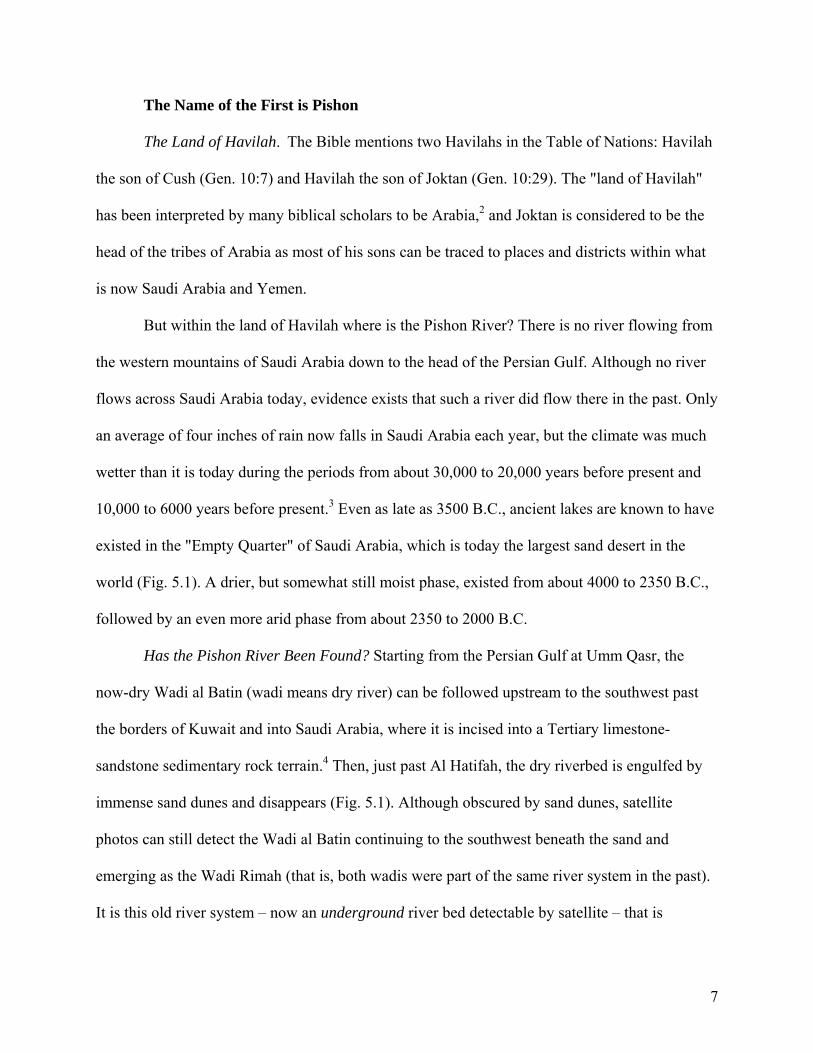
Has the Pishon River Been Found? Starting from the Persian Gulf at Umm Qasr, the
now-dry Wadi al Batin (wadi means dry river) can be followed upstream to the southwest past
the borders of Kuwait and into Saudi Arabia, where it is incised into a Tertiary limestone-
sandstone sedimentary rock terrain.4 Then, just past Al Hatifah, the dry riverbed is engulfed by
immense sand dunes and disappears (Fig. 5.1). Although obscured by sand dunes, satellite
photos can still detect the Wadi al Batin continuing to the southwest beneath the sand and
emerging as the Wadi Rimah (that is, both wadis were part of the same river system in the past).
It is this old river system – now an underground river bed detectable by satellite – that is
7

Figure 5.1. Map of the “land of Havilah” (Saudi Arabia and Yemen) showing the location of the old incense routes (short dashes), the area where bdellium was grown (diagonal hatching), Precambrian and sedimentary rock (long dashes between the two areas), the gravel fan deposited by the once-flowing Pishon River (gravel symbol), and places mentioned in the text.
believed to be the Pishon River of Genesis 2:11. This river flowed at a time when the climate
was much wetter than it is today, which implies an extraordinary memory on the part of the
biblical author(s), since the river dried up between about 3500 and 2000 B.C.5 This is another of
the “historical memories” of the Bible that we talked about in Chapters 2 and 4, and is further
8
evidence for the antiquity of the biblical text. How could an author who (according to “critical
scholars”) lived in the 8th to 6th Centuries B.C. have known about a river that had dried up some
1000 to 3000 years before?
Mahd adh Dhahab: Cradle of Gold. About 80 miles further in the upstream direction, the
Wadi Rimah forks into the Wadi Qahd on the northwest, and the Wadi al Jarir on the southwest
(Fig. 5.1). The Wadi al Jarir continues upgradient to the area of the Mahd adh Dhahab gold mine
exactly as Genesis 2:11-14 records: The River Pishon encompasses the whole land of Havilah,
where there is gold…And the gold of that land is good. The gold of that land is indeed good!
Mahd adh Dhahab (literally meaning "cradle of gold") was one the largest and richest gold mines
of the ancient world. It is the gold mine believed to be the fabled "Ophir" of the Bible (Ophir was
another of Joktan’s sons), the source of King Solomon's gold (1 Kings 9:28, 10:10). Gold occurs
at Mahd adh Dhahab mostly as electrum (gold-silver) within quartz veins. Besides gold the
mines have also produced a substantial amount of silver, copper, zinc, and lead. The quartz veins
containing the gold intrude (cross-cut, or are younger than) the Mahd adh Dhahab Series of
Precambrian volcanic and sedimentary rocks.6
The Onyx Stone. Onyx, sardonyx, agate, and carnelian are all varieties of chalcedony, a
very finely crystalline variety of quartz. In antiquity all of these (and other) varieties of fine-
grained quartz were sometimes referred to by the general label “onyx”.7 Chalcedony was fancied
by the ancients in any form. The stone has been identified from Mesopotamia in archaeological
levels dating from about 4000-3200 B.C. onward.8 Chalcedony is also known to occur in the
Western Desert of Arabia, and especially in Mahd adh Dhahab-Wadi al Aqiq area (Fig. 5.1).
That "aqiq" can mean "agate" in Arabian may signify that the onyx mentioned in Genesis 2:12
came from this area.
9

There is Bdellium. The last commodity mentioned in Genesis 2:12 is bdellium. Bdellium
is a fragrant gum resin obtained from plants of the bursera (balsam) family. Frankincense comes
from trees of the genus Boswellia of the bursera family, while myrrh and bdellium come from
trees of the genus Commiphora.9 All of these types of gum-resins (frankincense, myrrh and
bdellium) were used in the ancient Near East for religious (incense), cosmetic (perfume), and
medicinal purposes. The trees from which myrrh and bdellium are extracted grew exclusively in
southern Arabia (modern-day Yemen) and northern Somalia during ancient times (Fig. 5.1). The
Bible records the Queen of Sheba as coming to King Solomon’s court by caravan along the Great
Arabian Incense Road from Mariaba (now a part of Yemen) carrying gold, precious stones, and
spices (1 Kings 10: 1-13).
The Name of the Second is Gihon
The location of the second river of Genesis (the Gihon) is debatable. The problem
revolves around the identity of the "land of Cush", which in the King James Version was
translated "Ethiopia." Not only is this translation questionable, it also does not make sense. A
river in Ethiopia would flow to the Red Sea or to the Mediterranean or Indian Ocean, not to a
confluence of the Euphrates and Tigris Rivers as stated by Genesis. According to the biblical
scholar Speiser, the "land of Cush has been mistakenly identified with Ethiopia, rather than with
the land of the Kassites,”10 And, according to biblical archeologist Kitchen: “It should be
obvious that this Kush cannot have been Upper Nubia in East Africa, most of two thousand miles
away to the southwest of the Tigris zone. The land of ‘Kush’ would be the land of the Kassites
(Kashshu).11 The Kassites (or kaššû) lived to the east of Mesopotamia in the Old Babylonian
Period (1800-1600 B.C.; Table 4.1), but before then this area was known as the land of Elam or
10
Susiana, where the inhabitants of the Plain of Susa lived (Fig. 4.1). If the Cush intended by the
Hebrew word kush is the territory of the Kassites, then the river referred to in Genesis 10:13
must have come from the east of Mesopotamia, or what today is western Iran. In addition, if kush
denotes the territory of the Kassites, then this would be an indication that Genesis 2:10-14 was
written during or just after the patriarchial period, not much later during the 8th to 6th Centuries
B.C. In other words, this reference to “the land of Cush” may be yet another of the “historical
memories” preserved by the Bible.
It Compasseth the Whole Land. The most likely candidate for the biblical Gihon River is
the Karun. The word "compasseth" in Hebrew means to "revolve, surround, or border, or to
pursue a roundabout course, to twist and turn.” And that is exactly what the Karun River does: it
is a meandering river with great bends. Its course is 510 miles long, but its distance (as the crow
flies) is only 175 miles long. The reason for this zigzagging, "roundabout course" is because the
sedimentary rocks of the Zagros Mountains are folded into great anticlinal and synclinal
structures, and the river winds back and forth along, and cuts across, these folded rocks.
The Name of the Third is Hiddekel
The third river of Genesis is the Hiddekel, which is the Hebrew name for Tigris. The
Tigris River rises on the southern slopes of the Taurus Mountains in eastern Turkey and cuts a
bed almost 1160 miles long on its way to the Persian Gulf. The Tigris was the great river of
ancient Assyria. On its banks stood many of the cities mentioned in the Bible, including
Nineveh, Nimrud and Asshur (Fig. 4.2). Genesis 2:14 identifies it as that which goeth toward the
east of Assyria, or the land of Asshur. And the Tigris does (and did) flow east of ancient Asshur
(now the mound Ashur), in perfect concordance with Genesis 2:14 if a modern landscape is
11
assumed rather than a Flood Geology topography that bears no resemblance to today’s
topography.
And the Fourth River is Euphrates
Continuing counterclockwise from the Pishon to the Gihon to the Tigris is the fourth river
of Eden, the Euphrates (Gen. 2:14). Draining the western part of ancient Mesopotamia, it starts
in the highlands of Turkey, flows southeastward over a limestone hill terrain in northern Iraq,
and enters its delta at Hit (about 80 miles west of Baghdad; Fig. 4.1). Overall, the river winds its
way over a 1700-mile path on its way to the Persian Gulf. South of Hit, the river has an
extremely low gradient. Hit is located more than 500 miles upriver from the Gulf, yet is only 175
feet above sea level. At An Nasiriyah, the water level of the Euphrates is only 8 feet above sea
level, even though the river still has to cover a distance of more than 95 miles to Basra. Once
Ash Shāmīyah is passed, the water of the Euphrates is lost in an immense marshland region (Fig.
4.1). During spring floods this whole region – from the Euphrates east to the Tigris – can become
severely inundated.
Where the Four Rivers Meet: A Garden in Eden
So exactly where was the Garden of Eden? Assuming a date of about 4000-5000 B.C. for
Adam and the Garden of Eden, the four rivers would have confluenced at the Persian Gulf at a
position somewhat inland from where the Gulf is today.12 The Pishon River (Wadi al Batin) now
enters the Persian Gulf at Umm Qasr, but the cobbles and pebbles from this fossil river system
once extended as a fan from southern Kuwait northward to the vicinity of Ur (Fig. 5.1).13 From
about 5000 to 2000 B.C., Ur was possibly a seaport located at the confluence of the Euphrates
12

River with the Gulf, and it is also possible that the Pishon River flowed into the Gulf at or near
this locality.
The location of the Tigris and Karun Rivers at this time is uncertain. Pliny's Natural
History states that, during the conquest of Alexander the Great (~340 B.C.), the confluence of
the Tigris and Karun Rivers was at Charax, at a distance of one and a fourth miles from the
coast, and that after that time the Karun appears to have shifted its center of deposition to the
southeast.14 Charax was located about 80 miles southeast of Ur, and for a short time represented
the location of a temporary seaport on a retreating Gulf.
Figure 5.2. Google Earth aerial view of the four rivers of Eden, located in present-day Iraq, Saudi Arabia, Kuwait, and Iran. The circle shows the most likely site for the biblical Garden of Eden.
Despite much speculation concerning the exact location of the Garden of Eden, it does
seem likely that it was located somewhere about 100 miles northwest of the present-day Basra in
13

Iraq (Fig. 5.2). At the latitude of An Nasiriyah, the landscape is dotted with numerous mounds
representing ruins of ancient cities, but south of An Nasiriyah, no mounds exist – presumably
because the Persian Gulf extended this far inland and the land south of these cities was
submerged (Fig. 2).15 Of all of these ancient mounds, Eridu is archaeologically one of the oldest
settlements known in southern Mesopotamia, dating to about 4800-5000 B.C.16 According to
ancient Mesopotamian tradition, Eridu ranks as the oldest city in the world and it was also
regarded as a sacred city. Cuneiform inscriptions indicate that Eridu was located near a garden, a
“holy place” containing a sacred palm tree.17 On Sumerian tablets found at Nippur, a list of ten
"pre-flood" kings ending in Ziusudra (the Sumerian name for Noah) described Eridu as:
When the kingship was lowered from heaven the kingship was in Eridu. In Eridu, Alulem became King…18
The mound of Eridu is located about 12 miles southwest of Ur (Fig. 4.1).
A River Rises in Eden
And a river went out of Eden to water the garden; and from thence it was parted, and
became four heads. (Gen. 2:10).
This passage has been problematical for biblical scholars for years. The long-established,
widely held view is that a great river rose in Eden and after leaving the garden, split into four
rivers including the Tigris and Euphrates. Therefore some biblical scholars have interpreted the
text to mean that Eden was located somewhere in Armenia near the source of the Tigris and
Euphrates.19 However, this locality does not fit with the Pishon River most likely being in Arabia
(as discussed previously). Furthermore, there are alternate translations of Genesis 2:10 that are
equally viable.
One alternate interpretation is that of Kitchen: “Very strictly, it is not ‘the Garden of
Eden’ at all, but ‘a garden in Eden.’ It has to be grasped very clearly that the garden was simply
14

a limited area within a larger area ‘Eden,’ and the two are not identical, or of equal area. A
realization of this simple but much-neglected fact opens the way to a proper understanding of the
geography of Eden and its environment.”20 Kitchen’s take on the rivers of Eden is that out of the
“greater Eden” a stream flowed into the “garden” in Eden. Upstream from where this single
stream entered the garden, four “head” rivers came together, and these four headstreams were the
Pishon, Gihon, Tigris, and Euphrates.
Another interpretation is that of Speiser. According to the Anchor Bible Commentary,
Genesis 2:10 should read: A river rises in Eden to water the garden; outside, it forms four
separate branches.21 A river "rises in" is how the Hebrew should be translated according to
Speiser, not the traditional "went out of" (the wrong tense). A river which "rises in" Eden
strongly suggests ground flow or the rise of subterranean waters (i.e., a spring). And the word
"outside" (which in the Hebrew literally means "from there") has the sense of being "beyond it"
(Eden). The term "heads" also have nothing to do with streams into which the river breaks up
after it leaves Eden, but designates instead four separate branches which have merged within the
vicinity of Eden.
A spring rising forth in or near Eden makes sense. All four rivers – the Pishon, Euphrates,
Tigris and Gihon – once converged near the (then) head of the Persian Gulf to create a fertile
land fit for a garden. Not only was this garden located near the junction of these four rivers, but
in addition a spring rose up in or near the garden to water it, and then it (the river created by the
spring) flowed out of the garden where it met with the confluence of the four great rivers. But
what evidence is there for a spring rising in the vicinity of Eridu, the most likely site for Eden?
There is geologic evidence. The Dammam Formation is the principle aquifer (water-
bearing rock) for all of Kuwait, Saudi Arabia and Bahrain – and aquifers discharge as springs.
15

The Dammam Formation is composed of sedimentary limestone rock which covers an extensive
part of western Iraq, occurring both on the surface and in the subsurface west of the Euphrates
River. The formation is known to crop out only a few miles southwest of Eridu.22 Thus, a spring
in the vicinity of Eridu (Eden?) would not be at all surprising, geologically speaking.
Implications for Flood Geology
In summary, geological and biblical evidence suggests that the four rivers of Eden were
(counterclockwise) the Pishon (Wadi al Batin), the Gihon (Karun), the Hiddekel (Tigris), and the
Euphrates. And while the identification of the Pishon and Gihon Rivers is somewhat tentative,
the certain identification of the Tigris and Euphrates leaves no doubt as to the approximate
location of the Garden of Eden. These rivers locate the Garden of Eden as being on a modern
landscape at the head of the Persian Gulf, possibly at or near Eridu (Fig. 5.1), one of the oldest
settlements in southern Mesopotamia, dating to about 4800-5000 B.C.23
The biblical author’s placement of the Garden of Eden on a modern landscape presents a
major conflict between Genesis and Flood Geology. The reason is this: there are six miles of
sedimentary rock beneath the Garden of Eden/Persian Gulf. How could Eden, which existed in
pre-flood times, be located over six miles of sedimentary rock supposedly deposited during
Noah's Flood? What Flood Geologists are implying is that the Garden of Eden existed on a
crystalline basement and then Noah's Flood covered up the Garden of Eden with six miles of
sedimentary rock (Fig. 5.3). But this is not what the Bible says. It implies that Eden was located
where the four rivers existed on a modern landscape, on top of six miles of sedimentary rock.
Thus, this sedimentary rock must have existed in pre-Flood times.
16

Geologists know that six miles of sedimentary rock exist beneath the Persian Gulf
because this area has been extensively drilled for oil down to the Precambrian basement. The six
miles of sedimentary rock below the Garden of Eden area include Tertiary, Cretaceous, Jurassic,
Triassic, and Paleozoic rock up to a depth of about 32,000 feet before the Precambrian basement
is encountered.24 A schematic cross-section of the sedimentary rock existing below the Persian
Gulf/Garden of Eden area is shown in Figure 5.3. Precambrian crystalline (granite) rock is
exposed at the surface in the western part of Saudi Arabia (geologists call this the Arabian
Shield), and this rock becomes progressively overlain by a thicker sedimentary rock cover
northeastwards, towards Iran. Point A on Figure 5.3 indicates the approximate location of the
Garden of Eden according to the Bible, and Point B indicates its approximate location according
to Flood Geologists, since no sedimentary rock supposedly existed at the time of Noah's Flood.
Figure 5.3. Idealized diagram of the subsurface geology beneath the Persian Gulf/Garden of Eden area. If all sedimentary rock formed at the time of Noah’s Flood, as claimed by Flood Geologists, then the Garden of Eden would have had to exist on Precambrian basement rock 32,000 feet (six miles) below where the Bible says it was located.
17

Pitch for the Ark
Another Genesis passage confirms that the pre-Flood world was located on a modern
landscape: Make thee an ark of gopher wood; rooms shalt thou make in the ark, and shalt pitch it
within and without with pitch (Gen. 6:14). Pitch (or bitumen) is a thick, tarry, oil product
composed of a mixture of hydrocarbons of variable color, hardness and volatility. Bitumen was
used extensively by the ancient peoples of Mesopotamia for every type of adhesive-construction
need, including the waterproofing of boats and mortar for buildings (e.g., the "slime" of
Gen.11:3). The center of bitumen production in Noah’s time was (and still is) at Hit, located
along the Euphrates River about 80 miles west of Baghdad (Fig. 4.1). The Hit bitumen occurs in
"lakes" where a line of hot springs are upwelling along deep faults.25 These faults connect the
surface with the source of hydrocarbons at depth – the source being sedimentary rock (Fig. 5.2).
In southern Iraq oil and gas are produced from the limestone and sandstone sedimentary rocks of
the Jurassic Najmah Formation; the Cretaceous Yamama, Zubair, Nahr Umr, Mishrif, and Hartha
Formations; and the Miocene (Tertiary) Fars and Ghar Formations.26
The essential point of the above discussion is this: How could Noah have obtained pitch
from sedimentary rock for building his ark, if (as claimed by Flood Geologists) no sedimentary
rock existed? The Bible identifies Eden with four rivers that flowed over and cut into
sedimentary rock. When it flowed, the Pishon River cut into Tertiary sedimentary limestone and
sandstone rock near the border of Saudi Arabia and Kuwait. The gold of Havilah is found in
quartz veins that cut across sedimentary-metamorphic rock. The Karun (Gihon?) River winds
around folded and faulted sedimentary rock in western Iran. And, the Tigris and Euphrates
Rivers encounter sedimentary rock throughout their drainage systems from the mountains of
18
Turkey to the Persian Gulf. All of this is biblical evidence for sedimentary rock being present on
the Earth before Noah's Flood rather than being formed during the flood.
Worldviews in Conflict
Flood Geology is in direct conflict with science on the subject of a universal flood. Not
only does it conflict with the findings of geology, it also defies the archaeological evidence as
well. The scientific evidence against a universal flood will be presented in the following section.
First, two of the basic tenants of Flood Geology will be critically examined from a scientific
perspective. Then some pertinent archeological and geologic evidence will be discussed. Finally,
two case studies in geology will be presented to show the implausibility of Flood Geology when
confronted by the actual geologic evidence that exists.
Flood Geology Logistical Problems
The tenants of Flood Geology pose a number of logistical problems, but we will cover
only two of the most insurmountable ones here: (1) the claim that a vapor canopy existed in pre-
Flood times, and (2) the claim that two of all animal species on Earth were present on Noah’s
ark.
Vapor Canopy. Why is a vapor canopy invoked by Flood Geologists to be the proper
interpretation of “mist” in Genesis 2:6? Because some kind of extra-water source is needed to
make the Noachian Flood universal (the original assumption). There simply is not enough water
in Earth's atmosphere today to supply more than about 40 feet of water to the ground, worldwide,
nor is there any evidence of vast reservoirs of subterranean water (past or present) that could
have supplied this volume of water.27 Therefore, a vast reservoir of water that deluged the entire
19

Earth must somehow be manufactured in order for Mount Ararat (almost 17,000 feet high) to
have been covered by floodwater.
Some of the scientific problems that arise with trying to supply the extra water demanded
by a vapor canopy are:
1. The vapor canopy envisioned by many Flood Geologists consists of a vast blanket of
invisible water vapor, translucent to the light from the stars, but yet producing a marvelous
"greenhouse effect" that gave the entire antediluvian world a relatively mild and uniform
climate.28 However, if this atmospheric canopy once held enough water to cover Mount Ararat, it
would have been so thick that even sunlight could not have penetrated the atmosphere so as to
produce the plants of Genesis 1:11 and the trees in the Garden of Eden (Gen. 2:9). And surely an
atmosphere holding all of this moisture would have been susceptible to thermal cells generated
by the sun, and thus would have experienced storms and precipitation.
2. If only a third of the water in modern oceans were part of the Earth's atmosphere in the
form of a vapor canopy, the atmospheric pressure at the Earth's surface would have been greater
than it is on Venus (90 atmospheres).29 This pressure, combined with warm temperatures
envisioned for a "greenhouse effect" phenomena, would not have created a benevolent
environment, but would have produced a "runaway greenhouse effect," such as is known to
occur on the planet Venus. Under these adverse conditions of very high pressure and
temperature, how could the plants and animals of Genesis 1 have survived on planet Earth?
3. Where did all of the 17,000+ feet of global water go to after the Flood? Did it
miraculously escape into space? The "fountains of the deep" (springs) would have been
completely saturated with water if there had been a worldwide flood, so the water could not have
20

drained away back into the "deep." And how could the wind of Genesis 8:1 have evaporated
water three to six miles deep in less than a year’s time (Gen. 8:13)?
4. If there was a vapor canopy before the Flood, and no rain, then where did the water
come from for the four rivers of Eden (Gen. 2:11-14)? Would not rain and snow have fed these
rivers as they do today?
Animals on the Ark. Many more logistical questions arise regarding the ark’s capacity
to carry two of all the animal species on Earth (Gen. 6:20). Even the early church fathers like
Augustine (354-430 A.D.) recognized this difficulty and struggled with the apologetics of such a
scenario.30 The problem became even more acute with the discovery of the New World and its
multitude of new species. It is now estimated that the number of animal species on Earth falls
somewhere between one and two million,31 and if the "all flesh" of Genesis 6:19 also includes
extinct animals and insects, as necessitated by a Flood Geology interpretation, this is multiplied
into more millions. Even a ship the size of an aircraft carrier could not carry all of these animals!
Other (among many) problems that arise with an "all animal species on planet Earth"
universal interpretation of Genesis 6-8 are:
1. How did animals migrate to the Old World from the New World and from places like
Australia? Or, how did they get from Mount Ararat to places like Australia without crossing
oceans and without leaving descendents in the Old World?
2. How did the ark carry food for all of these animals for one year's duration (Gen. 6:21)?
3. How did only eight people – Noah, his wife, three sons, and three daughters-in-law
(Gen. 7:13) – care for the millions of animal species?
4. How did large animals like the dinosaurs fit on the ark, if "all flesh" included extinct
animals as well as non-extinct ones?
21

5. How could marine life have survived the Flood? Would it not have been crushed by
tremendous water pressure or dilution of ocean water with fresh water?
6. How did all of the various kinds of animals descend the steep side of Mount Ararat,
which is even difficult for humans to climb in modern times?
Flood Geologists counter these concerns by heaping up miracles. God miraculously
caused the animals to migrate to (and from) the Middle East. Or, angels picked up the animals
and carried them to the ark.32 God miraculously caused all of the animals on the ark to hibernate
for a whole year, thus limiting their need for food and care.33 Only taxonomic families (not
individual species) were taken on the ark, and present-day species somehow descended from
these families within the last 5000 years or so.
The difficulty with these (and other) invoked miracles is not that God couldn't do every
one of them if He wanted to – it is that the Bible doesn't claim a single one of them! The only
mention the Bible makes of God's role in the Flood is that He miraculously intervened to impose
a great flood upon the earth (land) (Gen. 6:17), and that He protected Noah in that flood (Gen.
7:16, 8:1). God commanded Noah to do all the rest: to build the ark (Gen. 6:14); to bring the
animals alive into the ark (Gen 6:19-20); and to gather food for himself, his family, and the
animals (Gen. 6:21). And Noah did all that the Lord commanded him (Gen. 6:22). No miracles
regarding the animals are mentioned, and if the Bible is to be taken at face value, it must be
assumed that Noah went out and gathered the animals himself. This factor alone limits the
geographic region of the Flood to Mesopotamia, because it is hardly conceivable (nor logistically
possible) to envision Noah collecting animals from places like New Zealand, Australia, North
America, or South America.34
22

All told, the animals taken into the ark may have numbered in the hundreds, but probably
did not exceed a few thousand. The ark – even a boat typical of 3000 B.C. – would have been
adequate to house these animals and their food supply, and eight people could have cared for
them, as well as for themselves, for many months. The animals destroyed by the Flood may thus
be logically assumed to have been limited to those within the immediate geographic region of
Mesopotamia, and the animals preserved on the ark to those representative of that region. The
animals taken on the ark would have been used to restock the vast flooded Mesopotamian plain,
the “clean” animals being necessary to regain a livestock herd and pastoral way of life for Noah
and his family.
Archaeological Evidence
The archaeological evidence for a universal flood is non-existent. No flood deposits
correlative with those in Mesopotamia have been found in Egypt, Syria, or Palestine, let alone in
other parts of the world more distant from the Near East. Archaeological mounds in Syria and
Palestine (such as Jericho), which exhibit fairly continuous occupation since at least 4500 B.C.,
show no signs of a great flood.35 That the Flood did not extend even to the land of Israel is
alluded to in Ezekiel 22:24: "a land (Israel)…nor rained upon in the day of indignation (day of
God's judgment by the Flood)".36 Flood legends from around the world exist simply because
flooding has occurred in most parts of the Earth at one time or another. All of these flood stories
– except for those from within and surrounding Mesopotamia – are essentially different from the
biblical narrative and have only a few indeterminate elements in common with it.37
23

Geologic Evidence
In addition to the absence of archaeological evidence, there is also no geologic evidence
that supports a universal flood or vapor canopy. Modern geologists, hydrologists, geophysicists,
sedimentologists, paleontologists, and geomorphologists know exactly how the different types of
sedimentary rocks form, how fossils are made and the environments they represent, how fast
continents move, and what flood deposits look like and how they form. The principles of
geology were established and have been tested for almost 200 years, and geologists have now
field-surveyed practically the entire planet Earth.
The Fossil Record. One of the biggest arguments against the claim of Flood Geologists
that all sedimentary rock formed in Noah’s Flood is the fossil record. Remember back in Chapter
3 we talked about the Principle of Faunal Succession, which principle states that successive
layers of rock contain different assemblages of fossils, and that increasingly complex life forms
are found in successively younger strata. Less complex organisms (bacteria, algae) are found in
the lowest and oldest sedimentary rock layers (Fig. 5.4), while more complex organisms
(mammals) are found in the topmost and youngest layers.
Figure 5.4. Stromatolites (a structure produced principally by blue-green algae) from the Precambrian Kwagunt Formation, Carbon Creek area, Grand Canyon. Even though these stromatolites lived about 800 million years ago, they closely resemble stromatolites living today in parts of the world such as Australia. Photo by Doug Powell. PERMISSION GIVEN.
24

A very general view of the fossil sedimentary record over time is shown in Table 5.1. In
this sedimentary sequence one never finds later species mixed with earlier species in rock of
earlier age. For example, in Mesozoic rock one never find whales (mammals) with ichthyosaurs
(sea dinosaurs). However, one finds fish with dinosaurs and fish with mammals because fish,
once they appeared early the Paleozoic, never became extinct. The first flowering plants
appeared in the middle Cretaceous, and one never finds pollen grains in rock older than this.
Also, one never finds humans with dinosaurs, despite claims to the contrary (i.e., the so-called
Paluxy “man tracks”). These are not human footprints as some Flood Geologists have insisted.
They are dinosaur tracks in the Cretaceous Glen Rose Limestone, which include sauropod tracks
along with tracks of the dinosaur genus Irenesauripus, distinguishable by its long and relatively
slender toe marks and an acute “heel”.38 Bones of this dinosaur have been recovered along the
Paluxy River in the area of the “man tracks”.
Geologic Era/Eon Time (Ma = million
years ago)Types of Animals Important Events
Cenozoic 65-0 Ma Mammals Homo sapiens =<~0.2 Ma ~65 Ma Extinction of dinosaurs
Mesozoic 235-65 Ma Reptiles, dinosaurs, birds ~235 Ma Mass extinction of 95% of
invertebrates Paleozoic 570-235 Ma Invertebrates, fish
~570 Ma “Cambrian explosion” Proterozoic 2000-570 Ma Soft-bodied ,
multi-cellular organisms
Archean 4600-2000 Ma (4.6-2.0 billion years)
Algae, bacteria, single-cell organisms
Evidence of first life = ~3.5 billion years ago
Table 5.1. The different kinds of animals in Earth’s fossil record over time.
This order in the fossil record cannot be denied: it is simply there. How do Flood
Geologists defend this undeniable order? Whitcomb and Morris conjecture that a certain general
25

semblance of order should be anticipated in a universal flood, considering that submarine lavas,
tsunamis, and cataclysmic upheavals of the Earth’s crust accompanied the Flood.39 According to
this hypothesis, the creatures of the deep sea bottoms would have been universally overwhelmed
by the toxicity and violence of the volcanic emanations and bottom currents, and hence would
have been the first to be deposited from floodwaters. Fish and other organisms living nearer the
surface would have subsequently been entrapped either by debris washing down from the land
surface or by materials upwelling from the depths. Thus, they would have been deposited next,
over the creatures of the deep sea bottom. Raging rivers would have carried the bones of animals
and reptiles to sea along with great rafts of vegetation, depositing them over the fish, while land
animals and man would have escaped temporarily to higher ground – thus being the last to
survive and so be deposited higher than reptiles in the stratigraphic sequence.
There are numerous objections to this explanation of order from the actual fossil record.
However, only the most general objections will be mentioned:
(1) Creatures of the deep include fish as well as algae and bacteria, so why aren’t there
any fish in Archean and Proterozoic rock (Table 5.1)?
(2) Why wouldn’t a raging flood have circulated and deposited small pollen grains
uniformly throughout sedimentary sequences of rock, rather than depositing in rock only of
middle Cretaceous and younger age?
(3) If raging rivers carried the bones of land animals and reptiles to the ocean, then why
do they always occur in terrestrial (land) deposits and not with marine-type fish?
(4) Why couldn’t animals and reptiles (such as dinosaurs) have “beaten” man and
mammals (like cattle) to higher ground? Many types of dinosaurs were fast and agile creatures.
26

(5) Most importantly, why are the later species in Table 5.1 never mixed with earlier
species in rock of earlier age? Surely in a universal flood situation some humans would have
been deposited chaotically along with dinosaurs or marine fish? Flood hydrologists will tell you
that one of the most diagnostic criteria for recognizing flood deposits is that different kinds of
plants, animals, sediments, and rocks get all mixed up together.
Was Tyrannosaurus Rex a herbivore? Another Flood Geologist claim impossible to
believe from the fossil record is that there was no death before Adam sinned. The fossil record is
a record of death, and animals in all states of death are preserved. Evidence of carnivore activity
(animals eating other animals) is preserved in the fossil record, from Cambrian time up to the
present. If these animals were not carnivores, then what were their sharp teeth and claws used for
(Fig. 5.5)? The fossil record does not bear this claim out, and neither does the Bible. Where does
the Bible say that no animals died before Adam sinned? It is a theological supposition. This topic
will be discussed in Chapter 7, when the concept of “original sin” is explored.
Figure 5.5. Above. Side view of the skull and shoulder region of the fish Cheirolepis from the Devonian Period, ~360 million years ago. Note the sharp teeth. From Romer’s Vertebrate Paleontology.40 Right. Tyrannosaurus Rex, carnivore extraordinaire, from the Cretaceous Period, ~70 million years ago. From Bakker’s The Dinosaur Heresies.41 NEED PERMISSION FOR BOTH
27

Two Case Studies in Geology
Case Study #1: Mount Ararat
The geology of the Mount Ararat region will be the first of our two case studies because
it is directly related to the Genesis story of the Flood and because it will paint a simple picture
for the untrained (in geology) layperson as to why Flood Geology is implausible. Mount Ararat
(Agri Dag) is an almost 17,000-foot-high volcano that is still intermittently active (its last
eruption was reportedly on July 2, 1840).42 The mountain rises above the high (~6000 ft) plateau
of eastern Turkey (Fig. 5.6). This plateau is crossed by a broad east-west belt of folded
mountains formed by the Armenian Taurus and Zagros systems that separate the plateau from the
Mesopotamian alluvial valley or depression.43 As shown on the geologic map of Turkey,44 the
immense Ararat volcanic construct (including the two strato-volcanoes Big Ararat and Little
Ararat) cuts across Devonian, Permo-Carboniferous, Cretaceous, Eocene, and Miocene
Figure 5.6. Mount Ararat in eastern Turkey, where Flood Geologists say that the ark landed.
28
Cross-section of Mt. Ararat, showing the volcanic cones Big Ararat and Little Ararat and how the volcanic (basaltic) rock has cut across (and thus is younger than) the sedimentary rock of the region.
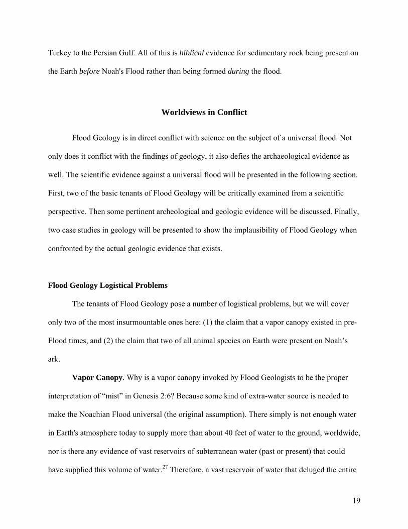
Figure 5.7. The Flood Geology scenario implied by this geologic map is: (1) sediments and dead animals were deposited from floodwater; (2) sediments were compacted into fossil-rich sedimentary rock; (3) volcanic magma cut through and flowed over the sedimentary rock, and the cone of Big Ararat grew to almost 17,000 ft; (4) the huge volcanic Ararat construct cooled; and (5) Noah’s ark landed on it – all of which happened in 150 days (Gen. 8:4)!
sedimentary rock (Fig. 5.7). The volcanoes have erupted along a southwest-northeast trending
linear structure, which formed at the beginning of the Miocene (about 20 million years ago).
Vast lava flows from then to the present cover many of the older sedimentary rocks of the region.
Why is all of this information on the geology of the Ararat region important to a critique
of Flood Geology? The claim of Flood Geologists is that all (or almost all) of the sedimentary
rock on Earth formed at the time of Noah's Flood, and this includes the sedimentary
rock of the Ararat region. But Mount Ararat itself cuts across sedimentary rock, and so from the
Principle of Crosscutting Relationships (see Chapter 3) it must be younger than this sedimentary
rock. The Flood Geology scenario that is thus implied, according to the actual stratigraphic
29

relationships present in the Mount Ararat region, is: (1) sediments (and dead animals) were
deposited out of the floodwater; (2) then these sediments were compacted into fossil-rich
sedimentary rock; (3) then volcanic lava erupted, intruding into and flowing over this
sedimentary rock; (4) then the entire huge volcanic Ararat construct cooled; so that (5) finally,
Noah's ark could land on Mount Ararat. All of the above had to have happened in less than 150
days since according to Genesis 8:4 the ark landed upon the mountains of Ararat on the seventh
month and seventeenth day after the Flood started.
This Flood Geology scenario proposes a series of geological impossibilities because, as
discussed in Chapter 3, it takes millions of years for sediments to deposit and solidify into rock.
Then it would have taken many more millions of years for a volcanic construct the size of Mount
Ararat to build up to a height of almost 17,000 ft and to cool to its present temperature.
Furthermore, the Bible claims none of this! Genesis simply states that the ark landed "on the
mountains of Ararat." That is, on mountains that existed in the already-known (to the ancient
Mesopotamians) land of "Urartu", or what is now the area of southeastern Turkey.
Case Study #2: Grand Canyon
Grand Canyon is one of the most spectacular places on planet Earth (Fig. 5.8). The
canyon cuts a gorge over a mile deep through both sedimentary rock and crystalline rock (Fig.
5.9), which date from the Proterozoic (~2 billion years) to the Triassic (~200 million years).
The geology of Grand Canyon has recently been the focus of media attention with regard
to the sale of Grand Canyon: A Different View at Grand Canyon National Park. 45 This book is a
Flood Geologist version of how Grand Canyon formed during Noah’s Flood, both from the
viewpoint of its rocks and its incision. The book is beautifully illustrated and I agree that the
canyon shows God’s glory. However, I disagree entirely with the geology presented in this book!
30

Figure 5.8. The Grand Canyon of Arizona, showing the almost 5000 ft thick, horizontally bedded, sedimentary rock sequence. Photo by Tom Till. NEED PERMISSION
Many Christians cannot understand what is wrong with a Flood Geology view of the
Grand Canyon – it sounds perfectly reasonable to them. This case study is intended to point out
what is fundamentally wrong with this geology. There is no way that all of the geology of Grand
Canyon can be presented in this one brief discussion because thousands of articles have been
written about the rocks of the canyon. We will cover only a few aspects of canyon geology that
are applicable to the subject of Noah’s Flood.
31

Figure 5.9. Schematic cross-section of the Grand Canyon. From Billingsley and others (1997).46
32

Rocks in Grand Canyon. Three different basic rock types exist on planet Earth (Box
5.2). All three of these types are present in Grand Canyon.
Box 5.2. The Three Different Basic Rock Types Igneous Rock forms from melted material (magma). Igneous rock can form quickly when magma erupts onto the surface of the earth, either as volcanic lava flows or as explosive material. But other igneous rock forms very slowly when it cools beneath the earth’s surface. Sedimentary Rock forms from sediments deposited by wind or water. Sediments are eroded off the land, blown by the wind, carried to the oceans by rivers, deposited on the ocean floors, and then slowly turned into rock. Sediments can also be derived from the shells and exoskeletons of marine invertebrate animals. Metamorphic Rock forms when igneous and sedimentary rocks are buried to great depths and are subjected to high temperatures and/or pressures over a long period of time. These processes cause these rocks to undergo a metamorphosis and become new rocks with different minerals, appearance, and structure that are compatible with their new pressure-temperature environment.
Igneous rocks. Igneous rocks form from melted material (magma or lava). This melted
material can cool beneath the Earth’s surface, or it can come to the surface and cool there. The
western part of Grand Canyon contains many volcanic flows and cinder cones, such as Vulcan’s
Throne. These volcanic rocks have been dated from about 20 million years ago to less than a half
a million years ago. (See Chapter 3 for a brief discussion on radioactive dating).
Sedimentary rocks. Sedimentary rocks are formed by the compaction and hardening of
sediments. The process by which sedimentary rocks form was also briefly discussed in Chapter
3. Grand Canyon contains an almost one mile-thick sequence of sedimentary rocks (Fig. 5.8).
These rocks include limestones (e.g., the Redwall Limestone), shales (e.g., the Hermit Shale),
sandstones (e.g., the Coconino Sandstone), and evaporites (e.g., gypsum beds in the Toroweap
Formation). These sedimentary rocks do not consist of a jumble of rock types and fossils, such as
might be expected for a tumultuous flood, but rather these rock types are interbedded and
interfinger with each other.
33

The sedimentary rock sequence in Grand Canyon also displays breaks between rock
types. These breaks are called unconformities because the surfaces between different rock layers
can be uneven or at an angle to each other. Unconformities represent gaps in time, where either
erosion or non-deposition has occurred. In the Granite Gorge area of Grand Canyon, where the
Cambrian Tapeats Sandstone rests on Precambrian metamorphic Vishnu rock, the time gap
between these two rock types is about 1 billion years. This erosion surface is called the “Great
Unconformity” because of the immense elapse in time that has occurred between the erosion of
the lower rock formation (Vishnu) and the deposition of the upper formation (Tapeats). A
number of smaller-time unconformities exist in the Grand Canyon rock sequence, as shown by
the wavy lines between rock formations in Figure 5.9.
Metamorphic rock. Metamorphic rocks form when igneous and sedimentary rocks are
buried to great depths and are subjected to high temperatures and/or pressure over a long period
of time. The metamorphic rocks of Grand Canyon lie at the very base of the canyon and
represent the core of a very ancient mountain range. These rocks are sometimes referred to as the
“crystalline basement.” The crystalline metamorphic rocks in Grand Canyon have been dated
from about 2 billion to 1.5 billion years ago. Crystalline rocks are exposed in the inner gorge of
the canyon as the Vishnu Schist (metamorphic rock derived from precursor sedimentary rock),
and Zoroaster Granite (igneous rock that cooled beneath the surface) (Fig. 5.9). A Flood Geology
interpretation of these crystalline basement rocks would be that these are pre-Flood rocks formed
before all the sedimentary rock of the canyon was deposited by Noah’s Flood about 5000 years
ago.
Problems for Flood Geology. The problems for a Flood Geology origin for the rocks of
Grand Canyon are similar to those discussed in our Mount Ararat case study, only on a much
34

grander scale. A basic premise of Flood Geology is that all of the mud, sand, and silt sediment
present in Earth’s sedimentary rocks were deposited in only one year’s time, since Genesis 8:14
says that after one year the ground was dry. What this implies for Grand Canyon is that the
canyon was carved through unconsolidated mud, silt, and sand because it certainly would have
taken much longer than a year for 5000 feet of sediment to completely harden into rock. But if
the canyon was cut into unconsolidated wet material, then why didn’t this material slump
towards an incising canyon, filling it up? This is not what we see in Grand Canyon. We don’t see
rock that slumps at steep angles toward the canyon. We see horizontal layers, where the canyon
has cut through hard rock (Fig. 5.8).
Other major problems relate to the time involved for geologic processes to occur.
Consider the time is would have taken for almost 5000 feet of sediment to have settled out of
flood water, the time for sedimentary rock to have turned into metamorphic rock, the time for
flood sediments to have turned into sedimentary rock, the time for erosion to have created
unconformities between rock layers, and the time for the canyon to have been cut down to its
present level. How much time? Millions upon millions of years. Yet Flood Geologists say that all
of these processes had to have happened in the last 5000 years during or since Noah’s Flood.
Sedimentary Structures in Grand Canyon Rocks. A number of small features in the
sedimentary rocks of Grand Canyon also attest to their non-Flood origin. Three important
sedimentary structures indicating that sediments formed under very shallow to drying-out
conditions are ripple marks, mud cracks, and raindrop prints. Cross-bedded structures in
sandstone also tell geologists that some types of sandstone deposits originally formed as sand
dunes. The reason geologists know the origin of these structures is because we can witness how
these features form today.
35
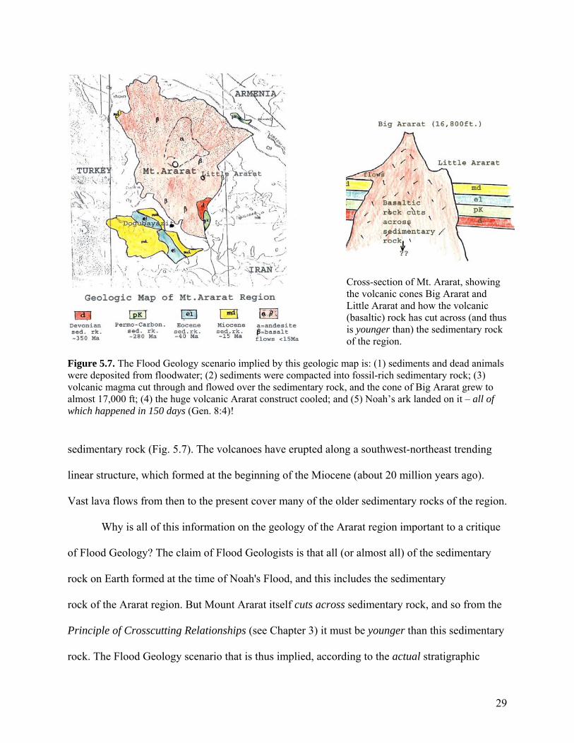
Ripple marks. Ripple marks are typically generated by the to-and-fro motion of waves in
shallow water at depths of a few tens of feet at the most. Figure 5.10 shows some ripple marks
that formed along the bank of the Colorado River in Grand Canyon in September of 2004
compared to ripple marks that formed in the Cambrian Tapeats Sandstone 550 million years ago.
Figure 5.10. Left: ripple marks formed today by wave action along the banks of the Colorado River (photo by Bob Buecher). Above. Ripple marks preserved in the rock of the Cambrian Tapeats Sandstone 550 million years ago (photo by Alan Hill).
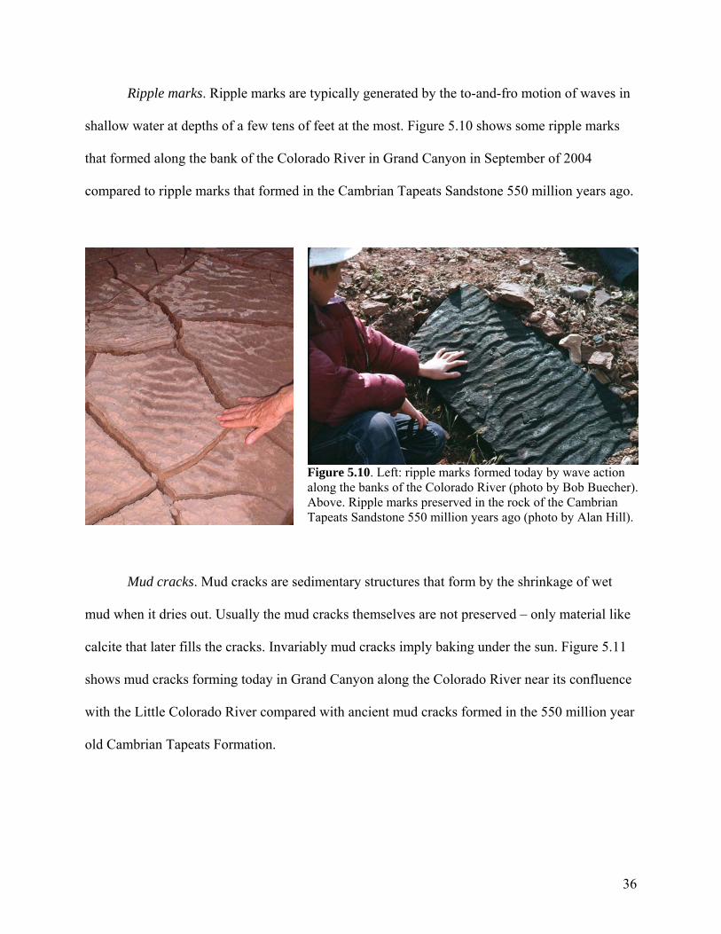
Mud cracks. Mud cracks are sedimentary structures that form by the shrinkage of wet
mud when it dries out. Usually the mud cracks themselves are not preserved – only material like
calcite that later fills the cracks. Invariably mud cracks imply baking under the sun. Figure 5.11
shows mud cracks forming today in Grand Canyon along the Colorado River near its confluence
with the Little Colorado River compared with ancient mud cracks formed in the 550 million year
old Cambrian Tapeats Formation.
36
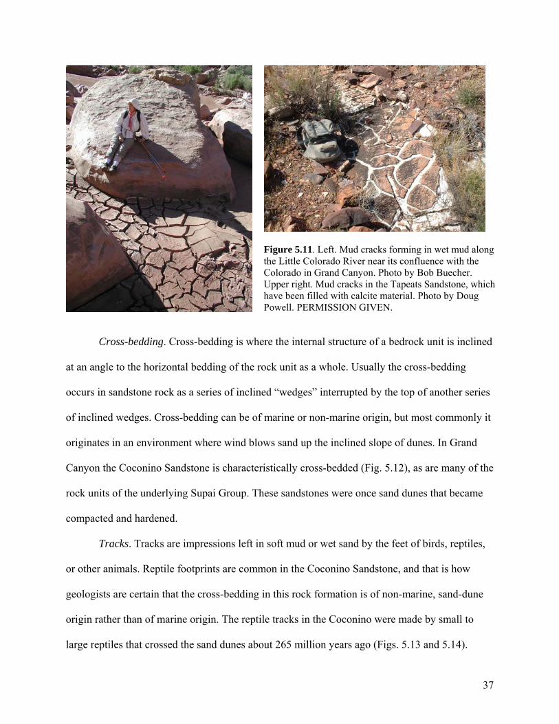
Figure 5.11. Left. Mud cracks forming in wet mud along the Little Colorado River near its confluence with the Colorado in Grand Canyon. Photo by Bob Buecher. Upper right. Mud cracks in the Tapeats Sandstone, which have been filled with calcite material. Photo by Doug Powell. PERMISSION GIVEN.
Cross-bedding. Cross-bedding is where the internal structure of a bedrock unit is inclined
at an angle to the horizontal bedding of the rock unit as a whole. Usually the cross-bedding
occurs in sandstone rock as a series of inclined “wedges” interrupted by the top of another series
of inclined wedges. Cross-bedding can be of marine or non-marine origin, but most commonly it
originates in an environment where wind blows sand up the inclined slope of dunes. In Grand
Canyon the Coconino Sandstone is characteristically cross-bedded (Fig. 5.12), as are many of the
rock units of the underlying Supai Group. These sandstones were once sand dunes that became
compacted and hardened.
Tracks. Tracks are impressions left in soft mud or wet sand by the feet of birds, reptiles,
or other animals. Reptile footprints are common in the Coconino Sandstone, and that is how
geologists are certain that the cross-bedding in this rock formation is of non-marine, sand-dune
origin rather than of marine origin. The reptile tracks in the Coconino were made by small to
large reptiles that crossed the sand dunes about 265 million years ago (Figs. 5.13 and 5.14).
37

Figure 5.12. Cross-bedding in the Coconino Sandstone, along the Hermit trail, Grand Canyon. Photo by Carol Hill.
Figure 5.13. Close-up of a track made by a small reptile, Coconino Sandstone, Grand Canyon. Note the 5 claw marks. Photo by Cyndi Mosch.
Figure 5.14. Fossilized trackway in the Coconino sandstone cliffs of Marble Canyon. The reptiles that made these tracks ranged from iguana size to komodo dragon size. National Geographic, v. 205, no. 6, June 2004.
Fossils. Flood Geologists claim that certain fossils found in Grand Canyon are evidence
of mass destruction and burial. The fossils being referred to are the orthocone nautiloids
Rayonnoceras sp., which occur in the top three feet or so of the Whitmore Wash Member of the
Redwall Limestone in Nautiloid Canyon (Fig. 5.15) and elsewhere in the Grand Canyon region.47
These have been described by Flood Geologists as debris-flow deposits from a giant inundation,
presumably Noah’s Flood.48
38

Figure 5.15. Left. Orthocone nautiloid fossil in the Whitmore Wash Member of the Redwall Limestone, Nautiloid Canyon. This nautiloid (and other nautiloids in this 3 ft-thick unit) are not broken up but are perfectly preserved. Photo by Doug Powell. PERMISSION GRANTED.
This presumption is completely unwarranted. While it may be true that this three-feet-
thick layer of the Whitmore Wash Member containing Rayonnoceras fossils represents a debris-
flow deposit, this in no way implies a world-wide cataclysmic flood affecting the entire 5000-
feet-thick suite of sedimentary rocks in Grand Canyon! My research in the canyon has focused
on the caves developed in the upper members of the Redwall Limestone, and none of this rock
shows the slightest trace of being deposited in a flood. Instead, the rock shows an early episode
of cave formation when the Redwall Limestone was just above sea level in the Mississippian
Period (Fig. 5.9), and a late-stage episode of cave formation that documents the time of incision
of Grand Canyon by the Colorado River.
Problems for Flood Geology. Why are these sedimentary structures pertinent to a
discussion of Flood Geology? Because they occur throughout the sedimentary rock sequence of
Grand Canyon, from the earliest sedimentary rocks up to the canyon rim. Referring to Figure 5.9,
ripple marks and mud cracks are preserved in the Precambrian Bass, Hakatai, Dox, and
Nankoweap Formations. Ripple marks (Fig. 5.10), mud cracks (Fig. 5.11), and raindrop prints
39

40
can also be seen in the Cambrian Tapeats Sandstone. Further up in the stratigraphic sequence, the
Permian Supai and Hermit rocks contain mud cracks, ripple marks, and reptile tracks. The
above-lying cross-bedded Coconino Sandstone represents solidified sand dunes (Fig. 5.12) that
display reptile tracks (Figs. 5.13 and 5.14). Well-developed mud cracks (polygons 6 inches or
more in diameter) have also been observed in the overlying Toroweap Formation.
Considering the above evidence, the pertinent questions can be asked: If all of the
sedimentary rock in Grand Canyon was deposited in a miles-deep universal flood lasting one
year, then why do the sedimentary structures in these rocks indicate a long depositional series of
marine to shallow-water to drying-out to sand-dune-forming environments? Why don’t all of the
fossils throughout the 5000-foot sedimentary sequence in the canyon attest to chaotic flood
conditions? How could tiny claw marks and footprints of reptiles made in loose sand (Figs. 5.13
and 5.14) have been preserved under turbulent flood conditions?
Summary of Grand Canyon Case Study. Sedimentary structures and rock types are some
of the many lines of evidence supporting a long history of sedimentation, exposure, and incision
for Grand Canyon. The evidence shows that the rocks displayed in the canyon do not represent a
one-year long, miles-deep, universal flood. They record the comings (transgressions) and goings
(regressions) of an ancient sea. When the sea transgressed over the Grand Canyon area it left
behind limestone; when it regressed it left behind shales and sandstones. And when it left the
area completely, sand eroded from sandstone piled up into dunes. Then the sea would transgress
again – back and forth, back and forth, over time – leaving behind the rocks, fossils, and
sedimentary structures in the canyon’s rock that attest to its long geologic history.
While Grand Canyon is the “geologic showcase of the world,” similar long and complex
histories are also written in the rocks of the rest of the world. This consistent and planet-wide

41
evidence is what has convinced geologists over the course of almost two hundred years that
Earth’s sedimentary rocks are not the product of a year-long biblical flood.
Concluding Remarks
If Earth’s sedimentary rocks were not deposited in a universal flood, as demanded by
Flood Geology, does this mean that one’s faith must fly out the window? No, because the Bible
never claims that the Flood was universal! It claims that the pre-flood world existed on a modern
landscape overlying sedimentary rock. Why then do so many Christians believe that Noah’s
Flood was universal? Because they have assumed an interpretation of Genesis that derives from
their modern concept of planet “earth” rather than from the cosmological worldview of “earth”
held by the biblical author(s). It is an assumption that has unfortunately helped to destroy the
faith of millions.
NOTES
1E. A. Speiser, “Anchor Bible Commentary,” Genesis, v. 1 (Garden City: Doubleday, 1981) 16-
17.
2C. F. Keil and F. Delitzsch, Commentary on the Old Testament, v. 1, The Penteteuch (Grand
Rapids: Eerdmans, 1975) 171; R. L. Harris, "The Mist, the Canopy and the Rivers of Eden,"
Bulletin of the Evangelical Theological Society 11, no. 4 (1968) 179.
3H. A. McClure, "Late Quaternary Palaeogeography and Landscape Evolution of the Rub' Al
Khali:" ed. D. T. Potts, Araby the Blest, Carsten Niebuhr Institute of Ancient Near Eastern
Studies (Copenhagen: Tusculanum Press, 1988) 9-13.
42
4U. S. Geological Survey-Arabian American Oil Company, Geologic Map of Saudi Arabia
(1963), scale 1:2,000,000.
5J. A. Sauer, "The River Runs Dry - Creation Story Preserves Historical Memory," Biblical
Archaeology Review, v. 22, no. 4 (1996) p. 52-64; E. Uchupi, S. A. Swift, and D. A. Ross,
“Gas Venting and Late Quaternary Sedimentation in the Persian (Abrabian) Gulf,” Marine
Geology 129 (1996) 237-269.
6A. M. Afife, "Geology of the Mahd adh Dhahab District, Kingdom of Saudi Arabia," U. S.
Geological Survey, Open File Report 90-315 (1990) 49 p.
7C. A. Hill, “The Garden of Eden: A Modern Landscape,” Perspectives on Science and Christian
Faith 52, no. 1 (2000) 31-46.
8S. Ratnager, Encounters - the Westerly Trade of the Harappa Civilization (Delhi: Oxford
University Press, 1981) 201.
9E. M. Meyers (ed.), The Oxford Encyclopedia of Archaeology in the Near East (New York:
Oxford University Press, 1997) 375.
10E. A. Speiser, Anchor Bible Commentary, v. 1 (Garden City: Doubleday, 1981) 17.
11K. A. Kitchen, On the Reliability of the Old Testament (Grand Rapids: Eerdmans, 2003) 429.
12C. A. Hill, “The Garden of Eden: A Modern Landscape,” Perspectives on Science and
Christian Faith 52, no. 1 (2000) 39-40.
13U. S. Geological Survey-Arabian American Oil Company, Geologic Map of Saudi Arabia
(1963), scale 1:2,000,000.
14G. A. Cooke, "Reconstruction of the Holocene Coastline of Mesopotamia," Geoarchaeology
2:1 (1987): 15-28.
15S. Lloyd, The Archaeology of Mesopotamia (London: Thames & Hudson, 1978) 15.
43
16C. C. Lamberg-Karlovsky and J. A. Sabloff, Ancient Civilizations - the Near East and
Mesopotamia (Menlo Park: Benjamin Cummings Publications, 1979): 110.
17J. C. Munday, “Eden’s Geography Erodes Flood Geology,” Westminister Theological Journal
58 (1996) 144.
18T. Jacobsen, The Sumerian King List, (Chicago: Oriental Institute, Asyriological Studies no.
11, 1966): 59.
19G. J. Wenham, "Genesis 1-15," Word Biblical Commentary, vol. 1 (Word Books, Waco,
1987):66.
20K. A. Kitchen, On the Reliability of the Old Testament (Grand Rapids: Eerdmans, 2003) 428-
429.
21E. A. Speiser, “Genesis,” Anchor Bible Commentary (Garden City: Doubleday, 1981)16-17.
22H. E. Wright, "The Southern Margins of Sumer: Archaeological Survey of the Area of Eridu
and Ur:" in R. M. Adam (ed.), Heartland of Cities (Chicago: University of Chicago Press,
1981): 300.
23C. C. Lamberg-Karlovsky and J. A. Sabloff, Ancient Civilizations – The Near East and
Mesopotamia (Menlo Park: Benjamin Cummings Publications, 1979) 110.
24Z. R. Beydoun, "Arabian Plate Hydrocarbon Geology and Potential - a Plate Tectonics
Approach," American Association of Petroleum Geologists, Studies in Geology no. 33 (1991)
77 p.
25S. A. al-Sinawi and D. S. Mahood, "Geothermal Measurements in the Upper Euphrates Valley,
Western Iraq," Iraqi Journal of Science 23, no.1 (1982) 94-106.
26B. P. Tissot and D. H. Welte, Petroleum Formation and Occurrence (New York: Springer-
Verlag, 1984) 699 p.

44
27R.S. Dietz, "Ark-Eology: a Frightening Example of Pseudoscience," Geotimes 38, no. 9 (1993)
4; P. H. Seely, “Noah’s Flood: Its Date, Extent, and Divine Accomodation,” Westminister
Theological Journal 66 (2004) 304, 308.
28H. Morris, Scientific Creationism (El Cajon: Master Books, 1985) 210-211.
29D. F. Siemens, "More Problems with Flood Geology," Perspectives on Science and Christian
Faith 44, no. 4 (1992) 231.
30D. Young, The Biblical Flood – A Case Study of the Church’s Response to Extrabiblical
Evidence (Grand Rapids: Eerdmans, 1995) 52.
31R. M. May, “How Many Species Inhabit the Earth?”, Scientific American 267, no. 4 (1992) 42-
48.; Wikipedia, The Free Encylopedia. http://en.wikipedia.org/wiki/species.
32B. Ramm, The Christian View of Science and Scripture (Grand Rapids: Eerdmans, 1974) 177.
33L. M. Davies, "Scientific Discoveries and their Bearing on the Biblical Account of the
Noachian Deluge," Journal of the Transactions of the Victoria Institute (London: Philosophical
Society of Great Britain, 1930) 133.
34J. T. Ator, The Return of Credibility (New York: Vantage Press, 1998) 37.
35W. H. Stiebling, "A Futile Quest: the Search for Noah’s Ark," Biblical Archaeology Review 2,
no. 2 (1976) 16.
36U. Cassuto, A Commentary on the Book of Genesis, pt. 2 (Jerusaleum: Magnes Press, 1972),
translated from Hebrew by Israel Abraham, 26, 46.
37Cassuto, A Commentary on the Book of Genesis, pt. 2 (Jerusaleum: Magnes Press, 1972),
translated from Hebrew by Israel Abraham, 4.
38W. Langston, “Nonmammalian Comanchean Tetrapods,” Geoscience and Man 8 (1974) 77-
102.

45
39J. C. Whitcomb and H. M. Morris, The Genesis Flood (Philadelphia: The Presbyterian and
Reformed Publishing Company, 1966) 265-266.
40A. S. Romer, Vertebrate Paleontology (Chicago: University of Chicago Press, 1974) 50.
41R. T. Bakker, The Dinosaur Heresies (New York: Zebra Books, 1986) 481 p.
42F. Navarra, Noah's Ark: I Touched It (Plainfield: Logos International, 1974) 121.
43E. C. Semple, "The Regional Geography of Turkey: a Review of Banse's Work," Geographical
Review 6 (1921) 344.
44A'tinli, I. E., Geologic Map of Turkey, Van Sheet (with map notes in English), 1:500,000
(1961) 50-62; A'tinli, I. E., "Geology of Eastern and Southeastern Anatolia," Bulletin of the
Mineral Research and Exploration Institute of Turkey 66 (1966) 42-46.
45T. Vail, Grand Canyon: A Different View (Green Forest: Master Books, 2003) 104 p.
46G. H. Billingsley, E.E. Spamer, and D. Menkes, Quest for the Pillar of Gold: The Mines and
Miners of the Grand Canyon (Grand Canyon: Grand Canyon Association, 1997) 112 p.
47G. H. Billingsley and W. J. Breed, “Mississippian Nautiloids of the Grand Canyon,” Plateau
48, no. 4 (1976) 67-69.
48S. A. Austin, “Nautiloid mass kill and burial event, Redwall Limestone (Lower Mississippian),
Grand Canyon region, Arizona and Nevada,” Unpublished report to Grand Canyon National
Park, January 24, 2003, 41 p.; S. A. Austin, compiler T. Vai, Grand Canyon: A Different View
(Green Forest: Master Books, 2003) 52-53.