Embed Size (px)
Citation preview
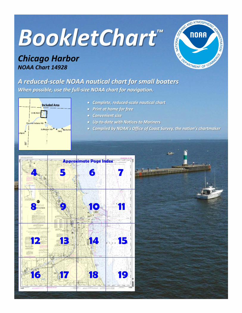
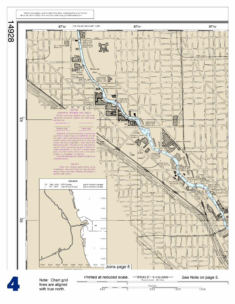
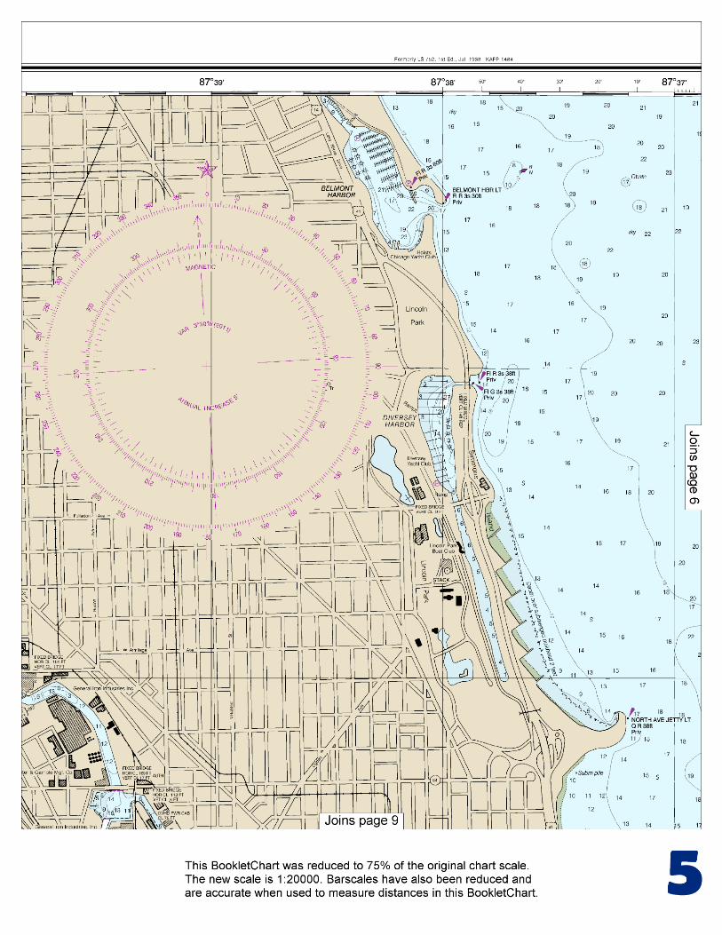
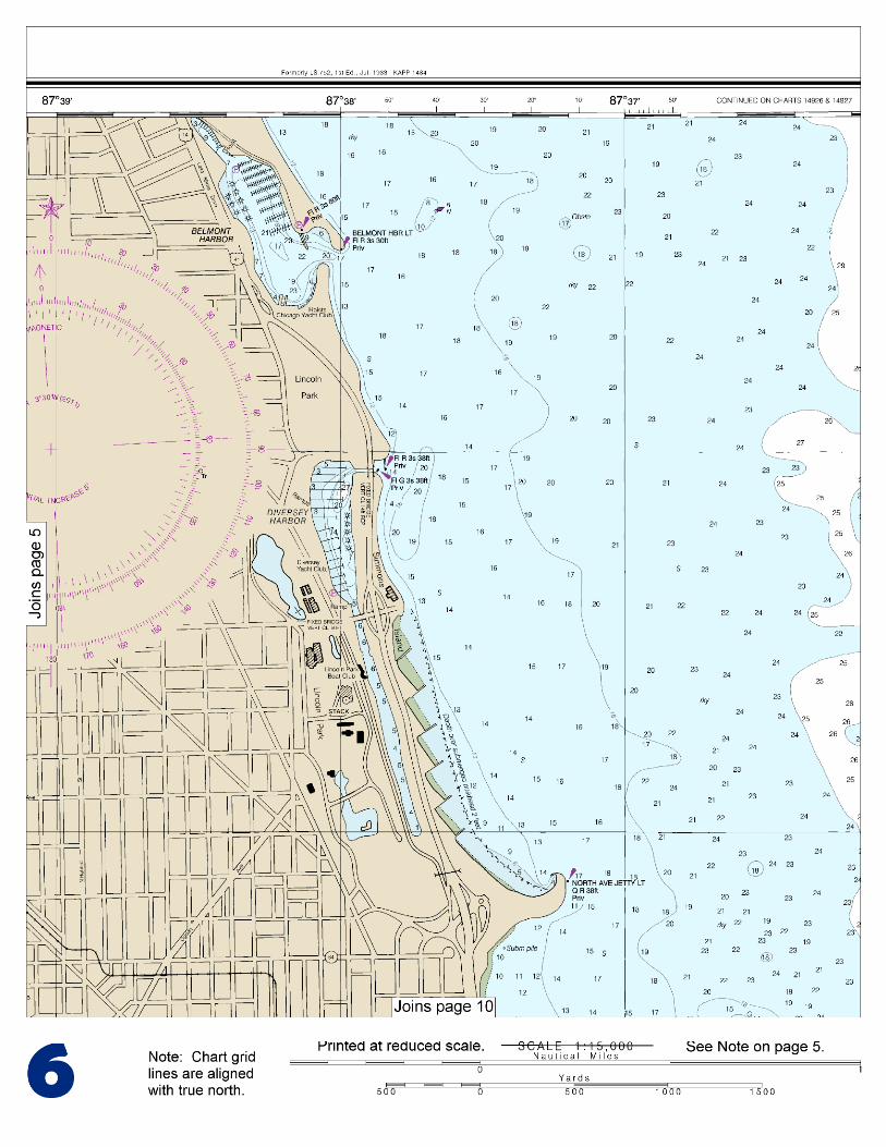
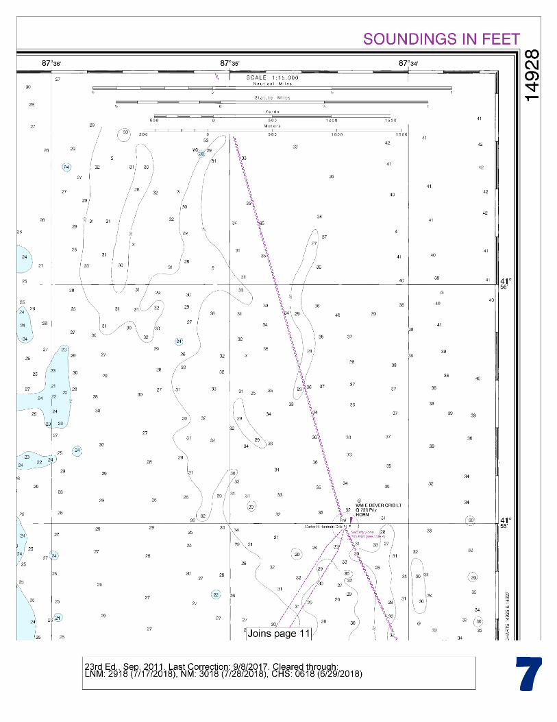
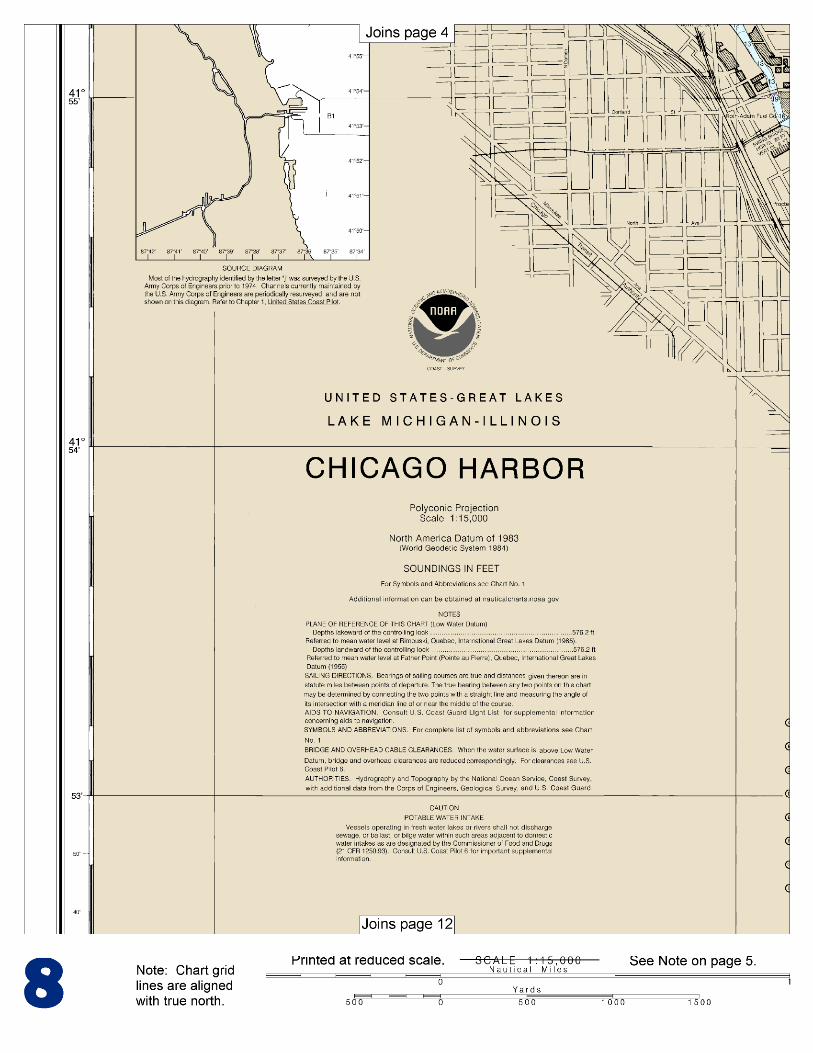
BookletChart™ Chicago Harbor NOAA Chart 14928
A reduced-scale NOAA nautical chart for small boaters When possible, use the full-size NOAA chart for navigation.
Included Area
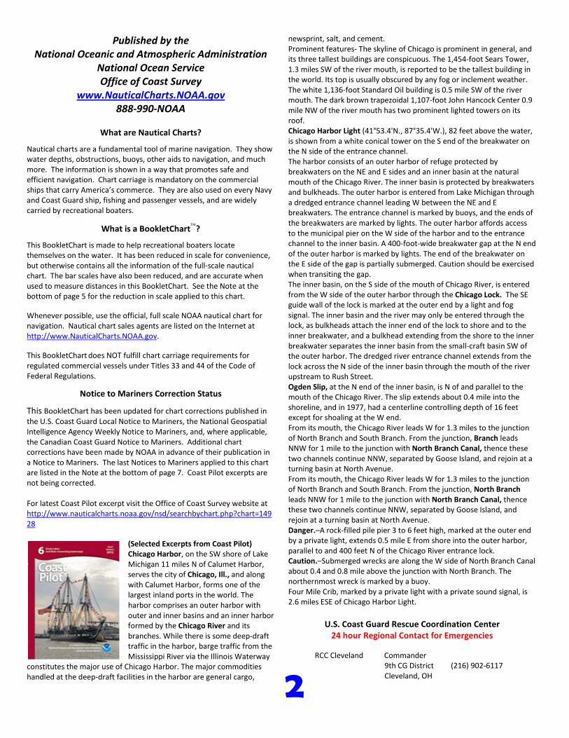
2
Published by the National Oceanic and Atmospheric Administration
National Ocean Service Office of Coast Survey
www.NauticalCharts.NOAA.gov 888-990-NOAA
What are Nautical Charts?
Nautical charts are a fundamental tool of marine navigation. They show water depths, obstructions, buoys, other aids to navigation, and much more. The information is shown in a way that promotes safe and efficient navigation. Chart carriage is mandatory on the commercial ships that carry America’s commerce. They are also used on every Navy and Coast Guard ship, fishing and passenger vessels, and are widely carried by recreational boaters.
What is a BookletChart?
This BookletChart is made to help recreational boaters locate themselves on the water. It has been reduced in scale for convenience, but otherwise contains all the information of the full-scale nautical chart. The bar scales have also been reduced, and are accurate when used to measure distances in this BookletChart. See the Note at the bottom of page 5 for the reduction in scale applied to this chart.
Whenever possible, use the official, full scale NOAA nautical chart for navigation. Nautical chart sales agents are listed on the Internet at http://www.NauticalCharts.NOAA.gov.
This BookletChart does NOT fulfill chart carriage requirements for regulated commercial vessels under Titles 33 and 44 of the Code of Federal Regulations.
Notice to Mariners Correction Status
This BookletChart has been updated for chart corrections published in the U.S. Coast Guard Local Notice to Mariners, the National Geospatial Intelligence Agency Weekly Notice to Mariners, and, where applicable, the Canadian Coast Guard Notice to Mariners. Additional chart corrections have been made by NOAA in advance of their publication in a Notice to Mariners. The last Notices to Mariners applied to this chart are listed in the Note at the bottom of page 7. Coast Pilot excerpts are not being corrected.
For latest Coast Pilot excerpt visit the Office of Coast Survey website at http://www.nauticalcharts.noaa.gov/nsd/searchbychart.php?chart=14928
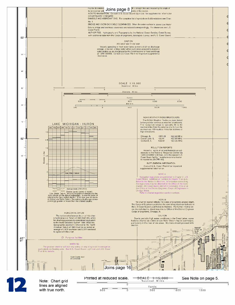
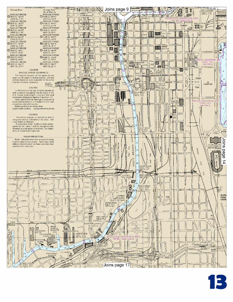
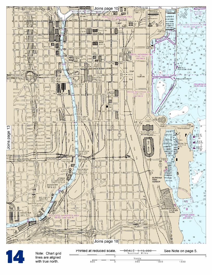
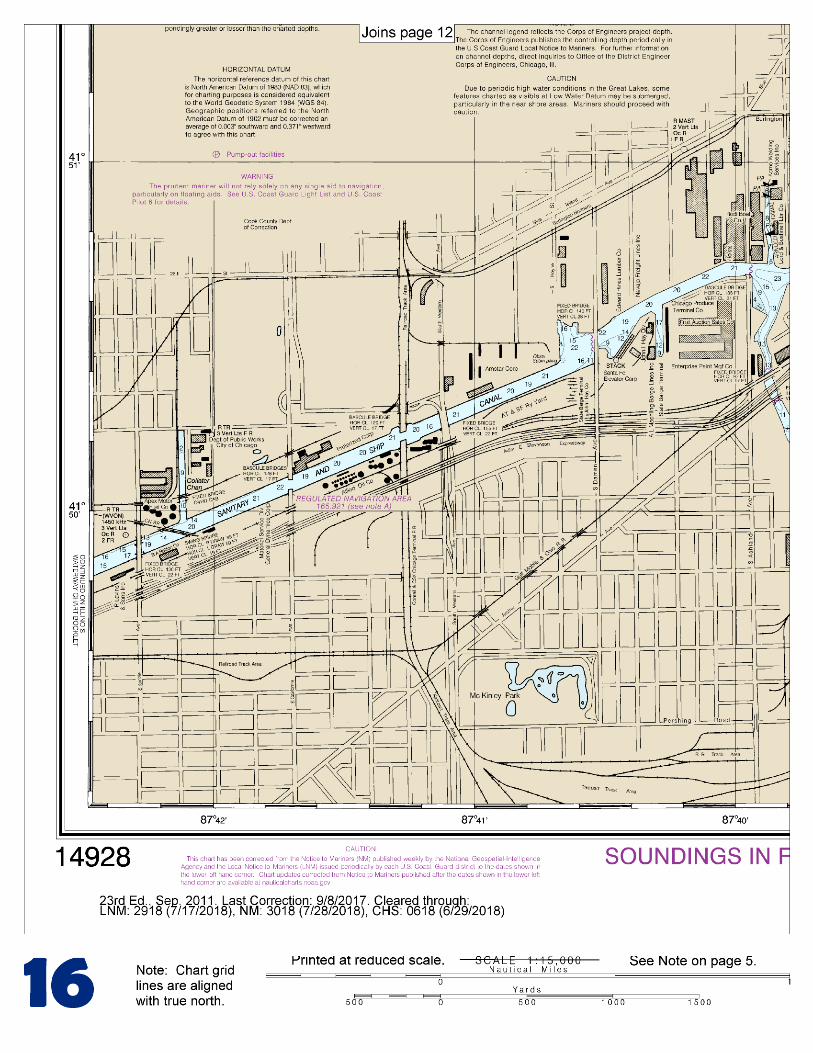
(Selected Excerpts from Coast Pilot) Chicago Harbor, on the SW shore of Lake Michigan 11 miles N of Calumet Harbor, serves the city of Chicago, Ill., and along with Calumet Harbor, forms one of the largest inland ports in the world. The harbor comprises an outer harbor with outer and inner basins and an inner harbor formed by the Chicago River and its branches. While there is some deep-draft traffic in the harbor, barge traffic from the Mississippi River via the Illinois Waterway
constitutes the major use of Chicago Harbor. The major commodities handled at the deep-draft facilities in the harbor are general cargo,
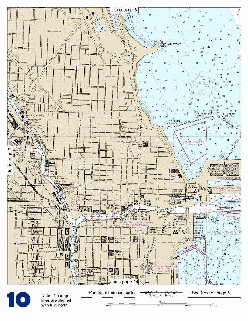
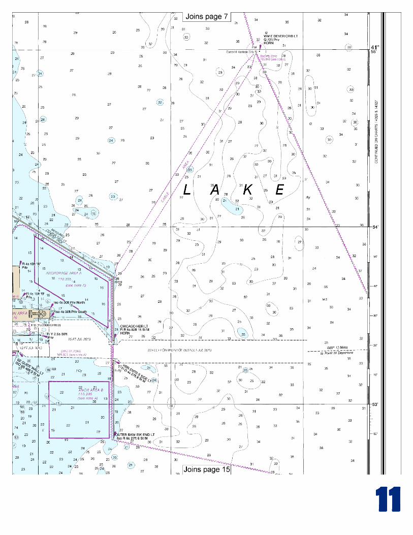
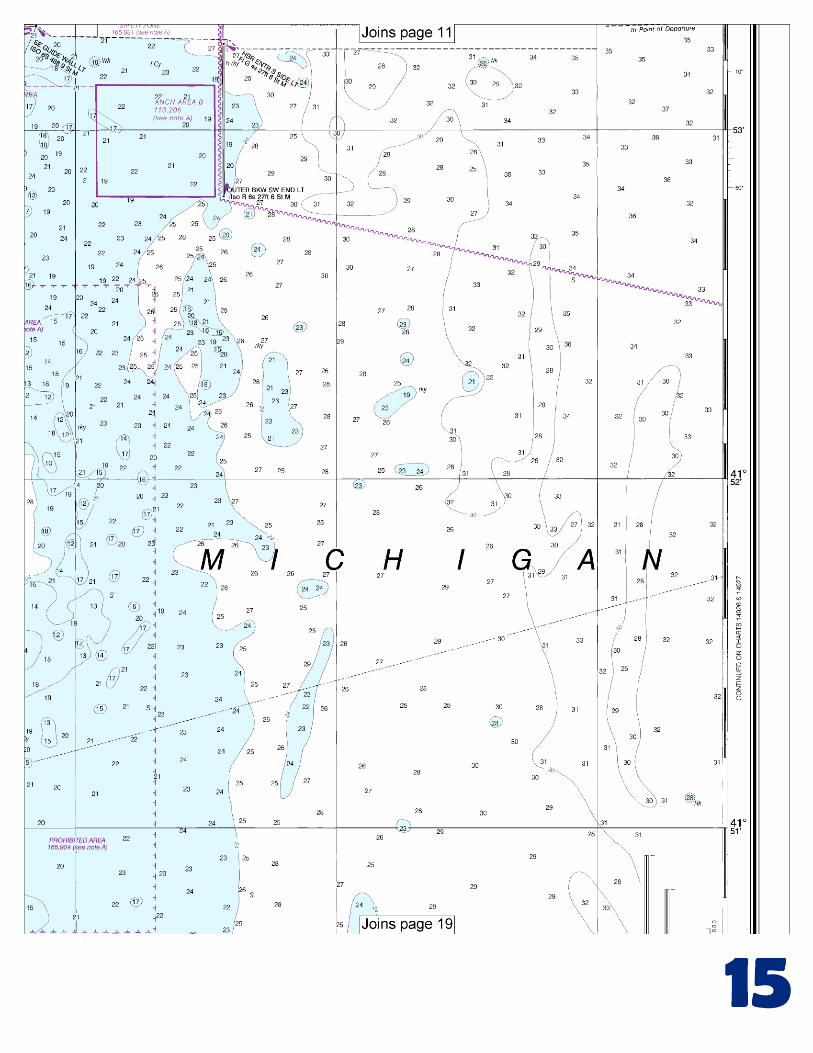
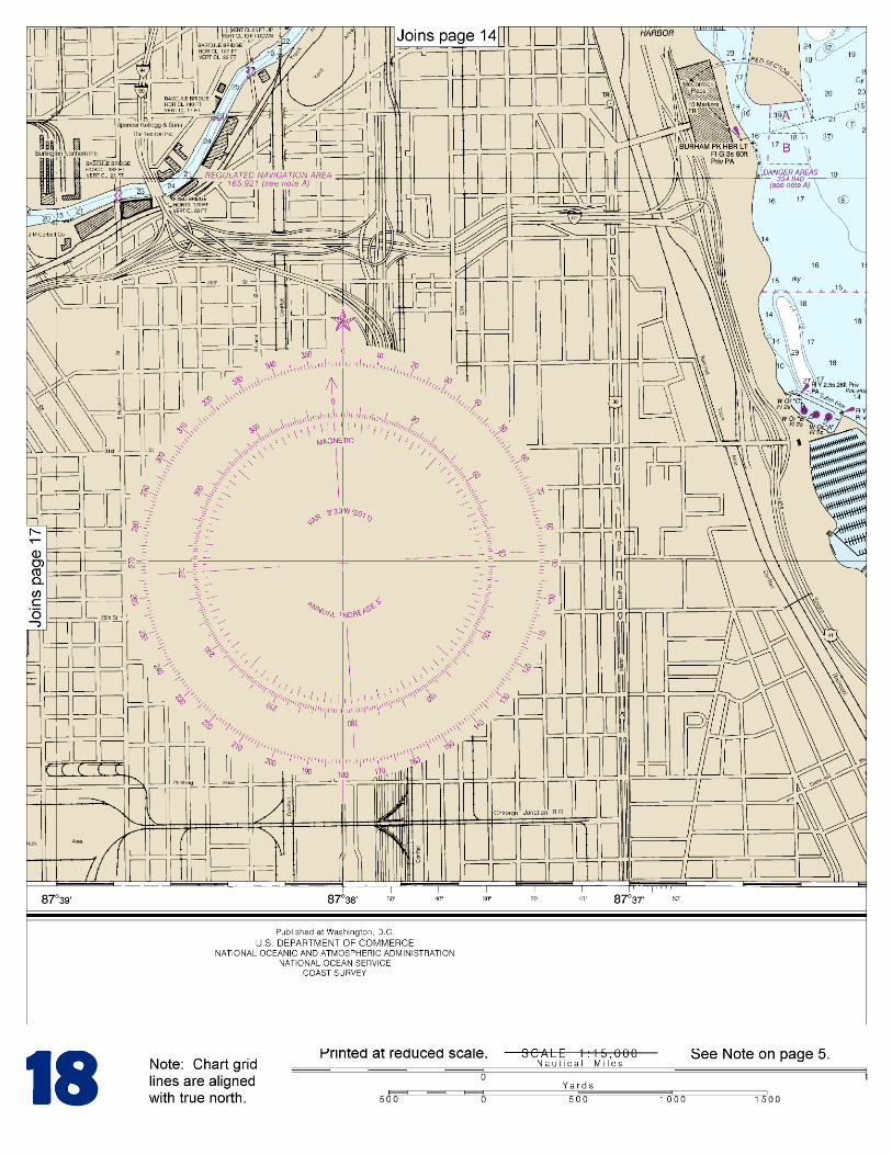
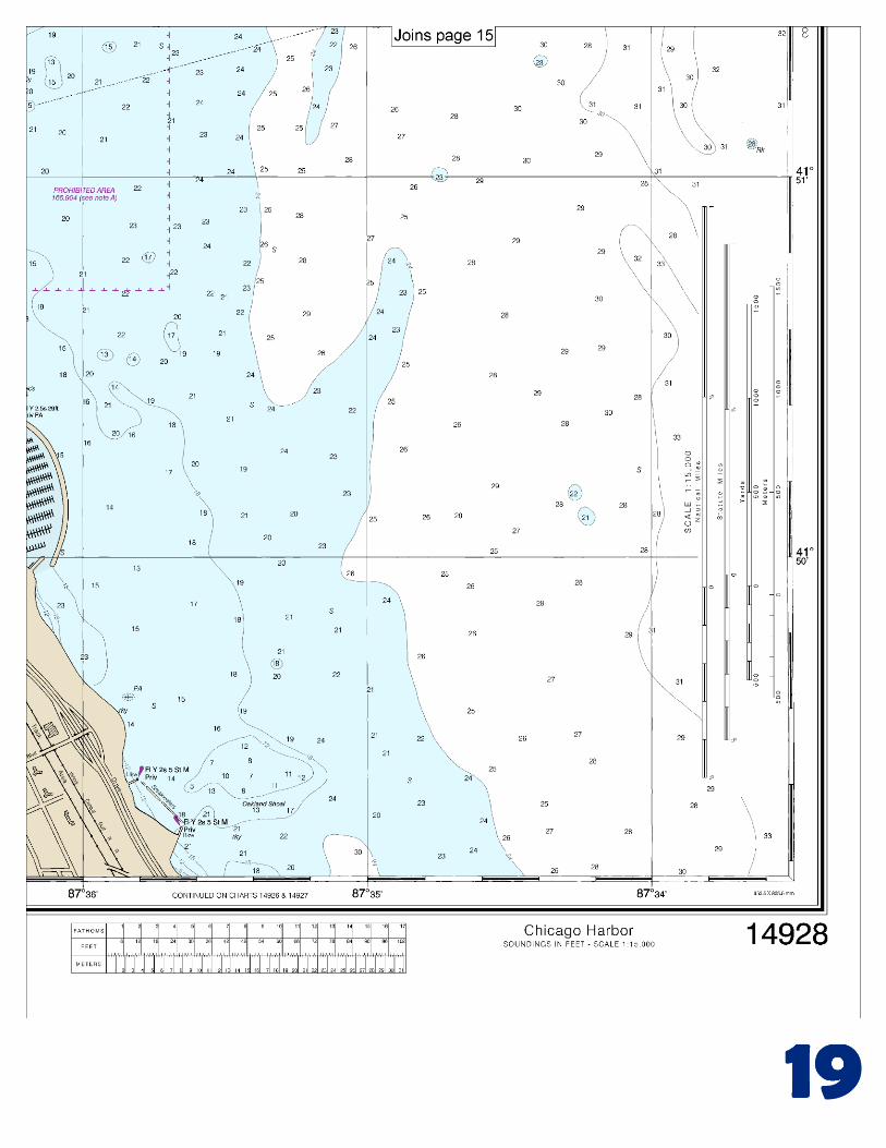
newsprint, salt, and cement. Prominent features- The skyline of Chicago is prominent in general, and its three tallest buildings are conspicuous. The 1,454-foot Sears Tower, 1.3 miles SW of the river mouth, is reported to be the tallest building in the world. Its top is usually obscured by any fog or inclement weather. The white 1,136-foot Standard Oil building is 0.5 mile SW of the river mouth. The dark brown trapezoidal 1,107-foot John Hancock Center 0.9 mile NW of the river mouth has two prominent lighted towers on its roof. Chicago Harbor Light (41°53.4'N., 87°35.4'W.), 82 feet above the water, is shown from a white conical tower on the S end of the breakwater on the N side of the entrance channel. The harbor consists of an outer harbor of refuge protected by breakwaters on the NE and E sides and an inner basin at the natural mouth of the Chicago River. The inner basin is protected by breakwaters and bulkheads. The outer harbor is entered from Lake Michigan through a dredged entrance channel leading W between the NE and E breakwaters. The entrance channel is marked by buoys, and the ends of the breakwaters are marked by lights. The outer harbor affords access to the municipal pier on the W side of the harbor and to the entrance channel to the inner basin. A 400-foot-wide breakwater gap at the N end of the outer harbor is marked by lights. The end of the breakwater on the E side of the gap is partially submerged. Caution should be exercised when transiting the gap. The inner basin, on the S side of the mouth of Chicago River, is entered from the W side of the outer harbor through the Chicago Lock. The SE guide wall of the lock is marked at the outer end by a light and fog signal. The inner basin and the river may only be entered through the lock, as bulkheads attach the inner end of the lock to shore and to the inner breakwater, and a bulkhead extending from the shore to the inner breakwater separates the inner basin from the small-craft basin SW of the outer harbor. The dredged river entrance channel extends from the lock across the N side of the inner basin through the mouth of the river upstream to Rush Street. Ogden Slip, at the N end of the inner basin, is N of and parallel to the mouth of the Chicago River. The slip extends about 0.4 mile into the shoreline, and in 1977, had a centerline controlling depth of 16 feet except for shoaling at the W end. From its mouth, the Chicago River leads W for 1.3 miles to the junction of North Branch and South Branch. From the junction, Branch leads NNW for 1 mile to the junction with North Branch Canal, thence these two channels continue NNW, separated by Goose Island, and rejoin at a turning basin at North Avenue. From its mouth, the Chicago River leads W for 1.3 miles to the junction of North Branch and South Branch. From the junction, North Branch leads NNW for 1 mile to the junction with North Branch Canal, thence these two channels continue NNW, separated by Goose Island, and rejoin at a turning basin at North Avenue. Danger.–A rock-filled pile pier 3 to 6 feet high, marked at the outer end by a private light, extends 0.5 mile E from shore into the outer harbor, parallel to and 400 feet N of the Chicago River entrance lock. Caution.–Submerged wrecks are along the W side of North Branch Canal about 0.4 and 0.8 mile above the junction with North Branch. The northernmost wreck is marked by a buoy. Four Mile Crib, marked by a private light with a private sound signal, is 2.6 miles ESE of Chicago Harbor Light.
U.S. Coast Guard Rescue Coordination Center 24 hour Regional Contact for Emergencies
RCC Cleveland Commander
9th CG District (216) 902-6117 Cleveland, OH
G
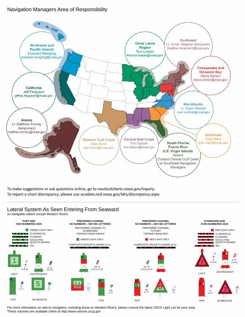
NOAA’s navigation managers serve as ambassadors to the maritime community. They help identify navigational challenges facing professional and recreational mariners, and provide NOAA resources and information for safe navigation. For additional information, please visit nauticalcharts.noaa.gov/service/navmanagers
To make suggestions or ask questions online, go to nauticalcharts.noaa.gov/inquiry. To report a chart discrepancy, please use ocsdata.ncd.noaa.gov/idrs/discrepancy.aspx.
Lateral System As Seen Entering From Seaward on navigable waters except Western Rivers
PORT SIDE
ODD NUMBERED AIDS
GREEN LIGHT ONLY
FLASHING (2)
PREFERRED CHANNEL
NO NUMBERS – MAY BE LETTERED
PREFERRED CHANNEL TO
STARBOARD
TOPMOST BAND GREEN
PREFERRED CHANNEL
NO NUMBERS – MAY BE LETTERED
PREFERRED CHANNEL
TO PORT
TOPMOST BAND RED
STARBOARD SIDE
EVEN NUMBERED AIDS
RED LIGHT ONLY
FLASHING (2)
FLASHING FLASHING
OCCULTING GREEN LIGHT ONLY RED LIGHT ONLY OCCULTING QUICK FLASHING QUICK FLASHING
ISO COMPOSITE GROUP FLASHING (2+1) COMPOSITE GROUP FLASHING (2+1) ISO
"1"
Fl G 6s
G "9"
Fl G 4s
GR "A"
Fl (2+1) G 6s
RG "B"
Fl (2+1) R 6s
"2"
Fl R 6s
8
R "8"
Fl R 4s
LIGHT
G
C "1"
LIGHTED BUOY
G
"5"
GR
"U"
GR
C "S"
RG
N "C"
RG
"G"
LIGHT
6
R
N "6"
LIGHTED BUOY
R
"2
"
CAN DAYBEACON
CAN NUN NUN
DAYBEACON
For more information on aids to navigation, including those on Western Rivers, please consult the latest USCG Light List for your area.
These volumes are available online at http://www.navcen.uscg.gov
Navigation Managers Area of Responsibility
Northeast
Lt. Meghan McGovern
Northwest and
Pacific Islands
Crescent Moegling
Great Lakes Region
Tom Loeper
Chesapeake and
Delaware Bay
Steve Soherr
California
Jeff Ferguson
[email protected] Mid-Atlantic
Lt. Ryan Wartick
Alaska
Lt. Timothy M. Smith
Western Gulf Coast
Alan Bunn
Central Gulf Coast
Tim Osborn
[email protected] South Florida
Puerto Rico
U.S. Virgin Islands
Michael Henderson
Southeast
Kyle Ward
2
2 C U 5
1


VHF Marine Radio channels for use on the waterways:Channel 6 – Inter-ship safety communications.Channel 9 – Communications between boats and ship-to-coast.Channel 13 – Navigation purposes at bridges, locks, and harbors.Channel 16 – Emergency, distress and safety calls to Coast Guard and others, and to initiate calls to other
vessels. Contact the other vessel, agree to another channel, and then switch.Channel 22A – Calls between the Coast Guard and the public. Severe weather warnings, hazards to navigation and safety warnings are broadcast here.Channels 68, 69, 71, 72 and 78A – Recreational boat channels.
Getting and Giving Help — Signal other boaters using visual distress signals (flares, orange flag, lights, arm signals); whistles; horns; and on your VHF radio. You are required by law to help boaters in trouble. Respond to distress signals, but do not endanger yourself.
EMERGENCY INFORMATION
Distress Call Procedures
• Make sure radio is on.• Select Channel 16.• Press/Hold the transmit button.• Clearly say: “MAYDAY, MAYDAY, MAYDAY.”• Also give: Vessel Name and/or Description;Position and/or Location; Nature of Emergency; Number of People on Board.• Release transmit button.• Wait for 10 seconds — If no responseRepeat MAYDAY call.
HAVE ALL PERSONS PUT ON LIFE JACKETS!
This Booklet chart has been designed for duplex printing (printed on front and back of one sheet). If a duplex option is not available on your printer, you may print each sheet and arrange them back-to-back to allow for the proper layout when viewing.
QR
Quick ReferencesNautical chart related products and information - http://www.nauticalcharts.noaa.gov
Interactive chart catalog - http://www.charts.noaa.gov/InteractiveCatalog/nrnc.shtmlReport a chart discrepancy - http://ocsdata.ncd.noaa.gov/idrs/discrepancy.aspx
Chart and chart related inquiries and comments - http://ocsdata.ncd.noaa.gov/idrs/inquiry.aspx?frompage=ContactUs
Chart updates (LNM and NM corrections) - http://www.nauticalcharts.noaa.gov/mcd/updates/LNM_NM.html
Coast Pilot online - http://www.nauticalcharts.noaa.gov/nsd/cpdownload.htm
Tides and Currents - http://tidesandcurrents.noaa.gov
Marine Forecasts - http://www.nws.noaa.gov/om/marine/home.htm
National Data Buoy Center - http://www.ndbc.noaa.gov/
NowCoast web portal for coastal conditions - http://www.nowcoast.noaa.gov/
National Weather Service - http://www.weather.gov/
National Hurrican Center - http://www.nhc.noaa.gov/
Pacific Tsunami Warning Center - http://ptwc.weather.gov/
Contact Us - http://www.nauticalcharts.noaa.gov/staff/contact.htm
NOAA’s Office of Coast Survey The Nation’s Chartmaker
For the latest news from Coast Survey, follow @NOAAcharts
NOAA Weather Radio All Hazards (NWR) is a nationwide network of radio stations broadcasting continuous weather information directly from the nearest National Weather Service office. NWR broadcasts official Weather Service warnings, watches, forecasts and other hazard information 24 hours a day, 7 days a week. http://www.nws.noaa.gov/nwr/