Embed Size (px)
Citation preview

Journal of Civil Engineering and Architecture 9 (2015) 1463-1473 doi: 10.17265/1934-7359/2015.12.008
Chronological Restoration of Fort Frontenac in 3D for
Heritage Visualization
Mitsuyoshi Yabe1, Elizabeth Goins2, Chris Jackson1, David Halbstein1, Shaun Foster1 and Sue Bazely3
1. Department of Visual Communication Design, Rochester Institute of Technology, Rochester 10605, New York, USA
2. Department of Cultural Materials Science and Fine Arts, Rochester Institute of Technology, Rochester 10605, New York, USA
3. Cataraqui Archaeological Research Foundation, Kingston K7L 1E1, Ontario, Canada
Abstract: This paper is composed of three elements: 3D modeling, web design and heritage visualization on the basis of the chronological restoration of Fort Frontenac in 1673, 1675, 1680, 1685 and 1688, changing from narrow and plain to broad, grand features. The aim is to use computer graphic design to inform and create an interest in historical visualization by rebuilding Fort Frontenac using 3D modeling and interactive design. The final model can be integrated into an interactive website to learn more about the fort’s historic importance. It is apparent that using computer graphics can save time and money when it comes to historical visualization. Visitors do not have to travel to the actual archaeological buildings and can simply use the web in their own homes to learn about this information virtually. In order to create a sophisticated restoration of archaeological buildings, meticulously assessing historical records will draw viewers into the visualizations, such as the historical world of Fort Frontenac. As a result, the completed restoration allows the viewers to effectively understand the fort’s social system, habits and historical events. Key words: Heritage visualization, 3D computer graphics, interactive virtual design, web design, effective usage of learning.
1. Introduction
Fort Frontenac was an important military fortress
and fur trading post that was built in Kingston, Ontario,
Canada in 1673. The fort was renovated four times,
initially by replacing log palings with masonry walls
and adding bastions while it was embroiled in
occasional outbreaks of fighting between the Iroquois
and the British. When the reconstruction of the fort was
completed, it became an impressive. However, the
newly reconstructed fort was destroyed in 1689 but was
then later reconstructed in 1695 to strengthen military
activity and accommodation. Over the course of
50 years, fur trade gradually became more unprofitable,
and the fort was relinquished to British forces who
devastated it during the Seven Years’ War in 1758. The
fort was never rebuilt and was abandoned, because the
fortification was no longer needed. New buildings and
streets were then erected above its ruins for more than a
Corresponding author: Mitsuyoshi Yabe, M.Sc., research
field: virtual archaeology. E-mail: [email protected].
hundred years. In 1983, archaeological research finally
successfully excavated only a small portion of the fort,
the northwest bastion (Fig. 1). The fort was designated
as a Canadian National Historic Site, and a part of the
northwest bastion was reconstructed in 1984 [1, 2].
This paper aimed at virtually reconstructing all the
buildings to look like the provenance of the buildings.
The field that embraces this process is called “heritage
visualization”, which is derived from a combination of
the use of conventional archaeology and cutting-edge
3D computer graphics design. It represents a great
opportunity to rebuild Fort Frontenac using this
technique because many forts have been renovated in
this manner to show historical reenactment sites.
This research aims at virtually restoring an
archaeological building, Fort Frontenac, which in turn
will draw viewers into the historical world of Fort
Frontenac. This is a difficult task because there is
limited information and only a small amount of
archaeological remains from the original fort.
While the original maps and plans of Fort Frontenac are
D DAVID PUBLISHING
Chronological Restoration of Fort Frontenac in 3D for Heritage Visualization
1464
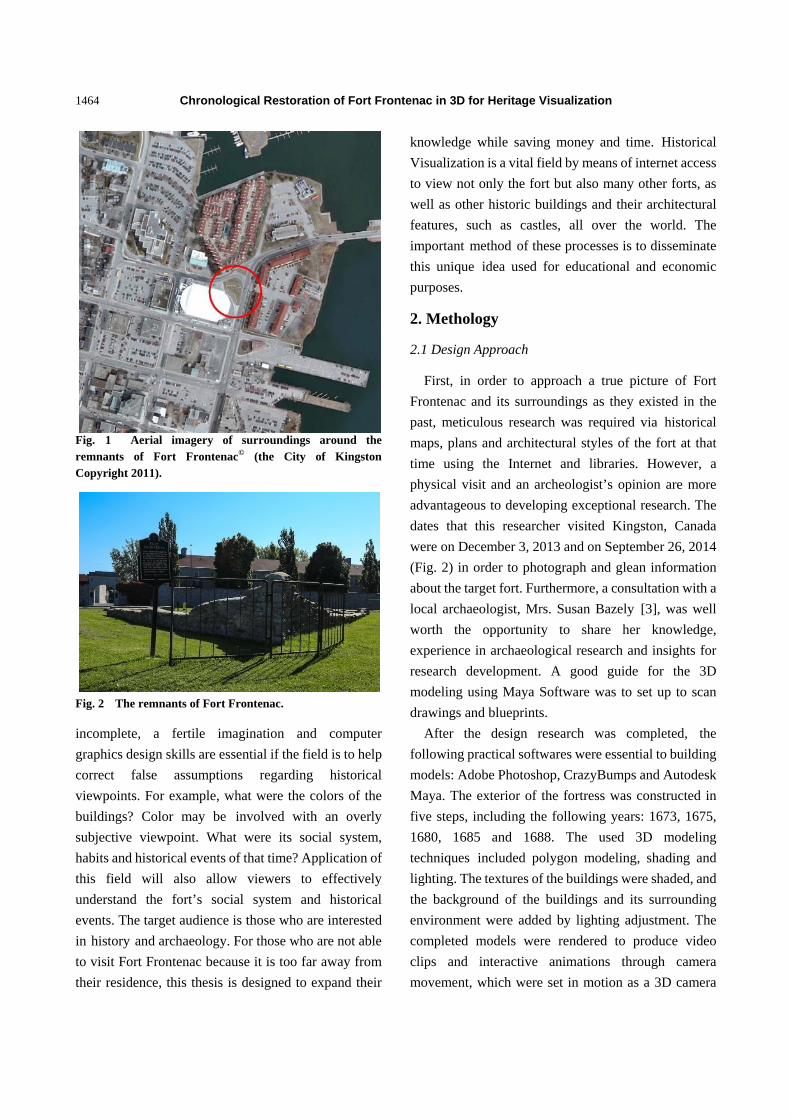
Fig. 1 Aerial imagery of surroundings around the remnants of Fort Frontenac© (the City of Kingston Copyright 2011).
Fig. 2 The remnants of Fort Frontenac.
incomplete, a fertile imagination and computer graphics design skills are essential if the field is to help correct false assumptions regarding historical viewpoints. For example, what were the colors of the buildings? Color may be involved with an overly subjective viewpoint. What were its social system, habits and historical events of that time? Application of this field will also allow viewers to effectively understand the fort’s social system and historical events. The target audience is those who are interested in history and archaeology. For those who are not able to visit Fort Frontenac because it is too far away from their residence, this thesis is designed to expand their
knowledge while saving money and time. Historical Visualization is a vital field by means of internet access to view not only the fort but also many other forts, as well as other historic buildings and their architectural features, such as castles, all over the world. The important method of these processes is to disseminate this unique idea used for educational and economic purposes.
2. Methology
2.1 Design Approach
First, in order to approach a true picture of Fort Frontenac and its surroundings as they existed in the past, meticulous research was required via historical maps, plans and architectural styles of the fort at that time using the Internet and libraries. However, a physical visit and an archeologist’s opinion are more advantageous to developing exceptional research. The dates that this researcher visited Kingston, Canada were on December 3, 2013 and on September 26, 2014 (Fig. 2) in order to photograph and glean information about the target fort. Furthermore, a consultation with a local archaeologist, Mrs. Susan Bazely [3], was well worth the opportunity to share her knowledge, experience in archaeological research and insights for research development. A good guide for the 3D modeling using Maya Software was to set up to scan drawings and blueprints.
After the design research was completed, the following practical softwares were essential to building models: Adobe Photoshop, CrazyBumps and Autodesk Maya. The exterior of the fortress was constructed in five steps, including the following years: 1673, 1675, 1680, 1685 and 1688. The used 3D modeling techniques included polygon modeling, shading and lighting. The textures of the buildings were shaded, and the background of the buildings and its surrounding environment were added by lighting adjustment. The completed models were rendered to produce video clips and interactive animations through camera movement, which were set in motion as a 3D camera

Chronological Restoration of Fort Frontenac in 3D for Heritage Visualization
1465
was placed to create a bird’s eye-view and a
360-degree view from the fort.
After the modeling was complete, interactive
sceneries in Adobe Flash were devised to provide an
effective way to implement visual communication and
learning through the use of a mouse. Interactivity was
integrated into the 3D models of the fort with unseen
clickable buttons in order to allow the viewer to learn
more about the fort’s structure and historical
importance. The video clips and interactive sceneries
were integrated into the website in order to inform the
user of the fort’s social systems and historical events.
2.2 Modeling Buildings in Maya
2.2.1 Constructing Buildings and Environment
Maya 2014 is a professional tool that has the means
of modeling physical objects and rendering sequences
to create animations. By complying with the notes
regarding the archaeological and historical
consequences produced from research, photos of the
forts, online documentation and historical plans and
print documentation provided by the City of Kingston
and Mrs. Bazely’s evidence1, the careful operation was
performed in Maya in order to fashion the length,
height and size of each building, including the log
palisades, curtain walls and moats.
In addition, CrazyBumps is a convenient software
program for shading textural materials, where photos
were simultaneously turned into displacement and
normal maps. The software is the most effective,
simplest and easiest way of creating these types of
maps, since the software is beneficial to the
enhancement of aesthetics and contrast. Four, six or
eight images became two or four of each image by
means of flipping the images vertically and
horizontally and then stitching the original whole
images together with much repetition in Photoshop.
The images were offset, and the clone tool was used to
make seamless repeating patterns. The more images
1Bazely, S. M., email message to Mitsuyoshi Yabe, February 26, 2014.
that were put onto the one large image in Photoshop,
the more realistic the textures of the buildings were
when the images were transformed to displacement and
normal maps adjusted by CrazyBumps according to
intensity sharpen, detail, shade and highlight, which
were then imported into Maya. Finally, the normal
maps were placed along with the displacement maps
onto a Blinn bump map for particular buildings. Most
texture images were provided by a website referenced
as Cgtextures, which has a wide amount of abundant
textural resources that range from ancient to modern.
The log textures were from Cgtexture, and the
limestone textures were from the remnants of Fort
Frontenac. The six similar repeated images were
stitched together using offset in Photoshop in order to
respectively adjust the surfaces of each pole with the
UV texture editor, protruding a 2D texture image to
the 3D model’s surface in Maya. For the roofs and
wooden walls of the two storehouses, the textures were
also found in Cgtexture and were created by the same
means of Photoshop and CrazyBumps with the results
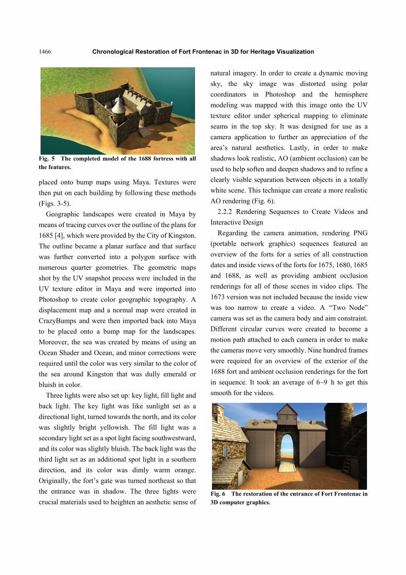
Fig. 3 The prototypical, wireframe model of the 1688 fortress.
Fig. 4 The foundation model of the 1688 fortress with only solid.
1466
Fig. 5 The the features.
placed onto
then put on
(Figs. 3-5).
Geograph
means of tra
1685 [4], wh
The outline
was further
numerous q
shot by the U
UV texture
Photoshop t
displacemen
CrazyBump
to be place
Moreover, t
Ocean Shad
required unt
the sea arou
bluish in col
Three ligh
back light.
directional li
was slightly
secondary lig
and its color
third light se
direction, a
Originally, t
the entrance
crucial mate
Chron
completed mo
bump maps
each building
hic landscape
acing curves o
hich were pro
became a pl
converted i
quarter geom
UV snapshot
editor in M
to create colo
nt map and a
s and were th
d onto a bu
the sea was c
der and Ocean
til the color w
und Kingston
lor.
hts were also
The key ligh
ight, turned to
y bright yell
ght set as a sp
r was slightly
et as an addit
and its color
the fort’s gate
e was in sha
erials used to
ological Rest
odel of the 168
s using Maya
g by followin
es were crea
over the outlin
ovided by the
lanar surface
into a polyg
metries. The
t process wer
Maya and wer
or geographi
a normal map
hen imported
ump map for
created by m
n, and minor
was very simil
n that was d
set up: key li
ht was like s
owards the no
lowish. The
pot light facin
bluish. The b
tional spot li
r was dimly
e was turned
adow. The th
heighten an a
toration of Fo
88 fortress wit
a. Textures w
ng these meth
ated in Maya
ne of the plan
City of Kings
and that sur
gon surface w
geometric m
re included in
re imported
ic topography
p were create
d back into M
r the landsca
means of using
corrections w
lar to the colo
dully emerald
ight, fill light
sunlight set
orth, and its c
fill light wa
g southwestw
back light was
ght in a south
y warm ora
northeast so
hree lights w
aesthetic sens
ort Frontenac
th all
were
hods
a by
s for
ston.
rface
with
maps
n the
into
y. A
ed in
Maya
apes.
g an
were
or of
d or
t and
as a
color
as a
ward,
s the
hern
ange.
that
were
se of
natu
sky
coo
mod
text
seam
cam
area
sha
use
clea
whi
AO
2
Inte
R
(por
ove
date
and
rend
167
was
cam
Dif
mot
the
wer
168
in s
smo
Fig.3D c
c in 3D for He
ural imagery.
y, the sky
ordinators in
deling was m
ture editor u
ms in the to
mera applicat
a’s natural a
dows look re
d to help soft
arly visible s
ite scene. Thi
O rendering (F
2.2.2 Render
eractive Desig
Regarding th
rtable netwo
erview of the
es and inside
d 1688, as w
derings for a
73 version wa
s too narrow
mera was set a
fferent circula
tion path atta
cameras mov
re required fo
88 fort and am
sequence. It
ooth for the v
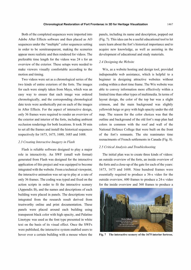
. 6 The restorcomputer grap
eritage Visual
. In order to
image was
n Photoshop
mapped with
under spheric
op sky. It wa
tion to furthe
aesthetics. L
alistic, AO (a
ten and deepe
eparation bet
is technique c
Fig. 6).
ing Sequenc
gn
e camera an
ork graphics)
e forts for a
views of the
well as prov
all of those sc
as not include
w to create a
as the camera
ar curves we
ached to each
ve very smoot
for an overvie
mbient occlus
took an aver
videos.
ration of the enphics.
lization
create a dyna
s distorted
p and the
this image o
cal mapping
as designed
er an apprec
Lastly, in ord
ambient occlu
en shadows an
tween object
can create a m
es to Create
nimation, ren
) sequences
series of all
forts for 1675
viding ambie
cenes in vide
ed because the
a video. A “
a body and ai
ere created t
h camera in o
thly. Nine hu
ew of the ex
sion rendering
rage of 6~9
ntrance of For
amic moving
using polar
hemisphere
onto the UV
to eliminate
for use as a
iation of the
der to make
usion) can be
nd to refine a
s in a totally
more realistic
Videos and
ndering PNG
featured an
construction
5, 1680, 1685
ent occlusion
eo clips. The
e inside view
“Two Node”
m constraint.
to become a
order to make
undred frames
xterior of the
gs for the fort
h to get this
rt Frontenac in
g
r
e
V
e
a
e
e
e
a
y
c
d
G
n
n
5
n
e
w
”
.
a
e
s
e
t
s
n
Both of th
Adobe After
sequences un
in order to
appear more
preferable ti
overview of
make viewe
motion and t
Two vide
two kinds o
for each wer
easy way t
chronologica
date texts w
in After Eff
only 36 fram
the exterior
occlusion re
to set all the
respectively
2.3 Creating
Flash is r
role in inte
generated fr
application o
integrated w
the interactiv
only 36 fram
action scrip
(Appendix B
building wer
integrated f
trustworthy
panels wer
transparent b
Linotype wa
text on the
were publish
hover over a
Chron
he completed
r Effects soft
nder the “mu
be semitrans
e realistic and
ime length fo
f the exterior.
ers visually c
timing.
os were set a
f entire exter
re simply tak
to ensure th
ally, and the
ere aesthetica
fects. For the
mes were requ
and interior o
enderings for
frames and i
for 1673, 16
g Interactive I
reliable softw
eractivity. An
rom Flash wa
of this project
with the websit
ve animation
mes. The codi
pts in order t
B), and the na
re placed in p
from the re
online and
re placed ar
black color w
as used as the
basis of its v
hed, the intera
a certain buil
ological Rest
sequences w
ftware and th
ltiple” color s
sparent, maki
d then rendere
or the videos
. These setup
comfortable
as a chronolog
riors of the f
ken from May
hat each ima
correspondin
ally put on ea
e aspect of in
uired to rende
of the forts, in
both location
install the his
675, 1680, 168
Imagery in F
ware designed
n SWF (sm
as designed fo
t and was equ
te. From a tec
was set up to
ing was typed
to fit the int
ames and des
panels. The d
esearch resul
print docum
round each
with high opac
e font type pr
visual effect.
active system
lding with a m
toration of Fo
were imported
en placed as
sequences set
ing the scene
ed for videos.
was 24 s fo
ps were neede
according to
gical series of
forts. The ima
ya, which wa
age was ord
ng chronolog
ach of the ima
nteractive des
er an overview
ncluding amb
ns. It took 30
torical sequen
85 and 1688.
Flash
d to play a m
mall web form
for the interac
uipped to bec
chnical viewpo
o play at a rat
d and fixed on
teractive scen
scriptions of e
descriptions w
lt derived f
mentation. Th
building u
city, and Pala
resented in w
Once the SW
m enabled use
mouse where
ort Frontenac
into
AO
tting
eries
The
or an
ed to
o the
f the
ages
as an
dered
gical
ages
sign,
w of
bient
min
nces
major
mat)
ctive
ome
oint,
te of
n the
nery
each
were
from
hese
using
atino
white
WFs
rs to
e the
pan
(Fig
user
acq
dev
2.4
W
indi
beg
cod
able
lim
layo
crim
yell
map
outl
colo
Nat
of
reen
2.5
T
an o
the
167
esse
outs
for
Fig.
c in 3D for He
nels, including
g. 7). This ide
rs learn about
quire new kn
velopment of
Designing th
Wix, as a web
ispensable w
ginner in de
ding within a s
e to convey i
ited time than
out design, t
mson, and t
lowish beige
p. The reaso
line and back
ors in comm
tional Defenc
the fort’s r
nactments of
Critical Ana
The initial pla
outside overv
forts and a cl
73, 1675 and
entially requ
side overview
the inside ov
. 7 The intera
eritage Visual
g its name an
ea can be a us
t the fort’s hi
nowledge, as
educational a
he Website
bsite hosting
web assistanc
esigning attr
short time fra
information m
n other types o
the color of
the main b
or grey with h
on for the co
kground of th
mon with th
ce College th
remnants. Th
French settle
lysis and Tro
an was to cre
view of the fo
ose-up of the
d 1688. Nin
uired to produ
w, 600 frame
verview and
active scenery
lization
nd description
eful educatio
storical impo
well as ass
and study mat
and design to
e, which is
ractive webs
ame. The Wix
more effectiv
of multimedi
the top bar
background w
high opacity
olor choices
he old fort’s m
he roof and
hat were built
he site rean
ements in Can
ubleshooting
eate three kin
orts, an inside
gate for each
ne hundred f
uce a 36-s v
s to produce
360 frames
of the 1675 int
1467
n, popped out
nal tool to let
ortance and to
isting in the
terials.
ool, provided
helpful to a
sites without
x website was
vely within a
a. In terms of
was a slight
was slightly
under the old
was that the
map plan had
wall of the
t on the front
nimates time
nada (Fig. 8).
g
ds of videos:
e overview of
h of the years:
frames were
video for the
a 24-s video
to produce a
terior fortress.
7
t
t
o
e
d
a
t
s
a
f
t
y
d
e
d
e
t
e
.
:
f
:
e
e
o
a
.

1468
Fig. 8 The w
12-s video
900 frames
on a daily ba
video. To cr
week. On th
for the outs
took only 3
to build a
rate, more th
day.
However,
influenced b
sceneries f
determined t
Consequentl
memory-inte
required. On
fort in 168
completed w
the exteriors
well as thei
The appeara
comfortable
an effective
videos was
use of thi
applications
economize t
videos is
considerable
Chron
website of the 3
for the clos
greatly impa
asis, in that it
reate the full
e other hand,
side and insi
30 m to ren
360-degree i
han 10 intera
, designing
by the video
for each p
the best meth
ly, most vide
ensive usage
nly the video
8 were uplo
website featur
s for 1673, 16
ir interiors re
ance of the
for users and
e way, whil
not innovativ
s design co
are attract
the time spen
relatively
e effort and ti
ological Rest
3D restoration
e-up of the
acted the rese
t took one day
set of nine v
to create inte
ide of the fo
der all 24 fr
interaction in
actions could
a related
o file formats
page. User-c
hod to incorp
eos were remo
e and the tim
os for the co
oaded for th
red nine inter
675, 1680, 16
espectively, e
website was
d enhanced th
le in compa
ve and banal
ould assert
tive to user
nt creating the
conventional
ime.
toration of Fo
of Fort Fronte
gate. Rende
earcher’s lifes
y to complete
videos requir
eractive scene
orts in Flash
frames neces
n Flash. At
d be created o
d website
s and interac
centered de
porate the vid
oved due to t
me managem
ompleted exte
e webpage.
ractive scene
685 and 1688
except for 1
s innovative
heir knowledg
arison, watch
. To sum up,
that interac
rs and usef
em, but featu
l and expe
ort Frontenac
enac.
ering
style
e one
red a
eries
CC
ssary
that
on a
was
ctive
esign
deos.
their
ment
erior
The
ries:
8, as
673.
and
ge in
hing
, the
ctive
fully
uring
ends
3. C
3.1
T
con
Ind
secu
buil
stor
log
and
rest
rese
tree
map
3.2
T
bec
pres
pali
bast
circ
orig
soil
to b
3.3
T
peo
Fig.
2Ibid
c in 3D for He
Chronologi
The 1673 Fo
The original f
nstruction was
ian attacks a
urity of the f
ldings inclu
rehouses for
palisades wh
d whose other
toration of th
earching thei
es in Kingston
ple, bur oak, b
The 1675 Fo
The second
ause it was n
sence on Lak
isades had th
tions in an
cumference [
ginally cut fro
l where the fo
be yellowish,
The 1680 Fo
To serve the n
ople, a compl
. 9 The front
d.
eritage Visual
ical Restor
ort Restoratio
fortress looke
s completed i
and the need
fort as a tradi
uded the fo
provisions a
hose north an
r sides were 2
he wooden p
ir detailed t
n, wood was t
beech or east
ort Restoratio
fortress was
needed as an e
ke Ontario. I
he addition o
n area tha
[5]. The mas
om the bedro
ort was erecte
rough and bl
ort Restoratio
needs of the g
lex of buildin
of the 1673 for
lization
ation
on
ed very crude
in less than a
d for enhance
ing post. The
ollowing: a
and ammunit
nd south side
20 ft in length
palisades, as
textures amo
taken from a
tern cedar (Fi
on
rebuilt two
evident sign o
n this renova
of four lime
at was 800
onry of the b
ck and cover
ed. The surfa
lunt2 (Fig. 10
on
garrison, trade
ngs had deve
rtress.
e because the
a week due to
ement to the
e constructed
well, two
ions storage,
es were 46 ft
h [5]. For the
a sequel to
ong common
kind of sugar
ig. 9).
o years later
of the French
ation, the log
stone square
0 yards in
bastions was
red below the
aces appeared
0).
ers and native
eloped inside
e
o
e
d
o
,
t
e
o
n
r
r
h
g
e
n
s
e
d
e
e

Chronological Restoration of Fort Frontenac in 3D for Heritage Visualization
1469
Fig. 10 The front of the 1675 fortress.
Fig. 11 The front of the 1680 fortress.
Fig. 12 The front of the 1685 fortress.
Fig. 13 The front of the 1688 fortress.
the fort. The constructed buildings included the
following: a 100-ft-long quarter, a blacksmith shop, a
guardhouse, a cow house, a well, wooden platforms
and scaffolds and log palisades on the north, east and
south sides, as well as masonry curtain walls on the
west side, with the addition of four limestone square
bastions. Around the fort were 15-ft-wide ditches [5].
The masonry curtain walls included many casements
and loopholes [6] (Fig. 11).
3.4 The 1685 Fort Restoration
About 2,000 men built the masonry curtain walls and
the bastions [6]. The fort was enlarged in a square
alongside each of four bastions, which measured
approximately 96 ft from curtain wall to curtain wall.
The south side had a combination of a 4-ft-high
masonry foundation wall and log palisade that stood on
the foundation wall. The inside included a masonry
quarters or barracks, a guardhouse, a forge, mills, a
powder magazine, a bakery, trade house, a well, a
sentry-box and moats that were 15 ft deep [5]. An
architect inspected the fort and reported that the height
of the walls was still too low [6] (Fig. 12).
3.5 The 1688 Fort Restoration
The additionally constructed buildings included the
following: a large tower and four small towers, wooden
platforms and scaffolds, a wooden bridge, a masonry
gate and full limestone curtain walls with many
casements and loopholes [5]. Most of buildings were
completely transformed from wooden surfaces to
limestone surfaces. However, some buildings still
remained with wooden textures. Both textures were
replaced because the fort had to be strongly reinforced
due to the improvement of the military services and the
interior exploration. Although the features were fine
looking, there was no reassurance of safety. Only one
year later, the fort was destroyed by Indian attacks [6]
(Fig. 13).
3.6 Output of the Fort Restoration
The main output of this project can capture the
important features of the fort restoration in

Chronological Restoration of Fort Frontenac in 3D for Heritage Visualization
1470
chronological order. As these figures show, the width
of the walls was obviously broader when it was being
renovated as time passed, whereas its height remained
the same. Additionally, Appendixes A and B indicate
the size and materials of the walls and the interior
buildings. This information resulted from a clear
relationship between the height and weight of the
fortress wall in the context to the fact that it was
constructed for the number of garrisons required. In
1673, there were 400 men, including soldiers, traders
and French inhabitants, and by 1685, there were
2,000 men [5]. The number of garrisons was not clear,
but garrisons increased in proportion to a total of all the
men participating in the fort. The number of buildings
inside the fort was increasing, and building materials
were becoming stronger and more highly qualified for
the task.
Masonry walls were gradually added to improve the
security of the fort against occasional attacks by the
Iroquois. However, although the fort was not fully
destroyed by these attacks, the settlement was totally
spoiled due to Iroquois attack and the prevalence of
scurvy among its settlers. The number presented at the
garrison was quickly reduced to only 13 defenders, so
as a result, the French destroyed the newly restored fort
due to a lack of military defense and supplies so in that
case all the walls did not get any taller from that time
forward [6].
4. Conclusions
Proving this collaborative evidence needed videos
and interactive sceneries of the front view and the
360-degree view of exterior and interior of the fortress.
Following the videos and interactive sceneries of the
chronological restoration of Fort Frontenac in 1673,
1675, 1680, 1685 and 1688, the width of the walls
gradually widened, whereas their height did not change.
The number of the garrisons living inside the fort also
affected the direct relationship between the width and
the height of its walls. To produce the videos and
interactive sceneries, modeling the buildings and the
related environment created a lot of challenges and
many difficulties because there was very little
information available about the 17th-century Fort
Frontenac. Further research and information were
needed to clarify that Fort Frontenac compared with
other forts that were relatively similar to the target fort,
according to their various sizes, such as the height,
length and width of buildings, as well as the textures of
the buildings and the environment surrounding them.
To make the visual motion smooth and slow,
900 frames in the rendering sequences were required to
create the video clips. Needless to say, the average
rendering time was 9 h, and occasionally several
defections from the rendering occurred, so supervision
was important to the rendering several times each hour.
By changing the consumer’s understanding to an
archaeological viewpoint, the field continues to evolve
step-by-step. The 3D techniques and web design
gradually support this evolution, even though the
technology is still developing in areas, such as comfort
and convenience for modeling, importing colors and
sounds, lighting, shading, setting items into motion in
3D, visually communicating a 3D screen, and
interactively using a mouse on a website. The project
can state facts backing up historical sites that have been
abolished, are in bad condition or are in repair, which
can then be resuscitated and examined through the use
of the latest technology, such as videos and interactive
sceneries and those in this research that demonstrate
and prove the different sizes of the fort restoration as
they occurred in chronological order.
Acknowledgments
The authors would like to thank Dr. Elizabeth Goins,
Mr. Chris Jackson, Mr. David Halbstein, Mr. Shaun
Foster and Mrs. Susan Bazely for giving useful advice
on this research work.
References
[1] Canada’s Historic Place. 1984. “Fort Frontenac National Historic Site of Canada.” Canada’s Historic Place. Accessed September 10, 2013. http://www.historicplaces.

Chronological Restoration of Fort Frontenac in 3D for Heritage Visualization
1471
ca/en/rep-reg/place-lieu.aspx?id=12130. [2] Cataraqui Archaeological Research foundation. n.d. “Fort
Frontenc.” Cataraqui Archaeological Research Foundation. Accessed September 10, 2013. http://www.carf.info/kings ton-past/fort-frontenac.
[3] Bazely, S. M., Fernandez, J., and Sheldon, H. 2007. Archaeological Assessment Place D’Armes Re-Alignment Kingston, Ontario. Kingston: Cataraqui Archaeological Research Foundation.
[4] Engineering Division Planning and Development
Services. 2006. Fort Frontenac Based on a 1685 Map. Map Scale 1:1000. Kingston: Engineering Division Planning and Development Services in City of Kingston.
[5] Stewart, B. W. 1982. The Kingston Harbourfront Archaeological Project Phase II, Fort Frontenac: Results of the 1982 Test Excavations. Kingston: Cataraqui Archaeological Research Foundation.
[6] Preston, R. A. 1958. Royal Fort Frontenac. Toronto: The Champlain Society.

Appendix A: The table of architectural and chronological data of the fort construction of the exterior and the interior.
Year South wall West wall North wall East wall Height Length Width Overview Inside Ref./Page#
1673 Wood Wood Wood Wood -
One, 46 ft (14 m); the other, 20 ft (6.1 m)
- Wooden palisaded post Two small storehouses for provisions and ammunition Stewart [5]/p.5
1675 - - - -
A rampart with four bastions, 12 ft (3.66 m) in height
-
A rampart with four bastions, 3 ft (0.91 m) in width
A rampart with four bastions faced with masonry revetments, 360 toise (approx. 800 yards = 731.52 m) in circumference; Twice as big as the first construction
The largest wooden house built of squared logs, approx. 100 ft in length A blacksmith shop, a guard house, officers’ quarters, a cow house, and a well; 15 ft (4.57 m) wide defensive ditches around the fort and a moat across the peninsula
Stewart [5]/p.6; Preston [6]/p.32
1680 Wood Masonry Wood Wood - - - - - Bazely [3]/p.8
1682 - - - - 12 ft at the base - 3 ft at the
base
Square in shape with four bastions each of which was 15 toise (approx. 96 ft = 87.78 m) from curtain wall to curtain wall; Two stone bastions constructed of limestone
Three quarters constructed of limestone masonry with the remaining side of the fort enclosed with stakes; The largest wooden house built of squared logs, approx. 100 ft (30.5 m) in length. A blacksmith shop, a guard house, officers’ quarters, a cow house and a well.
Stewart [5]/pp.6-7
1685
Wood 4 ft (1.22 m) high foundation wall associated with the southeast bastion
Two associated bastions were constructed of masonry, 12 ft height
Wood Wood
12-ft-high-masonry wall, including 4-ft-high foundation and 8-ft-high (2.44 m) palisade
- 3 ft at the base
A combination of log palisade and masonry construction; The existing bastions associated with the palisade wall which were constructed of masonry; Two bastions constructed with a mortar made without lime
A barracks, a guard house, a powder magazine, a mill, a bakery, a sentry-box at the gate and a well
Stewart [5]/pp.7-8 Fort Frontenac or CatarakouyLa Salle’s Improvements at Fort Frontenac by Cpl. Walter B.
1686 - - Masonry - - - - - The close association of the palisade wall with the main barracks
Stewart [5]/p.10
1687 - - - - - - - - A tower erected for storing goods and to serve as a lookout post
Stewart [5]/p.10
1688 Masonry Masonry Masonry Masonry - - - All the walls constructed of Masonry - Stewart[5]/p.10

Chronological Restoration of Fort Frontenac in 3D for Heritage Visualization 1073
Appendix B: Codes in action scripts.


![Canada’s LastCanada’s LastCanada’s Last WWIWWIWWI ... · in “Lober Township” 1 [Loughborough Township], Frontenac County, [Holleford, South Frontenac Township, Ontario 2],](https://img.pdfslide.net/doc/110x75/5f35e2273a998c7f334174d5/canadaas-lastcanadaas-lastcanadaas-last-wwiwwiwwi-in-aoelober-townshipa.jpg)