Embed Size (px)
Citation preview
Circulation
C-1 Adopted by City Council 1/25/93
SECTION 1: INTRODUCTION The City’s circulation system supports vitality and growth. From the system’s most basic component, pedestrian walkways, to interstate transit and regional air service, the transportation network connects City neighborhoods to each other and to the region. If the network fails and this linkage is interrupted, the local economy and quality of life in the community may suffer. Palmdale depends more heavily upon transportation systems for its economic viability than some communities, because many of its residents must commute to jobs outside the region, and because the local economy has been based upon the aerospace industry for many years. Continued growth in Palmdale will be constrained by the ability of its circulation system to accommodate new development. This Circulation Element is designed to provide a blueprint for construction and maintenance of a transportation network which will accommodate growth, support economic development, allow safe and convenient access, and meet regional transportation goals. The Element is consistent with State law and with the other Elements in the General Plan. The road network is based upon projected development permitted by the Land Use Element. The public transit and trip reduction policies are in conformance with State, County and regional programs. Policies requiring coordination of circulation systems with other public infrastructure conform to the Public Services Element, while others requiring protection of resources relate to the Environmental Resources Element. Projected noise levels as contained in the Noise Element were based upon models developed for the Circulation Element, and Safety Element policies have been incorporated into all aspects of the Circulation Element. The Element addresses the City’s plans to upgrade and expand its pedestrian walkways, surface streets, arterial and regional highways, public transportation, rail service and air service. Recreational trail plans and bikeways are addressed in the Parks, Recreation and Trails Element. The following sections contain the City’s goals, objectives and policies for circulation; implementation programs; and background information identifying opportunities and constraints to circulation planning within City and the Planning Area.
Circulation
C-2 Adopted by City Council 1/25/93
SECTION 2: GOALS, OBJECTIVES AND POLICIES GOAL C1: Establish, maintain and enhance a system of streets and highways which will provide for the safe and efficient movement of people and goods throughout the Planning Area, while minimizing adverse impacts on the community. Objective C1.1: Adopt and implement a street and highway plan designed to meet existing and future circulation needs. Policy C1.1.1: Designate roadways within the Planning Area as local, collector,
secondary arterial, major arterial and regional arterial streets, as shown on the Circulation Plan Map, and adopt standards for right of way and design of these streets which will ensure appropriate capacity and performance of each roadway.
Policy C1.1.2: Cooperate with Caltrans and other affected jurisdictions to
establish and adopt standards for intra-regional expressways. Policy C1.1.3: Develop and maintain a computer traffic model based upon the
designated network, and assess existing and projected levels of service on streets within the network in making land use decisions and formulating the Land Use Plan.
Policy C1.1.4: Periodically monitor levels of service within the existing street
network to identify deficient street segments and intersections, and develop programs to improve service levels where needed.
Policy C1.1.5: Improve the existing street network based upon the adopted
Circulation Plan, through implementation of the Capital Improvement Program and through requirements placed upon new development approvals.
Policy C1.1.6: Design the Circulation Plan Map so as to protect existing
neighborhoods and/or significant environmental resources, wherever feasible. Policy C1.1.7: Ensure that right-of-way is reserved wherever possible to
implement the adopted Circulation Plan.
Policy C1.1.8: Evaluate all land use decisions to ensure consistency with the Circulation Plan.
Circulation
Adopted by City Council C-3 1/25/93
Policy C.1.1.9: Ensure that the cumulative and regional impacts of new development on the circulation system are mitigated to the extent feasible, concurrent with development. Concurrent shall mean that required facilities are installed as needed during various stages of development. Policy C1.1.10: Develop and adopt standards regulating where raised medians will be required, and where right-of-way and pavement width may be reduced, based upon existing and approved development, access control, and circulation needs.
Objective C1.2: Maintain and expand the arterial and regional roadway system to serve existing and future circulation needs.
Policy C1.2.1: Provide adequate system capacity and efficiency through exclusive turn lane additions at arterial intersections and other significant locations. Policy C1.2.2: Assure safe and efficient arterial operations through careful control of access, signal spacing, median placement, and overall street and development design. Policy C1.2.3: Protect and increase the capacity of arterial streets through the following measures: 1. No new direct residential driveway access will be permitted onto regional,
major and secondary arterials or highways, except where no other feasible access is available.
2. For residential development, full intersections will generally be permitted at
no less than one-quarter mile spacing along arterial streets. Where it is determined by the City Traffic Engineer that community-wide circulation will not be negatively impacted, full intersections (non-signalized) may be permitted at approximately one-eight mile spacing.
3. Except as specified in Policy C1.2.3.b, right turn only access will typically
be permitted at approximately one-eighth mile spacing in residential developments, unless no other feasible access is available. Additional right-of-way may be required on arterials for right turn lanes onto local and collector streets, and significant private streets or driveways.
4. On-street parking will be prohibited on arterial roadways, unless otherwise
approved by the City Traffic Engineer.
Circulation
C-4 Adopted by City Council 1/25/93
5. New arterial streets, and extensions of existing arterial streets, will be
designed so as to eliminate jogs and discontinuities and facilitate regional traffic flow.
6. All secondary, major and regional arterials should be constructed with
medians. Policy C1.2.4: Promote development of regional arterial links within the community where needed to serve existing and future needs, including but not limited to the following: 1. Promote development of grade separations at railroad tracks, in particular,
at Palmdale Boulevard.
2. Coordinate with Caltrans and other affected agencies to expedite rerouting of Highway 138 and widening of State Route 14.
3. Coordinate with affected agencies and jurisdictions to address the
potential for establishing a regional north-south transportation corridor within the west side of the Antelope Valley.
Policy C1.2.5: In order to maintain the efficiency, effectiveness, and safety of Pearblossom Highway, a corridor design study shall be conducted. The design shall incorporate expressway design features to the extent practical. The design shall include, but not be limited to, features such as the following: 1. Identification of potential traffic signal locations, with application of the
maximum practical spacing and limitation of signals to arterial intersections.
2. Where practical, intersections should be grade-separated. 3. Direct driveway and local or collector street access should be minimized.
Direct access should be avoided if alternative access is available; maximum driveway spacing (generally 400 feet or more spacing between driveways) should be utilized; left-turn restrictions shall typically apply and right-turn lanes shall be provided; joint access shall be encouraged to minimize the number of driveways.
Circulation
Adopted by City Council C-5 1/25/93
4. Intersection designs should include provision of right-turn lanes and double left-turn lanes. Free flow right-turn lanes shall be used at arterial intersections to the extent practical.
5. Lane widths should be no less than 12 feet and the median should be 30
feet in width or more where feasible. 6. Consideration for pedestrian and non-motorized vehicle safety shall be
incorporated into the design. Features to be considered may include grade separations, setback of facilities from the roadway, and restriction of crossings.
7. The design shall incorporate aesthetic features and positive advance
guide signing.
Objective C1.3: Establish a system of local and collector streets which serve residential neighborhoods while protecting them from intrusion of through traffic flow.
Policy C1.3.1: Promote development of local street patterns which create and unify neighborhoods, rather than divide them, through the following means: 1. Local street patterns should provide access between subdivisions within a
neighborhood, with the exception of through traffic which should be directed onto major and secondary arterials.
2. The local street system should be logical and understandable for the user.
Creation of circuitous and confusing travel paths between internal neighborhood areas and adjacent arterials should be avoided.
3. The street system should be designed to avoid creating local streets which
will ultimately function as collectors. A local street may be determined to function as a collector street when it is or will be used to collect traffic from local streets and convey it to an arterial street. This function of collecting traffic may be due to the street’s length, alignment, design or the lack of other streets which may be used to convey traffic to nearby arterials. In general, local streets will be discouraged from extending more than one-half mile so as to avoid serving this function.
4. Direct residential driveway access onto collectors, or onto local streets
which function as collectors, is discouraged.
Circulation
C-6 Adopted by City Council 1/25/93
5. Local street design should provide efficient connection to the arterial highway system while discouraging excessive speeds and volumes within neighborhoods.
6. Maximum cul-de-sac length should be 700 feet. “Dog-leg” cul-de-sacs
with one or more turns between the bulb and the outlet should be avoided. 7. To discourage excessive speed and through traffic, street width should not
exceed that required for the level of use; right-of-way and pavement widths on local streets may be reduced when it can be demonstrated that such reduction will not negatively impact internal and external circulation. Where such reductions are proposed, the City Traffic Engineer shall make appropriate recommendations to the Planning Commission during review of the tentative map.
Objective C1.4: Adopt policies and standards for street design and construction which promote safety, convenience and efficiency.
Policy C1.4.1: Strive to maintain a Level of Service (LOS) C or better to the extent practical; in some circumstances, a LOS D may be acceptable for a short duration during peak periods. Policy C1.4.2: Ensure that approvals of new development are correlated with any roadway improvements that would be necessary to maintain the existing level of service or LOS C, whichever is less, and other performance characteristics applicable to the affected roadways. Development shall not be authorized until measures are in place to construct any necessary improvements; these measures may include, but not be limited to, payment of traffic impact fees or construction of street improvements as required in the conditions of approval. Policy C1.4.3: Establish street design standards which provide the capacities that are needed to adequately serve the projected travel demand. Policy C1.4.4: Promote safe circulation and emergency access, through the following means: 1. Require a minimum 26-foot wide paved access from an improved public
street to all developments. Individual single family residences (not associated with a tract map) are excluded from this requirement except as deemed necessary by the Los Angeles County Fire Protection District. Access roads shall be increased to 28 feet in width within 200 feet of an intersection with a public street.
Circulation
Adopted by City Council C-7 1/25/93
2. Two points of ingress and egress should be provided to every subdivision
or phase thereof. Exceptions may be granted for small subdivisions where physical constraints make it difficult or impossible to provide a second access point.
3. Medians constructed in arterial streets should be provided with decorative
paved crossover points for emergency vehicles, where deemed necessary by the Fire Department.
4. Street naming and numbering should consider ease of use for dispatch of
emergency services. 5. The street system should function safely and effectively, without the
subsequent need for excessive traffic control devices. Policy C1.4.5: Locate and design intersections so as to promote safe and efficient circulation, through the following means: 1. Local to local street intersections should be spaced at least 150 feet apart
(from centerline to centerline). 2. Intersections, including knuckles, should generally be perpendicular.
Public streets should intersect at a 90 degree angle plus or minus five degrees. Knuckles should be constructed at a 90 degree angle, plus or minus 10 degrees.
3. Excessive grade variations, curves or other features which impair sight
distance at intersections shall be avoided. 4. Local to collector street intersections should be spaced no less than 300
feet apart, where necessary to provide adequate queuing room for left turn movements on to the collector street. Where left turn movements onto the collector street are not needed, this spacing requirement may be reduced to 150 feet.
5. On local to local intersections, four-way intersections should be avoided. 6. For intersections of collector or larger streets, four-way intersections are
preferred over offset or “T” intersections.
Circulation
C-8 Adopted by City Council 1/25/93
Policy C1.4.6: Adopt standards for use of private streets, where appropriate; private streets, other than driveways and alleyways typically associated with multi-family development, should be constructed to City standards for public rights-of-way, and should be used only for gated communities.
Objective C1.5: Identify and mitigate existing areas of deficiency within the street system in the Planning Area.
Policy C1.5.1: Develop parking and traffic plans for those neighborhoods which are adversely impacted by parking and traffic. Policy C1.5.2: Periodically monitor levels of service, traffic accident patterns, and physical conditions of the existing street system, and upgrade roadways as needed through the Capital Improvement Program.
Objective C1.6: Ensure that the City street system is adequately maintained, to promote safety and increase the useful life of these facilities.
Policy C1.6.1: Pro-actively maintain all City streets; maintenance levels and schedules should consider long-term costs of street maintenance. Policy C1.6.2: Require assurance of long-term maintenance for all private streets constructed within the City.
Objective C1.7: Ensure adequate access within the Planning Area for trucks, while protecting incompatible uses from through truck traffic.
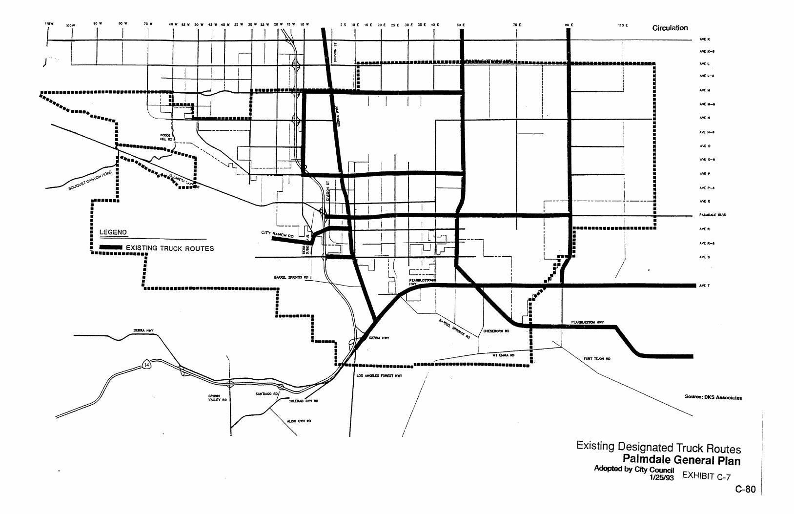
Policy C.1.7.1: Review periodically, and update as necessary, City Code provisions concerning truck routes and enforcement. Policy C.1.7.2: To the extent feasible, route through truck traffic around existing and future residential neighborhoods. Policy C.1.7.3: Designate truck routes which will serve commercial/industrial areas while minimizing adverse impacts of heavy truck traffic on these uses.
Circulation
Adopted by City Council C-9 1/25/93
Objective C1.8: Participate in multi-jurisdictional efforts to upgrade and expand the regional road network.
Policy C1.8.1: Cooperate with other agencies and jurisdictions, including Caltrans, Los Angeles County, and adjacent cities, to evaluate the proposed solutions to regional transportation issues relating to the City of Palmdale. Policy C1.8.2: Coordinate with other jurisdictions to integrate circulation networks. Policy C1.8.3: Support local, regional, state and federal agencies in identifying and implementing funding alternatives for the City’s transportation systems.
Objective C1.9: Plan for the development of arterial streetscapes which present an aesthetically pleasing appearance, promote ease of use for pedestrian and non-motorized as well as vehicular traffic, and provide maximum public safety through design features.
Policy C1.9.1: Encourage use of landscaping and construction materials which discourage graffiti on walls adjacent to public rights-of-way. Policy C1.9.2: Encourage the use of street furniture such as seating, light standards, trash receptacles and other similar features to establish design themes on arterial streets and provide amenities for pedestrians, where appropriate. Policy C1.9.3: Promote unified treatment of arterial streets with respect to medians and parkway treatment, where appropriate. Where a design theme has been established on an arterial street through existing or planned development, promote the extension of that theme along other portions of the street, where feasible and appropriate.
GOAL C2: Reduce the number of trips and vehicle miles traveled by individuals within the Planning Area, to meet regional transportation and air quality goals. Objectives C2.1: Encourage development and implementation of a variety of measures to reduce trips and vehicle miles traveled by existing and future residents and workers within the Planning Area.
Policy C2.1.1: Require Transportation Demand Management Plans from major employers, as defined by the Air Quality Management District and the Congestion Management Plan.
Circulation
C-10 Adopted by City Council 1/25/93
Policy C2.1.2: Promote the use of ridesharing by providing safe and convenient park-and-ride facilities, accessible to mass transit facilities where available, and by providing public information programs for commuters. Policy C2.1.3: Require residential developments to contribute towards City programs to reduce vehicle trips. Policy C2.1.4: Provide incentives for trip reduction measures. Policy C2.1.5: Ensure compliance with the County’s Congestion Management Plan. Policy C2.1.6: Promote alternative means of trip reduction, including telecommuting.
Objective C2.2: Increase the public transit opportunities available to Palmdale residents in order to reduce traffic impacts on streets and highways and provide travel alternatives.
Policy C2.2.1: Promote public transit operations within the Planning Area, and work with transit operators to coordinate schedules, services, service routes and fares. Policy C2.2.2: Promote the use of public transit by facilitating dedication of access routes and construction of safe and convenient stops with sufficient parking. Policy C2.2.3: Encourage location of bikeways and storage areas which are integrated with public transit facilities. Policy C2.2.4: Encourage development of regional rail transit serving the Palmdale area. Policy C2.2.5: Require provision of bus turnouts for new development, where deemed to be appropriate in consultation with the transit authority. Policy C2.2.6: Establish a regional transportation center within the City, conveniently located to maximize access to downtown and major commercial centers, which will accommodate a variety of public transportation uses including rail, bus, and shuttle service.
Circulation
Adopted by City Council C-11 1/25/93
GOAL C3: Encourage use of non-vehicular transportation throughout the Planning Area. Objective C3.1: Minimize the need for short service-oriented vehicle trips through land use and design strategies.
Policy C3.1.1: Schools, parks and neighborhoods uses should be located within convenient walking distance to residential developments. Policy C3.1.2: Land uses should be arranged in a manner which increases the opportunity to utilize alternate forms of transportation, such as transit systems, bikeways and pedestrian walkways. Policy C3.1.3: Promote bicycle accessibility to all public facilities, including parks, schools, and centers of civic activity, to include secure bicycle storage areas. Policy C3.1.4: Require residential subdivision designs to accommodate convenient pedestrian and bicycle access, both on- and off-site. Policy C3.1.5: Adopt and implement a bikeway plan as a component of the Parks, Recreation and Trails Element.
GOAL C4: Promote opportunities for rail service to move goods, passengers and commuters into and out of the Planning Area. Objective C4.1.1: Promote the use of rail service to support industry in the City.
Policy C4.1.1: Designate industrial land uses in areas with potential for freight rail service. Policy C4.1.2: Work with the Southern Pacific Transportation Company to increase surface street access across the railroad tracks while minimizing impacts on rail service.
Objective C4.2: Encourage extension of passenger rail service to the City of Palmdale.
Policy C4.2.1: Support regional efforts to connect Palmdale Regional Airport to Los Angeles International Airport with a high-speed rail line.
Circulation
C-12 Adopted by City Council 1/25/93
Policy C4.2.2: Support regional efforts to provide commuter rail service from Palmdale to the Los Angeles basin.
GOAL C5: Protect and promote a variety of air transportation services within the City of Palmdale. Objective C5.1: Protect opportunities for full utilization and expansion of Air Force Plant 42.
Policy C5.1.1: Adopt land use designations and policies which minimize encroachment of incompatible uses into space utilized by air operations. Policy C5.1.2: Implement noise and safety policies as developed by the Joint Land Use Committee and as incorporated into various elements of this General Plan. Policy C5.1.3: Coordinate development policies and decisions with Air Force Plant 42 representatives.
Objective C5.2: Promote development of Palmdale Regional Airport.
Policy C5.2.1: Promote economic development of land surrounding the airport for large-scale commercial uses, so as to support a market demand for airport services. Policy C5.2.2: Restrict encroachment of incompatible uses into land affected by future airport operations. Policy C5.2.3: Promote and support regional transportation planning for routes serving the airport facility, including State Routes 14 and 138.
Circulation
Adopted by City Council C-13 1/25/93
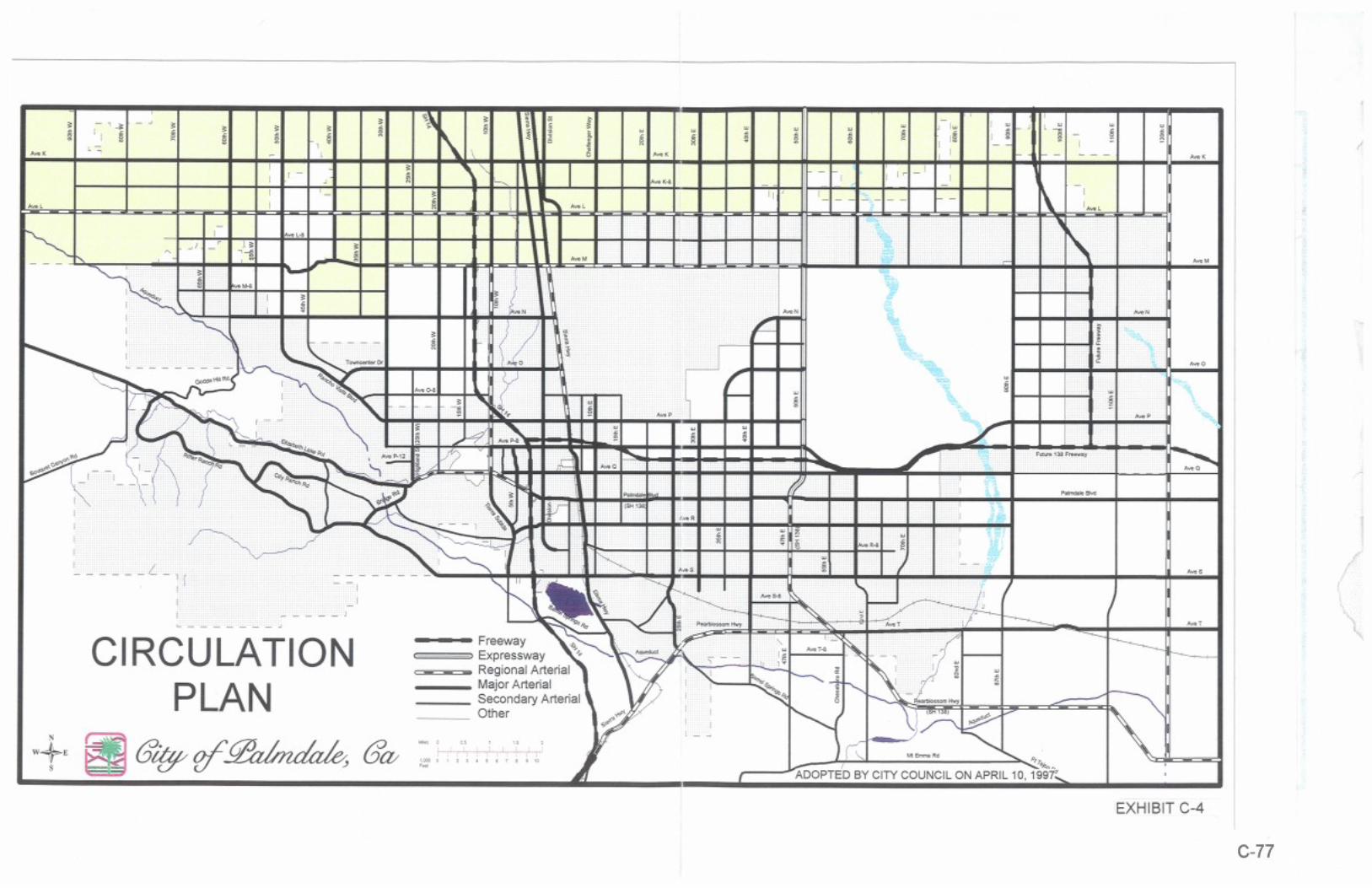
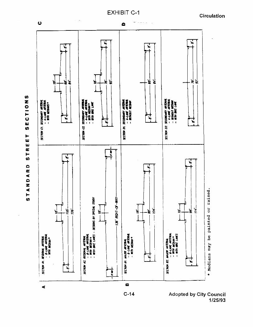
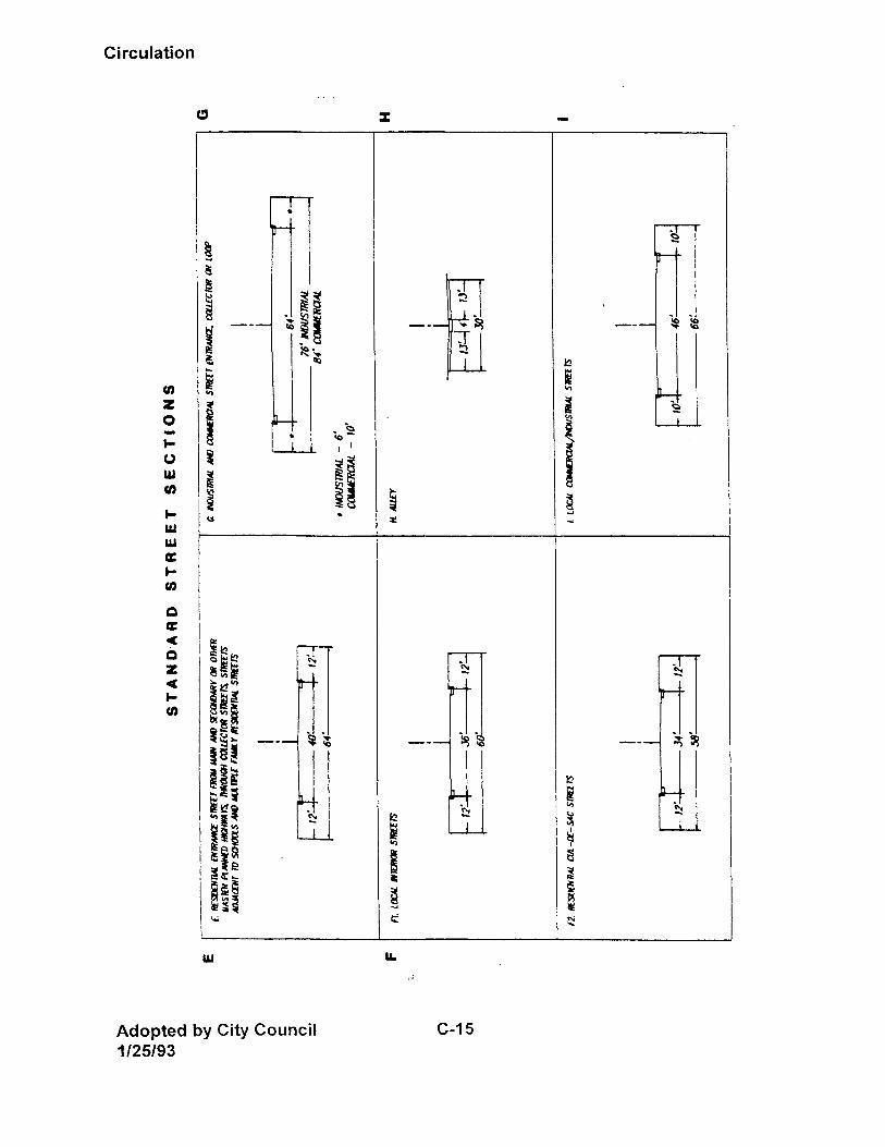
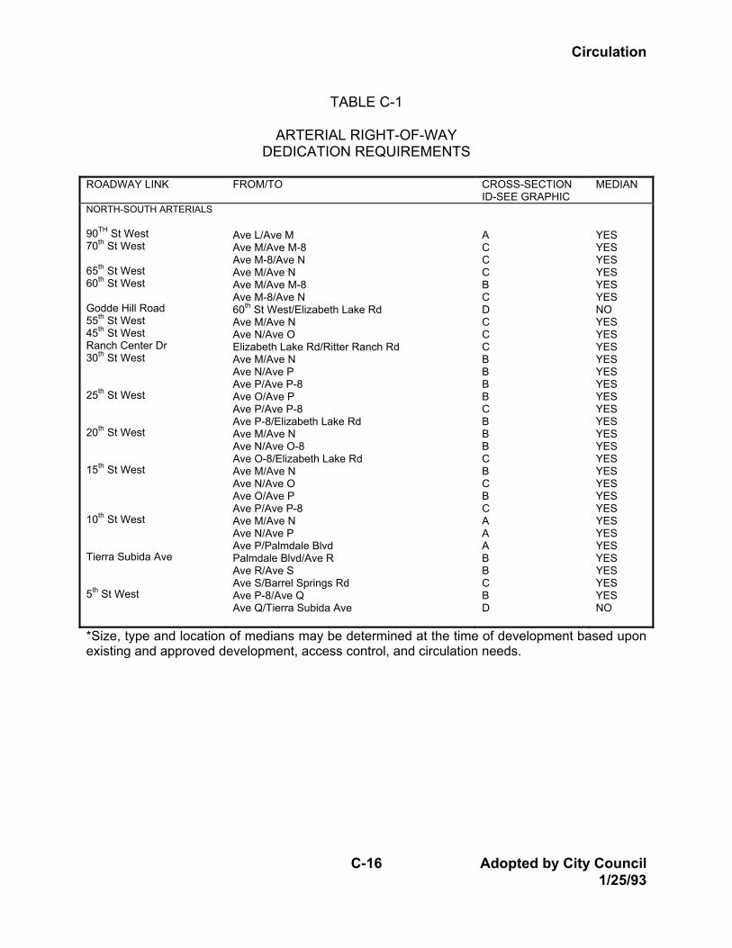
SECTION 3: IMPLEMENTATION The City’s goals, policies and objectives for development of a transportation system to meet future community needs will implemented by the following means: A. Circulation Plan The City will construct or require construction of roads and transportation facilities in conformance with the Roadway Network, presented in Exhibit C-4. The City will regularly update the Roadway Network and coordinate it with the Land use Plan, to ensure provision of transportation facilities adequate to support permitted land uses throughout the Planning Area. B. Traffic Model The City’s traffic consultants prepared a computer model of the City’s street and highway network in order to evaluate adequacy of the Circulation Plan to accommodate build-out of the Land Use Plan. The City will maintain this model to reflect changing conditions, as road improvements are constructed and new development takes place. The model will be used to evaluate future proposed changes to the Land Use Element of the General Plan. C. Street Standards The City’s adopted standards for typical street sections are established as shown on Exhibit C-1 and Table C-1. Standards specified here in shall be maximum requirements; where existing streets and approved development preclude adherence to these standards, the City will give consideration to modifications to reflect standards under which previous development was approved. Standards will be developed for intersection enhancement where needed. The cross-sections listed on Table C-1 shall be reviewed and updated as needed by the City Public Works Department.
Circulation
C-16 Adopted by City Council 1/25/93
TABLE C-1
ARTERIAL RIGHT-OF-WAY DEDICATION REQUIREMENTS
ROADWAY LINK FROM/TO CROSS-SECTION
ID-SEE GRAPHIC MEDIAN
NORTH-SOUTH ARTERIALS 90TH St West 70th St West 65th St West 60th St West Godde Hill Road 55th St West 45th St West Ranch Center Dr 30th St West 25th St West 20th St West 15th St West 10th St West Tierra Subida Ave 5th St West
Ave L/Ave M Ave M/Ave M-8 Ave M-8/Ave N Ave M/Ave N Ave M/Ave M-8 Ave M-8/Ave N 60th St West/Elizabeth Lake Rd Ave M/Ave N Ave N/Ave O Elizabeth Lake Rd/Ritter Ranch Rd Ave M/Ave N Ave N/Ave P Ave P/Ave P-8 Ave O/Ave P Ave P/Ave P-8 Ave P-8/Elizabeth Lake Rd Ave M/Ave N Ave N/Ave O-8 Ave O-8/Elizabeth Lake Rd Ave M/Ave N Ave N/Ave O Ave O/Ave P Ave P/Ave P-8 Ave M/Ave N Ave N/Ave P Ave P/Palmdale Blvd Palmdale Blvd/Ave R Ave R/Ave S Ave S/Barrel Springs Rd Ave P-8/Ave Q Ave Q/Tierra Subida Ave
A C C C B C D C C C B B B B C B B B C B C B C A A A B B C B D
YES YES YES YES YES YES NO YES YES YES YES YES YES YES YES YES YES YES YES YES YES YES YES YES YES YES YES YES YES YES NO
*Size, type and location of medians may be determined at the time of development based upon existing and approved development, access control, and circulation needs.
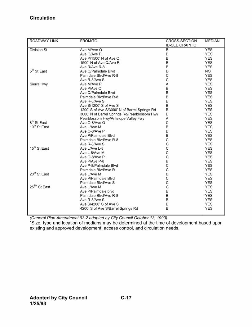
Circulation
Adopted by City Council C-17 1/25/93
ROADWAY LINK FROM/TO CROSS-SECTION
ID-SEE GRAPHIC MEDIAN
Division St 5th St East Sierra Hwy 8th St East 10th St East 15th St East 20th St East 25TH St East
Ave M/Ave O Ave O/Ave P Ave P/1500’ N of Ave Q 1500’ N of Ave Q/Ave R Ave R/Ave R-8 Ave Q/Palmdale Blvd Palmdale Blvd/Ave R-8 Ave R-8/Ave S Ave M/Ave P Ave P/Ave Q Ave Q/Palmdale Blvd Palmdale Blvd/Ave R-8 Ave R-8/Ave S Ave S/1200’ S of Ave S 1200’ S of Ave S/3000’ N of Barrel Springs Rd 3000’ N of Barrel Springs Rd/Pearblossom Hwy Pearblossom Hwy/Antelope Valley Fwy Ave O-8/Ave Q Ave L/Ave M Ave O-8/Ave P Ave P/Palmdale Blvd Palmdale Blvd/Ave R-8 Ave R-8/Ave S Ave L/Ave L-8 Ave L-8/Ave M Ave O-8/Ave P Ave P/Ave P-8 Ave P-8/Palmdale Blvd Palmdale Blvd/Ave R Ave L/Ave M Ave P/Palmdale Blvd Palmdale Blvd/Ave S Ave L/Ave M Ave P/Palmdale blvd Palmdale Blvd/Ave R-8 Ave R-8/Ave S Ave S/4200’ S of Ave S 4200’ S of Ave S/Barrel Springs Rd
B B B B B D C C A B B B B B B B A C B B B C C C C C B C C B C C C B B B B B
YES YES YES YES YES NO YES YES YES YES YES YES YES YES YES YES YES YES YES YES YES YES YES YES YES YES YES YES YES YES YES YES YES YES YES YES YES YES
(General Plan Amendment 93-2 adopted by City Council October 13, 1993) *Size, type and location of medians may be determined at the time of development based upon existing and approved development, access control, and circulation needs.
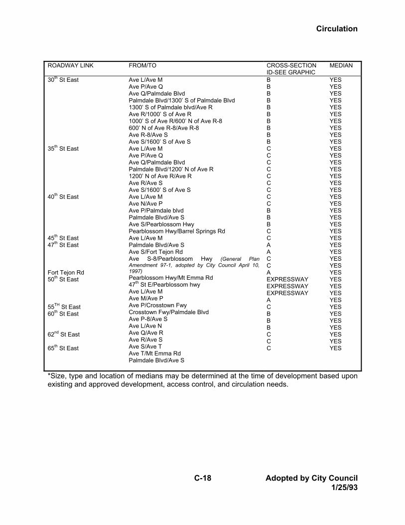
Circulation
C-18 Adopted by City Council 1/25/93
ROADWAY LINK FROM/TO CROSS-SECTION
ID-SEE GRAPHIC MEDIAN
30th St East 35th St East 40th St East 45th St East 47th St East Fort Tejon Rd 50th St East 55TH St East 60th St East 62nd St East 65th St East
Ave L/Ave M Ave P/Ave Q Ave Q/Palmdale Blvd Palmdale Blvd/1300’ S of Palmdale Blvd 1300’ S of Palmdale blvd/Ave R Ave R/1000’ S of Ave R 1000’ S of Ave R/600’ N of Ave R-8 600’ N of Ave R-8/Ave R-8 Ave R-8/Ave S Ave S/1600’ S of Ave S Ave L/Ave M Ave P/Ave Q Ave Q/Palmdale Blvd Palmdale Blvd/1200’ N of Ave R 1200’ N of Ave R/Ave R Ave R/Ave S Ave S/1600’ S of Ave S Ave L/Ave M Ave N/Ave P Ave P/Palmdale blvd Palmdale Blvd/Ave S Ave S/Pearblossom Hwy Pearblossom Hwy/Barrel Springs Rd Ave L/Ave M Palmdale Blvd/Ave S Ave S/Fort Tejon Rd Ave S-8/Pearblossom Hwy (General Plan Amendment 97-1, adopted by City Council April 10, 1997) Pearblossom Hwy/Mt Emma Rd 47th St E/Pearblossom hwy Ave L/Ave M Ave M/Ave P Ave P/Crosstown Fwy Crosstown Fwy/Palmdale Blvd Ave P-8/Ave S Ave L/Ave N Ave Q/Ave R Ave R/Ave S Ave S/Ave T Ave T/Mt Emma Rd Palmdale Blvd/Ave S
B B B B B B B B B B C C C C C C C C C B B B C C A A C C A EXPRESSWAY EXPRESSWAY EXPRESSWAY A C B B B C C C
YES YES YES YES YES YES YES YES YES YES YES YES YES YES YES YES YES YES YES YES YES YES YES YES YES YES YES YES YES YES YES YES YES YES YES YES YES YES YES YES
*Size, type and location of medians may be determined at the time of development based upon existing and approved development, access control, and circulation needs.
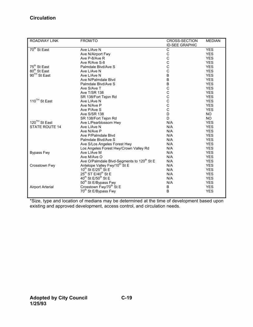
Circulation
Adopted by City Council C-19 1/25/93
ROADWAY LINK FROM/TO CROSS-SECTION
ID-SEE GRAPHIC MEDIAN
70th St East 75th St East 80th St East 90TH St East 110TH St East 120TH St East STATE ROUTE 14 Bypass Fwy Crosstown Fwy Airport Arterial
Ave L/Ave N Ave N/Airport Fwy Ave P-8/Ave R Ave R/Ave S-8 Palmdale Blvd/Ave S Ave L/Ave N Ave L/Ave N Ave N/Palmdale Blvd Palmdale Blvd/Ave S Ave S/Ave T Ave T/SR 138 SR 138/Fort Tejon Rd Ave L/Ave N Ave N/Ave P Ave P/Ave S Ave S/SR 138 SR 138/Fort Tejon Rd Ave L/Pearblossom Hwy Ave L/Ave N Ave N/Ave P Ave P/Palmdale Blvd Palmdale Blvd/Ave S Ave S/Los Angeles Forest Hwy Los Angeles Forest Hwy/Crown Valley Rd Ave L/Ave M Ave M/Ave O Ave O/Palmdale Blvd-Segments to 120th St E Antelope Valley Fwy/10th St E 10th St E/25th St E 25th ST E/40th St E 40th St E/50th St E 50th St E/Bypass Fwy Crosstown Fwy/70th St E 70th St E/Bypass Fwy
C C C C C C B B B C C C C C C D D N/A N/A N/A N/A N/A N/A N/A N/A N/A N/A N/A N/A N/A N/A N/A B B
YES YES YES YES YES YES YES YES YES YES YES YES YES YES YES NO NO YES YES YES YES YES YES YES YES YES YES YES YES YES YES YES YES YES
*Size, type and location of medians may be determined at the time of development based upon existing and approved development, access control, and circulation needs.

Circulation
C-20 Adopted by City Council 1/25/93
ROADWAY LINK FROM/TO CROSS-SECTION
ID-SEE GRAPHIC MEDIAN
EAST-WEST ARTERIALS Avenue L Avenue L-8 Avenue M Avenue M-8 Avenue N Avenue O Avenue O-8
10th St E/20th St E 20th St E/40th St E 40th St E/50th St E 50th St E/90th ST E 90th St E/120th St E 10th St E/20th St E 20th St E/50th St E 90th St A/80th St W 80th St W/60th St W 60th St W/30th St W 30th St W/15th St W 15th St W/Antelope Valley Fwy Antelope Valley Fwy/Sierra Hwy Sierra Hwy/Division St Division St/10th St E 10th St E/15th St E 15th St E/50th St E 50th St E/90th St E 90th St E/120th St E 70th St W/60th St W 60th St W/53rd St W 53rd St W/30th St W 70th St W/60th St W 60th ST W/25th St W 25th St W/Antelope Valley Fwy Antelope Valley Fwy/10th St W 10th St W/Sierra Hwy 2000’ W of 40th St E/90th St E 90th St E/120th St E Rancho Vista Blvd/30th St W 30th St W/10th St W 10th St W/Sierra Hwy 90th St E/120th St E Rancho Vista Blvd/10th ST W Sierra Hwy/15th St E
A A A A A C C C B B A A A A A A A B B D B D C B B B B B B B B B B C C
YES YES YES YES YES YES YES YES YES YES YES YES YES YES YES YES YES YES YES NO YES NO YES YES YES YES YES YES YES YES YES YES YES YES YES
*Size, type and location of medians may be determined at the time of development based upon existing and approved development, access control, and circulation needs.
Circulation
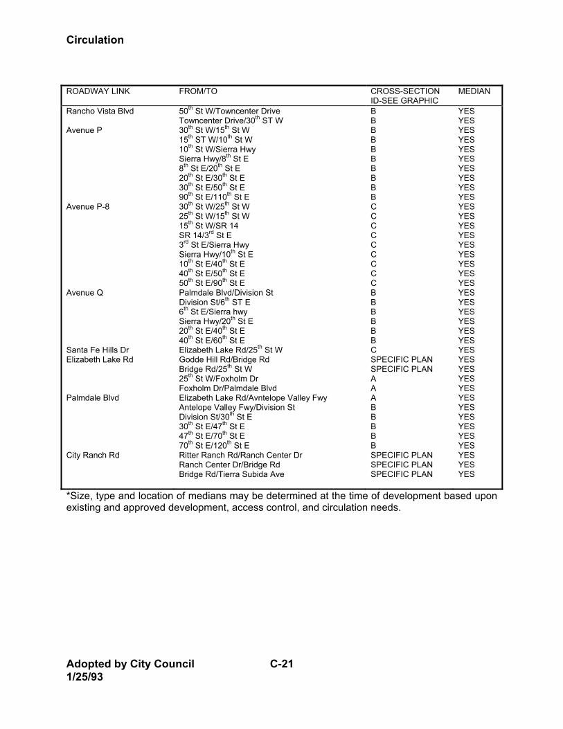
Adopted by City Council C-21 1/25/93
ROADWAY LINK FROM/TO CROSS-SECTION
ID-SEE GRAPHIC MEDIAN
Rancho Vista Blvd Avenue P Avenue P-8 Avenue Q Santa Fe Hills Dr Elizabeth Lake Rd Palmdale Blvd City Ranch Rd
50th St W/Towncenter Drive Towncenter Drive/30th ST W 30th St W/15th St W 15th ST W/10th St W 10th St W/Sierra Hwy Sierra Hwy/8th St E 8th St E/20th St E 20th St E/30th St E 30th St E/50th St E 90th St E/110th St E 30th St W/25th St W 25th St W/15th St W 15th St W/SR 14 SR 14/3rd St E 3rd St E/Sierra Hwy Sierra Hwy/10th St E 10th St E/40th St E 40th St E/50th St E 50th St E/90th St E Palmdale Blvd/Division St Division St/6th ST E 6th St E/Sierra hwy Sierra Hwy/20th St E 20th St E/40th St E 40th St E/60th St E Elizabeth Lake Rd/25th St W Godde Hill Rd/Bridge Rd Bridge Rd/25th St W 25th St W/Foxholm Dr Foxholm Dr/Palmdale Blvd Elizabeth Lake Rd/Avntelope Valley Fwy Antelope Valley Fwy/Division St Division St/30th St E 30th St E/47th St E 47th St E/70th St E 70th St E/120th St E Ritter Ranch Rd/Ranch Center Dr Ranch Center Dr/Bridge Rd Bridge Rd/Tierra Subida Ave
B B B B B B B B B B C C C C C C C C C B B B B B B C SPECIFIC PLAN SPECIFIC PLAN A A A B B B B B SPECIFIC PLAN SPECIFIC PLAN SPECIFIC PLAN
YES YES YES YES YES YES YES YES YES YES YES YES YES YES YES YES YES YES YES YES YES YES YES YES YES YES YES YES YES YES YES YES YES YES YES YES YES YES YES
*Size, type and location of medians may be determined at the time of development based upon existing and approved development, access control, and circulation needs.
Circulation
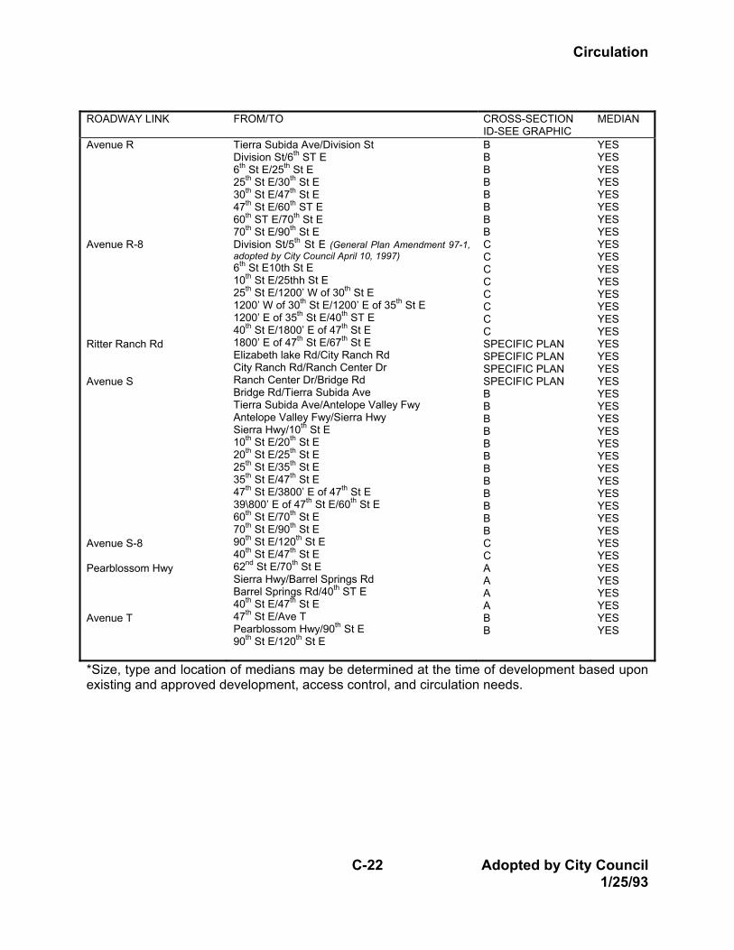
C-22 Adopted by City Council 1/25/93
ROADWAY LINK FROM/TO CROSS-SECTION
ID-SEE GRAPHIC MEDIAN
Avenue R Avenue R-8 Ritter Ranch Rd Avenue S Avenue S-8 Pearblossom Hwy Avenue T
Tierra Subida Ave/Division St Division St/6th ST E 6th St E/25th St E 25th St E/30th St E 30th St E/47th St E 47th St E/60th ST E 60th ST E/70th St E 70th St E/90th St E Division St/5th St E (General Plan Amendment 97-1, adopted by City Council April 10, 1997) 6th St E10th St E 10th St E/25thh St E 25th St E/1200’ W of 30th St E 1200’ W of 30th St E/1200’ E of 35th St E 1200’ E of 35th St E/40th ST E 40th St E/1800’ E of 47th St E 1800’ E of 47th St E/67th St E Elizabeth lake Rd/City Ranch Rd City Ranch Rd/Ranch Center Dr Ranch Center Dr/Bridge Rd Bridge Rd/Tierra Subida Ave Tierra Subida Ave/Antelope Valley Fwy Antelope Valley Fwy/Sierra Hwy Sierra Hwy/10th St E 10th St E/20th St E 20th St E/25th St E 25th St E/35th St E 35th St E/47th St E 47th St E/3800’ E of 47th St E 39\800’ E of 47th St E/60th St E 60th St E/70th St E 70th St E/90th St E 90th St E/120th St E 40th St E/47th St E 62nd St E/70th St E Sierra Hwy/Barrel Springs Rd Barrel Springs Rd/40th ST E 40th St E/47th St E 47th St E/Ave T Pearblossom Hwy/90th St E 90th St E/120th St E
B B B B B B B B C C C C C C C C SPECIFIC PLAN SPECIFIC PLAN SPECIFIC PLAN SPECIFIC PLAN B B B B B B B B B B B B C C A A A A B B
YES YES YES YES YES YES YES YES YES YES YES YES YES YES YES YES YES YES YES YES YES YES YES YES YES YES YES YES YES YES YES YES YES YES YES YES YES YES YES YES
*Size, type and location of medians may be determined at the time of development based upon existing and approved development, access control, and circulation needs.
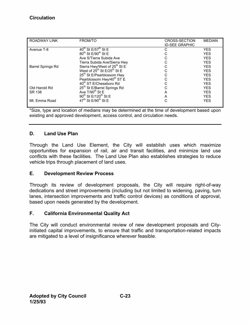
Circulation
Adopted by City Council C-23 1/25/93
ROADWAY LINK FROM/TO CROSS-SECTION
ID-SEE GRAPHIC MEDIAN
Avenue T-8 Barrel Springs Rd Old Harold Rd SR 138 Mt. Emma Road
40th St E/57th St E 80th St E/90th St E Ave S/Tierra Subida Ave Tierra Subida Ave/Sierra Hwy Sierra Hwy/West of 25th St E West of 25th St E/25th St E 25th St E/Pearblossom Hwy Pearblossom Hwy/40th ST E 40th ST E/Cheseboro Rd 25th St E/Barrel Springs Rd Ave T/90th St E 90th St E/120th St E 47th St E/90th St E
C C C C C C C C C C A A C
YES YES YES YES YES YES YES YES YES YES YES YES YES
*Size, type and location of medians may be determined at the time of development based upon existing and approved development, access control, and circulation needs. D. Land Use Plan Through the Land Use Element, the City will establish uses which maximize opportunities for expansion of rail, air and transit facilities, and minimize land use conflicts with these facilities. The Land Use Plan also establishes strategies to reduce vehicle trips through placement of land uses. E. Development Review Process Through its review of development proposals, the City will require right-of-way dedications and street improvements (including but not limited to widening, paving, turn lanes, intersection improvements and traffic control devices) as conditions of approval, based upon needs generated by the development. F. California Environmental Quality Act The City will conduct environmental review of new development proposals and City-initiated capital improvements, to ensure that traffic and transportation-related impacts are mitigated to a level of insignificance wherever feasible.
Circulation
C-24 Adopted by City Council 1/25/93
G. Congestion Management Plan The City will require developers to comply with the Congestion Management Plan (CMP) adopted by Los Angeles County Transportation Commission. The City will comply with goals, directives and programs contained in the CMP as they relate to City responsibilities. H. Right-of-Way Through the Land Use Plan and development review process, the City will reserve or limit uses within future right-of-way needed for roadways. I. Capital Improvements 1. The City will annually prepare and implement a five-year Capital Improvement
Program addressing road improvement projects. 2. The City will continue to pursue a pro-active program of signalization and
intersection improvements. 3. The Public Works Department will regularly monitor service levels throughout the
City, in order to identify deficiencies in service and program improvement schedules.
J. Transportation System Management The City will implement Transportation System Management techniques to increase capacity of the existing road system, including but not limited to signal coordination, access controls, and parking restrictions. K. Transportation Demand Management Consistent with the CMP and the Air Quality Management Plan, the City will adopt and implement a Transportation Demand management (TDM) ordinance which includes but is not limited to the following measures: 1. Support a computerized rideshare service to facilitate creation of carpools
between persons living and working in the same vicinities. 2. Provide information to businesses on how to establish carpool and vanpool
programs.
Circulation
Adopted by City Council C-25 1/25/93
3. Continue to operate the City’s Park-and-Ride facility at Highway 14 and Avenue S, and participate in construction and operation of an additional facility at Sierra Highway and Highway 14.
4. Prepare a long-range park-and-ride plan for future facilities within the City,
including methods of financing these facilities. L. Transit The City will continue to participate in the Antelope Valley Transit Authority to promote implementation of the Antelope Valley Transit Needs Plan, and other plans and programs as developed in the future. M. Commuter Transportation The City will explore opportunities for linking commuter bus service from Palmdale to rail transit services in Santa Clarita, to convey commuters to the Los Angeles basin. N. School Safety The City will continue to coordinate with school districts within the Planning Area to provide traffic safety controls and devices near schools. The City will also work with the districts to plan for adequate pick-up and drop-off areas near schools for parents and buses. O. Truck Routes The City will evaluate the Municipal Code periodically to determine the adequacy of existing designated truck routes and to address the need for modified truck routes within various areas of the City. P. Parking The City will enhance street capacity by addressing parking needs as follows: 1. Develop a downtown parking plan as part of its downtown revitalization effort. 2. Prohibit parking on all arterial streets. 3. Periodically reevaluate off-street parking requirements to ensure that adequate
parking is provided for businesses within Palmdale.
Circulation
C-26 Adopted by City Council 1/25/93
Q. Bikeway Plan The City will adopt and implement a Bikeway Plan to encourage non-vehicular travel throughout the Planning Area. R. Financing The City will pursue all feasible funding sources to support improvements to the Circulation System, including traffic impact fees, state and federal funding program, and public financing methods. The City’s Traffic Impact Fee Assessment and Master Traffic Level Maintenance Plan will be implemented, and periodically evaluated and updated, to support collection and expenditures of developer fees. S. Inter-Agency Coordination The City will continue to cooperate with other jurisdictions to develop and implement solutions to regional transportation needs. T. Streetscape Design Guidelines The City will develop, adopt and implement guidelines for design of medians, parkways and associated facilities through the Community Design Element of the General Plan. U. Westside Transportation Corridor The City will, through input on the Antelope Valley Sketch Plan, assist in evaluating the potential location, size and designation of a regional north-south transportation corridor within the west side of the Antelope Valley. V. Pearblossom Highway The City will prepare a design study for the Pearblossom Highway corridor. The study will consider existing rights-of-way, established and proposed land use patterns, accommodation of pedestrian and bicycle facilities and design alternatives that ensure pedestrian safety, and alternative means of addressing circulation/access concerns including the potential redesignation of Pearblossom Highway to an Expressway.
Circulation
C-27 Adopted by City Council 1/25/93
SECTION 4: ISSUES AND OPPORTUNITIES The purpose of the Circulation Element is to evaluate the transportation needs of the City and present a comprehensive transportation plan to accommodate those needs. The Element addresses surface streets and highways, air and rail service, public transit and transportation management issues. Background information and planning issues relating to each of these topics are contained in this section of the Element. A. Street and Highway System A city's roadway system consists of a wide range of transportation facilities which serve two basic functions: mobility and land access. Mobility means providing the ability for motorists to travel between their points of activity. Land access means providing for parking, storage or other types of driveway access at the final destination. A circulation network is composed of facilities that emphasize mobility or access to different degrees. The following types of facilities are typically defined: • Freeway. Mobility with very limited access. • Expressway. Mobility with more frequent access to arterial streets than a
freeway, but no direct land access. • Arterial. Mobility with access to collectors, some local streets and major traffic. • Collector. Connects local streets with arterials and also provides access to
adjacent land uses; thus balancing mobility with access. • Local. Provides access to adjacent land uses exclusively. Street and highway systems are designed in the above manner as a means of achieving the goals of mobility and access in an efficient manner. While it might be desirable to provide both access and mobility on all facilities, no one would favor arterial street standards for all facilities in a circulation system. The designation of the above types of streets thus has a functional and economic value to the community. Problems occur when a street designed to provide mobility is expected to provide for land access as well. Land access typically requires driveways or local streets to move vehicles off the street and onto the property in question. When too many access points are provided on a street intended for mobility, friction and conflicts occur between vehicles needing access and vehicles using the facility for mobility. The different functions of various roadways require specific methods of analysis and design. Each street type must meet different traffic capacity and access requirements. For example, local streets are not designed or intended to serve as regional thoroughfares. For this reason, various street types are treated separately in the
Circulation
Adopted by City Council C-28 1/25/93
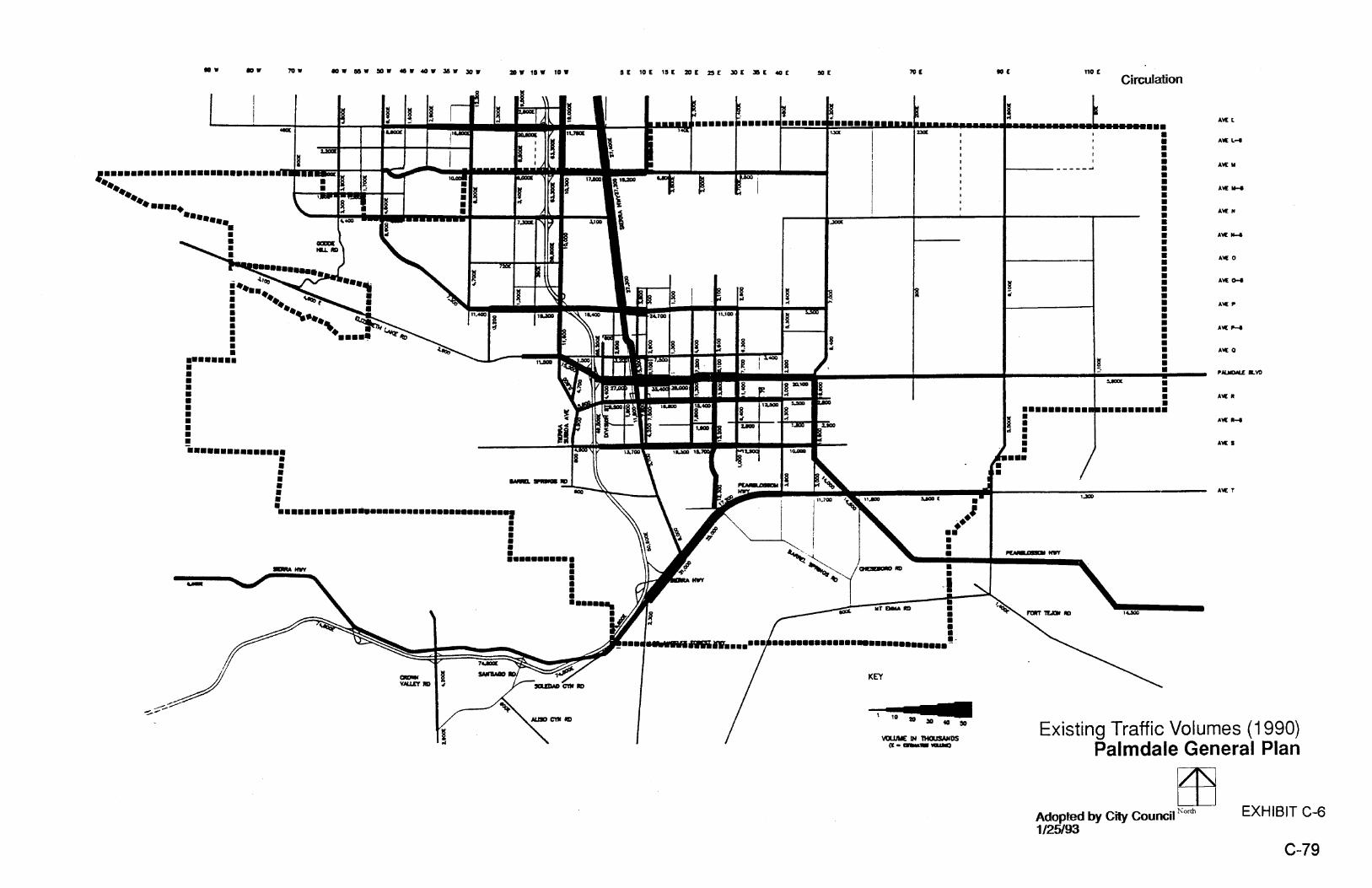
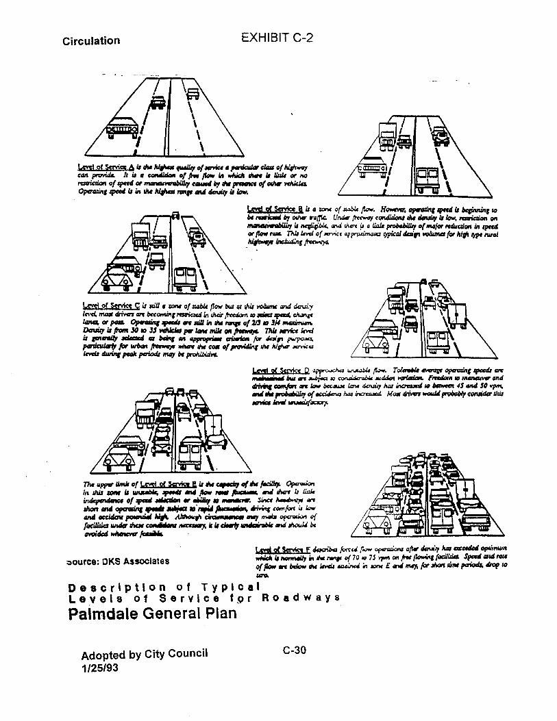
following discussion. Prior to discussing existing and future roadway conditions in the Planning Area, however, a brief overview of the methodology used to analyze the street network is provided. 1. Circulation Analysis Methods Five steps were involved in developing the roadway component of the Circulation Element: (1) documenting existing conditions and assembling a factual data base; (2) the development and validation of the transportation model, which was used to forecast future usage of alternative circulation plans; (3) the identification of problems, opportunities and issues; (4) testing and evaluating alternative improvement plans; and (5) the selection and refinement of the recommended circulation plan. These steps are briefly described below. a. Existing Roadway Analysis Palmdale's existing roadway network and functional classification system is illustrated in Exhibit C-5. Annual daily traffic volumes for most of the arterials within the City (1990) were obtained through traffic counts, to assess existing levels of service. The evaluation of Palmdale's circulation system focused on two major criteria: capacity and connectivity. Capacity refers to the ability of the street system (roadways and intersections) to adequately serve the demand placed on it. It is a measure of how well the mobility needs of the City are provided for. Connectivity is defined less precisely as a measure of how well various parts of the City are joined together, and how easy it is to move between different parts of the City. Connectivity is also related to how well, in a more global sense, land access is provided in the City. The capacity of a roadway is affected by a number of factors, including the street's width, the number of crossing arterials and collectors, the amount of green time given to the street at each signal, the presence or absence of on-street parking, the number of turning lanes at each intersection and the number of driveways. Roadway capacities were defined for each street (see Table C-5). Intersection capacity depends on the lane configuration, meaning the number of through lanes and left-turn lanes. Utilization of an intersection during the peak hours provides a measure of service level. The level of service (LOS) designation of a roadway or an intersection indicates whether the capacity is adequate to handle the volume of traffic using the facility. LOS A indicates a good service level, with minimal stacking of vehicles, while LOS F describes
Circulation
C-29 Adopted by City Council 1/25/93
densely congested conditions. A description of service level categories is provided in Exhibit C-2. Existing capacities and levels of service for Palmdale's arterial streets and highways were calculated and are presented in the following sections dealing with specific roadway types. With regard to connectivity or linkage within Palmdale's roadway system, the Element analyzed missing segments in the street pattern which disrupt traffic flow. A discussion of future needs in this area is also included in sections dealing with specific roadway types. b. Development of the Traffic Model The traffic consultants retained to analyze Palmdale's roadway system and develop a circulation plan utilized a computerized traffic model. The traffic model focuses on the Palmdale/Lancaster area, and extends from Avenue J to the north to Mt. Emma Road and Soledad Canyon Road to the south, and from 110th Street West to the west to 120th Street East to the east. For modeling purposes, this area was divided into 91 traffic analysis zones (TAZ's). Another 32 zones were identified where roadways cross the analysis area boundary to represent trips to/from locations outside the study area. Though the model includes a portion of Lancaster for purposes of developing the Circulation Element, only the City of Palmdale was studied. The traffic model utilized TRANPLAN software, which has also been utilized by the same consultant (DKS Associates) to model the City of Lancaster's General Plan network. TRANPLAN software is also used by Southern California Association of Governments (SCAG) and Caltrans for their subarea studies, ensuring that Palmdale's traffic model has regional as well as local applications. Traffic analysis with a model of this type involves four steps: (1) specification of the roadway network; (2) development of vehicle trip generation rates for uses within each analysis zone; (3) distribution of these vehicle trips to destination points; and (4) assignment of vehicle trips to specific roadway segments. Based on this analysis, the model will indicate whether planned roadway widths will be adequate to handle projected traffic volumes, and where capacity problems will occur.
Circulation
C-31 Adopted by City Council 1/25/93
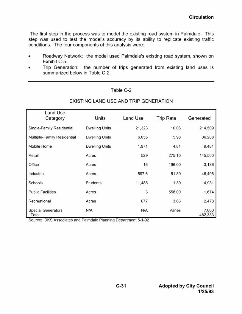
The first step in the process was to model the existing road system in Palmdale. This step was used to test the model's accuracy by its ability to replicate existing traffic conditions. The four components of this analysis were: • Roadway Network: the model used Palmdale's existing road system, shown on
Exhibit C-5. • Trip Generation: the number of trips generated from existing land uses is
summarized below in Table C-2.
Table C-2
EXISTING LAND USE AND TRIP GENERATION
Land Use Category
Units
Land Use
Trip Rate
Generated
Single-Family Residential Dwelling Units 21,323 10.06 214,509 Multiple-Family Residential Dwelling Units 6,055 5.98 36,208 Mobile Home Dwelling Units 1,971 4.81 9,481 Retail Acres 529 275.16 145,560 Office Acres 16 196.00 3,136 Industrial Acres 897.6 51.80 46,496 Schools Students 11,485 1.30 14,931 Public Facilities Acres 3 558.00 1,674 Recreational Acres 677 3.66 2,478 Special Generators Total
N/A N/A Varies 7,860482,333
Source: DKS Associates and Palmdale Planning Department 5-1-92
Circulation
Adopted by City Council C-32 1/25/93
• Trip Distribution: Distribution of vehicle trips was calibrated based upon an
analysis of existing traffic counts within the Planning Area. Trips were distributed both within and outside the study area.
• Trip Assignment: Trip assignments were refined based upon a detailed analysis of intersection capacity to produce estimates of traffic volumes on the roadway system.
After developing and calibrating the traffic model, the consultants performed several different runs of the model based upon various assumptions. The model was run to predict traffic volumes in year 2010 and at buildout of the land uses permitted by the Land Use Element. It was also run using the existing Circulation Plan network and a revised network. The estimated number of trips generated from General Plan buildout is shown in Table C-3. The model was also run assuming that various trip reduction (Transportation Demand Management, or TDM) measures were adopted throughout the City. TDM measures reduce the total number of vehicle trips at peak hours by promoting public transit, ride-sharing, flexible working schedules, telecommuting and similar methods. Results of the various model runs are discussed in the following sections. c. Identification of Issues Based upon their analysis of existing conditions and the traffic model results, the consultants identified several traffic needs which have been addressed throughout this Circulation Element. Other issues were identified through the public input process, CAC meetings and Planning Commission hearings. The following issues were identified: 1. The need to upgrade and increase capacity on State Route 14, including
interchange upgrades. 2. The need to realign and widen Highway 138 for additional capacity, improved
level of service, and to serve the Regional Airport. 3. The need for increased arterial roadway capacity along north-south routes,
especially east of State Route 14. 4. The need for grade separations over the railroad tracks.
Circulation
C-33 Adopted by City Council 1/25/93
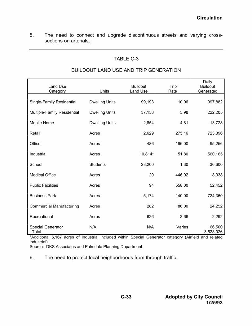
5. The need to connect and upgrade discontinuous streets and varying cross-sections on arterials.
TABLE C-3
BUILDOUT LAND USE AND TRIP GENERATION
Land Use Category
Units
Buildout
Land Use
Trip
Rate
Daily Buildout
Generated Single-Family Residential Dwelling Units 99,193 10.06 997,882 Multiple-Family Residential Dwelling Units 37,158 5.98 222,205 Mobile Home Dwelling Units 2,854 4.81 13,728 Retail Acres 2,629 275.16 723,396 Office Acres 486 196.00 95,256 Industrial Acres 10,814* 51.80 560,165 School Students 28,200 1.30 36,600 Medical Office Acres 20 446.92 8,938 Public Facilities Acres 94 558.00 52,452 Business Park Acres 5,174 140.00 724,360 Commercial Manufacturing Acres 282 86.00 24,252 Recreational Acres 626 3.66 2,292 Special Generator Total
N/A N/A Varies 66,5003,528,026
*Additional 6,167 acres of Industrial included within Special Generator category (Airfield and related industrial). Source: DKS Associates and Palmdale Planning Department 6. The need to protect local neighborhoods from through traffic.
Circulation
Adopted by City Council C-34 1/25/93
7. The need to develop and implement comprehensive Transportation Demand Management (TDM) and Transportation System Management (TSM) techniques to increase capacities on existing roadways.
8. The need to increase right-of-way widths to accommodate bikeways. 9. The need to coordinate circulation plans of individual development projects with
each other and with the surrounding street network. 10. The need to define alignments for arterial roads within vacant, undeveloped
areas which are ready for development. 11. The need to protect arterial street capacity from excessive cross traffic and
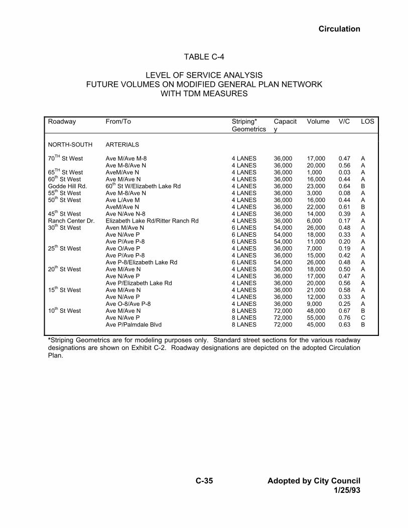
turning movements. d. Evaluating Alternative Improvement Plans Once the traffic model was completed and run, it was necessary to make certain adjustments to the Land Use Plan and the road network plan to achieve acceptable Levels of Service at General Plan buildout. In addition, it was necessary in 1990 to expand the network and model to include two specific plan areas in the southwest portion of the Planning Area. In 1991, the model was re-run to reflect revised estimates of buildout, particularly in the Industry Trade Center and Airport Corridor Specific Plan areas, and to more accurately reflect existing build-out conditions. The latest traffic model run was completed in March, 1992, and shows acceptable levels of service throughout the Planning Area. e. Refinement of the Circulation Plan Based upon the latest traffic model run, the original network has been re-evaluated and several adjustments were made to recommended street widths. In some cases, ultimate right-of-way was reduced based on projected traffic volumes which were lower than expected. In other cases, additional right-of-way is recommended. The final result of this analysis is presented in Table C-4 which lists the buildout traffic volumes on the Future Roadway Network.
Circulation
C-35 Adopted by City Council 1/25/93
TABLE C-4
LEVEL OF SERVICE ANALYSIS FUTURE VOLUMES ON MODIFIED GENERAL PLAN NETWORK
WITH TDM MEASURES
Roadway From/To Striping* Geometrics
Capacity
Volume V/C LOS
NORTH-SOUTH
ARTERIALS
70TH St West 65TH St West 60th St West Godde Hill Rd. 55th St West 50th St West 45th St West Ranch Center Dr. 30th St West 25th St West 20th St West 15th St West 10th St West
Ave M/Ave M-8 Ave M-8/Ave N AveM/Ave N Ave M/Ave N 60th St W/Elizabeth Lake Rd Ave M-8/Ave N Ave L/Ave M AveM/Ave N Ave N/Ave N-8 Elizabeth Lake Rd/Ritter Ranch Rd Aven M/Ave N Ave N/Ave P Ave P/Ave P-8 Ave O/Ave P Ave P/Ave P-8 Ave P-8/Elizabeth Lake Rd Ave M/Ave N Ave N/Ave P Ave P/Elizabeth Lake Rd Ave M/Ave N Ave N/Ave P Ave O-8/Ave P-8 Ave M/Ave N Ave N/Ave P Ave P/Palmdale Blvd
4 LANES 4 LANES 4 LANES 4 LANES 4 LANES 4 LANES 4 LANES 4 LANES 4 LANES 4 LANES 6 LANES 6 LANES 6 LANES 4 LANES 4 LANES 6 LANES 4 LANES 4 LANES 4 LANES 4 LANES 4 LANES 4 LANES 8 LANES 8 LANES 8 LANES
36,000 36,000 36,000 36,000 36,000 36,000 36,000 36,000 36,000 36,000 54,000 54,000 54,000 36,000 36,000 54,000 36,000 36,000 36,000 36,000 36,000 36,000 72,000 72,000 72,000
17,000 20,000 1,000 16,000 23,000 3,000 16,000 22,000 14,000 6,000 26,000 18,000 11,000 7,000 15,000 26,000 18,000 17,000 20,000 21,000 12,000 9,000 48,000 55,000 45,000
0.47 0.56 0.03 0.44 0.64 0.08 0.44 0.61 0.39 0.17 0.48 0.33 0.20 0.19 0.42 0.48 0.50 0.47 0.56 0.58 0.33 0.25 0.67 0.76 0.63
A A A A B A A B A A A A A A A A A A A A A A B C B
*Striping Geometrics are for modeling purposes only. Standard street sections for the various roadway designations are shown on Exhibit C-2. Roadway designations are depicted on the adopted Circulation Plan.
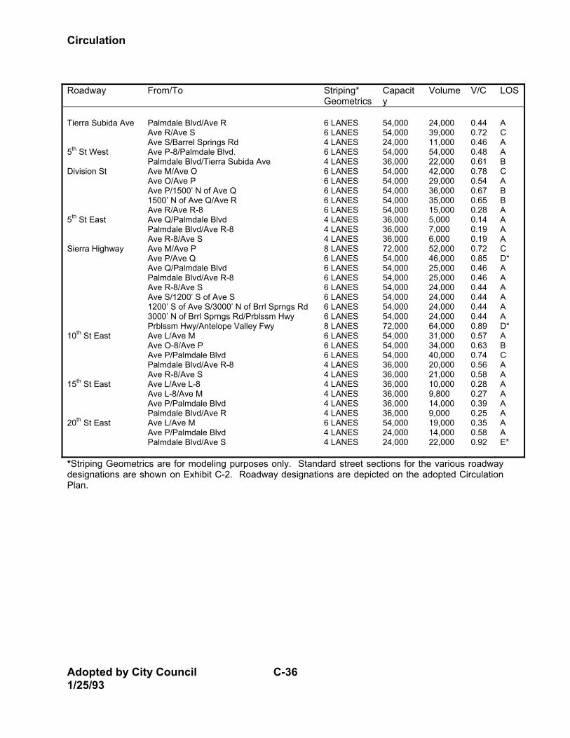
Circulation
Adopted by City Council C-36 1/25/93
Roadway From/To Striping*
Geometrics Capacity
Volume V/C LOS
Tierra Subida Ave 5th St West Division St 5th St East Sierra Highway 10th St East 15th St East 20th St East
Palmdale Blvd/Ave R Ave R/Ave S Ave S/Barrel Springs Rd Ave P-8/Palmdale Blvd. Palmdale Blvd/Tierra Subida Ave Ave M/Ave O Ave O/Ave P Ave P/1500’ N of Ave Q 1500’ N of Ave Q/Ave R Ave R/Ave R-8 Ave Q/Palmdale Blvd Palmdale Blvd/Ave R-8 Ave R-8/Ave S Ave M/Ave P Ave P/Ave Q Ave Q/Palmdale Blvd Palmdale Blvd/Ave R-8 Ave R-8/Ave S Ave S/1200’ S of Ave S 1200’ S of Ave S/3000’ N of Brrl Sprngs Rd 3000’ N of Brrl Sprngs Rd/Prblssm Hwy Prblssm Hwy/Antelope Valley Fwy Ave L/Ave M Ave O-8/Ave P Ave P/Palmdale Blvd Palmdale Blvd/Ave R-8 Ave R-8/Ave S Ave L/Ave L-8 Ave L-8/Ave M Ave P/Palmdale Blvd Palmdale Blvd/Ave R Ave L/Ave M Ave P/Palmdale Blvd Palmdale Blvd/Ave S
6 LANES 6 LANES 4 LANES 6 LANES 4 LANES 6 LANES 6 LANES 6 LANES 6 LANES 6 LANES 4 LANES 4 LANES 4 LANES 8 LANES 6 LANES 6 LANES 6 LANES 6 LANES 6 LANES 6 LANES 6 LANES 8 LANES 6 LANES 6 LANES 6 LANES 4 LANES 4 LANES 4 LANES 4 LANES 4 LANES 4 LANES 6 LANES 4 LANES 4 LANES
54,000 54,000 24,000 54,000 36,000 54,000 54,000 54,000 54,000 54,000 36,000 36,000 36,000 72,000 54,000 54,000 54,000 54,000 54,000 54,000 54,000 72,000 54,000 54,000 54,000 36,000 36,000 36,000 36,000 36,000 36,000 54,000 24,000 24,000
24,000 39,000 11,000 54,000 22,000 42,000 29,000 36,000 35,000 15,000 5,000 7,000 6,000 52,000 46,000 25,000 25,000 24,000 24,000 24,000 24,000 64,000 31,000 34,000 40,000 20,000 21,000 10,000 9,800 14,000 9,000 19,000 14,000 22,000
0.44 0.72 0.46 0.48 0.61 0.78 0.54 0.67 0.65 0.28 0.14 0.19 0.19 0.72 0.85 0.46 0.46 0.44 0.44 0.44 0.44 0.89 0.57 0.63 0.74 0.56 0.58 0.28 0.27 0.39 0.25 0.35 0.58 0.92
A C A A B C A B B A A A A C D* A A A A A A D* A B C A A A A A A A A E*
*Striping Geometrics are for modeling purposes only. Standard street sections for the various roadway designations are shown on Exhibit C-2. Roadway designations are depicted on the adopted Circulation Plan.
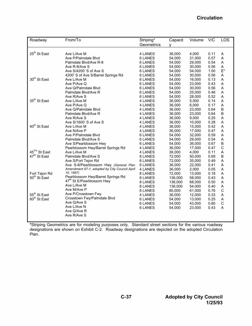
Circulation
C-37 Adopted by City Council 1/25/93
Roadway From/To Striping*
Geometrics Capacity
Volume V/C LOS
25th St East 30th St East 35th St East 40th St East 45TH St East 47th St East Fort Tejon Rd 50th St East 55th St East 60th St East
Ave L/Ave M Ave P/Palmdale Blvd Palmdale Blvd/Ave R-8 Ave R-8/Ave S Ave S/4200’ S of Ave S 4200’ S of Ave S/Barrel Springs Rd Ave L/Ave M Ave P/Ave Q Ave Q/Palmdale Blvd Palmdale Blvd/Ave R Ave R/Ave S Ave L/Ave M Ave P/Ave Q Ave Q/Palmdale Blvd Palmdale Blvd/Ave R Ave R/Ave S Ave S/1600’ S of Ave S Ave L/Ave M Ave N/Ave P Ave P/Palmdale Blvd Palmdale Blvd/Ave S Ave S/Pearblossom Hwy Pearblossom Hwy/Barrel Springs Rd Ave L/Ave M Palmdale Blvd/Ave S Ave S/Fort Tejon Rd Ave S-8/Pearblossom Hwy (General Plan Amendment 97-1, adopted by City Council April 10, 1997) Pearblossom Hwy/Barrel Springs Rd 47th St E/Pearblossom Hwy Ave L/Ave M Ave M/Ave P Ave P/Crosstown Fwy Crosstown Fwy/Palmdale Blvd Ave Q/Ave S Ave L/Ave N Ave Q/Ave R Ave R/Ave S
4 LANES 6 LANES 6 LANES 6 LANES 6 LANES 6 LANES 6 LANES 6 LANES 6 LANES 6 LANES 6 LANES 4 LANES 4 LANES 4 LANES 4 LANES 4 LANES 4 LANES 4 LANES 4 LANES 6 LANES 6 LANES 6 LANES 4 LANES 4 LANES 8 LANES 8 LANES 6 LANES 4 LANES 8 LANES 8 LANES 8 LANES 8 LANES 8 LANES 4 LANES 6 LANES 6 LANES 6 LANES
36,000 54,000 54,000 54,000 54,000 54,000 54,000 54,000 54,000 54,000 54,000 36,000 36,000 36,000 36,000 36,000 36,000 36,000 36,000 54,000 54,000 54,000 36,000 36,000 72,000 72,000 36,000 36,000 72,000 136,000 136,000 136,000 80,000 36,000 54,000 54,000 54,000
4,000 31,000 29,000 30,000 54,000 30,000 16,000 23,000 30,000 25,000 28,000 5,000 6,000 23,000 23,000 9,000 10,000 15,000 17,000 32,000 29,000 36,000 17,000 4,000 50,000 35,000 22,000 2,000 13,000 58,000 68,000 54,000 61,000 12,000 13,000 43,000 23,000
0.11 0.57 0.54 0.56 1.00 0.56 0.13 0.43 0.56 0.46 0.52 0.14 0.17 0.64 0.64 0.25 0.28 0.42 0.47 0.59 0.54 0.67 0.47 0.11 0.69 0.49 0.41 0.05 0.18 0.43 0.50 0.40 0.76 0.33 0.25 0.80 0.43
A A A A E* A A A A A A A A B B A A A A A A B C A B A A A A A A A C A A C A
*Striping Geometrics are for modeling purposes only. Standard street sections for the various roadway designations are shown on Exhibit C-2. Roadway designations are depicted on the adopted Circulation Plan.
Circulation
Adopted by City Council C-38 1/25/93
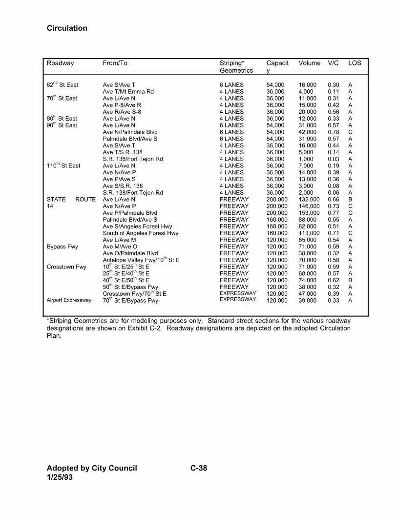
Roadway From/To Striping*
Geometrics Capacity
Volume V/C LOS
62nd St East 70th St East 80th St East 90th St East 110th St East STATE ROUTE 14 Bypass Fwy Crosstown Fwy Airport Expressway
Ave S/Ave T Ave T/Mt Emma Rd Ave L/Ave N Ave P-8/Ave R Ave R/Ave S-8 Ave L/Ave N Ave L/Ave N Ave N/Palmdale Blvd Palmdale Blvd/Ave S Ave S/Ave T Ave T/S.R. 138 S.R. 138/Fort Tejon Rd Ave L/Ave N Ave N/Ave P Ave P/Ave S Ave S/S.R. 138 S.R. 138/Fort Tejon Rd Ave L/Ave N Ave N/Ave P Ave P/Palmdale Blvd Palmdale Blvd/Ave S Ave S/Angeles Forest Hwy South of Angeles Forest Hwy Ave L/Ave M Ave M/Ave O Ave O/Palmdale Blvd Antelope Valley Fwy/10th St E 10th St E/25th St E 25th St E/40th St E 40th St E/50th St E 50th St E/Bypass Fwy Crosstown Fwy/70th St E 70th St E/Bypass Fwy
6 LANES 4 LANES 4 LANES 4 LANES 4 LANES 4 LANES 6 LANES 6 LANES 6 LANES 4 LANES 4 LANES 4 LANES 4 LANES 4 LANES 4 LANES 4 LANES 4 LANES FREEWAY FREEWAY FREEWAY FREEWAY FREEWAY FREEWAY FREEWAY FREEWAY FREEWAY FREEWAY FREEWAY FREEWAY FREEWAY FREEWAY EXPRESSWAY EXPRESSWAY
54,000 36,000 36,000 36,000 36,000 36,000 54,000 54,000 54,000 36,000 36,000 36,000 36,000 36,000 36,000 36,000 36,000 200,000 200,000 200,000 160,000 160,000 160,000 120,000 120,000 120,000 120,000 120,000 120,000 120,000 120,000 120,000 120,000
16,000 4,000 11,000 15,000 20,000 12,000 31,000 42,000 31,000 16,000 5,000 1,000 7,000 14,000 13,000 3,000 2,000 132.000 146,000 153,000 88,000 82,000 113,000 65,000 71,000 38,000 70,000 71,000 68,000 74,000 38,000 47,000 39,000
0.30 0.11 0.31 0.42 0.56 0.33 0.57 0.78 0.57 0.44 0.14 0.03 0.19 0.39 0.36 0.08 0.06 0.66 0.73 0.77 0.55 0.51 0.71 0.54 0.59 0.32 0.58 0.59 0.57 0.62 0.32 0.39 0.33
A A A A A A A C A A A A A A A A A B C C A A C A A A A A A B A A A
*Striping Geometrics are for modeling purposes only. Standard street sections for the various roadway designations are shown on Exhibit C-2. Roadway designations are depicted on the adopted Circulation Plan.
Circulation
C-39 Adopted by City Council 1/25/93
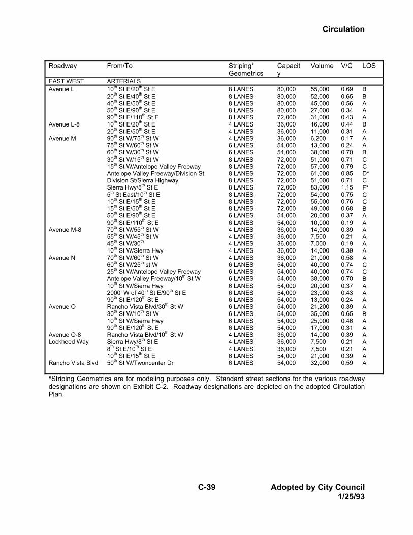
Roadway From/To Striping*
Geometrics Capacity
Volume V/C LOS
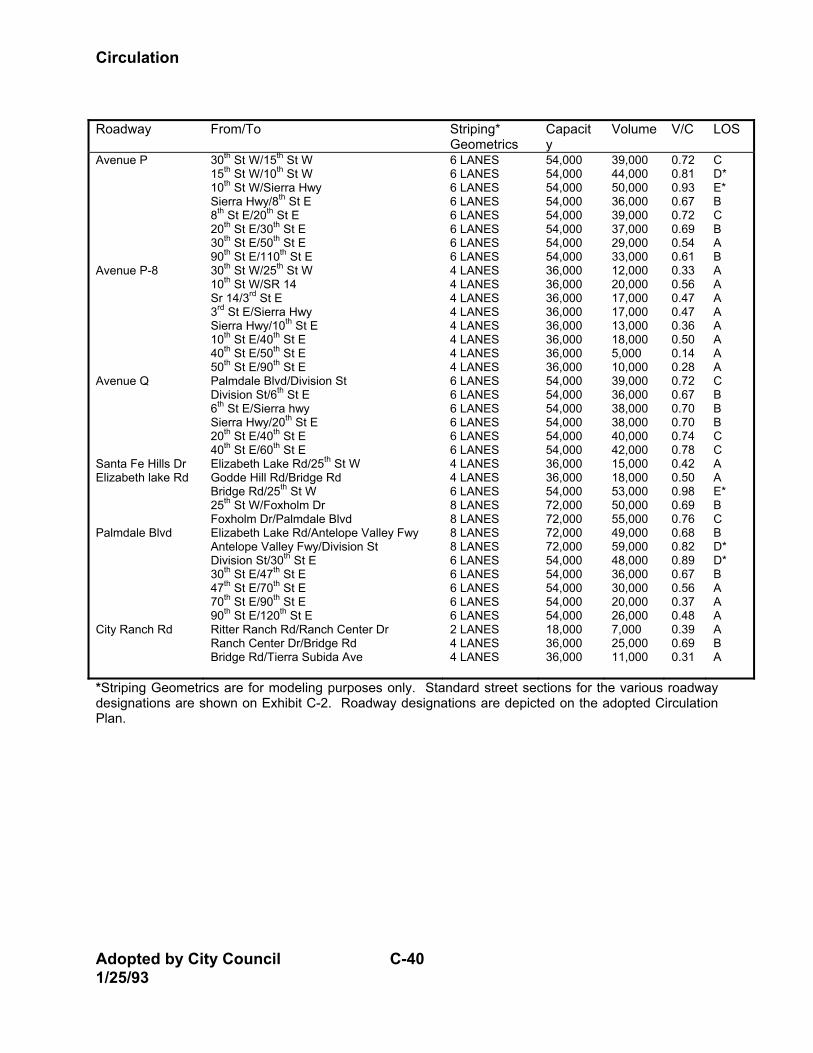
EAST WEST ARTERIALS Avenue L Avenue L-8 Avenue M Avenue M-8 Avenue N Avenue O Avenue O-8 Lockheed Way Rancho Vista Blvd
10th St E/20th St E 20th St E/40th St E 40th St E/50th St E 50th St E/90th St E 90th St E/110th St E 10th St E/20th St E 20th St E/50th St E 90th St W/75th St W 75th St W/60th St W 60th St W/30th St W 30th St W/15th St W 15th St W/Antelope Valley Freeway Antelope Valley Freeway/Division St Division St/Sierra Highway Sierra Hwy/5th St E 5th St East/10th St E 10th St E/15th St E 15th St E/50th St E 50th St E/90th St E 90th St E/110th St E 70th St W/55th St W 55th St W/45th St W 45th St W/30th 10th St W/Sierra Hwy 70th St W/60th St W 60th St W/25th st W 25th St W/Antelope Valley Freeway Antelope Valley Freeway/10th St W 10th St W/Sierra Hwy 2000’ W of 40th St E/90th St E 90th St E/120th St E Rancho Vista Blvd/30th St W 30th St W/10th St W 10th St W/Sierra Hwy 90th St E/120th St E Rancho Vista Blvd/10th St W Sierra Hwy/8th St E 8th St E/10th St E 10th St E/15th St E 50th St W/Twoncenter Dr
8 LANES 8 LANES 8 LANES 8 LANES 8 LANES 4 LANES 4 LANES 4 LANES 6 LANES 6 LANES 8 LANES 8 LANES 8 LANES 8 LANES 8 LANES 8 LANES 8 LANES 8 LANES 6 LANES 6 LANES 4 LANES 4 LANES 4 LANES 4 LANES 4 LANES 6 LANES 6 LANES 6 LANES 6 LANES 6 LANES 6 LANES 6 LANES 6 LANES 6 LANES 6 LANES 4 LANES 4 LANES 4 LANES 6 LANES 6 LANES
80,000 80,000 80,000 80,000 72,000 36,000 36,000 36,000 54,000 54,000 72,000 72,000 72,000 72,000 72,000 72,000 72,000 72,000 54,000 54,000 36,000 36,000 36,000 36,000 36,000 54,000 54,000 54,000 54,000 54,000 54,000 54,000 54,000 54,000 54,000 36,000 36,000 36,000 54,000 54,000
55,000 52,000 45,000 27,000 31,000 16,000 11,000 6,200 13,000 38,000 51,000 57,000 61,000 51,000 83,000 54,000 55,000 49,000 20,000 10,000 14,000 7,500 7,000 14,000 21,000 40,000 40,000 38,000 20,000 23,000 13,000 21,200 35,000 25,000 17,000 14,000 7,500 7,500 21,000 32,000
0.69 0.65 0.56 0.34 0.43 0.44 0.31 0.17 0.24 0.70 0.71 0.79 0.85 0.71 1.15 0.75 0.76 0.68 0.37 0.19 0.39 0.21 0.19 0.39 0.58 0.74 0.74 0.70 0.37 0.43 0.24 0.39 0.65 0.46 0.31 0.39 0.21 0.21 0.39 0.59
B B A A A B A A A B C C D* C F* C C B A A A A A A A C C B A A A A B A A A A A A A
*Striping Geometrics are for modeling purposes only. Standard street sections for the various roadway designations are shown on Exhibit C-2. Roadway designations are depicted on the adopted Circulation Plan.
Circulation
Adopted by City Council C-40 1/25/93
Roadway From/To Striping*
Geometrics Capacity
Volume V/C LOS
Avenue P Avenue P-8 Avenue Q Santa Fe Hills Dr Elizabeth lake Rd Palmdale Blvd City Ranch Rd
30th St W/15th St W 15th St W/10th St W 10th St W/Sierra Hwy Sierra Hwy/8th St E 8th St E/20th St E 20th St E/30th St E 30th St E/50th St E 90th St E/110th St E 30th St W/25th St W 10th St W/SR 14 Sr 14/3rd St E 3rd St E/Sierra Hwy Sierra Hwy/10th St E 10th St E/40th St E 40th St E/50th St E 50th St E/90th St E Palmdale Blvd/Division St Division St/6th St E 6th St E/Sierra hwy Sierra Hwy/20th St E 20th St E/40th St E 40th St E/60th St E Elizabeth Lake Rd/25th St W Godde Hill Rd/Bridge Rd Bridge Rd/25th St W 25th St W/Foxholm Dr Foxholm Dr/Palmdale Blvd Elizabeth Lake Rd/Antelope Valley Fwy Antelope Valley Fwy/Division St Division St/30th St E 30th St E/47th St E 47th St E/70th St E 70th St E/90th St E 90th St E/120th St E Ritter Ranch Rd/Ranch Center Dr Ranch Center Dr/Bridge Rd Bridge Rd/Tierra Subida Ave
6 LANES 6 LANES 6 LANES 6 LANES 6 LANES 6 LANES 6 LANES 6 LANES 4 LANES 4 LANES 4 LANES 4 LANES 4 LANES 4 LANES 4 LANES 4 LANES 6 LANES 6 LANES 6 LANES 6 LANES 6 LANES 6 LANES 4 LANES 4 LANES 6 LANES 8 LANES 8 LANES 8 LANES 8 LANES 6 LANES 6 LANES 6 LANES 6 LANES 6 LANES 2 LANES 4 LANES 4 LANES
54,000 54,000 54,000 54,000 54,000 54,000 54,000 54,000 36,000 36,000 36,000 36,000 36,000 36,000 36,000 36,000 54,000 54,000 54,000 54,000 54,000 54,000 36,000 36,000 54,000 72,000 72,000 72,000 72,000 54,000 54,000 54,000 54,000 54,000 18,000 36,000 36,000
39,000 44,000 50,000 36,000 39,000 37,000 29,000 33,000 12,000 20,000 17,000 17,000 13,000 18,000 5,000 10,000 39,000 36,000 38,000 38,000 40,000 42,000 15,000 18,000 53,000 50,000 55,000 49,000 59,000 48,000 36,000 30,000 20,000 26,000 7,000 25,000 11,000
0.72 0.81 0.93 0.67 0.72 0.69 0.54 0.61 0.33 0.56 0.47 0.47 0.36 0.50 0.14 0.28 0.72 0.67 0.70 0.70 0.74 0.78 0.42 0.50 0.98 0.69 0.76 0.68 0.82 0.89 0.67 0.56 0.37 0.48 0.39 0.69 0.31
C D* E* B C B A B A A A A A A A A C B B B C C A A E* B C B D* D* B A A A A B A
*Striping Geometrics are for modeling purposes only. Standard street sections for the various roadway designations are shown on Exhibit C-2. Roadway designations are depicted on the adopted Circulation Plan.
Circulation
C-41 Adopted by City Council 1/25/93
Roadway From/To Striping*
Geometrics Capacity
Volume V/C LOS
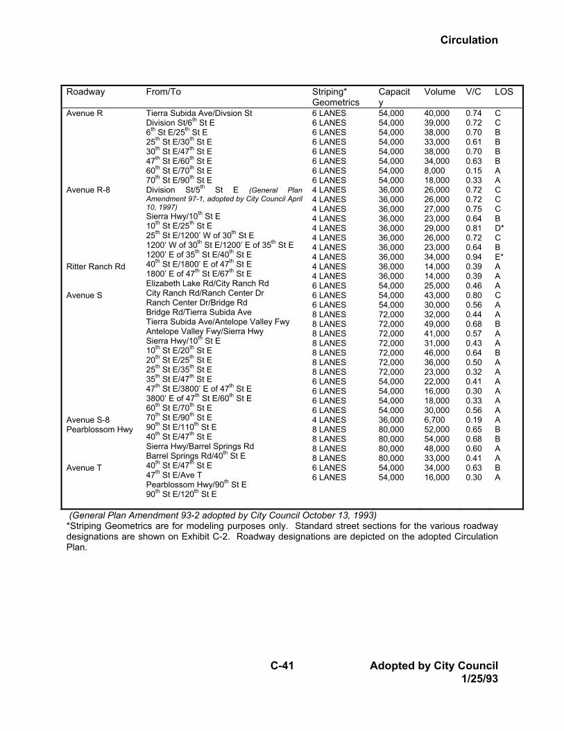
Avenue R Avenue R-8 Ritter Ranch Rd Avenue S Avenue S-8 Pearblossom Hwy Avenue T
Tierra Subida Ave/Divsion St Division St/6th St E 6th St E/25th St E 25th St E/30th St E 30th St E/47th St E 47th St E/60th St E 60th St E/70th St E 70th St E/90th St E Division St/5th St E (General Plan Amendment 97-1, adopted by City Council April 10, 1997) Sierra Hwy/10th St E 10th St E/25th St E 25th St E/1200’ W of 30th St E 1200’ W of 30th St E/1200’ E of 35th St E 1200’ E of 35th St E/40th St E 40th St E/1800’ E of 47th St E 1800’ E of 47th St E/67th St E Elizabeth Lake Rd/City Ranch Rd City Ranch Rd/Ranch Center Dr Ranch Center Dr/Bridge Rd Bridge Rd/Tierra Subida Ave Tierra Subida Ave/Antelope Valley Fwy Antelope Valley Fwy/Sierra Hwy Sierra Hwy/10th St E 10th St E/20th St E 20th St E/25th St E 25th St E/35th St E 35th St E/47th St E 47th St E/3800’ E of 47th St E 3800’ E of 47th St E/60th St E 60th St E/70th St E 70th St E/90th St E 90th St E/110th St E 40th St E/47th St E Sierra Hwy/Barrel Springs Rd Barrel Springs Rd/40th St E 40th St E/47th St E 47th St E/Ave T Pearblossom Hwy/90th St E 90th St E/120th St E
6 LANES 6 LANES 6 LANES 6 LANES 6 LANES 6 LANES 6 LANES 6 LANES 4 LANES 4 LANES 4 LANES 4 LANES 4 LANES 4 LANES 4 LANES 4 LANES 4 LANES 4 LANES 6 LANES 6 LANES 6 LANES 8 LANES 8 LANES 8 LANES 8 LANES 8 LANES 8 LANES 8 LANES 6 LANES 6 LANES 6 LANES 6 LANES 4 LANES 8 LANES 8 LANES 8 LANES 8 LANES 6 LANES 6 LANES
54,000 54,000 54,000 54,000 54,000 54,000 54,000 54,000 36,000 36,000 36,000 36,000 36,000 36,000 36,000 36,000 36,000 36,000 54,000 54,000 54,000 72,000 72,000 72,000 72,000 72,000 72,000 72,000 54,000 54,000 54,000 54,000 36,000 80,000 80,000 80,000 80,000 54,000 54,000
40,000 39,000 38,000 33,000 38,000 34,000 8,000 18,000 26,000 26,000 27,000 23,000 29,000 26,000 23,000 34,000 14,000 14,000 25,000 43,000 30,000 32,000 49,000 41,000 31,000 46,000 36,000 23,000 22,000 16,000 18,000 30,000 6,700 52,000 54,000 48,000 33,000 34,000 16,000
0.74 0.72 0.70 0.61 0.70 0.63 0.15 0.33 0.72 0.72 0.75 0.64 0.81 0.72 0.64 0.94 0.39 0.39 0.46 0.80 0.56 0.44 0.68 0.57 0.43 0.64 0.50 0.32 0.41 0.30 0.33 0.56 0.19 0.65 0.68 0.60 0.41 0.63 0.30
C C B B B B A A C C C B D* C B E* A A A C A A B A A B A A A A A A A B B A A B A
(General Plan Amendment 93-2 adopted by City Council October 13, 1993) *Striping Geometrics are for modeling purposes only. Standard street sections for the various roadway designations are shown on Exhibit C-2. Roadway designations are depicted on the adopted Circulation Plan.
Circulation
Adopted by City Council C-42 1/25/93
Roadway From/To Striping*
Geometrics Capacity
Volume V/C LOS
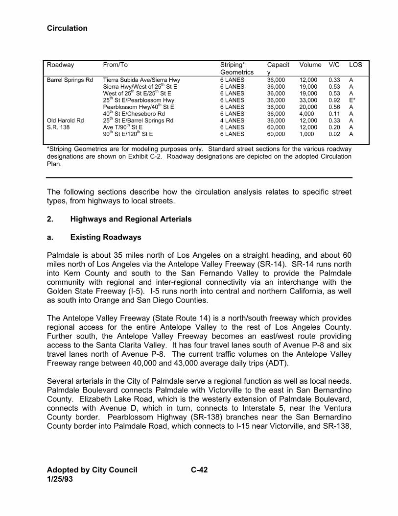
Barrel Springs Rd Old Harold Rd S.R. 138
Tierra Subida Ave/Sierra Hwy Sierra Hwy/West of 25th St E West of 25th St E/25th St E 25th St E/Pearblossom Hwy Pearblossom Hwy/40th St E 40th St E/Cheseboro Rd 25th St E/Barrel Springs Rd Ave T/90th St E 90th St E/120th St E
6 LANES 6 LANES 6 LANES 6 LANES 6 LANES 6 LANES 4 LANES 6 LANES 6 LANES
36,000 36,000 36,000 36,000 36,000 36,000 36,000 60,000 60,000
12,000 19,000 19,000 33,000 20,000 4,000 12,000 12,000 1,000
0.33 0.53 0.53 0.92 0.56 0.11 0.33 0.20 0.02
A A A E* A A A A A
*Striping Geometrics are for modeling purposes only. Standard street sections for the various roadway designations are shown on Exhibit C-2. Roadway designations are depicted on the adopted Circulation Plan. The following sections describe how the circulation analysis relates to specific street types, from highways to local streets. 2. Highways and Regional Arterials a. Existing Roadways Palmdale is about 35 miles north of Los Angeles on a straight heading, and about 60 miles north of Los Angeles via the Antelope Valley Freeway (SR-14). SR-14 runs north into Kern County and south to the San Fernando Valley to provide the Palmdale community with regional and inter-regional connectivity via an interchange with the Golden State Freeway (I-5). I-5 runs north into central and northern California, as well as south into Orange and San Diego Counties. The Antelope Valley Freeway (State Route 14) is a north/south freeway which provides regional access for the entire Antelope Valley to the rest of Los Angeles County. Further south, the Antelope Valley Freeway becomes an east/west route providing access to the Santa Clarita Valley. It has four travel lanes south of Avenue P-8 and six travel lanes north of Avenue P-8. The current traffic volumes on the Antelope Valley Freeway range between 40,000 and 43,000 average daily trips (ADT). Several arterials in the City of Palmdale serve a regional function as well as local needs. Palmdale Boulevard connects Palmdale with Victorville to the east in San Bernardino County. Elizabeth Lake Road, which is the westerly extension of Palmdale Boulevard, connects with Avenue D, which in turn, connects to Interstate 5, near the Ventura County border. Pearblossom Highway (SR-138) branches near the San Bernardino County border into Palmdale Road, which connects to I-15 near Victorville, and SR-138,
Circulation
C-43 Adopted by City Council 1/25/93
which connects to I-15 near San Bernardino. Sierra Highway links Palmdale with the City of Mojave to the north in Kern County and with the I-5/SR-14 interchange to the south near Sylmar. These roads are further described below: Palmdale Boulevard/Elizabeth Lake Road has a total of two through lanes west of Foxholm Drive near the City limit, four lanes between Foxholm Drive and 47th Street East, and two lanes east of 47th Street East. In addition, Palmdale Boulevard has a full (partial cloverleaf) interchange configuration with the Antelope Valley Freeway and a raised, landscaped median island between 10th Street West and 11th Street East. Caltrans has recently removed the serrated median island between 11th and 22nd Streets East and is currently replacing it with a flash median. Pearblossom Highway (SR-138) extends from the San Bernardino County border to Sierra Highway, where it branches into SR-14 and Antelope Highway (SR-138). Within the City of Palmdale, it has four through lanes west of Old Nadeau Road, and two lanes to the east. Old Nadeau Road is located about 600 feet north of Sierra Highway. Sierra Highway extends from the City of Mojave, in Kern County, through Palmdale to the I-5/SR-14 interchange to the south. Within the City, it has four through lanes north of Avenue R-8, two lanes between Avenue R-8 and 1,200 feet south of Avenue S, four lanes between 1200 feet south of Avenue S and 3,000 feet north of Barrel Springs Road, and two lanes to the south. Sierra Highway generally runs adjacent to SR-14 and turns into an east/west arterial a few miles south of the Planning Area. b. Existing Levels of Service With few exceptions, the City of Palmdale arterial network currently operates at acceptable levels of service. A few arterial segments are currently operating near or above their striped capacity at LOS D, E, or F. These congested segments are located on major arterial sections that have yet to be built to the full major arterial cross-section. Palmdale Boulevard, between the Antelope Valley Freeway and 30th Street East, currently operates at LOS E, indicating significant levels of congestion for motorists. This section of Palmdale Boulevard has four through lanes with a paved median island on an 84-foot cross-section. By eliminating on-street parking, this section can be restriped to six through lanes and a median, which would accommodate the traffic. This would improve the operating level to LOS C. Pearblossom Highway, between Barrel Springs and 30th Street East, currently operates at LOS F. This segment is currently striped for two through lanes and has yet to be built to the full major arterial cross-section.
Circulation
Adopted by City Council C-44 1/25/93
The intersection of Pearblossom Highway and Avenue T operates at LOS D (V/C = 0.84) during the a.m. peak hour, and the intersection of Palmdale Boulevard and 30th Street East operates at LOS D (V/C = 0.87) during the p.m. peak hour. Continued monitoring of future growth along these intersections will facilitate implementation of appropriate mitigation strategies at specific times. The Traffic Impact Fee Assessment and Master Traffic Level Maintenance Plan identifies various links as candidate locations for this funding strategy. S.R. 138 is currently operating at LOS E. This facility is striped for total of two through lanes and has yet to be built to the full major arterial cross-section. Sierra Highway, between Avenue M and Avenue P, which is currently striped for four through lanes is operating at LOS E. Sierra Highway, between Pearblossom Highway and the Antelope Valley Freeway, currently operates at LOS F. This segment is striped for four through lanes. c. Future Regional Arterial and Highway Needs When running the traffic model, the consultant calculated that highways and regional arterials could carry 10,000 vehicles per lane per day. This figure assumed that traffic improvements, including signal coordination and progression, would occur concurrently with development and that full roadway improvements would be in place at General Plan build-out. SR-14 was assumed to have four lanes in each direction through the study area. In addition, several existing major arterials were recommended to be upgraded to Regional Arterial status, including the following road segments: East-West Arterials • Avenue L west of 10th Street East; • Avenue M between 30th Street West and 50th Street East; • Elizabeth Lake Road between 25th Street West and Palmdale Boulevard; • Palmdale Boulevard between Elizabeth Lake Road and Division Street; • Avenue S between 35th Street East and 3800' east of 47th Street East; and, • Pearblossom Highway between Sierra Highway and Avenue T.
Circulation
C-45 Adopted by City Council 1/25/93
North-South Arterials • 10th Street West between Avenue M and Palmdale Boulevard; • Sierra Highway between Avenue M and Avenue P; • Sierra Highway between Pearblossom Highway and SR-14; • 47th Street East between Palmdale Boulevard and Ft. Tejon Road;
Ft. Tejon Road between 47th Street East and Pearblossom Highway; and, 50th Street East between the Cross Town Freeway and Palmdale Boulevard.
In addition to these upgrades, other recommended regional improvements included the following: • Upgrading of 50th Street East to an expressway designation north of Avenue P-
8. An expressway has more capacity that either an arterial or a regional arterial, approaching that of a freeway. This is achieved by providing grade-separated intersections, preferential signal timing, and very limited access (one-mile or half-mile spacing).
• A new east/west freeway along the alignment of Avenue P-8, having three lanes in each direction from SR-14 to just east of 90th Street East. For purposes of this study, interchanges were assumed at SR-14, 10th Street East, 25th Street East, 40th Street East, and at the new six-lane north/south freeway. Future studies of this facility should consider additional interchange locations.
• A new north/south freeway having three lanes in each direction from SR-138 on the south to the City of Lancaster to the north. For purposes of this study, interchanges were assumed at the new six-lane east/west freeway, Palmdale Boulevard, Avenue S, and SR-138. Future studies of this facility should consider additional interchange locations.
• Expansion of SR-14 from four lanes each way to five lanes each way between Avenue L and Crown Valley Parkway.
The proposed east/west freeway is projected to carry about 75,000 vehicles per day between SR-14 and 50th Street East and about 40,000 vehicles per day further east. The proposed north-south freeway is projected to carry approximately 50,000 vehicles per day. Along with additional freeways and designation upgrades, the consultants recommended trip reduction measures to reduce total vehicle trips throughout the Planning Area by 15 percent. However, even with these measures some regional arterial locations within the City will be operating at LOS D or worse at the year of land use buildout. These locations include: Sierra Highway, between Pearblossom Highway
Circulation
Adopted by City Council C-46 1/25/93
and the Antelope Valley Freeway; Avenue M, between the Antelope Valley Freeway and Division; and Palmdale Boulevard between the Antelope Valley Freeway and Division. Based on the traffic model analysis, the regional roadway improvements mentioned above will be necessary to ensure acceptable levels of service within the Planning Area as buildout occurs. 3. Arterials a. Existing Roadways Major Arterials Major arterials as previously designated on the City's General Plan Circulation Map are spaced at approximately one-mile intervals, and represent the major carrying capacity for traffic to and within the City. The City's current policy is to create major arterials at one-mile intervals and secondary arterials at one-half mile intervals between the majors. Previous design standards for a major arterial called for a paved section of 84 feet within a 100-foot right-of-way which, when built to its full carrying capacity, provides for either three lanes of through traffic in each direction and a median for left-turning traffic, or two lanes in each direction, a left-turn median, and a curb lane for parking. In some portions of the City, the median is paved to create specific left- and U-turn bays; in other locations, painted medians with optional/dual left-turn lanes are used. Some of the major arterials within Palmdale are discontinuous, and many have yet to be built to the full 84-foot paved cross-section along the entire length. A detailed discussion of each major arterial follows. Avenue L is discontinuous along its length, which extends from west of 70th Street West to the City limit at 120th Street East. It is classified as a major arterial west of 40th Street East, and as a minor to the east. It has a total of two through lanes over its length. Avenue M extends from 90th Street West to east of the City limit at 120th Street East, and has a total of two through lanes over its entire length. Avenue N, a two-lane arterial, is discontinuous along its length. It reaches from 70th Street West to Sierra Highway, and from about 2,000 feet west of 40th Street East to east of 110th Street East. Avenue R extends from Tierra Subida Avenue to 3,000 feet east of 47th Street East. It has two through lanes west of 6th Street East, four lanes between 6th Street East and
Circulation
C-47 Adopted by City Council 1/25/93
20th Street East, two lanes eastbound and one lane westbound between 20th Street East and 22nd Street East, four lanes between 22nd Street East and 30th Street East, and two lanes east of 30th Street East. The arterial crosses under the Antelope Valley Freeway but does not have an interchange. Avenue S extends from 20th Street West to about 3,800 feet east of 47th Street East. It has two lanes over its entire length except for the following segments which have two lanes eastbound and one lane westbound: between Sierra Highway and 15th Street East, and between 25th Street East and 35th Street East. The arterial has a full-diamond interchange with the Antelope Valley Freeway, providing regional connections to the north and south. Avenue O has two segments: one extends from 30th Street West to 10th Street West, and the other extends from 27th Street East to east of the City limit at 120th Street East. Avenue O has a total of two through lanes. Avenue P extends from 30th Street West to 50th Street East. It has four through lanes over much of its length west of 30th Street East, except for the segment between 10th Street West and 15th Street West, which has six lanes. Avenue Q is discontinuous along its length. It reaches from Palmdale Boulevard to 6th Street East where it is classified as a secondary arterial, and from Sierra Highway to 40th Street East where it is classified as a major arterial. This arterial has one through lane in each direction along its entire length, though between 30th and 35th Street East, the south side is currently paved wide enough for two lanes. Avenue T extends from Pearblossom Highway to east of 90th Street East and has two through lanes along its length. 90th Street West extends north of Avenue L and has two through lanes along its length. 70th Street West reaches from north of Avenue K to Avenue N and has two through lanes along its length. It is classified as a secondary arterial over most of this length, except for the segment between Avenue L and M-8, which is classified as a major arterial. 60th Street West extends from north of Avenue K, outside the City limit, to the California Aqueduct where it becomes Godde Hill Road. It has a total of two through lanes. Godde Hill Road is an extension of 60th Street West south of Avenue M to Elizabeth Lake Road. It has two through lanes along its length.
Circulation
Adopted by City Council C-48 1/25/93
50th Street West reaches from north of Avenue K to south of Avenue N, where it becomes Quartz Hill Cutoff. 40th Street West, a two lane arterial, extends from north of Avenue K in Lancaster, south to Avenue M. 30th Street West extends from north of Avenue K to Avenue P and has two through lanes. 20th Street West, a two-lane arterial, reaches from north of Avenue K to Avenue P. 25th Street East reaches from Avenue P to Barrel Springs Road. It has two through lanes over most of its length, except for the segment between Avenue S and 4,200 feet to the south, which has four through lanes. 25th Street East is classified as a major arterial north of Avenue S, and as a secondary arterial to the south. 30th Street East is discontinuous with two segments. It extends from north of Avenue K in Lancaster to Avenue M where it has two through lanes, and from Avenue P to 1,600 feet south of Avenue S. The number of through lanes oscillates between two and four along the segment between Avenue P and 1,600 feet south of Avenue S. 10th Street East is discontinuous along its length. It extends from north of Avenue K in Lancaster to Avenue M, and from Avenue O-8 to Avenue S. It has two through lanes along both segments. 20th Street East is also discontinuous, with two segments. It extends from north of Avenue K to Avenue M where it is classified as a major arterial, and from Avenue O-8 to Avenue S where it is classified as a secondary arterial. It has two through lanes along both segments. 10th Street West/Tierra Subida Avenue is a major north/south arterial serving the area. It extends from north of Avenue G in Lancaster and south to Barrel Springs Road. It has a freeway interchange near Avenue P and is classified as a major arterial north of Avenue S, and as a secondary arterial to the south. It has two lanes over its entire length except for one-half mile south of Palmdale Boulevard where it has two lanes southbound and one lane northbound. It changes its name from 10th Street West, north of Palmdale Boulevard, to Tierra Subida Avenue, south of Palmdale Boulevard. Division Street, a two-lane arterial, reaches from 1,500 feet north of Avenue Q to Avenue R-8.
Circulation
C-49 Adopted by City Council 1/25/93
40th Street East extends from Avenue O to Barrel Springs Road. This arterial is classified as a major arterial north of Pearblossom Highway, and as a secondary arterial to the south and has two through lanes. 50th Street East extends from north of Avenue K to Palmdale Boulevard, where it becomes 47th Street East. 47th Street East. South of Palmdale Boulevard, 47th Street East continues on to south of Barrel Springs Road. This arterial (47th/50th Street East) has two through lanes over most of its length, except for the segment between Palmdale Boulevard and Fort Tejon Road which has four lanes and a two-way, left turn median. 47th Street East is classified as a major arterial north of SR-138 and as a secondary arterial to the south. Fort Tejon Road reaches from 47th Street East to SR-138, and has four through lanes with a continuous two-way left-turn median. 70th Street East extends from north of Avenue K to Palmdale Boulevard, and has two through lanes along its entire length. It is classified as a major arterial south of Avenue L, and as a secondary arterial to the north. 90th Street East extends from north of Avenue K to south of Avenue T, where it becomes 87th Street East. It has two through lanes along its entire length. Secondary Arterials Under the previous General Plan, secondary arterials were designated so as to be spaced at approximately one-half mile intervals between the major arterials, and provide access to the major arterials. Previously, design standards for a secondary arterial called for a paved section of 64 feet within a 80-foot right-of-way width. When built to its full carrying capacity, this cross-section provides for either two lanes in each direction with a painted median left-turn lane, or one lane in each direction with a painted median left-turn lane and curb parking. Typically, secondary arterials do not have a raised median. Some of the secondary arterials within Palmdale are discontinuous, and have yet to be built to the full 64-foot paved cross-section along their entire length. A detailed discussion of each secondary arterial follows. Avenue L was previously discussed in Major Arterials section. Avenue L-8 extends from 65th Street West to 20th Street West in the City of Lancaster and has a total of two through lanes.
Circulation
Adopted by City Council C-50 1/25/93
Avenue M-8, a two-lane arterial, extends from 70th Street West to 45th Street West. Avenue N-8 extends from 70th Street East to 80th Street East. Avenue O-8 is discontinuous and extends from 20th Street West to 10th Street West, and from Lockheed Way to Sierra Highway to 15th Street East. It has two through lanes along both segments. Avenue P-8 has three discontinuous segments between 10th Street West and 50th Street East. All segments are striped for two through lanes except for the segment between 10th Street West and Sierra Highway which is striped for four lanes. This facility parallels the alignment of the proposed freeway extension to the Palmdale Regional Airport. Avenue Q was previously discussed in Major Arterials section. Avenue R-8 has four discontinuous segments between 12th Street East and 1,800 feet east of 47th Street East. All segments are striped for two through lanes, though many of them are paved wide enough for four. Barrel Springs Road, a two-lane arterial, has two unconnected segments: from Tierra Subida Avenue to Sierra Highway and from east of Pearblossom Highway to Cheseboro Road. Bouquet Canyon Road is a two-lane road which extends south from Elizabeth Lake Road along the alignment of 80th Street West and southwesterly into the Santa Clarita Valley. It winds through canyons and provides a regional connection with the western portion of the Planning Area. 80th Street West extends north of Avenue L and has two through lanes along its length. 55th Street West, a two-lane arterial, extends from Avenue L, north of the City limit, to Avenue N. 45th Street West has two unconnected segments: from north of Avenue K to Avenue L-14 and from Avenue M to Avenue N. Both segments are striped for two through lanes. 25th Street West has two discontinuous segments: from north of Avenue K to Avenue L in Lancaster, and from Avenue P to Elizabeth Lake Road. Both segments have two through lanes.
Circulation
C-51 Adopted by City Council 1/25/93
15th Street West, a two-lane arterial, extends from Avenue N to Avenue O-8. Tierra Subida Avenue was previously discussed in the Major Arterials section. 5th Street East extends from Avenue Q to Avenue S, and has a total of two through lanes. 6th Street East extends west of Palmdale Boulevard. 15th Street East reaches between Avenue O-8 and Avenue R, and has two through lanes. 20th Street East was previously discussed in the Major Arterials section. 25th Street East was previously discussed in the Major Arterials section. 35th Street East has three discontinuous segments between Avenue Q and 1,600 feet south of Avenue S. All segments are striped for two through lanes though some of them are paved wide enough for four. 40th Street East was previously discussed in the Major Arterials section. 47th Street East was previously discussed in the Major Arterials section. 70th Street East was previously discussed in the Major Arterials section. 110th Street East extends from Avenue K to Avenue S, and has a total of two through lanes along its entire length. b. Arterial Levels of Service Capacity Existing service levels on major and secondary arterials were analyzed and determined to be generally good. (See Table C-5 and Exhibit C-6.) However, Palmdale Boulevard between SR-14 and 30th Street East was found to be operating at LOS D during peak hours. It should be noted, in reviewing Table C-5, that LOS standards shown for each link may vary due to irregularities in the model. Intersection capacities were analyzed using turning movement volumes obtained from actual counts taken during the months of August and September 1989. Forty-seven
Circulation
Adopted by City Council C-52 1/25/93
intersections were analyzed for the evaluation of existing capacities. All of the 47 study intersections operate at LOS D or better. A few intersections may be characterized as approaching the maximum acceptable LOS value, LOS E. Connectivity The City of Palmdale's circulation system has, for the most part, developed around a grid system in which major arterials are spaced approximately every mile and secondary arterials are spaced every half-mile between the major arterials. As the capacity evaluation shows, this pattern appears to be providing a solid foundation for serving the community's mobility needs. The majority of the arterial segments are currently operating at LOS D or better, which indicates good traffic flow. There are, however, many missing segments in the street pattern that currently result in connectivity problems, some of which will contribute to capacity problems in the future, as the City's population and traffic increase. As the community develops, it is planned that the majority of the major and secondary arterials will be made continuous throughout the limits of the City. The following arterials are currently continuous along their entire lengths within the City: Avenue L, Avenue M, Palmdale Boulevard, Pearblossom Highway/Avenue T, 60th Street West, 30th Street West, 20th Street West, 10th Street West/Tierra Subida Avenue, Sierra Highway, 47th/50th Street East, 90th Street East, and 110th Street East.
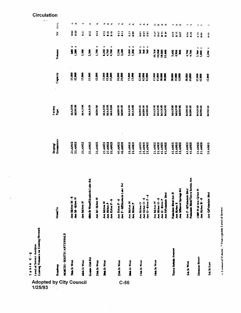
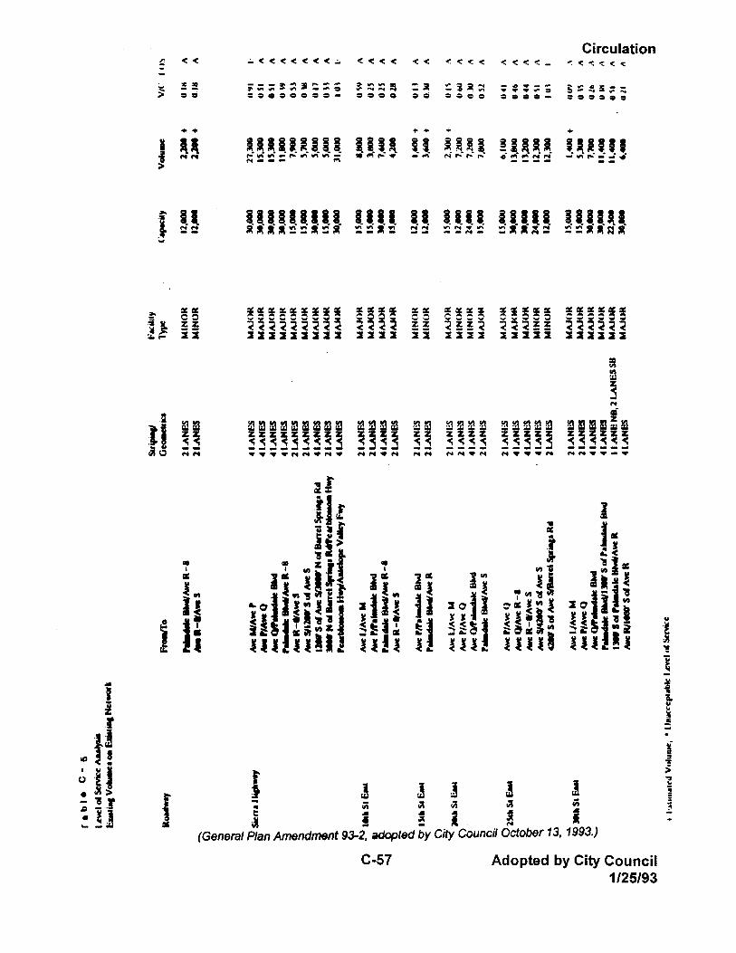
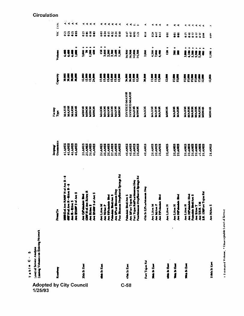
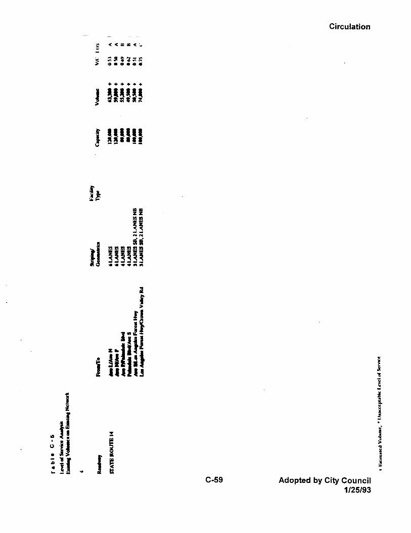
Circulation
Adopted by City Council C-60 1/25/93
Several arterials are not planned to be or cannot be continuous because they intercept the United States Air Force Plant area or the proposed Palmdale Regional Airport site. These arterials include Avenues N through Q, 10th through 40th Streets East, and 60th through 80th Street East. Future Arterial Needs To help mitigate the effects of future traffic growth and improve the circulation system within the City, many of the existing gaps in the existing arterial system will need to be closed to accommodate projected buildout traffic conditions. The arterials that are recommended to be made continuous throughout the City are: Avenue M, Avenue P-8, Avenue R, Avenue R-8, Avenue S, Division Street, 10th Street East, and 110th Street East. In addition, several new north/south and east/west arterials are planned in the southwestern region of the City (south of Elizabeth Lake Road and west of Tierra Subida Avenue). The east/west facilities include Ritter Ranch Road (which is the westerly extension of Avenue S); City Ranch Road (which is the westerly extension of Avenue R); and Santa Fe Hills Drive. The north/south facilities include Bridge Road and Ranch Center Drive. The analysis indicated that even with implementation of transportation demand management measures, some arterial locations within the City will be operating at LOS D or worse at the year of land use buildout. The most significant locations are listed below: • Avenue M between 30th Street West and Division Street • Avenue P between 15th Street West and Sierra Highway • Avenue Q • Elizabeth Lake Road between Bridge Road and Palmdale Boulevard • Palmdale Boulevard between Elizabeth Lake Road and 30th Street East • Avenue R between Tierra Subida Avenue and 47th Street East • Godde Hill Road • 10th Street West between Avenue M and Palmdale Boulevard • 5th Street West between Avenue P-8 and Tierra Subida Avenue • Division Street between Avenue P and 1500 feet north of Avenue Q • Sierra Highway near the Antelope Valley Freeway • 10th Street East between Avenue P and Palmdale Boulevard • 20th Street East between Palmdale Boulevard and Avenue S • 25th Street East near Avenue S
Circulation
C-61 Adopted by City Council 1/25/93
• 30th Street East between Avenue P and Avenue Q • 40th Street East south of Pearblossom Highway Intersection capacities in the new Circulation Plan at land use buildout were also analyzed. The increased capacity of the new Circulation Plan will improve overall intersection traffic operations at buildout. The addition of the new freeway facility along the alignment of Avenue P-8 will facilitate east/west travel movements in the City. Parallel facilities such as Avenue M are expected to experience slight improvements in traffic operations. Nonetheless, it is anticipated that some intersections may operate beyond LOS D. Unacceptable levels of congestion are likely to occur without further specific capacity improvements at intersections or reduction of traffic demand through aggressive local TDM measures. These focused capacity improvements may include an increase in the number of through lanes, additional turning lanes, channelization of various intersections, computerized traffic signal coordination measures, etc. 4. Local and Collector Streets The recent rapid development of single-family residential subdivisions in Palmdale has produced thousands of affordable homes in the last few years. However, the same rapid pace of development has sometimes caused traffic problems on the local neighborhood street systems. In some areas, such as segments of Avenue R-4 and Spanish Broom Drive, local streets provide through access and attract high traffic volumes at excessive speeds. In other areas, the mass of cul-de-sacs and discontinuous local streets bearing the same name has created confusing and circuitous networks, which are difficult to navigate for both visitors and emergency vehicles. Proper design of local streets is critical to creation of livable neighborhoods. Both safety and aesthetic concerns must be addressed. Streets that are too long and straight contribute to a monotonous streetscape and potential traffic hazards associated with speeding traffic. Alternatively, overly complex neighborhood street networks may lack a logical flow pattern, provide an inefficient traffic pattern, and impede emergency vehicle response times. Local street design issues must be addressed both at the in-tract level and on a broader neighborhood scale. Because there are many smaller parcels in the City, it can be expected that multiple small subdivisions may be proposed within a larger neighborhood unit. In these situations, local street connections between the unrelated subdivisions may be desirable to ensure neighborhood linkages. However, these linkages must avoid creation of local streets functioning as collectors. When this occurs, and multiple lots front that street, hazards from excessive vehicular speeds may result. Therefore, it is critical that both existing and planned circulation systems be considered to provide
Circulation
Adopted by City Council C-62 1/25/93
the proper balance between creating neighborhood linkage and avoidance of high volume through traffic problems. In the context of neighborhood planning and local streets, cul-de-sacs provide both opportunities and potential constraints. A properly located and designed cul-de-sac can provide a residential setting where traffic speeds and volumes are reduced. Residents are generally comfortable with front yard activities in a cul-de-sac setting. However, the excessive use of cul-de-sacs can create numerous local intersections, poor integration of neighborhood components, uneven distribution of traffic volumes on other local streets, and disrupted traffic flow patterns. "Dog leg" cul-de-sacs, with one or more turns between the bulb and the outlet, result in dead ends that are not apparent when the street is entered. The key to successful future neighborhood planning will be creation of a local street network that provides optional travel paths for traffic dispersal while avoiding an overly regimented grid system. The number of local street intersections on two arterial and collector streets must be at defined intervals to provide a logical internal street pattern. Efficiency is desired; however, it must not be accomplished at the expense of neighborhood safety via long, straight streets. To address these issues, policies for local and collector street design were drafted and accepted by the City Council as interim policies in February, 1992 ("Subdivision Design Guidelines"). These policies have been incorporated into the General Plan policy sections, where appropriate, including the Circulation Element (see Objectives C1.3 and C1.4). A need was also identified to develop special street standards for hillside areas, rural developments and private gated communities. Opportunities exist to develop special standards which could minimize grading in hillside areas, maintain the character of rural areas, and to ensure that private streets are constructed to appropriate standards. The City will develop special street standards to serve these needs. 5. Truck Routes On December 9, 1991, the Palmdale City Council adopted Ordinance No. 953, establishing truck routes within the City of Palmdale. The Ordinance regulates vehicles exceeding 10,000 pounds gross weight and prohibits their use on undesignated City streets, except when delivering or otherwise servicing uses on such streets. Designated truck routes include the following (see Exhibit C-7): • 10th Street West from Avenue P to Avenue M • Sierra Highway from the Antelope Valley Freeway to Avenue M • 50th Street East from Palmdale Boulevard to Avenue M
Circulation
C-63 Adopted by City Council 1/25/93
• Avenue M from the Antelope Valley Freeway to 50th Street East • Avenue P from 10th Street West to 50th Street East • City Ranch Road, Tierra Subida, Rayburn Road and Avenue R from the Antelope
Valley Landfill to Sierra Highway • Avenue S from the Antelope Valley Freeway to Sierra Highway • Pearblossom Highway from Sierra Highway to Fort Tejon Road • Avenue T from Fort Tejon Road to 90th Street East Additional truck routes may be needed to serve the access needs of the eastside Mineral Resource Area (MRE), particularly for that portion north of the railroad tracks. Establishing truck routes connecting this area to Avenue T or Palmdale Boulevard could prevent quarry trucks from using Avenue R, Avenue R-8 and Avenue S as primary access routes. Policy C1.7.1 addresses the need to maintain the City's truck route program. 6. Congestion Management Plan The Congestion Management Program (CMP) was enacted by the state legislature in 1989 to improve traffic congestion in California's urbanized areas. The program became effective with the passage of Proposition III in June, 1990, which increased the state gas tax by nine cents over a five year period. The increase in funds generated by Proposition III will be available to cities and counties for regional road improvements, provided that they are in compliance with CMP requirements. If a city does not comply with the CMP, it could lose funding under Proposition III. Therefore, it is imperative for Palmdale to develop local programs to comply with the Congestion Management Program. Under the program, regional agencies are designated within each County to prepare and administer the CMP. In Los Angeles County, the Congestion Management Agency is the Los Angeles County Transportation Commission (LACTC). LACTC is in the process of drafting the countywide Congestion Management Plan and preparing an Environmental Impact Report for the Plan. When completed, the CMP Exhibit C-73(Map) will be submitted to SCAG, which will determine the Plan's consistency with the Regional Mobility Plan. After the CMP plan is adopted, each City within the County must take steps to administer elements of the plan locally. The City's responsibilities include the following: • Assisting in monitoring the CMP system; • Adopting and implementing a trip reduction and travel demand ordinance;
Circulation
Adopted by City Council C-64 1/25/93
• Analyzing the impacts of local land use discussions on the regional transportation system; and,
• Preparing annual deficiency plans for portions of the CMP system where level of service standards are not maintained.
LACTC will annually review the City's performance of these responsibilities to ensure they are in compliance with the CMP. After notice and a correction period, LACTC will report local agencies who are out of compliance to the State Controller, who will then withhold a portion of their state gas tax funds. LACTC adopted the County's Congestion Management Plan in November, 1992. As approved, the CMP includes the following roadways within the City of Palmdale: • Antelope Valley Freeway (Highway 14) • State Route 138 After adoption of the CMP, levels of service on these roadways must stay at LOS E or better; if they do not, the City must prepare a deficiency plan to bring the level of service back up to LOS E. Under the CMP legislation, once a roadway is entered into the CMP network it cannot be deleted, even if service levels are ultimately improved. Because the City is responsible for monitoring and reporting service levels on all CMP roadways, the City's position has been to discourage the addition of any additional links into the CMP network. The City's policy since 1991 has been to condition development projects to comply with CMP requirements. Policy C2.1.5 reinforces the City's intent to maintain compliance with the CMP process. 7. Street System Maintenance Presently the City contracts with Los Angeles County Department of Public Works to provide maintenance on public streets within Palmdale. Services provided include street sweeping, filling of potholes and cracks, snowplowing, maintenance of drainage structures, and bridge inspection. It is anticipated that, in the future, the City will assume these maintenance responsibilities, as funds become available to establish a public works corporation yard and acquire street maintenance equipment. The City could begin phasing in some maintenance duties within the next five years, and fully take over maintenance responsibilities within ten to twelve years, depending on funding availability. Some portions of the Planning Area require additional street maintenance due to substandard street sections. Several of the unincorporated County "islands" currently
Circulation
C-65 Adopted by City Council 1/25/93
under consideration for annexation were developed without curbs, gutters, sidewalks or drainage. As a result, stormwater runoff undermines the paving and maintenance costs are increased. As these older areas become redeveloped, road improvements will be required to upgrade the street systems. In general, street maintenance levels are adequate to meet existing City needs. As the City continues to develop and expand, the contract maintenance costs will increase to the point where it will be more economical for the City to take over this function. Private streets are required to be maintained by property owners or homeowners associations. Objective C1.6 and related policies address road maintenance issues. B. Public Transit and Alternative Travel Modes 1. Fixed Route Bus Service Bus service within the City of Palmdale is provided through the Antelope Valley Transit Authority (AVTA), a joint powers agency whose members also include the City of Lancaster and Los Angeles County. The AVTA recently completed a five-year plan for service within the Antelope Valley, the Antelope Valley Transit Need Plan. They are currently developing a ten-year transit plan for the area. The AVTA is responsible for overseeing bus services, including selection of service provider and establishment of routes, schedules and hours of operation. Recently AVTA awarded the service contract to DAVE Transportation Services. Service includes fifteen buses in service and five buses in reserve. Weekday service includes five core urban routes and four supplemental routes. Supplemental routes or additional buses are utilized during morning and afternoon hours on school routes. Student bus use to and from school is causing extra service requirements during limited hours. Saturday service will include five core routes in the urban area. Bus frequency is two bus trips per hour on inter-city routes. Service hours are from 5:30 a.m. to 8:00 p.m. on weekdays and 8:30 a.m. to 6:00 p.m. on Saturday. This level of bus service represents a considerable improvement of service levels before 1992, in terms of geographic coverage, frequency of service, and span of service. Total hours of service have almost doubled over 1991 levels. The five fixed routes serve many of the major thoroughfares in Lancaster and Palmdale. Three of the five routes either terminate or pass through the Antelope Valley Mall, which functions as a focal point for local service. Route locations are shown on Exhibit C-7. 2. Inter-City Bus Services
Circulation
Adopted by City Council C-66 1/25/93
DAVE Transportation Services operates two commuter bus lines between Palmdale and central Los Angeles and the San Fernando Valley. Nine buses are in service with two in reserve. Service operates on Monday through Friday, with seven trips to downtown Los Angeles on Route 785 and two trips to the San Fernando Valley on Route 787. Routes are shown on Exhibit C-8. Service is available in the morning from 4:30 a.m. to 6:00 a.m. trips to Los Angeles and the San Fernando Valley, and in the afternoon for return trips to Palmdale from 3:30 p.m. to 5:30 p.m. Under the administration of AVTA, commuter bus service was expanded substantially in 1992. The seven existing service runs will increase to nine as ridership increases. Total service hours were increased 50 percent over 1991 service levels. In addition to AVTA services, Greyhound Lines provides bus service to Lancaster and Palmdale, primarily as intermediate stops along routes heading toward central or northern California, or Los Angeles. Service is limited to two trips in each direction, and tickets have to be purchased from the driver. A limited number of Palmdale residents use this service as a commuter bus to get to and from work in areas such as downtown Los Angeles. Antelope Valley Airport Express offers a reservation-only scheduled van between Antelope Valley and Los Angeles, as well as similar service to airports. 3. Dial-A-Ride Bus Service Dial-A-Ride service is provided by DAVE Transportation Services, which operates thirteen vans in service, and two vans in reserve. Services are offered to disabled persons and senior citizens (age 62 and older) with priority given to persons determined to be eligible for ADA paratransit, between 5:30 a.m. and 8:00 p.m. on weekdays and between 8:30 a.m. and 6:00 p.m. on Saturdays. On Sundays, Dial-A-Ride services are available to the general public residing within the service area. Outside the service area, capacity-constrained service is available to the general public on weekdays between 7:30 a.m. and 6:00 p.m. The service area boundary is shown on Exhibit C-9.
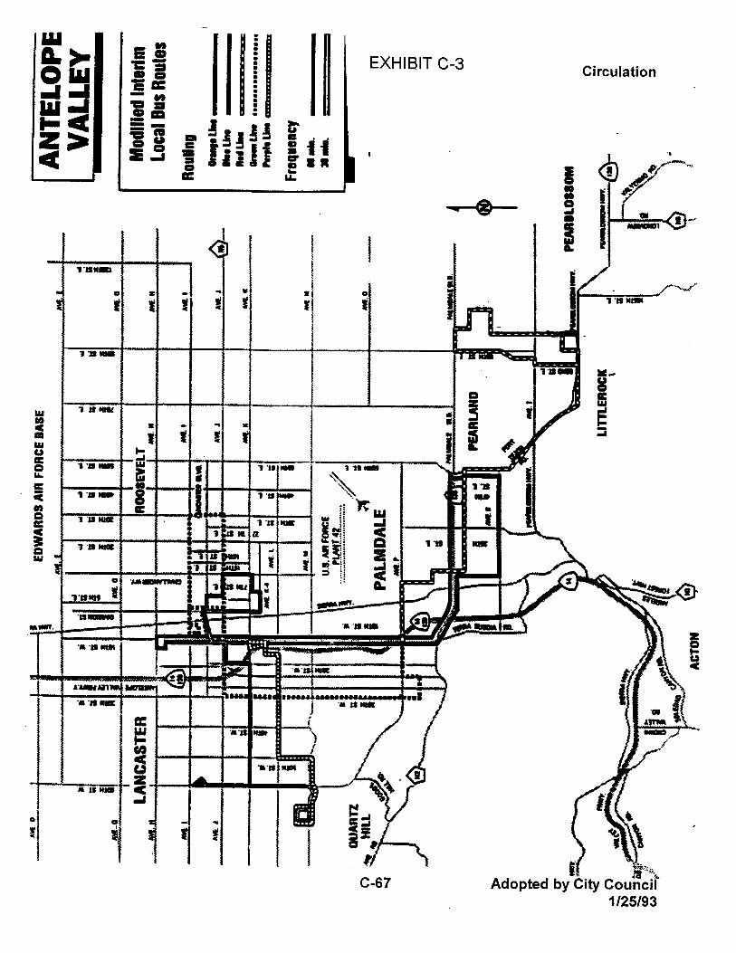
Circulation
Adopted by City Council C-68 1/25/93
Along with its expansion of fixed route and commuter bus service, AVTA increased service levels for Dial-A-Ride service. The service area was extended to the same area served by the fixed-route system, over the same operating hours, and complies with the requirements of the 1990 Americans with Disabilities Act. The service was also extended for the first time to rural areas of the Antelope Valley, including Acton, Lake Los Angeles and Lake Hughes. Total service hours increased 300 percent over 1991 levels. 4. Incentives to Promote Bus Use The City will continue to promote expansion of transit service to serve all need groups within the community. In addition, the City will utilize bus service as part of its comprehensive vehicle trip reduction strategy. Public transportation issues will be considered in the development review process as well, to ensure provision of adequate, convenient bus turnouts along streets served. Bus service can be made more effective through implementation of the following measures: • Bus stops provided at regular intervals along each route. • Bus stops provided with attractive weather-resistant benches and/or shelters. • Bus transit directories provided at each bus stop and placed at a height readable
by children and wheelchair users. • Pocket transit guides designed and made available for all residents and visitors
informing them of the transit routes and services. • Requiring all new or remodeled developments on existing or future streets served
by public transit to provide a bus turnout lane. 5. Commuter Van Services and Carpools Commuter Transportation Services (CTS) is a private non-profit ridesharing organization which provides ridesharing services throughout the SCAG region, including the Palmdale area. CTS is funded by Caltrans, SCAG, San Bernardino Associated Governments, Ventura County Association of Governments, and the Transportation Commission of Los Angeles, Orange and Riverside Counties. Contributions are also made by the City of Los Angeles and more than 1,000 private companies which utilize CTS. CTS operates 86 vans which serve vanpoolers in the Palmdale area who travel south to communities in the San Fernando Valley and Los Angeles. Each van seats between 12 and 15 passengers.
Circulation
C-69 Adopted by City Council 1/25/93
CTS estimates that 21 percent of the Antelope Valley commuters are using vanpool services. This is higher than the regionwide average of 17 percent of commuters who are utilizing vanpools. CTS continues to organize additional vanpools as the commuting population increases. CTS also organizes car and vanpools for commuters and estimates that 5 percent of the Antelope Valley commuters carpool. The City encourages carpooling by providing park-and-ride lots. Developers and employers are also providing park-and-ride lots in convenient locations for commuting. Currently there is a City of Palmdale park-and-ride lot located at Avenue S and the Antelope Valley Freeway (700 spaces). The City is assisting Los Angeles County in construction of a park-and-ride lot on Sierra Highway near the Antelope Valley Freeway (300 spaces). In addition, developers or employers have provided park-and-ride lots at Avenue P near the Antelope Valley Freeway in the Walmart store parking lot (200 spaces) and the Target store parking lot (52 spaces), and on Avenue P in the Lockheed facility parking lot (133 spaces). Additional park-and-ride spaces will be provided within the City as need and funding sources are identified. 6. Paratransit Services Senior and transportationally-handicapped paratransit service in Palmdale is provided by four nonprofit organizations with county and/or state funding and two private companies. Service providers include the following: • Antelope Valley Committee on Aging (Public) • Los Angeles County Community and Senior Citizen Services Department (Public) • North Los Angeles County Regional Center (Public) • Independent Senior Center (Public) • Mediride (Private) • Antelope Valley Taxi (Private) 7. Transportation Demand Management (TDM) Measures The City of Palmdale has been pro-active in promoting reductions in trips through ride-sharing programs. As noted above, the City has provided and required developers to provide several park-and-ride sites throughout the City. In the future, the City will formulate a comprehensive park-and-ride plan to coordinate location of these facilities with public transit routes. Other TDM measures will include preparation and adoption of a TDM Ordinance, in compliance with the Congestion Management Plan. Various TDM measures which might be addressed in this ordinance include:
Circulation
Adopted by City Council C-70 1/25/93
• Require that if employers subsidize parking, they also subsidize transit; • Proactive work place based promotion and marketing of commute alternatives,
employee rideshare coordinators and Transportation Management Organizations;
• Financial subsidy for transit riders and carpoolers including fare subsidies and/or transportation allowance;
• Employee-paid parking charges; • Provision of midday transportation and guaranteed-ride-home for ridesharers; • Walk-accessible transit services; • Preferential treatments for ridesharing, including parking and high occupancy
vehicle facilities; • Modified work weeks; • Flexible work hours; and, • Work at home and satellite work centers. C. Rail Service The Southern Pacific Transportation Company owns and operates two rail lines which traverse the City of Palmdale. The Valley Mainline, located adjacent and parallel to Sierra Highway, generally bisects the Planning Area from north to south. The Colton Cutoff line branches off from the main line south of Avenue R and runs easterly towards the Cajon Pass in San Bernardino County, where it heads south into the cities of San Bernardino and Colton. These lines are illustrated on Exhibit C-10. Trains run twenty-four hours a day on these two lines, with approximately fourteen to sixteen trains daily around the clock. The peak volume of train traffic occurs during the early morning hours between 1:00 a.m. and 5:00 a.m. Another fleet is run in the afternoon and evening hours, while mid-day schedules vary daily. Sunday traffic is light, but rail activity is heavy during the rest of the week. All rail traffic through Palmdale is used for freight. There is currently no passenger rail service offered, and a Southern Pacific representative has indicated that there are no future plans for passenger service. Freight traffic does not run on a regular schedule, but trains are called up as crews and power become available. Customers are informed when their goods arrive. On a recent (May, 1992) check with the Southern Pacific office in Mojave, twelve trains were scheduled over an eighteen-hour period, carrying between 1,000 and 2,000 cars, with a freight tonnage of between 50,000 and 60,000 pounds. This volume was said to be typical.
Circulation
C-71 Adopted by City Council 1/25/93
The Palmdale rail facilities are under the supervision of a yardmaster located in Mojave. Palmdale contains a maintenance office charged with maintenance of the tracks throughout the City. Two privately-owned spurs exist within the industrial area of the City, branching off the Valley Mainline in the vicinity of Avenue P-4 and P-8, and extending east to 15th Street East. One of these is in use by a lumber company, and the other by a manufacturing company. Circulation planning issues relating to rail facilities include the railroad lines' interface with the existing street system. Currently there are grade separated railroad crossings at Sierra Highway and at Avenue S, with additional at-grade crossings on section-line roads. In the future, the City will promote construction of grade separations at arterial crossings of the railroad, particularly at Palmdale Boulevard. This goal is reflected in Circulation Policy C1.2.4.a. A crossing will also be needed where 62nd Street East intersects with the Colton Cutoff rail line. A land planning issue relating to the railroads is the opportunity to promote additional rail-supported industry in Palmdale. Palmdale's location at the edge of the Pacific Rim and between Interstates 5 and 15 provides an opportunity to utilize various transportation systems to move raw materials and finished products from the Los Angeles basin to points east and north. In addition, the City's applications for Enterprise Zone and Free Trade Zone status will provide incentives for industry to locate in rail-served industrial areas. Another land use issue of concern is the transition between railroad lines and adjacent residential uses within certain areas of the City, particularly where the rail lines are elevated. Care must be taken to protect residences from excessive noise and vibration caused by train traffic. These issues are addressed in the Land Use and Community Design Elements. Future long-range regional plans call for a high-speed rail line connecting the Palmdale Regional Airport to Los Angeles International Airport (LAX). LACTC has included this line in its 30-year regional transportation plan, and the City of Los Angeles Department of Airports, which owns Palmdale Regional Airport and the surrounding 17,000 acres of land, is promoting the concept. Phase 1 of the project calls for extending the high-speed rail line from LAX to Sylmar, while Phase 2 will complete the line from Sylmar to Palmdale. Within the Palmdale Planning Area, the line is proposed to extend along the median strip of Highway 14 to Avenue P-8, then head westerly to the airport complex within the right-of-way of the future 138 freeway. Stations are proposed to be located at the interchange of Avenue S and Highway 14, and at the airport. LACTC has issued a
Circulation
Adopted by City Council C-72 1/25/93
Request for Proposals for design, financing and construction of this line. However, no firm dates have been established for completion of either phase. Construction will undoubtedly be closely tied with expansion of the Palmdale airport facilities. Another future rail service within Palmdale will be Metro-Link, a commuter rail service. In fall of 1992, service began between the City of Santa Clarita and Union Station in Los Angeles, and the feasibility of extending service to Palmdale is currently being studied. Metro-Link uses existing railroad lines and purchases the right to run trains on them. Cars will be run in peak commute periods. Until Metro-Link is extended to Palmdale, a trial commuter bus run will be made from Palmdale to the rail station in Santa Clarita. This demonstrator "feeder line" will be run for a six to twelve month period, and evaluated for its ability to attract and serve commuters to Los Angeles employment centers. The likelihood of commuters transferring from a commuter bus to a commuter train and possibly to a third public transit mode in Los Angeles is unknown at this time. D. Air Service As noted above, the Los Angeles County Division of Airports owns over 17,000 acres of land within the community of Palmdale, surrounded on all sides by incorporated City territory but presently not annexed to the City (see Exhibit C-11). Long-range plans call for development of a regional airport at the site, which would be linked to LAX by a high speed rail line and by a new freeway linking Highway 14 to the site along an alignment following existing Avenue P-8. Although the Division of Airports has not constructed its own landing facilities at this time, it has an agreement with Air Force Plant 42 to utilize Air Force landing strips for up to 50 operations per day. A representative of Skywest, the commercial serving Palmdale, states that currently seven commercial flights per day use the facilities: six daily flights to LAX and one daily flight to Palm Springs. The Division of Airports is under the jurisdiction of an Airport Commission. The Airport Commission has negotiated an agreement with the Air Force to increase usage up to 200 flights per day; however, the agreement is subject to environmental review and an Environmental Impact Report must be prepared prior to execution of the agreement. South Coast Air Quality Management District regulations call for an air quality certification, requiring purchase of emissions credits and other measures, which may delay the planned expansion of use. Current airport use in Palmdale (March, 1992) is summarized as follows:
Circulation
C-73 Adopted by City Council 1/25/93
• Number of passengers served: 2,362 • Number of air carrier flights (over 12,500 lbs): 216 • Number of air taxi flights (under 12,500 lbs): 470 • Number of military flights: 3,990 • Number of general aviation flights (private jets, small propeller driven aircraft,
corporate jets): 1,175 Circulation planning issues relating to airport facilities include widening of the Avenue P-8 corridor to an ultimate freeway right-of-way; the future extension of high-speed rail service to the airport; and the barrier effect of the airport facility (along with Plant 42) on through traffic between Sierra Highway and 50th Street East. These issues have been dealt with in the circulation policies and plan map. Land use planning issues relating to airport facilities include the effects of noise and safety in overflight areas. To the extent feasible, these issues have been dealt with on the Land Use Plan, and in the Safety and Noise Elements. Where existing development within overflight areas precluded full compliance with airport land use policies, these uses were recognized on the Land Use Plan; this situation occurred within a narrow strip of land south of Avenue Q between 10th and 25th Streets East. However, the City has identified future airport expansion as a unique opportunity for Palmdale, and has affirmed its intent to protect future airport operations throughout the Elements of this General Plan. A significant environmental issue relating to airport operations as preservation of air quality; policies for protection of air quality from increased airport use are included in the Environmental Resource Element. In January, 1992, the County Airport Land Use Commission adopted a County-wide Comprehensive Airport Land Use Plan. This plan considers the future expansion of Palmdale Regional Airport, and contains policies for future land uses adjacent to the airport in order to protect air operations. This General Plan is consistent with the County's Airport Land Use Plan, as required by state law.
Circulation
Adopted by City Council C-74 1/25/93
E. Circulation Considerations Provision of adequate circulation is vital to the long-term planned development of the City. Additionally, maintaining air, rail and transit links between the City and the surrounding region is critical for sustaining economic development and developing jobs for Palmdale residents. Construction of needed circulation facilities will occur over a long time frame. The primary challenge for the City is to assure that adequate circulation facilities are properly phased and available for use at the time they are needed. The rate at which circulation facilities are constructed will be affected by the following considerations: 1. Fiscal Constraints The fundamental element of the City's circulation system is the roadway network, most of which will be constructed incrementally as the adjacent property develops. Some portions of the network may need to be constructed prior to the development of the adjacent property in order to maintain connectivity and levels of service. Other circulation facilities, such as railroad crossings or bridges, may be regionally beneficial and require cost of construction to be spread beyond adjacent properties. Potential funding sources for these special circulation facilities may include traffic impact fees, special assessment or Mello Roos districts, and transportation improvement funds. The City will need to continue to use public financing districts where necessary, and explore other creative ways of obtaining financing to build circulation facilities as needed to adequately serve ongoing development. 2. Development Patterns The City has developed in a dispersed pattern with vacant areas surrounded by new development. This scattered development pattern makes inefficient use of circulation facilities and increases the per unit cost of constructing the future roadway network. General Plan policies encourage infill development to efficiently utilize the existing roadway network and require new development to support itself, without significantly impacting existing residents. 3. Environmental Considerations The construction and future use of the City's planned circulation system could affect the natural environment in a variety of ways. For example, grading for roadways could potentially displace plant and animal communities, alter landforms or disturb cultural resources. Future use of the circulation system will affect air quality, noise and growth within the region. However, the planned circulation system is not an independent development project, but rather is intended as a tool which will allow the community to
Circulation
C-75 Adopted by City Council 1/25/93
develop according to the proposed Land Use Plan and allow the community to realize many of its economic development goals. The goals of environmental protection and economic development may at times conflict, requiring the City to consider alternatives and strike a balance between both needs. 4. The Need to Retrofit Roadway Improvements into Developed Areas Several rural areas, which are not currently within the City boundaries but are expected to be annexed within the life of the General Plan, lack paved roadways and through streets. The City will need to develop programs to fund and construct needed roadway improvements, without financially impacting the City or overburdening the affected property owners in these annexation areas. 5. Regulation from Other Agencies Development of the City's planned circulation system will be influenced by a variety of regulatory entities. Southern Pacific Railroad will influence decisions on where railroad crossings will occur and whether the crossings are at grade or grade separated. Caltrans administers the State's highway system and has jurisdiction over state highway routing, placement of on- and off-ramps, and over and under crossings. The Planning Area is part of SCAG, which influences circulation decisions through its adopted Regional Mobility Plan. Circulation planning in the City is also subject to review by the Los Angeles County Transportation Commission, which functions as the Congestion Management Agency. Additionally, many of the north/south routes through the western portion of the Antelope Valley connect the cities of Lancaster and Palmdale and much of our public transit network is interconnected. Substantial coordination between the two cities and the other regulatory agencies is necessary in order to achieve a cohesive plan and to coordinate development within the region. 6. Jobs/Housing Imbalance The City's current jobs/housing imbalance places a strain on the freeway and regional arterials, due to large numbers of commuters using these facilities. Among Palmdale residents who work, about 80 percent must commute to employment in the San Fernando Valley and Los Angeles metropolitan area. Over the past several years, the City has actively promoted economic development and the creation of jobs within the Planning Area. Continued improvement in the jobs/housing ratio is needed to mitigate commuter impacts on regional roadways and freeways.
Circulation
Adopted by City Council C-76 1/25/93
7. New Technology Given the long-term nature of the General Plan, new technology may develop which could alter the way in which people travel. Development of a high speed rail project linking downtown Los Angeles with the San Fernando Valley and Palmdale could significantly alter the commuting patterns of thousands of Palmdale residents. At some point during the build-out period of the General Plan, a rapid transit system could be developed to serve the needs of Palmdale residents. Advances in transportation technology such as these could alter the needs, goals and implementation programs of the City's Circulation Element. 8. Regional Impacts. Land use decisions and transportation planning within the City of Palmdale will affect traffic and circulation in the cities of Lancaster and Santa Clarita, unincorporated county areas, and even the City of Los Angeles. In turn, land use and transportation decisions made by these jurisdictions will impact roadways in Palmdale. The need to assess and mitigate regional impacts (both to and from the City of Palmdale) will remain a challenge in implementing this Circulation Plan.