Embed Size (px)
Citation preview

Exhibit 1
City of Irrigon Transportation System Plan
Irrigon, Oregon
Prepared For: City of Irrigon
P.O. Box 428 Irrigon, Oregon 97844
(541) 922-3047 Originally Prepared By:
Kittelson & Associates, Inc.
610 SW Alder, Suite 700 Portland, OR 97205
(503) 228-5230 In association with:
Cogan Owens Cogan, Inc. And
Murase Associates
Updated in 2005 by the City of Irrigon In co-operation with the Oregon Department of Transportation & Adopted March 22, 2005
Updated in 2014 by the City of Irrigon as part of a TGM Grant & Adopted in July 2014
iv
Table of Contents
v
TABLE OF CONTENTS
PAGE
LIST OF FIGURES ......................................................................................................................................................... VIII
LIST OF TABLES ........................................................................................................................................................... VIII
PREFACE ............................................................................................................................................................................ X
Management Team: ....................................................................................................................................................... x Transportation Advisory Committee: ............................................................................................................................ x Consultant Team ........................................................................................................................................................... x Management Team: ...................................................................................................................................................... xi Consultant Team .......................................................................................................................................................... xi
INTRODUCTION ................................................................................................................................................................ 2
STUDY AREA ........................................................................................................................................................................... 4 PUBLIC INVOLVEMENT AND STUDY GOALS ............................................................................................................................ 4
Goal 1............................................................................................................................................................................ 5 Goal 2............................................................................................................................................................................ 5 Goal 3............................................................................................................................................................................ 5 Goal 4............................................................................................................................................................................ 5
TRANSPORTATION SYSTEM PLAN STUDY METHODOLOGY AND ORGANIZATION ..................................................................... 6
EXISTING CONDITIONS .................................................................................................................................................. 9
INTRODUCTION ........................................................................................................................................................................ 9 LAND USE HISTORY ................................................................................................................................................................ 9 TRANSPORTATION FACILITIES ................................................................................................................................................. 9 ROADWAY SYSTEM ................................................................................................................................................................. 9
Jurisdictions .................................................................................................................................................................. 9 State Facilities............................................................................................................................................................. 10 City of Irrigon Facilities ............................................................................................................................................. 10
PEDESTRIAN AND BICYCLE SYSTEM ...................................................................................................................................... 11 TRANSIT SYSTEM .................................................................................................................................................................. 14
Confederate Tribes of the Umatilla Indian Reservation ............................................................................................. 14 Morrow County Special Transportation Program ...................................................................................................... 14 Other Services ............................................................................................................................................................. 14
AIR TRANSPORTATION SYSTEM ............................................................................................................................................ 14 RAILROAD TRANSPORTATION SYSTEM .................................................................................................................................. 14 MARINE TRANSPORTATION SYSTEM ..................................................................................................................................... 15 PIPELINE TRANSPORTATION SYSTEM .................................................................................................................................... 15 TRAFFIC OPERATIONS ANALYSIS .......................................................................................................................................... 15
Traffic Control ............................................................................................................................................................ 15 Traffic Volumes ........................................................................................................................................................... 15
TRAFFIC SAFETY ................................................................................................................................................................... 19 Intersection Accident Analysis .................................................................................................................................... 19
OTHER IDENTIFIED EXISTING TRANSPORTATION DEFICIENCIES ............................................................................................ 20 Highway 730 ............................................................................................................................................................... 20 System Connectivity .................................................................................................................................................... 21 Use of Traffic Control Devices.................................................................................................................................... 21
QUALITATIVE MULTI-MODAL LEVEL OF SERVICE (THIS SECTION WAS ADDED IN THE 2014 TSP UPDATE) ......................... 21 Overview of QMMLOS ................................................................................................................................................ 21
BICYCLE LEVEL OF TRAFFIC STRESS ..................................................................................................................................... 26 SUMMARY ............................................................................................................................................................................. 29
FUTURE CONDITIONS ANALYSIS .............................................................................................................................. 31
INTRODUCTION ...................................................................................................................................................................... 31 TRANSPORTATION DEMAND .................................................................................................................................................. 31
Land Use/Demographics ............................................................................................................................................. 31 Population and Employment ....................................................................................................................................... 31

vi
Anticipated Future Growth ......................................................................................................................................... 33 Historical Growth ....................................................................................................................................................... 33
FORECAST FUTURE TRAFFIC VOLUMES/DEFICIENCIES .......................................................................................................... 34 Level of Service Analysis ............................................................................................................................................. 34 Potential Capacity Improvements ............................................................................................................................... 36
SUMMARY ............................................................................................................................................................................. 36
ALTERNATIVES ANALYSIS .......................................................................................................................................... 39
INTRODUCTION ...................................................................................................................................................................... 39 LAND USE/TRANSPORTATION SYSTEM RELATIONSHIP ......................................................................................................... 39
Background ................................................................................................................................................................. 39 Land Use Alternatives Evaluation............................................................................................................................... 41 Land Use Alternative 1: Continue Existing Trend ...................................................................................................... 42 Land Use Alternative 2: Defined Commercial Downtown Area/Refined Parking Strategy ........................................ 42 Land Use Alternative 3: Development of a Mixed Use Commercial Downtown Zone and Main Street with North-
South Connections ....................................................................................................................................................... 43 Zoning Code Issues ..................................................................................................................................................... 44 Preferred Alternative .................................................................................................................................................. 44
INTERSECTION IMPROVEMENTS ............................................................................................................................................. 45 Provision of a Traffic Signal along Highway 730 ....................................................................................................... 45 Issues Related to Signalizing an Intersection on Highway 730................................................................................... 45 Conclusion .................................................................................................................................................................. 46
CIRCULATION IMPROVEMENTS .............................................................................................................................................. 47 North-South Connectivity ............................................................................................................................................ 47 East-West Connectivity ............................................................................................................................................... 47 Access Management and Safety .................................................................................................................................. 48
IMPROVEMENT ALTERNATIVES EVALUATION ....................................................................................................................... 48 Alternative #1 – Reduce Vehicular Reliance through Zoning and Development Code Revisions .............................. 49 Alternative #2 – Improve Division Street/include pedestrian facilities ....................................................................... 49 Alternative #3 – Signalize First Street/Highway 730 Intersection .............................................................................. 49 Alternative #4 – Provide Strategic North/South Roadway Extensions ........................................................................ 51 Alternative #5 – Provide Strategic East/West Roadway Extensions ........................................................................... 52 Alternative #6 – Vacate North East Main Avenue between Tenth Street and Twelfth Street ...................................... 52 Alternative #7 – Improve Delineation on North East Main Avenue Adjacent to the A.C. Houghton Elementary
School .......................................................................................................................................................................... 53 Alternative #8 – Inventory and Review Posting of City Traffic Control Devices ........................................................ 53 Alternative #9 – Promote Access Management along Highway 730 .......................................................................... 53 Alternative #10 – Provide Gateway Treatments along Highway 730 ......................................................................... 54 Alternative #11 – Enhance Pedestrian Crossings of Highway 730 ............................................................................. 54 Alternative #12 – Implement Transportation Demand Management Measures.......................................................... 55 Alternative #13 – Pave Key Collector Facilities ......................................................................................................... 55 Alternative #14 – Reconstruct First Street Approach to Highway 730 ....................................................................... 56
SUMMARY ............................................................................................................................................................................. 56
TRANSPORTATION SYSTEM PLAN ........................................................................................................................... 60
INTRODUCTION ...................................................................................................................................................................... 60 PREFERRED LAND USE PLAN................................................................................................................................................. 60
Desirable Elements of the Preferred Alternative ........................................................................................................ 60 ROADWAY SYSTEM PLAN ...................................................................................................................................................... 61
Functional Classification ............................................................................................................................................ 61 Street Design Standards .............................................................................................................................................. 62 Relation to Development Activities ............................................................................................................................. 70 Relation to County Facilities ...................................................................................................................................... 70 Parking Restrictions .................................................................................................................................................... 70 Roadway/Intersection Improvements .......................................................................................................................... 71 Access Management Strategy ...................................................................................................................................... 72
UPDATED PEDESTRIAN-BICYCLE ORIENTED PROJECTS ......................................................................................................... 81 Future Pedestrian/Bicycle/Transit Facilities Map ...................................................................................................... 81 1. Columbia River Heritage Trail .......................................................................................................................... 83

vii
2. Access Improvements to the Marina Park ......................................................................................................... 84 3. Washington Avenue Pedestrian Improvement ................................................................................................... 84 4. Tenth Street Improvement from US 730 to Marina Park ................................................................................... 85 5. Neighborhood Routes ........................................................................................................................................ 85 6. First Street Improvement from Main Avenue to Washington Avenue ................................................................ 85 7. Potential Park & Ride and Transit Stop Amenities ........................................................................................... 85 8. US 730 Streetscape and Crossing Improvements .............................................................................................. 86 9. Neighborhood Route Improvement .................................................................................................................... 88 10. Two-way Side path Improvement on Division Street ......................................................................................... 88 11. First Street Multi-use Path Gap Completion ..................................................................................................... 89 12. Wyoming Avenue Improvements ........................................................................................................................ 89
PUBLIC TRANSPORTATION SYSTEM PLAN ............................................................................................................................. 90 Service Enhancements ................................................................................................................................................. 91
MARINE SYSTEM PLAN ......................................................................................................................................................... 92 AIR TRANSPORTATION SYSTEM PLAN ................................................................................................................................... 92 PIPELINE SYSTEM PLAN ........................................................................................................................................................ 92 IMPLEMENTATION PLAN ........................................................................................................................................................ 92 SUMMARY ............................................................................................................................................................................. 93
TRANSPORTATION FUNDING PLAN ......................................................................................................................... 95
HISTORICAL CITY OF IRRIGON TRANSPORTATION FUNDING .................................................................................................. 95 Typical Revenue Sources............................................................................................................................................. 95 Expenditure History .................................................................................................................................................... 96
PROJECTED CITY OF IRRIGON TRANSPORTATION FUNDING ................................................................................................... 97 POTENTIAL FUNDING SOURCES ............................................................................................................................................. 97 SUMMARY ............................................................................................................................................................................. 97
POLICIES AND LAND USE ORDINANCE MODIFICATIONS ................................................................................. 99
*** (EDITOR’S NOTE: THIS SECTION WAS NOT UPDATED WITH THE 2014 TSP UPDATE)
TRANSPORTATION PLANNING RULE COMPLIANCE ........................................................................................ 101
REFERENCES ................................................................................................................................................................. 106
APPENDIX ....................................................................................................................................................................... 107

viii
LIST OF FIGURES
FIGURE 1 – STUDY AREA MAP ................................................................................................................................................ 4 FIGURE 2 – EXISTING ROADWAY CLASSIFICATION ................................................................................................................ 11 FIGURE 3 – 2014 PAVEMENT CONDITIONS............................................................................................................................. 12 FIGURE 4 – PEDESTRIAN, BICYCLE, AND TRANSIT FACILITIES .............................................................................................. 13 FIGURE 5 – EXISTING LANE CONFIGURATIONS AND TRAFFIC CONTROL DEVICES................................................................. 16 FIGURE 6 – TRAFFIC VOLUMES WEEKDAY PEAK HOUR (1998) ............................................................................................. 17 FIGURE 7 – 1997 ESTIMATED AVERAGE DAILY TRAFFIC VOLUMES ...................................................................................... 18 FIGURE 8 – EXISTING BICYCLE LEVEL OF TRAFFIC STRESS (LTS) ........................................................................................ 28 FIGURE 9 – 2020 FORECAST AVERAGE DAILY TRAFFIC VOLUMES ....................................................................................... 35 FIGURE 10 – 2020 FORECAST TRAFFIC VOLUMES, WEEKDAY PM PEAK HOUR .................................................................... 36 FIGURE 11 – IMPROVEMENT ALTERNATIVES ......................................................................................................................... 51 FIGURE 12 – ROADWAY NETWORK AND FUNCTIONAL CLASSIFICATION SYSTEM ................................................................. 62 FIGURE 13 – ARTERIAL CROSS-SECTIONS: SECOND STREET TO TENTH STREET .................................................................... 64 FIGURE 14 – ARTERIAL CROSS-SECTIONS: TENTH STREET TO FOURTEENTH STREET ............................................................ 65 FIGURE 15 – ‘TYPICAL’ MINOR COLLECTOR CROSS-SECTION............................................................................................... 66 FIGURE 16 – ‘TYPICAL’ LOCAL STREET CROSS-SECTION ...................................................................................................... 67 FIGURE 17 – DOWNTOWN LOCAL STREETS CIRCULATION PLAN ........................................................................................... 69 FIGURE 18 – US 730 ACCESS MANAGEMENT STRATEGY – SECOND STREET TO TENTH STREET ........................................... 79 FIGURE 19 – US 730 ACCESS MANAGEMENT STRATEGY – TENTH STREET TO FOURTEENTH STREET ................................... 80 FIGURE 20 – FUTURE PEDESTRIAN/BICYCLE/TRANSIT FACILITIES MAP ............................................................................... 82 FIGURE 21 – WYOMING AVENUE GENERAL IMPROVEMENTS ................................................................................................ 89
LIST OF TABLES
TABLE 1 - LEVEL OF SERVICE AND VOLUME TO CAPACITY RATIO CRITERIA FOR ARTERIAL AND COLLECTOR STREETS...... 17 TABLE 2 – 1998 PM PEAK HOUR LEVEL OF SERVICE AND VOLUME TO CAPACITY RATIO, UNSIGNALIZED INTERSECTIONS .. 19 TABLE 3 – STUDY INTERSECTION ACCIDENT RATES ............................................................................................................. 19 TABLE 4 - EXISTING US 730 STUDY INTERSECTION OPERATIONS ......................................................................................... 23 TABLE 5 - FUTURE 2034 US 730 STUDY INTERSECTION OPERATIONS ................................................................................... 24 TABLE 6 - EXISTING QMMLOS ASSESSMENT ....................................................................................................................... 26 TABLE 7 – POPULATION PROJECTIONS .................................................................................................................................. 31 TABLE 8 – EMPLOYMENT PROJECTIONS ................................................................................................................................ 32 TABLE 9 – 2020 FORECAST LEVEL OF SERVICE AND VOLUME TO CAPACITY RATIOS (UN-SIGNALIZED INTERSECTIONS ........ 34 TABLE 10 - SUMMARY OF IMPROVEMENT ALTERNATIVE RECOMMENDATIONS..................................................................... 57 TABLE 11 – STREET DESIGN STANDARDS.............................................................................................................................. 63 TABLE 12 – ROADWAY IMPROVEMENTS ................................................................................................................................ 71 TABLE 13 – MINIMUM INTERSECTION SPACING STANDARDS ................................................................................................ 72 TABLE 14 – PRIVATE ACCESS DRIVEWAY WIDTH STANDARDS ............................................................................................. 72 TABLE 15 –ACCESS MANAGEMENT: SECOND STREET TO FIRST STREET ............................................................................... 75 TABLE 16 – ACCESS MANAGEMENT: SECOND STREET TO TENTH STREET ............................................................................ 76 TABLE 17 –ACCESS MANAGEMENT: DIVISION STREET TO TENTH STREET ............................................................................ 77 TABLE 18 – ACCESS MANAGEMENT: TENTH STREET TO FOURTEENTH STREET .................................................................... 78 TABLE 19 – PEDESTRIAN AND BICYCLE SYSTEM IMPROVEMENTS ......................................................................................... 90 TABLE 20 - CITY OF IRRIGON TRANSPORTATION REVENUE SOURCE HISTORY ...................................................................... 95 TABLE 21 - CITY OF IRRIGON EXPENDITURE HISTORY .......................................................................................................... 96 TABLE 22 - FUTURE TRANSPORTATION FUNDING PROJECTIONS ............................................................................................ 97

ix
Preface
x
Preface
The following Preface information pertains to the original development of the Irrigon Transportation
System Plan in the year 2000:
This project is partially funded by a grant from the Transportation Growth Management (TGM) Program, a joint program of the Oregon Department of Transportation and the Oregon Department of Land Conservation and Development. TGM grants rely on federal Intermodal Surface Transportation Efficiency Act and Oregon Lottery funds. The contents of this document do not necessarily reflect the views or policies of the state of Oregon.
The progress of this plan was guided by the Management Team, Transportation Advisory Committee, and Consultant Team identified below.
Management Team:
Tamra Mabbott Morrow County Planning Department
Cheryl Jarvis-Smith Oregon Department of Transportation
Linda Fox Mayor, City of Irrigon
George Ruby Oregon Department of Transportation
Transportation Advisory Committee:
Don Hurd Keith Kitcher
Dick McCombs Carol Ford
Don Eppenbach Patti Burres
Advisory Committee members devoted a substantial amount of voluntary time and effort to the development of the Transportation System Plan, and their participation was instrumental in the development of the recommendations that are presented in this report. The Consultant Team and Management Team believe that the City of Irrigon's future transportation system will be better because of their commitment.
Consultant Team
Kittelson & Associates, Inc. Cogan Owens Cogan, Inc. Murase Associates
Julia Kuhn, P.E. Linda Davis, AICP Steve Shapiro
Wayne Kittelson, P.E. Kirstin Greene
Marc Butorac, P.E. Matt Hastie
Chris Brehmer
The following Preface information pertains to the 2005 TSP Update:
This plan was updated, enhanced, and adopted March 22, 2005 by the following:
Irrigon Planning Commission
Irrigon City Council
Irrigon City Administrators – Patrick Reay; David Sawyer; Susan Jackson
The Oregon Department of Transportation – Patrick Knight

xi
The following Preface information pertains to the 2014 TSP Update:
The pedestrian, bicycle, transit, and funding components of this plan were updated and adopted in July 2014. In addition to these mode specific updates, the TSP Update also incorporated revised elements of the previously adopted 2009 Downtown Development Plan and US 730 Streetscape Plan, maintaining at the minimum the approved Access Management and Freight Mobility standards. Updates are shown in Section 5, Section 6, and Appendix F.
This update was partially funded by a grant from the Transportation and Growth Management (“TGM”) Program, a joint program of the Oregon Department of Transportation and the Oregon Department of Land Conservation and Development. This TGM grant is financed, in part, by federal Moving Ahead for Progress in the 21st Century (MAP-21), local government, and the State of Oregon funds.
The contents of this document do not necessarily reflect views or policies of the State of Oregon.
The progress of this update was guided by the following:
Management Team:
Aaron Palmquist City Manager, City of Irrigon
Cheryl Jarvis-Smith Oregon Department of Transportation
Consultant Team
Kittelson & Associates, Inc. SERA Architects, Inc. Angelo Planning Group
Matt Hughart, AICP Matt Arnold, AICP Serah Breakstone, AICP
Jesse Boudart Ben Weber Cathy Corliss, AICP
Marc Butorac, P.E.

1
Section 1
Introduction

2
Introduction
The City of Irrigon, in conjunction with Morrow County and the Oregon Department of Transportation (ODOT), initiated a study of the city’s transportation system during the summer of 1998. The purpose of this study is two-fold: to guide the management and development of appropriate transportation facilities; and to incorporate the vision of the community into a land use and transportation system that addresses both the potential for infill and redevelopment strategies and the multi-modal needs of the community.
Several community-specific issues that needed to be addressed as part of the study process were identified at the project inception stage. From the beginning, it was recognized that transportation and land use issues are strongly interconnected in the Irrigon community. Accordingly, this study closely examined the interrelationships between transportation and land use and how such relationships will direct future growth and development in Irrigon. For example, the Irrigon urban growth boundary (UGB) covers a large expanse of land; however, low-density development could consume more land than necessary and cause a need to expand the UGB. Irrigon also lacks an established downtown commercial core and needs additional, concentrated commercial development. How and where future commercial development occurs were considered to be pivotal issues in terms of helping Irrigon establish a stronger identity and character while also developing a comprehensive transportation system that corresponds to land uses. The analysis, findings, and recommendations of this report incorporate a diverse spectrum of vehicular, pedestrian, bicycle, and other multi-modal circulation and connectivity solutions.
Furthermore, an update to the Transportation System Plan (TSP) in 2014 was performed to enhance the pedestrian, bicycle, and transit aspects of Irrigon. The purpose of this update is to provide projects which are right sized to Irrigon’s rural character. This update also includes any other pertinent documents adopted since the 2005 TSP, such as Irrigon’s 2009 downtown development plan and the US 730 Streetscape Plan.
This study and updates were prepared as part of a Transportation Growth Management Grant. The report is formatted to provide the necessary elements for the City of Irrigon to assemble its Comprehensive Plan and provides Morrow County and ODOT with recommendations for incorporation with their respective planning efforts.
State of Oregon guidelines stipulate that the TSP must be based on the current comprehensive plan land-use map and must provide a transportation system that accommodates the expected 20-year growth in population and employment that will result from implementation of the land use plan. Oregon Revised Statute 197.712 and the Land Conservation and Development Commission (LCDC) administrative rule known as the Transportation Planning Rule (TPR) require that all jurisdictions develop the following:
• a road plan for a network of arterial and collector streets;
• a public transit plan;
• a bicycle and pedestrian plan;
• an air, rail, water, and pipeline plan;
• a transportation finance plan; and,
• policies and ordinances for implementing the transportation system plan

3
The TPR requires that alternative travel modes be given equal consideration and that reasonable effort be applied to the development and enhancement of the alternative modes in providing the future transportation system. In addition, the TPR requires that local jurisdictions adopt land use and subdivision ordinance amendments to protect transportation facilities and to provide bicycle and pedestrian facilities between residential, commercial, and employment/institutional areas. It is further stipulated that local communities coordinate their respective plans with county and state transportation plans.

4
STUDY AREA
Figure 1 – Study Area Map
The City of Irrigon is located along Highway 730 in the northeastern quadrant of Morrow County, Oregon, as shown in Figure 1. The city, which is bordered by the Columbia River to the north, is home to an estimated population of 1,780 persons (Portland State University 2003 estimate). Incorporated in 1957, the city’s economy is primarily based on agriculture, though the downtown area contains a mix of commercial, residential, and public land uses.
The majority of the commercial land uses within Irrigon are located along Highway 730 while light industrial zoning is provided along the south side of Highway 730. Residential land uses are located throughout the city, with farmland located along the city’s southern periphery. Reflecting the area’s rural character, Irrigon’s residential development is primarily of low-density design. Single-family homes, manufactured homes, and some duplexes on modest lots are located throughout the city.
Future growth may be limited by current water capacity and infrastructure deficiencies. The City will work towards eliminating these deficiencies by the year 2025.
PUBLIC INVOLVEMENT AND STUDY GOALS
The TSP planning process provided the citizens of Irrigon with the opportunity to identify their priorities for future growth and development. Expressing their vision for the future in terms of goals and objectives for the TSP was a central element of the public involvement process. The goals and objectives identified by the community were used as guidelines for developing and evaluating alternatives, selecting a preferred transportation plan, and prioritizing improvements.
Two committees were formed to guide the planning process: the Management Team and the Transportation Advisory Committee (TAC). The Management Team was composed of representatives of the City of Irrigon, Morrow County, ODOT, and the consultant team. The Transportation Advisory Committee included several community members with a specific interest in transportation and land use planning in the community. The two committees convened at several key junctures of the project including: project inception, completion of the existing conditions analysis, presentation of the future conditions and alternatives analysis findings, and presentation of the draft TSP.
Given the city’s Comprehensive Plan, and through the direction provided by both the two TSP committees and the public hearing process, a series of transportation system goals and objectives evolved that provided the planning process with direction as well as evaluation criteria. Those goals and objectives are listed below.
IrrigonBoardman
Ione
Lexington
Heppner
217
5
217
217
217
217
217
*
**
**
217
MORROWCOUNTY
OREGONIrrigon
Study Area
5
Goal 1
Promote a balanced, safe, and efficient transportation system.
Objectives
1. Develop a multi-modal transportation system that avoids reliance upon one form of transportation as well as minimizes energy consumption and air quality impacts.
2. Protect the qualities of neighborhoods and the community.
3. Provide for adequate street capacity and optimum efficiency.
4. Promote adequate transportation linkages between residential, commercial, public, and industrial land uses.
5. Minimize conflicts between through and local traffic on Highway 730 to reduce traffic hazards and expedite the flow of traffic.
Goal 2
Ensure the adequacy of the roadway network in terms of function, capacity, level of service, and safety.
Objectives
1. Develop a functional classification system that addresses all roadways within the study area.
2. In conjunction with the functional classification system, identify corresponding street standards that recognize the unique attributes of the local area.
3. Identify existing and potential future capacity constraints and develop strategies to address those constraints, including potential intersection improvements, future roadway needs, and future street connections.
4. Evaluate the need for modifications to and/or the addition of traffic control devices.
5. Identify access spacing standards on Highway 730 that conform to the Oregon Highway Plan.
6. Provide an acceptable level of service at all intersections in the city, recognizing the rural character of the area. Intersection operations on Highway 730 should conform to the level of service and volume/capacity ratio requirements identified in the Oregon Highway Plan.
7. Identify existing and potential future safety concerns as well as strategies to address those concerns.
Goal 3
Promote alternative modes of transportation.
Objectives
1. Develop a comprehensive system of pedestrian and bicycle routes that link major activity centers within the study area.
2. Encourage the continued use of public transportation services.
Goal 4
Identify and prioritize transportation improvement needs in the City of Irrigon, and identify a set of reliable funding sources that can be applied to these improvements.
Objectives

6
1. Develop a prioritized list of transportation improvement needs in the study area.
2. Develop construction cost estimates for the identified projects.
3. Evaluate the adequacy of existing funding sources to serve projected improvement needs.
4. Evaluate new innovative funding sources for transportation improvements.
TRANSPORTATION SYSTEM PLAN STUDY METHODOLOGY AND ORGANIZATION
The development of the City of Irrigon’s Transportation System Plan began with an inventory of the existing transportation system and a review of the local, regional, and statewide plans and policies that guide land use and transportation planning in the city (Appendix “A” contains the plans and policies review). The inventory included documentation of all transportation-related facilities within the study area and allowed for an objective assessment of the current system’s physical characteristics, operational performance, safety, deficiencies, and general function. A description of the inventory process, as well as documentation of the existing conditions analyses and their implications, is presented in Section 2 of this report. The findings of the existing conditions analysis were presented to and verified by the two TSP committees.
Upon completion of the existing conditions analysis, the focus of the project shifted to forecasting future travel demand and the corresponding long-term future transportation system needs. Development of long-term (year 2020) transportation system forecasts relied heavily on population and employment growth projections for the study area and review of historical growth in the area. Through the city’s Comprehensive Plan and land use projections provided by the consultant team, reasonable assumptions could be drawn as to the potential for and location of future development activities. Section 3 of this report, Future Conditions Analysis, details the development of anticipated long-term future transportation needs within the study area.
Section 4 of this report, Alternatives Analysis, documents the development and prioritization of alternative measures to mitigate identified safety and capacity deficiencies, as well as projects that would enhance the multi-modal features of the local transportation system. The process where transportation system projects are identified and prioritized included extensive cooperation with both TSP committees. The impact of each of the identified alternatives was considered based on individual merits, conformance with the existing transportation system and land use, as well as potential conflicts to implementation and integration with the surrounding transportation system and land use components. Ultimately, a preferred plan was developed that reflected a consensus as to which elements should be incorporated into the city’s long-term transportation system.
Having identified a preferred set of alternatives, the next phase of the TSP planning process involved presenting and refining the individual elements of the transportation system plan through a series of decisions and recommendations. The recommendations identified in Section 5, Transportation
System Plan, include a Roadway Network and Functional Classification Plan, a Pedestrian Plan, a Bikeway Plan, a Public Transportation Plan, and other multi-modal plans. Section 5 has been updated during the 2014 pedestrian, bicycle, and transit Transportation System Plan (TSP) update reflecting context sensitive projects to Irrigon’s environment.
Section 6, Transportation Funding Plan, provides an analysis and summary of the alternative funding sources available to finance the identified transportation system improvements. Section 6 has also been updated to represent past and proposed project costs in 2014 dollars.
The city’s existing comprehensive plan and zoning ordinances were limited and did not allow the city to develop the type of transportation system desired. In an effort to rectify this situation and ensure compliance with the TPR, several comprehensive plan and zoning ordinance modifications have been developed. Development review guidelines were also drafted. The recommended modifications

7
presented in Section 7, Policies and Land Use Ordinance Modifications, address major land use and transportation issues identified through development of the TSP and reflect the desire to enhance all modes of the transportation system. Section 7 also contains updates to the City’s policies to allow for such projects proposed in the 2014 pedestrian, bicycle, and transit TSP update.
Finally, Section 8, Transportation Planning Rule Compliance, lists the requirements and recommendations of the Oregon Transportation Planning Rule (OAR 660 Division 12) and identifies how the City of Irrigon TSP satisfies that criterion.

8
Section 2
Existing Conditions

9
Existing Conditions
INTRODUCTION
The development of this transportation system plan began with an assessment of the existing land use and transportation system conditions. This section describes the existing land uses and conditions for all transportation modes that the transportation system plan will address, including trucks, cars, pedestrians, bikes, transit, air, marine, and pipeline facilities. The purpose of this section is to provide an inventory description of existing facilities while setting the stage for a basis of comparison to future conditions.
LAND USE HISTORY
Settled first in 1861 as a supply point for the gold fields of Montana, Idaho, and eastern Oregon, Irrigon was incorporated in 1957. Early transportation of goods focused on the river. The first railroad serving the area was completed in 1883 and the first highway, the Columbia River Highway, was completed in 1921. In 1964, planners were hired to provide guidance on the city’s long-term development goals – a water supply and distribution system and the eventual need for sewer collection. In the 1970’s, when the highway system was expanded, Highway 30 became Highway 730. The Columbia River Highway, relocated, still serves as the main transportation route through the city today.
The majority of the commercial land uses within Irrigon are located along Highway 730 while light industrial zoning is provided along the south side of Highway 730. Residential land uses are located throughout the city, with farmland located along the city’s southern periphery. Reflecting the area’s rural character, Irrigon’s residential development is primarily of low-density design. Single-family homes, manufactured homes, and some duplexes on modest lots are located throughout the city. Figure 2 illustrates the local zoning.
Irrigon has grown quite rapidly since the expansion of the highway system in the 1970’s. Population increased 47% from 1990 to 1997 – from 737 to 1,200 people. Population in 2003 has reached 1780. Growth in the region continues to be generated by regional economic forces, including expansion at the Port of Morrow in Boardman, the new correctional facility in Umatilla County, the Army Depot Incinerator in north Umatilla and Morrow Counties, a new Wal-Mart distribution facility in Hermiston, and the expansion of Union Pacific Railroad’s Hinkle Rail yard in Hermiston.
Conversations with members of the Irrigon TAC indicate that residents feel that there is considerable opportunity for commercial development and redevelopment in town to capitalize on these regional economic impacts.
TRANSPORTATION FACILITIES
The City of Irrigon’s transportation system includes facilities that serve several different modes. All of these facilities are identified and discussed in detail in the remainder of this section.
ROADWAY SYSTEM
Jurisdictions
All public roadways within the City of Irrigon are operated and maintained under the auspices of one of three jurisdictions – the Oregon Department of Transportation (ODOT), Morrow County, and/or the city. The following paragraphs highlight the existing roadway network, which is illustrated in Figure 4.

10
State Facilities
Highway 730
Highway 730, also known as the Columbia River Highway, is operated and maintained by ODOT and classified as being a Regional Highway as identified by the 1999 Oregon Highway Plan. The primary function of a Regional Highway is to provide connections and links to areas within regions of the state, between small, urbanized areas and larger population centers, and to higher-level facilities. The highway generally parallels the Columbia River, providing a continuous east-west route between Interstate 84 and the State of Washington and serves as a city-to-city link between neighboring cities.
Highway 730 provides the backbone of the city’s transportation system and serves as the primary east-west corridor through the community. The cross-section design of Highway 730 consists of three lanes throughout the city with the speed limit posted as 35 miles per hour. Given the location of Highway 730, the roadway effectively bisects the city. As a result, while the highway links the east and west portions of the community, it also limits north-south connectivity by creating a barrier that affects adjacent land use as well as pedestrian and bicycle access.
City of Irrigon Facilities
The City of Irrigon’s roadway system is comprised of a number of north-south and east-west streets that provide connections to Highway 730. A basic grid network of roads is provided on the north side of Highway 730 within the city. The transportation related study prepared for the city in 1993 identifies the street classification used by the city as having three distinctive groups, arterials, collectors, and local roads (Reference 2). The classification of city streets is summarized below and in Figure 2.
Arterials:
• Highway 730
Minor Collectors:
• Washington Avenue
• North East Main Avenue
• Utah Avenue
• Second Street West
• First Street
• Division Street
• Thirteenth Street
• Wyoming Avenue (Future)
• Fourteenth Street (Future)
• Oregon Avenue (Future)
• California Avenue (Future)
• Idaho Avenue (Future)
The remainder of the streets within the City of Irrigon is classified as local streets.
The city’s Street, Sidewalk, Bikeway, and Handicapped Access Study identifies street cross-section design standards. No striped on-street parking is provided within the city, though several homeowners appear to park off the shoulders of local streets within the residential areas.
Figure 3 identifies the updated 2014 existing pavement condition of roadways within the city. As suggested by Figure 3, there is unimproved gravel roadways within the city, primarily within the expanding residential areas located on the south side of the city. Some of the roadways exhibit half-street paving projects, apparently completed in conjunction with development activities.

11
Figure 2 – Existing Roadway Classification
PEDESTRIAN AND BICYCLE SYSTEM
Figure 4 illustrates a handful of pedestrian and bicycle facilities in Irrigon. An existing mixed-use path along US 730 links A.C. Houghton Elementary School to the skate park, City Hall/ future library, and post office. And there is one Rectangular Rapid Flashing Beacon (RRFB) at First St and US 730.
The Columbia River Heritage Trail is located along the banks of the Columbia River. Sections of this trail have been worn into the landscape over time and are frequented by walkers, equestrians, and other users.
ESTHER PL
1ST
ST
2ND
ST
3RD
ST
4TH
ST
5TH
ST
6TH
ST
7TH
ST
8TH
ST
9TH
ST
10T
HST
11T
HST
12T
HST
13T
HST
ST
14T
H
13TH PL
EAST ST
WASHINGTON AV
OREGON AVE
OPA
L P
L
JEW
EL
LN
2ND
ST
WE
ST
3RD
ST
WE
ST
IDAHO LN
COLUMBIA AVE MAIN ST
3RD
ST
ST
4TH
PAR
KPL
5TH
AV
DIV
ISIO
N S
T
CALIFORNIA AV
WYOMING AV
KNAPP ST
THOMAS ST
KIR
STE
N S
T
UTAH AVE
COLUMBIA RIVER
IDAHO AV
4TH
ST W
EST
HURD LN
IRRIGATION CANAL
Roadway Classification
COLLECTOR
ARTERIAL
URBAN GROWTH BOUNDARYCITY LIMITS
LOCAL STREET

12
Figure 3 – 2014 Pavement Conditions

13
Figure 4 – Pedestrian, Bicycle, and Transit Facilities

14
TRANSIT SYSTEM
There are existing transit services provided by the Confederate Tribes of the Umatilla Indian Reservation (CTUIR) and Morrow County.
Confederate Tribes of the Umatilla Indian Reservation
The CTUIR provides free service from Irrigon to neighboring cities of Umatilla, McNary, Hermiston, Stanfield and Pendleton. This bus service has weekday and weekend bus schedules which can be found at the website: ctuir.org/bus.html.
Morrow County Special Transportation Program
Also, Morrow County provides two public transportation programs that serve the City of Irrigon, organized by the Blue Mountain Inter-Regional Transit Association. A senior bus service is available to groups by appointment and provides service for seniors, disabled persons, and low-income persons. Other users are welcome as long as they do not displace the primary users (i.e., seniors, the disabled, and the disadvantaged). A dial-a-ride service is also available by appointment to serve the same audience. Both programs are funded through Special Transportation Funds and rely on a volunteer pool of drivers. While increased usage of these services is desirable, there are no current or pending plans to expand public transportation services to the area. Further information regarding the program may be found by calling Stokes Landing Senior Center at (541) 922-3603 or visiting the website: http://webbuilder.nationalrtap.org/birta1/en-us/home.aspx.
Other Services
The local school district provides school bus service to portions of the city on school days, and the RSVP/CAPECO program based in Pendleton provides a transportation option. Under the RSVP/CAPECO program, qualified drivers are reimbursed for transporting others in personal vehicles when the local county transportation service is unavailable. This program requires an initial application process and authorization prior to persons being qualified for reimbursement. Reimbursement is then available for qualified trips on a per mile basis. The RSVP Program Contact may be reached by calling (541) 278-5669.
AIR TRANSPORTATION SYSTEM
No commercial or private aviation facilities are located within the City of Irrigon. Regional freight cargo and air passenger services are provided at the Eastern Oregon Regional Airport at Pendleton, located approximately 45 miles southeast of Irrigon via I-84, and at the Tri-Cities Airport located approximately 40 miles to the north in Pasco, Washington. The Tri-Cities Airport provides regional passenger air service, connecting to national and international airports. In addition, the City of Hermiston owns and operates a general aviation airport that offers charter service.
RAILROAD TRANSPORTATION SYSTEM
Freight rail service would potentially be available through the Port of Morrow, though intermediate non-rail transport to the Port of Morrow would be necessary. The rail service at Port of Morrow has and is being upgraded to accommodate greater shipping traffic and includes a new loop and siding to serve the industrial area with additional features being planned. Shippers in the area have the use of two inter-modal facilities, located in Spokane, Washington and Nampa, Idaho.
Passenger rail service was discontinued in May 1997. The nearest service is provided by Empire Builder line (Portland – Spokane) in Pasco, Washington, approximately 35 miles to the north.

15
MARINE TRANSPORTATION SYSTEM
Irrigon has a small public marine park and recreational boat ramp located on the north side of the community at the end of Tenth Street. Marine freight transportation is not available within the City of Irrigon, though the Port of Morrow maintains a barge area along the Columbia River in Boardman, Oregon to the west. Also to the west is a barge terminal managed by the Morrow County Grain Growers at the northern terminus of Patterson Ferry Road. To the east of Irrigon, the Port of Umatilla maintains a marina and a freight transfer area along the Columbia River in the City of Umatilla.
PIPELINE TRANSPORTATION SYSTEM
No major pipelines within the City of Irrigon were identified; however, it was noted that a natural gas line owned and operated by Cascade Natural Gas runs parallel to the north side of Highway 730.
TRAFFIC OPERATIONS ANALYSIS
Seven intersections within the city were selected for operational analysis under 1998 existing conditions. Traveling west to east, those intersections include Highway 730 and:
• Second Street West
• First Street West
• Third Street
• Columbia Avenue
• Division Street
• Sixth Street
• Twelfth Street
Traffic Control
Figure 6 illustrates the existing lane configurations and traffic control devices at each of the study intersections, all of which are currently un-signalized.
Traffic operations at each of the intersections were examined during the weekday p.m. peak hour. The p.m. peak period represents the worst-case condition for traffic operations on the transportation system. Travel patterns during this weekday time-period typically combine commuting, shopping, and recreational trips, thus generating higher traffic volumes on the transportation system than during any other time-period or day of the week.
Traffic Volumes
Weekday p.m. peak hour manual traffic volume counts at the intersections were conducted in mid-November 1998. Manual turning movement traffic-counts were conducted between 3:30 p.m. and 5:30 p.m. on a mid-week day. The highest one-hour flows during these periods were used in this study.
Based on the turning movement counts conducted at study area intersections, the system-wide p.m. peak hour of traffic on a typical weekday afternoon was estimated to occur between 4:30 and 5:30 p.m. Existing weekday p.m. peak hour traffic volumes are shown in Figure 5. Traffic volumes have been rounded to the nearest five vehicles per hour. For comparative purposes, local average daily traffic (ADT) volume data obtained from ODOT are summarized in Figure 6.

16
Figure 5 – Existing Lane Configurations and Traffic Control Devices
LEVEL OF SERVICE AND VOLUME TO CAPACITY RATIO ANALYSIS
Transportation engineers have established various standards for measuring traffic capacity of roadways or intersections. Each standard is associated with a particular level of service (LOS). The LOS concept summarized in Appendix B, requires consideration of factors that include travel speed, delay, frequency of interruptions in traffic flow, relative freedom for traffic maneuvers, driving comfort and convenience, and operating cost. In the 1991 Oregon Highway Plan, levels of service were defined by a letter grade from A-F, with each grade representing a range of volume to capacity (v/c) ratios. A volume to capacity ratio (v/c) is the peak-hour traffic volume on a highway divided by the maximum volume that the highway can handle. If traffic volume entering a highway section exceeds the section’s capacity, then disruptions in traffic flow will occur, reducing the level of service. LOS A represents relatively free-flowing traffic and LOS F represents conditions where the street system is totally saturated with traffic and movement is very difficult. The 1999 Oregon Highway Plan maintains a similar concept for measuring highway performance, but represents LOS by specific v/c ratios to improve clarity and ease of implementation. Table 1 presents the level of service criteria and the corresponding volume to capacity ratio for arterial and collector streets.
ESTHER PL
1ST
ST
2ND
ST
3RD
ST
4TH
ST
5TH
ST
6TH
ST
7TH
ST
8TH
ST
9TH
ST
10T
HST
11T
HST
12T
HST
13T
HST
ST
14T
H
13TH PL
EAST ST
WASHINGTON AV
OREGON AV
OPA
L P
L
JEW
EL
LN
2ND
ST W
EST
3RD
ST W
EST
IDAHO LN
SOUTH MAIN AVMAIN
AV
3RD
ST
ST
4TH
PAR
KPL
5TH
AV
DIV
ISIO
N S
T
CALIFORNIA AV
THOMAS ST
UTAH AV
COLUMBIA RIVER
URBAN GROWTH BOUNDARY
IDAHO AV
4TH
ST W
EST
CITY LIMITS
HURD LN
- STOP SIGN
- APPROACH LANE, INDICATING ALLOWED MOVEMENTS
Lane Configurations andTraffic Control Devices

17
Figure 6 – Traffic Volumes Weekday Peak Hour (1998)
Table 1 - Level of Service and Volume to Capacity Ratio Criteria for Arterial and Collector Streets
Service
Level –
(Volume to
Capacity
Ratio)
Typical Traffic Flow Conditions
A (0.00 – 0.48) Relatively free flow of traffic with some stops at signalized or stop sign controlled intersections. Average speeds would be at least 30 miles per hour.
B (0.49 – 0.59) Stable traffic flow with slight delays at signalized or stop sign controlled intersections. Average speed would vary between 25 and 30 miles per hour
C (0.60 – 0.69)
C-D (0.70 – 0.73)
Stable traffic flow with delays at signalized or stop sign controlled intersections. Delays are greater than at level B but still acceptable to the motorist. The average speeds would vary between 20 and 25 miles per hour
D (0.74 – 0.83)
D-E (0.84 – 0.87)
Traffic flow would approach unstable operating conditions. Delays at signalized or stop sign controlled intersections would be tolerable and could include waiting though several signal cycles for some motorists. The average speed would vary between 15 and 20 miles per hour.
E (0.88 – 0.97)
E-F (0.98 – 0.99)
Traffic flow would be unstable with congestion and intolerable delays to motorists. The average speed would be approximately 10 to 15 miles per hour.
F (> 1.00) Traffic flow would be forced and jammed with stop and go operating conditions and intolerable delays. The average speed would be less than 10 miles per hour
Source(s): Transportation Research Board, Highway Capacity Manual, Special Report 209; ODOT, SIGCAP Users Manual. ODOT, 1984
ESTHER PL
1ST
ST
2ND
ST
3RD
ST
4TH
ST
5TH
ST
6TH
ST
7TH
ST
8TH
ST
9TH
ST
10T
HS
T
11T
HS
T
12T
HS
T
13T
HS
T
ST
14
TH
13TH PL
EAST ST
WASHINGTON AV
OREGON AV
OP
AL
PL
JEW
EL
LN
2ND
ST
WE
ST
3RD
ST
WE
ST
IDAHO LN
MAINAV
3RD
ST
ST
4T
H
5TH
AV
DIV
ISIO
N S
T
CALIFORNIA AV
THOMAS ST
UTAH AV
COLUMBIA RIVER
IDAHO AV
4TH
ST
WE
ST
HURD LN
10240
26510
15
25
21020
50235
40
55
20515
2517080
20
25
15175
190<5
45
55
<5155
35
8015510
25
35
25
10
35
5
<5175
10
2014010
5 510
5<5
<5
10235
3055
55
URBAN GROWTH BOUNDARY
CITY LIMITS
Traffic Volumes WeekdayPeak Hour (1998)
COLUMBIA AVE
18
Using the weekday p.m. peak hour turning movement volumes shown in Figure 6, an operational analysis was conducted at each of the study area intersections to determine existing levels of service. All level of service analyses described in this study was conducted in accordance with the 1994 Highway Capacity Manual, published by the Transportation Research Board (Reference 3). Appendix “B” summarizes the level of service concept.
To ensure that this analysis was based on a reasonable worst-case scenario, the peak 15 minute flow rate during the weekday p.m. peak hour was used in the evaluation of all intersection level of service and volume to capacity ratio analyses. For this reason, the analyses reflect conditions that are only likely to occur for 15 minutes out of each average weekday p.m. peak hour. Traffic conditions during all other weekday periods will likely operate under better conditions than those described in this report. It should be noted that peak seasonal traffic conditions typically occurs during the summer harvest season, hence Design Hour Volumes may be up to 25 percent higher than the peak hour analyzed in the TSP.
Un-signalized Intersections
For un-signalized two-way stop-controlled (TWSC) intersections, level of service (LOS) and volume to capacity ration (v/c ratio) is based on an intersection’s capacity to accommodate the worst, or critical, movement. Typically, the left-turn from the stop-controlled approach is the most difficult movement for drivers to complete at a TWSC intersection. This is due to this movement being exposed to the greatest potential number of conflicting, higher-priority movements at the intersection. Available gaps in the through traffic flow of the uncontrolled approach(s) are used by all other conflicting movements before the side-street left-turn can be negotiated. Therefore, the number of available gaps for the side street left-turn to negotiate its movement safely is likely to be substantially lower than any other movement. As a result, the side-street left-turn typically experiences the highest delays and the worst level of service. For the Highway 730 corridor through the City of Irrigon, the Oregon Highway Plan stipulates that a maximum volume to capacity ratio of 0.80 (Reference 1). Table 2 summarizes the level of service and volume to capacity ratio results for the un-signalized study intersections.
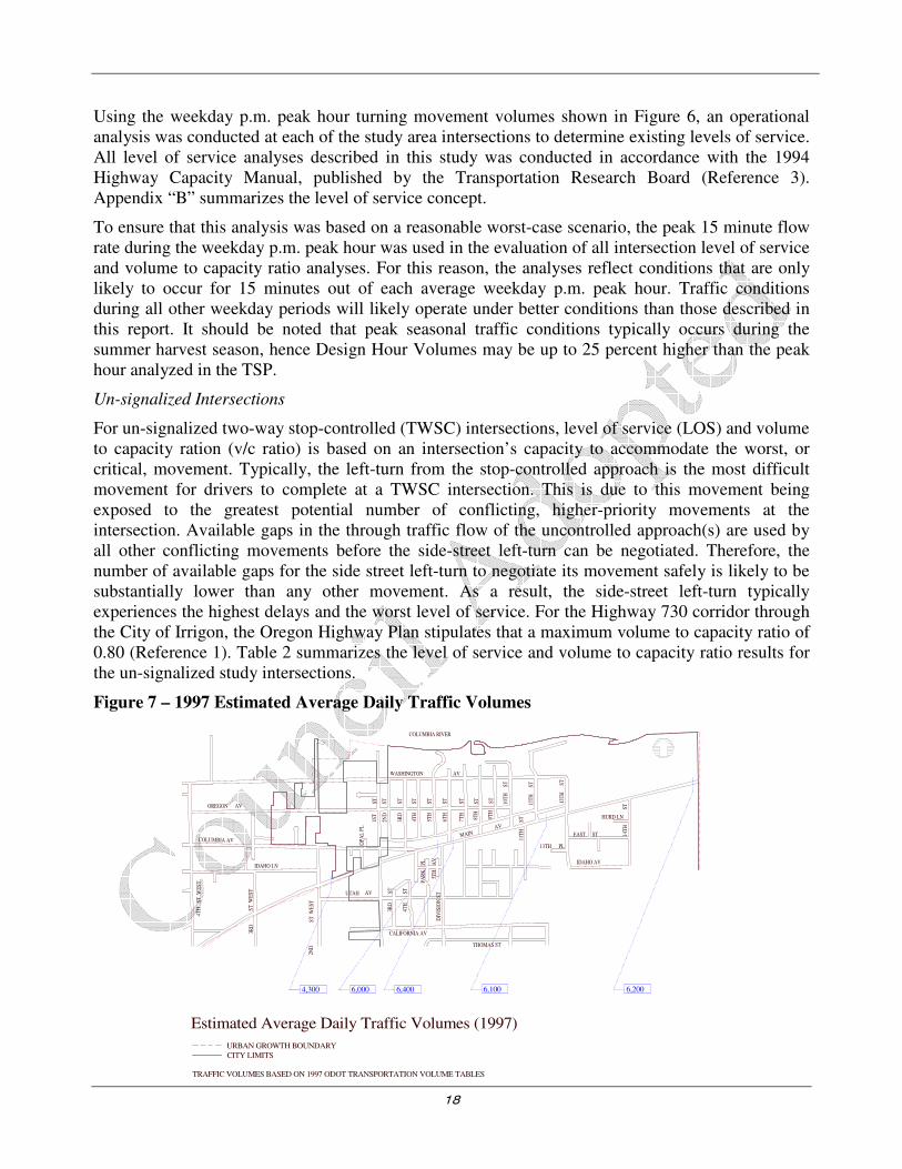
Figure 7 – 1997 Estimated Average Daily Traffic Volumes
1ST
ST
2ND
ST
3RD
ST
4TH
ST
5TH
ST
6TH
ST
7TH
ST
8TH
ST
9TH
ST
10T
HS
T
11T
HS
T
12T
HS
T
13T
HS
T
ST
14
TH
13TH PL
EAST ST
WASHINGTON AV
OREGON AV
OP
AL
PL
2ND
ST
WE
ST
3RD
ST
WE
ST
IDAHO LN
MAINAV
3RD
ST
ST
4T
H
PA
RK
PL
5TH
AV
DIV
ISIO
N S
T
CALIFORNIA AV
THOMAS ST
UTAH AV
COLUMBIA RIVER
IDAHO AV
4TH
ST
WE
ST
HURD LN
6,2006,1006,4006,0004,300
URBAN GROWTH BOUNDARY
CITY LIMITS
COLUMBIA AV
Estimated Average Daily Traffic Volumes (1997)
TRAFFIC VOLUMES BASED ON 1997 ODOT TRANSPORTATION VOLUME TABLES
19
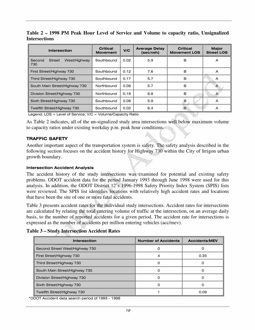
Table 2 – 1998 PM Peak Hour Level of Service and Volume to capacity ratio, Unsignalized
Intersections
Intersection Critical
Movement V/C
Average Delay
(sec/veh)
Critical
Movement LOS
Major
Street LOS
Second Street West/Highway 730
Southbound 0.02 5.9 B A
First Street/Highway 730 Southbound 0.12 7.6 B A
Third Street/Highway 730 Southbound 0.17 5.7 B A
South Main Street/Highway 730 Northbound 0.08 5.7 B A
Division Street/Highway 730 Northbound 0.18 6.8 B A
Sixth Street/Highway 730 Southbound 0.08 5.9 B A
Twelfth Street/Highway 730 Southbound 0.02 6.4 B A
Legend: LOS = Level of Service; V/C = Volume/Capacity Ratio
As Table 2 indicates, all of the un-signalized study area intersections well below maximum volume to capacity ratios under existing weekday p.m. peak hour conditions.
TRAFFIC SAFETY
Another important aspect of the transportation system is safety. The safety analysis described in the following section focuses on the accident history for Highway 730 within the City of Irrigon urban growth boundary.
Intersection Accident Analysis
The accident history of the study intersections was examined for potential and existing safety problems. ODOT accident data for the period January 1993 through June 1998 were used for this analysis. In addition, the ODOT District 12’s 1996-1998 Safety Priority Index System (SPIS) lists were reviewed. The SPIS list identifies locations with relatively high accident rates and locations that have been the site of one or more fatal accidents.
Table 3 presents accident rates for the individual study intersections. Accident rates for intersections are calculated by relating the total entering volume of traffic at the intersection, on an average daily basis, to the number of reported accidents for a given period. The accident rate for intersections is expressed as the number of accidents per million entering vehicles (acc/mev).
Table 3 – Study Intersection Accident Rates
Intersection Number of Accidents Accidents/MEV
Second Street West/Highway 730 0 0
First Street/Highway 730 4 0.35
Third Street/Highway 730 0 0
South Main Street/Highway 730 0 0
Division Street/Highway 730 0 0
Sixth Street/Highway 730 0 0
Twelfth Street/Highway 730 1 0.09
*ODOT Accident data search period of 1993 – 1998
20
As shown in Table 3, the only study intersections with reported accidents during the review period were the First Street/Highway 730 intersection and the Twelfth Street/Highway 730 intersection. A single accident was reported at the Twelfth Street/Highway 730 intersection in August of 1994. There were no SPIS sites within the city limits.
During the study period, the First Street/Highway 730 intersection had four reported accidents, all of which involved vehicles on First Street not yielding to vehicles traveling on Highway 730. Field inspection revealed that the First Street approach to Highway 730 was below the grade of the highway and was aligned at a skew, potentially contributing to the potential for accidents at the intersection. Local residents further noted that sun glare looking to the west from First Street during the evening hours often makes entry to the highway difficult. The First Street/Highway 730 intersection needs to be improved to accommodate the intended functionality of First Street (Collector) and maintain appropriate north/south connectivity.
OTHER IDENTIFIED EXISTING TRANSPORTATION DEFICIENCIES
As an extension of the existing conditions analysis, different aspects of the transportation system with existing deficiencies were identified. A description of the deficiencies and potential improvements follows. The summary is based on field data/observations and information/suggestions that were made by members of the respective transportation agencies and the public.
Highway 730
Members of the Irrigon community raised several concerns regarding the cross-section and function of Highway 730. These issues reflect both vehicular and pedestrian/bicycle access concerns and include:
• The current lack of pedestrian or bicycle facilities along the highway raise safety issues with the exception of the multiuse path on the North side of Highway 730. Several agency staff members and citizens noted that, although there are no sidewalk facilities or bicycle facilities, children routinely walk along and across the highway going to and from school. Several other citizens also routinely cross the highway to reach residences and/or commercial destinations on opposite sides of the highway. The recent Rapid Rectangular Flashing Beacon construction at First Street and US 730 has improved crossing comfort for pedestrians and bicyclists. But, there are still few safe places for pedestrians to cross Highway 730 due to few breaks in the traffic stream and the width of the roadway itself.
• Growing traffic volumes on the highway impact community mobility, making access to Highway 730 from side streets increasingly difficult, though adequate capacity currently exists for ingress and egress. (As previously documented, approximately 6,000 vehicles currently traverse Highway 730 through the city on a daily basis.)
• There is a perception among local residents that drivers’ speeds along the highway are too fast
• The parking of large trucks along the shoulders of the highway (and to a lesser extent, cars) was noted to obstruct visibility for drivers at adjacent intersections.
• Parking availability along fruit stands within the community is limited and is a safety concern. Sidewalks and curbs along Highway 730 would help define these areas and control traffic ingress and egress.

21
System Connectivity
During the TAC meeting process, it was noted that there is a continuing need to provide strategic north-south connections across Highway 730 for both vehicles and pedestrians. Similarly, there is a need to ensure that the city provides adequate east-west facilities parallel to Highway 730 such that the community does not become entirely dependent on highway access to facilitate local trips. In addition, with the large amount of residential development occurring on the south side of the city, there is a need to review the layout of the city’s roads to ensure that reasonable connectivity is preserved.
Use of Traffic Control Devices
The placement of some traffic control devices within the City of Irrigon was questioned by local citizens. Based on field inspection, it appears that both stop and yield signs have been inappropriately installed in the past as traffic calming measures. An example of this situation exists along Washington Street. There are several All-Way stops that have been installed along Washington Street, apparently at the request of local residents who were hoping to lower speeds on the roadways.
There are two primary concerns associated with the inappropriate placement of traffic control devices:
1. The placement of the traffic control devices represents a liability to the city if they are inappropriately used (Placement standards are identified in the Manual on Uniform Traffic Control Devices, Reference 4).
2. The inappropriate use of traffic control devices tends to result in disrespect for the device; potentially leading to driver complacency and future accidents (for which the city may then be liable).
QUALITATIVE MULTI-MODAL LEVEL OF SERVICE (THIS SECTION WAS ADDED IN
THE 2014 TSP UPDATE)
The qualitative multi-modal level of service methodology (QMMLOS) is outlined in the draft Analysis Procedures Manual V2, 2014 edition. A QMMLOS was performed for segments of US 730, Division Street, Wyoming Avenue, and First Street. This section outlines the QMMLOS methodology and findings along these three roadway segments.
Overview of QMMLOS
In general QMMLOS integrates the following characteristics for pedestrians, bicyclists, transit, and auto modes:
Pedestrian Facilities
� Outside travel lane width
� Bike lane/shoulder width
� Buffers
� Sidewalk path presence
� Pavement Condition
� Volume and Speed

22
� Traffic Control
� Crossing Width
� Median Islands
Bicycle Facilities
� Bicycle lane presence and effective width
� Shoulder presence and width
� Outside travel lane width
� Pavement Condition
� On Street Parking
� Volume, type, and speed of motorized traffic in the adjacent travel lane:
� Traffic Control
� Crossing Width
Transit
� Service frequency
� Bus Speed/Travel Times
� Bus Stop Features
� Pedestrian Network
Auto
� Volume to Capacity Ratio
� Delay
� Safety
Given these high-level roadway characteristics, the following roadway corridors were inventoried and analyzed as described below.
US 730 (Second Street to Twelfth Street)
US 730 is a three-lane facility (center two-way left-turn (TWLT) lane) with approximately 5,000 ADT. The posted speed is 35 mph, dropping to 20 mph during school hours in the school speed zone adjacent to A.C. Houghton Elementary School. The through travel lanes are 12 feet wide and the center TWLT lane is 14 feet wide. The fog line to fog line roadway width is approximately 38 feet while some of the marked crossings may be as long as 60 feet depending on the presence of an additional turn lane. The roadway length between First Street and Twelfth Street is approximately 0.66 miles.
Pedestrian Facilities
There are no concrete sidewalks along US 730, however there is a paved shoulder six to eight feet wide and a three-foot wide gravel shoulder. Locations near businesses tend to have more gravel area

23
between the paved roadway and the frontage. The north side of US 730 has a parallel multi-use path connecting Third Street to Tenth Street.
There is one rapid rectangular flashing beacon (RRFB) crossing the east leg of First Street/US 730 intersection and three other zebra crossings at the Division Street/US 730, Tenth Street/US 730, and Twelfth Street/US 730 intersections.
Bicycle Facilities
There are no formal bicycle lanes along US 730, however there is a paved shoulder six to eight feet in width. There are five intersections (First Street, Third Street, Tenth Street, Twelfth Street, and Fourteenth Street) that have right-turn deceleration lanes, and at those locations, a four foot through bike lane is striped.
The north side of US 730 has a parallel multi-use path connecting Third Street to Tenth Street.
There is parallel on-street parking along this segment of US 730, however head-in perpendicular parking is provided at some locations. The perpendicular parking is setback from the shoulder at least ten feet.
As previously noted, there is one RRFB crossing on the east leg of First Street/US 730 intersection. However, because the crossing is on the east leg of the intersection, only northbound bicyclists are directly accommodated. Furthermore, there is no curb tight bicyclist push button, therefore bicyclists must mount the sidewalk to activate the RRFB.
Transit
Currently CTUIR Public Transit provides free transit services between Irrigon and Pendleton via the Hermiston Hopper shuttle. Stops are located at the Irrigon City Hall and Post Office.
Auto
The automobile operational performance was evaluated according to ODOT’s analysis methodology and performance targets as identified in the Technical Standards/Methodology Memorandum dated October 7th, 2013.
Table 4 illustrates the operational analysis of key intersections along US 730.
Table 4 - Existing US 730 Study Intersection Operations
Intersection Volume to
Capacity
Average Delay (seconds)
Level of Service
Critical Movement
SW Second Street/US 730 0.02 10.8 B Northbound
S First Street/US 730 0.07 11.4 B Southbound
Division Street/US 730 0.05 12.7 B Southbound
Tenth Street NE/US 730 0.06 10.8 B Southbound
SE Fourteenth Street/US 730 0.03 10.7 B Northbound
As shown in Table 4, all intersections operate at level of service B or better and the volume to capacity ratios are below 0.75, which are within Highway Design Manual and Oregon Highway Plan performance targets. Appendix D contains the detailed operations worksheets.
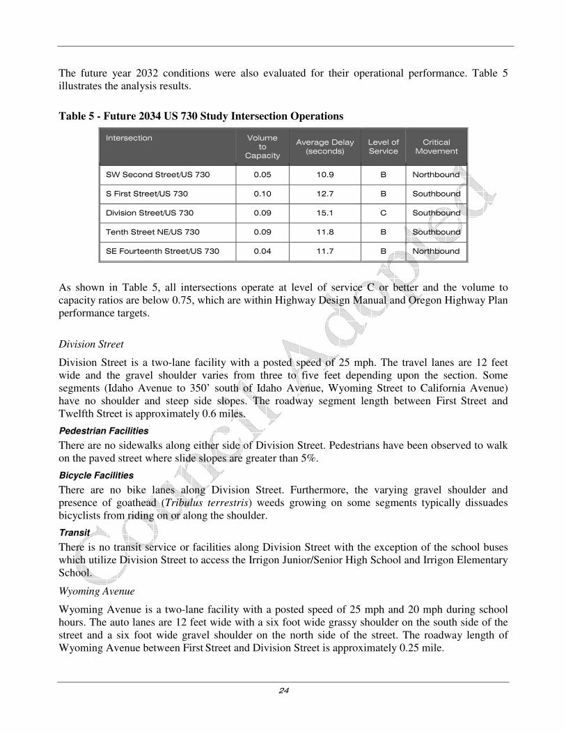
24
The future year 2032 conditions were also evaluated for their operational performance. Table 5 illustrates the analysis results.
Table 5 - Future 2034 US 730 Study Intersection Operations
Intersection Volume to
Capacity
Average Delay (seconds)
Level of Service
Critical Movement
SW Second Street/US 730 0.05 10.9 B Northbound
S First Street/US 730 0.10 12.7 B Southbound
Division Street/US 730 0.09 15.1 C Southbound
Tenth Street NE/US 730 0.09 11.8 B Southbound
SE Fourteenth Street/US 730 0.04 11.7 B Northbound
As shown in Table 5, all intersections operate at level of service C or better and the volume to capacity ratios are below 0.75, which are within Highway Design Manual and Oregon Highway Plan performance targets.
Division Street
Division Street is a two-lane facility with a posted speed of 25 mph. The travel lanes are 12 feet wide and the gravel shoulder varies from three to five feet depending upon the section. Some segments (Idaho Avenue to 350’ south of Idaho Avenue, Wyoming Street to California Avenue) have no shoulder and steep side slopes. The roadway segment length between First Street and Twelfth Street is approximately 0.6 miles.
Pedestrian Facilities
There are no sidewalks along either side of Division Street. Pedestrians have been observed to walk on the paved street where slide slopes are greater than 5%.
Bicycle Facilities
There are no bike lanes along Division Street. Furthermore, the varying gravel shoulder and presence of goathead (Tribulus terrestris) weeds growing on some segments typically dissuades bicyclists from riding on or along the shoulder.
Transit
There is no transit service or facilities along Division Street with the exception of the school buses which utilize Division Street to access the Irrigon Junior/Senior High School and Irrigon Elementary School.
Wyoming Avenue
Wyoming Avenue is a two-lane facility with a posted speed of 25 mph and 20 mph during school hours. The auto lanes are 12 feet wide with a six foot wide grassy shoulder on the south side of the street and a six foot wide gravel shoulder on the north side of the street. The roadway length of Wyoming Avenue between First Street and Division Street is approximately 0.25 mile.

25
Pedestrian Facilities
There are no sidewalks along Wyoming Avenue; however there is an asphalt path on the south side of the road which stretches from the elementary school to First Street. There is an asphalt path on the north side of Wyoming Avenue which stretches 150 feet east from First Street.
Bicycle Facilities
There are no bike lanes on Wyoming Avenue.
Transit
There is no transit service or facilities along Wyoming Avenue.
First Street
First Street is a two-lane facility with a posted speed of 25 mph. In 2009/2010, Division Street from US 730 to California Avenue was reconstructed to include a new paved travel way, green street drainage swales, and sidewalks. There are five foot wide gravel shoulders from California Avenue to Wyoming Street. The roadway length between First Street and 12 Street is approximately half a mile.
Pedestrian Facilities
There are sidewalks on both sides of First Street from US 730 to California Avenue where there are also concrete six planters between the sidewalk and street in place of parking which provide more separation between auto traffic and pedestrians. There is a RRFB at US730 which provides an enhanced crossing on the east leg of First Street. Between California and Wyoming Avenue there are approximately five feet shoulders on both sides of the street. There is an asphalt path on the east side of First Street stretching approximately 500 feet from Wyoming Street.
Bicycle Facilities
There are no bike facilities on First Street except for an asphalt path on the east side of First Street 500 feet from Wyoming Avenue. There are no formal bicycle facilities on First Street; therefore they are mixed traffic. The RRFB at US 730 provides an enhanced crossing on the east leg of First Street, but there is no curb tight bicycle push button; therefore, bicyclists must mount the sidewalk to activate the RRFB.
Transit
There are no transit facilities or service along on First Street.
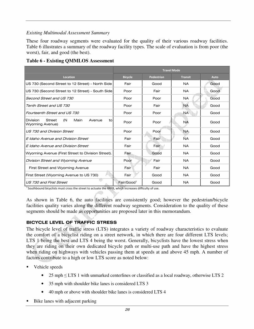
26
Existing Multimodal Assessment Summary
These four roadway segments were evaluated for the quality of their various roadway facilities. Table 6 illustrates a summary of the roadway facility types. The scale of evaluation is from poor (the worst), fair, and good (the best).
Table 6 - Existing QMMLOS Assessment
Travel Mode
Location Bicycle Pedestrian Transit Auto
US 730 (Second Street to 12 Street) - North Side Fair Good NA Good
US 730 (Second Street to 12 Street) - South Side Poor Fair NA Good
Second Street and US 730 Poor Poor NA Good
Tenth Street and US 730 Poor Fair NA Good
Fourteenth Street and US 730 Poor Poor NA Good
Division Street (N Main Avenue to Wyoming Avenue)
Poor Poor NA Good
US 730 and Division Street Poor Poor NA Good
E Idaho Avenue and Division Street Fair Fair NA Good
E Idaho Avenue and Division Street Fair Fair NA Good
Wyoming Avenue (First Street to Division Street). Fair Good NA Good
Division Street and Wyoming Avenue Poor Fair NA Good
First Street and Wyoming Avenue Fair Fair NA Good
First Street (Wyoming Avenue to US 730) Fair Good NA Good
US 730 and First Street Fair/Good1 Good NA Good
1 Southbound bicyclists must cross the street to actuate the RRFB, which increases difficulty of use.
As shown in Table 6, the auto facilities are consistently good; however the pedestrian/bicycle facilities quality varies along the different roadway segments. Consideration to the quality of these segments should be made as opportunities are proposed later in this memorandum.
BICYCLE LEVEL OF TRAFFIC STRESS
The bicycle level of traffic stress (LTS) integrates a variety of roadway characteristics to evaluate the comfort of a bicyclist riding on a street network, in which there are four different LTS levels; LTS 1 being the best and LTS 4 being the worst. Generally, bicyclists have the lowest stress when they are riding on their own dedicated bicycle path or multi-use path and have the highest stress when riding on highways with vehicles passing them at speeds at and above 45 mph. A number of factors contribute to a high or low LTS score as noted below:
� Vehicle speeds
• 25 mph ≤ LTS 1 with unmarked centerlines or classified as a local roadway, otherwise LTS 2
• 35 mph with shoulder bike lanes is considered LTS 3
• 40 mph or above with shoulder bike lanes is considered LTS 4
� Bike lanes with adjacent parking

27
• Sum of roadway and bike lane is greater than 15 feet then LTS = 1
� Intersections
• Unsignalized crossings at 35 mph is LTS 2
• Enhanced crossings (presence of RRFB) are considered LTS 1
More detail of how the LTS methodology applies can be found in the APM version 2 and the publication by the Mineta institute <http://transweb.sjsu.edu/project/1005.html>.
There are several limitations to LTS methodology. For example, LTS does not take into account street lighting. There are few street lights in the City of Irrigon, therefore if upgrades are to be made to achieve a higher LTS score, consideration should be made to install street lights, where appropriate. Figure 8 illustrates the LTS methodology applied to the City of Irrigon. As shown in Figure 8, US 730 is a barrier separating north and south Irrigon. Some streets are classified as collectors or have center marked lines which result in an LTS 2 rather than LTS 1.

28
Figure 8 – Existing Bicycle Level of Traffic Stress (LTS)
29
SUMMARY
Through an inventory of existing conditions, several key findings were identified. Those findings include:
• The City of Irrigon’s roadway network is focused around Highway 730 with supplemental access to local commercial and residential areas provided by city streets.
• The future growth potential of Irrigon is currently limited by existing water and sewer infrastructure deficiencies.
• There are a handful of sidewalk facilities provided along public roadways within the city. There is a need for pedestrian facilities linking residential neighborhoods to the existing and proposed school buildings, as well as to facilitate safe pedestrian crossings of Highway 730.
• There were a handful of bicycle facilities identified within the city.
• Public transit service is available in the form of a senior bus and dial-a-ride service provided through Morrow County and CTUIR. Other transportation services include bus service provided by the local school bus service, and a personal vehicle reimbursement program for special needs that is funded through RSVP/CAPECO.
• On a typical weekday afternoon, the transportation system experiences its peak roadway traffic demand between 4:30 and 5:30 p.m. During this peak period, the transportation system operates well within established standards.
• Review of accident data from the study intersections did not identify any specific safety deficiencies, though field inspection of the First Avenue/Highway 730 intersection suggests that the geometric design of the intersection could be improved.
• Since the realignment of Highway 730 in 1999, the intersection of NE Third, Columbia Lane, and Highway 730 has created an intersection that does not operate as intended. This has a detrimental effect on the commercially zoned properties within this proximity.
• The use of some traffic control devices within the city is inappropriate.
• A QMMLOS analysis was performed illustrating existing conditions.
• A bicycle LTS analysis was performed identifying gaps in the low stress bicycle network.
30
Section 3
Future Conditions Analysis

31
Future Conditions Analysis
INTRODUCTION
This section presents estimates of long-term future travel conditions within the TSP study area. The long-term future transportation needs for the City of Irrigon were examined based on available employment and population forecasts, identified development activities, review of the proposed roadway network, results from the operational analysis of the existing street system, and extensive discussions with regional transportation personnel and local citizens.
TRANSPORTATION DEMAND
Future transportation demand within the City of Irrigon urban growth boundary was estimated based on expected growth in the study area population, employment, and traffic traveling through the study area for the horizon year 2020. Alternative land uses were compared with the land use mix proposed in the city’s Comprehensive Plan during development of the long-term travel demand forecast. The unique trip making characteristics of residential as well as employment-based activities were then considered in the development of the future travel demand estimates. As part of this analysis, planned developments and transportation improvement projects were identified and reviewed within the city’s urban growth boundary. Historic transportation trends were compared with proposed future site-specific growth to arrive at a reasonable forecast condition.
Land Use/Demographics
Year 2020 traffic volumes on the City of Irrigon transportation system were forecast based on population and employment estimates developed by the State of Oregon for Morrow County and the city. Estimates were compared with development trends, planned developments, and area forecast growth rates. This information was provided by local agencies to verify their appropriateness. The 20-year planning horizon was chosen to ensure compliance with the Transportation Planning Rule.
Population and Employment
Tables 7 and 8 summarize population and employment projections prepared for the City of Irrigon in conjunction with the TSP process. The population information is based on forecasts prepared by the State Economist’s office for Morrow County. In reviewing the two tables, it should be noted that the estimates contained in Table 4 include the population within the city limits as well as the Urban Growth Boundary (UGB). The employment estimates shown in Table 8 are for the city only.
Table 7 – Population Projections
Year 1990 1997 2000 2002 2005 2010 2015 2020 1997-2020
Average
City of Irrigon Projections
Projected Population
-Including UGB
737 1,200
-1,444
1,470
-1,769
1,683
-2,025
1,776
-2,137
1,922
-2,313
2,071
-2,492
2,209
-2,658 --
Annual Percent Change -- 7.2% 7.0% 7.0% 1.8% 1.6% 1.5% 1.3% 2.7%
Morrow County Projections
Projected Population -- 9,895 11,131 12,039 12,701 13,750 14,812 15,801 --
Annual Percent Change -- -- 4.0% 4.0% 1.8% 1.6% 1.5% 1.3% 2.1%
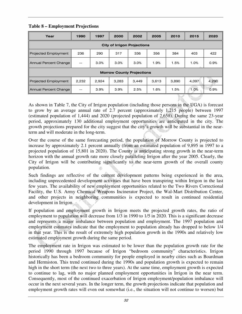
32
Table 8 – Employment Projections
Year 1990 1997 2000 2002 2005 2010 2015 2020
City of Irrigon Projections
Projected Employment 236 290 317 336 356 384 403 422
Annual Percent Change -- 3.0% 3.0% 3.0% 1.9% 1.5% 1.0% 0.9%
Morrow County Projections
Projected Employment 2,232 2,924 3,283 3,449 3,613 3,890 4,097 4,290
Annual Percent Change -- 3.9% 3.9% 2.5% 1.6% 1.5% 1.0% 0.9%
As shown in Table 7, the City of Irrigon population (including those persons in the UGA) is forecast to grow by an average annual rate of 2.7 percent (approximately 1,215 people) between 1997 (estimated population of 1,444) and 2020 (projected population of 2,658). During the same 23-year period, approximately 130 additional employment opportunities are anticipated in the city. The growth projections prepared for the city suggest that the city’s growth will be substantial in the near-term and will moderate in the long-term.
Over the course of the same forecasting period, the population of Morrow County is projected to increase by approximately 2.1 percent annually (from an estimated population of 9,895 in 1997 to a projected population of 15,801 in 2020). The County is anticipating strong growth in the near-term horizon with the annual growth rate more closely paralleling Irrigon after the year 2005. Clearly, the City of Irrigon will be contributing significantly to the near-term growth of the overall county population.
Such findings are reflective of the current development patterns being experienced in the area, including unprecedented development activities that have been transpiring within Irrigon in the last few years. The availability of new employment opportunities related to the Two Rivers Correctional Facility, the U.S. Army Chemical Weapons Incinerator Project, the Wal-Mart Distribution Center, and other projects in neighboring communities is expected to result in continued residential development in Irrigon.
If population and employment growth in Irrigon meets the projected growth rates, the ratio of employment to population will decrease from 1/3 in 1990 to 1/5 in 2020. This is a significant decrease and represents a major imbalance between population and employment. The 1997 population and employment estimates indicate that the employment to population already has dropped to below 1/4 in that year. This is the result of extremely high population growth in the 1990s and relatively low estimated employment growth during the same period.
The employment rate in Irrigon was estimated to be lower than the population growth rate for the period 1990 through 1997 because of Irrigon “bedroom community” characteristics. Irrigon historically has been a bedroom community for people employed in nearby cities such as Boardman and Hermiston. This trend continued during the 1990s and population growth is expected to remain high in the short term (the next two to three years). At the same time, employment growth is expected to continue to lag, with no major planned employment opportunities in Irrigon in the near term. Consequently, most of the continued exacerbation of Irrigon employment/population imbalance will occur in the next several years. In the longer term, the growth projections indicate that population and employment growth rates will even out somewhat (i.e., the situation will not continue to worsen) but

33
there will continue to be a serious imbalance between the number of people living and working in Irrigon.
Further details regarding the employment and growth assumptions for this report are detailed in Appendix “C”.
While the contractor produced population figures for transportation demand for this document, ODOT continues to monitor needs within the community. ODOT continually updates current needs based on development and traffic movement within the community.
It is important to recognize that the City of Irrigon uses an annual average growth rate of 5% growth. They base this average annual growth rate on a 1977 report prepared for the City of Irrigon by J. Val Toronto and Associates, Inc., listed the following populations for the City.
YEAR POPULATION
1960* 232
1970* 261
1976 390
1980* 700
While updating their population the City hired Anderson-Perry and Associates to evaluate the City’s water system in 1984. That report indicated a 1984 population of 900.
YEAR POPULATION
1984 900
1990* 737
1997 1245
1998 1447**
2000* 1702
**City staff estimated the 1998 population.
SCM Consultants, Inc., the City of Irrigon’s engineering company, calculated an average annual growth rate for the City from the period of 1960 to 1998—a period of 38 years—of 4.94%. Furthermore, SCM suggested using a 5% rate for all future growth calculations. The City of Irrigon bases all population estimates on a 5% annual average growth rate.
Anticipated Future Growth
In an effort to account for regional traffic growth, a net annual growth rate was chosen to forecast the year 2020 traffic analysis. This rate was determined based on a review of historical traffic volume trends, anticipated population and employment growth, regional population densities, and local knowledge of planned development.
Historical Growth
A review of local Oregon Department of Transportation traffic volume data on Highway 730 indicated a historical 0.6 percent growth rate between 1960 and 1996. Considering only the past five years and using additional data available for Interstates 82 and 84, the annual traffic growth rate was approximately three percent. Based on the data available, it appears that the relationships between historical employment, population, and traffic growth trends in the study area have been relatively consistent. Given this information, the addition of new residents in the area over the next 20 years is expected to result in a growth in traffic of approximately 2.9 percent annually. The traffic growth can

34
be expected to parallel population growth; hence, the near-term growth in traffic volumes is expected to be more substantial than the long-term growth rate.
FORECAST FUTURE TRAFFIC VOLUMES/DEFICIENCIES
Future conditions within the City of Irrigon were forecast by applying the 2.9 percent annual growth rate assuming a “no-build” condition (i.e., no new roadways would be constructed in the 23-year horizon) to the 1997 local average daily traffic (ADT) volume data (refer to the Existing Conditions section). Figure 6 illustrates the resulting forecast year 2020 average daily traffic volumes under the no-build condition.
A similar analysis of traffic volumes at the study intersections was completed by applying the 2.9 percent annual growth factor to the 1998 existing intersection traffic counts identified in Figure 7. Figure 8 summarizes the forecast year 2020 weekday p.m. peak hour traffic volumes at the study intersections under the no-build condition.
Typically, a two-lane rural highway with geographic features similar to Highway 730 (i.e. relatively flat and straight) can accommodate a maximum of 15,000 to 20,000 vehicles (including vehicles in both directions) daily based on the Highway Capacity Manual (Reference 3). It should, however, be noted that the daily traffic volumes on the Highway 730 should be in the range of 9,000 to 12,000 vehicles to maintain the level of service that residents of Irrigon are accustomed to.
Reviewing the volumes shown in Figure 9, the forecast volumes suggest that the downtown area of Highway 730 east of First Street will experience increased delay in the future that result in a degradation of service below levels currently experienced. While delay will increase, congestion in a commercial area such as Highway 730 should be expected. The forecast volumes clearly indicate that no capacity deficiencies are anticipated for highway traffic.
Level of Service Analysis
For the Highway 730 corridor through the town of Irrigon, ODOT stipulates a maximum volume to capacity ratio of 0.80.
To ensure that the local study area intersections will continue to operate at an acceptable volume to capacity ratio, the forecast future traffic-volumes were analyzed. The findings of this analysis are summarized in Table 9.
Table 9 – 2020 Forecast Level of Service and volume to capacity ratios (Un-signalized Intersections
Intersection Critical
Movement V/C
Average Delay
(sec/veh)
Critical
Movement
LOS
Major Street
LOS
Second Street West/Highway 730
Southbound 0.06 8.1 B A
First Street/Highway 730 Southbound 0.64 30.1 E A
Third Street/Highway 730 Southbound 0.17 16.6 C A
South Main Street/Highway 730 Northbound 0.23 10.2 C A
Division Street/Highway 730 Northbound 0.63 26.7 D A
Sixth Street/Highway 730 Southbound 0.24 12.5 C A
Twelfth Street/Highway 730 Southbound 0.07 13.1 C A
Legend: LOS = Level of Service, V/C = Volume/Capacity Ratio

35
As Table 9 indicates, the major street movements of all of the un-signalized study area intersections are forecast to continue operating at acceptable volume to capacity ratios under year 2020 weekday p.m. peak hour conditions.
Figure 9 – 2020 Forecast Average Daily Traffic Volumes
1ST
ST
2ND
ST
3RD
ST
4TH
ST
5TH
ST
6TH
ST
7TH
ST
8TH
ST
9TH
ST
10TH
ST
11TH
ST
12TH
ST
13TH
ST
ST
14TH
13TH PL
EAST ST
WASHINGTON AV
OREGON AV
2ND
ST W
EST
3RD
ST W
EST
IDAHO LN
COLUMBIA AVMAIN
AV
3RD
ST
ST
4TH
PAR
KPL
5TH
AV
DIV
ISIO
N S
T
CALIFORNIA AV
THOMAS ST
UTAH AV
COLUMBIA RIVER
IDAHO AV
4TH
ST W
EST
HURD LN
12,00011,70012,35011,5008,300
URBAN GROWTH BOUNDARY
CITY LIMITS
Forecast Average Daily Traffic Volumes (2020)
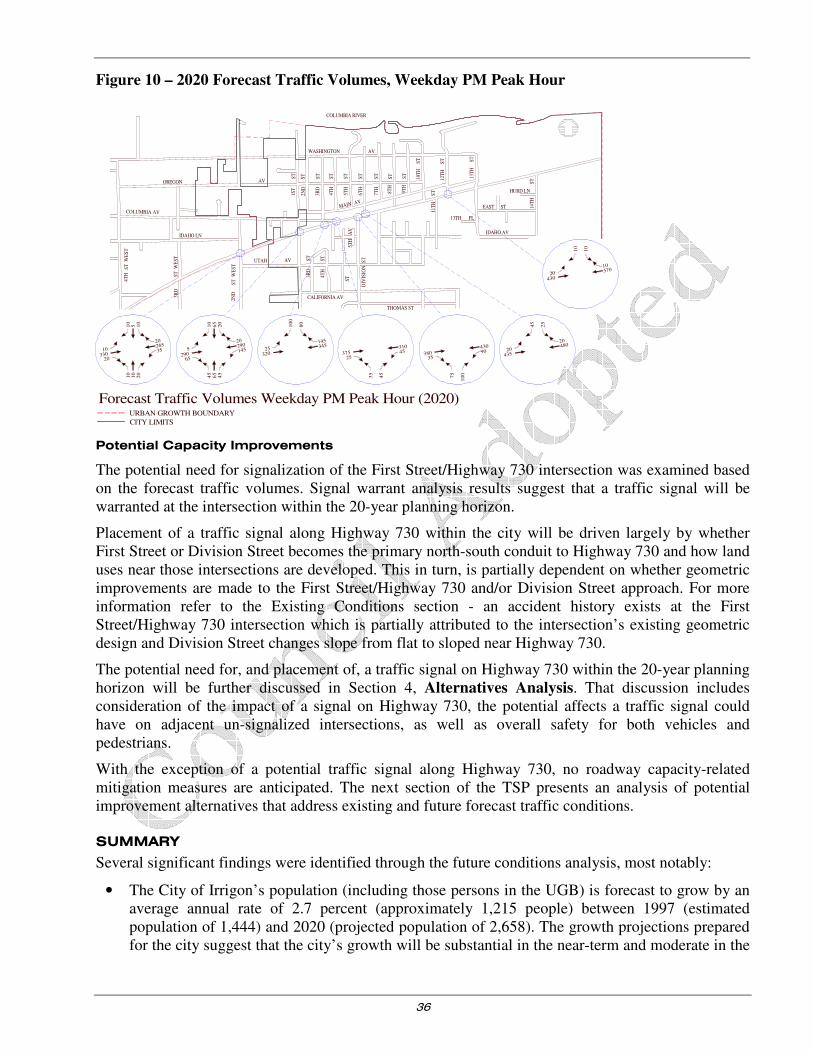
36
Figure 10 – 2020 Forecast Traffic Volumes, Weekday PM Peak Hour
Potential Capacity Improvements
The potential need for signalization of the First Street/Highway 730 intersection was examined based on the forecast traffic volumes. Signal warrant analysis results suggest that a traffic signal will be warranted at the intersection within the 20-year planning horizon.
Placement of a traffic signal along Highway 730 within the city will be driven largely by whether First Street or Division Street becomes the primary north-south conduit to Highway 730 and how land uses near those intersections are developed. This in turn, is partially dependent on whether geometric improvements are made to the First Street/Highway 730 and/or Division Street approach. For more information refer to the Existing Conditions section - an accident history exists at the First Street/Highway 730 intersection which is partially attributed to the intersection’s existing geometric design and Division Street changes slope from flat to sloped near Highway 730.
The potential need for, and placement of, a traffic signal on Highway 730 within the 20-year planning horizon will be further discussed in Section 4, Alternatives Analysis. That discussion includes consideration of the impact of a signal on Highway 730, the potential affects a traffic signal could have on adjacent un-signalized intersections, as well as overall safety for both vehicles and pedestrians.
With the exception of a potential traffic signal along Highway 730, no roadway capacity-related mitigation measures are anticipated. The next section of the TSP presents an analysis of potential improvement alternatives that address existing and future forecast traffic conditions.
SUMMARY
Several significant findings were identified through the future conditions analysis, most notably:
• The City of Irrigon’s population (including those persons in the UGB) is forecast to grow by an average annual rate of 2.7 percent (approximately 1,215 people) between 1997 (estimated population of 1,444) and 2020 (projected population of 2,658). The growth projections prepared for the city suggest that the city’s growth will be substantial in the near-term and moderate in the
1ST
ST
2ND
ST
3RD
ST
4TH
ST
5TH
ST
6TH
ST
7TH
ST
8TH
ST
9TH
ST
10T
HS
T
11T
HS
T
12T
HS
T
13T
HS
T
ST
14
TH
13TH PL
EAST ST
WASHINGTON AV
OREGON AV
2ND
ST
WE
ST
3RD
ST
WE
ST
IDAHO LN
MAIN AV
3RD
ST
ST
4T
H
ST
5TH
AV
DIV
ISIO
N S
T
CALIFORNIA AV
THOMAS ST
UTAH AV
COLUMBIA RIVER
IDAHO AV
4TH
ST
WE
ST
HURD LN
URBAN GROWTH BOUNDARY
CITY LIMITS
20435
48020
25
45
38035
90430
75
10
0
37525
45310
35
45
25320
345145
80
10
0
5290
65
14529020
45
65
45
20
65
10
10330
20
3526520
10
10
20
10
510
20430
57010
10
10
Forecast Traffic Volumes Weekday PM Peak Hour (2020)
COLUMBIA AV

37
long-term. The current population of 1780 (2003) far exceeds the projected 2.7 percent average annual growth rate that was assumed for this project.
• During the same period, the population of Morrow County is projected to increase approximately 2.1 percent annually from an estimated population of 9,895 in 1997 to a projected population of 15,801 in 2020.
• The City of Irrigon’s transportation system is generally expected to accommodate forecast future growth in travel demand without triggering the need for major capacity-related roadway improvements. One potential capacity-related improvement that warrants further consideration is the long-term need for a traffic signal along Highway 730.

38
Section 4
Alternatives Analysis

39
Alternatives Analysis
INTRODUCTION
This section presents a summary of future transportation improvement alternatives that could be implemented to mitigate existing and projected future transportation system deficiencies. Potential roadway improvement alternatives are presented and recommendations are offered as to their feasibility. As potential deficiency mitigation projects were developed, consideration was given to how a multi-modal approach could contribute to individual projects. Thus, while the primary impetus for a given mitigation alternative may center on increasing vehicular capacity, provision of appropriate bicycle and pedestrian facilities was given equal consideration.
Special effort was provided in considering and recommending improvements to the pedestrian and bicycle systems. Recommendations were developed that create direct linkage to all identified pedestrian/bicycle generators and provide for a core pedestrian and bicycle transportation system. The alternative analysis and subsequent recommendations process were handled separately to ensure that a complete system for each mode was identified without constraint.
It should be noted that, in this section, formal alternatives development and analysis have only been presented for the roadway network and its components. Other elements of the transportation system such as pedestrian access, bicycle access, etc. currently exist at a level such that an entire network needs to be developed. The Transportation System Plan section of this report contains the recommended improvements to all of the modal systems. Furthermore, the 2014 Transportation System Plan update to the pedestrian, bicycle, and transit components have also been provided in Section 5. Information contained in Section 5 may conflict with the Alternatives Analysis in Section
4.
The remainder of this section is organized into two parts. First, a general discussion of improvement needs and associated ramifications is presented. A discussion of specific improvement alternatives, including estimated costs, then follows.
LAND USE/TRANSPORTATION SYSTEM RELATIONSHIP
The existing and future land uses within the City of Irrigon have a substantial impact on the local transportation system. As a result, the city’s transportation system will continue to reflect a strong relationship to local land use well into the future. For illustrative purposes, the following discussion presents some of the transportation implications associated with various land use alternatives.
Background
As stated in the Existing Conditions section, most of the opportunities associated with development and redevelopment over the next 20 years focus on Highway 730 and the parallel North Main Street. Land use opportunities and constraints are described below for industrial, commercial, and residential land. A description of land use alternatives available to the city is then presented.
One of the most prominent opportunities for Irrigon in terms of land use in the context of the transportation system is the abundance of commercially zoned land, including 22 currently vacant and redevelopable acres in the Urban Growth Boundary. Sixteen of these were estimated in the buildable lands inventory to be in excess of the amount needed for the next twenty years. Excess commercial land often contributes to a diffused pattern of commercial development and detracts from objectives to create commercial focal points such as a downtown area. An over supply of land will help keep

40
land prices low but at the expense of efficient use of the land supply. Inexpensive, abundant land is a disincentive to efficient land use resulting in extremely auto-dependent land uses and site design, large parking lots with excessive parking and disconnected development.
While it would seem that the city is attractive for commercial development because it has such a large supply, the opposite can actually be the case to achieve long-term, stable business development.
Scattered commercial development also has these disadvantages:
• Difficulty of creating pedestrian-oriented commercial districts. Auto-dependency increases vehicle trips and can disadvantage those who cannot drive automobiles to access needed services.
• The inability to create synergistic effects where businesses can benefit themselves and the community through co-location such as customer patronage and increased sales, shared parking and signage, landscaping, managed access, etc.
• The difficulty in establishing a strong business district identity that in turn can attract more business development.
• The difficulty in establishing a strong community identity that contributes to the community’s social fabric and sense of well-being.
Future residential growth will provide an increased local market for a range of goods and services that will also benefit existing residents. The current arrangement of commercial land in Irrigon is strip commercial along the Highway without defined parking areas. To summarize, this arrangement, exacerbated by lack of definition of the city’s beginning and end, risks distracting the consumer base from stopping and shopping. Additionally, the lack of defined access to stores poses not only a consumer but a safety hazard.
Related land use opportunities include:
• The commercial center at the west end of the city (including the bank, Bakes, the vacant market and the hotel) is the most defined downtown center area and can be considered the downtown commercial center.
• Several fruit market stands along Highway 730 in the highway right-of-way are a regional draw and enjoy a considerable reputation. Although these have historically developed in a dispersed fashion along the highway, centralization of this market type, with available parking and signage, could encourage an increased consumer base and add to the agricultural aspect of the city’s identity. One location for such a use could be between Fifth Street and Sixth Street to the north of Highway 730 as a transitional use between the commercial zone and the city park. (Refer to Figure 2 and the land use scenario maps contained in Appendix E for conceptual illustrations of the proposed zone changes.
• There are currently a number of residential uses on commercial land in Irrigon. By allowing non-commercial uses in commercially zoned areas, the city may be inhibiting the potential for future main street or commercial core development/redevelopment and encouraging strip commercial development along both Highway 730 and North Main Street.
• At the time the buildable lands inventory for Irrigon was completed in 1997, there were over 700 acres of residentially zoned property within the Irrigon Urban Growth Area that were vacant, redevelopable, or had the potential for infill. Redevelopment was projected to occur at densities similar to existing densities (3.5 – 5.5 units per acre). Neither multi-family housing nor mobile home parks are allowed outright in any of Irrigon’s residential zones. Mobile homes are allowed outright on single lots in the R-1 zone.
41
• There are approximately 50 acres of industrially zoned land on the eastern city limit that is not being used for industry. Due to the retail commercial, rather than industrial economic nature of Irrigon, and the excess regional supply of industrial land, particularly owned by the Port of Morrow in Boardman, members of the City Council are considering rezoning some or all of this land. Rezoning the industrial land to commercial where it is currently located at the western end of town could dilute consumer draw from the eastern end of town where the immediate potential for a downtown center is pronounced.
Irrigon thus has an opportunity to create a downtown or main street character to help define the “center” of the city. The existence of a downtown, central commercial core or other focus for retail business is important to the city for a variety of reasons:
• Downtowns perform an important economic function. A downtown provides a center where businesses can congregate and mutually support each other, providing a stronger benefit to each other and the community than when they are separated.
• Downtowns provide a convenient, central location where the community can obtain a variety of goods and services. It performs a social function, especially if civic buildings are located in the downtown, by bringing people together with a sense of pride and ownership in the community.
• Downtowns provide an organizing element to the physical growth and development of the community that help establish logical arrangements of land use that are mutually supportive.
• Downtown’s help a community establish its identity.
Traditionally, downtown’s have these characteristics:
• Grid system of streets;
• 200’ – 300’ blocks;
• wide sidewalks;
• combination of on-street and off-street parking;
• shallow front yard set-backs;
• zero side yard setbacks with attached buildings;
• rear alleys and loading areas; and
• mix of uses – retail, services, public buildings and residential (often above retail businesses)
Many, but not all downtowns have also incorporated landscaping, distinctive lighting, and other street fixture design or design themes.
Whether in a downtown or Main Street, public investment is often a critical factor in creating successful new centers or revitalizing older ones. The location of post offices, city halls, libraries, public safety buildings and other similar facilities helps create the environment of community activity and supports retail businesses. These also help downtowns and main streets be more interesting places, become centers of community life and contribute to the community’s identity and self-image.
Land Use Alternatives Evaluation
The abundant supply of land in Irrigon, while presenting problems and challenges, is also an opportunity, presenting the community with several choices on how to develop the Main Street, residential and commercial areas.

42
This analysis presents three alternatives for consideration by the community: 1) continuation of the existing trend, 2) development of a defined commercial downtown center, and 3) development of a mixed-use commercial downtown zone and main street.
Land Use Alternative 1: Continue Existing Trend
If the existing development pattern is continued, strip commercial development pattern along Highway 730 will result. Lack of multi-family housing will encourage continued development of RV and mobile home parks in a scattered nature throughout the city and urban growth boundary. Undefined commercial and associated parking areas will contribute to a confused transportation system on Highway 730 for both residents and visitors, and risks diffusing the potential market base. Appendix “D” Figure D-1 contains an illustration of this alternative.
Advantages:
• Allows market to operate freely, generally unconstrained;
• Requires limited commitment by city to promote or regulate;
• Ample area for expansion; and
• Diffuses traffic impacts associated with commercial development
Disadvantages:
• Continues undefined strip commercial development pattern;
• May be difficult to attract quality commercial development along entire strip;
• Commercial development unrelated to residential development;
• Spreads out development making it virtually impossible to achieve a ‘downtown’ character in any one area;
• Diffuses potential market base;
• Not conducive to pedestrian use;
• Tends to increase infrastructure costs; and
• Lack of definition of end or beginning of city, such as ‘gateways’.
Land Use Alternative 2: Defined Commercial Downtown Area/Refined Parking Strategy
Land Use Alternative 2 would build upon areas of existing development and refines city zoning to develop a concentrated commercial downtown between the western city limits and Sixth Street. The primary elements of this alternative include: 1) defined commercial zoning and design standards focus commercial development in the downtown and desired Main Street areas, 2) a parking strategy for both the downtown (refer to Appendix Figure D-2, Character 1) and Main Street areas (Figure D-2), Character 2), and 3) development of recognizable “gateways” to the city.
To ensure infill and redevelopment opportunities, existing ordinances would be reviewed to ensure that they do not contain regulations that could inhibit infill and redevelopment of parcels in the city core.
Advantages:
• Allows current uses to continue;
• Creates a small, tight area as a commercial focus;
43
• Stimulates efficient use of commercial land, infill and redevelopment activity;
• Commercial area close to open space/park area and City Hall;
• Provides a more defined main street feel with pedestrian and bicycle accessibility and facilities at key areas; and
• Can be expanded over time.
Disadvantages:
• Tighter traffic circulation; potential conflicts between inter and intra-city traffic, including freight traffic without adequate signage;
• Will need to be revised, expanded over time; and
• Potential for conflict between auto, pedestrian and bicycle uses.
Land Use Alternative 3: Development of a Mixed Use Commercial Downtown Zone and Main
Street with North-South Connections
Lacking any zone where multi-family housing is allowed in Irrigon, a commercial downtown zone lends itself to a mixed-use blend of development. Under Alternative 3, property would be rezoned to allow residential development above commercial/retail development in the Main Street area (C1), a new C2 zone for more auto-oriented uses would be created for the western and eastern ends of the community (see Figure D-3), and access alley parking would be allowed in the downtown and Main Street zones. Such a development pattern would decrease safety/access problems associated with currently undefined parking on Highway 730. A new multifamily zone would also be designated in the Main Street area of the city as depicted in Figure D-3, close to pedestrian and bicycle facilities, public use areas, and retail/commercial zoning.
Advantages:
• Creates a small, tight area as a commercial focus;
• Makes use of and builds upon what is already developed;
• Builds upon the city’s geographic location and recreational opportunities;
• Allows for more compact commercial and residential development;
• Stimulates efficient use of commercial land, infill and redevelopment activity as well as multifamily units close to key services and transportation routes;
• Utilizes open space/park area;
• Provides a more defined main street feel with pedestrian and bicycle accessibility and amenities at key areas, including commercial center and City Hall;
• Consolidates parking both in front of and behind businesses;
• With consolidated parking behind businesses, more left-turn lanes for commercial access are possible;
• Enhances recreational and tourism opportunities; and
• Can be expanded over time.
Disadvantages:

44
• Tighter traffic circulation; could cause conflicts between inter and intra-city traffic, including freight traffic and
• Will need to be revisited and evaluated with potential for commercial area expansion over time.
Zoning Code Issues
Several zoning code issues were considered in selecting a preferred land use alternative. These issues are presented below.
1. Commercial lands supply and uses allowed in zone.
• The 1997 buildable lands inventory identified buildable commercial land within the city limits and the urban growth boundary. At that time, the study identified 32 acres of vacant and redevelopable commercial land, 17 acres in excess of need through the year 2017 based upon projected population and employment growth.
• The study found that residential uses are allowed in the commercial zone, eroding the developable commercial base, and encouraging commercial sprawl or strip commercial development. As previously described, unconstrained strip commercial development is likely to pose market and aesthetic disadvantages over the long term.
• Currently, there are no residential uses allowed above retail in Irrigon, a historic development pattern that can be very conducive to a downtown ‘main street’ environment.
• The City Park between North Main Street and Highway 730 is currently zoned commercial.
2. Residential supply and lack of a multifamily residential zone.
• At the time of the 1997 buildable lands study, there were an estimated 178 vacant residential lots in the city (363 acres) and the opportunity for 121 units of infill, or building of additional dwelling units on large lots (52 acres). This supply exceeded projected demand by 176 acres for the next 20 years.
• The buildable lands study also described the need, based upon local demographics, for a variety of housing types in Irrigon, including allowing multifamily development in at least one residential zone as an outright permitted use. Lack of a designated zone could discourage provision of needed housing.
3. Related traffic safety issues.
• The Existing Conditions section identified ingress and egress between Highway 730 and commercial land uses as a subject of existing pedestrian and traffic safety issues. The proximity of commercial development to Highway 730 coupled with the lack of definition of the roadways, driveways and parking areas results in driver confusion and safety problems for both vehicles and pedestrians. Sidewalks and curbs along with a parking strategy will help to minimize these conflicts.
Preferred Alternative
To address the issues described above, Land Use Alternative 3, the Mixed Use Commercial Downtown Zone and Main Street alternative is the recommended preferred alternative, with modifications, including creation of an additional commercial zone. The primary reasons for and benefits of this alternative include:
• Efficient use of vacant and redevelopable commercial land for 20 years of community growth in retail and service needs in a pattern conducive to focused commercial growth.

45
• Provision of areas for multifamily development in areas that take advantage of residential proximity to downtown services and uses. Brings zoning code into compliance with statewide land use planning Goal 10 (Housing) requiring a range of housing types.
• The ability to incorporate and surround the downtown with public uses, mixed use, single and multiple family development within walking and bicycling distance of commercial services.
• The capacity of the current and future street system to accommodate growth of commercial and residential development over a long period, simultaneously increasing the safety of the street network, particularly regarding Highway 730.
• To focus commercial development that allows retail uses above the ground floor in close proximity to the central business district.
• The potential to establish a strong identity for the city that will foster community cohesion and pride.
Appendix “D” contains graphical renderings that illustrate elements of the preferred land use alternative. Section 5 of this TSP, Transportation System Plan, provides additional information on the implementation of the preferred land use alternative.
There are also several transportation improvements that will be necessary in the future. The remainder of this section provides improvement alternatives that could be implemented to mitigate existing and anticipated transportation system deficiencies.
INTERSECTION IMPROVEMENTS
The need for mitigation of existing and future roadway/intersection operations in the City of Irrigon is relatively limited in scope. The long-term future forecast conditions analysis described in the Forecast Future Conditions section only identified one anticipated capacity-related intersection deficiency along Highway 730.
Provision of a Traffic Signal along Highway 730
Based on the long-term future forecast traffic conditions, the minor street northbound movement at the First Street/Highway 730 intersection is forecast to operate at a volume to capacity ratio of 0.64 by the year 2020. While the First Street/Highway 730 intersection is considered to operate at a marginally acceptable volume to capacity ratio, the potential need for signalization of the intersection was examined based on the forecast future traffic volumes. Signal warrant analysis results suggest that a traffic signal will be warranted at the intersection within the 20-year planning horizon; however, several issues affect that potential need.
Issues Related to Signalizing an Intersection on Highway 730
There are several interrelated issues that surround the potential installation of a traffic signal along Highway 730 within the City of Irrigon.
Location of a traffic signal
The appropriate location of a signal should be given consideration with respect to its implications on access and circulation for pedestrians, bicyclists, and motorists in the community. The location where the majority of local land uses are concentrated will influence the location of the traffic signal.
The forecast future conditions analysis results suggest that the location which will warrant a traffic signal in the future will depend on whether First Street or Division Street becomes the primary conduit to Highway 730 and how land uses in the vicinity of those intersections are developed. This in turn, is partially dependent on whether geometric improvements are made to First Street’s approach

46
and/or Division Street’s approach near Highway 730. Refer to the Existing Conditions section - an accident history exists at the First Street/Highway 730 intersection that is partially attributed to the intersection’s existing geometric design. Both of these intersections should be improved to improve safety conditions.
Connectivity Considerations
There are also broad connectivity and non-vehicular access issues that will be affected by placement of a traffic signal along Highway 730. One of the issues that have been raised by community members is the need for convenient access across Highway 730 between the north and south sides of the city. Signalization of an intersection on Highway 730 will include installation of pedestrian signals, thereby enhancing safety for both vehicles and pedestrians crossing Highway 730. Given that vehicular, bicycle, and pedestrian crossing of Highway 730 will be facilitated by a traffic signal, the future signalized intersection can be expected to become a community focal point for north-south connections. Considering the implications of that focal effect, it may not be desirable to signalize a particular intersection in order to avoid concentrating traffic in certain areas. Conversely, locating a traffic signal near areas such as the middle school is good for serving pedestrian needs.
Emergency Access to Highway 730
Another potential benefit of a traffic signal would be the ability to facilitate local emergency access to the highway. A traffic signal could be used to pre-empt highway traffic and provide emergency vehicles from the fire station (located on North Main Avenue between Seventh Street and Eighth Street) with priority access to the highway in response situations. The use of the traffic signal for pre-emptive purposes would be especially useful in instances where emergency vehicles need to respond to incidents on the south side of the city. For the purposes of fire pre-emption, provision of a traffic signal at the Highway 730/ Division Street intersection would be desirable as compared to First Street or Second Street West, though a signal anywhere along Highway 730 would be valuable.
Impact on Adjacent Intersections
Installation of a traffic signal is also expected to have other direct and indirect impacts on the local transportation system. The traffic signal should have a positive impact on adjacent un-signalized intersections due to the gaps created in the Highway 730 traffic stream as vehicles on Highway 730 are occasionally stopped at a signal to allow for side street movements. The gaps in the traffic stream will allow for easier access to Highway 730 from un-signalized intersections.
Impact on Highway 730 Traffic
It should be recognized that the installation of a traffic signal on Highway 730 will increase delay to vehicles on the highway as highway traffic will be stopped during those periods when side-street traffic is served by the traffic signal. Although highway traffic will experience some increase in delay, all highway approaches will operate at an acceptable level of service.
Conclusion
Based on these considerations, the intersections of Second Street West/Highway 730, First Street/Highway 730, and Division Street/Highway 730 all are potential candidates for signalization. It is anticipated that one of these intersections will warrant signalization within the 20-year planning horizon. The final determination of which intersection to signalize is dependent on signal warrant analysis and consideration of how the traffic signal could be integrated into the overall transportation system. Accordingly, the ODOT and the City of Irrigon should monitor operations at each intersection over the next 20 years to determine when and if a traffic signal is required at any location. (It should be noted that the addition or modification of a traffic signal on any ODOT facility requires
47
the approval of the State Traffic Engineer. Identification and documentation of the need in this TSP
does not guarantee the provision or modification will occur.)
CIRCULATION IMPROVEMENTS
The City of Irrigon roadway system should be developed to ensure that adequate circulation is provided. Currently, there is a continuing need to provide north-south connections across Highway 730. Similarly, the city needs to ensure that adequate east-west facilities parallel to Highway 730 are provided such that the city does not become entirely dependent on highway access to facilitate local trips. The city should also consider development of access management techniques to further circulation needs. These issues are described further below.
North-South Connectivity
There are several potential opportunities to strengthen north-south connectivity within the City of Irrigon. Some of the improvement alternatives include:
• The potential placement of a traffic signal along Highway 730 at Second Street West, First Street, or Division Street would create an opportunity to provide the community with a north-south focal point for pedestrian, bicycle, and vehicular connections across the highway.
• Second Street West will eventually be extended from Columbia Avenue to Oregon Avenue.
• Extend SE Eleventh Street to California Avenue.
• Extend SE Seventh Street from Utah Avenue to California Avenue.
• Thirteenth Street will eventually be extended from Idaho Avenue to Wyoming Avenue.
• Fourteenth Street will eventually be extended from Idaho Avenue to Wyoming Avenue.
• Fifteenth Street will eventually be extended to Wyoming Avenue.
• Median treatments along Highway 730 that provide an island that serves as a pedestrian refuge and gateway treatments. This project is especially important in the area of schools and the Post Office as well as other pedestrian generators.
• The First Street/Highway 730 intersection needs to be improved to accommodate the intended functionality of First Street (Collector) and maintain appropriate north/south connectivity.
• Other roadway cross-section improvements that more clearly define the shoulders of Highway 730 and/or minimize the straight-line crossing distance for pedestrians and cyclists, such as curbs, bike lanes, and sidewalks.
• Provision of access-management techniques that consolidate access points along Highway 730 as property develops or redevelops and allow for more focused north-south movements across the highway at intersections with public streets. Addition of sidewalks, curbs, and pedestrian refuge facilities would aid in resolving issues along Highway 730.
• Continued development of a grid system as properties develop in the south part of the city.
East-West Connectivity
In addition to improving north-south connectivity, it is important to ensure that convenient east-west connectivity is also preserved such that the city does not become entirely dependent on highway access to facilitate local trips. With the large amount of residential development occurring on the south side of the city, there is a need to ensure that the city’s east-west roads are connected in a logical manner.
48
Further, ODOT has access control lines within the city that limit future connections to Highway 730. Specifically, Highway 730 is access controlled on both sides from milepost 174.1 to milepost 175.5 (approximately from Fourth Street West to Columbia Avenue) and on the south side from milepost 165.05 to milepost 178.70 (milepost 178.70 represents the Morrow County line).
Potential opportunities to strengthen east-west connectivity within the City of Irrigon include:
• Wyoming Avenue will eventually be extended from Division Street to Fifteenth Street and from Second Street West to Fourth Street West.
• California Avenue will eventually extend from First Street to Third Street West and from Tenth Street to Fifteenth Street.
• Utah Avenue will eventually extend from Tenth Street to Fifteenth Street.
• Idaho Avenue will eventually extend from Thirteenth Street to Fifteenth Street.
Main Avenue Connectivity/Impact on the A.C. Houghton Elementary School
Columbia Avenue and North East Main Avenue offer city residents a frontage road that is a convenient alternative to Highway 730 for east-west travel. While such a connection is desirable from a connectivity perspective, there is at least one major concern associated with the frontage road concept. The A.C. Houghton Elementary School is located on the north side of NE Main Avenue between Tenth Street and Twelfth Street. Currently, there is not adequate delineation between the lanes of NE Main Avenue and the school parking lot located on the south side of NE Main Avenue. There also are no pullout lanes for school buses to load and unload students, though the City of
Irrigon Street, Sidewalk, Bikeway, and Handicap Access Study recommends provision of such facilities. Because of the current layout of NE Main Avenue and the school parking lot, this section of NE Main Avenue has been the subject of safety concerns.
Access Management and Safety
The spacing of access points along roadways influences the capacity, safety, and overall performance of a given facility. Accordingly, access locations on roadway sections need to be properly located to ensure safe and efficient travel along roadway corridors. Access locations should be placed appropriately to limit potential conflicting turning movements, weaving maneuvers over short distances, and congestion along facilities.
In general, as the number and proximity of access points along a given road increases, there is an increase in the number of potential conflicting turning movements into and out of those access points. These turning maneuvers ultimately can adversely affect the operations of traffic on the roadway itself.
IMPROVEMENT ALTERNATIVES EVALUATION
The following discussion presents specific improvement alternatives that were considered for inclusion as part of the City of Irrigon Transportation System Plan. Each of the alternatives has been identified by number for reference purposes, with the relative location of each improvement identified in Figure 9.
It should be noted that the order in which the alternatives are presented is not intended to convey the relative rank or significance of the respective projects. Further, the identified improvement alternatives were evaluated based on construction costs and ability to meet identified transportation needs. Other factors, including potential environmental impacts, were not specifically considered. Some environmental impacts that could occur have the potential to increase costs or require project modifications. The required modifications or increased costs could be significant enough to make the
49
project impractical. All cost estimates were based on industry unit costs and do not reflect utility relocation, environmental constraints, property acquisition or inflationary increases in cost over the planning horizon of this document.
Funding resources available to the City of Irrigon and ODOT are limited. It is expected that, for the near future, those funding sources that are available will predominantly be applied to maintenance and preservation of the existing transportation system. In light of the constrained funding situation, it should be recognized that implementation of some of the alternatives presented in this section may not be practical within the 20-year planning horizon.
Alternative #1 – Reduce Vehicular Reliance through Zoning and Development Code
Revisions
In part, Oregon’s Transportation Planning Rule seeks to reduce the reliance on personal vehicles as a mode of travel through the creation of environments that foster alternative modes of transportation. Local land uses can have a significant impact on the form of transportation necessary to travel from one location to another. Specifically, by carefully structuring local zoning and development codes, development activities can be focused such that a more self-contained community can be achieved. Construction of mixed-use developments, the location of commercial/service businesses near residential land uses, and the provision of employment opportunities near residential areas are all means by which the need for travel by personal automobile can be reduced.
In relatively rural areas such as Irrigon, the need to travel long distances to employment, commercial, and service opportunities fosters a travel environment dependent on personal automobiles. Implementation of the Mixed Use Commercial Downtown Zone with North-South Connections concept, as described in the Preferred Land Use Alternative, will help reduce the need for vehicular reliance. The proposed location of multi-family residential zones as well as allowing residential development above retail uses in the downtown and main street areas will offer, when the residential units are constructed, increased pedestrian and cycling alternatives to automobile-only oriented transportation.
Recommendation
Implementation of the preferred land use alternative, the Mixed Use Commercial Downtown Zone with North-South Connections concept, is recommended. Provision of appropriate zoning and development code revisions should be made by the city.
Alternative #2 – Improve Division Street/include pedestrian facilities
Improve Division Street to accommodate auto and pedestrian traffic. This is a main thoroughfare for transporting people to the local schools (Irrigon Elementary, Irrigon High School).
Recommendation
This improvement alternative is recommended for implementation in the mid- to long-term future.
Alternative #3 – Signalize First Street/Highway 730 Intersection
As previously discussed, there are several potential benefits to having a traffic signal along Highway 730. These potential benefits include enhanced north-south connectivity, enhanced emergency access to and across Highway 730, and improved operations at both the signalized intersection and adjacent un-signalized intersections. Highway 730 traffic will experience some increased delay resulting from a reduction in capacity associated with the traffic signal; however, highway movements will operate at an acceptable level of service.
50
While traffic signal warrants are not met at any of the un-signalized study intersections at this time, the long-term future forecast suggests that a traffic signal will ultimately be warranted along Highway 730 within the city. This location would focus north-south travel on to First Street and provide a signalized crossing point to serve the core commercial area of the community. The development of community focal point is central to the concept of a core commercial area that the community is trying to achieve through land use and zoning amendments. Further, the location is ideal for pedestrian and bicycle movements.
This improvement is viewed as being preferable to other locations because it addresses both capacity and safety issues, while also creating a safer environment for pedestrians and cyclists to cross Highway 730.
Recommendation
This improvement alternative is recommended for implementation in the long-term future. (NOTE: The addition or modification of a traffic signal on any ODOT facility requires the approval of the State Traffic Engineer. Identification and documentation of the need in this TSP does not guarantee the provision or modification will occur.)
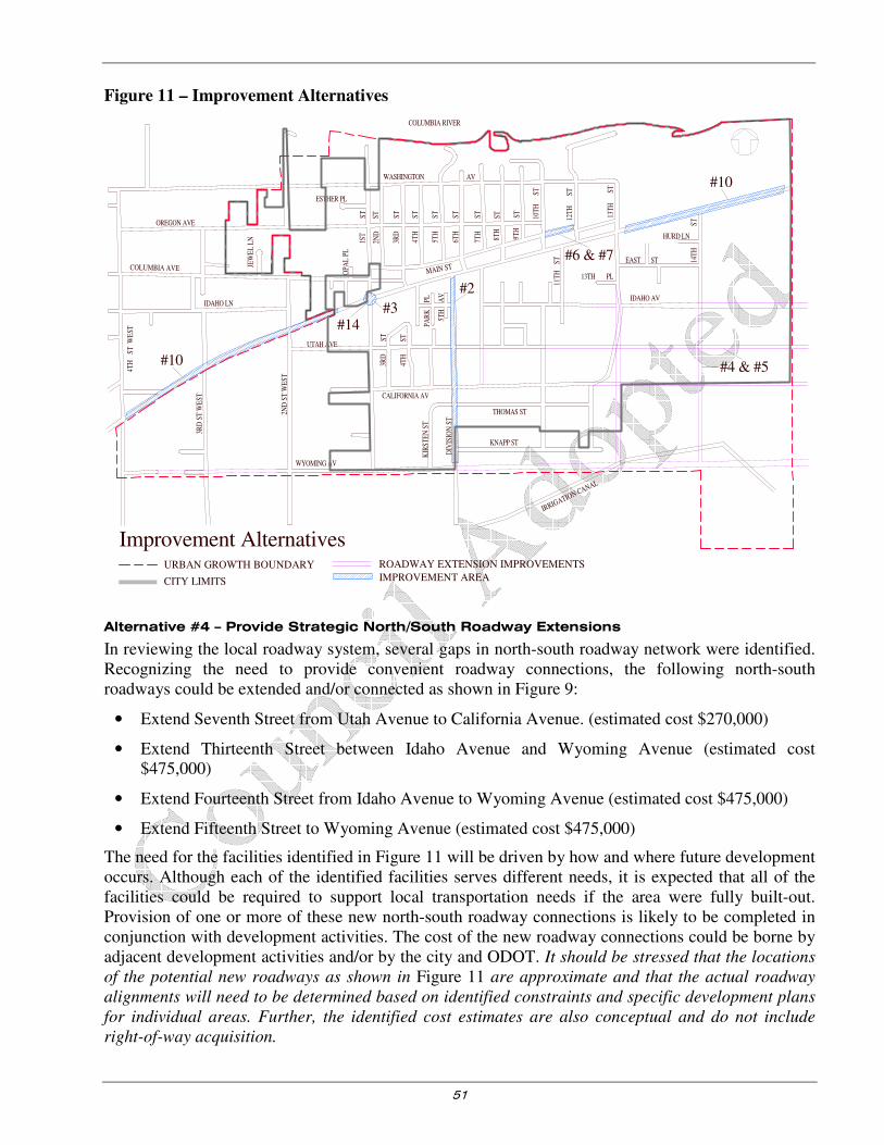
51
Figure 11 – Improvement Alternatives
Alternative #4 – Provide Strategic North/South Roadway Extensions
In reviewing the local roadway system, several gaps in north-south roadway network were identified. Recognizing the need to provide convenient roadway connections, the following north-south roadways could be extended and/or connected as shown in Figure 9:
• Extend Seventh Street from Utah Avenue to California Avenue. (estimated cost $270,000)
• Extend Thirteenth Street between Idaho Avenue and Wyoming Avenue (estimated cost $475,000)
• Extend Fourteenth Street from Idaho Avenue to Wyoming Avenue (estimated cost $475,000)
• Extend Fifteenth Street to Wyoming Avenue (estimated cost $475,000)
The need for the facilities identified in Figure 11 will be driven by how and where future development occurs. Although each of the identified facilities serves different needs, it is expected that all of the facilities could be required to support local transportation needs if the area were fully built-out. Provision of one or more of these new north-south roadway connections is likely to be completed in conjunction with development activities. The cost of the new roadway connections could be borne by adjacent development activities and/or by the city and ODOT. It should be stressed that the locations
of the potential new roadways as shown in Figure 11 are approximate and that the actual roadway
alignments will need to be determined based on identified constraints and specific development plans
for individual areas. Further, the identified cost estimates are also conceptual and do not include
right-of-way acquisition.
#2
#6 & #7
#3
#4 & #5
#10
#10
#14
Improvement AlternativesROADWAY EXTENSION IMPROVEMENTS
IMPROVEMENT AREA
ESTHER PL
1ST
ST
2ND
ST
3RD
ST
4TH
ST
5TH
ST
6TH
ST
7TH
ST
8TH
ST
9TH
ST
10T
HST
11T
HST
12T
HST
13T
HST
ST
14T
H
13TH PL
EAST ST
WASHINGTON AV
OREGON AVE
OPA
L P
L
JEW
EL
LN
2ND
ST
WE
ST
3RD
ST
WE
ST
IDAHO LN
COLUMBIA AVE MAIN ST
3RD
ST
ST
4TH
PAR
KPL
5TH
AV
DIV
ISIO
N S
T
CALIFORNIA AV
WYOMING AV
KNAPP ST
THOMAS ST
KIR
STE
N S
T
UTAH AVE
COLUMBIA RIVER
IDAHO AV
4TH
ST W
EST
HURD LN
IRRIGATION CANAL
URBAN GROWTH BOUNDARY
CITY LIMITS
52
Recommendation
The identified north-south roadway extensions should be implemented as local development activities warrant.
Alternative #5 – Provide Strategic East/West Roadway Extensions
Similar to the need for north-south connectivity, there are several east-west connectivity needs. As shown in Figure 9, several gaps in east-west roadway network were also identified. Recognizing the need to provide convenient roadway connections alternative to Highway 730, the following roadways could be extended and/or connected:
• Extend Idaho Avenue from Thirteenth Street to Fifteenth Street. Some portions of Idaho Avenue already have either an existing gravel base; the purpose of this project would be to link and improve the existing roadway segments such that a continuous improved roadway is ultimately provided
• Extend Utah Avenue from Tenth Street to Fifteenth Street
• Extend California Avenue from Third Street West to Fifteenth Street. Some portions of California Avenue already have either an existing gravel base or half-street improvements; the purpose of this project would be to link and improve the existing roadway segments such that a continuous improved roadway is ultimately provided
• The need for the facilities identified in Figure 9 will be driven by future development. Provision of one or more of these new east-west roadway facilities is likely to be completed in conjunction with local development activities and all the facilities are likely to be required to support full build-out of the area. The cost of the new roadway connections could be borne by adjacent development activities and/or by the city. It should be stressed that the locations of the potential
new roadways as shown in Figure 11 are approximate and that the actual roadway alignment
will need to be determined based on identified constraints and specific development plans for
individual areas. Further, the identified cost estimates are also conceptual and do not include
right-of-way acquisition.
Recommendation
The identified east-west roadway extensions should be implemented as local development activities warrant.
Alternative #6 – Vacate North East Main Avenue between Tenth Street and Twelfth Street
Recognizing the potential for an accident because the roadway separates the school facilities from the parking lot and forces school buses to load/unload buses on the street, the local school district has previously requested that North Main Avenue be vacated between Tenth Street and Twelfth Street. Upon vacation, the school district intends to restrict access on the effected section of road to one-way movements of school vehicles.
Currently, the amount of traffic using North East Main Avenue between Tenth Street and Twelfth Street is relatively small as the land uses to the east are limited in number and scope (to date, those land uses have primarily been developed for single-family residential purposes). The school district has posted signs restricting access to this segment of road during certain hours of the day. While these conditions may limit the near-term potential for conflicts, it should be recognized that traffic volumes on North East Main Avenue in this area might increase substantially in the future if North East Main Avenue is extended to the east to serve as a frontage road for future developments along Highway 730. For this reason, vacation of North Main Avenue in the near-term will jeopardize the long-term ability of the city to provide a parallel frontage road along the north side of Highway 730.

53
Recommendation
In recognition of the frontage road function of North East Main Avenue, the roadway should not be vacated between Tenth Street and Twelfth Street. Instead, alternative improvement measures should be identified and implemented.
Alternative #7 – Improve Delineation on North East Main Avenue Adjacent to the A.C.
Houghton Elementary School
The City of Irrigon Street, Sidewalk, Bikeway, and Handicap Access Study recommends improvements that could be implemented along North East Main Avenue between Tenth Street and Twelfth Street to improve channelization of the roadway and more clearly delineate the parking area (refer to Appendix E). Potential locations for a bus loading/unloading area are also identified.
Recommendation
The conceptual improvement plan developed in the City of Irrigon Street, Sidewalk, Bikeway, and
Handicap Access Study for Main Avenue should be implemented in the near-term future.
Alternative #8 – Inventory and Review Posting of City Traffic Control Devices
As discussed in the Existing Conditions section, the current use of several posted traffic control devices within the city is questionable. Inappropriate placement of traffic control devices has the potential to create a liability issue for the city and encourages disrespect for those traffic control device, potentially contributing to safety problems.
Under this improvement alternative, the City of Irrigon would inventory all existing traffic control devices within the city’s jurisdiction and evaluate whether those devices comply with the placement methodology identified in the Manual on Uniform Traffic Control Devices (Reference 4). Any traffic control devices that are not compliant should then be replaced with an appropriate alternative device or eliminated.
The cost for this project will depend on how it is administered. With proper guidance and instruction, the field inventory could be completed relatively inexpensively by a summer intern. Further, it is unlikely that many will need to be purchased given the number of inappropriately placed signs. Accordingly, the primary cost associated with this alternative would involve mobilizing local crews to remove and/or replace identified traffic control devices as appropriate.
Recommendation
This improvement alternative should be implemented immediately to promote public safety. Specifically, it is recommended that the city only install “Stop” or “Yield” signs to assign right of way, not to slow vehicle speeds. For example, “Stop” signs on roadways such as Washington Avenue would be removed while the traffic control devices on the minor street approaches to Washington Avenue would remain.
Alternative #9 – Promote Access Management along Highway 730
The Oregon Highway Plan has established access spacing standards for Highway 730. These standards, which are presented in detail in Section 5, are intended to ensure the long-term safety and efficiency of the Highway 730 corridor. Implementation of the standards as they relate to local development activities will be essential to ensure the long-term viability of the Highway 730 corridor.
The future conditions analysis, as presented in this document, assumes that current public roadway spacing along Highway 730 will be maintained into the long-term future. As long as access spacing standards along Highway 730 are maintained and new private access points are allowed in accordance with the access spacing standards presented in Section 5, it is expected that the forecast traffic

54
conditions will be reflective of long-term operations along the Highway 730 corridor. Conversely, if multiple additional access points are granted along Highway 730, it can be expected that additional incremental delay will be added to the highway’s operations.
Recommendation
Access Management should be implemented in the immediate future. No specific construction need is evident to implement this improvement as it simply promotes compliance with existing roadway policy. No immediate land use actions would be required either. Instead, as property along Highway 730 is developed or redeveloped, appropriate action should be taken by local and state agencies to ensure that the relevant access spacing standards are reasonably enforced. Section 5, Transportation
System Plan, includes a full access management plan and corresponding implementation strategy complete with typical spacing standards, driveway widths, etc.
Alternative #10 – Provide Gateway Treatments along Highway 730
Through the public meeting process, it was noted that the City of Irrigon currently lacks a defined core area that is evident traveling along Highway 730. The lack of a defined downtown has an indirect impact on highway operations in that drivers perceive a wide-open environment and tend to speed on Highway 730 through the city limits. Streetscape treatments such as landscape strips, pedestrian refuges and bike lanes may be valuable to the city in the future as an instrument by which the character of roadways can be influenced. The graphical renditions contained in Appendix “E” identify potential locations for gateway treatments such as pedestrian refuges, landscaped medians, etc. These treatments provide an indication to drivers that the adjacent land uses necessitate slower speeds.
Recommendation
The city should develop gateway treatments along the highway in conjunction with implementation of the preferred land use alternative. Further, through new roadway and land-use standards, future development activities and roadway improvements along Highway 730 should be focused to influence the streetscape of the highway. By modifying the highway streetscape, driver’s perceptions can be influenced and travel speeds may be reduced. Section 5, Transportation System Plan, presents recommended street standards that will assist in fostering a more constrained perception of the highway travel environment. Appendix “D” contains conceptual renderings of potential streetscapes that could be incorporated into the gateway concept.
Alternative #11 – Enhance Pedestrian Crossings of Highway 730
The public input process and the existing conditions analysis of the TSP identified community concerns involving pedestrian crossings along Highway 730, especially near the elementary school. The combination of Highway 730’s wide cross-section, growing traffic volumes, and the commercial orientation of Highway 730 confirm the need for additional pedestrian facilities. In addition to sidewalk and multi-use path facilities there are other enhancements that should be considered along Highway 730 including:
• provision of additional street lighting to enhance visibility of pedestrians at night
• construction of curb extensions that reduce the exposed crossing distance pedestrians must walk; and
• use of median treatments that provide pedestrians with a “safe-haven” at a mid-crossing

55
Recommendation
Implementation of specific improvement measures will be dependent on local development activities and the city’s ability to create some form of gateway treatment that influences the character of Highway 730. The Recommended Pedestrian and Bicycle System Plan contained in Section 5 identifies specific pedestrian and bicycle improvement projects along the Highway 730 corridor along with appropriate roadway standards.
Alternative #12 – Implement Transportation Demand Management Measures
Transportation Demand Management (TDM) measures identify opportunities to reduce the impact of trips generated by various land uses. Specifically, TDM techniques typically seek to reduce reliance on single-occupant vehicle trips and promote the use of alternative travel modes by persons accessing a given area or facility. The Transportation Planning Rule encourages the evaluation of TDM measures as part of the TSP development process.
TDM strategies often focus on major employers or other sources of traffic that can be influenced through scheduling changes, alternative transit opportunities such as carpools and buses, and other means. Oftentimes, financial disincentives are included in programs as a revenue generator to support other elements of an overall program. The success of fee parking and other commonly used disincentives is dependent on the environment in which a given employer is located.
Given the rural nature of Eastern Oregon and the City of Irrigon, the TDM measures available to the city are limited in scope as compared to larger metropolitan areas. Given the limited employment opportunities in the community, one of the most promising options available to the city is the provision of a carpool or vanpool service for people who live in Irrigon and work in neighboring communities such as Umatilla and Hermiston. Coordination of a vanpool and/or carpool(s) to the major employers in the area such as the Two Rivers Correctional Facility in Umatilla, the Wal-Mart Distribution Center in Hermiston, Union Pacific’s Hinkle Rail yards in Hermiston, and the U.S. Army Chemical Weapons Incinerator at the Umatilla Depot could help to reduce the number of single occupant vehicle commute trips from Irrigon. This type of transportation option would help the community achieve the objectives of transportation demand management.
Provision of a park-and-ride facility at a key location within the community is another means by which the use of non-auto dependent travel can be encouraged. Further, the city could also promote carpooling to out-of-town employers through education.
The cost of implementing a TDM program is dependent on the type and variety of measures selected. Facilitation of carpools, vanpools, or a park-and-ride facility could be completed through a volunteer network and/or coordination with major employers at minimal cost.
Recommendation
It is recommended that the City of Irrigon focus TDM efforts on supporting carpools and/or vanpools to major employers through education, coordination with employers, and provision of appropriate facilities such as park-and-ride areas.
Alternative #13 – Pave Key Collector Facilities
As a part of the development of the city’s roadway infrastructure, the city should pave collector level roadways within the city. Roadway improvements can be made gradually and may be required as part of adjacent development activities. Section 5 of this report, Transportation System Plan, identifies key collector roadways within the city.

56
Recommendation
Alternative #13 should be implemented in the near-term future using the roadway functional classification and cross-section standards identified in Section 5 of this report. It is recognized that the paving projects will extend into the long-term future as the respective roadways are gradually brought up to standard.
Alternative #14 – Reconstruct First Street Approach to Highway 730
The existing First Street/Highway 730 intersection has a vertical curve on the southbound approach to the intersection that limits intersection sight distance and results in issues relating to vehicles’ ability to adequately accelerate as they enter the highway. The intersection should be reconstructed to limit the grade differential between Highway 730 and First Street and support the North/South connectivity concerns of the community. The intersection should be constructed such that it supports the appropriate function of the local road system (collector). Pedestrian facilities should also be provided in conjunction with the reconstruction of the intersection.
Recommendation
Alternative #14 should be implemented in the near- to mid-term future, potentially in conjunction with roadway improvements made by the state along Highway 730.
SUMMARY
This section has presented the alternatives that have been developed and evaluated to address the near-term and long-range transportation deficiencies within the City of Irrigon urban growth boundary.

57
Table 10 - Summary of Improvement Alternative Recommendations
Alternative
Number Improvement Description
Estimated
Cost*
Implementation
Timeline
Responsible
Jurisdiction
#4 Provide Strategic North/South Roadway Extensions
$1,270,000 Concurrent with
local development Private
#5 Provide Strategic East/West Roadway Extensions
$3,905,000 Concurrent with
local development Private
#12 Implement Transportation Demand Management Measures
No estimate As appropriate City/Private
#13 Pave Key Collector Facilities $350/linear
foot
Concurrent with local development and as funds are
available
City/ County/ODOT/
Private
Near–Term
#1 Reduce Vehicular Reliance Through Zoning and Development Code Revisions
No estimate Near –term City
#7 Improve Delineation on North Main Avenue Adjacent to the A.C. Houghton Elementary School
$30,000 Near-term City/Private
#8 Inventory and Review Posting of City Traffic Control Devices
No estimate Near-term City
#9 Promote Access Management Along Highway 730
No estimate Near-term ODOT/City
#10 Provide Gateway Treatments Along Highway 730
No estimate Near-term City/ODOT
#11 Enhance Pedestrian Crossings of Highway 730
No estimate Near-term ODOT
Mid–Term
#2 Improve Division Street and include pedestrian facilities
$130,000 Mid-term City
#14 Reconstruct First Street Approach to Highway 730
$130,000 Mid-term City/ODOT
Long–Term
#3 Signalize the First Street/Highway 730 Intersection
$250,000 Long-term City/ODOT
#6 Vacate North Main Avenue Between Tenth Street and Twelfth Street
No estimate Not recommended for implementation
*Estimated costs are in 1999 dollars and do not include right-of-way acquisition
The privately funded projects identified in

58
Table 10 will be funded and constructed as adjacent properties develop. Implementation of identified city transportation projects over the next 20 years is estimated to cost $395,000 plus administrative charges. Assuming a dedication of $20,000 per year towards the identified projects over the next 20 years, it is reasonable to conclude that the city can fund the recommended improvement alternatives.
Section 5, which follows, incorporates the recommended improvements for each transport mode into the city’s transportation system.

59
Section 5
Transportation System Plan

60
Transportation System Plan
INTRODUCTION
This section describes the individual elements of the City of Irrigon Transportation System Plan. The TSP addresses several components for development of the future transportation network including:
• Preferred Land Use Plan
• Roadway System Plan
• Access Management Plan
• Pedestrian System Plan (Updated in 2014)
• Bicycle System Plan (Updated in 2014)
• Public Transportation System Plan (Updated in 2014)
• Marine System Plan
• Air/Water/Pipeline System Plan
• Evacuation Plan
• Implementation Plan
The individual plans and policies presented in this section were developed specifically to address the requirements of Oregon’s Transportation Planning Rule. Projects associated with each plan element have been identified and costs have been estimated as described herein. The recommendations set forth by this plan reflect the findings of the existing and forecast future conditions analyses, the alternatives analysis, and the concerns expressed by both the citizens of Irrigon and the public agencies that serve them.
PREFERRED LAND USE PLAN
Desirable Elements of the Preferred Alternative
To gain the community benefits of a well-defined, mixed-use downtown area, the following are considered beneficial elements that should be explored in the planning and design, preferably through amendments to the comprehensive plan, implementing ordinances and local street network:
• Defining a mixed use commercial downtown and main street area by defining new multifamily and mixed use commercial zones and rezoning some excess commercial land to residential use
• Limiting residential uses in the commercial (C-1) zone, except above ground floor retail
• Creating an additional commercial zone (C-2) to enhance development of a downtown central business district in the C-1 zone
• Creating ‘gateways’ to the downtown zone that definitively mark entry and exit to the city’s downtown commercial area
• Taking full advantage of good connections to the Columbia River as a recreational amenity and tourist destination
• Creating an area for tourist-oriented commercial development to take advantage of the Columbia River as a recreational amenity and tourist destination
• Careful arrangement of buildings, parking and access that will promote a compact, pedestrian-oriented design
• Defining priority routes for pedestrian and bicycle paths, including sidewalks
• A mix of off-street and on-street parking, including shared parking arrangements and rear-access alleys for additional off-street access and parking
61
Additionally, due to the amount of industrial land available regionally at the Port of Morrow in Boardman, the city might explore the potential for rezoning the 40 acres of currently undeveloped industrial land at the east end of the city to residential use compatible with neighboring properties.
ROADWAY SYSTEM PLAN
Based on the identified existing and anticipated operational and circulation needs, the roadway system plan was developed. The city’s roadway system plan provides guidance as to how to best facilitate travel within the city by addressing two key issues:
• A roadway functional classification system and corresponding roadway design standards that meet the needs of the City of Irrigon.
• Roadway connectivity, including new and improved streets to meet future capacity, circulation, and safety needs
Functional Classification
The purpose of classifying roadways is to create a mechanism through which a balanced transportation system can be developed that facilitates mobility for all modes of transportation. A given roadway’s functional classification determines its intended purpose, the amount and character of traffic, commitment to serve and promote non-auto travel, and its design standards.
The classification of a given street is intended to convey the requirements, capabilities, and capacity of each respective roadway while recognizing that roadway’s contribution to the overall transportation system. It is imperative that the classification of streets is considered in relation to adjacent properties, the land uses that they serve, and the modes of transportation that can be accommodated. Further, each roadway must be appropriately designed to accommodate vehicles local to the roadway (i.e., passenger cars, heavy trucks, pedestrians, and bicycles). The public right-of-way must also provide sufficient space for utilities to serve adjacent land uses.
Based on a review of the city street classification map set forth in the City of Irrigon Street, Sidewalk,
Bikeway, and Handicap Access Study, the functional classification plan for the City of Irrigon is illustrated in Figure 12 to incorporate three functional categories: arterials, collectors, and local streets. The major roadway designations are as follows:
Arterials
• Highway 730
Minor Collectors
• Washington Avenue
• North Main Avenue
• Second Street West
• First Street
• Columbia Avenue
• Fourth Street West
• Fourteenth Street
• Division Street
Local Streets
The remaining roads in the city are designated as local streets.
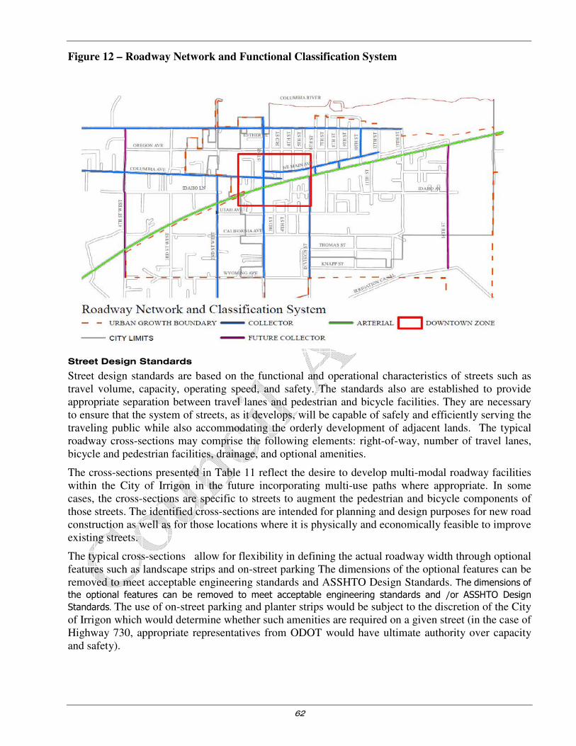
62
Figure 12 – Roadway Network and Functional Classification System
Street Design Standards
Street design standards are based on the functional and operational characteristics of streets such as travel volume, capacity, operating speed, and safety. The standards also are established to provide appropriate separation between travel lanes and pedestrian and bicycle facilities. They are necessary to ensure that the system of streets, as it develops, will be capable of safely and efficiently serving the traveling public while also accommodating the orderly development of adjacent lands. The typical roadway cross-sections may comprise the following elements: right-of-way, number of travel lanes, bicycle and pedestrian facilities, drainage, and optional amenities.
The cross-sections presented in Table 11 reflect the desire to develop multi-modal roadway facilities within the City of Irrigon in the future incorporating multi-use paths where appropriate. In some cases, the cross-sections are specific to streets to augment the pedestrian and bicycle components of those streets. The identified cross-sections are intended for planning and design purposes for new road construction as well as for those locations where it is physically and economically feasible to improve existing streets.
The typical cross-sections allow for flexibility in defining the actual roadway width through optional features such as landscape strips and on-street parking The dimensions of the optional features can be removed to meet acceptable engineering standards and ASSHTO Design Standards. The dimensions of
the optional features can be removed to meet acceptable engineering standards and /or ASSHTO Design
Standards. The use of on-street parking and planter strips would be subject to the discretion of the City of Irrigon which would determine whether such amenities are required on a given street (in the case of Highway 730, appropriate representatives from ODOT would have ultimate authority over capacity and safety).

63
Table 11 – Street Design Standards
Classification Reference
Arterial See Figure 13 and Figure 14 and Appendix F for more details
Collector See Figure 15 for the typical Collector street design standard and
Appendix F for more detailed variations on individual street segments
Local Street See Figure 16 for the typical Local street design standard and Appendix F
for more detailed variations on individual street segments
Through the flexible requirements provided in these standards, the City of Irrigon will have an ability to reduce impervious surface and provide site-specific standards for roadway improvement projects that reflect local conditions. The optional availability of streetscape treatments such as landscape strips, pedestrian refuges, and bike lanes will be valuable to the city in the future as an instrument by which the character of roadways can be influenced.
Arterials
Highway 730 is a Regional Highway in the State Highway Classification System. Regional highways typically provide connections and links to regional centers. The City of Irrigon has commercial development on both sides of Highway 730, serves Irrigon’s downtown core, and is a vital component to Irrigon’s accessibility and local economic livelihood. Therefore Irrigon’s arterial street network consists of US 730. Arterials provide the highest level of service for a community. Irrigon’s arterial street network consists of Highway 730 which is a vital component to the City’s access, livelihood, economic development that traverses through the center of town.
In 2009 the City completed the Highway 730 Streetscape Plan, which is illustrated in Figure 13, Figure 14, and Appendix F. Rendering cross-sections (Appendix F) are proposed to better integrate the North and South sides of the city while maintaining ODOT’s commitment to serving freight travel. These streetscapes serve as a guide to future ODOT and City infrastructure projects. While maintaining amenities the cross sections can be modified, freight mobility and capacity requirements must be met. Safety features, such as medians, can be eliminated or modified based on more detailed safety and capacity studies. Further amenities, such as colored pavement, on-street parking, sidewalk widths, etc. can be modified based on the current Oregon Highway Plan, ODOT requirements, acceptable engineering standards, City and ODOT capital and O&M funding and impacts to private properties.
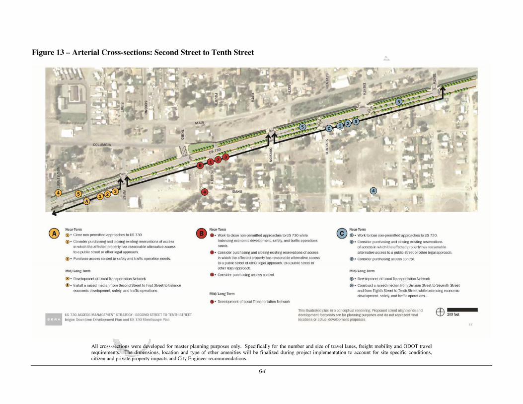
64
Figure 13 – Arterial Cross-sections: Second Street to Tenth Street
All cross-sections were developed for master planning purposes only. Specifically for the number and size of travel lanes, freight mobility and ODOT travel requirements. The dimensions, location and type of other amenities will be finalized during project implementation to account for site specific conditions, citizen and private property impacts and City Engineer recommendations.
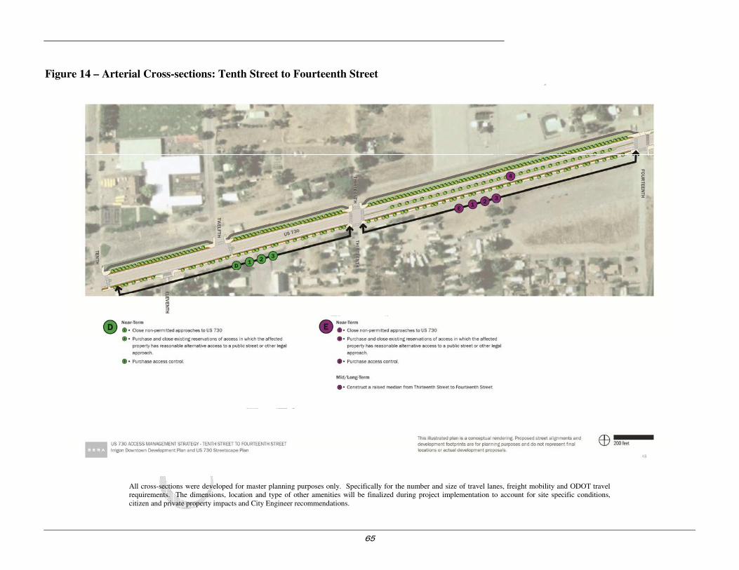
65
Figure 14 – Arterial Cross-sections: Tenth Street to Fourteenth Street
All cross-sections were developed for master planning purposes only. Specifically for the number and size of travel lanes, freight mobility and ODOT travel requirements. The dimensions, location and type of other amenities will be finalized during project implementation to account for site specific conditions, citizen and private property impacts and City Engineer recommendations.

66
Collectors
Collector facilities link arterials with the local street system. As implied by their name, collectors are intended to collect traffic from local streets (and sometimes from direct land access) and channel it to arterial facilities. Collector facilities tend to carry lower traffic volumes at slower speeds than arterials. On-street parking is more prevalent and pedestrian facilities are typically provided. On collectors, bicycle facilities may be exclusive lanes or shared roadways.
For the purposes of Transportation Planning Rule (TPR) compliance, the current and long-term population projections for Irrigon and all collector facilities in this TSP are considered Minor Collectors. (The TPR requires that sidewalks and bike lanes be provided on all Major Collectors within a given Urban Growth Boundary).
Minor collector streets will either have a ‘typical’ cross-section as shown in Figure 15, or will be specific to the individual street segments as shown in Appendix F. The street-specific cross-sections were created as a ‘right sized’ approach to accommodating non-motorized users’ needs, and may be considered when moving forward into future design stages. Typical city collectors will have two (2) 12’ travel lanes. Amenities, such as parking and sidewalks are optional and installed in accordance with City Engineer’s requirements and only if funding allows. The roadway design (base rock and asphalt) shall meet the City’s Public Works Standards.
Figure 15 – ‘Typical’ Minor Collector Cross-Section

67
Local Streets
Local streets are primarily intended to provide access to abutting land uses. Local street facilities offer the lowest level of mobility and consequently tend to be short, low-speed facilities. As such, local streets should primarily serve passenger cars, pedestrians, and bicyclists; heavy truck traffic should be discouraged. On-street parking is common and sidewalks are typically present.
Local streets will either be a ‘typical’ local street as illustrated in Figure 16 or will be specific to the individual street segment as indicated in Appendix F.
Figure 16 – ‘Typical’ Local Street Cross-Section

68
Street Design for Downtown Streets
As part of the 2009 Downtown Development Plan, unique cross-sections were developed for specific downtown Irrigon streets. The following section describes the street vision for downtown Irrigon.
All of the existing and proposed public streets in Downtown may be improved to have 5 to10-foot sidewalks, stormwater swales to capture stormwater runoff, optional on-street parking on both sides of the street, and a travel lane in each direction. Curb extensions at the intersections will improve pedestrian crossing safety while not limiting or impeding travel lanes, improve intersection sight distance, and provide ancillary stormwater treatment areas. The bicycle facility on Downtown streets may be a shared bikeway, where bicyclists and vehicles share the travel lane. The speeds and traffic volumes on these streets are typically low enough that separate bicycle facilities are not warranted. The streets included in the Downtown Development Plan are identified in.
Street Cross-Sections
The local streets in Downtown should maximize to the extent possible of use of the public right of way. This right-of-way dimension provides adequate space for a comfortable pedestrian realm, on-street parking, and travel lanes. The Downtown street dimensions in this Plan vary slightly from the adopted standards in the City’s Transportation System Plan (TSP), which may need to be amended to reflect any changes. Currently, the Local Street standard in the TSP is not appropriate for a downtown setting. As such, four new Downtown street standards for the Downtown core are proposed as part of this Plan.
Downtown Street A
Downtown Street A (see Appendix F for more details) will have a 60-foot public right-of-way and include two 12-foot travel lanes, an optional 8-foot parallel parking lane with a mid-block stormwater swale on either side of the street, and two 5 to 10-foot sidewalks. The sidewalk zones on Downtown Street A streets will have a 6-inch curb, optional 2-foot paver band for buried utilities with optional intermittent 4-foot by 4-foot tree wells, and a roughly seven foot pedestrian zone for walking. If funding for both capital and O&M cost allows, street trees can be placed at location to be determined by the City Engineer and a licensed landscape architect to eliminate conflicts with other infrastructure.
Downtown Street B
Downtown Street B (see Appendix F for more details) is similar to the existing standard in the City’s TSP. It will have a 60-foot public right-of-way and include two 11-foot travel lanes, an optional 8-foot parallel parking lane on either side of the street, and a pedestrian zone that includes a six (6) foot stormwater swale / median and a five foot sidewalk. A one-foot curb provides a narrow disembarking area for vehicle passengers. Stormwater will be conveyed into swale via curb cuts as specified by the City Engineer.

69
Figure 17 – Downtown Local Streets Circulation Plan

70
Downtown Street C
Downtown Street C (see Appendix F for more details) on Columbia Avenue is the only Downtown street with a 70-foot public right-of-way. This condition allows optional angle parking to be established on one side of the street; parallel parking will be on the other side of the street. Mid-block stormwater swales will capture and treat stormwater runoff as specified by the City Engineer.
Relation to Development Activities
The conditions of approval are recommended to require that roadways adjacent to development activities be constructed to comply with the street standards presented in this TSP. Section 7, Policies
and Land Use Ordinance Modifications, provides sample development review guidelines that are recommended for adoption by the city.
Relation to County Facilities
The Morrow County Transportation System Plan (Reference 5) identifies roadway standards for county facilities including a right-of-way requirement of 60 feet, as opposed to the 50-foot requirement identified for local roads in this TSP. Although the county’s standard may be applicable to some roadways within the City of Irrigon Urban Growth Area, the roadway standards stated in the City of Irrigon TSP do not conflict with the county’s standards. The county’s standards are intended for roads that do not exhibit substantial traffic volumes but are expected to increase in the future. It is likely that the county roads will become collectors when incorporated into city limits. As the County has co-adopted the Irrigon Transportation System Plan, city standards will be used in most instances within the Urban Growth Area.
By comparison, the 45-foot right-of-way required on city streets designated as being local roads reflects the expectation that these roadways will not require additional widening in the long-term future. The city’s collector designation would be an appropriate counterpart to the county’s Rural Access Roadway designation.
Parking Restrictions
Adequate intersection sight distance shall be provided at all intersections as stipulated by the City Engineer. Access spacing standards for the respective roadway classifications are presented later within this section.

71
Roadway/Intersection Improvements
The required transportation improvements in the City of Irrigon over the next 20 years, to meet both short- and long-term needs, are listed below in Table 12 and complete cost estimates are described in Appendix G. The projects have been divided into 3 periods; 0 to 5 years, 5 to 10 years, and 10 to 20 years.
Table 12 – Roadway Improvements
Improvement Description
Near-Term, High Priority Projects (0-5 years)
Inventory and Review Posting of City Traffic Control Devices
Improve Delineation on North Main Avenue Adjacent to the A.C. Houghton Elementary School
Pave Key Collector Facilities
Provide Gateway Treatments Along Highway 730
Reduce Vehicular Reliance Through Zoning and Development Code Revisions
Enhance Pedestrian Crossings of Highway 730
Mid-Term Projects (5-10 years)
Implement Transportation Demand Management Measures
Remove Columbia Avenue Access to Highway 730 to balance traffic operations and safety.
Long-Term Projects (10-20 years)
Highway 730 Streetscape Improvements: Second Street to First Street
Highway 730 Streetscape Improvements: First Street to Third Street
Highway 730 Streetscape Improvements: Third Street to Division Street
Highway 730 Streetscape Improvements: Division Street to Tenth Street
Highway 730 Streetscape Improvements: Tenth Street to Thirteenth Street
Highway 730 Streetscape Improvements: Thirteenth Street to Fourteenth Street
New Public Street Connection West of First Street: Columbia Avenue to Highway 730
Idaho Street Extension
Concurrent with Development
Provide Strategic North/South Roadway Extensions
Provide Strategic East/West Roadway Extensions
Development of Downtown Core
Promote Access Management Along Highway 730

72
Access Management Strategy
As part of the US 730 Streetscape Plan, a generalized highway access plan was developed to help identify future access locations and public circulation routes along the study corridor. The plan is a tool to be used by the City of Irrigon and ODOT in future land use decisions involving the properties located within and along the US 730 study corridor.
This Access Management Strategy was developed prior to Oregon Senate Bill 264 which included significant revisions to the Access Management Strategy. Some components of this strategy are more restrictive than the 2012 Oregon Highway Plan (OHP). Access Management revision or any future updates to the current OHP shall supersede components in this strategy during implementation. It is the City of Irrigon’s goal that access management balances access to developed land to promote economic development while ensuring movement of traffic in a safe and efficient manner.
City Standards
Table 13 identifies the minimum public street intersection and private access spacing standards for the City of Irrigon roadway network as they relate to new development and redevelopment. Table 14 identifies standards for private access driveway widths. In cases where physical constraints or unique site characteristics limit the ability for the access spacing standards listed in Table 13 and Table 14 to be met, the City of Irrigon should retain the right to grant an access spacing variance. County facilities within the city’s urban growth boundary should be planned and constructed in accordance with these street design standards. It is recommended that future updates to the TSP review and modify the Access Management Strategy to incorporate installed measures, current transportation operations, and any updated refinement.
Table 13 – Minimum Intersection Spacing Standards
Functional Classification Public Street (feet) Private Access Drive (feet)
Arterial Current Block Length – 425 425
Collector Current Block Length – 300 60
Local Current Block Length – 300 15
Table 14 – Private Access Driveway Width Standards
Land Use Minimum (feet) Maximum (feet)
Single Family Residential 10 20
Multi-Family Residential 12 24
Commercial 20 40
Industrial 20 40
Management Techniques
From an operational perspective, the City of Irrigon should consider implementing access management measures to limit the number of redundant access points along roadways. This will enhance roadway capacity and benefit circulation without limiting economic development and/or creating safety issues. Improvements that should be considered include:
73
• Planning for and developing intersection improvement programs in order to regularly monitor intersection operations and safety problems
• Purchasing right-of-way and closing driveways were financially feasible and not preserved as taking
• Installing positive channelization and driveway access controls as necessary
Enforcement of the access spacing standards should be complemented with the availability of alternative access points. Purchasing right-of-way and closing driveways without a parallel road system and/or other local access could seriously affect the viability of the impacted properties. Thus, if an access management approach is taken, alternative access, based on property owner and City Engineer feedback and direction should be developed prior to “land-locking” a given property. Specifically, provision of key east-west collector facilities as identified in Figure 17 would provide alternative access to land adjacent to Highway 730; thereby reducing or eliminating the need to provide new direct highway access to multiple properties along Highway when the level of service or use
on US 730 requires.
As part of every land use action, the City of Irrigon should evaluate the potential need for conditioning a given development proposal with the following items, in order to maintain and/or improve traffic operations and safety along the arterial and collector roadways:
• Crossover easements should be provided on all compatible parcels (considering topography, access, and land use) to facilitate future access between adjoining parcels and would facilitate compliance with access management objectives.
• Conditional access permits should be issued to developments having proposed access points that do not meet the designated access spacing policy or engineering standards of practice and/or have the ability to align with opposing driveways.
• Right-of-way dedications should be provided to facilitate the future planned roadway system near proposed developments.
Using these guidelines, all driveways, and roadways along the highway will eventually comply with the access spacing policy set for a particular segment of roadway as development and redevelopment occurs in the study area to make sure every parcel’s access is satisfactorily addressed through the process. The topography of the parcel, type of proposed or adjoining use, and/or highway frontage may preclude a development from using consolidated or crossover access points (e.g., consolidating access for a commercial business and an industrial or agricultural land use would be inappropriate).
Section 7, Policies and Land Use Ordinance Modifications, contains suggested code language that could be adopted to implement the access spacing standards. Development review guidelines are also included for the city’s use.
US 730 Access Plan
Access spacing standards along US 730 are currently regulated by the 1999 Oregon Highway Plan. Although it is inherently difficult to modify existing roadway sections to meet these exact access management standards, under the guidance of the planning process, an access management plan has been developed for the US 730 study corridor. The resulting access management plan contains strategies and future access plans that balance the need to provide reasonable access to the highway while still efficiently accommodating through traffic. Together with the recommended circulation improvement projects, the access management plan will enhance the safety, function, and capacity of the US 730 study corridor when the level of service or use on US 730 requires. The following section outlines details of the access management plan for US 730.

74
US 730 from Second Street to First Street
This section of the study corridor is consistent with Segment “A” in Figure 18. The focus of the access management plan on this section of the study corridor is to consolidate the overall number of private access driveways necessary to address safety needs and plans to limit access and turning movements in the long-term through highway median controls when required by an engineering study. To achieve this, the following access plan and management strategies have been developed:
• Near-Term: Work to consolidate the existing driveways and highway approach permits through implementation of the following strategies:
o Identify illegal approaches and close (those driveways constructed since 1949 without a permit
from ODOT) or if appropriate, place under permit. For new legal approach permits, condition the
permit to state that private access will be eliminated when other alternate, reasonable access
becomes available to the property.
o Identify locations where adjacent properties can share access to US 730 and relocate (indenture)
existing highway approaches to the new shared locations.
o Where properties have multiple highway approaches, identify situations where approaches can be
consolidated.
o Where properties have alternate reasonable access for the parcel’s approved or intended land use
function by some means other than US 730 such as an adjacent City street, establish a new
secondary access.
o Consider purchasing access control along those portions of the corridor where it hasn’t already
been acquired and where future development potential exists.
• Mid/Long-Term: Establish public access to the north side of US 730 as outlined below:
o As part of private property redevelopment or capital improvement projects, establish a public
access and approach approximately 500 feet west of First Street. This connection will provide
secondary access between US 730 and Columbia and improve downtown circulation.
o Upon development of the new public roadway, redirect adjacent properties with direct access to
US 730 to the new roadway, consider purchasing access reservations, and close the highway
approaches.
• Mid/Long-Term: As a result of a safety or operational need, construct a raised median along US 730 between Second Street and First Street. All remaining points of access including any new public street described above will have right-in/right-out access. This process will balance economic development of the adjacent land parcels, traffic operations, and safety.
The following table provides an approach to accommodating the short term and the mid/long term access management strategy for Second to First.
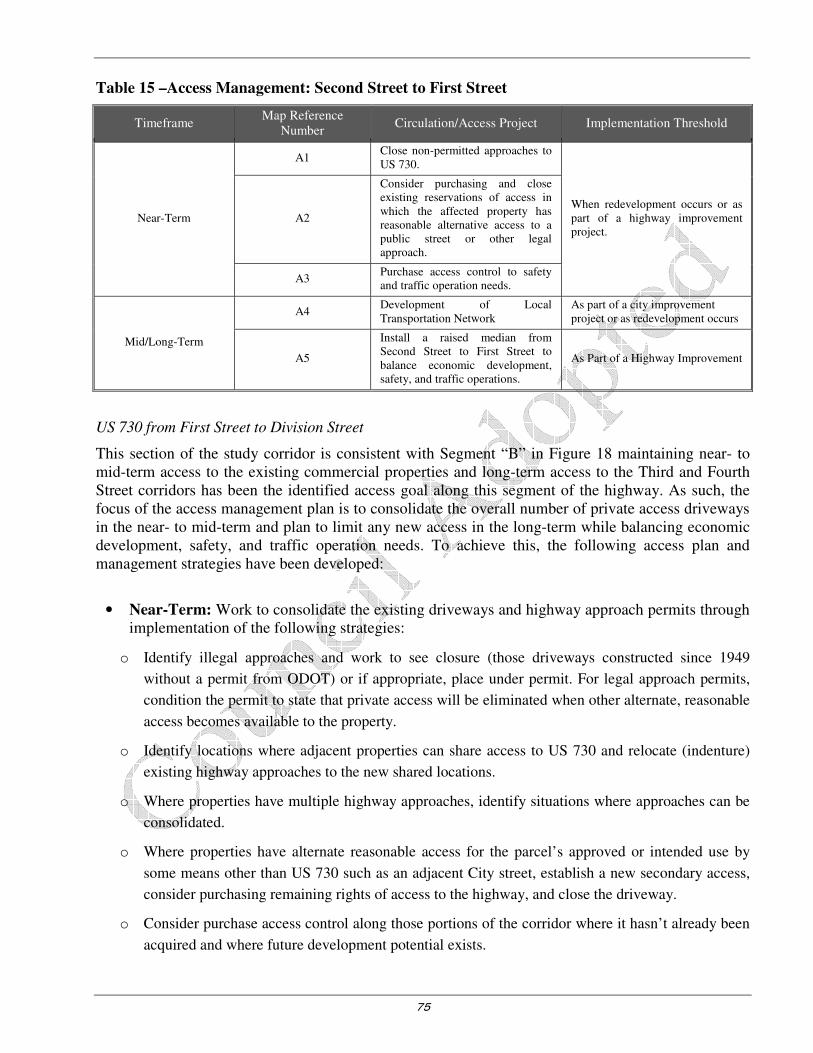
75
Table 15 –Access Management: Second Street to First Street
Timeframe Map Reference
Number Circulation/Access Project Implementation Threshold
Near-Term
A1 Close non-permitted approaches to US 730.
When redevelopment occurs or as part of a highway improvement project.
A2
Consider purchasing and close existing reservations of access in which the affected property has reasonable alternative access to a public street or other legal approach.
A3 Purchase access control to safety and traffic operation needs.
Mid/Long-Term
A4 Development of Local Transportation Network
As part of a city improvement project or as redevelopment occurs
A5
Install a raised median from Second Street to First Street to balance economic development, safety, and traffic operations.
As Part of a Highway Improvement
US 730 from First Street to Division Street
This section of the study corridor is consistent with Segment “B” in Figure 18 maintaining near- to mid-term access to the existing commercial properties and long-term access to the Third and Fourth Street corridors has been the identified access goal along this segment of the highway. As such, the focus of the access management plan is to consolidate the overall number of private access driveways in the near- to mid-term and plan to limit any new access in the long-term while balancing economic development, safety, and traffic operation needs. To achieve this, the following access plan and management strategies have been developed:
• Near-Term: Work to consolidate the existing driveways and highway approach permits through implementation of the following strategies:
o Identify illegal approaches and work to see closure (those driveways constructed since 1949
without a permit from ODOT) or if appropriate, place under permit. For legal approach permits,
condition the permit to state that private access will be eliminated when other alternate, reasonable
access becomes available to the property.
o Identify locations where adjacent properties can share access to US 730 and relocate (indenture)
existing highway approaches to the new shared locations.
o Where properties have multiple highway approaches, identify situations where approaches can be
consolidated.
o Where properties have alternate reasonable access for the parcel’s approved or intended use by
some means other than US 730 such as an adjacent City street, establish a new secondary access,
consider purchasing remaining rights of access to the highway, and close the driveway.
o Consider purchase access control along those portions of the corridor where it hasn’t already been
acquired and where future development potential exists.

76
• Mid/Long-Term: Work to establish a continuous Idaho Avenue connection between First and Division Streets.
o With the Idaho Avenue corridor established, work to close individual property driveways with
direct access to US 730 and reconnect them to Idaho Avenue.
o The table below provides an approach to accommodating the short term and the mid/long term
access management strategy for First to Division.
Table 16 – Access Management: Second Street to Tenth Street
Timeframe Map Reference
Number Circulation/Access Project Implementation Threshold
Near-Term
B1
Work to close non-permitted approaches to US 730 while balancing economic development, safety, and traffic operation needs. When redevelopment occurs or as
part of a highway improvement project.
B2
Consider purchasing and closing existing reservations of access in which the affected property has reasonable alternative access to a public street or other legal approach.
B3 Consider purchasing access control.
Mid/Long-Term B4 Development of Local Transportation Network.
As part of a city improvement project or as redevelopment occurs.
US 730 from Division Street to Tenth Street
This section of the study corridor is consistent with Segments “C” and Figure 18. Compared with the previous two segments, there are significantly more highway approaches and less potential for the development of a supporting parallel local street network on the south side of the highway. Given these conditions, the focus of the access management plan on this section of the study corridor is to consolidate the overall number of private access driveways in the near/mid-term and work towards the development of a series of raised medians in the long-term while balancing economic development, safety, and traffic operation needs. To achieve this, the following access plan and management strategies have been developed:
• Near/Mid-Term: Work to consolidate the existing driveways and highway approach permits through implementation of the following strategies:
o Identify illegal approaches and work to close (those driveways constructed since 1949 without a
permit from ODOT) or if appropriate, place under permit. For legal approach permits, condition
the permit to state that private access will be eliminated when other alternate, reasonable access
becomes available to the property while balancing economic development, safety, and traffic
operations.
o Identify locations where adjacent properties can share access to US 730 and relocate (indenture)
existing highway approaches to the new shared locations.
o Where properties have multiple highway approaches, identify situations where approaches can be
consolidated.

77
o Where properties have alternate reasonable access for the parcels approved or intended function or by
some means other than US 730 such as an adjacent City street, establish a new secondary access,
consider purchasing remaining rights of access to the highway, and close the driveway.
o Consider purchasing access control along those portions of the corridor where it hasn’t already
been acquired and where future development potential exists.
• Long-Term – Construct a raised median from Division Street to Seventh Street and another raised median from Eight Street to Tenth Street while balancing economic development, safety, and traffic operations.
The table below provides an approach to accommodating the short term and the mid/long term access management strategy for First to Division.
Table 17 –Access Management: Division Street to Tenth Street
Timeframe Map Reference
Number Circulation/Access Project Implementation Threshold
Near/Mid-Term
C1 Work to close non-permitted approaches to US 730.
When redevelopment occurs or as part of a highway improvement project.
C2
Consider purchasing and close existing reservations of access in which the affected property has reasonable alternative access to a public street or other legal approach.
C3 Consider purchasing access control.
Long-Term
C4 Development of Local Transportation Network
As part of a city improvement project or as redevelopment occurs
C5
Consider constructing a raised median from Division Street to Seventh Street and from Eighth Street to Tenth Street while balancing economic development, safety, and traffic operations.
As Part of a Highway Improvement
US 730 from Tenth Street to Fourteenth Street
This section of the study corridor is consistent with segment “D” and “E” in Figure 19. The focus of the access management plan on this section of the study corridor is to consolidate the overall number of private access driveways in the near-term and plan to limit access and turning movements in the long-term through highway median controls while balancing economic development, safety, and traffic operation. To achieve this, the following access plan and management strategies have been developed:
• Near/Mid-Term: Work to consolidate the existing driveways and highway approach permits through implementation of the following strategies:
• Identify illegal approaches and consider closing (those driveways constructed since 1949 without a permit from ODOT) or if appropriate, place under permit while balancing economic development, safety, and traffic operations. For legal approach permits, condition the permit to state that private access will be eliminated when other alternate, reasonable access becomes available to the property.
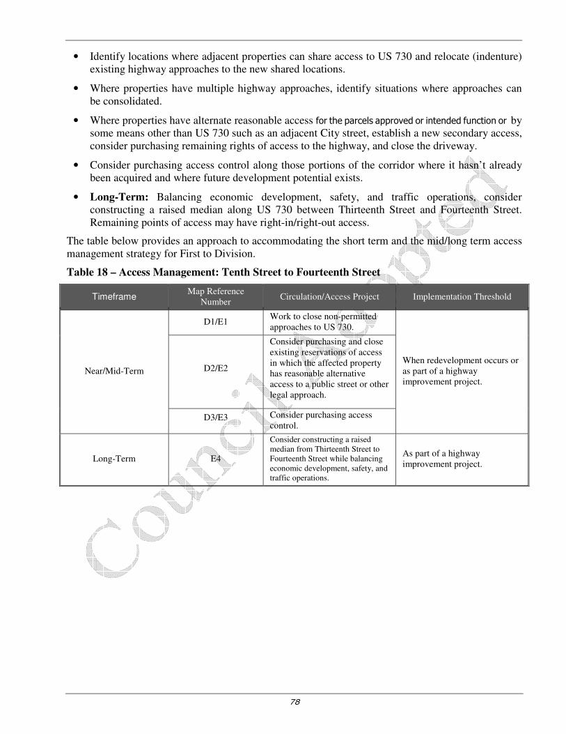
78
• Identify locations where adjacent properties can share access to US 730 and relocate (indenture) existing highway approaches to the new shared locations.
• Where properties have multiple highway approaches, identify situations where approaches can be consolidated.
• Where properties have alternate reasonable access for the parcels approved or intended function or by some means other than US 730 such as an adjacent City street, establish a new secondary access, consider purchasing remaining rights of access to the highway, and close the driveway.
• Consider purchasing access control along those portions of the corridor where it hasn’t already been acquired and where future development potential exists.
• Long-Term: Balancing economic development, safety, and traffic operations, consider constructing a raised median along US 730 between Thirteenth Street and Fourteenth Street. Remaining points of access may have right-in/right-out access.
The table below provides an approach to accommodating the short term and the mid/long term access management strategy for First to Division.
Table 18 – Access Management: Tenth Street to Fourteenth Street
Timeframe Map Reference
Number Circulation/Access Project Implementation Threshold
Near/Mid-Term
D1/E1 Work to close non-permitted approaches to US 730.
When redevelopment occurs or as part of a highway improvement project.
D2/E2
Consider purchasing and close existing reservations of access in which the affected property has reasonable alternative access to a public street or other legal approach.
D3/E3 Consider purchasing access control.
Long-Term E4
Consider constructing a raised median from Thirteenth Street to Fourteenth Street while balancing economic development, safety, and traffic operations.
As part of a highway improvement project.

79
Figure 18 – US 730 Access Management Strategy – Second Street to Tenth Street
All cross-sections were developed for master planning purposes only. Specifically for the number and size of travel lanes, freight mobility and ODOT travel requirements. The dimensions, location and type of other amenities will be finalized during project implementation to account for site specific conditions, citizen and private property impacts and City Engineer recommendations.

80
Figure 19 – US 730 Access Management Strategy – Tenth Street to Fourteenth Street
All cross-sections were developed for master planning purposes only. Specifically for the number and size of travel lanes, freight mobility and ODOT travel requirements. The dimensions, location and type of other amenities will be finalized during project implementation to account for site specific conditions, citizen and private property impacts and City Engineer recommendations.

81
UPDATED PEDESTRIAN-BICYCLE ORIENTED PROJECTS
The City of Irrigon received a grant in 2013 from the Oregon Department of Transportation to update their pedestrian, bicycle, and transit master plan. A component of the grant was to develop a project list of Irrigon’s opportunities and constraints with respect to its pedestrian, bicycle, and transit facilities, which was done in December, 2013. These initial projects were commented on during a variety of meetings including: A) the Stakeholder Advisory Committee meeting, B) the Technical Advisory Committee meeting, and C) Youth Workshops with elementary and high school students. The project list was then refined incorporating those public comments which resulted in the following update to Irrigon’s pedestrian, bicycle, and transit plan.
Future Pedestrian/Bicycle/Transit Facilities Map
Figure 20 illustrates a variety of projects to enhance Irrigon’s pedestrian/bicycle/transit environment. As shown in Figure 20, the map describes key improvements recommended for the bicycle, pedestrian, and transit networks in Irrigon. Figure 2020 also includes a table which numbers the projects described in more detail in the following sections. Several new road improvement types are also applied throughout the city:
• Neighborhood Routes: low-traffic residential streets will be paved (if not already) and have a shoulder/bicycle lane. Way finding and signage will help direct travelers to local destinations such as the schools, Marina Park, City Hall, and downtown.
• Side-path Streets: A two-way side-path will provide improved walking and biking routes along several key busier local streets. Given existing right-of-way and slope constraints, side paths are more practical in many areas than a full build-out of bicycle lanes and sidewalks on both sides of these streets.
• Sidewalk and path improvements: Improvements along US 730 and Division Street to Wyoming are required for safe access to and from schools.

82
Figure 20 – Future Pedestrian/Bicycle/Transit Facilities Map
83
1. Columbia River Heritage Trail
The Columbia River Heritage Trail is a walking, bicycling, and equestrian trail network linking Irrigon to Boardman in Morrow County and Umatilla in Umatilla County. Completing the entire trail link will require the coordinated efforts of numerous cities, counties, tribes, and federal agencies. With strong coordination between the Confederated Tribes of the Umatilla Indian Reservation *CSRP, Morrow County, Army Corp of Engineers, Dept. of State Lands and the City of Irrigon, localized improvements can begin to the trail along the City’s stretch of Columbia Riverfront.
The graphics in Appendix F outline the greater establishment of the Columbia River Heritage trail to provide a beautiful way to experience the Columbia River –and any historical elements.
As shown in Appendix F, the concepts consider the Columbia River Heritage Trail between First Street and the trailhead location at the west end of Marina Park. Elements of this vision can be carried forward throughout the entire potential trail connection in Morrow County and to Umatilla. A 10’ wide paved trail near the river’s edge would provide a welcoming walking and bicycling route for people exercising, recreating, and commuting between destinations. People on horseback could have a dedicated trail along the same alignment and placed slightly further in from the river. Enhanced shoreline restoration would improve habitats on land and in the water and would make the trail a more attractive regional amenity. Occasional picnic areas and viewpoints could further provide resting and gathering spots along the Trail. Lastly, access trails could be provided from the trail to Washington Avenue, which is a popular walking route in Irrigon.
The typical section in Appendix F illustrates where from south to north, the trail cross-section vision could consist of an 8’ wide equestrian path, a vegetated buffer zone, a 10’ wide paved bicycle/walking path, the existing tree line, and a restored shoreline zone. This section would be a typical environment within Irrigon and may vary somewhat along the proposed 25-mile route as conditions change.
The Viewpoint Concept illustrates where a picnic area and viewpoint could be located along the Trail. This spot is envisioned to include bicycle parking and horse tie-ups, picnic tables, river access trail spurs, and directional and informative signage and exhibits.
Trailhead Concept illustrates where trailhead locations along the trail could welcome users with interpretive signage, horse tie-ups, bicycle parking, benches, water fountains (where practical), and other enhancements.
The photo rendering illustrates a typical configuration of the equestrian and bike/hike trails with a viewpoint pull-out in the background. Separated trails provide access for all manner of non-motorized travel. The trail will be aligned to maximize access to and views of the Columbia River. Viewpoint locations will provide bicycle parking, horse tie-ups, benches, tables, and other features designed to make them welcoming resting points for trail users.
The vision is to be able to provide an established trail for the Irrigon portion of the Columbia River that will accommodate tourism, through hikers, and equestrians.

84
Washington Avenue looking west
2. Access Improvements to the Marina Park
This project will construct paved paths to more formally link the Marina Park to Seventh, Eighth, and Ninth Streets through existing, but unimproved, right-of-way (ROW). Paving, delineating, wayfinding, signage, and gateway treatments would be desirable to help tourists and residents identify additional opportunities to the Marina Park.
The picture below illustrates the Marina Park parking lot’s gate opening at Ninth Street. However, there is no paved trail through the gate and there is a parking spot which would block pedestrian/bicycle access to the Marina Park if the parking spot was occupied. A clear view and access to this gate opening at the Marina Park parking lot should be created.
The other pedestrian/bicycle access in the Marina Park parking lot at on Eighth Street may also benefit from a paved through access point. This access also has a turnstile, which would inhibit easy bicycle movement. The Eighth Street Marina Park access point should be paved, signage installed, and the turnstile removed.
Looking southbound from the Marina Park at Eighth
Street
Looking southbound from the Marina Park at Ninth
Street
3. Washington Avenue Pedestrian
Improvement
The Washington Avenue project is scoped to construct a two-way sidepath along the north side of Washington Avenue from First Street to Tenth Street as shown in Appendix F, the Washington Avenue cross-section. Providing additional separation between vehicles and non-motorized users may increase safety along this already popular walking route. Furthermore, the project could connect with perpendicular paths accessing the Columbia River Heritage Trail.

85
4. Tenth Street Improvement from US 730 to Marina Park
The Tenth Street project consists of constructing a two-way sidepath on the east side of the street to provide better delineation between automobile, bicycle, and pedestrian travel ways. Appendix F contains this project’s cross-section. This pathway could also connect the existing multi-use path on the north side of US 730 with the Marina Park.
To complete this project, the ROW for the improvement would need to be clarified between the City, School District, and other property owners.
5. Neighborhood Routes
This project consists of establishing ‘neighborhood routes’ to create a network of pedestrian/bicycle routes in Irrigon. Groups of people walk throughout Irrigon for exercise and leisure and some of the facilities they walk on are not well established and may be unpaved. Appendix F illustrates the cross-section of these neighborhood routes to provide higher quality and delineated routes to connect to existing streets with sidewalks, side paths, and other ‘improved’ facilities. These neighborhood routes would include way finding and signage. With a complete network of ‘neighborhood routes’, side paths, and multi-use paths, safer navigation of Irrigon as a pedestrian or bicyclist would be made possible. As shown in Figure 20, these streets include Oregon Avenue and N Main Avenue.
6. First Street Improvement from Main Avenue to Washington Avenue
This project consists of constructing a side path on the east side of First Street between Main Avenue to Washington Street. This project would help create a network of pedestrian/bicycle friendly streets especially coupled with other side paths and neighborhood routes proposed throughout this draft pedestrian/bicycle/transit plan update. The east side of First Street is preferred because there is one less intersection to cross (Esther Place), therefore, the east side design is a more simple than the west side. Appendix F contains illustrations of the proposed cross-section for First Street.
7. Potential Park & Ride and Transit Stop Amenities
A free bus service is being provided by a local organization which stops in Irrigon and travels to Hermiston and Kennewick. Because there are several empty lots in Irrigon, proposed locations for the park & ride lot: A) in-between the Post Office and Irrigon City Hall & Library, B) east of Irrigon City Hall & Library. All of the proposed lots’ auto parking spaces are anticipated to meet transit demand. However, parking lots should strongly consider stop amenities such as transit signs, shelters, and the bus’s time table. Bike parking should be accommodated for the park & ride lot with “U” Bike Racks. Any planning and/or design will be coordinated with Morrow County in collaboration with the County’s Special Transportation Program and concur with City Engineer requirements and Irrigon’s Public Works Standards
Tenth Street looking south
86
8. US 730 Streetscape and Crossing Improvements
In 2009, Irrigon’s US 730 Streetscape Plan was developed including proposed cross-sections and crossing treatments along US 730. Guidance on intersection crossing treatments on US 730 is referenced in the US 730 Streetscape Plan and is formally brought into the TSP Update in the following sections.
These improvements focus on preserving the long-term capacity and safety for both vehicular movements and pedestrian crossing movements.
US 730/First Street Intersection Improvements
� In the near/mid-term, capacity based improvements include
reconstructing the First Street highway approaches and installing
separate left and through/right-turn lanes on both the north and
south First Street approaches.
� In the long-term, a more structured form of intersection traffic
control will be needed, such as a traffic signal or a roundabout.
� From a pedestrian standpoint, the First Street intersection is and
will continue to be a primary pedestrian connection between the
north and south sides of US 730. As such, bulbouts have been
identified to shorten the pedestrian crossing distance of US 730
and improve pedestrian awareness/visibility. The pedestrian
bulbouts will be designed to accommodate all typical design vehicles.
US 730/Third Street Intersection
� In the near/mid-term, Third Street is realigned to intersect US
730 at a right angle, with any realignment based against capacity
evaluation as well.
� In the near/mid-term, capacity based improvements include
installing a separate left and right-turn lane on the southbound
Third Street approach.
� Pedestrian bulbouts and a median refuge island are identified to
shorten the pedestrian crossing distance of US 730 and improve
pedestrian awareness/visibility. The refuge island will not restrict
any turning movements at the US 730/Third Street intersection.
� The pedestrian bulbouts will be designed to accommodate all typical design vehicles without limiting
or restricting width movements of all vehicles, including EMS and freight.
US 730/First Street Intersection
US 730/Third Street intersection
US 730/Division Street intersection
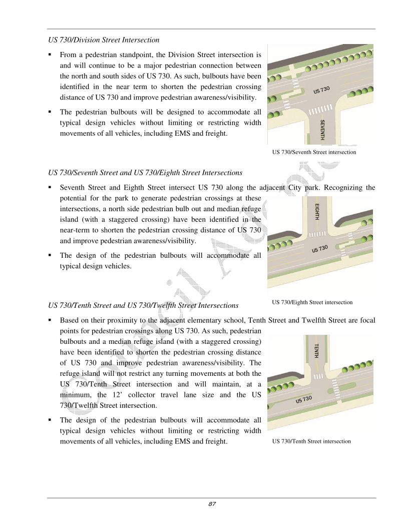
87
US 730/Tenth Street intersection
US 730/Division Street Intersection
� From a pedestrian standpoint, the Division Street intersection is
and will continue to be a major pedestrian connection between
the north and south sides of US 730. As such, bulbouts have been
identified in the near term to shorten the pedestrian crossing
distance of US 730 and improve pedestrian awareness/visibility.
� The pedestrian bulbouts will be designed to accommodate all
typical design vehicles without limiting or restricting width
movements of all vehicles, including EMS and freight.
US 730/Seventh Street and US 730/Eighth Street Intersections
� Seventh Street and Eighth Street intersect US 730 along the adjacent City park. Recognizing the
potential for the park to generate pedestrian crossings at these
intersections, a north side pedestrian bulb out and median refuge
island (with a staggered crossing) have been identified in the
near-term to shorten the pedestrian crossing distance of US 730
and improve pedestrian awareness/visibility.
� The design of the pedestrian bulbouts will accommodate all
typical design vehicles.
US 730/Tenth Street and US 730/Twelfth Street Intersections
� Based on their proximity to the adjacent elementary school, Tenth Street and Twelfth Street are focal
points for pedestrian crossings along US 730. As such, pedestrian
bulbouts and a median refuge island (with a staggered crossing)
have been identified to shorten the pedestrian crossing distance
of US 730 and improve pedestrian awareness/visibility. The
refuge island will not restrict any turning movements at both the
US 730/Tenth Street intersection and will maintain, at a
minimum, the 12’ collector travel lane size and the US
730/Twelfth Street intersection.
� The design of the pedestrian bulbouts will accommodate all
typical design vehicles without limiting or restricting width
movements of all vehicles, including EMS and freight.
US 730/Seventh Street intersection
US 730/Eighth Street intersection

88
US 730/Fourteenth Street intersection US 730/Twelfth Street intersection
US 730/Thirteenth Street and US 730/Fourteenth Street Intersections
� The Thirteenth and Fourteenth Street intersections frame the gateway median along the eastern edge
of the US 730 study corridor. In the mid/long-term, bulb-outs have been identified to improve
pedestrian awareness/visibility and help establish US 730 through Irrigon and may lower speed multi-
modal corridor.
9. Neighborhood Route Improvement
This project will formalize a neighborhood route designation as illustrated in Appendix F, which includes way finding and signage. In this project’s situation, as opposed to project 5, there are several roadways in Irrigon with recent construction and sufficient width of paved shoulders. These roadways are important for connectivity in the southern part of the City, particularly as opportunities to gain access to significant transportation corridors such as Division Street or US 730. The noted speeds and traffic volumes are low enough on these facilities such that additional or separated bicycle and walking pathways are not necessary. Lastly, because streets such as Idaho Avenue, Eleventh Street and Seventh Street already have adequate paved shoulders, these streets will not require additional treatments beyond way finding and signage.
10. Two-way Side path Improvement on Division Street
This project consists of creating a side path on the west side of Division Street. Appendix F contains the cross-section illustration. This project would provide excellent facilities for pedestrians and bicyclists, and would require less construction and ultimately, less overall cost than a roadway with full curb and gutter. Construction of the side path will also improve the bicycle Level of Traffic Stress Score from 2 to 1; meaning, the facility would easily accommodate school children’s travel to Irrigon Elementary School or Irrigon Junior/Senior High School. Also, parking would be accommodated on one side of Division Street and potentially both sides of Division Street depending on roadway constraints and residents/business needs.
Feedback from community residents and students at the youth workshops and historical public outreach efforts indicated a strong desire for safer and more comfortable pedestrian/bicycle facilities on Division Street from US 730 to Wyoming Street.
US 730/Thirteenth Street intersection

89
11. First Street Multi-use Path Gap Completion
As shown in the picture on the right, the path ends into the football fields and does not continue on to the existing sidewalks extending from US 730 to California Avenue. This project would complete this multi-use path connection on First Street just south of California Street near Irrigon Junior/Senior High School. This project was also desired by the high school students who participated in the youth workshops.
12. Wyoming Avenue Improvements
There is a general lack of pedestrian facilities on Wyoming Avenue, which borders Irrigon Elementary School and Irrigon Junior/Senior High School. Therefore, this project would construct a paved pathway on the north side of Wyoming Avenue between First Street and Division Street. As shown in Appendix F, the Wyoming Avenue cross-section has been designed to provide more comfortable and safe school access. Figure 21 illustrates landscaping and pathways which would better establish pedestrian zones for both sides of the street. Because of the significant pedestrian mid-block crossing activity on Wyoming Avenue, greater emphasis should be placed on crossing treatments when project construction occurs.
Figure 21 – Wyoming Avenue General Improvements

90
Table 19 – Pedestrian and Bicycle System Improvements
Project Project Start/End Point Improvement
Description
Near-Term, High Priority Projects (0-5 years)
Division Street Wyoming Avenue to Highway 730 Sidepath
Access Improvements to Marina Park Parking lot at Eighth Street and Ninth
Street Pave Connection
Wyoming Avenue First Street to Division Street Sidewalk/Sidepath
First Street Multi-use Path Completion California Avenue to Irrigon Junior/Senior H.S. Fields
Sidewalk/Sidepath
Mid-Term Projects (5-10 years)
Washington Avenue Multi-use Path First Street to Tenth Street Sidepath
Tenth Street US 730 to Marina Park Sidepath
First Street Main Avenue to Washington Avenue Sidepath
Columbia River Heritage Trail First Street to Eastern Irrigon City
Limits Multi-use Trail with
Amenities
Neighborhood Route Designation to Existing Paved Roads
Idaho Avenue, Seventh Street, Eleventh Street
Signage
Long-Term Projects (10-20 years)
Neighborhood Routes Improvement Oregon Avenue, Seventh Street, Main
Avenue in City Limits Paving with 6’ Shoulders
Park and Ride Transit Stop To be determined Bus Stop Amenities
US 730 Crossing Treatments Various Additional Paving and Signage
Many of the multi-use facilities presented in Table 19 could be completed incrementally as part of local development projects. Creating “partnership programs” with landowners and businesses to construct such facilities would be one method by which individual projects could be brought to fruition in a timely manner. The pedestrian/bicycle facilities could be constructed as adjacent properties develop, thereby ensuring alternative modes of access to various land uses. The city would need to develop a reasonably equitable methodology of assessing the extent of facilities that individual developers would be required to provide.
Table 19 provides a summary of pedestrian and bicycle system projects. In reviewing the projects identified in Table 19, it should be recognized that there is limited funding for such facilities and that the identification of projects does not guarantee their completion within the 20-year planning horizon.
PUBLIC TRANSPORTATION SYSTEM PLAN
Transit service provides mobility to community residents who do not have access to automobiles and provides an alternative to driving for those who do. Transit service should meet the needs both of travelers within the city and those of travelers making trips outside of the community. City will continue coordination efforts with Morrow County for near seamless services.
The 1997 Oregon Public Transportation Plan identifies minimum level of service standards for rural and frontier communities such as the City of Irrigon (Reference 6). Under the 1997 Oregon Public
Transportation Plan, public transportation in small communities and rural areas in the year 2015 (under Level 3-Respond to State and Federal Mandates and Goals) should:

91
• Provide public transportation service to the general public based on locally established service and funding priorities
• Provide an accessible ride to anyone requesting service
• Provide a coordinated centralized scheduling system in each county and at the state level
• Provide phone access to the scheduling system at least 40 hours weekly between Monday and Friday
• Respond to service requests within 24 hours (not necessarily provide a ride within 24 hours)
Service Enhancements
Overall, the City of Irrigon should continue to monitor the adequacy of the transit service provided to the community and work with the county to extend service as necessary. The local transit program should also seek to meet the 2015 minimum level of service standards identified in the 1997 Oregon
Public Transportation Plan. Three improvement strategies are identified below for further consideration.
Increase Public Awareness
Both the city and the county should promote a greater public awareness of the available public transit services and the need for additional volunteer dispatchers and drivers. Greater awareness of the service and its needs will likely result in increased usage and availability. Provision of better recognition for drivers and/or driver meetings would be an additional avenue by which to encourage more volunteer participation in the program.
Coordinate Trips
Consideration should be given to coordinating trip requests to other neighboring communities and areas outside the county such as Hermiston, Boardman and Tri-Cities. For example, a given day of the week could be designated for trips to Boardman, Hermiston, Tri-Cities, and Walla Walla. This would then allow the city’s residents to visit specialized medical service providers or satisfy other needs on a scheduled basis. Similarly, weekly shopping trips to Boardman, Hermiston, or other communities could be established to allow community members to purchase commodities not available through local commercial and service providers.
A recent survey conducted by transportation provider staff suggests that coordination of medical visits could be difficult due to the unpredictable nature of office visits, though the need for such a service should be more closely examined. Assuming that the demand for such a service exists, a scheduled weekly service would lend itself to greater coordination with service providers in the neighboring communities of Boardman and Umatilla.
Close coordination between the City of Irrigon and adjacent communities is also encouraged and should increase ridership and efficiency through better use of the resources available. Such coordination could prove to be especially fruitful if the weekly trips previously discussed are established as a joint community service. Coordinated trips to local community events would likely generate significant interest. Ultimately, if an increased demand for service can be established and documented, additional resources (i.e. funding, equipment) may be successfully pursued.
Provide Commuter Service
It is recommended that a carpool or vanpool service be provided for people who live in Irrigon and work in neighboring communities. Provision of a vanpool and/or carpools to major employers in the area could help to reduce the number of single occupant vehicle commute trips from Irrigon and help the community to achieve transportation demand management (TDM) objectives.

92
Park and ride service may also be offered as described in project #7 in the previous section as indicated in Figure 20.
MARINE SYSTEM PLAN
As previously noted in the Existing Conditions section, the Columbia River borders the City of Irrigon to the north and serves as a means of recreational transportation. The city’s public marine facility is capable of accommodating future expansion and can be expected to continue to grow with the surrounding community, though no formal expansion plans have been identified to date. The City of Irrigon should actively support the continued presence and operation of the boat launch as an effective means of recreational transportation. The creation of multi-use paths and other facilities that promote the multi-modal use of the recreational areas along the shore of the Columbia River should be encouraged. Further, the city should support the continued use of port facilities in neighboring communities such as the City of Umatilla and the City of Boardman.
AIR TRANSPORTATION SYSTEM PLAN
Existing regional air service for passengers and freight is provided via a full service commercial airport at the Tri-Cities Airport located in Pasco, Washington. Air transport charter-service is also available through the Hermiston Municipal Airport and Pendleton. The City of Irrigon should work with the county to achieve an intermodal connection to one or both airports, via demand-responsive transit service, subsidized taxi service, or other mutually agreeable means. The continued use of these facilities is recommended.
PIPELINE SYSTEM PLAN
Existing pipeline facilities should be maintained and enhanced as necessary.
IMPLEMENTATION PLAN
This section has outlined specific transportation system improvements as well as a corresponding timeline for implementation of the identified improvements. The sequencing plan presented is not detailed to the point of a schedule identifying specific years when infrastructure should be constructed, but rather ranks projects to be developed over 0 to 5 year, 5 to 10 year, and 10 to 20 year horizon periods. In this manner, the implementation of identified system improvements has been staged to spread investment in this infrastructure over the 20-year life of the plan.
The construction of roads, water, sewer, and electrical facilities in conjunction with local development activity should be coordinated if the City of Irrigon is to develop in an orderly and efficient way. Consequently, the plans identified in the TSP should be considered in light of developing infrastructure-sequencing plans, and may need to be modified accordingly.
For future decision-making and implementation it is very critical to take into account how the City of Irrigon can and will finance any proposed plan or project. Funding levels at the time of the TSP adoption are at critically low levels and may be as such over the course of several years.
In this TSP there are identified near, mid-term, and far-term plans and proposed projects and transportation system improvements. Considering funding levels and anticipated limited resources these items may not fully be implemented. The City will continue to strengthen fiscal areas in anticipation for project completions.
It is further noted that in any implementation will follow acceptable planning and land use processes, working with local property owners and constituents, City Engineer and City’s Public Works to ensure clear and transparent action takes place.

93
SUMMARY
The adoption and implementation of this Transportation System Plan will enable the City of Irrigon to rectify existing transportation system deficiencies, combines and supersedes all other plan documents while also accommodating growth in the study area.
Future periodic updates are warranted to accommodate issued upgrades, current capacity conditions, and updated refinements to meet the changing needs of the residents of the City of Irrigon.

94
Section 6
Transportation Funding Plan

95
Transportation Funding Plan
The Transportation Planning Rule (OAR 660-12-040) requires that the City of Irrigon Transportation System Plan (TSP) include a transportation financing program. These programs are to include:
• a list of planned transportation facilities and major improvements;
• a general estimate of the timing for planned transportation facilities and major improvements;
• determination of rough cost estimates for the transportation facilities and major investments identified in the TSP (intended to provide an estimate of the fiscal requirements to support the land uses in the acknowledged comprehensive plan(s) and allow jurisdictions to assess the adequacy of existing and possible alternative funding mechanisms); and,
• a discussion of existing and potential financing sources to fund the development of each transportation facility and major improvement (which can be described in terms of general guidelines or local policies).
Section 5 of this TSP identified the recommended improvement projects, an implementation timeline, and estimated improvement costs. This section provides an overview of the City of Irrigon’s historic funding levels and available funding sources at a federal, state, county, and local level. Furthermore, the funding of bicycle, pedestrian, and transit improvements has been expanded per the TSP update in 2014.
The timing and financing provisions in the transportation financing program are not considered a land use decision as defined by the TPR and ORS 197.712(2) (e) and, therefore, cannot be the basis of appeal under State law. In addition, the transportation financing program is intended to implement the comprehensive plan policies, which provide for phasing of major improvements to encourage infill and redevelopment of urban lands, prior to facilities that would cause premature development of urbanizable areas or conversion of rural lands to urban uses.
HISTORICAL CITY OF IRRIGON TRANSPORTATION FUNDING
Key funding sources that have contributed to transportation projects within the city over the past four years are summarized below.
Typical Revenue Sources
Table 20 displays the total revenue by source used to fund transportation projects within the city over the past four years.
Table 20 - City of Irrigon Transportation Revenue Source History
Revenue Source FY 2012-
2013
FY 2011-
2012
FY 2010-
2011
FY 2009-2010 Average
Taxes1 $153,741 $152,665 $165,693 $183,082 $163,795
Inter-Govt. Sources $0 $18,700 $151,298 $1,382,964 $388,240
Other2 $4,757 $3,821 $2,552 $7,170 $4,575
Total Revenue $158,497 $175,185 $319,542 $1,573,216 $556,610
Total Revenue (Excluding Inter-Govt. Sources)
$158,497 $156,485 $168,244 $190,252 $168,370

96
Based on the information shown in Table 20, the City of Irrigon has generated an average of $556,610 per year in total revenue for transportation related maintenance/projects. However, it should be noted that this average is significantly influenced by a $1.38 million streetscape/sidewalk/lighting improvement grant received in the 2009/2010 fiscal year for First Street. This grant was the result of federal stimulus funding. In recognition of the special nature of this grant, a more conservative review (excluding inter-governmental sources) shows that the City of Irrigon has generated an average of $168,370 per year in total revenue for transportation related purposes. The largest revenue source for the City are the various forms of taxes (highway gas tax, property tax, and county road tax).
Other Revenue Sources/Partnerships
The City of Irrigon has historically benefited from outside transportation improvement grants and other miscellaneous improvements administered by the Oregon Department of Transportation (ODOT). Although they shouldn’t be seen as a consistent and reliable source of transportation revenue, this outside resource has contributed to several major projects in Irrigon over the past several years:
� First Street sidewalk and streetscape improvements from US 730 to California Avenue. The
total cost of the improvements was approximately $1,528,000.
� US 730 chip seal project. The project included portions of US 730 through Irrigon.
� US 730/First Street rectangular rapid flashing beacon. Total project cost including right-of-
way exceeded $90,000.
� Miscellaneous maintenance projects along US 730.
Expenditure History
Table 21 displays the total transportation related expenditures on within the City of Irrigon over the last four years.
Table 21 - City of Irrigon Expenditure History
Expenditures FY 2012-
2013
FY 2011-
2012
FY 2010-
2011
FY 2009-2010 Average
Personnel $95,040 $107,848 $95,262 $93,873 $98,006
Materials & Services $52,281 $47,457 $49,383 $41,840 $47,741
Equipment $13,000 $0 $488 $1,261 $3,687
Street Construction / Repair
$4,000 $19,519 $138,798 $1,385,664 $386,995
Total Expenditures $164,322 $174,823 $283,931 $1,522,638 $536,429
Based on the information shown in Table 21, the City of Irrigon has spent an average of $149,434 per year on personnel/materials/equipment. With regards to street construction/repair projects, the 2009/2010 through 2011/2012 fiscal years all saw a sizable combination of streetscape improvement grants and small city allotment grants. Based on conversations with City staff, these grants have been determined to be either one-time grants or grants that can’t be assumed to occur on an annual basis or even every few years. As such, a more likely and conservative average shows that the City has spent more in the range of $4,000 per year on capital improvement projects. Under these revised

97
assumptions, an average annual expenditure of $4,000 is approximately 3 percent of available resources.
The information shown in Table 20 and Table 21 were used to project the availability of future funding for transportation improvement projects as described below.
PROJECTED CITY OF IRRIGON TRANSPORTATION FUNDING
Table 22 provides a summary of the potential future project funding (in year 2013 dollars) over the next five, ten, and twenty years based on an assumed average funding level of approximately $168,370 per year.
Table 22 - Future Transportation Funding Projections
Revenue Source Average Annual 5-Year Forecast 10-Year Forecast 20-Year Forecast
Total Revenue $168,370 $841,850 1,683,700 $3,364,400
Revenue for Capital Improvements (3%)
$5,050 $25,250 $50,500 $101,000
Revenue for Personnel/Overhead/Maintenance (97%)
$158,270 $816,600 $1,633,200 $3,263,400
As shown in Table 22, it is anticipated that approximately $3.36 million will be available for transportation project funding over the next 20 years using historical funding trends. Under this methodology, approximately $101,000 of the $3.36 million can reasonably be assumed to be available for funding transportation improvement projects while the remaining $3.25 million will be needed for personnel/materials/equipment.
POTENTIAL FUNDING SOURCES
The projected transportation funding analysis shows that the City of Irrigon will likely have very little funds that can be dedicated to transportation-related capital improvement projects over the next twenty years. As such, the City is going to have to continue to rely upon transportation improvement grants, partnerships with regional and state agencies, and other funding sources to help implement future transportation-related improvements. Appendix I identifies a list of potential Grant sources and Partnering Opportunities for the City to consider during the course of the Bicycle, Pedestrian, and Transit TSP Update. Appendix I also contains a list of potential new funding sources for the City to consider in an effort to bolster funds for additional capital improvement projects.
The tables in Appendix I are not an all-inclusive list of alternative funding sources. Each of these financing tools will require additional research to ensure that it is the right fit for the community, and can be closely matched with achieving the objectives of the TSP update.
SUMMARY
Transportation funding resources available to the City of Irrigon and ODOT are limited. It is expected that, for the near future, those funding sources that are available will predominantly be applied to maintenance and preservation of the existing transportation system. As additional funding becomes available, the list of transportation improvement projects identified in this TSP should be used to select projects for implementation. In the interim, the City of Irrigon should consider developing alternative transportation funding sources such as System Development Charges, Local Improvement Districts, or Street Maintenance Fees as a mechanism by which to finance improvements to the city’s transportation system.

98
Section 7
Policies and Land Use Ordinance Modifications

99
Policies and Land Use Ordinance Modifications
This section is provided under separate cover in the document “City of Irrigon Implementing Ordinances for the Transportation System Plan.”

100
Section 8
Transportation Planning Rule Compliance

101
*** (Editor’s Note: This section was not updated with the 2014 TSP update) Transportation Planning Rule Compliance
In April 1991, the Land Conservation and Development Commission (LCDC), with the concurrence of ODOT, adopted the Transportation Planning Rule (TPR), OAR 660 Division 12. The TPR requires local jurisdictions to prepare and adopt a Transportation System Plan (TSP) by 1997. Outlined below is a list of recommendations (designated by italics) and requirements for a TSP for an urban area with a population between 2,500 and 25,000, and how each of those were addressed in the City of Irrigon TSP. The comparison demonstrates that the City of Irrigon TSP is in compliance with the provisions of the TPR.
DEVELOPMENT OF A TRANSPORTATION SYSTEM PLAN
TPR Recommendations/Requirements City of Irrigon TSP Compliance
Public and Interagency Involvement
Establish Advisory Committees.
A Management Team and Technical Advisory Committee were established at the outset of the project. Membership on the Management Team included members of the City, County, and ODOT staff. Membership on the Technical Advisory Committee included representatives from all facets of the community.
• Develop informational material.
Technical memoranda and status reports of work undertaken and completed by the advisory committee were published and made available to the public throughout the project. Informational posters were also prepared concerning the project and opportunities for participation at public workshops for use at community information centers.
• Schedule informational meetings, review meetings and public hearings throughout the planning process. Involve the community.
Three Management Team/TAC meetings were held through the planning process. The meetings were advertised by distribution of meeting notices. All TAC meetings were advertised and open to the public as part of joint City Council/Planning Commission meetings.
• Coordinate Plan with other agencies.
Coordination with the City, ODOT, and Morrow County was accomplished by including agency representatives on the project mailing list, individual project briefings/meetings, and participation on the Management Team and the TAC.
Review Existing Plans, Policies, Standards, and Laws
• Review and evaluate existing comprehensive plan.
The following plans were reviewed as part of the development of the TSP: 1991 Oregon Highway Plan, (June, 1991); 1996 Oregon Bicycle Plan; City of Irrigon Comprehensive Plan, (1991); Draft Statewide Transportation Improvement Program (2000-2003).
• Land use analysis - existing land use/vacant lands inventory.
In developing the forecast of transportation needs, an analysis was conducted of current land use designations and land status within the project area to determine the capacity for growth,

102
which would increase demand for transportation services. Population and employment forecasts were prepared for the year 2020 that reflect regional growth prospects and the City’s economic role in the region. Estimates of needed housing, commercial, and employment lands were derived from these forecasts. An inventory of vacant buildable lands within the city was also conducted.
• Review existing ordinances - zoning, subdivision, engineering standards.
Existing City Subdivision Ordinances, Zoning Ordinances, and Comprehensive Plan engineering standards were reviewed for adequacy in the development of the City of Irrigon TSP.
• Review existing significant transportation studies.
Significant transportation studies reviewed as part of the City of Irrigon TSP include the above mentioned comprehensive plans and their associated transportation elements, the Morrow County TSP, and the City’s Street, Sidewalk, Bikeway, and Handicap Access Study.
• Review existing capital improvements programs/public facilities plans.
The City of Irrigon CIP, Morrow County CIP, and the State TIP were reviewed as part of City of Irrigon TSP development.
• Americans with Disabilities Act requirements. The ADA requirements were reviewed and acknowledged as part of the City of Irrigon TSP development.
• Review current Transportation System Plan and evaluate compliance with the 1999 Oregon Highway Plan
Reviewed existing Transportation System Plan and updated document to reflect requirements, standards, and policies of the 1999 Oregon Highway Plan.
Inventory Existing Transportation System
• Street system (number of lanes, lane widths, traffic volumes, level of service, traffic signal location and jurisdiction, pavement conditions, structure locations and conditions, functional classification and jurisdiction, truck routes, number and location of accesses, safety, substandard geometry).
An inventory of the existing street network, traffic volumes, traffic control devices, accident history, and levels of service is provided in Section 2: Existing Conditions.
• Bicycle ways (type, location, width, condition, ownership/jurisdiction).
As noted in Section 2: Existing Conditions, there are no existing bicycle ways within the City of Irrigon.
• Pedestrian ways (location, width, condition, ownership/jurisdiction).
As noted in Section 2: Existing Conditions, there are no existing pedestrian ways within the City of Irrigon.
• Public Transportation Services (transit ridership, volumes, route, frequency, stops, fleet, intercity bus, passenger rail, special transit services).
A summary of the existing public transportation services is presented in Section 2: Existing Conditions. Only Special Transit and Intercity Bus services exist within the City of Irrigon.
• Intermodal and private connections. A summary of the existing intermodal and private carrier transportation services is presented in Section 2: Existing Conditions.
• Air transportation. A summary of existing air transportation facilities

103
is provided in Section 2: Existing Conditions. No air transportation facilities are provided in the City of Irrigon.
• Freight rail transportation. As noted in Section 2: Existing Conditions, there are no freight rail transportation services within the City of Irrigon.
• Water transportation. A summary of water transportation services is provided in Section 2: Existing Conditions.
• Pipeline transportation. A summary of pipeline transportation services is provided in Section 2: Existing Conditions.
• Environmental constraints. Development of the TSP did not include the identification of environmental constraints beyond those specifically documented in the TSP.
• Existing population and employment.
As outlined Section 1: Introduction, the 1997 City of Irrigon population is approximately 1,200 persons in the city, 1,444 within the Urban Growth Area. This information and employment data cited in Section 3: Future Conditions Analysis, is included in Future Conditions as the basis for the forecasts that were performed for this TSP.
Determine Transportation Needs
• Forecast population and employment
Population and employment forecasts were prepared for the year 2020 that reflect regional growth prospects and City of Irrigon's economic role. This information is summarized in Section 3: Future Conditions.
• Determination of transportation capacity needs (cumulative analysis, transportation gravity model).
Travel demand forecasts were undertaken as part of this project. The methodology for travel forecasting and assumptions used in the transportation model are contained in Section 3: Future Conditions, which presents an analysis of future transportation conditions and identifies capacity needs.
• Other roadway needs (safety, bridges, reconstruction, operation/maintenance).
Non-capacity related transportation needs are identified and recommended for implementation in Section 5: Transportation System Plan.
• Freight transportation needs. Freight transportation needs are adequately met via motor carrier freight services.
• Public transportation needs (special transportation needs, general public transit needs).
Public transportation needs are presented in Section 5: Transportation System Plan.
• Bikeway needs.
• Pedestrian needs.
Future bicycle and pedestrian improvements are to be made in conjunction with roadway improvements to provide cyclists and pedestrians with full accessibility to City of Irrigon's street system. Plans for these facilities are shown in Figure 15 of Section 5: Transportation System Plan.
Develop and Evaluate Alternatives
• Update community goals and objectives. Goals were established as part of the TSP development (see Section 1: Introduction).
• Establish evaluation criteria.
Evaluation criteria was established from the study goals and objectives and used to develop the Preferred Alternative presented in Section 5: Transportation System Plan.

104
• Develop and evaluate alternatives (no-build system, all build alternatives, transportation system management, transit alternative/feasibility, improvements/additions to roadway system, land use alternatives, combination alternatives).
Section 4: Alternatives Analysis includes a summary of the land use and transportation alternatives considered and analyzed for City of Irrigon's TSP. Land uses, roadway alternatives, transportation system management options, bike and pedestrian options were analyzed.
• Select recommended alternative. A recommended alternative for roadways, bikeways, and pedestrian facilities is contained in Section 5: Transportation System Plan.
Produce a Transportation System Plan
• Transportation goals, objectives and policies.
Specific recommendations regarding transportation goals and policies are outlined in Section 7: Policies and Land Use Ordinance Modifications.
• Streets plan element (functional street classification and design standards, proposed facility improvements, access management plan, truck plan, safety improvements).
The streets plan element is outlined in Section 5: Transportation System Plan.
• Public transportation element (transit route service, transit facilities, special transit services, intercity bus and passenger rail).
The public transportation element is outlined in Section 5: Transportation System Plan.
• Bikeway system element. The bikeway plan is outlined in Section 5: Transportation System Plan, and shown in Figure 15.
• Pedestrian system element. The pedestrian plan is outlined in Section 5: Transportation System Plan, and shown in Figure 15.
• Airport element (land use compatibility, future improvements, accessibility/ connections/conflicts with other modes).
The airport element is outlined in Section 5: Transportation System Plan.
• Freight rail element (terminals, safety). There is no rail service available or anticipated to serve the City of Irrigon.
• Water transportation element (terminals). The water transportation element is outlined in Section 5: Transportation System Plan
Produce a Transportation System Plan (Continued)
• Transportation System Management element (TSM).
TSM element not applicable per OAR 660-12-020(2)(f) and (g).
• Transportation Demand Management element (TDM).
TDM element not applicable per OAR 660-12-020(2)(f) and (g).
Implementation of a Transportation System Plan
Plan Review and Coordination
• Consistent with ODOT and other applicable plans.
See Section 7: Policies and Land Use Ordinance Modifications
Adoption
• Is it adopted? To follow.
Implementation
• Ordinances (facilities, services and improvements; land use or subdivision regulations).
Included in Section 7: Policies and Land Use Ordinance Modifications.
• Transportation financing/capital improvements program.
The transportation finance plan is summarized in Section 6: Transportation Funding Plan.

Section 9
References

106
References
1. Oregon Department of Transportation. Oregon Highway Plan. 1991 & 1999.
2. Anderson Perry & Associates, Inc. City of Irrigon, Oregon Street, Sidewalk, Bikeway, and
Handicap Access Study. 1993.
3. Transportation Research Board. Highway Capacity Manual, Special Report No. 209. 1994.
4. U.S. Department of Transportation, Federal Highway Administration. Manual on Uniform Traffic
Control Devices. 1988.
5. KCM, Inc. Morrow County Transportation System Plan Final Report. March 1998.
6. Oregon Department of Transportation. 1997 Oregon Public Transportation Plan. April 1997.
7. Oregon Department of Transportation. State Transportation Fiscal and Statistical Data for 1997. September 1998.
8. Oregon Department of Transportation. Financial Services Website,
http://www.odot.state.or.us/fspublic. May 1999.

107
Appendix
Appendix A Plans and Policies Review
Appendix B Description of Level-of-Service Methods and Criteria
Appendix C Employment and Population Forecast
Appendix D Level-of-Service Worksheets
Appendix E Preferred Land Use Alternative Graphical Renderings
Appendix F Cross Sections
Appendix G Roadway and Pedestrian/Bicycle Project Improvement Costs
Appendix H Main Street Mitigation Design
Appendix I Supplemental Funding Information


![[Urban transportation] city presentation tokyo(japan)](https://img.pdfslide.net/doc/110x75/55a2debc1a28abb7558b4771/urban-transportation-city-presentation-tokyojapan.jpg)
![[Urban transportation] city presentation thimpu(bhutan)](https://img.pdfslide.net/doc/110x75/55a2def71a28abab558b478a/urban-transportation-city-presentation-thimpubhutan.jpg)

![[Urban transportation] city presentation bangkok(thailand)](https://img.pdfslide.net/doc/110x75/55a2debf1a28abb7558b4773/urban-transportation-city-presentation-bangkokthailand.jpg)


![[Urban transportation]city presentation shanghai(china)](https://img.pdfslide.net/doc/110x75/55d75d3abb61eb5f118b45e8/urban-transportationcity-presentation-shanghaichina.jpg)
