Embed Size (px)
Citation preview

PLANNING AND DEVELOPMENT ACT 2005
———————————
CITY OF STIRLING
_________
DISTRICT PLANNING SCHEME No. 2
AMENDMENT No. 458
!200900053GG!
1057
PERTH, FRIDAY, 3 APRIL 2009 No. 53 SPECIALPUBLISHED BY AUTHORITY JOHN A. STRIJK, GOVERNMENT PRINTER AT 3.00 PM
© STATE OF WESTERN AUSTRALIA
WESTERN AUSTRALIAN GOVERNMENT ISSN 1448-949X PRINT POST APPROVED PP665002/00041

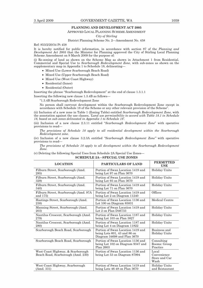
PLANNING AND DEVELOPMENT ACT 2005 APPROVED LOCAL PLANNING SCHEME AMENDMENT
City of Stirling District Planning Scheme No. 2—Amendment No. 458
Ref: 853/2/20/34 Pt 458 It is hereby notified for public information, in accordance with section 87 of the Planning and Development Act 2005 that the Minister for Planning approved the City of Stirling Local Planning Scheme Amendment on 9 March 2009 for the purpose of: (i) Re-zoning of land as shown on the Scheme Map as shown in Attachment 1 from Residential, Commercial and Special Use to Scarborough Redevelopment Zone, with sub-zones as shown on the supplementary map in Appendix 1 to Schedule 18, delineating— • Mixed Use (Lower Scarborough Beach Road) • Mixed Use (Upper Scarborough Beach Road) • Mixed Use (West Coast Highway) • Residential (Inner) • Residential (Outer) Inserting the phrase “Scarborough Redevelopment” at the end of clause 1.3.1.1 Inserting the following new clause 1.3.4B as follows—
“1.3.4B Scarborough Redevelopment Zone No person shall carryout development within the Scarborough Redevelopment Zone except in accordance with Schedule 18 of the Scheme or any other relevant provision of the Scheme”.
(ii) Inclusion of a new zone in Table 1 (Zoning Table) entitled Scarborough Redevelopment Zone, with the annotation against the use classes, ‘Land use permissibility to accord with Table 18.1 in Schedule 18, based on sub-zones delineated in Appendix 1 to Schedule 18’. (iii) Inclusion of a new clause 2.3.11 entitled “Scarborough Redevelopment Zone” with operative provisions to read—
The provisions of Schedule 18 apply to all residential development within the Scarborough Redevelopment zone.
(iv) Inclusion of a new clause 3.2.3A entitled “Scarborough Redevelopment Zone” with operative provisions to read—
The provisions of Schedule 18 apply to all development within the Scarborough Redevelopment Zone.
(v) Deleting the following Special Uses from Schedule 2A Special Use Zones— SCHEDULE 2A—SPECIAL USE ZONES
LOCATION PARTICULARS OF LAND PERMITTED USE
Filburn Street, Scarborough (Amd. 285)
Portion of Swan Location 1419 and being Lot 97 on Plan 3670
Holiday Units
Filburn Street, Scarborough (Amd. 329)
Portion of Swan Location 1419 and being Lot 93 on Plan 3670
Holiday Units
Filburn Street, Scarborough (Amd. 340)
Portion of Swan Location 1419 and being Lot 71 on Plan 3670
Holiday Units
Filburn Street, Scarborough (Amd. 97A and 175)
Portion of Swan Location 1419 and being Lot 2 on Diagram 11240
Offices
Hastings Street, Scarborough (Amd. 238)
Portion of Swan Location 1136 and Lot 100 on Diagram 85831
Medical Centre
Manning Street, Scarborough (Amd. 203)
Portion of Swan Location 1419 and Lot 2 on Plan D46733
Holiday Units
Nautilus Crescent, Scarborough (Amd. 279)
Portion of Swan Location 1187 and being Lot 103 on Plan 3827
Holiday Units
Nautilus Crescent, Scarborough (Amd. 280)
Portion of Swan Location 1187 and being Lot 4 on Diagram 11822
Holiday Units
Scarborough Beach Road, Scarborough Portion of Swan Location 1419 and being Lots 601, 43 and 86 on Diagram 34698 and Plan 3670
Business and Holiday Units
Scarborough Beach Road, Scarborough Portion of Swan Location 1136 and being Lot 102 on Diagram 9347 and Plan 2603
Consulting Rooms: Group Practice
West Coast Highway, & Scarborough Beach Road, Scarborough (Amd. 230)
Portion of Swan Location 1136 and being Lot 53 on Diagram 87994
Local Convenience Store and Car Wash
West Coast Highway, Scarborough (Amd. 331)
Portion of Swan Location 1419 and being Lots 46-48 on Plan 3670
Holiday Units and Restaurant
3 April 2009 GOVERNMENT GAZETTE, WA 1059

(vi) Inclusion of a new Schedule 18, as follows— SCHEDULE 18: SCARBOROUGH REDEVELOPMENT ZONE
[Clause 2.3.11 and 3.2.3A] 1. APPLICATION The provisions of this schedule shall apply to development in the Scarborough Redevelopment Zone, as provided for under clauses 2.3.11 and 3.2.3A. The Zone has been divided into five separate sub-zones as follows— • Mixed Use (Lower Scarborough Beach Road) • Mixed Use (Upper Scarborough Beach Road) • Mixed Use (West Coast Highway) • Residential (Inner) • Residential (Outer) The sub-zones are delineated on the supplementary scheme map at Appendix 1 to this schedule, each being subject to individual land use and development controls and requirements as detailed in this schedule.
2. OBJECTIVES The objectives of the Scarborough Redevelopment Zone are as follows— • Establishment of a sustainable and vibrant coastal development node comprising mix of
development including particularly commercial and residential within identified precincts; • Development of a range of commercial facilities that will contribute towards economic
development, local employment and the viability of the area as a commercial centre servicing residents, visitors and the local workforce;
• Development of a range of versatile, medium and high density accommodation suitable for both tourists and permanent residents, so as to maximise accessibility to the foreshore and enhance the level of support for a wide range of commercial and recreational facilities.
• Buildings designed to contribute towards a distinctive urban-coastal character and sense of place.
• Buildings designed to capitalise on the vistas and climatic attributes of the location, but which will respect the visual amenities of the street and locality.
• Buildings designed to provide an attractive visual frame and sense of enclosure for the adjacent street but which are in ‘scale’ with the adjoining public spaces.
• Buildings designed to provide safe and efficient vehicular and pedestrian access and egress along the streets and to the foreshore.
3. LAND USE Land uses within the respective sub-zones shall be in accordance with Table 18.1 in Schedule 18, with permissibility of use classes being determined by cross reference between the list of use classes on the left hand side of the Table and the list of sub-zones at the top of the Table. Where no symbol appears against the particular use class, it means the use class is not permitted. In other respects the interpretation of the zoning table shall accord with the provisions of clause 1.3.2 of the Scheme.
4. DESIGN REQUIREMENTS Development within the respective sub-zones shall accord with the design requirements set out in this clause, in addition to any other requirements applicable under the Scheme or the Residential Design Codes. In respect to any discrepancy in these requirements, the requirements set out in this clause shall prevail. 4.1 Mixed Use Sub-Zones (Lower Scarborough Beach Road and West Coast Highway) 4.1.1 Plot Ratio: The plot ratio of development shall accord with the following— (a) Subject to clause 4.1.1(b) below, the total plot ratio of any development within the
Mixed Use Sub-Zones (Lower Scarborough Beach Road and West Coast Highway), (excluding 0.5:1 of ground level commercial floor space) shall not exceed 1.5:1.
(b) For the purposes of clause 1.4.3 of the Scheme, the plot ratio referred to in clause 4.1.1(a) above may be increased to a maximum of 2.5:1 (excluding 0.5:1 of ground level commercial floor space), but only subject to:—
(i) provision of commercial floor space at ground level with a plot ratio area of at least 0.2:1;
(ii) compliance with the dwelling unit size and occupancy requirements of Clause 4.1.3 ‘Dwelling Unit Size and Occupancy’ below, without modification; and
(iii) payment of a contribution towards the cost of infrastructure in accordance with Part 6 Developer Contributions, without modification.
(c) For the purposes of determining the plot ratio area for a particular site, where land is or has been ceded free of cost to the Crown for public access (including road widening), the area of land so ceded shall be deemed to remain part of the development site.
1060 GOVERNMENT GAZETTE, WA 3 April 2009
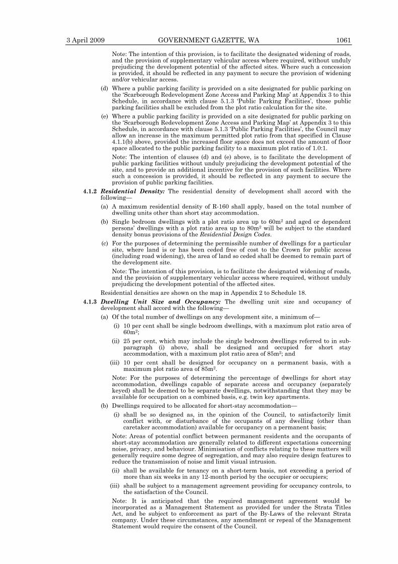
Note: The intention of this provision, is to facilitate the designated widening of roads, and the provision of supplementary vehicular access where required, without unduly prejudicing the development potential of the affected sites. Where such a concession is provided, it should be reflected in any payment to secure the provision of widening and/or vehicular access.
(d) Where a public parking facility is provided on a site designated for public parking on the ‘Scarborough Redevelopment Zone Access and Parking Map’ at Appendix 3 to this Schedule, in accordance with clause 5.1.3 ‘Public Parking Facilities’, those public parking facilities shall be excluded from the plot ratio calculation for the site.
(e) Where a public parking facility is provided on a site designated for public parking on the ‘Scarborough Redevelopment Zone Access and Parking Map’ at Appendix 3 to this Schedule, in accordance with clause 5.1.3 ‘Public Parking Facilities’, the Council may allow an increase in the maximum permitted plot ratio from that specified in Clause 4.1.1(b) above, provided the increased floor space does not exceed the amount of floor space allocated to the public parking facility to a maximum plot ratio of 1.0:1.
Note: The intention of clauses (d) and (e) above, is to facilitate the development of public parking facilities without unduly prejudicing the development potential of the site, and to provide an additional incentive for the provision of such facilities. Where such a concession is provided, it should be reflected in any payment to secure the provision of public parking facilities.
4.1.2 Residential Density: The residential density of development shall accord with the following—
(a) A maximum residential density of R-160 shall apply, based on the total number of dwelling units other than short stay accommodation.
(b) Single bedroom dwellings with a plot ratio area up to 60m2 and aged or dependent persons’ dwellings with a plot ratio area up to 80m2 will be subject to the standard density bonus provisions of the Residential Design Codes.
(c) For the purposes of determining the permissible number of dwellings for a particular site, where land is or has been ceded free of cost to the Crown for public access (including road widening), the area of land so ceded shall be deemed to remain part of the development site.
Note: The intention of this provision, is to facilitate the designated widening of roads, and the provision of supplementary vehicular access where required, without unduly prejudicing the development potential of the affected sites.
Residential densities are shown on the map in Appendix 2 to Schedule 18. 4.1.3 Dwelling Unit Size and Occupancy: The dwelling unit size and occupancy of
development shall accord with the following— (a) Of the total number of dwellings on any development site, a minimum of— (i) 10 per cent shall be single bedroom dwellings, with a maximum plot ratio area of
60m2; (ii) 25 per cent, which may include the single bedroom dwellings referred to in sub-
paragraph (i) above, shall be designed and occupied for short stay accommodation, with a maximum plot ratio area of 85m2; and
(iii) 10 per cent shall be designed for occupancy on a permanent basis, with a maximum plot ratio area of 85m2.
Note: For the purposes of determining the percentage of dwellings for short stay accommodation, dwellings capable of separate access and occupancy (separately keyed) shall be deemed to be separate dwellings, notwithstanding that they may be available for occupation on a combined basis, e.g. twin key apartments.
(b) Dwellings required to be allocated for short-stay accommodation— (i) shall be so designed as, in the opinion of the Council, to satisfactorily limit
conflict with, or disturbance of the occupants of any dwelling (other than caretaker accommodation) available for occupancy on a permanent basis;
Note: Areas of potential conflict between permanent residents and the occupants of short-stay accommodation are generally related to different expectations concerning noise, privacy, and behaviour. Minimisation of conflicts relating to these matters will generally require some degree of segregation, and may also require design features to reduce the transmission of noise and limit visual intrusion.
(ii) shall be available for tenancy on a short-term basis, not exceeding a period of more than six weeks in any 12-month period by the occupier or occupiers;
(iii) shall be subject to a management agreement providing for occupancy controls, to the satisfaction of the Council.
Note: It is anticipated that the required management agreement would be incorporated as a Management Statement as provided for under the Strata Titles Act, and be subject to enforcement as part of the By-Laws of the relevant Strata company. Under these circumstances, any amendment or repeal of the Management Statement would require the consent of the Council.
3 April 2009 GOVERNMENT GAZETTE, WA 1061

4.1.4 Building Height: The building height of development shall accord with the following— (a) Subject to clause 4.1.5 ‘Podium Height’, the maximum building height of any building
shall be limited to 8 storeys or 32 metres above natural ground level or 47 metres AHD (whichever is the lesser), except—
(i) where such a limit would otherwise restrict the building height to less than 14 metres above natural ground level or 3 storeys, in which case a 14 metres above natural ground level or 3 storey (whichever is the lesser) height limit shall apply; or
(ii) Where a public parking facility is provided on a site designated for public parking on the ‘Scarborough Redevelopment Zone Access and Parking Map’ at Appendix 3 to this Schedule, in accordance with clause 5.1.3 ‘Public Parking Facilities’, a height bonus to a maximum building height of 44 metres above natural ground level or 12 storeys (whichever is the lesser), may be allowed provided the plot ratio floor area of the building above 32 metres above natural ground level is no more than the floor area allocated for the public parking facility;
(iii) where a 7 metre public access thoroughfare is provided connecting Hastings Street and West Coast Highway as designated on the ‘Scarborough Redevelopment Zone Access and Parking Map’ at Appendix 3 to this Schedule in accordance with clause 5.2.2, a height bonus to a maximum building height of 44 metres above natural ground level or 12 storeys (whichever is the lesser) may be allowed.
Note— • The height cap of 47 metres AHD is based on a 32 metre building height above a
nominal 15 metre AHD ground level. Where the natural ground level is above 15 metres AHD, the building height limit referred to above, shall be commensurately reduced.
• Height in relation to a ‘building’ refers to the vertical distance at any point from natural ground level to the uppermost part of the building above that point, and shall include all lift motor rooms, lift overruns, and architectural features.
(b) All developments shall include distinguishable roofing to a height of between 3 metres and 5 metres above the highest point of the wall to which it relates, and within the maximum permitted building height specified in clause 4.1.4(a) above.
(c) The minimum floor to ceiling heights of any development shall be:— (i) 3.5 metres for the ground floor; and (ii) 3.0 metres for all other floors. 4.1.5 Podium Height: The wall height of any development adjoining or immediately adjacent
to any street, shall be between 6.5 metres and 10 metres (2-3 storeys), above which there shall be a setback so as to create a podium for any extension of height above this level in accordance with clause 4.1.6 Street (front) Setbacks below.
4.1.6 Street (front) Setback— (a) Subject to clause 4.1.6 (b) below, the setback of buildings from the street alignment
(or in the case of streets to be widened, the road widening alignment) and from the 7-metre wide public access thoroughfares (as referred to on the ‘Scarborough Redevelopment Zone Access and Parking Map’ at Appendix 3 to this Schedule) shall be as follows—
(i) The first two to three storeys (up to 10m), should take the form of street-front development, with a zero street (front) setback;
(ii) Wall sections above 10 metres (3 storeys) shall have a minimum setback of 6 metres from the podium or building façade at the ground floor level.
(b) For the purposes of clause 1.4.3 of the Scheme, the zero front setback referred to in clause 4.1.6(a)(i) may be increased to allow a front setback, but only if alfresco dining or other active public use is to be made of the setback area, or in the case of approved vehicular or pedestrian access to a parking area located to the interior of the site (“access” in regard to vehicles refers to driveways only, and not parking or standing).
Note: The purpose of this setback requirement is to provide a continuity of building frontages at street level and a visual frame for the street. The additional setback above podium height is to limit the extent of over-shadowing and/or visual dominance of the street which might otherwise occur.
4.1.7 Other (side and rear) Setbacks: Side and rear setbacks shall accord with the standards prescribed in the Residential Design Codes, except in the case of side setbacks for the building podium adjacent to commercial street frontages, where a zero setback will be required to a maximum length/depth of 15 metres along the side boundary so as to maintain the continuity of building frontages.
4.1.8 Open Space and Landscaping: All dwelling units (irrespective of the nature of occupancy) shall be provided with a minimum of at least one balcony or equivalent, opening directly from a habitable room and with a minimum dimension of 2 metres and a minimum area of 10m2. In addition, each development shall provide one area of communal open space equating to a minimum of 5% of the site area.
1062 GOVERNMENT GAZETTE, WA 3 April 2009

4.1.9 Solar Access: A development will be deemed to meet the Performance Criteria of the Residential Design Codes in regard to solar access provided living areas on the affected site are afforded at least three hours of solar access between the hours of 9.00am and 3.00pm on the shortest day of the year.
4.1.10 Visual Permeability: In order to provide for east-west visual permeability, all development from a height of 10 metres and above shall accord with the side and rear setback standards prescribed in the Residential Design Codes, except in regard to street setbacks in which case the provisions of clause 4.1.6 shall prevail.
4.1.11 Pedestrian Movement and Shelter: Continuous pedestrian shelter shall be provided along all commercial street frontages, either in the form of awnings from the street alignment (or in the case of streets to be widened, from the widening line) or colonnading not within any street widening line, with a minimum width of 2.5 metres and a vertical clearance from the finished pavement level of 3.5 metres.
4.1.12 Signs: Advertising signage shall accord with the requirements of Schedule 11 of District Planning Scheme No. 2 applicable to the ‘Special Beach Development’ zone subject to the following—
(a) Pylon signs shall not be permitted due to their inconsistency with ‘main street’ design principles.
(b) Signs attached to or incorporated as part of an awning over a public thoroughfare, may be permitted at the discretion of the Council, taking into consideration issues such as safety and amenity.
4.1.13 Architecture and Form: In addition to the other requirements applicable under the District Planning Scheme, the architecture and form of development shall accord with the following—
(a) Any Design Guidelines adopted by the Council for the particular area or site; (b) Building facades should be articulated by the inclusion of significant and robust
detail, including balconies, awnings, major openings and variations in alignment; (c) Significant areas of blank wall should be avoided, and no less than 75 per cent of the
vertical face of the building façade facing the street at ground floor level shall take the form of glazing.
Note: Preliminary design drawings should be submitted to the City for advice on proposed development, before applicants proceed with detailed design work required for a formal planning application.
4.2 Residential Sub-Zones (Inner and Outer) 4.2.1 Plot Ratio: The plot ratio of development shall accord with the following— (a) In the case of land within the Residential (Inner) sub-zone, the overall plot ratio of
development shall not exceed 2.0:1 provided that any increase above a plot ratio of 1.5:1 shall be conditional upon payment of a contribution towards the cost of infrastructure in accordance with Part 6 Developer Contributions.
(i) In the case of the portion of land within the Residential (Inner) sub-zone on Lot 1 (HN 242) West Coast Highway, the allowable plot ratio floor area may be transferred to the Mixed-Use (West Coast Highway) portion of the site on the basis that the portion of land on the Residential (Inner) sub-zone (exclusive of the 7.0 metre public access thoroughfare) be developed and maintained as an area of open space accessible to the public to the satisfaction of the City.
(b) In the case of land within the Residential (Outer) sub-zone, the overall plot ratio of development shall not exceed 1.0:1.
(c) For the purposes of determining the plot ratio area for a particular site, where land is or has been ceded free of cost to the Crown for public access (including road widening), the area of land so ceded shall be deemed to remain part of the development site.
Note: The intention of this provision, is to facilitate the designated widening of roads, and the provision of supplementary vehicular access where required, without unduly prejudicing the development potential of the affected sites.
4.2.2 Residential Density: The residential density of development shall accord with the following—
(a) In the case of land within the Residential (Inner) sub-zone a maximum residential density of R-160 shall apply, based on the total number of dwelling units irrespective of the nature of occupancy.
(b) In the case of land within the Residential (Outer) sub-zone a maximum residential density of R-80 shall apply, based on the total number of dwelling units irrespective of the nature of occupancy.
(c) Single bedroom dwellings with a plot ratio area up to 60m2 and aged or dependent persons’ dwellings with a plot ratio area up to 80m2 will be subject to the standard density bonus provisions of the Residential Design Codes.
3 April 2009 GOVERNMENT GAZETTE, WA 1063

(d) For the purposes of determining the permissible number of dwellings for a particular site, where land is or has been ceded free of cost to the Crown for public access (including road widening), the area of land so ceded shall be deemed to remain part of the development site.
Note: The intention of this provision, is to facilitate the designated widening of roads, and the provision of supplementary vehicular access where required, without unduly prejudicing the development potential of the affected sites. Residential densities are shown on the map in Appendix 2 to Schedule 18.
4.2.3 Building Height: The maximum building height of any building shall be limited as follows—
(a) In the case of land within the Residential (Inner) sub-zone, the maximum building height shall be 32 metres above natural ground level or 8 storeys or 47 metres AHD (whichever is the lesser), except where such a limit would otherwise restrict the height to less than 14 metres above natural ground level or 3 storeys, in which case a 14 metres above natural ground level or 3 storey (whichever is the lesser) height limit shall apply.
(b) In the case of land within the Residential (Outer) sub-zone the maximum building height shall be 17 metres above natural ground level or 4 storeys or 47 metres AHD (whichever is the lesser), except where such a limit would otherwise restrict the height to less than 14 metres above natural ground level or 3 storeys, in which case a 14 metres above natural ground level or 3 storey (whichever is the lesser) height limit shall apply.
Note— • The height cap of 47 metres AHD is based on a 32 building height above a
nominal 15 metre AHD ground level. Where the natural ground level is above 15 metres AHD, the building height limit referred to above, shall be commensurately reduced.
• Height in relation to a ‘building’ refers to the vertical distance at any point from natural ground level to the uppermost part of the building above that point, and shall include all lift motor rooms, lift overruns, and architectural features.
(c) All developments shall include distinguishable roofing to a height of between 3 metres and 5 metres above the highest point of the wall to which it relates, and within the maximum permitted building height specified in clause 4.2.3 (a) and (b) above.
4.2.4 Street (front) Setback: The setback of buildings from the street alignment (or in the case of streets to be widened, the road widening alignment) shall accord with the requirements of the Residential Design Codes, except for walls above 10 metres (3 storeys) in height, which shall be set back an additional 4 metres from that of the wall immediately below which faces any street. Note—
• The purpose of this requirement is to provide a visual softening of the façade of taller buildings, and to limit the extent of over-shadowing and/or visual dominance of the street which might otherwise occur.
• On sites abutting the 7-metre wide public access thoroughfare as shown on the Scarborough Redevelopment Zone Access and Parking Map, the above provision applies only to the Hastings Street frontage and not to the sides abutting the thoroughfare (which are subject to the side and rear setback provisions below).
4.2.5 Other (side and rear) Setbacks: Side and rear setbacks shall accord with the requirements of the Residential Design Codes.
4.2.6 Open Space and Landscaping: All dwelling units (irrespective of the nature of occupancy) shall be provided with a minimum of at least one balcony or equivalent, opening directly from a habitable room and with a minimum dimension of 2 metres and a minimum area of 10m2. In addition, each development shall provide one area of communal open space equating to a minimum of 5% of the site area (and not located within the front setback area) and front setback areas shall be landscaped with mature in-ground planting.
4.2.7 Solar Access: A development will be deemed to meet the Performance Criteria of the Residential Design Codes in regard to solar access, provided living areas on the affected site are afforded at least three hours of solar access between the hours of 9.00am and 3.00pm on the shortest day of the year.
4.2.8 Visual Permeability: In order to provide for east-west visual permeability, all development shall accord with the side and rear setback standards prescribed in the Residential Design Codes, except in regard to street setbacks in which case the provisions of clause 4.2.4 shall prevail.
4.2.9 Signs: Advertising signage shall accord with the requirements of Schedule 11 of District Planning Scheme No. 2 as they apply to the High Density Residential Zone.
1064 GOVERNMENT GAZETTE, WA 3 April 2009

4.2.10 Architecture and Form: In addition to the other requirements applicable under the District Planning Scheme, the architecture and form of development shall accord with the following—
(a) Any Design Guidelines adopted by the Council for the particular area or site; (b) Building facades should be articulated by the inclusion of significant and robust
detail, including balconies, awnings, major openings and variations in alignment; and significant areas of blank wall should be avoided.
Note: Preliminary design drawings should be submitted to the City for advice on proposed development, before applicants proceed with detailed design work required for a formal planning application.
4.2.11 Additional Uses: Despite anything contained in Table 18.1 (Permissibility of use Classes by Sub-zones of the Scarborough Redevelopment Zone), the land specified below may be used for the specific use or uses that are listed in addition to any uses permissible in the zone in which the land is situated subject to the conditions set out below with respect to that land. Location Particulars of Land Additional Use 23 Hastings Street, Scarborough
Loc 1136 Lot 2 D 62094 Vol 1621 Fol 827 Hotel
‘Hotel’ means premises providing accommodation the subject of a hotel licence under the Liquor Licensing Act 1988, and may include a betting agency on those premises, but does not include a tavern or motel. Note: An additional use is a land use that is permitted on a specific portion of land in addition to the uses already permissible in that zone that applies to the land.
4.3 Mixed Use (Upper Scarborough Beach Road) 4.3.1 Plot Ratio: The plot ratio of development shall accord with the following— (a) The overall plot ratio shall not exceed 1.0:1 plus any ground level commercial floor
space. (b) For the purposes of determining the plot ratio area for a particular site, where land is
or has been ceded free of cost to the Crown for public access (including road widening), the area of land so ceded shall be deemed to remain part of the development site.
Note: The intention of this provision, is to facilitate the designated widening of roads, and the provision of supplementary vehicular access where required, without unduly prejudicing the development potential of the affected sites.
4.3.2 Residential Density: The residential density of development shall accord with the following—
(a) A maximum residential density of R-80 shall apply, based on the total number of dwelling units irrespective of the nature of occupancy.
(b) Single bedroom dwellings with a plot ratio area up to 60m2 and aged or dependent persons’ dwellings with a plot ratio area up to 80m2 will be subject to the standard density bonus provisions of the Residential Design Codes.
(c) For the purposes of determining the permissible number of dwellings for a particular site, where land is or has been ceded free of cost to the Crown for public access (including road widening), the area of land so ceded shall be deemed to remain part of the development site.
Note: The intention of this provision, is to facilitate the designated widening of roads, and the provision of supplementary vehicular access where required, without unduly prejudicing the development potential of the affected sites.
Residential densities are shown on the map in Appendix 2 to Schedule 18. 4.3.3 Building Height: The maximum building height of any building shall be limited as
follows— (a) The maximum building height of any building shall be limited to 17 metres above
natural ground level or 4 storeys or 47 metres AHD (whichever is the lesser), except where such a limit would otherwise restrict the height to less than 14 metres above natural ground level or 3 storeys, in which case a 14 metres above natural ground level or 3 storey (whichever is the lesser) height limit shall apply.
Note— • The height cap of 47 metres AHD is based on a 32 metre building height above a
nominal 15 metre AHD ground level. Where the natural ground level is above 15 metres AHD, the building height limit referred to above, shall be commensurately reduced.
• Height in relation to a ‘building’ refers to the vertical distance at any point from natural ground level to the uppermost part of the building above that point, and shall include all lift motor rooms, lift overruns, and architectural features.
(b) All developments shall include a distinguishable roof element to a height of between 3 metres and 5 metres above the highest point of the wall to which it relates, and within the maximum permitted building height specified in clause 4.3.3 (a) above.
3 April 2009 GOVERNMENT GAZETTE, WA 1065

4.3.4 Podium Height: The wall height of buildings adjoining or immediately adjacent to any street, shall be between 6.5 metres and 7 metres (2 storeys), above which there shall be a setback so as to create a podium for any extension of building height above this level. [Refer clause 4.3.5 Street (front) Setbacks.]
4.3.5 Street (front) Setback: The setback of buildings from the street alignment (or in the case of streets to be widened, the widening line as referred to on the Access, Parking and Road Widening Plan at Appendix 3 to this Schedule) shall be as follows—
(a) The first two storeys (up to 7 metres), should take the form of street-front development, with a nil setback except as provided for under paragraph (c);
(b) Wall sections above 7 metres (2 storeys) shall have a minimum setback of 4 metres from the podium or building façade at ground floor level;
(c) Exceptions to a nil front setback may be granted where alfresco dining or other active public use is to be made of the setback area, or in the case of approved vehicular or pedestrian access to the interior of the site (“access” in regard to vehicles refers to driveways only and not parking).
Note: The purpose of this setback requirement is to provide a continuity of building frontages at street level and a visual frame for the street. The additional setback above podium height is to limit the extent of over-shadowing and/or visual dominance of the street which might otherwise occur.
4.3.6 Other (side and rear) Setbacks: Side and rear setbacks shall accord with the requirements of the Residential Design Codes, with the exception being for side setbacks for walls adjacent to commercial street frontages, where a nil setback will be required for a maximum length/depth of 15 metres along the side boundary so as to maintain the continuity of building frontages.
4.3.7 Open Space and Landscaping: All dwelling units (irrespective of the nature of occupancy) shall be provided with a minimum of at least one balcony or equivalent, opening directly from a habitable room and with a minimum dimension of 2 metres and a minimum area of 10m2. In addition, each development shall provide one area of communal open space equating to a minimum of 5% of the site area.
4.3.8 Solar Access: A development will be deemed to meet the Performance Criteria of the Residential Design Codes in regard to solar access, provided living areas on the affected site are afforded at least three hours of solar access between the hours of 9.00am and 3.00pm on the shortest day of the year.
4.3.9 Pedestrian Movement and Shelter: Continuous pedestrian shelter shall be provided along all commercial street frontages, either in the form of awnings from the street alignment (or in the case of streets to be widened, from the widening line) or colonnading not within any street widening line, with a minimum width of 2.5 metres and a vertical clearance from the finished pavement level of 3.5 metres.
4.3.10 Signs: Advertising signage shall accord with the requirements of Schedule 11 of District Planning Scheme No. 2 applicable to the ‘Town Centre’ zone subject to the following—
(a) Pylon signs shall not be permitted due to their inconsistency with ‘main street’ design principles.
(b) Signs attached to or incorporated as part of an awning over a public thoroughfare, may be permitted at the discretion of the Council, taking into consideration issues such as safety and amenity.
4.3.11 Architecture and Form: In addition to the other requirements applicable under the District Planning Scheme, the architecture and form of development shall accord with the following—
(a) Any Design Guidelines adopted by the Council for the particular area or site; (b) Building facades should be articulated by the inclusion of significant and robust
detail, including balconies, awnings, major openings and variations in alignment; and (c) Significant areas of blank wall should be avoided, and no less than 75 per cent of the
vertical face of the building façade facing the street at ground floor level shall take the form of glazing.
Note: Preliminary design drawings should be submitted to the City for advice on proposed development, before applicants proceed with detailed design work required for a formal planning application.
4.3.12 Additional Uses: Despite anything contained in Table 18.1 (Permissibility of use Classes by Sub-zones of the Scarborough Redevelopment Zone), the land specified below may be used for the specific use or uses that are listed in addition to any uses permissible in the zone in which the land is situated subject to the conditions set out below with respect to that land. Location Particulars of Land Additional Use 74 Scarborough Beach Road, Corner Joyce Street, Scarborough
Lot 9 on plan 5941 vol 1079 Folio 934 Service Station
1066 GOVERNMENT GAZETTE, WA 3 April 2009

‘Service Station’ means premises used for— (a) the retail sale of petroleum products, motor vehicle accessories and goods of an
incidental/convenience retail nature; and (b) the carrying out of greasing, tyre repairs and minor mechanical repairs to motor
vehicles, but does not include premises used for a transport depot, panel beating, spray painting, major repairs or wrecking;
Note: An additional use is a land use that is permitted on a specific portion of land in addition to the uses already permissible in that zone that applies to the land.
5. PARKING AND ACCESS 5.1 Parking 5.1.1 Parking Standards: Parking provision shall accord with the standards in District
Planning Scheme No.2, and where applicable the Residential Design Codes, with the exception that a portion of the required parking shall be subject to the cash-in-lieu requirements in accordance with clause 5.1.2 below.
5.1.2 Cash-in-lieu: (a) A proportion of the required parking shall be subject to a cash-in-lieu contribution as
provided for under paragraphs (b) and (c) below, and where cash-in-lieu is required, the number of on-site parking spaces may be reduced by the number of spaces for which cash-in-lieu is payable.
(b) In the case of residential development within all Sub-Zones, the cash-in-lieu contribution shall be 10 per cent of the total number of parking spaces required for the residential development.
(c) In the case of non-residential development within all Sub-Zones, the cash-in-lieu contribution shall be 25 per cent of the total number of parking spaces required for the relevant use under District Planning Scheme No. 2.
(d) The Council may agree to a cash-in-lieu contribution in respect of a greater proportion of the total number of required parking spaces in circumstances where the provision of additional parking on-site is considered undesirable or not practicable.
(e) The amount of cash-in-lieu to be paid for the requisite number of parking spaces shall be determined by Council on the basis of the estimated cost of providing an equivalent number of parking spaces and manoeuvring areas in the form of decked parking in terms of land and construction cost.
(f) Where cash-in-lieu of parking for non-residential uses is payable, the amount is to be reduced by half in recognition of the economies of shared use of common public parking facilities off-site.
Note: This means that where for example, 25% of the total parking requirement is to be subject to a cash-in-lieu payment, the actual cash payable will be based on only 12.5% of the requisite number of parking spaces.
(g) Where cash-in-lieu of parking is payable, there shall be no reduction in parking standards otherwise applicable under the Scheme, except for the reduction in on-site parking as a consequence of the contribution to the cost of off-site parking.
Note: The purpose of this provision is to avoid a shortfall in parking contributions which would otherwise arise from a reduction in parking requirements based on assumptions of shared use of on-site parking facilities. Such a reduction is already accounted for by the reduced contribution payable under paragraph (f) above.
(h) Cash-in-lieu of required parking shall be placed in a trust account for use in the provision of public parking facilities within the Special Beach Development Zone, Scarborough Redevelopment Zone, or land adjacent to those zones which may take the form of additional on-street parking bays or a parking station which is open to the public.
(i) The number of parking spaces required to be provided on-site shall be reduced by the number of parking spaces in respect of which a cash-in-lieu contribution is made pursuant to this clause.
5.1.3 Public Parking Facilities: (a) For the purposes of clauses 4.1.1 (d) and (e), 4.1.4(a)(ii), and this clause 5.1.3, the
term ‘public parking facility’ shall mean land used for the purpose of parking vehicles by members of the public, where the site on which it is located (which may comprise one or more lots) is used primarily for other purposes; and is not used as a car parking station.
(b) Clauses 4.1.1 (d) and (e), 4.1.4 (a)(ii) and the provisions of this clause 5.1.3 shall apply only where the public parking facility—
(i) is to be located on land shown as the location of a public parking facility on the ‘Scarborough Redevelopment Zone Access and Parking Map’ at Appendix 3 of this Schedule.
(ii) is separate from any parking spaces provided on the land in relation to other uses of the land; and
(iii) is not reserved for use in relation to the other uses of the land.
3 April 2009 GOVERNMENT GAZETTE, WA 1067

(c) Council may refuse or approve, with or without conditions, a public parking facility. Where Council grants approval for a public parking facility it may impose a condition requiring the owner of the land to enter into an agreement with the City in relation to the operation of the public parking facility.
(d) In determining any application for approval to commence development of a public parking facility, Council shall consider—
(i) whether the public parking facility (to include design, layout, access and operation) would have a significant adverse effect on any adjoining land;
(ii) whether the public parking facility (to include design layout, access, and operation) would have a significant adverse effect on any other use of the land on which the public parking facility is to be located;
(iii) whether the public parking facility complies with relevant Australian Standards in relation to the size of bays, aisle widths, and circulation and manoeuvring areas;
(iv) the hours of operation, long-term maintenance, and the level and nature of security measures provided for the public parking facility.
(e) The public parking facility shall be operated in accordance with the terms of any agreement entered into under clause 5.1.3 (c).
Note: The allocation of parking for public use does not necessarily require that the land or facilities be publicly owned and/or managed. It is anticipated that the development of public parking facilities would be integrated with the overall development of the site.
5.1.4 Design and allocation: (a) On-site parking shall be designed and operated to facilitate shared use by all
occupants and visitors of the particular site, by ensuring that:— (i) access to any on-site parking bays in excess of the required 90 per cent of
residential parking and in excess of 2 bays per tenancy for non-residential uses, shall not be restricted by the placement of partitions, bollards, signage, or other means to prevent parking by other users of the site;
(ii) any on-site parking bays in excess of the required 90 per cent of residential parking and in excess of 2 bays per tenancy for non-residential uses shall be designated as common property on any strata titles issued for the particular site, and shall not be allocated to individual strata lots.
Note: The purpose of this provision is to avoid allocation of more than the required share of on-site parking to residential users to the detriment of other users.
(b) Notwithstanding clause 5.1.4 (a) above, in the case of residential development, car parking bays in excess of the required 90 per cent may be allocated for the exclusive use of the occupiers of individual dwellings, provided that additional common parking bays shall be provided on site to the same amount as those bays allocated for exclusive use to the residential occupants in excess of the 90 per cent.
5.1.5 Location of facilities: Parking which is provided on-site shall be located so as not to be visible from the street and disrupt the continuity of commercial frontages, or otherwise detract from the amenity of the streetscape, but shall be located so as to facilitate safe and convenient access by users. Note: The purpose of this provision is to ensure car parking areas are not located adjacent to the street, where they have the potential to detract from the character of the streetscape and continuity of the built form.
5.2 Access 5.2.1 Crossovers: (a) Crossovers and assessways shall accord with the Scarborough Redevelopment Zone
Access and Parking Map at Appendix 3 to this Schedule, and where designated crossovers are identified as shared, appropriate reciprocal rights of carriageway easements will be required over the affected lots in relation to driveway access as a condition of development approval. Crossovers may be approved for a limited time pending alternative vehicular access arrangements becoming available at which time such temporary crossovers shall be removed at the owner’s expense.
(b) No more than one crossover shall be permitted for any one site, and the position and width of all crossovers shall be such as to minimise traffic (including pedestrian) conflict and any disruption to the continuity of commercial frontage or the amenity of the streetscape.
(c) The position and design of existing crossovers shall be reviewed in relation to all applications for development approval and removed at the owner’s expense where required.
5.2.2 Public Access: (a) In order to facilitate safe and convenient movement of vehicles and pedestrians
between West Coast Highway and Hastings Street, a 7 metre public access thoroughfare (5.5 metre two-way vehicle access, 1.5 metre pedestrian access) shall be provided for in accordance with the ‘Scarborough Redevelopment Zone Access and
1068 GOVERNMENT GAZETTE, WA 3 April 2009

Parking Map’ at Appendix 3 to this Schedule and in accordance with clause 4.1.4(a)(ii).
Note: Such access may take the form of either a public road or an easement-in-gross and is intended to be provided in conjunction with the re-development of the land on which it is situated. Where ceded free of cost to the Crown by the owner/developer the area of land so ceded shall be deemed to remain part of the original development site for the purposes of determining the site’s development potential (plot ratio and residential density).
5.2.3 New Vehicular Accessways: New 5.5 metre wide vehicular accessways depicted on the Scarborough Redevelopment Zone Access and Parking Map at Appendix 3 to this Schedule shall be created by the creation of public access easements in gross. Note: In relation to clause 5.2.3 above, accessways that are not required for the full length of the sites as shown on the Scarborough Redevelopment Zone Access and Parking Map, must have a minimum length of 25 metres to ensure that the accessway is continued to the rear of ground floor commercial tenancies and provide enough length for on-site circulation and manoeuvring.
5.2.4 Existing Laneways: Existing small roads (rights-of-way/laneways) depicted on the Scarborough Redevelopment Zone Access and Parking Map at Appendix 3 to this Schedule shall be widened to 6 metres and the land be ceded free of cost and vested in the Crown under Section 152 of the Planning and Development Act 2005. Note: In relation to clause 5.2.3 and 5.2.4 above, it is intended that such access shall be provided in conjunction with the redevelopment of the land on which it is situated. In the case of the provision of easements in gross (clause 5.2.3) and where the land is ceded free of cost to the Crown (clause 5.2.4) by the owner/developer, the area of land so provided/ceded shall be deemed to remain part of the original development site for the purposes of determining its development potential (plot ratio and residential density).
6. DEVELOPER CONTRIBUTIONS 6.1 Interpretation 6.1.1 In this part, unless the context otherwise requires—
“borrowing costs” means the costs incurred or expected to be incurred by the City in borrowing money to meet the costs of and incidental to the carrying out by the City of the infrastructure works;
“infrastructure contribution” means the share of infrastructure costs payable in respect of a particular development, determined in accordance with clause 6.4
“infrastructure costs” means the costs of and incidental to the carrying out by the City of the infrastructure works, including borrowing costs;
“infrastructure works” means the works described in Table 18.2 to this Schedule and includes all such works carried out, contracted or undertaken by the City or proposed to be carried out, contracted or undertaken under clause 6.3.1;
“owner” means owner of land within the Scarborough Redevelopment Zone. 6.1.2 For the purposes of clause 1.4.3 of the Scheme, the provisions of this Part 6 are not a
development requirement or standard specified in the Scheme and the discretion to modify any development requirement or standard does not apply to any of the provisions of this Part 6.
6.2 Application 6.2.1 As set out in clauses 4.1.1(b)(iii) and 4.2.1(a), an infrastructure contribution in
accordance with this Part shall be required in respect of any development in the Mixed Use (Lower Scarborough Beach Road) Sub-Zone, in the Mixed Use (West Coast Highway) Sub-Zone and in the Residential (Inner) Sub-Zone with a plot ratio (excluding 0.5:1 of ground level commercial floor space), as determined by the City, of more than 1.5:1.
6.2.2 Developer contributions are not applicable in the Mixed Use (Upper Scarborough Beach Road) Sub-Zone or the Residential (Outer) Sub-zone, where a maximum plot ratio of 1.0:1 will apply.
6.3 Infrastructure Works: The City may in its discretion carry out, or contract for the carrying out, or otherwise undertake any or all of the infrastructure works. 6.4 Estimate of Infrastructure Costs— 6.4.1 The City’s initial estimate of the infrastructure costs (including road works, landscaping,
street lighting and streetscape works) is set out by reference to the infrastructure works referred to in Table 18.2 of this Schedule.
6.4.2 The City may revise the estimate of infrastructure costs set out in clause 6.4.1 based on the best advice or information available to it.
6.4.3 The City may, in revising an estimation of infrastructure costs, take into consideration any promised or anticipated grant of allocation of funds with respect to the infrastructure works.
6.4.4 Except where the only reason for a revision of an estimate of infrastructure costs by the City is a change in the borrowing costs or estimate of the borrowing costs, any revision of an estimate of the infrastructure costs shall be supported by the report of an independent auditor with respect to the calculation of the estimate.
3 April 2009 GOVERNMENT GAZETTE, WA 1069

6.4.5 On request by an owner, the City shall make available to the owner, for inspection:— (a) the advice or information referred to in clause 6.4.2 and clause 6.4.3; and (b) the report of the independent auditor referred to in clause 6.4.4. 6.5 Calculation of Infrastructure Contribution 6.5.1 The infrastructure towards which developer contributions are required, is listed in Table
18.2, and includes road works, landscaping, street lighting and streetscape works for each of the identified section of roads to which development sites have frontage.
6.5.2 In addition to the common infrastructure contributions identified in clause 6.5.1 above, the owner of any site affected by a road widening reservation under the Metropolitan Region Scheme shall cede such road widening free of cost on the date on which, in the opinion of the City, the development, subdivision or strata subdivision of the lot the subject of the road widening requirement, is commenced.
Note: Road widening shall be ceded in accordance with the Western Australian Planning Commission Plan No. 1.3167, No. 1.0714/3 and No. 1.3.168.
6.5.3 In relation to clause 6.5.2 above, where road widening reservation is ceded free of cost to the Crown by the owner/developer of a site, the area of land so ceded for road widening shall be deemed to remain part of the original development site for the purposes of determining the site’s applicable plot ratio and residential density.
6.5.4 Contributions in relation to individual development sites shall be based on 50 per cent of that proportion of which the area of the development site bears to the total area of all sites which have frontage to the relevant section of street identified in Table 18.2.
Note: A maximum of 50% of the cost of the designated infrastructure is to be funded from developer contributions. Contribution will normally be divided between development sites on either side of the relevant street, except in the case of those streets which provide frontage to land which is not subject to any developer contribution. In such cases, the total area of land with frontage to the relevant section of road will still be used for the purposes of calculating individual contributions, so that the level of contribution from individual development sites is the same as it would be if sites on both sides of the road were required to contribute.
6.5.5 In the case of sites which have frontage to more than one street to which developer contributions apply—
(a) the area of the development site for the purposes of calculating the contribution referred to in clause 6.5.4 shall be deemed to be reduced according to the proportion of which the particular street frontage bears to the total of all such frontages to which contribution requirements apply; and
(b) the amount of contribution otherwise payable in respect of each such street shall be reduced accordingly.
Note: The intention of this provision is to ensure the overall 50% contribution rate is achieved while at the same time equitably apportioning contributions in respect of corner sites between each of the two streets to which contributing development sites have frontage.
6.5.6 Where any cost contribution has been calculated on the basis of an estimated cost for infrastructure, the Council may—
(a) adjust the cost contribution of any owner in accordance with the revised estimated costs or the final expenditure; or
(b) accept a cost contribution based upon estimated costs as a final cost contribution and advise the owner accordingly.
6.5.7 Where an owner’s cost contribution is adjusted under clause 6.5.6, the Council, on receiving a request in writing from the owner, is to—
(a) provide the owner with a copy of estimated costs and the calculation of adjustments; (b) reimburse the owner in accordance with the adjustment under clause 6.5.6(a). 6.6 Payment of Infrastructure Contribution 6.6.1 The City is to establish and maintain a reserve account in accordance with the Local
Government Act 1995, into which infrastructure contributions in accordance with this Part will be credited and from which all payments for the cost of infrastructure will be paid.
6.6.2 An infrastructure contribution in respect of a development is payable by the owner for the time being of the land the subject of the development.
6.6.3 If there are two or more owners of land under clause 6.6.2 they are jointly and severally liable to pay the infrastructure contribution.
6.6.4 The City shall notify the owner of the infrastructure contribution payable in respect of a development in writing at the time of granting planning approval in respect of the development.
6.6.5 Subject to any express agreement between the City and the owner as to the date on which an infrastructure contribution becomes due and payable, an infrastructure contribution in respect of a development becomes due and payable on the date on which, in the opinion of the City, the development the subject of the infrastructure contribution is commenced.
1070 GOVERNMENT GAZETTE, WA 3 April 2009

6.6.6 The City may agree with an owner that an infrastructure contribution may be paid by a lump sum, by instalments, or in such other manner as agreed with the City.
6.6.7 No person shall commence or carry out any development the subject of an infrastructure contribution until:—
(a) the infrastructure contribution has been paid in full; or (b) an agreement has been entered into with the City, to the satisfaction of the City,
regarding the payment of the infrastructure contribution. 6.6.8 Interest shall be payable on any infrastructure contribution which is due at a rate 2 per
cent higher than the rate payable from time to time on judgment debts as determined pursuant to section 142 of the Supreme Court Act 1935.
6.6.9 Interest payable pursuant to clause 6.6.8 shall accrue from the date the infrastructure contribution became due and payable to the date of payment.
6.6.10 The liability to pay any infrastructure contribution shall be a charge on the land the subject of the infrastructure contribution and the City may lodge a caveat against the title of the land in respect of that liability.
6.6.11 Upon payment of the entirety of an infrastructure contribution in respect of any land, the City shall withdraw any caveat lodged against the title of that land pursuant to clause 6.6.10.
6.7 Disputes: Any dispute between any owner and the City as to calculation of an infrastructure contribution under clause 6.5 is to be resolved by any method agreed upon by the City and the owner, or in the absence of such agreement by arbitration in accordance with the Commercial Arbitration Act 1985. 6.8 Acquisition of Land for Infrastructure Works: The City may acquire land for the carrying out of any infrastructure works either by agreement or compulsorily under the powers conferred by section 190 and 191 of the Planning and Development Act 2005. 7. DESIGN GUIDELINES 7.1 Adoption, Amendment and Rescission of Design Guidelines 7.1.1 For the purpose of promoting the highest standard of development within the
Scarborough Redevelopment zone the Council may adopt appropriate Design Guidelines for the Scarborough Redevelopment Zone.
7.1.2 The Council having prepared and adopted draft Design Guidelines shall publish a notification once a week for three consecutive weeks in a local newspaper circulating in the District giving details of where the draft Design Guidelines may be inspected, and in what form and during what period submissions may be made.
7.1.3 The Council shall review the draft Design Guidelines in the light of any submissions made and shall then resolve either to finally adopt the draft Design Guidelines with or without modification, or not to proceed with the draft Design Guidelines.
7.1.4 Following final adoption of the Design Guidelines, notification of the final adoption shall be published once in a newspaper circulating in the District.
7.1.5 The Council shall make copies of the Design Guidelines available to the public at the offices of the City during normal office hours and may charge for copies an amount sufficient to recoup the cost of reproduction for public distribution.
7.1.6 An amendment or addition to the Design Guidelines may be made after the Design Guidelines have become operative and shall be made in the same manner as provided for the making of the Design Guidelines in clauses 7.1.2, 7.1.3 and 7.1.4 above and the provisions of those clauses shall apply with due alteration to an amendment or addition.
7.1.7 Design Guidelines prepared by the Council before the coming into operation of this Schedule and dealt with in accordance with the procedures in clauses 7.1.2, 7.1.3 and 7.1.4 above shall upon the completion of those procedures be operative, and shall upon the coming into operation of this Schedule have the same force and effect as if prepared and dealt with under those clauses after the coming into operation of this Schedule.
7.1.8 Design Guidelines may be rescinded by:— (a) preparation and final adoption of new Design Guidelines in accordance with clauses
7.1.2, 7.1.3 and 7.1.4 above, specifically worded to supersede the existing Design Guidelines; and
(b) publication of a formal notice of rescission in a local newspaper circulating in the District.
7.2 Application of Design Guidelines 7.2.1 In making a decision in respect of any Application for Approval to Commence
Development within the Scarborough Redevelopment Zone, Council shall have due regard to the provisions of any Design Guidelines adopted by the Council and to the objectives which the Design Guidelines are intended to achieve.
7.2.2 Subject to clause 1.4.3 of the Scheme, where there is any inconsistency between development requirements or standards specified in the Scheme and development requirements or standards specified in Design Guidelines adopted by the Council for the Scarborough Redevelopment Zone, the development requirements or standards specified in the Design Guidelines shall apply.
3 April 2009 GOVERNMENT GAZETTE, WA 1071

8. INFORMATION TO ACCOMPANY APPLICATIONS In addition to any other information required by the District Planning Scheme or Council Policy, applications for planning approval in respect of land situated in the Scarborough Redevelopment Zone, shall be accompanied by the following— 8.1 diagrams illustrating the shading of adjacent property, including the public domain, at 9.00 am, 12.00 noon and 3.00 pm on the shortest day (June 21) and at the time of the equinox (March 22/September 22); 8.2 for buildings in excess of four storeys in height, assessment of the effect of any proposed building development on wind velocities as experienced by pedestrians, including any interactive effects associated with existing or likely future building development and the effect of any measures designed to ameliorate any adverse impacts and/or improve pre-existing wind conditions; 8.3 for buildings in excess of four storeys in height, assessment of the effect of any proposed building development on the reception of TV, radio, telephone and micro-wave signals, including the effect of any measures designed to ameliorate any adverse impacts and/or improve any pre-existing deficiencies; 8.4 traffic assessment associated with the proposed development, including the volume and timing of associated traffic flow, and the impact of any traffic access to the development site during peak periods of the day for both the development itself and the adjacent road network.
TABLE 18.1: PERMISSIBILITY OF USE CLASSES BY SUB-ZONES OF THE SCARBOROUGH REDEVELOPMENT ZONE
[Schedule 18, Clause 3] Sub-Zones
USE CLASS
Mix
ed U
se
(Low
er S
carb
orou
gh
Bea
ch R
oad)
Mix
ed U
se
(Upp
er S
carb
orou
gh
Bea
ch R
oad)
Mix
ed U
se
(Wes
t Coa
st H
ighw
ay)
Res
iden
tial (
Inne
r)
Res
iden
tial (
Out
er)
Advertising Signs (1) (1) (1) (2) (2) Amusement Area P P P Automotive: Accessory Sales Automotive: Panelbeating Automotive: Repairs Automotive: Spraypainting Automotive: Wrecking Automotive and Marine Sales Automatic Car Wash Bed and Breakfast P P P AA AA Betting Agency AA AA AA Boarding House Builders Storage Yard Caravan Park Caretaker’s Dwelling AA AA AA AA AA Car Parking Station / Public Parking Facility AA3 AA3 AA3 AA3 AA3 Child Day Care Centre AA AA AA AA AA Cinema/Theatre AA AA AA Civic Use AA AA AA AA AA Club Premises AA AA AA Consulting Rooms P P P AA AA Consulting Rooms: Group Practice AA AA AA Corner Store/Service Shop P P P Display Home Centre Drive-In Cinema Dwelling: Aged or Dependant Persons AA3 AA3 AA3 P P Dwelling: Single House AA3 AA3 AA3 P P Dwelling: Grouped AA3 AA3 AA3 P P
1072 GOVERNMENT GAZETTE, WA 3 April 2009

Sub-Zones
USE CLASS
Mix
ed U
se
(Low
er S
carb
orou
gh
Bea
ch R
oad)
Mix
ed U
se
(Upp
er S
carb
orou
gh
Bea
ch R
oad)
Mix
ed U
se
(Wes
t Coa
st H
ighw
ay)
Res
iden
tial (
Inne
r)
Res
iden
tial (
Out
er)
Dwelling: Multiple AA3 AA3 AA3 P P Educational Establishment AA AA AA AA AA Fuel Depot Funeral Parlour Garden Centre AA Holiday Unit AA3 AA3 AA3 AA AA Home Business P P P P P Home Occupation P P P P P Home Office P P P P P Horse Stables Hospital Hospital—Special Purpose Hotel/Motel AA AA AA Hotel/Motel: Private AA AA AA AA AA Indoor Sports Centre AA AA AA Industrial Showroom Industry: General Industry: Noxious Industry: Service AA AA AA Institutional Building Institutional Home Local Convenience Store Lunch Bar P P P Marine Collector’s Yard Market Garden Sales Medical Centre AA AA AA Nursing Home AA AA AA AA AA Office P P P Personal Services P P P Prison Public Amusement AA AA AA Public Assembly Public Utility Public Worship AA AA AA AA AA Radio Equipment Radio—T.V. Installation Reception Centre AA AA AA Reformatory Residential Building AA3 AA3 AA3 AA AA Restaurant/Cafe P P P Restricted Premises AA AA AA Rural Use Service Station Shop P P AA4 Showroom
3 April 2009 GOVERNMENT GAZETTE, WA 1073

Sub-Zones
USE CLASS
Mix
ed U
se
(Low
er S
carb
orou
gh
Bea
ch R
oad)
Mix
ed U
se
(Upp
er S
carb
orou
gh
Bea
ch R
oad)
Mix
ed U
se
(Wes
t Coa
st H
ighw
ay)
Res
iden
tial (
Inne
r)
Res
iden
tial (
Out
er)
Spraypainting (Non-Automotive) Take-Away/Fast Foods P5 P5 P5 Tavern AA AA AA Trade Display Transport Depot Veterinary Consulting Rooms AA AA AA Veterinary Hospital Video Hire Outlet AA AA AA Warehouse
(1) Sign permissibility as for Town Centre Zone (Refer Table 11.1, Schedule 11). (2) Sign permissibility as for High Density Residential Zone (Refer Table 11.1, Schedule 11). (3) Means use must be situated other than at street / pedestrian level (4) Means gross leasable area must not exceed 750m2 (5) Means that the use must not have a vehicle drive-through component.
TABLE 18.2: INFRASTRUCTURE TO WHICH DEVELOPER CONTRIBUTIONS APPLY [Schedule 18, Clause 6]
The following table details the infrastructure in respect of which developer contributions will be required under clause 6 of Schedule 18 (Note: all figures exclude GST).
Street and Section Infrastructure to which cost sharing arrangements apply
Cost Estimate (current as at
November 2005, and subject to
change) West Coast Highway, between Reserve Street and Brighton Road
Road works (re-construction of median and replacement/upgrading of footpath), landscaping of street, street lighting, street furniture, and associated streetscape works
$1,407,481.00
West Coast Highway, between Contacio Cove and Reserve Street
Road works (replacement/upgrading of footpath), landscaping of street, street lighting, street furniture, and associated streetscape works
$635,524.00
Scarborough Beach Road between West Coast Highway and Hastings Street
Road works (realignment of carriageway, construction of median and replacement/upgrading of footpath), landscaping of street, street lighting, street furniture, and associated streetscape works
$2,174,316.00
Brighton Road, between The Esplanade and West Coast Highway
Road works (realignment of carriageway and replacement/upgrading of footpath), landscaping of street, street lighting, street furniture, and associated streetscape works
$95,154.00
Brighton Road, between West Coast Highway and Hastings Street
Road works (replacement/upgrading of footpath), landscaping of street, street lighting, street furniture, and associated streetscape works
$173,968.00
Hastings Street, between Scarborough Beach Road and Brighton Road
Road works (replacement/upgrading of footpath), landscaping of street, street lighting, street furniture, and associated streetscape works
$509,582.00
Filburn Street, between Scarborough Beach Road and Reserve Street
Road works (replacement/upgrading of footpath), landscaping of street, street lighting, street furniture, and associated streetscape works
$752,160.00
Manning Street, between West Coast Highway and Filburn Street
Road works (realignment of carriageway and replacement/upgrading of footpath), landscaping of street, street lighting, street furniture, and associated streetscape works
$166,466.00
1074 GOVERNMENT GAZETTE, WA 3 April 2009

Street and Section Infrastructure to which cost sharing arrangements apply
Cost Estimate (current as at
November 2005, and subject to
change) The Esplanade, from Brighton Road to it’s termination
Road works (realignment of carriageway and replacement/upgrading of footpath), landscaping of street, street lighting, street furniture, and associated streetscape works
$526,644.00
Reserve Street, between The Esplanade and West Coast Highway
Road works (realignment of carriageway and replacement/upgrading of footpath), landscaping of street, street lighting, street furniture, and associated streetscape works
$130,677.00
Reserve Street, between West Coast Highway and Filburn Street
Road works (replacement/upgrading of footpath), landscaping of street, street lighting, street furniture, and associated streetscape works
$163,357.00
————
APPENDIX 1: SCARBOROUGH REDEVELOPMENT ZONE SUB-ZONES
[Schedule 18, Clause 1]
————
APPENDIX 2: SCARBOROUGH REDEVELOPMENT ZONE RESIDENTIAL DENSITY MAP [Schedule 18, Clause 1 & Clause 4]
————
APPENDIX 3: SCARBOROUGH REDEVELOPMENT ZONE ACCESS AND PARKING MAP
[Schedule 18—Clause 4 & Clause 5]
———————————
3 April 2009 GOVERNMENT GAZETTE, WA 1075