Embed Size (px)
Citation preview
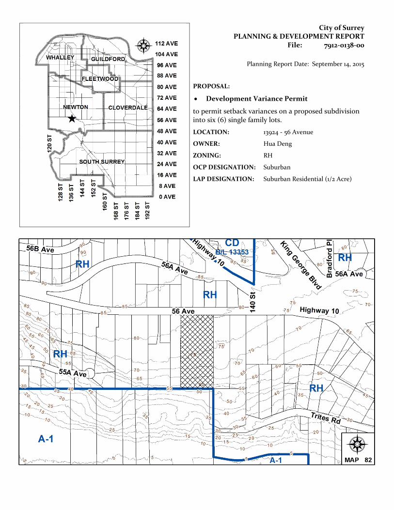
City of Surrey PLANNING & DEVELOPMENT REPORT
File: 7912-0138-00
Planning Report Date: September 14, 2015
PROPOSAL:
• Development Variance Permit
to permit setback variances on a proposed subdivision into six (6) single family lots.
LOCATION: 13924 - 56 Avenue
OWNER: Hua Deng
ZONING: RH
OCP DESIGNATION: Suburban
LAP DESIGNATION: Suburban Residential (1/2 Acre)
Staff Report to Council File: 7912-0138-00
Planning & Development Report
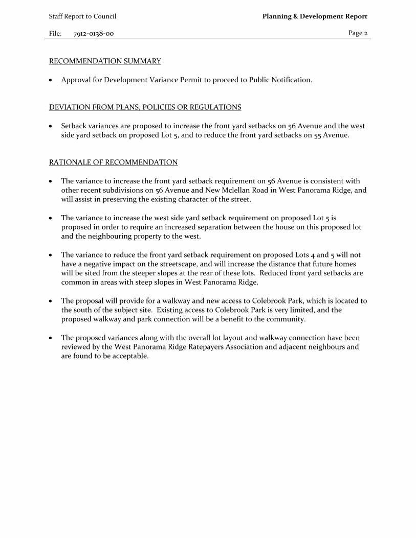
Page 2 RECOMMENDATION SUMMARY • Approval for Development Variance Permit to proceed to Public Notification. DEVIATION FROM PLANS, POLICIES OR REGULATIONS • Setback variances are proposed to increase the front yard setbacks on 56 Avenue and the west
side yard setback on proposed Lot 5, and to reduce the front yard setbacks on 55 Avenue. RATIONALE OF RECOMMENDATION • The variance to increase the front yard setback requirement on 56 Avenue is consistent with
other recent subdivisions on 56 Avenue and New Mclellan Road in West Panorama Ridge, and will assist in preserving the existing character of the street.
• The variance to increase the west side yard setback requirement on proposed Lot 5 is
proposed in order to require an increased separation between the house on this proposed lot and the neighbouring property to the west.
• The variance to reduce the front yard setback requirement on proposed Lots 4 and 5 will not have a negative impact on the streetscape, and will increase the distance that future homes will be sited from the steeper slopes at the rear of these lots. Reduced front yard setbacks are common in areas with steep slopes in West Panorama Ridge.
• The proposal will provide for a walkway and new access to Colebrook Park, which is located to
the south of the subject site. Existing access to Colebrook Park is very limited, and the proposed walkway and park connection will be a benefit to the community.
• The proposed variances along with the overall lot layout and walkway connection have been
reviewed by the West Panorama Ridge Ratepayers Association and adjacent neighbours and are found to be acceptable.
Staff Report to Council File: 7912-0138-00
Planning & Development Report
Page 3 RECOMMENDATION The Planning & Development Department recommends that Council approve Development Variance Permit No. 7912-0138-00 (Appendix VII) varying the following, to proceed to Public Notification:
(a) to increase the minimum front yard setback of the RH Zone from 7.5 metres (25 ft.) to 15 metres (50 ft.) on proposed Lots 1 and 2;
(b) to reduce the minimum front yard setback of the RH Zone from 7.5 metres (25 ft.)
to 5.0 metres (16 ft.) on proposed Lots 4 and 5; and (c) to increase the minimum west side yard setback of the RH Zone from 4.5 metres
(15 ft.) to 7.0 metres (23 ft.) on proposed Lot 5. REFERRALS Engineering: The Engineering Department has no objection to the project
[subject to the completion of Engineering servicing requirements] as outlined in Appendix IV.
School District: Projected number of students from this development: 2 Elementary students at Colebrook Elementary School 1 Secondary students at Panorama Ridge Secondary School (Appendix V.) The applicant has advised that the dwelling units in this project are expected to be constructed and ready for occupancy by Summer 2016.
Parks, Recreation & Culture:
While Parks prefers the western alignment of the park pathway (Appendix III), the current proposal with the eastern park pathway alignment (Appendix II) can be supported.
SITE CHARACTERISTICS Existing Land Use: Single family dwelling on 1.7 hectare (4.2 acre) property. Adjacent Area:
Direction Existing Use OCP/LAP Designation
Existing Zone
North (Across 56 Avenue):
Single family homes.
Suburban/Suburban Residential (1/2 acre)
RH

Staff Report to Council File: 7912-0138-00
Planning & Development Report
Page 4
Direction Existing Use OCP/LAP Designation
Existing Zone
East:
Single family home.
Suburban/Suburban Residential (1/2 acre)
RH
South:
Colebrook Park Agricultural A-1
West:
Single family home.
Suburban/Suburban Residential (1/2 acre)
RH
DEVELOPMENT CONSIDERATIONS Background • The subject 1.7 hectare (4.2 acre) site is located on the south side of 56 Avenue, west of King
George Boulevard, in West Panorama Ridge. It is designated "Suburban Residential (1/2 Acre)" in the West Panorama Ridge Local Area Plan (LAP). The site is adjacent to Colebrook Park to the south, oversized RH Zoned lots to the east and west, and RH lots to the north.
Proposal • The applicant proposes to subdivide the subject site into six (6) single family lots under the
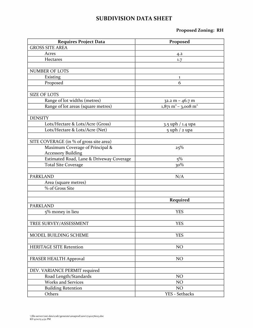
existing RH Zone (Appendix II). The proposed gross unit density is 3.5 units per hectare (1.4 units per acre) and the net unit density is 5 units per hectare (2 units per acre). The proposal meets all subdivision and density requirements of the RH Zone.
• The applicant also proposes to dedicate 8 metres (26 ft.) of land to the east of the buildable
portion of proposed Lot 4 for a future access to Colebrook Park (Appendix II). Parks is supportive of this connection to Colebrook Park, which currently has very limited access from 56 Avenue.
• The portion of proposed Lot 4 on the east side of the proposed 8 metre (26 ft.) wide walkway
is planned to be consolidated and developed with the property to the immediate east at 13956 – 56 Avenue in the future, subject to further review. A Section 219 "No Build" Restrictive Covenant will be required in this regard.
• The applicant proposes road dedications for a new north-south road (139 Street) and east-west
road (55 Avenue) (Appendix II). The proposed 55 Avenue could continue to both the east and west, to allow future subdivision on adjacent oversized RH lots.
• Three (3) variances are being sought: to increase the front yard setback on 56 Avenue from
7.5 metres (25 ft.) to 15 metres (50 ft.) for proposed Lots 1 and 2, to increase the west side yard setback on proposed Lot 5 from 4.5 metres (15 ft.) to 7 metres (23 ft.), and to reduce the front yard setback from 7.5 metres (25 ft.) to 5.0 metres (16 ft.) for proposed Lots 4 and 5 (Appendix VII). These variances are discussed in more detail in the "By-law Variance and Justification" section of this report.
Staff Report to Council File: 7912-0138-00
Planning & Development Report
Page 5 Walkway to Colebrook Park and Servicing Strategy • The walkway location to Colebrook Park is proposed in the same location as a servicing
corridor for temporary sanitary and permanent storm servicing from 55 Avenue through Colebrook Park. The proposed temporary sanitary main will tie-in with an existing City sanitary main located at the west end of Trites Road. The existing sanitary main is connected to the Metro Vancouver sanitary main located to the south of the subject site. The proposed sanitary and storm mains will be located in the middle of the 8 metre (26 ft.) wide dedicated walkway, and the remaining 9 metres (30 ft.) required for the servicing corridor (for a total of 17 metres / 56 ft.) will be secured via statutory right-of-way for maintenance purposes (Appendix II).
• The Parks, Recreation and Culture and Engineering Departments have reviewed the proposed servicing strategy and indicated that it is generally acceptable, subject to detailed review through the Servicing Agreement process.
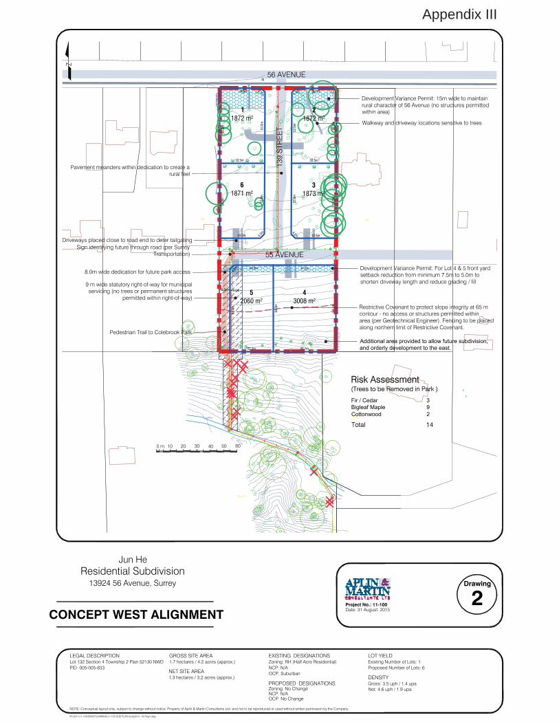
• In the previous iteration of the proposal, from April 2015, the walkway and servicing corridor
were proposed at the western edge of the subject site, south of 55 Avenue (Appendix III). However, as is explained in more detail in the “Neighbourhood Consultation” section of this report, this alignment was opposed by the West Panorama Ridge Ratepayers Association (WPRRA) and surrounding neighbourhood residents.
• The Parks, Recreation & Culture Department’s preference is for the western alignment, as this
option would have the least impact on tree removal.
o The Project Arborist, Nick McMahon of Arbortech Consulting, has advised that with the previous proposal or western alignment (Appendix III), 14 trees require removal. All of these trees are off-site trees, located in Colebrook Park. 3 trees in high risk condition;
• 1 Western Red Cedar in Unsuitable Condition • 1 Alder or Cottonwood • 1 Big Leaf Maple in Unsuitable Condition
11 Additional Trees are proposed to be removed • 3 Alder or Cottonwood • 6 Big Leaf Maple • 2 West Red Cedar in Marginal Condition
o With the current proposal or eastern alignment (Appendix II), 20 trees have been
identified for removal (18 located in Colebrook Park / 2 on-site). The trees for removal include: 3 trees in high risk condition
• 3 Big Leaf Maple in Unsuitable Condition 16 Additional trees require removal
• 2 Alder or Cottonwood • 8 Big Leaf Maple in Unsuitable Condition • 2 Big Leaf Maple in Marginal Condition • 1 Birch in Unsuitable Condition • 1 Western Red Cedar in Marginal Condition • 1 Western Red Cedar in Suitable Condition
Staff Report to Council File: 7912-0138-00
Planning & Development Report
Page 6
• 1 Douglas Fir in Marginal Condition
o Based on the information provided by the Project Arborist, the previous proposal (Appendix III) is a better option from a tree preservation perspective, because 14 trees require removal as opposed to 19 trees. However, with both options, only 1 suitable Western Redcedar tree requires removal.
• As is explained in more detail in the next section of this report, the WPRRA and neighbourhood residents are opposed to the previous proposal (Appendix III) and supportive of the current proposal (Appendix II).
• Staff from Parks, Engineering and Planning agree that the current proposal (eastern
alignment) is acceptable, recognizing that it is not the most desirable option from a tree preservation perspective.
Hazard Lands • The site is also subject to a Development Permit for Hazard Lands under the new OCP, given
there are existing slopes on the property in excess of 15% grade. The applicant has submitted a geotechnical report providing a slope stability analysis. The geotechnical report outlines a number of recommendations to be followed for the design and construction of future residential homes.
• City staff are currently establishing a process around Hazard Land DPs and expect to have this
process in place in the near future. The applicant is aware of the DP requirement, and understands that prior to final subdivision approval, the DP requirement must be met and the DP issued.
NEIGHBOURHOOD CONSULTATION • A development proposal sign was erected on the site on June 11, 2012. Since the application
does not involve rezoning, pre-notification letters are not required. At the time, the proposal was for subdivision into seven (7) lots. The sign was revised to reflect the six (6) lot proposal in April 2015.
• On April 15, 2013, a petition in opposition to the proposal was submitted with signatures from
26 households. On September 26, 2013, 14 additional households were added to the petition. However, signatures from these 14 households were not provided on the petition. The petition indicated opposition due to the proposed introduction of new roads and lack of consistency with the existing neighbourhood character.
• Between September 2012 and July 2015, there have been numerous meetings and discussions
between staff, the applicant, the West Panorama Ridge Ratepayers Association (WPRRA) and neighbouring residents regarding the proposal.
• The current proposal (Appendix II) is the result of collaboration between staff, the applicant,
the WPRRA and neighbouring residents. This proposal addresses the concerns raised including (1) the western portion of the proposed 55 Avenue, and (2) the walkway location previously proposed at the southwest corner of the site.
Staff Report to Council File: 7912-0138-00
Planning & Development Report
Page 7
1. 55 Avenue (the proposed east-west road)
A concern was expressed regarding the need to have the proposed 55 Avenue extend west of the proposed 139 Street. The property owners of lands to the west of the subject site indicated that they are not planning on subdividing their properties, and therefore do not require a road extension, in the foreseeable future. The WPRRA and residents expressed concerns about privacy and safety, and about people potentially parking their vehicles at the end of the dead-end street (future through-road).
In response, staff explained that this part of West Panorama Ridge is zoned "Half-Acre Residential" and designated "Suburban Residential (1/2 Acre)" in the West Panorama Ridge Local Area Plan (LAP). Therefore, in consideration of the proposed development, staff must take into consideration the development potential of surrounding properties, regardless of whether or not the current property owner expresses an interest in subdividing at the present time. The proposed east-west connection is critical in order to preserve the development potential of adjacent properties to the east and west. In order to address concerns about parking in the dead-end road, staff suggested that the driveways for proposed Lots 5 and 6 be placed as far west as possible. The applicant has included this in their latest proposal (Appendix II). Further, the westernmost portion of 55 Avenue is proposed to not be constructed at this time and an 8-metre wide landscaped buffer is proposed instead in order to provide buffering with the property immediately west of the subject site. The landscaped buffer is in road allowance and is anticipated to be constructed as a road at the time of development of the lands to the west. The latest proposal (Appendix II) satisfactorily addresses the concerns raised regarding the western portion of 56 Avenue.
2. Walkway to Colebrook Park
Currently Colebrook Park has very limited pedestrian access from the West Panorama Ridge neighbourhood. The Parks, Recreation and Culture Department (PRC) are planning for improvements to Colebrook Park in the future. With the subject development application, Parks has the opportunity to obtain a pedestrian park linkage which will improve connectivity to this major Parks asset and amenity. As aforementioned, the walkway was previously proposed along the western property line as this alignment provides for the least impact to tree removal from both the subject site and Colebrook Park to the south. As the walkway was proposed to be adjacent to the existing property to the west, the WPRRA and neighbouring residents expressed concerns about safety and loss of privacy. In the current proposal, the walkway and servicing right-of-way are proposed to be located near the southeast portion of the site, between two new proposed lots rather than adjacent to an existing dwelling. Staff agree that this alignment is acceptable; however it is not the preferred alignment as it results in greater impacts to existing trees in Colebrook Park.
Staff Report to Council File: 7912-0138-00
Planning & Development Report
Page 8
In addition, the WPRRA has expressed concern regarding the proposed removal of tree #552 in order to accommodate construction of 139 Street. Staff responded that this tree would require a significant root protection zone, making it challenging to retain this tree while maintaining minimum road standards. However, staff will review and consider this as part of the detailed design review of servicing and road works, prior to final subdivision approval.
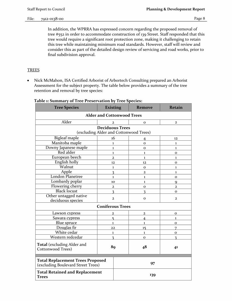
TREES • Nick McMahon, ISA Certified Arborist of Arbortech Consulting prepared an Arborist
Assessment for the subject property. The table below provides a summary of the tree retention and removal by tree species: Table 1: Summary of Tree Preservation by Tree Species:
Tree Species Existing Remove Retain
Alder and Cottonwood Trees Alder 2 0 2
Deciduous Trees (excluding Alder and Cottonwood Trees)
Bigleaf maple 16 4 12 Manitoba maple 1 0 1
Downy Japanese maple 1 0 1 Red alder 1 1 0
European beech 2 1 1 English holly 12 12 0
Walnut 1 0 1 Apple 3 2 1
London Planetree 1 1 0 Lombardy poplar 10 1 9 Flowering cherry 2 0 2
Black locust 3 3 0 Other untagged native
deciduous species 2 0 2
Coniferous Trees Lawson cypress 2 2 0 Sawara cypress 5 4 1
Blue spruce 1 1 0 Douglas fir 22 15 7
White cedar 1 1 0 Western redcedar 3 0 3
Total (excluding Alder and Cottonwood Trees) 89 48 41
Total Replacement Trees Proposed (excluding Boulevard Street Trees) 97
Total Retained and Replacement Trees 139
Staff Report to Council File: 7912-0138-00
Planning & Development Report
Page 9 • The Arborist Assessment states that there are a total of 89 protected trees on the site,
excluding Alder and Cottonwood trees. There are 2 existing Alder or Cottonwood trees on the site. It was determined that 41 trees can be retained as part of this development proposal (excluding Alder and Cottonwood trees). The proposed tree retention was assessed taking into consideration the location of services, building footprints, road dedication and proposed lot grading.
• A number of the existing trees on the site appear to be severely infected with root diseases.
The applicant proposes to undertake detailed testing of these trees to diagnose these trees prior to the approval of the subdivision. This testing may lead to additional trees for retention, or additional trees requiring removal.
• For those trees that cannot be retained, the applicant will be required to plant trees on a 1 to 1
replacement ratio for Alder and Cottonwood trees, and a 2 to 1 replacement ratio for all other trees. This will require a total of 97 replacement trees on the site. The applicant is proposing 97 replacement trees, meeting this requirement.
• In addition to the replacement trees, boulevard street trees will be planted on 56 Avenue, 55 Avenue and 139 Street. This will be determined at the servicing agreement stage by the Engineering Department.
• In summary, a total of 139 trees are proposed to be retained or replaced on the site. SUSTAINABLE DEVELOPMENT CHECKLIST The applicant prepared and submitted a sustainable development checklist for the subject site on June 16, 2015. The table below summarizes the applicable development features of the proposal based on the seven (7) criteria listed in the Surrey Sustainable Development Checklist.
Sustainability Criteria
Sustainable Development Features Summary
1. Site Context & Location
(A1-A2)
• N/A
2. Density & Diversity (B1-B7)
• The proposal includes space for potential private gardens.
3. Ecology & Stewardship
(C1-C4)
• The proposal respects the natural slope at the rear of proposed Lots 5 and 6.
• The proposal provides for recycling and organic waste facilities.
4. Sustainable Transport & Mobility
(D1-D2)
• The proposal includes an 8 metre (26 ft.) wide dedication for the construction of a future access to Colebrook Park to the south of the subject site.
5. Accessibility & Safety
(E1-E3)
• The site design incorporates CPTED design principles.
6. Green Certification (F1)
• N/A
Staff Report to Council File: 7912-0138-00
Planning & Development Report
Page 10
Sustainability Criteria
Sustainable Development Features Summary
7. Education & Awareness
(G1-G4)
• The community has been involved in the development proposal through a number of meetings with neighbouring residents and the WPRRA, as discussed in the "Neighbourhood Consultation" section of this report.
BY-LAW VARIANCE AND JUSTIFICATION (a) Requested Variance:
• To increase the minimum front yard setback on proposed Lots 1 and 2 from 7.5 metres (25 ft.) to 15 metres (50 ft.).
Applicant's Reasons:
• The increase in setback is proposed in order to match the character of the adjacent
homes on 56 Avenue.
• The increased setback allows for winding walkways to the front of the homes similar to those found on the north side of 56 Avenue.
Staff Comments:
• The proposed increased setbacks are consistent with recent adjacent subdivisions on
56 Avenue and New Mclellan Road in West Panorama Ridge. The rationale for the increased setbacks is to maintain the estate character of 56 Avenue and New Mclellan Road.
• Some landscaping along the street, to be determined before subdivision approval, will also be required.
• Staff support the proposed increased setbacks on 56 Avenue.
(b) Requested Variance:
• To reduce the minimum front yard setback on proposed Lots 4 and 5 from 7.5 metres (25 ft.) to 5.0 metres (16 ft.).
Applicant's Reasons:
• The setback relaxations are proposed in order to reduce the required depth of the
sanitary servicing connections. Reducing the depth of the sanitary connection will help to reduce the depth of the temporary sanitary main, which is proposed to run through existing parkland via a statutory right-of-way.
• Geotechnical assessment determined that no buildings or structures should be erected south of the 65 metre contour line. By reducing the front yard setback, building
Staff Report to Council File: 7912-0138-00
Planning & Development Report
Page 11
footprints are pushed toward 56 Avenue, away from the south property line which is the steepest portion of the slope.
• With a shorter distance between the road and the house, and therefore a shorter
driveway, the house can step down to steeper grades at the rear of the property, and therefore less lot grading will be required at the front of the property.
Staff Comments:
• Parks and Engineering approval are required in order to permit the proposed site
servicing, which includes a statutory right-of-way for sanitary and storm servicing through Colebrook Park.
• Reduced front yard setbacks are common in areas with steep slopes in West Panorama Ridge. The setbacks will not have a negative impact on the streetscape, and will also increase the distance that future homes will be sited from the steeper slopes at the rear of these lots.
• Staff have no concerns with the proposed variance.
(c) Requested Variance:
• To increase the minimum west side yard setback on proposed Lot 5 from 4.5 metres (15 ft.) to 7 metres (23 ft.).
Applicant's Reasons:
• The increase in setback is proposed in order to require an increased separation
between the house on this proposed lot and the neighbouring property to the west.
Staff Comments:
• Staff support the proposed increased setback.
Staff Report to Council File: 7912-0138-00
Planning & Development Report
Page 12 INFORMATION ATTACHED TO THIS REPORT The following information is attached to this Report: Appendix I. Lot Owners, Action Summary and Project Data Sheets Appendix II. Proposed Subdivision Layout (August 2015 Proposal) Appendix III. Previously Proposed Subdivision Layout (April 2015 Proposal) Appendix IV. Engineering Summary Appendix V. School District Comments Appendix VI. Summary of Tree Survey and Tree Preservation Appendix VII. Development Variance Permit No. 7912-0138-00 Appendix VIII. Building Design Guidelines Summary
original signed by Nicholas Lai Jean Lamontagne General Manager Planning and Development HK/da \\file-server1\net-data\csdc\generate\areaprod\save\17421276023.doc KD 9/10/15 4:52 PM
\\file-server1\net-data\csdc\generate\areaprod\save\17421276023.doc KD 9/10/15 4:52 PM
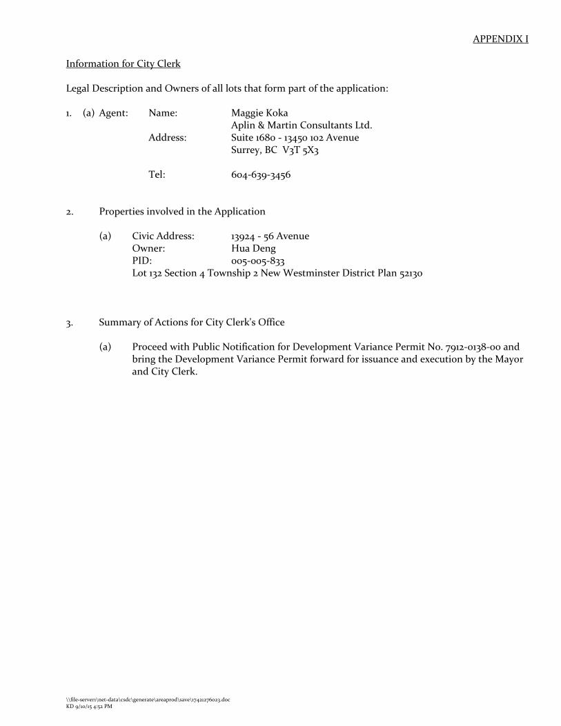
APPENDIX I
Information for City Clerk Legal Description and Owners of all lots that form part of the application: 1. (a) Agent: Name: Maggie Koka
Aplin & Martin Consultants Ltd. Address: Suite 1680 - 13450 102 Avenue Surrey, BC V3T 5X3 Tel: 604-639-3456
2. Properties involved in the Application
(a) Civic Address: 13924 - 56 Avenue Owner: Hua Deng
PID: 005-005-833 Lot 132 Section 4 Township 2 New Westminster District Plan 52130
3. Summary of Actions for City Clerk's Office
(a) Proceed with Public Notification for Development Variance Permit No. 7912-0138-00 and
bring the Development Variance Permit forward for issuance and execution by the Mayor and City Clerk.
\\file-server1\net-data\csdc\generate\areaprod\save\17421276023.doc KD 9/10/15 4:52 PM
SUBDIVISION DATA SHEET
Proposed Zoning: RH
Requires Project Data Proposed GROSS SITE AREA Acres 4.2 Hectares 1.7 NUMBER OF LOTS Existing 1 Proposed 6 SIZE OF LOTS Range of lot widths (metres) 32.2 m – 46.7 m Range of lot areas (square metres) 1,871 m2 – 3,008 m2
DENSITY Lots/Hectare & Lots/Acre (Gross) 3.5 uph / 1.4 upa Lots/Hectare & Lots/Acre (Net) 5 uph / 2 upa SITE COVERAGE (in % of gross site area) Maximum Coverage of Principal &
Accessory Building 25%
Estimated Road, Lane & Driveway Coverage 5% Total Site Coverage 30% PARKLAND N/A Area (square metres) % of Gross Site Required PARKLAND 5% money in lieu YES TREE SURVEY/ASSESSMENT YES MODEL BUILDING SCHEME YES HERITAGE SITE Retention NO FRASER HEALTH Approval NO DEV. VARIANCE PERMIT required Road Length/Standards NO Works and Services NO Building Retention NO Others YES - Setbacks

Drawing
1Project No.: 11-100Date: 31 August 2015
CONCEPT EAST ALIGNMENT
NOTE: Conceptual layout only, subject to change without notice. Property of Aplin & Martin Consultants Ltd. and not to be reproduced or used without written permission by the Company.
M:\2011\11-100\DWG\PLANNING\11-100 SUB PLAN 26Aug2015 - E V.2.dwg
LEGAL DESCRIPTION
PID: 005-005-833
GROSS SITE AREA1.7 hectares / 4.2 acres (approx.) Zoning: RH (Half Acre Residential)
NCP: N/AOCP: Suburban
LOT YIELDExisting Number of Lots: 1Proposed Number of Lots: 6
DENSITYGross: 3.5 uph / 1.4 upa
Lot 132 Section 4 Township 2 Plan 52130 NWDEXISTING DESIGNATIONS
PROPOSED DESIGNATIONS
OCP: No ChangeNCP: N/AZoning: No Change
NET SITE AREA1.3 hectares / 3.2 acres (approx.)
Net: 4.6 uph / 1.9 upa
Residential SubdivisionJun He
13924 56 Avenue, Surrey
Appendix II
Drawing
2Project No.: 11-100Date: 31 August 2015
CONCEPT WEST ALIGNMENT
NOTE: Conceptual layout only, subject to change without notice. Property of Aplin & Martin Consultants Ltd. and not to be reproduced or used without written permission by the Company.
M:\2011\11-100\DWG\PLANNING\11-100 SUB PLAN 6July2015 - W Align.dwg
LEGAL DESCRIPTION
PID: 005-005-833
GROSS SITE AREA1.7 hectares / 4.2 acres (approx.) Zoning: RH (Half Acre Residential)
NCP: N/AOCP: Suburban
LOT YIELDExisting Number of Lots: 1Proposed Number of Lots: 6
DENSITYGross: 3.5 uph / 1.4 upa
Lot 132 Section 4 Township 2 Plan 52130 NWDEXISTING DESIGNATIONS
PROPOSED DESIGNATIONS
OCP: No ChangeNCP: N/AZoning: No Change
NET SITE AREA1.3 hectares / 3.2 acres (approx.)
Net: 4.6 uph / 1.9 upa
Residential SubdivisionJun He
13924 56 Avenue, Surrey
Appendix III

ktSliRREY ~ the future lives here.
INTER-OFFICE MEMO
TO: Manager, Area Planning & Development - South Surrey Division Planning and Development Department
FROM: Development Services Manager, Engineering Department
DATE: September 09, 2.015 PROJECT FILE: 7812.-0138-oo
RE: Engineering Requirements Location: 1392.4- 56 Avenue
SUBDIVISION
Property and Right-of Way Requirements • Dedicate 2.o.ooom each for 139 Street, and 55 Avenue. • Dedicate 3.om x 3.om corner cuts at the intersection of 139 Street and 56 Avenue and at
the intersection of139 Street and 55 Avenue. • Dedicate 8.ooom wide road allowance for future park access. • Provide 9.ooom wide SROW on Lot 4 and off-site SROW on Colebrook Park for servicing.
Works and Services • Construct south side of 56 Avenue to West Panorama Ridge standard. • Construct 139 Street and 55 Avenue as full road to West Panorama Ridge standard. • Construct sanitary main, storm main and water main on 139 Street and on 55 Avenue. • Construct sanitary main and storm main within dedicated walkway and within Colebrook
Park. Secure Parks approval for servicing through the Park and satisfy engineering maintenance access concerns.
• Construct storm main and sanitary main on 56 Avenue. • Submit geotechnical report in favour of proposed sanitary and storm servicing. • Provide on-site and off-site statutory rights-of-way for servicing. • Register restrictive covenant for engineered foundation, pumped sanitary and storm
connections and driveway access.
A Servicing Agreement is required prior to Subdivision.
DEVELOPMENT VARIANCE PERMIT
There are no engineering requirements relative to issuance of the Development Variance Permit.
j!-c~~ ~ Remi Dube, P.Eng. Development Services Manager
HB
NOTE: Detailed Land Development Engineering Review available on file
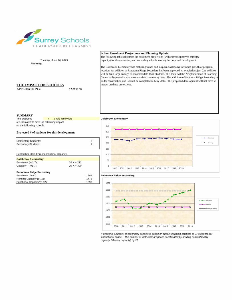
School Enrolment Projections and Planning Update:The following tables illustrate the enrolment projections (with current/approved ministrycapacity) for the elementary and secondary schools serving the proposed development.
THE IMPACT ON SCHOOLSAPPLICATION #: 12 0138 00
SUMMARY The proposed 7 single family lots Colebrook Elementaryare estimated to have the following impacton the following schools:
Projected # of students for this development:
Elementary Students: 2Secondary Students: 1
September 2014 Enrolment/School Capacity
Colebrook ElementaryEnrolment (K/1-7): 26 K + 212 Capacity (K/1-7): 20 K + 300
Panorama Ridge SecondaryEnrolment (8-12): 1502 Panorama Ridge SecondaryNominal Capacity (8-12): 1475 Functional Capacity*(8-12); 1593
Projected cumulative impact of development Nominal Capacity (8-12):subject project) in the subject catchment areas:
Elementary Students: 8Secondary Students: 50Total New Students: 58
The Colebrook Elementary has maturing trends and surplus classrooms for future growth or program location. An addition to Panorama Ridge Secondary has been approved as a capital project (the addition will be built large enough to accommodate 1500 students, plus there will be Neighbourhood of Learning Centre with space that can accommodate community use). The addition to Panorama Ridge Secondary in under construction and should be completed in May 2014. The proposed development will not have an impact on these projections.
PlanningTuesday, June 16, 2015
*Functional Capacity at secondary schools is based on space utilization estimate of 27 students per instructional space. The number of instructional spaces is estimated by dividing nominal facility capacity (Ministry capacity) by 25.
0
50
100
150
200
250
300
350
2010 2011 2012 2013 2014 2015 2016 2017 2018 2019
Enrolment
Capacity
1350
1400
1450
1500
1550
1600
1650
2010 2011 2012 2013 2014 2015 2016 2017 2018 2019
Enrolment
Capacity
Functional Capacity
a division of:
PAGE 1 OF 1
145 – 12051 HORSESHOE WAY RICHMOND, BC V7A 4V4 P 604 275 3484 F 604 275 9554
Appendix _____
TREE PRESERVATION SUMMARY Surrey Project No.: ______________
Project Address: 13924 56 Avenue Surrey, BC
Consulting Arborist: Nick McMahon
ON-SITE TREES: QUANTITY OF TREES Total Bylaw Protected Trees Identified (on-site and shared trees, including trees within boulevards and proposed streets and lanes, excluding Park and ESA dedications)
91
Bylaw Protected Trees to be Removed 48 Bylaw Protected Trees to be Retained (excludes trees in Park dedication areas and ESA’s)
43
Replacement Trees Required: Alder and Cottonwood at 1:1 ratio: 3 times 1 = 3 All Other Bylaw Protected Trees at 2:1 ratio: 47 times 2 = 94 TOTAL: 97
Replacement Trees Proposed 97 Replacement Trees in Deficit 0 Protected Trees Retained in Proposed Open Space/ Riparian Areas 0 OFF-SITE TREES: QUANTITY OF TREES Bylaw Protected Off-Site Trees to be Removed 18 Replacement Trees Required:
Alder and Cottonwood at 1:1 ratio: 2 times 1 = 2 All Other Bylaw Protected Trees at 2:1 ratio: 16 times 2 = 32 TOTAL: 34
Replacement Trees Proposed 34 Replacement Trees in Deficit 0
This summary and the referenced documents are prepared and submitted by:
Nick McMahon, Consulting Arborist Dated: September 9, 2015
Direct: 604 812 2986 Email: [email protected]
CITY OF SURREY
(the "City")
DEVELOPMENT VARIANCE PERMIT
NO.: 7912-0138-00 Issued To: HUA DENG ("the Owner") Address of Owner: 13924 - 56 Avenue Surrey, BC V3X 2Z8 1. This development variance permit is issued subject to compliance by the Owner with all
statutes, by-laws, orders, regulations or agreements, except as specifically varied by this development variance permit.
2. This development variance permit applies to that real property including land with or
without improvements located within the City of Surrey, with the legal description and civic address as follows:
Parcel Identifier: 005-005-833
Lot 132 Section 4 Township 2 New Westminster District Plan 52130
13924 - 56 Avenue
(the "Land") 3. (a) As the legal description of the Land is to change, the City Clerk is directed to insert
the new legal description for the Land once titles have been issued, as follows:
Parcel Identifier: ____________________________________________________________
(b) If the civic addresses change, the City Clerk is directed to insert the new civic addresses for the Land, as follows:
_____________________________________________________________
- 2 -
4. Surrey Zoning By-law, 1993, No. 12000, as amended is varied as follows:
(a) In Section F. of Part 14 "Half-Acre Residential Zone (RH)" the minimum front yard setback to a principal building is increased from 7.5 metres (25 ft.) to 15 metres (50 ft.) on Lots 1 and 2, as conceptually shown on Schedule A which is attached hereto and forms part of this development variance permit.
(b) In Section F. of Part 14 "Half-Acre Residential Zone (RH)" the minimum front yard
setback to a principal building is reduced from 7.5 metres (25 ft.) to 5.0 metres (16 ft.) on Lots 4 and 5, as conceptually shown on Schedule A which is attached hereto and forms part of this development variance permit.
(c) In Section F. of Part 14 "Half-Acre Residential Zone (RH)" the minimum west yard
setback to a principal building is increased from 4.5 metres (15 ft.) to 7.0 metres (23 ft.) on Lot 5, as conceptually shown on Schedule A which is attached hereto and forms part of this development variance permit.
5. The Land shall be developed strictly in accordance with the terms and conditions and
provisions of this development variance permit. 6. This development variance permit shall lapse unless the subdivision, as conceptually
shown on Schedule A which is attached hereto and forms part of this development variance permit, is registered in the New Westminster Land Title Office within three (3) years after the date this development variance permit is issued.
7. The terms of this development variance permit or any amendment to it, are binding on all
persons who acquire an interest in the Land. 8. This development variance permit is not a building permit. AUTHORIZING RESOLUTION PASSED BY THE COUNCIL, THE DAY OF , 20 . ISSUED THIS DAY OF , 20 . ______________________________________ Mayor – Linda Hepner ______________________________________ City Clerk – Jane Sullivan \\file-server1\net-data\csdc\generate\areaprod\save\18018196048.doc . 9/10/15 4:39 PM
Drawing
1Project No.: 11-100Date: 31 August 2015
CONCEPT EAST ALIGNMENT
NOTE: Conceptual layout only, subject to change without notice. Property of Aplin & Martin Consultants Ltd. and not to be reproduced or used without written permission by the Company.
M:\2011\11-100\DWG\PLANNING\11-100 SUB PLAN 26Aug2015 - E V.2.dwg
LEGAL DESCRIPTION
PID: 005-005-833
GROSS SITE AREA1.7 hectares / 4.2 acres (approx.) Zoning: RH (Half Acre Residential)
NCP: N/AOCP: Suburban
LOT YIELDExisting Number of Lots: 1Proposed Number of Lots: 6
DENSITYGross: 3.5 uph / 1.4 upa
Lot 132 Section 4 Township 2 Plan 52130 NWDEXISTING DESIGNATIONS
PROPOSED DESIGNATIONS
OCP: No ChangeNCP: N/AZoning: No Change
NET SITE AREA1.3 hectares / 3.2 acres (approx.)
Net: 4.6 uph / 1.9 upa
Residential SubdivisionJun He
13924 56 Avenue, Surrey
Schedule A
BUILDING GUIDELINES SUMMARY Surrey Project no: 7912-0138-00 Project Location: 13924 – 56 Avenue, Surrey, B.C. Design Consultant: Tynan Consulting Ltd., (Michael E. Tynan) The draft Building Scheme proposed for this Project has been filed with the City Clerk. The following is a summary of the Residential Character Study and the Design Guidelines which highlight the important features and form the basis of the draft Building Scheme. 1. Residential Character 1.1 General Description of the Existing and/or Emerging Residential Character
of the Subject Site: This area was built out over a time period spanning from the 1960's to the 1990's. The age distribution from oldest to newest is : 50 years old (25%), 40 years old (58%), 30 years old (8%), 20 years old (8%). Most homes are over 3500 sq.ft. in size. Home size distribution is as follows : 1000-1500 sq.ft. (25%), 2501-3000 sq.ft. (17%), 3001-3550 sq.ft. (25%), over 3550 sq.ft. (33%). Styles found in this area include: "Old Urban" (8%), "West Coast Traditional (68%), "Modern California Stucco" (8%), "Neo-Heritage" (8%), and "Traditional Cape Cod" (8%). Home types include: Bungalow (17%), Bungalow with above-ground basement (8%), 1½ Storey (17%), Basement Entry (8%), Cathedral Entry (8%), and Two-Storey (42%). The massing scale found on neighbouring homes ranges from simple rectangular low mass structures to mid-scale structures with proportionally consistent well balanced massing designs, to high mass, box-like structures. Massing scale is distributed as follows: low mass structures (25%), low to mid-scale structures (8%), mid-scale structures of average quality (25%), mid-scale structures with proportionally consistent, well balanced context quality massing designs (17%), mid-to-high-scale structures (8%), high scale structures with box-like massing resulting from locating the upper floor directly above or beyond the floor below (17%). The scale range for the front entrance element is: one storey (83%), and 1½ storey front entrance (17%). A wide range of roof slopes have been used including: low slope (flat to 5:12) = (41)%, moderate slope (6:12 to 7:12) = (20)%, steeply sloped (8:12 and steeper) = (41)%. Roof forms include : common hip (42%), common gable (50%), Dutch hip (8%). Roof surfaces include: roll roofing (8%), metal (8%), interlocking tab type asphalt shingles (17%), rectangular profile type asphalt shingles (25%), concrete tile (rounded Spanish profile) (8%), and cedar shingles (33%). Main wall cladding materials include : horizontal cedar siding (8%), vertical channel cedar siding (8%), vertical board and batten cedar (8%), horizontal vinyl siding (17%), stucco cladding (33%), and full height stone at front (25%). Feature veneers on the front façade include : no feature veneer (30%), brick (20%), wood wall shingles (10%), horizontal cedar (30%), Tudor style battens over stucco (10%). Wall cladding and trim colours include : Neutral (white, cream, grey, black) (50%), Natural (earth tones) (39%), Primary derivative (red, blue, yellow) (11%). Covered parking configurations include : No covered parking (9%), Single carport (18%), Single vehicle garage (9%), Double garage (64%).
A variety of landscaping standards are evident, ranging from "modest old suburban" (sod, a few shrubs, and a few mature trees) to 'high quality modern suburban" featuring over 100 shrubs, numerous trees and thoughtfully designed features. Driveway surfaces include: gravel (17%), asphalt (67%), and exposed aggregate (17%). Fifty five percent of homes can be considered 'non-context', and are not recommended for emulation. Forty five percent of homes can be considered 'context homes' (as identified in the residential character study), which provide acceptable architectural context for the subject site. However, massing design standards have improved markedly in the past ten years. The recommendation therefore is to require new homes to be designed and detailed to common new post year 2010 standards for suburban-estate homes on RH zoned lots in South Surrey, rather than be designed to emulate specific neighbouring homes. 1.2 Prevailing Features of the Existing and Surrounding Dwellings
Significant to the Proposed Building Scheme:
1) Context Homes: Although there are numerous aesthetically acceptable homes in this neighbourhood, the recommendation is to require new homes to be designed and detailed to common new post year 2010 standards for suburban-estate homes on RH zoned lots in South Surrey, rather than to emulate existing structures.
2) Style Character : For reasonable blending with existing homes, and to provide styles that are suitable for the proposed executive quality suburban-estate character, the following styles are recommended: "Traditional", “Neo-Traditional” "Heritage" and “Neo-Heritage”.
3) Home Types : There are a wide variety of home types evident in this area, and the lots are large. Therefore a variety of home types can be accommodated, though it is likely that all new homes will be Two-Storey type.
4) Massing Designs : Surrounding new homes provide acceptable massing context. However, emulation of the neighbouring homes is not recommended. New homes will have to meet high new standards for suburban estate homes on RH zoned lots. New homes will have aesthetically pleasing shapes with interesting, proportionally consistent feature projections well balanced across the façade.
5) Front Entrance Design : Front entrance porticos range from one to 1 ½ storeys in height. A 1 ½ storey entrance element is of an appropriate size for a home of a suburban-estate scale. The recommendation is an entrance element ranging in size from 1 to 1½ storeys.
6) Exterior Wall Cladding : A wide range of wall cladding materials have been used in this area, including vinyl. Vinyl however is an economical utility wall cladding material appropriate for areas in which affordability is a concern. Vinyl is not appropriate for use on high value suburban estate homes and is not recommended for this site.
7) Roof surface: Roof surfaces are not a defining characteristic in this area, and so some flexibility can be justified, providing the materials are of a high standard. Cedar shingles, shake profile concrete roof tiles, and shake profile asphalt shingles with a 40 year or greater warranty are recommended.
8) Roof Slope : There are a wide range of roof slopes on existing neighbouring homes. The recommendation is to use roof slopes of 8:12 or higher for consistency with the proposed suburban-estate character, subject to standard exceptions.
Window/Door Details: Rectangular dominant.
Streetscape: This area has a distinct old suburban appearance. Lots are large. A wide variety of : home types, styles, home sizes, quality of massing designs, and exterior cladding and detailing components, have been constructed over a time period spanning from the 1960's to the 1990's. The character is best described as "varied old suburban". Landscapes range from "modest old suburban" featuring sod, and few mature shrubs, and native trees, to "estate quality suburban" featuring more than 100 shrubs with interesting raised planting bed designs.
2. Proposed Design Guidelines 2.1 Specific Residential Character and Design Elements these Guidelines
Attempt to Preserve and/or Create: The new homes are constructed to a high architectural standard, meeting or exceeding standards
found in most executive-estate quality subdivisions on RH zoned lots in the City of Surrey. New homes are readily identifiable as one of the following styles: “Traditional” (including English Country, English Tudor, English Manor, Cape Cod and other sub-styles that impart a formal, stately character), Classical Heritage, Neo-Heritage, and estate quality manifestations of the Neo-Traditional style. Note that the proposed style range is not contained within the building scheme, but is contained within the residential character study which forms the basis for interpreting building scheme regulations.
a new single family dwelling constructed on any lot meets year 2000's design standards, which include the proportionally correct allotment of mass between various street facing elements, the overall balanced distribution of mass within the front facade, readily recognizable style-authentic design, and a high trim and detailing standard used specifically to reinforce the style objectives stated above.
trim elements will include several of the following: furred out wood posts, articulated wood post bases, wood braces and brackets, louvered wood vents, bold wood window and door trim, highly detailed gable ends, wood dentil details, stone or brick feature accents, covered entrance verandas and other style-specific elements, all used to reinforce the style (i.e. not just decorative).
the development is internally consistent in theme, representation, and character. the entrance element will be limited in height (relative dominance) to 1 to 1 ½ storeys. 2.2 Proposed Design Solutions:
Interfacing Treatment Although many homes in this area are constructed to an with existing dwellings) "agreeable" standard, most are not constructed to the high
new standards which have evolved for new suburban-estate RH zoned developments in South Surrey. No existing neighbouring homes provide specific context and therefore specific interfacing treatments are not contemplated. Rather, the homes will be constructed to common new (post year 2010) standards for RH zoned developments.
Exterior Materials/Colours: Stucco, Cedar, Hardiplank, Brick, and Stone. No Vinyl.
“Natural” colours such as browns, greens, clays, and other earth-tones, and “Neutral” colours such as grey, white, and cream are permitted. “Primary” colours in subdued tones such as navy blue or forest green can be considered providing neutral
trim colours are used, and a comprehensive colour scheme is approved by the consultant. “Warm” colours such as pink, rose, peach, salmon are not permitted. Trim colours: Shade variation of main colour, complementary, neutral, or subdued contrast only.
Roof Pitch: Minimum 8:12. Roof Materials/Colours: Cedar shingles, shake profile concrete roof tiles, and shake
profile asphalt shingles (minimum 40 year warranty) with a raised ridge cap, and new shake profile environmentally sustainable roofing products are permitted, providing that aesthetic properties of the new materials are equal to or better than that of the traditional roofing products. Grey, black, or brown only.
In-ground basements: Permitted, subject to determination that service invert locations
are sufficiently below grade. Basements will appear underground from the front.
Treatment of Corner Lots: Significant, readily identifiable architectural features are
provided on both the front and flanking street sides of the dwelling, resulting in a home that architecturally addresses both streets. One-storey elements on the new home shall comprise a minimum of 40 percent of the width of the front and flanking street elevations of the single family dwelling. The upper floor is set back a minimum of 0.9 metres [3'- 0"] from the one-storey elements.
Landscaping: High suburban estate standard required: Tree planting as
specified on Tree Replacement Plan plus minimum 50 shrubs of a minimum 3 gallon pot size. Corner lots shall have an additional 15 shrubs of a minimum 3 gallon pot size, planted in the flanking street sideyard. Sod from street to face of home. Driveways: exposed aggregate, interlocking masonry pavers, or stamped concrete only.
Compliance Deposit: $5,000.00 Summary prepared and submitted by: Tynan Consulting Ltd. Date: June 16, 2015
Reviewed and Approved by: Date: June 16, 2015