Embed Size (px)
Citation preview

0 CITY OF WILDOMAR –PART I - ANNEX LOCAL HAZARD MITIGATION PLAN SEPTEMBER 2012
CITY OF WILDOMAR
ANNEX LOCAL HAZARD
MITIGATION PLAN SEPTEMBER 2012
Prepared by: Paula Willette
Community Services Director
1 CITY OF WILDOMAR –PART I - ANNEX LOCAL HAZARD MITIGATION PLAN SEPTEMBER 2012
CONTACT INFORMATION
CITY OF WILDOMAR
Name: Paula Willette
Title: Community Services Director
Address: 23873 Clinton Keith Rd Ste. 201
City, State Zip: Wildomar, CA 92595
Direct Contact: 951-677-7751
Fax: 951.698.1463
Email: [email protected]
2 CITY OF WILDOMAR –PART I - ANNEX LOCAL HAZARD MITIGATION PLAN SEPTEMBER 2012
EXECUTIVE SUMMARY
The purpose of this local hazard mitigation plan is to identify the County’s hazards,
review and assess past disaster occurrences, estimate the probability of future
occurrences and set goals to mitigate potential risks to reduce or eliminate long-term
risk to people and property from natural and man-made hazards.
The plan was prepared pursuant to the requirements of the Disaster Mitigation Act of
2000 to achieve eligibility and potentially secure mitigation funding through Federal
Emergency Management Agency (FEMA) Flood Mitigation Assistance, Pre-Disaster
Mitigation, and Hazard Mitigation Grant Programs.
Riverside County's continual efforts to maintain a disaster-mitigation strategy is on-
going. Our goal is to develop and maintain an all-inclusive plan to include all
jurisdictions, special districts, businesses and community organizations rather than
them writing their own plan to promote consistency, continuity and unification.
The County’s planning process followed a methodology presented by FEMA and CAL-
EMA which included conducting meetings with the Operational Area Planning
Committee (OAPC) coordinated by Riverside County Fire – Office of Emergency
Services comprised of participating Federal, State and local jurisdictions agencies,
special districts, school districts, non-profit communities, universities, businesses, tribes
and general public.
The plan identifies vulnerabilities, provides recommendations for prioritized mitigation
actions, evaluates resources and identifies mitigation shortcomings, provides future
mitigation planning and maintenance of existing plan.
The plan will be implemented upon FEMA approval.

3 CITY OF WILDOMAR –PART I - ANNEX LOCAL HAZARD MITIGATION PLAN SEPTEMBER 2012
PLAN ADOPTION/RESOLUTION
The City of Wildomar will submit plans to Riverside County Fire – Off ice of
Emergency Services who wil l forward to CAL EMA for review prior to being
submitted to FEMA. In addition, we will wait to receive an “Approval Pending
Adoption” before taking the plan to our local governing bodies for adoption. Upon
approval, the City of Wildomar will insert the signed resolution.

4 CITY OF WILDOMAR –PART I - ANNEX LOCAL HAZARD MITIGATION PLAN SEPTEMBER 2012
Table of Contents CONTACT INFORMATION ........................................................................................................ 1 EXECUTIVE SUMMARY ........................................................................................................... 2 PLAN ADOPTION/RESOLUTION .............................................................................................. 3 SECTION 1.0 - COMMUNITY PROFILE .................................................................................... 6
1.1 CITY OF WILDOMAR MAP ...................................................................................... 6 1.2 BRIEF HISTORY ...................................................................................................... 6 1.3 GEOGRAPHY AND CLIMATE DESCRIPTION ........................................................ 6 1.4 ECONOMY DESCRIPTION...................................................................................... 7 1.5 POPULATION CHARACTERISTICS ........................................................................ 8 1.6 HOUSING CHARACTERISTICS .............................................................................. 9 1.7 LAND USE AND DEVELOPMENT TRENDS ...........................................................10
SECTION 2.0 - PLANNING PROCESS.....................................................................................11 2. 1 PARTICIPATION IN REGIONAL (OA) PLANNING PROCESS ...............................11 2. 2 LOCAL PLANNING PROCESS ...............................................................................11 2. 3 DATES AVAILABLE FOR PUBLIC COMMENT .......................................................11 2. 4 PLANS ADOPTED BY RESOLUTION .....................................................................12
SECTION 3.0 – HAZARD UPDATES AND MITIGATION ACTIONS .........................................12 3.1 HAZARD UPDATES ................................................................................................12 3.2 BRIEF STATEMENT OF UNIQUE HAZARDS .........................................................12 3.3 MITIGATION PROJECT UPDATE...........................................................................12 3.4 MITIGATION ACTIONS ...........................................................................................13
SECTION 4.0 – HAZARD IDENTIFICATION AND RISK ASSESSMENT ..................................14 4.1 HAZARD REVIEW AND SUMMARY .......................................................................14 4.2 CRITICAL FACILITIES AND INFRASTRUCTURES ................................................14 4.3 ESTIMATING POTENTIAL LOSS ...........................................................................15 4.4 TABLE/REPLACEMENT VALUE .............................................................................15 4.5 IDENTIFICATION OF RISKS AND VULNERABILITIES ..........................................16
SECTION 5.0 – COMMUNITY RATING SYSTEM ....................................................................20 5.1 REPETITIVE LOSS PROPERTIES .........................................................................20 5.2 NATIONAL FLOOD INSURANCE PROPERTIES ....................................................20
SECTION 6.0 – CAPABILITIES ASSESSMENT .......................................................................21 6.1 REGULATORY MITIGATION CAPABILITIES .........................................................21 6.2 ADMINISTRATIVE/TECHNICAL MITIGATION CAPABILITIES ...............................22 6.3 FISCAL MITIGATION CAPABILITIES .....................................................................23 6.4 MITIGATION OUTREACH AND PARTNERSHIPS ..................................................23 6.5 OTHER MITIGATION EFFORTS ............................................................................23
SECTION 7.0 - GROWTH AND DEVELOPMENT TRENDS .....................................................24 7.1 GOALS AND OBJECTIVES ....................................................................................24 7.2 MITIGATION STRATEGIES ....................................................................................26 7.3 ON-GOING MITIGATION STRATEGY PROGRAMS ..............................................26 7.4 FUTURE MITIGATION STRATEGIES .....................................................................26
SECTION 8.0 - INCORPORATION INTO EXISTING PLANNING MECHANISMS ....................28 SECTION 9.0 - PLAN MAINTENANCE PROCESS ...................................................................29 SECTION 10.0 – CONTINUED PUBLIC INVOLVEMENT .........................................................29 EXHIBITS A & B .......................................................................................................................30 HAZARD MITIGATION AGENCY INVENTORY WORKSHEETS ..............................................31 PLAN REVIEW TOOL/CROSSWALK .......................................................................................32

5 CITY OF WILDOMAR –PART I - ANNEX LOCAL HAZARD MITIGATION PLAN SEPTEMBER 2012
6 CITY OF WILDOMAR –PART I - ANNEX LOCAL HAZARD MITIGATION PLAN SEPTEMBER 2012
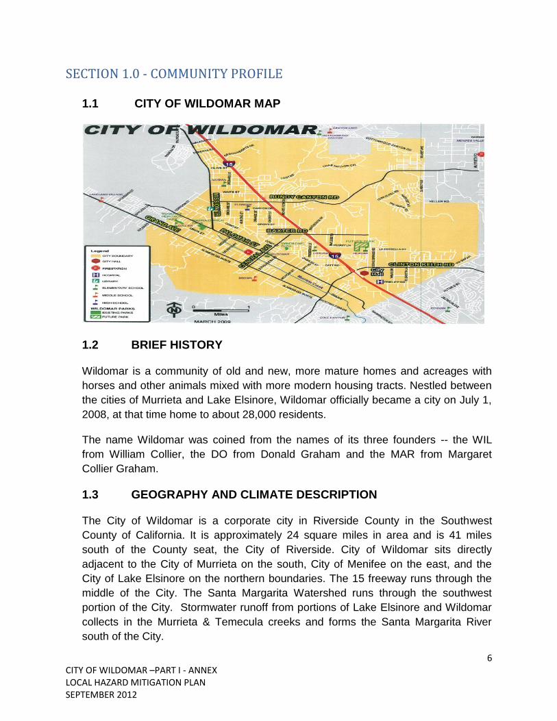
SECTION 1.0 - COMMUNITY PROFILE
1.1 CITY OF WILDOMAR MAP
1.2 BRIEF HISTORY
Wildomar is a community of old and new, more mature homes and acreages with
horses and other animals mixed with more modern housing tracts. Nestled between
the cities of Murrieta and Lake Elsinore, Wildomar officially became a city on July 1,
2008, at that time home to about 28,000 residents.
The name Wildomar was coined from the names of its three founders -- the WIL
from William Collier, the DO from Donald Graham and the MAR from Margaret
Collier Graham.
1.3 GEOGRAPHY AND CLIMATE DESCRIPTION
The City of Wildomar is a corporate city in Riverside County in the Southwest
County of California. It is approximately 24 square miles in area and is 41 miles
south of the County seat, the City of Riverside. City of Wildomar sits directly
adjacent to the City of Murrieta on the south, City of Menifee on the east, and the
City of Lake Elsinore on the northern boundaries. The 15 freeway runs through the
middle of the City. The Santa Margarita Watershed runs through the southwest
portion of the City. Stormwater runoff from portions of Lake Elsinore and Wildomar
collects in the Murrieta & Temecula creeks and forms the Santa Margarita River
south of the City.

7 CITY OF WILDOMAR –PART I - ANNEX LOCAL HAZARD MITIGATION PLAN SEPTEMBER 2012
City of Wildomar’s climate can be described as: Winter is almost never extreme, low
temperatures rarely go below freezing. In the summer the high temperatures will
hover in the 90's, but some days may go over 100 during heat waves. Rainfall for
City of Wildomar is typical of that of the rest of Riverside County.
1.4 ECONOMY DESCRIPTION
City of Wildomar is primarily a bedroom community. Development in the City is 90
percent residential, 10 percent commercial/industrial, which limits the sales and
property tax base. The largest employer is Inland Valley Medical Center-Southwest
Health Care which employs 600 healthcare professionals and serves as Southwest
Riverside County’s only trauma center, providing emergency medical services and
trauma surgery.
Figure 1.4.1 Jobs by Sector – City of Wildomar

8 CITY OF WILDOMAR –PART I - ANNEX LOCAL HAZARD MITIGATION PLAN SEPTEMBER 2012
1.5 POPULATION CHARACTERISTICS
The population of City of Wildomar from the 2010 Census was estimated at 32,176.
This was an increase in the population of 24,000 in 2005.
Figure 1.5.1 Population Characteristics – City of Wildomar

9 CITY OF WILDOMAR –PART I - ANNEX LOCAL HAZARD MITIGATION PLAN SEPTEMBER 2012
1.6 HOUSING CHARACTERISTICS
Figure 1.6.1 Housing Characteristics – City of Wildomar

10 CITY OF WILDOMAR –PART I - ANNEX LOCAL HAZARD MITIGATION PLAN SEPTEMBER 2012
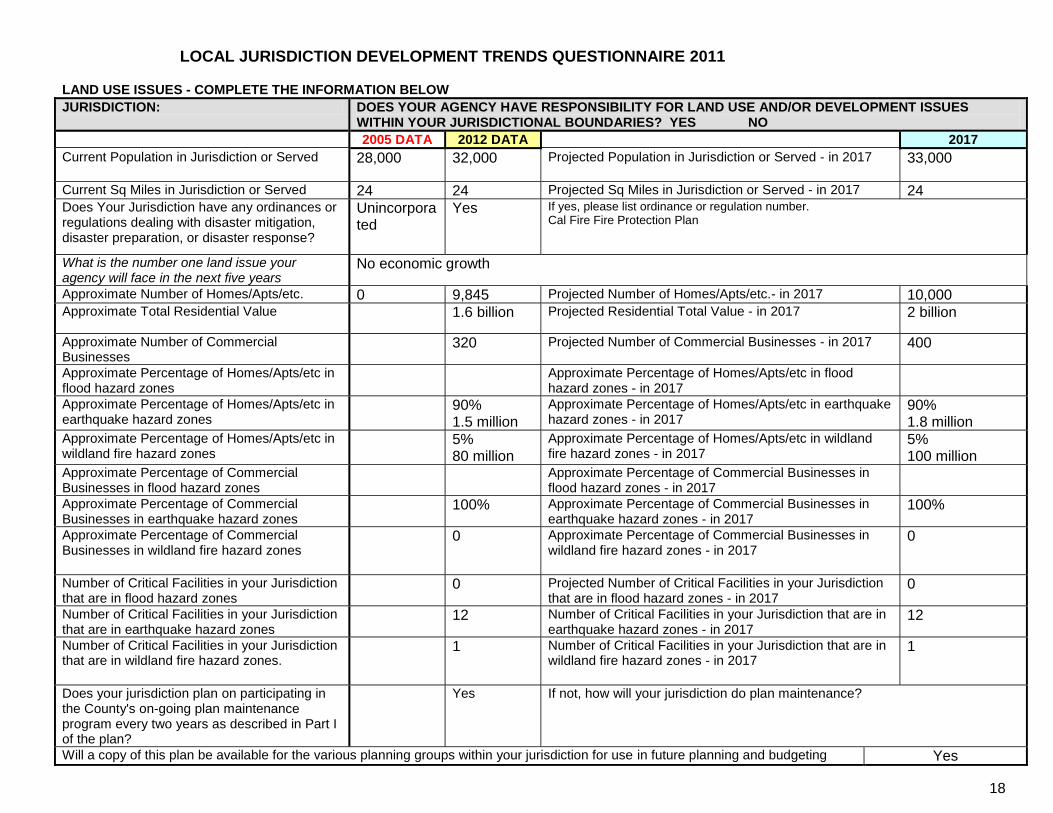
1.7 LAND USE AND DEVELOPMENT TRENDS
JURISDICTION: DOES YOUR AGENCY HAVE RESPONSIBILITY FOR LAND USE AND/OR DEVELOPMENT ISSUES WITHIN YOUR JURISDICTIONAL BOUNDARIES? YES NO
2005 DATA 2012 DATA 2017
Current Population in Jurisdiction or Served 28,000 32,000 Projected Population in Jurisdiction or Served - in 2017 33,000 Current Sq Miles in Jurisdiction or Served 24 24 Projected Sq Miles in Jurisdiction or Served - in 2017 24 Does Your Jurisdiction have any ordinances or regulations dealing with disaster mitigation, disaster preparation, or disaster response?
Unincorporated
Yes If yes, please list ordinance or regulation number. Cal Fire Fire Protection Plan
What is the number one land issue your agency will face in the next five years
No economic growth
Approximate Number of Homes/Apts/etc. 0 9,845 Projected Number of Homes/Apts/etc.- in 2017 10,000 Approximate Total Residential Value 1.6 billion Projected Residential Total Value - in 2017 2 billion
Approximate Number of Commercial Businesses 320 Projected Number of Commercial Businesses - in 2017 400 Approximate Percentage of Homes/Apts/etc in flood hazard zones
Approximate Percentage of Homes/Apts/etc in flood hazard zones - in 2017
Approximate Percentage of Homes/Apts/etc in earthquake hazard zones
90% 1.5 million
Approximate Percentage of Homes/Apts/etc in earthquake hazard zones - in 2017
90% 1.8 million
Approximate Percentage of Homes/Apts/etc in wildland fire hazard zones
5% 80 million
Approximate Percentage of Homes/Apts/etc in wildland fire hazard zones - in 2017
5% 100 million
Approximate Percentage of Commercial Businesses in flood hazard zones
Approximate Percentage of Commercial Businesses in flood hazard zones - in 2017
Approximate Percentage of Commercial Businesses in earthquake hazard zones
100% Approximate Percentage of Commercial Businesses in earthquake hazard zones - in 2017
100%
Approximate Percentage of Commercial Businesses in wildland fire hazard zones
0 Approximate Percentage of Commercial Businesses in wildland fire hazard zones - in 2017
0
Number of Critical Facilities in your Jurisdiction that are in flood hazard zones
0 Projected Number of Critical Facilities in your Jurisdiction that are in flood hazard zones - in 2017
0
Number of Critical Facilities in your Jurisdiction that are in earthquake hazard zones
12 Number of Critical Facilities in your Jurisdiction that are in earthquake hazard zones - in 2017
12
Number of Critical Facilities in your Jurisdiction that are in wildland fire hazard zones.
1 Number of Critical Facilities in your Jurisdiction that are in wildland fire hazard zones - in 2017
1
Does your jurisdiction plan on participating in the County's on-going plan maintenance program every two years as described in Part I of the plan?
Yes If not, how will your jurisdiction do plan maintenance?
Will a copy of this plan be available for the various planning groups within your jurisdiction for use in future planning and budgeting purposes?
Yes
11 CITY OF WILDOMAR –PART I - ANNEX LOCAL HAZARD MITIGATION PLAN SEPTEMBER 2012
SECTION 2.0 - PLANNING PROCESS
2. 1 PARTICIPATION IN REGIONAL (OA) PLANNING PROCESS
The City of Wildomar participated in various Riverside County workshops,
conferences, and meetings, including:
LHMP Orientation meeting
o June 30, 2011 in Temecula CA
Workshop
o August 22, 2011 Ben Clark Training Center
o October 13, 2011 at County OES office
Planning Meetings
o August 25, 2011
o September 1, 2011
2. 2 LOCAL PLANNING PROCESS
Representatives from City of Wildomar departments met on a regular basis to
identify and prioritize appropriate mitigation strategies. Personnel involved in these
meetings included senior management, including City Manager, Frank Oviedo and
Assistant City Manager, Gary Nordquist, Police Chief, Dave Fontnea, Fire Chief,
Steven Beach, Paula Willette, Community Services Director, Planning City Clerk,
Debbie Lee, and Public Works Director, Tim D’Zmura.
At the first meeting, jurisdiction development trends were discussed Subsequent
meetings identified mitigation strategies, prioritized said strategies, and reviewed
preliminary budgets and potential funding sources for strategies designated.
2. 3 DATES AVAILABLE FOR PUBLIC COMMENT
Presentation of the LHMP planning process for your City of Wildomar was held on:
Monthly CERT meeting – October 4, 2011
Public Outreach at Community Events
Community BBQ, July 2, 2011
Movie in the Park, August 6, 2011
Movie in the Park, September 10, 2011

12 CITY OF WILDOMAR –PART I - ANNEX LOCAL HAZARD MITIGATION PLAN SEPTEMBER 2012
2. 4 PLANS ADOPTED BY RESOLUTION
City Council will adopt the plan in a public meeting via an official Resolution upon
approval by FEMA. The mitigation strategies will become an implementation
appendix of the Safety Element of the City of Wildomar General Plan.
SECTION 3.0 – HAZARD UPDATES AND MITIGATION ACTIONS
3.1 HAZARD UPDATES
The City of Wildomar planning team has reviewed the hazards that affect the City and summarized the frequency of occurrence and have determined there are no additional hazards since approval of the LHMP in 2005.
3.2 BRIEF STATEMENT OF UNIQUE HAZARDS
The hazards in the City of Wildomar include the same as much of Riverside County,
including earthquake, flooding and fires.
Past Occurrences of Disasters (natural and human-induced)
The City of Wildomar has experienced a number of different disasters over the last
three (3) years of Incorporation, including floods, wildfires, and severe storms.
The City had proclaimed Local Emergencies in January 2010 and December
2010.
January 2010 damages totaled more than $317,000 from damage due to
flooding, debris flow & silt build up, and unpaved road repairs.
December 2010 damages totaled more than $70,000 damage due to flooding,
debris flow & silt build up, unpaved road repairs, and multiple downed trees.
3.3 MITIGATION PROJECT UPDATE
In partnership with the Lake Elsinore Unified School District, the City of Wildomar is constructing the Sidewalks to Schools Improvements Project near Ronald Reagan Elementary School. The project is funded by the Safe Routes to School and the Bicycle and Pedestrian Facilities Program. New curb, gutter and sidewalks were constructed to allow for safe pedestrian access near Ronald Reagan Elementary School along George Avenue project. Construction substantially completed as of September 2012. Remaining construction activities include addressing the punch list.

13 CITY OF WILDOMAR –PART I - ANNEX LOCAL HAZARD MITIGATION PLAN SEPTEMBER 2012
3.4 MITIGATION ACTIONS
Figure 3.3.1 Capital Improvement Plan – City of Wildomar

14 CITY OF WILDOMAR –PART I - ANNEX LOCAL HAZARD MITIGATION PLAN SEPTEMBER 2012
SECTION 4.0 – HAZARD IDENTIFICATION AND RISK ASSESSMENT
4.1 HAZARD REVIEW AND SUMMARY
Figure 4.1.1 2005 LHMP page numbers for each hazard – City of Wildomar
Wildfire 40
Flooding 54
Earthquakes 68
Extreme Weather 116
Landslides 140
Insect Infestation 149
Dam Failure 153
Hazardous Materials (Hazmat) Incidents 161
Transportation emergencies 168
Pipeline/Aqueduct incidents 176
Blackout 179
Toxic pollution 182
Nuclear incidents 189
Civil unrest 192
Jails and prisons incidents 194
Terrorism 197
4.2 CRITICAL FACILITIES AND INFRASTRUCTURES
Table lists particular critical facilities and other community assets identified by City of
Wildomar’s planning team as important to protect in the event of a disaster.
Figure 4.4.1 Critical Facilities – City of Wildomar
Critical Facilities Type Number
Airports -
Communications Centers -
Detention Centers -
Emergency Command Centers (City Hall)
1
Fire Department 1
Health Care Facilities 1
Law Enforcement Facilities -
Maintenance Yards -
Residential Elderly Facilities 1
Schools and Day Care Facilities
10
Public Utilities—Water/Sewer 1
Totals 15
Source: City of Wildomar

15 CITY OF WILDOMAR –PART I - ANNEX LOCAL HAZARD MITIGATION PLAN SEPTEMBER 2012
4.3 ESTIMATING POTENTIAL LOSS
Please refer to Riverside County Operational Area MJHMP Section 4.5 page 144 for
the property loss value for the City of Wildomar.
(See Page 10 Local Jurisdiction Development Trends Questionnaire)
4.4 TABLE/REPLACEMENT VALUE
The following table shows specific critical facilities and other community assets
identified by the City of Wildomar’s Planning Team.
Figure 4.6.1 Critical Facilities and Other Community Assets -City of Wildomar
Name of Asset Replacement
Value ($) Occupancy/ Capacity #
Hazard Specific Info.
City Hall Leased-Unknown
Fire & Earthquake
Fire Department—Station 61
County Owned
n/a Fire & Earthquake
County Library County Owned - Unknown
Fire & Earthquake
LEUSD (six schools) 4 Elementary 1 Middle School 1 High School
District Owned
4,015
Secured Campuses
Sycamore Academy Private 300 Secured Campus
Baxter Charter School Private 100 Non-secured Campus
Hilltop Day Care Center Private 70 Secured Campus
Ann Sullivan Preschool Private Secured Campus
Bundy Canyon Christian School
Private Secured Campus
Note: The replacement values are unknown at this time due to these facilities not being owned by the City of Wildomar and to prevent misrepresentation of the amounts we have left these off intentionally.

16 CITY OF WILDOMAR –PART I - ANNEX LOCAL HAZARD MITIGATION PLAN SEPTEMBER 2012
4.5 IDENTIFICATION OF RISKS AND VULNERABILITIES
Impacts of past events and vulnerability to specific hazards are further discussed; see Part 4 County and the Submitting City of Wildomar’s Hazards for more detailed information about these hazards and their impacts on Riverside County, pages below.
Wildfire 40
Flooding 54
Earthquakes 68
Extreme Weather 116
Landslides 140
Insect Infestation 149
Dam Failure 153
Hazardous Materials (Hazmat) Incidents 161
Transportation emergencies 168
Pipeline/Aqueduct incidents 176
Blackout 179
Toxic pollution 182
Nuclear incidents 189
Civil unrest 192
Jails and prisons incidents 194
Terrorism 197

17 CITY OF WILDOMAR –PART I - ANNEX LOCAL HAZARD MITIGATION PLAN SEPTEMBER 2012
Other risks -
1. Drought - Severity -3, Probability - 1, Ranking – 6
(See Riverside County OA MJHMP Section 5.3.5 Pages 227-230).
2. Earthquake – Severity - 4, Probability – 3, Ranking –3
Wildomar’s most significantly known active faults in the vicinity of the City include:
Elsinore Fault Zone: The fault zone, which includes the Wildomar and Wolf Valley
faults pass through the City on the west side of Interstate 15. The fault zone is
capable of generating an earthquake in excess of Richter Magnitude 6.8.
Wildomar Fault: The fault runs northwest/southeast and is located in the City
approximately 2,000-4,000 feet west of Interstate 15. The areas adjacent to the fault
are within a “Special Studies Zone” as designated under the Alquist-Priolo Special
Study Zone Act of 1972.
San Andreas Fault Zone: This fault zone, located approximately 50 miles northeast
of the study area, is the dominant active fault in California. The maximum credible
earthquake from this fault zone is a magnitude 8.25
San Jacinto Fault Zone: This fault zone is located approximately 30 miles northeast
of the City and has a maximum credible earthquake magnitude of 7.5.
In addition to these active faults, two potentially active faults, the Agua Caliente Fault
zone and the Murrieta Hot Springs Fault, which are also located near the City.
City of Wildomar is located in Seismic Hazard Zone. The nearest active earthquake
faults are Wildomar and Elsinore. Wildomar has experienced several noticeable
ground movement incidents over the past years, but no local damage was
sustained.
The planning team has not identified any unreinforced masonry buildings in the City.
(See Riverside County OA MJHMP Section 5.3.3 Pages 196-218).
3. Wildland Fires – Severity -4 , Probability - 3, Ranking –2
Undeveloped hillside areas in and adjacent to the City can present a serious hazard
due to the potential for large-scale wildland fires. The threat is particularly significant
during dry summer months and when there are strong “Santa Ana” winds. Wildland
fire protection is the primary responsibility of Riverside County Fire with assistance
provided by the California Department of Forestry under an agreement for fire

18 CITY OF WILDOMAR –PART I - ANNEX LOCAL HAZARD MITIGATION PLAN SEPTEMBER 2012
protection of wildlands. 5% of the homes within the City boundary are in a high fire
area. The high fire area is located throughout the Bundy Canyon corridor and
includes Lost Road and Cottonwood Canyon. Other areas include the mountain
area between Bundy Canyon and Baxter as well as Grand Ave along the base of the
Ortega Mountains. (See Riverside County OA MJHMP Section 5.3.2 Pages 154-
163).
Flood - Severity -1 , Probability -4, Ranking –1
Heavy rain can lead to problems with storm drainage and create localized flood
problems. The City of Wildomar is in the process of writing a Storm Drain Master
Plan and relies on the County of Riverside’s existing Master Plan. There are several
flooding problem areas in the City. These areas are primarily a result of no drainage
infrastructure, undersized pipes where the runoff exceeds the pipe capacity even for
minor storms, obstructions, or damaged drain pipes.
The majority of the damaged lines are on the west side of the City, where there are
limited storm drain pipes and they are some of the oldest in the system.
The City has over 53 miles of dirt roads and the rain and erosion have left many
roads impassable each winter even for four-wheel drive vehicles. Lost Road and
Cottonwood Canyon are the most impacted roads. Once the roads have dried out,
gullies, ruts, rock-slides and wash-outs can render roads impassable, especially for
low clearance vehicles until road maintenance can be scheduled. (See Riverside
County OA MJHMP Section 5.3.1 Pages 164-195).
4. Severe Weather – Extreme Heat/Cold- Severity -2 , Probability - 2, Ranking – 5
The City utilizes the County of Riverside Health Department heat and cold advisories
and centers. The City has one (1) center and is opened when a Public Health
“Heat/Cold Warning” is issued.
Severe Weather: Centers are open when the Department of Public Health issues a
Heat/Cold warning when temperatures are expected to reach 105 for at least 3
consecutive days and when the temperatures drop to 40 degrees or less for more
than 3 consecutive days. . (See Riverside County OA MJHMP Section 5.3.4 Pages
219-226 and Section 5.3.8 Pages 239-245).
5. Agricultural Hazards – Severity-2, Probability - 2, Ranking – 11
The City has limited agricultural production. The City of Wildomar’s agriculturally
based economy is vulnerable to heat waves, flooding, and insect infestations. A
19 CITY OF WILDOMAR –PART I - ANNEX LOCAL HAZARD MITIGATION PLAN SEPTEMBER 2012
heat wave in the summer can affect the dairy industry with less milk production.
(See Riverside County OA MJHMP Section 5.5 Pages 295-306).
6. Dam Failure – Severity - , Probability - , Ranking – N/A
The northern edge of the City is 4 miles from the Canyon Lake Dam. The likelihood
of water inundating the City is very unlikely. (See Riverside County OA MJHMP
Section 5.4.1 Pages 261-270).
7. Technological Hazards -Hazardous Materials- Severity -2 , Probability – 2, Ranking – 9
As with most cities, Wildomar has a number of businesses that use hazardous materials or generate hazardous waste. There are also a number of sites in the City which have contamination associated with underground tanks used to store petroleum products. Monitoring of these sites is the primary responsibility of the California Department of Health Services and the Regional Water Quality Control Board. Hazardous materials incidents in the City are responded to by Riverside Fire County-Hazmat with specialized assistance from the Riverside County Health Services Agency.
Along with the potential for death and injuries from large-scale motor vehicle accidents, there is the potential for hazardous material spills or fires as numerous commercial transportation vehicles travel the 15 freeway with various types and quantities of hazardous materials.
The Elsinore airport is located adjacent to the City on the northwest border. The airport is primarily used for single engine fixed-wing general aviation aircraft. (See Riverside County OA MJHMP Section 5.4.1 Pages 261-270).
(See Part II – Table Page 8)

20 CITY OF WILDOMAR –PART I - ANNEX LOCAL HAZARD MITIGATION PLAN SEPTEMBER 2012
SECTION 5.0 – COMMUNITY RATING SYSTEM
5.1 REPETITIVE LOSS PROPERTIES
There are no known repetitive loss properties in the City due to floods.
5.2 NATIONAL FLOOD INSURANCE PROPERTIES
The City does participate in the National Flood Insurance Program (NFIP). The City
joined the program on November 10, 2010 with Resolution 2010-53.
a. Describe participation in NFIP, including any changes since previously
approved plan. There have been no changes in the NFIP since the City joined
in November 2010.
b. Date first joined NFIP. November 10, 2010
c. Identify actions related to continued compliance with NFIP.
The City of Wildomar is currently in compliance with the NFIP and conducts
outreach to educate residents on the potential flood hazards and actively promotes
the flood insurance program for residents whose properties are in or near the flood
hazard zone.
d. CRS member? No
e. CRS class? N/A
f. Describe any data used to regulate flood hazard area other than FEMA
maps.
g. Have there been issues with community participation in the program? No
h. What are the general hurdles for effective implementation of the NFIP?
None
i. Summarize actions related to continued compliance with NFIP (c-2 and c-4)
i. Repetitive Loss Properties –
There have been no historical claims for flood losses and thus there were no
repetitive or severe repetitive loss structures.

21 CITY OF WILDOMAR –PART I - ANNEX LOCAL HAZARD MITIGATION PLAN SEPTEMBER 2012
SECTION 6.0 – CAPABILITIES ASSESSMENT
6.1 REGULATORY MITIGATION CAPABILITIES
Figure 6.1.1 Regulatory Mitigation Capabilities – City of Wildomar
Regulatory Tool Yes/No Comments
General plan Yes Comprehensive General Plan is part of the County of Riverside
Zoning ordinance Yes Adopted all County Ordinances on July 1, 2008
Subdivision ordinance Yes Adopted all County Ordinances on July 1, 2008
Site plan review requirements Yes Adopted all County Ordinances on July 1, 2008
Growth management ordinance
Yes Adopted all County Ordinances on July 1, 2008
Floodplain ordinance Yes Adopted all County Ordinances on July 1, 2008
Other special purpose ordinance (stormwater, water conservation, wildfire)
Yes Adopted all County Ordinances on July 1, 2008
Building code Yes Adopted new California Codes in December, 2010
Fire department ISO rating Yes Rating: 4
Erosion or sediment control program
Adopted all County Ordinances on July 1, 2008
Stormwater management program
Yes City of Wildomar Storm Drain Master Plan, 2005
Capital improvements plan No
Economic development plan In Progress
Economic Development Committee is actively working on a plan
Local emergency operations plan
Yes Emergency Operations Plan adopted in 2009
Flood Insurance Study or other engineering study for streams
No
The City of Wildomar adopted the Riverside County General Plan at the time of
Incorporation July 1, 2008. Due to the current economic times there have not been
any updates to the plan.
Goal 1: Public Safety Hazards
Goals for public safety seek to reduce loss of life or property due to crime, fire,
earthquake, or other disasters or hazards, provide adequate medical and emergency

22 CITY OF WILDOMAR –PART I - ANNEX LOCAL HAZARD MITIGATION PLAN SEPTEMBER 2012
services to reduce the effects of natural or manmade disasters, promote citizen
awareness and preparedness for emergency/disaster situations or potential for the
incidence of crime, and implement adequate interagency disaster planning.
The City will continue to maintain and update emergency service plans, including
plans for managing emergency operations, the handling of hazardous materials, and
the rapid cleanup of hazardous materials spills. The City currently contracts with the
County of Riverside and Cal Fire and participates with all entities under their mutual
aid agreements.
The general plan’s Hazard Management Element incorporates the Safety Element of
the County General Plan by reference “to the extent that these original elements
apply to the City of Wildomar Planning area.”
6.2 ADMINISTRATIVE/TECHNICAL MITIGATION CAPABILITIES
Table identifies the personnel responsible for activities related to mitigation and loss prevention in City of Wildomar.
Figure 6.2.1 Administrative and Technical Mitigation Capabilities – City of Wildomar
Personnel Resources Yes/No Department/Position
Planner/engineer with knowledge of land development/land management practices
Yes City Engineer, Planning Director
Engineer/professional trained in construction practices related to buildings and/or infrastructure
Yes City Engineer and Building Official
Planner/engineer/scientist with an understanding of natural hazards
Yes City Engineer, Building Official
Personnel skilled in GIS Yes Planning Department
Full time building official Yes Building Official
Floodplain manager No
Emergency manager Yes Community Services Director
Grant writer Yes Community Services Department & Contract with outside consultant
Other personnel No
GIS Data—Land use Yes Planning Department
GIS Data—Links to Assessor’s data
Warning systems/services (Reverse 9-11, outdoor warning signals)
Yes Police Chief
Other

23 CITY OF WILDOMAR –PART I - ANNEX LOCAL HAZARD MITIGATION PLAN SEPTEMBER 2012
6.3 FISCAL MITIGATION CAPABILITIES
Table identifies financial tools or resources that the City could potentially use to help
fund mitigation activities.
Figure 6.3.1 Fiscal Mitigation Capabilities – City of Wildomar
Financial Resources Accessible/Eligible
to Use (Yes/No) Comments
Community Development Block Grants No The City will be eligible for
CDBG in 2013
Capital improvements project funding No
Authority to levy taxes for specific purposes
Yes With voter approval
Fees for water, sewer, gas, or electric services
No
Impact fees for new development Yes
Incur debt through general obligation bonds
Yes With voter approval
Incur debt through special tax bonds Yes With voter approval
Incur debt through private activities No
Withhold spending in hazard prone areas
n/a
Other n/a
6.4 MITIGATION OUTREACH AND PARTNERSHIPS
The City of Wildomar has an existing water responsible program and annual fire
safety programs in schools and throughout the year at special community events. A
CERT program is currently in place. The Community Emergency Response Team
(CERT) program helps train individuals to be better prepared to respond to
emergency situations in their neighborhood. When emergencies happen, Wildomar
CERT trained members can give critical support to local public safety agencies,
provide immediate assistance to victims and organize volunteers at a disaster site.
6.5 OTHER MITIGATION EFFORTS
The City has implemented mitigation efforts in the past. Examples that were not
covered elsewhere in this section include the following:
The City has designated cooling/heating centers sites if needed during an inclement
weather emergency. The cooling center is located at 32700 Mission Trail, Wildomar,
92530.

24 CITY OF WILDOMAR –PART I - ANNEX LOCAL HAZARD MITIGATION PLAN SEPTEMBER 2012
SECTION 7.0 - GROWTH AND DEVELOPMENT TRENDS
7.1 GOALS AND OBJECTIVES
The City of Wildomar’s mitigation goals and objectives are the following:
Goal 1: Provide Protection for People’s Lives from All Hazards
Objective 1.1: Provide timely notification and direction to the public of imminent and
potential hazards.
Objective 1.2: Protect public health and safety by preparing for, responding to, and
recovering from the effects of natural or technological disasters.
Objective 1.3: Improve community transportation corridors to allow for better
evacuation routes for public and better access for emergency responders.
Goal 2: Improve Community and Agency Awareness about Hazards and Associated Vulnerabilities that Threaten our Communities
Objective: 2.1: Increase public awareness about the nature and extent of hazards they are exposed to, where they occur, what is vulnerable, and recommended responses to identified hazards (i.e. both preparedness and response).
2.1.1: Create/continue an outreach program, provide educational resources, and develop and provide training.
Goal 3: Improve the Community’s Capability to Mitigate Hazards and Reduce Exposure to Hazard Related Losses
Objective 3.1: Reduce damage to property from an earthquake event.
3.1.1: Adopt/maintain building codes to meet required earthquake standards.
Objective 3.2: Reduce flood and storm related losses.
3.2.1: Provide for better collection of data related to severe weather events. 3.2.2: Reduce localized flooding within the City’s storm drain systems. 3.2.2.1: Implement better drainage to accommodate heavy rains that cause flooding.
Objective 3.3: Minimize the impact to the City due to reoccurring drought conditions
that impact both ground water supply and agricultural industry.
3.3.1: Provide conservation information from Elsinore Valley Municipal Water District
to the residents to promote better water management.

25 CITY OF WILDOMAR –PART I - ANNEX LOCAL HAZARD MITIGATION PLAN SEPTEMBER 2012
Objective 3.4: Minimize the impact to vulnerable populations within the community
that may be affected by severe weather-related events, such as long duration heat
waves and winter storms.
3.4.1: Promote community response plans, such as cooling centers, during heat waves. 3.4.2: Promote community response plans during winter storms to assist the vulnerable population.
Goal 4: Provide Protection for Critical Facilities, Utilities, and Services from Hazard
Impacts.
Goal 5: Maintain Coordination of Disaster Planning.
Objective 5.1: Coordinate with changing DHS/FEMA needs.
5.1.1: National Incident Management System (NIMS) 5.1.2: Disaster Mitigation Act (DMA) planning 5.1.3: Emergency Operations plans
Objective 5.2: Coordinate with community plans. 5.2.1: General plans 5.2.2: Drought plans 5.2.3: Drainage plans 5.2.4: Intergovernmental agency disaster planning.
Objective 5.3: Maximize the use of shared resources between City of Wildomar and
special districts for mitigation/communication.
5.3.1: Develop Mutual/Automatic Aid agreements with adjacent Cities and agencies.
Objective 5.4: Standardize systems among agencies to provide for better
interoperability.
5.4.1: Standardize communication technology and language.
Goal 6: Maintain/Provide for FEMA Eligibility and Work to Position City Departments
and Community Partners for Grant Funding.

26 CITY OF WILDOMAR –PART I - ANNEX LOCAL HAZARD MITIGATION PLAN SEPTEMBER 2012
7.2 MITIGATION STRATEGIES
Our City/Special District coordinated with multiple cities and agencies throughout
Riverside County in the creation/update of our LHMP Annex. The cooperation and
discussions both in regional meetings, community outreach and internal meetings
allowed for both “big picture” and “local jurisdiction” views of mitigation needs and
possibilities.
The Part Two, Agency Inventory Worksheet process enabled our City/Special district
to recognize hazards and their severity and also assisted in determining what
mitigation actions are appropriate to lessen or prevent the hazard on a long term
basis.
7.3 ON-GOING MITIGATION STRATEGY PROGRAMS
The planning team for the City of Wildomar acknowledges there are areas that need
mitigation actions based on the risk assessment. Unfortunately with the current
economic conditions of the City any specified project discussed will have to wait until
there is major improvement in the economy or grant funds become available.
The City of Wildomar has many on-going mitigation programs that help create a
more disaster-resistant region. The following list highlights those programs identified
as Existing Programs in the mitigation strategy spreadsheet. Others are on-going
programs that are currently underfunded. It is the City of Wildomar’s priority to find
additional funding to sustain these on-going programs over time.
• Vulnerability assessments of City facilities and infrastructure
• Creating a Citizens Corp
• Vegetation removal of flood channels
(See Part 2 Page 15, “Local Jurisdiction Proposed Mitigation Action”)
7.4 FUTURE MITIGATION STRATEGIES
The City of Wildomar planning team will prioritize specific mitigation tasks for the
next 5 years. This list will include an implementation process, funding strategy,
responsible agency, and approximate time frame.
Fire:
Require on-going brush clearance and establish low fuel landscaping policies to
reduce combustible vegetation along the urban/wildland interface boundary.

27 CITY OF WILDOMAR –PART I - ANNEX LOCAL HAZARD MITIGATION PLAN SEPTEMBER 2012
Create fuel modification zones around development within high hazard areas by
thinning or clearing combustible vegetation within 100 feet of buildings and
structures. The fuel modification zone size may be altered with the addition of fuel
resistant building techniques. The fuel modification zone may be replanted with fire-
resistant material for aesthetics and erosion control.
Encourage programs that educate citizens about the threat of human wildfire
origination from residential practices such as outdoor barbeques and from highway
use such as cigarette littering.
Provide public safety education programs through the Community Services
Department to reduce accidents, injuries, and fires as well as to train members of
the public to respond to emergencies.
Implementation Program: The City shall condition project to comply with Riverside
County Fire Department requirements, and work with the California Department of
Forestry as well. Continue to grow the local CERT Program.
Flood:
Continue to ensure that new construction in floodways and floodplains conforms to
all applicable provisions of the National Flood Insurance Program in order to protect
buildings and property from flooding.
Utilize the Capital Improvement Program for storm drainage projects and
maintenance and improvement of local storm drain systems including channels,
pipes, and inlets to ensure the capacity for maximum runoff flows.
Implementation Program through the project review and the CEQA processes the
City shall assess new development and reuse applications for potential flood
hazards, and shall require compliance with FEMA Special Flood Hazard Areas
where appropriate.
Seismic:
The City recognizes the importance of addressing secondary seismic hazards, and
has delineated areas of known and suspected liquefaction hazard. In general,
liquefaction susceptibility ranges from very low in the former lake footprint to
moderate on much of the remainder of the valley floor and very high in the valley
floor corridor formerly occupied by the axial riverine drainage.

28 CITY OF WILDOMAR –PART I - ANNEX LOCAL HAZARD MITIGATION PLAN SEPTEMBER 2012
SECTION 8.0 - INCORPORATION INTO EXISTING PLANNING MECHANISMS
The City of Wildomar has incorporated the Hazard Mitigation Plan into the following
Ordinances and Codes:
Title 8 – Health and Safety Codes
Chapter 8.28 – Fire Code
Chapter 8.48 – Hazardous Vegetation
Chapter 8.52 Hazardous Waste Control
ChChapter 8.112 Underground Tank Systems containing Hazardous Substances
Title 15 – Building and Construction
Chapter 15.12 – Building Code
Chapter 15.36 Housing Code
Chapter 15.56 Relocation of Buildings and Structures
Chapter 14.76 Earthquake Fault Area Construction Regulations
Chapter 15.96 Flood Hazard Area Regulations
Chapter 15.100 Post-Disaster Safety Assessment
Chapter 15.104 Abandoned and Distressed Residential Properties Regulations
Title 17 – Zoning Codes
City Land Use Code 17.04
See Table Page 13 “Regulatory Mitigation Table”

29 CITY OF WILDOMAR –PART I - ANNEX LOCAL HAZARD MITIGATION PLAN SEPTEMBER 2012
SECTION 9.0 - PLAN MAINTENANCE PROCESS
The City of Wildomar will be monitored by a committee, including the Assistant City
Manager, Office of Emergency Manager, and Public Works Director. A review will take
place at the end of each Fiscal year where the committee will then review any changes
necessary.
All updates will be presented in the form of a council report to the city of Murrieta for
approval.
Our city/agency will monitor and evaluate our LHMP on an annual basis. Over the next
5 years, we will review the LHMP. We will assess, among other things, whether:
The goals and objectives address current and expected conditions.
The nature, magnitude, and/or type of risks have changed.
The current resources are appropriate for implementing the plan.
There are implementation problems, such as technical, political, legal, or
coordination issues with other agencies.
The outcomes have occurred as expected (a demonstration of progress).
The agencies and other partners participated as originally proposed.
SECTION 10.0 – CONTINUED PUBLIC INVOLVEMENT
After we go through the Scheduled Plan Maintenance Process, we will notify the public
of any changes/no change in the LHMP at the monthly Community Emergency
Preparedness meeting following the review. Monthly meetings are posted on the City
website and by email to those interested in emergency preparedness.
In addition, the City will announce the annual review of the plan via announcements at
City Council Meetings, Service Group Training, planning meetings and at quarterly
Operational Area Planning Committee Meetings.
30 CITY OF WILDOMAR –PART I - ANNEX LOCAL HAZARD MITIGATION PLAN SEPTEMBER 2012
EXHIBITS A & B
SEE ATTACHMENTS
Exhibit A-1 – City of Wildomar Jurisdiction Map
Exhibit B-1 – FEMA Flood Zone Map


31 CITY OF WILDOMAR –PART I - ANNEX LOCAL HAZARD MITIGATION PLAN SEPTEMBER 2012
HAZARD MITIGATION AGENCY INVENTORY WORKSHEETS
SEE ATTACHMENTS – PART II

RIVERSIDE COUNTY MULTI-JURISDICTIONAL
LOCAL HAZARD MITIGATION AGENCY
INVENTORY WORKSHEETS
City of Wildomar January 2012

2
TABLE OF CONTENTS Introduction: These documents are meant to be discussed, used and reviewed by a multi-disciplinary team. The Participation by a wide range of stakeholders who play a role in identifying and implementing mitigation actions is required. SPECIAL CONCERNS:
1. Has the completed Letter of Commitment been returned to OES? OES must forward this completed Letter of Commitment to Cal EMA.
1. Local Jurisdiction Contact Information page 3
2. Hazard Identification Questionnaire page 4-6
3. Specific Hazards Summary page 7
4. Jurisdiction Vulnerability Worksheet page 8-9
5. Jurisdiction Mitigation Strategies and Goals page 10-14
6. Local Jurisdiction Proposed Mitigation Action
and Strategy Proposal page 14-16
7. Local Jurisdiction Development Trends page 17-18
8. Updated Crosswalk from Cal EMA page 19
Following page 19 is the attached crosswalk for your reference. This is the document Cal EMA and FEMA will be using to verify that all of the required information is in the submitted document. Please refer to the document for information. OES will be placing the page numbers in the crosswalk.

3
1. LOCAL JURISDICTION CONTACT INFORMATION
The information on this page identifies:
Jurisdiction and the contact person
Jurisdiction's service area size and population
EOP Plan and a Safety Element of their General Plan
PLEASE PROVIDE THE FOLLOWING INFORMATION:
Agency/Jurisdiction: City of Wildomar
Type Agency/Jurisdiction: Local
Contact Person: Title: Community Services Director
First Name: Paula Last Name: Willette
Agency Address: Street: 23873 Clinton Keith Rd Ste. 201
City: Wildomar
State: CA
Zip: 92595
Contact Phone 951.677.7751 ext. 206
FAX 951.698.1463
E-mail [email protected]
Population Served 32,000 Square Miles Served 24
Does your organization have a general plan? Yes
Does your organization have a safety component to the general plan? Yes
What year was your plan last updated? 10-2003
Does your organization have a disaster/emergency operations plan? Yes
What year was your plan last updated? 2009
Do you have a recovery annex or section in your plan? No
Do you have a terrorism/WMD annex or section in your plan? No

4
2. Hazard Identification Questionnaire
The purpose of the questionnaire is to help identify the hazards within your
service area. The list was developed from the first round of meetings with the
various working groups in the 2005 plan creation, and from the hazards listed in
the County's General Plan. Each hazard is discussed in detail in Part I of the
2005 LHMP. The information will be used as the basis for each jurisdiction to
evaluate its capabilities, determine its needs, and to assist in developing goals
and strategies. The information identifies:
a) What hazards can be identified within or adjacent to the service area of the
jurisdiction.
i. Flooding
ii. Fire
iii. Earthquake
iv. Windstorm
v.
b) Which of those hazards have had reoccurring events
i. Flooding
ii. Fire
iii. Earthquake
iv. Windstorm
c) What specific hazards and risks are considered by the jurisdiction to be
a threat specifically to the jurisdiction? ( These locations should be
identified by name and location for inclusion in the Specific Hazard
Summary Table).
i. Flooding along the following streets:
1. Palomar and Frederick
2. Palomar dips between Gruwell and Wesley
3. McVicar between Palomar and Grand Ave.
4. Central between Cervera and Grand Ave.
5. Mission Trail from Bundy Cyn Rd and Malaga

5
6. Corydon Rd between Mission Trail and Grand
7. Lemon Street from the 15 freeway to Mission Trial
8. Corydon between Mission Trail and Grand Ave
9. Bundy Canyon Rd from the City line to the 15 frwy
ii. High fire areas:
1. Grand Ave Mountains
2. Bundy Cyn Corridor
3. Lost road area
4. Grape street hills
b. Specific types of facilities owned and operated by the jurisdiction.
i. Marna O’Brien Park
1. Restrooms
2. 4 shelter areas
3. Snack bar – no amenities
4. Limited parking area
ii. Heritage Park
1. 3 shelter areas
iii. Windsong Park
1. 3 shelter areas
c. Locations damaged from prior disasters or hazard causing events.
d) Information about the jurisdiction's EOC
(Relates to Number 5 in the 2012 Annex : Jurisdiction Template) With your Multi-Disciplinary Planning Team:
a. Instructions for Updating Jurisdictions, with your planning team: Review your old Questionnaire for accuracy and relevance, mark changes.
b. Instructions for New Jurisdictions and Special Districts, with your planning
team, meet and go over the questionnaire. Fill in YES, NO or NA on the Questionnaire.

6
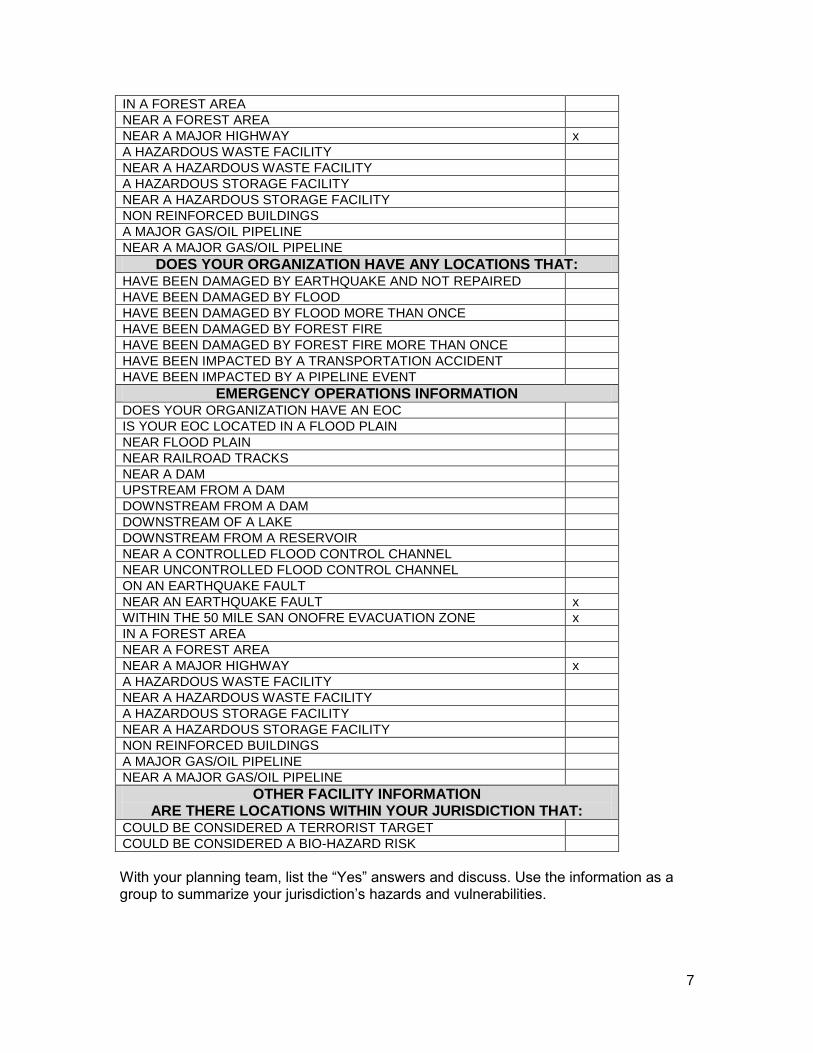
HAZARD IDENTIFICATION QUESTIONNAIRE
DOES YOUR ORGANIZATION HAVE: AIRPORT IN JURISDICTION
AIRPORT NEXT TO JURISDICTION
DAIRY INDUSTRY x
POULTRY INDUSTRY
CROPS/ORCHARDS x
DAMS IN JURISDICTION
DAMS NEXT TO JURISDICTION x
LAKE/RESERVOIR IN JURISDICTION
LAKE/RESERVOIR NEAR JURISDICTION x
JURISDICTION IN FLOOD PLAIN x
CONTROLLED FLOOD CONTROL CHANNEL x
UNCONTROLLED FLOOD CONTROL CHANNEL
EARTHQUAKE FAULTS IN JURISDICTION x
EARTHQUAKE FAULTS NEXT TO JURISDICTION x
MOBILE HOME PARKS x
NON-REINFORCED FREEWAY BRIDGES
NON-REINFORCED BRIDGES
BRIDGES IN FLOOD PLAIN
BRIDGES OVER OR ACROSS RIVER/STREAM x
ROADWAY CROSSING RIVER/STREAM
NON REINFORCED BUILDINGS
FREEWAY/MAJOR HIGHWAY IN JURISDICTION x
FREEWAY/MAJOR HIGHWAY NEXT TO JURISDICTION
FOREST AREA IN JURISDICTION
FOREST AREA NEXT TO JURISDICTION x
WITHIN THE 50 MILES SAN ONOFRE EVACUATION ZONE x
MAJOR GAS/OIL PIPELINES IN JURISDICTION
MAJOR GAS/OIL PIPELINES NEXT TO JURISDICTION
RAILROAD TRACKS IN JURISDICTION
RAILROAD TRACKS NEXT TO JURISDICTION
HAZARDOUS WASTE FACILITIES IN JURISDICTION
HAZARDOUS WASTE FACILITIES NEXT TO JURISDICTION
HAZARDOUS STORAGE FACILITIES IN JURISDICTION
HAZARDOUS STORAGE FACILITIES NEXT TO JURISDICTION
DOES YOUR ORGANIZATION OWN OR OPERATE A FACILITY IN A FLOOD PLAIN x
NEAR FLOOD PLAIN
NEAR RAILROAD TRACKS
NEAR A DAM
UPSTREAM FROM A DAM
DOWNSTREAM FROM A DAM
DOWNSTREAM OF A LAKE
DOWNSTREAM FROM A RESERVOIR
NEAR A CONTROLLED FLOOD CONTROL CHANNEL x
NEAR UNCONTROLLED FLOOD CONTROL CHANNEL
ON AN EARTHQUAKE FAULT
NEAR AN EARTHQUAKE FAULT x
WITHIN THE 50 MILE SAN ONOFRE EVACUATION ZONE x
7
IN A FOREST AREA
NEAR A FOREST AREA
NEAR A MAJOR HIGHWAY x
A HAZARDOUS WASTE FACILITY
NEAR A HAZARDOUS WASTE FACILITY
A HAZARDOUS STORAGE FACILITY
NEAR A HAZARDOUS STORAGE FACILITY
NON REINFORCED BUILDINGS
A MAJOR GAS/OIL PIPELINE
NEAR A MAJOR GAS/OIL PIPELINE
DOES YOUR ORGANIZATION HAVE ANY LOCATIONS THAT: HAVE BEEN DAMAGED BY EARTHQUAKE AND NOT REPAIRED
HAVE BEEN DAMAGED BY FLOOD
HAVE BEEN DAMAGED BY FLOOD MORE THAN ONCE
HAVE BEEN DAMAGED BY FOREST FIRE
HAVE BEEN DAMAGED BY FOREST FIRE MORE THAN ONCE
HAVE BEEN IMPACTED BY A TRANSPORTATION ACCIDENT
HAVE BEEN IMPACTED BY A PIPELINE EVENT
EMERGENCY OPERATIONS INFORMATION
DOES YOUR ORGANIZATION HAVE AN EOC
IS YOUR EOC LOCATED IN A FLOOD PLAIN
NEAR FLOOD PLAIN
NEAR RAILROAD TRACKS
NEAR A DAM
UPSTREAM FROM A DAM
DOWNSTREAM FROM A DAM
DOWNSTREAM OF A LAKE
DOWNSTREAM FROM A RESERVOIR
NEAR A CONTROLLED FLOOD CONTROL CHANNEL
NEAR UNCONTROLLED FLOOD CONTROL CHANNEL
ON AN EARTHQUAKE FAULT
NEAR AN EARTHQUAKE FAULT x
WITHIN THE 50 MILE SAN ONOFRE EVACUATION ZONE x
IN A FOREST AREA
NEAR A FOREST AREA
NEAR A MAJOR HIGHWAY x
A HAZARDOUS WASTE FACILITY
NEAR A HAZARDOUS WASTE FACILITY
A HAZARDOUS STORAGE FACILITY
NEAR A HAZARDOUS STORAGE FACILITY
NON REINFORCED BUILDINGS
A MAJOR GAS/OIL PIPELINE
NEAR A MAJOR GAS/OIL PIPELINE
OTHER FACILITY INFORMATION ARE THERE LOCATIONS WITHIN YOUR JURISDICTION THAT:
COULD BE CONSIDERED A TERRORIST TARGET
COULD BE CONSIDERED A BIO-HAZARD RISK
With your planning team, list the “Yes” answers and discuss. Use the information as a group to summarize your jurisdiction’s hazards and vulnerabilities.

7
3. SPECIFIC HAZARDS SUMMARY This table helps to identify the information (name, owner, location, etc.) about the specific hazards identified in the Hazard Questionnaire. (Related to #6 in the 2012 Annex : Jurisdiction Template). In the Summary Table, list the basic information of the hazards identified by the jurisdiction in the Hazard Identification Questionnaire as a potential threat. These specific hazards were used in the development of response plans, maps, and other analysis data.
a. Instructions for Updating Jurisdictions and Special Districts: With your planning team,
review the “Yes” answers and see if there were any changes, if so summarize why there is a difference from the 2005.
b. Instructions for New Jurisdictions and Special Districts: With your planning team, review the “Yes” answers and discuss. Use the information as a group to summarize your jurisdiction’s hazards and vulnerabilities. (relates to #6 in the 2012 Annex : Jurisdiction Template)
SPECIFIC HAZARDS SUMMARY
Jurisdiction Hazard Type Hazard Name In Jurisdiction?
Adjacent to Jurisdiction?

8
4. JURISDICTION VULNERABILITY WORKSHEET (Related to #5 in the 2012 Annex : Jurisdiction Template)
This table is a listing of the primary hazards identified by the 2005 LHMP working groups. Each jurisdiction was asked to evaluate the potential for an event to occur in their jurisdiction by hazard. They were also asked to evaluate the potential impact of that event by hazard on their jurisdiction. The impact potential was determined based on:
1. Economic loss and recovery 2. Physical loss to structures (residential, commercial, and critical facilities) 3. The loss or damage to the jurisdictions infrastructure 4. Their ability to continue with normal daily governmental activities 5. Their ability to quickly recover from the event and return to normal daily activities 6. The loss of life and potential injuries from the event.
The jurisdictions were asked to rate the potential and severity using a scale of between 0 and 4 (4 being the most severe). The jurisdictions were also asked to rank the listed hazards as they relate to their jurisdiction from 1 to 19 (1 being the highest overall threat to their jurisdiction).
With the assistance of the RCIP Plan and County Departments, Riverside County OES conducted an extensive evaluation of the severity and probability potential for the county as a whole. The hazards were also ranked for the County. Those numbers and rankings were provided to the jurisdictions as a comparison guide.
A separate table was created to address the hazards relating to agriculture and was assessed by the agriculture working group. This table can be found in the Agriculture Appendix of Part I of the 2005 Plan.
a. Instructions for Updating Jurisdictions and Special Districts: Please review the table, determine if your ranking from the 2005 LHMP remains the same, and note that Pandemic has been added to the list. Please discuss and document new or unchanged severity and rankings.
b. Instructions for New Jurisdictions and Special Districts: Please evaluate the potential for an event to occur in your jurisdiction by
hazard. Then, evaluate the potential impact of that event by hazard on your jurisdiction according to #1-6 from the potential impact list above.
NOTE: Under Medical, Pandemic was added. This was a result of the H1N1 and other incidents.

9
NAME: City of Wildomar AGENCY: DATE : 10-14-11
COUNTY LOCAL JURISDICTION
HAZARD SEVERITY
0 - 4 PROBABILITY
0 - 4 SEVERITY
0 - 4 PROBABILITY
0 - 4 RANKING
1 - 19
EARTHQUAKE 4 3 4 3 3
WILDLAND FIRE 3 4 4 3 2
FLOOD 3 3 1 4 1
OTHER NATURAL HAZARDS
DROUGHT 3 3 3 1 6
LANDSLIDES 2 3 3 1 13
INSECT INFESTATION 3 4 2 2 12
EXTREME SUMMER/WINTER WEATHER 2 4 2 2 5
SEVERE WIND EVENT 3 3 2 2 4
AGRICULTURAL
DISEASE/CONTAMINATION 3 4 2 2 11
TERRORISM 4 2 2 2 10
OTHER MAN-MADE
PIPELINE 2 3 2 1 14
AQUEDUCT 2 3 1 1 15
TRANSPORTATION 2 4 1 1 7
POWER OUTAGE 3 4 2 3 8
HAZMAT ACCIDENTS 3 3 2 2 9
NUCLEAR ACCIDENT 4 2 2 1 16
TERRORISM 4 2 4 2 17
CIVIL UNREST 2 2 2 2 18
JAIL/PRISON EVENT 1 2 1 1 19
MEDICAL
PANDEMIC 4 2

10
5. JURISDICTION MITIGATION STRATEGIES AND GOALS This comprehensive table is a listing of the various mitigation strategies, goals, and objectives developed by the 2005 LHMP working groups. The jurisdictions were also given the opportunity to list additional strategies, goals, and objectives specific to either their jurisdiction or their workgroup (i.e. the hospitals, agriculture, etc.).
LOCAL JURISDICTION MITIGATION STRATEGIES AND GOALS
With your Planning Team
a. Instructions for Updating Jurisdictions and Special Districts: please review the table; determine if your ranking from the 2005 LHMP remains the same.
b. Instructions for New Jurisdictions and Special Districts: please follow below:
Please evaluate the priority level for each listed mitigation goal identified below as it relates to your jurisdiction or facility. If you have any additional mitigation goals or recommendations, please list them at the end of this document. Place an H (High), M (Medium), L (Low), or N/A (Not Applicable) for your priority level for each mitigation goal in the box next to the activity.
EARTHQUAKE
H Aggressive public education campaign in light of predictions
Generate new literature for dissemination to:
H ◊ Government employees
M ◊ Businesses
NA ◊ Hotel/motel literature
M ◊ Local radio stations for education
M ◊ Public education via utilities
NA ◊ Identify/create television documentary content
L Improve the Emergency Alert System (EAS)
NA ◊ Consider integration with radio notification systems
M ◊ Upgrade alerting and warning systems for hearing impaired
M ◊ Training and maintenance
M Procure earthquake-warning devices for critical facilities
NA Reinforce emergency response facilities
NA Provide training to hospital staffs
L Require earthquake gas shutoffs on remodels/new construction
NA Evaluate re-enforcing reservoir concrete bases
NA Evaluate EOCs for seismic stability
NA Install earthquake cutoffs at reservoirs
L Install earthquake-warning devices at critical facilities
NA Develop a dam inundation plan for new Diamond Valley Reservoir
Earthquake retrofitting
L ◊ Bridges/dams/pipelines
L ◊ Government buildings/schools
L ◊ Mobile home parks
L Develop educational materials on structural reinforcement and home inspections (ALREADY DEVELOPED)
H Ensure Uniform Building Code compliance

11
◊ Update to current compliance when retrofitting
L Insurance coverage on public facilities
H Funding for non-structural abatement (Earthquake kits, etc.)
H Pre - identify empty commercial space for seismic re-location
NA Electrical co-generation facilities need retrofitting/reinforcement (Palm Springs, others?)
L Mapping of liquefaction zones
L Incorporate County geologist data into planning
NA Backup water supplies for hospitals
Evaluate pipeline seismic resiliency
Pre-positioning of temporary response structures
M Fire sprinkler ordinance for all structures
Evaluate adequacy of reservoir capacity for sprinkler systems
L Training/standardization for contractors performing retrofitting
Website with mitigation/contractor/retrofitting information
H ◊ Links to jurisdictions
H ◊ Alerting information
H ◊ Volunteer information
NA Evaluate depths of aquifers/wells for adequacy during quakes
NA Evaluate hazmat storage regulations near faults
COMMUNICATIONS IN DISASTER ISSUES
H Communications Interoperability
H Harden repeater sites
H Continue existing interoperability project
Strengthen/harden
L Relocate
M Redundancy
H Mobile repeaters
FLOODS
M Update development policies for flood plains
M Public education on locations of flood plains
L Develop multi-jurisdictional working group on floodplain management
L Develop greenbelt requirements in new developments
L Update weather pattern/flood plain maps
L Conduct countywide study of flood barriers/channels/gates/water dispersal systems
L Required water flow/runoff plans for new development
L Perform GIS mapping of flood channels, etc.
L Install vehicular crossing gates/physical barriers for road closure
H Maintenance of storm sewers/flood channels
M Create map of flood channels/diversions/water systems etc.
L Require digital floor plans on new non-residential construction
L Upgrade dirt embankments to concrete
L Conduct countywide needs study on drainage capabilities
L Increase number of pumping stations
L Increase sandbag distribution capacities
Develop pre-planned response plan for floods
M ◊ Evacuation documentation
M ◊ Re-examine historical flooding data for potential street re-design

12
L Training for city/county PIOs about flood issues
Warning systems - ensure accurate information provided
M ◊ Publicize flood plain information (website?)
M ◊ Install warning/water level signage
M ◊ Enhanced public information
M ◊ Road closure compliance
M ◊ Shelter locations
M ◊ Pre-event communications
Look at County requirements for neighborhood access
M ◊ Secondary means of ingress/egress
L Vegetation restoration programs
M Ensure critical facilities are hardened/backed up
L Hardening water towers
L Terrorism Surveillance - cameras at reservoirs/dams
L Riverbed maintenance
NMA Evaluate existing lift stations for adequacy
L Acquisition of property for on-site retention
L Evaluate regulations on roof drainage mechanism
L Erosion-resistant plants
L Traffic light protection
L Upkeep of diversionary devices
M Install more turn-off valves on pipelines
M Backup generation facilities
M Identify swift water rescue capabilities across County
WILDFIRES
Aggressive weed abatement program
H ◊ Networking of agencies for weed abatement
NA Develop strategic plan for forest management
H Public education on wildfire defense
H Encourage citizen surveillance and reporting
L Identify hydrants with equipment ownership information
NA Enhanced firefighting equipment
Fire spotter program/red flag program
L ◊ Expand to other utilities
L Research on insect/pest mitigation technologies
L Volunteer home inspection program
Public education program
L ◊ Weather reporting/alerting
L ◊ Building protection
L ◊ Respiration
H Pre-identify shelters/recovery centers/other resources
M Roofing materials/defensive spacing regulations
M Community task forces for planning and education
L Fuel/dead tree removal
NA Strategic pre-placement of firefighting equipment
H Establish FEMA coordination processes based on ICS
NA Brush clearings around repeaters

13
NA Research new technologies for identifying/tracking fires
M Procure/deploy backup communications equipment
L "Red Tag" homes in advance of event
L Provide fire-resistant gel to homeowners
M Involve insurance agencies in mitigation programs
L Clear out abandoned vehicles from oases
M Code enforcement
NA Codes prohibiting fireworks
M Fuel modification/removal
M Evaluate building codes
M Maintaining catch basins
OTHER HAZARDS
NA Improve pipeline maintenance
L Wetlands mosquito mitigation (West Nile Virus)
L Insect control study
M Increase County Vector Control capacities
General public drought awareness
L ◊ Lawn watering rotation
NA Develop County drought plan
L Mitigation of landslide-prone areas
L Develop winter storm sheltering plan
L Ease permitting process for building transmission lines
L Evaluate restrictions on dust/dirt/generating activities during wind seasons
NA Rotational crop planning/soil stabilization
NA Enhance agricultural checkpoint enforcement
NA Agriculture - funding of detection programs
NA Communications of pipeline maps (based on need to know)
NA Improved notification plan on runaway trains
M Improve/maintain blackout notification plan.
M Support business continuity planning for utility outages
Terrorism training/equipment for first responders
L ◊ Terrorism planning/coordination
L ◊ Staffing for terrorism mitigation
Create a SONGS regional planning group
L ◊ Include dirty bomb planning
NA Cooling stations - MOUs in place
L Fire Ant eradication program
L White Fly infestation abatement/eradication program
H Develop plan for supplemental water sources
L Public education on low water landscaping
NA Salton Sea desalinization
L Establish agriculture security standards (focus on water supply)
H ID mutual aid agreements
NA Vulnerability assessment on fiber-optic cable
NA Upgrade valves on California aqueduct
Public education
L ◊ Bi-lingual signs
14
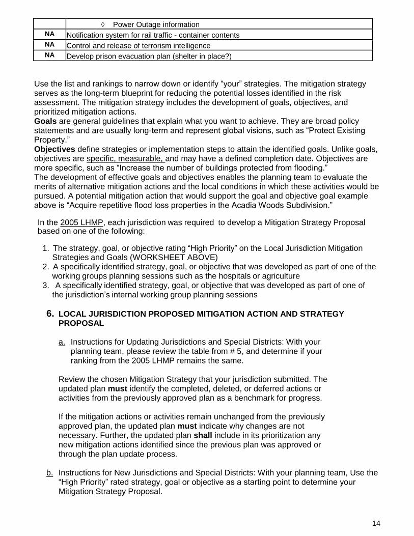
◊ Power Outage information
NA Notification system for rail traffic - container contents
NA Control and release of terrorism intelligence
NA Develop prison evacuation plan (shelter in place?)
Use the list and rankings to narrow down or identify “your” strategies. The mitigation strategy serves as the long-term blueprint for reducing the potential losses identified in the risk assessment. The mitigation strategy includes the development of goals, objectives, and prioritized mitigation actions. Goals are general guidelines that explain what you want to achieve. They are broad policy statements and are usually long-term and represent global visions, such as “Protect Existing Property.” Objectives define strategies or implementation steps to attain the identified goals. Unlike goals, objectives are specific, measurable, and may have a defined completion date. Objectives are more specific, such as “Increase the number of buildings protected from flooding.” The development of effective goals and objectives enables the planning team to evaluate the merits of alternative mitigation actions and the local conditions in which these activities would be pursued. A potential mitigation action that would support the goal and objective goal example above is “Acquire repetitive flood loss properties in the Acadia Woods Subdivision.” In the 2005 LHMP, each jurisdiction was required to develop a Mitigation Strategy Proposal based on one of the following:
1. The strategy, goal, or objective rating “High Priority” on the Local Jurisdiction Mitigation Strategies and Goals (WORKSHEET ABOVE)
2. A specifically identified strategy, goal, or objective that was developed as part of one of the working groups planning sessions such as the hospitals or agriculture
3. A specifically identified strategy, goal, or objective that was developed as part of one of the jurisdiction’s internal working group planning sessions
6. LOCAL JURISDICTION PROPOSED MITIGATION ACTION AND STRATEGY PROPOSAL
a. Instructions for Updating Jurisdictions and Special Districts: With your
planning team, please review the table from # 5, and determine if your ranking from the 2005 LHMP remains the same.
Review the chosen Mitigation Strategy that your jurisdiction submitted. The updated plan must identify the completed, deleted, or deferred actions or activities from the previously approved plan as a benchmark for progress. If the mitigation actions or activities remain unchanged from the previously approved plan, the updated plan must indicate why changes are not necessary. Further, the updated plan shall include in its prioritization any new mitigation actions identified since the previous plan was approved or through the plan update process.
b. Instructions for New Jurisdictions and Special Districts: With your planning team, Use the
“High Priority” rated strategy, goal or objective as a starting point to determine your Mitigation Strategy Proposal.

15
LOCAL JURISDICTION PROPOSED MITIGATION ACTION AND STRATEGY PROPOSAL
Jurisdiction: City of Wildomar
Contact: Paula Willette
Phone: 951.677.7751 ext. 206
MITIGATION STRATEGY INFORMATION Proposal Name:
Proposal Location:
Proposal Type Place an "X" by the type of mitigation strategy (one or more may apply)
Flood and mud flow mitigation
Fire mitigation
Elevation or acquisition of repetitively damaged structures or structures in high hazard areas
Mitigation Planning (i.e. update building codes, planning develop guidelines, etc.)
Development and implementation of mitigation education programs
Development or improvement of warning systems
Additional Hazard identification and analysis in support of the local hazard mitigation plan
Drinking and/or irrigation water mitigation
Earthquake mitigation
Agriculture - crop related mitigation
Agriculture - animal related mitigation
Flood inundation/Dam failure
Weather/Temperature event mitigation
DESCRIPTION OF THE PROPOSED MITIGATION STRATEGY Proposal/Event History
List any previous disaster related events (dates, costs, etc.)
Description of Mitigation Goal Narrative:
Give a detailed description of the need for the proposal, any history related to the proposal. List the activities necessary for its completion in the narrative section below, including estimated timeline. (how long will it take)

16
Does your jurisdiction have primary responsibility for the proposal? If not, what agency does?
Yes X No Responsible Agency:
FUNDING INFORMATION Place an "X" by the proposed source of funding for this proposal
Unfunded proposal - funds are not available for the proposal at this time
Local jurisdiction General Fund
Local jurisdiction Special Fund (road tax, assessment fees, etc.)
Non-FEMA Hazard Mitigation Funds
Local Hazard Mitigation Grant Funds - Future Request
Hazard Mitigation Funds
Has your jurisdiction evaluated this mitigation strategy to determine its cost benefits?
(i.e. has the cost of the mitigation proposal been determined to be beneficial in relationship to the potential damage or loss using the attached Cost/Benefit Analysis Sheet or another internal method)
As part of this process, each Submitting Jurisdiction is required to perform a cost-benefit analysis. They were required to answer the question at the bottom of the Proposal page that asks if they had conducted a Cost-Benefit Analysis of some type. This analysis was conducted either by completing a Cost Benefit form or by some other approved method. Many of the jurisdictions used the cost-effective analysis approach outlined in the FEMA publication, Cost and Benefits of Natural Hazards Mitigation. This cost-benefit analysis was not restricted to natural hazards.
In some cases, the jurisdiction or working group identified a proposal that highlighted a life- safety issue over a standard hazard proposal. This was done when there was either historical data or other sources of information indicating that the life-safety issue needed to be emphasized or brought to the public’s attention.

17
7. LOCAL JURISDICTION DEVELOPMENT TRENDS QUESTIONNAIRE (Same as #7 in the 2012 Annex : Jurisdiction Template) LAND USE ISSUES - COMPLETE THE INFORMATION BELOW This questionnaire identifies a comparison of specific land use issues between 2004, 2012 and 2017. The questionnaire also identifies the specific threat potential to the jurisdiction in relationship to residential and commercial structures along with critical facilities. This threat potential is focused on structural loss rather than dollar-value loss as it relates to the three main natural hazards – earthquakes, floods, and wildland fires. The determination of dollar-value loss relating to commercial and critical facilities was found to be very limited and a difficult task to establish. This issue will be addressed in future updates of the Plan.
The questionnaire also requires the jurisdiction to identify the process it will use to maintain their portion of the Plan.
18
LOCAL JURISDICTION DEVELOPMENT TRENDS QUESTIONNAIRE 2011 LAND USE ISSUES - COMPLETE THE INFORMATION BELOW
JURISDICTION: DOES YOUR AGENCY HAVE RESPONSIBILITY FOR LAND USE AND/OR DEVELOPMENT ISSUES WITHIN YOUR JURISDICTIONAL BOUNDARIES? YES NO
2005 DATA 2012 DATA 2017
Current Population in Jurisdiction or Served
28,000 32,000 Projected Population in Jurisdiction or Served - in 2017 33,000
Current Sq Miles in Jurisdiction or Served 24 24 Projected Sq Miles in Jurisdiction or Served - in 2017 24 Does Your Jurisdiction have any ordinances or regulations dealing with disaster mitigation, disaster preparation, or disaster response?
Unincorporated
Yes If yes, please list ordinance or regulation number. Cal Fire Fire Protection Plan
What is the number one land issue your agency will face in the next five years
No economic growth
Approximate Number of Homes/Apts/etc. 0 9,845 Projected Number of Homes/Apts/etc.- in 2017 10,000 Approximate Total Residential Value 1.6 billion Projected Residential Total Value - in 2017 2 billion
Approximate Number of Commercial Businesses
320 Projected Number of Commercial Businesses - in 2017 400
Approximate Percentage of Homes/Apts/etc in flood hazard zones
Approximate Percentage of Homes/Apts/etc in flood hazard zones - in 2017
Approximate Percentage of Homes/Apts/etc in earthquake hazard zones
90% 1.5 million
Approximate Percentage of Homes/Apts/etc in earthquake hazard zones - in 2017
90% 1.8 million
Approximate Percentage of Homes/Apts/etc in wildland fire hazard zones
5% 80 million
Approximate Percentage of Homes/Apts/etc in wildland fire hazard zones - in 2017
5% 100 million
Approximate Percentage of Commercial Businesses in flood hazard zones
Approximate Percentage of Commercial Businesses in flood hazard zones - in 2017
Approximate Percentage of Commercial Businesses in earthquake hazard zones
100% Approximate Percentage of Commercial Businesses in earthquake hazard zones - in 2017
100%
Approximate Percentage of Commercial Businesses in wildland fire hazard zones
0 Approximate Percentage of Commercial Businesses in wildland fire hazard zones - in 2017
0
Number of Critical Facilities in your Jurisdiction that are in flood hazard zones
0 Projected Number of Critical Facilities in your Jurisdiction that are in flood hazard zones - in 2017
0
Number of Critical Facilities in your Jurisdiction that are in earthquake hazard zones
12 Number of Critical Facilities in your Jurisdiction that are in earthquake hazard zones - in 2017
12
Number of Critical Facilities in your Jurisdiction that are in wildland fire hazard zones.
1 Number of Critical Facilities in your Jurisdiction that are in wildland fire hazard zones - in 2017
1
Does your jurisdiction plan on participating in the County's on-going plan maintenance program every two years as described in Part I of the plan?
Yes If not, how will your jurisdiction do plan maintenance?
Will a copy of this plan be available for the various planning groups within your jurisdiction for use in future planning and budgeting Yes

19
32 CITY OF WILDOMAR –PART I - ANNEX LOCAL HAZARD MITIGATION PLAN SEPTEMBER 2012
PLAN REVIEW TOOL/CROSSWALK
SEE ATTACHMENTS – PART III