Embed Size (px)
DESCRIPTION
Civil Defence Command Centers for New Century (Emergency Operation Center). By: Dr Rahul Ralegaonkar. BACKGROUND. Frequency of disasters- growing vulnerability, and changing climate patterns. Breaking the cycle of destruction and reconstruction- Address the root causes of vulnerability. - PowerPoint PPT Presentation
Citation preview
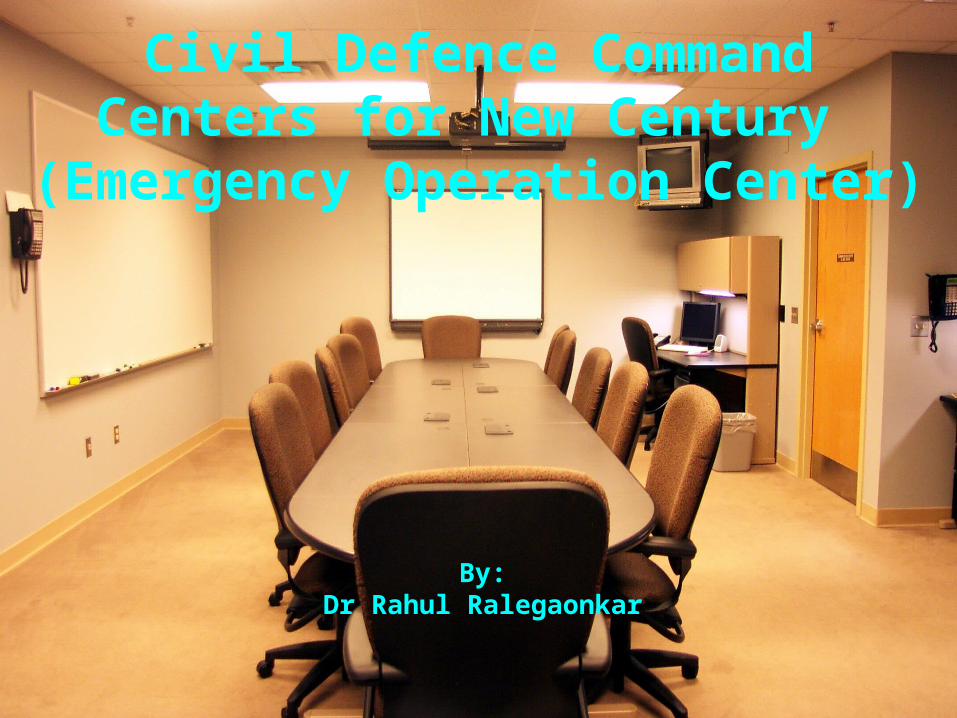
Civil Defence Command Centers for New Century
(Emergency Operation Center)
By:Dr Rahul
Ralegaonkar
BACKGROUND
• Frequency of disasters- growing vulnerability, and changing climate patterns.
• Breaking the cycle of destruction and reconstruction- Address the root causes of vulnerability.
• Causes of vulnerability- Rapid and uncontrolled urbanization, mismanagement of natural resources, inefficient public policies, and lagging & misguided investments in infrastructure.
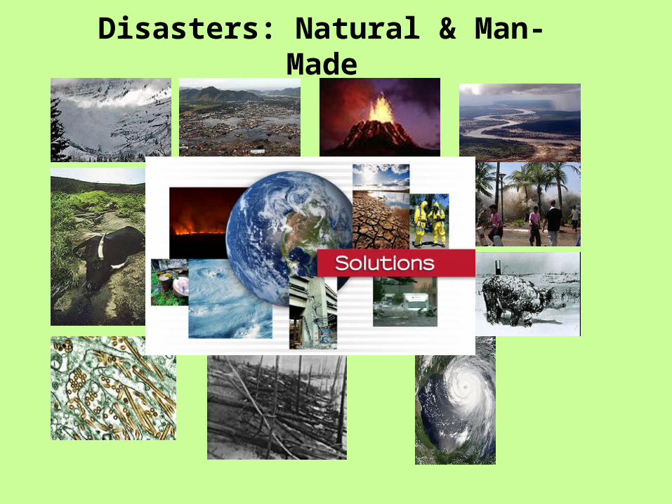
Disasters: Natural & Man-Made
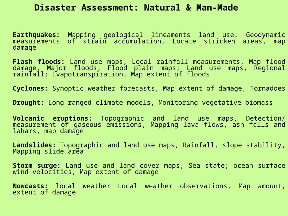
Disaster Assessment: Natural & Man-Made
Earthquakes: Mapping geological lineaments land use, Geodynamic measurements of strain accumulation, Locate stricken areas, map damage
Flash floods: Land use maps, Local rainfall measurements, Map flood damage, Major floods, Flood plain maps; Land use maps, Regional rainfall; Evapotranspiration, Map extent of floods
Cyclones: Synoptic weather forecasts, Map extent of damage, Tornadoes
Drought: Long ranged climate models, Monitoring vegetative biomass
Volcanic eruptions: Topographic and land use maps, Detection/ measurement of gaseous emissions, Mapping lava flows, ash falls and lahars, map damage
Landslides: Topographic and land use maps, Rainfall, slope stability, Mapping slide area
Storm surge: Land use and land cover maps, Sea state; ocean surface wind velocities, Map extent of damage
Nowcasts: local weather Local weather observations, Map amount, extent of damage
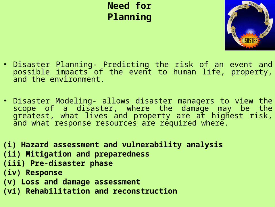
Need for Planning
• Disaster Planning- Predicting the risk of an event and possible impacts of the event to human life, property, and the environment.
• Disaster Modeling- allows disaster managers to view the scope of a disaster, where the damage may be the greatest, what lives and property are at highest risk, and what response resources are required where.
(i) Hazard assessment and vulnerability analysis(ii) Mitigation and preparedness(iii) Pre-disaster phase(iv) Response(v) Loss and damage assessment(vi) Rehabilitation and reconstruction
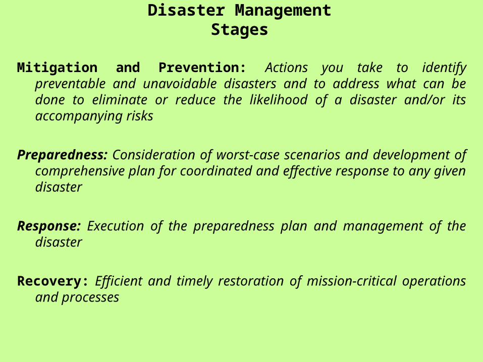
Mitigation and Prevention: Actions you take to identify preventable and unavoidable disasters and to address what can be done to eliminate or reduce the likelihood of a disaster and/or its accompanying risks
Preparedness: Consideration of worst-case scenarios and development of comprehensive plan for coordinated and effective response to any given disaster
Response: Execution of the preparedness plan and management of the disaster
Recovery: Efficient and timely restoration of mission-critical operations and processes
Disaster Management Stages
Disaster Management-Goals
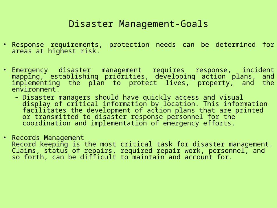
• Response requirements, protection needs can be determined for areas at highest risk.
• Emergency disaster management requires response, incident mapping, establishing priorities, developing action plans, and implementing the plan to protect lives, property, and the environment. – Disaster managers should have quickly access and visual display of
critical information by location. This information facilitates the development of action plans that are printed or transmitted to disaster response personnel for the coordination and implementation of emergency efforts.
• Records ManagementRecord keeping is the most critical task for disaster management. Claims, status of repairs, required repair work, personnel, and so forth, can be difficult to maintain and account for.

An example- Earthquake Damage Prediction
• Locate the epicenter and Intensity of earthquake.
• Damaged area distance from the epicenter- demarcate a severely damaged area ,moderate damaged, and least affected area with the help of images.
• Based on above information we need to provide a base relief operation. Area which needs most quicker relief, Man-power, Shortest route to provide medical facility, Food, shelter, and other basic needs.
• Transportation: roads / highways / public transportation / airport /seaport
• Parcels: building footprint and typology
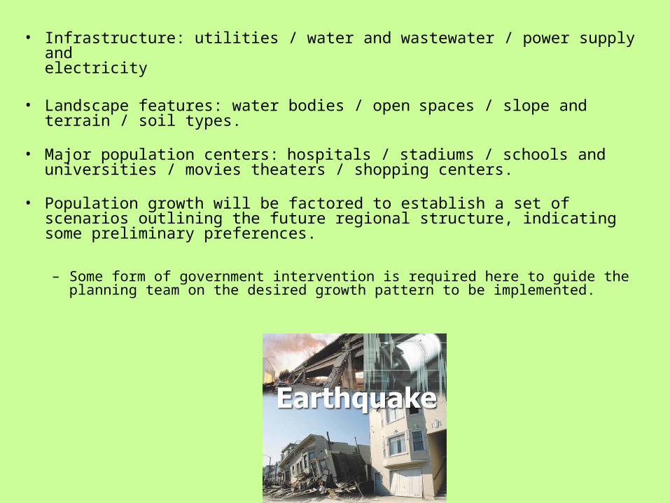
• Infrastructure: utilities / water and wastewater / power supply andelectricity
• Landscape features: water bodies / openspaces / slope andterrain / soil types.
• Major population centers:hospitals / stadiums / schools anduniversities / movies theaters / shopping centers.
• Population growth will be factored to establish a set of scenarios outlining the future regional structure, indicating some preliminary preferences.
– Some form of government intervention is required here to guide the planning team on the desired growth pattern to be implemented.
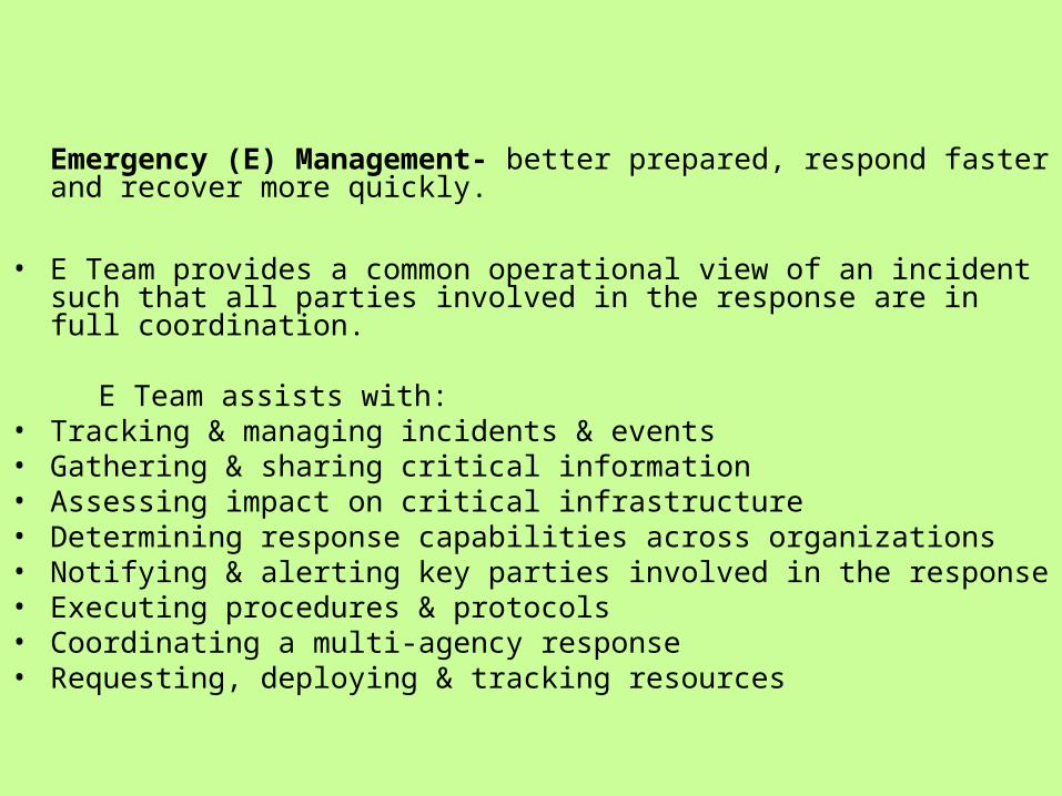
Emergency (E) Management- better prepared, respond faster and recover more quickly.
• E Team provides a common operational view of an incident such that all parties involved in the response are in full coordination.
E Team assists with: • Tracking & managing incidents & events • Gathering & sharing critical information • Assessing impact on critical infrastructure • Determining response capabilities across organizations • Notifying & alerting key parties involved in the response • Executing procedures & protocols • Coordinating a multi-agency response • Requesting, deploying & tracking resources
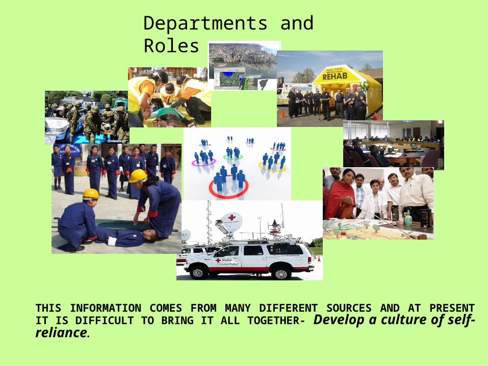
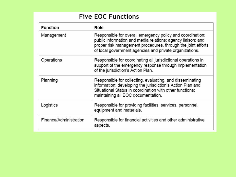
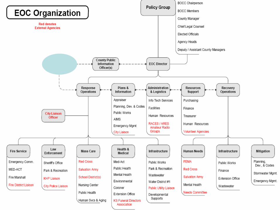
Departments and Roles
THIS INFORMATION COMES FROM MANY DIFFERENT SOURCES AND AT PRESENT IT IS DIFFICULT TO BRING IT ALL TOGETHER- Develop a culture of self-reliance.
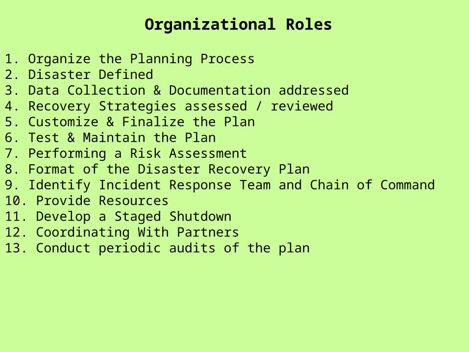
1. Organize the Planning Process2. Disaster Defined3. Data Collection & Documentation addressed4. Recovery Strategies assessed / reviewed5. Customize & Finalize the Plan6. Test & Maintain the Plan7. Performing a Risk Assessment8. Format of the Disaster Recovery Plan9. Identify Incident Response Team and Chain of Command10. Provide Resources11. Develop a Staged Shutdown12. Coordinating With Partners13. Conduct periodic audits of the plan
Organizational Roles
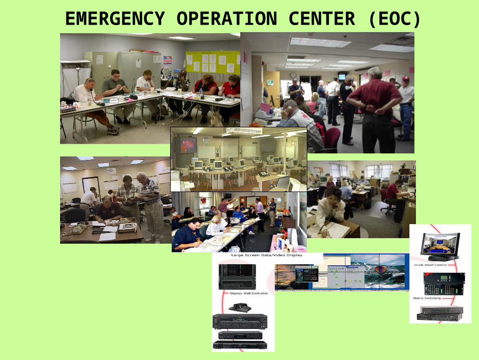
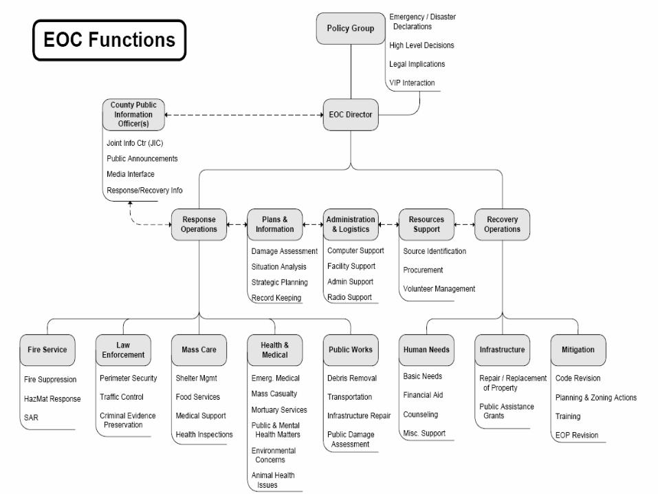
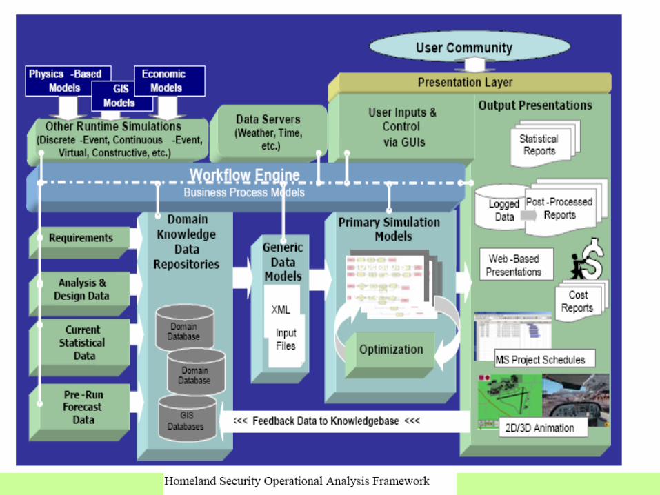
EMERGENCY OPERATION CENTER (EOC)
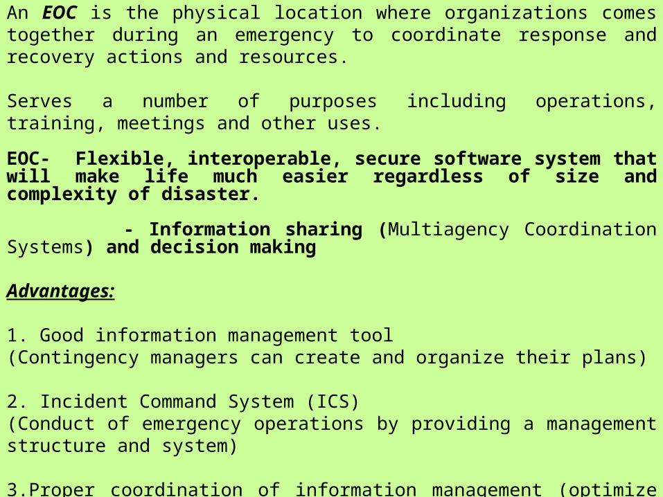
An EOC is the physical location where organizations comes together during an emergency to coordinate response and recovery actions and resources.
Serves a number of purposes including operations, training, meetings and other uses.
EOC- Flexible, interoperable, secure software system that will make life much easier regardless of size and complexity of disaster.
- Information sharing (Multiagency Coordination Systems) and decision making
Advantages:
1. Good information management tool (Contingency managers can create and organize their plans)
2. Incident Command System (ICS) (Conduct of emergency operations by providing a management structure and system)
3.Proper coordination of information management (optimize communication), decisions and resources facilitation.
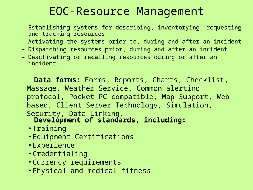
EOC-Resource Management– Establishing systems for describing, inventorying, requesting and
tracking resources– Activating the systems prior to, during and after an incident– Dispatching resources prior, during and after an incident– Deactivating or recalling resources during or after an incident
Development of standards, including:• Training• Equipment Certifications• Experience• Credentialing• Currency requirements• Physical and medical fitness
Data forms: Forms, Reports, Charts, Checklist, Massage, Weather Service, Common alerting protocol, Pocket PC compatible, Map Support, Web based, Client Server Technology, Simulation, Security, Data Linking.
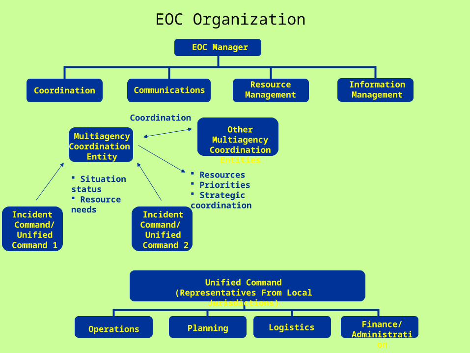
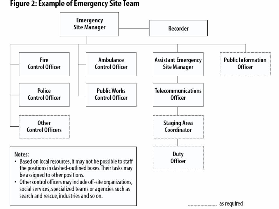
EOC Organization
EOC Manager
Coordination CommunicationsResource
ManagementInformation
Management
Coordination
Resources Priorities Strategic coordination
Multiagency Coordination
Entity
Incident Command/
Unified Command 1
Incident Command/
Unified Command 2
Situation status Resource needs
Other Multiagency Coordination
Entities
Unified Command(Representatives From Local
Jurisdictions)
Finance/ Administrati
on
LogisticsPlanningOperations
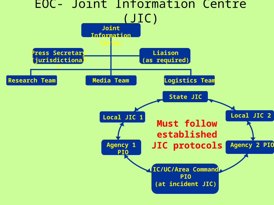
EOC- Joint Information Centre (JIC)
State JIC
Local JIC 1 Local JIC 2
Agency 1 PIO
Agency 2 PIO
IC/UC/Area CommandPIO
(at incident JIC)
Must follow established
JIC protocols
Joint Information
Center
Research Team Media Team Logistics Team
Press Secretary(jurisdictional)
Liaison(as required)
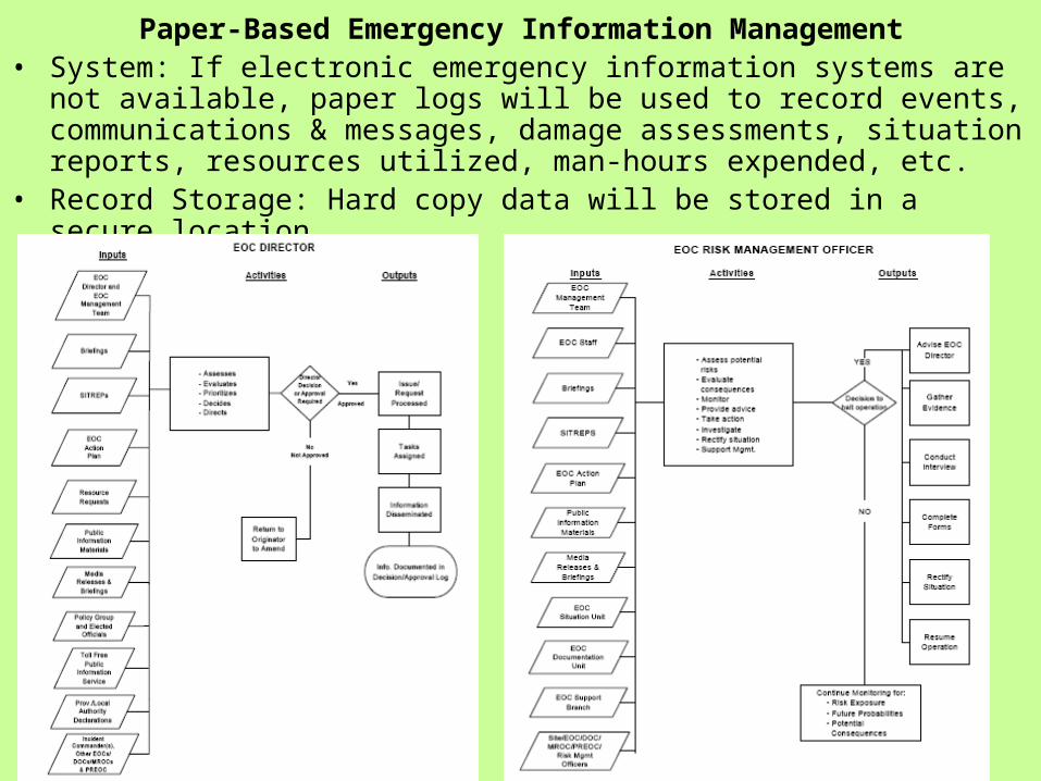
Paper-Based Emergency Information Management• System: If electronic emergency information systems are not available,
paper logs will be used to record events, communications & messages, damage assessments, situation reports, resources utilized, man-hours expended, etc.
• Record Storage: Hard copy data will be stored in a secure location
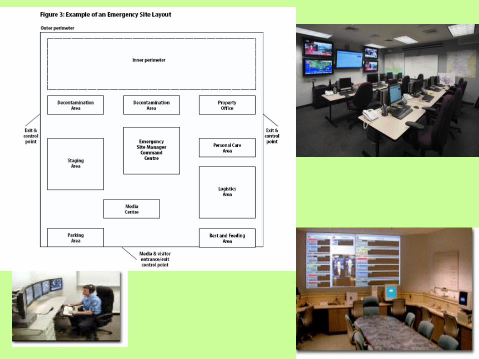
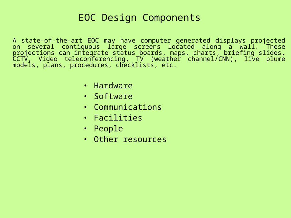
A state-of-the-art EOC may have computer generated displays projected on several contiguous large screens located along a wall. These projections can integrate status boards, maps, charts, briefing slides, CCTV, Video teleconferencing, TV (weather channel/CNN), live plume models, plans, procedures, checklists, etc.
EOC Design Components
• Hardware• Software• Communications• Facilities• People• Other resources
E-management resources
- The internet/intranet- voice and video teleconferencing (recorded)- phones with lights instead of ringers and, headsets for hands free operation- automated displays featuring status boards and maps with motion- raised access flooring for easy installation of telecommunications- acoustic walls and ceilings, and static-free carpeted floors- task lighting at each position- large screen room displays in virtual windows- systems furniture including ergonomic chairs- digital clock systems (accurate to a millisecond)- cameras and video recording- automated checklists and forms and computerized reference documents- human factored lighting and colors- mission driven seating configurations- Decision-makers that are facing away from traffic flow within the room
Public Safety Answering Point (PSAP Center):
• A PSAP is a 24X7 operation that typically has two critical activities or areas we can refer to as the "dispatcher area" (where the Call Takers and/or Dispatchers are located) and the "equipment room" (where the critical systems are housed).
• The PSAP serves as the focal point for high density communications utilizing phones, radios, speakers, position-to-position voice communications and occasional foot traffic from shift changes, visitors, etc.
Virtual EOC
• Two-way audio-vidual communications…a structured mechanism for receiving and sending information.
• Automated response and recovery checklists...
• Alert notifications…
EOC Decision MakingStrong management will be needed during EOC operations. EOCs should be activated as soon as possible to ensure that rapid decision making can occur. During the incident response phase, the real-time tracking of incidents and response resources is critical. Resources may be in short supply while multiple requests for services pile up. An operations log capability in needed to fulfill the requirement of documenting, tracking, and managing the response to an infinite number of concurrent incidents.
Typical Status Board Displays: Chronological, "Timeline" or "Significant Events"
This display records all reports entered into the system that meet the criteria for entry. Reports are posted in the order received and are referenced by the Time of Receipt (TOR). Typically, the Time of Occurrence (TOC) is recorded in the narrative. If you had only one status board this is the one you would need. These displays can be filtered and sorted as well.
Multiple chronological displays can be maintained. Examples are: A log of all reports to the system can be maintained; a
log of “Significant Events” can be maintained; a log of reports by category can also be maintained. Categorical Displays help us manage high volume information flow by breaking it down into functional groups.
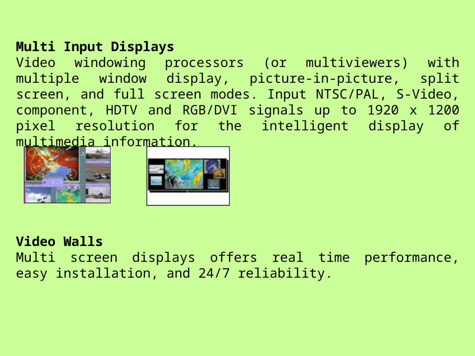
Multi Input DisplaysVideo windowing processors (or multiviewers) with multiple window display, picture-in-picture, split screen, and full screen modes. Input NTSC/PAL, S-Video, component, HDTV and RGB/DVI signals up to 1920 x 1200 pixel resolution for the intelligent display of multimedia information.
Video WallsMulti screen displays offers real time performance, easy installation, and 24/7 reliability.
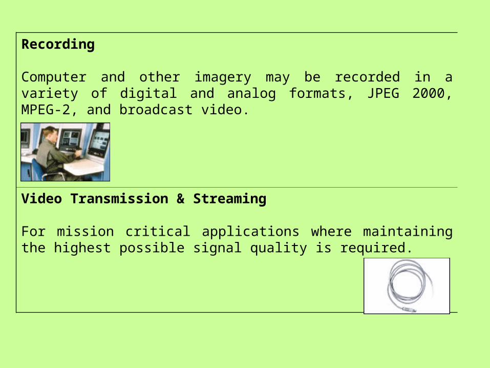
Recording
Computer and other imagery may be recorded in a variety of digital and analog formats, JPEG 2000, MPEG-2, and broadcast video.
Video Transmission & Streaming
For mission critical applications where maintaining the highest possible signal quality is required.
PHOTONICS is being studied today as a possible alternate technology for the future. Investigations are on to harness the capability of the photon to carry information and energy. Fortunately, success has already been achieved in the area of communications.
Optical fibers, not copper cables, are already being used to carry huge amounts of information across the great oceans. Even the internet cables around us are now optical and not electronic. However, communication is only one of the three `C' s, that has been taken care of, the other two being computing and control.
Photonic switches and optical computers are still in the laboratories and not yet in the marketplace. The major bottleneck in this area is not in solving technological problems or in perfecting theoretical understanding, but in developing suitable materials.
Photonics is the science of generating, controlling, and detecting photons, particularly in the visible and near infra-red spectrum, but also extending to the ultraviolet (0.2 - 0.35 µm wavelength), long-wave infrared (8 - 12 µm wavelength), and far-infrared/THz portion of the spectrum (e.g., 2-4 THz corresponding to 75-150 µm wavelength) where today quantum cascade lasers are being actively developed. Photonics is an outgrowth of the first practical semiconductor light emitters.
• Semiconductor photonic devices include optical data recording, fiber optic telecommunications, laser printing (based on xerography), displays, and optical pumping of high-power lasers.
• The potential applications of photonics are virtually unlimited and include chemical synthesis, medical diagnostics, on-chip data communication, laser defense, and fusion energy, etc.
The Nature of Optical Nonlinearity• Spectroscopic characterization and analysis of materials
using the techniques of optical absorption, luminescence, Raman scattering are standard techniques in research. These studies help in structure analysis and in understanding the electronic processes and energy levels in systems. Several interesting photochemical processes and reactions such as photosynthesis have attracted the attentions of Materials Scientists and Biologists. The advent of lasers has revolutionized optical technology including spectroscopic instrumentation.
• The high intensity radiation from lasers is also capable of causing new processes to occur in materials. In such cases, most of the materials can have a `nonlinear interaction' with the electric field. The nonlinear interaction results in several novel processes, which have the potential for communication, control and computing applications.
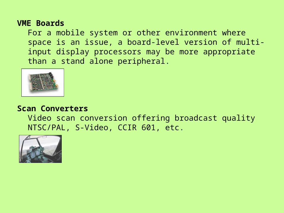
VME BoardsFor a mobile system or other environment where space is an issue, a board-level version of multi-input display processors may be more appropriate than a stand alone peripheral.
Scan ConvertersVideo scan conversion offering broadcast quality NTSC/PAL, S-Video, CCIR 601, etc.
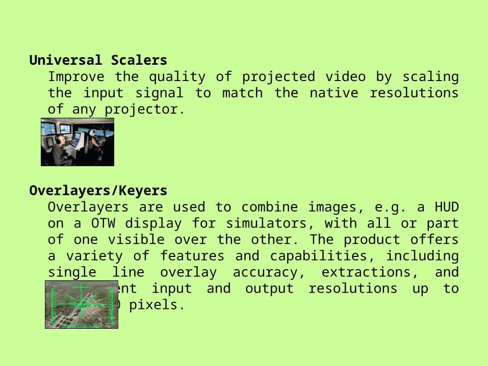
Universal ScalersImprove the quality of projected video by scaling the input signal to match the native resolutions of any projector.
Overlayers/KeyersOverlayers are used to combine images, e.g. a HUD on a OTW display for simulators, with all or part of one visible over the other. The product offers a variety of features and capabilities, including single line overlay accuracy, extractions, and independent input and output resolutions up to 1900x1200 pixels.
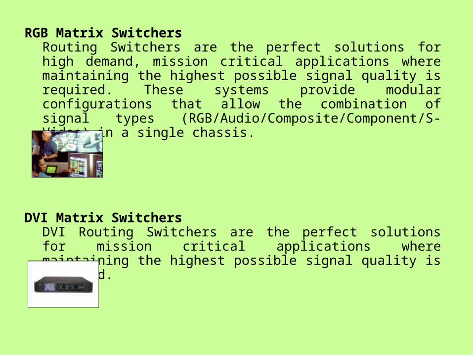
RGB Matrix SwitchersRouting Switchers are the perfect solutions for high demand, mission critical applications where maintaining the highest possible signal quality is required. These systems provide modular configurations that allow the combination of signal types (RGB/Audio/Composite/Component/S-Video) in a single chassis.
DVI Matrix SwitchersDVI Routing Switchers are the perfect solutions for mission critical applications where maintaining the highest possible signal quality is required.
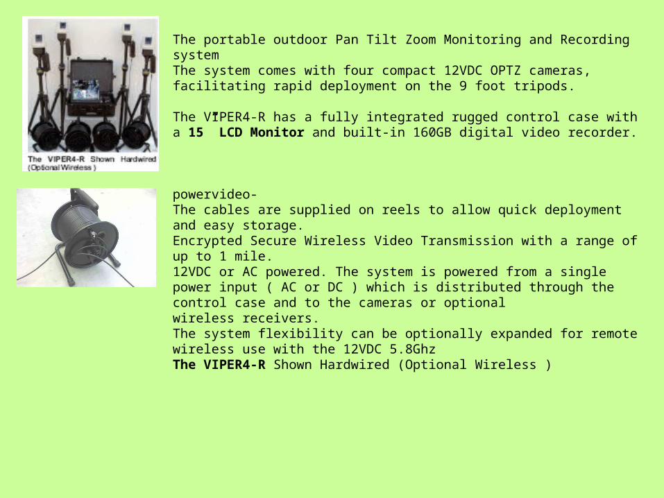
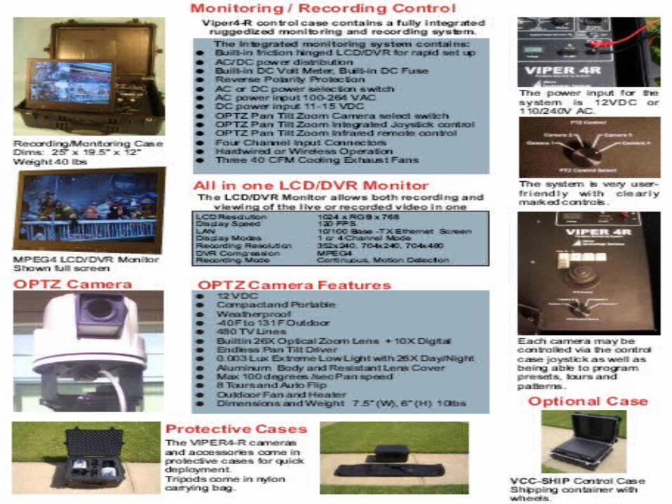
The portable outdoor Pan Tilt Zoom Monitoring and Recording system The system comes with four compact 12VDC OPTZ cameras, facilitating rapid deployment on the 9 foot tripods.
The VIPER4-R has a fully integrated rugged control case with a 15” LCD Monitor and built-in 160GB digital video recorder.
powervideo-The cables are supplied on reels to allow quick deployment and easy storage.Encrypted Secure Wireless Video Transmission with a range of up to 1 mile.12VDC or AC powered. The system is powered from a single power input ( AC or DC ) which is distributed through the control case and to the cameras or optionalwireless receivers.The system flexibility can be optionally expanded for remote wireless use with the 12VDC 5.8GhzThe VIPER4-R Shown Hardwired (Optional Wireless )
Networking
• Networking is a complex part of computing that makes up most of the IT Industry. Without networks, almost all communication in the world would cease to happen. It is because of networking that telephones, televisions, the internet, etc. work.
• One way to categorize computer networks are by their geographic scope, although many real-world networks interconnect Local Area Networks (LAN) via Wide Area Networks (WAN).
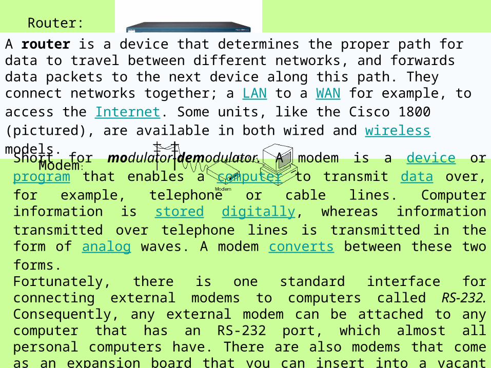
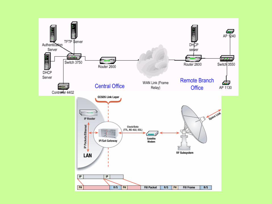
Router:
A router is a device that determines the proper path for data to travel between different networks, and forwards data packets to the next device along this path. They connect networks together; a LAN to a WAN for example, to access the Internet. Some units, like the Cisco 1800 (pictured), are available in both wired and wireless models.
Modem:
Short for modulator-demodulator. A modem is a device or program that enables a computer to transmit data over, for example, telephone or cable lines. Computer information is stored digitally, whereas information transmitted over telephone lines is transmitted in the form of analog waves. A modem converts between these two forms.Fortunately, there is one standard interface for connecting external modems to computers called RS-232. Consequently, any external modem can be attached to any computer that has an RS-232 port, which almost all personal computers have. There are also modems that come as an expansion board that you can insert into a vacant expansion slot. These are sometimes called onboard or internal modems.
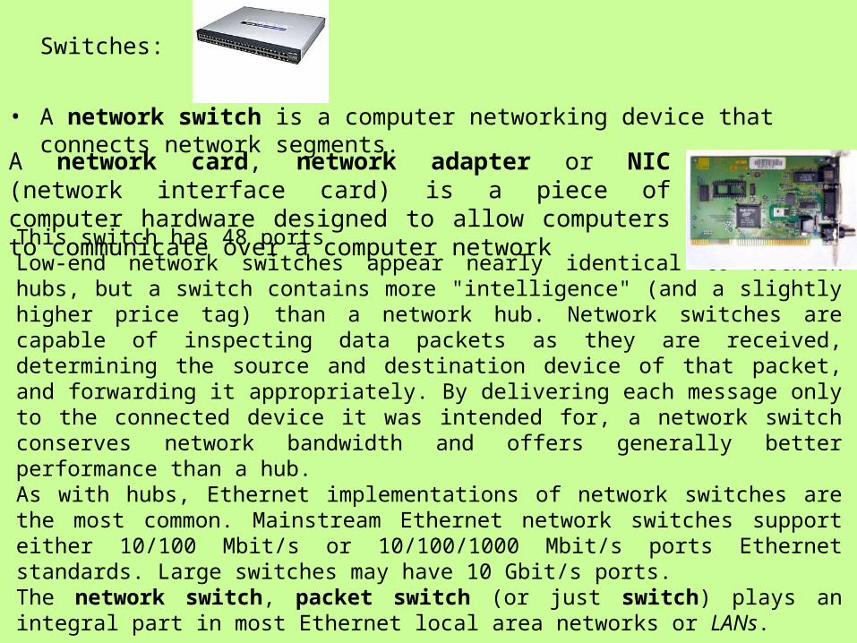
This switch has 48 portsLow-end network switches appear nearly identical to network hubs, but a switch contains more "intelligence" (and a slightly higher price tag) than a network hub. Network switches are capable of inspecting data packets as they are received, determining the source and destination device of that packet, and forwarding it appropriately. By delivering each message only to the connected device it was intended for, a network switch conserves network bandwidth and offers generally better performance than a hub.As with hubs, Ethernet implementations of network switches are the most common. Mainstream Ethernet network switches support either 10/100 Mbit/s or 10/100/1000 Mbit/s ports Ethernet standards. Large switches may have 10 Gbit/s ports.The network switch, packet switch (or just switch) plays an integral part in most Ethernet local area networks or LANs.
A network card, network adapter or NIC (network interface card) is a piece of computer hardware designed to allow computers to communicate over a computer network
Switches:
• A network switch is a computer networking device that connects network segments.
Networking:• Computer networking is the engineering discipline concerned with
communication between computer systems or devices.• Communicating computer systems constitute a computer network and these
networks generally involve at least two devices capable of being networked with at least one usually being a computer. The devices can be separated by a few meters (e.g. via Bluetooth) or nearly unlimited distances
• A computer network is any set of computers or devices connected to each other. Examples of networks are the Internet, or a small home local area network (LAN) with two computers connected with standard networking cables connecting to a network interface card in each computer. All modern aspects of the Public Switched Telephone Network (PSTN) are computer-controlled, and telephony increasingly runs over the Internet Protocol, although not necessarily the public Internet.
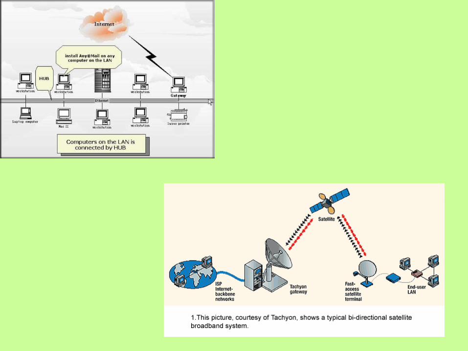
Local Area Network (LAN)• A Local Area Network is a network that spans a relatively small space and
provides services to a small amount of people. Depending on the amount of people that use a Local Area Network, a peer-to-peer or client-server method of networking may be used. A peer-to-peer network is where each client shares their resources with other workstations in the network.
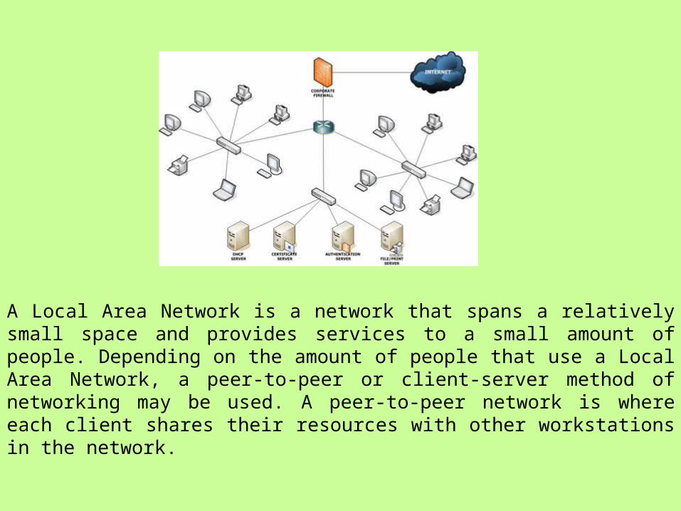
A Local Area Network is a network that spans a relatively small space and provides services to a small amount of people. Depending on the amount of people that use a Local Area Network, a peer-to-peer or client-server method of networking may be used. A peer-to-peer network is where each client shares their resources with other workstations in the network.
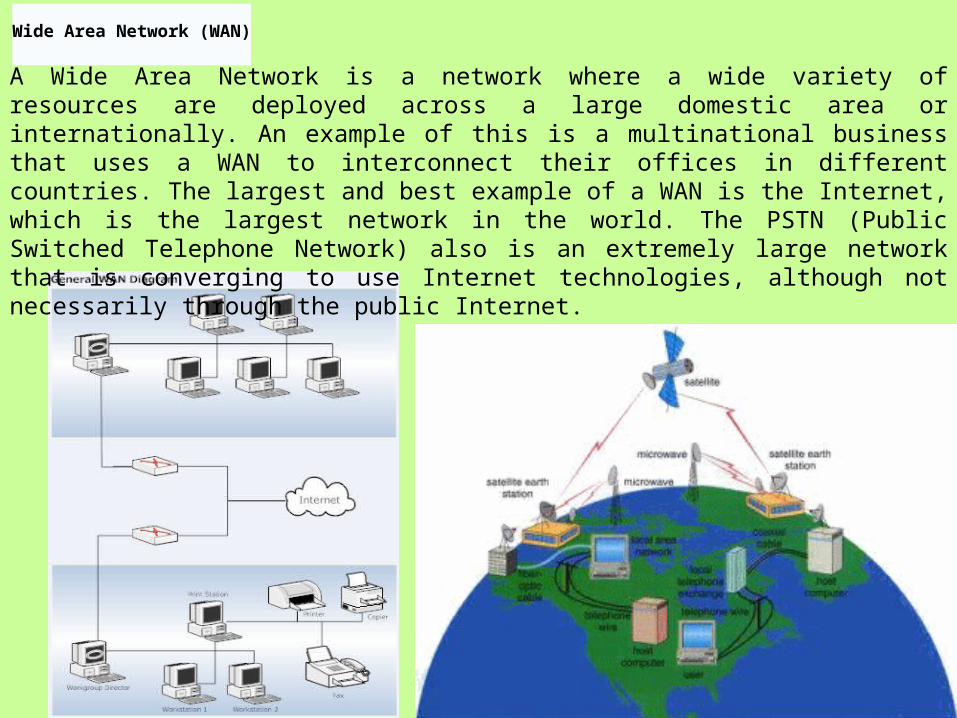
Wide Area Network (WAN)
A Wide Area Network is a network where a wide variety of resources are deployed across a large domestic area or internationally. An example of this is a multinational business that uses a WAN to interconnect their offices in different countries. The largest and best example of a WAN is the Internet, which is the largest network in the world. The PSTN (Public Switched Telephone Network) also is an extremely large network that is converging to use Internet technologies, although not necessarily through the public Internet.
Wireless Networks (WLAN, WWAN)• A wireless network is basically the same as a LAN or a WAN but
there are no wires between hosts and servers. The data is transferred over sets of radio transceivers. These types of networks are beneficial when it is too costly or inconvenient to run the necessary cables.
Types of connectivity:• Wi-Fi:• Wi-Fi is a wireless technology brand owned by the Wi-Fi Alliance
intended to improve the interoperability of wireless local area network products based on the IEEE 802.11 standards.
• A Wi-Fi enabled device such as a PC, cell phone or PDA can connect to the Internet when within range of a wireless network connected to the Internet. The area covered by one or several interconnected access points is called a hotspot. Hotspots can cover as little as a single room with wireless-opaque walls or as much as many square miles covered by overlapping access points. Wi-Fi can also be used to create a mesh network. Both architectures are used in community networks.
Advantages of Wi-Fi• Wi-Fi allows LANs to be deployed without cabling for client devices, typically
reducing the costs of network deployment and expansion. Spaces where cables cannot be run, such as outdoor areas and historical buildings, can host wireless LANs.
• As of 2007 wireless network adapters are built into most modern laptops. The price of chipsets for Wi-Fi continues to drop, making it an economical networking option included in ever more devices. Wi-Fi has become widespread in corporate infrastructures, which also helps with the deployment of RFID technology that can piggyback on Wi-Fi
VPN:• A virtual private network (VPN) is a communications network tunneled
through another network, and dedicated for a specific network. One common application is secure communications through the public Internet, but a VPN need not have explicit security features, such as authentication or content encryption. VPNs, for example, can be used to separate out the traffic of different user communities over an underlying network with strong security features.
• Connectivity to Internet• Dialup• Broad Band• Lease Line• Cable net
Other types of computer network• As your business develops, you might wish to consider other networks such as wide
area networks (WANs), virtual private networks (VPNs), intranets and extranets. These networks each offer different business benefits, such as linking together systems in different offices, allowing remote workers to access your office systems securely, or providing up-to-date information for your staff and business partners.
• WANs are used by companies with offices at different locations. The WAN connects different local area networks together, into a more complex network. You will need to use client/server networks, which are based around central server computers, so that you can connect the various servers over a telecommunications network. WANs use cables/lines that are leased from a telecoms company.
• A VPN allows the user to connect across the Internet to the business' private network. It creates a secure link between the remote worker's computer and the central system. A VPN can be cheaper to use than leased lines or domestic-type broadband connections.
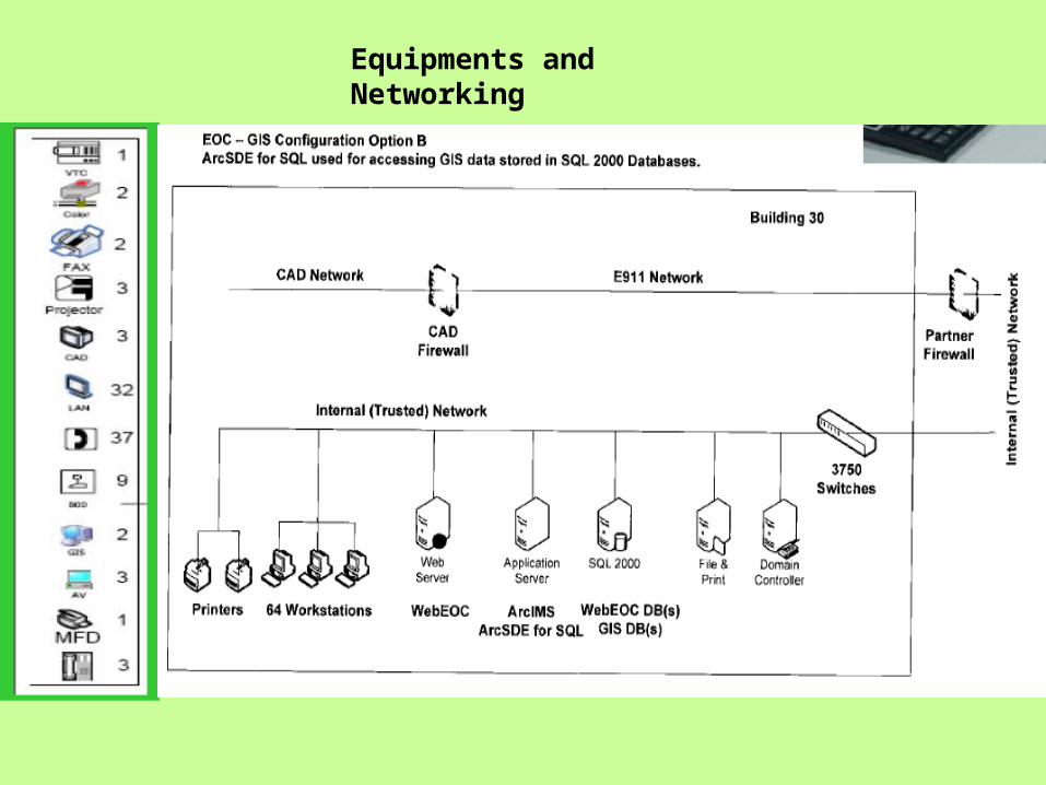
Equipments and Networking
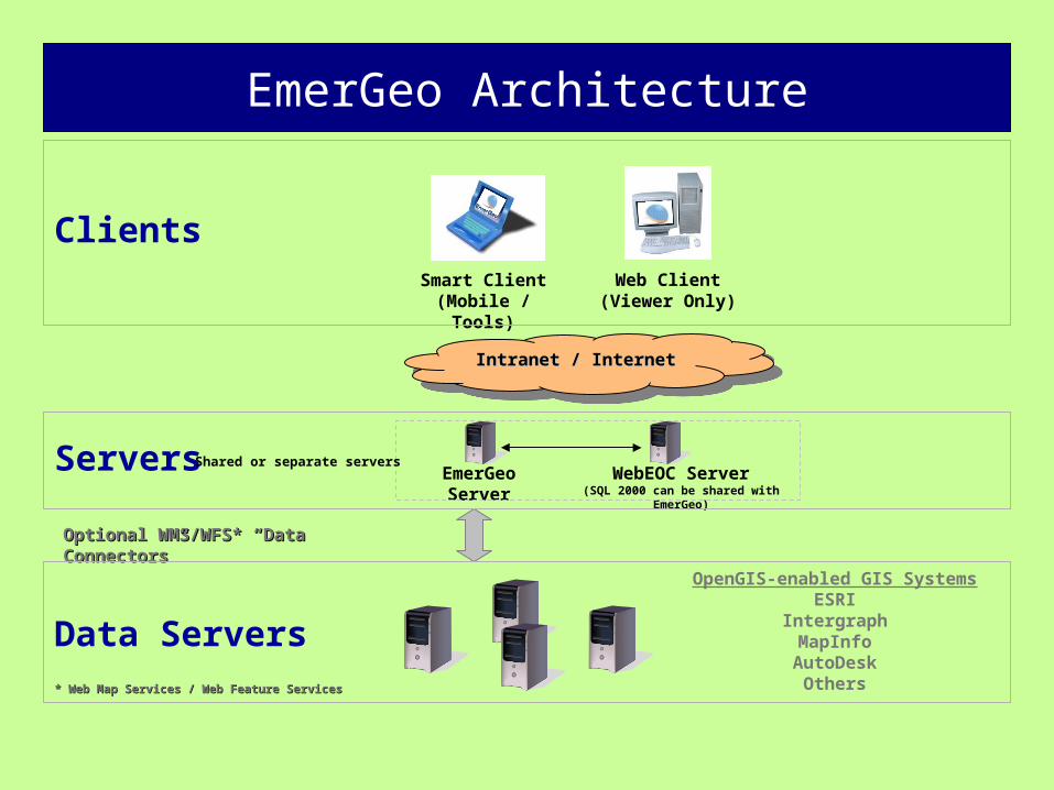
EmerGeo Architecture
Data Servers
Servers WebEOC Server(SQL 2000 can be shared with EmerGeo)
Clients
Intranet / InternetIntranet / InternetIntranet / InternetIntranet / Internet
Smart Client (Mobile / Tools)
Web Client(Viewer Only)
OpenGIS-enabled GIS SystemsESRI
IntergraphMapInfo
AutoDeskOthers
Optional WMS/WFS* “Data Connectors”Optional WMS/WFS* “Data Connectors”
EmerGeo Server
* Web Map Services / Web Feature Services* Web Map Services / Web Feature Services
Shared or separate servers
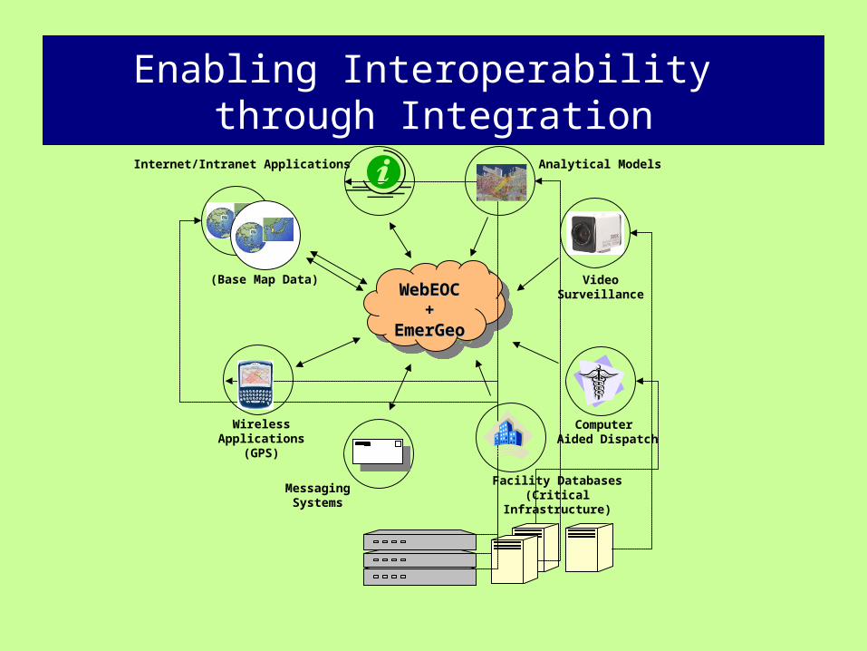
Enabling Interoperability through Integration
VideoSurveillance
Internet/Intranet Applications
(Base Map Data)
WebEOCWebEOC++
EmerGeoEmerGeo
WebEOCWebEOC++
EmerGeoEmerGeo
WirelessApplications
(GPS)
Analytical Models
Computer Aided Dispatch
Facility Databases(Critical Infrastructure)
MessagingSystems
Cyber Security for the Digital DistrictSecurity and IT-
•Security – All measures that monitor or restrict access to the system, such as locks, surveillance cameras, guards, fences, and entry control systems.
• Sound backup system based on priorities• Electronic and paper backup of vital records (and plan!)• Offsite backups and data storage• Offsite office/redundant data center• Remote data replication and outsourcing
Egress access from the EOC network to the Internet occurs through the local router's Network Address Translation (NAT) capability. Egress filtering is limited because of the variety of protocols used by agencies that may partner with the EOC in case of emergency. For example, assisting staff from local, state, and federal agencies may each require outbound connectivity to a different set of ports and destinations to facilitate access back to their organizations' networks. Because of the way Groove utilizes relay servers, workspace synchronization can also occur over this NAT connection. In the future, if we choose to implement more strict egress filtering, Groove would still function by wrapping its communications within HTTP frames for outbound access.
Security and Emergency Management
• Operational areas, including CCTV, Security, and Emergency Management • Customs House loading dock • Security incident database • Corporate security risk assessment • Corporate Security Plan • Alarm system remedial works • Mail handling and receipt of goods • Security alert procedures • On-line visitor and contractor management system • National Code of Practice for CCTV Systems for the Mass Passenger
Transport for Counter Terrorism
Security-Biometrics• face: the analysis of facial characteristics • fingerprint: the analysis of an individual’s unique fingerprints • hand geometry: the analysis of the shape of the hand and the length of
the fingers • retina: the analysis of the capillary vessels located at the back of the eye • iris: the analysis of the colored ring that surrounds the eye’s pupil • signature: the analysis of the way a person signs his name. • vein: the analysis of pattern of veins in the back if the hand and the wrist • voice: the analysis of the tone, pitch, cadence and frequency of a person’s
voice.
CCTV • The development of novel sensor-centric data fusion models appropriate
to fusion of disparate range and image data; • Fusion of complex, information-rich, probabilistic representations of
geometric and physical properties; and • development of endogenous data fusion and communication algorithms
appropriate to large-scale distributed sensor networks.
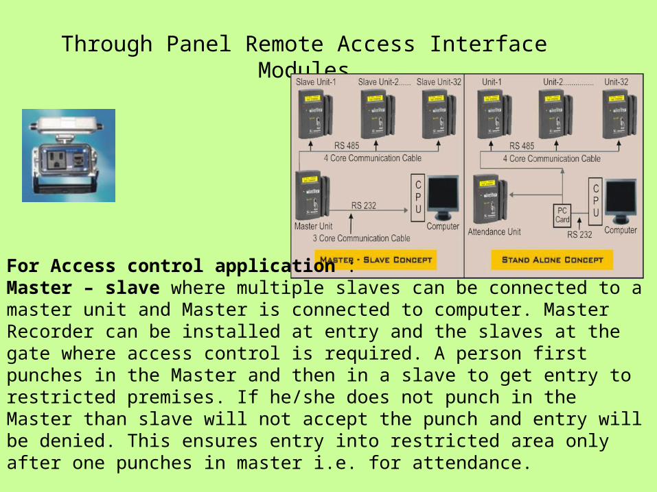
Through Panel Remote Access Interface Modules
For Access control application :Master – slave where multiple slaves can be connected to a master unit and Master is connected to computer. Master Recorder can be installed at entry and the slaves at the gate where access control is required. A person first punches in the Master and then in a slave to get entry to restricted premises. If he/she does not punch in the Master than slave will not accept the punch and entry will be denied. This ensures entry into restricted area only after one punches in master i.e. for attendance.

Radio frequency identification (RFID) is a method of remotely storing and retrieving data using devices called RFID tags. An RFID tag is a small object, such as an adhesive sticker, that can be attached to or incorporated into a product. RFID tags contain antennae to enable them to receive and respond to radio-frequency queries from an RFID transceiver.
RFID tags can be either active or passive.
Another proposed application is the use of RFID as intelligent traffic signals on the road (Road Beacon System or RBS).
Building on Groove and SharePoint
SharePoint is the core of EOC communication platform, providing an easy-to-use, full-featured Web site for storing documents, contacts, and task lists. Because it's a Web-based application, we can easily make its content available to anyone physically in the EOC building or anywhere on the Internet (assuming we have network connectivity). What we can't do with SharePoint is take the data offline, and that's where Groove comes in.
Groove provides key pieces of the overall solution. Through its Mobile Workspace for SharePoint, Groove allows us to take the entire SharePoint site and make it available offline. Groove users synchronize the contents of the SharePoint site to their local computers and can then view, edit, and add to the site even if they don't have a network connection. When they reconnect, the content is automatically synchronized back to SharePoint for the rest of the EOC to use.
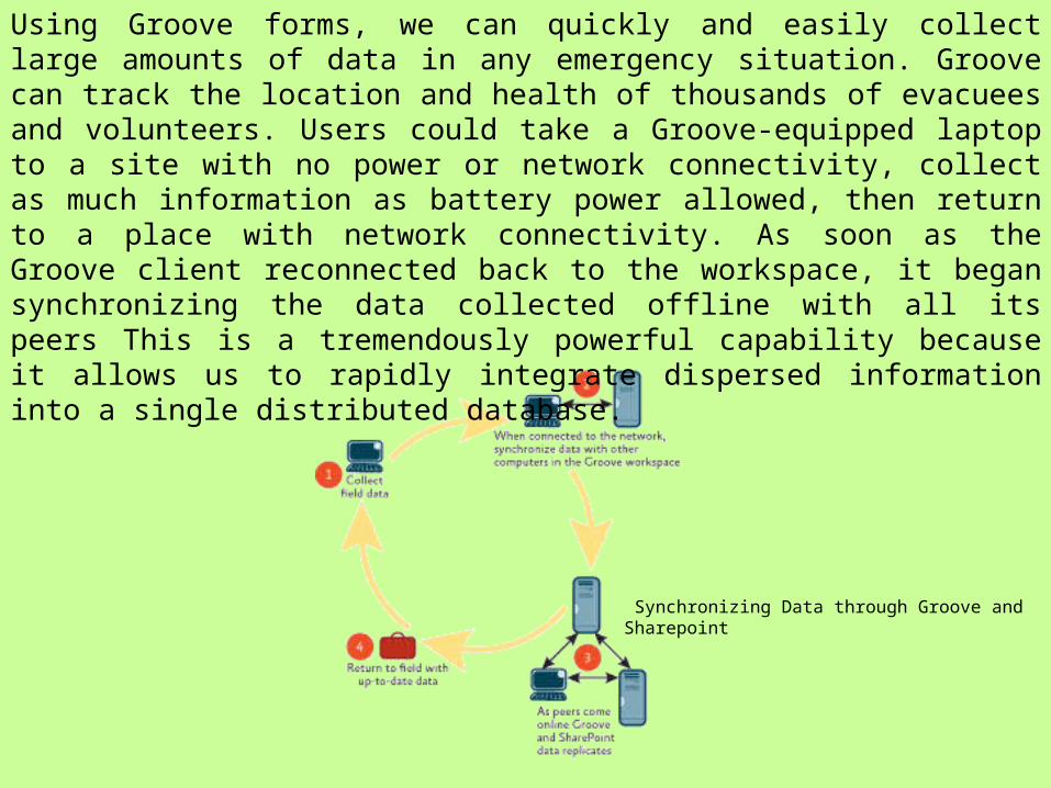
Synchronizing Data through Groove and Sharepoint
Using Groove forms, we can quickly and easily collect large amounts of data in any emergency situation. Groove can track the location and health of thousands of evacuees and volunteers. Users could take a Groove-equipped laptop to a site with no power or network connectivity, collect as much information as battery power allowed, then return to a place with network connectivity. As soon as the Groove client reconnected back to the workspace, it began synchronizing the data collected offline with all its peers This is a tremendously powerful capability because it allows us to rapidly integrate dispersed information into a single distributed database.
BASIS FOR EOC- TOOLS?
Mapping, Database Construction and Decision Making
• Resource Mapping: hospitals, police stations, transport services, blood banks, medicine shops, doctors, cranes, tent suppliers, water suppliers, ST depots, NGOs, fire stations etc.
• Applications- record keeping and status of ongoing work, risk assessment; scenario analysis or analysis of consequences; forecast and projection; dissemination of information; allocation of personnel, equipment and other resources; reaching various affected areas by relief personnel; damage assessment and so on.

Information Technology- Issues (conceptual, technical, socio-technical, political, institutional and financial
perspectives)
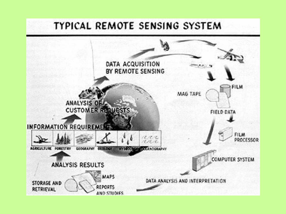
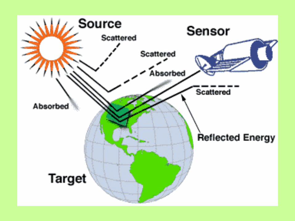
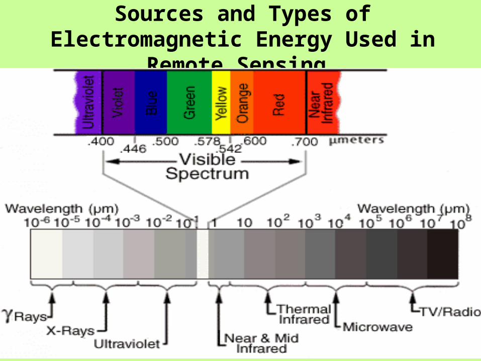
• Geographical Information Systems (GIS), Remote Sensing (RS), and Global Positioning System (GPS)
• The integration of such technologies with each other and with other technologies such as decision support systems (DSS), the world-wide-web and simulators has created more effective disaster management.
• Developing Spatial Data Infrastructure to Facilitate Disaster Management
• Emergency Response Modeling and Simulation Systems (ERMSSs)
• The access networks- inter- and intranets, policy and standards
• Parallel Computing- Distributed computing
• A web-based disaster management system for data sharing, data exchange and data analysis using an SDI model.
• National Natural Disaster Knowledge Network:- (Nanadisk-Net) – Digital Library Multilinguistic and e-training-
It is a platform to facilitate an interactive dialogue with all government departments, research institutions, universities, community-based organizations and even individuals. The network acts as a digital library service and facilitates access to global databases and early warning systems in a significant way. The Knowledge Network is designed to give a boost to technical cooperation among developing countries and to expand international relationships to include exchange of information and transfer of technology. Nanadisk-Net also promotes e-training and have the feature of many languages through a translation software.
The Information System is structured at four levels:• First level – National Government (through the Standing Committee for Protection of the Population in the Events of Major Natural and Man-MadeDisasters /SCPP/ under the Council of Ministers; the National SituationCenter at the State Agency for Civil Protection (SACP), ministries and agencies);• Second level – district administrations;• Third level – municipalities;• Fourth level – peripheral (high-risk industrial or business facilities, power stations, sensitive points, research sites, observatories, warning and alert systems, etc.).
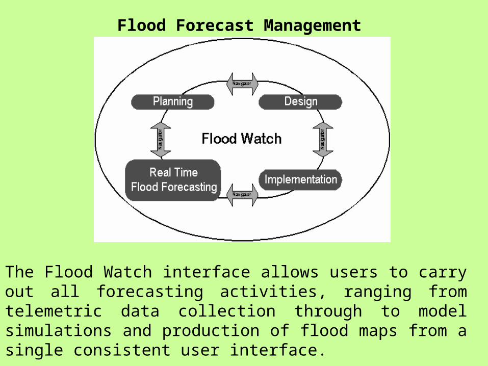
Flood Forecast Management
The Flood Watch interface allows users to carry out all forecasting activities, ranging from telemetric data collection through to model simulations and production of flood maps from a single consistent user interface.
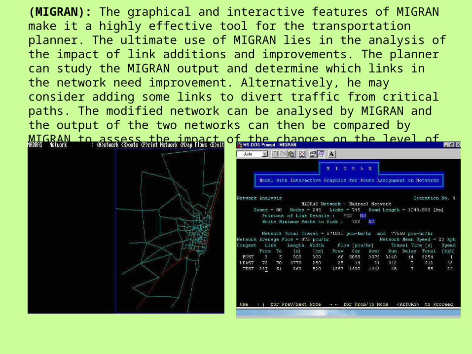
(MIGRAN): The graphical and interactive features of MIGRAN make it a highly effective tool for the transportation planner. The ultimate use of MIGRAN lies in the analysis of the impact of link additions and improvements. The planner can study the MIGRAN output and determine which links in the network need improvement. Alternatively, he may consider adding some links to divert traffic from critical paths. The modified network can be analysed by MIGRAN and the output of the two networks can then be compared by MIGRAN to assess the impact of the changes on the level of service.
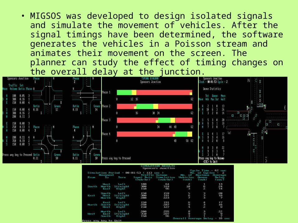
• MIGSOS was developed to design isolated signals and simulate the movement of vehicles. After the signal timings have been determined, the software generates the vehicles in a Poisson stream and animates their movement on the screen. The planner can study the effect of timing changes on the overall delay at the junction.
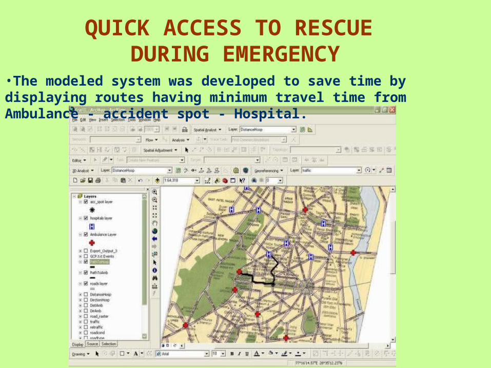
QUICK ACCESS TO RESCUE DURING EMERGENCY
•The modeled system was developed to save time by displaying routes having minimum travel time from Ambulance - accident spot - Hospital.
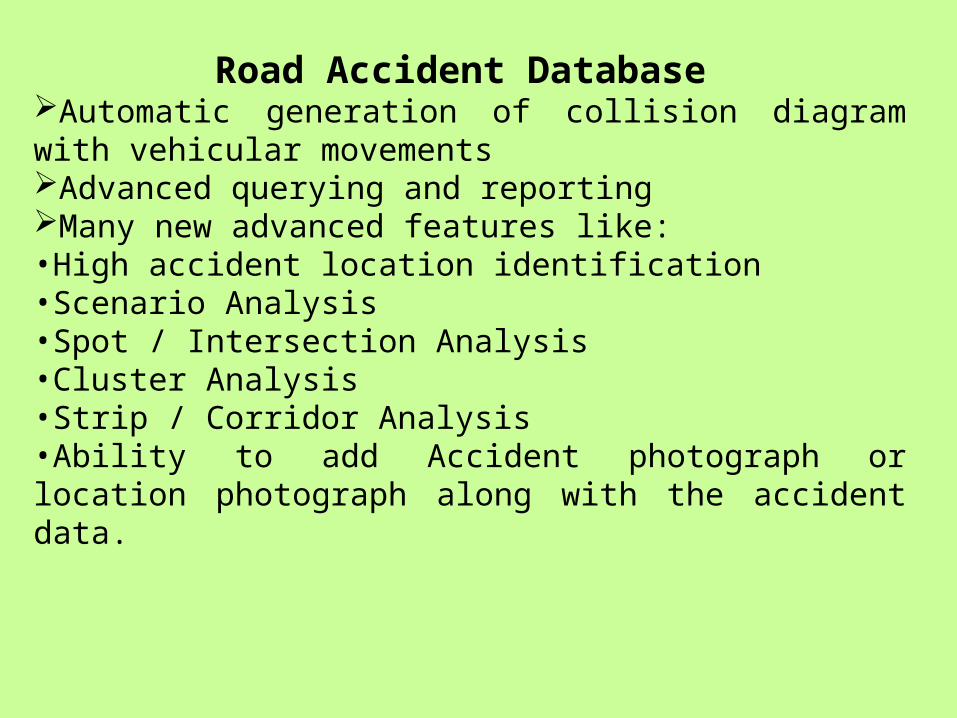
Road Accident Database Automatic generation of collision diagram with vehicular movements Advanced querying and reporting Many new advanced features like: •High accident location identification •Scenario Analysis •Spot / Intersection Analysis •Cluster Analysis •Strip / Corridor Analysis •Ability to add Accident photograph or location photograph along with the accident data.
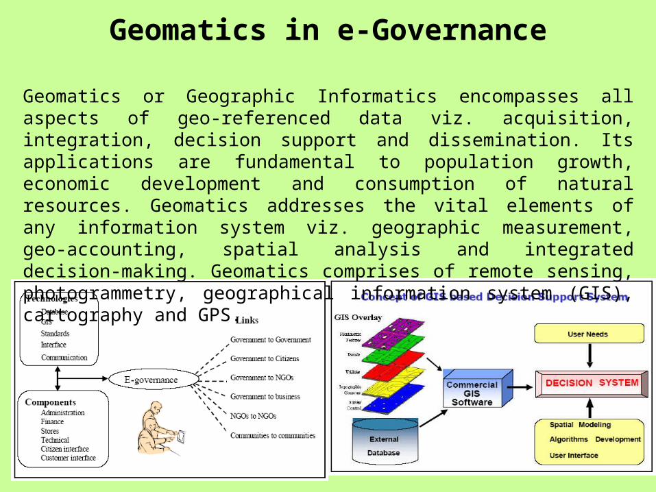
Geomatics in e-Governance
Geomatics or Geographic Informatics encompasses all aspects of geo-referenced data viz. acquisition, integration, decision support and dissemination. Its applications are fundamental to population growth, economic development and consumption of natural resources. Geomatics addresses the vital elements of any information system viz. geographic measurement, geo-accounting, spatial analysis and integrated decision-making. Geomatics comprises of remote sensing, photogrammetry, geographical information system (GIS), cartography and GPS.
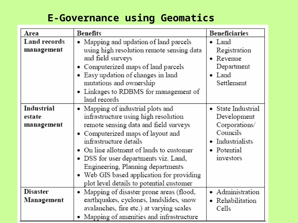
E-Governance using Geomatics
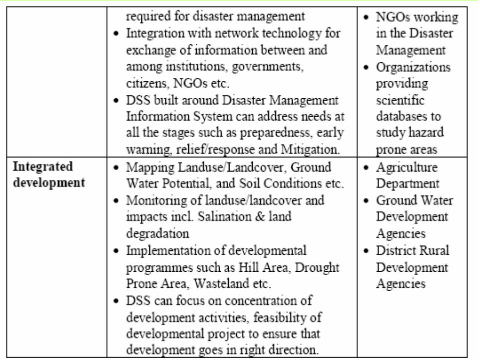
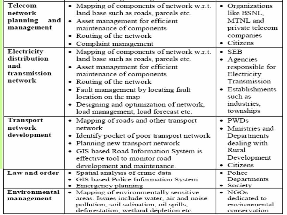
• Rural road informationAs e-Gram Suvidha encompasses rural road inventory, key information corresponding to any selected road segment on the map can be easily obtained. The road information may consist of category of the road (NH: National Highways, SH: State Highways, MDR: Major District Road, ODR: Other District Road, OR: Other Roads) and type of the road (BT: Black Top, WBM, Earthen, Gravel), status (poor/good/average), length of road, population and villages benefited.
• GIS Combines spatial and non-spatial data; Icons for infrastructure / projects at Block & Panchayat levels; Thematic maps on works / sanctioned amount / pending works; Geographic distribution of projects clearly seen; Clustering of projects in a Block or neglect of Panchayat identified.
• The area traffic control (ATC) centre is the operational hub of the transport system. From the centre the traffic signals are constantly being monitored and the timings are being adjusted to aid the flow of traffic. Sensors are placed on the entire road, which help in detecting traffic density. The traffic signals are then controlled by a central control room. Faults are recorded and passed onto the engineers on street and the data is collected to aid the future development of traffic schemes.
• Traffic information service: Increasing importance is attached to provide upto the minute information to road users about the condition of the transport network. A central database of incident and road network information is maintained comprising data, which has been supplied from a varity of sources including police, Local authorities, utility companies, public transport operators, media persons for broadcasting and the end users.
• Aims of ATC system are• Automated Vehicle Identification and Classification• Automatic Vehicle Location• Pedestrian Movement Detection• Real Time Traffic Transmissions • Pollution monitoring• Environment conservation
Tools for More Informed Decisions• With Autodesk Crisis Command 2 users can be more confident in the
outcome of decisions made using new tools for tasks including sharing site and resource information, managing data for incidents in progress, and performing recovery analysis. Key features and benefits of Autodesk Crisis Command 2 include:
• Incident reporting and notification – Enhancements allow users to better track events, record incident history and automatically alert appropriate emergency managers for efficient event response and management, and insightful post-incident analysis.
• Situational and spatial awareness – Tools for critical asset tracking and buffer creation allow users to generate reports on map features within a selected location for situational and spatial awareness and analysis.
• Planning and locating resources – Landmark information, planning and drawing tools allow users to better visualize resources, mark up and share information for pre-planning emergency preparedness.
• Improved management and security - Work order, time reporting and administrative tools ensure emergency managers can secure access to information, manage and track assigned tasks, and understand time spent and personnel costs.
The Autodesk Emergency Response Solution
The Autodesk Emergency Response Solution consists of interoperable Autodesk technologies and services, including Autodesk MapGuide Web mapping software to manage and distribute information about an incident to anyone who needs it; Autodesk Crisis Command 2; and Autodesk Mobile Command software to provide both tactical and strategic capabilities including functionality for fire attack pre-planning, fire flow/bomb blast analysis, sniper/counter sniper capabilities, dynamic 3D visualization, and command and control. , Autodesk also uses its Autodesk Pre-Plan Command software to create and edit maps and drawings, and help non-technical users quickly transform architectural drawings and floor plans into ready-to-use tactical and fire attack pre-plans that can track casualties with up-to-date information during an incident.
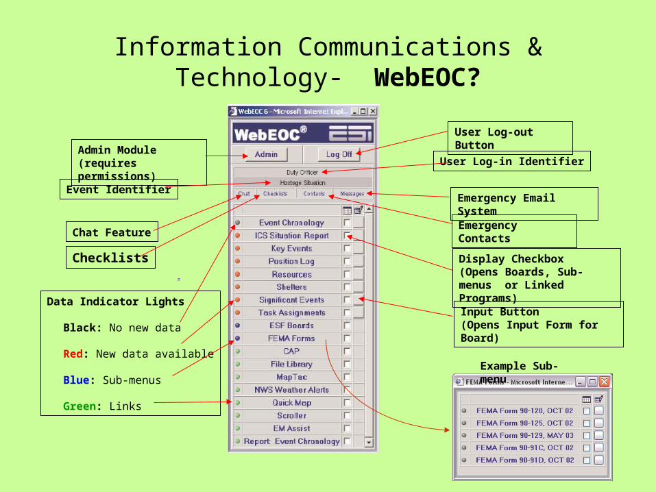
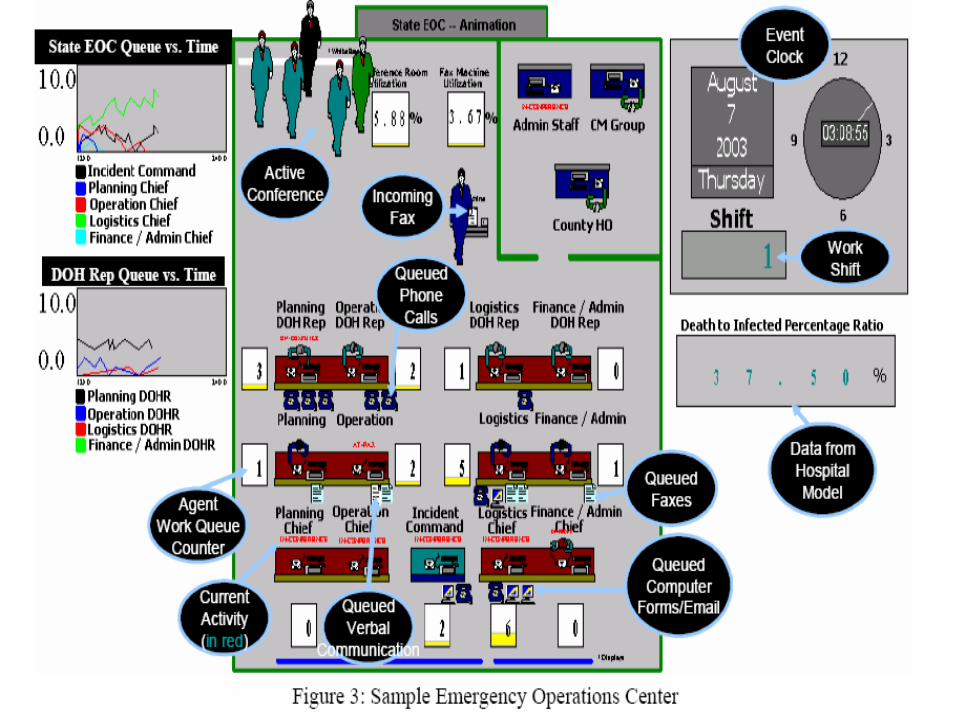
Information Communications & Technology- WebEOC?
Admin Module(requires permissions)
Event Identifier
Chat Feature
Data Indicator Lights
Black: No new data
Red: New data available
Blue: Sub-menus
Green: Links
User Log-out Button
User Log-in Identifier
Emergency Email System
Display Checkbox(Opens Boards, Sub-menus or Linked Programs)
Input Button(Opens Input Form for Board)
Checklists
Emergency Contacts
Example Sub-menu
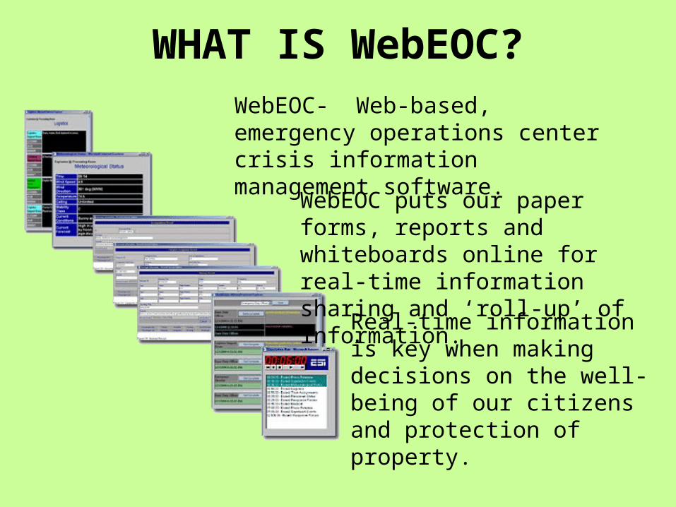
WHAT IS WebEOC?WebEOC- Web-based, emergency operations center crisis information management software.
WebEOC puts our paper forms, reports and whiteboards online for real-time information sharing and ‘roll-up’ of information.
Real-time information is key when making decisions on the well-being of our citizens and protection of property.
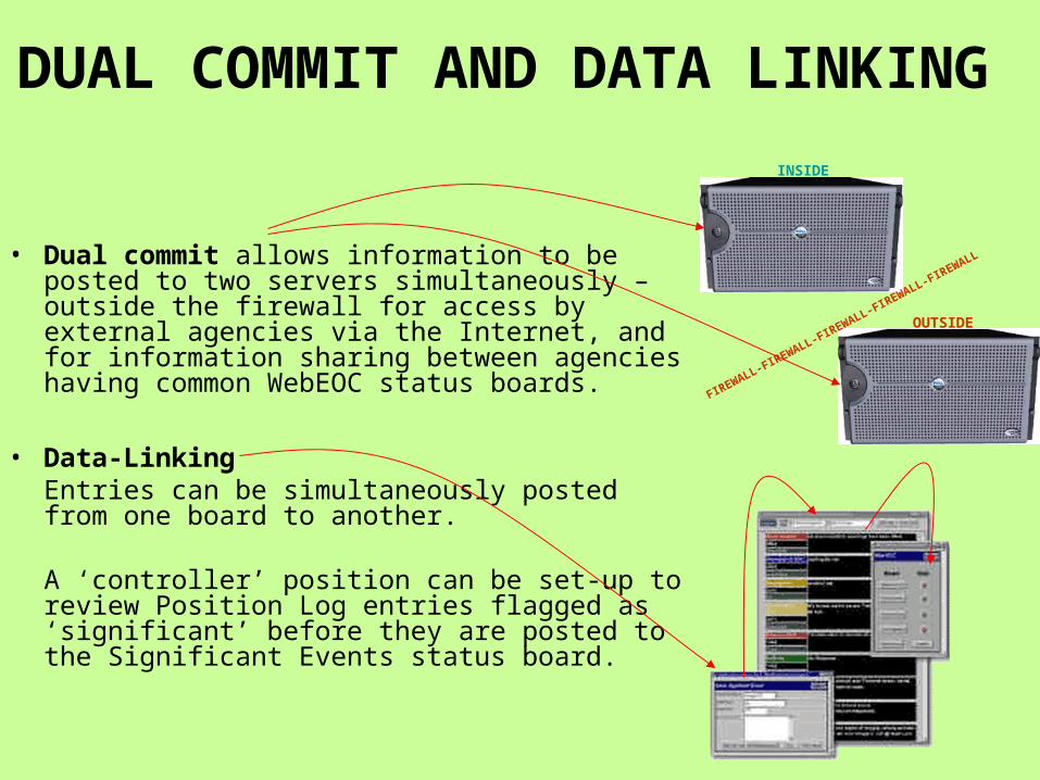
DUAL COMMIT AND DATA LINKING
• Dual commit allows information to be posted to two servers simultaneously – outside the firewall for access by external agencies via the Internet, and for information sharing between agencies having common WebEOC status boards.
• Data-LinkingEntries can be simultaneously posted from one board to another.
A ‘controller’ position can be set-up to review Position Log entries flagged as ‘significant’ before they are posted to the Significant Events status board.
FIREWALL-FIREWALL-FIREWALL-FIREWALL-FIREWALL
INSIDE
OUTSIDE
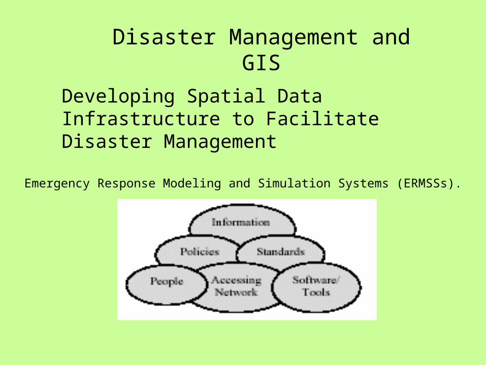
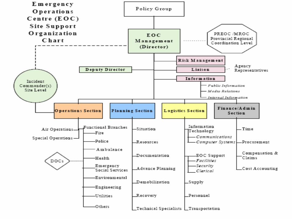
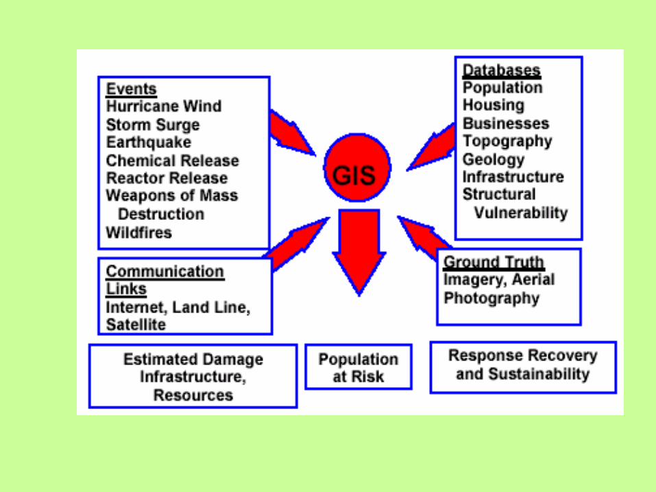
Disaster Management and GIS
Developing Spatial Data Infrastructure to Facilitate Disaster Management
Emergency Response Modeling and Simulation Systems (ERMSSs).
Sources and Types of Electromagnetic Energy Used in Remote Sensing
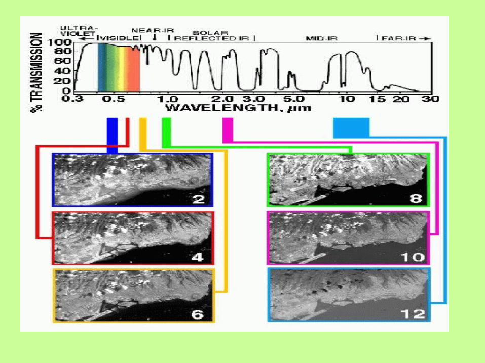

Range direction
Pulse length
Detector
modulator
transmitter
Tranmit/ Receive switch
Antenna
Syncroniser
Receiver
Mixer & local oscilator
Aircraft
film Analogue tape
Digital tape
Ground surface
Azimuth direction
Previous scan lines
SLAR
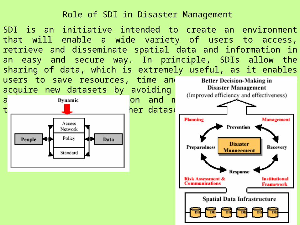
Role of SDI in Disaster Management
SDI is an initiative intended to create an environment that will enable a wide variety of users to access, retrieve and disseminate spatial data and information in an easy and secure way. In principle, SDIs allow the sharing of data, which is extremely useful, as it enables users to save resources, time and effort when trying to acquire new datasets by avoiding duplication of expenses associated with generation and maintenance of data and their integration with other datasets.
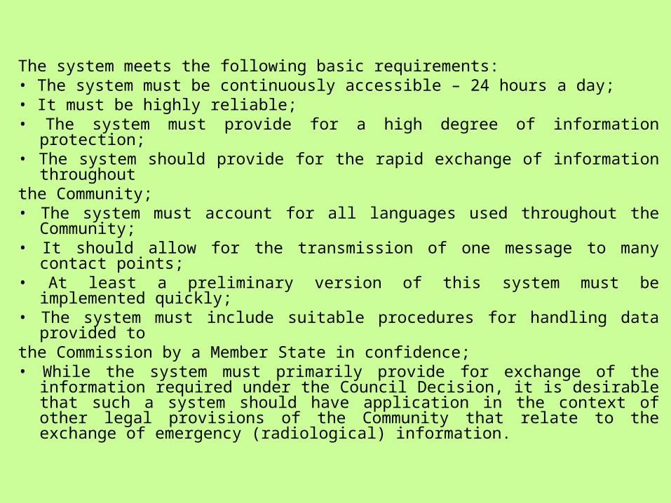
The system meets the following basic requirements:• The system must be continuously accessible – 24 hours a day;• It must be highly reliable;• The system must provide for a high degree of information protection;• The system should provide for the rapid exchange of information throughoutthe Community;• The system must account for all languages used throughout the
Community;• It should allow for the transmission of one message to many contact points;• At least a preliminary version of this system must be implemented quickly;• The system must include suitable procedures for handling data provided tothe Commission by a Member State in confidence;• While the system must primarily provide for exchange of the information
required under the Council Decision, it is desirable that such a system should have application in the context of other legal provisions of the Community that relate to the exchange of emergency (radiological) information.
Conclusions
• An EOC is a unique environment for most IT professionals. Many of the services often taken for granted, such as high bandwidth and Internet connectivity, cannot be relied on during an emergency. Thus, the systems put in place to manage emergencies must be able to deal with scenarios where connectivity may be spotty and users widely dispersed, but where it's more crucial than ever to have secure, reliable access to data. By combining SharePoint and Groove, it’s possible to build an EOC that's survivable and able to come to the needs of serious disasters.
• A Virtual EOC can be a core concept of operations or an adjunct to a traditional EOC. Participants can share information, make decisions, and deploy resources without the requirement to be physically present in the operations center. A Virtual EOC can allow participants to work from their normal workstation, from home, or from the field with data, information and plans available from any location.
Key Solution
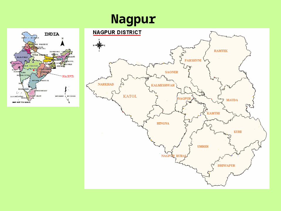
Nagpur District
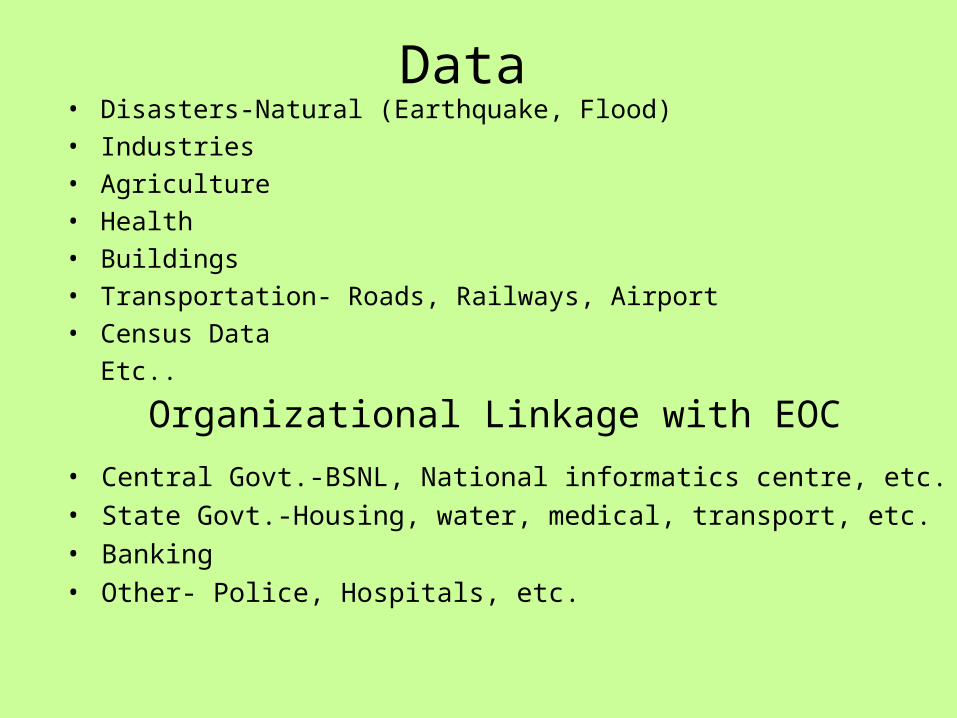
Data • Disasters-Natural (Earthquake, Flood)• Industries• Agriculture• Health• Buildings• Transportation- Roads, Railways, Airport• Census Data
Etc..
Organizational Linkage with EOC
• Central Govt.-BSNL, National informatics centre, etc.• State Govt.-Housing, water, medical, transport, etc. • Banking• Other- Police, Hospitals, etc.
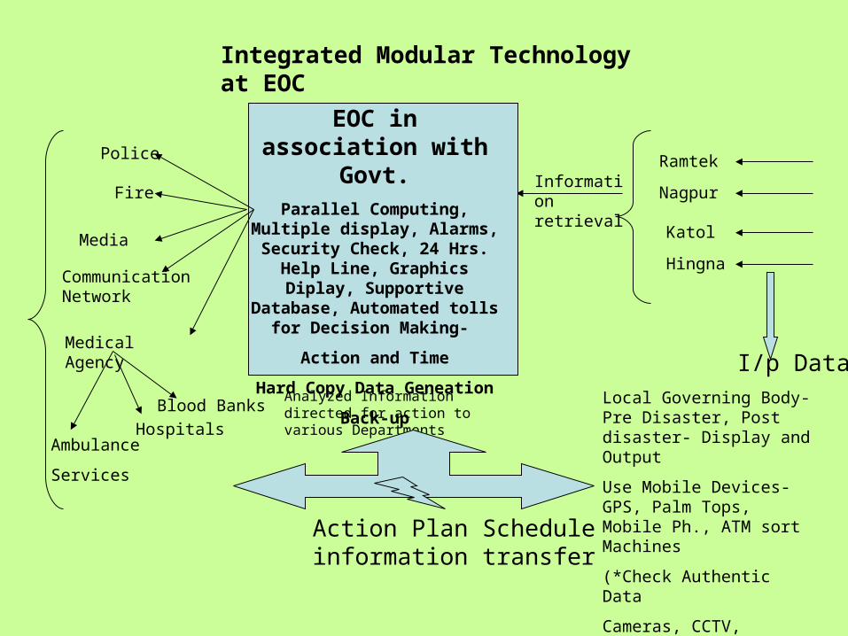
Hingna
Nagpur
Katol
Ramtek
I/p Data Local Governing Body- Pre Disaster, Post disaster- Display and Output
Use Mobile Devices-GPS, Palm Tops, Mobile Ph., ATM sort Machines
(*Check Authentic Data
Cameras, CCTV, Sensors, etc. )
EOC in association with Govt.
Parallel Computing, Multiple display, Alarms, Security Check, 24 Hrs. Help Line,
Graphics Diplay, Supportive Database, Automated tolls for
Decision Making-
Action and Time
Hard Copy Data Geneation
Back-up
Medical Agency
Police
Fire
Blood Banks
HospitalsAmbulance
Services
Analyzed Information directed for action to various Departments
Information retrieval
Media
Communication Network
Action Plan Schedule information transfer
Integrated Modular Technology at EOC

Jai Hind..