Embed Size (px)
Citation preview
SEOA
Civil Engineering Comment Responses
to
Preliminary Draft SupplementalEnvironmental Impact Statement
Dated March 1997
for
Lakepointe Development
RECEJVFDMAY 3 0 1997
SEPA
Submitted by:
KPFF Consulting Engineers1201 Third Avenue, Suite 900
Seattle, WA 98101 -
Phone: (206) 622-5822
Job No. 95379
May 30, 1997
EXHBT_

TABLE OF CONTENTS
COMMENTS
Annotated Copies of Comments
RESPONSES
Attachment A
Attachment B
Attachment C
Attachment D
Attachment E
Attachment F
Attachment G
Attachment H
Attachment I

pc- rpOes c
site. This moderate earthquake has a higher probability, a 40 percent probability of exceedance in 50years, or an estimated occurrence rate (return period) of one event per 100 years.
The effects of seismic shaking on structures are minimized by structural design and constructionspecifications of current building codes.
Liquefaction Potential
Liquefaction potential is greatest where groundwater levels are shallow and where loose, fine sands occurat depths of 50 feet or less. Liquefction potential decreases with increasing grain size, clay, and gravelcontents, but increases with increasing ground acceleration and duration of shaking. On-site groundwateris at depths of 5 to 8 feet. Because layers of loose, sandy soils are present within the upper 50 feet of thesite, liquefaction is an important design consideration for development.
The majority of on-site soils, including wood debris fill, peat and organic silt, and dense sand and gravelare not susceptible to 1iquefction. Peat and organic silts deposits are distributed in a horizontal layer ofrelatively uniform thickness, with no significant unbalanced loading across the site. Therefore, if theunderlying loose alluvium liquefies, the risk of seismically-induced lateral spreading within these upperorganic layers, is low. Beneath the peats and organic silt, some of the explorations encountered loosealluvial sands with interbeds of silt and gravel. Structures above loose alluvial sands could be susceptibleto liquefaction-induced settlement.
IMPACTS OF THE PROPOSED ACTION
Topography and Geology
Topographic Constraints
There are no topographic constraints that would affect the proposed development. The upland portion ofthe site, where building and road development would occur, is relatively flat with elevations ranging from23 to 32 feet. Alteration of the site topography under the Proposed Action would be limited to demolition LIof existing buildings, excavation for building and garage areas (need detail here; why need for cut,relationship to MTCA), and fill for a portion of the embankments for the Lakepointe Way intersectionswith NE Bothell Way and 68th Avenue NE. Utilizing piles to elevate the majority of proposed structuresabove the existing site elevations would minimize the amount of cut volumes. Total excavation volumeswould range from approximately 160,000 to 180,000 cubic yards, and total fill volumes would range fromapproximately 65,000 to 75,000 cubic yards. (need to discuss transport ofmaterial off-site?)
Steeper slopes in the shoreline area, generally less than 10 feet in height, would be protected, stabilized orenhanced. No building or roadway development is planned within or near the slopes along the LakeWashington and Samrnamish River shoreline area. Proposed development within or in the vicinity of theseslopes would be limited to public viewpoints and stormwater outfall locations. Grading in these areaswould be limited and slopes would be planted with native vegetation to minimize any erosion impacts. Thesite topography poses no significant constraint to implementing any of the shoreline enhancement orprotection options.
Lakepointe Mixed Use Master Plan Draft SEIS - Earth 3-10
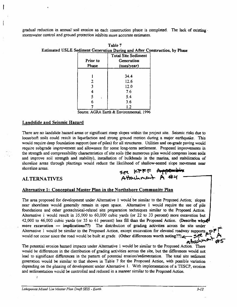
gradual reduction in annual soil erosion as each construction phase is completed. The lack of existing -
stormwater control and ground protection inhibits more accurate estimates.
Table 7Estimated USLE Sediment Generation During and After Construction, by Phase
Total Site SedimentPrior to GenerationPhase (tons/year)
1 34.42 12.63 12.04 7.65 5.46 3.67 1.2
Source: AGRA Earth & Environmental, 1996
Landslide and Seismic Hazard
There are no landslide hazard areas or significant steep slopes within the project site. Seismic risks due toloose/soft soils could result in liquefaction and strong ground motion during a major earthquake. Thiswould require deep foundation support (use of piles) for all structures. Utilities and on-grade paving wouldrequire subgrade improvement and allowance for some long-term settlement. Proposed improvements inthe strength and compressibility characteristics of site soils (the numerous piles would compress loose soilsand improve soil strength and stability), installation of buLkheads in the marina, and stabilization ofshoreline areas through plantings would reduce the likelihood of shallow-seated slope movement nearshoreline areas. #t-4
P 414 1Alternative 1: Conceptual Master Plan in the Northshore Community Plan
The area proposed for development under Alternative 1 would be similar to the Proposed Action; slopesnear shorelines would generally remain in open space. Alternative I would require the use of pilefoundations and other geotechnicai-related site preparation techniques similar to the Proposed Action.Alternative 1 would result in 35,000 to 60,000 cubic yards (or 22 to 33 percent) more excavation but42,000 to 46,000 cubic yards (or 35 to 61 percent) less fill than the Proposed Action. (Describe whmore excavation — implications??) The distribution of grading activities across the site underAlternative 1 would be similar to the Proposed Action, except excavation for elevated roadway supportswould not occur since the road would be built at grade. (Other differences worth noting??) - bet- 1—
The potential erosion hazard impacts under Alternative I would be similar to the Proposed Action. Therewould be differences in the distribution of grading activities across the site, but the differences would notlead to significant differences in the pattern of potential erosion/sedimentation. The total site sedimentgeneration would be similar to that shown in Table 7 for the Proposed Action., with possible variationdepending on the phasing of development under Alternative 1. With implementation of a TESCP, erosionand sedimentation would be controlled and reduced in a manner similar to the Proposed Action.
ALTERNATIVES
Lakepoinre Mixed Use Master Plan Draft SEIS - Earth 3-12

WATER
This section summarizes the analyses and findings of several technical reports prepared by members ofthe Lakepointe water resources evaluation team. The team consists of Beak Consultants, KPFFConsulting Engineers and AGRA Earth and Environmental. The full technical reports are included inAppendices _, and —.
AFFECTED ENVIRONMENT
Surface Water Quantity
Rivers and Lakes
Sammamish River
The Sammamish River is approximately 15.3 miles long. The river, which has been channelized by theArmy Corps of Engineers for its entire length, generally flows north and west from Lake Sammamish toLake Washington. The site borders the north side of the Sammamish River at its confluence with LakeWashington.
Lake Washington
Lake Washington, which borders the west side of the site, is the largest lake in King County, with adrainage area of 472 square miles and an area of 21,500 acres. The lake has a volume of 2.35 millionacre-feet, a mean depth of 108 feet, and a maximum depth of 214 feet. The main inflows to the lake arethe Cedar River in the south end (57 %) and the Sammamish River in the north end (27 %). The LakeWashington watershed is considered urban, with approximately 63 percent of its area developed (Metro1989).
Site Drainage Characteristics
The site is located within the Lake Washington Drainage Basin (North Section). All runoff generated onthe site eventually flows to Lake Washington, although some surface water does reach the SammamishRiver at it’s confluence (river mouth) with Lake Washington. Surface water drainage from anapproximately 24-acre area north of NE Bothell Way is either conveyed under the site, via anunderground pipe, to Lake Washington or is infiltrated to groundwater. Refer to Appendix .., TechnicalInformation Report, for maps indicating the various drainage basins in the site vicinity. Groundwaterfrom this area migrates to the groundwater table under the site.
The site currently contains approximately 14 acres in impervious surfaces, including 10 acres of parkingarea, 3 acres of building area and 1 acre of roadway. Existing stormwater flows are calculated to be 16cubic feet per second (cfs) for the 25-year storm and 22 cfs for the 100-year storm. Surface water fromon-site impervious areas currently sheet flows to catch basins where it is collected and conveyed by pipeto Lake Washington and the mouth of the Sammamish River. (need more description on existingdrainage system - locations ofpipes and ourfatis) Precipitation that falls on pervious surfaces on the
Lakepointe Mixed Use Master Plan Draft SEIS - Water 3-20

1the organic wood leachate of the fill and peat soils. Lead concentrations in the groundwater are
- Iattributed to lead paint coatings on wood debris. The source of arsenic concentrations in the groundwateris not known, but may be due to the presence of treated piling in the wood debris: copper arsenate is usedas a wood preservative. (do these levels exceed standards - fso, by how much)
IIMPACTS OF THE PROPOSED ACTION
V
Surface Water QuantityV I
Development of the Proposed Action would increase the area of impervious surfaces (i.e., decrease thearea available for stormwater infiltration). At full buildout of the first six phases of the Master Plan,approximately 27 acres (approximately 60 percent of the 45 acres included in the first six phases of theMaster Plan) would be covered in impervious surfaces, compared to less than 32 percent in the existingcondition. The proposed 27 acres of impervious surfaces would include approximately 14 acres of roads,walkways and parking areas, and 13 acres of building area.
All runoff generated by the proposed impervious surfaces would be directed to a storm draina2e system (‘ V
which would collect, treated through a variety of stormwater treatment facilities, and discharge to onelocation in the inner harbor, one location at Lake Washington, and three locations along the SammamishRiver. t p 2. tW ve
The locations for stormwater discharge along the Sammamish River and Lake Washington would be Usimilar to that under the existing condition (need to identjfy all existing outfall locations). However, the Idischarge of stormwater into the inner harbor would be different from existing conditions (currently nodischarge to the inner harbor); a primary purpose of discharging to the inner harbor would be to provideflushing of the current stagnant water in the harbor.
Because the site is located adjacent to Lake Washington and the Sammamish River and stormwaterrunoff would not impact downstream properties, no detention facilities are required and none areproposed.
V Upon full development of the first six phases of the Master Plan, it is estimated that flows of- approximately 26 cubic feet per second (cfs) for the 25-year storm and 35 cfs for the 100-year storm
would be generated, compared to 16 cfs and 22 cfs under existing conditions, respectively (verify)?V
Because no detention facilities would be provided, the duration of stormwater flow would not besignificantly greater than under existing conditions (do we need to calculate flows at each outfall
VV V location, any erosion potential at outfall, describe measures to mitigate erosion un acts at)utfall locations?) 4Pi” ,cA,”i-Z+
‘!‘ IV torm runoff from the Proposed Action would be treated to remove pollutants in one of three ways.
-rom the high-use-traffic areas (Lakepointe Way, Lakepointe Boulevard and surface parking areas),;tormwater runoff would be routed through a oil/water separator then to a two-celled watervetpond. Discharge from the wetpond would be conveyed by pipe to the north end of the innermarina channel) to promote flushing of the marina area. Stormwater from the lesser-usedincluding NE 173rd Place and NE 174th Street) would be directed to one of two sand
filtration/biofiltration swales for treatment. Treated discharge from these swales may be directed to the
Lakepoinre Mixed Use Master Plan Draft SE/S - Water 3-25
I
F
I
II
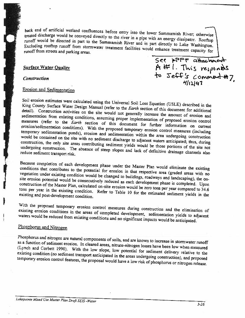
back end of artificial wetland confluences before entry into the lower Sammamish River; otherwisetreated discharge would be conveyed directly to the river in a pipe with an energy dissipator. Rooftop \runoff would be directed in part to the Sammamish River and in part directly to Lake Washington.Excluding rooftop runoff from stormwater treatment facilities would enhance treatment capacity forrunoff from streets and parking areas.
____________________________
5k -tF Ø(tCL%
I T\.csSurface Water Oualitv
Construction
Erosion and Sedimentation
Soil erosion estimates were calculated using the Universal Soil Loss Equation (USLE) described in theKing County Surface Water Design Manual (refer to the Earth section of this document for additionaldetail). Construction activities on the site would not generally increase the amount of erosion andsedimentation from existing conditions, assuming proper implementation of proposed erosion controlmeasures (refer to the Earth section of this document for further information on currentrosionJsedimentation conditions). With the proposed temporary erosion control measures (includingtemporary sedimentation ponds), erosion and sedimentation within the area undergoing constructionwould be contained on the site with no sediment discharge to adjacent waters anticipated; thus, duringconstruction, the only site areas contributing sediment yields would be those portions of the Site notundergoing construction. The absence of steep slopes and lack of definitive drainage channels alsoreduce sediment transport risk.
Because completion of each development phase under the Master Plan would eliminate the existingconditions that contributes to the potential for erosion in that respective area (graded areas with novegetation under existing condition would be changed to buildings, roadways and landscaping), the on-site erosion potential would be consecutively reduced as each development phase is completed. Uponconstruction of the Master Plan, calculated on-site erosion would be zero tons per year compared to 34.6tons per year in the existing condition. Refer to Table 10 for the estimated sediment yields in theexisting and post-development condition.
With the proposed temporary erosion control measures during construction and the elimination ofexisting erosion conditions in the areas of completed development, sedimentation yields to adjacentwaters would be reduced from existing conditions and no significant impacts would be anticipated.Phosphonis and Nitrogen
Phosphorus and nitrogen are natural components of soils, and are known to increase in stormwater runoffas a function of sediment erosion. In cleared areas, nitrate-nitrogen losses have been low when measured(Lynch and Corbett 1990). With the low slope, low potential for sediment delivery relative to theexisting condition (no sediment transport anticipated in the areas undergoing construction), and proposedtemporary erosion control features, the proposal would have a low risk of phosphorus or nitrogen release.
Lakepoinre Mixed Use Master Plan Draft SEIS - Water3-26

UTILITIES
Note: The Project Team (possibly kpfl) will need to provide additional information in order to complete this section. The requested information is summarized on the two pages following this section.
AFFECTED ENVIRONMENT
Water Supply
The Northshore Utility District supplies water to existing users on the site and in the vicinity. There are12-inch diameter water mains in both 68th Avenue NE and NE 175th Street, with existing pressure ofapproximately 125 pounds per square inch (psi). Existing fire flow available in the site vicinity isapproximately 5,000 gallons per minute (gpm). An existing 8-inch cast iron/ductile iron water mainconstructed in 1974 and 1980 provides domestic water and fire flow to existing uses on the site.
The Northshore Utility District provides domestic water from three reservoirs located
______.
The Districthas included the estimated water demands of the Proposed Action in its projected future demands.(Existing use and capacity?? Avg. year/month and peak year/month demand...)
Sewer/Solid Waste
Sewer
The Northshore Utility District supplies water to existing users on the site and in the vicinity. There is a42-inch diameter reinforced concrete pipe gravity sewer main in NE 175 Street. Existing sanitary sewerservices on the site connect to the 42-inch sewer by 8-inch PVC gravtv mains.
A METRO pump station is located adjacent to the northern portion of the site. Other sewer mainsassociated with this pump station include a 78-inch diameter METRO pipe, and two 132-inch diameterpipes are located under the Burke-Gilman Trail. Existing buildings east of the pump station connect bygravrtv main to the 78-inch METRO pipe.
Solid Waste
Unincorporated areas of King County are served by private garbage collection companies, which receivefranchises through the Washington State Utilities and Transportation Commission (WUTC). EastsideDisposal currently serves the Kenmore area. Refuse is taken to the Houghton Transfr Station in Kirkland,and then to the Cedar Hills Regional Landfill. Eastside Disposal provides full residential recycling servicefor glass, alumaium, tin, cardboard, mixed paper, newspaper-, and plastic bottles.
The King County Comprehensive Solid Waste Management Plan (CSWMP) guides the County’s solidwaste planning. A waste characterization study in the 1992 CSWMP estimated waste disposal rates of0.26 tons/multi-family resident/year, and 0.73 tons/commercial employee/year. These are equivalent torates of 1.42 pounds/multi-family resident/day, and 4.0 pounds/commercial employee/day (CSWMP,Appendix B, 1992).
Some of the existing commercialjindustnal uses on the site generate solid waste, likely including cardboard,wood, plastic and paper. Also. construction debris, including waste roofing materials, was stockpiled onthe site until it was removed in 1996.
L.akepointe Mixed Use Master Plan Draft SEIS. Utilities
I- ‘
3-208

pfrJ•
IEnergy
Electrical service in the site vicinity is provided by the Puget Sound Power and Light Company (Puget Power).
Existing on-site uses are served by underground transmission lines (Sizing??) along NE 175th Street. (Capacity
of existing system??flmps??)
The Washington Natural Gas Company (WNG) provides natural gas service to the site vicinity. The system
consists of a network of mains and distribution lines located throughout the area. The nearest gas mains are a 4-
inch high pressure line along NE 175th Street and a 6-inch high pressure line along 68th Avenue NE. (Capacity of
existing system??) 5 pp
IMPACTS OF THE PROPOSED ACTION , 7
Water Supply
The Proposed Action would obtain water through extensions from the existing water lines in 68th Avenue yJ INE and NE 175th Street. The on-site water lines would be installed in a looping configuration around the1’
site perimeter and under (the new street), with extensions to the proposed structures.
The Proposed Action would generate daily domestic water demands of approximately — gpd and fire
flow demands of
______
gpm for _-hour duration. The Northshore Utility District would be able to
supply the needed volumes of water to serve the Proposed Action. =Sewer/Solid Waste
Sewer
The Proposed Action would obtain sanitary sewer service by extension from the existing sewer line in NE I175th Street through the center of the proposed structures.
The Proposed Action would generate daily sewer volumes of approximately
_____
gpd. The Northshore
Utility District would be able to accommodate the expected additional wastewater volume.
Solid Waste IUsing the factors cited in the CSWMP, the Proposed Action would generate an estimated — tons of solid
waste per day from residential and commercial sources. Residential uses would generate an estimated 585
tons for disposal per year, and commercial uses would generate an estimated tons per year. Eastside
Disposal would provide solid waste collection and residential recycling services to the site. As required by
King County, construction, demolition and land clearing (CDL) debris would be transported to approved
disposal locations.
Energy
Lakepointe Mixed Use .tt’aster Plan Draft SEIS - Utilities 3-209

ALTERNATWES
Alternative 1: Conceptual Master Plan in the Northshore Community Plan
Water Supply
Sewer/Solid Waste
Natural Gas and Electricity
Alternative 2: No Action Alternative
Under the No Action Alternative, existing uses of the site would continue, and there would be no impact onthe provision of utilities.
MITIGATION MEASURES
SIGNTFICANT UNAVOIDABLE ADVERSE IMPACTS
Water
With implementation of the proposed mitigation measures, no significant unavoidable water system impactsare expected.
Sewer/Solid Waste
With implementation of the proposed mitigation measures, no significant unavoidable sewer or solid wasteimpacts are expected.
Enerv
With implementation of the proposed mitigation measures, no significant unavoidable electricity or naturalgas impacts are expected.
Lakepointe Mixed Use Master Plan Draft SEIS - Utilities 3-210

(1FF c & p c ô ct.-Le4
k rj4.UTILITIES INFORMATION NEEDS
______
__
treated by weond and whichareas will be treated by biofiltration,
• When discussing downstream erosion, a discussion on the potential for erosionat each discharge location should be provided.
• V Describe how post development storm flows would be higher than existingconditions but would be controlled to limit erosion.
• Under “Sediment Deposition”, quantify the effectiveness of sediment removalunder the proposed system. Would there be sediment impact under the 1 00-yearstorm?
• -
-“‘ / Under “Fire Flow Requirements”, a description of available water systemcapacity for fire flow, without the proposal, is required per the EIS Scope.
• (_) Regarding the Northshore Utility District, state which reservoir serves the site.
•“Regarding “Projected Water Demand”, what is the estimated 3.5 person per unit
assumption based upon; this number seems high for multifamily use.
• -‘ Regarding “Commercial and retail demand”, clarify the assumptions for uses;are you assuming some restaurant uses (which use more water than shops)?
•,.,Regarding “Total Site Water Demand”, for each phase describe the following:
average yearly demand; peak 4 month demand; and, peak week demand (per EISScope).
• () Regarding “Ability to serve Water Demand”, describe total capacity of district,existing demand on district capacity on an overall basis and available districtcapacity to serve the project.
(,, Also, describe any district deficiencies in storage, distribution, firefiow etc.
Regarding “Water District Impacts”, indicate that no boundary expansion isrequired.
Sewer System
• Regarding “Projected Wastewater Flows”, what is the 3.5 persons per unitassumption based on; seems high.
Lakepoinre Mired Ue Master Plan - Utilities Information Needs

.i-Th• () Describe what the estimated effluent from the commercial retail based on.
• ‘Regarding “Capacity of Metro to Treat Sewage”, describe the remainingcapacity of the plant and the ability to serve project flows./
L Regarding “ Construction Waste”, are there any proposed programs for\v composting arid recycling?
Gas/Electricity
7 Is the anticipated demand for natural gas based on primarily using gas or‘ electricity for heating? Please explain in detail.•
‘ The anticipated gas demand for commercial/retail is stated to be for 500,000square feet of area. The actual amount of commercial/retail space is closer to650,000 square feet. Verify with Callison.
Is the anticipated demand for electricity based on primarily using gas orelectricity for heating? Please explain in detail.
i• anticipated electricity demand for commercial/retail is stated to be for500,000 square feet of area. The actual amount of commercial/retail space iscloser to 650,000 square feet. Verify with Callison.
I
I
I
I
r1
I
ILakepointe Mixed Use .W’aster Plan - Utilities information Needs2

03/14/97 FRI 15;47 FAX CALLISON NORTH -i-’-’ KPFF-
— Us 2O La t-ei &.cnd K--
MIMvrnI I 111lM4A RMMIllflfi IJ €w,n*
I1UkIi1 V1Iillh1l J(j1Q ffi, esetrcrl
-
2U5
MEMOR.ANDIJM -November 22, 1996E4.
CiWs.a Ard.itec*,r., lit. —
Z._N ELAI.( Cw4fTo: Nelson —.__
King County DDES
_____________
206423.4646
From: Mike Bhxmen/Rich Schipanski
_____________________
Fa 206-623-4625 -—
Hue Weinntsn Associatesfô,— ,PPF it
Re: Lakepointe Master Plan SETSDraft Technical Report Review t? &CILI /2A-5
This memo outlines our major comxneets on c draft tcchnical reports received by King County
and transmitted to HuckelliWeinmnan Associates. The technical reports reviewed include thefollowing: Technical Reporf on Natural Resources’ (Beak Consultants, October 11);Transportation Impact Malysis (7?&E October 30); Response to Scoping Issues (KPFF,
October 17); Drofi Technlcd Information Report (KPFF, March 15); Supplemental infonriadonto Draft Technicci Information Report (KPFF, October 1): and, Draft Technical Report an Zarth,
Water, Toxic and Hazardous Materials (AGL&I., November 12). This memo is intended as adiscuion tool for our mccting with King County scheduled for Decnber 9. k is assumed thatyou will compile all re’evant comments and prepare a comprdiensive memo to the Applicant
seeking all necessary revisions. The Applicant will then coordinate the preparation of revised
reports for submittal to the County and Huckell/Weinman Associates.
Per our agreement with King County, w have assumcd two round5 of res’ew of technical reports.
Should more than two rounds of review be required to preduce axial reports, an adjusnent in
scope and budget may be warranted, Further, our agreement on schedule (submittal of the
Preliminary SDEIS four weeks after receipt of final reports) is still valid.
The following general comment re1atesto ailof the iechnical repo: “An analysis of the impacts
generated by the SEPA Alternative, with a comparison to the impacts identified for the proposal
must be provided”. It should be noted ‘that this akernativ analysis cannot be perfomed until a sitc
plan, with associated site plan statistics (impervious surfaces, building heights, open space,
roadway alignment, etc.) is prepared and distributed to the technical team, as well as to King
County and HuckeUlWeinman Associates, Therefore, all technical reports should be revised to
include the analysis of the SEPA Alternative.
The following comments do not include our editorial comments; these ccrrnents will betransniittcd to the technical consultants, via King County, separately.
L.2kcpc.iinc 41a.r ‘&u S11S - DPGJ? Tch,iicaI Rpri Comentz I.

03/14/97 FRI 1548 FAX CALLISON NORTH -‘-‘-‘ KPFF
TRAtSPORTAT1ON REPORT - TP&E
Paw!(Pararanh) Comment
I (p 1) It might be useful to briefly summarize the conclusions of the Transpo Report.Should also mention that the Transpo Report analyzed 1000 ridezitia1 units and500,000 square feet of conunercial/retail usc.
5 (p1) lit reference to wNonn,otorized Facilities”, provide discussion on existing air andmarine transportation in the area (listed as an item in the SEIS Scope of Work).
5 (p2) In reference to “Planned Transportation improvnents”, the list of roadwayiprovCU2Ct3 does not inelude the naire of the impiovemcnt. Please deseribe the
type of planrxed improvements.
6 (p4) Provide a conclusionaiy statement on how the different horizon years might affecttraffic assumptions (per SETS Scope of Work).
8 (p2) Regarding NE 175th Street, will retaining the 175th Street alignment result inimproved ciraitation over the earUer realignment proposed in the NSCP (andreflected in P-Suffix conditions)?
9 (p3) Regarding “reductions in gross trips generated”, provide a detailed basis fbr the 35
percent reduction (due to internal trips?). SEIS scope requires an explanation of.ctors included in the trip generation rates.
10 (p 4) Provide a rational for using a different estimate procedure for trips outside of theestablished cordon Uric.
12 (p3) Regarding the “Northshore Community ?lan A1tcnative”, is the trip gcncration
estimate of 14,212 daily trips for the Northshorc alternative based on thc sameassumprkrnc uicd to estimate daily trips for the proposal (i.e. ITE rates). if not7
does a comparison accurately compare impacts?
Also, even though the Northshore Community Plan Alternative has less
commercial/retail space and fewer residential units, the Northshore CommunityPlan Altcrnativc has more daily trips than the proposal. Please explain (possibly
related to the above conmient).
13 (p 1) Please provide a more detailed diSCUSSiOn Ofl impact of the proposal to pedestrian
traffic (i.c. describe on-site trail accessibility, saèty, etc;).
14 (p5) Regarding “changes in the 2005 condition compared to the Transpo Report”.please evplain why the ohanges werc made,
15 (p 3) Plcase ecplain why 140 and 150-second cycles were used instead of the 180-second cycle used in the Transpo Report.
Lkepointe Ma.:er P! S7!.’S - Drr/r Tcchnical Reporr Cammrs 2

O/14/97 FRI 15:,48 FAX CALLISON NORTH -‘-.+ KPFF
(Pczrqg,c,ph) Cornnie,rt
16 (p4) Describe why the transportation performancc measures improve aft Lakepofnte
is developed.
16(p 5) Provide a more detailcd discussion on why tlic system wide Tfliflrq delay
opthnization option was used.
J7(p2) DehowSeu6OofOrdine11617relatcstotacanalvsi&
18 (p3) Is the anticipated queuing of traffIc beyond the intersection of SR S22iakepointc
Way cnzidered a signi6cant impact. xpLain why it Is or is not. Any mitigation
for this impact?
19 (p3) Regarding the Baseline Option, would the increased trips reLate to additional
queuing or LOS inipacts? Would impacts be signi5cant - please discuss.
20 (p4) De5ne the RID process (area. beneted properties etc.), funding responsibilities
and timing of improvements.
21 (p3) Rebc the proposed rnitigalion to the mitigation described in the Transpo Report
arid mitigation established through the zoning actualization. Idtify and discuss
the project’s full mitigation conunitttncnts.
21 (p3) Are there any aLlditional mitigation measures fbr queuing back-up a LOS F
intersection impacts?
RES?ONSE TO SCOPYNC 1SSUS - KP l&41E TjT’
I (p 1) ?leasc describe how proposed excavaaon and fill relates to sue ckmip under
MTCA. It was our understanding that impact related to excavation and till wc
to be described as an element of site cleanup through the MTCA process.
•atcr‘7a 1P4-’ )4
2 (p 2) ?lcse describe in more detail whicl areas will be treated by wetpond and which
areas will be trtcd by bioflltration.
3(p 1) W1 discussing downstreatecn cssior aforcrosion
each discharge location should be provided.
3 (p 4) Descnbe how post ‘ji ZX eiing
conditions but would be controlled to limit erosion.
L..kupain:e A4a.srerP1a’ SEJS DrcIr Tech,iical Repn Cammei:. 3

03/14/97 FRI 15:48 FAX CALLISON NORTH -‘-‘-‘ KPFF OO4
PagE!L?arQzTaph) Cment
3 (p7) Under “Sediment Dcposition”, quan’ the ectivcncss of seiimt rva1
under the proposed system. Would there be sediment impact under the 100-ycar
storm?
ci ?3 (p9) Under “Fire Flow Rnqi.nremàits”, a description of available wa4er system capacity
for re flow, without the proxJic required pcr the E!S Scope.
4 (p2) Regarding the Northshore Utility Distitc reSi.J
4(p 5) Regarding ‘Trojected Waxrnak un
assnmption based upon; this number seems high for multitmily use.
cec- -W( Clhd
4(p7) Regarding “Commercial and rersi] demand”, c1ari the assumptions for uses air
you assuming some istaurant uses (which use more waler than shops)?
S € CADJ-. Vdtbb ,*74 (p8) Regarding ‘Total Sire Water Dcrriand”, for cach phase describo the following
average yearly demand; peak 4 month demand; and, peak veek demand (per EIS
Scope).I0
S (p1) Regarding “Ability to serve Water Demand7’, dcscribe total capacity of dIstrict.
existing demand on district capacity on an overall basis and available district
capacity to serve the project.c- 0JDJ,L u n
Also, describe any district deciencies in storage, distribution, fireflow etc.
ç
5 (p2) Regardmg ‘Water District Impacts, indicatc that no bo’mdary expansion is
required.
rsJSolid Ws
PPF *05 (p 9) Regarding “Projected Wastewarer Flows”, what is the 3.5 persons per
assumption based on seems high.
Sec< (I) Dscribc what thc estimated effluent from the cornmereiai retafl based on. I
ccjL?1’F L.-13 f?56 (p4) Regarding “Capacity of Metro to Trcat Sewage”, describe the remaining caacn
ofthe plant and the ability to serve project flows.
-
6 (p 5) R.cgarding “ Construction Waste”, arc thcrc any proposed programs for
compostirig arid recycling?
L.kcpvint i.fnsrerPla SZZS - Droll 2’echnical Reprr Cirnent.r

03/14/97 FRI 15:48 FAI CALLISON NORTH -‘-‘. !CPFF
Pa2eJ(Parafrqph) Comment
JJecrjcitv)L m’
7(pI) is the anticipated demand fr natural gas based on primarily usiQ gas orelectricity for heaLing? Please ccplain in detail.
ç pj C tLw%.- 1)*i 1%
7(pl) Tho anticipated ga demand for commëruialfretall is ted to be fof 500,000square feet of area The actual amount of commcrciaVretail space is closer to650OOO square feet. Verify with Callison.
7(p 4) Is the arnicipated demand tor electncity based on primarily usmg gas or’clectncitvfor hcating? Please explain in dei1.
*u:7 (p 7) The anticipated electricity demand for commercial!retail is stated tc be for
500,000 square feet of area. The actual amount of commercial/retail space iscloser to 650000 square feet. Verify with Callison.
TEChNiCAL REPOWrON EARTH. WATER, TOXIC_& HAZATZDOUS MATETA1.-AGRA
Overall Appendix A eliminaiy Geotechnical Engineering Evaluation) contains existingsite condition discu.ssions, identiflc.tion of potential impacts, and rmtigatioa
measures (i.e. methane gas, dewatering etc.) which should be incorporated into orreferred tn in the technical report.
Overall it was or understanding that environmental impacts relating to the excavation andfill on the site would be analyzed separately under the MTCA clean-up plan..Therefore, the impact analysis, as it relates to required excavation and fill, shouldinclude a detailed discussion on how the proped grading acthritie relate to theMTCA clean-up process
Eah
l0(p 5) Rega.rding irnpac to Topogrophy/Gcology, thcrc should be a discussion on the
overall plan to access underlying structuraly sound soils through the use of piles,thus minirrijzjn the need to disturb contaminated soils.. There should also be adiscussion on potential impacts related to pile placement.
10 (p5) The discussion on “Additional Oeoteclmical Rcquiremerits”, should recognize thegeotechnical investigations completed to date. Would the additional geotechnicalstudies be considered typical for building permit rcview? If n, we should mentionthat these studics are typical.
13 (p 4) When would the creosote analysis be completed and would this analysis be a partof the MTCA clean-Lip process?
L.akepainre Ma.rep Plan SEIS - Draft Tcchnical Reprr Comain1s 5

03/14/97 FRI 15:49 FAX CALLISON NORTH -i-’-’ KPFF 141006
(zrairaph) Comment
13(p4) How would the use of fill rotate to se1enient potential? Would the use of fill
significantly reduce the potcurial for sctrlcmcnt?
14 (p 1) Describe the relative significance of the ctimated scdiment generation presented in
Tablet. Isthetotal annual existing scdimcntof 34.4 tons per yeara relatively
large number? Docs the 34.4 tons reach adjacent waters and does ft have any
effect on the receiving waters?
14 (p3) Regarding landslide and seismic impacts. dcscribe subgrade improvcmcnt and
relate this rmprovernent to the MTCA clean-ip. This discussion should also
descnbe how the proposed pilings relate (i.e. minimize) to landslide and seismic
impacts.
14 (p 3) The arth cction does ot contain a. nii.tigation discussion. Identify and
consolidate all mitigation, including those idcntifled in Appendix A.
Groundwater
16 (p 1) Is the groundwater table beneath the sire hydrologically conncctcd to the
S2flUflaITLiSh River as well as to Lake Washington?
17(p I) The discussion on surface water may be more appropriately located in the Eatth
section in relation to erosion.
l7 2) When discussing Estimated Increases in Shoreline Erosion, more location
peciflc (outhlls) anaivi should be provided. A1o, indicate f sediment znld
reach adjacent waters (Lake Washington or Sammamish River).
17 (p4) Regardingt1Groundwater”, is infiltration of stomiwater proposed? Not consistent
with KPFFS report.
17 (p5) Is thcrc any potential impact to groundwater quantity as a result of proposed
development? If nor, state:
18 (p3 &4) The discussion on groundwater quality resulting from disruption of the soil cap
should be discussed in terms of the MTCA clean-up. The impacts from IsrrCA
clean-up is not to be analyzed in this docuntent Would not resolution otthe
Clean-up Action Plan li1c)y preclude any possihle impacts to coutaxninnt levels
for the sire?
18 (p 6) The Groundwater ecton does not contain a mitigation section. Identify and
consolidate all mitigation.
Lakqoi;zr Masrcr Plan SEIS. rafr Tcchnicl Rcparf Cø,nmenrs 6

03/14/97 FRI 15:49 IAJ( .‘•‘-‘ l’l.t J VU I
Toxic & Hazardou3 Materia
PgilI?q!afrayh) Comment
2S (p 1 & 4) Define the general term “engineered cap”; how do they work, what type of material
generaUy used, what is required thiclcncss, ctc.
0(p2) Describe what is ment by “localized romediation of the soil or debris?
30 (p4) ft is stated that TMcontact with the debris fill will be prevented by the consteuction of
an engineered cap. On page 18, it is stated that projcct ccustmction will disrupt
the existing soil cap”. Is there a contradiction or are you saying that the existing
soil cap will be disrupted during establishment of the igineered cap? Please
resolve this and refer to the MTCA process
35(p2 & 4) The groundwater discussions related to interception and monitoring could also be
summarized as mitigation in the growidzer section.
TECHNCATI RERT_O)tNATURAL RESOUES BEAK CONSULTANTS
1-6 (p 1) ft is stated that “sand flhrer/b1oflltraion a vctpond will ho used”. KPFP’s
Technical Infonnanon Report indicates that both will be used - please reconcile.
2-1 (p1) It is stated that the River has been identified as “Water Quality Limited” for fecal
coliform along 47 percent of it’s lengtK Does this include the portion of the River
adjacent to the site.
24 (p2) us existing watcr quality conditions discussion should include some general
description of existing pollution conditions from the existing industrial and harbor
related uses,
2-8 (p2) The existing water quality conditions discussion should include a description of
cxisting erosion conditions on the sits, in1uding a discussion on the character of
erosion (i.e. is erosion primarily silt?). Is the erosion of 34 tons a significant
amount. Does the 4 wn reach adjacent waters?
2-8 (p 3) The water quality construction impacts discussion should include impacts from
marina construction.
2-10 (p I) Would thc anticipated sediznent.ation to the river and lake during construction be
considered a. significant impact?
2-23 (p 2) Please describe A’hy the suthce water quality analysis does not assume that
biofiltration would provide preliminary sediment rcmoval.
2-3! (p 3) What is the dissolved lake concentration of 0.001 mg/I bascd on?
I zkepciint tàsrcr Plan SEtS Draft Ttch,,ic1 Rpo1 Ccn,menL 7
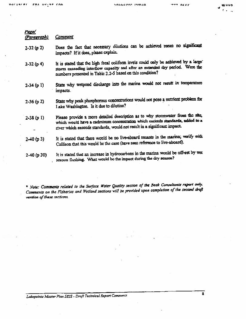
U.uj*/g F1’J D*O IUJF,.Lfl -,-,., ‘ai vu4
(amiaph) Comment
2-32 (p2) Does the ct that necessary dilutions can be achieved mean no significant
impacts? If it does, please explain.
2-32 (p4) ft is stared that th high fecal co]iform levels could caiy be achieved by a laige
tox exceeding interfiow capacity ard after au extended dry penod. Were the
numbers presented in Tabic 2.2-5 based on this condition?
2.34 (p1) State why wpond discharge into the marina would not result in tempature
impacts.
2-36 (p2) State why peak phosphorous concentrations would not pose a nutrient problem for
T.ake Washington. Is it due to dilution?
2-38 (p1) Please provide a more detailed description as to why stotmwatcr from the sltc
which wou1 have a cadmim.tm concentration which exâcds sandards,, uddcd to a
ri.r which excceds standards, would not result in a significant impact.
2.40 (p3) It is stated that there would be no live-aboard tenants in the marina verify with
Callison that this would be the case (have seen reference to live-aboard).
2-40(p 30) It is stated that an increase in hydrocarbons in the marina would be off-set by wet
scaon flushñg. What would be the impact during the dxy season?
- Note: CommenLv reLated to the Surface Waler Quality section of rile eak Cunwhants repon’ o4
Commenty on the Fisheries and Wetland setho,z wit! be provided un completion of rhe second th’nft
‘epsian ofthese .fimc
LakepoinIc Masrer Plan SifiS - Drnft Technical Report Comn,’nts 8

King CouuyDepsrtnene of Deve1oprnetsnd En’rIronnieutal ServicesBuilding Services DMsknSite Engln.edng and Planning SecIon
• h?S*beiBd1c W.h’ 91006.1400
April 12, 1997RECEIVF
To: Barbara Questad, SEPA PlannerAPR14 1997
From: 3effONeill, Supervisor, Site Engineering & PlarniingE A
Re: Comments on LakePointe Preliminanr Draft Supplemental EIS-March, 1997
Hazardous Waste Resolution - Tithe hazardous waste on site is capped instead of 4-removed, then storm drainage facilities should not be placed in or below the cap. This mayrequire a variance if minimum velocities or pipe slopes are not obtainable because ofshallow placement of pipes.
Lake Washington Elevation Datum - Several different elevation datum’s are available onLake Washington ranging including Dity ofSeattle, US Engineers, US Geodetic Survey,and King County Aerial Survey: The tatió elevation ofLake Washington can vary by upto 12.98 feet depending on the datum used. There appear to be several different elevationdatum’s used on the plan set. It is essential that all datum’s given or the elevation ofLakeWashington and all drainage and elevation references on site is based on King CountyAerial Survey datum.
Capping of Hazardous Waste - The EIS states that there is offsite groundwater flowingthrough the site below the surface. Tithe site is capped, will this include water barriers for ‘this subsurface interfiow and if so, how will this blocked water be picked up andtransported into Lake Washington.
QSammarriish River/Surface WateQxtaflty Standards (page 3-22) -The first paragraphstates that the Sammarnish River is d!signated as Class AA water (extraordinary). The
1 third paragraph states that it is identified as “limited” along 47% of its length. Isn’t this acontradiction? The third paragraph under ‘Water Quality Limited List also refers to five orsix factors resulting in impaired uses.
Groundwater Ouan vJoae 3-24) - First paragraph states that the reason the Corplowers Lake Washington in the winter is for extra storage capacity. An additional reasonthe Corp lowers the lake is to reduce the shoreline wave damage from winter storms. The
1
Ac i
rehabilitation of much of the shoreline may also be a mitigating factor in develoing the- site and reestablishing vegetation along the shorelines.
r Infiltration (page 3-24 - If the groundwater table on site is primarily influenced and
(c)
coincidence with the level ofLake Washington, it would seem that very little actual LI?
‘recharge’ of groundwater occurs from upland interfiow or from rainwater infiltration. Ifthis is -so, how will capping ofthe site help the site prevent leaching of the waste buriedwithin the groundwater table.
Would any significant velocity be expected from upland through the groundwater table onsite if hydrostatic pressure from Lake Washington is maintaining the groundwater.
Surface Water Quantity (page 3-25 - Sixth paragraph states that oil/water separators willbe used as one of the primary pollutants removal systems. While Coalescing PlateSeparators are good for mitigating large quantities of oils encountered in conditions suchas oil spills, are they effective enough in removing the smaller and finer concentrations ofoil in normal street/parking lot runoff to be listed as major component? Please quantifythere effectiveness.
(top of page 3-26) It is stated that roof runoffwill be piped directly to the receiving bodieswithout water quality treatment. Will the rooftop materials Used for the structures bespecified to not include materials such as copper or zinc that may produce untreatedpollutants? Has Washington State Fisheries bought off on directing rooftop runoffdirectly to receiving bodies?
Third paragraph states that there is currently no pipes discharging into the inner harborarea. Recent field trips have indicated a large offsite flow from a p-.ipe entering at the head (of the inner harbor.
ErOsion and Sedimentation - Please note approximate timing expected to complete allseven phases of ëonstruction.
The first paragraph states that during construction, no silt laden runoff is expected to leavethe site. Temporary Erosion and Sediment Control Ponds are usually designed to containapproximately the 2 year return storm. During the many years of construction and giventhe recent history of extreme storm events, isn’t it reasonable to expect that some siltladen runoff will leave the ponds? What kind of outlets are to be used in the ponds? Arewe saying that they will reduce turbidity to 0 NTU or are we saying that no runoff willleave the site during construction?
Will the phases be constructed randomly?
If site is capped instead of removing of waste material, will the temporary ponds and otherstormwater facilities have to be kept at an elevation above the cap?
-
i —‘7/JJ/J
—..— (‘ /
2

MRY @9 ‘97. @25GPM US SERVICES P.14
Lin’ic pDBlSitM 9 199Piget2
Page 3-195
Page 3-202
Page 3-203
Page.3-206
InCcc bullets at the top of the page, p1.. elaborate on “converaico.”
nvumon ofwhat? Could you say ahing like “eonvwilon of storageice to rrgular classroom
the lut pviaph, it says that the proposed marine would generate
litiona] boat traa and üiuaue congestion. Vaiious dton ryenr ill imply that this won’t be the cue. This paragraph should be
iacd based on the Reld h4lddu.tcn air and marine raport, and acme eft’ortWdbe made to quanti the .mow ofdaily boat iMc to and *om the
wvs the proposed limiwions on boat mi and viéton The amousttac may vaty dqading upon whether or not a hotel is bulk cit the
and whether or not penpie ate encouraged to commute to rauranta,
,onth.site.
o companions in this asetlon s” ounvoluted and confiaazng. I would
writà jams pwu umng shoilar, znor straight-tbrwvd sentences.
the ata*emt that the‘4Proposed Action would provide public macragepotisa for reaüanal boater? carreat? This doesn’t seam
nsiatent with description. elsewhere, including the Keid Middletonpt
Chapter 3JUTIUTIXS
Page 3.208
Page 3-209
Page 3-210
II the iwamsr in the last paraaph (“constncticn debris .wu ramoved
1996”) true? uiendy, there arc large piles of concrete, lumber, andii on the site is tha.wuthwaet end’ of the in harbor.
sewer and water certificate. .ibmiu.d with the Commercial Site
vulopmsnt Permit? If not, at what point in the procesa will they be
a we diieuuod in the May lit m.Ming bween C.flh,or, Ruc,dh/
wnar and King Comty, the ansfrs ofunpacta for alternatives should
rovide an oviil. “order ofmft1dc” aueumcnt and comparison to thee’
ropo.cd Actiän. Detailed desips and cMificition is not neceasmy. c

‘.j L’4k +c’
rv
conditions. We currently have no way of knowing what the final configuration of the shoreline,
after cleanup, will look like. For example, existing “signifint trees” and “regulated tree?
found in sensitive areas buffer/shoreline zone may have to be removed, along with unknown
quantities of soil. Existing allegedly contaminated shorelines may have to be excavated and
resloped for example. At this point we simply do not know. Existing site conditions wilt change
with site cleanup and this could have different or unforseen impacts on aquatic resources and
buffer/shoreline zones. I recommend we wait until the site rernediation plan is finalized and
agreed to before conducting additional review, as the hazardous site cleanup appears to be the
ultimate site limiting factor.
In addition, there has been a very recent (September/October 1996) redistributiOn of waste piles
over a large portion of the site, including sensitive areas buffers. We noted fresh fill over an
area approximately 1000 feet long by approximately 200 feet wide. The goose nesting easement
was filled to within approximately 20 feet of the Sammamish River’s edge. Apparently this
waste was to be hauled off site. This action occurred after all of the studies (we are currently
reviewing) were completed. Some fill was possibly imported to the site in addition to the waste
pile redistribution. This new activity has changed surface elevatons, possibly recontaminated the
site (surface and groundwater), and/or made future Sammamish River buffer replanting or
enhancement difficult or impossible until cleanup. While on-site on 10/14/96, we observed wood
and other waste roofing material, and general garbage up to approximately 6 feet deep in the
Samma.mish River buffer to be planted/enhanced. On 10/14/96, 1 waded through pools of black
leach water ponded on the surface of the newly filled area. Rainwater was obviously soaking
through the recently spread waste and picking up organics and possibly copper compounds (if
the cedar shakes had been treated). As a general comment to all the studies being reviewed, has
this changed surface runoff quality or quantity? How has groundwater quality and quantity been
affected? Will River buffer plantings successfully grow in 3 to 6 feet of shredded cedar and
composition roofing, and assorted garbage? Do the conclusions of any of the studies change.
given the changed site conditions? -
1) Draft TIR, and 2) Supplement to Draft TIR.
- Section 1, Site Overview. In the Project Approach, it is stated that., “The site will become
partially impervious.” This is an understatement as the site will be 90% impervious according1-
to page 35 of the AGRA Earth, Water, Toxic 11/8/96 report. Does this high percentage or
impervious surface change the stormwater requirements and design elements in the TIR? Was
90% anticipated?
- The Upstream Drainage Basin Map, MP 3 shows a drainage path outletting to the SW corner
of subject site. The shoreline plan maps show the upstream drainage basin culvert outletting at
a point near the SE portion of the site. This outfall pipe CMP was observed on 10/14/96 at the
eastern location. Are there additional outfall pipes into the river, lake, or inner harbor? These
should be identified, located and mapped, if any.
- We noted a 1 foot diameter (eat) white plastic outfall pipe exiting into the eastern end of the

i 1e-4 +b -\
f1g4j
-J
Inner Harbor. Highly turbid water was exiting from this pipe on 10/14/96 into the Inner Harbor.gvThe source appeared to be on site runoff from a fenced area adjacent to the east end of the c,harborS
- Will the proposed ponds, biofiltration swales, and connecting channels to the river be attractivenuisances to fish? How will juvenile or adult fish stranding be prevented, given the alternatingwet/dry cycles and stream like appearance. Will fish be stranded in the ponds when the outletflows thy up? How will this be prevented?
- Will the biofiltration swales or their connectors function as wetlands given the constant wet/drycycles that will occurr? In an average year, how often will these features be wetfdry?
- How was water temperature of stormwater runoff addressed? What criteria were used? Weare concerned about temperature increases and the effects on salmonid adults and juveniles forboth rearing and migration. Will a thermal barrier be created or worsened at the mouth of theSammamish River or the Inner Harbor due to elevated runoff temperatures? How will this beaddressed? A major identified salmonid limiting factor at the subject site location is excessivelyhigh water temperatures. Given 90% impervious surfaces, was temperature considered a waterquality parameter? Can it be controlled? Were other stonnwater quality issues addressed forthe non parking lot runoff areas?
3) Preliminaiy Geotecbnical Evaluation
- Does the spreading out of the stoclcpiles noted on page 3, or the addition of fill, topped withwood and composition roof waste aiid garbage, change the issues addressed, the analysis, or theconclusions of this study? If so, how? Is additional work now needed?
-1 defer review of this document to Steve Bottheim, Senior Geologist.
4) Phase It Environmental Assessment, Volumes I and II.
- I conducted only a skim review of these documents, due to the limited review period allowed.While the documents were dated 5121/96, 1 did not receive them for review until 11/7/96. Givena four day work week, snow closure days, Thanksgiving and Veterans day holidays, andLakepointe meetings, I have had only eighc working days to review these very complex.,technical studies. Also, with the previous deadlines for review of the Natural ResourcesTechnical Report, my focus was on the Natural Resources report, not the E.A. I feel the tightdeadline on this detailed two volume technical report is unattainable and should be extended toan appropriate date.
- The report states that medical waste was not discovered during subsurface explorations. Wasit noted during surface examinations? Were the stockpiles sampled? On 10/14/96 we observed

15. 97. 03 3S Poe
Michaci GuøuJcwsxy 14, 1991Pgs
• Studies need to be revised to condItions subsequent to the I1hg and
4gthat occurred on the_fi!cr/October 1996. FIeld ob vation of
surface water movenent around 6-foot-deep tc pits revealed extensive lateral
movement Ciniuflow) ofwater tluough the surflclal waste materiaL A discuesion of
these fill mnatesials as po.aible sources of surce and oundwater contamination needs
to be provided, ii weLl as a discussion of the transport potential of any eont’*’nra,,
and their iuteraion with the Sanimenileb River and Lake WLshIngton.
The scope of the submitted studies ii limited to the upland portions of the sitc the
studies need to include the littoral, or near shore, zone ofLake Washington. Staffhave observed significant areas of submerged fill and debris located along the Lko
Washington shoreline. Dea included steelptates, oncrete, containei dni
and miscellaneous construction debris. Parcel boundaries include portion. of this
or near shore area, thus Wii appropriate to characterize the a*isting conditionsin this area- The analysis of the littoral should Include an inventory of the type and
amount of debris, a sediment analysis and bioassay, and an alternatives analysis to
identify mitigation measures needed to remedies. past eantaminatlon of this near shore
are’.
• Information in diilent technical studios is sometimes inconsistent. In addition,
technical studies are sommes Inconsistent with reports from site visits by1n
County ate These1niii&ciiecd to be reconciled.
Draft and Supolamental [R
NQTE Some of the quIstions below appear to be answered in the memo om bun
E.liuon, FF. to Lois Broadway, Callison Azthltncturn dated October 17, 1996. This
memo wu forwarded to Huckell/Weinmen and more receitly to the KIng County SPA’
Section. It would be helpful to incorporate information from this mno into the Tm so
that all reviewers have the information in a dlidated tbrm rather than in separate
memo. and reports. It would also be helpful to hay, the information c nacliditod in the7Th. when it is appended to the BIS for public review.
Draft/pg: The Draft T indicates that the project site ii 45 acres In. szc. This r,appears to refr to the largest parcel (112604-9001) whIch ii 45.26 acres. Did the study‘
C,$
include the additional three parcels which snake up the mite? (Parcels 112604.9020, -9133, <.,and -9137 total 9.63 acres)
Draage1: The report statee that existing elte conditions are considered to be exposed
rpervious ii1, and after development, the iitc will become “partially impervious.” What
percentage of the entire site was considered to be impervious for purposes ofthe drainage
calculations?

15. 35P “QL.EON
Michael L.wmJmaaty 14, 1991Page 6
DrafDae 2S: The report states that The eitiu site ii considered to be glacial tilL”1
However, on page 54, the report states,‘4Tha native sail descriptions from soil boring logsconsists of ailt, sand, and some peat.” As written, the doeiptions ire not consistent.Please cladfr or explain the appireut inconaimcy.
pra.ft/ge 46: The report states that the on-etc conveyance system has been dosigiiedand analyzed at a scitematic level for the 25-year pcak flow at developed conditions. The”
FSupp1nta1 T.providue calculations for sizing dlitIearPhase I development, theaccess road and Building A land.caping and I.ácpcinto BouIevard Please .çlain howthe schematic design relates to the site design ftr the Master Plan, the Commerc4sl Site
Dcveloprnmtt Pmit, and the Shoreline Permlt, sad at what point in the review processmore detailed drainage plans will be subnitted fbr each phase of development.
Irjftlpage 54: The description ofthe edsting project site needs to be revised to Include /“ \recent grading and ifillng.
References are made in àther technical reports to infiltration on-site (c.gi, EartK Water,,Toc and I ardoi&{atensi states on page 17, “Intercepted runo’would be treateder would be inmtrated to the upid1it groundwater table ...“) Please clarify whether ornot infiltration is proposed anywhere on the site.
= SuooVpaecai-2: Row will oiVwater separators and wet ponds collect water if they areupgradient of the site?
W
e
b4...(,Lt.
The study characterizes the Lakepointc site u it was prior to the r.greding and flh1irg thatoccuned an the site in September/October 1996. The study should be revised toaccLtratCly resect the changed conditions. Does the regrading and filling change theresults end conclusions ofthe study
Earth
Page 12: The Signlcant hupacts — Topography/Geology section should dlacus.jya1[pji to access underivina structurally sound soils through the use of piles and
oaes’ the impact that pile placement would have on contaminated soils and ground water.
The Additional Geotechnical Requirements cction should identify and cite the- gcotechriical investigations completed to date. State whether the additional geotechriical
KingCountyIDepartment of Development
and Environmental Services3600 - 136th Place SoutheastBellevue, Washington 98006-1400
LAKEPOINTE MIXED USE MASIER PLANPRELThItNARY DRAFT STIPPLEMENTAL EIS — March 1997
AGENCY STAFF REVIEW & COMMENTSApril 21, 1997
General Comments
Some of the comments below require clar±Ecation of information that we already have availableto us. Others require a response from the applicant.
Throughout the document, you should assume that the lay reader does not understand technicalterms and “plannerese”. Whenever possible, use common language or give a brief explanationof technical terms before using them in a discussion.
‘ Metro is now a part ofKing County. Throughout the document, correct reference needs to bemade to what was formerly “Metro.” When referring to the former Metro’s solid waste orwater pollution control functions, I would suggest using:
King County Department of Natural Resource. (formerly “Metro”)‘
When referring to the former Metro’s transit functions, I would suggest using:
King County Department of Transportation (formerly “Metro”)
A consistent reference needs to be made to the Washington Department ofEcology (DOE). Iwould suggest spelling it out the first time it is mentioned in each section such as EARTH orWATER, and thereafter referencing it as “DOE,” since that seems to be the common term usecL
An acronym or a symbol should be indicated in parentheses only when it is going to used as areference later; otherwise the acronym/symbol can be left out (i.e., no need to use KCC or Pb,when there will be no further reference).
Please use the following references: Environmental Impact Statement (EIS), Supplemental EIS,Dra Supplemental EIS, Final SuppleinentalEIS.

Lakepoiate pDEIS reewApril21, 1997Page 2
When referring to streets and avenues throughout the text, please use a consistent convention:
NE 175th St or Northeast 175th Street68th Ave NE 68th Avenue Northeast
Consistently use “and” or “&“, “AM/PM or “a..mJp.m.”, and. “SF’, “sq. ft.”, or “square feet.”
Use a consistent convention when referencing figures and tables, e.g., “(see Figure 3)” or “(Fig.
Reference nmnhers/numerals consistently, e.g., spell out “one” through “twenty” and usenumerals for “21” and up, or use some other consistent system you decide upon. This includesconsistently using the convention “two-stor/’ or “2-story.”
Also, two or more words describing a noun should be hyphenated, e.g., “30,000-square-foot,two-story building.”
Does this BIS analyze the Master Plan, the Commercial Site Development Permit, the ShorelinePermit, or all three? This is something we should discuss with the applicant, clearly state hi theintroduction and on page 2-8, and then review the document to be sure that we are, in fact,doing what we say.
Throughout the document, it needs to be clearly stated whether each analysis is based on the 45-acre site or the 50-acre site, and then call out when additional analysis will be needed later. Iwould avoid using percentages when referring to the amount of acreage. If you usepercentages, then you have to define whether it is a percent of 45 acres or 50 acres.
The heading at the end of each section should read UNAVOIDABLE SIGNIFtCANT &ADVERSE IMPACTS.
See handwritten editorial comments in the text of the document
Chapter 2/DESCRIPTION
NOTE: Comments in this section and. in the text reflect my review as an EnvironmentalPlanner.
Page 2-2 It makes more sense conceptually to discuss the King County ComprehensivePlan (KCCP) prior to discussing the Northshore Community Plan (NSCP), eventhough the NSCP was issued first. You could include a sentence such as thefollowing:

Lakepoüitc pDEIS reviewApril21, 1997Page 7
page 3-14 If the impacts ofpile driving are going to be evaluated at some later point in time,then the section on UNAVOIDABLE SIGNFICANT ADVERSE IMPACrSshould state that vibrations from pile driving are unavoidable, adverse, andpossIbly significant
Chapter 3/AIR QUALITY
NOTE: Comments on this section are provided in the text of the Preliminary DrafrSupplemental ‘EIS and reilect my review as an Environmental Planner.
Chapter 3/WATER
NOTE: Comments in this section and in the text reflect my review as an Environmental
Planner.Also see comments by Ieff O’Neill, Supervisor, DDES Site Engineering and PIarmiig,
dated April 12, 1997.
Figures cited throughout the document for acreage and percentages are inconsistent Does the\WATER section analyze 45 or 50 acres? The document needs to clearly state acreage used inanalyzing existing conditions and pràposed development. Will the proposed action result in 1 /
60%, 65%, or 90% impervious surface? .
Pages 3-21 to 3-23 The Surface Water Quality section is corifasing and repetitious. Iwould suggest beginning with an explanation of federal and state standards with abrief statement of designations for Lake Washington and the Sammamish River.Then move into an explanation of how each waterbody meets the standards.Time frames for sampling, monitoring, etc., need to be provided or clarified, e.g.,define “current”
Page 3-21 Briefly define “trophic.”
What is the significance of all ofthe infonnation provided in the last paraaph?For example, what is the impact on the lake when chlorophyll-a levels are above-or below-average and transparency, phosphorus, and fecal coiiforms are aboveaverage?
Page 3-22 It is not clear’what WAC 173-201A-130 refers to.
What does it mean to “exceed state standards”? Is this good or bad?

Lakepointe pEIS reviewApril 21, 1997Page 10
Page 3-37
Page 3-38
Page 3-39
Page 3-40
Statements about prohibition of live-aboard tenants don’t seem consistent withstatements elsewhere that showers and other amenities will be provided (see page2-17).
Please simmrize surface water impacts in a section. titled Summary of SurfaceWater Impacts.
The second paragraph under Groundwater Ouantitv should be moved to theGroundwater Ouality section.
Comparisons ofgreater or lesser impervious surface areas need to be verified 9-when consistent data are provided by the applicant.
Under MITIGATION MEASURES, please identify dearly which measures arerequired by King County Code or other regulations, which are proposed hraddition to code requirements, and other possible mitigation measures. C’
The paragraph under Surface Water Ouantity needs to be written more clearly.\%j& \Please define “sumps.”
,A
Potential mitigation measures for surface water quality (see Ieff O’Neill’scomments) should include something to the effect:
• Prohibit the use of roof-top materials such as copper, zinc, etc.. Restrict the use of fertilizers, etc.• Restrict above water-line work on boats, etc.
Please define “constructed wetlands” and “wetland confluences.”
How would “wet street sweeping” be enforced?
Are there regulations in place to ensure that erosion from pile-driving would notreilt in water-quality impacts?
Chapter 3/PLANTS AND ANIMALS
DDES is deferring comments on this section until the final Technical Report on NaturalResources is submitted by the applicant.

Laepciutc DEIS xewApril21, 1991Page 12
Pages 3-75 to 3-79 It seems that two receiving areas should be added to the analysis of
conat cdonnoithresidentiareaonthehlilnorthofthesiteaboveNE
Both Way and an area across the water to the west. There would be no sound
barn between construction on the site and either of these areas,and anyone
who ever walked on one ofthe many beaches in the Seattle area knows that.
sound vels remarkably well over water. The discussLon should include the
effect of sound traveling over water.
A sep a section should be provided on the noise impacts of pile driving. It
aboul ciarIf,’ the type and apecicatlona of the piling proposed to be used (wood
or ). If the typical sound level for driving wooden piles is 38 dBA, estimate
the ical sound level for drIving steel piles. Include a description of
appro’ yhowmnypilswouldbedrivenhzeachphase,thedepthtowhich ‘
they ould be driven, the applicant’s projected schedule for each phase (hours
each y, number of daythnonths). Calculations ShOuld be provided of the sound
levels ‘dents would be subjected to at the receiving sites listed in Table 21 as
well the sound levels residents to the north and west (described shave) would
besu jectedto.
TabI 21 indicates that sound level measurements at Inglewood Shores would
inner in ?hs.ses 1 through Sby more than twice the level dened by the EPA
as “v serious”, and in Phase 6 would increase by 1.5 times this leveL The
ThIP CTS section should include a dlwissioa of the serious health ebcts of
noise especially when it would continue for more than seven years. Include a
discu aion of the impacts of the consistent and repetitive nauire of the noise. No
doub there is considerable documentation in the literare. You may with to
con the Xlng County ?ublic Health Depaxtrnert for assistance (Waily
Swo ord., 296-4784), The City of Everett may be able to provide studies of the
eff a of pile driving done for the Harncport project.
Page 3-75 See a earlier note about exemptions from noise regulations.
Page 3.76 Ta.bI 20 should include noise levels for both vibrator,’ and piston methods ofpile
dri g.
Page 3-78 Do e calculated noise levels in Table 21 include Kenmore Pre-Mix, aeaplanes,
and affic? If not, wea a table that does. In other words, what are thq total
nois levels from all sources during construction? Also, include a clear statement
of Ii w long the Kenmore Pro-Mix plant is likely to ccntinue in operation.
Page 3-79 The of construction noise impacts should honestly analyze the
si cance of increased noise levels indicated in Table 21 and eliminate effbrts
to those impacts (see notes above and edits in the tt).
;UPLEMENTAL ENVIROIMPACJSYATEME1
this section re all by 3udith Aitken and zzaxis Cleanup Program, Washington w
ma have seeped in, r apologize.
DRAFT
•h 4 The statement about 24 acres north ofNE Bothell Way can betning the 24 acres are part of the site. Th13 nøeds to be clari5ed.
vk1. You cannot state the number of acrCs that will be imperviousplan and the proposed cap have not been approved. There ii a potential (,
leas) use of capping on the te, depend1n on the outcome of the Jrthe emediai rnvestIgaoriIFeibility Stdy (RILFS). If it is thought
‘ it is going to be, you need top conditional word.s in the stence.
1a 4. I am very concerned about this 3ta.tment, StorTn water may .—
waters ofLake Washington arid the Sammarnlsh River and some sort oficcessary. Some ofthe surfaca storm water in the southeast part ofthevith metals and other contaminants and drained, by way of a drainageake Whington. Conditions like this wil[have an e.ct on therca. You need to also take into account tile: the isung surcc wilt benstrtjction activities occur on the sltc and ondftions ax that time maythat re now unavailable lbr transport by the surtce water.
phs 4 anL nd Page 3-33araraphJ,. Treatment by dllutioa, thatiter being added tu t.he storm wat does not solve the problem of the
‘3
.—
MENTAL
The comments Iconcerns of theamc citonali2
aes 2-16 and
rr
intendedto deal onlywithe epanmcnt ofEcology.
fasilia are dieare that ;plestorage areas, al,states tkiat thc bpage 3-36 the 5t.
marina, and on pthe aouthweat pflngineerz will nishould also takeboatkeclsandmAlso, yau C5AF1O
3e530fl” tbia i& nthat address the
1)qot, 1_2t
-36. The Marina. There are a. lot of!ncorslstencies here. Proposedssed and in one part of the do.imit (page 2.16) there are indications
UI be able to stay on their boat:, albeit nt ermanendy (Cable TV,wer eilitIes plus long term paridng all pzvided), yet the documentits moored in the marina may not be used as a. puiancnt dwelling. On,cnzn is made that no dredging will be required for construcrion ofthege 2.16, Paragraph S it clearly msea that dredging will be required iniion of the harbor. Dredging that will beconducted by the Corps of
be di;cuascd, ii. is an integral part of 4eveloping the marina. Yourite account that pleasure boats do use a.ntibidants (such a.s TI3T) on theLrinas alien are irioro contaminated that ccr6niercial boat rnoorage..rely on removal of the hydrocarbons &om ,he manna waters by the “wett an acceptable pollution prevention tac.I Plans have to be drawn uproblcrns associaLed with fi.iel spills.
- Paraintctpreted as in
gc3-25 azag.since th cleanup
forfar greater (cAgreed Order axthat this is the w
j?araindeed impact thdctcnr.ion may besite was pollutedditch, dtrectly to:sediments in thatd3turbcd wizenrelease substance
Pare 3-SO. Paras, by additiona.l ‘.‘

•
___________________________________
Land US(rUCj Suite 2
Environmental 11jrdnicJ. W runo,i 38O33
%&Wi/$WflnAW4 IFij?tMEMORANDUM - May 21, 1997
mail ‘akcr cm
To: Lois BroadwayCallison Architecture
From: Rich Schipanski’Huckell/Weinrnan Associates
Re: Lakeponte Master Plan Draft SETS
I have provided a list of pile driving information which McCullcy Frick & G1man requires to
respond to King County comments on the Noise section of the Lakepointe Master Plan Draft
SEIS. Although I have directcd this memo to you, KPFF will need to provide input.
1. Please estimate the type(s) and numbers of piles. If different types of piles will be used, ‘
in different portions of the site, please describe.
2. Please estimate the time it takes to set up the equipment to drive each pile, and the time
it takes to drive each pile./
3. Estimate the approximate duration of pile driving for each individual phase. .—
4. What type(s) of pile-driver is proposed and why? If the speci tic equipment t.u be used is
known, would this equipment be fitted with any type of noise mitigation?
5. Would it be possible to use a vibratory hammer for some or all pile placement?
6. Would it be possible to use a cushioned insert between the hammer and the pile head? If
not, why?
Please provide the requested information by June 4, 1997.
If you have any questions, please don’t hesitate to call.
CC: Barbara Questad, King County DOES
John Eliason, KJ2FF
A7TACHMENTA
RESPONSE TO PDSEIS
1. Storm runoff from the Proposed Action would be treated to remove pollutants in one ofthree ways. From the high use traffic areas (Lakepointe Way, Lakepointe Boulevard andsurface parking areas), stormwater runoff would be routed through [a series oftreatment systems starting with] a oil/water separator [to remove oil spills,] then to a2-celled water quality wet pond [to remove fines and small concentrations of oil perKing County standards.] Discharge from the wet pond would be conveyed by pipe tothe north end of the inner harbor marina channel to promote flushing of the marina area.Stormwater from the lesser used roadways, including NE 173rd Place and NE 174thStreet, would be directed to one of two sand filtrationlbiofiltration swales for treatment.Treated discharge from these swales may be directed to the back end of artificial wetlandconfluences before entry into the lower Sammamish River; otherwise treated dischargewould be conveyed directly to the river in a pipe. [At the discharge location, quarryspalls and plantings will be placed to control erosion adjacent to the pipe.Discharge velocities within 10 feet of the outlet will be less than 1/2-foot persecond which is nonerosive.] Rooftop runoff would be directed in part to theSammamish River, and in part directly to Lake Washington. Excluding rooftop runoff fromthe stormwater treatment facilities would enhance treatment capacity for runoff fromstreets and parking areas. [Roofing will not include exposed copper or zincmaterials. Refer to Section 4, Technical Information Report Exhibit MP.A1 showingthe areas of the site draining to the various water quality features.]
2. [The existing on-site storm drain system is largely undocumented. Fieldobservations noted several catch basins in the paved developed area around theharbor. It is assumed these catch basins drain through pipe outfalls to the harborin multiple locations, although only one is visible.
The remainder of the site is undeveloped from a storm drain perspective. Fieldobservations indicate the majority of the site drains through infiltration and minoroverland sheetflow. SR 522, NE 175th Street and the off-site property in thenortheast corner drain to a storm drain which crosses through the site and outfallsto the Sammamish River 450 feet downstream of the 68th Avenue NE bridge.
The Proposed Action will collect stormwater, provide water quality treatment, anddischarge to both the harbor and Sammamish River. To improve the water qualityand provide some flushing action, treated runoff and clean roof water will bedischarged to the harbor through a new outfall.]

3. There are no topographic constraints that would affect the proposed development. Theupland portion of the site where building and road development would occur is relativelyflat with elevations ranging from 23 to 32 feet. Alteration of the site topography under theProposed Action would be limited to demolition of existing buildings, excavation forbuilding and garage areas, and fill for a portion of the embankments for the LakepointeWay intersections with NE Bothell Way and 68th Avenue NE. [Cut material, which issuitable, will be used for on-site fill. Excess material will be disposed off-site inaccordance with the applicable laws and regulations.] Total excavation volumeswould range from approximately 160,000 to 180,000 cubic yards and total fill volumeswould range from approximately 65,000 to 75,000 cubic yards. [The finish floorelevations of the garage and building are set to meet the constraint of joiningexisting grades at SR 522 and 68th Avenue NE. This results in the need toexcavate nominally 1-foot of material from the site. Selected eastern portions ofthe site require cuts up to 4 feet. The building/garage floor slabs will be designedto form the site “cap.” Open areas between buildings will have an earth-type ormembrane-type cap. Capped areas are presumed to meet Department ofEcology/MTCA requirements.]
4. [The increased excavation of Alternative I results from the need to constructunderground parking beneath the building footprints. This additional parking isrequired to meet King County codes.]
5. [Alternative 1 requires excavating significant quantities of contaminated soils toconstruct underground parking structures. The Proposed Action eliminates thisimpact by creating parking at existing grade and elevating the roadways.]
6. [Electrical service in the site vicinity is provided by the Puget Sound Power andLight Company (Puget Power). Existing on-site uses are served by undergroundtransmission lines along NE 175th Street. Puget Power has indicated their systemhas adequate capacity to serve the project. Upgrades to some localized lines andtransformers may be required. Puget Power has indicated they will determine theexact scope of upgrades at the design stage of the project.]
7. [Washington Natural Gas indicated their system has adequate capacity to servethe project. They have indicated that the location of site specific improvementswill be identified at the design stage.]
8. [Water Supply: Total water consumption and domestic flow rates for Alternative 1will be 80 percent of the Proposed Action since Alternative 1 is 80 percent the sizeof the Proposed Action. The fire flow requirements are roughly the same since fireflow is governed by individual building size.
Sewer/Solid Waste: Total sewage flows and solid waste generation for Alternative1 will be 80 percent of the Proposed Action.
Natural Gas/Electricity: Total use of natural gas and electricity for Alternative 1will be 80 percent of the Proposed Action.]

9A. [The Northshore Utility District provides domestic water from three reservoirslocated at NE 195th Street and 5th Avenue NE, 88th Avenue NE and NE 190thStreet, and NE 150th Street and 81st Avenue NE. All reservoirs are on the systemwhich serves the project site.
The District’s planning documents show a 1993 metered average waterconsumption of 4.9 million gallons per day (MGD). The water consumptionforecast based on area zoning is 6.9 MGD in the year 2002 and 7.2 MGD in 2012.The project site is included in these numbers.]
9B. [The Proposed Action would generate the following water demands in addition to a5,000 gpm, 4-hour duration fire flow demand.
Phase Average Day }_Peak Week_[_Peak 4-Month_[ Average Year
1 0.25 MG 2.6 MG 33 MG 92 MG
2 0.06 MG 0.6 MG 8 MG 21 MG
3 & 4 0.07 MG 0.8 MG 10 MG 28 MG
5 0.07 MG 0.8 MG 10 MG 28 MG
6 0.02 MG 0.1 MG 2 MG 5 MG
Totals 0.47 MG 4.9 MG 63 MG 174 MG
The Northshore Utility District has stated they can supply the needed volumes toserve the Proposed Action. There is no Water District boundary expansionrequired to serve the project.]

A7TACHMENT B
RESPONSE TO PDSEIS UTILITIES INFORMA TION NEEDS
1. See revised PDSEIS narrative in Attachment A, No. 1.
2. See revised PDSEIS narrative in Attachment A, No. 1.
3. Revised PDSEIS narrative to:
Upon full development of the first six phases of the Master Plan, it is estimated thatflows of approximately 26 cubic feet per second (cfs) for the 25-year storm and 32cfs for the 100-year storm would be generated, compared to 18 cfs and 24 cfsunder existing conditions, respectively. Because no detention facilities would beprovided, the duration of stormwater flow would not be significantly greater thanunder existing conditions.
[Post developed flows are higher than predeveloped flows because the site hasmore impervious areas, such as paving and rooftops. The actual flows at eachnew outfall will be controlled to limit erosion by using pipe sizes which resultin low velocity and using quarry spalls and plantings to control erosionadjacent to the pipe. Once discharged to receiving water, the velocity will beless than 1/2-foot per second at 10 feet from the outlet which is a nonerosivevelocity]
Refer to Section 5 of the Final Technical Information Report for calculations of peakflow rates for the developed 25- and 100-year storms for the 5 proposed drainageoutfalls.
4. By Beak.
5. Information is in the PDSEIS, Page 3-208, first paragraph (5,000 gpm).
6. See revised PDSEIS narrative in Attachment A, No. 9A.
T The estimated 3.5 persons per unit is the planning level criteria used by Northshore UtilityDistrict which is the governing jurisdiction. We agree it is high (conservative).
8. The Northshore Utility District planning criteria for areas of commercial business is 3,600-gallon/acre/day: We have used a more refined City of Believue Water Departmentplanning value of 30-gallon/250-square foot/day since we have building areas. The Cityof Bellevue planning criteria includes a factor for restaurants. Residential demand is 95percent of the total.
9. See revised PDSEIS narrative in Attachment A, No. 9B.
10. See revised PDSEIS narrative in Attachment A, No. 9B.
11. The District has indicated they have capacity and no deficiencies.

12. See revised PDSEIS narrative in Attachment A, No. 9B.
13. See response on Comment No. 7 above.
14. The sewage effluent estimates are based on Northshore Utility District criteria which isWater Demand ÷ 1.1.
15. The King County Department of Natural Resources (formerly Metro) sewage treatmentplant has been designed to serve the project area as zoned. King County Department ofNatural Resources (formerly Metro) has indicated adequate capacity to serve the project,but will not state what their remaining capacity is.
16. There is very little demolition material suitable for recycling or composting. We plan onallowing the existing concrete and asphalt to be recycled.
17. it is expected that natural gas will be the most economical and practical means of heatingthe commercial buildings. The residential structures may be heated by gas or electricity.
18. See response to No. 17 above.
19. Electrical demand will be primarily for lighting and power with the potential for electricheating in residential structures. The use of electric heat will be driven by economics andbuilding configuration.
20. See response to No. 19 above.

A1TACHMENT CRESPONSE TO PDSEIS
Comment Letter From Jeff O’NeillApril 72, 1997
1. Storm drainage facilities will be placed below the cap. The detailed design of the stormdrainage will include special details where the pipes exit the cap. We expect the detailswill be similar to those recently used on the Port of Seattle Southwest Harbor projectwhich is being constructed on a former superfund site.
2. The architectural and civil site drawings are on King County datum.
3. - 6. Answered by other consultants.
7. Please see KPFF Attachment A, Nos. 1 and 2 for, information which addresses thiscomment.
8. Temporary ponds and stormwater facilities do not have to be kept above the cap.Please see response to Comment No. 1.
All other comments are answered by other consultants.

A7TACHMENT DRESPONSE TO PDSEIS
Comment LetterMay 9, 1997
1. Sewer and water availability certificates were submftted with the Commercial SiteDevelopment Permit.
2. Alternative 1 utility qualitative information is provided in Attachment A, Nos. 8 and 9b.
All other comments are answered by other consultants.

ATTACHMENT ERESPONSE TO PDSEIS
Comment Letter from Don FinneyDecember 4, 1996
1. Refer to the revised project approach in the Final Technical Information Report (TIR). Theproject site will not have detention since it is adjacent to Lake Washington. The onlyimpact would be increased developed flows to Lake Washington. Existing and developedflows are also provided in the Final TIR Section 5.
2. Refer to the revised MP3 plan in the Final TIR. During a site observation, we located theoutfall pipe in the southeast portion of the site as noted in your comment. Refer toAttachment A, No. 2, for additional information.
All other comments are answered by other consultants.

A 7TACHMENT FRESPONSE TO PDSEIS
Comment LetterJanuary 14, 1997
1. KPFF provided a report, dated October 17, 1996, which addressed EIS scope questions.We also provided our March 15, 1996, Draft and October 1, 1996, Supplemental TechnicalInformation Reports based on King County Surface Water Design Manual requirements.Our Final Technical Information Report incorporates our October 17, 1996, reportinformation where possible.
2. The areas used in our report were based on Table 1, “Proposed Uses by Acreage,”provided by Callison Architecture on Page 2-11 of the PDSEIS. This table includesbuilding area for Buildings A through G, but does not include the property north of themarina.
3. AGRA Earth & Environmental confirmed that the site will be capped based on currentnegotiations with the Department of Ecology. The current plan includes capping with useof buildings, roadway, and earth- or membrane-type over approximately 90 percent of theproject site. Our Final Technical Information Report, Section 5, shows existing stormdrainage calculations assuming the site will be 90 percent impervious.
4. Our Final Technical Information Report has been revised to be consistent with the soilboring logs.
5. The Final Technical Information Report provides calculations for facilities for the entireproject site, including Phase 1 and future phases. The report is based on Civil EngineeringMaster Plans, Shoreline Substantial Development Plans, and Commercial SiteDevelopment Plans. Additional detail will be provided at the time of construction permitsubmittals.
6. The Final Technical Information Report, Section 1, includes a description of recent gradingat the project site provided by AGRA Earth & Environmental.
7. Infiltration is not proposed as a design feature on the project site at this time. Somelandscaped areas outside the site cap may have a small amount of infiltration.
8. Our civil engineering Commercial Site Development Permit plans show pumping of thewater quality storm from site areas subject to vehicular traffic to the water quality facilities.The locations of proposed pump stations are shown on our civil engineering plans.
All other comments are answered by other consultants.

A1TACHMENT GRESPONSE TO PDSEIS
Agency and Staff Review CommentsApril21, 1997
1. We have revised our responses as in Attachment B, No. 15.
2. Refer to Attachment F, No. 2.
3. Based on King County recommendations, comparisons with Alternative 1 are qualitativeonly.
4. Storm drainage from pavement subject to vehicular traffic will be treated based on therequirements provided in the King County Surface Water Design Manual. We plan to usenew water quality facilities provided in the Draft Surface Water Design Manual includingthe new 2-cell wet pond and combination biofiltration and sand filter swales. An oil/waterseparator will be provided to pretreat the high use areas before discharge of the waterquality storm to the wet pond.
5. Refer to Attachment A, No. 1, for a new description for Surface Water Quantity.
All other comments are answered by other consultants.
A7TACHMENTHRESPONSE TO PDSEIS
Comment LetterApril21, 1997
1. Refer to Attachment I, Nos. 1 and 2, for information about pile type, numbers of piles perphase and approximate time per phase. All other comments are answered by others.
2. Refer to Attachment F, No. 3.
3. During construction, temporary erosion and sedimentation control facilities will includedefined clearing limits, cover measures, perimeter protection, traffic area stabilization,sediment retention, surFace water controls, and dust control. These measures and facilitiesare designed based on the King County Surface Water Design Manual to minimizesediment from construction entering public storm drains and public water bodies. Refer toSection 8 in the Final Technical Information Report for additional information on proposedtemporary erosion and sedimentation control facilities.
The requirements for the developed site since it is adjacent to Lake Washington and theSamammish River do not include detention. Direct discharge is allowed by the KingCounty Surface Water Manual Core Requirement 3 to Lake Washington as a receivingwater. Water quality facilities will be provided for the site to treat pavement subject tovehicular traffic. Refer to Attachment A, No. 1, and the Final Technical Information Reportfor additional information about the proposed water quality facilities.
Drainage discharged to Lake Washington or the Samammish River will be a combination oftreated water from water quality facilities, roof drainage, and drainage from open areas andwalkways. Erosion control of open swales for the developed site will be provided by acombination of limiting the velocity of the discharge water by using open pools or dropstructures to reduce velocity, planting and rock armor.
All other comments are answered by other consultants.

A17ACHMENTJRESPONSE To PDSEIS
Comment Letter From Rich SchipanskiMay21, 1997
1. According to the Preliminary Geotechnical Report issued by AGRA Earth & Environmentalin December 1995, concrete filled pipes or driven grout piles would be the most economicaltypes of piles for this site. We estimate the total number of piles for the project to beapproximately 5,000. That includes 2,100 for Phase 1, 800 for Phase 2, 700 for Phase 3,400 for Phase 4, 500 for Phase 5 and 500 for Phase 6.
2. AGRA Earth & Environmental estimated that it would take 17 weeks to drive the piles forPhase 1; 7 weeks for Phase 2; 5 weeks for Phase 3; and 4 weeks each for Phases 4, 5and 6.