Embed Size (px)
Citation preview

CLIMATE RESEARCHClim Res
Vol. 12: 97–107, 1999 Published August 27
1. INTRODUCTION
Accelerated sea level rise (ASLR) is one of the mostcertain outcomes of global warming. With a coastlineof 34 000 km, The Philippines takes a serious view ofthe potential effects and possible responses to ASLR.The physical effects of sea level rise include inunda-tion (submergence) of low-lying wetland and drylandareas, erosion, salt water intrusion, increased risk offlooding, and storm damage. In turn, these physicalchanges may cause substantial socio-economic lossesof coastal structures, both natural and man-made, anddislocation of the population and change of livelihood.The same physical changes may bring about certainecological consequences such as redistribution of wet-lands, destruction of coral reefs, reduction in biologicaldiversity and loss of wildlife, and changes in biophysi-
cal properties of the coastal zones. To avoid these un-wanted changes, it may be necessary to invoke a rangeof possible responses such as construction of seawallsand dikes, upgrading of coastal infrastructure in con-sideration of high water levels, relocation of coastalpopulations, mangrove regeneration, or other options.
The detailed impact assessment of Manila Baycoastal area was undertaken by the Philippine CountryStudy to Address Climate Change through one of itsstudy elements: Vulnerability Assessments and Evalu-ation of Adaptations on Coastal Resources Due toAccelerated Sea Level Rise (ASLR). The objectives ofthis study element are as follows: (1) study the possibleeffects of ASLR on the coastal ecosystem of ManilaBay; (2) examine the possible effects of ASLR on socio-economic structures and activities in the coastal areasof Manila Bay; (3) formulate response strategies byidentifying potential costs and benefits; (4) identifyneeded actions to develop a long-term coastal zonemanagement plan; (5) develop the capability to apply
© Inter-Research 1999
*E-mail: [email protected]
Climate change impacts and responses in thePhilippines coastal sector
Rosa T. Perez1,*, Leoncio A. Amadore1, Renato B. Feir2
1Philippine Atmospheric, Geophysical and Astronomical Services Administration (PAGASA), Agham Road, Diliman, Quezon City 1104, Philippines
2Coast and Geodetic Survey Department (CGSD) of the National Mapping and Resource Information Authority (NAMRIA), Department of Environment and Natural Resources (DENR), 421 Barraca St., San Nicolas, Manila, Philippines
ABSTRACT: The Manila Bay coastal area in The Philippines was evaluated for the possible conse-quences of accelerated sea level rise in the context of climate change and to assess adaptive responsesto such threats. The coastal area is an important region in terms of commercial, industrial, agricultural,and aquacultural activities of The Philippines. Results show that areas along the coast if inundated bya 1 m sea level rise would include coastal barangays from 19 municipalities of Metro Manila, Bulacan,and Cavite and would cover an area of 5555 ha. Proposed response strategies consist of protecting thecoast by building sea walls; institutional actions such as formulation of setback policies and construc-tion regulations; and adaptive planning in the context of an integrated coastal zone management toaddress the short- and long-term problems, with the involvement of communities in the area. Informa-tion, education, and communication are essential along with the technical and scientific efforts toachieve a well-balanced adaptation plan.
KEY WORDS: Accelerated sea level rise · Vulnerability · Sustainability · Adaptation · Integrated coastalzone management plan

Clim Res 12: 97–107, 1999
the methodology to other areas in The Philippines; and(6) brief policy/decision makers on the vulnerability ofThe Philippines to ASLR and the urgent need to miti-gate or adapt to climate change.
2. VULNERABILITY ANALYSIS AND ADAPTATION ASSESSMENT
The methodology adopted for this study is essentiallythat of the 7 steps or ‘Common Methodology’ of theCoastal Zone Management Sub-group (CZMS) of theIntergovernmental Panel on Climate Change (IPCC1990). However, this method was followed quiteloosely because of some data and information gaps.The 7 steps are: (1) delineating the study area andspecification of ASLR scenarios; (2) inventorying thestudy area characteristics; (3) identifying relevantdevelopment factors; (4) assessing physical changesand natural system responses; (5) formulating responsestrategies and assessments of their costs and effects; (6)assessing the vulnerability profile and interpretation ofresults; and (7) identifying needs and a plan of action.
2.1. Delineation of the study area and specification ofASLR scenarios. For the present study, the Manila Bayarea (Fig. 1) is considered for evaluation of the possibleconsequences of ASLR and to draw adaptive responsesto such threats. The provinces of Bataan, Pampanga, Bu-lacan, Cavite, and some of the towns and cities of MetroManila along the eastern side bound the highly enclosedbay. Manila Bay is located in the western midsection of
Luzon. It lies between 120° 35’ and 121° 00’ E and 14° 15’and 14° 50’ N and has a coastal perimeter of 800 km. TheManila Bay coastal area plays an important role in thecountry’s economy in terms of industry and commerce,agriculture, aquaculture, and tourism. It is one of thecountry’s oldest traditional fishing grounds. Even beforethe arrival of the Spaniards, Manila Bay had been thehub of economic activity in trade and transportation. To-day, Manila is the seat of the national government whilethe rest of the provinces are some of the constituents ofthe national capital region and nearby political regions.The bay is considered to be the second most productivefishing ground in The Philippines next to the Visayasseas. Fishponds and fish and shellfish pens proliferatealong Bulacan, Bataan, Cavite, and the northern MetroManila coastlines. The North and South Harbors in thecity of Manila provide support to the international anddomestic shipping industry. The bay is adjacent to themost densely populated, urbanized, and industrializedarea in the country. This has led to some of its presentproblems. The city of Manila and its surroundings havethe necessary infrastructure that attracts most of thecountry’s economic pursuits. Coupled with the perceivedlack of opportunities in the rural areas, people begantheir mass migration to the city—an exodus the ecosys-tem is hard-pressed to support. With very little concernfor or ignorance of environmental requirements,wastes have been indiscriminately dumped into the airand water, eventually finding their way into Manila Bay,destroying fragile food chains. In addition, deforestationin the uplands causes topsoil erosion, which renders
these areas unsuitable for productiveagriculture; increased siltation damagesvaluable ecosystems such as corals, sea-grasses and seaweeds.
The study set the boundary condi-tions of an accelerated sea level rise of0.3, 1.0, and 2.0 m by the year 2100. Thefirst 2 values are the low and high esti-mates of IPCC, while a 2.0 m rise repre-sents a worst-case scenario.
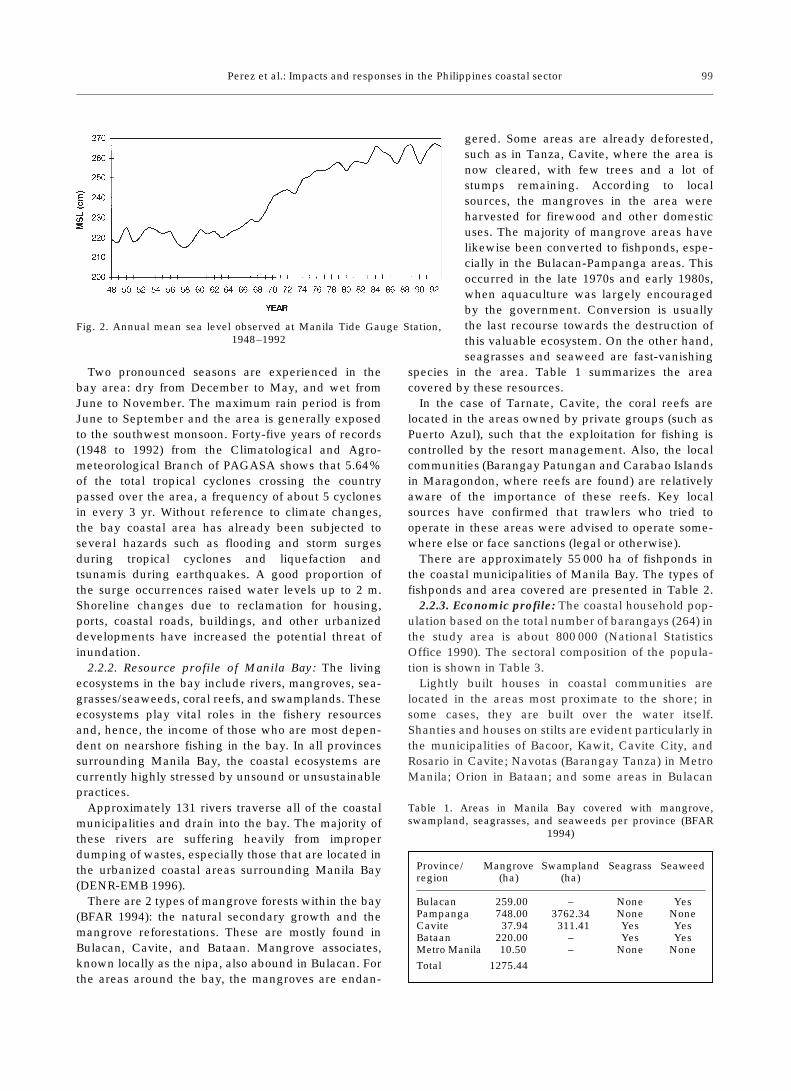
2.2. Inventory of the study area char-acteristics. 2.2.1. Physical environment:Tidal gauge data from a station at ManilaSouth Harbor (14° 35’ N, 120° 58’ E)show an increasing trend in the mean sealevel (Fig. 2). The bay experiences a tidalregime ranging from –0.475 m to a highlevel of 0.529 m (based on CGSDrecords). The coastline of Manila Bay is190 km long, and the coasts are generallygently sloping. These are covered by asoft clayey deposit of Alluvium age. Thegroundwater level averages from 50 to150 m below sea level.
98
Fig. 1. The study area. The provinces of Bataan, Pampanga, Bulacan, Cavite,and some of the towns and cities of Metro Manila along the eastern side bound
the highly enclosed bay
Perez et al.: Impacts and responses in the Philippines coastal sector
Two pronounced seasons are experienced in thebay area: dry from December to May, and wet fromJune to November. The maximum rain period is fromJune to September and the area is generally exposedto the southwest monsoon. Forty-five years of records(1948 to 1992) from the Climatological and Agro-meteorological Branch of PAGASA shows that 5.64%of the total tropical cyclones crossing the countrypassed over the area, a frequency of about 5 cyclonesin every 3 yr. Without reference to climate changes,the bay coastal area has already been subjected toseveral hazards such as flooding and storm surgesduring tropical cyclones and liquefaction andtsunamis during earthquakes. A good proportion ofthe surge occurrences raised water levels up to 2 m.Shoreline changes due to reclamation for housing,ports, coastal roads, buildings, and other urbanizeddevelopments have increased the potential threat ofinundation.
2.2.2. Resource profile of Manila Bay: The livingecosystems in the bay include rivers, mangroves, sea-grasses/seaweeds, coral reefs, and swamplands. Theseecosystems play vital roles in the fishery resourcesand, hence, the income of those who are most depen-dent on nearshore fishing in the bay. In all provincessurrounding Manila Bay, the coastal ecosystems arecurrently highly stressed by unsound or unsustainablepractices.
Approximately 131 rivers traverse all of the coastalmunicipalities and drain into the bay. The majority ofthese rivers are suffering heavily from improperdumping of wastes, especially those that are located inthe urbanized coastal areas surrounding Manila Bay(DENR-EMB 1996).
There are 2 types of mangrove forests within the bay(BFAR 1994): the natural secondary growth and themangrove reforestations. These are mostly found inBulacan, Cavite, and Bataan. Mangrove associates,known locally as the nipa, also abound in Bulacan. Forthe areas around the bay, the mangroves are endan-
gered. Some areas are already deforested,such as in Tanza, Cavite, where the area isnow cleared, with few trees and a lot ofstumps remaining. According to localsources, the mangroves in the area wereharvested for firewood and other domesticuses. The majority of mangrove areas havelikewise been converted to fishponds, espe-cially in the Bulacan-Pampanga areas. Thisoccurred in the late 1970s and early 1980s,when aquaculture was largely encouragedby the government. Conversion is usuallythe last recourse towards the destruction ofthis valuable ecosystem. On the other hand,seagrasses and seaweed are fast-vanishing
species in the area. Table 1 summarizes the areacovered by these resources.
In the case of Tarnate, Cavite, the coral reefs arelocated in the areas owned by private groups (such asPuerto Azul), such that the exploitation for fishing iscontrolled by the resort management. Also, the localcommunities (Barangay Patungan and Carabao Islandsin Maragondon, where reefs are found) are relativelyaware of the importance of these reefs. Key localsources have confirmed that trawlers who tried tooperate in these areas were advised to operate some-where else or face sanctions (legal or otherwise).
There are approximately 55 000 ha of fishponds inthe coastal municipalities of Manila Bay. The types offishponds and area covered are presented in Table 2.
2.2.3. Economic profile: The coastal household pop-ulation based on the total number of barangays (264) inthe study area is about 800 000 (National StatisticsOffice 1990). The sectoral composition of the popula-tion is shown in Table 3.
Lightly built houses in coastal communities arelocated in the areas most proximate to the shore; insome cases, they are built over the water itself.Shanties and houses on stilts are evident particularly inthe municipalities of Bacoor, Kawit, Cavite City, andRosario in Cavite; Navotas (Barangay Tanza) in MetroManila; Orion in Bataan; and some areas in Bulacan
99
Fig. 2. Annual mean sea level observed at Manila Tide Gauge Station, 1948–1992
Table 1. Areas in Manila Bay covered with mangrove,swampland, seagrasses, and seaweeds per province (BFAR
1994)
Province/ Mangrove Swampland Seagrass Seaweedregion (ha) (ha)
Bulacan 259.00 – None YesPampanga 748.00 3762.34 None NoneCavite 37.94 311.41 Yes YesBataan 220.00 – Yes YesMetro Manila 10.50 – None None
Total 1275.44
Clim Res 12: 97–107, 1999
and Pampanga (usually along riverbanks). The settle-ment areas near the shore are usually congested andhave small floor areas. Many of the houses have nosanitary facilities for the disposal of waste, which isindiscriminately dumped into the waters of ManilaBay.
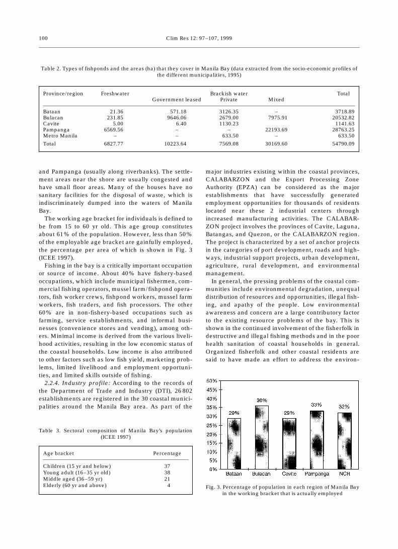
The working age bracket for individuals is defined tobe from 15 to 60 yr old. This age group constitutesabout 61% of the population. However, less than 50%of the employable age bracket are gainfully employed,the percentage per area of which is shown in Fig. 3(ICEE 1997).
Fishing in the bay is a critically important occupationor source of income. About 40% have fishery-basedoccupations, which include municipal fishermen, com-mercial fishing operators, mussel farm/fishpond opera-tors, fish worker crews, fishpond workers, mussel farmworkers, fish traders, and fish processors. The other60% are in non-fishery-based occupations such asfarming, service establishments, and informal busi-nesses (convenience stores and vending), among oth-ers. Minimal income is derived from the various liveli-hood activities, resulting in the low economic status ofthe coastal households. Low income is also attributedto other factors such as low fish yield, marketing prob-lems, limited livelihood and employment opportuni-ties, and limited skills outside of fishing.
2.2.4. Industry profile: According to the records ofthe Department of Trade and Industry (DTI), 26 802establishments are registered in the 30 coastal munici-palities around the Manila Bay area. As part of the
major industries existing within the coastal provinces,CALABARZON and the Export Processing ZoneAuthority (EPZA) can be considered as the majorestablishments that have successfully generatedemployment opportunities for thousands of residentslocated near these 2 industrial centers throughincreased manufacturing activities. The CALABAR-ZON project involves the provinces of Cavite, Laguna,Batangas, and Quezon, or the CALABARZON region.The project is characterized by a set of anchor projectsin the categories of port development, roads and high-ways, industrial support projects, urban development,agriculture, rural development, and environmentalmanagement.
In general, the pressing problems of the coastal com-munities include environmental degradation, unequaldistribution of resources and opportunities, illegal fish-ing, and apathy of the people. Low environmentalawareness and concern are a large contributory factorto the existing resource problems of the bay. This isshown in the continued involvement of the fisherfolk indestructive and illegal fishing methods and in the poorhealth sanitation of coastal households in general.Organized fisherfolk and other coastal residents aresaid to have made an effort to address the environ-
100
Table 2. Types of fishponds and the areas (ha) that they cover in Manila Bay (data extracted from the socio-economic profiles ofthe different municipalities, 1995)
Province/region Freshwater Brackish water TotalGovernment leased Private Mixed
Bataan 21.36 571.18 3126.35 – 3718.89Bulacan 231.85 9646.06 2679.00 7975.91 20532.82Cavite 5.00 6.40 1130.23 1141.63Pampanga 6569.560 – – 22193.69 28763.25Metro Manila – – 633.50 – 633.50
Total 6827.770 10223.640 7569.08 30169.60 54790.09
Table 3. Sectoral composition of Manila Bay’s population (ICEE 1997)
Age bracket Percentage
Children (15 yr and below) 37Young adult (16–35 yr old) 38Middle aged (36–59 yr) 21Elderly (60 yr and above) 4 Fig. 3. Percentage of population in each region of Manila Bay
in the working bracket that is actually employed
Perez et al.: Impacts and responses in the Philippines coastal sector
mental problems of the bay. These efforts, though,tended to be limited and had no widespread impact onthe rest of the communities around the bay. This maybe partly attributed to the perception that the govern-ment, despite its inability to implement coastal andfishery laws, has the primary responsibility for manag-ing the bay’s resources. Directly or indirectly, factorscontributing to this low awareness and concern aboutthe environment include poor education, limited orminimal flow of information, poor health and sanitationawareness, and ineffective enforcement of laws.
2.3. Vulnerability analysis. Topographic and bathy-metric maps are important sources of data for the vul-nerability assessment of the impacts of ASLR in thecoastal areas. However, for most developing nations,high-resolution maps are difficult to obtain. Most of thecoastal charts that are available have 10 to 100 m con-tour intervals, which are virtually useless when analyz-ing the prescribed scenarios. Supplementing existingdata by means of airborne photogrammetry is costly,both in terms of funds available and time allocatedfor the vulnerability analysis and assessment of adap-tations. Satellite imagery can also be very expensiveor not easily obtained. A technique developed byLeatherman et al. (1995) called Aerial Videotape-assisted Vulnerability Analysis (AVVA) has beenadopted by the present country study. In effect, thistechnique covers Steps 3 to 6 of the IPCC commonmethodology. AVVA is a reconnaissance-level assess-ment of the implications of land use in response to sealevel rise. It involves unrectified oblique aerial video-recording of the coastal area taken from a height of 50to 500 m, limited ground truth information, archivalresearch, and analysis of the data in conjunction withsimple land loss and response models.
2.3.1. Base maps: The finest resolution maps used inthis study have a scale of 1:10 000 with 4.0 m contourlines and spot heights. Similarly scaled land use mapswere also obtained from CGSD for references.
2.3.2. Aerial survey: A UH-IH model helicopter wasflown over the area of the Manila Bay coastline. Thefirst low-level pass was taken at 75 m altitude fromBataan to Cavite and back. The 300 m level survey hadto be suspended due to heavy air traffic in the area.The survey included still pictures and 8 mm videocoverage.
2.3.3. Ground truth measurements: The main objec-tive of the field survey was to delineate the specifiedboundary conditions for the ASLR scenarios: 0.3, 1.0and 2.0 m contours, along the coast, and the majorchanges that had occurred there since the last up-dating of the topographic maps of the area. The mainwork consisted of establishing geodetic controls (pointsof known geographic positions and elevations) alongthe coast spaced approximately at 2.5 km. Supplemen-
tary controls were established in low elevation areasextending significantly inland.
Ground profiling was also done where spot heightswere obtained. The spacing of spot heights dependedlargely on the nature of the terrain (i.e. closely spacedheights for steep slope). The heights and positions ofthese spot heights were then plotted on survey forms toobtain the 0.3 and 1.0 m contours. High-resolution 2 mcontour lines were drawn on existing maps by interpo-lating between the 4 m contour lines.
2.4. Identification of needs and actions. Selection ofthe appropriate response will depend on site-specificconditions (as reflected in the results of the vulnerabil-ity analysis), costs, land use, and coastal infrastructure.Some issues and concerns for consideration in re-sponding to ASLR are as follows:
(1) The costs of the responses must be assessed.(2) Assuming that the coastal resources cannot be
protected, the main political factor to be considered isthe necessity to relocate people and infrastructureslikely to be affected by ASLR. The big question is:What policies or laws are required to do so?
(3) Adoption of policies and laws restricting habita-tion and investment in vulnerable areas may be neces-sary.
(4) Public education about the coastal environment isneeded to sensitize the government and the peopleabout the issues involved—that is, the danger andpossible solutions.
(5) Any rise in sea level will likely increase the levelof flooding both in magnitude and duration. Majordevelopment projects such as flood protection em-bankments or levees have to address these problems.
(6) Basic research is needed aimed at a better under-standing of coastal processes, rational use of coastalresources such as mangrove forests and coral reefs,and artificial coastal protection.
(7) Dislocation of people and changes in livelihoodmust be addressed. At the turn of the century, it will notbe uncommon to hear about ‘environmental refugees’.Responsible agencies must be ready to intervene.
(8) Long-term development within the context of anintegrated coastal zone management plan must be putin place by all agencies concerned. Some of the coastalmanagement issues that address sea level rise are(i) management of shoreline flood plain hazards for theprotection of life and property, including evacuationplanning and protective works, (ii) prevention of saltwater intrusion through judicious use (conservation) offresh water, (iii) preservation of public access and reg-ulation of coastal recreation areas, (iv) protection ofpeople and economics at risk, and conservation of wet-land, estuaries, and nearshore habitats, and (v) plan-ning the sustainable development of vulnerable nat-ural resources like ground water, sand, and corals.
101

Clim Res 12: 97–107, 1999
3. RESULTS AND DISCUSSION
3.1. Aerial survey
The aerial survey confirmed the presence of severaltypes of coastal environments in the Manila Bay area.These are the brushland/industrial environment ofsouthern Bataan, the agro-aquacultural environmentof the Bataan-Pampanga coasts, the aquacultural andurban environment of Bulacan and northern MetroManila, the highly urbanized environment of MetroManila, the tourism and agro-aquacultural environ-ment of Cavite, and the natural environment of south-ern Cavite (Perez et al. 1996).
Initial observations also revealed erosion at theBataan coasts and other shoreline changes due toreclamation for various land usages, especially in theManila-Cavite areas. The presence of squatter areas(areas occupied by homeless citizens who do not havetheir own legitimate dwellings) along the river deltasof Bataan, Bulacan, and Metro Manila emphasized theincreased vulnerability of the area. The river outlets tothe bay from Pampanga and Bulacan are noticeablyheavily silted with lahar deposits. There has beenextensive land reclamation for fishponds along thecoasts of southern Bulacan, although previously it wasknown that the Department of Agriculture disap-proved of this practice as it had serious detrimentalenvironmental effects. A check with the Bureau ofFisheries and Aquaculture Research revealed thatleases or permits for ponding along Manila Bay hadbeen canceled since 1967 by a Presidential Decree onFishpond Leasing/Developments.
Only 2 areas within the bay were identified asforested. These are the extreme ends of Manila Bay inBataan (Mariveles) and in Cavite (Maragondon). TheMetro Manila shoreline has been greatly restructuredby the high level of urbanization. As a result of theextensive economic developments that have beencarried out, the area is now almost devoid of naturalvegetation. This is also the only place in the bay coast-line where physical protection structures are notice-able. The agricultural lands (ricefields) of Cavite aremostly near the shore, while those of Bataan andBulacan are landward of the fishponds.
Most of the coasts in the northern portion of the bayare characterized by a muddy substrate, while towardthe south the shores have a sandy substrate. Shorelinechanges due to reclamation for urbanized develop-ments are quite significant over Parañaque (residentialsubdivisions), Pasay (Cultural Center of the PhilippinesComplex), Las Piñas-Cavite (coastal road). Erosion ismostly evident in the beach areas of Cavite, most prob-ably due to sand quarrying, and in some abandonedfishponds of Bulacan.
Data from the Public Estates Development showsthat a total area of 17.74 km2 has been developedalong the coast of Manila Bay over the last 40 yr. Thisfigure is further broken down into 8.16 km2 for fish-pond development and 9.28 km2 for urbanized devel-opments such as settlement areas, road network ex-pansion, port facilities development, and institutional/recreational complexes.
3.2. Vulnerability to accelerated sea level rise
From the graph in Fig. 2, it is quite noticeable thatthe mean sea level in Manila Bay abruptly rose in thelate 1960s. Although Manila is known to be below sealevel and sinking, the rising sea level observations arenot believed to be the result of land subsidence sincethe instruments are calibrated periodically and thereference site tested for stability (Carandang 1989).
Shallowing of the nearshore areas is generally due tothe natural processes of soil erosion and siltation.Several reasons can be cited, such as the unsoundresource-use practices in the upland (for example,slash-and-burn farming) and indiscriminate disposal ofwastes and garbage in the coastal areas that hashastened and intensified these natural processes.
Infrastructure development, whether in the interioror in the coastal areas, generally causes adverse effectsto the coastal zone in the long term. Land reclamationprojects like the one being carried out along the Pasayand Parañaque areas, for example, had caused a lot ofsiltation in the nearshore areas of these 2 towns.
Baseline information on the natural ecosystemreveals the sad state of corals and other fish habitats,such as seagrasses, in the bay. This decline is directlyattributed to water pollution and increased siltation ofthe bay’s waters. Similarly, mangrove forests in thecoastal areas are definitely vanishing due to humanintervention. In their present condition, if ASLR doesoccur, these weakened ecosystems may not keep pacewith the warmer temperature and reduced light(because of increased turbidity). Corals are sensitive towater temperature (warmer water causes a conditionknown as ‘bleaching’ of the corals). For their growth,corals also need light. The growth of mangroves is usu-ally affected by the salinity of water. Mangroves,which are found mostly in estuaries, may not be able tosurvive the increased salinity when the sea level rises.Several anthropogenic causes for the decline of man-groves, corals and seagrasses can be mentioned. Theyinclude the following: (1) Mangrove forests have beenconverted into fishponds, saltbeds, rice paddies andeven for residential, commercial, and industrial pur-poses. (2) Mangroves have been overexploited fortimber use, firewood, and tanbarks. (3) Philippine
102

Perez et al.: Impacts and responses in the Philippines coastal sector
mangroves are affected by pollution due to mining anddumping of mine tailings and solid wastes. (4) Siltationhas been an important factor in the destruction of coralreefs. The Zambales area that was affected by laharand ashfall is an example. Another cause of deteriora-tion of corals is water turbidity and water temperature.(5) Among the major causes of the decrease in seagrassbeds is siltation due to agricultural cultivation and min-ing. Natural causes like storm surges, tsunamis, andvolcanic activity affect the productivity and lifetime ofsea grasses.
The decline of wetlands/freshwater swamps may betraced to the lack of a coherent balanced policy on theproper use and management of such lands and to thefact that these areas have been declared as built-upareas. There are issues involving public easements andbuffer strips, illegal construction of permanent struc-tures, and squatting on easement areas. Non-compli-ance of the public to Presidential Directive 953 (plant-ing trees along the riverbanks) can be viewed as due tolaxity in the implementation of this directive (or lack ofa monitoring mechanism).
There are also indications that agricultural produc-tivity drinking water quality will be affected by salt-water intrusion into coastal soils and freshwateraquifers. This, in turn, is seen to seriously affect humanhealth and livelihood.
Results of the vulnerability analysis showed thatmost areas along the coast of Manila Bay—specifically,Cavite City, Noveleta, Kawit, Imus and Bacoor inthe province of Cavite, some parts of Las Pinas andParañaque, Malabon, Navotas in Metro Manila, andparts of Bulacan such as Hagonoy and Malolos—couldsuccumb to a 1 m sea level rise by 2100. Even inlandareas would be affected, especially near riverbanks,when sea level rise reaches a height of 2 m. However,the most densely populated areas (which are alsocurrently economically depressed) of Malabon andNavotas may survive a gradual increase in sea level,but not in conjunction with the more intense stormsurges that periodically hit Manila Bay. The surge-prone areas of Limay and Orani, Bataan, are vulnera-ble in the same way.
Maps of the Manila Bay area showing vulnerabilityto the different ASLR scenarios are presented in Fig. 4.Even without climate change, the areas prone to inun-dation due to the 0.3 m sea level rise have beenreported to suffer flooding during high tides. Table 4summarizes the tentative areas prone to inundation inthe different sea level rise scenarios. Further verifica-tion is still needed through photometric or actual fieldsurvey.
Based on computer models developed by the Com-mission on Population (PopCom), the University ofthe Philippines Population Institute (UPPI), and the
Future Group, the population of The Philippines isestimated to reach 143 million by the year 2025(DOH/USAID 1993). Further, keeping the growth ratefrom 1990 to 1995 constant, the population of ThePhilippines is estimated to increase to more thantwice the 1995 level by the year 2025. With thisdevelopment, the number of people to be affected bya 1 m ASLR (Table 5) by the year 2025 is estimated toreach about 2.3 million, though this projection maybe an overestimate because the base data is for allmunicipalities.
3.3. Commitment to sea level rise
One strategy to adapt to future sea level rise isthrough long-term planning in the context of inte-grated coastal zone management (ICZM) practices.ICZM is a ‘process of governance consisting of thelegal and institutional framework necessary to ensurethat the development and management of the coastalzones are integrated with environment and socio-economic goals in a community-participatory process’(Post & Landin 1996). Some of the areas in The Philip-pines—such as Lingayen Gulf, Davao Gulf, Cebu, andBatangas Bay—are already implementing ICZM, par-ticularly practices that constitute sound environmentalmanagement and wise use of resources and, to a lesserdegree, address coastal disaster preparedness andemergency response. Still lacking in these plans areappropriate responses to present-day climatic vari-ability (such as El Niño events) and natural hazards,and, eventually, to climate changes and the impacts tothe coastal resources.
103
Table 5. Projection of population that will be affected by a 1 msea level rise by the year 2025. 1990 and 1995 data supplied
by National Statistics Office
Place 1990 1995 2025
The Philippines 62 049 000 68 614 000 143 096 245Cavite 230 506 257 706 658 762Metro Manila 429 600 510 794 1 443 228Bulacan 130 000 140 790 227 166
Total: 2 329 156
Table 4. Endangered areas in different projected sea level rise scenarios for the year 2100
Sea level rise scenario (m) Area to be inundated (ha)
0.3 20901.0 55552.0 8905

Clim Res 12: 97–107, 1999104
N
14°50’
14°45’
14°40’
14°35’
14°30’
14°25’
120° 42’ 120° 47’ 120° 52’ 120° 57’ 121° 02’ E
SEA LEVEL RISE VULNERABILITY MAP
0 7.5 15
Kilometers
0.3-METERS SLR (LOW ESTIMATE)AREA: 2.090 HECTARES
1.0-METERS SLR (HIGH ESTIMATE)AREA: 5.555 HECTARES
2.0-METERS SLR (WORST CASE SCENARIO)AREA: 8.905 HECTARES
EXISTING WATER AREAS(BAY, RIVERS, MARINE PONDS, ETC.)

Perez et al.: Impacts and responses in the Philippines coastal sector
ICZM is basically a cooperative effort on the part ofall coastal zone stakeholders, resulting in a ‘win-win’outcome. It is a dynamic process in which a continuingstrategy is developed and implemented for the alloca-tion of environmental, socio-cultural, and institutionalresources to achieve the conservation and sustainablemultiple use of the coastal zone. In judging the need toinclude climate change factors in the analysis of ICZM,an assessment is required of the relative importance ofthe various agents with respect to both the short- andlong-term impacts. The decision will revolve around 2concerns, vulnerability and sustainability. For exam-ple, the lifetimes of structures and implementationtimes of measures are within time scales during whichsignificant increases in sea level rise may occur. In thisregard, short-term development and solution maybecome unsustainable in view of the long-termimpacts of sea level rise. However, ICZM has to beginas early as possible to increase preparedness to dealwith the potentially far-reaching impacts of climatechange upon the coastal areas.
3.4. Government’s capability
Since the 1970s, the Philippine Government has for-mulated programs and projects on coastal resourcemanagement. It received funding supports from multi-lateral funding institutions to develop concepts andmanagement schemes related to fisheries and man-groves. At present, the government is implementingthe Fisheries Sector Program (FSP), which seeks to putinto place the coastal resource management schemesin 12 priority bays.
Mangrove reforestation is one of the components ofFSP. Reforestation is being undertaken through con-tracts with private companies. But this scheme wasmodified when DENR started implementing theCoastal Environmental Program (CEP) in 1993. TheCEP seeks to develop coastal communities as resourceand environmental managers; hence, the task ofmangrove reforestation was transferred to these com-munities.
Under the CEP, 12 pilot areas, one in each geo-graphical region, were selected to demonstrate sitesfor implementation of community-based coastal re-source management. In each pilot area, a massive in-formation campaign is conducted to inform the peopleabout the program. A community organizing or devel-
opment officer then organizes the people. The commu-nity organization takes 1 to 3 yr. During this period, thecommunity leaders are trained to manage cooperativesand people’s organizations, and the community isassisted in developing a management plan for itscoastal area. The program has 5 components—namely(1) conservation and management of habitats, includ-ing the establishment of coastal/marine protectedareas; (2) protection of endangered species; (3) moni-toring and control of coastal pollution; (4) inventory/assessment of coastal resources; and (5) appliedresearch and special projects.
The Local Government Code (LGC) of 1991 (RA7160) empowered local government units (LGUs) toplan and implement development programs or projectswithin their areas of jurisdiction. Under the LGC,coastal resource management is the primary responsi-bility of LGUs (Pimentel 1993). The LGC gives theLGUs the autonomy to pursue their own developmentas far as the bay’s resources are concerned. This alsoaffords them with an opportunity to effectively initiatethese opportunities without waiting for the nationalgovernment to make the first move. However, the factthat different political units encompass the Manila Baycoastal areas makes coordinated effort a relativelydifficult problem, because each political unit has itsown developmental agenda.
There are no clear-cut policies on the use and man-agement of wetlands and marshes, or even on thepreservation of mangroves and coral reefs and otherprecious coastal ecosystem.
In other instances where policies, laws, or regula-tions have been set up, some institutional problemsstill pose barriers to effective implementation. Amongthese are institutional weakness (or lack of politicalwill) at different levels of government, especially in theLGUs to which the function of managing municipalwaters was devolved. Enforcing agencies lack theresources to effectively enforce existing laws, rules,and regulations.
4. RECOMMENDATIONS
4.1. Proposed policy intervention
In general, it is proposed that an assessment of cur-rent practices on crisis management should be done, asclimate change may exacerbate or increase the fre-
105
Fig. 4. Areas found in Manila Bay to be vulnerable under the different sea level rise scenarios. The red areas are prone to inunda-tion due to the 0.3 m sea level rise; the yellow color signifies the areas likely to be affected by a 1.0 m sea level rise; while the
gray-colored areas are most likely to be inundated by a 2 m sea level rise
Clim Res 12: 97–107, 1999
quency of extreme events such as droughts, floods, orstorms. Greater awareness of climatic variability andchange, which are not well understood by the public ordecision-makers, should be promoted. Increasing sen-sitivity to climate issues will facilitate the public accep-tance and subsequent adoption of measures to preparefor climate variability and climate change. Such mea-sures include the following:
(1) Formulating guidelines and legislation for theimplementation of integrated coastal zone manage-ment for all coastal zones in The Philippines. Land useplanning in coastal zones will help reduce vulnerabil-ity to a rise in sea level.
(2) Institutionalizing development and protectionof mangrove resources. This can be made possiblethrough the formulation of additional policies and reg-ulations or by amending existing policies and regula-tions to allow effective and sustainable mangrovemanagement characterized by a massive reforestationof degraded mangrove systems through a community-based approach.
(3) Requiring that LGUs reserve foreshore areas thatare critical for recreation/ tourism purposes and otherpublic uses and that they be excluded from disposition.
(4) Including wetlands, swamps, and marshes in theNational Integrated and Protected Areas (NIPAS)within a category of wildlife sanctuary or uniqueecosystem.
(5) Developing a multi-hazard mitigation and protec-tion plan for natural coastal hazards, with priority onthe maximum reduction in threat to life, structures,and economic production.
(6) Formulating and strictly implementating mininglaws, and reforesting denuded watersheds to reduceriver and coastal erosion.
(7) Requiring geological, hydro-meteorological, andstructural engineering evaluation as part of the envi-ronmental impact assessment prior to coastal develop-ment.
(8) Limiting government subsidies or tax incentivesto develop land sensitive to sea level rise, such as bar-rier islands, coastal wetlands, estuarine shorelines, andcritical wildlife habitats.
(9) Promoting awareness about climate changeimpacts on coastal zone systems such as erosion, sealevel rise, flooding risks and storm/earthquake stan-dard building codes could be a cost-effective means ofreducing future expenditures.
4.2. Institutional vehicles for implementation androle of stakeholders
In The Philippines, much of the coastal zones and theadjacent ocean and most of the resources are usually
under public ownership. Hence the programs to man-age such areas and resources are operated by thegovernment for the benefit of the people. In caseswhere properties are privately owned, the manage-ment is left to the owners. In an ICZM program, impor-tant roles will exist for specialized agencies at thenational and local government levels, for researchinstitutions, for users and owners of the coastal zoneand its resources, and for the general public.
Coastal stakeholders are individuals or groups ofindividuals involved in the activities that take place inthe coastal zone. They could also be those who place ahigh value on the aesthetic, touristic, and recreationalvalue of the coastal zone. The economic survival ofthese stakeholders depends largely on the health ofthe coastal zone. Hence, the different stakeholdersmust be jointly involved in the development andimplementation of the ICZM process. This group usu-ally provides the drive and momentum to sustain anICZM process and help generate the political will toelicit action among the government policy-makers.
Community groups are the direct beneficiaries ofany long-term management plans in the coastal areas.They consist of the fisherfolk and their families,coastal zone workers, community leaders, or just ordi-nary members of the community. These people can beencouraged to become involved in the day-to-dayICZM tasks. Examples are monitoring of ambientwater quality of streams; carrying out clean-up activi-ties on coastal lands such as seashores; monitoringdischarges from various coastal zone activities; help-ing to develop watershed management activities; andadopting community-based mangrove reforestationand sustainable fishing techniques. They also canserve as active watchers of what is taking place inlocal waters and report to authorities illegal fishingand coral reef poaching. Although individual effortsare solicited and appreciated, it is the accomplish-ments of an organized group over the long term thatare most effective.
One sure way to lessen vulnerability to the impactsof climate changes is to increase resiliency throughsustainability. The government can urge those whostand to gain most to get involved with projects. Smallfishing communities will support and maintain sus-tainable use programs, such as approved fishingmethods or preservation and nourishment of coralreefs, if they derive tangible benefits from their efforts(White 1989). The incentives for ensuring a marineecosystem include sustainable, continued supply offish, improved conditions of coral reefs, increasingnumber of tourists who come to scuba and dive, andthe pride derived from sharing the management tech-niques and successes with neighboring communities,among others.
106
Perez et al.: Impacts and responses in the Philippines coastal sector
5. CONCLUSION
Many may view climate change and sea level rise astoo overwhelming and too remote. Perhaps this isbecause the issue does not fit within the political timeframe of 6 yr, which is typical for elected officials.Nevertheless, activities must begin in anticipation ofthe resulting impacts. Considering that many coastalresources in the Manila Bay area are already inseverely stressed conditions and declining, vulnerabil-ity is high and could further lead to unsustainability.
The vulnerability analysis showed that the ManilaBay area is vulnerable to sea level rise from both phys-ical and socio-economic standpoints. Most areas alongthe coast will succumb to a 1 m sea level rise, specifi-cally about 19 municipalities of Metro Manila, Bula-can, and Cavite. Areas that could be inundated by0.3 m sea level rise already experience flooding duringhigh tides (for example, Navotas, Malabon, and Dagat-dagatan areas). Densely populated areas along thecoast, especially the areas inhabited by squatters inNavotas and Malabon, may survive ASLR but will bevery vulnerable to the severe storm surges that arelikely to increase in frequency and severity. Coral reefsand wetlands are already heavily stressed and may notkeep pace with the changes in sea level. Mangrovesmay not survive changes in sediments and salinity.Saltwater intrusion will affect agricultural productivityand water quality. Considering present (1995) costs,coastal protection will be an expensive solution. Forexample, a concrete sea wall 3 m high and 1 m thickwith an underwater base that is 1.5 m high and 3 mthick will cost US $0.6 million km–1.
To be able to carry out all of these strategies, anextensive information and education campaign toinform policy-makers and the general public of theissues and concerns of ASLR must be carried out.
There is an urgent need to review and integrate allmeasures, policies, and management plans to avoidcostly duplication and increase the coordination be-tween and among all the coastal stakeholders. The in-volvement of the communities or the so-called ‘grassroots’ will serve as the strongest cohesive factor that willensure the success of any sustainable use program of the
government. The LGUs should be equipped with theproper technical know-how, together with the power toexecute all rules and regulations pertaining to the uti-lization, development, and rehabilitation of resources.
Acknowledgements. This study was supported by grants fromthe Country Studies Program for Climate Change of theGovernment of the United States of America and the Philip-pine Government under the auspices of PAGASA. Sincerethanks go to the staff of the Natural Disaster ReductionBranch and the Climatology and Agrometeorology Branch ofPAGASA and the Coast and Geodetic Survey Department ofNAMRIA/DENR.
LITERATURE CITED
Bureau of Fisheries and Aquaculture Research (BFAR) (1994)Annual report: 1993. Department of Agriculture, QuezonCity
Carandang E (1989) A study on the variation of sea level,Manila Bay. Technical Report, CGSD, NAMRIA, Manila
Department of Environment and Natural Resources—Environmental Management Bureau (DENR-EMB) (1996)Philippine environmental quality report: 1990–1995.DENR, Quezon City
Department of Health (DOH)/USAID (1993) A look in thePhilippine population and socio-economic realities. DOH,Manila
Institute for Climate, Environment and Energy (ICEE) (1997)A report on the socio-economic study on Manila bay area.Inter-Agency Committee on Climate Change (Philippines)
IPCC (1990) Sea level rise: climate change: the IPCC scientificassessment. Cambridge University Press, Cambridge
Leatherman S, Nicholls RJ, Dennis KC (1995) Aerial video-tape-assisted vulnerability analysis: a cost effective ap-proach to assess sea level rise impacts. J Coastal Res SpecIssue 14:15–25
National Statistics Office (NSO) (1990) Philippine statisticalyearbook. NSO, Manila
Perez RT, Feir R, Carandang E, Gonzalez E (1996) Potentialimpacts of accelerated sea level rise on the coastal re-sources of Manila Bay water. Air Soil Pollut J 92:137–147
Pimentel AQ (1993) The local government code of 1991: thekey to national development. Cacho Publishing House,Inc, Metro Manila
Post JC, Landin CG (1996) Guidelines for ICZM. World BankMonograph Series No. 9, Washington, DC
White AT (1989) Two community-based marine reserves:lessons for coastal zone management. In: Chua TE, PaulyD (eds) Coastal zone management in Southeast Asia, poli-cies, management strategies and case studies. ICLARM,Manila
107