Embed Size (px)
Citation preview
i
Environmental Management Framework
Bangladesh Forest Department &
Arannayk Foundation
May, 2013
Climate Resilient Participatory
Afforestation and Reforestation Project
ii
Table of Contents
Abbreviations .................................................................................................................................v
Executive Summary ..................................................................................................................... vi
1.0 INTRODUCTION ...............................................................................................................1
1.1 General .......................................................................................................................................... 1
1.2 Purpose of EMF ............................................................................................................................. 1
2.0 DESCRIPTION OF THE PROJECT ................................................................................3
2.1 Project Development Objectives .................................................................................................. 3
2.2 Project Locations ........................................................................................................................... 3
2.3 Project Implementing Agencies .................................................................................................... 3
2.4 Project Components ..................................................................................................................... 4
3.0 RELEVANT GOVERNMENT POLICIES/LEGISLATIONS AND WORLD BANK POLICEIS ............................................................................................................................8
3.1 General .......................................................................................................................................... 8
3.1.1 General Description of Environmental Polices and Legislations in Bangladesh ................... 8
3.1.2 Environment Conservation Act, 1995 and Amendments ..................................................... 8
3.1.3 Environment Conservation Rules, 1997 and Amendments ................................................ 10
3.1.4 Forestry Acts ....................................................................................................................... 11
3.1.5 Forest Act 1927 (Amendment 2000) ................................................................................... 12
3.1.6 Private Forest Ordinance (PFO), 1959................................................................................. 12
3.1.7 Private Forest Policy 1994 ................................................................................................... 12
3.1.8 Social Forestry Rules, 2004 and Amendments .................................................................... 13
3.1.9 Bangladesh Climate Change Strategy and Action Plan (BCCSAP) 2009 .............................. 13
3.1.10 National Water Policy 1999 ................................................................................................ 14
3.1.11 National Safe Drinking Water Supply and Sanitation Policy 1998 ...................................... 14
3.1.12 National Agricultural Policy, 1999 ....................................................................................... 15
3.1.13 National Fisheries Policy, 1996 ........................................................................................... 15
3.1.14 National Livestock Development Policy, 2007 .................................................................... 15
3.1.15 National Integrated Pest Management Policy, 2002 .......................................................... 16
3.1.16 Standing Orders on Disaster, 2010 ..................................................................................... 16
3.1.17 Costal Zone Policy, 2005 ..................................................................................................... 17
3.1.18 Costal Development Strategy, 2006 ................................................................................... 17
iii
3.1.19 National Adaptation Program of Action (NAPA), 2005 ....................................................... 17
3.1.20 National Land Use Policy 2001 ................................................................................................. 18
3.1.21 Environmental Clearance Procedure ....................................................................................... 18
3.2 World Bank Safeguard Policies ................................................................................................... 18
3.2.1 General Description of World Bank Safeguard Policy ......................................................... 18
3.2.2 OP/BP 4.01 Environmental Assessment ............................................................................. 19
3.2.3 OP/BP 4.04 Natural Habitats ............................................................................................... 20
3.2.4 OP/BP 4.09 Pest Management ............................................................................................ 20
3.2.5 OP/BP 4.11 Physical Cultural Resources ............................................................................. 20
3.2.6 OP/BP 4.36 Forests ............................................................................................................. 21
3.2.7 OP/BP 4.37 Safety of Dams ................................................................................................. 22
3.2.8 WBG/ IFC Environmental, Health and Safety Guidelines .................................................... 22
3.3 Implications of National Polices and Legislations on the Project ............................................... 22
3.4 Implication of Safeguard Policies of WB on the Project ............................................................. 22
3.5 Project Environment Category .................................................................................................... 23
4.0 ENVIRONMENTAL SETTINGS OF THE PROJECT AREAS ......................................24
4.1 Introduction ................................................................................................................................ 24
4.2 Agro-Ecological Zones ................................................................................................................. 24
4.3 Existing Forest ............................................................................................................................. 28
4.4 Climate Condition ....................................................................................................................... 30
4.4.1 Chittagong ........................................................................................................................... 30
4.4.2 Noakhali .............................................................................................................................. 34
5.0 Key Features of EMF.............................................................................................................39
5.1 General Principles of EMF ........................................................................................................... 39
5.2 Community Participation for Better Environmental Management ............................................ 40
5.3 Environmentally Sound Design ................................................................................................... 40
6.0 Potential Environmental Impacts .........................................................................................41
6.1 Impacts of Afforestation and Reforestation Programs ............................................................... 41
7.2 Small-Scale Infrastructure (Rehabilitation/Reconstruction of Field Offices) .............................. 43
7.0 Environmental Management ................................................................................................45
7.1 Introduction ................................................................................................................................ 45
iv
7.2 Afforestation and Reforestation Programs ................................................................................. 45
7.3 Small scale Infrastructure (rehabilitation/reconstruction of field offices) ................................. 48
7.3 Community Level Alternative Livelihood Activities .................................................................... 50
7.4 Review by World Bank ................................................................................................................ 50
7.5 Grievance Redress Mechanism ................................................................................................... 53
7.6 Consultation ................................................................................................................................ 53
7.7 Monitoring .................................................................................................................................. 56
7.8 Disclosure .................................................................................................................................... 56
Annex-A: Screening Format for Afforestation and Reforestation Program ........................................... 57
Annex-B: Screening Format for Small Infrastructure .............................................................................. 61
Annex-C: Guidelines for Carrying out IEE for Small Infrastructure ......................................................... 64
Annex-D: Environmental Screening Format for Community Level AIG Activities .................................. 71
Annex-E: Grievance Redress Mechanism ............................................................................................... 75
Annex-F: Consultation Photographs and Participant Lists ..................................................................... 78
Annex-G: Monitoring Checklist .............................................................................................................. 90
Annex-H: Exemption Notice for Use of Poly Propylene Bag .................................................................. 93
v
Abbreviations
AEZ Agro-Ecological Zone
AF Arannayk Foundation
AIGA Alternative Income Generation Activities
BCCRF Bangladesh Climate Change Resilience Fund
BFD Bangladesh Forest Department
CMO Community Mobilization Officer
CPGs Community Patrolling Groups
DoE Department of Environment
ECC Environmental Clearance Certificate
ECP Environmental Code Of Practice
ECR Environment Conservation Rules
EIA Environmental Impact Assessment
EMF Environmental Management Framework
EMP Environmental Management Plan
FDGs Forest Dependant Groups
GIS Geographic Information System
GIS Geographical Information System
GoB Government of Bangladesh
IEE Initial Environmental Examination
IP Indigenous People
MoEF Ministry of Environment And Forests
NGOs Non-Government Organizations
PIU Project Implementation Unit
SO Staff Officer
TSS Targeting And Selection Strategy
USG United Sates Government
vi
Executive Summary The objective project Climate Resilient Participatory Afforestation and Reforestation Project is to improve the resilience of selected communities in the coastal and hilly areas of Bangladesh. This would be achieved by (i) increasing the size of afforested and reforested areas; (ii) strengthening alternative livelihoods of forest-dependent communities; and (iii) improving the institutional capacity of the forest department to sustainably manage forest resources. Project will be implemented in the selected areas of 9 coastal districts out of the 19 coastal districts of Bangladesh. These coastal districts are Cox’s Bazar, Chittagong, Noakhali, Lakshimipur, Barisal, Pakuakhali, Barguna, Bhola,
Feni. The Bangladesh Forest Department (BFD) under the Ministry of Environment and Forests (MoEF) will be responsible for the overall execution and implementation of the Project. BFD will establish a full-fledged PIU, headed by a Project Director. The Arannayk Foundation (AF), the main implementing agency for this component 2 (Alternative Livelihood Support to Forestry Communities) will work closely with partner NGOs and specialized in value adding and business development organizations or individual experts in implementing the project in different selected locations.
The project has been developed under the Bangladesh Climate Change Resilience Fund (BCCRF), a Multi Donor Trust Fund to support the climate change adaptation and mitigation initiatives of the Bangladesh Government. In consultation with the Government of Bangladesh, the World Bank will, for a limited duration, ensure due diligence requirements on the BCCRF (including fiduciary management, transparency and accountability) and ensure projects are implemented with due regard to economy, efficiency and effectiveness.
As per requirement of the World Bank of Project/Program Financing, this Environmental Management Framework (EMF) has been jointly prepared by the two implementing agencies: Bangladesh Forest Department (BFD) and Arannayk Foundation (AF). The major objective of the EMF is to ensure that neither the subproject activities (both in terms of needs and quality) nor the environment is compromised through the program intervention.
The EMF will facilitate compliance with the World Bank’s environmental safeguard policies and also with the policies, acts and rules of the Government of Bangladesh. ensuring the long-term sustainability of benefits from “subprojects” by securing the natural resource base on which they are
dependent. The main objectives of the EMF is “ to outline a framework for environmental screening procedures and methodologies for the “subprojects” and guideline for preparation of environmental management (mitigation, monitoring and compensation) and reporting at the concept and proposal stage of the sub-project.
The proposed project is expected to make a positive long-term contribution to the environment such as protecting against soil and water erosion, working as a barrier during cyclone and storm surge, reducing atmospheric pollution, providing habitat for flora and fauna etc. The activities which may trigger environmental issues are the afforestation/reforestation, construction of small infrastructure and alternative livelihood. The afforestation and reforestation activities may create possible environmental issues from (i) inappropriate site selection (ii) plantation of non-native species (iii) monoculture plantations, (iv) excessive and disproportionate use of fertilizer which will cause damage to sensitive and valuable ecosystem. Environmental issues like (i) deterioration of natural drainage system (ii) sedimentation of surface water (iii) cutting of trees may trigger from the rehabilitation/reconstruction of existing field
vii
infrastructures. Without knowing the specific site and design of the infrastructure, it’s not possible to
ascertain the exact environmental impact. The activities under Alternative Livelihood Support will be implemented both individually and at community level. Without knowing the specific type of activities for livelihood support, it’s not
possible to identify specific impact for this component at this stage. A wide range of laws and regulations like Environment Conservation Act, 1995 (ECA, 1995), and the Environment Conservation Rules (ECR, 1997) related to environmental issues related to this project have been reviewed. Under the Environmental Conservation Rules (1997) a classification system was established for development projects and industries on basis of the project objective. These categories are: Green, Orange A, Orange B, and Red. The afforested/reforested or tree plantation type project is not listed or classified in accordance DOE’s classification. According to the World Bank requirement, the project has been classified as “Category B” considering risk associated with the site clearance of plantation, species selection, use of fertilizer in the plantation program, minor construction related disturbance and community level livelihood options in areas of high ecological sensitivity and vulnerability.
Baseline Information
The project location has been described as agro-ecological zones. The agro-ecological zone (AEZ) concept involves the representation of land in layers of spatial information and combination of the layers of spatial information using a Geographic Information System (GIS). The AEZ models include models for the calculation of length of growing period, irrigation requirements, crop biomass, land suitability, land productivity. The project areas mainly fall into 3 Agro-ecological zones. These are: i) Young Meghna Estuarine Floodplain (Zone 18); ii) Chittagong Coastal Plain (Zone 23); and iii) Northern and Eastern Hills (Zone 29). Climate, Rainfall and Temperature of 2 representative districts Chittagong (Southeast side of project area) and Noakhali (South side of project area) have been described under this chapter. Mangrove is the dominating forest area in the coastal divisions. Core and buffer are the main forest in the hilly areas
The climate of Chittagong is largely tropical and humid. The climatic variations are often hazardous and at times devastating. The climate of Noakhali is largely tropical and humid.
This EMF has been prepared to establish the mechanism to determine and assess future potential environmental impacts of the project that are to be identified and to set out mitigation, monitoring and institutional measures to be taken during implementation of the activities to eliminate adverse environmental impacts, offset them, or to reduce them to acceptable limit.
Environmental Management Procedure
The Forest Department will carry out screening of each plantation site and keep record of other essential information. A simple screening format (Annex-B) will be used for screening purpose. The concerned Beat Officer and Range officer will conduct the screening in consultation with the local community.
viii
The project will follow the standard Environmental Code of practice (ECP) for afforestation and reforestation. A monitoring plan will be developed by the Staff Officer (SO) for each division. The third party monitoring will also carry out independent monitoring of the ECP implementation.
The environmental management of the small scale infrastructure i.e., rehabilitation and reconstruction of office building will be also carried out in different steps. The Design, Supervision and Monitoring (DSM) consultant will carry out environmental screening in all the construction locations. Relevant Environmental Code of Practice (ECP) will be applicable for the small scale rehabilitation
For the alternative livelood component, the partner NGO will carry out the environmental screening (Annex - E) of all the community level alternative livelihood activities. AF will review the screening report and will decide on the requirement of the Environmental Management Plan (EMP).
Consultation
Comprehensive consultation with stakeholders forms a critical part of best practice project planning and development of EMF. The project will have extensive consultation with the community and stakeholders at the field level to ensure proper participatory process. The plan for participatory selection through open public meeting at union level will help designing proper consultation for environmental issues. The environmental screening and implementation of ECP or EMP will be carried out involving the community. The participation of the selected beneficiaries of the plantation program will be mandatory for such activities.
Disclosure
BFD and AF have followed follow the disclosure requirement of the World Bank on environmental documentation. The draft final version of the EMF along with a Bangla summary was posted on the website of BFD and AF on May 17, 2012 and also kept in the offices for further comments and inputs from non-governmental organization, civil society and general public. The document has been finalized based on the comments.
1
1.0 INTRODUCTION
1.1 General
1. The Climate Resilient Participatory Afforestation and Reforestation Project (CRPARP) has been developed under the Bangladesh Climate Change Resilience Fund (BCCRF), a Multi Donor Trust Fund to support the climate change adaptation and mitigation initiatives of the Bangladesh Government. The BCCRF will be managed and implemented by the Government of Bangladesh. On behalf of the contributing Development Partners, and in consultation with the Government of Bangladesh, the World Bank will, for a limited duration, ensure due diligence requirements on the BCCRF (including fiduciary management, transparency and accountability) and ensure projects are implemented with due regard to economy, efficiency and effectiveness. 2. Bangladesh Forest Department (BFD) prepared the project proposal for this project and the BCCRF Management Committee chaired by the Secretary of Ministry of Environment and Forests (MoEF) endorsed the project.
3. As per requirement of the World Bank of Project/Program Financing, this Environmental Management Framework (EMF) has been jointly prepared by the two implementing agencies: Bangladesh Forest Department (BFD) and Arannayk Foundation (AF). The major objective of the EMF is to ensure that neither the subproject activities (both in terms of needs and quality) nor the environment is compromised through the program intervention.
1.2 Purpose of EMF 3. This EMF serves as detailed guidance for environmental management during project implementation. As the exact project locations have not yet been determined, design will not be sufficiently detailed to produce implementation ready EMPs before the project is appraised. This EMF will become a legally and contractually binding document for the implementing agencies. 4. The EMF describes the environmental baseline conditions within which the project will be implemented, identifies the overall range of impacts, and designs generic mitigation, management and monitoring measures. It will also describe environmental management implementation arrangements and the legal framework based on which the project interventions will be implemented and monitored. The key safeguards instruments for project implementation – the environmental screening/assessment and the specific environmental management plan (EMP) – are described in this general EMP which provides guidance on roles and responsibilities for implementing agencies.
5. The EMF will facilitate compliance with the World Bank’s environmental safeguard
policies and also with the policies, acts and rules of the Government of Bangladesh. The EMF will contribute the goal of environmental sustainability by:
enhancing environmental outcomes of the activities implemented under individual “subprojects”;
2
preventing and/or mitigating any negative environmental impact that may emerge from the “subprojects”;
ensuring the long-term sustainability of benefits from “subprojects” by securing the
natural resource base on which they are dependent; and facilitating pro-active “subprojects” that can be expected to lead to increased
efficiency and improved management in the use of natural resources resulting in improvements in local environmental quality and human well-being.
6. More specifically the objectives of the EMF are: To outline a framework for environmental screening procedures and methodologies
for the “subprojects” to be screened and financed under the program at the concept
and proposal stage of the sub-project; and To specify appropriate roles and responsibilities to carryout environmental
screening/assessment, environmental management (mitigation, monitoring and compensation) and reporting related to “subprojects”.
3
2.0 DESCRIPTION OF THE PROJECT 2.1 Project Development Objectives 16. The project development objective is to reduce forest degradation through participatory planning/ monitoring and to contribute in building the long-term resilience of selected coastal and hilly communities to climate change. It will be achieved by (i) increasing the afforested and reforested areas; (ii) supporting alternative livelihoods of forest-dependent communities; and (iii) strengthening the institutional capacity of the forest department to manage forests in participatory and sustainable manner.
2.2 Project Locations 17. The project will be implemented in the selected areas of 9 coastal districts out of the 19 coastal districts of Bangladesh. These coastal districts are Cox’s Bazar, Chittagong, Noakhali,
Lakshimipur, Barisal, Pakuakhali, Barguna, Bhola, Feni. In the hilly area, the project will target the core1 and buffer2 zones of the Reserved Forest Land of 2 districts. These are Chittagong District and Cox’s Bazar District, which are also included as coastal districts. The BFD
administrative divisions are different from the administrative districts. Ten Forest Divisions will be covered under the project: Patuakhali Coastal Afforestation Division, Bhola Coastal Afforestation Division, Noakhali Coastal Afforestation Division, Chittagong Coastal Afforestation Division, Chittagong North Forest Division, Chittagong South Forest Division, Cox’s Bazar North Forest Division, Cox’s Bazar South Forest Division, Barisal Social Forestry
Division and Feni Social Forestry Division. 2.3 Project Implementing Agencies 18. The Bangladesh Forest Department (BFD) under the Ministry of Environment and Forests (MoEF) will be responsible for the overall execution and implementation of the Project. BFD will establish a full-fledged PIU, headed by a Project Director. The PIU will be equipped with relevant qualified specialists who will be compensated with market-based salaries. A Project Manager will be hired to coordinate the day-to-day managerial activities and provide technical guidance and input for the different components. The BFD officials will work closely with the specialists and will receive appropriate on-job training to develop individual and institutional capacity to design, implement large scale projects.
19. The Arannayk Foundation (AF), the main implementing agency for component 2 (Alternative Livelihood Support to Forestry Communities) will work closely with partner NGOs and specialized in value adding and business development organizations or individual experts in implementing the project in different selected locations AF, also called the “Bangladesh Tropical
Forest Conservation Foundation”, was established in July 2003 jointly by the Government of
Bangladesh (GOB) and the United Sates Government (USG) in order to conserve rapidly disappearing forests and biodiversity of Bangladesh. AF is managed by an independent Board of 1 Core zone is the undisturbed and protected forest areas from which the beneficiaries will not collect any benefit from the afforestation/reforestation program. 2 Buffer zone is the peripheral area of the core forest zone from which the beneficiaries will collect benefit.
4
Directors composed of one representative each from the GOB and USG, and five representatives from non-governmental organizations. 2.4 Project Components
20. The project will focus on enhancing resilience of forest communities in nine coastal and hilly districts. The project will be comprised of four components i) participatory afforestation and reforestation; (ii) alternative livelihood to support forest communities; (iii) capacity development for forest resource planning and management; and (iv) project management. The project components are designed to complement and support each other. Component 1: Afforestation and Reforestation Program (US$22.0 million): 21. The component objective of this component is to increase the afforested/reforested areas through participatory forestry and co-management approach in the degraded forestland, marginal, fallow and newly accreted land in coastal and hilly areas.3 In achieving the target of the participatory Afforestation and Reforestation, the component will also support the rehabilitation/reconstruction of the existing field offices of the Bangladesh Forest Department. The component will have 2 subcomponents: (i) participatory afforestation and reforestation and (ii) rehabilitation/reconstruction of forest department field infrastructure.
(i) Participatory Afforestation and Reforestation(approximately US$19.0 million)
22. This subcomponent will contribute to (i) better protection of lives and property in coastal areas against cyclones and storm surges and will also contribute in stabilizing the newly accreted land; and (ii) improved soil stability and water retention capacity in hilly areas and also better protection during cyclones. The afforestation and reforestation will be undertaken on available lands that are not yet covered by other planned, on-going and completed projects of BFD or other development partners. In the coastal zone, afforestation and reforestation will cover 6,767 ha of lands and 1,672 km of roadside area. In hilly areas, the project will cover 3,878 ha of core zone and 6,352 ha of buffer zone. The total 17,000 ha land and 1,672 km roadside plantation will contribute to the national plantation target4 mentioned in the Sixth Five Year Plan. This component will support nursery raising, plantations, 2 years plantations’ maintenance, cost of
beneficiaries’ selection, and monitoring and evaluation of the plantation program. 23. The project will engage local communities in afforestation and reforestation activities throughout the project cycle. The sites and species will be selected through the community consultation process, which will be properly documented. Community engagement in the hilly areas is expected to be critical to the sustainability of the program. In the coastal areas,
3 In coastal region, target geographic area will cover nine coastal districts out of the nineteen coastal districts of Bangladesh. These coastal districts are Cox’s Bazar, Chittagong, Noakhali, Lakshimipur, Barisal, Pakuakhali, Barguna, Bhola, and Feni. In the hilly area, the project will target the core and buffer zones of the Reserved Forest Land of Chittagong District and Cox’s Bazar District. The BFD administrative divisions are different from the administrative districts and the above districts are divided in ten Divisional Forest Offices. 4 The plan underscores the need for afforestation and reforestation of an estimated 250,000 ha of hill forest land, 40,000 ha of coastal areas and 7,000 ha of plain land forest by 2015.
5
particularly where foreshore afforestation is to take place, community engagement will still be encouraged, though less critical to the program’s sustainability. In many areas, people live far away from the newly accreted land where plantations will be carried out. BFD will encourage poor people in the target geographic areas to participate in nursery raising and plantations establishment. BFD will coordinate with AF and their selected NGOs in mobilizing the communities and identifying the beneficiaries and participants (where benefits will not be shared like core zones and mangroves) who will work as labor in the affoestation/ reforestation program. The detailed procedures will be spelled out in the Project Operation Manual. 24. In addition to the income generated social forestry program and livelihood support, provided under the second component, the poor and vulnerable people will be selected as the core beneficiaries of afforestation program.12 The beneficiary selection will be open, transparent and inclusive. The selected groups will also be responsible for maintaining plantations and will receive benefits from the earnings of the afforestation/reforestation program. 25. This project will pilot a beneficiary selection process at union level through open meeting to improve the participatory process and expedite the finalization before the plantation starts. The project will finance the relevant cost of this regard. This will be mandatory before initiating the plantation in the actual site.
(ii) Rehabilitation/Reconstruction of Forest Department Field Infrastructure (US$3 million)
26. The objective of the subcomponent is to rehabilitate and/or reconstruct the existing field level offices in the project area to ensure proper operation of BFD. The subcomponent will follow the design and construction practices that have no or little residual impacts on the surrounding biological, physical and natural environment and could potentially support forest biodiversity conservation by (i) minimizing and mitigating adverse impacts of infrastructure through appropriate site selection and construction methods; and (ii) remediating and compensating for any residual damage to have a net positive impact. The design options will consider solar system, rainwater harvesting and other renewable sources. It is anticipated that the civil works will generate local employment of about 0.18 million man days.
Component 2: Alternative Livelihoods to Support Forest Communities (approximately US$4.0 million) 27. The objective of this component is to reduce forest dependence of selected communities through the introduction of alternative livelihood opportunities. This will serve to reduce pressure on forests, thereby improving its sustainable use, conservation and protection. The Arannayk Foundation (AF), also known as the Bangladesh Tropical Forest Conservation Foundation, is a not for profit company (limited by guarantee and not having a share capital), established in 2003 by the joint initiative of the Governments of the People's Republic of Bangladesh and the United States of America based on the provisions of the US Tropical Forest Act of 1998, which seeks to contribute to the conservation of biodiversity assets of tropical forests. AF’s mandate is to promote conservation and restoration of tropical forests and forest biodiversity through promoting alternative income-generating activities (AIGAs). AF has
6
developed an approach to support AIGAs for community-based organizations through USAID-financed-grants, such as vegetable cultivation, small scale businesses, poultry rearing, and handicrafts. Grants are typically given to communities to be channeled for AIGAs at the household level, and are often supplemented by participatory savings. By 2010, AF was actively supporting 27 projects, for a total of US$14 million. The approach proved successful, with net returns up to two times the investment value.
28. AF will use the same approach in this component by targeting 6,000 beneficiaries in 200 villages located in forest buffer zones. In the first year, funds will be channeled to promote small-scale AIGAs at the household level (e.g. goat and poultry rearing, vegetable cultivation, small scale trade). In the second year, the project will identify the activities which have potential for being expanded at the community level (e.g. establishing cooperatives for improving marketing channels for local products, community based eco-tourism, making energy efficient cooking stoves, and agricultural firms). The component will also improve linkages with BFD through mobilizing the targeted communities into Forest Dependent Groups (FDGs). These FDGs will benefit from AIGA and will also participate in social forestry and afforestation works and to jointly protect forest resources. This will directly link with Component 1 of the Project.
29. The component will finance technical assistance consultancies, training, development of informational and educational materials, skill development, and investment support in cash grants.
Component 3: Capacity Development for Forest Resource Planning and Management (US$5.5 million)
30. This component aims to improve forest management through three subcomponents: (i) Institutional Strengthening; and (ii) Training.
(i) Institutional Strengthening (approximately US$4.0 million)
31. The objective of the subcomponent is to improve the technical knowledge base on forest resource assessment, program monitoring and long-term planning for the sustainable development of the forest sector. This subcomponent will establish a forest resource assessment and monitoring system at BFD with the use of Remote Sensing (RS) and Geographic Information System (GIS) technologies. The system will be strengthened through cross field verification. This system will provide BFD with (i) scientific and comprehensive information on existing resources in coastal and hilly areas that will be covered by afforestation/reforestation; (ii) future afforestation/ reforestation needs, thereby contributing to better planning. The assessments will be carried out in the first and last year of project implementation. They will determine the extent of the changes in plantation cover or forest density that have occurred during the project timeframe. In addition, the subcomponent will help BFD to strengthen its overall monitoring system by formulating guidelines for quality assurance of data, results, mapping and assessment of change in forest. This will be tested at the pilot level. Furthermore, this subcomponent will also help BFD in disclosing and disseminating the project related information in the website and other print media.
7
32. The subcomponent will also support the review and update of the existing Forestry Sector Master Plan (1993-2013). The update will include contemporary issues of climate change impacts, adaptation measures and carbon sequestration. The analytical studies such as economic cost-benefit of afforestation/reforestation investment, impacts of climate change, improved water management in hilly areas, land tenure issues in accreted afforested areas, policy and institutional structure of BFD for participatory approach and better forest management will be carried out to strengthen the present knowledge base and contribute to the master plan. The updated master plan will also highlight the importance of other biota like fish and wildlife of the forest for their sustainable harvest and conservation. It will also explore potential financing support through bio-carbon financing for sustainable forest sector planning and management. The plan will include a section on short, medium and long term investment requirements.
(ii) Training (US$1.5 million)
33. The objective of the subcomponent is to strengthen the capacity of BFD and targeted communities to better manage forest resources in a country confronted with climate change risks. This subcomponent will support capacity assessment and will provide a strategy for capacity development. Some BFD officials and staff will receive long-term training (i.e. one year masters/diploma program for around five forest department officials and two to three months training for around twenty officials5), while another 370 officials and staff will benefit from short-term training on climate change impact on bio-diversity and forests, community mobilization and participatory process, methods to design and implement policy, programs and projects in coastal and hilly areas. Special attention will be given to quality assurance, FM, RS, GIS, management information systems, performance management/monitoring and evaluation. The targeted beneficiaries also will receive training on forest conservation, common resource management, climate risk mitigation etc. The subcomponent will also support a general awareness campaign on forest conservation.
Component 4: Project Management (US$3.5 million):
34. This component will support the establishment of a Project Implementation Unit (PIU) in BFD. The PIU will also provide necessary support for financial management, social and environmental safeguards, communication and procurement to AF. The budget will cover consultancy fees, routine monitoring, travel, purchase of office equipment, vehicles and water crafts, including their repair and maintenance as required, meeting costs, audits and other operating costs necessary for project implementation and reporting.
5 The selection of the participants will be carried out by an agreed criteria with the World Bank and the list will requires the World Bank approval.
8
3.0 RELEVANT GOVERNMENT POLICIES/LEGISLATIONS AND WORLD BANK POLICEIS
3.1 General
3.1.1 General Description of Environmental Polices and Legislations in Bangladesh
35. A wide range of laws and regulations related to environmental issues are in place in Bangladesh. Many of these are cross-sectoral and several of them are directly related to environmental issues. The most important of these are the Environment Conservation Act, 1995 (ECA, 1995), and the Environment Conservation Rules (ECR, 1997). The ECA 1995 is primarily an instrument for establishing the Department of Environment (DOE), and for controlling industrial and project related pollution. The Act also defines in general terms that if any particular activity is causing damage to the ecosystem, the responsible party will have to apply corrective measures. Until the appearance of ECR, 1997, enforcement of the Act was not possible, as many of the clauses refer to specifications detailed in the Rules. 36. In addition to the Environmental Conservation Act and Rules, there are a number of other policies, plans and strategies which deal with the water sector, agricultural development, coastal area, protected area disaster management and climate change. These are the National Water Policy, 1999; the Forest Act 1927 (last modified 30th April 2000); National Forest Policy, 1994; the National Conservation Strategy1992; National Environmental Management Action Plan (NEMAP), 1995; Coastal Zone Policy, 2005; Coastal Development Strategy, 2006; National Agricultural Policy, 1999; National Fisheries Policy, 1996; National Livestock Development Policy, 2007; Standing Orders on Disaster, 1999 (revised in 2010); Bangladesh Climate Change Strategy and Action Plan, 2009; National Plan for Disaster Management, 2010-2015. Some of these policies and legislations are described in this chapter for reference.
3.1.2 Environment Conservation Act, 1995 and Amendments
37. The national environmental legislation known as Environmental Conservation Act, 1995 (ECA'95) is currently the main legislative document relating to environmental protection in Bangladesh, which replaced the earlier environment pollution control ordinance of 1992 and has been promulgated in Environmental Conservation Rules, 1997 (ECR’97). This Act is amended in
2000, 2002 and 2010. The main objectives of ECA’95 are: i) conservation of the natural environment and improvement of environmental standards; and ii) control and mitigation of environmental pollution. 38. The main strategies of the act can be summarized as:
Declaration of ecologically critical areas, and restriction on the operation and process, which can be continued or cannot be initiated in the ecologically critical areas
Regulation with respect to vehicles emitting smoke harmful to the environment Environmental clearances Remedial measures for injuries to ecosystems
9
Regulation of projects and other development activities Promulgation of standards for quality of air, water, noise and soil for different areas for
various purposes Promulgation of standard limit for discharging and emitting waste Formulation and declaration of environmental guidelines
39. Department of Environment (DOE) implements the Act. DOE is under the Ministry of Environment and Forest and is headed by a Director General (DG). The DG has complete control over the DOE. The power of DG, as given in the Act, may be outlined as follows:
The DG has the power to shut down any activities considered harmful to human life or the environment. The operator has the right to appeal and procedures exist for this purpose. However, if the incident is considered an emergency, there is no opportunity for appeal.
The DG has the power to declare an area affected by pollution as an ecologically critical area. DOE governs the type of work or activities that can take place in such an area.
Before beginning new development project, the project proponent must obtain Environmental Clearance from DOE. The procedures to obtain such clearance are in place.
Failure to comply with any part of ECA'95 may result in punishment by a maximum of 10 years imprisonment or a maximum fine of BDT. 1000,000 or both.
Environmental Conservation Act (Amendment 2000) 40. The Bangladesh Environment Conservation Act Amendment 2000 focuses on ascertaining responsibility for compensation in cases of damage to ecosystems, increased provision of punitive measures both for fines and imprisonment and the authority to take cognizance of offences. Environmental Conservation Act (Amendment 2002) 41. The 2002 Amendment of the ECA elaborates on the following parts of the Act:
Restrictions on polluting automobiles; Restrictions on the sale, production of environmentally harmful items like
polythene bags; Assistance from law enforcement agencies for environmental actions; Break up of punitive measures; and Authority to try environmental cases.
Environmental Conservation Act (Amendment 2010)
42. This amendment of the act introduces new rules & restriction on: No individual or institution (Gov. or Semi Gov./Non Gov./Self Governing) cannot
cut any Hill and Hillock. In case of national interest; it can be done after getting clearance from respective the department
10
Owner of the ship breaking yard will be bound to ensure proper management of their hazardous wastes to prevent environmental pollution and Health Risk
No remarked water body cannot be filled up/changed; in case of national interest; it can be done after getting clearance from the respective department; and
Emitter of any activities/incident will be bound to control emission of environmental pollutants that exceeds the existing emission standards.
3.1.3 Environment Conservation Rules, 1997 and Amendments
43. The Environment Conservation Rules provide a first set of rules under the Environment Conservation Act, 1995. The ECR is further amended in 2002 and 2003. These provide, amongst others items, standards and guidelines for:
Categorization of industries and development projects, including roads and bridges on the basis of actual and anticipated pollution load
Requirement for undertaking Initial Environmental Examination (IEE) and Environmental Impact Assessment (EIA), as well as formulating an Environmental Management Plan (EMP) according to categories of industries/development projects/activities
Procedure for obtaining environmental clearance Environmental quality standards for air, surface water, groundwater, drinking water,
industrial effluents, emissions, noise and vehicular exhaust
44. The Rules incorporate "inclusion lists" of projects requiring varying degrees of environmental investigation. The Government is also empowered to specify which activities are permissible and which restricted in the ecologically critical area. Under this mandate, MOEF has declared Sunderban, Cox's Bazar-Tekhnaf Sea Shore, Saint Martin Island, Sonadia Island, Hakaluki Haor, Yanguar Haor, Marzat Baor and Gulshan-Baridhara Lake as ecologically critical areas and accordingly has prohibited certain activities in those areas. 45. Under the Environmental Conservation Rules (1997) a classification system was established for development projects and industries on basis of the location, the size and the severity of potential pollution. It classifies industrial units and projects into four categories for the purpose of issuance of Environmental Clearance Certificate (ECC). These categories are:
(i) Green
(ii) Orange A
(iii) Orange B, and
(iv) Red 46. Green Category projects are considered relatively pollution-free and hence do not require initial environmental examination (IEE) and EIA. An environment clearance certificate (ECC) from the Department of Environment (DoE) is adequate for a project that fall into the Green category. Orange Category projects fall into two categories. Orange A projects are required to submit general information, a feasibility report, a process flow diagram and schematic diagrams of waste treatment facilities along with their application for obtaining DOE
11
environmental clearance. Orange B projects are required to submit an Initial Environmental Examination (IEE) report, along with their application and the information and papers specified for Orange B projects. Red Category projects are those which may cause ‘significant adverse’
environmental impacts and are, therefore, required to submit an EIA report. It should be noted that they may obtain an initial site clearance on the basis of an IEE report, and subsequently submit an EIA report for obtaining environmental clearance along with other necessary papers, such as feasibility study reports and no objections from local authorities. The DoE has recently developed IEE and EMP checklists in order to simplify the preparation of conventional and voluminous IEE and EMP reports that may contain irrelevant and unnecessary information. 47. As per ECR ’97 all existing and new industries and projects in Orange B and Red
category require an Environmental Management Plan (EMP) to be prepared (after conducting an IEE or EIA) and submitted along with other necessary papers while applying for environmental clearance.
3.1.4 Forestry Acts
48. Systematic management of forests started in the 1860s after the establishment of a Forest Department in the Province of Bengal. To regulate activities within forests, rules and regulations have been formulated, amended, modified and improved upon over the years. These rules and regulations are formulated on the basis of long-existing acts and policies. 49. Forest legislation in Bangladesh dates back to 1865, when the first Indian Forest Act was enacted. It provided for protection of tree, prevention of fires, prohibition of cultivation, and grazing in forest areas. Until a comprehensive Indian Forest Act was formulated in 1927, several acts and amendments covering forest administration in British India were enacted and were as follows: (a) Government Forest Act, 1865; (b) Forest Act, 1890; (c) Amending Act, 1891; (d) Indian Forest (Amendment) Act, 1901; (e) Indian Forest (Amendment) Act, 1911; (f) Repealing and Amending Act, 1914; (g) Indian Forest Amendment Act, 1918; and (h) Devolution Act, 1920.
50. The Forest Act of 1927, as amended with its related rules and regulations, is still the basic law governing forests in Bangladesh. The emphasis of the Act is on the protection of reserved forest. Some important features of the Act are: (i) Under the purview of the Forest Act, all rights or claims over forestlands have been settled at the time of the reservation. The Act prohibits the grant of any new rights of any kind to individuals or communities; (ii) Any activity within the forest reserves is prohibited, unless permitted by the Forest Department; (iii) Most of the violations may result in court cases where the minimum fine is Taka 2,000 and/or two month's rigorous imprisonment; and (iv) The Act empowers the Forest Department to regulate the use of water-courses within Reserve Forests.

12
3.1.5 Forest Act 1927 (Amendment 2000)
51. The Forest Act of 1927 as amended in 1989 has its roots in Indian Forest Act, 1878. The Forest Act grants the government several basic powers, largely for conservation and protection of government forests, and limited powers for private forests. The 1927 version of the act was amended in 1989 for extending authority over "any [Government-owned] land suitable for afforestation". 52. Forest department is the main agency to implement the provisions of the Forest Act. The Act, however, does not specify any sort of institutional structure for the forest or other land holding agencies. It also does not set out any specific policy direction for managing the forests. 53. Most of the forest lands under the management of forest department are areas declared to be reserved and protected forests under this act. The act empowers the government to regulate the felling, extraction, and transport of forest produce in the country.
3.1.6 Private Forest Ordinance (PFO), 1959
54. The Private Forest Act of 1959 allows the Government to take over management of improperly managed private forest lands, any private lands that can be afforested, and any land lying fallow for more than three years. The Private Forest Ordinance was originally enacted in 1945, as the Bengal Private Forest Act, and was re-enacted by the Bangladesh (then East Pakistan) in 1949 before being issued as an Act in 1959. These government managed lands under this act are called "vested forests". The Forest Department manages approximately 8,500 hectares in the country as "vested forests". This area is relatively small, but the area historically affected by this law is much larger. 55. PFA, 1959 empowers the government to require management plans for private forests and to assume control of private forests as vested forests. Government has broad powers to write rules regarding use and protection of vested forests, and apply rules to "controlled forests," which include all private forests subject to any requirement of the Act.
3.1.7 Private Forest Policy 1994
56. The policy suggested for extended effort to bring about 20% of the country's land under the afforestation programs of the government and private sector by year 2015 by accelerating the pace of the program through the coordinated efforts of the government and NGOs and active participation of the people in order to achieve self reliance in forest products and maintenance of ecological balance. The policy viewed equitable distribution of benefits among the people, especially those whose livelihood depend on trees and forests; and people's participation in afforestation programs and incorporation of people's opinions and suggestions in the planning and decision-making process. The people-centered objectives of the policy are: creation of rural employment opportunities and expansion of forest-based rural development sectors; and prevention of illegal occupation of forest lands and other forest offences through people's
13
participation. The policy statements envisage: massive afforestation on marginal public lands through partnerships with local people and NGOs; afforestation of denuded/encroached reserved forests with an agroforestry model through participation of people and NGOs; giving ownership of a certain amount of land to the tribal people through forest settlement processes; strengthening of the Forest Department; strengthening of educational, training and research facilities; and amendment of laws, rules and regulations relating to the forestry sector and if necessary, promulgation of new laws and rules. Thus, over time the policy has shifted somewhat from total state control to a management regime involving local communities in specific categories of forests.
57. Because of limited amount of forestland, the policy underscores for effective measures for afforestation in rural areas, in the newly accreted char in the coastal areas and in the denuded Unclassed State Forest areas of Chittagong Hill Tract and northern zone of the country including the Barind tract. The policy also encourages the private sector participation in afforestation.
3.1.8 Social Forestry Rules, 2004 and Amendments
58. Social forestry was included in the Forest (Amendment) Act 2000 and the Social Forestry Rules were approved in 2004 (amended in 2010 and 2011). The Rules defined the process of beneficiaries’ selection, roles and responsibilities of different stakeholders, management, capacity building and distribution of earnings from social afforestation. According to the rules, the beneficiaries shall be selected from amongst the local communities and shall preferably be from the amongst the followings persons, namely: (a) landless persons; (b) owners or occupants of less than 50 decimals of land; (c) destitute women; (d) unprivileged community; (e) poor ethnic minority; (f) poor forest villages; and (g) insolvent freedom fighters or insolvent successor of freedom fighters. The rules provided the rotation period for different plantation and benefit sharing. In general, the communities responsible for maintenance of plantation will receive around 45% of timber value of the forest.
3.1.9 Bangladesh Climate Change Strategy and Action Plan (BCCSAP) 2009
59. The Government of Bangladesh prepared the Bangladesh Climate Change Strategy and Action Plan (BCCSAP) in 2008 and revised in 2009. This is a comprehensive strategy to address climate change challenges in Bangladesh. It is built around the following six themes:
Food security, social protection and health to ensure that the poorest and most vulnerable in society, including women and children, are protected from climate change and that all programs focus on the needs of this group for food security, safe housing, employment and access to basic services, including health.
Comprehensive disaster management to further strengthen the country’s already
proven disaster management systems to deal with increasingly frequent and severe natural calamities.
Infrastructure to ensure that existing assets (e.g., coastal and river embankments) are well maintained and fit for purpose and that urgently needed infrastructures
14
(cyclone shelters and urban drainage) is put in place to deal with the likely impacts of climate change.
Research and Knowledge management to predict that the likely scale and timing of climate change impacts on different sectors of economy and socioeconomic groups; to underpin future investment strategies; and to ensure that Bangladesh is networked into the latest global thinking on climate change.
Mitigation and low carbon development to evolve low carbon development options and implement these as the country’s economy grows over the coming decades.
Capacity building and Institutional strengthening to enhance the capacity government ministries, civil society and private sector to meet the challenge of climate change.
There are 44 specific programs proposed in the BCCSAP under the six themes.
3.1.10 National Water Policy 1999
60. The National Water Policy was promulgated in 1999 with the intention of guiding both public and private actions to ensure optimal development and management of water in order to benefit both individuals and the society at large. The policy aims to ensure progress towards fulfilling national goals of economic development, poverty alleviation, food security, public health and safety, a decent standard of living for the people and protection of the natural environment. According to the policy, all agencies and departments entrusted with water resource management responsibilities (regulation, planning, construction, operation and maintenance) will have to enhance environmental amenities and ensure that environmental resources are protected and restored while executing their activities. Environmental needs and objectives will be treated equally with the resources management needs. The policy has several clauses related to the protection and conservation of the natural environment to ensure sustainable development.
3.1.11 National Safe Drinking Water Supply and Sanitation Policy 1998
61. The National Safe Drinking Water Supply and Sanitation Policy (NSDWSSP, 1998) was adopted in 1998, and sets out the basic framework for the improvement of public health quality and to ensure an improved environment, together with a set of broad sectoral action guidelines. The policy offered the following various objectives to achieve the goal:
To manage water supply and sanitation related basic needs for all To bring about a positive change of peoples’ attitude towards water and sanitation To reduce the outbreak of water-borne diseases To increase the efficiency of the Local Government and associated communities for
handling the problems related to water supply and sanitation more effectively To improve and make the water supply and sanitation system more sustainable To promote proper conservation, management and use of surface water and to control
water pollution in light of the scarcity of groundwater To take necessary steps to capture and use rain water
15
62. Ensuring the installation of one sanitary latrine in each household in the rural areas and improving public health standard through inculcating the habit of proper use of sanitary latrines is mentioned as one of the objectives. About urban sanitation, the policy objective is to ensure sanitary latrine within easy access of every urban household through technology options ranging from pit latrines to water borne sewerage. Installing public latrines in schools, bus stations and important public places and community latrines in densely populated poor communities without sufficient space for individual household latrines is also emphasized.
3.1.12 National Agricultural Policy, 1999
63. The overall objective of the National Agriculture Policy is to make the nation self-sufficient in food through increasing production of all crops including cereals and ensure a dependable food security system for all. One of the specific objectives of National Agricultural Policy is to take necessary steps to ensure environmental protection as well as ‘environment-friendly sustainable agriculture’ through increased use of organic manure and strengthening of
the integrated pest management program. The policy also suggests to create awareness so that the chemical fertilizers and pesticides used for increased crop production do not turn out to be responsible for environmental pollution. Water logging and salinity are identified as one of the serious problem in some parts of the country including the coastal areas for agricultural activities and environmental damage. The policy recommends for crop rotation and salt tolerant crop varieties.
3.1.13 National Fisheries Policy, 1996
64. The National Fisheries Policy, 1996 recognizes that fish production has declined due to environmental imbalances, adverse environmental impact and improper implementation of fish culture and management programs. The policy suggests following actions:
Shrimp and fish culture will not he expanded to the areas which damage mangrove forest in the coastal region
Biodiversity will be maintained in all natural water bodies and in marine environment Chemicals harmful to the environment will not be used fish shrimp farms Environment friendly fish shrimp vulture technology will be used Control measures will be taken against activities that have a negative impact on
fisheries, resources and vice-versa Laws will be formulated to ban the disposal of any untreated industrial effluents into
the water bodies.
3.1.14 National Livestock Development Policy, 2007
65. The National Livestock Development Policy has been prepared to address the key challenges and opportunity for a comprehensive sustainable development of the Livestock sub-sector through creating an enabling policy framework. The policy recognizes that there are no guidelines for environmental protection and bio-security when establishing poultry farms. The use of antibiotics in feeds is thought to be common and a cause of public health concern. The
16
policy recommends for developing and enforcing specific guidelines for establishing environment-friendly commercial poultry farms.
3.1.15 National Integrated Pest Management Policy, 2002
66. The objective of the policy is to enable farmers to grow healthy crops in an increased manner and thereby increase their income on a sustainable basis while improving the environment and community health. Maintaining ecological balance is the first priority of the IPM policy. In order to reduce misuse of agro-chemicals that could easily lead to ecological disturbance threatening the sustainability of agricultural production, the policy suggests for the following measurers:
Efforts will be made to conserve and augment populations of bio-control agents in crop fields through the adoption of the principles and practices of IPM; and
Priorities will be given to the management of pests through the use of parasitoids, predators, insect pathogens, appropriate cultivation techniques, pest tolerant varieties, mechanical control measures, crop diversification, botanical products and bio-pesticides.
3.1.16 Standing Orders on Disaster, 2010
67. The 'Standing Orders on Disaster, 2010' is a substantial improvement over the previous edition (English 1999) New features introduced in this edition include, among others, the following: i) an outline of disaster management regulative framework, ii) an introduction of core groups for emergency response at various levels, iii) multi-agency disaster incident management system, iv) risk reduction roles and responsibilities for all committees and agencies, v) new outlines for local level plans, vi) revised storm warning signals, vii) a report on cyclone shelter design. Conceptually, this edition follows a comprehensive approach emphasizing risk reduction as well as emergency responses relating to all hazards and all sectors. Consequently, it has to be followed not only during disasters, but also at normal times. The Standing Order is designed to enhance capacity at all tiers of government administrative and social structures for coping with and recovering from disasters. The document contains guidelines for construction, management, maintenance and use of cyclone shelters. According to the guideline, geographical information system (GIS) technology will be applied at the planning stage to select the location of cyclone shelter considering habitation, communication facilities, distance from the nearest cyclone-center etc. The advice of the concerned District Committee is to be obtained before final decision. The cyclone shelters should have effective communication facilities so that in times of distress there are no unnecessary delays. For this reason, the road communication from the cyclone shelters should link to cities, main roads and neighboring village areas. Provision of emergency water, food, sanitation and shelter space for livestock during such periods should also be considered for future construction of shelters.
17
3.1.17 Costal Zone Policy, 2005
68. Coastal zone policy initiated as a harmonized policy that transcends beyond sectoral perspectives. The policy provides general guidance so that the coastal people can pursue their livelihoods under secured conditions in a sustainable manner without impairing the integrity of the natural environment. The policy framework underscores sustainable management of natural resources like inland fisheries & shrimp, marine fisheries, marine fisheries, mangrove and other forests, land, livestock, salt, minerals, sources of renewable energy like tide, wind and solar energy. It also emphasis on conservation and enhancement of critical ecosystem- necessary measures will be taken to conserve and develop aquatic and terrestrial including all the ecosystems of importance identified by the Bangladesh National Conservation Strategy (Mangrove, coral reef, tidal wetland, sea grass bed, barrier island, estuary, closed water body, etc).
3.1.18 Costal Development Strategy, 2006
69. Coastal Development Strategy has been approved by the Inter-Ministerial Steering Committee on ICZMP on February 13, 2006. The strategy is based on the Coastal Zone Policy and takes into account the emerging trends: increasing urbanization, changing pattern of land use, declining land and water resources, unemployment and visible climate change impacts. The strategy has 9 strategic priorities and the following 3 are relevant priorities with proposed type of interventions:
Safety from man-made and natural hazards - i) Strengthening and rehabilitation of sea dykes; and ii) reduction of severe vulnerability in the coastal zone through multi-purpose cyclone shelters-including coping mechanism.
Sustainable management of natural resources - i) environmentally and socially responsive shrimp farming; ii) introduction of renewable energy in coastal areas; and iii) development of marine fisheries and livelihood.
Environmental conservation – i) Marine and coastal environmental development; ii)
strengthening of Coast Guard for improvement of coastal safety and security in coordination with other law enforcing agencies.
3.1.19 National Adaptation Program of Action (NAPA), 2005
70. The NAPA of Bangladesh has been prepared by the Ministry of Environment and Forest (MoEF) and GoB as a response to the decision of the Seventh Session of the Conference of the Parties (COP 7). The action plan pointed out the future potential vulnerability which reveals that a major threat is expected on the forestry and biodiversity due to the climate change. The Action Plan suggested 15 priority coping strategies and mechanisms to reduce adverse effects of climate change. The first numbered list priority is “Reduction of climate change hazards through coastal afforestation with community participation”.
18
3.1.20 National Land Use Policy 2001
71. National Land Use Policy, 2001 developed by Ministry of Land highlights the policy about forest preservation and afforestation/reforestation for ecological balance. The policy states that 25% of the total land of a country should be forest covered. Environmental pollution can be mitigated by afforestation in the eligible lands and charland. The following are the highlighted land use policy for forestry sector:
Forest areas declared by the Ministry of Environment of Forest should be treated as reserved forest.
Current Forests should be reserved and expanded.
Green Belt will be created in the coastal zone. Social forestry should be encouraged.
3.1.21 Environmental Clearance Procedure
72. Legislative bases for the EIA in Bangladesh are the Environmental Conservation Act 1995 (ECA'95) and the Environmental Conservation Rules 1997 (ECR'97). The Department of Environment (DOE), under the Ministry of Environment and Forest (MOEF), is the regulatory body responsible for enforcing the ECA'95 and ECR'97. It is the responsibility of the proponent to conduct the EIA of development proposal, the responsibility to review EIA for the purpose of issuing Environmental Clearance Certificate (ECC) rests on DOE.
3.2 World Bank Safeguard Policies
3.2.1 General Description of World Bank Safeguard Policy
73. The World Bank has developed a number of Safeguard Operation Policies to ensure that all possible impacts are considered and mitigation measures are spelled out prior to the implementation of any proposed project. These policies ensure that the quality of operations is uniform across different settings worldwide. If the decision is taken that a Safeguard Policy should be applied, mitigation measures and plans must be developed and in place before the implementation of a proposed project. 74. The Bank requires environmental screening and classification for all investment projects2 (including ones financed by Trust Funds, Project Preparation Facilities and Guarantees) proposed for Bank financing, to help ensure that they are environmentally and socially sound and sustainable. Screening and classification take into account the natural environment (air, water, and land); human health and safety; social aspects (involuntary resettlement, Indigenous Peoples); cultural property; and transboundary and global environmental aspects. 75. The objectives of environmental screening and classification are: to evaluate the environmental risks associated with a proposed operation; to determine the depth and breadth
19
of Environmental Assessment (EA); and to recommend an appropriate choice of EA instrument(s) suitable for a given project. The Bank recognizes that environmental screening and classification is not absolute and involves professional judgment on a case by case basis. When screening, careful consideration needs to be given to potential environmental impacts and risks associated with the proposed project. Judgment is exercised with reference to the policy expectations and guidance; real impacts on the ground; and established regional and Bank-wide precedence and good practice.
3.2.2 OP/BP 4.01 Environmental Assessment
76. The Bank requires environmental assessment (EA) of projects proposed for Bank support to ensure that they are environmentally sound and sustainable, and thus to improve decision making. EA is a process whose breadth, depth, and type of analysis depend on the nature, scale, and potential environmental impact of the proposed project. EA evaluates a project's potential environmental risks and impacts in its area of influence; examines project alternatives; identifies ways of improving project selection, siting, planning, design, and implementation by preventing, minimizing, mitigating, or compensating for adverse environmental impacts and enhancing positive impacts; and includes the process of mitigating and managing adverse environmental impacts throughout project implementation. The bower is responsible for carrying out the EA and the Bank advises the bower on the Bank’s EA requirements. 77. The Bank classifies the proposed project into three major categories, depending on the type, location, sensitivity, and scale of the project and the nature and magnitude of its potential environmental impacts. Projects with multiple components or with multiple subprojects (other than projects using FIs) are categorized according to the component with the most serious potential adverse effects. Dual categories may not be used. However, the depth and breadth of EA and choice of EA instrument(s) for each component or each subproject is decided on the basis of its respective potential impacts and risks.
Category A: The proposed project is likely to have significant adverse environmental impacts that are sensitive, diverse, or unprecedented. These impacts may affect an area broader than the sites or facilities subject to physical works. Category B: The proposed project’s potential adverse environmental impacts on human
population or environmentally important areas-including wetlands, forests, grasslands, or other natural habitats- are less adverse than those of Category A projects. These impacts are site specific; few if any of them are irreversible; and in most cases mitigation measures can be designed more readily than Category A projects. Category C: The proposed project is likely to have minimal or no adverse environmental impacts.
20
3.2.3 OP/BP 4.04 Natural Habitats
78. The conservation of natural habitats, like other measures that protect and enhance the environment, is essential for long-term sustainable development. The Bank therefore supports the protection, maintenance, and rehabilitation of natural habitats and their functions in its economic and sector work, project financing, and policy dialogue. The Bank supports, and expects borrowers to apply, a precautionary approach to natural resource management to ensure opportunities for environmentally sustainable development. The Bank promotes and supports natural habitat conservation and improved land use by financing projects designed to integrate into national and regional development the conservation of natural habitats and the maintenance of ecological functions. Furthermore, the Bank promotes the rehabilitation of degraded natural habitats. The Bank does not support projects that involve the significant conversion or degradation of critical natural habitats.
3.2.4 OP/BP 4.09 Pest Management
79. To manage pests that affect either agriculture or public health, the Bank supports a strategy that promotes the use of biological or environmental control methods and reduces reliance on synthetic chemical pesticides. In Bank- financed projects, the borrower addresses pest management issues in the context of the project's environmental assessment. In appraising a project that will involve pest management, the Bank assesses the capacity of the country's regulatory framework and institutions to promote and support safe, effective, and environmentally sound pest management. As necessary, the Bank and the borrower incorporate in the project components to strengthen such capacity. The Bank uses various means to assess pest management in the country and support integrated pest management and the safe use of agricultural pesticides: economic and sector work, sectoral or project-specific environmental assessments, participatory IPM assessments, and investment projects and components aimed specifically at supporting the adoption and use of IPM. 80. In Bank-financed agriculture operations, pest populations are normally controlled through IPM approaches, such as biological control, cultural practices, and the development and use of crop varieties that are resistant or tolerant to the pest. The procurement of any pesticide in a Bank-financed project is contingent on an assessment of the nature and degree of associated risks, taking into account the proposed use and the intended user. With respect to the classification of pesticides and their specific formulations, the Bank refers to the World Health Organization's Recommended Classification of Pesticides by Hazard and Guidelines to Classification (Geneva: WHO 1994-95).
3.2.5 OP/BP 4.11 Physical Cultural Resources
81. Physical cultural resources are defined as movable or immovable objects, sites, structures, groups of structures, and natural features and landscapes that have archaeological, paleontological, historical, architectural, religious, aesthetic, or other cultural significance. Their cultural interest may be at the local, provincial or national level, or within the international community. Physical cultural resources are important as sources of valuable scientific and
21
historical information, as assets for economic and social development, and as integral parts of a people's cultural identity and practices. The Bank assists countries to avoid or mitigate adverse impacts on physical cultural resources from development projects that it finances. The impacts on physical cultural resources resulting from project activities, including mitigating measures, may not contravene either the borrower's national legislation, or its obligations under relevant international environmental treaties and agreements. The borrower addresses impacts on physical cultural resources in projects proposed for Bank financing, as an integral part of the environmental assessment (EA) process. The following projects are classified during the environmental screening process as Category A or B, and are subject to the provisions of this policy: (a) any project involving significant excavations, demolition, movement of earth, flooding, or other environmental changes; and (b) any project located in, or in the vicinity of, a physical cultural resources site recognized by the borrower. Projects specifically designed to support the management or conservation of physical cultural resources are individually reviewed, and are normally classified as Category A or B. When the project is likely to have adverse impacts on physical cultural resources, the borrower identifies appropriate measures for avoiding or mitigating these impacts as part of the EA process. These measures may range from full site protection to selective mitigation, including salvage and documentation, in cases where a portion or all of the physical cultural resources may be lost.
3.2.6 OP/BP 4.36 Forests
82. Forest is defined as an as an area of land of not less than 1.0 hectare with tree crown cover (or equivalent stocking level) of more than 10 percent that have trees with the potential to reach a minimum height of 2 meters at maturity in situ. A forest may consist of either closed forest formations, where trees of various stories and undergrowth cover a high proportion of the ground, or open forest. Young natural stands and all plantations that have yet to reach a crown density of 10 per cent or tree height of 2 meters are included under forest, as are areas normally forming part of the forest area that are temporarily unstocked as a result of human intervention such as harvesting or natural causes but that are expected to revert to forest. The definition includes forests dedicated to forest production, protection, multiple uses, or conservation, whether formally recognized or not. The definition excludes areas where other land uses not dependent on tree cover predominate, such as agriculture, grazing or settlements. In countries with low forest cover, the definition may be expanded to include areas covered by trees that fall below the 10 percent threshold for canopy density, but are considered forest under local conditions. The Bank's forests policy aims to reduce deforestation, enhance the environmental contribution of forested areas, promote afforestation, reduce poverty, and encourage economic development. Where forest restoration and plantation development are necessary to meet these objectives, the Bank assists borrowers with forest restoration activities that maintain or enhance biodiversity and ecosystem functionality. The Bank also assists borrowers with the establishment and sustainable management of environmentally appropriate, socially beneficial, and economically viable forest plantations to help meet growing demands for forest goods and services.
22
3.2.7 OP/BP 4.37 Safety of Dams
83. When the World Bank finances new dams, the Policy Safety on Dams requires that experienced and competent professionals design and supervise construction, and that the borrower adopts and implements dam safety measures through the project cycle. The policy also applies to existing dams where they influence the performance of a project. In this case, a dam safety assessment should be carried out and necessary additional dam safety measures implemented.
3.2.8 WBG/ IFC Environmental, Health and Safety Guidelines
84. The Environmental, Health and Safety (EHS) Guidelines of the World Bank Group (WBG)/International Finance Corporation (IFC), 2008 is the safeguard guidelines for environment, health and safety for the development of the industrial and other projects. They contain performance levels and measures that are considered to be achievable in new facilities at reasonable costs using existing technologies.
3.3 Implications of National Polices and Legislations on the Project
85. Except ECA’95 and ECR’97, all other policies, strategies and legal instruments do not
explicitly require any environmental screening and assessment. However, most of the policies, strategies and legal instruments emphasized the need for environmental consideration along with the project planning and implementation. The afforestation and reforestation are not mentioned in the list of the projects and industries in the ECR’97. The construction of six storied building or above has been considered as Orange B category project. So, the project interventions can be considered as ‘Green’ categories as per ECR’97. However, BFD will carry out environmental
screening to record the site specific information and to identify potential environmental issues from the afforestation/reforestation and also the rehabilitation/reconstruction of the field level small offices. The individual interventions under the alternative livelihoods to support forest communities component will be small and will not require any screening. However, the interventions at the community/cooperative level will require environmental screening. AF and its partner organizations will be responsible of the carrying environmental screening before taking any decision on the community level interventions. The environmental management framework will be submitted to DOE for their review and concurrence.
3.4 Implication of Safeguard Policies of WB on the Project 86. The project has been considered as a Category B project, due to the risk associated with the site clearance of plantation, species selection, use of fertilizer in the plantation program, minor construction related disturbance and community level livelihood options. It has been agreed that no pesticides or herbicides will be used during plantation. The Project has triggered three environmental safeguard policies for environmental assessment (OP/BP 4.01), Natural
23
Habitats (OP/BP 4.04) and Forests (OP/BP 4.36) However, in exceptional cases like during any deadly disease outbreak; pesticides can be used after adequate screening and in consultation with the Bank. In the emergency, Pest Management (OP/BP 4.09) may trigger. As per Bank requirement, the borrower needs to consult project-affected groups and local nongovernmental organizations (NGOs) about the project's environmental aspects and takes their views into account. The borrower initiates such consultations as early as possible. In addition, the borrower consults with such groups throughout project implementation as necessary to address EA-related issues that affect them.
3.5 Project Environment Category 87. Under the Environmental Conservation Rules (1997) a classification system was established for development projects and industries on basis of the project objective. These categories are: Green, Orange A, Orange B, and Red. The afforested/reforested or tree plantation type project is not listed or classified in accordance DOE’s classification. In addition The Bank requires environmental assessment (EA) of projects proposed for Bank support to ensure that they are environmentally sound and sustainable, and thus to improve decision making. EA is a process whose breadth, depth, and type of analysis depend on the nature, scale, and potential environmental impact of the proposed project. Depending on the type, location, sensitivity, and scale of the project and the nature and magnitude of its potential environmental impacts, the project falls in Category B in accordance with Bank’s classification.
24
4.0 ENVIRONMENTAL SETTINGS OF THE PROJECT AREAS
4.1 Introduction 88. The project will be implemented in the selected areas of 9 coastal districts out of the 19 coastal districts of Bangladesh. These coastal districts are Cox’s Bazar, Chittagong, Noakhali,
Lakshimipur, Barisal, Patuakhali, Barguna, Bhola, Feni. In the hilly area, the project will target the core and buffer zones of the Reserved Forest Land of 2 districts. These are Chittagong District and Cox’s Bazar District, which are also included as coastal districts. The BFD administrative divisions are different from the administrative districts. Ten Forest Divisions will be covered under the project: Patuakhali Coastal Afforestation Division, Bhola Coastal Afforestation Division, Noakhali Coastal Afforestation Division, Chittagong Coastal Afforestation Division, Chittagong North Forest Division, Chittagong South Forest Division, Cox’s Bazar North Forest Division, Cox’s Bazar South Forest Division, Barisal Social Forestry
Division and Feni Social Forestry Division. The Figure 4.1 shows the forest divisions in the Bangladesh map.
4.2 Agro-Ecological Zones 89. The project can be described as agro-ecological zones. The agro-ecological zone (AEZ) concept involves the representation of land in layers of spatial information and combination of the layers of spatial information using a Geographic Information System (GIS). The AEZ models include models for the calculation of length of growing period, irrigation requirements, crop biomass, land suitability, land productivity. 90. The agro-ecological map (Figure 4.2) was built up by adding successive layers of information about the environment which are relevant for land use and for the assessment of agricultural potential. These layers are:
physiography (which provides information on landforms and soil parent materials); soils depth and duration of seasonal flooding; length of rainfed kharif and rabi growing periods; length of the pre-kharif period of unreliable rainfall length of the cool winter period; and frequency of occurrence of extremely high (>40oC) summer temperature
91. From the figure 4.2, it is evident that the project areas mainly fall into 3 Agro-ecological zones. These are: i) Young Meghna Estuarine Floodplain (Zone 18); ii) Chittagong Coastal Plain (Zone 23); and iii) Northern and Eastern Hills (Zone 29).
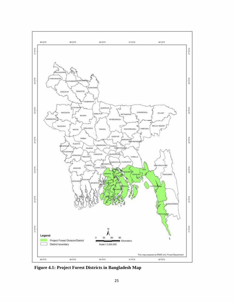
25
Figure 4.1: Project Forest Districts in Bangladesh Map
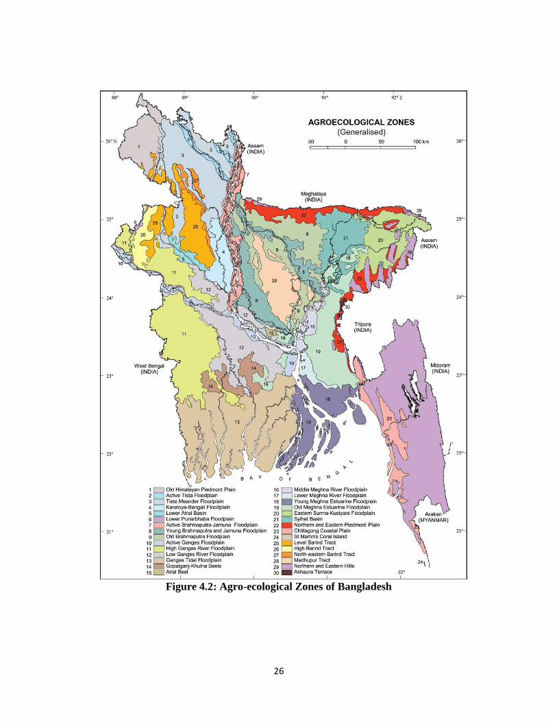
26
Figure 4.2: Agro-ecological Zones of Bangladesh
27
Young Meghna Estuarine Floodplain (Zone 18) 92. Location and extent: Chittagong, Feni, Lakshmipur, Noakhali, Bhola, Barisal, Potuakhali, Barguna districts covering 9,269 km2 area. 93. Physiography: Almost level with very low ridges and broad depressions. Shifting channels constantly erode land and deposit new char formations. 94. Climate: Mean annual rainfall is about <2,500 mm in north and >3,000 mm in the centre and south. Mean annual temperature is about 25.7°C. 95. Land type and soil type: Land type percentage: High land <1; Medium high land 45; Medium low land 7; Homestead and water bodies 47. Soils are mainly grey to olive, deep, silt loams and silty clay loams. Organic matter contents are medium. 96. Water resources: Small amount of sweet water occur at a shallow depth in floodplain ridges, but they are fully required for domestic use. Salinity gradually increases northward in the dry season. 97. Present agriculture land use: Most areas grow a single crop of T.aman rice followed by kheshari or lentils.HYV aus or aman are grown in some area. Chilies also grown as rabi crops. Coconut, betel nut, sugarcane also grown.
Chittagong Coastal Plain (Zone 23)
98. Location and extent: Feni, Chittagong, Cox's Bazar districts covering 3,720 km2 area. 99. Physiography: The region includes 6 physiographic unit namely piedmont plains, river floodplain, old tidal floodplain Young tidal floodplain. Mangrove tidal floodplain and old beach ridges. 100. Climate: Mean annual rainfall is about 2,500 mm in the centre and 3,500 mm in the south. Mean annual temperature is about 25.8°C. 101. Land type and soil type: Land type percentage: High land 17; Medium high land 43; Medium low land 13; Low land <1; Homestead and water bodies 27. Soils conditions are relatively uniform over most of the area, with grey, near neutral, silt loams and silty clay loams predominating. Acid sulfate soils occur on mangrove tidal floodplain. OM status is low. 102. Water resources: Small Limited amount of water available in the rivers and streams in the dry season and is already fully exploited for irrigation. Ground water resources are scattered. 103. Present agriculture land use: Broadcast and transplant aus, T.aman is the main crop. Deepwater aman is grown in basin. Dry land rabi crops are grown in the highest loamy soils. Within irrigation HYV boro is grown.
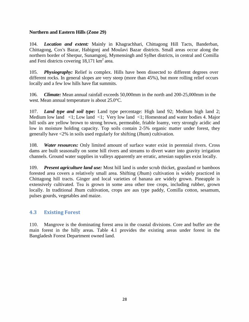
28
Northern and Eastern Hills (Zone 29)
104. Location and extent: Mainly in Khagrachhari, Chittagong Hill Tacts, Banderban, Chittagong, Cox's Bazar, Habigonj and Moulavi Bazar districts. Small areas occur along the northern border of Sherpur, Sunamgonj, Mymensingh and Sylhet districts, in central and Comilla and Feni districts covering 18,171 km2 area. 105. Physiography: Relief is complex. Hills have been dissected to different degrees over different rocks. In general slopes are very steep (more than 45%), but more rolling relief occurs locally and a few low hills have flat summits. 106. Climate: Mean annual rainfall exceeds 50,000mm in the north and 200-25,000mm in the west. Mean annual temperature is about 25.0°C. 107. Land type and soil type: Land type percentage: High land 92; Medium high land 2; Medium low land <1; Low land <1; Very low land <1; Homestead and water bodies 4. Major hill soils are yellow brown to strong brown, permeable, friable loamy, very strongly acidic and low in moisture holding capacity. Top soils contain 2-5% organic matter under forest, they generally have <2% in soils used regularly for shifting (Jhum) cultivation. 108. Water resources: Only limited amount of surface water exist in perennial rivers. Cross dams are built seasonally on some hill rivers and streams to divert water into gravity irrigation channels. Ground water supplies in valleys apparently are erratic, artesian supplies exist locally. 109. Present agriculture land use: Most hill land is under scrub thicket, grassland or bamboos forested area covers a relatively small area. Shifting (Jhum) cultivation is widely practiced in Chittagong hill tracts. Ginger and local varieties of banana are widely grown. Pineapple is extensively cultivated. Tea is grown in some area other tree crops, including rubber, grown locally. In traditional Jhum cultivation, crops are aus type paddy, Comilla cotton, sesamum, pulses gourds, vegetables and maize.
4.3 Existing Forest 110. Mangrove is the dominating forest area in the coastal divisions. Core and buffer are the main forest in the hilly areas. Table 4.1 provides the existing areas under forest in the Bangladesh Forest Department owned land.
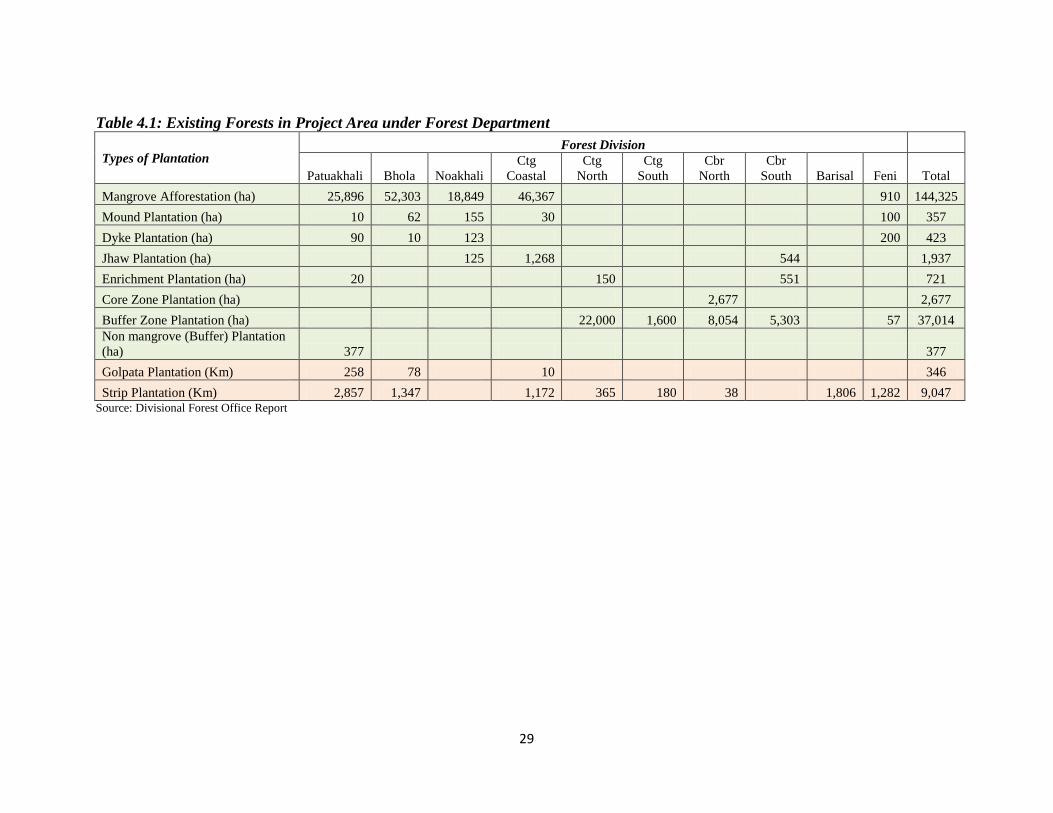
29
Table 4.1: Existing Forests in Project Area under Forest Department
Types of Plantation Forest Division
Patuakhali Bhola Noakhali Ctg
Coastal Ctg
North Ctg
South Cbr
North Cbr
South Barisal Feni Total
Mangrove Afforestation (ha) 25,896 52,303 18,849 46,367 910 144,325
Mound Plantation (ha) 10 62 155 30 100 357
Dyke Plantation (ha) 90 10 123 200 423
Jhaw Plantation (ha) 125 1,268 544 1,937
Enrichment Plantation (ha) 20 150 551 721
Core Zone Plantation (ha) 2,677 2,677
Buffer Zone Plantation (ha) 22,000 1,600 8,054 5,303 57 37,014 Non mangrove (Buffer) Plantation (ha) 377 377
Golpata Plantation (Km) 258 78 10 346
Strip Plantation (Km) 2,857 1,347 1,172 365 180 38 1,806 1,282 9,047 Source: Divisional Forest Office Report
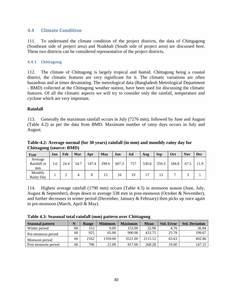
30
4.4 Climate Condition 111. To understand the climate condition of the project districts, the data of Chittgagong (Southeast side of project area) and Noakhali (South side of project area) are discussed here. These two districts can be considered representative of the project districts. 4.4.1 Chittagong 112. The climate of Chittagong is largely tropical and humid. Chittagong being a coastal district, the climatic features are very significant for it. The climatic variations are often hazardous and at times devastating. The metrological data (Bangladesh Metrological Department - BMD) collected at the Chittagong weather station, have been used for discussing the climatic features. Of all the climatic aspects we will try to consider only the rainfall, temperature and cyclone which are very important. Rainfall
113. Generally the maximum rainfall occurs in July (7276 mm), followed by June and August (Table 4.2) as per the data from BMD. Maximum number of rainy days occurs in July and August.
Table-4.2: Average normal (for 30 years) rainfall (in mm) and monthly rainy day for Chittagong (source: BMD)
Year Jan Feb Mar Apr May Jun Jul Aug Sep Oct Nov Dec Average
Rainfall in mm
5.6 24.4 54.7 147.4 298.6 607.3 727 530.6 259.3 184.8 67.5 11.9
Monthly Rainy Day
1 2 4 8 13 16 19 17 13 7 3 1
114. Highest average rainfall (1790 mm) occurs (Table 4.3) in monsoon season (June, July, August & September), drops down to average 538 mm in post-monsoon (October & November), and further decreases in winter period (December, January & February) then picks up once again in pre-monsoon (March, April & May).
Table 4.3: Seasonal total rainfall (mm) pattern over Chittagong
Seasonal pattern N Range Minimum Maximum Mean Std. Error Std. Deviation Winter period 60 153 0.00 153.00 32.98 4.76 36.84
Pre-monsoon period 60 925 65.00 990.00 433.75 25.78 199.67
Monsoon period 60 2162 1359.00 3521.00 2115.12 63.63 492.86
Post monsoon period 60 796 21.00 817.00 268.28 19.00 147.15
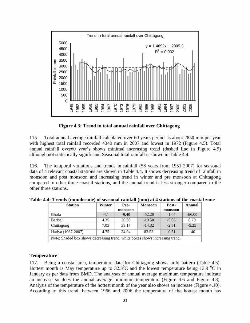
31
Figure 4.3: Trend in total annual rainfall over Chittagong
115. Total annual average rainfall calculated over 60 years period is about 2850 mm per year with highest total rainfall recorded 4340 mm in 2007 and lowest in 1972 (Figure 4.5). Total annual rainfall over60 year’s shows minimal increasing trend (dashed line in Figure 4.5) although not statistically significant. Seasonal total rainfall is shown in Table 4.4. 116. The temporal variations and trends in rainfall (58 years from 1951-2007) for seasonal data of 4 relevant coastal stations are shown in Table 4.4. It shows decreasing trend of rainfall in monsoon and post monsoon and increasing trend in winter and pre monsoon at Chittagong compared to other three coastal stations, and the annual trend is less stronger compared to the other three stations. Table-4.4: Trends (mm/decade) of seasonal rainfall (mm) at 4 stations of the coastal zone
Station Winter Pre-monsoon
Monsoon Post-monsoon
Annual
Bhola -4.1 -9.40 -52.20 -1.05 -66.00 Barisal 4.35 20.30 -10.50 -5.05 8.70 Chittagong 7.03 39.17 -14.32 -2.51 -5.25
Hatiya (1967-2007) 4.75 24.94 83.52 -0.51 140
Note: Shaded box shows decreasing trend, white boxes shows increasing trend.
Temperature
117. Being a coastal area, temperature data for Chittagong shows mild pattern (Table 4.5). Hottest month is May temperature up to 32.30C and the lowest temperature being 13.9 0C in January as per data from BMD. The analyses of annual average maximum temperature indicate an increase so does the annual average minimum temperature (Figure 4.6 and Figure 4.8). Analysis of the temperature of the hottest month of the year also shows an increase (Figure 4.10). According to this trend, between 1966 and 2006 the temperature of the hottest month has
Trend in total annual rainfall over Chittagong
y = 1.4692x + 2805.3
R2 = 0.002
0
500
1000
1500
2000
2500
3000
3500
4000
4500
5000
1949
1952
1955
1958
1961
1964
1967
1970
1973
1976
1979
1982
1985
1988
1991
1994
1997
2000
2003
2006
Rai
nfal
l in
mm
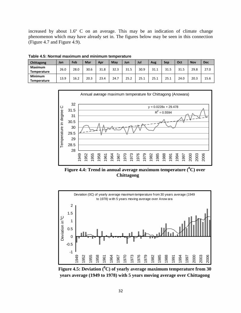
32
increased by about 1.6º C on an average. This may be an indication of climate change phenomenon which may have already set in. The figures below may be seen in this connection (Figure 4.7 and Figure 4.9).
Table 4.5: Normal maximum and minimum temperature
Chittagong Jan Feb Mar Apr May Jun Jul Aug Sep Oct Nov Dec
Maximum Temperature
26.0 28.0 30.6 31.8 32.3 31.5 30.9 31.1 31.5 31.5 29.8 27.0
Minimum Temperature
13.9 16.2 20.3 23.4 24.7 25.2 25.1 25.1 25.1 24.0 20.3 15.6
Figure 4.4: Trend in annual average maximum temperature (0C) over
Chittagong
Figure 4.5: Deviation (0C) of yearly average maximum temperature from 30 years average (1949 to 1978) with 5 years moving average over Chittagong
Annual average maximum temperature for Chittagong (Anowara)
y = 0.0228x + 29.478
R2 = 0.5594
28
28.5
29
29.5
30
30.5
31
31.5
32
1949
1952
1955
1958
1961
1964
1967
1970
1973
1976
1979
1982
1985
1988
1991
1994
1997
2000
2003
2006
Tem
pera
ture
in d
egre
e C
Deviation (0C) of yearly average maximum temperature from 30 years average (1949 to 1978) w ith 5 years moving average over Anow ara
-1
-0.5
0
0.5
1
1.5
2
1949
1952
1955
1958
1961
1964
1967
1970
1973
1976
1979
1982
1985
1988
1991
1994
1997
2000
2003
2006
Dev
iatio
n in
0 C
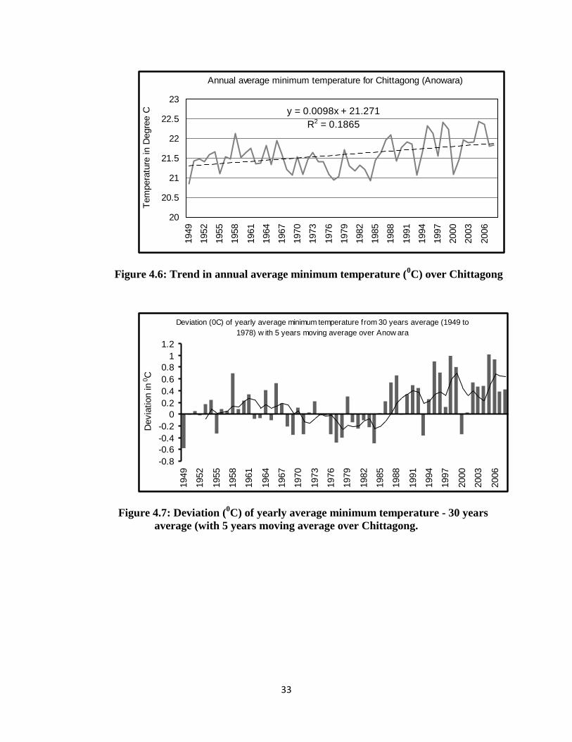
33
Figure 4.6: Trend in annual average minimum temperature (0C) over Chittagong
Figure 4.7: Deviation (0C) of yearly average minimum temperature - 30 years average (with 5 years moving average over Chittagong.
Annual average minimum temperature for Chittagong (Anowara)
y = 0.0098x + 21.271R2 = 0.1865
20
20.5
21
21.5
22
22.5
23
1949
1952
1955
1958
1961
1964
1967
1970
1973
1976
1979
1982
1985
1988
1991
1994
1997
2000
2003
2006
Tem
pera
ture
in D
egre
e C
Deviation (0C) of yearly average minimum temperature from 30 years average (1949 to 1978) w ith 5 years moving average over Anow ara
-0.8-0.6-0.4-0.2
00.20.40.60.8
11.2
1949
1952
1955
1958
1961
1964
1967
1970
1973
1976
1979
1982
1985
1988
1991
1994
1997
2000
2003
2006
Dev
iatio
n in
0 C
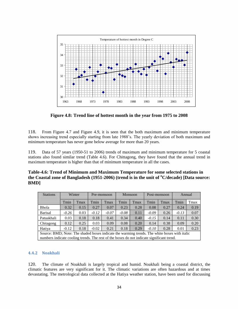
34
Figure 4.8: Trend line of hottest month in the year from 1975 to 2008
118. From Figure 4.7 and Figure 4.9, it is seen that the both maximum and minimum temperature shows increasing trend especially starting from late 1988’s. The yearly deviation of both maximum and
minimum temperature has never gone below average for more than 20 years. 119. Data of 57 years (1950-51 to 2006) trends of maximum and minimum temperature for 5 coastal stations also found similar trend (Table 4.6). For Chittagong, they have found that the annual trend in maximum temperature is higher than that of minimum temperature in all the cases. Table-4.6: Trend of Minimum and Maximum Temperature for some selected stations in the Coastal zone of Bangladesh (1951-2006) (trend is in the unit of oC/decade) [Data source: BMD]
4.4.2 Noakhali
120. The climate of Noakhali is largely tropical and humid. Noakhali being a coastal district, the climatic features are very significant for it. The climatic variations are often hazardous and at times devastating. The metrological data collected at the Hatiya weather station, have been used for discussing
Temperature of hottest month in Degree C
30
31
32
33
34
35
1963 1968 1973 1978 1983 1988 1993 1998 2003 2008
Stations
Winter Pre-monsoon Monsoon Post-monsoon Annual
Tmin Tmax Tmin Tmax Tmin Tmax Tmin Tmax Tmin Tmax Bhola 0.32 0.15 0.27 0.07 0.23 0.28 0.08 0.27 0.24 0.19 Barisal -0.26 0.03 -0.12 -0.07 -0.08 0.11 -0.09 0.26 -0.13 0.07 Patuakhali 0.03 0.18 0.18 0.41 0.34 0.40 -0.15 0.14 0.11 0.30 Chitagong 0.12 0.25 0.03 0.09 0.08 0.20 0.14 0.38 0.09 0.20 Hatiya -0.12 0.18 -0.02 0.21 0.18 0.29 -0.10 0.28 0.01 0.23 Source: BMD; Note: The shaded boxes indicate the warming trends. The white boxes with italic numbers indicate cooling trends. The rest of the boxes do not indicate significant trend.
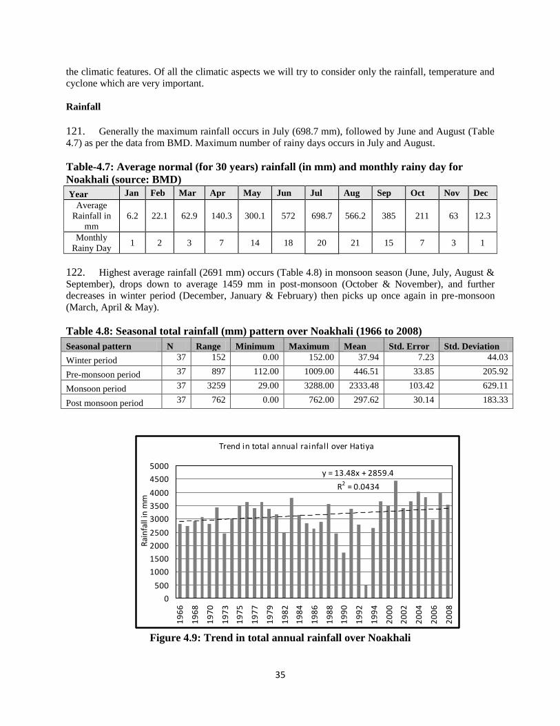
35
the climatic features. Of all the climatic aspects we will try to consider only the rainfall, temperature and cyclone which are very important. Rainfall
121. Generally the maximum rainfall occurs in July (698.7 mm), followed by June and August (Table 4.7) as per the data from BMD. Maximum number of rainy days occurs in July and August. Table-4.7: Average normal (for 30 years) rainfall (in mm) and monthly rainy day for Noakhali (source: BMD) Year Jan Feb Mar Apr May Jun Jul Aug Sep Oct Nov Dec
Average Rainfall in
mm 6.2 22.1 62.9 140.3 300.1 572 698.7 566.2 385 211 63 12.3
Monthly Rainy Day
1 2 3 7 14 18 20 21 15 7 3 1
122. Highest average rainfall (2691 mm) occurs (Table 4.8) in monsoon season (June, July, August & September), drops down to average 1459 mm in post-monsoon (October & November), and further decreases in winter period (December, January & February) then picks up once again in pre-monsoon (March, April & May). Table 4.8: Seasonal total rainfall (mm) pattern over Noakhali (1966 to 2008) Seasonal pattern N Range Minimum Maximum Mean Std. Error Std. Deviation
Winter period 37 152 0.00 152.00 37.94 7.23 44.03
Pre-monsoon period 37 897 112.00 1009.00 446.51 33.85 205.92
Monsoon period 37 3259 29.00 3288.00 2333.48 103.42 629.11
Post monsoon period 37 762 0.00 762.00 297.62 30.14 183.33
Figure 4.9: Trend in total annual rainfall over Noakhali
Trend in total annual rainfall over Hatiya
y = 13.48x + 2859.4
R2 = 0.0434
0
500
1000
1500
2000
2500
3000
3500
4000
4500
5000
19
66
19
68
19
70
19
73
19
75
19
77
19
79
19
82
19
84
19
86
19
88
19
90
19
92
19
94
20
00
20
02
20
04
20
06
20
08
Rai
nfa
ll in
mm
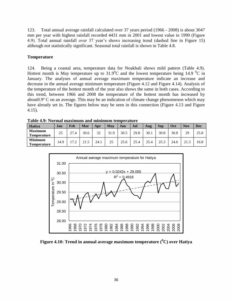
36
123. Total annual average rainfall calculated over 37 years period (1966 - 2008) is about 3047 mm per year with highest rainfall recorded 4431 mm in 2001 and lowest value in 1990 (Figure 4.9). Total annual rainfall over 37 year’s shows increasing trend (dashed line in Figure 15) although not statistically significant. Seasonal total rainfall is shown in Table 4.8.
Temperature 124. Being a coastal area, temperature data for Noakhali shows mild pattern (Table 4.9). Hottest month is May temperature up to 31.90C and the lowest temperature being 14.9 0C in January. The analyses of annual average maximum temperature indicate an increase and decrease in the annual average minimum temperature (Figure 4.12 and Figure 4.14). Analysis of the temperature of the hottest month of the year also shows the same in both cases. According to this trend, between 1966 and 2008 the temperature of the hottest month has increased by about0.9º C on an average. This may be an indication of climate change phenomenon which may have already set in. The figures below may be seen in this connection (Figure 4.13 and Figure 4.15). Table 4.9: Normal maximum and minimum temperature Hatiya Jan Feb Mar Apr May Jun Jul Aug Sep Oct Nov Dec Maximum Temperature
25 27.4 30.6 32 31.9 30.5 29.8 30.1 30.8 30.8 29 25.8
Minimum Temperature
14.9 17.2 21.5 24.1 25 25.6 25.4 25.4 25.3 24.6 21.3 16.8
Figure 4.10: Trend in annual average maximum temperature (0C) over Hatiya
Annual average maximum temperature for Hatiya
y = 0.0242x + 29.055
R2 = 0.4918
28.00
28.50
29.00
29.50
30.00
30.50
31.00
1966
1968
1970
1972
1974
1976
1978
1980
1982
1984
1986
1988
1990
1992
1994
1996
1998
2000
2002
2004
2006
2008
Tem
pera
ture
in 0 C
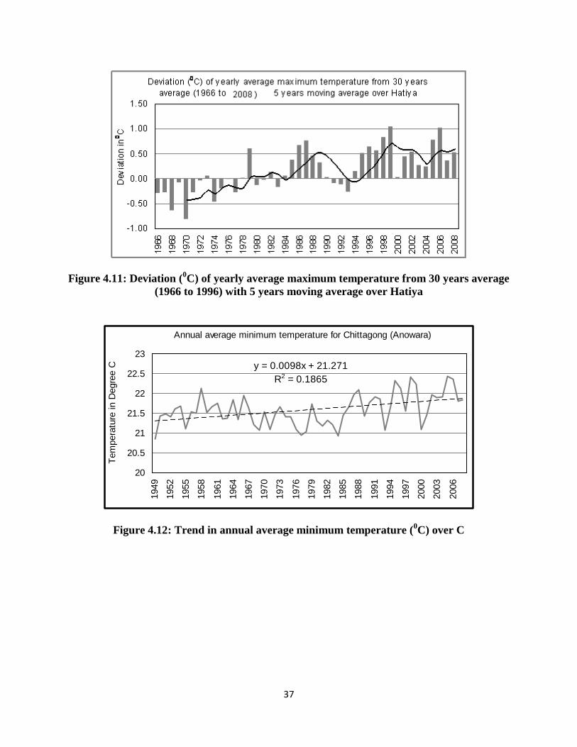
37
Figure 4.11: Deviation (0C) of yearly average maximum temperature from 30 years average (1966 to 1996) with 5 years moving average over Hatiya
Figure 4.12: Trend in annual average minimum temperature (0C) over C
Annual average minimum temperature for Chittagong (Anowara)
y = 0.0098x + 21.271R2 = 0.1865
20
20.5
21
21.5
22
22.5
23
1949
1952
1955
1958
1961
1964
1967
1970
1973
1976
1979
1982
1985
1988
1991
1994
1997
2000
2003
2006
Tem
pera
ture
in D
egre
e C
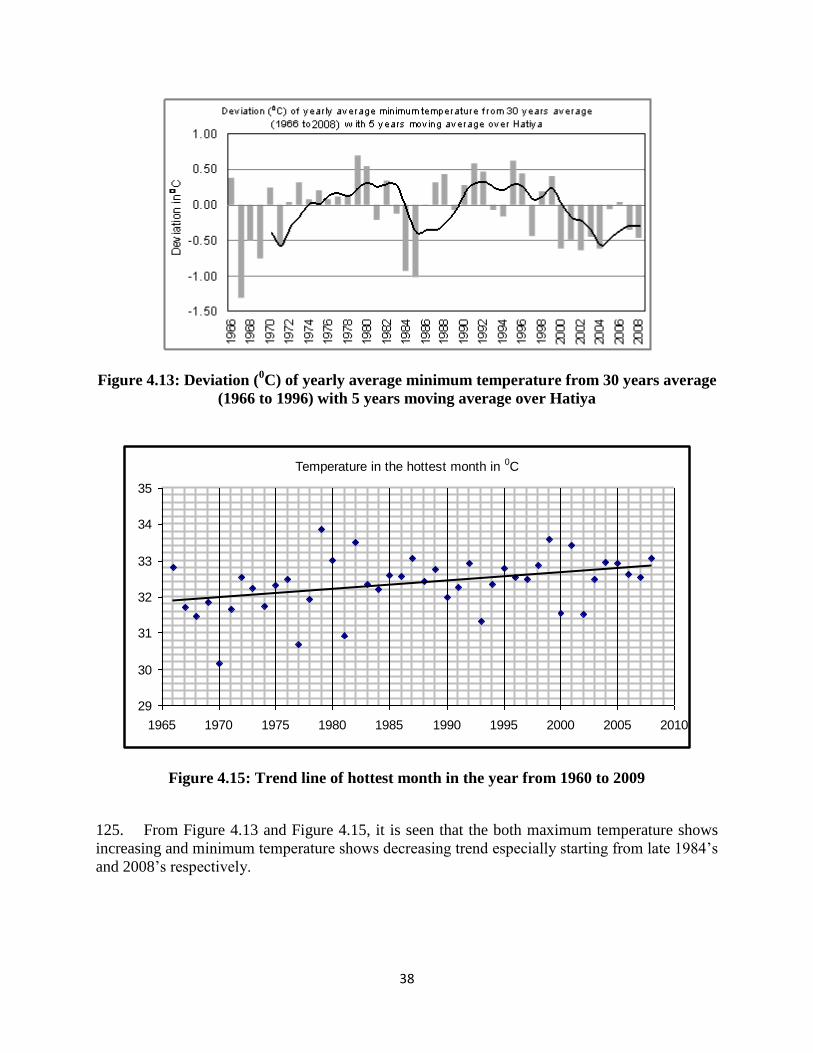
38
Figure 4.13: Deviation (0C) of yearly average minimum temperature from 30 years average (1966 to 1996) with 5 years moving average over Hatiya
Figure 4.15: Trend line of hottest month in the year from 1960 to 2009
125. From Figure 4.13 and Figure 4.15, it is seen that the both maximum temperature shows increasing and minimum temperature shows decreasing trend especially starting from late 1984’s
and 2008’s respectively.
Temperature in the hottest month in 0C
29
30
31
32
33
34
35
1965 1970 1975 1980 1985 1990 1995 2000 2005 2010
39
5.0 Key Features of EMF
5.1 General Principles of EMF
126. During the preparation phase, the tentative areas are identified for afforestation and reforestation. However, the exact locations of the afforestation and reforestation will be identified during the project implementation stage based on the detailed assessment and community consultation. Consequently, specific information on sites, local communities, geo-physical land features and nature will be collected during implementation stage. The construction related information will also be collected during implementation phase. This EMF is prepared to establish the mechanism to determine and assess future potential environmental impacts of the project that are to be identified and to set out mitigation, monitoring and institutional measures to be taken during implementation of the activities to eliminate adverse environmental impacts, offset them, or to reduce them to acceptable limit. The EMF will be followed by the Project authorities during the planning, design, construction and operations. 127. The implementing agencies BFD and AF will follow a set of principles in implementing the Climate Resilient Participatory Afforestation and Reforestation Project to ensure environmental sustainability of the project. In the view of EMF objectives and assessment of the nature, the planning and implementation of the project activities will be based on the following principles, most of which are incorporated in the project design and implementation arrangements. General principles
The Project Director or his/her assigned official having environmental background at PIU Office will be overall responsible for environmental compliance in the project.
The Executive Director of AF will be responsible for overall environmental compliance in the component 2.
The project will promote the environmental friendly practices in the project. No pesticides/herbicides will be used in afforestation/reforestation program The plantation activities, rehabilitation/reconstruction of field offices and community
level AIG activities to be funded under the project will be subject to an environmental screening in order to prevent significant environmental impacts from specific locations and/or activities.
BFD and AF will ensure due diligence to the related government rules (laws, ordinance, acts, etc.) and World Bank Operational Policies and guidelines related to environment are being followed in subprojects selection and implementation. The EMF would serve as the basis for ensuring the compliance of all relevant ECPs.
No Plantation or construction works will be carried out in disputed lands or lands restricted for development or Environmentally Sensitive areas.
The project will promote environmental sound design and environmental capacity building.
40
The success of the project authorities may be attributed to vigorous and continuous
monitoring of all its activities including environment and social issues. The official having environmental background at PIU Office will be dedicated for monitoring
entire project activities and reporting to the project director (PD).
5.2 Community Participation for Better Environmental Management
128. The project is intended to promote the participatory approach for better planning and management of afforestation reforestation activities. The project will pilot a transparent beneficiaries selection process, which will promote effective participation of the communities involved or influenced by development activities. The components will be inter-linked for better coordination and participation. The project activities should involve local beneficiaries from the beginning of the design process. When they participate in a project's design and implementation, local resource users are more likely to develop a sense of responsibility and ownership. They are also more likely to work with BFD and NGO implementing partners to mitigate adverse environmental impacts. Local resource users are often knowledgeable about environmental and associated issues, which can be invaluable during project design. Such users are also often best at monitoring long-term environmental impacts associated with the project.
5.3 Environmentally Sound Design 129. The project will promote environmentally sound design and construction practices that have no or little residual impacts on the surrounding biological, physical and natural environment and could potentially support forest biodiversity conservation by i) minimizing and mitigating adverse impacts of infrastructure through appropriate site selection and construction methods; and ii) remediating and compensating for any residual damage to have a net positive impact. The design options will consider solar system, rainwater harvesting and other renewable sources. The afforestation and reforestation program will also promote environmentally friendly plantation which will not use pesticides/herbicides and avoid burning out vegetation residual bushes.
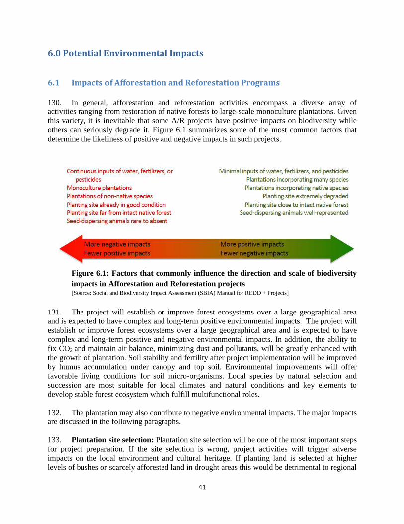
41
6.0 Potential Environmental Impacts
6.1 Impacts of Afforestation and Reforestation Programs
130. In general, afforestation and reforestation activities encompass a diverse array of activities ranging from restoration of native forests to large-scale monoculture plantations. Given this variety, it is inevitable that some A/R projects have positive impacts on biodiversity while others can seriously degrade it. Figure 6.1 summarizes some of the most common factors that determine the likeliness of positive and negative impacts in such projects.
Figure 6.1: Factors that commonly influence the direction and scale of biodiversity impacts in Afforestation and Reforestation projects [Source: Social and Biodiversity Impact Assessment (SBIA) Manual for REDD + Projects]
131. The project will establish or improve forest ecosystems over a large geographical area and is expected to have complex and long-term positive environmental impacts. The project will establish or improve forest ecosystems over a large geographical area and is expected to have complex and long-term positive and negative environmental impacts. In addition, the ability to fix CO2 and maintain air balance, minimizing dust and pollutants, will be greatly enhanced with the growth of plantation. Soil stability and fertility after project implementation will be improved by humus accumulation under canopy and top soil. Environmental improvements will offer favorable living conditions for soil micro-organisms. Local species by natural selection and succession are most suitable for local climates and natural conditions and key elements to develop stable forest ecosystem which fulfill multifunctional roles. 132. The plantation may also contribute to negative environmental impacts. The major impacts are discussed in the following paragraphs. 133. Plantation site selection: Plantation site selection will be one of the most important steps for project preparation. If the site selection is wrong, project activities will trigger adverse impacts on the local environment and cultural heritage. If planting land is selected at higher levels of bushes or scarcely afforested land in drought areas this would be detrimental to regional
42
biodiversity and integrity. Distribution of planting land is not only affects the efficiency of mixed forests but also the habitat of wildlife and the landscape of nature reserves. 134. Planting material selection: Planting material selection needs to be raised from seeds originating locally and match well to the local site conditions. The species mixture has to respect the individual growth characteristics and to be geared to generate synergies in the vegetation cover and improvement of soil quality. Otherwise, the plantation will not bring the expected benefits. 135. Impacts on Biodiversity and Protected Species: No impacts on nature reserves or protected species were identified. It is expected that the project will have a positive effect on biodiversity if correct forestry management practices are applied. Construction activities will be halted and preventive action will be taken if impacts on protected species is discovered during implementation. 136. Clearing planting sites: Clearing planting sites may cause permanent or temporal disturbances or damage original vegetation and incur water and soil erosion, increase rainfall runoff and soil nutrient loss, break animal passageways and create potential forest fire hazards in a wide area. 137. Fertilizer: Excessive use of chemical fertilizers, inappropriate application methods and wrong proportions result in the seepage of chemicals into underground aquifers as well as loss through surface runoff and rain water discharge. Excessive and continuous application of chemical fertilizers over a long duration will change physical and chemical features of the soil and result in soil hardening and damage, and deteriorate soil quality and reduce productivity. In addition, excessive and inappropriate application of fertilizers will affect the quality of nearby water bodies.
138. Pesticides: During any plant disease outbreak, the borrower may need to use pesticide. The misuse of pesticide will cause adverse environmental impacts. The application of pesticides can kill the natural predator of harmful insects, and cause biodiversity decline and the unbalance of species. The pesticide can pollute water supplies and soil, and endanger the health of the residents, livestock, crops, and wild animals, directly or indirectly. And the pesticide spraying equipment will contaminate the water and soil if not cleaned correctly. 139. Plant diseases and insect pests control should use precaution and microbiological processes. The 1st species of first and second category of pesticides are forbidden to use. The first year of the planting farmyard manure will be applied and then the organic fertilizers will be used after. These will improve the physical and chemical properties of soil, and cause slight adverse environmental impact. Besides, the packing receptacle of the pesticides and fertilizers should be collected and treated centralized, and also the vessel must be forbidden to wash in the river or lake.
140. Polypropylene Bags used for Seed Germination: Due to the humid weather effect of Bangladesh, BFD will use cost effective plastic (poly propylene) bag instead of biodegradable bags for seed germination. Use of polythene is banned in Bangladesh. PP bags are non-
43
degradable, If PP bags are not collected properly after plantation, non-degradable PP bags may create long term water logging.
7.2 Small-Scale Infrastructure (Rehabilitation/Reconstruction of Field
Offices) 141. Small-scale infrastructure i.e., rehabilitation/reconstruction of Bangladesh Forest Department field level offices involve some amount of construction. Construction includes one or more of several diverse activities: demolition, site-clearing, excavation, pipe laying, soil grading, leveling, and compacting. Adverse environmental impacts related to the small-scale construction work can be direct and indirect. These impacts can be managed with proper planning and management. 142. Loss of Natural Habitat and Biodiversity: The clearing of existing vegetation during construction and the development may result in the complete loss of associated ecological habitats and their fauna, within the footprint of the development. Noise, vibrations, and intrusive activities related to preparation and construction works may tend to scare away any animals remaining on the site after vegetation clearance. Construction in wetlands, estuaries or other sensitive ecosystems may destroy or damage exceptional natural resources and the benefits they provide. This damage may reduce economic productivity, impair essential ecosystem services (such as flood control or breeding habitat for food fish), or degrade the recreational value of these resources. 143. Erosion and Sedimentation: Removal of natural land cover, excavation, extraction of construction materials and other construction-related activities can result in soil erosion. Erosion can, in turn, lead to sedimentation in receiving waters. Sedimentation may reduce capacity of ponds and reservoirs, increasing flood potential, or substantially alter aquatic ecosystems. 144. Contamination of ground and surface water supplies: Toxic materials are often used in construction. Examples include solvents, paints, vehicle maintenance fluids (oil, coolant), and diesel fuel. If these are dumped on the ground or wash into streams they may contaminate ground or surface water supplies. This may harm the health of the local community, as well as populations living down gradient and downstream. Aquatic and terrestrial ecosystems may also be damaged. Where sanitary facilities for construction workers are inadequate, human waste may contaminate water resources. 145. Adverse impact on human health and safety: Potential concerns include: Dust and Noise: A certain amount of air borne particulate matter (dust) will be generated by earth moving activities during site development and construction. This situation may be worse during the dry season. Air borne particulates may pose a hazard to residents in the vicinity or downwind of the construction site that suffer from upper respiratory tract problems. Otherwise it may only be a nuisance. The impact of dusting is short-term, lasting for the duration of the construction activity, but it may be severe if it causes significant health problems. The use of

44
construction materials and labor activities during site clearance, land filling and construction works will inevitably generate noise, which may disturb neighbors. Spread of disease: An influx of construction workers from other regions may introduce new diseases to the local population or increase the incidence of local infection. This is a particular concern with sexually transmitted diseases, such as HIV/AIDS. Specific types of facilities such as those for healthcare, sanitation, and solid waste can also increase the spread of a variety of diseases unless they follow proper waste-handling procedures.
45
7.0 Environmental Management
7.1 Introduction
146. The main objective of the environmental management is to (a) establish clear and appropriate goals, objectives and principles for management activities; (b) ensure that the management activities are as consistent as possible with ecological processes and also to increase their stability and resilience, (c) limit site disturbance and soil degradation, (d) minimize environmental contamination, and (e) establish well-conceived environmental monitoring programs.
7.2 Afforestation and Reforestation Programs 147. The environmental management of afforestation and reforestation programs will be carried out in different steps. The field level staff of Bangladesh Forest Department will receive capacity development training for proper plantation program. A separate Project Implementation Report has been prepared (Volume II) as nursery and plantation guidelines. 148. BFD has decided not to acquire private lands for plantation. The afforestation and reforestation activities will be carried out on available public lands, which will include degraded forests, marginal and fallow lands, and more importantly the newly accreted lands in the coastal areas that are not under plantation by BFD itself or other development partners. Plantation will also cover the accreted offshore islands which are still not inhabited. Plantation on these islands will consist only of mangroves that have very little market value, making community involvement in benefit sharing schemes unlikely. In the hilly areas, the subprojects will target the core and buffer zones of the Reserved Forest Lands of Chittagong and Cox’s Bazaar districts.
149. The Forest Department will carry out screening of each plantation site and keep record of other essential information. A simple screening format (Annex-A) will be used for screening purpose. The concerned Beat Officer and Range officer will conduct the screening in consultation with the local community. The Community Mobilization Officer (CMO) and Staff Officer will review the screening format and compile the screening format for the forest division. The Divisional Forest Officer (DFO) will make field visit and cross-check 20% of the screening format. 150. The project will follow the standard Environmental Code of practice (ECP) for afforestation and reforestation. The ECP will provide both reasonable and practical management practices to address the possible environmental impacts. ECP related to Afforestation and Reforestation is shown in Table 7.1.
151. In Bangladesh, use of pesticides in forestry plantation is not practiced. It has been agreed that no pesticides or herbicides will be used during plantation. However, in exceptional cases like during any deadly disease outbreak; pesticides can be used for short duration. Depending on the type of disease the implementing agency will ensure detail environmental screening and prepare
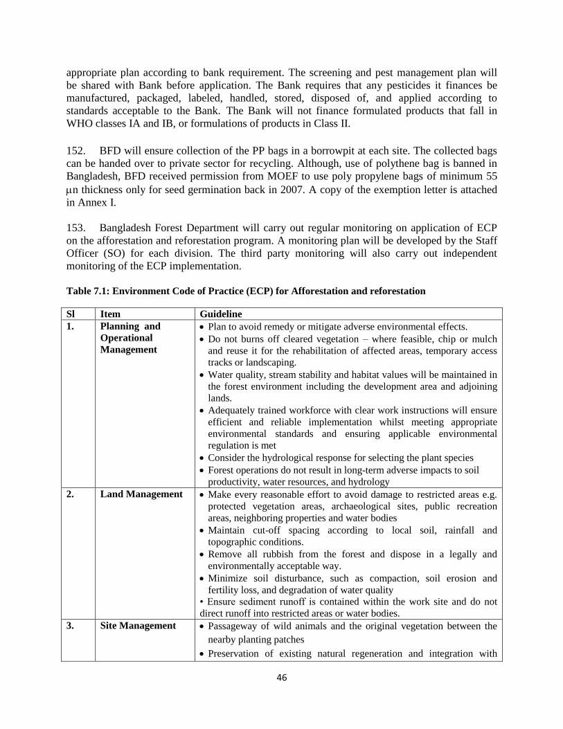
46
appropriate plan according to bank requirement. The screening and pest management plan will be shared with Bank before application. The Bank requires that any pesticides it finances be manufactured, packaged, labeled, handled, stored, disposed of, and applied according to standards acceptable to the Bank. The Bank will not finance formulated products that fall in WHO classes IA and IB, or formulations of products in Class II.
152. BFD will ensure collection of the PP bags in a borrowpit at each site. The collected bags can be handed over to private sector for recycling. Although, use of polythene bag is banned in Bangladesh, BFD received permission from MOEF to use poly propylene bags of minimum 55 n thickness only for seed germination back in 2007. A copy of the exemption letter is attached in Annex I. 153. Bangladesh Forest Department will carry out regular monitoring on application of ECP on the afforestation and reforestation program. A monitoring plan will be developed by the Staff Officer (SO) for each division. The third party monitoring will also carry out independent monitoring of the ECP implementation. Table 7.1: Environment Code of Practice (ECP) for Afforestation and reforestation
Sl Item Guideline 1. Planning and
Operational Management
Plan to avoid remedy or mitigate adverse environmental effects. Do not burns off cleared vegetation – where feasible, chip or mulch
and reuse it for the rehabilitation of affected areas, temporary access tracks or landscaping.
Water quality, stream stability and habitat values will be maintained in the forest environment including the development area and adjoining lands.
Adequately trained workforce with clear work instructions will ensure efficient and reliable implementation whilst meeting appropriate environmental standards and ensuring applicable environmental regulation is met
Consider the hydrological response for selecting the plant species Forest operations do not result in long-term adverse impacts to soil
productivity, water resources, and hydrology 2. Land Management Make every reasonable effort to avoid damage to restricted areas e.g.
protected vegetation areas, archaeological sites, public recreation areas, neighboring properties and water bodies
Maintain cut-off spacing according to local soil, rainfall and topographic conditions.
Remove all rubbish from the forest and dispose in a legally and environmentally acceptable way.
Minimize soil disturbance, such as compaction, soil erosion and fertility loss, and degradation of water quality
• Ensure sediment runoff is contained within the work site and do not direct runoff into restricted areas or water bodies.
3. Site Management Passageway of wild animals and the original vegetation between the nearby planting patches
Preservation of existing natural regeneration and integration with
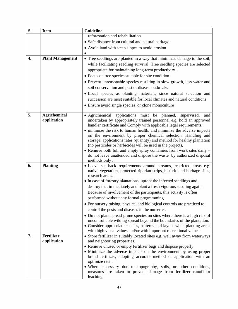
47
Sl Item Guideline reforestation and rehabilitation
Safe distance from cultural and natural heritage Avoid land with steep slopes to avoid erosion
4. Plant Management Tree seedlings are planted in a way that minimizes damage to the soil, while facilitating seedling survival. Tree seedling species are selected appropriate for maintaining long-term productivity.
Focus on tree species suitable for site condition Prevent unreasonable species resulting in slow growth, less water and
soil conservation and pest or disease outbreaks Local species as planting materials, since natural selection and
succession are most suitable for local climates and natural conditions Ensure avoid single species or clone monoculture
5. Agrichemical application
Agrichemical applications must be planned, supervised, and undertaken by appropriately trained personnel e.g. hold an approved handler certificate and Comply with applicable legal requirements,
minimize the risk to human health, and minimize the adverse impacts on the environment by proper chemical selection, Handling and storage, applications rates (quantity) and method for healthy plantation (no pesticides or herbicides will be used in the project),
Remove both full and empty spray containers from work sites daily – do not leave unattended and dispose the waste by authorized disposal methods only .
6. Planting Leave set back requirements around streams, restricted areas e.g. native vegetation, protected riparian strips, historic and heritage sites, research areas.
In case of forestry plantations, uproot the infected seedlings and destroy that immediately and plant a fresh vigorous seedling again. Because of involvement of the participants, this activity is often performed without any formal programming.
For nursery raising, physical and biological controls are practiced to control the pests and diseases in the nurseries.
Do not plant spread-prone species on sites where there is a high risk of uncontrollable wilding spread beyond the boundaries of the plantation.
Consider appropriate species, patterns and layout when planting areas with high visual values and/or with important recreational values.
7. Fertilizer application
Store fertilizer in suitably located sites e.g. well away from waterways and neighboring properties.
Remove unused or empty fertilizer bags and dispose properly Minimize the adverse impacts on the environment by using proper
brand fertilizer, adopting accurate method of application with an optimize rate .
Where necessary due to topography, soils, or other conditions, measures are taken to prevent damage from fertilizer runoff or leaching.
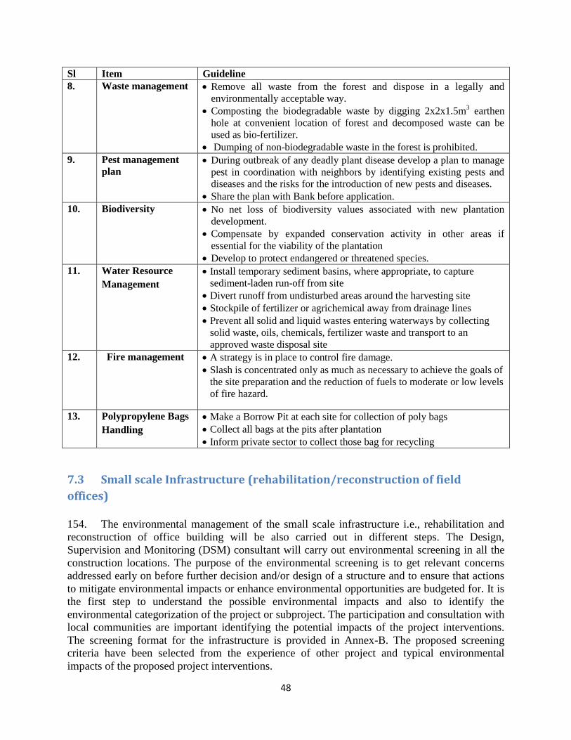
48
Sl Item Guideline 8. Waste management Remove all waste from the forest and dispose in a legally and
environmentally acceptable way. Composting the biodegradable waste by digging 2x2x1.5m3 earthen
hole at convenient location of forest and decomposed waste can be used as bio-fertilizer.
Dumping of non-biodegradable waste in the forest is prohibited. 9. Pest management
plan During outbreak of any deadly plant disease develop a plan to manage
pest in coordination with neighbors by identifying existing pests and diseases and the risks for the introduction of new pests and diseases.
Share the plan with Bank before application. 10. Biodiversity No net loss of biodiversity values associated with new plantation
development. Compensate by expanded conservation activity in other areas if
essential for the viability of the plantation Develop to protect endangered or threatened species.
11. Water Resource Management
Install temporary sediment basins, where appropriate, to capture sediment-laden run-off from site
Divert runoff from undisturbed areas around the harvesting site Stockpile of fertilizer or agrichemical away from drainage lines Prevent all solid and liquid wastes entering waterways by collecting
solid waste, oils, chemicals, fertilizer waste and transport to an approved waste disposal site
12. Fire management
A strategy is in place to control fire damage. Slash is concentrated only as much as necessary to achieve the goals of
the site preparation and the reduction of fuels to moderate or low levels of fire hazard.
13. Polypropylene Bags Handling
Make a Borrow Pit at each site for collection of poly bags Collect all bags at the pits after plantation Inform private sector to collect those bag for recycling
7.3 Small scale Infrastructure (rehabilitation/reconstruction of field
offices) 154. The environmental management of the small scale infrastructure i.e., rehabilitation and reconstruction of office building will be also carried out in different steps. The Design, Supervision and Monitoring (DSM) consultant will carry out environmental screening in all the construction locations. The purpose of the environmental screening is to get relevant concerns addressed early on before further decision and/or design of a structure and to ensure that actions to mitigate environmental impacts or enhance environmental opportunities are budgeted for. It is the first step to understand the possible environmental impacts and also to identify the environmental categorization of the project or subproject. The participation and consultation with local communities are important identifying the potential impacts of the project interventions. The screening format for the infrastructure is provided in Annex-B. The proposed screening criteria have been selected from the experience of other project and typical environmental impacts of the proposed project interventions.
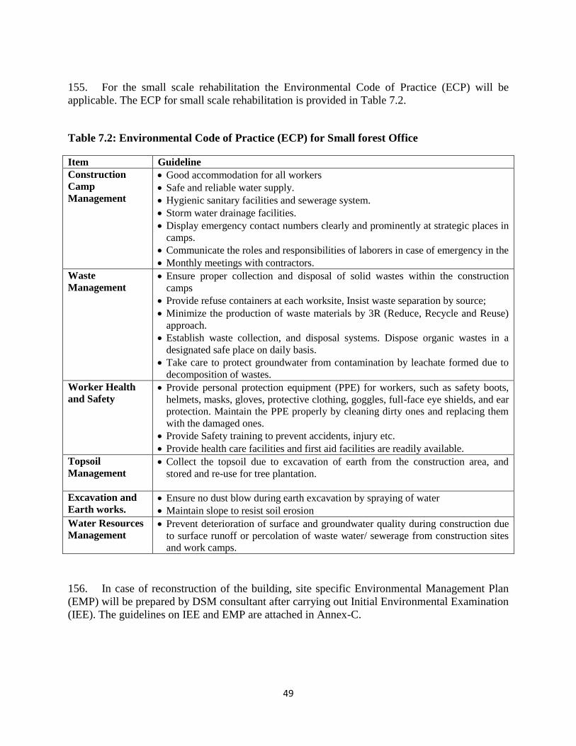
49
155. For the small scale rehabilitation the Environmental Code of Practice (ECP) will be applicable. The ECP for small scale rehabilitation is provided in Table 7.2.
Table 7.2: Environmental Code of Practice (ECP) for Small forest Office
Item Guideline Construction Camp Management
Good accommodation for all workers Safe and reliable water supply. Hygienic sanitary facilities and sewerage system. Storm water drainage facilities. Display emergency contact numbers clearly and prominently at strategic places in
camps. Communicate the roles and responsibilities of laborers in case of emergency in the Monthly meetings with contractors.
Waste Management
Ensure proper collection and disposal of solid wastes within the construction camps
Provide refuse containers at each worksite, Insist waste separation by source; Minimize the production of waste materials by 3R (Reduce, Recycle and Reuse)
approach. Establish waste collection, and disposal systems. Dispose organic wastes in a
designated safe place on daily basis. Take care to protect groundwater from contamination by leachate formed due to
decomposition of wastes. Worker Health and Safety
Provide personal protection equipment (PPE) for workers, such as safety boots, helmets, masks, gloves, protective clothing, goggles, full-face eye shields, and ear protection. Maintain the PPE properly by cleaning dirty ones and replacing them with the damaged ones.
Provide Safety training to prevent accidents, injury etc. Provide health care facilities and first aid facilities are readily available.
Topsoil Management
Collect the topsoil due to excavation of earth from the construction area, and stored and re-use for tree plantation.
Excavation and Earth works.
Ensure no dust blow during earth excavation by spraying of water Maintain slope to resist soil erosion
Water Resources Management
Prevent deterioration of surface and groundwater quality during construction due to surface runoff or percolation of waste water/ sewerage from construction sites and work camps.
156. In case of reconstruction of the building, site specific Environmental Management Plan (EMP) will be prepared by DSM consultant after carrying out Initial Environmental Examination (IEE). The guidelines on IEE and EMP are attached in Annex-C.
50
7.3 Community Level Alternative Livelihood Activities 157. The household level alternative livelihood activities will be very small scale like goat and poultry rearing, vegetable cultivation, small scale trade etc. These activities will not require any environmental screening. The community level alternative livelihood activities may include e.g. establishing cooperatives for improving marketing channels for local products, water facilities, community based eco-tourism, making energy efficient cooking stoves, and agricultural firms etc. Since the activities are not limited, it is not possible to identify the general environmental impact at this stage. 158. The partner NGO will carry out the environmental screening (Annex-D) of all the community level alternative livelihood activities. AF will review the screening report and will decide on the requirement of the Environmental Management Plan (EMP).
7.4 Review by World Bank
159. Both BFD and AF will prepare the half yearly progress report on environmental management and will submit to the World Bank for review. The World Bank will review the screening report, environmental management plan, monitoring reports on random basis and will carry out field visit to cross-check. The contributing development partners may also join in the field visit to understand the environmental compliance of the project. In addition, the effectiveness of screening, monitoring and implementation of EMP will be carried out by the third party monitoring firm along with the project component activity monitoring annually. The Annual Environmental Audit Report prepared by the third party monitoring firm will be shared with the safeguards secretariat. Key steps of environmental management procedure during project implementation and supervision are presented in Figure 7.1 and 7.2.
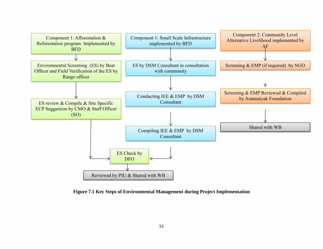
51
Figure 7.1 Key Steps of Environmental Management during Project Implementation
Component 1: Afforestation &
Reforestation program Implemented by
BFD
Component 1: Small Scale Infrastructure
implemented by BFD
Component 2: Community Level
Alternative Livelihood implemented by
AF
Environmental Screening (ES) by Beat
Officer and Field Verification of the ES by
Range officer
ES review & Compile & Site Specific
ECP Suggestion by CMO & Staff Officer
(SO)
ES Check by
DFO
ES by DSM Consultant in consultation
with community
Conducting IEE & EMP by DSM
Consultant
Compiling IEE & EMP by DSM
Consultant
Screening & EMP (if required) by NGO
Screening & EMP Reviewed & Compiled
by Arannatyak Foundation
Reviewed by PIU & Shared with WB
Shared with WB
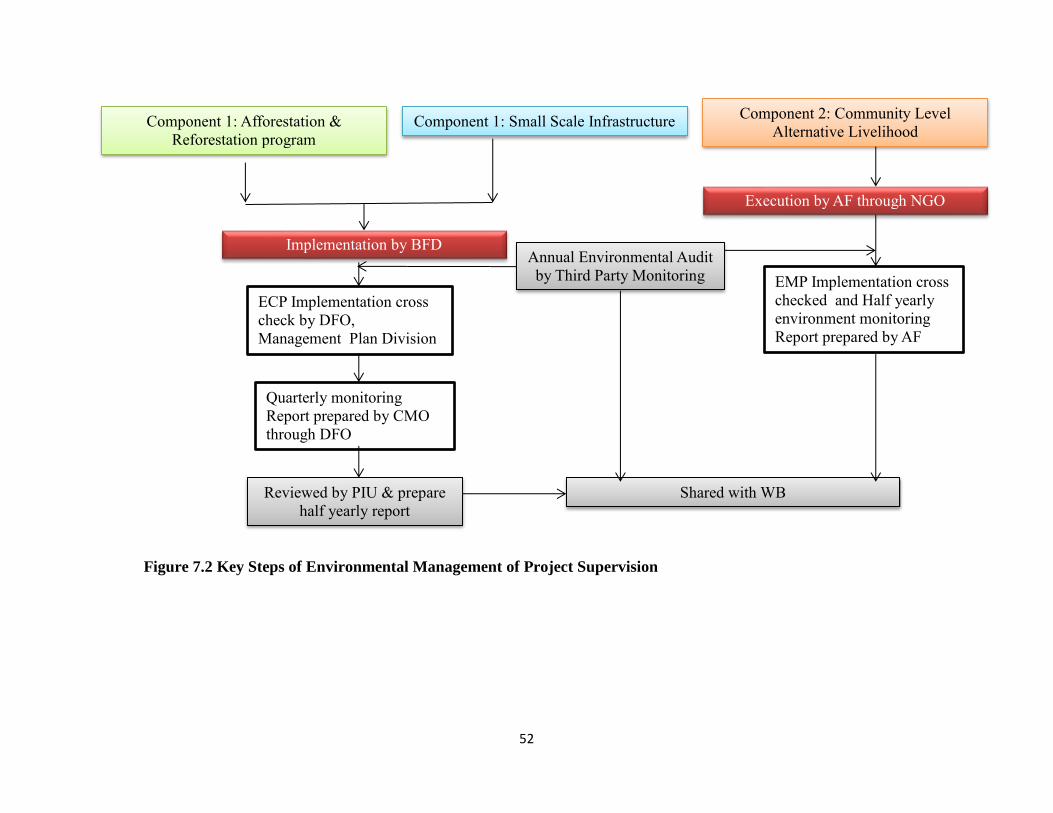
52
Figure 7.2 Key Steps of Environmental Management of Project Supervision
Annual Environmental Audit
by Third Party Monitoring
Shared with WB
Component 1: Afforestation &
Reforestation program Component 1: Small Scale Infrastructure Component 2: Community Level
Alternative Livelihood
Implementation by BFD
ECP Implementation cross
check by DFO,
Management Plan Division
Quarterly monitoring
Report prepared by CMO
through DFO
Reviewed by PIU & prepare
half yearly report
EMP Implementation cross
checked and Half yearly
environment monitoring
Report prepared by AF
Execution by AF through NGO
53
7.5 Grievance Redress Mechanism 160. The project will follow the same Grievance Redress Mechanisms (GRM) for social and environmental issues to deal with the possible complaints during the implementation of the project. GRCs are proposed to have the following memberships:
Range Officer Convener Union Parishad Member (or Ward Commissioner) from Complainant’s Ward
Member
A representative of local NGO (not partner NGO of AF) Member Headmaster of the High School of the Complainant’s
Area/Union Member
Headmaster of the Primary School of the Complainant’s
Area/Union Member
A Professor of College in the Upazila Headquarters (Nominated by Principal)
Member
A Representative of AF’s partner NGO Member Secretary
161. If the aggrieved person/complainant is a woman, the GRC convener will ask a female Union Parishad/Pourasava Member to participate in the hearing. If the complainant is an indigenous person, a member of his/her community will be asked to be present at the hearing. 162. If resolution attempts at the range level fail, the concerned Range Officer (RO) will refer the complaints to the DFO -- or next higher authority along with the minutes of the hearings. If a decision made at this level is found unacceptable by the aggrieved person, DFO can refer the case to Project Director with the minutes of the hearings at both range and division levels. A decision agreed with the aggrieved person at any level of hearing will be binding on the Project. 163. To ensure impartiality and transparency, hearings on complaints will remain open to the public. The GRCs will record details of the complaints and the reasons that led to acceptance or rejection of the particular cases. The RO will keep records of all resolved and unresolved complaints and grievances and make them available for review as and when asked for by BFD, World Bank and other development partners. The detail GRM for the project is given in Annex-E.
7.6 Consultation 164. Comprehensive consultation with stakeholders forms a critical part of best practice project planning and development of EMF. The objectives of the consultation for environment management are: (i) to address the environmental aspects as well as socio-economic issues from stakeholders’ point of view; (ii) assess any mitigation measures which may be undertaken to minimize any adverse impacts of the proposals under consideration.
54
165. This project focuses on the participatory process to involve the community from the planning phase and the process of public consultation and participation has been an integral part of project preparations. Participatory consultation is both an essential criteria and important strategy for an integrated environmental assessment process, the project design and its implementation. The project organized several consultations with the community and stakeholders during the project preparation. The views, needs and aspirations of the community as expressed during these consultations have been incorporated in the project design and the proposed mitigating measures with the objective to maximize benefits and minimize adverse social and environmental effects.
166. The EMF was prepared based on the field visit, consultation with community, field level staff and also the official involved at the Dhaka level. There were different types of consultations. A very important role was played by the Focus group discussions, where discussions were held with community groups focusing on specific subjects. At the beginning of such meetings the anticipated impacts were disclosed and followed by discussions on possible solutions to prevent or mitigate such impacts. Major issues discussed in such meetings typically included: (i) present problems of the afforestation and reforestation programs; (ii) people’s
preference land to be afforested and reforestation; (iii) preference on species; (iv) benefit sharing mechanism; (v) participatory monitoring/community severance; (vi) employment/job opportunities and occupational changes; (vii) silvi-culture methods. Participants actively joined in discussions and contributed very useful suggestions and ideas, which were recorded for follow up.
167. Several consultations on environmental management were held with the forest dependents community who are already organized by a NGO under Arannayk Foundation Project in Ukhiya, Cox’s Bazar District. Consultations were also held with the community at
Bhatiari, Chittagong. Special consultations were also held with the Forest Department officials in both Cox’s Bazar and .Chittagong both at division level and field level. Some photographs and participants list are provided in the Annex-G.
168. The following are some summary of the consultation, which are considered in project design and EMF finalization.
Major findings: The country’s forest cover has been degraded because of biotic and abiotic pressures.
Both the community and Bangladesh Forest Department realized that without active participation of local community, it will not be possible to effectively implement the afforestation or reforestation program. For conserving the existing natural forest, community participation is very much necessary also.
Afforestation should not be carried out by clearing existing natural forest patch. If the patch is degraded, the vacancy filling could be done through locally endangered plant species.
For effective community participation, the political and local influence should be avoided in selecting participants for participatory forestry. The project should build-up innovative and transparent mechanism for selecting the participants.
55
Community believes the participants of the participatory forestry should be selected at beat or range offices instead of Upazilla offices.
The project should encourage the establishing community petrol group and provide some incentive for forest conservation.
The labors to be engaged in nursery development, plantation and other works should be taken from local community. The project should prepare a list upfront who will be eligible to work there. The poor and forest dependent people must be given preference.
Not only Acacia but also indigenous tree species could include in plantation for support wildlife biodiversity. If possible, fruit trees can be considered in some places.
Conservation friendly AIGAs as well as motivation program needed to be promoted in surrounding area to bring success in forestation or reforestation program.
For insuring good governance, working NGO representatives could be involved in decision making process.
169. The project will have extensive consultation with the community and stakeholders at the field level to ensure proper participatory process. The plan for participatory selection through open public meeting at union level During the AIG activity implementation, the project will follow the following major steps for participants of AIG.
Village meeting with dissemination of information about Project, its objectives and processes, information about selection process and criteria
Gathering poverty data of village HH from the local government Conducting Focus Group Discussions with local authorities and leaders (Forest Beat
Officer, Union Parishad Secretary, representatives of local social leaders to: 1) inform them about the Project, objectives and processes, 2) identify closest to forest segments of village through participatory mapping and 3) to verify/modify if needed eligibility ranking system and weighing for each specific village to reflect real situation, 3) to identify obvious households eligible for alternative livelihood support
PRA in selected segments of the village closest to the forest with participatory wealth ranking exercise and identification of poor forest dependent households.
Verification of selected households through the beneficiaries’ eligibility weighing system Undertaking baseline survey of the household Affirmation of list of selected households at the village meeting.
170. The list of the selected beneficiaries will include number of people required for the SF program in that locality. However, only 30 households will be selected for AIG component, who are scored highest in the weighing system and affirmed by village meeting. 171. On a pilot basis the list of beneficiaries for the SF will be affirmed first by the respective Union Parishad (instead of Upazilla Environment and Forest Development Committee as stipulated in the SF rules). Bringing the final decision on the selection of the beneficiaries to the lowest local government level would enhance transparency of the process, ensure inclusion of poor and vulnerable households, and increase effectiveness of the SF program in general. Union Parishad (and its Ward committees) has the legal mandate for playing such roles according to the the Union Parishad Law 2009.
56
172. In order to avoid duplication, AF and its implementing partners will seek where possible to utilize existing village groups which include poor, forest dependent households. In communities of indigenous peoples, traditional institutions if exist will be used for defining eligible beneficiaries. Identification of beneficiaries will be facilitated by IP using PRA methods applicable to each situation and locality. However, list of selected beneficiaries should be affirmed by community in each location at the village meetings.
173. The PIU shall ensure coordination and synergy of activities implemented by the BFD and AF. The PIU will provide all relevant information to the AF needed for timely selection of beneficiaries. 174. The provision for participant selection at Union level through open public meeting will help to address environmental issues. The environmental screening and implementation of ECP or EMP will be carried out involving the community. The participation of the selected beneficiaries of the plantation program will be mandatory for such activities.
175. The project will provide importance on native species for afforestation and reforestation. The nursery section of the project implementation manual will have detailed guidelines about the species selection through participatory consultation and considering the technical aspects.
7.7 Monitoring 150. Monitoring is conducted to ensure the site specific plans and operations are properly implemented, environmental impacts of site disturbing operations are minimized, and that environmental code practices(ECP) are effective. Administrative monitoring from Forest Department aims to ensure that deed restrictions, land use restrictions, ECP etc., are enforced and not violated. Forest management shall conserve biological diversity and its associated values, water resources, soils, and unique and fragile ecosystems and landscapes, and, by so doing, maintain the ecological functions and the integrity of the forest. A monitoring checklist for the project is given in Annex-H.
7.8 Disclosure
151. BFD and AF will follow the disclosure requirement of the World Bank on environmental documentation. After the clearance from the World Bank, the draft final version of the EMF will be posted in the website of BFD and AF along with a Bangla summary version and will be kept in the offices for further comments and inputs from non-governmental organization, civil society and general public. BFD and AF already published the draft EMF for initial comments. Newspaper advertisement will be published in two national dailies (English and Bangla) about the disclosure and request for comments on EMF. The draft document has been disclosed in English by World Bank and has also been made available at the World Bank’s Info Shop. The EMF has been finalized taking into consideration of the comments received on draft version and now available in BFD and AF websites.
57
Annex-A: Screening Format for Afforestation and Reforestation Program
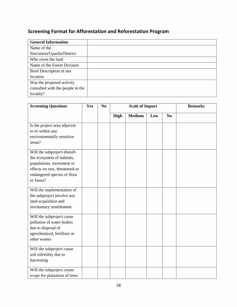
58
Screening Format for Afforestation and Reforestation Program
General Information Name of the Site/union/Upazila/District
Who owns the land Name of the Forest Division Brief Description of site location
Was the proposed activity consulted with the people in the locality?
Screening Questions Yes No Scale of Impact Remarks
High Medium Low No
Is the project area adjacent to or within any environmentally sensitive areas?
Will the subproject disturb the ecosystem of habitats, populations, movement or effects on rare, threatened or endangered species of flora or fauna?
Will the implementation of the subproject involve any land acquisition and involuntary resettlement
Will the subproject cause pollution of water bodies due to disposal of agrochemical, fertilizer or other wastes
Will the subproject cause soil infertility due to harvesting
Will the subproject create scope for plantation of trees
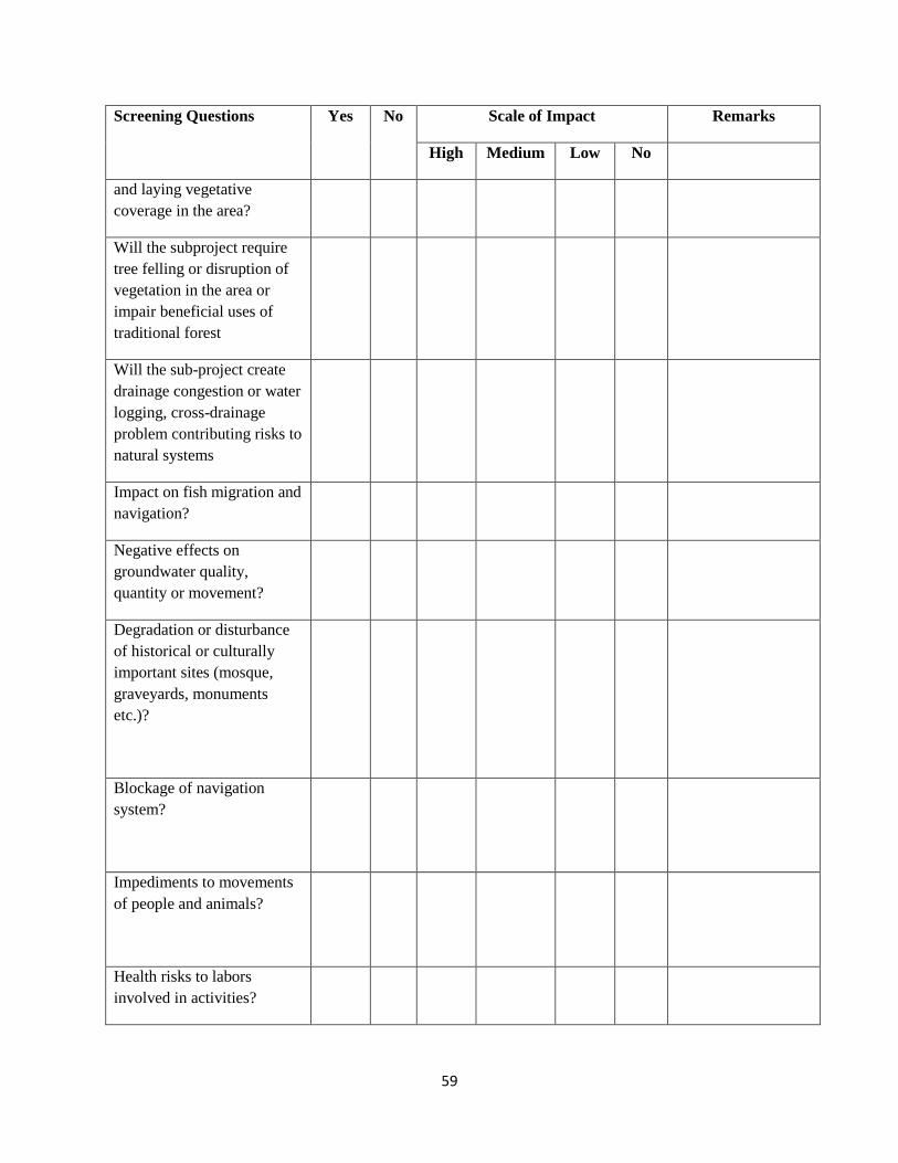
59
Screening Questions Yes No Scale of Impact Remarks
High Medium Low No
and laying vegetative coverage in the area?
Will the subproject require tree felling or disruption of vegetation in the area or impair beneficial uses of traditional forest
Will the sub-project create drainage congestion or water logging, cross-drainage problem contributing risks to natural systems
Impact on fish migration and navigation?
Negative effects on groundwater quality, quantity or movement?
Degradation or disturbance of historical or culturally important sites (mosque, graveyards, monuments etc.)?
Blockage of navigation system?
Impediments to movements of people and animals?
Health risks to labors involved in activities?

60
Screening Questions Yes No Scale of Impact Remarks
High Medium Low No
Possible Mitigation measures (if the area is affected)
Possible Alternative Measures:
Note: Please add any other screening questions relevant to the demonstration. Also provide additional comments and/or positive impacts in ‘remarks’ column. Recommendations:
Filled and signed by the Beat Officer Name: _______________________________ Date: _______________________________ Verified and signed by Range Officer: Name: _______________________________ Date: _______________________________
Reviewed and signed by CMO/SO: Name: _______________________________
Date: _______________________________
61
Annex-B: Screening Format for Small Infrastructure
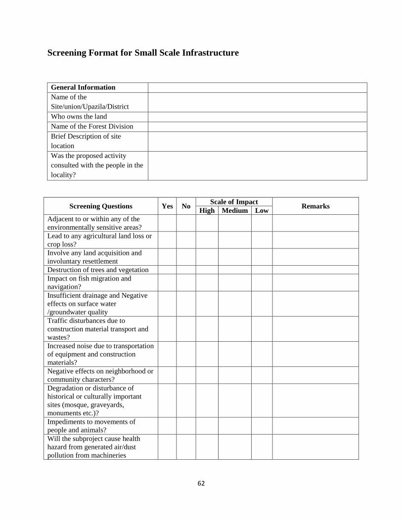
62
Screening Format for Small Scale Infrastructure
General Information Name of the Site/union/Upazila/District
Who owns the land Name of the Forest Division Brief Description of site location
Was the proposed activity consulted with the people in the locality?
Screening Questions Yes No Scale of Impact
Remarks High Medium Low
Adjacent to or within any of the environmentally sensitive areas?
Lead to any agricultural land loss or crop loss?
Involve any land acquisition and involuntary resettlement
Destruction of trees and vegetation Impact on fish migration and navigation?
Insufficient drainage and Negative effects on surface water /groundwater quality
Traffic disturbances due to construction material transport and wastes?
Increased noise due to transportation of equipment and construction materials?
Negative effects on neighborhood or community characters?
Degradation or disturbance of historical or culturally important sites (mosque, graveyards, monuments etc.)?
Impediments to movements of people and animals?
Will the subproject cause health hazard from generated air/dust pollution from machineries

63
Screening Questions Yes No Scale of Impact
Remarks High Medium Low
Possible Mitigation measures (if the area is affected)
Possible Alternative Measures:
*Please consider scale of 1 -2 for Low, 2 -3 for Medium and 5 for High impact.
** Protected areas are lands and waters where development and use is restricted by legal or other means for the conservation of nature
Recommendations: Filled and signed by the Beat Officer Name: _______________________________ Date: _______________________________ Verified and signed by Range Officer: Name: _______________________________ Date: _______________________________ Reviewed and signed by CMO/SO: Name: _______________________________ Date: _______________________________
64
Annex-C: Guidelines for Carrying out IEE for Small Infrastructure
65
Initial Environmental Examination (IEE)
What is initial environmental examination (IEE)?
The IEE is a review of the reasonably foreseeable effects on the environment of a proposed development intervention/activity. It can be considered as an important tool for incorporating environmental concerns at the project level. IEE should be carried out as early as the project planning stage as part of feasibility thus it can assure that the project will be environmentally feasible. The general objectives of IEE study should at least cover the following: i) to provide information about the general environmental settings of the project area as baseline data; ii) to provide information on potential impacts of the project and the characteristic of the impacts, magnitude, distribution, who will be the affected group, and their duration; iii) to provide information on potential mitigation measures to minimize the impact including mitigation costs; iv) to assess the best alternative project at most benefits and least costs in terms of financial, social, and environment. It is not always necessary to change location of the project, but it can be changed in project design or project management; and v) to provide basic information for formulating management and monitoring plan. The IEE is conducted if the project is likely to have minor or limited impacts, which can easily be predicted and evaluated, and for which mitigation measures are prescribed easily. However, the IEE is also used to confirm whether this is, indeed, requires an EIA as a follow up. An standard IEE process includes: i) preparing an environmental baseline; ii) partial assessment of environmental impacts; iii) identifying mitigation measures; iv) preparation of environmental management plan (EMP) - preparation of environmental mitigation and monitoring plan including responsibility and estimation of budget for implementation of mitigation and monitoring plan.
Describing Environmental Condition of the Project Area: This is the first main step of the
initial environmental examination (IEE) study. This includes collection of baseline information on biophysical, social and economic aspects of the project area. This is the most important reference for conducting IEE study. The description of environmental settings includes the characteristic of area in which the activity of proposed project would occur and it should cover area affected by all impacts including potential compensation area, and potential area affected by its alternatives. Normally, information is obtained from secondary sources when there is a facility of maintaining database, or other existing documentation, and through field sampling. Collection of baseline data should be designed to satisfy information requirements and should focus on relevant aspects that are likely to be affected by the proposed project. Therefore, the level of detail in this description of study area should be sufficient to convey to readers nature of environmental and social resources condition of the affected areas.
Assessing the potential impact: Prediction and quantification of the potential impact is the technical heart of the environmental assessment/examination process. The issues identified at the environmental screening will be further examined in detailed in assessing the impact. The process involves the prediction of changes over time in various environmental aspects as a result of a proposed project. The impacts of the pre-
66
construction, construction and post-construction operation & maintenance activities will be separately identified. The prediction of the nature, extent, and magnitude of environmental changes likely to result from a proposed project is aided by various tools and techniques, the choice of which depends upon the impacts of concern, data availability or lack thereof, and the appropriate specificity of quantitative models. The consultant needs to identify appropriate methods depending on the situation and predict the changes on ecology, human health, social life etc. Consultation with the affected people, beneficiaries, local government agency, other NGOs working in that area are extremely important.
Formulating Mitigation Measures: Once the impacts have been analyzed, then determine the significance of the impacts i.e., whether they are acceptable, require mitigation, or are unacceptable. Subsequently, measures will be devised to mitigate anticipated environmental changes and consequential impacts during project implementation and operation, or further reduce the residual environmental changes inherent in the selected project design. They normally include technical, social, and institutional measures to be implemented as integral elements of the project. In cases, where mitigation measures not directly possible like cutting of trees, compensation measures i.e., plantation of more trees of similar species should be considered. The standard mitigation measures are described in Annex-E.
Environmental Management Plan (EMP): An EMP is a plan of scheduled actions that follows directly from a completed environmental assessment of a project. An EMP is the organized expression of the environmental safeguards for the project. EMP has 2 parts: i) Environmental Mitigation Plan; ii) Environmental Monitoring Plan.
Environmental Mitigation Plan: The mitigation plan is a major sub-plan of the EMP. The mitigation plan manages the potential negative impacts of the project. A mitigation measure is a modification of a proposed project activity using different types of categories of actions, which can be applied individually or together to form a mitigation measure: i) deletion of activity; ii) change in location of activity; iii) change in timing of activity; iv) change in intensity of activity; v) isolation of activity with physical or chemical barrier and vi) social or environmental compensation. The mitigation plan to be prepared by the consultant should specify the following information for all potential negative and positive impacts of a project: i) description of mitigation measure to prevent or reduce negative impact; ii) location of mitigation measure; iii) schedule and frequency of mitigation measure implementation; iv) responsibility for implementing mitigation measure; v) key indicator of effectiveness of mitigation measure; vi) reporting requirement and reporting schedule for mitigation activity; and vii) estimated cost of mitigation measure. The construction related activities, it is suggested to mention about the 3 main phases of a sub-project: Pre-construction, Construction and Post-Construction & Maintenance phases. However, for other sub-project, it is not required to mention the phases.
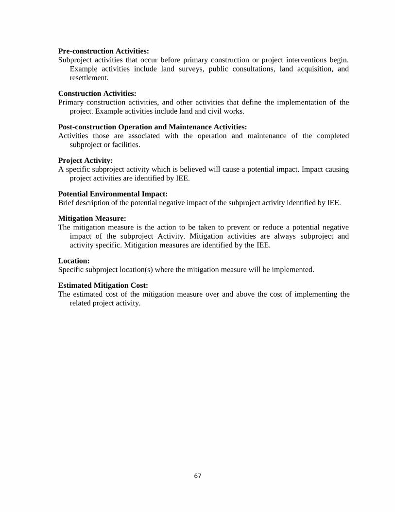
67
Pre-construction Activities: Subproject activities that occur before primary construction or project interventions begin.
Example activities include land surveys, public consultations, land acquisition, and resettlement.
Construction Activities: Primary construction activities, and other activities that define the implementation of the
project. Example activities include land and civil works. Post-construction Operation and Maintenance Activities: Activities those are associated with the operation and maintenance of the completed
subproject or facilities.
Project Activity: A specific subproject activity which is believed will cause a potential impact. Impact causing
project activities are identified by IEE. Potential Environmental Impact: Brief description of the potential negative impact of the subproject activity identified by IEE. Mitigation Measure: The mitigation measure is the action to be taken to prevent or reduce a potential negative
impact of the subproject Activity. Mitigation activities are always subproject and activity specific. Mitigation measures are identified by the IEE.
Location: Specific subproject location(s) where the mitigation measure will be implemented.
Estimated Mitigation Cost: The estimated cost of the mitigation measure over and above the cost of implementing the
related project activity.
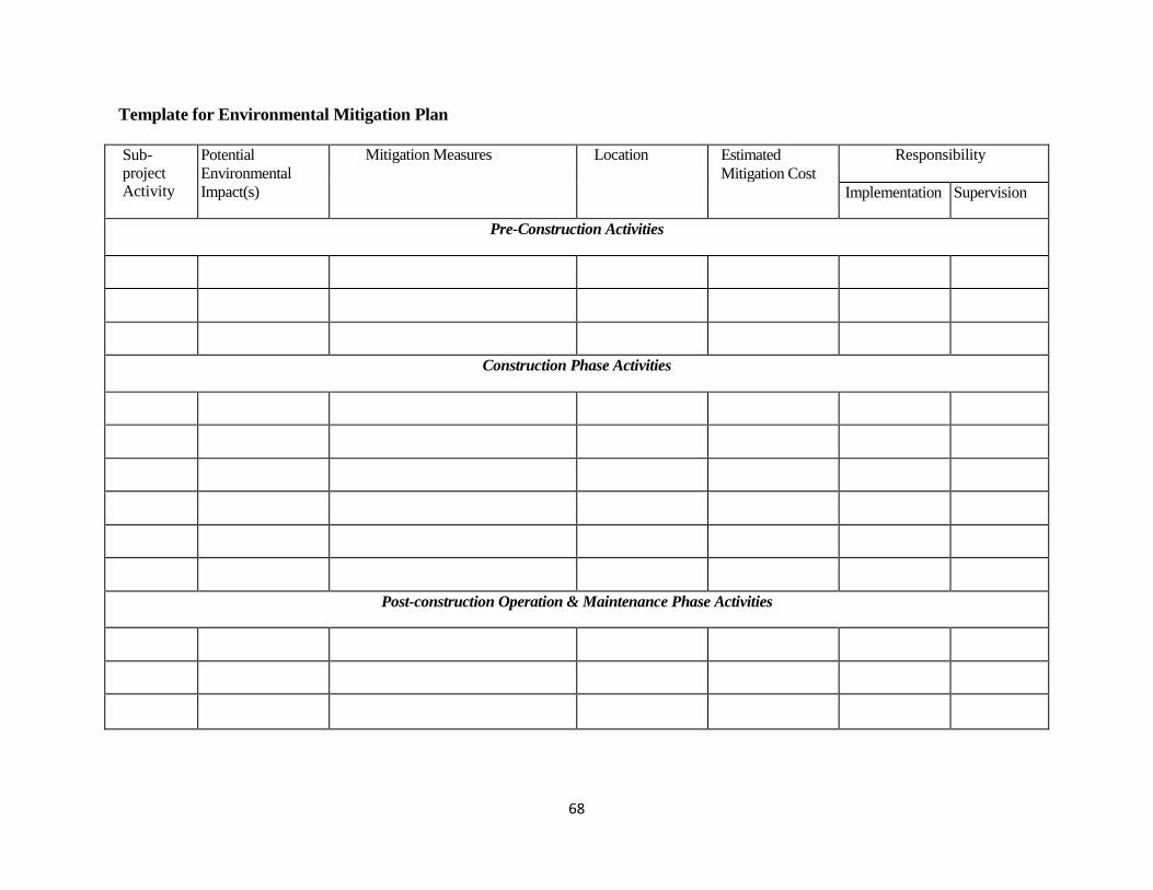
68
Template for Environmental Mitigation Plan
Sub-project Activity
Potential Environmental Impact(s)
Mitigation Measures Location Estimated Mitigation Cost
Responsibility
Implementation Supervision
Pre-Construction Activities
Construction Phase Activities
Post-construction Operation & Maintenance Phase Activities
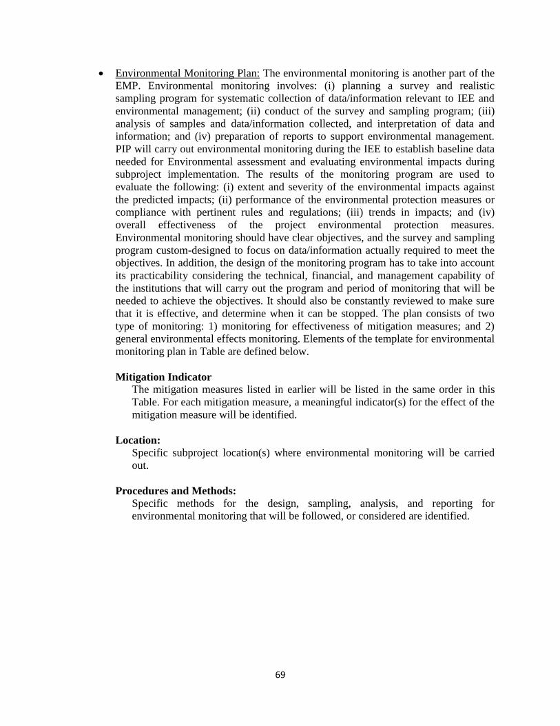
69
Environmental Monitoring Plan: The environmental monitoring is another part of the EMP. Environmental monitoring involves: (i) planning a survey and realistic sampling program for systematic collection of data/information relevant to IEE and environmental management; (ii) conduct of the survey and sampling program; (iii) analysis of samples and data/information collected, and interpretation of data and information; and (iv) preparation of reports to support environmental management. PIP will carry out environmental monitoring during the IEE to establish baseline data needed for Environmental assessment and evaluating environmental impacts during subproject implementation. The results of the monitoring program are used to evaluate the following: (i) extent and severity of the environmental impacts against the predicted impacts; (ii) performance of the environmental protection measures or compliance with pertinent rules and regulations; (iii) trends in impacts; and (iv) overall effectiveness of the project environmental protection measures. Environmental monitoring should have clear objectives, and the survey and sampling program custom-designed to focus on data/information actually required to meet the objectives. In addition, the design of the monitoring program has to take into account its practicability considering the technical, financial, and management capability of the institutions that will carry out the program and period of monitoring that will be needed to achieve the objectives. It should also be constantly reviewed to make sure that it is effective, and determine when it can be stopped. The plan consists of two type of monitoring: 1) monitoring for effectiveness of mitigation measures; and 2) general environmental effects monitoring. Elements of the template for environmental monitoring plan in Table are defined below.
Mitigation Indicator
The mitigation measures listed in earlier will be listed in the same order in this Table. For each mitigation measure, a meaningful indicator(s) for the effect of the mitigation measure will be identified.
Location:
Specific subproject location(s) where environmental monitoring will be carried out.
Procedures and Methods:
Specific methods for the design, sampling, analysis, and reporting for environmental monitoring that will be followed, or considered are identified.
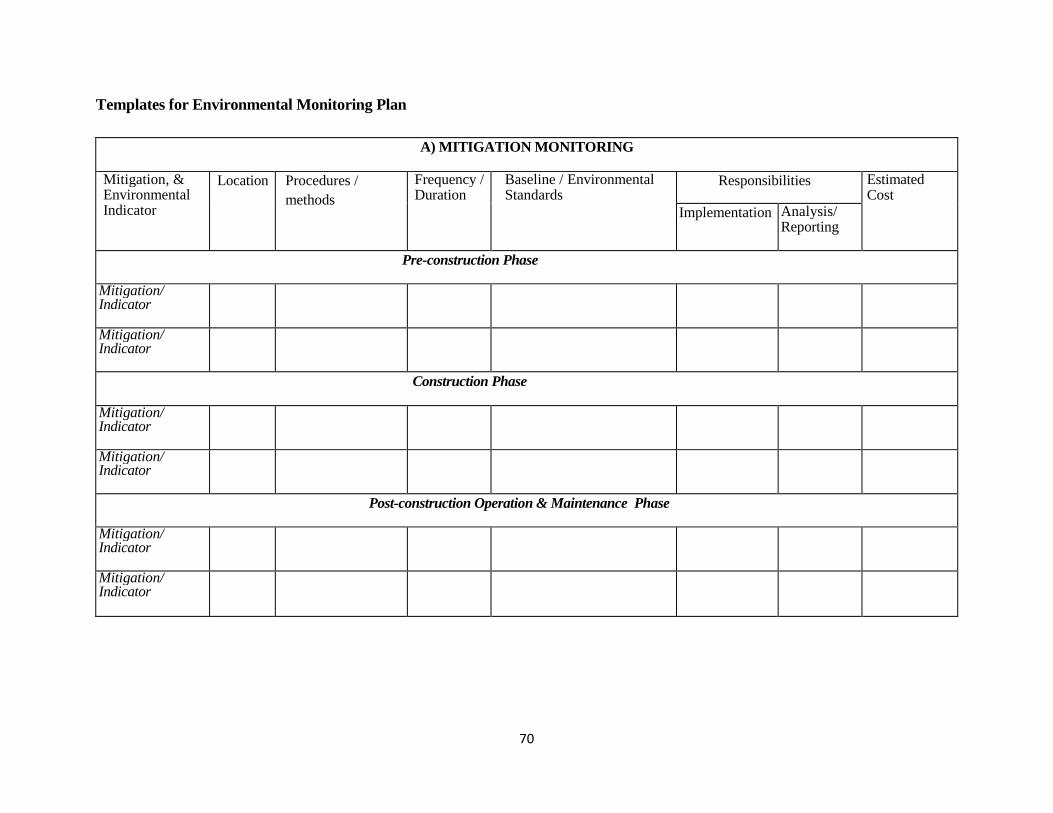
70
Templates for Environmental Monitoring Plan
A) MITIGATION MONITORING
Mitigation, & Environmental Indicator
Location Procedures / methods
Frequency / Duration
Baseline / Environmental Standards
Responsibilities Estimated Cost
Implementation Analysis/ Reporting
Pre-construction Phase
Mitigation/ Indicator
Mitigation/ Indicator
Construction Phase
Mitigation/ Indicator
Mitigation/ Indicator
Post-construction Operation & Maintenance Phase
Mitigation/ Indicator
Mitigation/ Indicator
71
Annex-D: Environmental Screening Format for Community Level AIG Activities
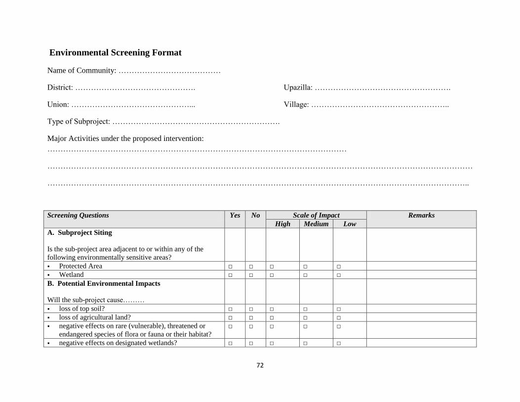
72
Environmental Screening Format
Name of Community: …………………………………
District: ………………………………………. Upazilla: …………………………………………….
Union: ………………………………………... Village: ……………………………………………..
Type of Subproject: ……………………………………………………….
Major Activities under the proposed intervention: ……………………………………………………………………………………………………
………………………………………………………………………………………………………………………………………………
……………………………………………………………………………………………………………………………………………..
Screening Questions Yes No Scale of Impact Remarks High Medium Low
A. Subproject Siting Is the sub-project area adjacent to or within any of the following environmentally sensitive areas?
Protected Area □ □ □ □ □ Wetland □ □ □ □ □ B. Potential Environmental Impacts Will the sub-project cause………
loss of top soil? □ □ □ □ □ loss of agricultural land? □ □ □ □ □ negative effects on rare (vulnerable), threatened or
endangered species of flora or fauna or their habitat? □ □ □ □ □
negative effects on designated wetlands? □ □ □ □ □
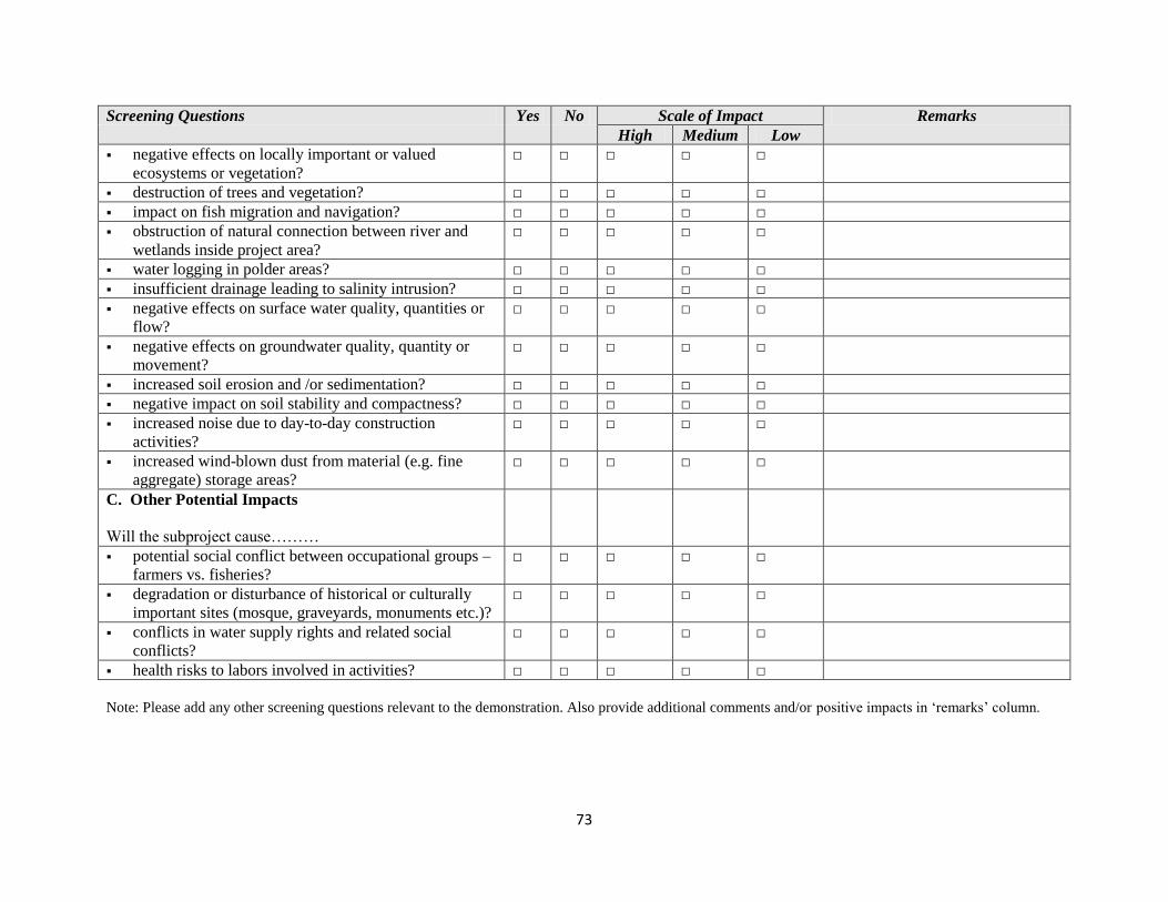
73
Screening Questions Yes No Scale of Impact Remarks High Medium Low
negative effects on locally important or valued ecosystems or vegetation?
□ □ □ □ □
destruction of trees and vegetation? □ □ □ □ □ impact on fish migration and navigation? □ □ □ □ □ obstruction of natural connection between river and
wetlands inside project area? □ □ □ □ □
water logging in polder areas? □ □ □ □ □ insufficient drainage leading to salinity intrusion? □ □ □ □ □ negative effects on surface water quality, quantities or
flow? □ □ □ □ □
negative effects on groundwater quality, quantity or movement?
□ □ □ □ □
increased soil erosion and /or sedimentation? □ □ □ □ □ negative impact on soil stability and compactness? □ □ □ □ □ increased noise due to day-to-day construction
activities? □ □ □ □ □
increased wind-blown dust from material (e.g. fine aggregate) storage areas?
□ □ □ □ □
C. Other Potential Impacts Will the subproject cause………
potential social conflict between occupational groups – farmers vs. fisheries?
□ □ □ □ □
degradation or disturbance of historical or culturally important sites (mosque, graveyards, monuments etc.)?
□ □ □ □ □
conflicts in water supply rights and related social conflicts?
□ □ □ □ □
health risks to labors involved in activities? □ □ □ □ □ Note: Please add any other screening questions relevant to the demonstration. Also provide additional comments and/or positive impacts in ‘remarks’ column.
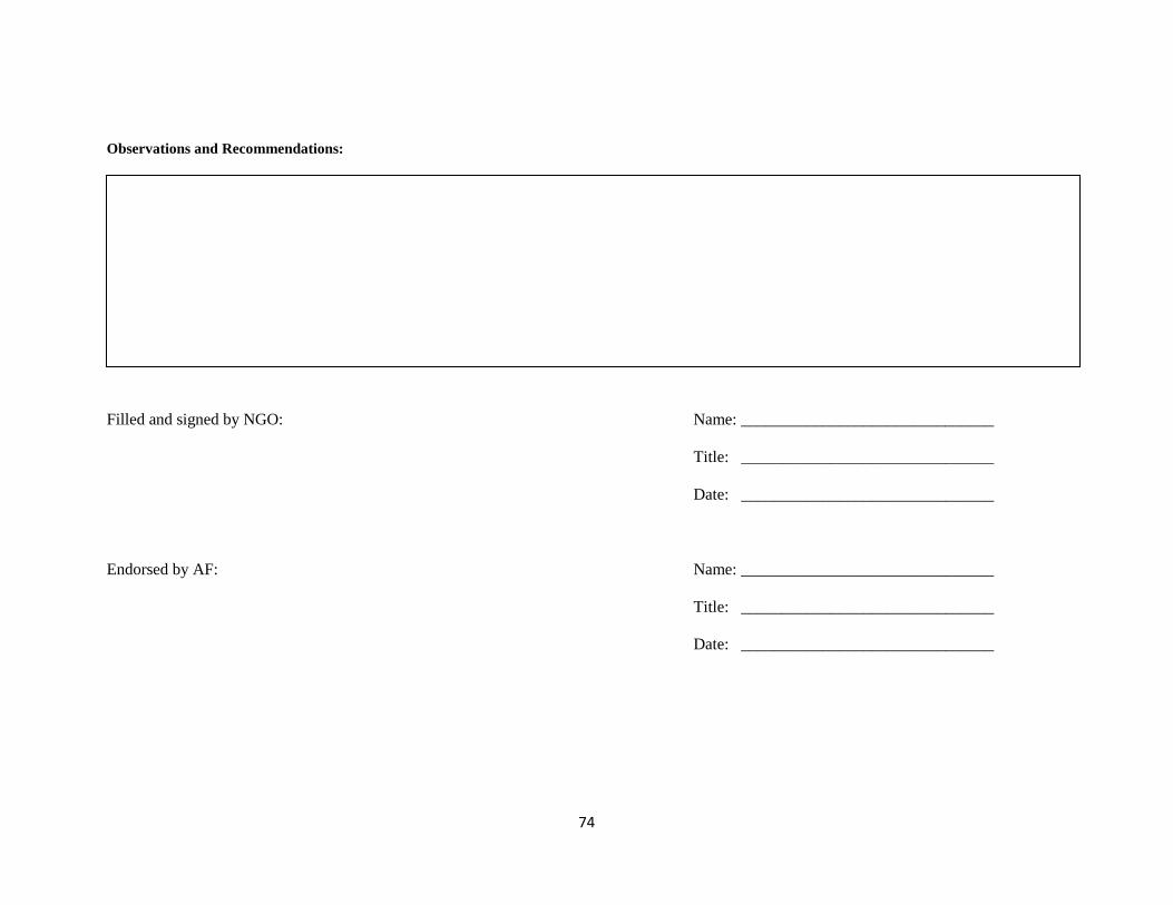
74
Observations and Recommendations: Filled and signed by NGO: Name: _______________________________ Title: _______________________________ Date: _______________________________ Endorsed by AF: Name: _______________________________ Title: _______________________________ Date: _______________________________

75
Annex-E: Grievance Redress Mechanism
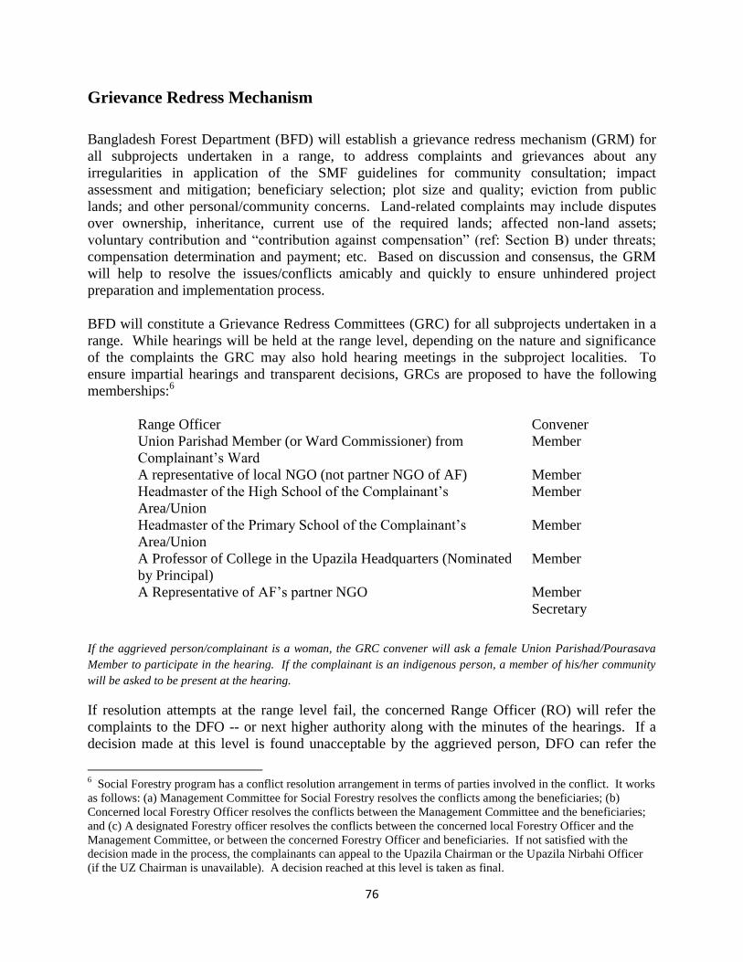
76
Grievance Redress Mechanism
Bangladesh Forest Department (BFD) will establish a grievance redress mechanism (GRM) for all subprojects undertaken in a range, to address complaints and grievances about any irregularities in application of the SMF guidelines for community consultation; impact assessment and mitigation; beneficiary selection; plot size and quality; eviction from public lands; and other personal/community concerns. Land-related complaints may include disputes over ownership, inheritance, current use of the required lands; affected non-land assets; voluntary contribution and “contribution against compensation” (ref: Section B) under threats;
compensation determination and payment; etc. Based on discussion and consensus, the GRM will help to resolve the issues/conflicts amicably and quickly to ensure unhindered project preparation and implementation process. BFD will constitute a Grievance Redress Committees (GRC) for all subprojects undertaken in a range. While hearings will be held at the range level, depending on the nature and significance of the complaints the GRC may also hold hearing meetings in the subproject localities. To ensure impartial hearings and transparent decisions, GRCs are proposed to have the following memberships:6
Range Officer Convener Union Parishad Member (or Ward Commissioner) from Complainant’s Ward
Member
A representative of local NGO (not partner NGO of AF) Member Headmaster of the High School of the Complainant’s
Area/Union Member
Headmaster of the Primary School of the Complainant’s
Area/Union Member
A Professor of College in the Upazila Headquarters (Nominated by Principal)
Member
A Representative of AF’s partner NGO Member Secretary
If the aggrieved person/complainant is a woman, the GRC convener will ask a female Union Parishad/Pourasava Member to participate in the hearing. If the complainant is an indigenous person, a member of his/her community will be asked to be present at the hearing.
If resolution attempts at the range level fail, the concerned Range Officer (RO) will refer the complaints to the DFO -- or next higher authority along with the minutes of the hearings. If a decision made at this level is found unacceptable by the aggrieved person, DFO can refer the
6 Social Forestry program has a conflict resolution arrangement in terms of parties involved in the conflict. It works as follows: (a) Management Committee for Social Forestry resolves the conflicts among the beneficiaries; (b) Concerned local Forestry Officer resolves the conflicts between the Management Committee and the beneficiaries; and (c) A designated Forestry officer resolves the conflicts between the concerned local Forestry Officer and the Management Committee, or between the concerned Forestry Officer and beneficiaries. If not satisfied with the decision made in the process, the complainants can appeal to the Upazila Chairman or the Upazila Nirbahi Officer (if the UZ Chairman is unavailable). A decision reached at this level is taken as final.

77
case to Project Director with the minutes of the hearings at both range and division levels. A decision agreed with the aggrieved person at any level of hearing will be binding on the project. 15. To ensure impartiality and transparency, hearings on complaints will remain open to the public. The GRCs will record details of the complaints and the reasons that led to acceptance or rejection of the particular cases. The RO will keep records of all resolved and unresolved complaints and grievances and make them available for review as and when asked for by BFD, World Bank and other development partners.

78
Annex-F: Consultation Photographs and Participant Lists
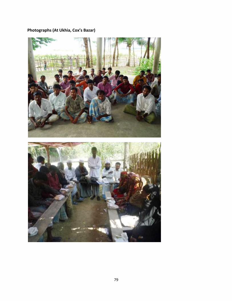
79
Photographs (At Ukhia, Cox’s Bazar)
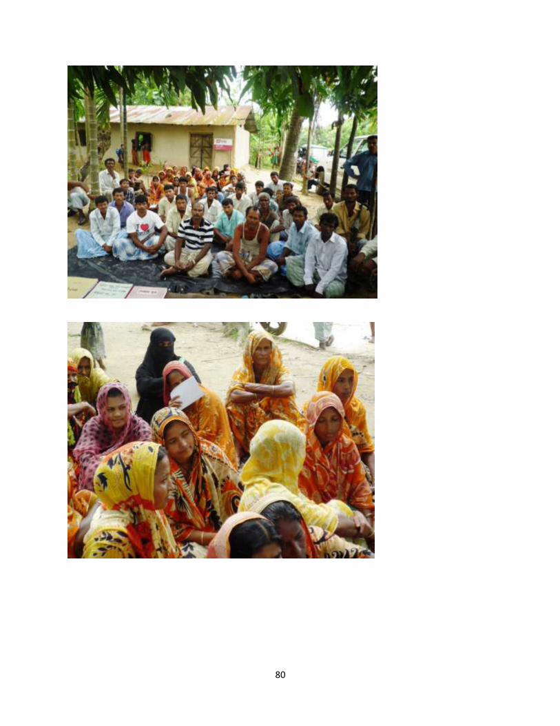
80
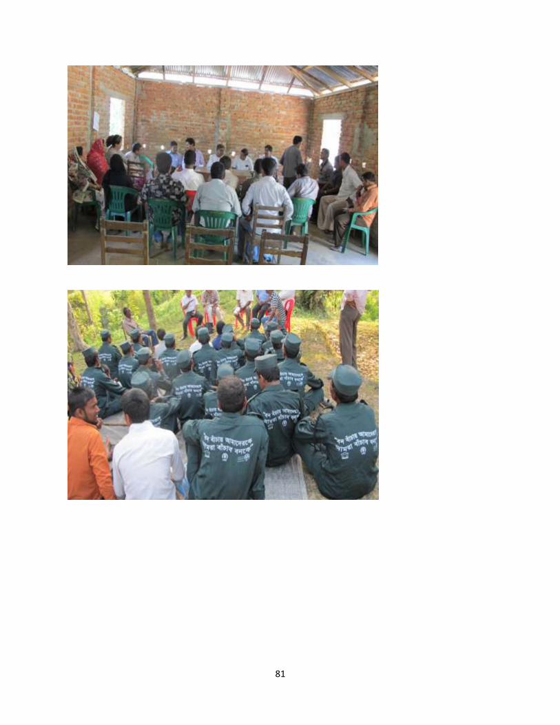
81
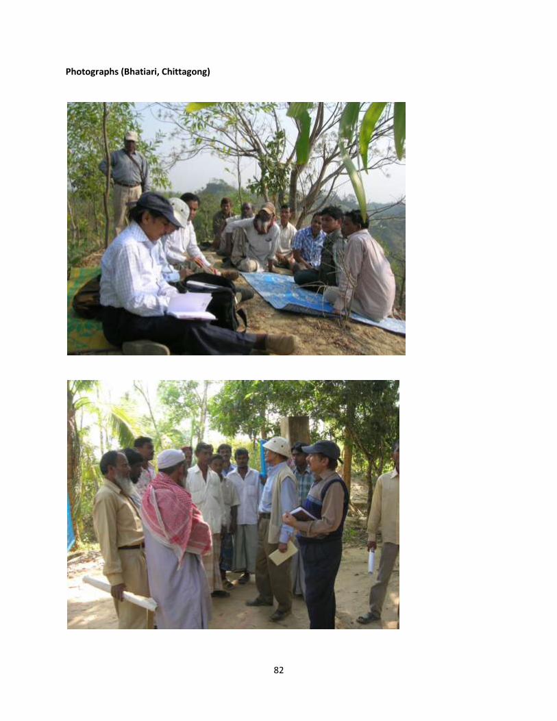
82
Photographs (Bhatiari, Chittagong)
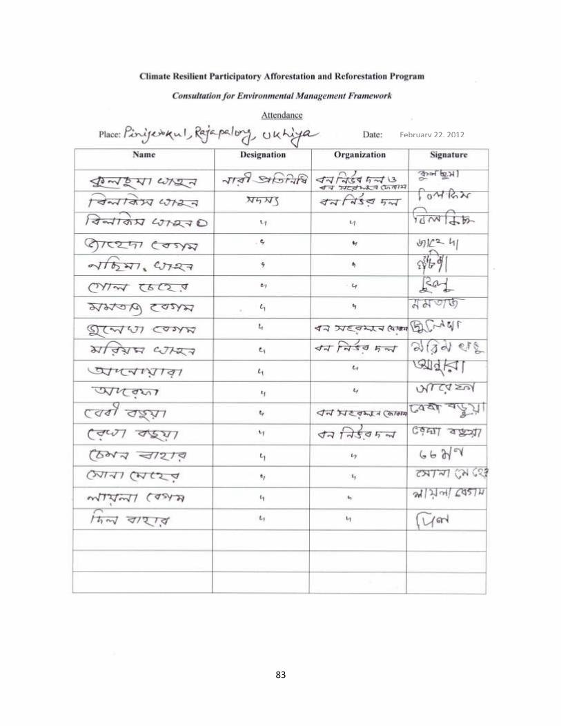
83
February 22, 2012
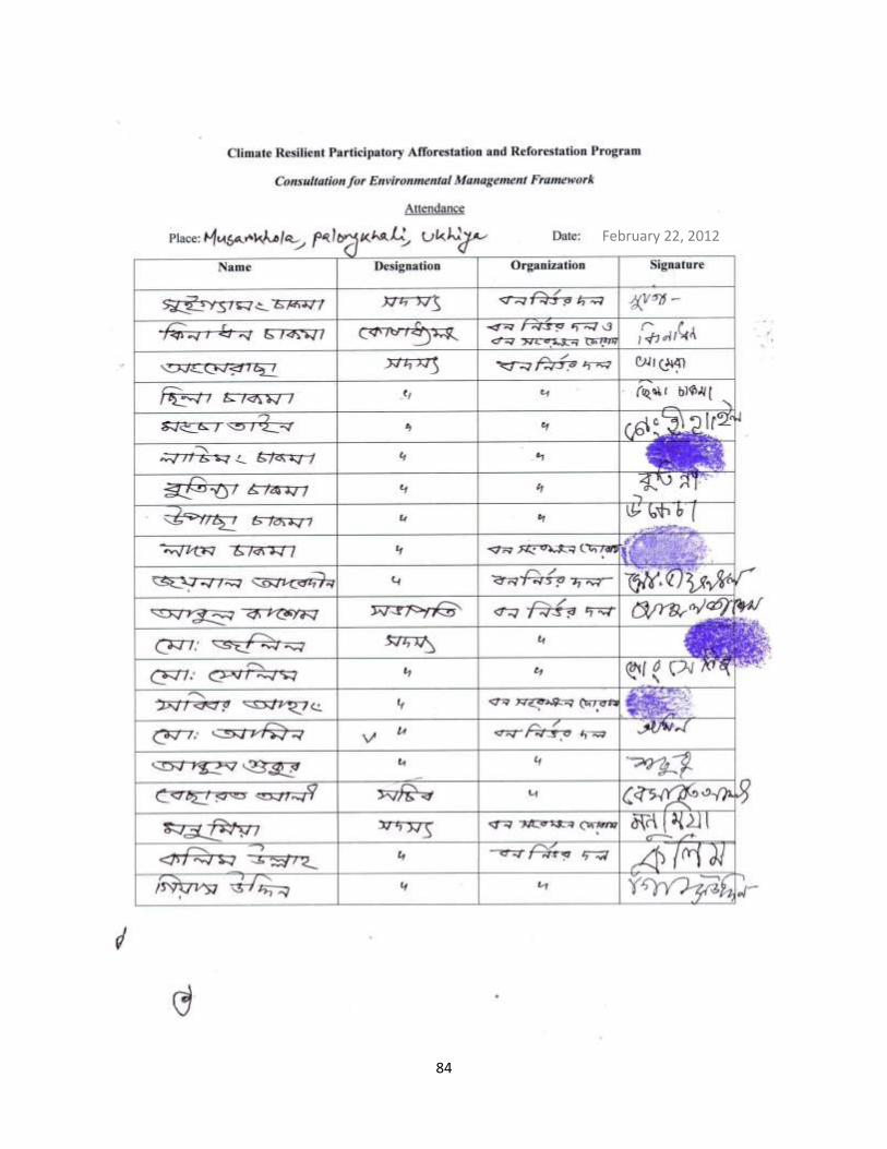
84
February 22, 2012
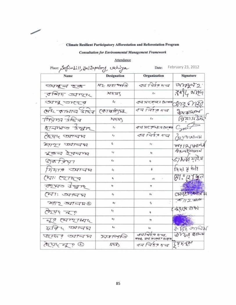
85
February 23, 2012
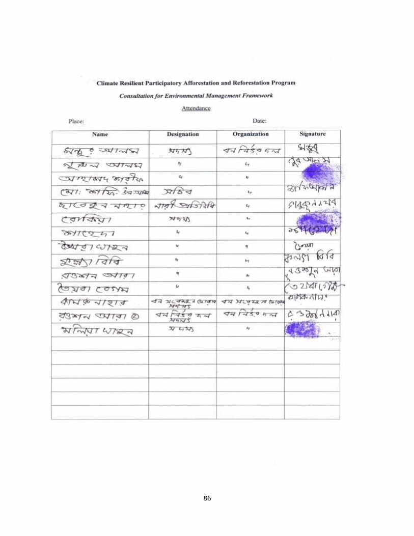
86
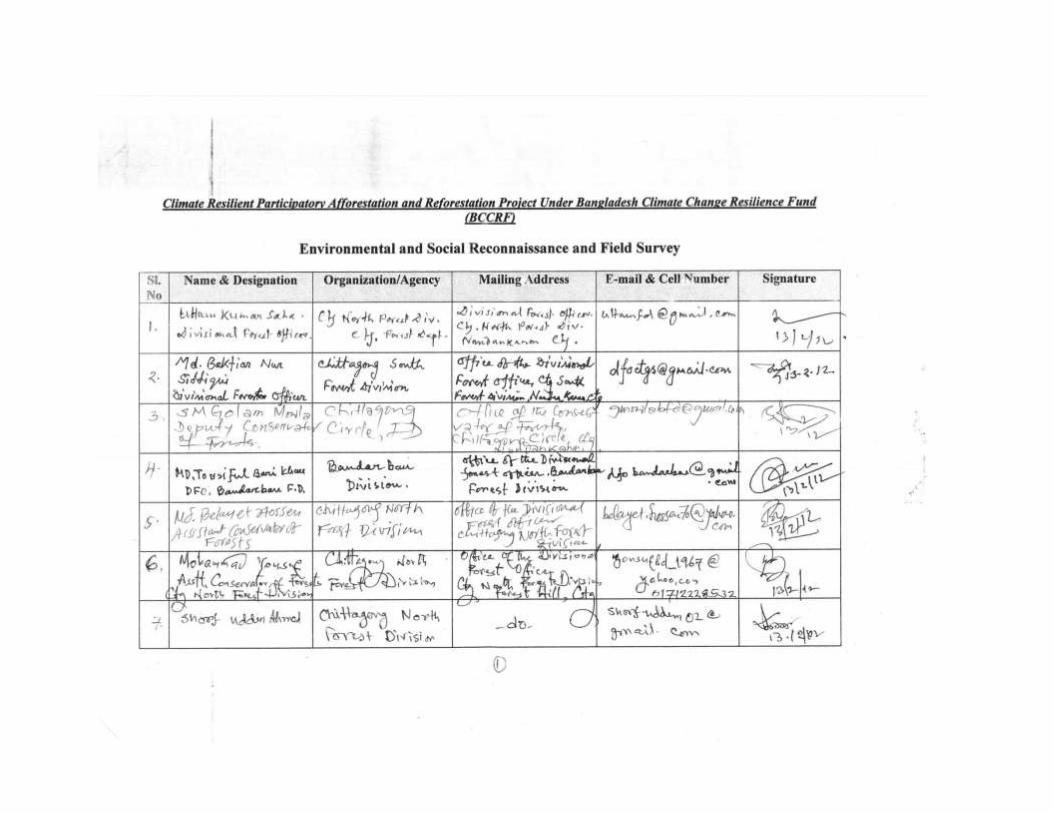
87
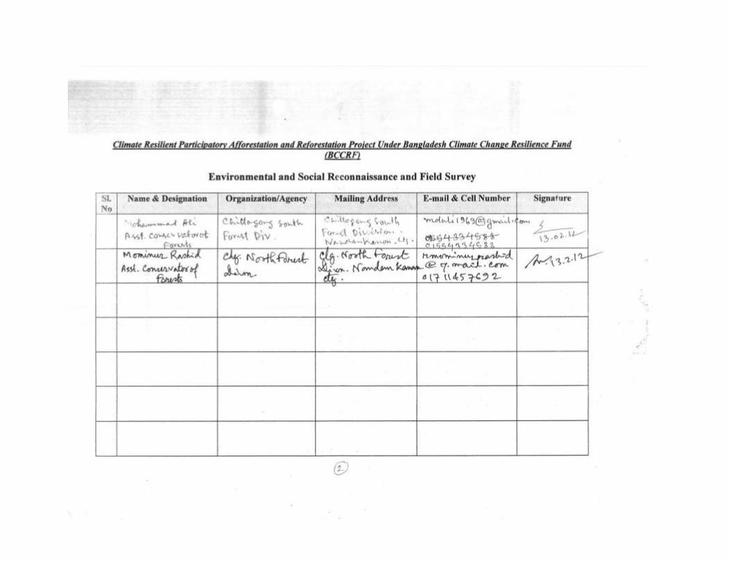
88
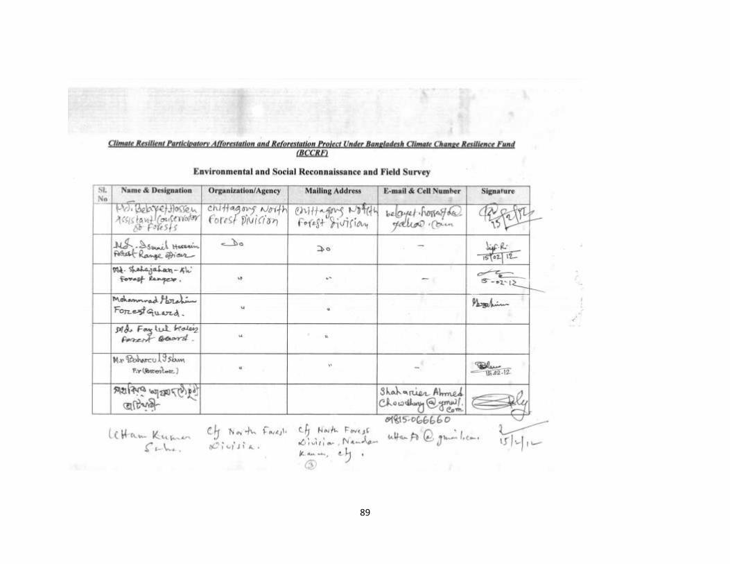
89

90
Annex-G: Monitoring Checklist
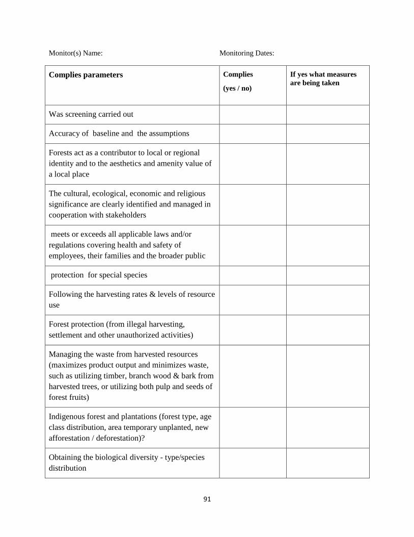
91
Monitor(s) Name: Monitoring Dates:
Complies parameters Complies
(yes / no)
If yes what measures are being taken
Was screening carried out
Accuracy of baseline and the assumptions
Forests act as a contributor to local or regional identity and to the aesthetics and amenity value of a local place
The cultural, ecological, economic and religious significance are clearly identified and managed in cooperation with stakeholders
meets or exceeds all applicable laws and/or regulations covering health and safety of employees, their families and the broader public
protection for special species
Following the harvesting rates & levels of resource use
Forest protection (from illegal harvesting, settlement and other unauthorized activities)
Managing the waste from harvested resources (maximizes product output and minimizes waste, such as utilizing timber, branch wood & bark from harvested trees, or utilizing both pulp and seeds of forest fruits)
Indigenous forest and plantations (forest type, age class distribution, area temporary unplanted, new afforestation / deforestation)?
Obtaining the biological diversity - type/species distribution
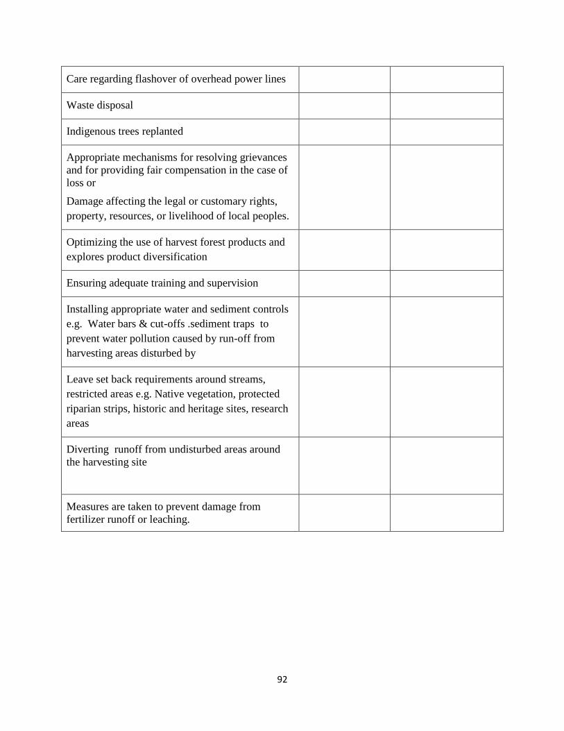
92
Care regarding flashover of overhead power lines
Waste disposal
Indigenous trees replanted
Appropriate mechanisms for resolving grievances and for providing fair compensation in the case of loss or
Damage affecting the legal or customary rights, property, resources, or livelihood of local peoples.
Optimizing the use of harvest forest products and explores product diversification
Ensuring adequate training and supervision
Installing appropriate water and sediment controls e.g. Water bars & cut-offs .sediment traps to prevent water pollution caused by run-off from harvesting areas disturbed by
Leave set back requirements around streams, restricted areas e.g. Native vegetation, protected riparian strips, historic and heritage sites, research areas
Diverting runoff from undisturbed areas around the harvesting site
Measures are taken to prevent damage from fertilizer runoff or leaching.
93
Annex-H: Exemption Notice for Use of Poly Propylene Bag
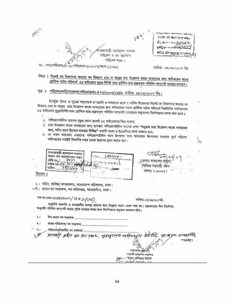
94