Embed Size (px)
Citation preview

spe393-13 page 359
359
Geological Society of AmericaSpecial Paper 393
2005
Climatic and tectonic controls on Jurassic intra-arc basins related to northward drift of North America
Cathy J. Busby*Department of Geological Sciences, University of California, Santa Barbara, California 93106, USA
Kari Bassett*Department of Geological Sciences, University of Canterbury, Christchurch, New Zealand
Maureen B. Steiner*Department of Geology and Geophysics, University of Wyoming, Laramie, Wyoming 82071, USA
Nancy R. Riggs*Department of Geology, Northern Arizona University, Flagstaff, Arizona 86011, USA
ABSTRACT
Upper Jurassic strike-slip intra-arc basins formed along the axis of earlier Lower to Middle Jurassic extensional intra-arc basins in Arizona. These strike-slip basins developed along the Sawmill Canyon fault zone, which may represent an inboard strand of the Mojave-Sonora megashear system that did not necessarily produce large-scale translations. Subsidence in the Lower to Middle Jurassic extensional arc was uniformly fast and continuous, whereas at least parts of the Upper Jurassic arc experienced rapidly alternating uplift and subsidence, producing numerous large-scale intrabasinal unconformities. Volcanism occurred only at releasing bends or stepovers in the Upper Jurassic arc, producing more episodic and localized eruptions than in the earlier extensional arc. Sediment sources in the Upper Jurassic strike-slip arc were also more localized, with restraining bends shedding sediment into nearby releasing bends. Normal fault scarps were rapidly buried by voluminous pyroclastic debris in the Lower to Middle Jurassic extensional arc, so epiclastic sedimentary deposits are rare, whereas pop-up structures in the Upper Jurassic strike-slip arc shed abundant epiclastic sedi-ment into the basins. Three Upper Jurassic calderas formed along the Sawmill Canyon fault zone where strands of the fault progressively stepped westward in a releasing geometry relative to paleo-Pacifi c–North America plate motion.
We hypothesize that strike-slip basins in the Upper Jurassic arc formed in response to changing plate motions that induced northward drift of North America, causing sinistral deformation of the paleo-Pacifi c margin. Drift out of the northern horse lati-tudes into northern temperate latitudes brought about wetter climatic conditions, with eolianites replaced by fl uvial, debris-fl ow, and lacustrine sediments. “Dry” eruptions
Busby, C.J., Bassett, K., Steiner, M.B., and Riggs, N., 2005, Climatic and tectonic controls on Jurassic intra-arc basins related to northward drift of North America, in Anderson, T.H., Nourse, J.A., McKee, J.W., and Steiner, M.B., eds., The Mojave-Sonora megashear hypothesis: Development, assessment, and alternatives: Geological Society of America Special Paper 393, p. 359–376. doi: 10.1130/2005.2393(13). For permission to copy, contact [email protected]. ©2005 Geological Society of America.
*E-mails: [email protected]; [email protected]; Steiner—[email protected]; [email protected]

360 C.J. Busby et al.
spe393-13 page 360
INTRODUCTION
Sedimentologic, paleontologic, and paleomagnetic data from well-studied Jurassic back-arc strata on the present-day Colorado Plateau indicate that very rapid Late Jurassic continental drift northward out of the horse latitudes into temperate latitudes brought about a change from hyperarid conditions to wetter climatic conditions (May et al., 1989; Blakey, 1996; Steiner and Marzolf, 1997). These studies have shown that the eolianites that dominate the Lower to Middle Jurassic section in the western inte-rior (e.g., Navajo and Entrada Sandstones) are largely replaced by fl uvial and lacustrine deposits in the Upper Jurassic section (Morrison Formation). Turner and Fishman (1991) infer that the climate may have remained semiarid, as inferred from alkaline lake deposits in part of the Morrison Formation, but shallow lakes, streams, and a water table never far below the surface indicate a wetter climate than envisioned for Early to Middle Jurassic time.
In this paper, we show that intra-arc basins near the plate margin in southern Arizona (Fig. 1) record a similar climate change, from eolian-dominated sedimentation in Early to Middle Jurassic time to fl uvially dominated sedimentation in Late Juras-sic time. We infer that this climatic change produced a change in eruptive style (Fig. 2) that infl uenced sedimentation far into the plate interior. We also present here a tectonic model for the Upper Jurassic arc in southern Arizona, in which intra-arc strike-slip basins formed in response to the changing plate motions that induced northward drift of North America.
We present our tectonic and paleoclimate models fi rst, in order to provide a coherent framework for the description and interpretation of structural and stratigraphic data. These data are described from ten structural blocks in southern Arizona that straddle the Sawmill Canyon fault zone. This is followed by a discussion of the controls of climate change on volcanic styles and super-regional stratigraphy. Last, we present a tectonic model for the Upper Jurasssic strike-slip arc, contrasting it with our previously published model for the Lowe to Middle Jurassic extensional arc.
REGIONAL TECTONIC SETTING
Throughout much of southern Arizona, Upper Jurassic to lower Cretaceous (?) conglomerates and interstratifi ed volcanic rocks occur upsection from more dominantly volcanic sections that are Lower to Middle Jurassic in age (Figs. 1 and 2; Saleeby and Busby-Spera, 1992). These conglomerates are widely referred to as the Glance Conglomerate and in many places lie
at the base of Cretaceous nonmarine to marine sections referred to as the Bisbee Group (Bilodeau, 1979; Jacques-Ayala, 1995; Lawton and Olmstead, 1995). The Glance Conglomerate is the basal unit in the Bisbee basin and thus records the tectonic set-ting during the basin’s initial opening. It occurs as piedmont fan and canyon fi ll deposits with locally interbedded lava fl ows and ignimbrites in grabens, half grabens, and calderas (Bilodeau, 1979; Dickinson et al., 1987, 1989; Busby and Kokelaar, 1992; Lipman and Hagstrum, 1992; Bassett and Busby, 1996, 1997; Lawton and McMillan, 1999; Dickinson and Lawton, 2001a).
Some workers have inferred that the Glance Conglomer-ate forms part of the Jurassic arc sequence, particularly in areas where it has abundant interstratifi ed volcanic rocks (Tosdal et al., 1989). Other workers have suggested it records back-arc extension (Bilodeau, 1979). Still others have inferred that the Glance Conglomerate records continental rifting associated with the opening of the Gulf of Mexico (Dickinson et al., 1986, 1987; Lawton and McMillan, 1999). The main “tug of war” has occurred between workers placing the Glance Conglomerate in an arc environment and those placing it in a continental rift environment. A kind of “fence-sitting” model proposes that the Glance Conglomerate records a transitional phase, wherein Gulf of Mexico–related rifts progressively exploited the thermally weakened, structurally attenuated crust of the Jurassic exten-sional arc (Busby-Spera et al., 1989; Saleeby and Busby-Spera, 1992; Lawton and McMillan, 1999). Strike-slip tectonics related to the Mojave-Sonora megashear of Silver and Anderson (1974; see also Anderson and Silver, this volume) probably infl uenced this rifting (Anderson et al., 1995; Bassett and Busby, 1997; Lawton et al., 1997; Anderson and Nourse, this volume). We pro-pose a different model wherein the Glance Conglomerate records oblique convergence partitioned between intra-arc strike-slip and back-arc extension.
The eastern part of the Glance Conglomerate outcrop belt, which is “inboard” relative to the paleo-Pacifi c subduction margin, contains few interstratifi ed volcanic rocks, and these are mafi c in composition (Lawton and Olmstead, 1995; Lawton and McMillan, 1999). Geochemical data on the mafi c volcanic rocks from the eastern Bisbee basin indicate eruption in a rift rather than arc environment (Lawton and McMillan, 1999). This rift was referred to as the “Mexican Borderland rift,” which was inferred to have been initiated when arc magmatism was aban-doned in Arizona (Lawton and McMillan, 1999; Dickinson and Lawton, 2001a, 2001b).
The Glance Conglomerate on the western, outboard edge of the Bisbee basin (relative to the paleo-Pacifi c subduction margin)
of welded ignimbrite were replaced by “wet” eruptions of nonwelded, easily reworked ignimbrite and phreatoplinian fall. This Late Jurassic transition from hyperarid to more temperate climatic conditions may thus form a superregional “time line” that ties the Cordilleran plate margin to events in the interior of the continent.
Keywords: Jurassic, arc, strike slip, continental drift, climate.
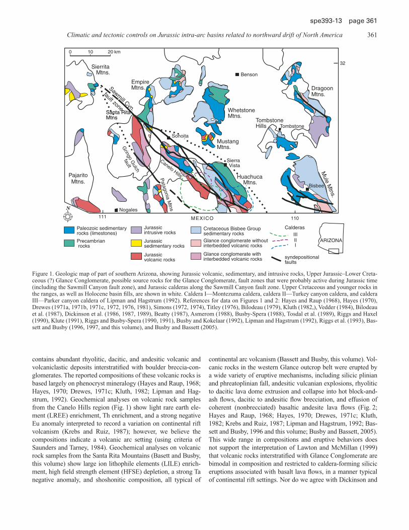
Climatic and tectonic controls on Jurassic intra-arc basins related to northward drift of North America 361
spe393-13 page 361
contains abundant rhyolitic, dacitic, and andesitic volcanic and volcaniclastic deposits interstratifi ed with boulder breccia-con-glomerates. The reported compositions of these volcanic rocks is based largely on phenocryst mineralogy (Hayes and Raup, 1968; Hayes, 1970; Drewes, 1971c; Kluth, 1982; Lipman and Hag-strum, 1992). Geochemical analyses on volcanic rock samples from the Canelo Hills region (Fig. 1) show light rare earth ele-ment (LREE) enrichment, Th enrichment, and a strong negative Eu anomaly interpreted to record a variation on continental rift volcanism (Krebs and Ruiz, 1987); however, we believe the compositions indicate a volcanic arc setting (using criteria of Saunders and Tarney, 1984). Geochemical analyses on volcanic rock samples from the Santa Rita Mountains (Basett and Busby, this volume) show large ion lithophile elements (LILE) enrich-ment, high fi eld strength element (HFSE) depletion, a strong Ta negative anomaly, and shoshonitic composition, all typical of
continental arc volcanism (Bassett and Busby, this volume). Vol-canic rocks in the western Glance outcrop belt were erupted by a wide variety of eruptive mechanisms, including silicic plinian and phreatoplinian fall, andesitic vulcanian explosions, rhyolitic to dacitic lava dome extrusion and collapse into hot block-and-ash fl ows, dacitic to andesitic fl ow brecciation, and effusion of coherent (nonbrecciated) basaltic andesite lava fl ows (Fig. 2; Hayes and Raup, 1968; Hayes, 1970; Drewes, 1971c; Kluth, 1982; Krebs and Ruiz, 1987; Lipman and Hagstrum, 1992; Bas-sett and Busby, 1996 and this volume; Busby and Bassett, 2005). This wide range in compositions and eruptive behaviors does not support the interpretation of Lawton and McMillan (1999) that volcanic rocks interstratifi ed with Glance Conglomerate are bimodal in composition and restricted to caldera-forming silicic eruptions associated with basalt lava fl ows, in a manner typical of continental rift settings. Nor do we agree with Dickinson and
Sierrita Mtns.
Nogales
Santa RitaMtns
Sawmill Cyn.
fault zone
Empire Mtns.
WhetstoneMtns.
Benson
MustangMtns.
Canelo Hills Huachuca Mtns.
Mule M
tns.
TombstoneHills Tombstone
Bisbee
Sonoita
0 10 km20
MEXICO
Calderas
syndepositionalfaults
ARIZONAPrecambrian rocks
Paleozoic sedimentaryrocks (limestones)
Jurassicintrusive rocks
Jurassicsedimentary rocks
Jurassicvolcanic rocks
Glance conglomerate withoutinterbedded volcanic rocks
Cretaceous Bisbee Groupsedimentary rocks
Glance conglomerate withinterbedded volcanic rocks
DragoonMtns.
111 110
PajaritoMtns.
SierraVista
32
Patagonia M
tnsIII
III
Gringo G
ulch
fault
Figure 1. Geologic map of part of southern Arizona, showing Jurassic volcanic, sedimentary, and intrusive rocks, Upper Jurassic–Lower Creta-ceous (?) Glance Conglomerate, possible source rocks for the Glance Conglomerate, fault zones that were probably active during Jurassic time (including the Sawmill Canyon fault zone), and Jurassic calderas along the Sawmill Canyon fault zone. Upper Cretaceous and younger rocks in the ranges, as well as Holocene basin fi lls, are shown in white. Caldera I—Montezuma caldera, caldera II—Turkey canyon caldera, and caldera III—Parker canyon caldera of Lipman and Hagstrum (1992). References for data on Figures 1 and 2: Hayes and Raup (1968), Hayes (1970), Drewes (1971a, 1971b, 1971c, 1972, 1976, 1981), Simons (1972, 1974), Titley (1976), Bilodeau (1979), Kluth (1982,), Vedder (1984), Bilodeau et al. (1987), Dickinson et al. (1986, 1987, 1989), Beatty (1987), Asmerom (1988), Busby-Spera (1988), Tosdal et al. (1989), Riggs and Haxel (1990), Klute (1991), Riggs and Busby-Spera (1990, 1991), Busby and Kokelaar (1992), Lipman and Hagstrum (1992), Riggs et al. (1993), Bas-sett and Busby (1996, 1997, and this volume), and Busby and Bassett (2005).

362 C.J. Busby et al.
spe393-13 page 362
Lawton’s (2001a, 2001b) intrepretation that volcanic rocks inter-stratifi ed with the Glance Conglomerate in the western Bisbee basin represent “post-arc rift volcanics.” We interpret the western (outboard) part of the Glance Conglomerate belt to represent intra-arc basins, which formed along strike-slip faults (discussed further below).
USEFULNESS OF IGNIMBRITE STRATIGRAPHY FOR REGIONAL-SCALE CORRELATIONS
The stratigraphic, volcanological, tectonic, and paleocli-matic interpretions presented in this paper take advantage of the widespread nature of ignimbrites. Ignimbrites are defi ned as pumiceous, ash-rich pyroclastic fl ow deposits, which may or may not be welded; some other workers use the term “ash-fl ow tuff” ignimbrites (Sparks et al., 1973; Freundt et al., 2000). We use distinctive characteristics of ignimbrites for purposes of cor-relation between ranges, including phenocryst abundance and types, color, degree of welding, lithic contents and compositions, and vertical and lateral organization of depositional structures
in the ignimbrites, as well as the nature of distinctive enclosing strata. Using our data and building upon previous work cited in Figure 1, we propose a correlation of Jurassic ignimbrites across a large part of southern Arizona, through ten structural blocks (Fig. 2), described below. This work demonstrates the useful-ness of ignimbrite stratigraphy in making correlations between widely separated ranges, despite postdepositional events includ-ing Jurassic strike-slip dismemberment, late Mesozoic to early Cenozoic Laramide shortening, and middle to late Cenozoic Basin and Range extension, as well as emplacement of plutons and attendant alteration throughout much of the Mesozoic and Cenozoic.
PROPOSED TECTONIC MODEL
We propose that Upper Jurassic basins of the western belt of Glance formed as intra-arc strike-slip basins along the Saw-mill Canyon fault zone (Fig. 1), at the same time that the eastern (inboard) part of the belt experienced back-arc extension, due to strain partitioning along an obliquely convergent margin. The
fault
fault
II
II
III
IIIII
I
north block south block
Base ofGlance Conglomerate
Base ofGlance Conglomerate
West-vergent Santa Rita Thrust
Ear
ly–
Mid
dle
Jura
ssic
Mt.
Wrig
htso
nF
m.
Fluvialredbeds
Nonweldedrhyoliteignimbrite
GlanceConglomerateinterstratifiedwith
Densely-weldedpurple-reddaciteignimbrites(MWF)witheolianquartz arenite
GlanceConglomerateinterstratifiedwith
Canelo Hills ignimbrites:Welded rhyolite,quartz-phyricUltra-weldedrhyolite, quartz poorWelded dacite,crystal rich
&
1Corral Cyn. Block
intrusions
Bagby Ranch Block
Quartz arenite
intracalderawith megablocks
intracalderawith megablocks
Pal
eozo
iclim
esto
ne
Tuff
ofC
obre
Rid
ge
Mid
dle
Jura
ssic
Pz.
“Gla
nce
tuffs
”
Gla
nce
Fm
.
1 2 3
&1 3
2Nonweldeddaciteblock and ashflow tuffs
3Andesite flowsand landslidemegabreccias
Weldedcrystal-richrhyoliteignimbritewith eolianquartz arenite(MWF)
(MWF)
PreCto C
3
3
IIIIII
IIIII
III
I
Mustang Mtns.Pajarito Mtns. toSonora (MX) Canelo Hills
SouthernNorthern SouthernHuachuca Mtns.
Northern Santa Rita Mtns. Central & SouthernSanta Rita Mtns.
Patagonia Mtns.
Figure 2. Generalized lithostratigraphic columns showing Lower to Middle Jurassic extensional arc volcanic deposits (Mount Wrightson Forma-tion, tuff of Cobre Ridge, and Canelo Hills volcanics) overlain by Upper Jurassic Glance Conglomerate and interstratifi ed andesitic, dacitic, and rhyolitic volcanic rocks (Glance Conglomerate, “Glance tuffs,” and “Glance volcanics”). These columns are hung on the base of the Glance Conglomerate. At most localities the Glance Conglomerate rests on densely welded Middle Jurassic ignimbrites and interstraifi ed eolian quartz arenites (Mount Wrightson Formation—MWF, tuff of Pajarito, and Canelo Hills Volcanics ignimbrites I, II, and II). The Glance Conglomerate contains three types of volcanic units that we correlate from range to range, labeled: (1) nonwelded rhyolite ignimbrites, (2) nonwelded dacite block-and-ash-fl ow tuffs, and (3) andesite lava fl ows and fl ow breccias.

Climatic and tectonic controls on Jurassic intra-arc basins related to northward drift of North America 363
spe393-13 page 363
Sawmill Canyon fault zone is the widest and longest fault zone in the Bisbee basin, and it formed an important conduit for andesitic to rhyolitic magmas throughout the Jurassic (Riggs and Busby-Spera, 1990; Busby and Kokelaar, 1992; Bassett and Busby, 1996 and this volume; Busby and Bassett, 2005). We propose that the Sawmill Canyon fault zone also controlled the siting of at least three calderas identifi ed by Lipman and Hagstrum (1992); these straddle the Sawmill Canyon fault zone (Fig. 1) and erupted ignimbrite units I, II, and III of the Canelo Hills volcanics (Fig. 2; Lipman and Hagstrum, 1992; Busby and Kokelaar, 1992).
The Sawmill Canyon fault zone and related NW-trending, steeply dipping faults form a regional lineament inherited from Precambrian basement and reactivated in Mesozoic and Cenozoic times (Fig. 1; Titley, 1976; Drewes, 1981). The Jurassic move-ment history of the Sawmill Canyon fault zone has been variably interpreted as normal, dextral, or sinistral (Drewes, 1972; Titley, 1976; Bilodeau, 1979; Drewes, 1981; Busby and Kokelaar, 1992; Lipman and Hagstrum, 1992). This fault marks the northeastern structural boundary of thick Lower to Middle Jurassic arc volca-nic successions, interpreted to form the fi ll in one segment of a 1000-km-long extensional arc graben depression that extended semicontinuously from Sonora, Mexico, to northern California and Nevada (Busby-Spera, 1988). Evidence for movement on the Sawmill Canyon fault zone in Late Jurassic time includes large slabs of shattered rock interbedded with the Glance Conglomer-ate in the Mustang Mountains, the Huachuca Mountains, and the Canelo Hills (Fig. 1; Hayes and Raup, 1968; Davis et al., 1979; Bilodeau, 1979) as well as along the southern extension of the Sawmill Canyon fault zone into Mexico (McKee and Anderson, 1998). These are widely agreed to represent megabreccias that avalanched off fault scarps. In this paper we present evidence that the Sawmill Canyon fault zone was active as a strike-slip fault during deposition of the Glance Conglomerate and interstratifi ed volcanic rocks.
Upper Jurassic strike-slip intra-arc basin deposits contrast with Lower to Middle Jurassic extensional intra-arc basin depos-its in several ways (Table 1). Subsidence in the Lower to Middle Jurassic extensional arc was uniformly fast and continuous along syndepositional normal faults (Busby-Spera, 1988; Busby-Spera et al., 1990; Riggs and Busby-Spera, 1990; Riggs et al., 1993;
Haxel et al., this volume). In contrast, at least parts of the Upper Jurassic arc experienced rapidly alternating uplift and subsid-ence, producing numerous large-scale unconformities, as well as intrabasinal reverse and normal faults (Bassett and Busby, this volume). We interpret this “porpoising” to be the result of temporal alternations between subsiding releasing bends and uplifting restraining bends along the Sawmill Canyon fault zone, and we propose that restraining bends were sites of sedi-ment production. High rates of extension in the Middle to Upper Jurassic arc resulted in high rates of magma production so that basin-bounding fault scarps were buried by pyroclastic deposits, leading to a general lack of talus cones and alluvial fan deposits (Fig. 2), similar to the modern Taupo Volcanic zone. In contrast, Late Jurassic volcanism was more restricted in volume, space, and time (Figs. 1 and 2) so that fault scarps were fringed with breccia-conglomerate units (Glance Conglomerate), in place of being buried by pyroclastic debris. Furthermore, erosion of pop-up structures along restraining bends contributed to the epiclastic sediment supply.
PROPOSED CLIMATIC CONTROLS ON STYLES OF VOLCANISM AND SEDIMENTATION
A super-regional “time line” controlled by climate change may be represented by a contact between: (1) sections with welded ignimbrites, and (2) sections with nonwelded ignimbrites and associated phreatoplinian fall deposits. In southern Arizona, this contact coincides approximately with the base of the Glance Conglomerate (Fig. 2). We do not regard this as a coincidence but rather a fundamental change in tectonic style that accompanied the very rapid northward drift of North America (Table 1).
Lower to Middle Jurassic rocks of the southwestern United States record hyperarid conditions. In the extensional arc of southern Arizona, this is recorded by eolian quartz arenites interstratifi ed with strongly welded ignimbrites with a rarity of fl uvial deposits and total lack of lake deposits (e.g., Mount Wrightson Formation and tuff of Cobre Ridge, Fig. 2; Riggs and Busby-Spera, 1990, 1991). The high emplacement temperatures required for strong welding indicates that the eruptions were “dry” (i.e., no interaction with surface water). All of the glass
TABLE 1. CONTRASTING VOLCANIC, STRUCTURAL, AND CLIMATIC CONTROLS ON THE FILL OF EARLY TO MIDDLE JURASSIC VERSUS LATE JURASSIC INTRA-ARC BASINS, ARIZONA
Early to Middle Jurassic extensional arc Late Jurassic strike-slip arc
Volcanic controls More voluminous, widespread, and continuous eruptions=> scarps buried by pyroclastic deposits
More restricted eruptions in space and time, episodic=> scarps eroded, shedding sediments into the canyons
Structural controls Uniformly fast and continuous subsidence=> unconformities rare
“Porpoising” on all scales, local regions of uplift within basins=> numerous big unconformities intrabasinal highs shed
sediment
Climatic controls Hyperarid: eolianites
=> “dry” eruptions of welded tuffs, most rheomorphic
Wetter climate: sheetwash and channelized hyperconcentrated fl ood fl ow and dilute fl ow
=> “wet” eruptions of nonwelded tuffs, plinian, and phreatoplinian fall

364 C.J. Busby et al.
spe393-13 page 364
shards in these ignimbrites are bubble-wall shards produced by magmatic vesiculation. They lack blocky shards, which are pro-duced by fragmentation upon contact with surface water (Heiken and Wohletz, 1985).
As the climate grew wetter in late Middle to Late Jurassic time, eolian quartz sands were reworked as fl uvial deposits (for example, fl uvial quartz arenites interstratifi ed with Canelo Hills volcanics and basal “Glance tuffs,” Fig. 2). Finally, the climate became wet enough for surface and groundwater to collect in and around vent areas, and the style of volcanism changed dramati-cally, generating nonwelded to weakly welded ignimbrites and associated phreatoplinian fallout. Nonwelded ignimbrites and phreatoplinian ashes are friable, very easily remobilized pyro-clastic deposits. Increased rainfall remobilized this pyroclastic debris by fl uvial processes, including channelized stream fl ow and sheetfl ood, as well as by debris-fl ow processes (e.g., Glance Conglomerate, central and southern Santa Rita Mountains, Fig. 2; Bassett and Busby, this volume).
Phreatomagmatic eruptions commonly result in nonwelded ignimbrites, together with widespread and voluminous fall deposits (plinian and phreatoplinian) and surge deposits. They typically occur where lakes or shallow embayments of the sea lie above vents in downsagged areas of caldera evacuation or struc-turally controlled extension or transtension (Wilson et al., 1995).
Ignimbrites generated from phreatomagmatic eruptions are nonwelded, with blocky shards as well as bubble-wall shards, and commonly lack carbonized plant material, due to cooling of pyroclasts during eruption through water (Self, 1983; Heiken and Wohletz, 1985; McPhie et al., 1993; Bryan et al., 2000; De Rita et al., 2002). Silicic magmatic explosions enhanced by steam explosions produce the highest eruption columns, which provide the momentum to make phreatoplinian ignimbrites the most mobile pyroclastic fl ows on Earth (Self, 1983; Houghton et al., 2000a).
Phreatoplinian fallout tuffs can be enormously widespread, with thicknesses generally <3–4 m but extending for many hun-dreds of kilometers in both upwind and downwind directions, with very little change in grain size with distance (Self, 1983). Phreatoplinian ash fall is extremely fi ne grained and well sorted, with deformational structures typical of water-saturated, cohe-sive soft sediment, e.g., convolute lamination and plastering of vertical surfaces (Self and Sparks, 1978; Self, 1983; Wilson et al., 1995; De Rita et al., 2002). Phreatoplinian tuffs occur in thin to very thin beds (~1–5 cm) that are tabular to convolute and mantle topography; they are composed largely of blocky glass shards, in addition to bubble-wall shards, and may preserve horizons of accretionary lapilli (Heiken and Wohletz, 1985; McPhie et al., 1993; Morissey et al., 2000; Houghton et al., 2000a; Jurado-Chichay and Walker, 2001). The very thin tabular beds in phre-atoplinian ash fall suggest intermittent explosions from highly vesiculated magma interacting with surface water (Houghton et al., 2000a). Phreatoplinian tuffs are commonly interstratifi ed with plinian pumice fall deposits; these are recognized as well-sorted pumice accumulations that mantle topography in thin beds
(Fisher and Schminke, 1984; Houghton et al., 2000b). The alter-nation of plinian and phreatoplinian tuffs results from variability in water infl ux to the vent (Wohletz, 1986; Jurado-Chichay and Walker, 2001). Phreatoplinian tuffs that lack nonjuvenile rock fragments are more typical of interaction with surface water, rather than aquifers (De Rita et al., 2002).
The pyroclastic rocks interstratifi ed with the Glance Con-glomerate are dominated by nonwelded rhyolitic to andesitic phre-atomagmatic ignimbrites, with lesser phreatoplinian rhyolitic tuffs and phreatomagmatic andesitic tuffs (Fig. 2). We speculate that the change in eruptive style recorded in the western belt of the Glance Conglomerate was the result of climate change from hyperarid to wetter conditions, induced during rapid northward drift of North America out of the horse latitudes into more temperate latitudes.
To summarize, our new correlations of widespread ignim-brites across ten structural blocks straddling the Sawmill Canyon fault zone (Figs. 1 and 2) permit the following interpretations for Jurassic time: an earlier stage of “dry” ignimbrite eruptions (Lower to Middle Jurassic Mount Wrightson Formation, overlain by Middle Jurassic tuff of Pajarito and Middle Jurassic Canelo Hills volcanics) was succeeded across the region by a later stage of dominantly “wet” ignimbrite eruptions (Upper Jurassic “Glance Conglomerate and volcanics” and “Glance tuffs”). This climatically controlled transition in eruptive style coincides with a tectonically controlled change in sedimentological style, char-acterized by deposition of compositionally and texturally imma-ture, locally sourced conglomerates (Glance Conglomerate).
PALEOMAGNETIC EVIDENCE FOR VERY RAPID NORTHWARD DRIFT OF NORTH AMERICA IN LATE JURASSIC TIME
Southwestern North America resided in equatorial latitudes from the mid-Pennsylvanian (Supai Group) through the Early Jurassic (~Pliensbachian Kayenta Formation), shown in Figure 3A. For reference, the center of the plateau (e.g., Four Corners area) lay at paleolatitudes of 4°–7° N through the Early Jurassic.
For the end of the Early Jurassic and most of the Middle Jurassic (Toarcian–Bathonian), no paleomagnetic data are avail-able to defi ne the paleolatitude of North American, but by latest Middle Jurassic time (upper Callovian Summerville Formation), the Plateau center lay at 21° N. Paleomagnetic poles with ages within that time gap have been determined (Kluth et al., 1982; May et al., 1986) and lie in sequential relative positions between the Kayenta and Summerville paleopoles, but their reliability is questionable because they come from sites in the block-rotation-prone Basin and Range province. If these sites have not been subject to rotation, a more refi ned estimate of northward motion versus age can be made. Nevertheless, at this stage of our knowl-edge, an ~15° northward shift of North America occurred during the Middle Jurassic (Fig. 3A), between ca. 185 Ma and 160 Ma (using the time scale of Gradstein et al., 2004).
The North American Plate apparently exhibited little motion with respect to the geomagnetic pole between the latest Callovian

Climatic and tectonic controls on Jurassic intra-arc basins related to northward drift of North America 365
spe393-13 page 365
and late Oxfordian (ca. 155–150 Ma; Fig. 3B), demonstrated by statistically identical paleopoles from the Summerville and over-lying lower Morrison Formations. This “stillstand” of the plate is indicated from data at locations on both the Colorado Plateau and the craton. The J-5 unconformity, which formed in this time frame, may therefore have encompassed little time, consistent with its only intermittent presence and aerially restricted nature (Imlay, 1980).
Paleomagnetic data suggest that a second period of north-ward drift of North America and the plateau, of more rapid nature, occurred in the Late Jurassic, after deposition of the lower sand-dominated (Salt Wash) member of the Morrison Formation and prior to the deposition of the variegated tuffaceous claystones of the Brushy Basin member. This shift was ~13° northward (Fig. 3). In addition, between deposition of the two members, the Colorado Plateau was rotated 4°–5° clockwise relative to cratonic North America. No fi eld evidence of a hiatus has been observed, but the two very different paleopole positions require one. The change in sedimentary facies across the unconformity may be indicative of the tectonic event that caused rotation of the Colorado Plateau. We infer that abundant ashes above the unconformity record a climatically controlled transition in erup-tive style in the arc, i.e., progressively “wetter,” as North America drifted into temperate latitudes. The age of the postulated hiatus is between ca. 152 and 150 Ma, estimated from a comparison of the magnetostratigraphy to the seafl oor record (Steiner, 1998) and from 40Ar/39Ar dating of tuffs in the formation (Kowallis et al., 1998; Gradstein et al., 2004).
In summary, southwestern North America was translated ~15° northward from equatorial latitudes between ca. 185 and 160 Ma and even more rapidly, another ~13° further northward, between ca. 152 Ma and 150 Ma.
LITHOSTRATIGRAPHY OF STRUCTURAL BLOCKS STRADDLING THE SAWMILL CANYON FAULT ZONE
We summarize stratigraphic and structural data that support the tectonic and paleoclimatic models presented above (Table 1 and Fig. 4); for more complete reviews of the Jurassic arc and the Glance Conglomerate in southern Arizona, see Dickinson et al. (1986, 1987, 1989), Bilodeau et al. (1987), Busby-Spera (1988), Tosdal et al. (1989), Saleeby and Busby-Spera (1992), and Dick-inson and Lawton (2001a).
We make stratigraphic correlations between ranges (Fig. 2) on the basis of lithologic similarities, using outcrop and thin section characteristics. Lithologic correlations are more con-vincing where two or more lithologically distinct units occur in stratigraphic succession. The correlations presented here are based largely on our reconnaissance mapping, using published maps and papers cited in the caption for Figure 1; we have not made our own detailed maps, cross sections, and measured sec-tions of most of these ranges, except in the Santa Rita Mountains (Bassett and Busby, this volume; Riggs and Busby-Spera, 1990) and the Pajarito Mountains (Riggs and Busby-Spera, 1991). The
lithostratigraphic columns are generalized, composite sections intended to summarize the predominant and lithologically distinc-tive units used for correlation in this paper, and are by no means detailed or exhaustive. We intend for these correlations and the model that results from them to be tested by future workers using geochemistry, geochronology, and additional fi eld mapping.
Generalized lithostratigraphic columns of Figure 2 are hung on the base of the Glance Conglomerate. This rests on densely welded Middle Jurassic ignimbrites and interstratifi ed eolian quartz arenites at most localities, and correlations between these ignimbrites are summarized in Figure 2, as well as the types of volcanic units correlated from range to range in the Glance Con-glomerate. The columns are arranged in a manner that makes it easiest to see the correlation of units between structural blocks of the present-day Basin and Range topography, rather than being arranged in any consistent fashion relative to the various strands of the Sawmill Canyon fault zone. The northern Santa Rita Mountains and the Mustang Mountains lie northwest of all pro-posed traces of the Sawmill Canyon fault zone, and the Pajarito and Patagonia Mountains lie southwest of all proposed traces. We propose that all the other ranges lie between various strands of the fault zone (Fig. 1), including the central and southern Santa Rita Mountains, the northern and southern Canelo Hills, and the Huachuca Mountains.
Santa Rita Mountains, Northern Block
The northern Santa Rita Mountains structural block is bounded to the south by the Sawmill Canyon fault zone (Fig. 1) and is further subdivided into two structural blocks by a Laramide (Upper Cretaceous–lower Tertiary) thrust fault. Glance Con-glomerate in the north sub-block overlies the Cambrian Bolsa Quartzite and the Precambrian Continental Granodiorite, and in the south sub-block it rests on Paleozoic carbonates (Fig. 2; Drewes, 1972, 1976). The Glance Conglomerate passes upward from carbonate clast-dominated conglomerate to granodiorite-clast-dominated conglomerate, recording the stripping of Paleo-zoic cover down to basement. There are no Lower to Middle Jurassic volcanic rocks below the Glance Conglomerate here, but an andesite lava fl ow lies within it (Fig. 2).
Precambrian to Paleozoic source rocks for the Glance Con-glomerate are abundant northwest of the Sawmill Canyon fault zone and absent south of it. This is probably because they are deeply buried under the Lower to Middle Jurassic extensional arc graben depression of California and Arizona (Busby-Spera, 1988). This is the reason Dickinson and Lawton’s (Fig. 7 in Dickinson and Lawton, 2001a) NW-SE trending boundary between volcanic-clast-dominated and limestone-clast-domi-nated Glance Conglomerate coincides with the Sawmill Canyon fault zone of Figure 1.
The lack of Lower to Middle Jurassic volcanic rocks in the northern Santa Rita structural block is consistent with the inter-pretation that the Sawmill Canyon fault zone formed the north-eastern boundary of the extensional arc graben depression shown

366 C.J. Busby et al.
spe393-13 page 366
a) ~185-160 Ma b) ~160-152 Ma c) 155-148 Ma
0
10
20
30
40
50
6070
80
0
10
20
30
40
50
60
7080
010
20
30
40
50
60
7080
Pliensbachian Oxfordian Oxfordian Kimmeridgian Kimmeridgian Tithonian
Figure 3. Changes in paleolatitude and paleoorientation of the North American continent during the Jurassic for the times during which data is avail-able. Chartreuse: Sinemurian-Pliensbachian, or ca. 185 Ma (Kayenta Formation); green: upper Callovian–lower Oxfordian, ca. 160–155 Ma (Sum-merville Formation); blue: upper Oxfordian–lower Kimmeridgian, ca. 155–152 Ma (lower Morrison Formation); red: upper Kimmeridgian–lower Tithonian, 150–148 Ma (Upper Morrison Formation). The heavy line designates the equator, and paleolatitude is shown in 5° increments.
?
Transpressional Arc (Klamaths & N. Sierra Nevada)
Strain Partitioned Transtensional Arc (Bisbee basin)
Strike-slip Dominated Volcanic Arc (S. Sierra Nevada)
Transtensional Rift (Chihuahua trough)
NA
MEX-YUC
KU-FA
~165 Ma
Subduction Zone
Late Jurassic Continental Strike-Slip Arc
NA
MEX-YUC
FA
~180 Ma
Subduction Zone
Early to Middle JurassicContinental Extentional Arc
Extensional Deep Marine Arc
(Klamaths & N. Sierra Nevada)
Extensional Shallow Marine Arc(S. Sierra Nevada)
Extensional Nonmarine Arc(Mojave-Sonoran Deserts)
Figure 4. Regional reconstructions of the Jurassic plate boundary in the Cordilleran United States and Mexico. (A) The Lower to Middle Juras-sic arc was dominantly extensional, probably due to high rates of slab rollback during subduction of old, cold lithosphere (Busby-Spera, 1988). (B) The Upper Jurassic arc refl ects sinistral oblique convergence, with transpression in the north and transtension in the south (Saleeby and Busby-Spera, 1992). We propose here that strain partitioning in the south caused intra-arc strike-slip faulting along the western edge of the Bis-bee basin and back-arc transtensional faulting along the eastern edge. Red dots represent arc volcanoes, hachured lines represent grabens, and parallel lines represent rifts. FA—Farralon plate; KU—Kula plate; NA—North America.

Climatic and tectonic controls on Jurassic intra-arc basins related to northward drift of North America 367
spe393-13 page 367
in Figure 4, perhaps representing an area of footwall uplift at that time. The Mustang Mountains (Fig. 1; discussed below) is the only range northeast of the Sawmill Canyon fault zone that contains a section of Lower or Middle Jurassic volcanic rocks, and these are relatively thin caldera outfl ow ignimbrites (described below).
Santa Rita Mountains, Central and Southern Block
Jurassic strata of the central and southern Santa Rita Moun-tains include (Fig. 2): (1) the Lower to Middle Jurassic Mount Wrightson Formation, described in detail by Riggs and Busby-Spera (1990), and (2) the Upper Jurassic Temporal, Bathtub, and Glance Formations of Drewes (1971a), redefi ned as the Santa Rita Glance Conglomerate and described in detail by Bassett and Busby (this volume).
The Lower to Middle Jurassic Mount Wrightson Formation records hyperarid conditions, with eolian quartz arenites and a total lack of fl uvial or lacustrine deposits, an eruptive style that was “dry,” with all of the ignimbrites strongly welded, and a complete lack of phreatoplinian or phreatomagmatic tuff (Riggs and Busby-Spera, 1991). This is in strong contrast with the Upper Jurassic Santa Rita Glance Conglomerate, which has abundant fl uvially reworked tuffs and mudfl ow deposits and an eruptive style that was “wet,” with predominantly nonwelded ignimbrites interstratifi ed with phreatoplinian rhyolite tuffs and ignimbrites, as well as phreatomagmatic andesite tuffs and reworked tuffs (described in detail by Busby and Bassett, 2005). Another major difference between the Mount Wrightson Formation and the Santa Rita Glance Conglomerate is that the Mount Wrightson Formation lacks the boulder breccia-conglomerates that domi-nate the Santa Rita Glance Conglomerate adjacent to the Saw-mill Canyon fault zone (Fig. 2). We attribute this to a change in tectonic style along the Sawmill Canyon fault zone, from exten-sional in the Early to Middle Jurassic (Busby-Spera, 1988; Riggs and Busby-Spera, 1990) to strike slip in the Late Jurassic (Bassett and Busby, this volume).
The most distinctive feature of the Lower to Middle Jurassic Mount Wrightson Formation, densely welded purple-red dacite ignimbrites, is emphasized in Figure 2, and we correlate these with ignimbrites in the Northern Canelo Hills and the Pajarito Mountains of Arizona and Sonora (Fig. 2 and described below). These ignimbrites are distinctive not only for their color and dense welding but also for their lack of quartz phenocrysts, which are commonly present in other Lower to Middle Jurassic continental arc ignimbrites of Arizona and California. How-ever, in addition to the distinctive ignimbrites, in the Santa Rita Mountains the Mount Wrightson Formation contains a diverse array of volcanic lithofacies that represent a complex of multiple small intermediate to silicic eruptive centers, referred to as a “multivent complex” (Riggs and Busby-Spera, 1990). There, rapid intra-arc subsidence resulted in a complex juxtaposition of vent proximal, medial, and distal facies, because vent areas were buried by volcanic/volcaniclastic material derived from adjacent vents in the multivent complex. Rapid intra-arc subsidence also
resulted in repeated burial of vent areas (and other environments) by eolian quartz arenites equivalent in age to major ergs on the Colorado Plateau (Riggs et al., 1993). The distinctive purple-red dacite ignimbrites of the Mount Wrightson Formation basin accumulated as outfl ow ignimbrites presumably erupted from an unidentifi ed caldera/caldera complex elsewhere in the arc (Riggs and Busby-Spera, 1991).
The Upper Jurassic Santa Rita Glance Conglomerate unconformably overlies the underlying Lower to Middle Juras-sic Mount Wrightson Formation and is similar in that both are largely composed of silicic to intermediate composition multi-vent complexes preserved in a basin that also accumulated and preserved outfl ow ignimbrites erupted elsewhere (Bassett and Busby, this volume; Busby and Bassett, 2005). We consider it very signifi cant that multivent complexes formed in the area of the present-day Santa Rita Mountains throughout the Early, Mid-dle, and Late Jurassic. We interpret this to refl ect proximity to a continuously active fault zone (Sawmill Canyon), with strands of the fault frequently plumbing small batches of magma to the surface. We propose that multivent volcanic complexes should be common along major fault zones, be they normal faults (e.g., Mount Wrightson Formation) or strike-slip faults (e.g., Santa Rita Glance Conglomerate).
We interpret the Santa Rita Glance Conglomerate as the fi ll of an intra-arc strike-slip basin (Bassett and Busby, this volume). Evidence for an intra-arc, rather than rift, setting for this basin includes: (1) a wide compositional range and rela-tive proportions of those compositions (~30% andesitic, ~25% dacitic, and ~45% rhyolitic), (2) a wide range in eruptive styles, and (3) strong LILE enrichment, HFSE depletion, a strong Ta negative anomaly, and shoshonitic composition, all typical of continental arc volcanism (Basett and Busby, this volume). The Sawmill Canyon fault zone was the master fault for the intra-arc strike-slip basin, as shown by lithofacies distribution, basin asymmetry, vent locations, structural style, and the geometry of intrabasinal unconformities. A less regionally signifi cant fault zone lay along the south end of the basin, and we name this fault the Gringo Gulch fault zone (Fig. 1). The basin also contains numerous intrabasinal syndepositional high-angle faults, which alternated in space and time between normal-slip and reverse-slip separation. The basin fi ll thickens dramatically away from subordinate basin-bounding faults (“shallow” end) toward the master strike-slip fault (“deep” end) where subsidence was greatest. Talus cone-alluvial fan deposits (Glance Conglomerate sensu stricto) are largely restricted to the master fault–proximal (deep) end of the basin. Nearly all of the proximal extrabasinal volcanic rocks were erupted from the master fault zone, where they became trapped in the deep end of the basin, and most of the intrabasinal volcanic rocks were erupted from vents along splays of the master fault and trapped in the deep end. These processes kept the deep (master fault–proximal) end of the basin overfi lled, so that it could not provide accommodation for the reworked tuffs and extrabasinally sourced ignimbrites that dominate the shallow (underfi lled) end of the basin. This pattern of basin fi ll

368 C.J. Busby et al.
spe393-13 page 368
contrasts markedly with that of nonvolcanic strike-slip basins on transform margins, where clastic sedimentation commonly cannot keep pace with subsidence in the master fault–proximal end (Busby and Bassett, 2005). Eight large-scale unconformable surfaces occur within the basin. Five are asymmetrical and show extreme vertical relief (460–910 m) with very high paleoslope gradients (40°–71°) that dip away from the master fault. We interpret these as fault scarps or paleoslide scars produced during basin uplift events at restraining bends along the master fault. The other three unconformities are symmetrical and less steep, with vertical relief of 200–600 m and paleoslope gradients of 20°–25°. We interpret these surfaces to be the walls of steep paleocanyons (Bassett and Busby, this volume).
The structural style and the unconformities recorded in the Upper Jurassic Santa Rita Glance Formation are typical of basins affected by both releasing bends and restraining bends along strike-slip faults (Bassett and Busby, this volume). Alternating reactivation of normal faults as reverse faults, and vice versa, is a distinguishing feature of releasing-bend strike-slip basins that have been affected by restraining bends, either simultaneously or successively through time (Crowell, 2003; Link, 2003; Nilsen and Sylvester, 1995). When a strike-slip fault system is slightly transtensional, the sizes of the restraining bends (where reverse faulting occurs) are less than the size of the releasing bends (where normal faulting occurs); therefore, net subsidence over time will result in partial preservation of the basin fi ll (Cowan et al., 1989; Cowan and Pettinga, 1992; Cowan et al., 1989; Wood et al., 1994). We infer that the deep unconformities in the Santa Rita Glance Formation were created during uplift at small restraining bends, leaving most of the releasing bend basin deposits unde-formed (Bassett and Busby, this volume).
Patagonia Mountains, Bagby Ranch Block
Jurassic strata of the Patagonia Mountains occur in two structural blocks, separated by a fault zone of uncertain age and amount and sense of offset (Simons, 1972). The fault zone cuts the top of the Bagby Ranch block and the base of the Corral Can-yon block section (Fig. 2). We correlate red beds at the top of the Bagby Ranch block with red beds in basal strata of the Corral Canyon block and interpret them as fault-distal facies of Glance Conglomerate (Fig. 2). This interpretation is supported by the volcanic stratigraphy of the two blocks, which we correlate with units in the Santa Rita Mountains (Fig. 2), discussed here.
Basal strata of the Bagby Ranch block consist of a very thick (~200 m) texturally and compositionally mature quartz arenite with trough cross-lamination, ripple cross-lamination, planar lamination, and cut and fi ll structures. We interpret this to record fl uvial reworking of eolian sands. This is overlain by a distinc-tive phenocryst-poor rheomorphic rhyolite ignimbrite. This very densely welded ignimbrite is pale tan to gray, containing less than 10% small phenocrysts of quartz and feldspar and abundant distinctive spherulitic and lithophysal crystallization textures. It is identical to the “rhyolite lava” member of the Canelo Hills
Volcanics of Hayes (1970), which was reinterpeted to be a “lava-like” or ultrawelded ignimbrite by Lipman and Hagstrum (1992). They correlated this ignimbrite (unit II of Canelo Hills Volcanics, Fig. 2) from the southern Huachuca Mountains through the Canelo Hills to the Mustang Mountains and inferred that it was erupted from the Turkey Canyon caldera (caldera II, Fig. 1) sited along the Sawmill Canyon fault zone. We extend this correlation to the Patagonia Mountains (Fig. 2). Our correlation is supported by the presence of Canelo Hills Volcanics unit III on top of unit II in the Patagonia Mountains (Fig. 2). This is a phenocryst-rich welded ignimbrite characterized by abundant quartz and feldspar, referred to as the “welded tuff member” of the Canelo Hills Vol-canics of Hayes (1970); like unit II, it was correlated from the southern Huachuca Mountains through the Canelo Hills to the Mustang Moutains by Lipman and Hagstrum (1992), who identi-fi ed and named the Parker Canyon caldera (caldera II, Fig. 1) as its source. This in turn is overlain by red sandstones and siltstones whose stratigraphic position directly above the Canelo Hills Vol-canics is similar to that of the Glance Conglomerate in three other structural blocks (Hayes and Raup, 1968; Vedder, 1984; Lipman and Hagstrum, 1992). Therefore, we infer that these red beds represent a fault-distal, fl uvial facies of the Glance Conglomer-ate, similar to fl uvial redbeds in the master fault–distal part of the Santa Rita Mountains. These are in turn overlain by dacite block-and-ash-fl ow tuffs (Fig. 2).
Dacite block-and-ash-fl ow tuffs in the Bagby Ranch block of the Patagonia Mountains (Fig. 2) appear identical to those of the Santa Rita Mountains except that they are more fi ne grained. They are gray, massive, monomict, poorly sorted matrix-sup-ported tuff breccia and lapilli tuff. They are composed of ~75% nonvesiculated (dense) dacitic blocks and lapilli in a matrix of ash-sized fragments of the same composition and shape. Pumice is absent. In both the Santa Rita and the Patagonia Mountains, the dacite block-and-ash-fl ow tuffs have ~15%–30% crystals, mostly plagioclase with lesser biotite and quartz, with a higher crystal content in the matrix than the clasts, probably due to loss of vitric component during fl ow. In the Santa Rita Mountains, these deposits coarsen dramatically toward the Sawmill Canyon fault zone, and they are inferred to have been generated by col-lapses on lava domes sited along the fault (Busby and Bassett, this volume).
Several features of the dacite block-and-ash-fl ow tuffs in the Patagonia Mountains indicate they are distal equivalents of the those of the Santa Rita Mountains. They are predominately lapilli tuffs rather than tuff breccias; they occur in fl ow units 1–2 m thick rather than tens of meters thick; there are only a few of them rather than dozens of fl ow units; and they lack the deli-cate, plastically deformed “amoeboid” clasts that occur (although rarely) in the Santa Rita Mountains. The present-day distance of the block-and-ash-fl ow deposits from their proximal equivalents in the Santa Rita Mountains (~25 km) is a rather long one for block-and-ash fl ows to travel. Perhaps there was enough relief on the Sawmill Canyon fault zone to generate the momentum neces-sary to drive block-and-ash-fl ows that far; the enormous scale of

Climatic and tectonic controls on Jurassic intra-arc basins related to northward drift of North America 369
spe393-13 page 369
buried fault scarps and slide scars in the Santa Rita section sug-gests there may have been. Alternatively (or in addition), the two basins may have been originally closer to each other, if they were subsequently offset in a sinistral sense by the Gringo Gulch fault (Fig. 1), which was active during deposition of the Santa Rita Glance Conglomerate (decribed above; Bassett and Busby, this volume). This fault reconstruction would also restore Jurassic intrusions of the two ranges (Fig. 1) to closer proximity.
Dacite block-and-ash-fl ow tuffs occur within unconfor-mity-bounded sequences 4 and 5 (out of 8) in the Santa Rita Mountains, indicating that the top of the Bagby Ranch block section is correlative with the middle of the Santa Rita Glance Conglomerate.
Patagonia Mountains, Corral Canyon Block
We correlate strata of the Corral Canyon block with the upper part of the Santa Rita Glance Conglomerate, using a dis-tinctive pale greenish white nonwelded ignimbrite that occurs near the top of the Corral Canyon section (Fig. 2) and also in unconformity-bounded sequence 6 (out of 8) in the Santa Rita Mountains (Bassett and Busby, this volume).
The basal unit of the Corral Canyon block consists of red siltstone, conglomerate, and sandstone beds that we refer to as Glance Conglomerate. Most show cut and fi ll structures and stratifi cation/cross stratifi cation typical of fl uvial deposits, although some are massive, matrix-supported beds typical of debris fl ows. Fault talus breccias are absent. We therefore interpret these redbeds to represent fault-distal to fault-medial facies of the Glance Conglomerate. The conglomerate clasts are largely volcanic, and the granitoid clasts that are present in most conglomerate beds in the Santa Rita Mountains are absent, although many conglomerate beds in the Santa Rita Mountains have 100% volcanic clasts. Siltstones in the middle of the red bed unit have a single interbed of algal limestone, less than a meter thick, which may represent the deposit of a shallow lake.
The Glance Conglomerate is overlain by two ignimbrites that we have not yet recognized in other ranges, separated by a few meters of bedded sandstone. These are in turn overlain by another section of Glance Conglomerate with sandstone and siltstone, in turn overlain by a distinctive pale greenish white ignimbrite that we recognize in unconformity-bounded sequence 6 of the Santa Rita Mountains (labeled 1 on Fig. 2; Bassett and Busby, this volume). This is a pale greenish white nonwelded pumice-rich rhyolite tuff. Pumices are abundant and fl attened in a white to pink aphyric matrix of vitric tuff, composed of blocky or splintery shards and bubble-wall shards. The matrix is crystal poor, with less than 10% crystals of plagioclase, quartz, biotite, and traces of potassium-feldspar. Similar nonwelded ignimbrite are also present in the southern Canelo Hills block (labeled 1 on Fig. 2 and discussed below). The top of the section consists of a third ignimbrite we have not recognized in other ranges, partly intruded out along an andesite sill.
Pajarito Mountains (Arizona and Sonora)
The volcanic section in the Pajarito Mountains is dominated by the Middle Jurassic tuff of Pajarito, which fi lls an enormous composite caldera ~50 km long by 25 km wide, described by Riggs and Busby-Spera (1991). The tuff of Pajarito is very crystal rich (50% phenocrysts), with quartz, plagioclase, and potassium feldspar in equal proportions. It is dated at 169 Ma and contains interbeds of eolian quartz arenites (variably contaminated by volcanic detritus) that are age-correlative with the Temple Cap or Page sandstones on the Colorado Plateau (Riggs et al., 1993). The caldera-fi lling tuff of Pajarito is conformably overlain by caldera moat deposits (Riggs and Busby-Spera, 1991).
The Mount Wrightson Formation lies in the fl oor of the caldera in the Las Borregas area of Sonora (Fig. 2; Riggs and Busby-Spera, 1991). This forms a >1-km-thick section of crys-tal-poor igimbrites lacking quartz, with lesser eolian sandstone. The uppermost of these ignimbrites is identical in outcrop and thin section to crystal-poor, densely welded, reddish purple ignimbrites of the Lower to Middle Jurassic Mount Wrightson Formation in the Santa Rita Mountains, which also lack quartz phenocrysts (Riggs and Busby-Spera, 1990, 1991).
The Glance Conglomerate unconformably overlies the Mid-dle Jurassic volcanic section in the Pajarito Mountains (Knight, 1970; Keith and Theodore, 1975). It lacks volcanic interbeds, possibly due to its distance from the Sawmill Canyon fault zone, which appears to have plumbed magmas to the surface in Late Jurassic time (Fig. 1).
Mustang Mountains
We follow Lipman and Hagstrum’s (1992) stratigraphy for the Mustang Mountains, consisting of the triparite ignimbrite sequence, Canelo Hills volcanics units I, II, and III, overlain by the Glance Conglomerate (Fig. 2). Unit I consists of reddish brown welded dacite tuff with ~25% phenocrysts of plagioclase, quartz, and biotite (Lipman and Hagstrum, 1992). In places it rests on Permian carbonates (Lipman and Hagstrum, 1992), but we map this contact as a buttress unconformity, where redbeds intervene between the Paleozoic carbonates and the ignimbrite (Fig. 2). The redbeds that underlie unit I contain slide blocks of Paleozoic limestone encased in siltstone. These are interstrati-fi ed with breccia-conglomerate beds with chert clasts derived from the Paleozoic limestone as well as volcanic sandstone and conglomerate and lesser quartz arenite, all showing sedimentary structures typical of fl uvial deposition (e.g., cut and fi ll structures, cross-lamination, good sorting). We recognize an angular uncon-formity of up to 45° between ignimbrite unit I and ignimbrite unit II, which we attribute to rotation on a syndepositional fault with a normal component of offset; this fault cuts unit I and is overlapped by unit II (Fig. 2). We also recognize angular discor-dance between units II and III, possibly due to rotation on a fault that cuts both units but does not cut the Glance Conglomerate (Fig. 2), which overlies unit II with slight angular discordance.

370 C.J. Busby et al.
spe393-13 page 370
Canelo Hills volcanics unit II, the crystal-poor ultrawelded spherulitic rhyolite ignimbrite (Lipman and Hagstrum, 1992), contains lineations produced during fl ow that are useful for determining paleotransport directions. Both units II and III lie in buttress unconformity against faulted Paleozoic limestone (Fig. 2), and lineations in unit II are suggestive of transport at a 45° angle to the Sawmill Canyon fault zone; we speculate that this refl ects funneling of fl ows along paleocanyons controlled by faults antithetic to the Sawmill Canyon fault zone.
Canelo Hills, Northern Block
The “rhyolite fl ow member” of the Canelo Hills volcanics (now referred to as ignimbrite unit II, Fig. 2) was fi rst described in the northern Canelo Hills by Kluth (1982). This crystal-poor spherulitic ultrawelded rhyolite ignimbrite overlies quartz arenite (Fig. 2) with sedimentary structures typical of fl uvial deposition (cut and fi ll structures and ripple and trough cross-lamination). This may record fl uvial reworking of eolian sands. Downsection from this, in a section of redbeds, lies a purplish red, densely welded ignimbrite with plagioclase phenocrysts, which we tenta-tively correlate with the Mount Wrightson Formation (Fig. 2).
Canelo Hills, Southern and Lone Mountain BlocksCanelo Hills volcanics unit II in the southern Canelo Hills
and at nearby Lone Mountain is a thick intracaldera accumula-tion with shattered megablocks (Lipman and Hagstrum, 1992). Although those megablocks presumably avalanched off caldera walls, we suggest that the caldera was sited along a fault zone, because we recognize shattered megablocks in the overlying carbonate clast-dominated Glance Conglomerate as well. This passes gradationally upward into the volcanic clast-dominated Glance Conglomerate, with an andesite lava fl ow near its base and three ignimbrites in its upper part (Fig. 2). These ignimbrites also occur at Lone Mountain. These are nonwelded to weakly welded, pale gray crystal-poor ignimbrites that we tentatively correlate with crystal-poor nonwelded ignimbrites of the Patago-nia Mountains and Santa Rita Mountains (Fig. 2).
Southern Huachuca Mountains
We follow Lipman and Hagstrum’s (1992) stratigraphy for the southern Huachuca Mountains, consisting of the triparite ignimbrite sequence, Canelo Hills volcanics units I, II, and III, overlain by the Glance Conglomerate (Fig. 2). Unit I here fi lls the Montezuma caldera of Lipman and Hagstrum (1992) and contains abundant megablocks. We map andesitic to dacitic lava fl ows and fl ow breccias interstratifi ed with red beds in the fl oor of the caldera. Unit II is relatively thin and discontinuous and is locally cut out by fl uvial channels fi lled with volcanic lithic sandstone and reworked tuff. The upper contact of unit III is irregular and passes gradationally upward into unit III mega-blocks encased in basal Glance limestone-clast conglomerate. Above that, cobble-sized clasts of unit II and then unit III appear in the limestone-clast conglomerate. About halfway through the
Glance Conglomerate is the “Glance andesite” of Hayes and Raup (1968), which consists of a chaotic mixture of andesite lava fl ow and fl ow breccia with shattered limestone and silicic volcanic megablocks. We interpret these as a rock avalanche deposit, synchronous with (perhaps triggered in some way by?) andesite effusive magmatism. Upsection from this, the Glance Conglomerate contains clasts of Canelo Hills volcanics unit I as well as clasts derived from the redbed section in the fl oor of the unit I caldera. To summarize, the Glance Conglomerate in the Huachuca Mountains records stripping of Canelo Hills volcanics units III, then II, and then I from a source area that also continu-ously exposed Paleozoic carbonates.
Summary of New Correlations
Our new correlations across the strands of the Sawmill Cayon fault zone include the following.
1. The Mount Wrightson Formation is correlated from the Santa Rita Mountains into the northern Canelo Hills, where it lies downsection from the Canelo Hills volcanics. It was also previously correlated to the southern extension of the Pajarito Mountains in the Borregas area, where it underlies the tuff of Cobre Ridge (Riggs et al., 1993).
2. Welded ignimbrite units II and III of the Canelo Hills volcanics in the Huachuca Mountains, Mustang Mountains, and southern Canelo Hills blocks (correlatons of Lipman and Hagstrum, 1992) are correlated into the northern Canelo Hills and Patagonia Mountains blocks. These all underlie Glance Con-glomerate.
3. Nonwelded gray dacite block-and-ash-fl ow deposits in the Santa Rita Mountains are correlated into the Bagby Ranch block of the Patagonia Mountains. These are all interstratifi ed with Glance Conglomerate.
4. Nonwelded to very weakly welded white rhyolite ignim-brites and interstratifi ed phreatoplinian tuffs in the Santa Rita Glance Conglomerate are correlated with nonwelded to weakly welded pink to white rhyolite ignimbrites in the Canelo Pass block and Lone Mountain block (both in the southern Canelo Hills) and with white nonwelded rhyolite ignimbrites in the Pata-gonia Mountains block. These are all interstratifi ed with Glance Conglomerate.
IMPLICATIONS OF “WET” ERUPTIONS FOR STRATIGRAPHY OF THE WESTERN UNITED STATES
The great volume of ash in the Upper Jurassic Morrison Formation (Peterson, 1988), relative to older Jurassic strata, is commonly attributed to prevailing winds blowing toward the ENE (Poole, 1962; Peterson, 1988; Turner and Fishman, 1991). We suggest that another factor must be considered, and that is the style of volcanism produced in a more humid climate where transtensional basins may collect water. Kowallis et al. (2001) used new and previously published age data from ash beds in the western interior to infer two periods of Jurassic volcanism: the

Climatic and tectonic controls on Jurassic intra-arc basins related to northward drift of North America 371
spe393-13 page 371
fi rst in the Middle Jurassic Carmel and Temple Cap Formations and a second “apparently more extensive record” in the Upper Jurassic Morrison Formation (p. 383). They suggested that the section we refer to as the Santa Rita Glance Conglomerate may have been the source for at least some of the Upper Jurassic ash beds (see “Temporal-Bathtub Formation” of their Fig. 14). We agree with this correlation. We further propose that phreatoplin-ian (“wet”) eruptions recorded by the “Glance volcanics” and “Glance tuffs” in southern Arizona were particularly effective at dispersing ash into the back-arc region during accumulation of the Morrison Formation. We predict that evidence of phre-atomagmatic eruptions will be found in other segments of the Upper Jurassic arc in Arizona and southern California.
The presence of nonwelded ignimbrites and phreatoplinian tuffs suggests standing water above vent areas, but do Upper Jurassic lake deposits exist in southern Arizona? The Apache Canyon Formation of the Bisbee basin is interpreted to be the deposit of a shallow- to deep-water permanent lake that formed within a half graben (Soreghan, 1998). These lake deposits are presently exposed to the north of the Sawmill Canyon fault zone, in the Empire and Whetstone Mountains (Fig. 2). Klute (1991) considered these lakebeds to be Early Cretaceous in age, but existing fossil age data permit a Late Jurassic age (Soreghan, 1998). Several features of the lakebeds are more consistent with deposition in a Upper Jurassic graben, rather than in a Creta-ceous posttectonic thermal downsag, as discussed by Soreghan (1998). The lacustrine facies distribution as well as beveling of older strata indicate deposition in a deep half graben. The lake-beds interfi nger with Glance Conglomerate alluvial fan depos-its. Blocks of distinctive laminated lacustrine limestone of the Apache Canyon Formation were resedimented into the Glance conglomerate, indicating syntectonic reworking of partially lithifi ed lake deposits onto alluvial fans, presumably along graben boundary faults. Other evidence of an active tectonic environment includes slumps, subaqueous debris-fl ow deposits, and conglomerate turbidite channels. The lake was “long lived” and deep, with laminated beds indicative of an anoxic environ-ment that would provide an excellent paleoclimate record if the strata were better dated. This is consistent with deposition in a faulted basin rather than a thermal downsag. Plant fragments concentrated on bedding planes suggest a humid environment with riverine input. Soreghan (1998) interprets siliceous layers in the laminated carbonates to represent ashes washed into the lake, and he reports the presence of at least two tuffs, as well as horizons of silicic volcanic rocks fragments. We are not aware of any tuffs in dated Cretaceous strata of the Bisbee basin. Magnetostratigraphic work could potentially resolve the Creta-ceous versus Jurassic age of the Apache Canyon Formation (M. Soreghan, 2003, personal commun.) since reversals occurred in the Jurassic but not in the Early Cretaceous. Other poorly dated lacustrine deposits in southern Arizona that may be Upper Jurassic include those in the Amole Arkose near Tucson (Ris-ley, 1987) as well as possible lakebeds in Sonora (T.F. Lawton, 2003, personal commun.).
MODEL FOR THE BISBEE BASIN AS A STRAIN-PARTITIONED ARC–BACK-ARC SYSTEM
Our interpretation of the Glance Conglomerate as intra-arc strike-slip basin deposits appears to be in confl ict with recently published models for postvolcanic arc opening of the Bisbee basin (Lawton and McMillan, 1999; Dickinson and Lawton, 2001a, 2001b). Geochemical analyses from mafi c lava fl ows in the Chiricahua Mountains (80 km east of the Santa Rita Mountains, just east of the Dragoon Mountains, Fig. 1) and the Huachuca Mountains (Fig. 1) show no evidence of slab involve-ment and are interpreted as continental rift volcanics erupted in a post-arc transtensional borderland (Lawton et al., 1997; Lawton and McMillan, 1999; Dickinson and Lawton, 2001a). The mafi c lava fl ows in the Chiracahua Mountains lie above the Glance Conglomerate within a marine section bearing Upper Jurassic (Kimmeridgian) fossils, and in the Huachuca Mountains they are interbedded with the Glance Conglomerate (Lawton and Olm-stead, 1995; Olmstead and Young, 2000; Dickinson and Lawton, 2001a). The mafi c lava fl ows are far less voluminous and make up a very small proportion of the eastern Bisbee deposits relative to andesitic to rhyolitic volcanics of the western Bisbee basin (Fig. 1). The tectonic model presented in Dickinson and Lawton (2001b) calls on slab rollback as the driving force for continental extension in the Bisbee basin (their Figs. 5 and 8b). However, slab rollback cannot exist without subduction (Marsaglia, 1995), which implies the presence of a volcanic arc. If the arc existed, then it would be located on the outboard side of the continental extension. We argue that the Upper Jurassic strata along the Sawmill Canyon fault zone (Fig. 1) represent that arc, and we propose here that strain partitioning caused intra-arc strike-slip faulting along the western edge of the Bisbee basin and back-arc transtensional faulting along the eastern edge (Fig. 4). A slightly different model invoking widely distributed sinistral transtension is proposed by Anderson et al. (1995) and Anderson and Nourse (this volume), who argue that Upper Jurassic pull-apart basins developed across a broader region encompassing the Jurassic arc, the Bisbee basin, and Chihuahua Trough. In both models presented in this volume, strike-slip tectonics are important.
Our evidence for intra-arc strike-slip faulting along the Sawmill Canyon fault zone suggests that plate convergence was oblique (Jarrard, 1986). Oblique convergence is far more common than orthogonal convergence, and at most continental arcs, an obliquity of only 10 degrees off orthogonal results in the formation of strike-slip faults in the upper plate (Fitch, 1972; Jarrard, 1986; McCaffrey, 1992). These faults commonly form in the thermally weakened crust of the arc, particularly on continental crust, which is weaker and better coupled to the subducted slab than oceanic-arc crust (Dewey, 1980; Jarrard, 1986; Ryan and Coleman, 1992; Smith and Landis, 1995). Strike-slip faults, transtensional faults, and block rotations play an important role in modern volcanic arcs; examples include the Central American arc (Burkhart and Self, 1985; Jarrard, 1986; Weinberg, 1992); the Trans-Mexican Volcanic belt (Israde-Alcantara and Garduno-Monroy, 1999);

372 C.J. Busby et al.
spe393-13 page 372
the Andean arc of southern Chile and Patagonia (Cembrano et al., 1996; Thomson, 2002); the Sumatra arc (Bellier and Sebrier, 1994); the Aeolian arc (Gioncada et al., 2003); the Calabrian arc (Van Dijk, 1994); the Aleutian arc (Geist et al., 1988); the Taupo Volcanic Zone (Cole and Lewis, 1981); the central Philippine arc (Sarewitz and Lewis, 1991); and others. Strike-slip basins are the most tectonically active type of basin (Nilsen and Sylvester, 1995), so the effects of strike-slip faulting on the development of volcanic successions within arcs must be profound.
We propose that transtensional stresses in the overriding plate resulted in partitioned strain within the Bisbee basin, where a back-arc continental rift formed behind (northeast of) a conti-nental arc dominated by strike-slip deformation (Fig. 4). In this model, strain partitioning would have allowed coeval back-arc extension and intra-arc strike-slip deformation in the thermally weakened arc axis. In addition, much of the strike-slip motion from the oblique plate convergence could have been taken up by smaller, nonparallel faults (Klute, 1991) in a probably transten-sional back-arc Bisbee basin.
Strain partitioning is more commonly discussed for transpres-sional settings (de Saint Blanquat et al., 1998), but there are examples of strain partitioning in transtensional settings (Acocella et al., 1999; Marra, 2001; Wesnousky and Jones, 1994). Strain par-titioning in transtensional settings appears to be controlled by the relative strengths of faults and spatial or temporal changes in the regional stress fi eld (Wesnousky and Jones, 1994). The presence of arc magmatism clearly affects relative fault strengths, especially at depth (de Saint Blanquat et al., 1998), providing the mechanism for strain partitioning in a transtensional convergent margin.
A possible modern analogue for a strain-partitioned, trans-tensional arc is the syn-arc back-arc rifting of the Andaman Sea at the obliquely convergent Sumatran-Andaman plate boundary (Curray et al., 1978; Maung, 1987). High obliquity reduces the volume of volcanism occurring within the arc itself as total rates of convergence decrease. Oblique convergence is strain-parti-tioned into intra-arc and accretionary wedge strike-slip faults and back-arc transtensional rifts. The back-arc rifting is highly oblique, with basin-bounding faults and volcanism obscured by a large sediment supply. Volcanism within the arc includes dome chains erupted along the master strike-slip fault, as well as calde-ras erupted from strike-slip stepover zones (Bellier and Sebrier, 1994; Bellier et al., 1999).
Our detailed studies in the Santa Rita Mountains show that unconformities and sequences developed synchronously with high-angle faults with normal- and reverse-slip separation that alternated in space and time and controlled the positions of grabens and arches. This structural style is typical of alternating restraining-releasing bend strike-slip basins. In this setting, small polygenetic, multivent volcanic complexes form along strands of the master fault.
We speculate that the Montezuma, Turkey Canyon, and Parker Canyon calderas of southern Arizona (from oldest to youngest, Fig. 1) formed at releasing stepovers in a sinistral fault system that progressively stepped left (to the southeast) with
time. Our model makes use of three previously mapped strands of the Sawmill Canyon fault zone (Hayes and Raup, 1968), plus two strands hypothesized here (the strands that lie furthest to the northeast and the southwest on Fig. 1). The northeastern of the two hypothesized strands is entirely buried due to Tertiary Basin and Range extension. Sinistral slip on this hypothesized fault would restore the Canelo Hill Volcanics in the Mustang Moun-tains closer to their source calderas and provide a master fault for antithetic faults that control the orientation of paleocanyons fi lled by the ignimbrites in the Mustang Mountains. This hypothesized fault would control the northwestern margin of the oldest caldera. The southwestern of the two hypothesized strands is the Gringo Gulch fault (Fig. 1), the syndepositional fault we have mapped in the Santa Rita Mountains (described above; also see Bassett and Busby, this volume). We speculatively extend the Gringo Gulch fault to the southwestern margin of the youngest caldera (Fig. 1).
We agree with Dickinson and Lawton (2001a, p. 485) that “the infl uence of regional tectonics on local caldera collapse can-not be excluded” for the Cobre Ridge caldera, although it is not sited on the Sawmill Canyon fault zone or any other recognized regional structures (Fig. 1). Regional fault controls on the siting of the caldera sources for the Canelo Hills volcanics (I, II, and II) are much more obvious (Fig. 1). The Canelo Hills volcanics source calderas were not only sited along strands of the Sawmill Canyon fault zone, they were dismembered by it, so their original shapes (circular versus rectangular) are not easily discerned. We suggest that the calderas, which were postulated by Lipman and Hagstrum (1992) to have been circular (Fig. 1), may have instead been more rectilinear features bounded to the northeast and southwest by strike-slip faults with a normal component of slip and to the northwest and southeast by normal faults with a strike-slip component of slip. The geometry of these would be similar to Pliocene transtensional basins on the Baja California margin of the Gulf of California (Umhoefer et al., 2002). Extension in pull-apart basins may control the location and geometry of cal-deras, making them more elongate and rectangular in shape than the classic circular caldera structure (Ventura, 1994; Bellier et al., 1999). Caldera collapse occurs in the area of maximum extension rather than over the basin as a whole (Bellier and Sebrier, 1994), and the volume of eruptive material isn’t enough to account for the volume of the basin, clearly indicating that subsidence is more controlled by fault kinematics than by magma withdrawal (Bel-lier and Sebrier, 1994; Ventura, 1994). Lipman’s (1997) review of the geometries of calderas indicates that no large-volume pyro-clastic eruptions have been proven to cause subsidence along a regional graben. Instead, subequant calderas with polygonal fault boundaries may be infl uenced by regional structures, although “drastic elongation of…subsidence structures along regional structural trends seems rare” (Lipman, 1997, p. 208).
The erosional unconformity between the Canelo Hills vol-canics and the overlying Glance Conglomerate in the Huachuca Mountains (described above) has been interpreted to record a change in tectonic regime (Dickinson and Lawton, 2001a). As discussed above, however, angular (and erosional) unconformi-

Climatic and tectonic controls on Jurassic intra-arc basins related to northward drift of North America 373
spe393-13 page 373
ties occur between each of the Canelo Hills volcanics units (I, II, and II) as well as between the top volcanic unit and the overly-ing Glance Conglomerate in the Mustang Mountains. Further-more, angular and erosional unconformities are well developed throughout the Santa Rita Glance Formation. We interpet these unconformities to record ongoing intra-arc deformation along strike-slip faults.
None of the Upper Jurassic rocks in modern ranges along the Sawmill Canyon fault zone have yet been mapped in as much detail as the Santa Rita Glance Formation. Nor have we yet identifi ed distinctive piercing points across the various strands of the fault zone. However, the widespread occurrence of large slide masses in upper Middle to Upper Jurassic strata along the Sawmill Canyon fault zone (absent from Lower to Middle Juras-sic strata, except within calderas) suggests a change in tectonic style. Furthermore, the possibility of sinistral strike-slip control on the development of the three upper Middle Jurassic calderas shown on Figure 1 is tantalizing. Therefore, we extend our robust interpretation of Late Jurassic strike-slip tectonics in the Santa Rita Mountains to other ranges along the Sawmill Canyon fault zone and suggest that future detailed basin analysis work will support this interpretation.
CONCLUSIONS
We propose that a transition from dominantly welded (i.e., DRY) ignimbrite eruptions to dominantly nonwelded (i.e., WET) ignimbrite eruptions occurred in late Middle to Late Jurassic time in the southwestern United States, in response to climate change (Table 1, Figs. 2 and 4). At the same time, eolianites were replaced by fl uvial, debris-fl ow, and lacustrine deposits. This was not only the direct result of a wetter climate, due to greater avail-ability of running water, but also the indirect result of a wetter cli-mate, since “wet” eruptive products are more easily resedimented than “dry” eruptive products. “Wet” explosive eruptions produce extremely widespread ash falls and these likely infl uenced sedi-mentation far into the plate interior. We further propose that rapid northward drift of North America, shown by paleomagnetic data, produced this change in climate, and was also responsible for a change in tectonic style within the arc, from dominantly exten-sional in Early to Middle Jurassic time, to sinistral oblique con-vergence in late Middle to Late Jurassic time. This resulted in the formation of intra-arc strike-slip basins in southern Arizona.
ACKNOWLEDGMENTS
Thorough reviews by Steve Richard and Mike Wolf are grate-fully acknowledged. We are indebted to Bill Dickinson, Peter Lipman, Gordon Haxel, Ken Hon, Peter Kokelaar, Richard Fisher, Michael Ort, Robert Hildebrand, and Malcolm How-ells for discussions in the fi eld. The fi eld companionship and patience of CJB’s three daughters, Claire, Sophia, and Marion, were very much appreciated. Support was provided by NSF-EAR 92-19739, awarded to Busby.
REFERENCES CITED
Acocella, V., Salvini, F., Funiciello, R., and Funiciello, C., 1999, The role of transfer structures on volcanic activity at Campi Flegri (southern Italy): Journal of Volcanology and Geothermal Research, v. 91, no. 2–4, p. 123–139, doi: 10.1016/S0377-0273(99)00032-3.
Anderson, T.H., McKee, J.W., McKee, M.B., and Nourse, J.A., 1995, Coarse clastic deposits of Late Jurassic age in southwestern North America—A record of pull-apart basins: Geological Society of America Abstracts with Programs, v. 27, no. 6, p. A-75.
Asmerom, Y., 1988, Mesozoic igneous activity in the Southern Cordillera of North America: Implication for tectonics and magma genesis [Ph.D. the-sis]: Tucson, Arizona, University of Arizona, 232 p.
Bassett, K., and Busby, C.J., 1996, Interstratifi ed rhyolite dome and andesite volcanic deposits in the Late Jurassic(?) Temporal-Bathtub Formations in southern Arizona: Geological Society of America Abstracts with Pro-grams, v. 28, no. 7, p. A-114.
Bassett, K., and Busby, C., 1997, Intra-arc strike-slip basins in the Late Juras-sic southern Cordillera: Structural and climatic controls on deposition: Geological Society of America 1997 Annual Meeting, Abstracts with Programs, v. 29, no. 6, p. A-201.
Beatty, B., 1987, Correlation of some mid-Mesozoic redbeds and quartz sand-stones in the Santa Rita Mountains, Mustang Mountains, and Canelo Hills, southeastern Arizona [M.S. thesis]: Tucson, Arizona, University of Arizona, 29 p.
Bellier, O., and Sebrier, M., 1994, Relationship between tectonism and vol-canism along the Great Sumatran fault zone deduced by SPOT image analyses: Tectonophysics, v. 233, p. 215–231.
Bellier, O., Bellon, H., Sebrier, M., and Sutanto, M.R.C., 1999, K-Ar age of the Ranau tuffs; implications for the Ranau Caldera emplacement and slip-partitioning in Sumatra (Indonesia): Tectonophysics, v. 312, p. 347–359, doi: 10.1016/S0040-1951(99)00198-5.
Bilodeau, W.L., 1979, Early Cretaceous tectonics and deposition of the Glance conglomerate, southeastern Arizona [Ph.D. thesis]: Stanford, California, Stanford University, 145 p.
Bilodeau, W.L., Kluth, C.F., and Vedder, L.K., 1987, Regional stratigraphic, sedimentologic, and tectonic relationships of the Glance Conglomerate in southern Arizona, in Dickinson, W.R., and Klute, M.A., eds., Mesozoic rocks of southern Arizona and adjacent areas: Arizona Geological Society Digest 18, p. 229–256.
Blakey, R.C., 1996, Jurassic regional unconformities of the Colorado Plateau: The key to accurate correlation and interpretation of the area’s Jurassic geologic history, in Morales, M., ed., The continental Jurassic: Museum of Northern Arizona Bulletin 60, p. 439–478.
Bryan, S.E., Cas, R.A.F., and Marti, J., 2000, The 0.57 Ma plinian eruption of the Granadilla Member, Tenerife (Canary Islands): An example of complexity in eruption dynamics and evolution: Journal of Volcanology and Geother-mal Research, v. 103, p. 209–238, doi: 10.1016/S0377-0273(00)00225-0.
Burkart, B., and Self, S., 1985, Extension and rotation of crustal blocks in northern Central America and effect on the volcanic arc: Geology, v. 13, p. 22–26, doi: 10.1130/0091-7613(1985)13<22:EAROCB>2.0.CO;2.
Busby, C.J. and Bassett, K., 2005, Volcanic facies architecture of an intra-arc strike slip basin, Santa Rita Mountains, Southern Arizona: Geological Society of America, Abstracts with programs, v. 37, no. 4, p. 64.
Busby, C.J., and Kokelaar, B.P., 1992, Development of calderas in a trans-tensional fault zone: 29th International Geological Congress Abstracts, Kyoto, Japan, v. 2, p. 482.
Busby-Spera, C.J., 1988, Speculative tectonic model for the Early Mesozoic arc of the southwest Cordilleran United States: Geology, v. 16, p. 1121–1125, doi: 10.1130/0091-7613(1988)016<1121:STMFTE>2.3.CO;2.
Busby-Spera, C.J., Mattinson, J.M., and Adams, B., 1989, The Jurassic transi-tion from continental intra-arc extension to Gulf of Mexico-related rifting in the southwest Cordillera: Eos (Transactions, American Geophysical Union), v. 70, p. 1300.
Busby-Spera, C.J., Mattinson, J.M., Riggs, N.R., and Schermer, E.R., 1990, The Triassic-Jurassic magmatic arc in the Mojave-Sonoran deserts and the Sierran-Klamath region; similarities and differences in paleogeo-graphic evolution, in Harwood, D., and Miller, M.M., eds., Paleozoic and Early Mesozoic paleogeographic relations; Sierra Nevada, Klamath Mountains, and related terranes: Geological Society of America Special Paper 255, p. 325–338.

374 C.J. Busby et al.
spe393-13 page 374
Cembrano, J., Herve, F., and Lavenu, A., 1996, The Liquine Ofqui fault zone: A long lived intra-arc fault system in southern Chile: Tectonophysics, v. 259, p. 55–66, doi: 10.1016/0040-1951(95)00066-6.
Cole, J.W., and Lewis, K.B., 1981, Evolution of the Taupo-Hikurangi sub-duction system: Tectonophysics, v. 72, p. 1–21, doi: 10.1016/0040-1951(81)90084-6.
Cowan, H., and Pettinga, J.R., 1992, Late Quaternary tectonics and landscape evolution: Glynn Wye, North Canterbury, Field Trip Guides, 1992 Joint Annual Conference of Geological Society of New Zealand and New Zea-land Geophysical Society, Geological Society of New Zealand Miscel-laneous Publication 63B, p. 51–73.
Cowan, H.A., Pettinga, J.R., and Smith, I.E.M., 1989, Transtension and struc-tural complexity along the Hope Fault, Glynn Wye to Hammer Basin, North Canterbury: Geological Society of New Zealand Miscellaneous Publication, v. 43, p. 31.
Crowell, J.C., 2003, Introduction to Geology of Ridge Basin, Southern Cali-fornia, in Crowell, J.C., ed., Evolution of Ridge Basin, southern Califor-nia: An interplay of sedimentation and tectonics: Geological Society of America Special Paper 367, p. 1–15.
Curray, J.R., Moore, D.G., Lawver, L.A., Emmel, F.J., Raitt, R.W., Henry, M., and Kieckhefer, R., 1978, Tectonics of the Andaman Sea and Burma, in Watkins, J.S., Montadert, L., and Dickerson, P.W., eds., Geological and Geophysical Investigations of Continental Margins: Tulsa, Oklahoma, American Association of Petroleum Geologists, p. 189–198.
Davis, G.H., Phillips, M.P., Reynolds, S.J., and Varga, R.J., 1979, Origin and provenance of some exotic blocks in lower Mesozoic red-bed basin deposits, southern Arizona: Geological Society of America Bulletin, v. 90, p. I-376–I-384.
De Rita, D., Giordano, G., Esposito, A., Fabbri, M., and Rodani, S., 2002, Large volume phreatomagmatic ignimbrites from the Colli Albani vol-cano (middle Pleistocene, Italy): Journal of Volcanology and Geothermal Research, v. 118, p. 77–98, doi: 10.1016/S0377-0273(02)00251-2.
de Saint Blanquat, M., Tikoff, B., Tessier, C., and Vigneresse, J.L., 1998, Transpressional kinematics and magmatic arcs: Geological Society Spe-cial Publication 135, p. 327–340.
Dewey, J.F., 1980, Episodicity, sequence, and style at convergent plate boundar-ies, in Strangway, D.W., ed., The Continental Crust and Its Mineral Depos-its: Geological Association of Canada, Special Paper 20, p. 533–573.
Dickinson, W.R., and Lawton, T.F., 2001a, Tectonic setting and sandstone petro-facies of the Bisbee basin (USA-Mexico): Journal of South American Earth Sciences, v. 14, p. 475–504, doi: 10.1016/S0895-9811(01)00046-3.
Dickinson, W.R., and Lawton, T.F., 2001b, Carboniferous to Cretaceous assembly and fragmentation of Mexico: Geological Society of America Bulletin, v. 113, p. 1142–1160, doi: 10.1130/0016-7606(2001)113<1142:CTCAAF>2.0.CO;2.
Dickinson, W.R., Klute, M.A., and Swift, P.N., 1986, The Bisbee Basin and its bearing on Late Mesozoic paleogeographic and paleotectonic relations between the Cordilleran and Caribbean regions, in Abbott, P.L., ed., Cretaceous Stratigraphy of Western North America: Society of Economic Paleontologists and Mineralogists, Field-Trip Guidebook Pacifi c Section, p. 51–62.
Dickinson, W.R., Klute, M.A., and Bilodeau, W.L., 1987, Tectonic setting and sedimentological features of upper Mesozoic strata in southeastern Ari-zona, in Davis, G.H., and NandenDolder, E.M., eds., Geologic Diversity of Arizona and Its Margins: Excursions to Choice Areas: Arizona Geo-logical Survey Special Paper 5, p. 266–279.
Dickinson, W.R., Fiorillo, A.R., Hall, D.L., Monreal, R., Potochnik, A.R., and Swift, P.N., 1989, Cretaceous strata of southern Arizona, in Jenny, J.P., and Reynolds, S.J., eds., Geologic Evolution of Arizona: Arizona Geo-logical Society Digest, v. 17, p. 397–434.
Drewes, H., 1971a, Geologic map of the Mount Wrightson Quadrangle, south-east of Tucson, Santa Cruz and Pima Counties, Arizona: U.S. Geological Survey Map I-614, scale 1:48,000, 1 sheet.
Drewes, H., 1971b, Geologic map of the Sahuarita Quadrangle, southeast of Tucson, Pima County, Arizona: U.S. Geological Survey Map I-613, scale 1:48,000, 1 sheet.
Drewes, H., 1971c, Mesozoic stratigraphy of the Santa Rita Mountains, southeast of Tucson, Arizona: U.S. Geological Survey Professional Paper 748, 35 p.
Drewes, H., 1972, Structural geology of the Santa Rita Mountains, southeast of Tucson, Arizona: U.S. Geological Survey Professional Paper 658-C, 81 p.
Drewes, H., 1976, Plutonic rocks of the Santa Rita Mountains, southeast of Tucson, Arizona: U.S. Geological Survey Professional Paper 915, 75 p.
Drewes, H., 1981, Tectonics of southeastern Arizona: U.S. Geological Survey Professional Paper 1144, 96 p.
Fisher, R.V., and Schmincke, H.-U., 1984, Pyroclastic Rocks: New York, Springer-Verlag, 472 p.
Fitch, T.J., 1972, Plate convergence, transcurrent faults, and internal deforma-tion adjacent to southeast Asia and the western Pacifi c: Journal of Geo-physical Research, v. 77, p. 4432–4460.
Freundt, A., Wilson, C.J.N., and Carey, S.N., 2000, Ignimbrites and block-and-ash fl ow deposits, in Sigurdsson, H., Houghton, B.F., McNutt, S.R., Rymer, H., and Stix, J., eds., Encyclopoedia of Volcanoes: Academic Press, San Diego, p. 581–600.
Geist, E.L., Childs, J.R., and Scholl, D.W., 1988, The origin of summit basins of the Aleutian Ridge: Implications for block rotation of an arc massif: Tectonics, v. 7, p. 327–341.
Gioncada, A., Mazzuoli, R., Bisson, M., and Pareschi, M.T., 2003, Petrology of volcanic products younger than 42 ka on the Lipari-Vulcano complex (Aeolian Islands, Italy): An example of volcanism controlled by tectonics: Journal of Volcanology and Geothermal Research, v. 122, p. 191–220, doi: 10.1016/S0377-0273(02)00502-4.
Gradstein, F.M., Ogg, J.G., and Smith, A.G., et al., 2004, A Geologic Time Scale 2004: Cambridge University Press.
Hayes, P.T., 1970, Mesozoic stratigraphy of the Mule and Huachuca Moun-tains, Arizona: U.S. Geological Survey Professional Paper 658-A, 27 p.
Hayes, P.T., and Raup, R.B., 1968, Geologic map of the Huachuca and Mustang Mountains, Arizona: U.S. Geological Survey Miscellaneous Investiga-tions Map I-509, 1:62,500, 1 sheet.
Heiken, G., and Wohletz, G., 1985, Volcanic Ash: University of California Press, Berkeley, 246 p.
Houghton, B.F., Wilson, C.J.N., Smith, R.T., and Gilbert, J.S., 2000a, Phre-atoplinian eruptions, in Sigurdsson, H., Houghton, B.F., McNutt, S.R., Rymer, H., and Stix, J., eds., Encyclopedia of Volcanoes: Academic Press, New York, p. 513–526.
Houghton, B.F., Wilson, C.J.N., and Pyle, D.M., 2000b, Pyroclastic fall depos-its, in Sigurdsson, H., Houghton, B.F., McNutt, S.R., Rymer, H., and Stix, J., eds., Encyclopedia of Volcanoes: Academic Press, New York, p. 555–570.
Imlay, R.W., 1980, Jurassic paleobiogeography of the conterminous United States in its continental setting: U.S. Geological Survey Professional Paper 1062, 134 p.
Israde-Alcantara, I., and Garduno-Monroy, V.H., 1999, Lacustrine record in a volcanic intra-arc setting: The evolution of the Late Neogene Cuitzeo basin system (central-western Mexico, Michoacan): Palaeogeography, Palaeoclimatology, Palaeoecology, v. 151, p. 209–227, doi: 10.1016/S0031-0182(99)00024-3.
Jacques-Ayala, C., 1995, Paleogeography and provenance of the Lower Creta-ceous Bisbee Group in the Caborca-Santa Ana area, northwestern Sonora, in Jacques-Ayala, C., González-León, C.M., and Roldán-Quintana, J., eds., Studies of the Mesozoic of Sonora and adjacent areas:Geological Society of America Special Paper 301, p. 79–98.
Jarrard, R.D., 1986, Relations among subduction parameters: Reviews of Geo-physics, v. 24, p. 217–284.
Jurado-Chichay, Z., and Walker, G.P.L., 2001, Variability of plinian fall depos-its: Examples from Okataina Volcanic Centre, New Zealand: Journal of Volcanology and Geothermal Research, v. 111, p. 239–263, doi: 10.1016/S0377-0273(01)00229-3.
Keith, W.J., and Theodore, T.G., 1975, Reconnaissance geologic map of the Arivaca quadrangle, Arizona: U.S. Geological Survey Miscellaneous Field Studies Map MF-678, scale 1:62,500.
Klute, M.A., 1991, Sedimentology, sandstone petrofacies, and tectonic setting of the Late Mesozoic Bisbee Basin, southeastern Arizona [Ph.D. thesis]: Tucson, Arizona, University of Arizona, 268 p.
Kluth, C.F., 1982, Geology and mid-Mesozoic tectonics of the northern Canelo Hills, Santa Cruz County, Arizona [Ph.D. thesis]: University of Arizona, Tucson, 245 p.
Kluth, C.F., Butler, R.F., Harding, L.E., Shafi qullah, M., and Damon, P.E., 1982, Paleomagnetism of Late Jurassic rocks in the northern Canelo Hills, south-eastern Arizona: Journal of Geophysical Research, v. 87, p. 7079–7086.
Knight, L.H., 1970, Structure and mineralization of the Oro Blanco Mining District, Santa Cruz County, Arizona [Ph.D. dissertation]: Tucson, Ari-zona, University of Arizona, 172 p.
Kowallis, B.J., Christiansen, E.H., Deino, A.L., Peterson, F., Turner, C.E., Kunk, M.J., and Obradovich, J.D., 1998, The age of the Morrison Formation, in

Climatic and tectonic controls on Jurassic intra-arc basins related to northward drift of North America 375
spe393-13 page 375
Carpenter, K., Chure, D.J., and Kirkland, J.I., eds., The Morrison Forma-tion: An Interdisciplinary Study: Modern Geology, v. 22, p. 235–260.
Kowallis, B.J., Christiansen, E.H., Deino, A.L., Zhang, C., and Everett, B.H., 2001, The record of Middle Jurassic volcanism in the Carmel and Temple Cap Formations of southwestern Utah: Geological Society of America Bulletin, v. 113, p. 373–387, doi: 10.1130/0016-7606(2001)113<0373:TROMJV>2.0.CO;2.
Krebs, C.K., and Ruiz, J., 1987, Geochemistry of the Canelo Hills volcanics and implications for the Jurassic tectonic setting of southeastern Arizona: Arizona Geological Society Digest, v. 18, p. 139–151.
Lawton, T.F., and McMillan, N.J., 1999, Arc abandonment as a cause for pas-sive continental rifting: Comparison of the Jurassic Mexican Borderland rift and the Cenozoic Rio Grande rift: Geology, v. 27, p. 779–782, doi: 10.1130/0091-7613(1999)027<0779:AAAACF>2.3.CO;2.
Lawton, T.F., and Olmstead, G.A., 1995, Stratigraphy and structure of part of the Bisbee group, northeastern Chiricahua Mountains, Arizona, in Jacques-Ayala, C., González-León, C.M., and Roldán-Quintana, J., eds., Studies in the Mesozoic of Sonora and Adjacent Areas: Geological Soci-ety of America Special Paper 301, p. 21–39.
Lawton, T.F., Garrison, J.M., and McMillan, N.J., 1997, Late Jurassic transten-sional borderland on the southwestern margin of North America: Geologi-cal Society of America Abstracts with Programs, v. 29, no. 6, p. A-200.
Link, M., 2003, Depositional systems and sedimentary facies of the Mio-Plio-cene Ridge Basin Group, Ridge Basin, California, in Crowell, J. C., ed., Evolution of Ridge Basin, southern California: An interplay of sedimen-tation and tectonics. Geological Society of America Special Paper 367, p. 17–87.
Lipman, P.W., 1997, Subsidence of sh-fl ow calderas: Relation to caldera size and magma-chamber geometry: Bulletin of Volcanology, v. 59, p. 198–218, doi: 10.1007/s004450050186.
Lipman, P.W., and Hagstrum, J.T., 1992, Jurassic ashfl ow sheets, calderas, and related intrusions of the Cordilleran volcanic arc in southeastern Arizona: Implications for regional tectonics and ore deposits: Geo-logical Society of America Bulletin, v. 104, p. 32–39, doi: 10.1130/0016-7606(1992)104<0032:JAFSCA>2.3.CO;2.
Marra, F., 2001, Strike-slip faulting and block rotation: A possible trigger mechanism for lava fl ows in the Alban Hills?: Journal of Structural Geol-ogy, v. 23, p. 127–141, doi: 10.1016/S0191-8141(00)00068-7.
Marsaglia, K., 1995, Interarc and backarc basins, in Busby, C.J., and Ingersoll, R.V., eds., Tectonics of Sedimentary Basins: Oxford, Blackwell Science, p. 299–330.
Maung, H., 1987, Transcurrent movements in the Burma-Andaman Sea region: Geology, v. 15, p. 911–912,
May, S.R., Butler, R.F., Shafi qullah, M., and Damon, P.E., 1986, Paleomagne-tism of Jurassic volcanic rocks in the Patagonia Mountains, southeastern Arizona; implications for the North American 170 Ma reference pole: Journal of Geophysical Research, v. 91, p. 11,545–11,555.
May, S.R., Beck, M.E., Jr., and Butler, R.F., 1989, North American apparent polar wander, plate motion, and left-oblique convergence, Late Jurassic–Early Cretaceous orogenic consequences: Tectonics, v. 8, p. 433–451.
McCaffrey, R., 1992, Oblique plate convergence, slip vectors, and forearc deformation: Journal of Geophysical Research, v. 97, B6, p. 8905–8915.
McKee, M.B., and Anderson, T.H., 1998, Mass-gravity deposits and structures in the Lower Cretaceous of Sonora, Mexico: Geological Society of America Bulletin, v. 110, p. 1516–1529, doi: 10.1130/0016-7606(1998)110<1516:MGDASI>2.3.CO;2.
McPhie, J., Doyle, M., and Allen, R., 1993, Volcanic Textures: A Guide to the Interpretation of textures in volcanic rocks: Hobart, Center for Ore Deposit and Exploration Studies, University of Tasmania, 196 p.
Morissey, M., Zimanowski, B., Wohletz, K., and Buettner, R., 2000, Phre-atomagmatic fragmentation, in Sigurdsson, H., Houghton, B.F., McNutt, S.R., Rymer, H., and Stix, J., eds., Encyclopedia of Volcanoes: Academic Press, New York, p. 431–446.
Nilsen, T.H., and Sylvester, A.G., 1995, Strike-slip basins, in Busby, C.J., and Ingersoll, R.V., eds., Tectonics of Sedimentary Basins: Cambridge, Mas-sachusetts, Blackwell Science, p. 425–457.
Olmstead, G.A., and Young, K., 2000, Late Jurassic ammonites from the north-eastern Chiricahua Mountains, southeast Arizona: New Mexico Geology, v. 22, p. 1–7.
Peterson, F., 1988, A synthesis of the Jurassic system in the southern Rocky Mountain region, in Sloss, L.L., ed., Sedimentary Cover—North Ameri-can Craton: U.S.: The Geology of North America, v. D-2, p. 65–76.
Poole, F.G., 1962, Wind directions in Late Paleozoic to Middle Mesozoic time on the Colorado Plateau, in Short Papers in Geology, Hydrology and Topography: U.S. Geological Survey Professional Paper 450-D, p. D147–D151.
Riggs, N.R., and Busby-Spera, C.J., 1990, Evolution of a multi-vent volcanic complex within a subsiding arc graben depression: Mount Wrightson Formation, southern Arizona: Geological Society of America Bulletin, v. 102, no. 8, p. 1114–1135, doi: 10.1130/0016-7606(1990)102<1114:EOAMVV>2.3.CO;2.
Riggs, N.R., and Busby-Spera, C.J., 1991, Facies analysis of an ancient large caldera complex and implications for intra-arc subsidence: Middle Juras-sic Cobre Ridge Group, southern Arizona, USA, in Cas, R., and Busby-Spera, C., eds., Sedimentary Geology, Special Issue on Volcanogenic Sedimentation, v. 74, nos. 1–4, p. 39–70.
Riggs, N.R., and Haxel, G.B., 1990, The Early to Middle Jurassic magmatic arc in southern Arizona: Plutons to sand dunes, in Gehrels, G.E., and Spencer, J.E., eds., Geologic Excursions through the Sonoran Desert Region, Ari-zona and Sonora: Arizona Geological Survey Special Paper 7, p. 90–103.
Riggs, N.R., Mattinson, J.M., and Busby, C.J., 1993, Correlation of Mesozoic eolian strata between the magmatic arc and the Colorado Plateau: New U-Pb geochronologic data from southern Arizona: Geological Society of America Bulletin, v. 105, no. 9, p. 1231–1246, doi: 10.1130/0016-7606(1993)105<1231:COJESB>2.3.CO;2.
Risley, R., 1987, Sedimentation and stratigraphy of the Lower Cretaceous Amole Arkose, Tucson Mountains, Arizona, in Dickinson, W.R., and Klute, M.A., eds., Mesozoic rocks of southern Arizona and adjacent areas: Arizona Geological Society Digest 18, p. 215–228.
Ryan, H.F., and Coleman, P.J., 1992, Composite transform-convergent plate boundaries: Description and discussion: Marine and Petroleum Geology, v. 9, p. 89–97, doi: 10.1016/0264-8172(92)90006-Z.
Saleeby, J.B., and Busby-Spera, C.J., 1992, Early Mesozoic tectonic evolution of the western U.S. Cordillera, in Burchfi el, B.C., Lipman, P.W., and Zoback, M.L., eds., The Cordilleran Orogen: Conterminous U.S.: Boul-der, Colorado, Geological Society of America, The Geology of North America, v. G-3, p. 107–168.
Sarewitz, D.R., and Lewis, S.D., 1991, The Marinduque intra-arc basin, Phil-ippines: Basin genesis and in situ ophiolite development in a strike-slip setting: Geological Society of America Bulletin, v. 103, p. 597–614, doi: 10.1130/0016-7606(1991)103<0597:TMIABP>2.3.CO;2.
Saunders, A.D., and Tarney, J., 1984, Geochemical characteristics of basaltic volcanism within back-arc basins, in Kokelaar, B.P., and Howells, M.F., eds., Marginal Basins: Geological Society of London Special Publication 16, p. 59–76
Self, S., 1983, Large scale phreatomagmatic silicic volcanism: A case study from New Zealand: Journal Volcanology and Geothermal Research, v. 17, p. 433–469.
Self, S., and Sparks, R.S.J., 1978, Characteristics of widespread pyroclastic deposits formed by the interaction of silicic magma and water: Bulletin of Volcanology, v. 41, p. 196–212.
Silver, L.T., and Anderson, T.H., 1974, Possible left-lateral early to middle Mesozoic disruption of the southwestern North American craton margin: Geological Society of America Abstracts with Programs, v. 6, no. 7, p. 955–956.
Simons, F.A., 1972, Mesozoic Stratigraphy of the Patagonia Mountains and adjoining areas, Santa Cruz County, Arizona: U.S. Geological Survey Professional Paper 658-E, 23 p.
Simons, F.S., 1974, Geologic map and sections of the Nogales and Lochiel quadrangles, Santa Cruz County, Arizona: USGS Miscellaneous Investi-gations Series Map I-762.1 sheet, 1:62,500.
Smith, G.A., and Landis, C.A., 1995, Intra-arc basins, in Busby, C.J., and Ingersoll, R.V. eds., Tectonics of Sedimentary Basins: Oxford, Blackwell Science, p. 263–298.
Soreghan, M.J., 1998, Facies distribution within an ancient asymmetric lake basin: The Apache Canyon Formation, Bisbee Basin, Arizona, in Pitmna, J.K., and Carrol, A.R., eds., Modern and Ancient Lake Systems: Utah Geological Society Guidebook 26, p. 163–190.
Sparks, R.S.J., Self, S., and Walker, G.P.L., 1973, Products of ignimbrite erup-tions: Geology, v. 1, p. 115–118, doi: 10.1130/0091-7613(1973)1<115:POIE>2.0.CO;2.
Steiner, M.B., 1998, Age, correlation, and tectonic implications of Morri-son Formation paleomagnetic data, including rotation of the Colorado Plateau, in Carpenter, K., Chure, D.J., and Kirkland, J.I., eds., The

376 C.J. Busby et al.
spe393-13 page 376
Morrison Formation: An Interdisciplinary Study: Modern Geology, v. 22, p. 261–282.
Steiner, M.B., and Marzolf, J.E., 1997, Jurassic tectonics from tectonose-quences and paleomagnetism: Geological Society of America Abstracts with Programs, v. 29, no. 6, p. A-203.
Thomson, S.N., 2002, Late Cenozoic geomorphic and tectonic evolution of the Patagonian Andes between latitudes 42°S and 46°S: An appraisal based on fi ssion-track results from the transpressional intra-arc Liquine-Ofqui fault zone: Geological Society of America Bulletin, v. 114, p. 1159–1173.
Titley, S.R., 1976, Evidence for a Mesozoic linear tectonic pattern in southeast-ern Arizona: Arizona Geological Society Digest, v. 10, p. 71–101.
Tosdal, R.M., Haxel, G.B., and Wright, J.E., 1989, Jurassic geology of the Sonoran Desert region, southern Arizona, southeastern California, and northernmost Sonora: Construction of a continental-margin magmatic arc, in Jenny, J.P., and Reynolds, S.J., eds., Geologic Evolution of Ari-zona: Arizona Geological Society Digest, v. 17, p. 397–434.
Turner, C.E., and Fishman, N.S., 1991, Jurassic lake T’oo’dichi’: A large alka-line, saline lake, Morrison Formation, eastern Colorado Plateau: Geologi-cal Society of America Bulletin, v. 103, p. 538–558, doi: 10.1130/0016-7606(1991)103<0538:JLTODA>2.3.CO;2.
Umhoefer, P.J., Mayer, L., and Dorsey, R.J., 2002, Evolution of the margin of the Gulf of California near Loreto, Baja California peninsula, Mexico: GSA Bulletin, v. 114, p. 849–868.
Van Dijk, J.P., 1994, Late Neogene kinematics of intra-arc oblique shear zones: The Petilia-Rizzuto fault zone (Calabrian arc, central Mediterranean): Tectonics, v. 13, no. 5, p. 1201–1230, doi: 10.1029/93TC03551.
Vedder, L.K., 1984, Stratigraphic relationship between the Late Jurassic Canelo Hills Volcanics and the Glance Conglomerate, southeastern Arizona [M.S. thesis]: Tucson, Arizona, University of Arizona, 129 p.
Ventura, G., 1994, Tectonics, structural evolution and caldera formation on Vulcano Island (Aeolian Archipelago, southern Tyrrhenian Sea): Journal of Volcanology and Geothermal Research, v. 60, no. 3-4, p. 207–224, doi: 10.1016/0377-0273(94)90052-3.
Weinberg, R.F., 1992, Neotectonic development of western Nicaragua: Tecton-ics, v. 11, p. 1010–1017.
Wesnousky, S.G., and Jones, C.H., 1994, Oblique slip, slip partitioning, spatial and temporal changes in the stress fi eld, and the relative strength of active faults in the Basin and Range, western United States: Geology, v. 22, no. 11, p. 1031–1034, doi: 10.1130/0091-7613(1994)022<1031:OSSPSA>2.3.CO;2.
Wilson, C.J.N., Houghton, B.F., McWilliams, M.O., Lanphere, M.A., Weaver, S.D., and Briggs, R.M., 1995, Volcanic and structural evolution of Taupo Volcanic Zone, New Zealand, a review: Journal of Volcanology and Geo-thermal Research, v. 68, p. 1–28, doi: 10.1016/0377-0273(95)00006-G.
Wohletz, K., 1986, Explosive magma-water interactions: Thermodynamics, explosion mechanisms, and fi eld studies: Bulletin of Volcanology, v. 48, p. 245–264, doi: 10.1007/BF01081754.
Wood, R.A., Pettinga, J.R., Bannister, S., Lamarche, G., and McMorran, T.J., 1994, Structure of the Hanmer strike-slip basin, Hope Fault, New Zea-land: Geological Society of America Bulletin, v. 106, p. 1459–1473, doi: 10.1130/0016-7606(1994)106<1459:SOTHSS>2.3.CO;2.
MANUSCRIPT ACCEPTED BY THE SOCIETY 24 MARCH 2005
Printed in the USA