Embed Size (px)
Citation preview


DIRECTORY OF COAL MINES IN ILLINOIS7.5-MINUTE QUADRANGLE SERIESEQUALITY QUADRANGLEGALLATIN AND SALINE COUNTIES
Jennifer M. Obrad & C. Chenoweth
Department of Natural ResourcesILLINOIS STATE GEOLOGICAL SURVEY2005REVISED 2009, 2016


DIRECTORY OF COAL MINES IN ILLINOIS7.5-MINUTE QUADRANGLE SERIESEQUALITY QUADRANGLEGALLATIN AND SALINE COUNTIES
2005REVISED 2009, 2016
ILLINOIS STATE GEOLOGICAL SURVEYWilliam Shilts, Chief
Natural Resources Building615 East Peabody DriveChampaign, Illinois 61820
Phone 1-217-244-4610Fax 1-217-333-2830

Cover photo Track-mounted duckbill loading machine at a Peabody Coal Company mine, ca. 1915.
DISCLAIMER: The accuracy and completeness of mine maps and directories vary with the availability ofreliable information. Maps and other information used to compile this mine map and directory were obtainedfrom a variety of sources and the accuracy of some of the original information cannot be verified. Consequently, the Illinois State Geological Survey (ISGS) cannot guarantee the mine maps are free of errorsand disclaims any responsibility for damages that may result from actions or decisions based on them.
The ISGS updates the maps and directories periodically, and welcomes any new information or corrections. Please contact the Coal Section of the ISGS at the address shown on the title page of this directory, ortelephone (217) 244-4610.
Printed by authority of the State of Illinois/2005

CONTENTS
INTRODUCTION . . . . . . . . . . . . . . . . . . . . . . . . . . . . . . . . . . . . . . . . . . . . . . . . . . . . . . . . . . . . . . . . . . . . . . . . . . . . . . . . 1
MINING IN THE EQUALITY QUADRANGLE . . . . . . . . . . . . . . . . . . . . . . . . . . . . . . . . . . . . . . . . . . . . . . . . . . . . . . . . . . . 1
PART I EXPLANATION OF MAP AND MINE SUMMARY SHEET . . . . . . . . . . . . . . . . . . . . . . . . . . . . . . . . . . . . . . . . . . 2INTERPRETING THE MAP . . . . . . . . . . . . . . . . . . . . . . . . . . . . . . . . . . . . . . . . . . . . . . . . . . . . . . . . . . . . . . . . . . . . . . 2
Mine Type and Mining Method . . . . . . . . . . . . . . . . . . . . . . . . . . . . . . . . . . . . . . . . . . . . . . . . . . . . . . . . . . . . . . . . . 2SOURCE MAPS . . . . . . . . . . . . . . . . . . . . . . . . . . . . . . . . . . . . . . . . . . . . . . . . . . . . . . . . . . . . . . . . . . . . . . . . . . . . 3POINTS AND LABELS . . . . . . . . . . . . . . . . . . . . . . . . . . . . . . . . . . . . . . . . . . . . . . . . . . . . . . . . . . . . . . . . . . . . . . . 3
INTERPRETING A MINE SUMMARY SHEET . . . . . . . . . . . . . . . . . . . . . . . . . . . . . . . . . . . . . . . . . . . . . . . . . . . . . . . . 6
REFERENCES . . . . . . . . . . . . . . . . . . . . . . . . . . . . . . . . . . . . . . . . . . . . . . . . . . . . . . . . . . . . . . . . . . . . . . . . . . . . . . . . . . 8
PART II DIRECTORY OF MINES IN THE EQUALITY QUADRANGLE . . . . . . . . . . . . . . . . . . . . . . . . . . . . . . . . . . . . . . 9
MINE SUMMARY SHEETS . . . . . . . . . . . . . . . . . . . . . . . . . . . . . . . . . . . . . . . . . . . . . . . . . . . . . . . . . . . . . . . . . . . . . . . . 9Mine Index 47
Illinois Saline Coal Company, Illinois Saline Mine . . . . . . . . . . . . . . . . . . . . . . . . . . . . . . . . . . . . . . . . . . . . . . . . . . . 9Mine Index 131
Tom Osborn, Osborn No. 2 Mine . . . . . . . . . . . . . . . . . . . . . . . . . . . . . . . . . . . . . . . . . . . . . . . . . . . . . . . . . . . . . . 10Mine Index 132
Al Tarlton, Tarlton No. 1 Mine . . . . . . . . . . . . . . . . . . . . . . . . . . . . . . . . . . . . . . . . . . . . . . . . . . . . . . . . . . . . . . . . . 11Mine Index 135
Saline River Coal Company, Saline River Mine . . . . . . . . . . . . . . . . . . . . . . . . . . . . . . . . . . . . . . . . . . . . . . . . . . . 12Mine Index 223
Sam Black, Bentley Mine . . . . . . . . . . . . . . . . . . . . . . . . . . . . . . . . . . . . . . . . . . . . . . . . . . . . . . . . . . . . . . . . . . . . 13Mine Index 230
J. H. Booten, Booten Mine . . . . . . . . . . . . . . . . . . . . . . . . . . . . . . . . . . . . . . . . . . . . . . . . . . . . . . . . . . . . . . . . . . . 14Mine Index 254
Richard Black, Black Mine . . . . . . . . . . . . . . . . . . . . . . . . . . . . . . . . . . . . . . . . . . . . . . . . . . . . . . . . . . . . . . . . . . . . 15Mine Index 426
Comet Coal Company, Comet Mine . . . . . . . . . . . . . . . . . . . . . . . . . . . . . . . . . . . . . . . . . . . . . . . . . . . . . . . . . . . . 16Mine Index 640
Cedar Hill Coal Company, Cedar Hill Mine . . . . . . . . . . . . . . . . . . . . . . . . . . . . . . . . . . . . . . . . . . . . . . . . . . . . . . . 17Mine Index 648
Logan Highway Coal Company, Hickory Hill Mine . . . . . . . . . . . . . . . . . . . . . . . . . . . . . . . . . . . . . . . . . . . . . . . . . . 18Mine Index 659
Thurmond Coal Company, Colbert Mine . . . . . . . . . . . . . . . . . . . . . . . . . . . . . . . . . . . . . . . . . . . . . . . . . . . . . . . . . 19Mine Index 691
B. & W. Coal Company, B. & W. No. 1 Mine . . . . . . . . . . . . . . . . . . . . . . . . . . . . . . . . . . . . . . . . . . . . . . . . . . . . . . 20Mine Index 709
Randall Coal Company, Randall Mine . . . . . . . . . . . . . . . . . . . . . . . . . . . . . . . . . . . . . . . . . . . . . . . . . . . . . . . . . . . 21Mine Index 712
Acme Stone & Coal Company, Acme No. 2 Mine . . . . . . . . . . . . . . . . . . . . . . . . . . . . . . . . . . . . . . . . . . . . . . . . . . 22Mine Index 745
Vandell Mining & Coke Company, Vandell Mine . . . . . . . . . . . . . . . . . . . . . . . . . . . . . . . . . . . . . . . . . . . . . . . . . . . 23Mine Index 746
Oak Hill Coal Company, Oak Hill Mine . . . . . . . . . . . . . . . . . . . . . . . . . . . . . . . . . . . . . . . . . . . . . . . . . . . . . . . . . . 24Mine Index 764
National Mining Company, National Mine . . . . . . . . . . . . . . . . . . . . . . . . . . . . . . . . . . . . . . . . . . . . . . . . . . . . . . . . 25Mine Index 765
New Oak Hill Coal Company, New Oak Hill Pit No. 2 . . . . . . . . . . . . . . . . . . . . . . . . . . . . . . . . . . . . . . . . . . . . . . . 26Mine Index 804
Vinyard Coal Company, Vinyard No. 1 Mine . . . . . . . . . . . . . . . . . . . . . . . . . . . . . . . . . . . . . . . . . . . . . . . . . . . . . . 27Mine Index 876
Wenzel Coal Company, Inc., Eagle Valley No. 1 Mine . . . . . . . . . . . . . . . . . . . . . . . . . . . . . . . . . . . . . . . . . . . . . . 28Mine Index 883
Peabody Coal Company, Eagle Surface Mine . . . . . . . . . . . . . . . . . . . . . . . . . . . . . . . . . . . . . . . . . . . . . . . . . . . . 29Mine Index 995
Arclar Company, Eagle Valley Mine . . . . . . . . . . . . . . . . . . . . . . . . . . . . . . . . . . . . . . . . . . . . . . . . . . . . . . . . . . . . 30
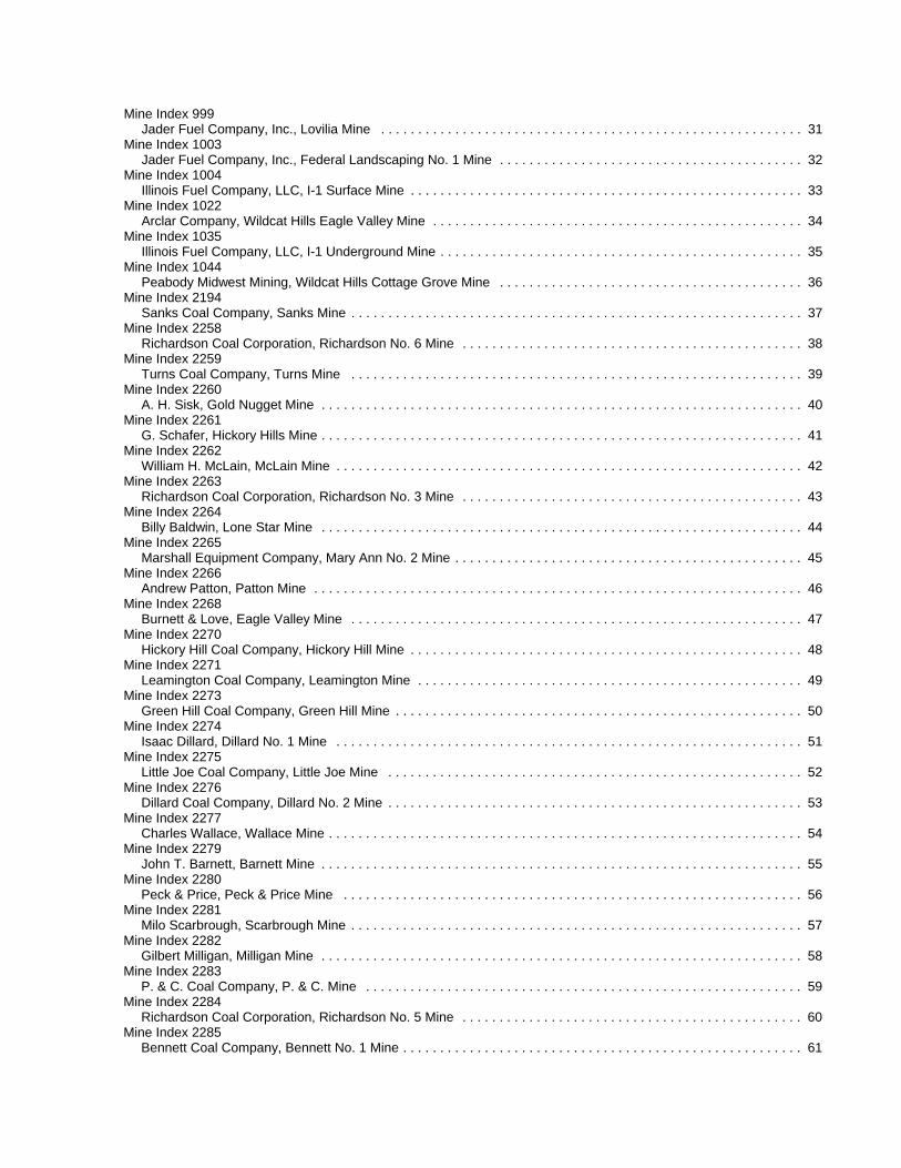
Mine Index 999Jader Fuel Company, Inc., Lovilia Mine . . . . . . . . . . . . . . . . . . . . . . . . . . . . . . . . . . . . . . . . . . . . . . . . . . . . . . . . . 31
Mine Index 1003Jader Fuel Company, Inc., Federal Landscaping No. 1 Mine . . . . . . . . . . . . . . . . . . . . . . . . . . . . . . . . . . . . . . . . . 32
Mine Index 1004Illinois Fuel Company, LLC, I-1 Surface Mine . . . . . . . . . . . . . . . . . . . . . . . . . . . . . . . . . . . . . . . . . . . . . . . . . . . . . 33
Mine Index 1022Arclar Company, Wildcat Hills Eagle Valley Mine . . . . . . . . . . . . . . . . . . . . . . . . . . . . . . . . . . . . . . . . . . . . . . . . . . 34
Mine Index 1035Illinois Fuel Company, LLC, I-1 Underground Mine . . . . . . . . . . . . . . . . . . . . . . . . . . . . . . . . . . . . . . . . . . . . . . . . . 35
Mine Index 1044Peabody Midwest Mining, Wildcat Hills Cottage Grove Mine . . . . . . . . . . . . . . . . . . . . . . . . . . . . . . . . . . . . . . . . . 36
Mine Index 2194Sanks Coal Company, Sanks Mine . . . . . . . . . . . . . . . . . . . . . . . . . . . . . . . . . . . . . . . . . . . . . . . . . . . . . . . . . . . . . 37
Mine Index 2258Richardson Coal Corporation, Richardson No. 6 Mine . . . . . . . . . . . . . . . . . . . . . . . . . . . . . . . . . . . . . . . . . . . . . . 38
Mine Index 2259Turns Coal Company, Turns Mine . . . . . . . . . . . . . . . . . . . . . . . . . . . . . . . . . . . . . . . . . . . . . . . . . . . . . . . . . . . . . 39
Mine Index 2260A. H. Sisk, Gold Nugget Mine . . . . . . . . . . . . . . . . . . . . . . . . . . . . . . . . . . . . . . . . . . . . . . . . . . . . . . . . . . . . . . . . . 40
Mine Index 2261G. Schafer, Hickory Hills Mine . . . . . . . . . . . . . . . . . . . . . . . . . . . . . . . . . . . . . . . . . . . . . . . . . . . . . . . . . . . . . . . . . 41
Mine Index 2262William H. McLain, McLain Mine . . . . . . . . . . . . . . . . . . . . . . . . . . . . . . . . . . . . . . . . . . . . . . . . . . . . . . . . . . . . . . . 42
Mine Index 2263Richardson Coal Corporation, Richardson No. 3 Mine . . . . . . . . . . . . . . . . . . . . . . . . . . . . . . . . . . . . . . . . . . . . . . 43
Mine Index 2264Billy Baldwin, Lone Star Mine . . . . . . . . . . . . . . . . . . . . . . . . . . . . . . . . . . . . . . . . . . . . . . . . . . . . . . . . . . . . . . . . . 44
Mine Index 2265Marshall Equipment Company, Mary Ann No. 2 Mine . . . . . . . . . . . . . . . . . . . . . . . . . . . . . . . . . . . . . . . . . . . . . . . 45
Mine Index 2266Andrew Patton, Patton Mine . . . . . . . . . . . . . . . . . . . . . . . . . . . . . . . . . . . . . . . . . . . . . . . . . . . . . . . . . . . . . . . . . . 46
Mine Index 2268Burnett & Love, Eagle Valley Mine . . . . . . . . . . . . . . . . . . . . . . . . . . . . . . . . . . . . . . . . . . . . . . . . . . . . . . . . . . . . . 47
Mine Index 2270Hickory Hill Coal Company, Hickory Hill Mine . . . . . . . . . . . . . . . . . . . . . . . . . . . . . . . . . . . . . . . . . . . . . . . . . . . . . 48
Mine Index 2271Leamington Coal Company, Leamington Mine . . . . . . . . . . . . . . . . . . . . . . . . . . . . . . . . . . . . . . . . . . . . . . . . . . . . 49
Mine Index 2273Green Hill Coal Company, Green Hill Mine . . . . . . . . . . . . . . . . . . . . . . . . . . . . . . . . . . . . . . . . . . . . . . . . . . . . . . . 50
Mine Index 2274Isaac Dillard, Dillard No. 1 Mine . . . . . . . . . . . . . . . . . . . . . . . . . . . . . . . . . . . . . . . . . . . . . . . . . . . . . . . . . . . . . . . 51
Mine Index 2275Little Joe Coal Company, Little Joe Mine . . . . . . . . . . . . . . . . . . . . . . . . . . . . . . . . . . . . . . . . . . . . . . . . . . . . . . . . 52
Mine Index 2276Dillard Coal Company, Dillard No. 2 Mine . . . . . . . . . . . . . . . . . . . . . . . . . . . . . . . . . . . . . . . . . . . . . . . . . . . . . . . . 53
Mine Index 2277Charles Wallace, Wallace Mine . . . . . . . . . . . . . . . . . . . . . . . . . . . . . . . . . . . . . . . . . . . . . . . . . . . . . . . . . . . . . . . . 54
Mine Index 2279John T. Barnett, Barnett Mine . . . . . . . . . . . . . . . . . . . . . . . . . . . . . . . . . . . . . . . . . . . . . . . . . . . . . . . . . . . . . . . . . 55
Mine Index 2280Peck & Price, Peck & Price Mine . . . . . . . . . . . . . . . . . . . . . . . . . . . . . . . . . . . . . . . . . . . . . . . . . . . . . . . . . . . . . . 56
Mine Index 2281Milo Scarbrough, Scarbrough Mine . . . . . . . . . . . . . . . . . . . . . . . . . . . . . . . . . . . . . . . . . . . . . . . . . . . . . . . . . . . . . 57
Mine Index 2282Gilbert Milligan, Milligan Mine . . . . . . . . . . . . . . . . . . . . . . . . . . . . . . . . . . . . . . . . . . . . . . . . . . . . . . . . . . . . . . . . . 58
Mine Index 2283P. & C. Coal Company, P. & C. Mine . . . . . . . . . . . . . . . . . . . . . . . . . . . . . . . . . . . . . . . . . . . . . . . . . . . . . . . . . . . 59
Mine Index 2284Richardson Coal Corporation, Richardson No. 5 Mine . . . . . . . . . . . . . . . . . . . . . . . . . . . . . . . . . . . . . . . . . . . . . . 60
Mine Index 2285Bennett Coal Company, Bennett No. 1 Mine . . . . . . . . . . . . . . . . . . . . . . . . . . . . . . . . . . . . . . . . . . . . . . . . . . . . . . 61

Mine Index 2287Richardson Coal Corporation, Richardson No. 1 Mine . . . . . . . . . . . . . . . . . . . . . . . . . . . . . . . . . . . . . . . . . . . . . . 62
Mine Index 2288Sam Black, Black Mine . . . . . . . . . . . . . . . . . . . . . . . . . . . . . . . . . . . . . . . . . . . . . . . . . . . . . . . . . . . . . . . . . . . . . . 63
Mine Index 2295Walter Finnie, Finnie Mine . . . . . . . . . . . . . . . . . . . . . . . . . . . . . . . . . . . . . . . . . . . . . . . . . . . . . . . . . . . . . . . . . . . . 64
Mine Index 3335Herod Mining Corporation, Herod No. 1 Mine . . . . . . . . . . . . . . . . . . . . . . . . . . . . . . . . . . . . . . . . . . . . . . . . . . . . . 65
Mine Index 4174Robert Pierson, Pierson Mine . . . . . . . . . . . . . . . . . . . . . . . . . . . . . . . . . . . . . . . . . . . . . . . . . . . . . . . . . . . . . . . . . 66
Mine Index 4175Jo Lor Mining Company, Jo Lor Mine . . . . . . . . . . . . . . . . . . . . . . . . . . . . . . . . . . . . . . . . . . . . . . . . . . . . . . . . . . . 67
Mine Index 4177K. & W. Coal Company, K. & W. No. 2 Mine . . . . . . . . . . . . . . . . . . . . . . . . . . . . . . . . . . . . . . . . . . . . . . . . . . . . . . 68
Mine Index 4574Hines Brothers Mining Company, Hines Brothers Mine . . . . . . . . . . . . . . . . . . . . . . . . . . . . . . . . . . . . . . . . . . . . . 69
Mine Index 4576Charles O. Purcell, Purcell Mine . . . . . . . . . . . . . . . . . . . . . . . . . . . . . . . . . . . . . . . . . . . . . . . . . . . . . . . . . . . . . . . 70
Mine Index 4580Beecher-Williams Coal Company, Beecher-Williams No. 4 Mine . . . . . . . . . . . . . . . . . . . . . . . . . . . . . . . . . . . . . . 71
Mine Index 4594Andy Boster, Boster Mine . . . . . . . . . . . . . . . . . . . . . . . . . . . . . . . . . . . . . . . . . . . . . . . . . . . . . . . . . . . . . . . . . . . . 72
Mine Index 4690Saline Gas Coal Company, Saline Gas Mine . . . . . . . . . . . . . . . . . . . . . . . . . . . . . . . . . . . . . . . . . . . . . . . . . . . . . 73
Mine Index 4765Black, Clifton & Moore, Black, Clifton & Moore Mine . . . . . . . . . . . . . . . . . . . . . . . . . . . . . . . . . . . . . . . . . . . . . . . . 74
Mine Index 4955Jesse Purcell, Purcell Mine . . . . . . . . . . . . . . . . . . . . . . . . . . . . . . . . . . . . . . . . . . . . . . . . . . . . . . . . . . . . . . . . . . . 75
Mine Index 6846Ginniville Mining Company, Ginniville Mine . . . . . . . . . . . . . . . . . . . . . . . . . . . . . . . . . . . . . . . . . . . . . . . . . . . . . . . 76
Mine Index 7041Frank Green, Green Mine . . . . . . . . . . . . . . . . . . . . . . . . . . . . . . . . . . . . . . . . . . . . . . . . . . . . . . . . . . . . . . . . . . . . 77
Mine Index 7042W. L. Wright, Wright Mine . . . . . . . . . . . . . . . . . . . . . . . . . . . . . . . . . . . . . . . . . . . . . . . . . . . . . . . . . . . . . . . . . . . . 78
OTHER MINES SHOWN ON EQUALITY QUADRANGLE . . . . . . . . . . . . . . . . . . . . . . . . . . . . . . . . . . . . . . . . . . . . . . . . 79Mine Index 2048 . . . . . . . . . . . . . . . . . . . . . . . . . . . . . . . . . . . . . . . . . . . . . . . . . . . . . . . . . . . . . . . . . . . . . . . . . . . . . 79Mine Index 2880, Wenzel Coal Company . . . . . . . . . . . . . . . . . . . . . . . . . . . . . . . . . . . . . . . . . . . . . . . . . . . . . . . . . . 79Mine Index 2902 . . . . . . . . . . . . . . . . . . . . . . . . . . . . . . . . . . . . . . . . . . . . . . . . . . . . . . . . . . . . . . . . . . . . . . . . . . . . . 79Mine Index 4508, Old Holly Mine . . . . . . . . . . . . . . . . . . . . . . . . . . . . . . . . . . . . . . . . . . . . . . . . . . . . . . . . . . . . . . . . . 79Mine Index 4510 . . . . . . . . . . . . . . . . . . . . . . . . . . . . . . . . . . . . . . . . . . . . . . . . . . . . . . . . . . . . . . . . . . . . . . . . . . . . . 79Mine Index 4525 . . . . . . . . . . . . . . . . . . . . . . . . . . . . . . . . . . . . . . . . . . . . . . . . . . . . . . . . . . . . . . . . . . . . . . . . . . . . . 79Mine Index 4530 . . . . . . . . . . . . . . . . . . . . . . . . . . . . . . . . . . . . . . . . . . . . . . . . . . . . . . . . . . . . . . . . . . . . . . . . . . . . . 79Mine Index 4534 . . . . . . . . . . . . . . . . . . . . . . . . . . . . . . . . . . . . . . . . . . . . . . . . . . . . . . . . . . . . . . . . . . . . . . . . . . . . . 79Mine Index 4571 . . . . . . . . . . . . . . . . . . . . . . . . . . . . . . . . . . . . . . . . . . . . . . . . . . . . . . . . . . . . . . . . . . . . . . . . . . . . . 79Mine Index 4573 . . . . . . . . . . . . . . . . . . . . . . . . . . . . . . . . . . . . . . . . . . . . . . . . . . . . . . . . . . . . . . . . . . . . . . . . . . . . . 79Mine Index 4579 . . . . . . . . . . . . . . . . . . . . . . . . . . . . . . . . . . . . . . . . . . . . . . . . . . . . . . . . . . . . . . . . . . . . . . . . . . . . . 79Mine Index 4584 . . . . . . . . . . . . . . . . . . . . . . . . . . . . . . . . . . . . . . . . . . . . . . . . . . . . . . . . . . . . . . . . . . . . . . . . . . . . . 79Mine Index 4586 . . . . . . . . . . . . . . . . . . . . . . . . . . . . . . . . . . . . . . . . . . . . . . . . . . . . . . . . . . . . . . . . . . . . . . . . . . . . . 79Mine Index 4587 . . . . . . . . . . . . . . . . . . . . . . . . . . . . . . . . . . . . . . . . . . . . . . . . . . . . . . . . . . . . . . . . . . . . . . . . . . . . . 79Mine Index 4588 . . . . . . . . . . . . . . . . . . . . . . . . . . . . . . . . . . . . . . . . . . . . . . . . . . . . . . . . . . . . . . . . . . . . . . . . . . . . . 79Mine Index 4592 . . . . . . . . . . . . . . . . . . . . . . . . . . . . . . . . . . . . . . . . . . . . . . . . . . . . . . . . . . . . . . . . . . . . . . . . . . . . . 79Mine Index 4691 . . . . . . . . . . . . . . . . . . . . . . . . . . . . . . . . . . . . . . . . . . . . . . . . . . . . . . . . . . . . . . . . . . . . . . . . . . . . . 79Mine Index 4692 . . . . . . . . . . . . . . . . . . . . . . . . . . . . . . . . . . . . . . . . . . . . . . . . . . . . . . . . . . . . . . . . . . . . . . . . . . . . . 79Mine Index 4693 . . . . . . . . . . . . . . . . . . . . . . . . . . . . . . . . . . . . . . . . . . . . . . . . . . . . . . . . . . . . . . . . . . . . . . . . . . . . . 79Mine Index 4694 . . . . . . . . . . . . . . . . . . . . . . . . . . . . . . . . . . . . . . . . . . . . . . . . . . . . . . . . . . . . . . . . . . . . . . . . . . . . . 79Mine Index 4695 . . . . . . . . . . . . . . . . . . . . . . . . . . . . . . . . . . . . . . . . . . . . . . . . . . . . . . . . . . . . . . . . . . . . . . . . . . . . . 79Mine Index 4696 . . . . . . . . . . . . . . . . . . . . . . . . . . . . . . . . . . . . . . . . . . . . . . . . . . . . . . . . . . . . . . . . . . . . . . . . . . . . . 79Mine Index 4698 . . . . . . . . . . . . . . . . . . . . . . . . . . . . . . . . . . . . . . . . . . . . . . . . . . . . . . . . . . . . . . . . . . . . . . . . . . . . . 79Mine Index 4733 . . . . . . . . . . . . . . . . . . . . . . . . . . . . . . . . . . . . . . . . . . . . . . . . . . . . . . . . . . . . . . . . . . . . . . . . . . . . . 79Mine Index 4760 . . . . . . . . . . . . . . . . . . . . . . . . . . . . . . . . . . . . . . . . . . . . . . . . . . . . . . . . . . . . . . . . . . . . . . . . . . . . . 79Mine Index 5080 . . . . . . . . . . . . . . . . . . . . . . . . . . . . . . . . . . . . . . . . . . . . . . . . . . . . . . . . . . . . . . . . . . . . . . . . . . . . . 79

Mine Index 5398 . . . . . . . . . . . . . . . . . . . . . . . . . . . . . . . . . . . . . . . . . . . . . . . . . . . . . . . . . . . . . . . . . . . . . . . . . . . . . 79Mine Index 5498 . . . . . . . . . . . . . . . . . . . . . . . . . . . . . . . . . . . . . . . . . . . . . . . . . . . . . . . . . . . . . . . . . . . . . . . . . . . . . 79Mine Index 5501 . . . . . . . . . . . . . . . . . . . . . . . . . . . . . . . . . . . . . . . . . . . . . . . . . . . . . . . . . . . . . . . . . . . . . . . . . . . . . 79Mine Index 5532 . . . . . . . . . . . . . . . . . . . . . . . . . . . . . . . . . . . . . . . . . . . . . . . . . . . . . . . . . . . . . . . . . . . . . . . . . . . . . 79Mine Index 5535 . . . . . . . . . . . . . . . . . . . . . . . . . . . . . . . . . . . . . . . . . . . . . . . . . . . . . . . . . . . . . . . . . . . . . . . . . . . . . 79Mine Index 5954 . . . . . . . . . . . . . . . . . . . . . . . . . . . . . . . . . . . . . . . . . . . . . . . . . . . . . . . . . . . . . . . . . . . . . . . . . . . . . 79Mine Index 6672 . . . . . . . . . . . . . . . . . . . . . . . . . . . . . . . . . . . . . . . . . . . . . . . . . . . . . . . . . . . . . . . . . . . . . . . . . . . . . 79Mine Index 6833 . . . . . . . . . . . . . . . . . . . . . . . . . . . . . . . . . . . . . . . . . . . . . . . . . . . . . . . . . . . . . . . . . . . . . . . . . . . . . 79Mine Index 7036 . . . . . . . . . . . . . . . . . . . . . . . . . . . . . . . . . . . . . . . . . . . . . . . . . . . . . . . . . . . . . . . . . . . . . . . . . . . . . 79Mine Index 7037 . . . . . . . . . . . . . . . . . . . . . . . . . . . . . . . . . . . . . . . . . . . . . . . . . . . . . . . . . . . . . . . . . . . . . . . . . . . . . 79Mine Index 7038 . . . . . . . . . . . . . . . . . . . . . . . . . . . . . . . . . . . . . . . . . . . . . . . . . . . . . . . . . . . . . . . . . . . . . . . . . . . . . 79
MINES WHOSE LOCATIONS ARE NOT KNOWN, EQUALITY QUADRANGLE . . . . . . . . . . . . . . . . . . . . . . . . . . . . . . . 80
INDEX OF MINES IN THE EQUALITY QUADRANGLE . . . . . . . . . . . . . . . . . . . . . . . . . . . . . . . . . . . . . . . . . . . . . . . . . . 84

INTRODUCTIONCoal has been mined in 76 counties of Illinois. More than 7,400 coal mines have operated sincecommercial mining began in Illinois about 1810; fewer than 30 are currently active. To detail the extentand location of coal mining in Illinois, the Illinois State Geological Survey (ISGS) has compiled maps anddirectories of known coal mines. The ISGS offers maps at a scale of 1:100,000 and accompanyingdirectories for each county in which coal mining is known to have occurred. Maps at a scale of 1:24,000and accompanying directories such as this are available for selected quadrangles. Contact the ISGS for alist of these quadrangles.
These larger scale maps show the approximate positions of mines in relation to surface features such asroads and water bodies, and indicate the mining method used and the accuracy of the mine boundaries. The maps are useful for locating mine boundaries relative to specific properties and for assessing thepotential for subsidence in an area. Mine boundaries compiled from final mine surveys are generallyshown within 200 feet of their true position. As a result of poor cartographic quality and inaccuracies in theoriginal mine surveys, boundaries of some older mines may be mislocated on the map by 500 feet ormore. Original mine maps should be consulted in situations that require precise delineation of mineboundaries or internal workings of mined areas.
The directory serves as a key to the accompanying mine map and provides basic information on the coalmines. The directory is composed of two parts. Part I explains the symbols and patterns used on theaccompanying map and the summary data presented for each mine. Part II numerically lists the mines inthe quadrangle and summarizes the geology and production history of each mine.
MINING IN THE EQUALITY QUADRANGLE
Mining in this area generally took place after 1890, with small underground mines in the Springfield Coal. A few underground mines operated in the Herrin and Davis Coals, but these coals are thinner, ranging upto just over 4 feet thick. Surface mining began in 1945. Thinner coals, such as the Dekoven (about 3 feetthick) and the Briar Hill (generally around 2.5 feet thick) Coals were taken as the large mines targeted theHerrin, Springfield and Davis Coals.
The West Side Mine of Gallatin Coal & Coke Company (mine index 47) flooded on April 6, 1913. Thisevent received a substantial write-up in the 1913 Coal Report, which indicated that the citizens of Equalityhelped unstintingly in trying to construct levees around the mine shaft so that the mine would not beinundated by the record-breaking floods of that year. Heavy timber retaining walls and trenches to routewater away from the mine were constructed in late March, but by April 1, the mine was surrounded bywater and materials had to be brought in by boat. The currents under the water eroded the soil under thelevees and the water broke into the shaft, rushing with such power as to wash pit cars and othermachinery into the rapidly filling shaft. Since the extremities of the mine away from the shaft were at lowerelevations, large bubbles of compressed air remained after the shaft was filled with water. Watercontinued to run in for five hours after the shaft was filled, further compressing the air in the mine, so thatwhen the air rebounded that afternoon, the force of the “explosion” threw pit cars, engines, cages andconcrete blocks to an estimated height of 500 feet, utterly destroying the top works of the mine. A secondoutburst of air occurred less than half an hour later, throwing water a height of approximately 150 feet. Each subsequent outburst was less extreme than the previous one, until all the air was out of the mine. Construction of a new shaft was begun in November 1913, but production was delayed until late 1915.
Portions of this quadrangle are within the Eagle Valley Syncline. The geology of the area is very complex,with many fault zones, including the Shawneetown Fault Zone, Cottage Grove Fault System, andGrindstaff Fault Zone. These structures are beyond the scope of this introduction, but more informationcan be found in the Geologic map of Equality Quadrangle, Gallatin and Saline Counties, Illinois (ISGSIGQ002) and Structural Geology of Southeastern Illinois and Vicinity (ISGS Circular 538).
1

2
PART I EXPLANATION OF MAP AND MINE SUMMARY SHEET
INTERPRETING THE MAP
The map accompanying this directory shows the location of coal mines known to be present in the quadrangle. Themap, corresponding to a U.S. Geological Survey (USGS) 7.5-minute quadrangle, covers an area bounded by lines oflatitude and longitude 7.5-minutes apart. In Illinois, a quadrangle is approximately 6.5 miles east to west and 8.5miles north to south, an area of about 56 square miles. The ISGS generally offers one map of mines per quadrangle. In some areas where extensive mining occurred in two or more overlapping seams, separate maps are compiled formines in each seam to maintain readability of the map.
Mine Type and Mining MethodThe mine type is indicated on the map by pattern color: green represents surface mines; red and yellow representunderground mines. The red patterns are used for areas of underground mining that are documented by a primary orsecondary source map. A yellow pattern is used for cases where no map of the mine workings is available, but ageneral area of mining can be inferred from property maps or production figures. The patterns indicate the mainmining methods used in underground mines. The methods are (1) room and pillar and (2) high extraction. Themethod used gives some indication of the amount and pattern of coal extraction within each mined area, and hassome influence on the timing and type of subsidence that can occur over a mine.
The following discussion and illustrations of mining methods are based on Guither et al. (1984).
In room-and-pillar mines, coal is removed from haulage-ways (entries) and selected areas called rooms. Pillars ofunmined coal are left between the rooms to support the roof. Depending on the size of rooms and pillars, the amountof coal removed from the production areas will range from 40% to 70%.
Room and Pillar - mining is divided into six categories:• room-and-pillar basic (RPB, fig. 1A), an early method that did not follow a preset mining plan and therefore
resulted in very irregular designs;• modified room and pillar (MRP, fig. 1B);• room-and-pillar panel (RPP, fig. 1C);• blind room and pillar (BRP, fig. 1D);• checkerboard room and pillar (CRP, fig. 1E);• room and pillar (RP), a classification used when the specific type of room-and-pillar mining is unknown.
Blind and checkerboard are the most common types of room-and-pillar mining used in Illinois today. The knowledgeof room-and-pillar mining methods gives a trained engineer information on the nature of subsidence that may occur. A more extensive discussion of subsidence can be found in Bauer et al. (1993).
High-extraction These mining methods are subdivided into high-extraction retreat (HER, Fig 1F) and longwall (LW,Fig 1G, 1H). In these methods, much of the coal is removed within well defined areas of the mine. Subsidence of thesurface above these areas occurs within weeks. Once the subsidence activity ceases, the potential for furthermovement over these areas is low; however, subsidence may continue for several years after mining.
High-extraction retreat mining is a form of room-and-pillar mining that extracts most of the coal. Rooms and pillarsare developed in the panels, and the pillars are then systematically removed (fig. 1F).
In early (pre-1960) longwall mines, mining advanced in multiple directions from a central shaft (fig. 1G). Large pillars of coal were left around the shaft, but all coal was removed beyond these pillars. Minersplaced rock and wooden props and cribs in the mined-out areas to support the mine roof. The overlying rockgradually settled onto these supports, thus producing subsidence at the surface. In post-1959 longwall mines, room-and-pillar methods have been used to develop the main entries of the mine and panel areas. Modern longwallmethods extract 100 percent of the coal in the panel areas (fig. 1H).

3
SOURCE MAPS
Mine outlines depicted on the map are, whenever possible, based on maps made from original mine surveys. Theprocess of compiling and digitizing the quadrangle map may produce errors of less than 200 feet in the location ofmine boundaries. Larger errors of 500 feet or more are possible for mines that have incomplete or inaccurate sourcemaps.
Because of the extreme complexity of some mine maps, detailed features of mined areas have been omitted. Thedigitized mine boundary includes the exterior boundary of all rooms or entries that were at least 80 feet wide orprotruded 500 feet from the main mining area. Unmined areas between mines are shown if they are at least 80 feetwide; unmined blocks of coal within mines are shown if they are at least 400 feet on each side. Original source mapsshould be consulted when precise information on mine boundaries or interior features is needed.
The mine summary sheet lists the source maps used to determine each mine outline. The completeness of mapsources is indicated on the map by a line symbol at the mine boundary. Source maps are organized in fivecategories.
Final mine map The mine outline was digitized from an original map made from mine surveys conducted within afew months after production ceased. The date of the map and the last reported production are listed on the summarysheet.
Not a final map The mine is currently active or the mine outline was made from a map based on mine surveysconducted more than few months before production ceased. This implies the actual mined-out area is probably largerthan the outline on the map. The mine summary sheet indicated the dates of source maps and the last reportedproduction, as well as the approximate tonnage mined between these two dates (if the mine is abandoned). Thesummary sheet also lists the approximate acreage mined since the date of the map and, in some cases, indicates thearea where additional mining may have taken place. This latter information is determined by locating on the map theactive faces relative to probable boundaries of the mine property.
Undated map The source map was undated, so it may or may not be based on a final mine survey. Whensufficient data are available, the probable acreage of the mined area is estimated from reported production, averageseam thickness and a recovery rate comparable to other mines in the area. This information is listed in the summarysheet for the mine.
Incomplete map The source map did not show the entire mine. The summary sheet indicates the missing part ofthe mine map and the acreage of the unmapped area, which is estimated from the amount of coal known to havebeen produced from the mine.
Secondary source map The original mine map was not found so the outline shown was determined fromsecondary sources (e.g., outlines from small-scale regional maps published in other reports). The summary sheetdescribes the secondary sources.
POINTS AND LABELS
The locations of all known mine openings (shafts, slopes, and drifts) and surface mine tipples are plotted on the map. Tipples are areas where coal was cleaned, stockpiled, and loaded for shipping.
Only openings or tipples are plotted for mines without source maps. If the precise locations of these features areunknown, a special symbol is used to indicate the approximate location of the mine.
Each mine on the map is labeled with the names of the mine and operating company, ISGS mine index number, andyears of operation (if known) if space permits. A seam designation is given on maps where more than one seam wasmined. For a mine that operated under more than one name, only the most recent name is generally given. When amine changed names or ownership shortly before closing, an earlier name is listed. All company and mine names arelisted on the mine summary sheet in the directory, under the production history segment.


6
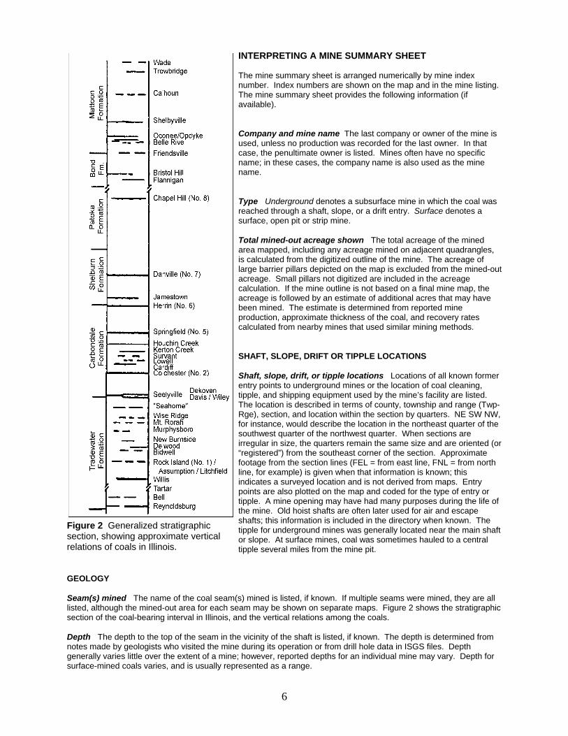
Figure 2 Generalized stratigraphicsection, showing approximate verticalrelations of coals in Illinois.
INTERPRETING A MINE SUMMARY SHEET
The mine summary sheet is arranged numerically by mine indexnumber. Index numbers are shown on the map and in the mine listing. The mine summary sheet provides the following information (ifavailable).
Company and mine name The last company or owner of the mine isused, unless no production was recorded for the last owner. In thatcase, the penultimate owner is listed. Mines often have no specificname; in these cases, the company name is also used as the minename.
Type Underground denotes a subsurface mine in which the coal wasreached through a shaft, slope, or a drift entry. Surface denotes asurface, open pit or strip mine.
Total mined-out acreage shown The total acreage of the minedarea mapped, including any acreage mined on adjacent quadrangles, is calculated from the digitized outline of the mine. The acreage oflarge barrier pillars depicted on the map is excluded from the mined-outacreage. Small pillars not digitized are included in the acreagecalculation. If the mine outline is not based on a final mine map, theacreage is followed by an estimate of additional acres that may havebeen mined. The estimate is determined from reported mineproduction, approximate thickness of the coal, and recovery ratescalculated from nearby mines that used similar mining methods.
SHAFT, SLOPE, DRIFT OR TIPPLE LOCATIONS
Shaft, slope, drift, or tipple locations Locations of all known formerentry points to underground mines or the location of coal cleaning,tipple, and shipping equipment used by the mine’s facility are listed. The location is described in terms of county, township and range (Twp-Rge), section, and location within the section by quarters. NE SW NW,for instance, would describe the location in the northeast quarter of thesouthwest quarter of the northwest quarter. When sections areirregular in size, the quarters remain the same size and are oriented (or“registered”) from the southeast corner of the section. Approximatefootage from the section lines (FEL = from east line, FNL = from northline, for example) is given when that information is known; thisindicates a surveyed location and is not derived from maps. Entrypoints are also plotted on the map and coded for the type of entry ortipple. A mine opening may have had many purposes during the life ofthe mine. Old hoist shafts are often later used for air and escapeshafts; this information is included in the directory when known. Thetipple for underground mines was generally located near the main shaftor slope. At surface mines, coal was sometimes hauled to a centraltipple several miles from the mine pit.
GEOLOGY
Seam(s) mined The name of the coal seam(s) mined is listed, if known. If multiple seams were mined, they are alllisted, although the mined-out area for each seam may be shown on separate maps. Figure 2 shows the stratigraphicsection of the coal-bearing interval in Illinois, and the vertical relations among the coals.
Depth The depth to the top of the seam in the vicinity of the shaft is listed, if known. The depth is determined fromnotes made by geologists who visited the mine during its operation or from drill hole data in ISGS files. Depthgenerally varies little over the extent of a mine; however, reported depths for an individual mine may vary. Depth forsurface-mined coals varies, and is usually represented as a range.

7
Thickness The approximate thickness of the mined seam is shown, if known. Thickness also comes from notes ofgeologists who visited the mine during its operation or from borehole data in ISGS files. Minimum, maximum, andaverage thicknesses are given when this information is available.
Mining method The principal mining method used at the mine (figs. 1A-H) is listed. See the mining methodssection at the beginning of this directory for a discussion of this parameter.
Geologic problems reported Any known geologic problems, such as faults, water seepage, floor heaving, andunstable roof, encountered in the mine are reported. This information is from notes made by ISGS geologists whovisited the mine, or from reports by mine inspectors published by the Illinois Department of Mines and Minerals, orfrom the source map(s). Geologic problems are not reported for active mines.
PRODUCTION HISTORY
Production history Tons of coal produced from the mine by each mine owner are totaled. When the source mapused for the mine outline is not a final mine map, the tonnage produced since the date of the map is identified. Formines that extend into adjacent quadrangles, the tonnage reported includes areas mined in adjacent quadrangles.
SOURCE OF DATA
Source map This section lists information about the map(s) used to compile the mine outline and the locations oftipples and mine openings. In some cases more than one source map was used. For example, a map drawn beforethe mine closed may provide better information on original areas of the mine than a later map. When more than onemap was used, the bibliography section explains what information was taken from each source.
Date The date of the most recent mine survey listed on the source map is reported.
Original scale The original scale of the source map is listed. Many maps are photo-reductions and are no longer attheir original scale. The original scale gives some indication of the level of detail of the mine outline and the accuracyof the mine boundary relative to surface features. Generally, the larger the scale, the greater the accuracy and detailof the mine map. Mine outlines taken from source maps at scales smaller than 1:24,000 may be highly generalizedand may well be inaccurately located with respect to surface features.
Digitized scale The scale of the digitized map is reported. The scale may be different from that of the originalsource map. In many cases the digitized map was made from a photo-reduction of the original source map, or thesource map was not in a condition suitable for digitizing and the mine boundaries were transferred to another basemap.
Map type Source maps are classified into five categories to indicate the probable completeness of the map. Seediscussion of source maps in the previous section.
Annotated bibliography Sources that provide information about the mine are listed, with the data taken from eachsource. Some commonly used sources are described below. Full bibliographic references are given for all othersources. Unless otherwise noted, all sources are available for public inspection at the ISGS.
Coal Reports Published since 1881, these reports contain tabular data on mine ownership, production, employment,and accidents. Some volumes include short descriptions made by mine inspectors of physical features andconditions in selected mines.
Directory of Illinois Coal Mines This source is a compilation of basic data about Illinois coal mines, originallygathered by ISGS staff in the early 1950s. Sources used for this directory are undocumented, but they are primarilyIllinois Department of Mines and Minerals annual reports, ISGS mine notes, and coal company officials.
ENR Document 85/01, Guither, H. D., J. K. Hines, and R. A. Bauer, 1985 The Economic Effect of UndergroundMining Upon Land Used for Illinois Agriculture: Illinois Department of Energy and Natural Resources Document 85/01,185 p.
Microfilm map The U.S. Bureau of Mines maintains a microfilm archive of mine maps. A microfilm file for Illinois isavailable for public viewing at the ISGS.

Mine notes ISGS geologists have visited mines or contacted mine officials throughout the state since the early1900s. Notes made during these visits range from brief descriptions of the mine location to long narratives (includingsketches) of mining conditions and geology.
Federal Land Bank of St. Louis, Preliminary Reports on Subsidence Investigations Mining engineers working for theFederal Land Bank of St. Louis mapped areas of subsidence due to coal mining in the early 1930s. These reportsoften include county maps of mine properties with mined-out areas including shaft locations, as well as subsidenceareas.
REFERENCESBauer, R. A., B. A. Trent, and P. B. Dumontelle, 1993, Mine Subsidence in Illinois: Facts for the Homeowner
Considering Insurance, Illinois State Geological Survey, Environmental Geology Note 144, 16p.
Butts, C., 1925, Geology & Mineral Resources of the Equality-Shawneetown Area, Illinois State Geological SurveyBulletin 47, 76p.
DeWolf, F. W., 1908, Coal Investigations in the Saline-Gallatin field, Illinois and the adjoining area, in Yearbook for1907, Illinois State Geological Survey Bulletin 8, 374p.
Gallatiin County Historical Society, 1988, History & Families of Gallatin County, Illinois, Volume I, Turner PublishingCompany, Paducah, Kentucky, 440 pages.
Guither, H. D., J. K. Hines, and R. A. Bauer, 1985, The Economic Effects of Underground Mining Upon Land Used forIllinois Agriculture, Illinois Department of Energy and Natural Resources Document 85/01, 185p.
Nelson, W. J. and D. K. Lumm, Geology of Shawneetown Fault and Vicinity – Study performed for the U. S. NuclearRegulatory Commission, Field Notes, Books 1 & 2, #918.
Nelson, W. J. and D. K. Lumm, 1986, Geologic map of the Equality Quadrangle, Gallatin and Saline Counties, Illinois,Illinois State Geological Survey IGQ002.
Nelson, W. J. and D. K. Lumm, 1987, Structural Geology of Southeastern Illinois and Vicinity, Illinois State GeologicalSurvey Circular 538, 70p.
8

PART II DIRECTORY OF MINES IN THE EQUALITY QUADRANGLE
MINE SUMMARY SHEETSA summary sheet on the geology and production history of each mine in the Equality Quadrangle isprovided. These summary sheets are arranged numerically by mine index number. Consult Part I for acomplete explanation of the data listed in the summary sheet.
Mine Index 47Illinois Saline Coal Company, Illinois Saline Mine
Type: Underground Total mined-out acreage shown: 290 Production indicates less than 1 acre wasmined after the map date.
SHAFT, SLOPE, DRIFT or TIPPLE LOCATIONS
Type County Township-Range Section Quarters-FootageMain shaft Gallatin 9S 8E 18 NE SE SEAir shaft Gallatin 9S 8E 18 SE NE SEOld shaft (pre-flood) Gallatin 9S 8E 20 NW NW NWOld air shaft Gallatin 9S 8E 19 NE NE NE
GEOLOGY Thickness (ft) Mining
Seam(s) Mined Depth (ft) Min Max Ave MethodSpringfield 80(old), 90-98(new) 4.67 MRP
Geologic Problems Reported: The source map showed an east-west trending fault, part of the Cottage Grove FaultSystem, in the northern part of the mine, where the coal was down-thrown about 5 feet on the northern side. Thecoal dipped in all directions from the shaft, with the northeastern workings 48 feet deeper than the bottom of the oldshaft. The irregular roof contained coal balls, and draw slate came down with the coal. The coal displayedoccasional slip planes with calcite along them. The floor was a fine clay which tended to heave when wet.
PRODUCTION HISTORY Production
Company Mine Name Years (tons) Equality Coal Company Equality 1882-1883 not reportedCassells, Temple & Company Equality 1883-1887 * 30,000Equality Coal Company Equality 1887-1900 370,340Hugh Murray Equality 1900-1902 37,140Gallatin Coal & Coke Company Equality 1902-1916 * 553,146Northern Coal Company Northern No. 4 1916-1917 53,316Gallatin Coal & Coke Company West Side 1917-1925 * 448,045Equality Coal Company West Side 1926-1926 9,663Saline Gas Coal Company Saline Gas No. 4 1927-1929 44,782Illinois Saline Coal Company Illinois Saline 1930-1930 2,350 **
1,548,782* Idle 1885-1887; idle 1914 & 1915 because of flooding and subsequent damage to the mine. A new shaft wasconstructed; idle 1922, 1924 & 1925** Production after map dateLast reported production: December 1930
SOURCES OF DATAOriginal Digitized
Source Map Date Scale Scale Map Type Microfilm, document 351531 1929 1:2400 1:8228 Not finalMicrofilm, document 351530 6-17-1921 1:2400 1:8228 Not final
Annotated Bibliography (data source, brief description of information)
Coal Reports - Production, ownership, years of operation, mining method, geologic problems.Mine notes (Gallatin County) - Mine type, shaft locations, seam, depth, thickness, geologic problems.Microfilm map, document 351531, reel 03136, frames 292 & 293 - Shaft locations, mine outline, mining method geologic problems.Microfilm map, document 351530, reel 03136, frames 290 & 291 - Mine outline (old works).
9

Mine Index 131Tom Osborn, Osborn No. 2 Mine
Type: Underground Total mined-out acreage shown: 1
SHAFT, SLOPE, DRIFT or TIPPLE LOCATIONS
Type County Township-Range Section Quarters-FootageMain drift Saline 10S 7E 13 SE NE SE
GEOLOGY Thickness (ft) Mining
Seam(s) Mined Depth (ft) Min Max Ave MethodSpringfield 4.67 RP
Geologic Problems Reported:
PRODUCTION HISTORY Production
Company Mine Name Years (tons) Tom Osborn Osborn No. 2 1938-1938 160William Angelly Osborn No. 2 1939-1940 832Tom Osborn Osborn No. 2 1940-1952 * 2,276
3,268
* Idle 1944-1946, 1948 & 1949
Last reported production: February 1952
SOURCES OF DATAOriginal Digitized
Source Map Date Scale Scale Map Type Microfilm, document 352809 12-27-1955 1:1200 1:1324 Secondary source
Annotated Bibliography (data source, brief description of information)
Coal Reports - Production, ownership, years of operation, mining method.Directory of Illinois Coal Mines (Saline County) - Mine names, mine index, ownership, years of operation.Mine notes (Saline County) - Mine type, drift location, seam, thickness.Microfilm map, document 352809, reel 03140, frame 361, map of Tarleton Mine (mine index 132) - Drift location, mine outline, mining method.
10

Mine Index 132Al Tarlton, Tarlton No. 1 Mine
Type: Underground Total mined-out acreage shown: Less than 1
SHAFT, SLOPE, DRIFT or TIPPLE LOCATIONS
Type County Township-Range Section Quarters-FootageMain drift Saline 10S 7E 13 NE SE SEDrift * Saline 10S 7E 13 NE SE SE
* This is labeled “old opening” on the source map, along with the fact that it had caved (suffered roof failure).
GEOLOGY Thickness (ft) Mining
Seam(s) Mined Depth (ft) Min Max Ave MethodSpringfield 45 4.67 RPB
Geologic Problems Reported:
PRODUCTION HISTORY Production
Company Mine Name Years (tons) A. L. Tarlton Tarlton 1925-1935 1,380Al Tarlton ** Tarlton No. 1 1938-1939 *** 360
1,740
** Microfilm document 352809, dated 1956, shows this mine with a later owner, Greely Coal Company. No productionwas reported under this name.*** Idle 1936, 1937
Last reported production: 1939
SOURCES OF DATAOriginal Digitized
Source Map Date Scale Scale Map Type Microfilm, document 352810 12-27-1955 1:1200 1:1324 Final
Annotated Bibliography (data source, brief description of information)
Coal Reports - Production, ownership, years of operation.Directory of Illinois Coal Mines (Saline County) - Mine names, mine index, ownership, years of operation.Mine notes (Saline County) - Mine type, drift location, seam, depth, thickness.Microfilm map, document 352810, reel 03140, frame 362 - Drift locations, mine outline, mining method.
11

Mine Index 135Saline River Coal Company, Saline River Mine
Type: Underground Total mined-out acreage shown: 180
SHAFT, SLOPE, DRIFT or TIPPLE LOCATIONS
Type County Township-Range Section Quarters-FootageMain slope * Gallatin 9S 8E 23 SW NE NWAir shaft Gallatin 9S 8E 23 SE NE NWAir shaft Gallatin 9S 8E 14 SE SW SW
* An additional slope was noted on the source map, an escape slope that was originally the main slope for SanksMine (mine index 2194).
GEOLOGY Thickness (ft) Mining
Seam(s) Mined Depth (ft) Min Max Ave MethodSpringfield 40 4.17 4.83 4.67 MRP
Geologic Problems Reported: The source map indicated water was a problem in the westernmost part of the mine. The roof was mainly black slate with very little draw slate, but in some areas it was grey shale, which came down withthe coal. The black slate also contained many coal balls. There were some small slips in the roof that required sometimbering. Pyrite stringers and lenses were found throughout the coal.
PRODUCTION HISTORY Production
Company Mine Name Years (tons) J. E. Dempsey Dempsey 1905-1908 ** 24,439Hickory Hill Coal Company Hickory Hill No. 1 1908-1924 *** 636,447Saline Creek Coal Company Saline Creek 1924-1925 54,611Saline River Coal Company Saline River 1926-1927 24,409
739,906
** Property title records indicate Dempsey Coal Company was operating as early as January 1893 at this location. Noproduction or years of operation were listed in the Coal Reports under this name. *** Idle 1924
Last reported production: March 1927
SOURCES OF DATAOriginal Digitized
Source Map Date Scale Scale Map Type Company, 4103.G3 i5.1-7 4-1-1927 1:2400 1:2400 Final
Annotated Bibliography (data source, brief description of information)
Coal Reports - Production, ownership, years of operation, mining method.Directory of Illinois Coal Mines (Gallatin County) - Mine names, mine index, ownership, years of operation.ENR Document 85/01 - Mining method.Mine notes (Gallatin County) - Mine type, slope location, seam, depth, thickness, geologic problems.Company map, ISGS map library, 4103.G3 i5.1-7 - Slope & shaft locations, mine outline, mining method, geologic problems.
12

Mine Index 223Sam Black, Bentley Mine
Type: Underground Total mined-out acreage shown: Less than 1 This mine is not shown on theaccompanying map because of later surface mining by the Eagle Surface Mine (mine index 883).
SHAFT, SLOPE, DRIFT or TIPPLE LOCATIONS
Type County Township-Range Section Quarters-FootageMain slope Gallatin 10S 8E 13 SE SW SE
GEOLOGY Thickness (ft) Mining
Seam(s) Mined Depth (ft) Min Max Ave MethodHerrin 50 3.75-4.0 RP
Geologic Problems Reported:
PRODUCTION HISTORY Production
Company Mine Name Years (tons) Sam Black Bentley 1909-1910 520
520
Last reported production: 1910
SOURCES OF DATAOriginal Digitized
Source Map Date Scale Scale Map Type ISGS map library, 4107 d5.1-209 1927 1:62500 1:62500 Secondary sourceISGS map library, 6-205 5-1-1977 1:1200 1:1200 Secondary source
Annotated Bibliography (data source, brief description of information)
Coal Reports - Production, ownership, years of operation, depth, mining method.Directory of Illinois Coal Mines (Gallatin County) - Mine names, mine index, ownership, years of operation.Mine notes (Gallatin County) - Mine type, slope location, seam, depth, thickness.ISGS field notes (Gallatin County) - Slope location, seam, thickness.ISGS map library, 4107 d5.1-209, map of G. H. Cady field notes - Slope location.ISGS Coal Section files, 6-205, map of Eagle Mine (mine index 883) - Mine outline.
13

Mine Index 230J. H. Booten, Booten Mine
Type: Underground Total mined-out acreage shown: 5 This mine was later partially surface mined bythe Bennett No. 1 Mine (mine index 2285).
SHAFT, SLOPE, DRIFT or TIPPLE LOCATIONS
Type County Township-Range Section Quarters-FootageMain slope Gallatin 10S 8E 18 NE NW SE
GEOLOGY Thickness (ft) Mining
Seam(s) Mined Depth (ft) Min Max Ave MethodSpringfield 4.83 MRP
Geologic Problems Reported:
PRODUCTION HISTORY Production
Company Mine Name Years (tons) J. H. Booten Booten unknown * not reported *
* The production and years of operation are unknown. Booten was not listed in the Coal Reports, but the mineoperated before 1925 (the publication date of Bulletin 47).
Last reported production:
SOURCES OF DATAOriginal Digitized
Source Map Date Scale Scale Map Type Microfilm, document 351554 1-8-1953 1:1200 1:1656 Secondary source
Annotated Bibliography (data source, brief description of information)
Directory of Illinois Coal Mines (Gallatin County) - Mine names, mine index, ownership, years of operation.Mine notes (Gallatin County) - Mine names, mine type, slope location, seam.ISGS Bulletin 47, Geology & Mineral Resources of the Equality-Shawneetown Area - Mine name, seam, thickness.Microfilm map, document 351554, reel 03136, frame 322, map of Colbert Mine (mine index 659) - Slope location, mine outline, mining method.
14

Mine Index 254Richard Black, Black Mine
Type: Underground Total mined-out acreage shown: None Production indicates less than 1 acre wasmined. This mine is not shown on the accompanying map because of later surface mining by the EagleSurface Mine (mine index 883).
SHAFT, SLOPE, DRIFT or TIPPLE LOCATIONS
Type County Township-Range Section Quarters-FootageMain slope Gallatin 10S 8E 23 NE NE NE
GEOLOGY Thickness (ft) Mining
Seam(s) Mined Depth (ft) Min Max Ave MethodSpringfield 50 5.0 RP
Geologic Problems Reported:
PRODUCTION HISTORY Production
Company Mine Name Years (tons) Richard Black * Black 1908-1909 1,600
1,600
* May have been owned at one time by H. S. Clayton (or Clayton may have owned the surface)
Last reported production: 1909
SOURCES OF DATAOriginal Digitized
Source Map Date Scale Scale Map Type ISGS mined-out area map, Area 32 1950 1:62500 1:62500 Secondary source
Annotated Bibliography (data source, brief description of information)
Coal Reports - Production, ownership, years of operation, depth, mining method.Directory of Illinois Coal Mines (Gallatin County) - Mine names, mine index, ownership, years of operation.Mine notes (Gallatin County) - Mine location, seam, thickness.ISGS mined-out area map, Area 32 - Slope location.
15

Mine Index 426Comet Coal Company, Comet Mine
Type: Underground Total mined-out acreage shown: 100 Production indicates 155 acres weremined.
SHAFT, SLOPE, DRIFT or TIPPLE LOCATIONS
Type County Township-Range Section Quarters-FootageMain shaft Gallatin 9S 8E 16 SW NW NWAir shaft Gallatin 9S 8E 16 NW SW NW
GEOLOGY Thickness (ft) Mining
Seam(s) Mined Depth (ft) Min Max Ave MethodSpringfield 130-140 4.5 5.0 4.58 MRP
Geologic Problems Reported: The field notes indicate the coal dipped to the south (4 feet drop in 600 horizontal feet)and then rose again. Water problems were noted in the southernmost portion of the mine, and the roof had rolls orhorsebacks at that location that may have been the source of the water. Mining advance was halted on the easternside of the mine by a “rock wall” that may have been a sandstone channel, because water entered from the roof atthis location. The roof was draw slate. There were coal balls present in the roof, and they were most common wherethe draw slate was absent. The coal thickness varied throughout the mine. Many pyrite lenses and veinlets existed inthe coal, as well as calcite facings. Floor heaving was noted during mining, but may not have hindered mining to agreat extent.
PRODUCTION HISTORY Production
Company Mine Name Years (tons) Pearce & Adkins Pearce & Adkins 1919-1922 * 3,804Showler A. Pearce Pearce 1922-1923 4,272Pekin Mining Company Pekin 1923-1925 17,437Pekin Coal Company Pekin 1926-1927 24,361Pekin Mining Company Pekin 1928-1934 40,826Pekin Coal Company Pekin 1935-1956 ** 521,990Pekin Coal Company *** Knickerbocker 1956-1957 6,400Comet Coal Company Comet 1957-1957 24,445
643,535
* Production was not reported in 1922 for mines producing less than 10,000 tons.** The mine changed management in 1935, but reported under the same name.*** A microfilm map (document 351546, reel 03136, frames 313 & 314, dated May 1957) indicates the owners ormanagers are Oak Hill Coal Company. This production was not listed under this name in the Coal Report.
Last reported production: October 1957
SOURCES OF DATAOriginal Digitized
Source Map Date Scale Scale Map Type Microfilm, document 351544 4-16-1958 1:1200 1:2152 Final
Annotated Bibliography (data source, brief description of information)
Coal Reports - Production, ownership, years of operation.Directory of Illinois Coal Mines (Gallatin County) - Mine names, mine index, ownership, years of operation.ENR Document 85/01 - Mining method.Mine notes (Gallatin County) - Mine type, shaft location, seam, depth, thickness, geologic problems.ISGS field notes (Gallatin County) - Shaft location, depth, geologic problems.Microfilm map, document 351544, reel 03136, frames 309 & 310 - Shaft locations, mine outline, mining method.
16

Mine Index 640Cedar Hill Coal Company, Cedar Hill Mine
Type: Underground Total mined-out acreage shown: 4 Production indicates approximately 10 acreswere mined after the map date. This mine was later partially surface mined by Eagle Strip Mine (mineindex 883).
SHAFT, SLOPE, DRIFT or TIPPLE LOCATIONS
Type County Township-Range Section Quarters-FootageMain slope Gallatin 10S 9E 19 NW NE NWAir shaft Gallatin 10S 9E 19 NW NE NW
GEOLOGY Thickness (ft) Mining
Seam(s) Mined Depth (ft) Min Max Ave MethodSpringfield 4.3-5.0 RPB
Geologic Problems Reported:
PRODUCTION HISTORY Production
Company Mine Name Years (tons) St. Thomas Coal Company St. Thomas 1934-1935 3,489Cedar Hill Coal Company Cedar Hill 1936-1937 9,704Cedar Hill Coal Company Cedar Hill 1938-1941 34,564 *Vancill, Dryden & Lindsay Company Vancill, Dryden & Lindsay 1941-1941 4,863 *Fred Lindsay Cedar Hill 1942-1942 1,892 *Duncan & Sons Duncan 1942-1942 563 *Cedar Hill Coal Company Cedar Hill 1942-1942 3,205 *
58,280
* Production after map date
Last reported production: 1942
SOURCES OF DATAOriginal Digitized
Source Map Date Scale Scale Map Type Microfilm, document 351536 1937 1:1200 1:1200 Not final
Annotated Bibliography (data source, brief description of information)
Coal Reports - Production, ownership, years of operation.Directory of Illinois Coal Mines (Gallatin County) - Mine names, mine index, ownership, years of operation.ENR Document 85/01 - Mining method.Mine notes (Gallatin County) - Mine type, slope location, seam, thickness.Microfilm map, document 351536, reel 03136, frame 301 - Slope & shaft locations, mine outline, mining method.
17

Mine Index 648Logan Highway Coal Company, Hickory Hill Mine
Type: Underground Total mined-out acreage shown: 55
SHAFT, SLOPE, DRIFT or TIPPLE LOCATIONS
Type County Township-Range Section Quarters-FootageMain slope * Gallatin 9S 8E 14 SE SW SE
* No air shaft was found on the source map. This mine connected underground to Old Hickory Hill Mine (mine index135), and the slope and airway for that mine were probably used for ventilation and escapement for this mine.
GEOLOGY Thickness (ft) Mining
Seam(s) Mined Depth (ft) Min Max Ave MethodSpringfield 47 4.5 MRP
Geologic Problems Reported: The coal dips to the northeast. Platy partings of calcite and kaolinite were found in thecoal.
PRODUCTION HISTORY Production
Company Mine Name Years (tons) Logan Highway Coal Company Hickory Hill 1929-1941 224,872
224,872
Last reported production: 1941
SOURCES OF DATAOriginal Digitized
Source Map Date Scale Scale Map Type Microfilm, document 351534 4-18-1941 1:2400 1:3312 Final
Annotated Bibliography (data source, brief description of information)
Coal Reports - Production, ownership, years of operation.Directory of Illinois Coal Mines (Gallatin County) - Mine names, mine index, ownership, years of operation.ENR Document 85/01 - Mining method.Mine notes (Gallatin County) - Mine type, slope location, seam, depth, thickness, geologic problems, mine name.ISGS field notes (Gallatin County) - Mine type, slope location, seam, depth, thickness, geologic problems.Microfilm map, document 351534, reel 03136, frame 299 - Slope location, mine outline, mining method.
18

Mine Index 659Thurmond Coal Company, Colbert Mine
Type: Underground Total mined-out acreage shown: 9 This mine was later partially surface mined bythe Bennett No. 1 Mine (mine index 2285).
SHAFT, SLOPE, DRIFT or TIPPLE LOCATIONS
Type County Township-Range Section Quarters-FootageMain slope * Gallatin 10S 8E 18 NW NE SE
* No air shaft or slope was found for this mine, but it was connected underground to the Booten Mine (mine index230), which was probably used for ventilation.
GEOLOGY Thickness (ft) Mining
Seam(s) Mined Depth (ft) Min Max Ave MethodSpringfield 45 4.83 MRP
Geologic Problems Reported:
PRODUCTION HISTORY Production
Company Mine Name Years (tons) James T. Calbert Calbert 1915-1916 200James T. Colbert Colbert 1916-1917 40Thornton Colbert Colbert 1917-1920 430Idle 1921-1924Thornton Colbert Colbert 1925-1942 6,759Thurmond Coal Company Colbert 1943-1950 38,700
45,459
Last reported production: 1950
SOURCES OF DATAOriginal Digitized
Source Map Date Scale Scale Map Type Microfilm, document 351554 1-8-1953 1:1200 1:1656 Final
Annotated Bibliography (data source, brief description of information)
Coal Reports - Production, ownership, years of operation.Directory of Illinois Coal Mines (Gallatin County) - Mine names, mine index, ownership, years of operation.Mine notes (Gallatin County) - Mine type, slope location, seam, depth, thickness.Microfilm map, document 351554, reel 03136, frame 322 - Slope location, mine outline, mining method.
19
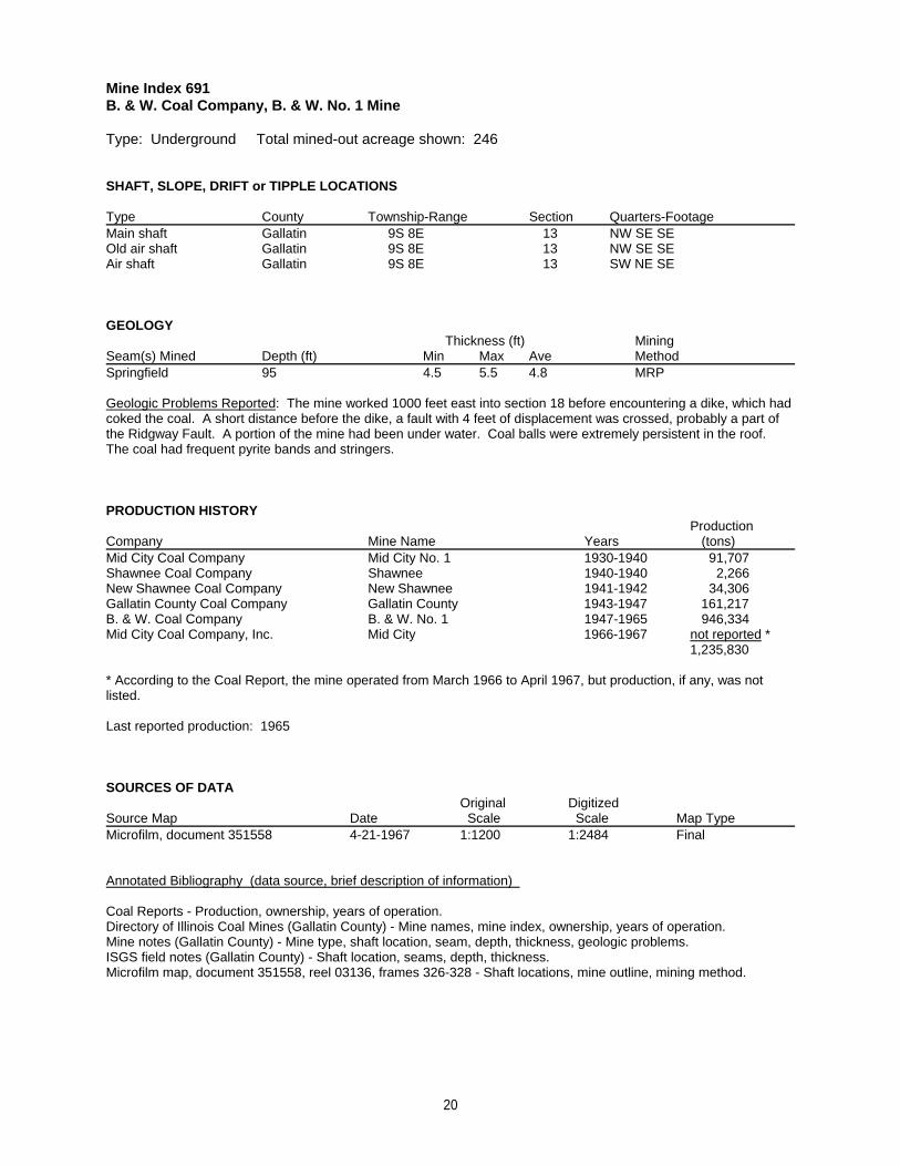
Mine Index 691B. & W. Coal Company, B. & W. No. 1 Mine
Type: Underground Total mined-out acreage shown: 246
SHAFT, SLOPE, DRIFT or TIPPLE LOCATIONS
Type County Township-Range Section Quarters-FootageMain shaft Gallatin 9S 8E 13 NW SE SE Old air shaft Gallatin 9S 8E 13 NW SE SEAir shaft Gallatin 9S 8E 13 SW NE SE
GEOLOGY Thickness (ft) Mining
Seam(s) Mined Depth (ft) Min Max Ave MethodSpringfield 95 4.5 5.5 4.8 MRP
Geologic Problems Reported: The mine worked 1000 feet east into section 18 before encountering a dike, which hadcoked the coal. A short distance before the dike, a fault with 4 feet of displacement was crossed, probably a part ofthe Ridgway Fault. A portion of the mine had been under water. Coal balls were extremely persistent in the roof. The coal had frequent pyrite bands and stringers.
PRODUCTION HISTORY Production
Company Mine Name Years (tons) Mid City Coal Company Mid City No. 1 1930-1940 91,707Shawnee Coal Company Shawnee 1940-1940 2,266New Shawnee Coal Company New Shawnee 1941-1942 34,306Gallatin County Coal Company Gallatin County 1943-1947 161,217B. & W. Coal Company B. & W. No. 1 1947-1965 946,334Mid City Coal Company, Inc. Mid City 1966-1967 not reported *
1,235,830
* According to the Coal Report, the mine operated from March 1966 to April 1967, but production, if any, was notlisted.
Last reported production: 1965
SOURCES OF DATAOriginal Digitized
Source Map Date Scale Scale Map Type Microfilm, document 351558 4-21-1967 1:1200 1:2484 Final
Annotated Bibliography (data source, brief description of information)
Coal Reports - Production, ownership, years of operation.Directory of Illinois Coal Mines (Gallatin County) - Mine names, mine index, ownership, years of operation.Mine notes (Gallatin County) - Mine type, shaft location, seam, depth, thickness, geologic problems.ISGS field notes (Gallatin County) - Shaft location, seams, depth, thickness.Microfilm map, document 351558, reel 03136, frames 326-328 - Shaft locations, mine outline, mining method.
20

Mine Index 709Randall Coal Company, Randall Mine
Type: Surface Total mined-out acreage shown: 6 (18 with augered coal, which may have been minedby another company)
SHAFT, SLOPE, DRIFT or TIPPLE LOCATIONS
Type County Township-Range Section Quarters-FootagePit Gallatin 10S 8E 16 N ½
GEOLOGY Thickness (ft) Mining
Seam(s) Mined Depth (ft) Min Max Ave MethodSpringfield 4.42 Surface
Geologic Problems Reported: There were pyrite facings throughout the coal.
PRODUCTION HISTORY Production
Company Mine Name Years (tons) Randall Coal Company Randall 1955-1956 59,739
59,739
Last reported production: October 1956
SOURCES OF DATAOriginal Digitized
Source Map Date Scale Scale Map Type Microfilm, document 351545 7-20-1956 1:1200 1:1656 Final *
* The map has a handwritten note stating this is a final map, although the date indicates it is not final. If the note isnot correct, an additional 2 acres could have been mined after the map date.
Annotated Bibliography (data source, brief description of information)
Coal Reports - Production, ownership, years of operation.Directory of Illinois Coal Mines (Gallatin County) - Mine names, mine index, ownership, years of operation.Mine notes (Gallatin County) - Mine type, mine location, seam, thickness, mining method, geologic problems..Microfilm map, document 351545, reel 03136, frames 311, 312 - Mine location, mine outline, mining method.
21

Mine Index 712Acme Stone & Coal Company, Acme No. 2 Mine
Type: Underground & Surface Total mined-out acreage shown: 2 Production indicates 3 acres weremined after the map date. This mine was later partially surface mined by the Eagle Surface Mine (mineindex 883). The last owner surface mined the Herrin Coal and used the tipple to load the Herrin Coal andso is included in the same index number.
SHAFT, SLOPE, DRIFT or TIPPLE LOCATIONS
Type County Township-Range Section Quarters-FootageMain drift Gallatin 10S 8E 23 SE NE NEAir shaft Gallatin 10S 8E 23 SE NE NE
GEOLOGY Thickness (ft) Mining
Seam(s) Mined Depth (ft) Min Max Ave MethodHerrin SurfaceSpringfield 28 5.0 MRP
Geologic Problems Reported: The black shale roof had large coal balls, with slickensides occurring nearby. Thebase of the coal contained a great deal of pyrite.
PRODUCTION HISTORY Production
Company Mine Name Years (tons) Sun Valley Coal Company Sun Valley No. 1 1953-1954 9,099Sun Valley Coal Company Sun Valley No. 1 1954-1955 10,939 *Acme Stone & Coal Company Acme No. 2 1956-1956 2,870 *, **
22,908
* Production after map date** This operator surface-mined in the vicinity, using the tipple of the underground mine.
Last reported production: December 1956
SOURCES OF DATAOriginal Digitized
Source Map Date Scale Scale Map Type Microfilm, document 351549 11-7-1954 1:1200 1:2148 Not finalUSGS topographic map 1959 1:24000 1:24000 Secondary source
Annotated Bibliography (data source, brief description of information)
Coal Reports - Production, ownership, years of operation.Directory of Illinois Coal Mines (Gallatin County) - Mine names, mine index, ownership, years of operation.ENR Document 85/01 - Mining method.Mine notes (Gallatin County) - Mine type, slope location, seam, depth, thickness, geologic problems.Microfilm map, document 351549, reel 03136, frame 317 - Drift & shaft locations, mine outline, mining method.USGS topographic map, Equality Quadrangle, 1959 - Mine outline.
22

Mine Index 745Vandell Mining & Coke Company, Vandell Mine
Type: Underground Total mined-out acreage shown: None
SHAFT, SLOPE, DRIFT or TIPPLE LOCATIONS
Type County Township-Range Section Quarters-FootageMain shaft Gallatin 9S 8E 24 NE SE NE
GEOLOGY Thickness (ft) Mining
Seam(s) Mined Depth (ft) Min Max Ave MethodSpringfield
Geologic Problems Reported: The shaft was not completed to the coal because of a water-saturated sand at a depthof 50 feet.
PRODUCTION HISTORY Production
Company Mine Name Years (tons) Vandell Mining & Coke Company Vandell 1907-1908 not reported *
* No production was listed in the Coal Reports for this name, and the field notes indicated the construction of the shaftwas not completed. It is likely that there was no production for this mine.
Last reported production:
SOURCES OF DATAOriginal Digitized
Source Map Date Scale Scale Map Type ISGS field notes (G. H. Cady) 4-9-1938 (text only) 1:24000 ** Secondary sourceISGS map library, 4107 d5.1-209 1927 1:62500 1:62500 Secondary source
** The mine name and general location were taken from the field notes and plotted on a 1:24000 USGS topographicmap, and this information identified a mine on Cady’s field notes map.
Annotated Bibliography (data source, brief description of information)
Directory of Illinois Coal Mines (Gallatin County) - Mine names, mine index, ownership, years of operation.Mine notes (Gallatin County) - Mine type, shaft location, geologic problems.ISGS field notes (Gallatin County) - Shaft location.ISGS map library, 4107 d5.1-209, map of G. H. Cady’s field notes - Shaft location.
23

Mine Index 746Oak Hill Coal Company, Oak Hill Mine
Type: Underground Total mined-out acreage shown: 8 This mine was later partially surface mined byRichardson No. 5 Mine (mine index 2284).
SHAFT, SLOPE, DRIFT or TIPPLE LOCATIONS
Type County Township-Range Section Quarters-FootageMain slope Gallatin 10S 8E 24 NW SW NEAir shaft Gallatin 10S 8E 24 SE NW NEAir shaft Gallatin 10S 8E 24 SW NW NE
GEOLOGY Thickness (ft) Mining
Seam(s) Mined Depth (ft) Min Max Ave MethodSpringfield 40 4.5 RPB
Geologic Problems Reported:
PRODUCTION HISTORY Production
Company Mine Name Years (tons) Martin & Brown Oak Hill 1948-1948 136Oak Hill Coal Company * Oak Hill 1949-1954 53,164
53,300
* The mine changed ownership in 1952 from B. Miles to R. Knickerbocker, but operated under the same name.
Last reported production: May 1954
SOURCES OF DATAOriginal Digitized
Source Map Date Scale Scale Map Type Microfilm, document 351541 7-2-1954 1:1200 1:2400 Final
Annotated Bibliography (data source, brief description of information)
Coal Reports - Production, ownership, years of operation.Directory of Illinois Coal Mines (Gallatin County) - Mine names, mine index, ownership, years of operation.ENR Document 85/01 - Mining method.Mine notes (Gallatin County) - Mine type, slope location, seam, depth, thickness.Microfilm map, document 351541, reel 03136, frame 306 - Slope & shaft locations, mine outline, mining method.
24

Mine Index 764National Mining Company, National Mine
Type: Surface Total mined-out acreage shown: 3 Production indicates approximately 15 acres weremined.
SHAFT, SLOPE, DRIFT or TIPPLE LOCATIONS
Type County Township-Range Section Quarters-FootageTipple Gallatin 9S 8E 23 NE NW
GEOLOGY Thickness (ft) Mining
Seam(s) Mined Depth (ft) Min Max Ave MethodSpringfield 4.75 Surface
Geologic Problems Reported:
PRODUCTION HISTORY Production
Company Mine Name Years (tons) Carl Wenzel Construction Company Wenzel Pit No. 1 1956-1956 924Carl Wenzel Construction Company Wenzel Pit No. 2 1956-1956 18,402Carl Wenzel Construction Company Wenzel Pit No. 3 1956-1956 22,664Liberty Coal Company Liberty No. 3 1957-1957 10,800Carl Wenzel Construction Company Wenzel No. 3 1957-1957 2,000National Mining Company National 1958-1958 5,623
60,413
Last reported production: July 1958
SOURCES OF DATAOriginal Digitized
Source Map Date Scale Scale Map Type ISGS map library, 4102 a-7, sheet 1 1983 1:24000 1:24000 Secondary sourceUSGS topographic map PR 1990 1:24000 1:24000 Secondary source
Annotated Bibliography (data source, brief description of information)
Coal Reports - Production, ownership, years of operation.Directory of Illinois Coal Mines (Gallatin County) - Mine names, mine index, ownership, years of operation.ENR Document 85/01 - Mining method.Mine notes (Gallatin County) - Mine type, mine location, seam, thickness, mining method.ISGS map library, 4102 a-7, sheet 1, work map for Equality Quadrangle Geologic Map - Mine location.USGS topographic map, Equality Quadrangle, 1959, photorevised 1990 - Mine outline.
25

Mine Index 765New Oak Hill Coal Company, New Oak Hill Pit No. 2
Type: Surface Total mined-out acreage shown: 1 Production indicates approximately 3 acres weremined after the map date.
SHAFT, SLOPE, DRIFT or TIPPLE LOCATIONS
Type County Township-Range Section Quarters-FootagePit Gallatin 9S 8E 23 NE NW
GEOLOGY Thickness (ft) Mining
Seam(s) Mined Depth (ft) Min Max Ave MethodSpringfield 4.5 Surface
Geologic Problems Reported:
PRODUCTION HISTORY Production
Company Mine Name Years (tons) Oak Hill Coal Company Pit No. 1 1955-1955 10,244New Oak Hill Coal Company Pit No. 2 1956-1956 22,657 *
32,901
* Production after map date
Last reported production: October 1956
SOURCES OF DATAOriginal Digitized
Source Map Date Scale Scale Map Type Microfilm, document 351542 1-2-1956 1:1200 1:1656 Not final
Annotated Bibliography (data source, brief description of information)
Coal Reports - Production, ownership, years of operation.Directory of Illinois Coal Mines (Gallatin County) - Mine names, mine index, ownership, years of operation.Mine notes (Gallatin County) - Mine type, mine location, seam, thickness, mining method.Microfilm map, document 351542, reel 03136, frame 307 - Mine outline, mining method.
26

Mine Index 804Vinyard Coal Company, Vinyard No. 1 Mine
Type: Surface Total mined-out acreage shown: 36 Production indicates approximately 24 acres weremined. The size difference may be from poor source maps or the coal thickness may not have been ashigh as reported.
SHAFT, SLOPE, DRIFT or TIPPLE LOCATIONS
Type County Township-Range Section Quarters-FootageTipple / pit Saline 9S 7E 13 NW SE SW
GEOLOGY Thickness (ft) Mining
Seam(s) Mined Depth (ft) Min Max Ave MethodSpringfield 30 4.5-4.67 Surface
Geologic Problems Reported:
PRODUCTION HISTORY Production
Company Mine Name Years (tons) Vinyard Coal Company Vinyard No. 1 1955-1957 132,437Liberty Coal Company Liberty No. 2 1957-1957 4,600Vinyard Coal Company Vinyard No. 1 1957-1957 40,000 *
177,037
* Some portion of this tonnage was mined by Vinyard Coal Company from January to June of 1957. Liberty CoalCompany operated the mine during June and July of 1957 and then ownership was transferred back to Vinyard CoalCompany in August. The Coal Report did not split the 1957 production listed for Vinyard Coal Company, and it is alllisted for the August-October time period.
Last reported production: October 1957
SOURCES OF DATAOriginal Digitized
Source Map Date Scale Scale Map Type ISGS map library, 4102 a-7, sheet 2 1981-1983 1:24000 1:24000 Secondary sourceDigital ortho-photographic quadrangle Unknown 1:24000 1:24000 Secondary source
Annotated Bibliography (data source, brief description of information)
Coal Reports - Production, ownership, years of operation.Directory of Illinois Coal Mines (Saline County) - Mine names, mine index, ownership, years of operation.Mine notes (Saline County) - Mine type, tipple / pit location, seam, depth, thickness.ISGS map library, 4102 a-7, sheet 2, work map for Rudement Quadrangle Geologic Map - Mine outline.Digital ortho-photographic map, Rudement 7.5-minute Quadrangle - Mine outline.
27

Mine Index 876Wenzel Coal Company, Inc., Eagle Valley No. 1 Mine
Type: Underground Total mined-out acreage shown: 14
SHAFT, SLOPE, DRIFT or TIPPLE LOCATIONS
Type County Township-Range Section Quarters-FootageMain drift Gallatin 9S 8E 33 NW SE SEAir drift Gallatin 9S 8E 33 NW SE SEAir drift Gallatin 9S 8E 33 NE SE SEAir drift Gallatin 9S 8E 33 NE SE SEEscape slope Gallatin 9S 8E 33 NE SW SE
GEOLOGY Thickness (ft) Mining
Seam(s) Mined Depth (ft) Min Max Ave MethodSpringfield 4.42 MRP
Geologic Problems Reported: The roof was dark gray shale which contained scattered coal balls. The floor was ahard underclay.
PRODUCTION HISTORY Production
Company Mine Name Years (tons) Wenzel Coal Company, Inc. * Eagle Valley No. 1 1965-1966 88,623
88,623
* The source map indicates the mine may have been managed by Roger Knickerbocker.
Last reported production: August 1966
SOURCES OF DATAOriginal Digitized
Source Map Date Scale Scale Map Type Company, 4103.G3 i5.1-11 8-31-1966 1:1200 1:1986 FinalISGS map library, 4102 a-7, sheet 1 1981-1983 1:24000 1:24000 Secondary source
Annotated Bibliography (data source, brief description of information)
Coal Reports - Production, ownership, years of operation.Directory of Illinois Coal Mines (Gallatin County) - Mine names, mine index, ownership, years of operation.Mine notes (Gallatin County) - Mine type, slope location, seam, thickness, geologic problems.Company map, ISGS map library, 4103.G3 i5.1-11 - Drift & slope locations, mine outline, mining method.ISGS map library, 4102 a-7, sheet 1, work map for Eqaulity Quadrangle Geologic Map - Georegistration aid.
28

Mine Index 883Peabody Coal Company, Eagle Surface Mine
Type: Surface Total mined-out acreage shown: 1,336 This area encompasses several other smallmines. Some were small underground mines whose pillars were retrieved by the Eagle Mine, some weresmall surface mines whose outlines are no longer relevant, and there is some evidence that a previouslyauger-mined area was surface-mined by the Eagle Mine.
SHAFT, SLOPE, DRIFT or TIPPLE LOCATIONS
Type County Township-Range Section Quarters-FootageTipple Gallatin 10S 9E 8 NE NE NE
GEOLOGY Thickness (ft) Mining
Seam(s) Mined Depth (ft) Min Max Ave MethodHerrin 6-80 3.0-4.67 SurfaceBriar Hill 2.5 SurfaceSpringfield 20-40 4.5 SurfaceDekoven 3.17 SurfaceDavis 3.17 Surface
Geologic Problems Reported: This mine uncovered traces of several faults of the Shawneetown Fault Zone. Manythrust faults and some normal faults were seen. In one case, the Herrin Coal was triplicated in the section caused bylarge-scale thrusting. The south side of one thrust fault was up-thrown about 10 feet. The faulting caused displacedcoal and made the coal elevation pitch and roll steeply, and caused instability of the highwall. In some pits, thePleistocene material directly overlay the Herrin Coal and appeared to have cut down into the coal in some spots. Theoverburden over the Herrin Coal consisted of black Anna Shale (sometimes pods or not present at all), a thin layer(from a few inches thick up to 3 or 4 feet) of Brereton Limestone, gray Lawson Shale (from 2 to 15 feet thick), andAnvil Rock Sandstone. In some places the Anvil Rock Sandstone was present as a channel fill about 1,000 feet widethat had eroded down to within a few inches of the coal, and up to 50 feet thick in the channel phase. In two pits, coalballs were commonly associated with the Herrin Coal. In one pit, the coal balls were pyritic and weathered easily to abrown powdery material in the spoil pile. A few thin pyrite lenses were also present in the coal, as well as calcite andpyrite on cleat faces. At least one clay dike was seen in the Briar Hill Coal. The Dekoven Coal was overlain by 35 to40 feet of hard gray silty shale with numerous thin beds of sandstone in the upper part.
PRODUCTION HISTORY Production
Company Mine Name Years (tons) Equality Coal Company Equality 1945-1945 8,663Idle 1946-1965Peabody Coal Company Eagle Surface 1966-1980 6,475,653
6,484,316
Last reported production: May 1980
SOURCES OF DATAOriginal Digitized
Source Map Date Scale Scale Map Type Company, 10-6-12 7-18-1983 1:12000 1:12000 FinalCompany, 4103.G3 i5.1-13 1-1-1979 1:12000 1:12000 Not final
Annotated Bibliography (data source, brief description of information)
Coal Reports - Production, ownership, years of operation.Directory of Illinois Coal Mines (Gallatin County) - Mine names, mine index, ownership, years of operation.Mine notes (Gallatin County) - Mine type, mine location, seam, depth, thickness, geologic problems.Company map, ISGS Coal Section files, 10-6-12 - Mine outline, mining method.Company map, ISGS map library, 4103.G3 i5.1-13 - Tipple location.
29

Mine Index 995Arclar Company, Eagle Valley Mine
Type: Underground Total mined-out acreage shown: 3,128 in the Springfield Coal and 1,194 in theDavis Coal. Production indicates an additional 60 acres were mined in the Davis Coal.
SHAFT, SLOPE, DRIFT or TIPPLE LOCATIONS
Type County Township-Range Section Quarters-FootageMain drift Gallatin 10S 8E 17 2620' FNL 960' FWLAir drift Gallatin 10S 8E 17 SE SW NWAir drift Gallatin 10S 8E 17 SE SW NWAir drift Gallatin 10S 8E 17 SE SW NWAir drift Gallatin 10S 8E 17 SE SW NWBlind slope to Davis Coal Gallatin 10S 8E Unknown *
* A blind slope was used to take the coal up to the Springfield Coal haulage routes, but this slope was not depicted onthe source map. (Blind slopes do not extend to the surface.)
GEOLOGY Thickness (ft) Mining
Seam(s) Mined Depth (ft) Min Max Ave MethodSpringfield 250 4.5-5.0 RPPDavis ** 450 3.58
** The Davis Coal was mined beginning in July 1996 from a blind slope that descended from the Springfield Coal.
Geologic Problems Reported: An igneous dike was present in this mine that trended due north. The dike wasbordered by a small rind of coked coal. The dike was found to coincide with a linear feature on the surface, indicatingthat the dike seen in the mine may extend to the surface. The roof was good, with very few falls occurring. The floorwas a hard claystone that did not cause problems, even when wet. There were some water problems in this minewhich required pumping at each face after mining. Some pyrite bands were found throughout the Davis seam, butmost commonly the bands were near the top of the Davis seam.
PRODUCTION HISTORY Production
Company Mine Name Years (tons) A. & F. Coal Company *** Arclar 1984-1986 488,300Tek Bar Industries, Inc. Arclar 1987-1988 619,346Tek Bar Industries, Inc. Eagle Valley 1989-1989 417,924Coal Miners, Inc. *** Eagle Valley 1990-2001 16,064,446Arclar Company Eagle Valley 2002-2002 209,250 †
17,799,266
*** The operators as listed in the Coal Reports may not accurately depict the mine ownership. A. & F Coal Companymay have been owned by Tek Bar Industries. Coal Miners, Inc. was a contract mining operation, and the mine wasowned by Sugar Camp Coal Company.† Production after map date
Last reported production: 2002
SOURCES OF DATAOriginal Digitized
Source Map Date Scale Scale Map Type Company 1-1-2002 1:4800 1:4800 Not final
Annotated Bibliography (data source, brief description of information)
Coal Reports - Production, ownership, years of operation, depth.Directory of Illinois Coal Mines (Gallatin County) - Mine names, mine index, ownership, years of operation.ENR Document 85/01 - Mining method.Mine notes (Gallatin County) - Mine type, drift location, seam, thickness, mining method, geologic problems.Company map, Coal Section files (digital) - Drift locations, mine outline, mining method.
30

Mine Index 999Jader Fuel Company, Inc., Lovilia Mine
Type: Underground Total mined-out acreage shown: 88 This mine was later partially surface minedby the I-1 Surface Mine (mine index 1004) and the drifts and most of the mine are not shown on theaccompanying map.
SHAFT, SLOPE, DRIFT or TIPPLE LOCATIONS
Type County Township-Range Section Quarters-FootageMain drift Gallatin 10S 8E 15 NE SW NWAir drift (intake) Gallatin 10S 8E 15 NE SW NWAir drift (return) Gallatin 10S 8E 15 NE SW NW
GEOLOGY Thickness (ft) Mining
Seam(s) Mined Depth (ft) Min Max Ave MethodSpringfield 150-175 5.0 BRP, some HER *
* The mine notes indicated that some pillars were pulled on retreat, but the extent of this practice is not known.
Geologic Problems Reported: The coal dipped to the north. Coal balls and limestone concretions were presentlocally. Narrow zones of closely spaced fractures caused weakness in the roof and some roof falls resulted. Analmost continuous zone of flattened pyrite nodules occurred at the roof/coal boundary. The coal contained somepyrite and calcite facings. Water seepage made the floor muddy.
PRODUCTION HISTORY Production
Company Mine Name Years (tons) Jader Fuel Company, Inc. Lovilia 1982-1985 450,223
450,223
Last reported production: 1985
SOURCES OF DATAOriginal Digitized
Source Map Date Scale Scale Map Type Company 6-7-1986 1:4800 1:4800 Final
Annotated Bibliography (data source, brief description of information)
Coal Reports - Production, ownership, years of operation, depth.Directory of Illinois Coal Mines (Gallatin County) - Mine names, mine index, ownership, years of operation.Mine notes (Gallatin County) - Mine type, drift location, seam, thickness, geologic problems.ISGS field notes (Gallatin County) - Geologic problems.Company map, Coal Section files - Drift locations, mine outline, mining method.
31

Mine Index 1003Jader Fuel Company, Inc., Federal Landscaping No. 1 Mine
Type: Surface Total mined-out acreage shown: 45 Production indicates approximately 10 acres weremined. The area shown on the accompanying map may include affected acreage from activitiesassociated with mining (haulage roads, areas cleared to maneuver machines, etc.) and the coal may nothave been as thick as reported.
SHAFT, SLOPE, DRIFT or TIPPLE LOCATIONS
Type County Township-Range Section Quarters-FootageTipple / pit Saline 10S 7E 12 SE SE
GEOLOGY Thickness (ft) Mining
Seam(s) Mined Depth (ft) Min Max Ave MethodHerrin 45 (20-60) 4.0 Surface
Geologic Problems Reported:
PRODUCTION HISTORY Production
Company Mine Name Years (tons) Federal Landscaping Company Federal Landscaping 1980-1980 none reportedJader Fuel Company, Inc. Federal Landscaping No. 1 1980-1982 65,509
65,509
Last reported production: October 1982
SOURCES OF DATAOriginal Digitized
Source Map Date Scale Scale Map Type Company, 6-281 6-15-1983 1:7920 1:7920 Final
Annotated Bibliography (data source, brief description of information)
Coal Reports - Production, ownership, years of operation, thickness.Directory of Illinois Coal Mines (Saline County) - Mine names, mine index, ownership, years of operation.Mine notes (Saline County) - Mine type, tipple / pit location, seam, depth, mining method.Company map, ISGS Coal Section, 6-281 - Mine location, mine outline, mining method.
32

Mine Index 1004Illinois Fuel Company, LLC, I-1 Surface Mine
Type: Surface Total mined-out acreage shown: 1,054 Production indicates approximately 200 acresor more were mined after the map date in Saline County. The northernmost pit in section 11, T10S-R7E isthe most recent production reported, after 2008.
SHAFT, SLOPE, DRIFT or TIPPLE LOCATIONS
Type County Township-Range Section Quarters-FootagePit Gallatin 10S 8E 16,17,18,19Pit Saline 10S 7E 13,14,23,24
GEOLOGY Thickness (ft) Mining
Seam(s) Mined Depth (ft) Min Max Ave MethodHerrin 140 * 3.0-4.0 SurfaceBriar Hill 90 * 2.0-2.5 SurfaceSpringfield 155 * 4.5-5.0 SurfaceDekoven 103-105 * 3.0 SurfaceDavis 125-130 * 4.0 Surface
* These depths were not measured at the same location, but in the locations where each coal was present and thickenough to mine.
Geologic Problems Reported:
PRODUCTION HISTORY Production
Company Mine Name Years (tons) Jader Fuel Company, Inc. Jader No. 4 1982-1996 5,517,954Jader Fuel Company, Inc. Jader No. 4 (Saline County) 1997-2000 4,178,422Illinois Fuel Company, LLC I-1 Surface 2001- ** 3,280,101 ***
12,976,477
** Idle 2004-2007*** The production is through 2011. The mine was not listed in the 2012-2015 Coal Reports, and may be closed.
Last reported production:
SOURCES OF DATAOriginal Digitized
Source Map Date Scale Scale Map Type Company (digital) 1-2012 1:2400 1:2400 Not final ***Company (digital) 1-1-2001 1:24000 1:24000 Final, not final †Company (paper) 1-1-2001 1:4896 1:4896 Final ††Company (paper) 1-10-2000 1:4800 1:4800 Final ††Company (paper), 1-42-27 4-18-1994 1:4800 1:4800 Final ††Company (paper) 12-31-1994 1:4800 1:4800 Final ††
*** The outline shown is of affected acres, which may not reflect actual mining. This source reflects only the mostrecent mining which was begun after the mine was reactivated after being idle.† Final for Gallatin County pits, not final for Saline County pits†† This map is final for the areas shown.
Annotated Bibliography (data source, brief description of information)
Coal Reports - Production, ownership, years of operation, depth.Mine notes (Gallatin County) - Mine type, mine location, seam, thickness, mining method, geologic problems.Company map, Coal Section files (digital) - Mine outline, mining method.Company map, Coal Section files, not numbered and 1-42-27 - Mine outline, mining method.
33

Mine Index 1022Arclar Company, Wildcat Hills Eagle Valley Mine
Type: Surface Total mined-out acreage shown: 942
SHAFT, SLOPE, DRIFT or TIPPLE LOCATIONS
Type County Township-Range Section Quarters-FootageTipple Gallatin 10S 8E 17 NE SWPit Gallatin 10S 8E 5Pit Gallatin 10S 8E 6
GEOLOGY Thickness (ft) Mining
Seam(s) Mined Depth (ft) Min Max Ave MethodHerrin 65-85 3.8-4.0 SurfaceSpringfield 35 Surface
Geologic Problems Reported:
PRODUCTION HISTORY Production
Company Mine Name Years (tons) Black Beauty Mining Company Wildcat Hills 1998-2001 5,988,417 *Arclar Company Wildcat Hills 2002-2004 7,855,678 *Black Beauty Mining Company Wildcat Hills Eagle Valley 2005-2007 6,586,992 *
20,431,087
* Production from 2000-2007 also includes Wildcat Hills Cottage Grove Mine (mine index 1044).
Last reported production: 2007
SOURCES OF DATAOriginal Digitized
Source Map Date Scale Scale Map Type Company, Coal Section digital files 2008 unknown 1:24000 Final
Annotated Bibliography (data source, brief description of information)
Coal Reports - Production, ownership, years of operation, seam, depth, thickness.Directory of Illinois Coal Mines (Gallatin County) - Mine names, mine index, ownership, years of operation.Mine notes (Gallatin County) - Mine type, mine location, seam, depth, mining method.Company digital map, Coal Section files - Mine outline, mining method.
34

Mine Index 1035Illinois Fuel Company, LLC, I-1 Underground Mine
Type: Surface Total mined-out acreage shown: 1,832
SHAFT, SLOPE, DRIFT or TIPPLE LOCATIONS
Type County Township-Range Section Quarters-FootageMain drift Saline 10S 7E 14 NW SE NEAir drift Saline 10S 7E 14 SW NE NEDrift Saline 10S 7E 14 SW NE NEDrift Saline 10S 7E 14 SW NE NE
GEOLOGY Thickness (ft) Mining
Seam(s) Mined Depth (ft) Min Max Ave MethodDavis 125-130 4.0 CRP
Geologic Problems Reported: Geologic problems are confidential information and are not reported for active mines.
PRODUCTION HISTORY Production
Company Mine Name Years (tons) Illinois Fuel Company, LLC I-1 Underground 2003-2003 * 12,791
12,791
* Production was only reported in the 2003 Coal Report, but the mine outline indicates a considerable amount of coalremoval. This production was probably recorded under the I-1 Mine, the surface mine identified as mine index 1004.
Last reported production: 2003
SOURCES OF DATAOriginal Digitized
Source Map Date Scale Scale Map Type Company 1-10-2000 1:4800 1:4800 Not final
Annotated Bibliography (data source, brief description of information)
Coal Reports - Production, ownership, years of operation, depth.Mine notes (Gallatin County) - Mine type, mine location, seam, thickness.Company map, Coal Section files - Mine outline, mining method.
35

Mine Index 1044Peabody Midwest Mining, Wildcat Hills Cottage Grove Mine
Type: Surface Total mined-out acreage shown: 3,296
SHAFT, SLOPE, DRIFT or TIPPLE LOCATIONS
Type County Township-Range Section Quarters-FootagePit Gallatin 9S 7E 1, 2, 3, 10, 11, 12, 14Pit Gallatin 9S 8E 4, 5, 6, 7, 8, 9
GEOLOGY Thickness (ft) Mining
Seam(s) Mined Depth (ft) Min Max Ave MethodDanville * SurfaceAllenby * 50 2.0 SurfaceHerrin 65 3.7 SurfaceBriar Hill SurfaceSpringfield * Surface
* The Danville Coal is mined only in the northern portions of the northernmost pits. The Allenby Coal was said tohave been mined in 2003, and again 2006-2009. The Allenby Coal is commonly found in channel deposits, so it isunclear which pits this coal was mined in. The Springfield Coal is mined in the southernmost pit, and in portions ofthe northern pits, south of the underground mines in the Springfield Coal.
Geologic Problems Reported: Geologic problems are confidential information and are not reported for active mines.
PRODUCTION HISTORY Production
Company Mine Name Years (tons) Black Beauty Coal Company Wildcat Hills Cottage Grove 2000-2009 4,347,151 **Peabody Midwest Mining Wildcat Hills Cottage Grove 2010- 11,058,464 ***
15,405,615
** The 2000-2005 production is included in the totals for Wildcat Hills Eagle Valley mine (mine index 1022). *** The production shown is through 2015, the latest available Coal Report.
Last reported production:
SOURCES OF DATAOriginal Digitized
Source Map Date Scale Scale Map Type Company, Coal Section files 2009 unknown 1:24000 Not finalCoal Section files 2012 unknown 1:24000 Not final
Annotated Bibliography (data source, brief description of information)
Coal Reports - Production, ownership, years of operation.Directory of Illinois Coal Mines (Saline County) - Mine names, mine index, ownership, years of operation.Company map, Coal Section files (2009 active mines) - Mine outline, mining method.Coal Section files, digital map - Mine outline.
36
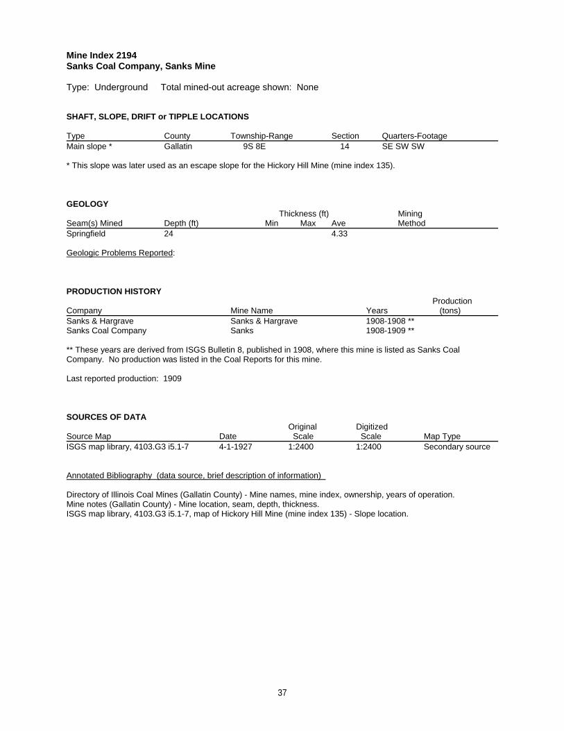
Mine Index 2194Sanks Coal Company, Sanks Mine
Type: Underground Total mined-out acreage shown: None
SHAFT, SLOPE, DRIFT or TIPPLE LOCATIONS
Type County Township-Range Section Quarters-FootageMain slope * Gallatin 9S 8E 14 SE SW SW
* This slope was later used as an escape slope for the Hickory Hill Mine (mine index 135).
GEOLOGY Thickness (ft) Mining
Seam(s) Mined Depth (ft) Min Max Ave MethodSpringfield 24 4.33
Geologic Problems Reported:
PRODUCTION HISTORY Production
Company Mine Name Years (tons) Sanks & Hargrave Sanks & Hargrave 1908-1908 **Sanks Coal Company Sanks 1908-1909 **
** These years are derived from ISGS Bulletin 8, published in 1908, where this mine is listed as Sanks CoalCompany. No production was listed in the Coal Reports for this mine.
Last reported production: 1909
SOURCES OF DATAOriginal Digitized
Source Map Date Scale Scale Map Type ISGS map library, 4103.G3 i5.1-7 4-1-1927 1:2400 1:2400 Secondary source
Annotated Bibliography (data source, brief description of information)
Directory of Illinois Coal Mines (Gallatin County) - Mine names, mine index, ownership, years of operation.Mine notes (Gallatin County) - Mine location, seam, depth, thickness.ISGS map library, 4103.G3 i5.1-7, map of Hickory Hill Mine (mine index 135) - Slope location.
37

Mine Index 2258Richardson Coal Corporation, Richardson No. 6 Mine
Type: Surface Total mined-out acreage shown: 5
SHAFT, SLOPE, DRIFT or TIPPLE LOCATIONS
Type County Township-Range Section Quarters-FootageTipple Gallatin 9S 8E 21 NW NEPit Gallatin 9S 8E 21 NW NEPit Gallatin 9S 8E 16 SW SW SE
GEOLOGY Thickness (ft) Mining
Seam(s) Mined Depth (ft) Min Max Ave MethodSpringfield Surface
Geologic Problems Reported:
PRODUCTION HISTORY Production
Company Mine Name Years (tons) Vinyard Coal Company Vinyard No. 5 1957-1958 6,556Richardson Coal Corporation Richardson No. 6 1958-1958 33,625
40,181
Last reported production: October 1958
SOURCES OF DATAOriginal Digitized
Source Map Date Scale Scale Map Type USGS topographic map PR 1990 1:24000 1:24000 Secondary source
Annotated Bibliography (data source, brief description of information)
Coal Reports - Production, ownership, years of operation.Directory of Illinois Coal Mines (Gallatin County) - Mine names, mine index, ownership, years of operation.Mine notes (Gallatin County) - Mine type, mine location, seam, mining method.USGS topographic map, Equality Quadrangle, 1959, photorevised 1990 - Mine outline.
38
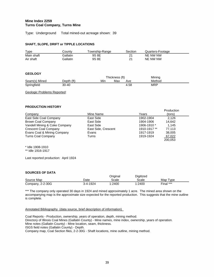
Mine Index 2259Turns Coal Company, Turns Mine
Type: Underground Total mined-out acreage shown: 39
SHAFT, SLOPE, DRIFT or TIPPLE LOCATIONS
Type County Township-Range Section Quarters-FootageMain shaft Gallatin 9S 8E 21 NE NW NWAir shaft Gallatin 9S 8E 21 NE NW NW
GEOLOGY Thickness (ft) Mining
Seam(s) Mined Depth (ft) Min Max Ave MethodSpringfield 30-40 4.58 MRP
Geologic Problems Reported:
PRODUCTION HISTORY Production
Company Mine Name Years (tons) East Side Coal Company East Side 1902-1904 2,126Brown Coal Company East Side 1904-1906 14,642Vandell Mining & Coke Company East Side 1906-1910 * 1,145Crescent Coal Company East Side, Crescent 1910-1917 ** 77,113Evans Coal & Mining Company Evans 1917-1919 38,005Turns Coal Company Turns 1919-1924 67,022
200,053
* Idle 1908-1910** Idle 1916-1917
Last reported production: April 1924
SOURCES OF DATAOriginal Digitized
Source Map Date Scale Scale Map Type Company, 2-2-30G 3-4-1924 1:2400 1:2400 Final ***
*** The company only operated 30 days in 1924 and mined approximately 1 acre. The mined area shown on theaccompanying map is the approximate size expected for the reported production. This suggests that the mine outlineis complete.
Annotated Bibliography (data source, brief description of information)
Coal Reports - Production, ownership, years of operation, depth, mining method.Directory of Illinois Coal Mines (Gallatin County) - Mine names, mine index, ownership, years of operation.Mine notes (Gallatin County) - Mine location, seam, thickness.ISGS field notes (Gallatin County) - Depth.Company map, Coal Section files, 2-2-30G - Shaft locations, mine outline, mining method.
39

Mine Index 2260A. H. Sisk, Gold Nugget Mine
Type: Underground Total mined-out acreage shown: None Production indicates approximately 9acres were mined.
SHAFT, SLOPE, DRIFT or TIPPLE LOCATIONS
Type County Township-Range Section Quarters-FootageMain shaft Gallatin 9S 8E 16 SW SW SW
GEOLOGY Thickness (ft) Mining
Seam(s) Mined Depth (ft) Min Max Ave MethodHerrin 20-55 4.0-4.83 RP
Geologic Problems Reported:
PRODUCTION HISTORY Production
Company Mine Name Years (tons) Baldwin & Turner Baldwin & Turner 1905-1906 472J. O. Baldwin Golden Nugget 1906-1912 15,210Dempsey & Walthen Dempsey & Walthen 1912-1913 2,985William A. Wather Wather 1913-1914 2,450Williams & Lessak Sunnyside 1914-1915 8,500Harrison Brothers Harrison 1915-1916 4,000Sisk, Flanders & White Gold Nugget 1916-1917 700A. H. Sisk Gold Nugget 1917-1918 650
34,967
Last reported production: 1918
SOURCES OF DATAOriginal Digitized
Source Map Date Scale Scale Map Type ISGS mined-out area map, area 32 1950 1:62500 1:62500 Secondary source
Annotated Bibliography (data source, brief description of information)
Coal Reports - Production, ownership, years of operation, seam, depth, thickness, mining method.Directory of Illinois Coal Mines (Gallatin County) - Mine names, mine index, ownership, years of operation.ENR Document 85/01 - Mining method.Mine notes (Gallatin County) - Mine type, shaft location, seam.ISGS mined-out area map, area 32 - Shaft location.
40

Mine Index 2261G. Schafer, Hickory Hills Mine
Type: Underground Total mined-out acreage shown: None Production indicates approximately 5acres were mined.
SHAFT, SLOPE, DRIFT or TIPPLE LOCATIONS
Type County Township-Range Section Quarters-FootageMain drift Gallatin 9S 8E 17 NE NE SE
GEOLOGY Thickness (ft) Mining
Seam(s) Mined Depth (ft) Min Max Ave MethodSpringfield 30 4.0-4.5 RP
Geologic Problems Reported:
PRODUCTION HISTORY Production
Company Mine Name Years (tons) Peter Brightner Brightner 1889-1890 600Brightner & Baldwin Brightner & Baldwin 1890-1894 * 12,946Lloyd & Jeris Lloyd & Jeris 1894-1895 1,180G. Schafer Hickory Hills 1895-1897 4,600
19,326
* Idle 1894 (reported abandoned)
Last reported production: 1897
SOURCES OF DATAOriginal Digitized
Source Map Date Scale Scale Map Type ISGS mined-out area map, area 32 1950 1:62500 1:62500 Secondary source
Annotated Bibliography (data source, brief description of information)
Coal Reports - Production, ownership, years of operation, mine type, seam, depth, thickness, mining method.Directory of Illinois Coal Mines (Gallatin County) - Mine names, mine index, ownership, years of operation.Mine notes (Gallatin County) - Mine location.ISGS field notes (Gallatin County) - Depth, thickness.ISGS mined-out area map, area 32 - Drift location.
41

Mine Index 2262William H. McLain, McLain Mine
Type: Underground Total mined-out acreage shown: None Production indicates approximately 6acres were mined.
SHAFT, SLOPE, DRIFT or TIPPLE LOCATIONS
Type County Township-Range Section Quarters-FootageMain drift Gallatin 9S 8E 17 NE SE NE
GEOLOGY Thickness (ft) Mining
Seam(s) Mined Depth (ft) Min Max Ave MethodHerrin 18-40 4.0-5.13 RP
Geologic Problems Reported:
PRODUCTION HISTORY Production
Company Mine Name Years (tons) William H. McLain McLain 1897-1909 23,505
23,505
Last reported production: 1909
SOURCES OF DATAOriginal Digitized
Source Map Date Scale Scale Map Type ISGS Bulletin 8, Plate 9 1908 1:84480 1:84480 Secondary source
Annotated Bibliography (data source, brief description of information)
Coal Reports - Production, ownership, years of operation, depth, thickness, mining method.Directory of Illinois Coal Mines (Gallatin County) - Mine names, mine index, ownership, years of operation.Mine notes (Gallatin County) - Mine type, drift location, seam, thickness.ISGS Bulletin 8, Plate 9 - Drift location.
42

Mine Index 2263Richardson Coal Corporation, Richardson No. 3 Mine
Type: Surface Total mined-out acreage shown: None Production indicates approximately 5 acreswere mined.
SHAFT, SLOPE, DRIFT or TIPPLE LOCATIONS
Type County Township-Range Section Quarters-FootageTipple Gallatin 9S 8E 19 NW NW NW
GEOLOGY Thickness (ft) Mining
Seam(s) Mined Depth (ft) Min Max Ave MethodSpringfield Surface
Geologic Problems Reported:
PRODUCTION HISTORY Production
Company Mine Name Years (tons) Richardson Coal Corporation Richardson No. 3 1957-1958 37,998
37,998
Last reported production: March 1958
SOURCES OF DATAOriginal Digitized
Source Map Date Scale Scale Map Type ISGS mined-out area map, area 32 1950 1:62500 1:62500 Secondary source
Annotated Bibliography (data source, brief description of information)
Coal Reports - Production, ownership, years of operation.Directory of Illinois Coal Mines (Gallatin County) - Mine names, mine index, ownership, years of operation.Mine notes (Gallatin County) - Seam.ISGS mined-out area map, area 32 - Mine location.
43

Mine Index 2264Billy Baldwin, Lone Star Mine
Type: Underground Total mined-out acreage shown: None Production indicates less than 1 acre wasmined.
SHAFT, SLOPE, DRIFT or TIPPLE LOCATIONS
Type County Township-Range Section Quarters-FootageMain drift Gallatin 9S 8E 19 NE SW NW
GEOLOGY Thickness (ft) Mining
Seam(s) Mined Depth (ft) Min Max Ave MethodSpringfield 60 4.5
Geologic Problems Reported:
PRODUCTION HISTORY Production
Company Mine Name Years (tons) John O. Baldwin Baldwin 1927-1928 * 616Charles E. Baldwin Baldwin 1929-1930 ** 444John O. Baldwin Baldwin 1931-1936 *** 1,442Billy Baldwin Lone Star 1937-1939 † 117
2,619
* Idle 1928** Idle, or produced less than 1,000 tons, in 1930*** Idle, or produced less than 1,000 tons per year, in 1932 & 1933† Idle 1938
Last reported production: 1939
SOURCES OF DATAOriginal Digitized
Source Map Date Scale Scale Map Type ISGS mined-out area map, area 32 1950 1:62500 1:62500 Secondary source
Annotated Bibliography (data source, brief description of information)
Coal Reports - Production, ownership, years of operation.Directory of Illinois Coal Mines (Gallatin County) - Mine names, mine index, ownership, years of operation.Mine notes (Gallatin County) - Mine type, drift location, seam, depth, thickness.ISGS mined-out area map, area 32 - Drift location.
44

Mine Index 2265Marshall Equipment Company, Mary Ann No. 2 Mine
Type: Surface Total mined-out acreage shown: 7
SHAFT, SLOPE, DRIFT or TIPPLE LOCATIONS
Type County Township-Range Section Quarters-FootagePit Gallatin 9S 8E 20 NW
GEOLOGY Thickness (ft) Mining
Seam(s) Mined Depth (ft) Min Max Ave MethodBriar Hill * SurfaceSpringfield 60 5.33 Surface
* The Briar Hill Coal pits are shown on the accompanying Springfield Coal map.
Geologic Problems Reported:
PRODUCTION HISTORY Production
Company Mine Name Years (tons) Marshall Equipment Company Mary Ann No. 2 1965-1966 70,039
70,039
Last reported production: 1966
SOURCES OF DATAOriginal Digitized
Source Map Date Scale Scale Map Type ISGS map library, 4102 a-7, sheet 1 4-14-1983 1:24000 1:24000 Secondary sourceUSGS topographic map PR 1990 1:24000 1:24000 Secondary source
Annotated Bibliography (data source, brief description of information)
Coal Reports - Production, ownership, years of operation, depth, thickness.Directory of Illinois Coal Mines (Gallatin County) - Mine names, mine index, ownership, years of operation.Mine notes (Gallatin County) - Mine type, mine location, seam, mining method.ISGS map library, 4102 a-7, sheet 1, work map for Equality Quadrangle Geologic Map - Mine outline.USGS topographic map, Equality Quadrangle, 1959, photorevised 1990 - Mine outline.
45

Mine Index 2266Andrew Patton, Patton Mine
Type: Underground Total mined-out acreage shown: None Production indicates less than 1 acre wasmined. This mine is not shown on the accompanying map because of later surface mining by the I-1 Mine(mine index 1004).
SHAFT, SLOPE, DRIFT or TIPPLE LOCATIONS
Type County Township-Range Section Quarters-FootageMain drift Gallatin 10S 8E 17 SW SW NE
GEOLOGY Thickness (ft) Mining
Seam(s) Mined Depth (ft) Min Max Ave MethodSpringfield 40 5.0 RP
Geologic Problems Reported:
PRODUCTION HISTORY Production
Company Mine Name Years (tons) Bratcher Patton Patton 1928-1933 * 40James A. Patton Patton 1934-1934 450Andrew Patton Patton 1935-1938 1,569
2,059
* Idle 1929; produced less than 1,000 tons per year 1930-1933 and not reported
Last reported production: 1938
SOURCES OF DATAOriginal Digitized
Source Map Date Scale Scale Map Type Mine notes Undated (text only) 1:24000 ** Secondary source
** The mine location was plotted on a 1:24000 USGS topographic map from the mine location description anddigitized.
Annotated Bibliography (data source, brief description of information)
Coal Reports - Production, ownership, years of operation, mining method.Directory of Illinois Coal Mines (Gallatin County) - Mine names, mine index, ownership, years of operation.Mine notes (Gallatin County) - Mine type, drift location, seam, depth, thickness.
46

Mine Index 2268Burnett & Love, Eagle Valley Mine
Type: Underground Total mined-out acreage shown: Less than 1 This mine is not shown on theaccompanying map because of later surface mining by the Eagle Surface Mine (mine index 883).
SHAFT, SLOPE, DRIFT or TIPPLE LOCATIONS
Type County Township-Range Section Quarters-FootageMain slope Gallatin 10S 8E 13 SW SE SW
GEOLOGY Thickness (ft) Mining
Seam(s) Mined Depth (ft) Min Max Ave MethodSpringfield 35 5.0 RP
Geologic Problems Reported:
PRODUCTION HISTORY Production
Company Mine Name Years (tons) C. E. Burnett Burnett No. 1 1937-1937 40Brooks & Barnett Brooks & Barnett 1937-1938 * 130Eagle Valley Coal Company ** Eagle Valley 1939-1940 657Burnett & Love Eagle Valley 1941-1941 150
977
* Idle 1938** Owned by Brooks & Barnett
Last reported production: 1941
SOURCES OF DATAOriginal Digitized
Source Map Date Scale Scale Map Type Microfilm, document 351550 8-9-1941 1:1200 1:1324 Final
Annotated Bibliography (data source, brief description of information)
Coal Reports - Production, ownership, years of operation, mining method.Directory of Illinois Coal Mines (Gallatin County) - Mine names, mine index, ownership, years of operation.ENR Document 85/01 - Mining method.Mine notes (Gallatin County) - Mine type, slope location, seam, depth, thickness.Microfilm map, document 351550, reel 03136, frame 318 - Slope location, mine outline.
47

Mine Index 2270Hickory Hill Coal Company, Hickory Hill Mine
Type: Underground Total mined-out acreage shown: 5 This mine was later partially surface mined bythe Eagle Surface Mine (mine index 883) and the Richardson No. 5 Mine (mine index 2284).
SHAFT, SLOPE, DRIFT or TIPPLE LOCATIONS
Type County Township-Range Section Quarters-FootageMain slope Gallatin 10S 8E 24 SW NE NEAir shaft Gallatin 10S 8E 24 SE NE NE
GEOLOGY Thickness (ft) Mining
Seam(s) Mined Depth (ft) Min Max Ave MethodSpringfield MRP
Geologic Problems Reported:
PRODUCTION HISTORY Production
Company Mine Name Years (tons) Hickory Hill Coal Company Hickory Hill * 1941-1942 14,902Hickory Hill Coal Company Hickory Hill 1942-1946 ** 19,012 ***
33,914
* Some ISGS maps have designated this mine “New Hickory Hill Mine” to distinguish this mine from Logan HighwayCoal Company’s Hickory Hill Mine (mine index 648), which closed in 1941. ** The mine changed ownership in 1943 but continued to operate under the same name.*** Production after map date
Last reported production: 1946
SOURCES OF DATAOriginal Digitized
Source Map Date Scale Scale Map Type Microfilm, document 351533 9-19-1942 1:1200 1:2152 Not finalCoal Section files, 6-205 5-1-1977 1:1200 1:1200 Secondary source †
† The mined area shown on the accompanying map is the approximate size expected for the reported production. This suggests that the mine outline is complete.
Annotated Bibliography (data source, brief description of information)
Coal Reports - Production, ownership, years of operation.Directory of Illinois Coal Mines (Gallatin County) - Mine names, mine index, ownership, years of operation.Mine notes (Gallatin County) - Mine type, slope location, seam.Microfilm map, document 351533, reel 03136, frame 298 - Slope & shaft locations, mine outline, mining method.Coal Section files, 6-205, map of the Eagle Surface Mine (mine index 883) - Mine outline.
48

Mine Index 2271Leamington Coal Company, Leamington Mine
Type: Surface Total mined-out acreage shown: 10 Production indicates approximately 1 acre wasmined. This mine is included within the Eagle Surface Mine (mine index 883) outline and is not shownseparately on the accompanying map.
SHAFT, SLOPE, DRIFT or TIPPLE LOCATIONS
Type County Township-Range Section Quarters-FootageTipple Gallatin 10S 8E 14 NE NE SE
GEOLOGY Thickness (ft) Mining
Seam(s) Mined Depth (ft) Min Max Ave MethodHerrin Surface
Geologic Problems Reported:
PRODUCTION HISTORY Production
Company Mine Name Years (tons) Leamington Coal Company Leamington 1964-1964 6,087
6,087
Last reported production: 1964
SOURCES OF DATAOriginal Digitized
Source Map Date Scale Scale Map Type Coal Section files, 6-205 5-1-1977 1:1200 1:1200 Secondary sourceCoal Section files, strip mine updates Undated 1:6600 1:6600 Secondary source
Annotated Bibliography (data source, brief description of information)
Coal Reports - Production, ownership, years of operation.Directory of Illinois Coal Mines (Gallatin County) - Mine names, mine index, ownership, years of operation.Mine notes (Gallatin County) - Mine location, mining method.Coal Section files, 6-205, map of the Eagle Surface Mine (mine index 883) - Mine outline.Coal Section files, strip mine updates - Mine location, mine identification.
49

Mine Index 2273Green Hill Coal Company, Green Hill Mine
Type: Underground Total mined-out acreage shown: 7 This mine is not shown on the accompanyingmap because of later surface mining by the I-1 Surface Mine (mine index 1004).
SHAFT, SLOPE, DRIFT or TIPPLE LOCATIONS
Type County Township-Range Section Quarters-FootageMain slope Gallatin 10S 8E 15 NW SE NWAir shaft Gallatin 10S 8E 15 NW SE NW
GEOLOGY Thickness (ft) Mining
Seam(s) Mined Depth (ft) Min Max Ave MethodSpringfield 12 4.83 RPB
Geologic Problems Reported:
PRODUCTION HISTORY Production
Company Mine Name Years (tons) W. B. Dickson Dickson 1920-1939 5,422 *Roy Bybee & Son Bybee 1940-1940 414Arthur Bybee Green 1941-1941 601Frank Green Green 1942-1942 1,208Harrison-Allen Coal Company Harrison-Allen 1943-1946 ** 123Green Hill Coal Company Green Hill 1947-1952 17,922
25,690
* Idle 1921, idle or produced less than 10,000 tons in 1922, and production not reported 1930-1933 for minesproducing less than 1,000 tons per year.** Idle 1944-1946
Last reported production: September 1952
SOURCES OF DATAOriginal Digitized
Source Map Date Scale Scale Map Type Microfilm, document 351538 2-28-1953 1:1200 1:993 FinalCoal Section files 6-7-1986 1:4800 1:4800 Secondary source
Annotated Bibliography (data source, brief description of information)
Coal Reports - Production, ownership, years of operation.Directory of Illinois Coal Mines (Gallatin County) - Mine names, mine index, ownership, years of operation.ENR Document 85/01 - Mining method.Mine notes (Gallatin County) - Mine type, slope location, seam, depth, thickness.Microfilm map, document 351538, reel 03136, frame 303 - Slope & shaft locations, mine outline, mining method.Coal Section files, map of Lovilia Mine (mine index 999) - Georegistration aid.
50

Mine Index 2274Isaac Dillard, Dillard No. 1 Mine
Type: Underground Total mined-out acreage shown: None Production indicates approximately 2acres were mined. The mine’s location as given in the mine notes is not specific, merely listing thequarter-section. Traditionally, such mines are plotted near the center of the smallest section segmentknown. This mine may have been later surface mined by the I-1 Surface Mine (mine index 1004).
SHAFT, SLOPE, DRIFT or TIPPLE LOCATIONS
Type County Township-Range Section Quarters-FootageMain slope Gallatin 10S 8E 16 SW
GEOLOGY Thickness (ft) Mining
Seam(s) Mined Depth (ft) Min Max Ave MethodDavis 40 4.5 RP
Geologic Problems Reported:
PRODUCTION HISTORY Production
Company Mine Name Years (tons) Isaac Dillert Jennings 1941-1941 437Harrison-Allen Harrison-Allen 1942-1942 1,125Isaac Dillard Dillard No. 1 1943-1952 * 5,078
6,640
* Idle 1950
Last reported production: 1952
SOURCES OF DATAOriginal Digitized
Source Map Date Scale Scale Map Type Mine notes Undated (text only) 1:24000 ** Secondary source
** The mine location was plotted on a 1:24000 USGS topographic map from the mine location description anddigitized.
Annotated Bibliography (data source, brief description of information)
Coal Reports - Production, ownership, years of operation, mining method.Directory of Illinois Coal Mines (Gallatin County) - Mine names, mine index, ownership, years of operation.Mine notes (Gallatin County) - Mine type, mine location, seam, depth, thickness.
51

Mine Index 2275Little Joe Coal Company, Little Joe Mine
Type: Underground Total mined-out acreage shown: 6 This mine is not shown on the accompanyingmap because of later surface mining by the I-1 Surface Mine (mine index 1004).
SHAFT, SLOPE, DRIFT or TIPPLE LOCATIONS
Type County Township-Range Section Quarters-FootageMain drift Gallatin 10S 8E 16 NW SE NEAir drift Gallatin 10S 8E 16 NW SE NE
GEOLOGY Thickness (ft) Mining
Seam(s) Mined Depth (ft) Min Max Ave MethodSpringfield 4.67 MRP
Geologic Problems Reported:
PRODUCTION HISTORY Production
Company Mine Name Years (tons) James Patton Patton No. 2 1938-1938 32James Potter Potter No. 1 1939-1939 501Joe Scarbrough & Company Scarbrough 1940-1940 515Hiram Elliott Pather 1941-1941 514James Potter Potter 1942-1947 2,623Pulliam & Certain Pulliam & Certain 1948-1948 1,216Berkel Brothers Little Joe 1948-1948 1,180Frank & W. E. Berkel Coal Company Berkel 1949-1949 10,200Little Joe Coal Company Little Joe 1950-1950 1,181
17,962
Last reported production: 1950
SOURCES OF DATAOriginal Digitized
Source Map Date Scale Scale Map Type Microfilm, document 351540 4-2-1950 1:1200 1:1324 Final
Annotated Bibliography (data source, brief description of information)
Coal Reports - Production, ownership, years of operation.Directory of Illinois Coal Mines (Gallatin County) - Mine names, mine index, ownership, years of operation.Mine notes (Gallatin County) - Mine type, drift location, seam, thickness.Microfilm map, document 351540, reel 03136, frame 305 - Drift locations, mine outline, mining method.
52

Mine Index 2276Dillard Coal Company, Dillard No. 2 Mine
Type: Underground Total mined-out acreage shown: Less than 1 Production indicates less than 1acre was mined after the map date. This mine is not shown on the accompanying map because of latersurface mining by the I-1 Surface Mine (mine index 1004).
SHAFT, SLOPE, DRIFT or TIPPLE LOCATIONS
Type County Township-Range Section Quarters-FootageMain slope Gallatin 10S 8E 16 NW SE NW
GEOLOGY Thickness (ft) Mining
Seam(s) Mined Depth (ft) Min Max Ave MethodSpringfield 15 5.0 RPB
Geologic Problems Reported:
PRODUCTION HISTORY Production
Company Mine Name Years (tons) Horace Barnett Barnett 1938-1938 197Clyde McClusky McClusky 1939-1940 * 83Jamie Austin & W. B. Dixon Austin 1941-1947 ** 367Sisk & Millspaugh Austin 1948-1952 *** 500Dillard Coal Company Dillard No. 2 1953-1953 1,575Dillard Coal Company Dillard No. 2 1953-1954 825 †
3,547
* Idle 1940** Idle 1943-1947*** Idle 1949-1952† Production after map date
Last reported production: May 1954
SOURCES OF DATAOriginal Digitized
Source Map Date Scale Scale Map Type Microfilm, document 351548 11-23-1953 1:1200 1:1200 Not final
Annotated Bibliography (data source, brief description of information)
Coal Reports - Production, ownership, years of operation.Directory of Illinois Coal Mines (Gallatin County) - Mine names, mine index, ownership, years of operation.Mine notes (Gallatin County) - Mine type, slope location, seam, depth, thickness.Microfilm map, document 351548, reel 03136, frame 316 - Slope location, mine outline, mining method.
53
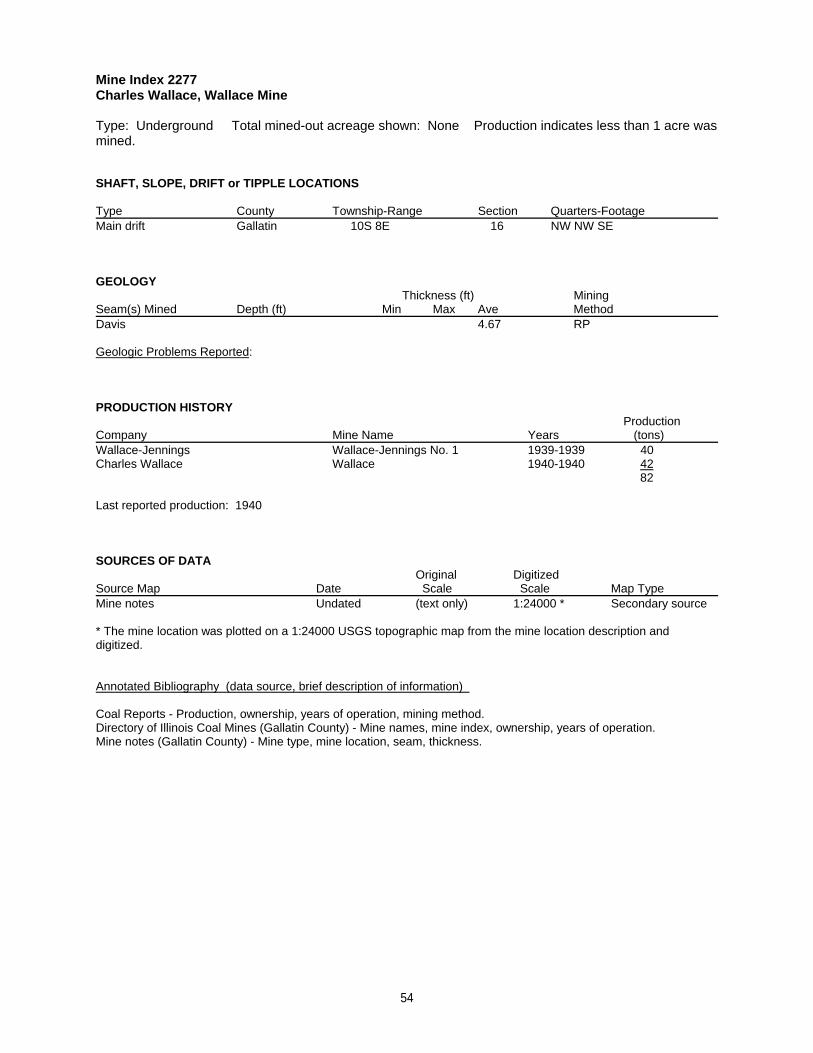
Mine Index 2277Charles Wallace, Wallace Mine
Type: Underground Total mined-out acreage shown: None Production indicates less than 1 acre wasmined.
SHAFT, SLOPE, DRIFT or TIPPLE LOCATIONS
Type County Township-Range Section Quarters-FootageMain drift Gallatin 10S 8E 16 NW NW SE
GEOLOGY Thickness (ft) Mining
Seam(s) Mined Depth (ft) Min Max Ave MethodDavis 4.67 RP
Geologic Problems Reported:
PRODUCTION HISTORY Production
Company Mine Name Years (tons) Wallace-Jennings Wallace-Jennings No. 1 1939-1939 40Charles Wallace Wallace 1940-1940 42
82
Last reported production: 1940
SOURCES OF DATAOriginal Digitized
Source Map Date Scale Scale Map Type Mine notes Undated (text only) 1:24000 * Secondary source
* The mine location was plotted on a 1:24000 USGS topographic map from the mine location description anddigitized.
Annotated Bibliography (data source, brief description of information)
Coal Reports - Production, ownership, years of operation, mining method.Directory of Illinois Coal Mines (Gallatin County) - Mine names, mine index, ownership, years of operation.Mine notes (Gallatin County) - Mine type, mine location, seam, thickness.
54

Mine Index 2279John T. Barnett, Barnett Mine
Type: Underground Total mined-out acreage shown: None Production indicates less than 1 acre wasmined. This mine not shown on the accompanying map because of later surface mining by the I-1 SurfaceMine (mine index 1004).
SHAFT, SLOPE, DRIFT or TIPPLE LOCATIONS
Type County Township-Range Section Quarters-FootageMain slope Gallatin 10S 8E 17 SE SW SE
GEOLOGY Thickness (ft) Mining
Seam(s) Mined Depth (ft) Min Max Ave MethodDavis 10 4.0 RP
Geologic Problems Reported:
PRODUCTION HISTORY Production
Company Mine Name Years (tons) John T. Barnett Barnett 1938-1938 107
107
Last reported production: 1938
SOURCES OF DATAOriginal Digitized
Source Map Date Scale Scale Map Type ISGS mined-out area map, area 32 1950 1:62500 1:62500 Secondary source
Annotated Bibliography (data source, brief description of information)
Coal Reports - Production, ownership, years of operation.Directory of Illinois Coal Mines (Gallatin County) - Mine names, mine index, ownership, years of operation.Mine notes (Gallatin County) - Mine type, slope location, seam, depth, thickness.ISGS mined-out area map, area 32 - Slope location.
55

Mine Index 2280Peck & Price, Peck & Price Mine
Type: Underground Total mined-out acreage shown: None Production indicates less than 1 acre wasmined. This mine is not shown on the accompanying map because of later surface mining by the I-1Surface Mine (mine index 1004).
SHAFT, SLOPE, DRIFT or TIPPLE LOCATIONS
Type County Township-Range Section Quarters-FootageMain slope Gallatin 10S 8E 17 SW SW NE
GEOLOGY Thickness (ft) Mining
Seam(s) Mined Depth (ft) Min Max Ave MethodSpringfield RP
Geologic Problems Reported:
PRODUCTION HISTORY Production
Company Mine Name Years (tons) Frank Patton Patton 1937-1937 112Peek & Price Peek & Price 1938-1938 35
147
Last reported production: 1938
SOURCES OF DATAOriginal Digitized
Source Map Date Scale Scale Map Type Mine notes Undated (text only) 1:24000 * Secondary source
* The mine location was plotted on a 1:24000 USGS topographic map from the mine location description anddigitized.
Annotated Bibliography (data source, brief description of information)
Coal Reports - Production, ownership, years of operation.Directory of Illinois Coal Mines (Gallatin County) - Mine names, mine index, ownership, years of operation.Mine notes (Gallatin County) - Mine type, slope location, seam.
56
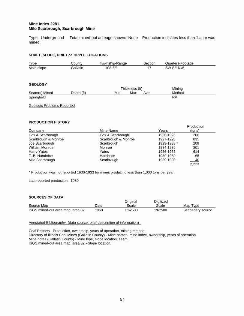
Mine Index 2281Milo Scarbrough, Scarbrough Mine
Type: Underground Total mined-out acreage shown: None Production indicates less than 1 acre wasmined.
SHAFT, SLOPE, DRIFT or TIPPLE LOCATIONS
Type County Township-Range Section Quarters-FootageMain slope Gallatin 10S 8E 17 SW SE NW
GEOLOGY Thickness (ft) Mining
Seam(s) Mined Depth (ft) Min Max Ave MethodSpringfield RP
Geologic Problems Reported:
PRODUCTION HISTORY Production
Company Mine Name Years (tons) Cox & Scarbrough Cox & Scarbrough 1926-1926 260Scarbrough & Monroe Scarbrough & Monroe 1927-1928 835Joe Scarbrough Scarbrough 1929-1933 * 208William Monroe Monroe 1934-1935 201Harry Yates Yates 1936-1938 614T. B. Hambrice Hambrice 1939-1939 65Milo Scarbrough Scarbrough 1939-1939 40
2,223
* Production was not reported 1930-1933 for mines producing less than 1,000 tons per year.
Last reported production: 1939
SOURCES OF DATAOriginal Digitized
Source Map Date Scale Scale Map Type ISGS mined-out area map, area 32 1950 1:62500 1:62500 Secondary source
Annotated Bibliography (data source, brief description of information)
Coal Reports - Production, ownership, years of operation, mining method.Directory of Illinois Coal Mines (Gallatin County) - Mine names, mine index, ownership, years of operation.Mine notes (Gallatin County) - Mine type, slope location, seam.ISGS mined-out area map, area 32 - Slope location.
57

Mine Index 2282Gilbert Milligan, Milligan Mine
Type: Underground Total mined-out acreage shown: 1 Production indicates less than 1 acre wasmined after the map date. Most of this mine was later surface mined by the I-1 Surface Mine (mine index1004).
SHAFT, SLOPE, DRIFT or TIPPLE LOCATIONS
Type County Township-Range Section Quarters-FootageMain slope Gallatin 10S 8E 17 SE SW NE
GEOLOGY Thickness (ft) Mining
Seam(s) Mined Depth (ft) Min Max Ave MethodSpringfield 30 4.67
Geologic Problems Reported: The source map indicates that the northern part of the mine and some rooms on theeastern side are old works and they had caved.
PRODUCTION HISTORY Production
Company Mine Name Years (tons) Frank McDonald McDonald 1938-1939 * 478W. H. McDonald McDonald No. 2 1940-1945 ** 833Gilbert Millikin Millikin 1945-1945 32W. H. McDonald McDonald 1946-1947 1,300Gilbert Milligan Milligan 1948-1948 794Gilbert Miligan Miligan 1948-1950 1,944 ***
5,381
* Idle 1939** Idle 1941 & 1943*** Production after map date
Last reported production: 1950
SOURCES OF DATAOriginal Digitized
Source Map Date Scale Scale Map Type Microfilm, document 351551 10-8-1948 1:1200 1:1200 Not final
Annotated Bibliography (data source, brief description of information)
Coal Reports - Production, ownership, years of operation.Directory of Illinois Coal Mines (Gallatin County) - Mine names, mine index, ownership, years of operation.Mine notes (Gallatin County) - Mine type, seam, depth, thickness.Microfilm map, document 351551, reel 03136, frame 319 - Slope location, mine outline, mining method, geologic problems.
58

Mine Index 2283P. & C. Coal Company, P. & C. Mine
Type: Underground Total mined-out acreage shown: None Production indicates less than 1 acre wasmined. This mine is not shown on the accompanying map because of later surface mining by the I-1Surface Mine (mine index 1004).
SHAFT, SLOPE, DRIFT or TIPPLE LOCATIONS
Type County Township-Range Section Quarters-FootageMain slope Gallatin 10S 8E 17 NW SE NE
GEOLOGY Thickness (ft) Mining
Seam(s) Mined Depth (ft) Min Max Ave MethodSpringfield
Geologic Problems Reported:
PRODUCTION HISTORY Production
Company Mine Name Years (tons) P. & C. Coal Company * P. & C. 1950-1953 2,617
2,617
* A note in the Coal Report indicates this is Pulliam & Certain.
Last reported production: June 1953
SOURCES OF DATAOriginal Digitized
Source Map Date Scale Scale Map Type ISGS mined-out area map, area 32 1950 1:62500 1:62500 Secondary source
Annotated Bibliography (data source, brief description of information)
Coal Reports - Production, ownership, years of operation.Directory of Illinois Coal Mines (Gallatin County) - Mine names, mine index, ownership, years of operation.Mine notes (Gallatin County) - Mine type, slope location.ISGS mined-out area map, area 32 - Slope location.
59

Mine Index 2284Richardson Coal Corporation, Richardson No. 5 Mine
Type: Surface Total mined-out acreage shown: 3 All of the production reported is after the map date. Richardson may have augered along the highwall of an existing mine, or Richardson may have enlargedan existing surface mine.
SHAFT, SLOPE, DRIFT or TIPPLE LOCATIONS
Type County Township-Range Section Quarters-FootagePit Gallatin 10S 8E 24 NE
GEOLOGY Thickness (ft) Mining
Seam(s) Mined Depth (ft) Min Max Ave MethodSpringfield Surface
Geologic Problems Reported:
PRODUCTION HISTORY Production
Company Mine Name Years (tons) Richardson Coal Corporation Richardson No. 5 1957-1959 * 16,150 **
16,150
* The mine opened November 1957, but no production was reported for that year.** Production after map date
Last reported production: October 1959
SOURCES OF DATAOriginal Digitized
Source Map Date Scale Scale Map Type Microfilm, document 351529 2-25-1956 1:2400 1:2648 Not final
Annotated Bibliography (data source, brief description of information)
Coal Reports - Production, ownership, years of operation.Directory of Illinois Coal Mines (Gallatin County) - Mine names, mine index, ownership, years of operation.Mine notes (Gallatin County) - Mine location, mining method.Microfilm map, document 351529, reel 03136, frame 289 - Mine outline, mining method.
60
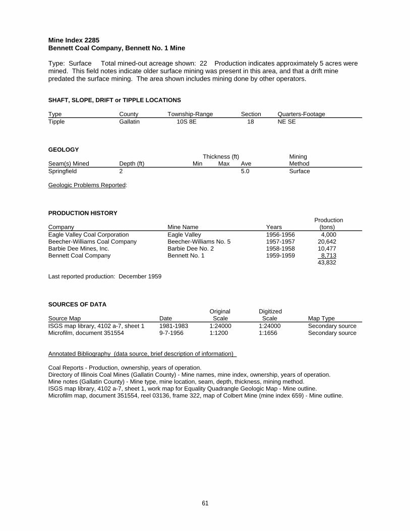
Mine Index 2285Bennett Coal Company, Bennett No. 1 Mine
Type: Surface Total mined-out acreage shown: 22 Production indicates approximately 5 acres weremined. This field notes indicate older surface mining was present in this area, and that a drift minepredated the surface mining. The area shown includes mining done by other operators.
SHAFT, SLOPE, DRIFT or TIPPLE LOCATIONS
Type County Township-Range Section Quarters-FootageTipple Gallatin 10S 8E 18 NE SE
GEOLOGY Thickness (ft) Mining
Seam(s) Mined Depth (ft) Min Max Ave MethodSpringfield 2 5.0 Surface
Geologic Problems Reported:
PRODUCTION HISTORY Production
Company Mine Name Years (tons) Eagle Valley Coal Corporation Eagle Valley 1956-1956 4,000Beecher-Williams Coal Company Beecher-Williams No. 5 1957-1957 20,642Barbie Dee Mines, Inc. Barbie Dee No. 2 1958-1958 10,477Bennett Coal Company Bennett No. 1 1959-1959 8,713
43,832
Last reported production: December 1959
SOURCES OF DATAOriginal Digitized
Source Map Date Scale Scale Map Type ISGS map library, 4102 a-7, sheet 1 1981-1983 1:24000 1:24000 Secondary sourceMicrofilm, document 351554 9-7-1956 1:1200 1:1656 Secondary source
Annotated Bibliography (data source, brief description of information)
Coal Reports - Production, ownership, years of operation.Directory of Illinois Coal Mines (Gallatin County) - Mine names, mine index, ownership, years of operation.Mine notes (Gallatin County) - Mine type, mine location, seam, depth, thickness, mining method.ISGS map library, 4102 a-7, sheet 1, work map for Equality Quadrangle Geologic Map - Mine outline.Microfilm map, document 351554, reel 03136, frame 322, map of Colbert Mine (mine index 659) - Mine outline.
61

Mine Index 2287Richardson Coal Corporation, Richardson No. 1 Mine
Type: Surface Total mined-out acreage shown: 7
SHAFT, SLOPE, DRIFT or TIPPLE LOCATIONS
Type County Township-Range Section Quarters-FootageTipple Gallatin 10S 8E 24 SE NW NEPit Gallatin 10S 8E 24 NW NW NE
GEOLOGY Thickness (ft) Mining
Seam(s) Mined Depth (ft) Min Max Ave MethodHerrin 17 3.83 Surface
Geologic Problems Reported:
PRODUCTION HISTORY Production
Company Mine Name Years (tons) Richardson Coal Corporation Richardson No. 1 1955-1959 * 112,036
112,036
* Idle 1957 & 1958
Last reported production: November 1959
SOURCES OF DATAOriginal Digitized
Source Map Date Scale Scale Map Type USGS topographic map 1959 ** 1:24000 1:24000 Secondary sourceMine notes 8-7-1956 (text only) 1:24000 ** Secondary source
** This surface-mined area was later expanded by the Eagle Surface Mine (mine index 883) and the area mined byRichardson No. 1 is better shown on the 1959 version of the Equality Quadrangle. The mine location was taken fromthe mine notes to identify the surface-mined area of the Richardson No. 1 Mine shown on the topographic map.
Annotated Bibliography (data source, brief description of information)
Coal Reports - Production, ownership, years of operation.Directory of Illinois Coal Mines (Gallatin County) - Mine names, mine index, ownership, years of operation.Mine notes (Gallatin County) - Mine type, mine location, seam, depth, thickness, mining method.USGS topographic map, Equality Quadrangle, 1959 - Mine outline.
62

Mine Index 2288Sam Black, Black Mine
Type: Underground Total mined-out acreage shown: Less than 1 Production indicates less than 1acre was mined after the map date.
SHAFT, SLOPE, DRIFT or TIPPLE LOCATIONS
Type County Township-Range Section Quarters-FootageMain slope Gallatin 10S 8E 24 NE SE NWAir slope Gallatin 10S 8E 24 NE SE NW
GEOLOGY Thickness (ft) Mining
Seam(s) Mined Depth (ft) Min Max Ave MethodSpringfield RPB
Geologic Problems Reported:
PRODUCTION HISTORY Production
Company Mine Name Years (tons) Sam Black Black 1919-1929 11,955 *Sam Black Black 1929-1940 ** 330 **
12,285
* Production not reported in 1922 for mines producing less than 10,000 tons, and idle 1926** Production after map date; production not reported 1930-1933 for mines producing less than 1,000 tons per year.
Last reported production: 1940
SOURCES OF DATAOriginal Digitized
Source Map Date Scale Scale Map Type Microfilm, document 351552 4-30-1929 1:1200 1:1324 Not final
Annotated Bibliography (data source, brief description of information)
Coal Reports - Production, ownership, years of operation.Directory of Illinois Coal Mines (Gallatin County) - Mine names, mine index, ownership, years of operation.ENR Document 85/01 - Mining method.Mine notes (Gallatin County) - Mine type, seam.Microfilm map, document 351552, reel 03136, frame 320 - Slope locations, mine outline, mining method.
63

Mine Index 2295Walter Finnie, Finnie Mine
Type: Underground Total mined-out acreage shown: None Production indicates less than 1 acre wasmined. This mine is not shown on the accompanying maps. The location as shown is south of the coaloutcrops. The Finnie Mine is probably further north than stated in the mine notes and later surface minedby the Eagle Surface Mine (mine index 883).
SHAFT, SLOPE, DRIFT or TIPPLE LOCATIONS
Type County Township-Range Section Quarters-FootageMain slope Gallatin 10S 9E 19 NW SE NW
GEOLOGY Thickness (ft) Mining
Seam(s) Mined Depth (ft) Min Max Ave MethodSpringfield RP
Geologic Problems Reported:
PRODUCTION HISTORY Production
Company Mine Name Years (tons) Walter Finnie Finnie 1938-1938 87
87
Last reported production: 1938
SOURCES OF DATAOriginal Digitized
Source Map Date Scale Scale Map Type Mine notes Undated (text only) 1:24000 * Secondary source
* The mine location was plotted on a 1:24000 USGS topographic map from the mine location description anddigitized.
Annotated Bibliography (data source, brief description of information)
Coal Reports - Production, ownership, years of operation, mining method.Directory of Illinois Coal Mines (Gallatin County) - Mine names, mine index, ownership, years of operation.Mine notes (Gallatin County) - Mine type, slope location, seam.
64

Mine Index 3335Herod Mining Corporation, Herod No. 1 Mine
Type: Surface Total mined-out acreage shown: 13 Production indicates between 30 and 50 acreswere mined.
SHAFT, SLOPE, DRIFT or TIPPLE LOCATIONS
Type County Township-Range Section Quarters-FootageTipple / pit Saline 10S 7E 24 NE SE NE
GEOLOGY Thickness (ft) Mining
Seam(s) Mined Depth (ft) Min Max Ave MethodDekoven SurfaceDavis 3.29 Surface
Geologic Problems Reported:
PRODUCTION HISTORY Production
Company Mine Name Years (tons) Herod Mining Corporation Herod No. 1 1961-1964 336,949
336,949
Last reported production: September 1964
SOURCES OF DATAOriginal Digitized
Source Map Date Scale Scale Map Type ISGS map library, 4102 a-7, sheet 2 1981-1983 1:24000 1:24000 Secondary source
Annotated Bibliography (data source, brief description of information)
Coal Reports - Production, ownership, years of operation.Directory of Illinois Coal Mines (Saline County) - Mine names, mine index, ownership, years of operation.Mine notes (Saline County) - Tipple / pit location, seam.ISGS field notes (Saline County) - Mining method, tipple / pit location, seam, thickness.ISGS map library, 4102 a-7, sheet 2, work map for Rudement Quadrangle Geologic Map - Mine outline.
65

Mine Index 4174Robert Pierson, Pierson Mine
Type: Underground Total mined-out acreage shown: None Production indicates less than 1 acre wasmined.
SHAFT, SLOPE, DRIFT or TIPPLE LOCATIONS
Type County Township-Range Section Quarters-FootageMain shaft Gallatin 9S 8E 16 SW NW NW
GEOLOGY Thickness (ft) Mining
Seam(s) Mined Depth (ft) Min Max Ave MethodHerrin 50 4.0 RP
Geologic Problems Reported:
PRODUCTION HISTORY Production
Company Mine Name Years (tons) Robert Pierson Pierson 1899-1900 200
200
Last reported production: 1900
SOURCES OF DATAOriginal Digitized
Source Map Date Scale Scale Map Type Mine notes Undated (text only) 1:24000 * Secondary source
* The mine location was plotted on a 1:24000 USGS topographic map from the mine location description anddigitized.
Annotated Bibliography (data source, brief description of information)
Coal Reports - Production, ownership, years of operation, depth, thickness, mining method.Directory of Illinois Coal Mines (Gallatin County) - Mine names, mine index, ownership, years of operation, mine Type, shaft location, seam.Mine notes (Gallatin County) - Mine location.
66

Mine Index 4175Jo Lor Mining Company, Jo Lor Mine
Type: Surface Total mined-out acreage shown: 20
SHAFT, SLOPE, DRIFT or TIPPLE LOCATIONS
Type County Township-Range Section Quarters-FootageTipple Gallatin 10S 8E 19 NE NW NW
GEOLOGY Thickness (ft) Mining
Seam(s) Mined Depth (ft) Min Max Ave MethodDekoven Surface
Geologic Problems Reported:
PRODUCTION HISTORY Production
Company Mine Name Years (tons) Jo Lor Mining Company Jo Lor 1966-1967 128,299
128,299
Last reported production: September 1967
SOURCES OF DATAOriginal Digitized
Source Map Date Scale Scale Map Type ISGS map library, 4102 a-7, sheet 1 1981-1983 1:24000 1:24000 Secondary source
Annotated Bibliography (data source, brief description of information)
Coal Reports - Production, ownership, years of operation.Directory of Illinois Coal Mines (Gallatin County) - Mine names, mine index, ownership, years of operation.Mine notes (Gallatin County) - Mine type, mine location, seam, mining method.ISGS map library, 4102 a-7, sheet 1, work map for Equality Quadrangle Geologic Map - Mine outline.
67

Mine Index 4177K. & W. Coal Company, K. & W. No. 2 Mine
Type: Surface Total mined-out acreage shown: 17 Production indicates approximately 5 acres weremined.
SHAFT, SLOPE, DRIFT or TIPPLE LOCATIONS
Type County Township-Range Section Quarters-FootagePit Gallatin 10S 8E 14 SE
GEOLOGY Thickness (ft) Mining
Seam(s) Mined Depth (ft) Min Max Ave MethodHerrin Surface
Geologic Problems Reported:
PRODUCTION HISTORY Production
Company Mine Name Years (tons) K. & W. Coal Company K. & W. No. 2 1958-1959 37,328
37,328
Last reported production: May 1959
SOURCES OF DATAOriginal Digitized
Source Map Date Scale Scale Map Type Coal Section files, 6-205 5-1-1977 1:1200 1:1200 Secondary source
Annotated Bibliography (data source, brief description of information)
Coal Reports - Production, ownership, years of operation.Directory of Illinois Coal Mines (Gallatin County) - Mine names, mine index, ownership, years of operation.Mine notes (Gallatin County) - Mine type, mine location, seam, mining method.Coal Section files, 6-205, map of Eagle Surface Mine (mine index 883) - Mine outline.
68

Mine Index 4574Hines Brothers Mining Company, Hines Brothers Mine
Type: Underground Total mined-out acreage shown: 1
SHAFT, SLOPE, DRIFT or TIPPLE LOCATIONS
Type County Township-Range Section Quarters-FootageMain drift Gallatin 10S 8E 5 NE SW NWAir shaft Gallatin 10S 8E 5 NE SW NW
GEOLOGY Thickness (ft) Mining
Seam(s) Mined Depth (ft) Min Max Ave MethodSpringfield RPB
Geologic Problems Reported:
PRODUCTION HISTORY Production
Company Mine Name Years (tons) William Johnson Johnson 1938-1938 50Hines Brothers Mining Company Hines Brothers 1951-1951 4,518
4,568
Last reported production: 1951
SOURCES OF DATAOriginal Digitized
Source Map Date Scale Scale Map Type Microfilm, document 351537 12-1-1951 1:600 1:910 Final
Annotated Bibliography (data source, brief description of information)
Directory of Illinois Coal Mines (Gallatin County) - Mine names, mine index, ownership, years of operation, mine location, seam, mining method.ENR Document 85/01 - Mining method.Microfilm map, document 351537, reel 03136, frame 302 - Mine outline, mine location, mining method.
69

Mine Index 4576Charles O. Purcell, Purcell Mine
Type: Underground Total mined-out acreage shown: None Production indicates less than 1 acre wasmined.
SHAFT, SLOPE, DRIFT or TIPPLE LOCATIONS
Type County Township-Range Section Quarters-FootageMine Gallatin 10S 8E 10 SW SW SW
GEOLOGY Thickness (ft) Mining
Seam(s) Mined Depth (ft) Min Max Ave MethodHerrin 3.5-6.42
Geologic Problems Reported: The coal had 3 or more clay lenses and bands. The upper 2 feet of coal was left tosupport the roof, and the lower 4 feet was mined.
PRODUCTION HISTORY Production
Company Mine Name Years (tons) Charles O. Purcell Purcell 1917-1920 700
700
Last reported production: 1920
SOURCES OF DATAOriginal Digitized
Source Map Date Scale Scale Map Type ISGS mined-out area map, area 32 1950 1:62500 1:62500 Secondary source
Annotated Bibliography (data source, brief description of information)
Coal Reports - Production, ownership, years of operation.Directory of Illinois Coal Mines (Gallatin County) - Mine names, mine index, ownership, years of operation.ENR Document 85/01 - Mining method.ISGS field notes (Gallatin County) - Mine location, seam, thickness, geologic problems.ISGS mined-out area map, area 32 - Mine location.
70

Mine Index 4580Beecher-Williams Coal Company, Beecher-Williams No. 4 Mine
Type: Surface Total mined-out acreage shown: Less than 1 Production indicates approximately 2acres were mined.
SHAFT, SLOPE, DRIFT or TIPPLE LOCATIONS
Type County Township-Range Section Quarters-FootagePit Gallatin 10S 8E 17 SW NE
GEOLOGY Thickness (ft) Mining
Seam(s) Mined Depth (ft) Min Max Ave MethodSpringfield 25 4.5 Surface
Geologic Problems Reported:
PRODUCTION HISTORY Production
Company Mine Name Years (tons) Beecher-Williams Coal Company Beecher-Williams No. 4 1956-1957 17,766
17,766
Last reported production: June 1957
SOURCES OF DATAOriginal Digitized
Source Map Date Scale Scale Map Type USGS topographic map PR 1990 1:24000 1:24000 Secondary source
Annotated Bibliography (data source, brief description of information)
Coal Reports - Production, ownership, years of operation.Directory of Illinois Coal Mines (Gallatin County) - Mine names, mine index, ownership, years of operation.ENR Document 85/01 - Mining method.Mine notes (Gallatin County) - Mine type, mine location, seam, depth, thickness.USGS topographic map, Equality Quadrangle, 1959, photorevised 1990 - Mine outline.
71

Mine Index 4594Andy Boster, Boster Mine
Type: Underground Total mined-out acreage shown: None Production indicates less than 1 acre wasmined.
SHAFT, SLOPE, DRIFT or TIPPLE LOCATIONS
Type County Township-Range Section Quarters-FootageMine Gallatin 10S 8E 24 SE SW SW
GEOLOGY Thickness (ft) Mining
Seam(s) Mined Depth (ft) Min Max Ave MethodWillis
Geologic Problems Reported:
PRODUCTION HISTORY Production
Company Mine Name Years (tons) Andy Boster Boster 1934-1936 126
126
Last reported production:
SOURCES OF DATAOriginal Digitized
Source Map Date Scale Scale Map Type ISGS mined-out area map, area 32 1950 1:62500 1:62500 Secondary source
Annotated Bibliography (data source, brief description of information)
Directory of Illinois Coal Mines (Gallatin County) - Mine names, mine index, ownership.ENR Document 85/01 - Mining method.Mine notes (Gallatin County) - Mine location.ISGS mined-out area map, area 32 - Mine location.
72

Mine Index 4690Saline Gas Coal Company, Saline Gas Mine
Type: Underground Total mined-out acreage shown: None
SHAFT, SLOPE, DRIFT or TIPPLE LOCATIONS
Type County Township-Range Section Quarters-FootageMine Gallatin 9S 8E 19 SW NW NW
GEOLOGY Thickness (ft) Mining
Seam(s) Mined Depth (ft) Min Max Ave MethodSpringfield
Geologic Problems Reported:
PRODUCTION HISTORY Production
Company Mine Name Years (tons) Saline Gas Coal Company Saline Gas before 1950 *
* This company was not listed in the Coal Reports for Gallatin County. The production may have been reported inSaline County. Saline Gas Company mined near Harrisburg, with their No. 1 Mine operating 1917-1924 (mine index3292) and the No. 3 Mine remaining unlocated near Harrisburg, and operating in 1927.
Last reported production:
SOURCES OF DATAOriginal Digitized
Source Map Date Scale Scale Map Type ISGS mined-out area map, area 32 1950 1:62500 1:62500 Secondary source
Annotated Bibliography (data source, brief description of information)
Directory of Illinois Coal Mines (Gallatin County) - Mine names, mine index, ownership.ISGS mined-out area map, area 32 - Mine location.
73

Mine Index 4765Black, Clifton & Moore, Black, Clifton & Moore Mine
Type: Underground Total mined-out acreage shown: Less than 1 This mine was later partiallysurface mined by the Eagle Surface Mine (mine index 883).
SHAFT, SLOPE, DRIFT or TIPPLE LOCATIONS
Type County Township-Range Section Quarters-FootageMain slope Gallatin 10S 8E 23 NW NE NE
GEOLOGY Thickness (ft) Mining
Seam(s) Mined Depth (ft) Min Max Ave MethodSpringfield 28 5.0 RP
Geologic Problems Reported:
PRODUCTION HISTORY Production
Company Mine Name Years (tons) John E. Vaught Vaught 1936-1937 336Clifford Moore Moore 1937-1938 342Moore & Miles Coal Company Moore & Miles 1939-1939 266C. Moore & R. A. Black Moore & Black 1940-1940 429R. Black, Clifton & Moore Black, Clifton & Moore 1941-1941 239
1,612
Last reported production: 1941
SOURCES OF DATAOriginal Digitized
Source Map Date Scale Scale Map Type Microfilm, document 351549 11-7-1954 1:1200 1:2148 Secondary source
Annotated Bibliography (data source, brief description of information)
Coal Reports - Production, ownership, years of operation.Directory of Illinois Coal Mines (Gallatin County) - Mine names, mine index, ownership, years of operation.ENR Document 85/01 - Mining method.Mine notes (Gallatin County) - Mine type, slope location, seam, depth, thickness, geologic problems.Microfilm map, document 351549, reel 03136, frame 317, map of Sun Valley Mine (mine index 712) - Slope location, mine outline, mining method.
74

Mine Index 4955Jesse Purcell, Purcell Mine
Type: Underground Total mined-out acreage shown: None Production indicates less than 1 acre wasmined.
SHAFT, SLOPE, DRIFT or TIPPLE LOCATIONS
Type County Township-Range Section Quarters-FootageMain drift Gallatin 9S 8E 16 SW NW NW
GEOLOGY Thickness (ft) Mining
Seam(s) Mined Depth (ft) Min Max Ave MethodHerrin 4.17
Geologic Problems Reported:
PRODUCTION HISTORY Production
Company Mine Name Years (tons) Jesse Purcell Purcell 1889-1890 320
320
Last reported production: 1890
SOURCES OF DATAOriginal Digitized
Source Map Date Scale Scale Map Type ISGS map library, 4107 d5.1-209 1927 1:62500 1:62500 Secondary source
Annotated Bibliography (data source, brief description of information)
Coal Reports - Production, ownership, years of operation.Directory of Illinois Coal Mines (Gallatin County) - Mine names, mine index, ownership, years of operation.ISGS field notes (Gallatin County) - Mine type, drift location, seam.ISGS map library, 4107 d5.1-209, map of G. H. Cady field notes - Mine type, drift location, seam.ISGS Bulletin 8, Plate 9 - Thickness.
75

Mine Index 6846Ginniville Mining Company, Ginniville Mine
Type: Underground Total mined-out acreage shown: None Production for this mine is unknown.
SHAFT, SLOPE, DRIFT or TIPPLE LOCATIONS
Type County Township-Range Section Quarters-FootageSlope Gallatin 9S 8E 23 NE SW NE *
* This location is very uncertain. The location is based on a written description which says that this mine is locatednear the intersection of the L & N Railroad and Route 13.
GEOLOGY Thickness (ft) Mining
Seam(s) Mined Depth (ft) Min Max Ave MethodSpringfield
Geologic Problems Reported:
PRODUCTION HISTORY Production
Company Mine Name Years (tons) Ginniville Mining Company ** Ginniville -1929 unknown ***
** No other information is known about this mine. This mine may have reported under another name. The mine wassaid to be owned by Samuel Hall Sisk.*** No production was listed in the Coal Reports under this name.
Last reported production: 1920
SOURCES OF DATAOriginal Digitized
Source Map Date Scale Scale Map Type History & Families of Gallatin Co. 1988 (text only) 1:24000 * Secondary source
* The mine location was plotted on a 1:24000 USGS topographic map from the mine location description anddigitized.
Annotated Bibliography (data source, brief description of information)
Directory of Illinois Coal Mines (Gallatin County) - Mine name, mine index, ownership, years of operation.History & Families of Gallatin County, Illinois, Volume I, 1988, page 16 - Ownership, mine type, slope location.
76

Mine Index 7041Frank Green, Green Mine
Type: Underground Total mined-out acreage shown: None Production indicates less than 1 acre wasmined.
SHAFT, SLOPE, DRIFT or TIPPLE LOCATIONS
Type County Township-Range Section Quarters-FootageMine Gallatin 9S 8E 15 NW NE
GEOLOGY Thickness (ft) Mining
Seam(s) Mined Depth (ft) Min Max Ave MethodHerrin 3.5
Geologic Problems Reported:
PRODUCTION HISTORY Production
Company Mine Name Years (tons) Frank Green Green 1919-1920 20
20
Last reported production: 1920
SOURCES OF DATAOriginal Digitized
Source Map Date Scale Scale Map Type ISGS Bulletin 47, Plate 3 1925 (text only) 1:24000 * Secondary source
* The mine location was plotted on a 1:24000 USGS topographic map from the mine location description anddigitized.
Annotated Bibliography (data source, brief description of information)
Coal Reports - Production, ownership, years of operation.Directory of Illinois Coal Mines (Gallatin County) - Mine name, mine index, ownership, years of operation.ISGS Bulletin 47, Plate 3 - Mine location, seam, thickness.
77
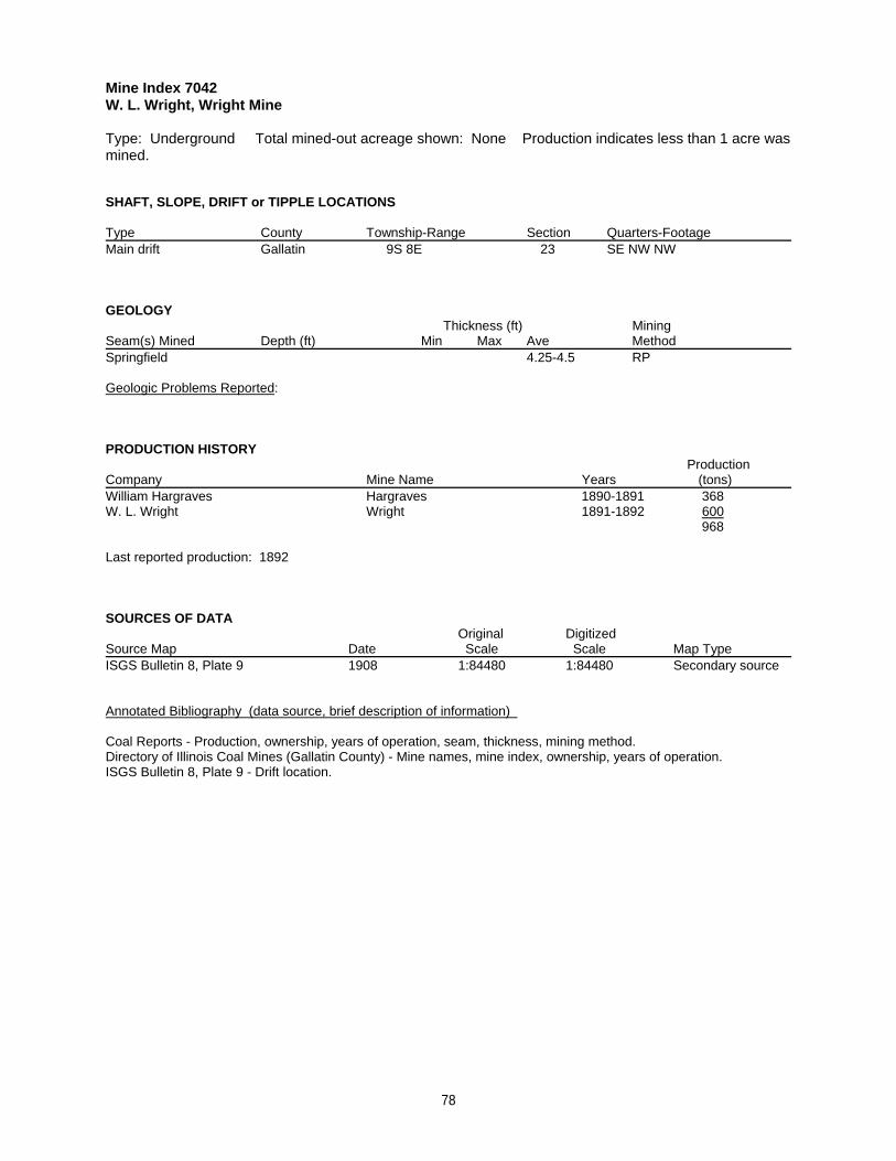
Mine Index 7042W. L. Wright, Wright Mine
Type: Underground Total mined-out acreage shown: None Production indicates less than 1 acre wasmined.
SHAFT, SLOPE, DRIFT or TIPPLE LOCATIONS
Type County Township-Range Section Quarters-FootageMain drift Gallatin 9S 8E 23 SE NW NW
GEOLOGY Thickness (ft) Mining
Seam(s) Mined Depth (ft) Min Max Ave MethodSpringfield 4.25-4.5 RP
Geologic Problems Reported:
PRODUCTION HISTORY Production
Company Mine Name Years (tons) William Hargraves Hargraves 1890-1891 368W. L. Wright Wright 1891-1892 600
968
Last reported production: 1892
SOURCES OF DATAOriginal Digitized
Source Map Date Scale Scale Map Type ISGS Bulletin 8, Plate 9 1908 1:84480 1:84480 Secondary source
Annotated Bibliography (data source, brief description of information)
Coal Reports - Production, ownership, years of operation, seam, thickness, mining method.Directory of Illinois Coal Mines (Gallatin County) - Mine names, mine index, ownership, years of operation.ISGS Bulletin 8, Plate 9 - Drift location.
78
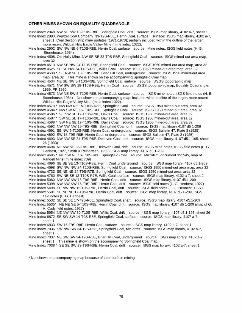
OTHER MINES SHOWN ON EQUALITY QUADRANGLE
Mine Index 2048 NW NE NW 18-T10S-R8E, Springfield Coal, drift source: ISGS map library, 4102 a-7, sheet 1Mine Index 2880, Wenzel Coal Company 33-T9S-R8E, Herrin Coal, surface surface: ISGS map library, 4102 a-7,
sheet 1, Coal Section strip mine updates (1971-1973); partially included within the outline of the larger,more recent Wildcat Hills Eagle Valley Mine (mine index 1022).
Mine Index 2902 SW NW NE 6-T10S-R8E, Herrin Coal, surface source: Mine notes, ISGS field notes (H. B. Stonehouse, 1954)
Mine Index 4508, Old Holly Mine NW SE SE 33-T9S-R8E, Springfield Coal source: ISGS mined-out area map,area 32
Mine Index 4510 NW SE NW 24-T10S-R8E, Springfield Coal source: ISGS 1950 mined-out area map, area 32Mine Index 4525 SE SE NW 24-T10S-R8E, Willis Coal source: ISGS 1950 mined-out area map, area 32Mine Index 4530 * SE NW SE 18-T10S-R8E, Briar Hill Coal, underground source: ISGS 1950 mined-out area
map, area 32 This mine is shown on the accompanying Springfield Coal map.Mine Index 4534 NE SE NW 5-T10S-R8E, Springfield Coal, surface source: USGS topographic map Mine Index 4571 NW SW SW 18-T10S-R9E, Herrin Coal source: USGS topographic map, Equality Quadrangle,
1959, PR 1990Mine Index 4573 NW NE SW 5-T10S-R8E, Herrin Coal, surface source: ISGS mine notes, ISGS field notes (H. B.
Stonehouse, 1954) Not shown on accompanying map; included within outline of the larger, more recent Wildcat Hills Eagle Valley Mine (mine index 1022).
Mine Index 4579 * NW NW NE 15-T10S-R8E, Springfield Coal source: ISGS 1950 mined-out area, area 32Mine Index 4584 * NW SW NE 16-T10S-R8E, Springfield Coal source: ISGS 1950 mined-out area, area 32Mine Index 4586 * SE SW SE 17-T10S-R8E, Davis Coal source: ISGS 1950 mined-out area, area 32Mine Index 4587 * SW SE SE 17-T10S-R8E, Davis Coal source: ISGS 1950 mined-out area, area 32Mine Index 4588 * SW NE SE 17-T10S-R8E, Davis Coal source: ISGS 1950 mined-out area, area 32Mine Index 4592 NW NW NW 19-T9S-R8E, Springfield Coal, drift source: ISGS map library 4107 d5 1-209Mine Index 4691 SE NW 5-T10S-R8E, Herrin Coal, underground source: ISGS Bulletin 47, Plate 3 (1925)Mine Index 4692 SW 16-T9S-R8E, Herrin Coal, underground source: ISGS Bulletin 47, Plate 3 (1925)Mine Index 4693 NW NW SE 34-T9S-R8E, Dekoven Coal, drift source: ISGS map library, 4107 d5.1-195, sheet
26 (1933)Mine Index 4694 NE NW NE 36-T9S-R8E, Dekoven Coal, drift source: ISGS mine notes, ISGS field notes (L. G.
Henbest, 1927, Smith & Reinertsen, 1959), ISGS map library, 4107 d5.1-209Mine Index 4695 * NE SW NE 16-T10S-R8E, Springfield Coal source: Microfilm, document 351545, map of
Randell Mine (mine index 709)Mine Index 4696 SE SE SE 13-T10S-R8E, Herrin Coal, underground source: ISGS map library, 4107 d5.1-209Mine Index 4698 SW NW NW 24-T10S-R8E, Springfield Coal source: ISGS 1950 mined-out area map, area 32Mine Index 4733 SE NE NE 24-T9S-R7E, Springfield Coal source: ISGS 1950 mined-out area, area 32Mine Index 4760 SW NE SE 13-T10S-R7E, Willis Coal, surface source: ISGS map library, 4102 a-7, sheet 2Mine Index 5080 NW NW NW 16-T9S-R8E, Herrin Coal, drift source: ISGS map library, 4107 d5.1-209Mine Index 5398 NW NW NW 16-T9S-R8E, Herrin Coal, drift source: ISGS field notes (L. G. Henbest, 1927)Mine Index 5498 SE NW NW 16-T9S-R8E, Herrin Coal, drift source: ISGS field notes (L. G. Henbest, 1927)Mine Index 5501 SE NE NE 17-T9S-R8E, Herrin Coal, drift source: ISGS map library, 4107 d5.1-209, ISGS
field notes (L. G. Henbest)Mine Index 5532 SE SE SE 17-T9S-R8E, Springfield Coal, shaft source: ISGS map library, 4107 d5.1-209Mine Index 5535* NE NE SE 5-T10S-R8E, Herrin Coal, drift source: ISGS map library, 4107 d5 1-209 (map of G.
H. Cady field notes, 1927)Mine Index 5954 NE NW NW 30-T10S-R9E, Willis Coal, drift source: ISGS map library, 4107 d5.1-195, sheet 26Mine Index 6672 SE SW SW 14-T9S-R8E, Springfield Coal, surface source: ISGS map library, 4107 a-7,
sheet 1Mine Index 6833 SW 16-T9S-R8E, Herrin Coal, surface source: ISGS map library, 4102 a-7, sheet 1Mine Index 7036 SW NW SW 34-T9S-R8E, Springfield Coal, two drifts source: ISGS map library, 4102 a-7,
sheet 1Mine Index 7037 NE SW SW 34-T9S-R8E, Briar Hill Coal, underground source: ISGS map library, 4102 a-7,
sheet 1 This mine is shown on the accompanying Springfield Coal map.Mine Index 7038 * SE SE SW 33-T9S-R8E, Herrin Coal, drift source: ISGS map library, 4102 a-7, sheet 1
* Not shown on accompanying map because of later surface mining
79

MINES WHOSE LOCATIONS ARE NOT KNOWN, EQUALITY QUADRANGLE
The locations of the following mines are unknown, but the production tonnage, operating names, andnearest town were reported in the Annual Coal Reports. The operators listed below mined in or near theEquality Quadrangle. The information shown is similar to that presented on the summary sheets in theprevious pages of this directory. The first item is the name the mine operated under as listed in the CoalReport, then the years the mine reported. If no physical data are available, the next item listed is the totaltons produced by the mine. If physical data are available, the order of presentation is as follows: type ofopening for the mine (drift, slope or shaft), depth of coal in feet, and thickness of coal in feet.
The total tons mined by these unlocated mines is 162,304 (119,220 underground, 17,017 surface minedand 26,947 by uncertain method), which would represent approximately 29 to 48 acres, depending on therecovery factor, mining method, and numerous other factors. (Note: 1 square mile = 640 acres)
COTTAGE GROVE
Burks (William), 1908-1909, slope, Herrin, 60, 4.0, RP 160 tons
EQUALITY
Bybee (Roy), 1922-1924 880 tons Mine Index 2256
Donahoe (John), 1883-1884, drift, Herrin, 5, 4.5, RP 400 tons
Hawes (William L.), 1894-1895, slope, –, 30, 4.0-4.5, RP 1,200 tonsStader & Millspaugh, 1895-1897 4,000 tonsStader (William), 1897-1901 12,200 tonsAnderson & Demser, 1901-1902 3,600 tonsAnderson (John), 1902-1903 2,000 tons
23,000 tons
Freels (B.), 1895-1896, drift, –, 21, 4.0, RP 500 tons
Dunksey & Glover, 1895-1897, drift, –, 20, 4.0-4.33, RP 700 tonsUnderwood (John), 1897-1901 2,170 tons
2,870 tons
Rutler & Smith, 1898-1899, drift, Herrin, 25-50, 4.5, RP 1,220 tonsRutler (James), 1899-1900 1,800 tonsRutley & Godsley, 1900-1901 800 tonsRatley (J. E.), 1901-1903 3,600 tons
7,420 tons
Flanders & Brown, 1899-1900, drift, Herrin, 20, 4.0, RP 500 tonsWeedman (F. W.), 1900-1901 290 tons
790 tons
Harper (Scott), 1904-1905 150 tons
Anderson (Josh A.), 1905-1910, slope, Herrin, 26-41, 4.0-4.5, RP 17,200 tonsAnderson (E. A.), 1910-1912 2,050 tons
19,250 tons
Spitzner (Jacob), 1908-1909, slope, Herrin, 45, 4.0, RP 808 tons
Burrell (William), 1908-1909, slope, Herrin, 30, –, RP 491 tons
Guard (Charles), 1910-1911, slope, Herrin, 30, 4.0, RP 672 tons
Sisk & McLean, 1911-1912, drift, Herrin, –, 4.0, RP 1,245 tons
80

McLain (W. H.), 1913-1915, shaft, –, 20-30, 4.0-4.25, RP 3,735 tonsHarrelson (H. C.), 1915-1916 4,000 tonsGenor (Frank) & Son, 1916-1917 3,883 tons
11,618 tons
Spitzner (Jacob), 1915-1916, drift, Springfield, 14, 4.0, RP 625 tonsSpitzner & James, 1916-1917 21 tonsSpitzner (Jake), 1917-1919 683 tons
1,329 tons
Brinkley (George), 1915-1916, drift, Springfield, 350, 4.67, RP 120 tons
Dempsey (J. E.), 1917-1918 900 tons
Patton (Andrew), 1917-1921 1,580 tons
Casey (Frank), 1917-1919 141 tons
Seddon (Robert), 1919-1920 400 tons
Glover (Frank), 1919-1921 172 tons
Imboden (F. J.), 1920-1921 800 tons
Hemitt (A. J.), 1922-1923 2,000 tons
Seaville & Stite, 1922-1923 200 tons
Hogan (R. L.), 1923-1925 520 tons
Jennings (Jim), 1923-1927 1,026 tons
Trousdale & Chandler, 1923-1924 91 tons
Maple (William), 1923-1924 80 tons
Big Dip Coal Company, 1923-1924 548 tons
Brinkley (G. E.) & Company, 1923-1924 480 tons
Stewart (Wake), 1923-1924 300 tons
Potter (James), 1924-1925 320 tons
Barrowman (George S.), 1923-1924 400 tons
Kirk, Dye & Rich, 1923-1924 70 tons
Shaver (Everett) & Sons, 1925-1927 13,669 tons
Dempsey, Newman & Kinkade, 1925-1926 507 tons
Wanlen & Stoke, 1925-1925 260 tonsWanles (Tom), 1926-1926 146 tons
406 tons
Pasway (Wave), 1925-1925 100 tons
Wathen (C. C.), 1927-1927 36 tons
McConnell (Clarence), 1928-1928, underground 160 tons
Lauds & Hasselton, 1928-1928, underground 76 tons
Berkel & Cardwell, 1928-1928, underground 30 tons
81

Dorris (George W.), 1929-1929, underground 200 tons
North Side Coal Company, 1934-1935, underground 1,622 tons
County Line Coal Company, 1934-1934, underground 211 tons
White (James) & Son, 1934-1936, underground 486 tons
Dillar & Dixon, 1940-1940, underground 182 tons
Baldwin (John), 1941-1941, underground 250 tons
Producers Coal Company, 1945-1945, surface, Springfield, 20, 3.0 14,256 tons
Elliott (Hiram), No. 1 Mine, 1949-1950, underground 300 tons
New Gallatin Coal Company, 1957-1957, surface 1,697 tons
Wenzel Brothers, No. 1 Mine, December 1963 - February 1964 production not reported
Vinyard Coal Company, No. 2 Mine, 1957-1957, surface 1,000 tons
GIBSONIA
Brinkley (Marion), 1908-1909, slope, Herrin, 30-35, 4.0, RP 165 tons
HORSESHOE
Dossey (Charles), 1908-1909, slope, Herrin, 60, 4.0, RP 105 tons
JUNCTION
Dempsey (J. E.), 1911-1912, slope, –, 18, 4.33, RP 1,660 tonsChinn (W. R.), 1912-1921 27,650 tons
29,310 tons
Siddons (Lee), 1915-1917, slope, Springfield, 30, 5.0-5.5, RP 1,515 tons
Elliott Brothers, 1916-1917, slope, Springfield, 25, 4.5, RP 150 tons
Jones & Martin, 1916-1917, slope, Springfield, 20, 5.0, RP 420 tonsJones (Sam), 1917-1918 780 tonsWallace, Martin & Jones, 1918-1919 800 tonsWallace & Martin, 1919-1923 780 tonsMartin & Jones, 1923-1924 425 tonsWallace & Martin, 1924-1927 1,880 tonsMartin (J. C.), 1928-1928 650 tonsIdle 1922, 1923, 1927 5,735 tons
Dobbs (S. D.), 1917-1918 512 tons
Boatright (H.) & Tite (B.), 1922-1923, underground 100 tonsTite & Leavell, 1923-1924 190 tonsTite (Ed), 1924-1929 1,947 tons
2,237 tons
Dobbs & Willshire, 1923-1924 90 tonsDodd (E. H.), 1924-1925 375 tons
465 tons
Potter (Luther), 1923-1926, underground 515 tonsPotter (George), 1927-1928 92 tons
82

607 tons
Bostnagle (John & Henry), 1923-1924 194 tons
Black (Isaac), 1934-1935, underground 243 tons
Barnett & Beeler, 1940-1940, underground 134 tons
KEDRON
Brinkley (John S.), 1889-1893, drift, Herrin, 40, 3.67-4.0, RP 720 tons
Boston (Henry), 1910-1911, slope, Herrin, –, 4.0, RP 84 tons
LEAMINGTON
Brinkley (Marion), 1895-1898, drift/slope, Herrin, 25, 4.5-4.67, RP 2,105 tons
Thompson (Wilburn), 1895-1898, slope/drift, Herrin, 25, 4.5-4.67, RP 1,920 tons
MARION
Stubblefield (R. P.) Coal Company, 1951-1951, surface 1,761 tons
83

INDEX OF MINES IN THE EQUALITY QUADRANGLE
A. & F. Coal Company . . . . . . . . . . . . . . . . . . . . . . . . . . . . . . . . . . . . . . . . . . . . . . . . . . . . . . . . . . . . . . . . . . . . . . . 30Acme Stone & Coal Company . . . . . . . . . . . . . . . . . . . . . . . . . . . . . . . . . . . . . . . . . . . . . . . . . . . . . . . . . . . . . . . . . 22Adkins (Pearce & Adkins) . . . . . . . . . . . . . . . . . . . . . . . . . . . . . . . . . . . . . . . . . . . . . . . . . . . . . . . . . . . . . . . . . . . . . 16Allen (Harrison-Allen Coal Company) . . . . . . . . . . . . . . . . . . . . . . . . . . . . . . . . . . . . . . . . . . . . . . . . . . . . . . . . . . . . 50Allen (Harrison-Allen) . . . . . . . . . . . . . . . . . . . . . . . . . . . . . . . . . . . . . . . . . . . . . . . . . . . . . . . . . . . . . . . . . . . . . . . . 51Anderson (E. A.) . . . . . . . . . . . . . . . . . . . . . . . . . . . . . . . . . . . . . . . . . . . . . . . . . . . . . . . . . . . . . . . . . . . . . . . . . . . . 80Anderson (John) . . . . . . . . . . . . . . . . . . . . . . . . . . . . . . . . . . . . . . . . . . . . . . . . . . . . . . . . . . . . . . . . . . . . . . . . . . . . 80Anderson (Josh A.) . . . . . . . . . . . . . . . . . . . . . . . . . . . . . . . . . . . . . . . . . . . . . . . . . . . . . . . . . . . . . . . . . . . . . . . . . . 80Anderson & Demser . . . . . . . . . . . . . . . . . . . . . . . . . . . . . . . . . . . . . . . . . . . . . . . . . . . . . . . . . . . . . . . . . . . . . . . . . 80Angelly (William) . . . . . . . . . . . . . . . . . . . . . . . . . . . . . . . . . . . . . . . . . . . . . . . . . . . . . . . . . . . . . . . . . . . . . . . . . . . . 10Arclar Company, Eagle Valley Mine . . . . . . . . . . . . . . . . . . . . . . . . . . . . . . . . . . . . . . . . . . . . . . . . . . . . . . . . . . . . . 30Arclar Company, Wildcat Hills Mine . . . . . . . . . . . . . . . . . . . . . . . . . . . . . . . . . . . . . . . . . . . . . . . . . . . . . . . . . . . . . 34Austin (Jamie) & Dixon (W. B.) . . . . . . . . . . . . . . . . . . . . . . . . . . . . . . . . . . . . . . . . . . . . . . . . . . . . . . . . . . . . . . . . 53B. & W. Coal Company, No. 1 Mine . . . . . . . . . . . . . . . . . . . . . . . . . . . . . . . . . . . . . . . . . . . . . . . . . . . . . . . . . . . . . 20Baldwin (Billy) . . . . . . . . . . . . . . . . . . . . . . . . . . . . . . . . . . . . . . . . . . . . . . . . . . . . . . . . . . . . . . . . . . . . . . . . . . . . . . 44Baldwin (Brightner & Baldwin) . . . . . . . . . . . . . . . . . . . . . . . . . . . . . . . . . . . . . . . . . . . . . . . . . . . . . . . . . . . . . . . . . . 41Baldwin (Charles E.) . . . . . . . . . . . . . . . . . . . . . . . . . . . . . . . . . . . . . . . . . . . . . . . . . . . . . . . . . . . . . . . . . . . . . . . . . 44Baldwin (J. O.) . . . . . . . . . . . . . . . . . . . . . . . . . . . . . . . . . . . . . . . . . . . . . . . . . . . . . . . . . . . . . . . . . . . . . . . . . . . . . 40Baldwin (John O.) . . . . . . . . . . . . . . . . . . . . . . . . . . . . . . . . . . . . . . . . . . . . . . . . . . . . . . . . . . . . . . . . . . . . . . . . . . . 44Baldwin (John) . . . . . . . . . . . . . . . . . . . . . . . . . . . . . . . . . . . . . . . . . . . . . . . . . . . . . . . . . . . . . . . . . . . . . . . . . . . . . 82Baldwin & Turner . . . . . . . . . . . . . . . . . . . . . . . . . . . . . . . . . . . . . . . . . . . . . . . . . . . . . . . . . . . . . . . . . . . . . . . . . . . 40Barbie Dee Mines, Inc. . . . . . . . . . . . . . . . . . . . . . . . . . . . . . . . . . . . . . . . . . . . . . . . . . . . . . . . . . . . . . . . . . . . . . . . 61Barnett (Brooks & Barnett) . . . . . . . . . . . . . . . . . . . . . . . . . . . . . . . . . . . . . . . . . . . . . . . . . . . . . . . . . . . . . . . . . . . . 47Barnett (Horace) . . . . . . . . . . . . . . . . . . . . . . . . . . . . . . . . . . . . . . . . . . . . . . . . . . . . . . . . . . . . . . . . . . . . . . . . . . . . 53Barnett (John T.) . . . . . . . . . . . . . . . . . . . . . . . . . . . . . . . . . . . . . . . . . . . . . . . . . . . . . . . . . . . . . . . . . . . . . . . . . . . . 55Barnett & Beeler . . . . . . . . . . . . . . . . . . . . . . . . . . . . . . . . . . . . . . . . . . . . . . . . . . . . . . . . . . . . . . . . . . . . . . . . . . . . 83Barrowman (George S.) . . . . . . . . . . . . . . . . . . . . . . . . . . . . . . . . . . . . . . . . . . . . . . . . . . . . . . . . . . . . . . . . . . . . . . 81Beecher-Williams Coal Company, No. 4 Mine . . . . . . . . . . . . . . . . . . . . . . . . . . . . . . . . . . . . . . . . . . . . . . . . . . . . . 71Beecher-Williams Coal Company, No. 5 Mine . . . . . . . . . . . . . . . . . . . . . . . . . . . . . . . . . . . . . . . . . . . . . . . . . . . . . 61Beeler (Barnett & Beeler) . . . . . . . . . . . . . . . . . . . . . . . . . . . . . . . . . . . . . . . . . . . . . . . . . . . . . . . . . . . . . . . . . . . . . 83Bennett Coal Company, No. 1 Mine . . . . . . . . . . . . . . . . . . . . . . . . . . . . . . . . . . . . . . . . . . . . . . . . . . . . . . . . . . . . . 61Bentley Mine . . . . . . . . . . . . . . . . . . . . . . . . . . . . . . . . . . . . . . . . . . . . . . . . . . . . . . . . . . . . . . . . . . . . . . . . . . . . . . . 13Berkel (Frank & W. E.) Coal Company . . . . . . . . . . . . . . . . . . . . . . . . . . . . . . . . . . . . . . . . . . . . . . . . . . . . . . . . . . . 52Berkel & Cardwell . . . . . . . . . . . . . . . . . . . . . . . . . . . . . . . . . . . . . . . . . . . . . . . . . . . . . . . . . . . . . . . . . . . . . . . . . . . 81Berkel Brothers . . . . . . . . . . . . . . . . . . . . . . . . . . . . . . . . . . . . . . . . . . . . . . . . . . . . . . . . . . . . . . . . . . . . . . . . . . . . . 52Big Dip Coal Company . . . . . . . . . . . . . . . . . . . . . . . . . . . . . . . . . . . . . . . . . . . . . . . . . . . . . . . . . . . . . . . . . . . . . . . 81Black (Isaac) . . . . . . . . . . . . . . . . . . . . . . . . . . . . . . . . . . . . . . . . . . . . . . . . . . . . . . . . . . . . . . . . . . . . . . . . . . . . . . . 83Black (Moore & Black) . . . . . . . . . . . . . . . . . . . . . . . . . . . . . . . . . . . . . . . . . . . . . . . . . . . . . . . . . . . . . . . . . . . . . . . 74Black (Richard) . . . . . . . . . . . . . . . . . . . . . . . . . . . . . . . . . . . . . . . . . . . . . . . . . . . . . . . . . . . . . . . . . . . . . . . . . . . . . 15Black (Sam) . . . . . . . . . . . . . . . . . . . . . . . . . . . . . . . . . . . . . . . . . . . . . . . . . . . . . . . . . . . . . . . . . . . . . . . . . . . . 13, 63Black Beauty Coal Company, Wildcat Hills Cottage Grove Mine . . . . . . . . . . . . . . . . . . . . . . . . . . . . . . . . . . . . . . . 36Black Beauty Mining Company . . . . . . . . . . . . . . . . . . . . . . . . . . . . . . . . . . . . . . . . . . . . . . . . . . . . . . . . . . . . . . . . . 34Black, Clifton & Moore . . . . . . . . . . . . . . . . . . . . . . . . . . . . . . . . . . . . . . . . . . . . . . . . . . . . . . . . . . . . . . . . . . . . . . . 74Boatright (H.) & Tite (B.) . . . . . . . . . . . . . . . . . . . . . . . . . . . . . . . . . . . . . . . . . . . . . . . . . . . . . . . . . . . . . . . . . . . . . . 82Booten (J. H.) . . . . . . . . . . . . . . . . . . . . . . . . . . . . . . . . . . . . . . . . . . . . . . . . . . . . . . . . . . . . . . . . . . . . . . . . . . . . . . 14Boster (Andy) . . . . . . . . . . . . . . . . . . . . . . . . . . . . . . . . . . . . . . . . . . . . . . . . . . . . . . . . . . . . . . . . . . . . . . . . . . . . . . 72Bostnagle (John & Henry) . . . . . . . . . . . . . . . . . . . . . . . . . . . . . . . . . . . . . . . . . . . . . . . . . . . . . . . . . . . . . . . . . . . . . 83Boston (Henry) . . . . . . . . . . . . . . . . . . . . . . . . . . . . . . . . . . . . . . . . . . . . . . . . . . . . . . . . . . . . . . . . . . . . . . . . . . . . . 83Brightner (Peter) . . . . . . . . . . . . . . . . . . . . . . . . . . . . . . . . . . . . . . . . . . . . . . . . . . . . . . . . . . . . . . . . . . . . . . . . . . . . 41Brightner & Baldwin . . . . . . . . . . . . . . . . . . . . . . . . . . . . . . . . . . . . . . . . . . . . . . . . . . . . . . . . . . . . . . . . . . . . . . . . . 41Brinkley (G. E.) & Company . . . . . . . . . . . . . . . . . . . . . . . . . . . . . . . . . . . . . . . . . . . . . . . . . . . . . . . . . . . . . . . . . . . 81Brinkley (George) . . . . . . . . . . . . . . . . . . . . . . . . . . . . . . . . . . . . . . . . . . . . . . . . . . . . . . . . . . . . . . . . . . . . . . . . . . . 81Brinkley (John S.) . . . . . . . . . . . . . . . . . . . . . . . . . . . . . . . . . . . . . . . . . . . . . . . . . . . . . . . . . . . . . . . . . . . . . . . . . . . 83Brinkley (Marion) . . . . . . . . . . . . . . . . . . . . . . . . . . . . . . . . . . . . . . . . . . . . . . . . . . . . . . . . . . . . . . . . . . . . . . . . . 82, 83Brooks & Barnett . . . . . . . . . . . . . . . . . . . . . . . . . . . . . . . . . . . . . . . . . . . . . . . . . . . . . . . . . . . . . . . . . . . . . . . . . . . . 47Brown (Flanders & Brown) . . . . . . . . . . . . . . . . . . . . . . . . . . . . . . . . . . . . . . . . . . . . . . . . . . . . . . . . . . . . . . . . . . . . 80Brown (Martin & Brown) . . . . . . . . . . . . . . . . . . . . . . . . . . . . . . . . . . . . . . . . . . . . . . . . . . . . . . . . . . . . . . . . . . . . . . 24Brown Coal Company . . . . . . . . . . . . . . . . . . . . . . . . . . . . . . . . . . . . . . . . . . . . . . . . . . . . . . . . . . . . . . . . . . . . . . . . 39Burks (William) . . . . . . . . . . . . . . . . . . . . . . . . . . . . . . . . . . . . . . . . . . . . . . . . . . . . . . . . . . . . . . . . . . . . . . . . . . . . . 80Burnett (C. E.) . . . . . . . . . . . . . . . . . . . . . . . . . . . . . . . . . . . . . . . . . . . . . . . . . . . . . . . . . . . . . . . . . . . . . . . . . . . . . . 47Burnett & Love . . . . . . . . . . . . . . . . . . . . . . . . . . . . . . . . . . . . . . . . . . . . . . . . . . . . . . . . . . . . . . . . . . . . . . . . . . . . . 47Burrell (William) . . . . . . . . . . . . . . . . . . . . . . . . . . . . . . . . . . . . . . . . . . . . . . . . . . . . . . . . . . . . . . . . . . . . . . . . . . . . 80Bybee (Arthur) . . . . . . . . . . . . . . . . . . . . . . . . . . . . . . . . . . . . . . . . . . . . . . . . . . . . . . . . . . . . . . . . . . . . . . . . . . . . . 50
84

Bybee (Roy) . . . . . . . . . . . . . . . . . . . . . . . . . . . . . . . . . . . . . . . . . . . . . . . . . . . . . . . . . . . . . . . . . . . . . . . . . . . . . . . 80Bybee (Roy) & Son . . . . . . . . . . . . . . . . . . . . . . . . . . . . . . . . . . . . . . . . . . . . . . . . . . . . . . . . . . . . . . . . . . . . . . . . . . 50Calbert (James T.) . . . . . . . . . . . . . . . . . . . . . . . . . . . . . . . . . . . . . . . . . . . . . . . . . . . . . . . . . . . . . . . . . . . . . . . . . . 19Cardwell (Berkel & Cardwell) . . . . . . . . . . . . . . . . . . . . . . . . . . . . . . . . . . . . . . . . . . . . . . . . . . . . . . . . . . . . . . . . . . 81Casey (Frank) . . . . . . . . . . . . . . . . . . . . . . . . . . . . . . . . . . . . . . . . . . . . . . . . . . . . . . . . . . . . . . . . . . . . . . . . . . . . . . 81Cassells, Temple & Company . . . . . . . . . . . . . . . . . . . . . . . . . . . . . . . . . . . . . . . . . . . . . . . . . . . . . . . . . . . . . . . . . . . 9Cedar Hill Coal Company . . . . . . . . . . . . . . . . . . . . . . . . . . . . . . . . . . . . . . . . . . . . . . . . . . . . . . . . . . . . . . . . . . . . . 17Certain (Pulliam & Certain) . . . . . . . . . . . . . . . . . . . . . . . . . . . . . . . . . . . . . . . . . . . . . . . . . . . . . . . . . . . . . . . . . 52, 59Chandler (Trousdale & Chandler) . . . . . . . . . . . . . . . . . . . . . . . . . . . . . . . . . . . . . . . . . . . . . . . . . . . . . . . . . . . . . . . 81Chinn (W. R.) . . . . . . . . . . . . . . . . . . . . . . . . . . . . . . . . . . . . . . . . . . . . . . . . . . . . . . . . . . . . . . . . . . . . . . . . . . . . . . 82Clayton (H. S) . . . . . . . . . . . . . . . . . . . . . . . . . . . . . . . . . . . . . . . . . . . . . . . . . . . . . . . . . . . . . . . . . . . . . . . . . . . . . . 15Clifton (Black, Clifton & Moore) . . . . . . . . . . . . . . . . . . . . . . . . . . . . . . . . . . . . . . . . . . . . . . . . . . . . . . . . . . . . . . . . . 74Coal Miners, Inc. . . . . . . . . . . . . . . . . . . . . . . . . . . . . . . . . . . . . . . . . . . . . . . . . . . . . . . . . . . . . . . . . . . . . . . . . . . . . 30Colbert (James T.) . . . . . . . . . . . . . . . . . . . . . . . . . . . . . . . . . . . . . . . . . . . . . . . . . . . . . . . . . . . . . . . . . . . . . . . . . . 19Colbert (Thornton) . . . . . . . . . . . . . . . . . . . . . . . . . . . . . . . . . . . . . . . . . . . . . . . . . . . . . . . . . . . . . . . . . . . . . . . . . . 19Comet Coal Company . . . . . . . . . . . . . . . . . . . . . . . . . . . . . . . . . . . . . . . . . . . . . . . . . . . . . . . . . . . . . . . . . . . . . . . . 16County Line Coal Company . . . . . . . . . . . . . . . . . . . . . . . . . . . . . . . . . . . . . . . . . . . . . . . . . . . . . . . . . . . . . . . . . . . 82Cox & Scarbrough . . . . . . . . . . . . . . . . . . . . . . . . . . . . . . . . . . . . . . . . . . . . . . . . . . . . . . . . . . . . . . . . . . . . . . . . . . 57Crescent Coal Company . . . . . . . . . . . . . . . . . . . . . . . . . . . . . . . . . . . . . . . . . . . . . . . . . . . . . . . . . . . . . . . . . . . . . . 39Dempsey (J. E.) . . . . . . . . . . . . . . . . . . . . . . . . . . . . . . . . . . . . . . . . . . . . . . . . . . . . . . . . . . . . . . . . . . . . . . 12, 81, 82Dempsey & Walthen . . . . . . . . . . . . . . . . . . . . . . . . . . . . . . . . . . . . . . . . . . . . . . . . . . . . . . . . . . . . . . . . . . . . . . . . . 40Dempsey Coal Company . . . . . . . . . . . . . . . . . . . . . . . . . . . . . . . . . . . . . . . . . . . . . . . . . . . . . . . . . . . . . . . . . . . . . 12Dempsey, Newman & Kinkade . . . . . . . . . . . . . . . . . . . . . . . . . . . . . . . . . . . . . . . . . . . . . . . . . . . . . . . . . . . . . . . . . 81Demser (Anderson & Demser) . . . . . . . . . . . . . . . . . . . . . . . . . . . . . . . . . . . . . . . . . . . . . . . . . . . . . . . . . . . . . . . . . 80Dickson (W. B.) . . . . . . . . . . . . . . . . . . . . . . . . . . . . . . . . . . . . . . . . . . . . . . . . . . . . . . . . . . . . . . . . . . . . . . . . . . . . . 50Dillar & Dixon . . . . . . . . . . . . . . . . . . . . . . . . . . . . . . . . . . . . . . . . . . . . . . . . . . . . . . . . . . . . . . . . . . . . . . . . . . . . . . 82Dillard (Isaac) . . . . . . . . . . . . . . . . . . . . . . . . . . . . . . . . . . . . . . . . . . . . . . . . . . . . . . . . . . . . . . . . . . . . . . . . . . . . . . 51Dillard Coal Company, No. 2 Mine . . . . . . . . . . . . . . . . . . . . . . . . . . . . . . . . . . . . . . . . . . . . . . . . . . . . . . . . . . . . . . 53Dillert (Isaac) . . . . . . . . . . . . . . . . . . . . . . . . . . . . . . . . . . . . . . . . . . . . . . . . . . . . . . . . . . . . . . . . . . . . . . . . . . . . . . . 51Dixon (Austin & Dixon) . . . . . . . . . . . . . . . . . . . . . . . . . . . . . . . . . . . . . . . . . . . . . . . . . . . . . . . . . . . . . . . . . . . . . . . 53Dixon (Dillar & Dixon) . . . . . . . . . . . . . . . . . . . . . . . . . . . . . . . . . . . . . . . . . . . . . . . . . . . . . . . . . . . . . . . . . . . . . . . . 82Dobbs (S. D.) . . . . . . . . . . . . . . . . . . . . . . . . . . . . . . . . . . . . . . . . . . . . . . . . . . . . . . . . . . . . . . . . . . . . . . . . . . . . . . 82Dobbs & Willshire . . . . . . . . . . . . . . . . . . . . . . . . . . . . . . . . . . . . . . . . . . . . . . . . . . . . . . . . . . . . . . . . . . . . . . . . . . . 82Dodd (E. H.) . . . . . . . . . . . . . . . . . . . . . . . . . . . . . . . . . . . . . . . . . . . . . . . . . . . . . . . . . . . . . . . . . . . . . . . . . . . . . . . 82Donahoe (John) . . . . . . . . . . . . . . . . . . . . . . . . . . . . . . . . . . . . . . . . . . . . . . . . . . . . . . . . . . . . . . . . . . . . . . . . . . . . 80Dorris (George W.) . . . . . . . . . . . . . . . . . . . . . . . . . . . . . . . . . . . . . . . . . . . . . . . . . . . . . . . . . . . . . . . . . . . . . . . . . . 82Dossey (Charles) . . . . . . . . . . . . . . . . . . . . . . . . . . . . . . . . . . . . . . . . . . . . . . . . . . . . . . . . . . . . . . . . . . . . . . . . . . . 82Dryden (Vancill, Dryden & Lindsay Company) . . . . . . . . . . . . . . . . . . . . . . . . . . . . . . . . . . . . . . . . . . . . . . . . . . . . . 17Duncan & Sons . . . . . . . . . . . . . . . . . . . . . . . . . . . . . . . . . . . . . . . . . . . . . . . . . . . . . . . . . . . . . . . . . . . . . . . . . . . . . 17Dunksey & Glover . . . . . . . . . . . . . . . . . . . . . . . . . . . . . . . . . . . . . . . . . . . . . . . . . . . . . . . . . . . . . . . . . . . . . . . . . . . 80Dye (Kirk, Dye & Rich) . . . . . . . . . . . . . . . . . . . . . . . . . . . . . . . . . . . . . . . . . . . . . . . . . . . . . . . . . . . . . . . . . . . . . . . 81Eagle Surface Mine . . . . . . . . . . . . . . . . . . . . . . . . . . . . . . . . . . . . . . . . . . . . . . . . . . . . . . . . . . . . . . . . . . . . . . . . . 29Eagle Valley Coal Company . . . . . . . . . . . . . . . . . . . . . . . . . . . . . . . . . . . . . . . . . . . . . . . . . . . . . . . . . . . . . . . . . . . 47Eagle Valley Coal Corporation . . . . . . . . . . . . . . . . . . . . . . . . . . . . . . . . . . . . . . . . . . . . . . . . . . . . . . . . . . . . . . . . . 61Eagle Valley Mine . . . . . . . . . . . . . . . . . . . . . . . . . . . . . . . . . . . . . . . . . . . . . . . . . . . . . . . . . . . . . . . . . . . . . . . . . . . 30Eagle Valley No. 1 Mine . . . . . . . . . . . . . . . . . . . . . . . . . . . . . . . . . . . . . . . . . . . . . . . . . . . . . . . . . . . . . . . . . . . . . . 28East Side Coal Company . . . . . . . . . . . . . . . . . . . . . . . . . . . . . . . . . . . . . . . . . . . . . . . . . . . . . . . . . . . . . . . . . . . . . 39Elliott (Hiram) . . . . . . . . . . . . . . . . . . . . . . . . . . . . . . . . . . . . . . . . . . . . . . . . . . . . . . . . . . . . . . . . . . . . . . . . . . . 52, 82Elliott Brothers . . . . . . . . . . . . . . . . . . . . . . . . . . . . . . . . . . . . . . . . . . . . . . . . . . . . . . . . . . . . . . . . . . . . . . . . . . . . . 82Equality Coal Company . . . . . . . . . . . . . . . . . . . . . . . . . . . . . . . . . . . . . . . . . . . . . . . . . . . . . . . . . . . . . . . . . . . . 9, 29Evans Coal & Mining Company . . . . . . . . . . . . . . . . . . . . . . . . . . . . . . . . . . . . . . . . . . . . . . . . . . . . . . . . . . . . . . . . 39Federal Landscaping Company . . . . . . . . . . . . . . . . . . . . . . . . . . . . . . . . . . . . . . . . . . . . . . . . . . . . . . . . . . . . . . . . 32Finnie (Walter) . . . . . . . . . . . . . . . . . . . . . . . . . . . . . . . . . . . . . . . . . . . . . . . . . . . . . . . . . . . . . . . . . . . . . . . . . . . . . 64Flanders (Sisk, Flanders & White) . . . . . . . . . . . . . . . . . . . . . . . . . . . . . . . . . . . . . . . . . . . . . . . . . . . . . . . . . . . . . . 40Flanders & Brown . . . . . . . . . . . . . . . . . . . . . . . . . . . . . . . . . . . . . . . . . . . . . . . . . . . . . . . . . . . . . . . . . . . . . . . . . . . 80Freels (B.) . . . . . . . . . . . . . . . . . . . . . . . . . . . . . . . . . . . . . . . . . . . . . . . . . . . . . . . . . . . . . . . . . . . . . . . . . . . . . . . . . 80Gallatin Coal & Coke Company . . . . . . . . . . . . . . . . . . . . . . . . . . . . . . . . . . . . . . . . . . . . . . . . . . . . . . . . . . . . . . . . . 9Gallatin County Coal Company . . . . . . . . . . . . . . . . . . . . . . . . . . . . . . . . . . . . . . . . . . . . . . . . . . . . . . . . . . . . . . . . . 20Genor (Frank) & Son . . . . . . . . . . . . . . . . . . . . . . . . . . . . . . . . . . . . . . . . . . . . . . . . . . . . . . . . . . . . . . . . . . . . . . . . 81Ginniville Mining Company . . . . . . . . . . . . . . . . . . . . . . . . . . . . . . . . . . . . . . . . . . . . . . . . . . . . . . . . . . . . . . . . . . . . 76Glover (Dunksey & Glover) . . . . . . . . . . . . . . . . . . . . . . . . . . . . . . . . . . . . . . . . . . . . . . . . . . . . . . . . . . . . . . . . . . . . 80Glover (Frank) . . . . . . . . . . . . . . . . . . . . . . . . . . . . . . . . . . . . . . . . . . . . . . . . . . . . . . . . . . . . . . . . . . . . . . . . . . . . . . 81Godsley (Rutley & Godsley) . . . . . . . . . . . . . . . . . . . . . . . . . . . . . . . . . . . . . . . . . . . . . . . . . . . . . . . . . . . . . . . . . . . 80Gold Nugget Mine . . . . . . . . . . . . . . . . . . . . . . . . . . . . . . . . . . . . . . . . . . . . . . . . . . . . . . . . . . . . . . . . . . . . . . . . . . . 40Greely Coal Company . . . . . . . . . . . . . . . . . . . . . . . . . . . . . . . . . . . . . . . . . . . . . . . . . . . . . . . . . . . . . . . . . . . . . . . . 11
85

Green (Frank) . . . . . . . . . . . . . . . . . . . . . . . . . . . . . . . . . . . . . . . . . . . . . . . . . . . . . . . . . . . . . . . . . . . . . . . . . . . 50, 77Green Hill Coal Company . . . . . . . . . . . . . . . . . . . . . . . . . . . . . . . . . . . . . . . . . . . . . . . . . . . . . . . . . . . . . . . . . . . . . 50Guard (Charles) . . . . . . . . . . . . . . . . . . . . . . . . . . . . . . . . . . . . . . . . . . . . . . . . . . . . . . . . . . . . . . . . . . . . . . . . . . . . 80Hambrice (T. B.) . . . . . . . . . . . . . . . . . . . . . . . . . . . . . . . . . . . . . . . . . . . . . . . . . . . . . . . . . . . . . . . . . . . . . . . . . . . . 57Hargrave (Sanks & Hargrave) . . . . . . . . . . . . . . . . . . . . . . . . . . . . . . . . . . . . . . . . . . . . . . . . . . . . . . . . . . . . . . . . . . 37Hargraves (William) . . . . . . . . . . . . . . . . . . . . . . . . . . . . . . . . . . . . . . . . . . . . . . . . . . . . . . . . . . . . . . . . . . . . . . . . . 78Harper (Scott) . . . . . . . . . . . . . . . . . . . . . . . . . . . . . . . . . . . . . . . . . . . . . . . . . . . . . . . . . . . . . . . . . . . . . . . . . . . . . . 80Harrelson (H. C.) . . . . . . . . . . . . . . . . . . . . . . . . . . . . . . . . . . . . . . . . . . . . . . . . . . . . . . . . . . . . . . . . . . . . . . . . . . . . 81Harrison Brothers . . . . . . . . . . . . . . . . . . . . . . . . . . . . . . . . . . . . . . . . . . . . . . . . . . . . . . . . . . . . . . . . . . . . . . . . . . . 40Harrison-Allen . . . . . . . . . . . . . . . . . . . . . . . . . . . . . . . . . . . . . . . . . . . . . . . . . . . . . . . . . . . . . . . . . . . . . . . . . . . . . . 51Harrison-Allen Coal Company . . . . . . . . . . . . . . . . . . . . . . . . . . . . . . . . . . . . . . . . . . . . . . . . . . . . . . . . . . . . . . . . . 50Hasselton (Lauds & Hasselton) . . . . . . . . . . . . . . . . . . . . . . . . . . . . . . . . . . . . . . . . . . . . . . . . . . . . . . . . . . . . . . . . 81Hawes (William L.) . . . . . . . . . . . . . . . . . . . . . . . . . . . . . . . . . . . . . . . . . . . . . . . . . . . . . . . . . . . . . . . . . . . . . . . . . . 80Hemitt (A. J.) . . . . . . . . . . . . . . . . . . . . . . . . . . . . . . . . . . . . . . . . . . . . . . . . . . . . . . . . . . . . . . . . . . . . . . . . . . . . . . . 81Herod Mining Corporation . . . . . . . . . . . . . . . . . . . . . . . . . . . . . . . . . . . . . . . . . . . . . . . . . . . . . . . . . . . . . . . . . . . . . 65Hickory Hill Coal Company . . . . . . . . . . . . . . . . . . . . . . . . . . . . . . . . . . . . . . . . . . . . . . . . . . . . . . . . . . . . . . . . . 12, 48Hickory Hill Mine . . . . . . . . . . . . . . . . . . . . . . . . . . . . . . . . . . . . . . . . . . . . . . . . . . . . . . . . . . . . . . . . . . . . . . . . . . . . 18Hickory Hills Mine . . . . . . . . . . . . . . . . . . . . . . . . . . . . . . . . . . . . . . . . . . . . . . . . . . . . . . . . . . . . . . . . . . . . . . . . . . . 41Hines Brothers Mining Company . . . . . . . . . . . . . . . . . . . . . . . . . . . . . . . . . . . . . . . . . . . . . . . . . . . . . . . . . . . . . . . 69Hogan (R. L.) . . . . . . . . . . . . . . . . . . . . . . . . . . . . . . . . . . . . . . . . . . . . . . . . . . . . . . . . . . . . . . . . . . . . . . . . . . . . . . 81I-1 Surface Mine . . . . . . . . . . . . . . . . . . . . . . . . . . . . . . . . . . . . . . . . . . . . . . . . . . . . . . . . . . . . . . . . . . . . . . . . . . . . 33I-1 Underground Mine . . . . . . . . . . . . . . . . . . . . . . . . . . . . . . . . . . . . . . . . . . . . . . . . . . . . . . . . . . . . . . . . . . . . . . . . 35Illinois Fuel Company, LLC . . . . . . . . . . . . . . . . . . . . . . . . . . . . . . . . . . . . . . . . . . . . . . . . . . . . . . . . . . . . . . . . . 33, 35Illinois Saline Coal Company . . . . . . . . . . . . . . . . . . . . . . . . . . . . . . . . . . . . . . . . . . . . . . . . . . . . . . . . . . . . . . . . . . . 9Imboden (F. J.) . . . . . . . . . . . . . . . . . . . . . . . . . . . . . . . . . . . . . . . . . . . . . . . . . . . . . . . . . . . . . . . . . . . . . . . . . . . . . 81Jader Fuel Company, Inc. . . . . . . . . . . . . . . . . . . . . . . . . . . . . . . . . . . . . . . . . . . . . . . . . . . . . . . . . . . . . . . . . . . . . . 32Jader Fuel Company, Inc., Lovilia Mine . . . . . . . . . . . . . . . . . . . . . . . . . . . . . . . . . . . . . . . . . . . . . . . . . . . . . . . . . . 31Jader Fuel Company, Inc., No. 4 Mine . . . . . . . . . . . . . . . . . . . . . . . . . . . . . . . . . . . . . . . . . . . . . . . . . . . . . . . . . . . 33James (Spitzner & James) . . . . . . . . . . . . . . . . . . . . . . . . . . . . . . . . . . . . . . . . . . . . . . . . . . . . . . . . . . . . . . . . . . . . 81Jennings (Jim) . . . . . . . . . . . . . . . . . . . . . . . . . . . . . . . . . . . . . . . . . . . . . . . . . . . . . . . . . . . . . . . . . . . . . . . . . . . . . 81Jennings (Wallace-Jennings) . . . . . . . . . . . . . . . . . . . . . . . . . . . . . . . . . . . . . . . . . . . . . . . . . . . . . . . . . . . . . . . . . . 54Jennings Mine . . . . . . . . . . . . . . . . . . . . . . . . . . . . . . . . . . . . . . . . . . . . . . . . . . . . . . . . . . . . . . . . . . . . . . . . . . . . . . 51Jeris (Lloyd & Jeris) . . . . . . . . . . . . . . . . . . . . . . . . . . . . . . . . . . . . . . . . . . . . . . . . . . . . . . . . . . . . . . . . . . . . . . . . . 41Jo Lor Mining Company . . . . . . . . . . . . . . . . . . . . . . . . . . . . . . . . . . . . . . . . . . . . . . . . . . . . . . . . . . . . . . . . . . . . . . 67Johnson (William) . . . . . . . . . . . . . . . . . . . . . . . . . . . . . . . . . . . . . . . . . . . . . . . . . . . . . . . . . . . . . . . . . . . . . . . . . . . 69Jones (Martin & Jones) . . . . . . . . . . . . . . . . . . . . . . . . . . . . . . . . . . . . . . . . . . . . . . . . . . . . . . . . . . . . . . . . . . . . . . . 82Jones (Sam) . . . . . . . . . . . . . . . . . . . . . . . . . . . . . . . . . . . . . . . . . . . . . . . . . . . . . . . . . . . . . . . . . . . . . . . . . . . . . . . 82Jones (Wallace, Martin & Jones) . . . . . . . . . . . . . . . . . . . . . . . . . . . . . . . . . . . . . . . . . . . . . . . . . . . . . . . . . . . . . . . 82Jones & Martin . . . . . . . . . . . . . . . . . . . . . . . . . . . . . . . . . . . . . . . . . . . . . . . . . . . . . . . . . . . . . . . . . . . . . . . . . . . . . 82K. & W. Coal Company . . . . . . . . . . . . . . . . . . . . . . . . . . . . . . . . . . . . . . . . . . . . . . . . . . . . . . . . . . . . . . . . . . . . . . . 68Kinkade (Dempsey, Newman & Kinkade) . . . . . . . . . . . . . . . . . . . . . . . . . . . . . . . . . . . . . . . . . . . . . . . . . . . . . . . . . 81Kirk, Dye & Rich . . . . . . . . . . . . . . . . . . . . . . . . . . . . . . . . . . . . . . . . . . . . . . . . . . . . . . . . . . . . . . . . . . . . . . . . . . . . 81Knickerbocker (R.) . . . . . . . . . . . . . . . . . . . . . . . . . . . . . . . . . . . . . . . . . . . . . . . . . . . . . . . . . . . . . . . . . . . . . . . . . . 24Knickerbocker (Roger) . . . . . . . . . . . . . . . . . . . . . . . . . . . . . . . . . . . . . . . . . . . . . . . . . . . . . . . . . . . . . . . . . . . . . . . 28Knickerbocker Mine . . . . . . . . . . . . . . . . . . . . . . . . . . . . . . . . . . . . . . . . . . . . . . . . . . . . . . . . . . . . . . . . . . . . . . . . . 16Lauds & Hasselton . . . . . . . . . . . . . . . . . . . . . . . . . . . . . . . . . . . . . . . . . . . . . . . . . . . . . . . . . . . . . . . . . . . . . . . . . . 81Leamington Coal Company . . . . . . . . . . . . . . . . . . . . . . . . . . . . . . . . . . . . . . . . . . . . . . . . . . . . . . . . . . . . . . . . . . . 49Leavell (Tite & Leavell) . . . . . . . . . . . . . . . . . . . . . . . . . . . . . . . . . . . . . . . . . . . . . . . . . . . . . . . . . . . . . . . . . . . . . . . 82Lessak (Williams & Lessak) . . . . . . . . . . . . . . . . . . . . . . . . . . . . . . . . . . . . . . . . . . . . . . . . . . . . . . . . . . . . . . . . . . . 40Liberty Coal Company . . . . . . . . . . . . . . . . . . . . . . . . . . . . . . . . . . . . . . . . . . . . . . . . . . . . . . . . . . . . . . . . . . . . . . . 25Liberty Coal Company, No. 2 Mine . . . . . . . . . . . . . . . . . . . . . . . . . . . . . . . . . . . . . . . . . . . . . . . . . . . . . . . . . . . . . . 27Lindsay (Fred) . . . . . . . . . . . . . . . . . . . . . . . . . . . . . . . . . . . . . . . . . . . . . . . . . . . . . . . . . . . . . . . . . . . . . . . . . . . . . . 17Lindsay (Vancill, Dryden & Lindsay Company) . . . . . . . . . . . . . . . . . . . . . . . . . . . . . . . . . . . . . . . . . . . . . . . . . . . . . 17Little Joe Coal Company . . . . . . . . . . . . . . . . . . . . . . . . . . . . . . . . . . . . . . . . . . . . . . . . . . . . . . . . . . . . . . . . . . . . . . 52Lloyd & Jeris . . . . . . . . . . . . . . . . . . . . . . . . . . . . . . . . . . . . . . . . . . . . . . . . . . . . . . . . . . . . . . . . . . . . . . . . . . . . . . . 41Logan Highway Coal Company . . . . . . . . . . . . . . . . . . . . . . . . . . . . . . . . . . . . . . . . . . . . . . . . . . . . . . . . . . . . . . . . . 18Lone Star Mine . . . . . . . . . . . . . . . . . . . . . . . . . . . . . . . . . . . . . . . . . . . . . . . . . . . . . . . . . . . . . . . . . . . . . . . . . . . . . 44Love (Burnett & Love) . . . . . . . . . . . . . . . . . . . . . . . . . . . . . . . . . . . . . . . . . . . . . . . . . . . . . . . . . . . . . . . . . . . . . . . . 47Lovilia Mine . . . . . . . . . . . . . . . . . . . . . . . . . . . . . . . . . . . . . . . . . . . . . . . . . . . . . . . . . . . . . . . . . . . . . . . . . . . . . . . . 31Maple (William) . . . . . . . . . . . . . . . . . . . . . . . . . . . . . . . . . . . . . . . . . . . . . . . . . . . . . . . . . . . . . . . . . . . . . . . . . . . . . 81Marshall Equipment Company . . . . . . . . . . . . . . . . . . . . . . . . . . . . . . . . . . . . . . . . . . . . . . . . . . . . . . . . . . . . . . . . . 45Martin (J. C.) . . . . . . . . . . . . . . . . . . . . . . . . . . . . . . . . . . . . . . . . . . . . . . . . . . . . . . . . . . . . . . . . . . . . . . . . . . . . . . . 82Martin (Jones & Martin) . . . . . . . . . . . . . . . . . . . . . . . . . . . . . . . . . . . . . . . . . . . . . . . . . . . . . . . . . . . . . . . . . . . . . . 82Martin (Wallace & Martin) . . . . . . . . . . . . . . . . . . . . . . . . . . . . . . . . . . . . . . . . . . . . . . . . . . . . . . . . . . . . . . . . . . . . . 82Martin (Wallace, Martin & Jones) . . . . . . . . . . . . . . . . . . . . . . . . . . . . . . . . . . . . . . . . . . . . . . . . . . . . . . . . . . . . . . . 82
86

Martin & Brown . . . . . . . . . . . . . . . . . . . . . . . . . . . . . . . . . . . . . . . . . . . . . . . . . . . . . . . . . . . . . . . . . . . . . . . . . . . . . 24Martin & Jones . . . . . . . . . . . . . . . . . . . . . . . . . . . . . . . . . . . . . . . . . . . . . . . . . . . . . . . . . . . . . . . . . . . . . . . . . . . . . 82Mary Ann No. 2 Mine . . . . . . . . . . . . . . . . . . . . . . . . . . . . . . . . . . . . . . . . . . . . . . . . . . . . . . . . . . . . . . . . . . . . . . . . 45McClusky (Clyde) . . . . . . . . . . . . . . . . . . . . . . . . . . . . . . . . . . . . . . . . . . . . . . . . . . . . . . . . . . . . . . . . . . . . . . . . . . . 53McConnell (Clarence) . . . . . . . . . . . . . . . . . . . . . . . . . . . . . . . . . . . . . . . . . . . . . . . . . . . . . . . . . . . . . . . . . . . . . . . . 81McDonald (Frank) . . . . . . . . . . . . . . . . . . . . . . . . . . . . . . . . . . . . . . . . . . . . . . . . . . . . . . . . . . . . . . . . . . . . . . . . . . . 58McDonald (W. H.) . . . . . . . . . . . . . . . . . . . . . . . . . . . . . . . . . . . . . . . . . . . . . . . . . . . . . . . . . . . . . . . . . . . . . . . . . . . 58McLain (W. H.) . . . . . . . . . . . . . . . . . . . . . . . . . . . . . . . . . . . . . . . . . . . . . . . . . . . . . . . . . . . . . . . . . . . . . . . . . . . . . 81McLain (William H.) . . . . . . . . . . . . . . . . . . . . . . . . . . . . . . . . . . . . . . . . . . . . . . . . . . . . . . . . . . . . . . . . . . . . . . . . . . 42McLean (Sisk & McLean) . . . . . . . . . . . . . . . . . . . . . . . . . . . . . . . . . . . . . . . . . . . . . . . . . . . . . . . . . . . . . . . . . . . . . 80Mid City Coal Company . . . . . . . . . . . . . . . . . . . . . . . . . . . . . . . . . . . . . . . . . . . . . . . . . . . . . . . . . . . . . . . . . . . . . . 20Miles (B.) . . . . . . . . . . . . . . . . . . . . . . . . . . . . . . . . . . . . . . . . . . . . . . . . . . . . . . . . . . . . . . . . . . . . . . . . . . . . . . . . . 24Miles (Moore & Miles Coal Company) . . . . . . . . . . . . . . . . . . . . . . . . . . . . . . . . . . . . . . . . . . . . . . . . . . . . . . . . . . . . 74Milligan (Gilbert) . . . . . . . . . . . . . . . . . . . . . . . . . . . . . . . . . . . . . . . . . . . . . . . . . . . . . . . . . . . . . . . . . . . . . . . . . . . . 58Millikin (Gilbert) . . . . . . . . . . . . . . . . . . . . . . . . . . . . . . . . . . . . . . . . . . . . . . . . . . . . . . . . . . . . . . . . . . . . . . . . . . . . . 58Millspaugh (Sisk & Millspaugh) . . . . . . . . . . . . . . . . . . . . . . . . . . . . . . . . . . . . . . . . . . . . . . . . . . . . . . . . . . . . . . . . . 53Millspaugh (Stader & Millspaugh) . . . . . . . . . . . . . . . . . . . . . . . . . . . . . . . . . . . . . . . . . . . . . . . . . . . . . . . . . . . . . . . 80Monroe (Scarbrough & Monroe) . . . . . . . . . . . . . . . . . . . . . . . . . . . . . . . . . . . . . . . . . . . . . . . . . . . . . . . . . . . . . . . . 57Monroe (William) . . . . . . . . . . . . . . . . . . . . . . . . . . . . . . . . . . . . . . . . . . . . . . . . . . . . . . . . . . . . . . . . . . . . . . . . . . . . 57Moore (Black, Clifton & Moore) . . . . . . . . . . . . . . . . . . . . . . . . . . . . . . . . . . . . . . . . . . . . . . . . . . . . . . . . . . . . . . . . . 74Moore (C.) & Black (R. A.) . . . . . . . . . . . . . . . . . . . . . . . . . . . . . . . . . . . . . . . . . . . . . . . . . . . . . . . . . . . . . . . . . . . . 74Moore (Clifford) . . . . . . . . . . . . . . . . . . . . . . . . . . . . . . . . . . . . . . . . . . . . . . . . . . . . . . . . . . . . . . . . . . . . . . . . . . . . . 74Moore & Miles Coal Company . . . . . . . . . . . . . . . . . . . . . . . . . . . . . . . . . . . . . . . . . . . . . . . . . . . . . . . . . . . . . . . . . 74Murray (Hugh) . . . . . . . . . . . . . . . . . . . . . . . . . . . . . . . . . . . . . . . . . . . . . . . . . . . . . . . . . . . . . . . . . . . . . . . . . . . . . . . 9National Mining Company . . . . . . . . . . . . . . . . . . . . . . . . . . . . . . . . . . . . . . . . . . . . . . . . . . . . . . . . . . . . . . . . . . . . . 25New Gallatin Coal Company . . . . . . . . . . . . . . . . . . . . . . . . . . . . . . . . . . . . . . . . . . . . . . . . . . . . . . . . . . . . . . . . . . . 82New Hickory Hill Mine . . . . . . . . . . . . . . . . . . . . . . . . . . . . . . . . . . . . . . . . . . . . . . . . . . . . . . . . . . . . . . . . . . . . . . . . 48New Oak Hill Coal Company . . . . . . . . . . . . . . . . . . . . . . . . . . . . . . . . . . . . . . . . . . . . . . . . . . . . . . . . . . . . . . . . . . 26New Shawnee Coal Company . . . . . . . . . . . . . . . . . . . . . . . . . . . . . . . . . . . . . . . . . . . . . . . . . . . . . . . . . . . . . . . . . 20Newman (Dempsey, Newman & Kinkade) . . . . . . . . . . . . . . . . . . . . . . . . . . . . . . . . . . . . . . . . . . . . . . . . . . . . . . . . 81North Side Coal Company . . . . . . . . . . . . . . . . . . . . . . . . . . . . . . . . . . . . . . . . . . . . . . . . . . . . . . . . . . . . . . . . . . . . 82Northern Coal Company . . . . . . . . . . . . . . . . . . . . . . . . . . . . . . . . . . . . . . . . . . . . . . . . . . . . . . . . . . . . . . . . . . . . . . . 9Oak Hill Coal Company . . . . . . . . . . . . . . . . . . . . . . . . . . . . . . . . . . . . . . . . . . . . . . . . . . . . . . . . . . . . . . . . . . . . 16, 24Oak Hill Coal Company, Pit No. 1 . . . . . . . . . . . . . . . . . . . . . . . . . . . . . . . . . . . . . . . . . . . . . . . . . . . . . . . . . . . . . . . 26Old Holly Mine . . . . . . . . . . . . . . . . . . . . . . . . . . . . . . . . . . . . . . . . . . . . . . . . . . . . . . . . . . . . . . . . . . . . . . . . . . . . . 79Osborn (Tom), No. 2 Mine . . . . . . . . . . . . . . . . . . . . . . . . . . . . . . . . . . . . . . . . . . . . . . . . . . . . . . . . . . . . . . . . . . . . 10P. & C. Coal Company . . . . . . . . . . . . . . . . . . . . . . . . . . . . . . . . . . . . . . . . . . . . . . . . . . . . . . . . . . . . . . . . . . . . . . . 59Pasway (Wave) . . . . . . . . . . . . . . . . . . . . . . . . . . . . . . . . . . . . . . . . . . . . . . . . . . . . . . . . . . . . . . . . . . . . . . . . . . . . . 81Pather Mine . . . . . . . . . . . . . . . . . . . . . . . . . . . . . . . . . . . . . . . . . . . . . . . . . . . . . . . . . . . . . . . . . . . . . . . . . . . . . . . 52Patton (Andrew) . . . . . . . . . . . . . . . . . . . . . . . . . . . . . . . . . . . . . . . . . . . . . . . . . . . . . . . . . . . . . . . . . . . . . . . . . 46, 81Patton (Bratcher) . . . . . . . . . . . . . . . . . . . . . . . . . . . . . . . . . . . . . . . . . . . . . . . . . . . . . . . . . . . . . . . . . . . . . . . . . . . 46Patton (Frank) . . . . . . . . . . . . . . . . . . . . . . . . . . . . . . . . . . . . . . . . . . . . . . . . . . . . . . . . . . . . . . . . . . . . . . . . . . . . . . 56Patton (James A.) . . . . . . . . . . . . . . . . . . . . . . . . . . . . . . . . . . . . . . . . . . . . . . . . . . . . . . . . . . . . . . . . . . . . . . . . . . . 46Patton (James) . . . . . . . . . . . . . . . . . . . . . . . . . . . . . . . . . . . . . . . . . . . . . . . . . . . . . . . . . . . . . . . . . . . . . . . . . . . . . 52Peabody Coal Company, Eagle Surface Mine . . . . . . . . . . . . . . . . . . . . . . . . . . . . . . . . . . . . . . . . . . . . . . . . . . . . . 29Peabody Midwest Mining, Wildcat Hills Cottage Grove Mine . . . . . . . . . . . . . . . . . . . . . . . . . . . . . . . . . . . . . . . . . . 36Pearce (Showler A.) . . . . . . . . . . . . . . . . . . . . . . . . . . . . . . . . . . . . . . . . . . . . . . . . . . . . . . . . . . . . . . . . . . . . . . . . . 16Pearce & Adkins . . . . . . . . . . . . . . . . . . . . . . . . . . . . . . . . . . . . . . . . . . . . . . . . . . . . . . . . . . . . . . . . . . . . . . . . . . . . 16Peek & Price . . . . . . . . . . . . . . . . . . . . . . . . . . . . . . . . . . . . . . . . . . . . . . . . . . . . . . . . . . . . . . . . . . . . . . . . . . . . . . . 56Pekin Coal Company . . . . . . . . . . . . . . . . . . . . . . . . . . . . . . . . . . . . . . . . . . . . . . . . . . . . . . . . . . . . . . . . . . . . . . . . 16Pekin Mining Company . . . . . . . . . . . . . . . . . . . . . . . . . . . . . . . . . . . . . . . . . . . . . . . . . . . . . . . . . . . . . . . . . . . . . . . 16Pierson (Robert) . . . . . . . . . . . . . . . . . . . . . . . . . . . . . . . . . . . . . . . . . . . . . . . . . . . . . . . . . . . . . . . . . . . . . . . . . . . . 66Potter (George) . . . . . . . . . . . . . . . . . . . . . . . . . . . . . . . . . . . . . . . . . . . . . . . . . . . . . . . . . . . . . . . . . . . . . . . . . . . . . 82Potter (James) . . . . . . . . . . . . . . . . . . . . . . . . . . . . . . . . . . . . . . . . . . . . . . . . . . . . . . . . . . . . . . . . . . . . . . . . . . 52, 81Potter (Luther) . . . . . . . . . . . . . . . . . . . . . . . . . . . . . . . . . . . . . . . . . . . . . . . . . . . . . . . . . . . . . . . . . . . . . . . . . . . . . . 82Price (Peek & Price) . . . . . . . . . . . . . . . . . . . . . . . . . . . . . . . . . . . . . . . . . . . . . . . . . . . . . . . . . . . . . . . . . . . . . . . . . 56Producers Coal Company . . . . . . . . . . . . . . . . . . . . . . . . . . . . . . . . . . . . . . . . . . . . . . . . . . . . . . . . . . . . . . . . . . . . . 82Pulliam & Certain . . . . . . . . . . . . . . . . . . . . . . . . . . . . . . . . . . . . . . . . . . . . . . . . . . . . . . . . . . . . . . . . . . . . . . . . 52, 59Purcell (Charles O.) . . . . . . . . . . . . . . . . . . . . . . . . . . . . . . . . . . . . . . . . . . . . . . . . . . . . . . . . . . . . . . . . . . . . . . . . . 70Purcell (Jesse) . . . . . . . . . . . . . . . . . . . . . . . . . . . . . . . . . . . . . . . . . . . . . . . . . . . . . . . . . . . . . . . . . . . . . . . . . . . . . 75Randall Coal Company . . . . . . . . . . . . . . . . . . . . . . . . . . . . . . . . . . . . . . . . . . . . . . . . . . . . . . . . . . . . . . . . . . . . . . . 21Ratley (J. E.) . . . . . . . . . . . . . . . . . . . . . . . . . . . . . . . . . . . . . . . . . . . . . . . . . . . . . . . . . . . . . . . . . . . . . . . . . . . . . . . 80Rich (Kirk, Dye & Rich) . . . . . . . . . . . . . . . . . . . . . . . . . . . . . . . . . . . . . . . . . . . . . . . . . . . . . . . . . . . . . . . . . . . . . . . 81Richardson Coal Corporation, No. 1 Mine . . . . . . . . . . . . . . . . . . . . . . . . . . . . . . . . . . . . . . . . . . . . . . . . . . . . . . . . 62Richardson Coal Corporation, No. 3 Mine . . . . . . . . . . . . . . . . . . . . . . . . . . . . . . . . . . . . . . . . . . . . . . . . . . . . . . . . 43
87

Richardson Coal Corporation, No. 5 Mine . . . . . . . . . . . . . . . . . . . . . . . . . . . . . . . . . . . . . . . . . . . . . . . . . . . . . . . . 60Richardson Coal Corporation, No. 6 Mine . . . . . . . . . . . . . . . . . . . . . . . . . . . . . . . . . . . . . . . . . . . . . . . . . . . . . . . . 38Rutler (James) . . . . . . . . . . . . . . . . . . . . . . . . . . . . . . . . . . . . . . . . . . . . . . . . . . . . . . . . . . . . . . . . . . . . . . . . . . . . . 80Rutler & Smith . . . . . . . . . . . . . . . . . . . . . . . . . . . . . . . . . . . . . . . . . . . . . . . . . . . . . . . . . . . . . . . . . . . . . . . . . . . . . . 80Rutley & Godsley . . . . . . . . . . . . . . . . . . . . . . . . . . . . . . . . . . . . . . . . . . . . . . . . . . . . . . . . . . . . . . . . . . . . . . . . . . . 80Saline Creek Coal Company . . . . . . . . . . . . . . . . . . . . . . . . . . . . . . . . . . . . . . . . . . . . . . . . . . . . . . . . . . . . . . . . . . . 12Saline Gas Coal Company . . . . . . . . . . . . . . . . . . . . . . . . . . . . . . . . . . . . . . . . . . . . . . . . . . . . . . . . . . . . . . . . . . 9, 73Saline River Coal Company . . . . . . . . . . . . . . . . . . . . . . . . . . . . . . . . . . . . . . . . . . . . . . . . . . . . . . . . . . . . . . . . . . . 12Sanks & Hargrave . . . . . . . . . . . . . . . . . . . . . . . . . . . . . . . . . . . . . . . . . . . . . . . . . . . . . . . . . . . . . . . . . . . . . . . . . . . 37Sanks Coal Company . . . . . . . . . . . . . . . . . . . . . . . . . . . . . . . . . . . . . . . . . . . . . . . . . . . . . . . . . . . . . . . . . . . . . . . . 37Scarbrough (Cox & Scarbrough) . . . . . . . . . . . . . . . . . . . . . . . . . . . . . . . . . . . . . . . . . . . . . . . . . . . . . . . . . . . . . . . . 57Scarbrough (Joe) . . . . . . . . . . . . . . . . . . . . . . . . . . . . . . . . . . . . . . . . . . . . . . . . . . . . . . . . . . . . . . . . . . . . . . . . . . . 57Scarbrough (Joe) & Company . . . . . . . . . . . . . . . . . . . . . . . . . . . . . . . . . . . . . . . . . . . . . . . . . . . . . . . . . . . . . . . . . 52Scarbrough (Milo) . . . . . . . . . . . . . . . . . . . . . . . . . . . . . . . . . . . . . . . . . . . . . . . . . . . . . . . . . . . . . . . . . . . . . . . . . . . 57Scarbrough & Monroe . . . . . . . . . . . . . . . . . . . . . . . . . . . . . . . . . . . . . . . . . . . . . . . . . . . . . . . . . . . . . . . . . . . . . . . . 57Schafer (G.) . . . . . . . . . . . . . . . . . . . . . . . . . . . . . . . . . . . . . . . . . . . . . . . . . . . . . . . . . . . . . . . . . . . . . . . . . . . . . . . 41Seaville & Stite . . . . . . . . . . . . . . . . . . . . . . . . . . . . . . . . . . . . . . . . . . . . . . . . . . . . . . . . . . . . . . . . . . . . . . . . . . . . . 81Seddon (Robert) . . . . . . . . . . . . . . . . . . . . . . . . . . . . . . . . . . . . . . . . . . . . . . . . . . . . . . . . . . . . . . . . . . . . . . . . . . . . 81Shaver (Everett) & Sons . . . . . . . . . . . . . . . . . . . . . . . . . . . . . . . . . . . . . . . . . . . . . . . . . . . . . . . . . . . . . . . . . . . . . . 81Shawnee Coal Company . . . . . . . . . . . . . . . . . . . . . . . . . . . . . . . . . . . . . . . . . . . . . . . . . . . . . . . . . . . . . . . . . . . . . 20Siddons (Lee) . . . . . . . . . . . . . . . . . . . . . . . . . . . . . . . . . . . . . . . . . . . . . . . . . . . . . . . . . . . . . . . . . . . . . . . . . . . . . . 82Sisk (A. H.) . . . . . . . . . . . . . . . . . . . . . . . . . . . . . . . . . . . . . . . . . . . . . . . . . . . . . . . . . . . . . . . . . . . . . . . . . . . . . . . . 40Sisk (Samuel Hall) . . . . . . . . . . . . . . . . . . . . . . . . . . . . . . . . . . . . . . . . . . . . . . . . . . . . . . . . . . . . . . . . . . . . . . . . . . 76Sisk & McLean . . . . . . . . . . . . . . . . . . . . . . . . . . . . . . . . . . . . . . . . . . . . . . . . . . . . . . . . . . . . . . . . . . . . . . . . . . . . . 80Sisk & Millspaugh . . . . . . . . . . . . . . . . . . . . . . . . . . . . . . . . . . . . . . . . . . . . . . . . . . . . . . . . . . . . . . . . . . . . . . . . . . . 53Sisk, Flanders & White . . . . . . . . . . . . . . . . . . . . . . . . . . . . . . . . . . . . . . . . . . . . . . . . . . . . . . . . . . . . . . . . . . . . . . . 40Smith (Rutler & Smith) . . . . . . . . . . . . . . . . . . . . . . . . . . . . . . . . . . . . . . . . . . . . . . . . . . . . . . . . . . . . . . . . . . . . . . . 80Spitzner (Jacob) . . . . . . . . . . . . . . . . . . . . . . . . . . . . . . . . . . . . . . . . . . . . . . . . . . . . . . . . . . . . . . . . . . . . . . . . . 80, 81Spitzner (Jake) . . . . . . . . . . . . . . . . . . . . . . . . . . . . . . . . . . . . . . . . . . . . . . . . . . . . . . . . . . . . . . . . . . . . . . . . . . . . . 81Spitzner & James . . . . . . . . . . . . . . . . . . . . . . . . . . . . . . . . . . . . . . . . . . . . . . . . . . . . . . . . . . . . . . . . . . . . . . . . . . . 81St. Thomas Coal Company . . . . . . . . . . . . . . . . . . . . . . . . . . . . . . . . . . . . . . . . . . . . . . . . . . . . . . . . . . . . . . . . . . . . 17Stader (William) . . . . . . . . . . . . . . . . . . . . . . . . . . . . . . . . . . . . . . . . . . . . . . . . . . . . . . . . . . . . . . . . . . . . . . . . . . . . 80Stader & Millspaugh . . . . . . . . . . . . . . . . . . . . . . . . . . . . . . . . . . . . . . . . . . . . . . . . . . . . . . . . . . . . . . . . . . . . . . . . . 80Stewart (Wake) . . . . . . . . . . . . . . . . . . . . . . . . . . . . . . . . . . . . . . . . . . . . . . . . . . . . . . . . . . . . . . . . . . . . . . . . . . . . . 81Stite (Seaville & Stite) . . . . . . . . . . . . . . . . . . . . . . . . . . . . . . . . . . . . . . . . . . . . . . . . . . . . . . . . . . . . . . . . . . . . . . . . 81Stoke (Wanlen & Stoke) . . . . . . . . . . . . . . . . . . . . . . . . . . . . . . . . . . . . . . . . . . . . . . . . . . . . . . . . . . . . . . . . . . . . . . 81Stubblefield (R. P.) Coal Company . . . . . . . . . . . . . . . . . . . . . . . . . . . . . . . . . . . . . . . . . . . . . . . . . . . . . . . . . . . . . . 83Sugar Camp Coal Company . . . . . . . . . . . . . . . . . . . . . . . . . . . . . . . . . . . . . . . . . . . . . . . . . . . . . . . . . . . . . . . . . . . 30Sun Valley Coal Company . . . . . . . . . . . . . . . . . . . . . . . . . . . . . . . . . . . . . . . . . . . . . . . . . . . . . . . . . . . . . . . . . . . . 22Sunnyside Mine . . . . . . . . . . . . . . . . . . . . . . . . . . . . . . . . . . . . . . . . . . . . . . . . . . . . . . . . . . . . . . . . . . . . . . . . . . . . 40Tarlton (A. L.) . . . . . . . . . . . . . . . . . . . . . . . . . . . . . . . . . . . . . . . . . . . . . . . . . . . . . . . . . . . . . . . . . . . . . . . . . . . . . . 11Tarlton (Al) . . . . . . . . . . . . . . . . . . . . . . . . . . . . . . . . . . . . . . . . . . . . . . . . . . . . . . . . . . . . . . . . . . . . . . . . . . . . . . . . 11Tek Bar Industries, Inc. . . . . . . . . . . . . . . . . . . . . . . . . . . . . . . . . . . . . . . . . . . . . . . . . . . . . . . . . . . . . . . . . . . . . . . . 30Temple (Cassells, Temple & Company) . . . . . . . . . . . . . . . . . . . . . . . . . . . . . . . . . . . . . . . . . . . . . . . . . . . . . . . . . . . 9Thompson (Wilburn) . . . . . . . . . . . . . . . . . . . . . . . . . . . . . . . . . . . . . . . . . . . . . . . . . . . . . . . . . . . . . . . . . . . . . . . . . 83Thurmond Coal Company . . . . . . . . . . . . . . . . . . . . . . . . . . . . . . . . . . . . . . . . . . . . . . . . . . . . . . . . . . . . . . . . . . . . . 19Tite (Boatright & Tite) . . . . . . . . . . . . . . . . . . . . . . . . . . . . . . . . . . . . . . . . . . . . . . . . . . . . . . . . . . . . . . . . . . . . . . . . 82Tite (Ed) . . . . . . . . . . . . . . . . . . . . . . . . . . . . . . . . . . . . . . . . . . . . . . . . . . . . . . . . . . . . . . . . . . . . . . . . . . . . . . . . . . 82Tite & Leavell . . . . . . . . . . . . . . . . . . . . . . . . . . . . . . . . . . . . . . . . . . . . . . . . . . . . . . . . . . . . . . . . . . . . . . . . . . . . . . 82Trousdale & Chandler . . . . . . . . . . . . . . . . . . . . . . . . . . . . . . . . . . . . . . . . . . . . . . . . . . . . . . . . . . . . . . . . . . . . . . . . 81Turner (Baldwin & Turner) . . . . . . . . . . . . . . . . . . . . . . . . . . . . . . . . . . . . . . . . . . . . . . . . . . . . . . . . . . . . . . . . . . . . 40Turns Coal Company . . . . . . . . . . . . . . . . . . . . . . . . . . . . . . . . . . . . . . . . . . . . . . . . . . . . . . . . . . . . . . . . . . . . . . . . 39Underwood (John) . . . . . . . . . . . . . . . . . . . . . . . . . . . . . . . . . . . . . . . . . . . . . . . . . . . . . . . . . . . . . . . . . . . . . . . . . . 80Vancill, Dryden & Lindsay Company . . . . . . . . . . . . . . . . . . . . . . . . . . . . . . . . . . . . . . . . . . . . . . . . . . . . . . . . . . . . . 17Vandell Mining & Coke Company . . . . . . . . . . . . . . . . . . . . . . . . . . . . . . . . . . . . . . . . . . . . . . . . . . . . . . . . . . . . 23, 39Vaught (John E.) . . . . . . . . . . . . . . . . . . . . . . . . . . . . . . . . . . . . . . . . . . . . . . . . . . . . . . . . . . . . . . . . . . . . . . . . . . . . 74Vinyard Coal Company, No. 1 Mine . . . . . . . . . . . . . . . . . . . . . . . . . . . . . . . . . . . . . . . . . . . . . . . . . . . . . . . . . . . . . 27Vinyard Coal Company, No. 2 Mine . . . . . . . . . . . . . . . . . . . . . . . . . . . . . . . . . . . . . . . . . . . . . . . . . . . . . . . . . . . . . 82Vinyard Coal Company, No. 5 Mine . . . . . . . . . . . . . . . . . . . . . . . . . . . . . . . . . . . . . . . . . . . . . . . . . . . . . . . . . . . . . 38Wallace (Charles) . . . . . . . . . . . . . . . . . . . . . . . . . . . . . . . . . . . . . . . . . . . . . . . . . . . . . . . . . . . . . . . . . . . . . . . . . . . 54Wallace & Martin . . . . . . . . . . . . . . . . . . . . . . . . . . . . . . . . . . . . . . . . . . . . . . . . . . . . . . . . . . . . . . . . . . . . . . . . . . . . 82Wallace, Martin & Jones . . . . . . . . . . . . . . . . . . . . . . . . . . . . . . . . . . . . . . . . . . . . . . . . . . . . . . . . . . . . . . . . . . . . . . 82Wallace-Jennings . . . . . . . . . . . . . . . . . . . . . . . . . . . . . . . . . . . . . . . . . . . . . . . . . . . . . . . . . . . . . . . . . . . . . . . . . . . 54Walthen (Dempsey & Walthen) . . . . . . . . . . . . . . . . . . . . . . . . . . . . . . . . . . . . . . . . . . . . . . . . . . . . . . . . . . . . . . . . . 40Wanlen & Stoke . . . . . . . . . . . . . . . . . . . . . . . . . . . . . . . . . . . . . . . . . . . . . . . . . . . . . . . . . . . . . . . . . . . . . . . . . . . . 81
88

Wanles (Tom) . . . . . . . . . . . . . . . . . . . . . . . . . . . . . . . . . . . . . . . . . . . . . . . . . . . . . . . . . . . . . . . . . . . . . . . . . . . . . . 81Wathen (C. C.) . . . . . . . . . . . . . . . . . . . . . . . . . . . . . . . . . . . . . . . . . . . . . . . . . . . . . . . . . . . . . . . . . . . . . . . . . . . . . 81Wather (William A.) . . . . . . . . . . . . . . . . . . . . . . . . . . . . . . . . . . . . . . . . . . . . . . . . . . . . . . . . . . . . . . . . . . . . . . . . . . 40Weedman (F. W.) . . . . . . . . . . . . . . . . . . . . . . . . . . . . . . . . . . . . . . . . . . . . . . . . . . . . . . . . . . . . . . . . . . . . . . . . . . . 80Wenzel (Carl) Construction Company, Pit No. 1 . . . . . . . . . . . . . . . . . . . . . . . . . . . . . . . . . . . . . . . . . . . . . . . . . . . . 25Wenzel (Carl) Construction Company, Pit No. 2 . . . . . . . . . . . . . . . . . . . . . . . . . . . . . . . . . . . . . . . . . . . . . . . . . . . . 25Wenzel (Carl) Construction Company, Pit No. 3 . . . . . . . . . . . . . . . . . . . . . . . . . . . . . . . . . . . . . . . . . . . . . . . . . . . . 25Wenzel Brothers, No. 1 Mine . . . . . . . . . . . . . . . . . . . . . . . . . . . . . . . . . . . . . . . . . . . . . . . . . . . . . . . . . . . . . . . . . . 82Wenzel Coal Company . . . . . . . . . . . . . . . . . . . . . . . . . . . . . . . . . . . . . . . . . . . . . . . . . . . . . . . . . . . . . . . . . . . . . . 79Wenzel Coal Company, Inc., Eagle Valley No. 1 Mine . . . . . . . . . . . . . . . . . . . . . . . . . . . . . . . . . . . . . . . . . . . . . . . 28Wenzel Construction Company, No. 3 Mine . . . . . . . . . . . . . . . . . . . . . . . . . . . . . . . . . . . . . . . . . . . . . . . . . . . . . . . 25West Side Mine . . . . . . . . . . . . . . . . . . . . . . . . . . . . . . . . . . . . . . . . . . . . . . . . . . . . . . . . . . . . . . . . . . . . . . . . . . . . . . 9White (James) & Son . . . . . . . . . . . . . . . . . . . . . . . . . . . . . . . . . . . . . . . . . . . . . . . . . . . . . . . . . . . . . . . . . . . . . . . . 82White (Sisk, Flanders & White) . . . . . . . . . . . . . . . . . . . . . . . . . . . . . . . . . . . . . . . . . . . . . . . . . . . . . . . . . . . . . . . . . 40Wildcat Hills Cottage Grove Mine . . . . . . . . . . . . . . . . . . . . . . . . . . . . . . . . . . . . . . . . . . . . . . . . . . . . . . . . . . . . . . . 36Wildcat Hills Eagle Valley Mine . . . . . . . . . . . . . . . . . . . . . . . . . . . . . . . . . . . . . . . . . . . . . . . . . . . . . . . . . . . . . . . . . 34Wildcat Hills Mine . . . . . . . . . . . . . . . . . . . . . . . . . . . . . . . . . . . . . . . . . . . . . . . . . . . . . . . . . . . . . . . . . . . . . . . . . . . 34Williams (Beecher-Williams No. 4 Mine) . . . . . . . . . . . . . . . . . . . . . . . . . . . . . . . . . . . . . . . . . . . . . . . . . . . . . . . . . . 71Williams (Beecher-Williams No. 5 Mine) . . . . . . . . . . . . . . . . . . . . . . . . . . . . . . . . . . . . . . . . . . . . . . . . . . . . . . . . . . 61Williams & Lessak . . . . . . . . . . . . . . . . . . . . . . . . . . . . . . . . . . . . . . . . . . . . . . . . . . . . . . . . . . . . . . . . . . . . . . . . . . . 40Willshire (Dobbs & Willshire) . . . . . . . . . . . . . . . . . . . . . . . . . . . . . . . . . . . . . . . . . . . . . . . . . . . . . . . . . . . . . . . . . . . 82Wright (W. L.) . . . . . . . . . . . . . . . . . . . . . . . . . . . . . . . . . . . . . . . . . . . . . . . . . . . . . . . . . . . . . . . . . . . . . . . . . . . . . . 78Yates (Harry) . . . . . . . . . . . . . . . . . . . . . . . . . . . . . . . . . . . . . . . . . . . . . . . . . . . . . . . . . . . . . . . . . . . . . . . . . . . . . . 57
89

Funding for this project was supplied by the Illinois Mine Subsidence Insurance Fund.