Embed Size (px)
Citation preview
COASTAL ADAPTATION PLANNING: A CASE STUDY ON VICTORIA, AUSTRALIA
Andrew Macintosh
CCLP Working Paper Series 2012/2
ANU Centre for Climate Law and Policy
Sponsored by
ii
About the ANU Centre for Climate Law and Policy
The ANU Centre for Climate Law and Policy (CCLP) is part of the ANU College of Law. It was established in 2007 with the objective of providing a focal point for law and policy research related to climate change. The CCLP also runs courses in climate law and provides consulting services. Additional details of the CCLP can be found on its website: http://law.anu.edu.au/CCLP/.
The CCLP gratefully acknowledges the support of its founding sponsor, Baker & McKenzie.
CCLP Working Paper Series
The CCLP Working Paper Series provides a forum for the presentation of initial findings from CCLP research projects. The publications are intended to facilitate the exchange of information on climate law and policy issues. Through this process, the CCLP hopes to improve its final research outputs.
CCLP Working Paper Series 2012/2 corresponding author:
Andrew Macintosh Ph: 61 2 6125 3832 Email: [email protected]
About Baker & McKenzie
Baker & McKenzie provides sophisticated legal advice and services to the world’s most dynamic global enterprises and has done so for more than 50 years. Our network of lawyers is amongst the world’s most diverse and respected. We come from more than 60 countries and speak more than five dozen languages, including a common one, English. We are guided by a culture of integrity, personal responsibility, friendship and tenacious client service. Our unique approach enables clients to call upon more than 3,600 locally qualified, globally experienced lawyers in over 38 countries. We deliver the broad scope of quality legal services required to respond to any business need —consistently, confidently and with sensitivity for cultural, social and legal practice differences.
For more information about Baker & McKenzie, including details of its climate practice, please visit: www.bakernet.com.
3
Abstract
Urban planning has the potential to be a powerful tool for facilitating efficient and equitable adaptation to climate change. However, its effectiveness is dependent on the user. Poor urban planning responses can increase costs and vulnerability, and unfairly affect the interests of particular groups. To illustrate the nature of this risk, this paper presents a case study on how climate change-related coastal hazards (coastal climate hazards) have been addressed through the planning system in Victoria, Australia. In 2008, a new state coastal climate hazards planning framework was established in the jurisdiction, based on a precautionary approach that seeks to minimise the exposure of communities to future coastal impacts. The framework is found to have a number of deficiencies, including that it encourages deterministic decision-making and does not place sufficient emphasis on the opportunity costs of precautionary responses. It is concluded that planning instruments that incorporate options and other step-wise decision-making techniques have the capacity to generate more efficient and equitable results.
4
1 Introduction
Climate change-related coastal hazards (here called coastal climate hazards), including coastal erosion and inundation attributable to rising sea levels and changes in the frequency and intensity of storms, pose a significant challenge for coastal communities. These hazards could potentially threaten existing and proposed settlements and infrastructure, and give rise to the pressing policy question of how urban planning systems should respond. Typically, the options are categorised as protect (e.g. build defensive structures), accommodate (e.g. raise floor levels in buildings, beach renourishment) or retreat (e.g. relocate settlements) (McLean et al 2007). This simple typology hides the complexities surrounding the implementation of these options. The intensity, distribution and timing of future coastal climate hazards are unknown, and there is no objective way of assigning probabilities to potential outcomes — decision makers face something approaching true (Knightian) uncertainty rather than risk. This creates difficulties when judging the optimal timing and nature of responses. Any fixed response runs the risk of being judged, with hindsight, to be an under- or over-reaction.
To complicate matters further, responses to coastal climate hazards can involve negative externalities. The construction of seawalls to protect private property, for example, will deflect wave energy and disrupt sand movement, resulting in harm to neighbouring properties and public areas, including beaches. Preventing landholders from constructing defensive structures will eliminate the externality but not all of the losses; some of the costs will be redistributed. Rather than neighbouring property owners and the broader society incurring losses, private landholders will suffer as their property is adversely affected by erosion and inundation. Other urban planning responses can give rise to similar welfare and distributional implications. Preventing development in areas susceptible to future hazards can reduce losses to landholders, insurers and governments. However, there is an associated opportunity cost — the capacity to use and develop the land — that falls on the property owner. Likewise, mandatory hazard warnings can enable property owners and potential purchasers to make more informed choices. Yet, in doing so, they can adversely affect property prices, exposing governments to a political backlash from landholders; something that has already been witnessed in Australian coastal communities (Cronshaw 2012).
The potential for planning responses to negatively affect interests in land provides a barrier to pre-emptive public adaptation. Weighing in the other direction is the future financial exposure of governments. While improved information and price signals (land prices, insurance premiums, insurance coverage etc.) will prompt private adaptive behaviour, it is inevitable that some uninsured assets will be affected by coastal climate hazard events prior to the end of their useful life. In liberal democracies, it is equally unavoidable that property owners will seek assistance from governments in these circumstances, potentially through litigation. Governments also have their own assets that could be threatened by future hazards. The blessing for current governments is the time lag before the threats materialise, creating a temptation to defer responses.
The uncertainties surrounding coastal climate hazards, and difficult distributional issues, raise a risk of urban planning responses producing maladaptations — where actions taken to prepare for or respond to global warming increase the social costs of climate change (Barnett and O’Neill 2010). Several studies have highlighted that
5
urban planning can be used as a way of facilitating efficient and equitable adaptation (Wilson 2006; de Vries 2006; Wilson and Piper 2010; Hansen 2010; McDonald 2011; Measham et al. 2011). While this general proposition is not in dispute, if responses are not appropriately designed and implemented, they can just as easily increase costs and vulnerability, and unfairly affect the interests of particular groups (McDonald 2011). To illustrate the nature of this risk, this paper presents a case study on how coastal climate hazards have been addressed through the planning system in Victoria, Australia. In 2008, a new state coastal climate hazards planning framework was established in the jurisdiction, based on a ‘precautionary approach’ that seeks to minimise the exposure of communities to future coastal impacts. The framework and the way it has been implemented have been controversial, attracting widespread public interest and triggering numerous disputes. Most of the concerns have centred on whether it embodies an excessive aversion to uncertainty and imposes unreasonable costs on landholders, and inconsistency in its implementation.
The object of the paper is to review and analyse the state coastal climate hazard framework to illustrate how planning responses can lead to maladaptation and inequitable outcomes. Section 2 describes the Victorian planning system and reviews the Victorian coastal climate hazard policy framework. Section 3 provides a critique of the framework and section 4 concludes.
2 Victoria’s coastal climate hazard planning framework
2.1 The basics of Victoria’s planning system
Victoria’s urban planning system was derived from the British system and has many of the standard features seen in western land use and development processes (Eccles and Bryant 2009). Planning policies and controls are contained in municipal planning schemes, which are operationalized through spatial zoning maps. People wanting to use and develop land are required to comply with the requirements of the planning scheme. This can involve the need to obtain a planning permit and adhere to conditions attached to it. The bulk of the functions associated with the planning system are performed by local councils. They are usually the responsible authorities that administer the planning schemes and decide planning permit applications. They are also planning authorities and can prepare amendments to planning schemes.
Two characteristics of the Victorian planning system set it apart from many others (Eccles and Bryant 2009). First, it is standardised. All municipal planning schemes accord to a prescribed format and contain ‘state standard provisions’ and ‘local provisions’. The state standard provisions consist of stock standard provisions taken from the Victoria Planning Provisions (VPPs), which, amongst other things, cover the State Planning Policy Framework (SPPF), state standard zones and overlay controls. The local provisions, the Local Planning Policy Framework, consist of a Municipal Strategic Statement (MSS) (land use and develop objectives and policies and strategies for achieving them) and specific provisions governing use and development within the municipality.
Second, the autonomy of local councils in the planning system is tightly constrained. This is a product of the powers of other governmental bodies. Details of the most relevant of these bodies are set out below.
6
State planning minister. Much of the power in the planning system is centralised in the hands of the planning minister. The minister is the only person that can make and amend planning schemes. The minister also sets the VPPs that must be included in all schemes, can amend any planning scheme at will and can take the power to decide particular permit applications from councils.
Referral authorities. Where provided for in the planning scheme, councils are required to refer permit applications to referral authorities and comply with their recommendations regarding their treatment. For coastal climate hazards, the most relevant referral authorities are Victoria’s ten floodplain authorities (nine Catchment Management Authorities (CMAs) that cover the rural areas and Melbourne Water within Port Phillip and Western Port Catchment Management Region).
Victorian Coastal Council and regional coastal boards. The Victorian Coastal Council is responsible for preparing the Victorian Coastal Strategy and the state’s three regional coastal boards can prepare coastal action plans. Local councils are required to take the strategy and any applicable action plan into account when determining permit applications and performing other relevant functions, including preparing planning scheme amendments.
Victorian Civil and Administrative Tribunal (VCAT). Under the planning system, permit applicants, objectors and other third parties are entitled to seek merits review of planning permit decisions before VCAT. In deciding appeals, VCAT effectively ‘sits in the shoes’ of the original decision maker and is required to have regard to all matters considered by the responsible authority.
The powers of these bodies mean that a local council is unable to unilaterally adopt a policy position to deal with coastal climate hazards. The success of any council policy hinges on the extent to which it is supported by the other institutions in the planning system.
2.2 The coastal climate hazards framework
The Victorian coastal climate hazards planning framework is contained in four main planning instruments: the Victorian Coastal Strategy 2008 (VCC 2008), the ‘Environmental Risks’ provision of the SPPF (SPPF, clause 13), Ministerial Direction No.13 (Madden 2008), and the General Practice Note, Managing coastal hazards and the coastal impacts of climate change (VDPCD 2008).
Victorian Coastal Strategy 2008
The centrepiece of the strategy is the policy that decision makers should “apply the precautionary principle to planning and management decision-making when considering the risks associated with climate change” (VCC 2008, p. 38). The strategy formally uses the Rio Declaration’s definition of the precautionary principle.1 However, in the body of the strategy, the principle is described as:
… a ‘commonsense’ notion that requires decision-makers to be cautious when assessing potential health or environmental harms in the absence of the full scientific facts (VCC 2008, p. 37).
1 Rio Declaration on Environment and Development (1992), Principle 15.
7
To put the principle into practice, the strategy requires decision makers to:
plan for sea level rise of not less than 0.8 m by 2100 and allow for the combined effects of tides, storm surges, coastal processes and local conditions;
avoid development in low-lying coastal areas; and
ensure that new development is located and designed so that it can be appropriately protected from climate change’s risks and impacts and coastal hazards (VCC 2008, p. 38).
In essence, the strategy embodies an approach that is averse to uncertainty, where the objective is to minimise future threats and avoid putting developments in locations that could be affected by future inundation, coastal flooding and coastal erosion.
SPPF clause 13, Environmental Risks
Clause 13 of the SPPF operationalises the policy outlined in the Victorian Coastal Strategy 2008. It requires responsible authorities and planning authorities to:
plan for sea level rise of not less than 0.8 m by 2100 and the impacts of storms and coastal processes;
apply the precautionary principle;
ensure that new development is located and designed to take account of the impacts of coastal climate hazards;
ensure that future development is not at risk; and
avoid development in identified coastal hazard areas susceptible to inundation and other coastal hazards.
Under the terms of clause 13, planning bodies are also required to have regard to the Victorian Coastal Strategy 2008 and the Future Coasts vulnerability mapping in performing coastal planning functions. The Future Coasts Program was established by the Victorian Government in 2008 to assessing the risks and impacts of sea-level rise and storm surges on Victoria’s coast. The assessment has three elements: digital elevation modelling to provide a representation of the elevation of coastal areas to 10 metres AHD (Australian Height Datum); coastal landform and geomorphology classification in order to identify areas susceptible to erosion and accretion; and sea level rise and extreme sea level modelling. The plan under the program is that after the completion of the Victorian state-wide assessment, additional local assessments will be undertaken in high risk areas. Originally, the state-wide assessment was scheduled to be completed by late 2010. At the time of writing in May 2012, it had not been released.
Ministerial Direction No. 13
The Ministerial Direction applies to planning scheme amendments involving the rezoning of non-urban land for urban use and development where the land abuts the
8
coastline or a coastal reserve, or is less than 5 m AHD and 1 km from the coastline. In these circumstances, planning authorities are required to include, in the materials sent to the planning minister, an explanation of how the amendment is consistent with the SPPF framework, addresses the current and future risks associated with coastal climate hazards, presents an outcome that seeks to avoid or minimise exposing future development to projected coastal climate hazards, and ensures new development will be located, designed and protected from potential coastal hazards to the extent practicable (Madden 2008).
Managing coastal hazards and the coastal impacts of climate change
The General Practice Note, which was published in late 2008, requires local councils, when faced with proposals in coastal areas, to use site-specific ‘coastal hazard vulnerability assessments’ (CHVAs) to help identify and evaluate risks, and to make final decisions on the basis of three general principles: risk avoidance, integrated coastal planning and the precautionary approach (VDPCD 2008). The risk avoidance principle in the practice note requires new uses and development to be sited and designed “in a way that does not unnecessarily expose future communities and assets to coastal hazard risks over its intended lifespan” (VDPCD 2008, p. 3). This is then subdivided into two hazard types: coastal erosion and inundation. For coastal erosion, avoidance is defined as ensuring that new uses and development “is not affected by the retreat of a coastline over the intended design lifespan” (VDPCD 2008, p. 3). Avoidance for inundation means “ensuring that new use and development is not placed in harm’s way and is located beyond, or above an area prone to temporary inundation” (VDPCD 2008, p. 3).
The integrated coastal planning principle requires triple-bottom line or sustainability assessments (economic, environmental and social) of the future impacts of coastal hazard risk exposure. The precautionary approach is defined in the practice note in terms similar to the description of the precautionary principle in the Victorian Coastal Strategy 2008. The practice note states that it:
[r]equires decision makers to act having regard to the best available science, knowledge and understanding of the consequences of decisions and in the context of increasing uncertainty, to make decisions that minimise adverse impacts on current and future generations and the environment (VDPCD 2008, p. 3).
All four of the planning instruments that contain the state framework are based on the same premise: that planning bodies should assume 0.8 m sea level rise by 2100 is a reality and avoid developments that could be at risk from coastal climate hazards under this scenario. The priority is to ensure that people and property are not placed in harm’s way.
3. A critique of the state framework
3.1 Deterministic decision making
Mandatory sea level rise planning benchmarks are a commonly used policy instrument and, at the time of writing, had been adopted in five Australian states (Gibbs and Hill 2011). Their primary attributes are simplicity and that they can
9
provide a degree of regulatory certainty for developers, communities and local governments. The downside of fixed sea level rise benchmarks is that they can induce deterministic decision making, where the prescribed level of sea level rise is treated as a certainty and responses are designed to avoid the associated impacts. This misconstrues the nature of coastal climate hazards, the dominant feature of which is uncertainty.
Assessments of future coastal climate hazards are based on predictions of global greenhouse gas emissions, changes in non-greenhouse gas anthropogenic forcing agents (e.g. aerosols and surface albedo associated with land use and black carbon), future changes in the proportion of CO2 that remains in the atmosphere (airborne fraction) and the atmospheric lifetime of CO2, the responsiveness of the climate to changes in radiative forcing (climate sensitivity) and the extent of regional variability of resulting temperature changes and associated impacts. All of these elements are subject to considerable uncertainty and the compound nature of these uncertainties makes accurate predictions of future impacts impossible.
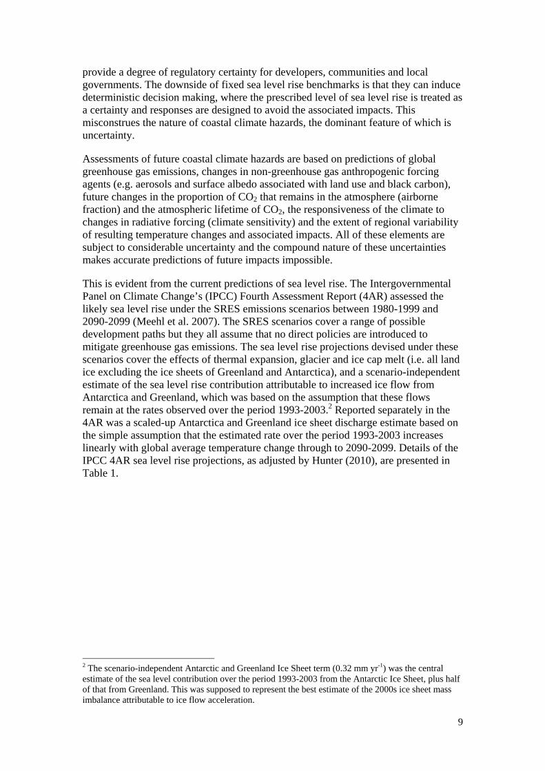
This is evident from the current predictions of sea level rise. The Intergovernmental Panel on Climate Change’s (IPCC) Fourth Assessment Report (4AR) assessed the likely sea level rise under the SRES emissions scenarios between 1980-1999 and 2090-2099 (Meehl et al. 2007). The SRES scenarios cover a range of possible development paths but they all assume that no direct policies are introduced to mitigate greenhouse gas emissions. The sea level rise projections devised under these scenarios cover the effects of thermal expansion, glacier and ice cap melt (i.e. all land ice excluding the ice sheets of Greenland and Antarctica), and a scenario-independent estimate of the sea level rise contribution attributable to increased ice flow from Antarctica and Greenland, which was based on the assumption that these flows remain at the rates observed over the period 1993-2003.2 Reported separately in the 4AR was a scaled-up Antarctica and Greenland ice sheet discharge estimate based on the simple assumption that the estimated rate over the period 1993-2003 increases linearly with global average temperature change through to 2090-2099. Details of the IPCC 4AR sea level rise projections, as adjusted by Hunter (2010), are presented in Table 1.
2 The scenario-independent Antarctic and Greenland Ice Sheet term (0.32 mm yr-1) was the central estimate of the sea level contribution over the period 1993-2003 from the Antarctic Ice Sheet, plus half of that from Greenland. This was supposed to represent the best estimate of the 2000s ice sheet mass imbalance attributable to ice flow acceleration.
10
Table 1 IPCC SRES projections of atmospheric GHG concentrations (incl. aerosols), radiative forcing, and warming at 2090-2099 relative to 1980-1999, and sea level rise as adjusted by Hunter (2010) at 2100 relative to 1990
SRES scenario B1 A1T B2 A1B A2 A1FI
All gases (incl. aerosols) atmospheric concentration at 2100 (CO2-e)
608 717 808 861 1256 1535
Anthropogenic radiative forcing at 2100 (W m-2)
4.19 5.07 5.71 6.05 8.07 9.14
Temperature change at 2100 (°C)* 1.8 [1.1-2.9]
2.4 [1.4-3.8]
2.4 [1.4-3.8]
2.8 [1.7-4.4]
3.4 [2.0-5.4]
4.0 [2.4-6.4]
Sea level rise at 2100 relative to 1990 (mm) (including scaled-up ice sheet discharge)
185-496 194-611 210-576 208-649 237-692 266-819
* Best estimate [likely range] above pre-industrial. Source: Meehl et al. (2007); EEA (2010); Hunter (2010).
As is evident from Table 3, Victoria’s sea-level rise benchmark of 0.8 m by 2100 was derived from the high range (95% maxima) A1FI scenario — a ‘worst case’ scenario that assumes the international community follows a fossil fuel-intensive development path, no direct policies are introduced to mitigate emissions and that the climate is ‘sensitive’ to increases in the atmospheric concentration of greenhouse gases. The climate outcomes under this scenario are vastly different from those envisaged under the Cancun Agreements, which set an aspirational target of limiting warming to 2ºC above pre-industrial levels.3 To achieve this target, anthropogenic radiative forcing in the late 21st century would have to be ~2.5 W m-2, well below the 9.14 W m-2 achieved in 2100 under the A1FI scenario.
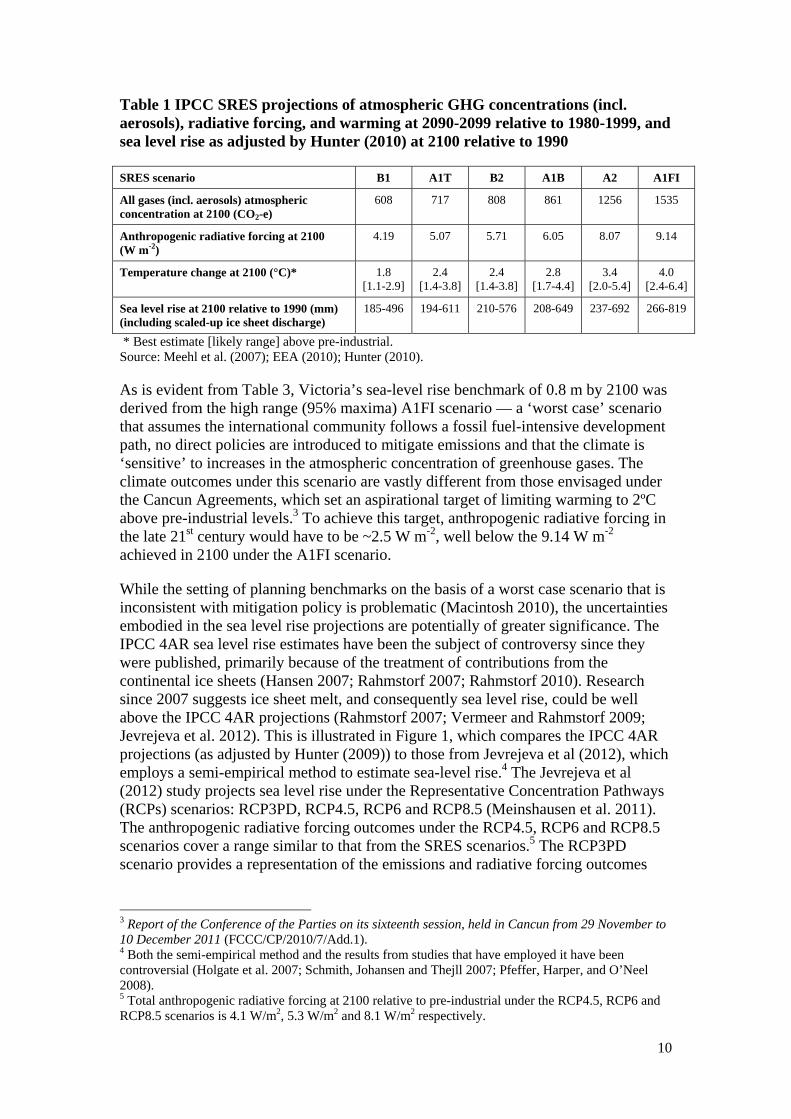
While the setting of planning benchmarks on the basis of a worst case scenario that is inconsistent with mitigation policy is problematic (Macintosh 2010), the uncertainties embodied in the sea level rise projections are potentially of greater significance. The IPCC 4AR sea level rise estimates have been the subject of controversy since they were published, primarily because of the treatment of contributions from the continental ice sheets (Hansen 2007; Rahmstorf 2007; Rahmstorf 2010). Research since 2007 suggests ice sheet melt, and consequently sea level rise, could be well above the IPCC 4AR projections (Rahmstorf 2007; Vermeer and Rahmstorf 2009; Jevrejeva et al. 2012). This is illustrated in Figure 1, which compares the IPCC 4AR projections (as adjusted by Hunter (2009)) to those from Jevrejeva et al (2012), which employs a semi-empirical method to estimate sea-level rise.4 The Jevrejeva et al (2012) study projects sea level rise under the Representative Concentration Pathways (RCPs) scenarios: RCP3PD, RCP4.5, RCP6 and RCP8.5 (Meinshausen et al. 2011). The anthropogenic radiative forcing outcomes under the RCP4.5, RCP6 and RCP8.5 scenarios cover a range similar to that from the SRES scenarios.5 The RCP3PD scenario provides a representation of the emissions and radiative forcing outcomes
3 Report of the Conference of the Parties on its sixteenth session, held in Cancun from 29 November to 10 December 2011 (FCCC/CP/2010/7/Add.1). 4 Both the semi-empirical method and the results from studies that have employed it have been controversial (Holgate et al. 2007; Schmith, Johansen and Thejll 2007; Pfeffer, Harper, and O’Neel 2008). 5 Total anthropogenic radiative forcing at 2100 relative to pre-industrial under the RCP4.5, RCP6 and RCP8.5 scenarios is 4.1 W/m2, 5.3 W/m2 and 8.1 W/m2 respectively.
11
that would be necessary to meet the current international target of keeping warming to 2ºC above pre-industrial levels.6
Figure 1 Sea level rise projections for the 21st century, 5%-95% confidence interval, IPCC 4AR and Jevrejeva et al. (2012)
Source: Hunter (2010); Jevrejeva et al. (2012).
It is evident from Figure 1 that the uncertainty in sea level rise projections is large and that it increases over time, primarily as a result of the uncertainties associated with emissions and climate sensitivity. The data in Figure 1 also highlight the extent of the high-side risks — sea level rise under the high range (95% maxima) A1FI scenario is approximately half of the equivalent Jevrejeva et al (2012) estimate under the RCP8.5 scenario.
Although the Victorian Coastal Strategy 2008 discusses the uncertainties associated with sea level rise, and stresses that the policy will be “reviewed as scientific data becomes available” (VCC 2008, p. 36), the use of the 0.8 m benchmark as the centrepiece of the policy has led to deterministic decision making. Planning bodies have generally adopted one of two approaches. Either they have assessed the threats to proposed developments against the 0.8 m benchmark, or against a lower benchmark derived from the high range A1FI scenario on the basis of the economic life of the development.7 Fixed responses have then been crafted with the intent of avoiding the
6 Total anthropogenic radiative forcing at 2100 relative to pre-industrial under the RCP3PD is 2.4 W/m2. 7 For examples, see Melbourne Water (2011); Myers v South Gippsland Shire Council (No.2) [2009] VCAT 2414; Restall v Hobsons Bay City Council [2010]VCAT 1348, Cadzow Enterprises Pty Ltd v Port Phillip City Council [2010] VCAT 634, and W & D Perrett & Period Developments Pty Ltd v Frankston City Council [2010] VCAT 1359; Tauschke v East Gippsland Shire Council [2009] VCAT
12
impacts associated with the benchmark, including storm surge, flooding and tidal affects (which are themselves subject to uncertainty). In some instances, this has led to highly precautionary decision making, where developments have been stopped on the basis of distant threats, or subject to conditions requiring the immediate construction of protective measures design to shield against distant impacts. Examples of where this has occurred are provided in Appendix A. Where decision makers have shaped responses around the economic life of the development, less precautionary outcomes have resulted. However, the outcomes have often still been based on the premise that sea level will be no more or less than the specified benchmark.8 In either case, there is the prospect that the responses will later be judged an under- or over-reaction.
The decision framing embodied in the state framework is not unlike that used in emergency management. Faced with ‘points of no return’ where there is no opportunity for step-wise decision-making, emergency managers will generally take risk averse decisions to minimise loss of life and property. The use of this approach in the context of coastal climate hazards downplays the importance of the timeframes and uncertainties associated with climate change. It can also block off adaptation options.
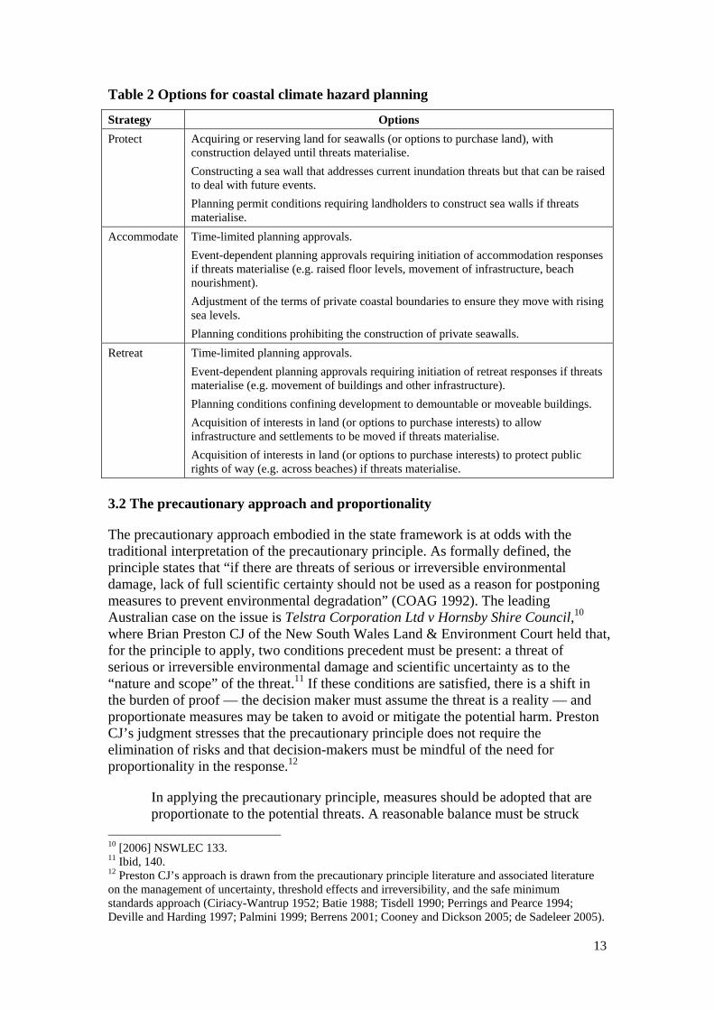
As Dobes (2008) has emphasised, improved outcomes can be achieved through the use of an options-based approach, where the capacity to make alternative use and development choices is embedded in planning instruments and responses.9 The precise nature of the options will depend on the desired outcomes and response strategy that is employed (protect, accommodate, retreat), both of which ideally should reflect community preferences. Examples of the types of options that could be used in coastal climate hazard planning are outlined in Table 2. The benefits of an options-based approach stem from the fact that it facilitates step-wise (or incremental) decision making, which allows for adjustments to be made in response to events. This can lower anticipatory adaptation response costs and lead to improved impact minimisation outcomes compared to more deterministic approaches.
2231; Rowe v Greater Geelong City Council [2011] VCAT 1772; Taip v East Gippsland Shire Council [2010] VCAT 1222; Findlay v Surf Coast Shire Council [2011] VCAT 1919; Suburban Blue Print Pty Ltd v Hobsons Bay City Council [2010] VCAT 1272; Bass Coast C53, C93 & C98 (PSA) [2010] PPV 33; Bass Coast C88 (PSA) [2009] PPV 126; Greater Geelong C93 (PSA) [2009] PPV 58; Greater Geelong C159 (PSA) [2010] PPV 4. 8 For examples, see Victorian Government (2010); Melbourne Water (2011); Ausbuild Constructions Pty Ltd v Frankston City Council [2010] VCAT 1778; Azzure Investment Group Pty Ltd v Mornington Peninsula Shire Council [2010] VCAT 860; Atkins Maritime Engineering (2010); Borough of Queenscliffe, Minutes – Ordinary Meeting of Council, 20 July 2011; Borough of Queenscliffe, Minutes – Ordinary Meeting of Council, 21 September 2011. 9 For an example where this approach has been employed in Victoria, see Glenelg Planning Scheme, cls 52.03 and 81.01, and Coastal land east of Portland between Dutton Way and Narrawong, Incorporated Document, April 2011.
13
Table 2 Options for coastal climate hazard planning
Strategy Options
Protect Acquiring or reserving land for seawalls (or options to purchase land), with construction delayed until threats materialise.
Constructing a sea wall that addresses current inundation threats but that can be raised to deal with future events.
Planning permit conditions requiring landholders to construct sea walls if threats materialise.
Accommodate Time-limited planning approvals.
Event-dependent planning approvals requiring initiation of accommodation responses if threats materialise (e.g. raised floor levels, movement of infrastructure, beach nourishment).
Adjustment of the terms of private coastal boundaries to ensure they move with rising sea levels.
Planning conditions prohibiting the construction of private seawalls.
Retreat Time-limited planning approvals.
Event-dependent planning approvals requiring initiation of retreat responses if threats materialise (e.g. movement of buildings and other infrastructure).
Planning conditions confining development to demountable or moveable buildings.
Acquisition of interests in land (or options to purchase interests) to allow infrastructure and settlements to be moved if threats materialise.
Acquisition of interests in land (or options to purchase interests) to protect public rights of way (e.g. across beaches) if threats materialise.
3.2 The precautionary approach and proportionality
The precautionary approach embodied in the state framework is at odds with the traditional interpretation of the precautionary principle. As formally defined, the principle states that “if there are threats of serious or irreversible environmental damage, lack of full scientific certainty should not be used as a reason for postponing measures to prevent environmental degradation” (COAG 1992). The leading Australian case on the issue is Telstra Corporation Ltd v Hornsby Shire Council,10 where Brian Preston CJ of the New South Wales Land & Environment Court held that, for the principle to apply, two conditions precedent must be present: a threat of serious or irreversible environmental damage and scientific uncertainty as to the “nature and scope” of the threat.11 If these conditions are satisfied, there is a shift in the burden of proof — the decision maker must assume the threat is a reality — and proportionate measures may be taken to avoid or mitigate the potential harm. Preston CJ’s judgment stresses that the precautionary principle does not require the elimination of risks and that decision-makers must be mindful of the need for proportionality in the response.12
In applying the precautionary principle, measures should be adopted that are proportionate to the potential threats. A reasonable balance must be struck
10 [2006] NSWLEC 133. 11 Ibid, 140. 12 Preston CJ’s approach is drawn from the precautionary principle literature and associated literature on the management of uncertainty, threshold effects and irreversibility, and the safe minimum standards approach (Ciriacy-Wantrup 1952; Batie 1988; Tisdell 1990; Perrings and Pearce 1994; Deville and Harding 1997; Palmini 1999; Berrens 2001; Cooney and Dickson 2005; de Sadeleer 2005).

14
between the stringency of the precautionary measures, which may have associated costs, such as financial, livelihood and opportunity costs, and the seriousness and irreversibility of the potential threat.13
The Victorian framework’s precautionary approach bears little resemblance to the precautionary principle described by Preston CJ. The focus is on risk avoidance; ensuring that people and property are not affected by the coastal climate hazards that could arise under the high range SRES A1FI sea level rise projections. Insufficient consideration is given to the opportunity costs associated with avoiding the uncertain future impacts. The only material reference to the need to consider the opportunity cost of precautionary responses in the main framework documents is found in the General Practice Note, where one of 11 matters identified as possible considerations in urban rezonings is the “intended use and design lifespan and value of a proposal assessed against the relative risk exposure during that time” (VDPCD 2008, p. 4). This relatively vague requirement is drowned out by the repeated emphasis on precaution and desire to avoid adverse impacts. For example, the opening paragraph of the section on rezonings in the General Practice Note states:
Given the current body of knowledge and information an important principle is the need to avoid the further intensification of development in areas that are likely to be impacted by projected coastal hazards under climate change (VDPCD 2008, p. 4).
The failure to stress the need to consider opportunity costs, combined with the prominence given to deterministic responses and precaution, has led some planning bodies to treat potential future losses as the equivalent of certain present costs.14 In economic language, the threats have not been weighted and a near zero social time preference rate has been used (if only implicitly) to discount future losses; something that is difficult to justify on either empirical or normative grounds. Due to this, one of the main downsides of the state framework is that, at times, it has generated outcomes where the opportunity costs have been disproportionate to the nature of the threats. This has wasted resources and generated inequitable outcomes.
3.3 Ambiguity and inconsistency
The Victorian framework is based on an awkward distribution of powers and responsibilities. It provides broad principles that are intended to guide decision-making by planning and responsible authorities. However, it does not dictate outcomes and is vague about what is expected in the treatment of coastal climate hazard issues. This has enabled councils to devise different approaches but the scope of their discretion is subject to the Minister’s and VCAT’s powers to review and reverse their decisions. As a consequence of the jumbled governance structure and vague procedural and substantive requirements, the implementation of the framework has been characterised by inconsistency.
13 [2006] NSWLEC 133, 167. 14 See Appendix A, particularly Myers v South Gippsland Shire Council (No.2) [2009] VCAT 2414, Taip v East Gippsland Shire Council [2010] VCAT 1222, Kala Developments Pty Ltd v Surf Coast Shire Council [2011] VCAT 513, Lake Park Holdings Pty Ltd v East Gippsland Shire Council [2011] VCAT 1491 and Findlay v Surf Coast Shire Council [2011] VCAT 1919.
15
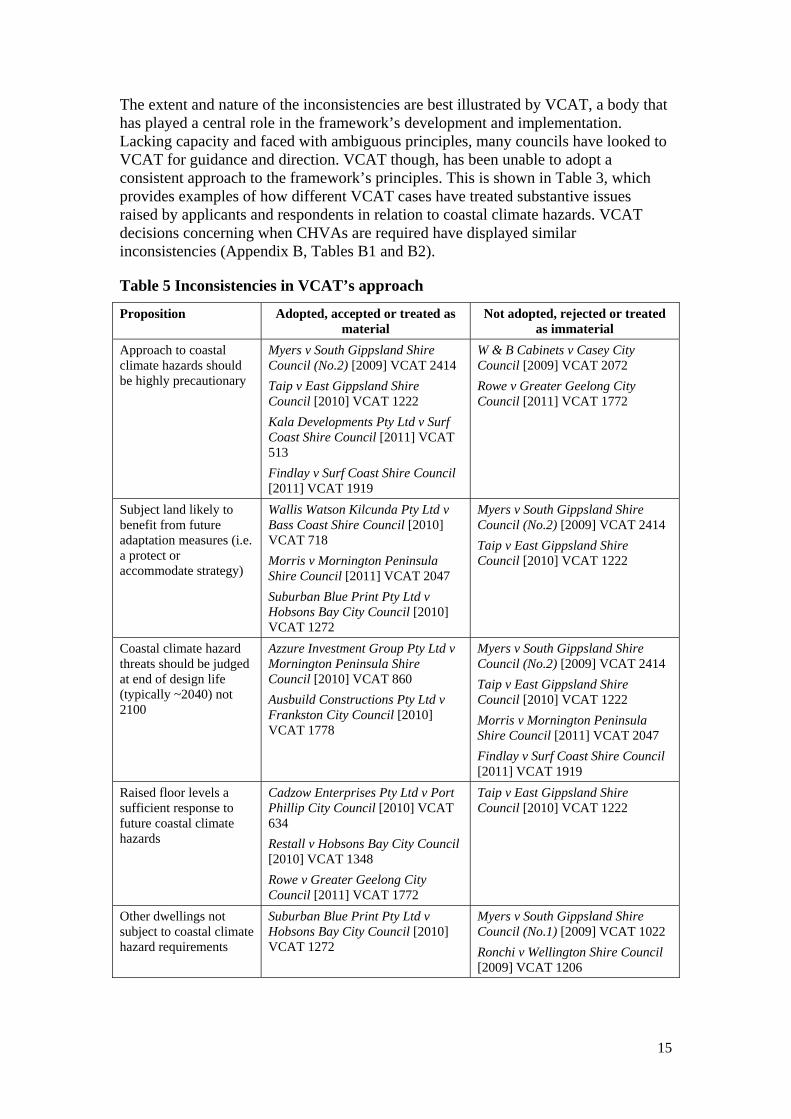
The extent and nature of the inconsistencies are best illustrated by VCAT, a body that has played a central role in the framework’s development and implementation. Lacking capacity and faced with ambiguous principles, many councils have looked to VCAT for guidance and direction. VCAT though, has been unable to adopt a consistent approach to the framework’s principles. This is shown in Table 3, which provides examples of how different VCAT cases have treated substantive issues raised by applicants and respondents in relation to coastal climate hazards. VCAT decisions concerning when CHVAs are required have displayed similar inconsistencies (Appendix B, Tables B1 and B2).
Table 5 Inconsistencies in VCAT’s approach
Proposition Adopted, accepted or treated as material
Not adopted, rejected or treated as immaterial
Approach to coastal climate hazards should be highly precautionary
Myers v South Gippsland Shire Council (No.2) [2009] VCAT 2414
Taip v East Gippsland Shire Council [2010] VCAT 1222
Kala Developments Pty Ltd v Surf Coast Shire Council [2011] VCAT 513
Findlay v Surf Coast Shire Council [2011] VCAT 1919
W & B Cabinets v Casey City Council [2009] VCAT 2072
Rowe v Greater Geelong City Council [2011] VCAT 1772
Subject land likely to benefit from future adaptation measures (i.e. a protect or accommodate strategy)
Wallis Watson Kilcunda Pty Ltd v Bass Coast Shire Council [2010] VCAT 718
Morris v Mornington Peninsula Shire Council [2011] VCAT 2047
Suburban Blue Print Pty Ltd v Hobsons Bay City Council [2010] VCAT 1272
Myers v South Gippsland Shire Council (No.2) [2009] VCAT 2414
Taip v East Gippsland Shire Council [2010] VCAT 1222
Coastal climate hazard threats should be judged at end of design life (typically ~2040) not 2100
Azzure Investment Group Pty Ltd v Mornington Peninsula Shire Council [2010] VCAT 860
Ausbuild Constructions Pty Ltd v Frankston City Council [2010] VCAT 1778
Myers v South Gippsland Shire Council (No.2) [2009] VCAT 2414
Taip v East Gippsland Shire Council [2010] VCAT 1222
Morris v Mornington Peninsula Shire Council [2011] VCAT 2047
Findlay v Surf Coast Shire Council [2011] VCAT 1919
Raised floor levels a sufficient response to future coastal climate hazards
Cadzow Enterprises Pty Ltd v Port Phillip City Council [2010] VCAT 634
Restall v Hobsons Bay City Council [2010] VCAT 1348
Rowe v Greater Geelong City Council [2011] VCAT 1772
Taip v East Gippsland Shire Council [2010] VCAT 1222
Other dwellings not subject to coastal climate hazard requirements
Suburban Blue Print Pty Ltd v Hobsons Bay City Council [2010] VCAT 1272
Myers v South Gippsland Shire Council (No.1) [2009] VCAT 1022
Ronchi v Wellington Shire Council [2009] VCAT 1206
16
Part of the explanation for the observed variability in VCAT decisions is the nature of the Tribunal. It is a merits-review body and its decisions do not set binding precedents; they are only binding on the parties to the proceedings. Due to this, inconsistencies in approach are not uncommon and can simply be a product of the different values and preferences of VCAT members. VCAT also suffers from the same, if not worse, capacity constraints concerning the evaluation of coastal climate hazards as councils. While VCAT members all have skills and expertise in particular areas, few have a detailed knowledge of climate change and, in hearing cases, have limited capacity to investigate relevant issues (Eccles and Bryant 2011). Against this background, it was foreseeable that the ambiguities in the state framework would lead to inconsistencies in VCAT decisions.
The inconsistencies in approach have not been confined to VCAT — there have been significant differences in the approaches adopted by councils and floodplain authorities.15 In many instances, diversity in regulation and the provision of public goods and services can be positive, allowing policy packages to be aligned with community preferences and facilitating experimentation (Mill 1848; Bryce 1888; Oates 1972; Tiebout 1956; Ostrom et al. 1961; Oates 1999). Here, there has been a more chaotic decision making process triggered by ambiguity in the state framework and a lack of capacity in local councils, floodplain authorities and VCAT. This has led to inequitable outcomes and created regulatory uncertainty.
To promote a more coordinated response, in May 2009, the Victorian Government established the Coastal Climate Change Advisory Committee (CCCAC). The purpose of the CCCAC was to advise the Government on whether and how the Victorian planning system could be amended to incorporate the outputs from the Future Coasts Program and improve the effectiveness with which it deals with coastal climate hazards. In February 2010, after an initial round of consultation, the CCCAC released a 200 page Issues and Option Paper that set out its preliminary views on how the planning framework for coastal climate hazards could be improved.
Many coastal councils and other planning bodies were hoping the work of the CCCAC would provide them with greater clarity and direction, and reduce the unpredictability associated with VCAT decisions.16 In late 2010, however, the Brumby Labor Government lost office and was replaced by the Baillieu Coalition Government. The change has led to a stalling of the CCCAC process. The final report of the CCCAC was submitted in December 2010, after the new government had taken office. As at May 2012, the report had not been publicly released and the state government had given no indication of its response. This has resulted in the stagnation
15 Bass Coast C53, C93 & C98 (PSA) [2010] PPV 33; Bass Coast C88 (PSA) [2009] PPV 126; Greater Geelong C93 (PSA) [2009] PPV 58; Greater Geelong C159 (PSA) [2010] PPV 4; South Gippsland C45 (PSA) [2009] PPV 50; Wellington C50 (PSA) [2009] PPV 119; Victorian Government (2010); Melbourne Water (2011); ‘Minister for Water’s Preliminary Guidelines for Coastal Catchment Management Authorities and Melbourne Water’, discussed in Taip v East Gippsland Shire Council [2010] VCAT 1222; Borough of Queenscliffe, Minutes – Ordinary Meeting of Council, 20 July 2011; Borough of Queenscliffe, Minutes – Ordinary Meeting of Council, 21 September 2011; City of Greater Geelong, Minutes – Ordinary Meeting of Council, 23 February 2010. See also VCAT decisions discussed in Appendices A and B. 16 City of Greater Geelong, Minutes – Ordinary Meeting of Council, 23 February 2010; Wellington C50 (PSA) [2009] PPV 119; Wellington C33 (PSA) [2011] PPV 9; East Gippsland C68 (PSA) [2009] PPV 32.
17
of policy development at the council level and added to the uncertainty surrounding the planning system.
3.4 Transaction costs and precision fallacy
Both strategic and statutory planning processes can involve significant transaction costs,17 including those associated with stakeholder consultations, assessments, spatial mapping, enforcement, compliance, litigation and appeals. In seeking to maximise the welfare benefits generated by planning processes, governments should be mindful of the magnitude and distribution of these costs. Arguably, in designing the Victorian framework, insufficient attention was given to these issues. Three transaction cost-related issues stand out.
The first stems from the reliance on CHVAs as a means of improving planning decisions. This approach is based on the simple (arguably naïve) premise that better information necessarily leads to better outcomes (Barlett and Kurian 1999). Whether or not this is true, site-specific CHVAs are an inefficient manner in which to carryout coastal assessments, a point made by VCAT and other planning bodies on multiple occasions.18 Not surprisingly, the quality and utility of these CHVA has been variable.19 In addition, the extent to which coastal assessments aid decision making processes is largely dependent on their treatment of uncertainty. By using a single sea level rise benchmark, the state framework has encouraged the generation of assessments based solely on the high-range SRES A1FI projection, which may or may not reflect actual outcomes. This can leave decision makers without sufficient information on the potential range of threats and, in the worst case, create a false sense of certainty and promote deterministic decision making. This is a risk with the site-specific CHVAs that have been undertaken — between 30 and 50 CHVAs have been carried out in Greater Geelong alone since 2008, at a cost of approximately $2500-$4500 per assessment plus review costs (all CHVAs in Greater Geelong are reviewed by a coastal engineer and referred to the Corangamite CMA).20 The same issue arises in the context of the Future Coasts Program, which is basing its modelling on the high-range SRES A1FI projection. An extensive local assessment on the area between Portland and Narrawong on Victoria’s west coast that was prepared for Glenelg Shire Council in 2010 was based on the same, single projection (AECOM 2010).
The second transaction cost-related issue is that the framework has generated a significant number of disputes and appeals. Over the period 1 January 2009 to 16 April 2012, there were at least 37 VCAT appeals where the state framework was a material issue the proceedings.21 There is also evidence of disputes concerning the framework in several other planning processes, including at least one instance where 17 Transaction costs are defined broadly here as the costs of establishing and maintaining freedoms and liberties concerning the use and enjoyment of a good or service, consistent with the property rights literature (Allen 1991; 2000). 18 Myers v South Gippsland Shire Council (No. 2) [2009] VCAT 2414; Taip v East Gippsland Shire Council [2010] VCAT 1222; Kala Developments Pty Ltd v Surf Coast Shire Council [2011] VCAT 513; Wellington C50 (PSA) [2009] PPV 119. 19 Owen v Casey City Council [2009] VCAT 1946; Kala Developments Pty Ltd v Surf Coast Shire Council [2011] VCAT 513. 20 City of Greater Geelong, senior planner, pers. comms (6 March 2012). 21 Derived from the Austlii VCAT database: http://www.austlii.edu.au/au/cases/vic/VCAT/ (16 April 2012).
18
the Victorian planning minister intervened to resolve a conflict over the actions of a council.22 While conflict over the distributional implications of adaptation responses is, to some extent, unavoidable, the structure of the framework, particularly its ambiguity and the failure of the state government to provide guidance, has exacerbated these risks.
The third transaction cost issue involves the use of climate change response plans and section 173 agreements as a way of shielding councils against future liability for planning decisions.23 This approach has been adopted by several councils, including the Moyne, Wellington, South Gippsland and Bass Coast Shire Councils, and Casey City Council.24 While the desire of councils to minimise their legal exposure is understandable, this site-specific approach involves unnecessary transaction costs. In New South Wales (another Australian state), a more cost-effective solution has been instituted through a jurisdiction-wide liability exemption for good faith actions taken (or not taken) by councils in relation to coastal climate hazards.25
4. Conclusions
Urban planning is an indispensable part of the public response to coastal climate hazards. Its role in regulating land use and development means that, like it or not, it will inevitably shape how communities respond to coastal threats. Moreover, when well design and implemented, it can help overcome barriers to adaptation and facilitate efficient and equitable outcomes. However, like all policy instruments, its effectiveness depends on the user. When it is misapplied, urban planning has the capacity to trigger inequity and maladaptation. The Victorian coastal climate hazards framework illustrates the types of issues that can lead to suboptimal planning outcomes.
Mirroring behaviours seen in financial markets, there has been an apparent overreaction to information regarding coastal climate hazards (de Bondt and Thaler 1985; Veronesi 1999). Afraid of the threats posed by climate change and potential liabilities stemming from planning decisions, the Victorian Government has put in place a precautionary framework based on the notion that people and property should be protected now from future coastal hazards. Planning bodies have been required to treat sea level rise of at least 0.8 m by 2100 as a certainty and encouraged to adopt responses that ensure people and properties will be shielded from the impacts under this scenario. This approach promotes deterministic decision making, where insufficient consideration is given to the uncertainties associated with climate hazards and the opportunity costs of precautionary responses. To make matters worse, the framework’s requirements are ambiguous and often involve significant transaction costs, and the state government has failed to give planning bodies adequate guidance and assistance in implementation. These defects have led to inconsistencies, disputes and some notably inefficient and inequitable outcomes.
22 Glenelg Planning Scheme Amendment C58 (2010); Glenelg Planning Scheme Amendment C60 (2011). 23 Section 173 agreements are agreements made under section 173 of the Planning and Environment Act 1987 (Vic) between a responsible authority and a landowner. After registration, the burden of any covenant in the agreement runs with the land. 24 For examples and discussion, see Elken Lane Pty Ltd v Casey City Council [2009] VCAT 1642; Wellington C50 (PSA) [2009] PPV 119; East Gippsland C68 (PSA) [2009] PPV 32. 25 Local Government Act 1993 (NSW), s 733.

19
Planning frameworks based on the management of uncertainty through the use of options and other similar step-wise decision-making techniques have the capacity to generate better results. These instruments can help promote development and design responses that are capable of responding to unforeseen events. However, their success is dependent on implementation and decision-makers being mindful of the costs of both under-and over-estimating potential future hazards. As the Victorian system demonstrates, in designing urban planning frameworks, attention should also be given to the capacity constraints of planning bodies and the potential for imprecision in planning instruments to magnify uncertainties associated with the regulation of land use and development.
20
References
AECOM Pty Ltd (2010) Coastal Spaces – Inundation and Erosion – Coastal Engineering Study. Glenelg Shire Council, Portland
Allen D (1991) What are Transaction Costs? Research in Law & Economics 14:1–18
Allen D (2000) Transaction Costs. In: Bouckeart B, De Geest G (eds) Encyclopaedia of Law and Economics. Edward Elgar, UK
Atkins Maritime Engineering (2010) Williamstown ‘The Strand’ Rock Revetments Design Report. Victorian Department of Sustainability and Environment, Melbourne
Barnett J, O’Neill S (2010) Maladaptation. Global Environmental Change 20:211–213
Bartlett R, Kurian P (1999) The theory of environmental impact assessment: Implicit models of policy making. Policy & Politics 27(4):415–433
Batie S (1988) Sustainable development: Challenges to the profession of agricultural economics. American Journal of Agricultural Economics 75:1084–1101
Berrens R (2001) The safe minimum standard of conservation and endangered species: a review. Environmental Conservation 28(2):104–116
Bryce J (1888) The American Commonwealth. Macmillan & Co, London
Ciriacy-Wantrup S (1952) Resource Conservation: Economics and Policy. University of California Press, Berkeley
Cooney R, Dickson B (eds) (2005) Biodiversity and the Precautionary Principle, Risk and Uncertainty in Conservation and Sustainable Use. Earthscan, London
Cronshaw D (2012) Lake council backdown on sea level. Newcastle Herald, 25 February
Council of Australian Governments (COAG) (1992) Intergovernmental Agreement on the Environment. Commonwealth of Australia, Canberra
de Bondt W, Thaler R (1985) Does the stock market overreact? Journal of Finance 40(3):793–805
de Sadeleer N (2005) Environmental Principles: From Political Slogans to Legal Rules. Oxford University Press, Oxford
de Vries J (2006) Climate change and spatial planning below sea-level: Water, water and more water. Planning Theory and Practice 7:229 –233
Deville A, Harding R (1997) Applying the Precautionary Principle. Federation Press, Sydney
21
Dobes L (2008) Getting real about Adapting to Climate Change: Using ‘Real Options’ to Address the Uncertainties. Agenda 15(3):55–69
European Environment Agency (EEA) (2010) Atmospheric Greenhouse Gas Concentrations (CSI-013). EEA, Copenhagen
Gibbs M, Hill T (2011) Coastal Climate Change Risk – Legal and Policy Responses in Australia. Commonwealth of Australia, Canberra
Hansen H (2010) Modelling the future coastal zone urban development as implied by the IPCC SRES and assessing the impact from sea level rise. Landscape and Urban Planning 98:141–149
Hansen J (2007) Scientific reticence and sea level rise. Environmental Research Letters 2:024002
Holgate S, Jevrejeva S, Woodworth P, Brewer S (2007) Comment on ‘A Semi-Empirical Approach to Projecting Future Sea-Level Rise. Science 317(5846):1866b
Hunter J (2010) Estimating Sea-Level Extremes Under Conditions of Uncertain Sea-Level Rise. Climatic Change 99:331–350
Jevrejeva S, Moore J, Grinsted A (2012) Sea level projections to AD2500 with a new generation of climate change scenarios. Global and Planetary Change 80-81:14–20
Macintosh A (2010) A Theoretical Framework for Adaptation Policy. In: Bonyhady T, Macintosh A, McDonald J (eds) Adaptation to Climate Change: Law and Policy. Federation Press, Sydney
Madden J (2008) Managing Coastal Hazards and the Coastal Impacts of Climate Change. Victorian Government, Melbourne
Meehl GA et al. (2007) 2007: Global Climate Projections. In: Solomon S et al. (eds) Climate Change 2007: The Physical Science Basis. Contribution of Working Group I to the Fourth Assessment Report of the Intergovernmental Panel on Climate Change. Cambridge University Press, Cambridge
McDonald J (2011) The role of law in adapting to climate change. Wiley Interdisciplinary Reviews: Climate Change 2:283–295
McLean R et al (2007) Coastal zones and marine ecosystems. In: Parry M et al (eds) Climate Change 2007: Impacts, Adaptation and Vulnerability. Contribution of Working Group II to the Fourth Assessment Report of the Intergovernmental Panel on Climate Change. Cambridge University Press, Cambridge
Measham T, Preston B, Smith T, Brooke C, Gorddard R, Withycombe G, Morrison C (2011) Adapting to climate change through local municipal planning: barriers and challenges. Mitigation and Adaptation Strategies for Global Change 16(8):889–909
22
Meinshausen et al. (2011) The RCP greenhouse gas concentrations and their extensions from 1765 to 2300. Climatic Change 109:213–241
Melbourne Water (2011) Planning for sea level rise: Interim guidelines – Assessing developments in areas prone to tidal inundation from sea level rise in the Port Phillip and Westernport Region. Melbourne Water, Melbourne
Mill JS (1848) Principles of Political Economy with Some of their Applications to Social Philosophy. John W Parker, West Strand
Nakicenovic N et al (2000) Special Report on Emissions Scenarios. Intergovernmental Panel on Climate Change, Geneva
Oates W (1972) Fiscal Federalism. Harcourt, Brace & Jovanovich, New York
Oates W (1999) An essay on fiscal federalism. Journal of Economic Literature 37:1120–1149
Ostrom V, Tiebout C, Warren R (1961) The organization of government in metropolitan areas: a theoretical inquiry. American Political Science Review 55(4):831–842
Palmini D (1999) Uncertainty, risk aversion and the game theoretical foundations of the safe minimum standard: a reassessment. Ecological Economics 29:463–472
Perrings C, Pearce D (1994) Threshold effects and Incentives for the Conservation of Biodiversity. Environmental and Resource Economics 4:13–28
Pfeffer W, Harper J, O’Neel S (2008) Kinematic constraints on glacier contributions to 21-st century sea-level rise. Science 321 (5894):1340–1343
Rahmstorf S (2007) A Semi-Empirical Approach to Projecting Future Sea-Level Rise. Science 315:368–370
Rahmstorf S (2010) A new view on sea level rise. Nature Climate Change 4:44–45
Schmith T, Johansen S, Thejll P (2007) Comment on ‘A semi-empirical approach to projecting future sea-level rise’. Science 317(5846): 1866c
Tiebout C (1956) A pure theory of local expenditures. Journal of Political Economy 64(5):416–424
Tisdell C (1990) Economics and the debate about preservation of species, crop variety and genetic diversity. Ecological Economics 2:77–90
Vermeer M, Rahmstorf S (2009) Global sea level linked to global temperature. PNAS 106(51):21527–21532
Veronesi P (1999) Stock Market Overreaction to Bad News in Good Times: A Rational Expectations Equilibrium Model. Review of Financial Studies 12(5):975–1007
23
Victorian Coastal Council (2008) Victorian Coastal Strategy 2008. Victorian Government, Melbourne
Victorian Department of Planning and Community Development (VDPCD) (2008) Managing coastal hazards and the coastal impacts of climate change, General Practice Note. Victorian Government, Melbourne
Victorian Government (2010) A Guide for Coastal Floodplain Management Authorities: Assessing development in coastal flood risk areas, June 2010, draft version 2.7. Victorian Government, Melbourne
Wilson E (2006) Adapting to Climate Change at the Local Level: The Spatial Planning Response. Local Environment 11:609–625
Wilson E, Piper J (2010) Spatial planning and climate change. Routledge, Abingdon
24
Appendix A Examples of highly precautionary and deterministic decision making under the state framework
Myers v South Gippsland Shire Council [2009] VCAT 1022 and [2009] VCAT 2414
Application to subdivide a 1624 m2 block of land in Waratah Bay, near Wilsons Promontory. The land already contained a two story dwelling, is located within the boundaries of the town and has an elevation of 3-6 m AHD. Between the land and the beach are a road and an intact dune system. Council initially decided to grant the permit but a neighbour appealed the decision to VCAT. In the initial VCAT decision, it was held that the site was potentially vulnerable to coastal climate hazards and that a CHVA should be undertaken before a final decision is made. The CHVA found that by 2100, the combined effect of sea level rise and storm surge would expose the site to inundation unless physical mitigation measures were undertaken. On this basis, VCAT overturned the decision of the Council, finding that the subdivision was inappropriate on account of “the high level of vulnerability to future sea level rise and associated risks to any future development at this location”. The VCAT members strongly criticised a suggestion that the house could be sacrificed if the climate risks materialise, describing it as simplistic. They also emphasised that the development “would unnecessarily burden future generations”.
Taip v East Gippsland Shire Council [2010] VCAT 1222
Application to construct three townhouses containing eight dwellings on Marine Parade in Lakes Entrance, a coastal town in East Gippsland with a history of flooding. The subject land is located in a low lying, built-up commercial/residential area close to the Esplanade (the main street) and adjacent to the estuary. Under the East Gippsland Planning Scheme, the land was included in a Business 1 Zone and was subject to a Land Subject to Inundation Overlay, reflecting its location and elevation (the land was between 0.6 m and 1.0 m AHD). The Council decided to grant the permit, prompting an owner of a neighbouring property to initiate a VCAT appeal. The proposal that was put before VCAT included a raised ground floor level to a height of 2.6 m AHD (1.7 m above Marine Parade street level), putting it above the estimated 1% AEP peak flood level of 1.8 m AHD. The ground floor was also designed solely for the use as a car park and “utilitarian entry foyer”. VCAT saw this as an acceptable response to the existing flood risk as it ‘would raise sensitive uses above the existing flood levels and minimising the exposure of occupants to hazards’. However, it was not satisfied that it constituted an adequate response to future coastal climate hazards. The Council argued that the economic life of the development would pass before these hazards materialised and that prohibiting development would be “tantamount to an imposed, unsupported strategy for ‘coastal retreat’ for Lakes Entrance”. The presiding VCAT member, Ian Potts, rejected these arguments in the following terms.
The proposition is little more than a spurious argument to defer proper and balanced decision making and focuses only on the short term economic benefits. Even from an economic perspective it avoids the longer term impacts. It is clear enough from the current understanding of the impacts to Lakes Entrance that without intervention, the development will be subject to conditions that may well lead to it being unviable for occupation. The resultant economic cost would be to those future owners and quite possibly the wider
25
community. It is hardly fair or equitable to see this as a balanced outcome for intergenerational equity. … The proposition disregards the benefits of sustainably utilising available resources for the longest possible time. To simply write off the materials, energy and other resources necessary to develop this site over what in reality would be a relatively short time span is counter to the concepts of sustainable development espoused in state planning policy and a primary objective of planning.26
Potts also rejected an argument that the location of the development within an existing urban area would mean that it would benefit from future defensive measures without increasing the cost.
Kala Developments Pty Ltd v Surf Coast Shire Council [2011] VCAT 513
A joint commercial/residential development in Anglesea on the Great Ocean Road, west of Melbourne. The land is adjacent to the Anglesea foreshore reserve and Anglesea River estuary, covers an area of 3203 m2 and has an elevation of 2-3 m AHD. At the time of the application, the land was vacant and adjoined a strip a shops and businesses. Prior to the creation of the state coastal climate hazards framework, the Council issued a permit at the direction of VCAT for the use and development of the subject land for five shops, a restaurant, 18 dwellings and under-croft parking area. Kala Developments sought an amendment to the permit in 2010 to convert the five shops into six additional dwellings and increase the floor area of the restaurant. The Corangamite CMA advised that, under current conditions, a 1% annual exceedance probability (AEP) flood event would have a peak of 2.1 m AHD. With 0.8 m of sea level rise, this would increase to 2.9 m AHD in 2100, resulting in the possible inundation of most of the subject land. Kala Developments reached a negotiated settlement with the Council and CMA on a design response to deal with the coastal climate hazards, consisting of a concrete flood/inundation protection wall around the residential dwellings to a height of 0.3 m above the projected 1% AEP peak flood level in 2100, raised levels to the basement car park entrance, a pedestrian walk way to provide an exit in the event of future flooding, and improved floor coverings and raised electrical wiring in the restaurant. Neighbours appealed the Council’s decision to grant the permit but VCAT upheld the decision, finding that the design response was sufficient because it would ‘protect all the residential components of the development from inundation projected under the 1% AEP 2100 scenarios’.
Lake Park Holdings Pty Ltd v East Gippsland Shire Council [2011] VCAT 1491
82 lot subdivision of a 10.7 hectare parcel of land in Paynesville, near Bairnsdale. The subject land fronts the Gippsland Lakes Foreshore Reserve and is adjacent to the Gippsland Lakes Ramsar site. The lowest point of the land is 2.02 m AHD. The estimated peak of a 1% AEP flood event at the time of the application was 1.82 m AHD. The projected 1% AEP peak in 2100 was 2.8m AHD. To deal with this risk, the proponent proposed filling parts of 20 lots (14% of the site) to ensure the minimum elevation was 3.1 m AHD. The Council failed to make a decision and, on appeal to VCAT, the Tribunal rejected the application, finding the filling proposal was inappropriate as it would block off potential adaptation processes of the shoreline and vegetation communities and could lead to adverse impacts on the environmental
26 Taip v East Gippsland Shire Council [2010] VCAT 1222, 90-93.
26
values of the lakes. VCAT emphasised that development should not be allowed below 2.8 m AHD as this would provide a buffer to “limit the potential effects of sea level rise on private property”, “avoid impacts from a 2100 projected 1% AEP flood event”, and “safeguard longer term environmental impacts”.
Rowe v Greater Geelong City Council [2011] VCAT 1772
Application for construction of two dwellings and a two lot subdivision in Point Lonsdale, near Geelong. The subject land has an elevation of 1.64-1.95 m AHD. The Corangamite CMA assessed that, in 2100, under the SRES A1FI scenario, the 1% AEP peak flood level will be 1.90 m AHD, and up to 2.24 m AHD with storm surges and high winds. The proponent amended the plans to account for this, raising the floor levels to 2.35 m AHD, giving it a freeboard of 10 cm in a 2100 flood event. On the basis of the potential coastal climate hazard impacts in 2100, the Council refused the application. Two issues were of particular concern to the Council. First, that intensification of development should not be allowed in a low lying area “when no mitigation works can be guaranteed”. Second, that in the event of an inundation event in 2100, the dwellings may not be inundated but the land would be, preventing occupants from exiting the property. In a subsequent appeal to VCAT, the Council’s decision was overturned, primarily on the grounds that the property would benefit from measures to protect Point Lonsdale and that occupants would have opportunities to exit the building prior to inundation.
Findlay v Surf Coast Shire Council [2011] VCAT 1919
Application for an 18 lot subdivision of a 10,400 m2 parcel of land in Anglesea, which, at the time of the matter, was used as a holiday park with 75 transportable cabins and a two storey manager’s house. The land is more than 1 km from the coast but is adjacent to the Anglesea River, in an existing residential area (the land is within a Residential 1 Zone under the Surf Coast Planning Scheme). The lowest point of the land is approximately 2.4-2.5 m AHD and it was projected that, at 2100, the 1% AEP flood level on the site would be 2.7 m AHD (assuming 0.8 m sea level rise). The application was originally made in September 2008. In September 2009, Council refused the application on several grounds, including a failure to adequately consider coastal climate hazards. On appeal, VCAT first decided that the application could not proceed without a cultural heritage management plan to address Indigenous heritage issues. While this was being prepared, the Council and applicant reached a negotiated settlement on measures to mitigate future coastal climate hazards, which included raised floor levels set at a minimum of 3.3 m AHD (2.7 m plus a 0.6 m freeboard), the prevention of entry to the site from the road on the low side of the property (between the land and the river), and the inclusion of an additional exit on the high side of the property to ensure residents could exit in the event of future inundation. More than three years after the application was initially lodged, VCAT rejected the application on the grounds that that negotiated design response was inappropriate. The VCAT member held that the raised floor levels on houses adjacent to the river would be inconsistent with the objectives of the Significant Landscape Overlay that applied to the site, which included “to maintain a low profile building height that minimises the visibility of building in the broader landscape, particularly where the vegetation canopy height is low or a site is prominently located”. VCAT indicated that, in any future proposal for the site, development should be confined to areas above 2.7 m
27
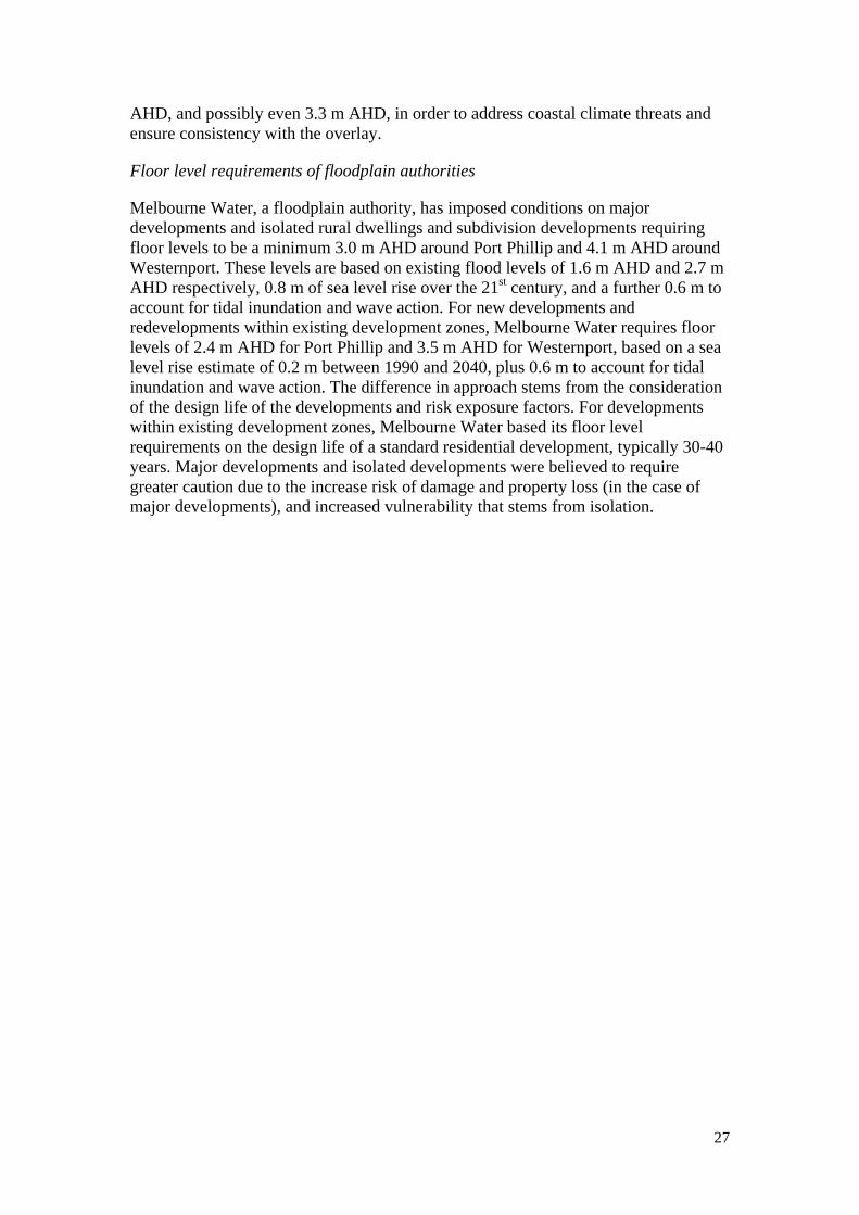
AHD, and possibly even 3.3 m AHD, in order to address coastal climate threats and ensure consistency with the overlay.
Floor level requirements of floodplain authorities
Melbourne Water, a floodplain authority, has imposed conditions on major developments and isolated rural dwellings and subdivision developments requiring floor levels to be a minimum 3.0 m AHD around Port Phillip and 4.1 m AHD around Westernport. These levels are based on existing flood levels of 1.6 m AHD and 2.7 m AHD respectively, 0.8 m of sea level rise over the 21st century, and a further 0.6 m to account for tidal inundation and wave action. For new developments and redevelopments within existing development zones, Melbourne Water requires floor levels of 2.4 m AHD for Port Phillip and 3.5 m AHD for Westernport, based on a sea level rise estimate of 0.2 m between 1990 and 2040, plus 0.6 m to account for tidal inundation and wave action. The difference in approach stems from the consideration of the design life of the developments and risk exposure factors. For developments within existing development zones, Melbourne Water based its floor level requirements on the design life of a standard residential development, typically 30-40 years. Major developments and isolated developments were believed to require greater caution due to the increase risk of damage and property loss (in the case of major developments), and increased vulnerability that stems from isolation.
28
Appendix B Inconsistencies in VCAT’s approach to CHVAs
Table B1 VCAT cases where CHVA held to be mandatory
Myers v South Gippsland Shire Council [2009] VCAT 1022 Appeal of decision to grant permit for the subdivision of a 1624 m2 block of land in Waratah Bay, with an elevation of 3-6 m AHD. Proponent argued that a CHVA should not be required because other dwellings had been, and were being, constructed without them. Held: CHVA required before substantive issues heard and resolved. Ronchi v Wellington Shire Council [2009] VCAT 1206 Appeal of decision to grant permit for two double storey dwellings on a 506 m2 site in Seaspray, a small, low-lying coastal settlement east of Sale. Council argued CHVA would be inequitable because single dwellings in Seaspray did not even require a planning permit. It also suggested that alternative mechanisms could be used to deal with coastal climate hazard issues, including permit conditions. Proponents argued CHVA was unnecessary because they accepted climate risks. Held: Decision to grant permit overturned and CHVA required in any future application. Owen v Casey City Council [2009] VCAT 1946 Appeal of decision to reject application to construct two double storey dwellings on a site in Tooradin, near Westernport. Council sought advice from VCAT about whether a CHVA should be submitted before the substantive issues were heard. Proponent argued that the CHVA was unnecessary because the finished floor levels had been raised to 3.3 m AHD in accordance with the advice from Melbourne Water that they be 0.6 m above the 1% AEP flood levels. They also suggested that the risks posed by sea level rise were of little relevance because they were unlikely to materialise during the economic lifetime of the dwellings (40-50 years). Proponent further submitted that requiring a CHVA was inequitable because single dwellings did not require a planning permit and, therefore, would not be subject to the same requirements. Held: CHVA required before substantive issues heard. Wade v Warrnambool City Council [2009] VCAT 2177 Appeal of decision to grant permit for a three lot subdivision. The elevation of the subject land is 1.0 m – 1.7 m AHD and the townhouses were proposed to be constructed at 1.4 m AHD. CMA required floor levels be raised to 2.3 m AHD to account for an existing 1% AEP flood level of 1.7 m AHD plus a 0.6 m freeboard. Held: Decision to grant permit overturned, partly on climate grounds. Absence of a CHVA evidenced a failure to give sufficient consideration to coastal climate hazards. Cooke v Greater Geelong City Council [2010] VCAT 60 Appeal of decision to grant permit for two, two-storey attached dwellings at Barwon Heads, 60 m from the Barwon River on lots with an average elevation of 3-3.5 m AHD. The Corangamite CMA, Department of Sustainability and Environment, and consultants engaged by the proponent submitted preliminary views that risk to site from coastal climate hazards likely to be low (with 0.8m sea level rise the 1% AEP level was projected to be 2.7 m AHD). Proponent argued CHVA should not be required because the site was not at risk. Held: A CHVA was required before substantive issues resolved. Emphasis placed on the role of CHVAs in increasing confidence in decision making.
29
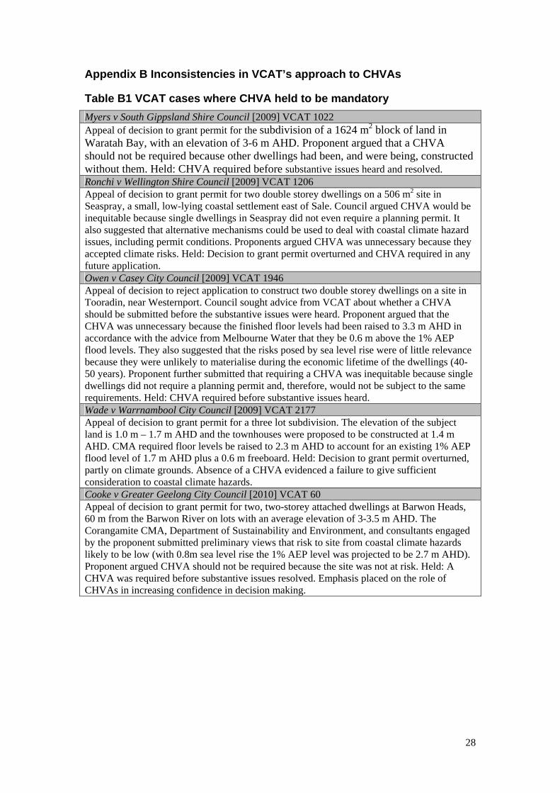
Table B2 VCAT cases where CHVA held to be unnecessary
W & B Cabinets v Casey City Council [2009] VCAT 2072 Appeal of decision to reject application to construct 22 single story dwellings on a 12,363 m² lot in Tooradin, 385 m from Western Port Bay and 240 m from Sawtells Inlet. Council sought VCAT advice on whether CHVA required, and subsequently argued that a CHVA should be prepared before the application was decided. Melbourne Water advised that it did not object to the application if the floor levels were raised to 0.6 m above the existing 1% AEP flood level. Held: CHVA not required as the referral advice provided by Melbourne Water satisfied the requirements of the state framework. Wallis Watson Kilcunda Pty Ltd v Bass Coast Shire Council [2010] VCAT 718 Appeal to VCAT of Council’s failure to make a decision on an application for a 52 lot residential subdivision on a site in Kilcunda (near Phillip Island), several hundred metres from the coast and adjacent to Bourne Creek. Held: Permit granted. CHVA not required because sufficient information provided through the evidence given in the hearing. Concluded that the effects of climate change would not have a significant impact on the site and that the site would benefit from measures that are likely to be taken to protect the Bass Highway, which separates the site from the foreshore. Azzure Investment Group Pty Ltd v Mornington Peninsula Shire Council [2010] VCAT 860 Appeal of Council’s failure to make decision on an application for service station on a site in Tootgarook with an elevation of 2.8 m – 3.4 m AHD, near Port Phillip Bay. Held: CHVA was not required because the station has an economic life of 30 years and that, by that time, under the SRES A1FI scenario, the site would still have a minimum freeboard of 1 m. Emond Golf Pty Ltd v Frankston City Council [2010] VCAT 1183 Appeal of decision to reject application to construct eight dwellings in a four storey building on a site on the Nepean Highway, Seaford, near Port Phillip Bay, with an elevation of 2.81 m – 4.02 m AHD. Held: CHVA not required because inundation risk low and the ‘land would get the benefit of any future works to protect the Highway’. W & D Perrett & Period Developments Pty Ltd v Frankston City Council [2010] VCAT 1359 Appeal of decision to reject application to construct two buildings, each containing a three storey dwelling and a two storey dwelling, at 204 Nepean Highway, Seaford, near Port Phillip Bay. Proposed finished floor levels below the levels required by Melbourne Water (minimum of 2.4 m AHD). Held: CHVA not required if plans amended to accord with minimum floor level requirements specified by Melbourne Water. Ausbuild Constructions Pty Ltd v Frankston City Council [2010] VCAT 1778 Appeal of decision to reject application to construct a three storey building containing 19 dwellings on a site on the Nepean Highway, near Port Phillip Bay and abutting Kananook Creek. Melbourne Water advised the floor levels should be a minimum of 2.4 m AHD, the entrance to the basement car park should be flood proofed to a minimum of 2.4 m AHD and that there should be no buildings or works below 1.55 m AHD. Held: Melbourne Water advice made CHVA unnecessary. Coastal climate hazard risk acceptable because of advice of Melbourne Water and fact that the site would benefit from likely future works to protect the Nepean Highway and associated infrastructure. Kropik v Hobsons Bay City Council [2011] VCAT 1979 Appeal of decision to grant permit for three double storey dwellings on Somers Parade, Altona (near Port Phillip Bay). Permit issued subject to condition that required finished floor levels to be modified to be consistent with advice provided by Melbourne Water or, in the event the advice was not forthcoming, for the proponent to engage a coastal engineer to prepare a CHVA that specifies required floor levels. Held: The permit conditions were not satisfactory as they could lead to significant changes to the development after approval. VCAT required the proponent to nominate the floor levels, which would then be referred to Melbourne Water for advice.
30
ANU Centre for Climate Law and Policy ANU College of Law The Australian National University Canberra ACT 0200 Ph: 61 2 6125 3832 http://law.anu.edu.au/CCLP/