Embed Size (px)
Citation preview
Coastal Land Loss and Landscape Level Plant Community Succession: An Expected Result of Natural Tectonic Subsidence,
Fault Movement, and Sea Level Rise
Kathleen S. Haggar
Riparian Inc., P.O. Box 40873, Baton Rouge, Louisiana 70835
ABSTRACT
This paper examines the natural and anthropogenic factors that are present and absent at Goose Point. Goose Point is of interest because it lacks most of the “usual (anthropogenic) suspects” typically associated with coastal land change in Louisiana. While most of Louisiana’s coastal land change has been attributed to anthropogenic factors, such may not be the case everywhere. Goose Point lacks anthropogenic impacts (such as levees and pumps, oil and gas exploration canals, production pipelines, and deep draft channels to cause salt water intrusion). Moreover, it also lacks typically nom-inated natural cause agents (such as thick sections of unconsolidated sediments). Since studies of faults and subsidence in the 2000s by other workers, the litany of coastal land loss factors has broadened to include faulting, small earthquakes, and regional defor-mation associated with crustal downwarping and transform faulting, in addition to sea level rise. Goose Point therefore may be an excellent control site for comparison with coastal habitats, both marshes and coastal woodlands, which have experienced coastal land change/land loss.
Goose Point, Louisiana, is located on the north shore of Lake Pontchartrain, far away from the coastal land loss so common to southern Louisiana. Unlike New Orleans, built on sediment deposited by the Mississippi River just a few thousand years ago as a feature of the St. Bernard Delta, most of the north shore of St. Tammany Parish is a Pleistocene terrace. In the northeastern corner of the lake there are Holocene fringing marshes. Yet, the same pattern of land loss, which would perhaps be more accurately known as “land change,” is also present at Goose Point. However, the conversion of marsh to open water at Goose Point cannot be attributed to any of the typically cited factors supposedly responsible for the southern marsh losses, such as levees and pumps, development, ground water extraction, direct removal by construction of oil and gas exploration and development canals, salt water intrusion into fresh environments via man-made deep draft channels or exploration and development canals, and surface oil and gas production impacts. Further, unlike most of the south coast of Louisiana, com-paction of sediment is not a significant factor at Goose Point, because there are no thick ancestral Mississippi River sediments there.
So, why does Goose Point exhibit the same signature of subsidence, the same pattern of marsh conversion to open water absent any of the “usual suspects?” Tectonic forces such as regional downwarp that provides the accommodation space for coastal sedimen-tary basins, transform movements associated with basement structures, buoyant salt movements in the southern Louisiana salt basin, earthquakes, and possible fault-driven subsidence along the Baton Rouge Fault System contribute to the subsidence mecha-nisms that, along with sea level rise, drive vegetation change and marsh loss/land change at Goose Point.
For example, the Baton Rouge Fault System trends northwest-southeast, straddling the north shore of Lake Pontchartrain with at least four active known active fault seg-ments in the lake. Prominent lineaments have been mapped as onshore components of
Haggar, K. S., 2014, Coastal land loss and landscape level plant community succession: An expected result of natural tectonic subsidence, fault movement, and sea level rise: Gulf Coast Association of Geological Societies Transactions, v. 64, p. 139–159.
139
Haggar
the Baton Rouge–Denham Springs Fault System. Changes in relative elevation and slope of marshes alter the hydrology of the marsh. Active faults that have been observed in the marshes of southeastern Louisiana often have extensive zones of deformation asso-ciated with the downthrown block; that deformation alters marsh hydrology. Increases in water depth, frequency of inundation, and duration of inundation are all drivers of plant succession in response to lower elevations due to any combination of tectonics and rising sea level. Marsh collapse/open water results when no plants can survive the com-bined stresses of water depth, frequency, and duration visited on the site. Marsh salinity increases or decreases in the Goose Point Marsh are relative to the salinity of the lake and overland sheet flow from higher elevations, as well as communication with Bayou Lacombe. Landscape level slopes can be altered by movements within the zone of defor-mation associated with active faults that have not yet broken to the surface. Salt water intrusion alone cannot to be a driver in plant succession or marsh loss at this site be-cause the dominant marsh plants at the site are still within their salinity tolerances. However, increased water depth and duration due to possible fault zone deformation, crustal downwarping, and sea level rise do play a role in driving plant community changes in the Goose Point marshes.
Goose Point’s land change over time serves as an excellent control site for compari-son with breakup of Louisiana’s coastal marshes fronting the Gulf of Mexico since it lacks anthropogenic impacts typically associated with coastal land loss. However, due to PO–33, a marsh recreation project constructed in 2008 at Goose Point (and at Point Platte just to the east), its utility as a control site for distinguishing tectonic subsidence from sea level rise may have been impacted. This site should be closely monitored for sediment aggradation or export, elevation, and salinity changes over time if we are to better understand the inter relationships between coastal geology and the fate of our coastal marshes.
INTRODUCTION Goose Point is located just south of Lacombe, Louisiana, on the north shore of Lake Pontchartrain, referred
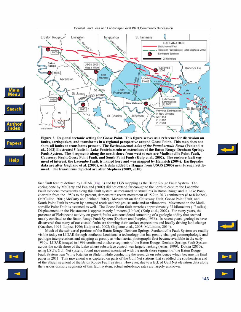
to in this paper as the Lake. The Lake is actually not a Lake, but a Bay in open communication with Lake Borgne and the Mississippi Sound, chiefly through the Chef Menteur and the Rigolets passes, with the Inner Harbor Nav-igation Canal playing a very minor role (Georgiou et al., 2007). This paper focuses primarily on the area of Goose Point west of Bayou Lacombe between the Lake and the onshore Lacombe fault segment of the Baton Rouge Fault System; see Figure 1.
The Goose Point marsh and the pine flatwoods landscape level communities are bounded by two fault seg-ments - one on shore just south of Lacombe and one in the lake just off the tip of Goose Point. These faults are associated with the Denham Springs–Baton Rouge Fault System (Lopez et al., 1997; McCulloh and Heinrich, 2013). However, for purposes of this paper, the faults onshore and in the Lake will be treated as one system of faults—the Baton Rouge Fault System. The fringing intermediate and brackish marshes rest atop Holocene mucky organic sediments that are separated by an unconformity from the Hammond Prairie Alloformation that rises to the north where it is sub-aerial at the marsh/pine flatwoods boundary.
This northern segment of the Baton Rouge Fault System is on the south side of Lacombe and is referred to here as the Lacombe fault. It is located about 15 meters (50 feet) south of the Tammany Trace as it crosses Loui-siana Hwy. 434/Lake Road. The southern bounding fault segment is in the Lake just off the southern tip of Goose Point, as mapped by Lopez (1996). This southern fault is mapped as the Goose Point Fault; it is one of four faults that move through the lake in an echelon pattern about 6 kilometers (4 miles) south of the north shore en echelon faults. These faults, Lacombe included, act on—or at least influence—the shoreline of the Lake. Lopez (1996) documented the in-lake fault set and their ongoing movement offsetting the Causeway Bridge, the rail road and U.S. Hwy. 11 bridges south of Slidell, the original U.S. Interstate Hwy. 10 (I–10) (Twin Span de-stroyed by Katrina), and cracking of U.S. Hwy. 190.
Unlike the long established cities and towns that border the Lake and have hardened shorelines, the marshes at Goose Point are as open to storm impacts as their sister marshes along the Louisiana coast. Fringing marshes form a narrow shore line band from the western side of Slidell to Fontainebleau State Park just west of Goose Point. The origin of these marshes is not precisely known (Kindinger, 1998a, 1998b). However, they could have formed by tectonic forces such as basin down-warping and the slow creep of faults onshore and offshore along the eastern end of the Lake by subsiding and/or tilting the Prairie surface. As long as freshwater runoff was suffi-cient and sea level was at or near a still stand, sustainable marshes could have developed. Vegetation surveys by
140
Coastal Land Loss and Landscape Level Plant Community Succession
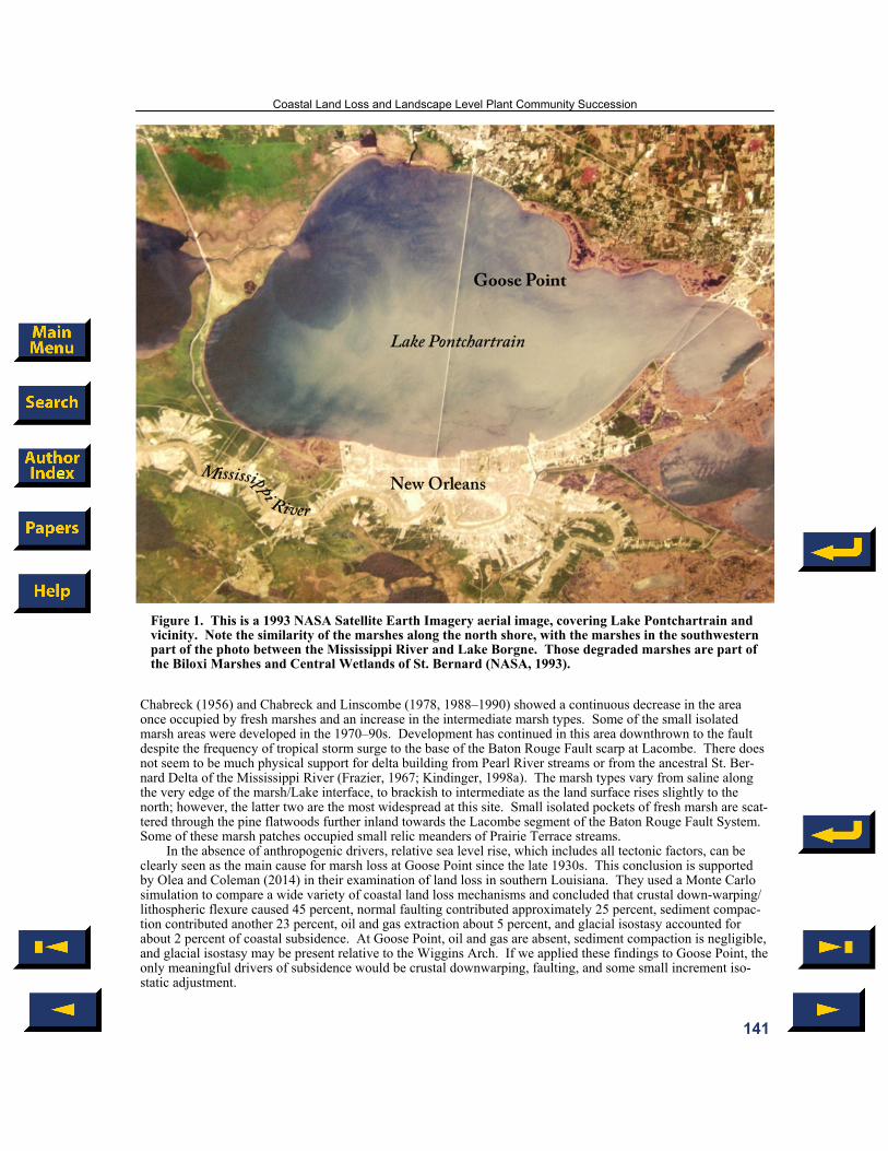
Figure 1. This is a 1993 NASA Satellite Earth Imagery aerial image, covering Lake Pontchartrain and vicinity. Note the similarity of the marshes along the north shore, with the marshes in the southwestern part of the photo between the Mississippi River and Lake Borgne. Those degraded marshes are part of the Biloxi Marshes and Central Wetlands of St. Bernard (NASA, 1993).
Chabreck (1956) and Chabreck and Linscombe (1978, 1988–1990) showed a continuous decrease in the area once occupied by fresh marshes and an increase in the intermediate marsh types. Some of the small isolated marsh areas were developed in the 1970–90s. Development has continued in this area downthrown to the fault despite the frequency of tropical storm surge to the base of the Baton Rouge Fault scarp at Lacombe. There does not seem to be much physical support for delta building from Pearl River streams or from the ancestral St. Ber-nard Delta of the Mississippi River (Frazier, 1967; Kindinger, 1998a). The marsh types vary from saline along the very edge of the marsh/Lake interface, to brackish to intermediate as the land surface rises slightly to the north; however, the latter two are the most widespread at this site. Small isolated pockets of fresh marsh are scat-tered through the pine flatwoods further inland towards the Lacombe segment of the Baton Rouge Fault System. Some of these marsh patches occupied small relic meanders of Prairie Terrace streams.
In the absence of anthropogenic drivers, relative sea level rise, which includes all tectonic factors, can be clearly seen as the main cause for marsh loss at Goose Point since the late 1930s. This conclusion is supported by Olea and Coleman (2014) in their examination of land loss in southern Louisiana. They used a Monte Carlo simulation to compare a wide variety of coastal land loss mechanisms and concluded that crustal down-warping/lithospheric flexure caused 45 percent, normal faulting contributed approximately 25 percent, sediment compac-tion contributed another 23 percent, oil and gas extraction about 5 percent, and glacial isostasy accounted for about 2 percent of coastal subsidence. At Goose Point, oil and gas are absent, sediment compaction is negligible, and glacial isostasy may be present relative to the Wiggins Arch. If we applied these findings to Goose Point, the only meaningful drivers of subsidence would be crustal downwarping, faulting, and some small increment iso-static adjustment.
141

Anyone considering the potential/suitability for restoration or re-creation of habitats on the Louisiana coast must account for the ongoing natural changes that occur on a local and regional scale; the expected results of natural earth processes (Dean, 2006; McLindon, 2014; Olea and Coleman, 2014). Correctly understanding the nature of earth processes and how they drive coastal land change is essential. If the model is wrong, no project can succeed. Anthropogenic factors are not as significant in the marshes at Goose Point as in some areas of the Louisiana coast. Therefore Goose Point is perhaps one of the best places for Louisiana to gage natural processes in the absence of large scale anthropogenic impacts.
GEOLOGIC SETTING
Stratigraphy The Goose Point area is included on the Gulfport Geologic Quadrangle produced by the Louisiana Geologi-
cal Survey (LGS). Heinrich (2004) interpreted this area as the Hammond Alloformation of the Prairie Allogroup. The weathered remains of coastal ridges at Goose Point are interpreted to be within this group. The fringing marshes however are considered to be Holocene. Some small areas of undetermined Quaternary are also mapped (Heinrich, 2004)
Baton Rouge Fault System One of the more noticeable causes of coastal land change is driven by faults that reach the surface. Fisk
(1944) was the first to publish on the existence of the Baton Rouge Fault. He noted that the system was about 13 kilometers (8 miles) wide and extended for over 110 kilometers (70 miles) long between Baron Rouge and east-ern St. Tammany. LIDAR flown by the Louisiana Department of Natural Resources (Atlas, 1999) further refined this trend to extend beyond Slidell, the Pearl River area of southwest Mississippi and the Mississippi Sound. The combined Tepetate–Baton Rouge fault systems extend from eastern Mexico through Texas, Louisiana, and the southwestern most tip of Mississippi (Murray, 1961)
Geologists such as, Durham and Peeples (1956), Durham (1964), and Hanor (1982) have referred to the Ba-ton Rouge, Denham Springs, and Scotlandville faults as a “zone” while Murray (1961) and Durham (1968) used the term “system.” After the 1958 earthquakes in Baton Rouge area, various segments along all three fault zones were actively breaking foundations during the late 1950s through mid-1960s (Durham 1964). This paper treats the northwest-southeast trending sub-parallel fault segments both in Lake Pontchartrain and on the north shore belonging to the Baton Rouge Fault System as a tectonic collective; see Figure 2. Here, the Baton Rouge Fault System segment north of Goose Point Marsh and south of Lacombe is referred to as the Lacombe Fault. The Goose Point Fault in Lake Pontchartrain just south of the tip of Goose Point was described and named by Lopez (1996) and cited in a subsequent paper (Lopez et al., 1997).
The Baton Rouge Fault System is the northernmost listric system associated with the conveyance of over 20,000 meters (65,600 feet) of sediments into the Gulf of Mexico (Dokka, 2006; Peel, 1995; Worrall and Snel-son, 1989).
Like other listric fault systems in Louisiana and in the Gulf, the movement along the Baton Rouge Fault System has been episodic. The subsurface nature of the Baton Rouge Fault System in the Baton Rouge area is documented by well logs and seismic data that date back to the earliest discovery of the University Field on the Louisiana State University (LSU) campus in the late 1930s (Durham 1964). Individual fault segments throughout this system were moving and expanding wedges of sediment during the Eocene, Oligocene, and Miocene and again more recently during the Pleistocene and Holocene (Roland et al., 1981; Nunn 1985; Milner and Heinrich, 2003; Lorenzo et al., 2004).
Just west of the Mississippi River in Point Coupe Parish, Hanor (1982) noted there were two distinct periods of movement on one of the Tepetate–Baton Rouge fault segments. The older movement was thought to be Lower Eocene–Wilcox or possibly earlier into Upper Oligocene–Frio. After the deposition of nearly 2400 m (8000 feet) of Miocene fluvial sands and shales, movement resumed. He measured displacement of about 12 meters (40 feet) of movement that he concluded was likely Pleistocene in age. The surface projection of the Baton Rouge Fault dip was estimated from a fault segment in the Baton Rouge area to be approximately 70 degrees (Durham and Peoples, 1956).
The Goose Point Fault off the tip of the Goose Point marsh was imaged by seismic and interpreted from core samples from an abrupt step down of the Pleistocene sediments along a transect through the Goose Point marsh which extends into the Lake. The Lake is actually about 7.2 kilometers (about 4.5 miles) south of the sur-
Haggar
142
face fault feature defined by LIDAR (Fig. 3) and by LGS mapping as the Baton Rouge Fault System. The coring done by McCarty and Penland (2002) did not extend far enough to the north to capture the Lacombe Fault. Holocene movements along this fault system, as measured on structures in Baton Rouge and in Lake Pont-chartrain from the 1950s to the present, demonstrate recent movement of 15.2 to 20.3 centimeters (6 to 8 inches) (McCulloh, 2001; McCarty and Penland, 2002). Movement on the Causeway Fault, Goose Point Fault, and South Point Fault is proven by damaged roads and bridges, seismic and/or vibracores. Movement on the Madi-sonville Point Fault is assumed as well. The Goose Point fault stretches approximately 27 kilometers (17 miles). Displacement on the Pleistocene is approximately 3 meters (10 feet) (Kulp et al., 2002). For many years, the presence of Pleistocene activity on growth faults was considered something of a geologic oddity that seemed mostly confined to the Baton Rouge Fault System (Durham and Peoples, 1956). In recent years, geologists have discovered that many of our coastal faults are showing their surface expressions and locally driving land change (Kuecher, 1994; Lopez, 1996; Kulp et al., 2002; Gagliano et al., 2003; McLindon, 2014).
Much of the sub-aerial portions of the Baton Rouge–Denham Springs–Scotlandville Fault System are readily visible today on LIDAR through southeast Louisiana, a technology that has greatly changed geomorphologic and geologic interpretations and mapping as greatly as when aerial photographs first became available in the early 1930s. LIDAR imaged in 1999 confirmed onshore segments of the Baton Rouge–Denham Springs Fault System across the north shore of the Lake where subsurface control was largely lacking (Atlas, 1999). Dokka (2010), using LSU’s Gulf Net system, found movement associated with the north shore segment of the Baton Rouge Fault System near White Kitchen in Slidell, while conducting the research on subsidence which became his final paper in 2011. This movement was captured on parts of the Gulf Net stations that straddled the southeastern end of the Slidell segment of the Baton Rouge Fault System. However, due to a lack of Gulf Net elevation data along the various onshore segments of this fault system, actual subsidence rates are largely unknown.
Figure 2. Regional tectonic setting for Goose Point. This figure serves as a reference for discussion on faults, earthquakes, and transforms in a regional perspective around Goose Point. This map does not show all faults or transforms present. The Environmental Atlas of the Pontchartrain Basin (Penland et al., 2002) illustrated 5 faults in Lake Pontchartrain as extensions of the Baton Rouge–Denham Springs Fault System. The 4 segments along the north shore from west to east are Madisonville Point Fault, Causeway Fault, Goose Point Fault, and South Point Fault (Kulp et al., 2002). The onshore fault seg-ment of interest, the Lacombe Fault, is named here and was mapped by Heinrich (2004). Earthquake data are after Gagliano et al. (2003), with data added by Haggar from USGS (2005) near French Settle-ment. The fransforms depicted are after Stephens (2009, 2010).
Coastal Land Loss and Landscape Level Plant Community Succession
143

Kulp et al. (2002) found four active fault segments in Lake Pontchartrain. They referred to these listric faults collectively as belonging to the Baton Rouge–Denham Springs Fault System. Typically, the measured dip of the fault plane along listric faults changes from a high angle about 65 degrees to about 45 degrees, and gradu-ally reaches a deeper glide plane that may well exceed 6000 meters (20,000 feet). They estimated possible move-ments along these faults between 2.5 to 10 millimeters/year (0.1 to 0.4 inch/year).
For the purposes of this paper, the faults on the north shore of the Lake and the similarly oriented faults in the lake are considered here to belong to the Baton Rouge Fault System. Individual faults are discussed here as fault segments. Most available high resolution seismic stops at the lake shore at Goose Point. There are no known wells or cores which penetrate the Lacombe Fault. North of Lake Maurepas, these fault segments separate bottomland hardwoods from swamps and marshes, but in the Goose Point area the Lacombe Fault cuts through the mixed pine flatwoods underlain by the Hammond Alloformation (Heinrich, 2004).
The scarp of Louisiana Hwy. 434/Lake Road crosses the Lacombe Fault and continues to the shore of Lake Pontchartrain, a distance of about 5.6 km (3.5 miles) from the Lake.
At least four faults that are part of the Baton Rouge-Denham Springs fault system cross through Lake Pont-chartrain. From northwest to southeast they are the Madisonville Point Fault, the Causeway Fault, the Goose Point Fault, and the South Point Fault (Kulp et al., 2002). These faults are still active as evidenced by offsets in the Causeway, the railroad bridge between New Orleans East and Old Slidell, the U.S. Hwy. 11 bridge, and the original Twin Span of I–10. (We can presume the Madisonville Point Fault would have shown movement but for the lack of structures.). Hurricane Katrina destroyed the shimmed part of the Twin Span in August of 2005, so the lost buckled eastbound guard rail just past the southern shoreline is no longer a tangible testament to fault activity. The Lake faults are still there and are probably still moving. The mapped onshore fault segments are very apparent on LIDAR; see Figure 3.
There is no direct evidence that the Lacombe Fault has moved as recently or as dramatically as the fault seg-ments in the Baton Rouge that broke building slabs, streets and other hard structures in the late 1960s–mid-1970s. But there is indirect evidence that there is tectonic driven subsidence, possibly due to fault movement. The fault segments that go through Lake Pontchartrain have offset the Causeway Bridge at mid-Lake, as well as the Rail Road Trestle and the Twin Spans (I–10) on the eastern end of the Lake. We do not have direct information on such surface expressions as broken slabs or leaning buildings for the Lacombe segment of the fault. However, we can see definite patterns of subsidence in the marshes and see plant communities migrating inland along the north shore of Pontchartrain and Maurepas lakes.
The evidence of subsidence we see at Goose Point is in the landscape level communities in the marshes over the past several decades. The pattern of plant community change and the appearance of more open water is indis-tinguishable from the patterns of marsh loss throughout the adjoining subsiding areas of Orleans, St. Bernard Plaquemines, and Jefferson parishes and much of the central and western portions of coastal Louisiana. The plant communities have changed—and are continuing to change. Some parts of the marshes are too deep to grow marsh plants and have become irregular ponds that only support submerged aquatic vegetation (SAV). Another possible bit of evidence for subsidence and fault movement is the pine beetle infestation at Fontainebleau State Park in the mid-1990s. There was a mature stand of beautiful Long Leaf Pines in the park. During that period of time, the beetles attacked trees sporadically along the north shore. But, the greatest known concentrated loss of pines was at Fontainebleau and Big Branch. The Lacombe segment of the Baton Rouge Fault cuts through Fon-tainebleau as the LIDAR clearly shows. Movement along the fault, or possibly the movement of saline fluids along the fault plane, could have stressed the trees and made them more vulnerable to attack by the beetles. In Slidell further to the east, along another segment of the Baton Rouge Fault System similar tree problems were occurring. At U.S. Hwy. 190 and Apple Pie Ridge Road, and also along the eastern side of Apple Pie Ridge, the old live oaks that lined the ridge began dying in the mid-1990s (Hedges, 1996). Homeowners said that their ar-borist told them that the oaks were dying from salt water in the root zone. Perhaps, like the pines at Fon-tainebleau, the salt stress is either the result of subsidence into higher salinity ground water or it might arise from saline fluids leaking up the fault plane and displacing fresh ground water.
FACTORS INFLUENCING COASTAL LAND CHANGE
Anthropogenic Factors Not Present at Goose Point
Levees and Pumps There are no levees or pumps at Goose Point. The classic case for subsidence due to levees and pumps are
the levees in the coastal parishes, such as Orleans and Jefferson. Peat deposits on inter-distributary clays de-
Haggar
144

scribed by Saucier (1963) are largely responsible for much of the subsidence effects observed in New Orleans after hurricane Katrina. However, Goose Point is not part of a delta complex. The thin fringing marsh is built atop Pleistocene sediments.
High Volume Injection Wells and Water Wells There are no high volume injection wells in Goose Point (SONRIS, 2014) and only two low volume injec-
tion wells—less than 7500 liters (2000 gallons) per quarter (Lee, 2014). Moreover, the two low volume wells were completed in 2011, decades after the marsh losses documented by Chabreck in 1956 and 1978. Similarly, there are no municipal water wells at Goose Point Marsh and only individual residential wells in the wooded are-as below the Lacombe Fault (SONRIS, 2014). In the Goose Point marsh area, the database shows only 2 water wells, both in the marsh. These points may be miss-plots since they do not appear to correspond to any existing structures (SONRIS, 2014).
Exploration/Production Canals or Oil and Gas Production There is no production associated with Goose Point marsh or the mixed pine flatwoods area between Goose
Point and the Lacombe Fault. The nearest production is to the east in the Lake, closer to Point Platte. Even so, it was a small field, with scant production. Out of the 43 locations in the Lake, only 5 wells produced gas and con-densate from the downthrown rollover structure associated with the Goose Point Fault off Point Platte. Those
Figure 3. Goose Point LIDAR Map (Lacombe SW and SE LIDAR Panels) (Atlas 1999a, 1999b). LI-DAR shows the fault relief along the trace of the Baton Rouge Fault just south of the Tammany Trace linear park. The Lacombe Fault segment of the Baton Rouge fault dies out just east of Bayou Lacombe. The point to the east of Goose Point is Point Platte. The profile shown here (Fig. 9) is to the west of Louisiana Hwy. 434/Lake Road and travels through the eastern side of the subject area.
Coastal Land Loss and Landscape Level Plant Community Succession
145

wells sat between 3 and 4 kilometers (2 and 2.5 miles) off the current shoreline. The wells were drilled in the 1940–50s and by about 1954 most had been plugged and abandoned (SONRIS, 2014). Since the patterns of marsh loss are similar at Goose Point, Point Platte, Big Point, and Slidell, it is highly improbable that this produc-tion had any effect on either the interior or fringing marshes.
Deep Draft Channels There are no deep draft channels similar to the Gulf Intra-Coastal Water Way (GIWW) along the north
shore. Because the deepest parts of the Lake are only 4 meters (15 feet) (NOAA, 2012), it never had deep draft traffic. The Mississippi River–Gulf Outlet (MRGO) deep draft channel in the Biloxi Marsh through St. Bernard Parish is a special case that does not apply to the north shore.
Natural Land Change Factors Not Present at Goose Point
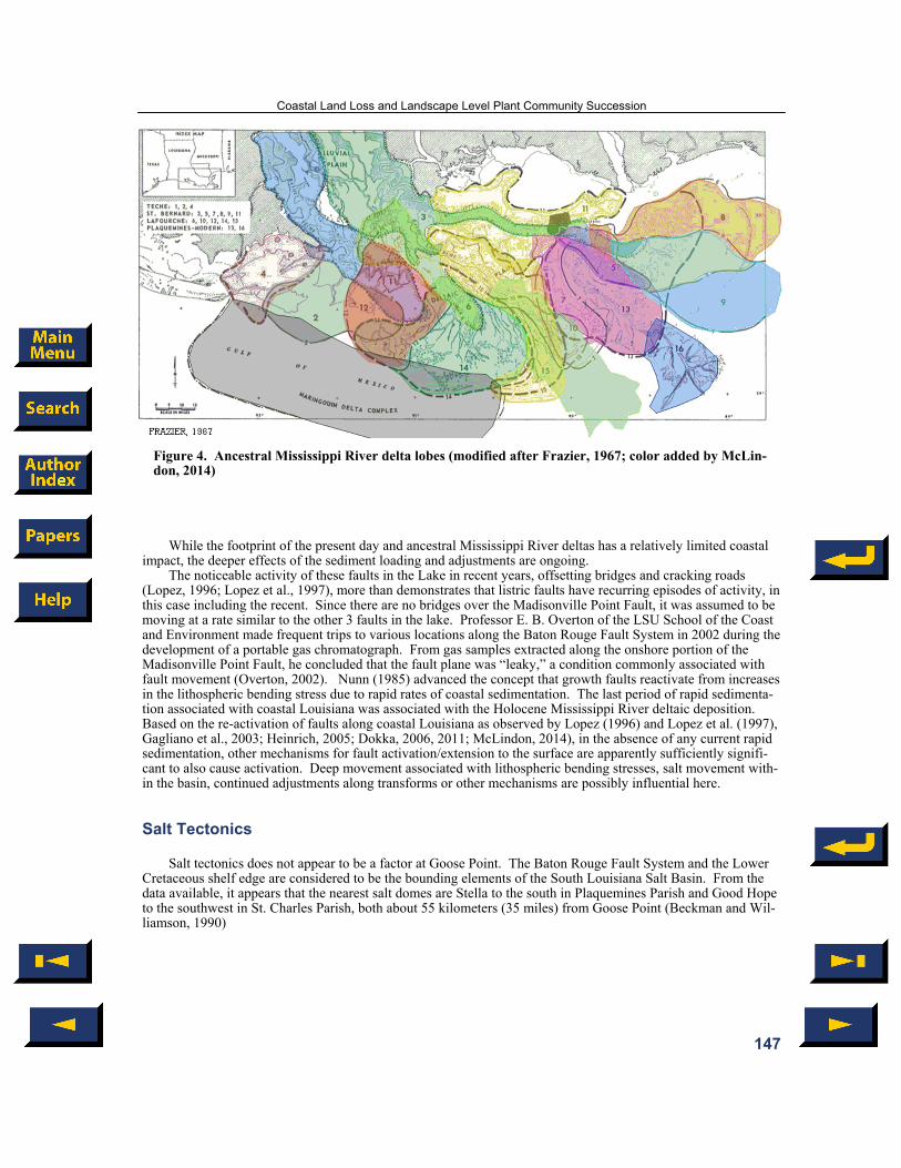
Ancestral Mississippi Deltas Figure 4 below is after Frazier (1967) and shows the location of Goose Point. Frazier, more than most, went
into detail on the channels and lobes associated with each of the ancestral Mississippi River deltas in succes-sion—16 of them in all. The closest delta to approach Goose Point was associated with the easternmost distribu-taries of the St. Bernard Delta. Two distributary channels diverted to the north towards the Baton Rouge Fault System. One went along the area that forms the land bridge between Lake Maurepas and the other formed the eastern New Orleans land bridge towards Slidell. These unusual north trending distributaries may have been “invited” by the zone of deformation associated with the Baton Rouge Fault System that helped to create Bay Pontchartrain/Lake Pontchartrain (Lopez et al., 1997; Sabate and Wiltenmuth, 2003). None of the ancestral del-tas of the Mississippi River reached Goose Point, or the north shore of Lake Pontchartrain; see Figure 5. The Holocene sediments on the north shore are present only as a thin wedge, 2.5 meters (8 feet) or less, mostly south and downthrown to the fault line scarps that parallel the lake (McCarty and Penland, 2002). The closest delta to Goose Point was the Cocodrie, delta II. However, this delta was not preserved. It was the first delta to swing to the east side of the Mississippi River trunk channel. The St. Bernard, delta VIII, was the most recent and is still subaerial (Frazier, 1967)
The areas where successive deltas have been active throughout the Holocene are also the sites of dramatic wetland loss over the past 50 years (Couvillion et al., 2011; Reed and Wilson, 2004). Compaction of these geo-logically young sediments has been proposed as one of the primary reasons for this coastal land loss (Törnqvist et al., 2006). However, Dokka (2009) concluded a different and much deeper process was at work—tectonics. Perhaps fault planes more frequently propagate to the surface as sediments compact? But more work would seem necessary to resolve the Törnqvist-Dokka tension (González and Törnqvist, 2006; Törnqvist, 2006). For exam-ple, González and Törnqvist (2006, p. 91) concluded that “The absence of major seismic activity in large portions of the southern United States during the past century raises serious concerns about the subsidence rates derived from the leveling data.” However, Dokka’s final paper (2011) did not conclude the tectonic-driven subsidence occurred rapidly enough to be detectable by seismic means. No reasonable person would expect an event lasting 25 years (1970–1995) to produce such a signal. Moreover, the cracked and displaced bridges documented by Lopez (1996) and Lopez et al. (1997) did not yield a detectable seismic signal yet resulted in structural damage and offset sufficiently severe to require repair.
In any case, for the marsh at Goose Point to exhibit the same pattern of degradation and collapse to open water as seen along the southern coastal areas, it must have something in common with those coastal marshes that have undergone similar patterns of break-up and collapse. However, there is a conspicuous lack of anthropogenic factors at Goose Point that are given heavy weight as causal factors elsewhere along the Louisiana coast (Reed and Wilson, 2004). Among the natural geologic factors that have influenced this area are sea level rise and the minimal thickness of the Holocene marsh sediments which limits sediment compaction (McCarty and Penland, 2002). Additionally, tectonic drivers include transforms, salt movements in the basin, faulting, earthquakes, crus-tal downwarp related to the delta depocenters, isostatic adjustments and uplift associated with the Wiggins Arch. Plant succession in the marsh and also in the mixed pine flatwoods between the tip of Goose Point and the Lacombe fault reflect ongoing subsidence in this area. Subsidence makes sustainability unachievable in the marsh and is a challenge areas of low sediment supply (even with geologic stability) in the face of rising sea lev-els (Blum and Roberts, 2009, 2012).
Haggar
146
While the footprint of the present day and ancestral Mississippi River deltas has a relatively limited coastal impact, the deeper effects of the sediment loading and adjustments are ongoing.
The noticeable activity of these faults in the Lake in recent years, offsetting bridges and cracking roads (Lopez, 1996; Lopez et al., 1997), more than demonstrates that listric faults have recurring episodes of activity, in this case including the recent. Since there are no bridges over the Madisonville Point Fault, it was assumed to be moving at a rate similar to the other 3 faults in the lake. Professor E. B. Overton of the LSU School of the Coast and Environment made frequent trips to various locations along the Baton Rouge Fault System in 2002 during the development of a portable gas chromatograph. From gas samples extracted along the onshore portion of the Madisonville Point Fault, he concluded that the fault plane was “leaky,” a condition commonly associated with fault movement (Overton, 2002). Nunn (1985) advanced the concept that growth faults reactivate from increases in the lithospheric bending stress due to rapid rates of coastal sedimentation. The last period of rapid sedimenta-tion associated with coastal Louisiana was associated with the Holocene Mississippi River deltaic deposition. Based on the re-activation of faults along coastal Louisiana as observed by Lopez (1996) and Lopez et al. (1997), Gagliano et al., 2003; Heinrich, 2005; Dokka, 2006, 2011; McLindon, 2014), in the absence of any current rapid sedimentation, other mechanisms for fault activation/extension to the surface are apparently sufficiently signifi-cant to also cause activation. Deep movement associated with lithospheric bending stresses, salt movement with-in the basin, continued adjustments along transforms or other mechanisms are possibly influential here.
Salt Tectonics Salt tectonics does not appear to be a factor at Goose Point. The Baton Rouge Fault System and the Lower
Cretaceous shelf edge are considered to be the bounding elements of the South Louisiana Salt Basin. From the data available, it appears that the nearest salt domes are Stella to the south in Plaquemines Parish and Good Hope to the southwest in St. Charles Parish, both about 55 kilometers (35 miles) from Goose Point (Beckman and Wil-liamson, 1990)
Figure 4. Ancestral Mississippi River delta lobes (modified after Frazier, 1967; color added by McLin-don, 2014)
Coastal Land Loss and Landscape Level Plant Community Succession
147

Figure 5. Evolution of Lake Pontchartrain (modified after Kindinger, 1998b).
Natural Land Change Factors Present at Goose Point
Sea Level and Possible Fault Driven Subsidence Unlike sea level rise on a stable platform that undergoes only edge erosion, in this area the water disregards
the nominal shoreline and enters the marsh and intrudes into the relic channels in the pine flatwoods south of the Lacombe Fault scarp. This pattern of land loss suggests that the land is also subsiding. This area has long been recognized by the National Geodetic Survey (NGS) as a subsidence area. The NGS remarks for Benchmark BH2878, Barringer 2, indicate that a station in an area of known vertical motion will not display an orthometric height because such heights are suspect and this will only be provided upon a specific request (NGS, 2014a). This BH2878 disc is located on the high ground about midway between the Lacombe Fault and the Lake (Irish, 2014), in a required warning area for inaccurate elevations (NGS, 2014b). Comparing the 1935 Slidell USGS Quadrangle with the 2013 Google Earth aerial, there is measurable shoreline retreat, roughly estimated at 110 meters (365 feet) during that 79 year period or approximately 1.4 meters (4.6 feet) per year retreat. However, on the General Land Office survey for Township 9 South, Range 12 East, the shoreline at the tip of Goose Point was not as far south as the 1935 shoreline (Boyd, 1852a; Kennedy, et al., 1935; USGS, 1939).
Dokka (2011) and Blum and Roberts (2009) both use and estimate of sea level rise of approximately 0.3 meters percentury (approximately 1 foot per century). Adding 1 foot of possible subsidence, yields a relative sea
Haggar
148
level rise of about 0.6 meters (2 feet) per century. Is that enough to cause this pattern of land loss at Goose Point or, for that matter, out in the Biloxi Marshes in St. Bernard east of Lake Borgne? If the benchmark near the Lake on Lake Road in 1935 was 1 meter (3 feet) and if the land was stable but the sea had risen some 0.6 meters (2 feet), then 82 years later in 2014 the benchmark should be in place, but with a reduced elevation of 0.4 meters (1.36 feet). Instead, the benchmark location of 1935 is now in open water south of the end of Lake Road, where the end of the road in 2013 is at least 60 meters (200 feet) north of the original road’s end as depicted by the USGS in 1935. Further into the lake are the rotting supports for the old boat slips shown south of the “3 foot elevation” benchmark (“BM 3”) on the 1935 edition of the Slidell Quadrangle. Additionally, the data block in the lower left margin of the 1935 Quadrangle indicates the survey work for this quadrangle was done in 1932 and further that it incorporated aerials taken by the U.S. Army Air Corps (USGS, 1935). Nature, whether acting through storms, downwarp, or faults, does not conform to the human concept of “average.” Events such as fault movements and earthquakes are somewhat episodic; they do not occur at a known or presently predictable rate.
A common geomorphologic signature of fault activity in the delta marshes is the occurrence of one or more of these features: a “D” shaped depression (where the straight leg of the “D” is the scarp), ballooned channels, and rapid landscape plant community change (Gagliano et al., 2003). These signatures often expand to create open water. A review of coastal topographic maps, quadrangle maps, and land office surveys from the mid-19th century through the early 20th century (Landry, 1846; Boyd, 1852a, 1852b, 1852c; Seaton, 1860; Martin and Lindenkohl, 1889; Kennedy, 1935) shows apparent stability in that the marsh is solid, there are no open water bodies mapped, there is no significant change in the channel meander pattern or ballooning of reaches along Bay-ou Lacombe, and isolated marshes along Bayou des Mats (a relic channel) in the western pine flatwoods area of Goose Point are unchanged from earlier maps. However, beginning with the 1939 Slidell Quadrangle, the coastal areas of the Goose Point had several shore parallel openings in the marsh while the area of Bayou des Mats to the north remained unchanged (Kennedy, 1939). (Curiously, the 1950 revision and republication of this quadrangle depicted the Goose Point area with the old 1935 image of a tight, undisturbed marsh [Kennedy et al., 1950]). Old aerial photographs of this area are scarce. The marsh habitats were identified across coastal Louisiana by Cha-breck (1956), and by Chabreck and Linscombe (1978, 1988–1990). Figure 6 show a progression of their maps showing marsh breakup into open water at Goose Point; a progression indistinguishable from patterns seen along the southern coast of Louisiana directly fronting the Gulf of Mexico (Chabreck, 1956; Chabreck and Linscombe, 1978, 1988–1990).
Flooding and ballooning of the Bayou des Mats suggests subsidence possibly related to movement on the Lacombe Fault. Google Earth images of the Goose Point area from 1998 to 2013 show a reconnection of the bayou to the open water of the former marsh and significant expansion of this relic channel feature across both Goose Point and Point Platte east of Bayou Lacombe (Google Earth, 1998, 2006, 2013). The 2010 true color aerial used as the base image of the 2012 digital USGS Lacombe quadrangle map, which superseded the 1998 paper edition, shows the continued northerly reach of Bayou des Mats into old meander scars (USGS, 2012).
The oldest available vertical (as opposed to oblique) aerial located during this research is from 1978–1980; the base map for the 1990 paper copy (all subsequent soil surveys were digital only) of the St. Tammany Parish Soil Survey made the former Soil Conservation Service of the U.S. Department of Agriculture (Trahan et al.,1990; Natural Resources Conservation Service, 2014b). This aerial, Sheet 57 of the 1990 paper Soil Survey, shows dramatic expansion of the old Bayou des Mats, transformed into a wide water feature from narrow former marsh with a central but narrow slough (Trahan et al., 1990). Between 1956 and 1980, the marshes extensively deteriorated into large areas of open water (Chabreck, 1956, Chabreck and Linscombe, 1978, 1988–1990). The marsh breakup found by Chabreck and Linscombe are also depicted in the smaller scale successors of the 1935 and 1939 editions of the 1:62,500 scale “Slidell” quadrangle and the successor “Lacombe” 1;24,000 scale quad-rangles. The Lacombe edition of 1971 was photo-revised in 1979 (with aerials from 1978) and edited in 1994 (with aerials taken in 1989) before being replaced with a new edition in 1998 (USGS, 1971, 1979, 1994, 1998).
Shoreline Oscillations The shoreline at Goose Point is not smooth on Google Earth aerials; it looks chipped. This point was origi-
nally mapped as “Ragged Point” on the 1860 and 1889 maps (Seaton, 1860; Martin and Lindenkohl, 1889). The condition of the marsh and its rim may be a function of the topography of the internal marsh that is differentially eroded. A comparison of Goose Point in maps from 1856, 1860, 1889, 1935, 1939, and 2012 (2010 aerial) re-vealed patterns of an oscillating shoreline. From farthest to nearest to the present day, they were 1935, 1856, 1889, and 2010–12/present. The 1889 map closely resembles today’s shoreline, meander patterns along Bayou Lacombe, and the marsh/tree line. There are other interior marsh sand rims and relic beach berms of Holocene age. However, the Hammond Alloformation exhibits the largest of these features which straddle the Pleistocene/Holocene marsh contact.
Coastal Land Loss and Landscape Level Plant Community Succession
149
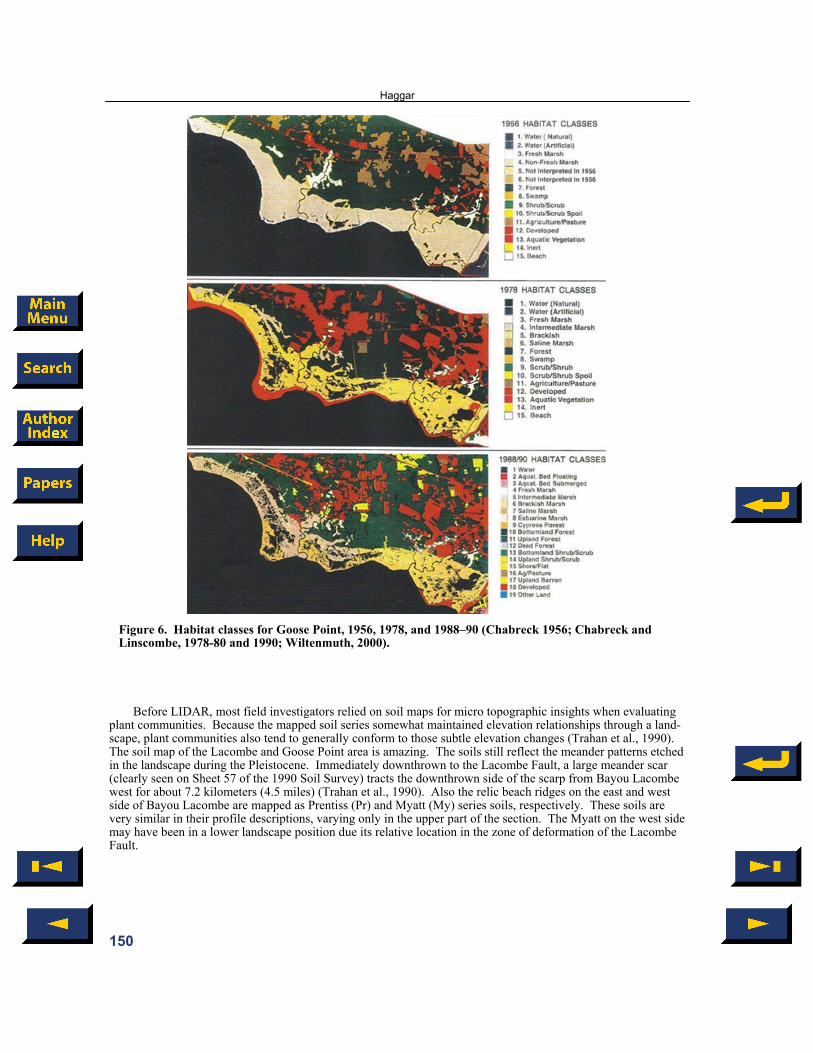
Figure 6. Habitat classes for Goose Point, 1956, 1978, and 1988–90 (Chabreck 1956; Chabreck and Linscombe, 1978-80 and 1990; Wiltenmuth, 2000).
Before LIDAR, most field investigators relied on soil maps for micro topographic insights when evaluating plant communities. Because the mapped soil series somewhat maintained elevation relationships through a land-scape, plant communities also tend to generally conform to those subtle elevation changes (Trahan et al., 1990). The soil map of the Lacombe and Goose Point area is amazing. The soils still reflect the meander patterns etched in the landscape during the Pleistocene. Immediately downthrown to the Lacombe Fault, a large meander scar (clearly seen on Sheet 57 of the 1990 Soil Survey) tracts the downthrown side of the scarp from Bayou Lacombe west for about 7.2 kilometers (4.5 miles) (Trahan et al., 1990). Also the relic beach ridges on the east and west side of Bayou Lacombe are mapped as Prentiss (Pr) and Myatt (My) series soils, respectively. These soils are very similar in their profile descriptions, varying only in the upper part of the section. The Myatt on the west side may have been in a lower landscape position due its relative location in the zone of deformation of the Lacombe Fault.
Haggar
150

Earthquakes and Transforms There have been two relatively recent but small earthquakes around Lake Pontchartrain; north of Lacombe in
2002 and near French Settlement in 2005 (Gagliano et al., 2003; USGS, 2014). At times, small tremors are felt along the trend of the Baton Rouge Fault System along the north shore of the Lake and in other areas around the Lake; however, these events are seldom reported by the USGS (Gagliano, 2008). While the fault movements in the Lake have been well documented by (e.g., Lopez, 1996), there have not been any reported quakes directly associated with their movements. These faults seem to move more like the rest of the faults in South Louisiana, primarily by creep, but occasionally episodically with offsets of inches (Dokka, 2006). However, there have been small earthquakes surrounding the Lake going back decades (Gagliano et al., 2003)
Transforms have been extensively studied by Bryan Stephens (e.g., 2009). Transform adjustments in this region may facilitate crustal down warping and could be a source for some of the small quakes felt around the Lake and along the Baton Rouge Fault system. As such, transforms would actually be first order controls on coastal geomorphology (Stephens, 2013). The north shore segments of the Baton Rouge fault align with trans-forms as proposed by Stephens (2009, 2010). Fault lines can be “captured” by transects, the controlling tectonic element. The small quakes in Figure 2 coincide with transform features. However, Stevens was not aware of these earthquake locations while mapping the transforms and so they did not influence his mapping of the trans-forms. The correlation, however, is remarkable (Stephens, 2014).
Minimal Holocene Compaction The USGS took cores in and near the Lake during the late 1990s in conjunction with a study of the Pontchar-
train Basin (Kindinger, 1998a). Five cores were taken along a transect through the middle of the Goose Point Marsh and additional cores were taken downthrown to the Goose Point Fault in the Lake. An interpreted profile is found in the report by McCarty and Penland (2002) in the Environmental Atlas of the Pontchartrain Basin (Penland et al., 2002). The profile started near the Pleistocene/Holocene marsh contact and proceeded to the Lake. From north to south, the cores encountered the top of the Pleistocene at depths of approximately +0.1, -1.2, -1.2, -1.9, and -2.4 meters (+0.3, -3.9, -3.9, -6.2, and –7.9 feet, respectively). The latter core encountered approximately 0.2 meters (0.7 feet) of shoreline sands in the interval above the Pleistocene. There was no evi-dence of deltaic sediments in the marsh deposits. One core in the Lake just below the Goose Point Fault encoun-tered approximately 2 meters (6.6 feet) of shoreline sands atop the Pleistocene at approximately -4.1 meters (-13.5 feet). This thin veneer of Holocene is not likely to result in a compaction problem. It is more likely to result in a removal problem due to weather fronts and storm surge (Freeman, 2010) .
Landscape Level Plant Community Succession at Goose Point The coastal Louisiana land change and marsh loss trend has been moving northward since 1932 as docu-
mented by the Land Loss Maps compiled by the USGS (Couvillion et al., 2011) Hydrology, salinity, storms, and marsh fires, soils are additional natural factors generally cited as causes for
coastal change specific to marsh environments and all influence the distribution of plant species. However, the degree of their impacts is subject to the movement of the ground—surface elevation, slope, and sea level rise.
Over time, plant communities appear to migrate from one place to another by dying out in one location in favor of better adapted species for that location. If this process is observed in a defined location, it is referred to as plant succession. If the site is very large, this change is viewed as landscape level change. For any given site, if no plants can survive the water depth and/or the salinity, then open water results.
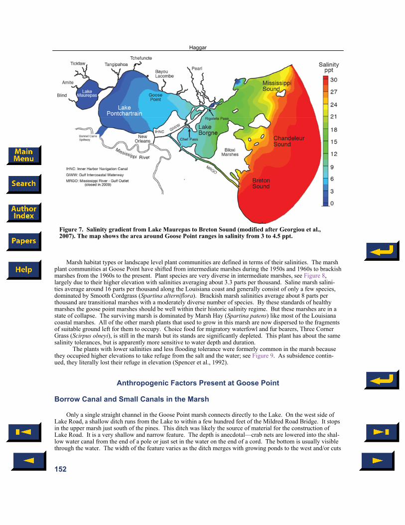
In a place like the Goose Point marsh where factors such as soil, light, and nutrients have remained relatively constant, water becomes a critical determining factor in plant succession. Water at Goose Point is present along a salinity gradient and a depth that is related to slope and elevation. Variations in the topography and slope deter-mine how long the water stays in a given area. Individual species have limits based on salinity and water depth. When the hydrology and or the salinity of a site changes, the landscape plant communities also change. When plants cannot survive, ponds develop and grow as tropical storms disperse organic sediments into the Lake. At Goose Point, the issue is not too much salinity because the marshes coexisted with the Lake for centuries or more. Salinity is a component of the mucky soils throughout most of the marsh but is highest near the Lake. Still, the average lake salinity, near Goose Point (see Figure 7) ranges between 3 and 4.5 parts per thousand.
Coastal Land Loss and Landscape Level Plant Community Succession
151
Marsh habitat types or landscape level plant communities are defined in terms of their salinities. The marsh plant communities at Goose Point have shifted from intermediate marshes during the 1950s and 1960s to brackish marshes from the 1960s to the present. Plant species are very diverse in intermediate marshes, see Figure 8, largely due to their higher elevation with salinities averaging about 3.3 parts per thousand. Saline marsh salini-ties average around 16 parts per thousand along the Louisiana coast and generally consist of only a few species, dominated by Smooth Cordgrass (Spartina alterniflora). Brackish marsh salinities average about 8 parts per thousand are transitional marshes with a moderately diverse number of species. By these standards of healthy marshes the goose point marshes should be well within their historic salinity regime. But these marshes are in a state of collapse. The surviving marsh is dominated by Marsh Hay (Spartina patens) like most of the Louisiana coastal marshes. All of the other marsh plants that used to grow in this marsh are now dispersed to the fragments of suitable ground left for them to occupy. Choice food for migratory waterfowl and fur bearers, Three Corner Grass (Scirpus olneyi), is still in the marsh but its stands are significantly depleted. This plant has about the same salinity tolerances, but is apparently more sensitive to water depth and duration.
The plants with lower salinities and less flooding tolerance were formerly common in the marsh because they occupied higher elevations to take refuge from the salt and the water; see Figure 9. As subsidence contin-ued, they literally lost their refuge in elevation (Spencer et al., 1992).
Anthropogenic Factors Present at Goose Point
Borrow Canal and Small Canals in the Marsh Only a single straight channel in the Goose Point marsh connects directly to the Lake. On the west side of
Lake Road, a shallow ditch runs from the Lake to within a few hundred feet of the Mildred Road Bridge. It stops in the upper marsh just south of the pines. This ditch was likely the source of material for the construction of Lake Road. It is a very shallow and narrow feature. The depth is anecdotal—crab nets are lowered into the shal-low water canal from the end of a pole or just set in the water on the end of a cord. The bottom is usually visible through the water. The width of the feature varies as the ditch merges with growing ponds to the west and/or cuts
Figure 7. Salinity gradient from Lake Maurepas to Breton Sound (modified after Georgiou et al., 2007). The map shows the area around Goose Point ranges in salinity from 3 to 4.5 ppt.
Haggar
152

Figure 8. Optimum salinity and water depth range for marsh plants (modified after Spencer et al., 1992). The red horizontal line approximates the average salinity for Goose Point marsh from about 3.0 to 4.5 ppt (Georgiou et al., 2007). The red balls show the optimum salinity for individual species. The green bars show optimum water depth ranges for these individual species (Couvillion and Beck, 2011) noted that optimum salinities may not correspond to sustainable conditions in some marshes.
Figure 9. Goose Point LIDAR profile from the Lake to the Lacombe Fault (Wiltenmuth, 2000). Couvillion and Beck (2013) modeled these marsh types and concluded that as relative sea level rise con-tinues, marshes either migrate inland or collapse to open water in place. This marsh community has been migrating into the lower features interior to the pine flatwoods south of the Lacombe Fault for decades. Hurricane and tropical storm winds and surge greatly assist in dispersing seeds and viable plant pieces into the surrounding area.
Coastal Land Loss and Landscape Level Plant Community Succession
153

under the three small low bridges that connect the Goose Point Marsh to Bayou Lacombe. Lake Road has been raised several times in the last 15 years with the addition of crushed limestone. The road surface during the late 1990s consisted of a mix of old Rangea shells and gravel. The repeated need for more road material also sug-gests that the area is subsiding and not just eroding.
Marsh Re-Creation Project The most noticeable recent impact to the marsh are the two marsh re-creation sites north of the shoreline rim
at the tip of Goose Point and east at Point Platte (Ruckstuhl, 2011). This 2008 Coastal Wetlands Planning, Pro-tection, and Restoration Agency (CWPPRA) project, PO–33, was almost completed when it was interrupted by Hurricane Gustav in 2008. Sand was slurry dredged into the site from the Lake south of Goose Point. The por-tion of this project not under water as of this writing appears to be largely un-vegetated on recent Google Earth photos. While the washed out sand may have marginally benefitted some of the nearby existing marsh, this sand may make future studies of this site more difficult.
SUMMARY The marshes at Goose Point have been collapsing for decades in the same pattern of conversion to open wa-
ter as marshes along Louisiana’s Gulf coast. Any disinterested observer shown large scale (e.g., 1:1200) aerials of the two areas would be hard pressed to say which pictures came from the shores of Lake Pontchartrain or the Gulf Coast. Identical outcomes, yet Goose Point lacks any of the anthropogenic impacts—no levees, no canals, no pumps, no oil and gas operators, no utilities pulling water from shallow aquifers—none of the “usual sus-pects.” So, why is the land change and marsh loss pattern at Goose Point indistinguishable from other coastal marshes? What mechanisms could be acting on Goose Point, but not on the coastal areas along the Gulf? Or could the same factors driving marsh breakup at Goose Point also be acting, but unrecognized, along the Gulf? Sea level rise affects all land outside a levee. What else could be a common cause? What’s different about Goose Point? The overlooked or unappreciated natural drivers of large scale coastal land change and marsh col-lapse are exposed at Goose Point because there are no anthropogenic drivers present to mask the true explana-tion—regional tectonics. Transforms, mobile salt, and regional listric faults—these are the actual primary mecha-nisms facilitating movement within the broad zone of crustal downwarping. Tectonics provides the accommoda-tion space—the place for deltas to deposit their sediment load. But at Goose Point, where there are no known salt movements, attention must be directed to the only remaining mechanisms capable of causing the marsh conver-sion to open water—transforms and faults. The plants are within their saline tolerances; the water depth exceeds their flooding tolerances. The marsh is dying, because it is drowning. The land is sinking. That is what is spe-cial about Goose Point. It is the easiest place in Louisiana to understand correctly why the coast is collapsing,
ACKNOWLEDGMENTS I am deeply indebted to my colleague Tom Klekamp for his considerable talent and expertise in creating fine
quality illustrations. My husband Kelly Haggar has contributed substantially by proofreading drafts. I can’t thank him enough for his patience. I would also like to thank Roice Nelson of Dynamic Measurement, LLC, for allowing me the time away from my representative duties to complete this paper. I particularly appreciate my colleague Chris McLindon’s participation in the discussion regarding “Rethinking Coastal Restoration.”
REFERENCES CITED
Atlas (Louisiana Statewide Geographical Information System), 1999a, Light detection and ranging, Lacombe SW, <http://data1.atlas.lsu.edu/lidar1999_as_dem/3008941 SW_dem.zip> Accessed April 24, 2014.
Atlas (Louisiana Statewide Geographical Information System), 1999a, 1999b, Light detection and ranging, Lacombe
SE, <http://data1.atlas.lsu.edu/lidar1999_as_dem/3008941SE_ dem.zip> Accessed April 24, 2014.
Haggar
154

Beckman, J. D., and A. K. Williamson, 1990, Salt-dome locations in the Gulf Coastal Plain, south-central United States: U.S. Geological Survey Water-Resources Investigations Report 90–4060, <http://pubs.usgs.gov/wri/1990/4060/report.pdf> Accessed May 1, 2014.
Boyd, R. W., 1852a, Dependent resurvey, Township 8 South, Range 12 East, St. Tammany Parish: U.S. Department
of the Interior General Land Office, <http://www.glorecords.blm.gov/ Converted Images/Plat_92234_1.pdf> Accessed April 28, 2014.
Boyd, R. W., 1852b, Dependent resurvey, Township 8 South, Range 13 East, St. Tammany Parish: U.S. Department
of the Interior General Land Office, <http://www.glorecords.blm.gov/ Converted Images/Plat_92320_1.pdf> Accessed April 28, 2014.
Boyd, R. W., 1852c, Dependent resurvey, Township 9 South, Range 12 East, St. Tammany Parish: U.S. Department
of the Interior General Land Office, <http://www.glorecords.blm.gov/ Converted Images/Plat_92246_1.pdf> Accessed April 28, 2014.
Blom, R., B. Chapman, R. Dokka, E. Fielding, B. Hawkins, S. Hensley, E. Ivins, C. Jones, J. Kent, Z. Liu, R. Lohman,
and Y. Zheng, 2013, Gulf Coast subsidence: Integration of geodesy, geophysical modeling, and interferometric synthetic aperture radar observations, <http:// uavsar.jpl.nasa.gov/science/workshops/presentations2013/UAVSAR_WorkShop 2013_Gulf_ Coast_Subsidence_(Blom).pdf> Accessed April 25, 2014.
Blum, M. D., and H. H. Roberts, 2009, Drowning of the Mississippi Delta due to insufficient sediment supply and glob-
al sea-level rise: Nature Geoscience Letters, v. 2, p. 488–491. Blum, M. D., and H. H. Roberts, 2012, The Mississippi Delta Region: Past, present, and future: Annual Review of
Earth and Planetary Sciences, v. 40, p. 655–83. Chabreck, R. H., 1956, Louisiana coastal marsh vegetative type maps: Louisiana Department of Wildlife and Fisheries,
Baton Rouge, Louisiana. Chabreck, R. H., and G. Linscombe, 1978, Louisiana coastal marsh vegetative type maps: Louisiana Department of
Wildlife and Fisheries, Baton Rouge, Louisiana. Chabreck, R. H., and G. Linscombe, 1988–1990, Louisiana coastal marsh vegetative type maps: Louisiana Department
of Wildlife and Fisheries, Baton Rouge, Louisiana. Couvillion, B. R., J. A. Barras, G. D. Steyer, W. Sleavin, M. Fischer, H. Beck, N. Trahan, B. Griffin, and D. Heckman,
2011, Land area change in coastal Louisiana from 1932 to 2010: U.S. Geological Survey Scientific Investigations Map 3164, scale 1:265,000, <http://pubs.. usgs.gov/ sim/3164/downloads/SIM3164_Map.pdf> Accessed April 28, 2014.
Couvillion, B. R., G. D. Steyer, H. Wang, H. J. Beck, and J. M. Rybczyk, 2013, Forecasting the effects of coastal pro-
tection restoration projects on wetland morphology in coastal Louisiana under multiple environmental uncertainty scenarios: Journal of Coastal Research, Special Issue 67, p. 29–50.
Couvillion, B. R., and H. J. Beck, 2013, Marsh collapse thresholds for coastal Louisiana estimated using elevation and
vegetation index data: Journal of Coastal Research, Special Issue 67, p. 58–67. Dean, R., and 13 other authors, 2006, Drawing Louisiana's new map: Addressing land loss in coastal Louisiana,
<www.nap.edu/catalog/11476.html> Accessed April 29, 2014. Dokka, R. K., 2005, Geologic implications of geodetic evidence of major subsidence and inundation of the Gulf Coast,
<www.csc.noaa.gov/cz/CZ05_Proceedings/pdf%20files/ Dokka.pdf> Accessed April 14, 2014. Dokka, R. K., 2006, Subsidence of South Louisiana: Measurement, causes, and human implications, <http://
www.nogs.org/articles/2006_october_RDokka.pdf> Accessed April 14, 2014. Dokka, R. K., 2009, Comparison of methods used to measure modern subsidence in southeastern Louisiana: Gulf Coast
Association of Geological Societies Transactions, v. 59, p. 225–242. Dokka, R. K., 2011, The role of deep processes in late 20th century subsidence of New Orleans and coastal areas of
southern Louisiana and Mississippi: Journal of Geophysical Research, v. 116, p. 403–428.
Coastal Land Loss and Landscape Level Plant Community Succession
155

Durham, C. O., Jr., and E. M. Peeples III, 1956, Pleistocene fault zone in southeastern Louisiana: Gulf Coast Associa-tion of Geological Societies Transactions, v. 6, p. 65–66.
Durham, C. O., Jr., 1964, Floodplain and terrace geomorphology, Baton Rouge Fault Zone: Geological Society
of America Southeastern Section 1964 Annual Meeting, Guidebook for Field Trip 3, <http://lmvmapping.erdc.usace.army.mil/RiverBasins/LMV_fieldTrips/ Alluvial% 20_Trip_ Guide.zip> Accessed April 14, 2014.
Durham, C. O., Jr., A. W. Palmisano, Jr., and J. T. Joanen, 1968, Vegetative type map of the Louisiana
coastal marshes: Louisiana Wildlife and Fisheries Commission, New Orleans, Louisiana. Fisk, H. N., 1944, Geological investigations of the alluvial valley of the lower Mississippi River: U.S. Army Corps of
Engineers, Mississippi River Commission, Vicksburg, Mississippi, 78 p. Frazier, D. E., 1967, Recent deltaic deposits of the Mississippi River: Their development and chronology: Gulf Coast
Association of Geological Societies Transactions, v. 17, p. 287–315. Freeman, A., 2010, Analysis and modeling of hurricane impacts on a Coastal Louisiana lake bottom: PhD. Disserta-
tion, Louisiana State University, Baton Rouge, <http://etd.lsu. edu/docs/available/etd-01242010-185628/unrestricted/angelina_ freeman_diss. pdf> Accessed April 30, 2014.
Gagliano, S., B. Kemp, K. Wicker, and K. Wiltenmuth, 2003, Active geological faults and land change in southeastern
Louisiana: A study of the contribution of faulting to relative subsidence rates, land loss, and resulting effects on flood control, navigation, hurricane protection and coastal restoration projects, <http://www.coastal env.com/Active_Geological_ Faults_and_Land_Change_in_SE_LA.pdf> Accessed April 24, 2014.
Georgiou, I., J. A. McCorquodale, A. G. Retana, D. M. FitzGerald, and Z. Hughes, 2007, Hydro-dynamic and salinity
modeling in the Pontchartrain Basin: Assessment of freshwater diversions at violet with MRGO modifications, <http://www.pbc.uno.edu/reports/Georgiou/ Hydro-dynamic/Violet_UNO_Final_Report_ AUG_2007.pdf> Accessed April 24, 2014.
Google Earth, 1998, Goose Point, Louisiana, 30°17'29.22"N, 89°57'51.72"W, eye alt 33,438 feet (10,191 meters), bor-
ders and labels, places, roads, historical imagery: NASA and U.S. Geological Survey, <http://www.google.com/earth/index.html> Accessed April 30, 2014.
Google Earth, 2006, Goose Point, Louisiana, 30°17'29.22"N, 89°57'51. 72"W, eye alt 33,438 feet (10,191 meters), bor-
ders and labels, places, roads, historical imagery: U.S. Geological Survey, <http://www.google.com/earth/index.html> Accessed April 30, 2014.
Google Earth, 2013, Goose Point, Louisiana, 30°17'29.22"N, 89°57'51.72"W, eye alt 33,438 feet (10,191 meters), bor-
ders and labels, places, roads, historical imagery, no source given, <http://www.google.com/earth/index.html> Accessed April 30, 2014.
González, J. L., and T. E. Törnqvist, 2006, Coastal Louisiana in crisis: Subsidence or sea level rise?: EOS, Transac-
tions of the American Geophysical Union, v. 87, p. 493–508, <http://cbr.tulane.edu/PDFs/Eos2006.pdf> Accessed April 30, 2014.
Hanor, J. S., 1982, Reactivation of fault movement, Tepetate Fault Zone, South Central Louisiana: Gulf Coast Associa-
tion of Geological Societies Transactions, v. 32, p. 237–245. Heinrich, P. V., R. P. McCulloch, and J. Snead, 2004, Gulfport 30 x 60 minute geologic quadrangle: Louisiana Geolog-
ical Survey, Baton Rouge <http://www.lgs.lsu.edu/deploy/uploads/Gulfport%20100K.pdf> Accessed April 25, 2014.
Heinrich, P. V., 2005, Distribution and origin of fault-line scarps of southwest Louisiana, USA: Gulf Coast Association
of Geological Societies Transactions v. 55, p. 284–293. Kennedy, D., J. B. Leachman, and J. H. Taubr, 1935, Slidell, La. 15 x 15 minute quadrangle, scale 1:62,500: U.S. Geo-
logical Survey, <http://www.lib.utexas.edu/maps/topo/louisiana/txu-pclma ps-topo-la-slidell-1934.jpg> Ac-cessed April 25, 2014.
Haggar
156

Kennedy, D., J. B. Leachman, and J. H. Taubr, 1939, Slidell, La. 15 x 15 minute quadrangle, scale 1:62,500: U.S. Geological Survey, <http://ims.er.usgs.gov/ gda_services/ download? item_id= 5594808> , <gda_5594808.zip>, <LA_Slidell_335005_1939_62500_geo.pdf> Accessed April 25, 2014.
Kennedy, D., J. B. Leachman, and J. H. Taubr, 1950, Slidell, La. 15 x 15 minute quadrangle, scale 1:62,500: U.S. Geo-
logical Survey, <LA_Slidell_335007_ 1950_ 62500_geo.pdf> Accessed April 30, 2014. Kindinger, J. L., 1998a, Holocene geologic framework of Lake Pontchartrain Basin and lakes of southeastern Louisi-
ana, <http://pubs.usgs.gov/of/1998/of98-805/html/kindingr.htm> Accessed April 28, 2014. Kindinger, J. L., 1998b, Figure 9, schematic representation during the formation of Lake Pontchartrain as sea-level rose,
<http://pubs.usgs.gov/of/1998/of98-805/html/jk_9.htm> Accessed April 28, 2014. Kulp, M., P. Howell, and J. Lopez, 2002, Baton Rouge–Denham Springs Fault System, Lake Pontchartrain, in S. Pen-
land, A. Beall, and J. Kindinger, 2002, Environmental atlas of the Lake Pontchartrain Basin: U.S. Geological Sur-vey Open-File Report 02–206, <http://pubs.usgs.gov/ of/2002/of02-206/geology/fault-system.html> Accessed April 24, 2014.
Kuecher, G. J., H. H. Roberts, M. D. Thompson, and I. Matthews, 2008, Evidence for active growth faulting in the Ter-
rebonne Delta Plain, south Louisiana: Implications for wetland loss and the vertical migration of petroleum: Envi-ronmental Geosciences, v. 8, p. 77–94.
Landry, P. T., 1846, Dependent resurvey, Township 9 South, Range 13 East, St. Tammany Parish: U.S. Department
of the Treasury General Land Office, <http://www.glorecords.blm. gov/Converted Images/Plat_92328_1.PDF> Accessed April 28, 2014.
Lopez, J. A., 1996, Review and update of active geologic faulting in Lake Pontchartrain: Third Bi-Annual Basics of the
Basin Research Symposium, New Orleans, Louisiana <http://www.saveourlake.org/PDF-documents/BOB/Basicsof theBasinProceedings1996.pdf> Accessed April 24, 2014.
Lopez, J. A., S. Penland and J. Williams, 1997, Confirmation of active geologic faults in Lake Pontchartrain in south-
east Louisiana: Gulf Coast Association of Geological Societies Transactions, v. 47, p. 299–303. Lorenzo, J. C., C. Cazes, C. Westbrook, A. Lowrie, and I. Van Heerden, 2004, Relation between Holocene and Tertiary
normal faults: A comparison of shallow and deep seismic, gravity and images across the Baton Rouge Fault Sys-tem, northern Gulf of Mexico Coast, Louisiana, USA: Gulf Coast Association of Geological Societies Transac-tions <http://archives .datapages.com/data/gcags/data/054/054 001/369.htm> Accessed April 24, 2014.
Martin, W. T., and H. Lindenkohl, 1889, Lakes Borgne and Pontchartrain, Chart 191, map scale 1:80,000, <http://
cartweb.geography.ua.edu/lizardtech/iserv/calcrgn?cat=Special%20Topics& item=Navigation%20Charts/NavLakesBorgenandPontchartrainLA.sid&wid=500&hei=400&props=item(Name,Description),cat(Name,Description)&style=simple/view.xsl&plugin=true> Accessed April 30, 2014.
McCarty, P., and S. Penland, 2002, Geologic setting of the Big Branch shoreline, in S. Penland, A. Beall, and
J. Kindinger, 2002, Environmental atlas of the Lake Pontchartrain Basin: U.S. Geological Survey Open-File Re-port 02–206, <http://pubs.usgs.gov/of/2002/of02-206/> Accessed April 24, 2014.
McLindon, C., 2014, Rethinking coastal restoration: Applying the principles of Earth Science: Presentation to the New
Orleans Geological Society, Louisiana, March 10, 2014, <http://biotech.law.lsu.edu/ la/geology/delta_cycle.pptx> Accessed April 25, 2014.
McCulloh, R. P., 2001, Active faults in East Baton Rouge Parish, Louisiana: Louisiana Geological Survey Public In-
formation Series 8, Baton Rouge, <http://www.lgs.lsu.edu/deploy/uploads/ 8faults.pdf> Accessed April 25, 2014. McCulloh, R. P., and P. V. Heinrich, 2013, Surface faults of the south Louisiana growth-fault province, in R. T. Cox,
M. P. Tuttle, O. S. Boyd, and J. Locat, eds., Recent advances in North American paleoseismology and neotectonics east of the Rockies: Geological Society of America Special Paper 493, Boulder, Colorado, p. 37–49.
Milner, R., and P. V. Heinrich, 2003, Hydrocarbon production and surface expression of the China Segment of the Tep-
etate Fault Zone, Louisiana: Gulf Coast Association of Geological Societies Transactions, v. 53, p. 548–554. Murray, G. E., 1961, Geology of the Atlantic and Gulf Coast Province of North America: Harper and Brothers Publish-
ers, New York, New York, 692 p.
Coastal Land Loss and Landscape Level Plant Community Succession
157

National Aeronautics and Space Administration (NASA), 1993, Imagery covering Lake Pontchartrain and Vicinity, Author’s collection, 2005 ed., < http://earthobservatory.nasa.gov/Newsroom/New Images/Images/landsat_new_orleans_nfl_lrg.jpg> Accessed September 12, 2014.
National Geodetic Survey (NGS), 2014a, The National Geodetic Survey Data Sheet [for Benchmark BH2878], <http://
www.ngs.noaa.gov/cgi-bin/ds_pid.prl/1> Accessed April 28, 2014. National Geodetic Survey (NGS), 2014b, Include suspect heights in subsidence areas, <http://www.ngs. noaa.gov/cgi-
bin/subsidence_warning.prl> Accessed April 28, 2014. National Oceanic and Atmospheric Administration (NOAA), 2012, Nautical Chart 11369, Lakes Pontchartrain and
Maurepas, <http://ocsdata.ncd.noaa.gov/BookletChart/11369_ Booklet Chart. pdf> Accessed April 28, 2014. Natural Resources Conservation Service (NRCS), 2014, Web soil survey, <http://websoilsurvey.sc.egov.usda.gov/App/
HomePage.htm> Accessed April 24, 2014. Nunn, J. A., 1985, State of stress in the northern Gulf Coast: Geology, v. 13, p. 429–432. Olea, R. A., and J. L. Coleman, 2014, A synoptic examination of causes of land loss in southern Louisiana as related to
the exploitation of subsurface geologic resources: Journal of Coastal Research, v. 30, p. 1025–1044 . Peel, F. J., C. J. H. Travis, and J. R. Hossack, 1995, Genetic structural provinces and salt tectonics of the Cenozoic Off-
shore U.S. Gulf of Mexico: A preliminary analysis, in M. P. A. Jackson, D. G. Roberts, and S. Snelson, eds., Salt tectonics: A global perspective: American Association of Petroleum Geologists Memoir 65, Tulsa, Oklahoma, p. 153–175.
Penland, S., A. Beall, and J. Kindinger, 2002, Environmental atlas of the Lake Pontchartrain Basin: U.S. Geological
Survey Open-File Report 02–206, <http://pubs.usgs.gov/of/2002/of02-206/> Last accessed September 18, 2014. Reed, D., and L. Wilson, 2004, Coast 2050: A new approach to restoration of Louisiana coastal wetlands: Physical
Geography, v. 25, p. 4–21. Roth, M. L., 1999, Late Pleistocene to recent subsurface geology of Lake Pontchartrain, Louisiana: An integration of
geophysical and geological techniques: M.S. Thesis, University of New Orleans, Louisiana, 176 p. Roland, H. L., T. F. Hill, ,P. Autin, C. O. Durham, Jr., and C. G. Smith, 1981, The Baton Rouge and Denham Springs–
Scotlandville faults: Mapping and damage assessment: Report prepared by the Louisiana Geological Survey and Durham Geological Associates for the Louisiana Department of Natural Resources under Contract 21576–80–01, Baton Rouge, 26 p.
Ruckstuhl, C. B., 2011, PO–33 general project fact sheet, Goose Point/Point Platte marsh creation (PO–33): Coastal
Wetlands Planning, Protection and Restoration Act Conservation and Restoration Task Force, <http://lacoast.gov/new/Projects/Info.aspx?num=po-33> Accessed April 24, 2014.
Sabate, R. W., and K. S. Wiltenmuth, 2003, Pontchartrain: Frangenic lake?: Gulf Coast Association of Geological
Societies Transactions, v. 53, p. 732. Saucier, R. T., 1963, Recent geomorphic history of the Pontchartrain Basin: Coastal Studies Series 9, Louisiana State
University Press, Baton Rouge, 114 p. Saucier, R. T., 1994, Geomorphology and Quaternary geologic history of the Lower Mississippi Valley: U.S. Army
Engineer Waterways Experiment Station, <http://lmvmapping.erdc.usace. army.mil/RiverBasins/TR_3-658/TR_3-658_Vol-I.zip> Accessed April 28, 2014.
Seaton, M., 1860, Lake Ponchartrain, from Bayou Bonfuca to Ragged Point, map scale 1:20,000, <http://
cartweb.geography.ua.edu/lizardtech/iserv/calcrgn?cat=Special%20Topics&item=Coastal %20Topography%20Sheets%20(T-maps)/T-0796.sid&wid=500&hei=400& props= item(Name,Description),cat(Name,Description)&style=simple/view.xsl&plugin=true> Accessed April 30, 2014.
Strategic Online Natural Resources Information System (SONRIS), 2014, Geographic information systems access:
Louisiana Department of Natural Resources, Baton Rouge, <http://sonris-www.dnr.state.la.us/gis/agsweb/E/JSViewer/ index.html?TemplateID=181> Accessed April 25, 2014.
Haggar
158

Spencer, A., and 17 additional authors, 1992, Coastal marsh management, southeast Texas: Report prepared by the Marsh Management Committee for the Southeast Texas Resource, Conservation, and Development Area Council, Livingston, Texas, 52 p.
Stephens, B. P., 2009, Basement controls on subsurface geologic patterns and coastal geomorphology across the north-
ern Gulf of Mexico: Implications for subsidence studies and coastal restoration: Gulf Coast Association of Geo-logical Societies Transactions, v. 59, p. 729–751.
Stephens, B. P., 2010, Basement controls on subsurface geologic patterns and coastal geomorphology across the north-
ern Gulf of Mexico: Implications of subsidence studies and coastal restoration, <http: //www.boem.gov/BOEM-Newsroom/Speeches/2010/100614_Stephens_NO GS_AUDIO.aspx> Accessed April 25, 2014.
Stephens, B. P., 2013, A subsurface structural model for natural subsidence patterns in south Louisiana: Gulf Coast
Association of Geological Societies Transactions, v. 63, p. 393–407. Trahan, L., J. J. Bradley, L. Morris, and R. Nolde, 1990, Sheet 57, Soil survey of St. Tammany Parish: Louisiana Soil
Conservation Service, in cooperation with the Louisiana Agricultural Experiment Station and the State Soil and Water Conservation Committee, Baton Rouge, 141 p. with 74 index and soil mapping foldout sheets.
Törnqvist, T. E., S. J. Bick, K. van der Borg, and A. F. M. De Jong, 2006, How stable is the Mississippi Delta?: Geolo-
gy, v. 34, p. 697–700. U.S. Geological Survey, 1971, Lacombe quadrangle, scale 1:24,000, LA_Lacombe_332400_ 1971_24000_geo.pdf,
<http://ims.er.usgs.gov/gda_services/download?item_id=5590222> Accessed April 30, 2014. U.S. Geological Survey, 1979, Photo-revised, Lacombe quadrangle, scale 1:24,000, LA_
Lacombe_332401_1971_24000_geo.pdf, <http://ims.er.usgs.gov/gda_services/download? item_id=5590224> Accessed April 30, 2014.
U.S. Geological Survey, 1994 edited, Lacombe quadrangle, scale 1:24,000, LA_Lacombe
_332402_1971_24000_geo.pdf, <http://ims.er.usgs.gov/gda_services/download?item_id= 5590226> Accessed April 30, 2014.
U.S. Geological Survey, 1998, Lacombe quadrangle, scale 1:24,000, LA_Lacombe_332403_ 1998_24000_geo.pdf,
<http://ims.er.usgs.gov/gda_services/download?item_id=5590228> Accessed April 30, 2014. U.S. Geological Survey, 2012, Lacombe quadrangle, scale 1:24,000, LA_Lacombe_332403_ 1998_24000_geo.pdf,
<http://ims.er.usgs.gov/gda_services/download?item_id=5590228> Accessed April 30, 2014. U.S. Geological Survey, 2014, Earthquake archive search & URL builder, <http://earthquake. usgs.gov/earthquakes/
search/> Accessed May 1, 2014. Wiltenmuth, K. S., 2000, Salinity characteristics and trends for Lake Pontchartrain: A comparison with the Barataria-
Terrebonne Estuary System (BTES): M.S. Thesis, Southeastern Louisiana University, Hammond, 181 p. Worrall, D. M., and S. Snelson, 1989, Evolution of the northern Gulf of Mexico, with emphasis on Cenozoic growth
faulting and the role of salt, in A. W. Bally and A. R. Palmer, eds., The geology of North America, v. A: An over-view: Geological Society of America, Boulder, Colorado, p. 97–138.
Coastal Land Loss and Landscape Level Plant Community Succession
159

NOTES
160