Embed Size (px)
Citation preview
Coastal Landforms and Processes
• Waves, Tides and Shallow Water Processes
• Littoral Zone
• Beaches & Seasonal Cycles
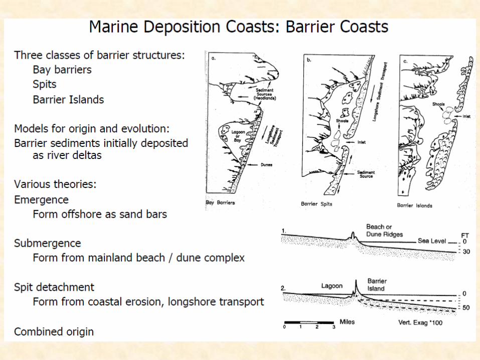
• Barrier Islands
• Beach Ridges
• Spits
• Deltas
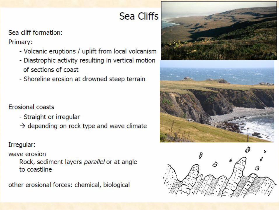
• Coastal Cliffs
• Marine Terraces
• Wave-Cut Scarps
• Sea Level Fluctuations
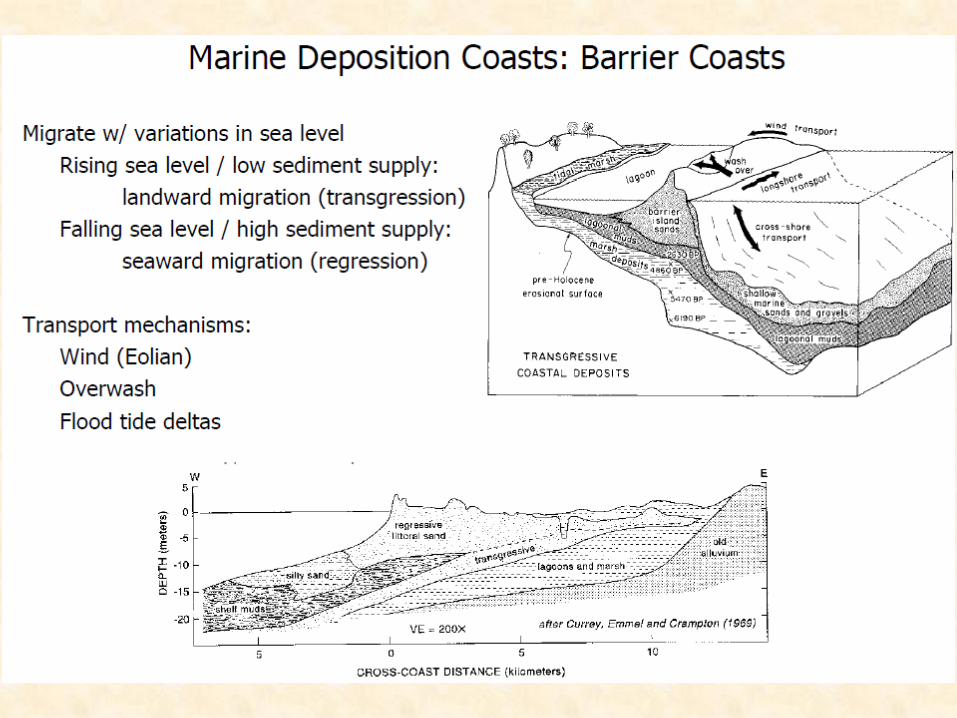
• Barrier Island Migration
• Coastal Diversity
1
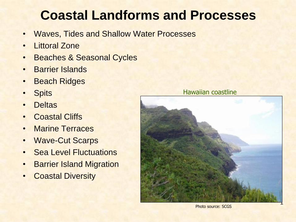
Hawaiian coastline
Photo source: SCGS
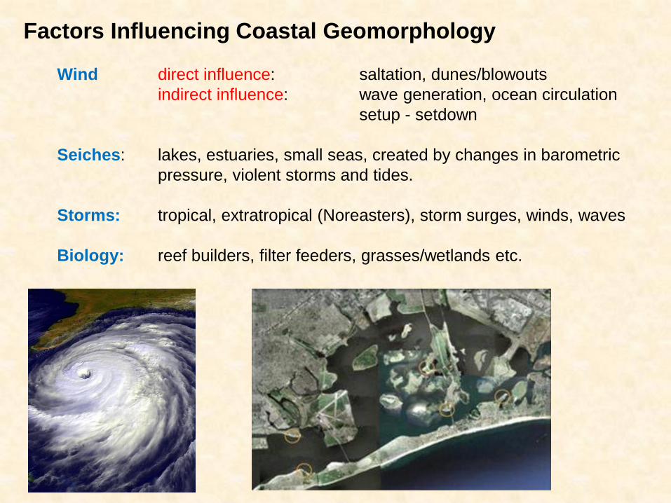
Factors Influencing Coastal Geomorphology
Wind direct influence: saltation, dunes/blowouts
indirect influence: wave generation, ocean circulation
setup - setdown
Seiches: lakes, estuaries, small seas, created by changes in barometric
pressure, violent storms and tides.
Storms: tropical, extratropical (Noreasters), storm surges, winds, waves
Biology: reef builders, filter feeders, grasses/wetlands etc.
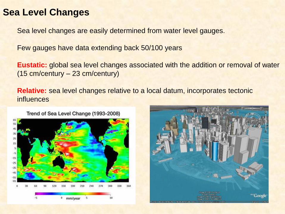
Sea Level Changes
Sea level changes are easily determined from water level gauges.
Few gauges have data extending back 50/100 years
Eustatic: global sea level changes associated with the addition or removal of water
(15 cm/century – 23 cm/century)
Relative: sea level changes relative to a local datum, incorporates tectonic
influences
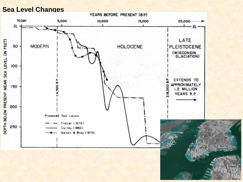
Sea Level Changes
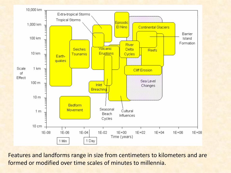
Features and landforms range in size from centimeters to kilometers and are formed or modified over time scales of minutes to millennia.
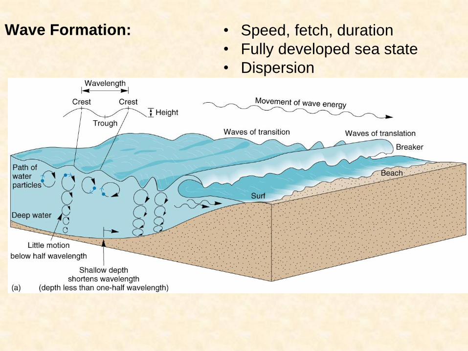
Wave Formation: • Speed, fetch, duration
• Fully developed sea state
• Dispersion
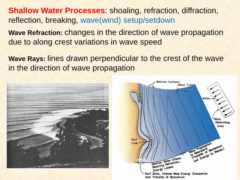
Wave Refraction: changes in the direction of wave propagation
due to along crest variations in wave speed
Wave Rays: lines drawn perpendicular to the crest of the wave
in the direction of wave propagation
Shallow Water Processes: shoaling, refraction, diffraction,
reflection, breaking, wave(wind) setup/setdown
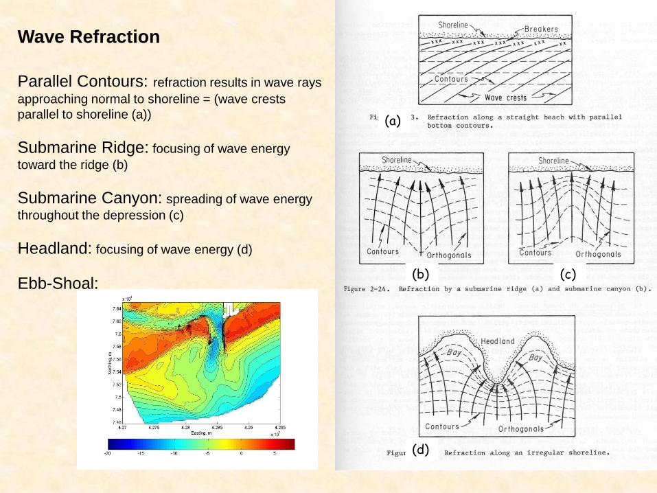
Wave Refraction
Parallel Contours: refraction results in wave rays
approaching normal to shoreline = (wave crests
parallel to shoreline (a))
Submarine Ridge: focusing of wave energy
toward the ridge (b)
Submarine Canyon: spreading of wave energy
throughout the depression (c)
Headland: focusing of wave energy (d)
Ebb-Shoal:
(a)
(c) (b)
(d)
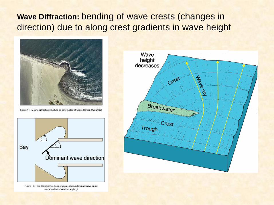
Wave Diffraction: bending of wave crests (changes in
direction) due to along crest gradients in wave height
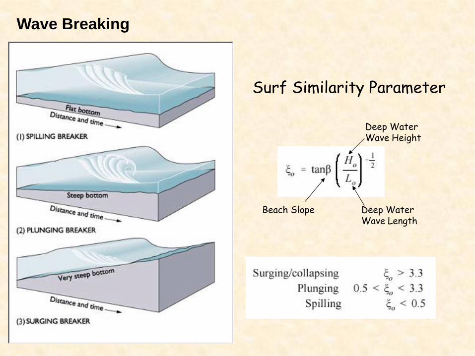
Wave Breaking
Surf Similarity Parameter
Beach Slope Deep Water Wave Length
Deep Water Wave Height
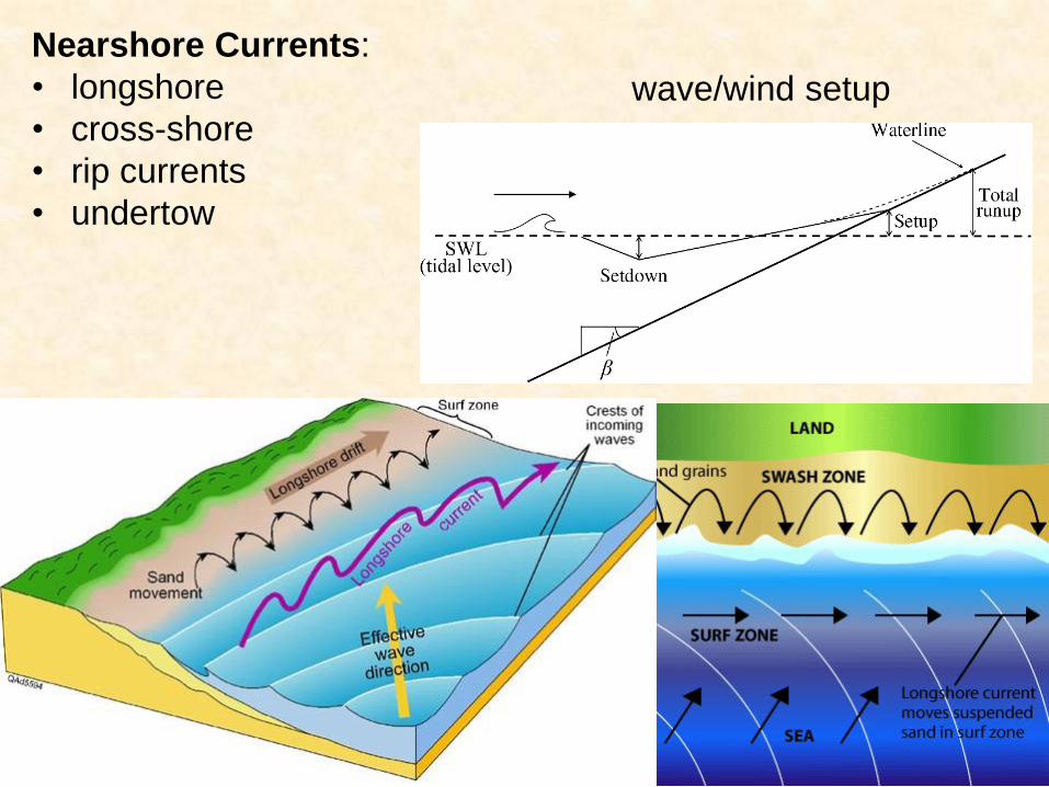
Nearshore Currents:
• longshore
• cross-shore
• rip currents
• undertow
wave/wind setup
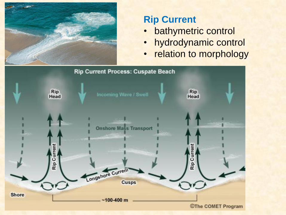
Rip Current
• bathymetric control
• hydrodynamic control
• relation to morphology
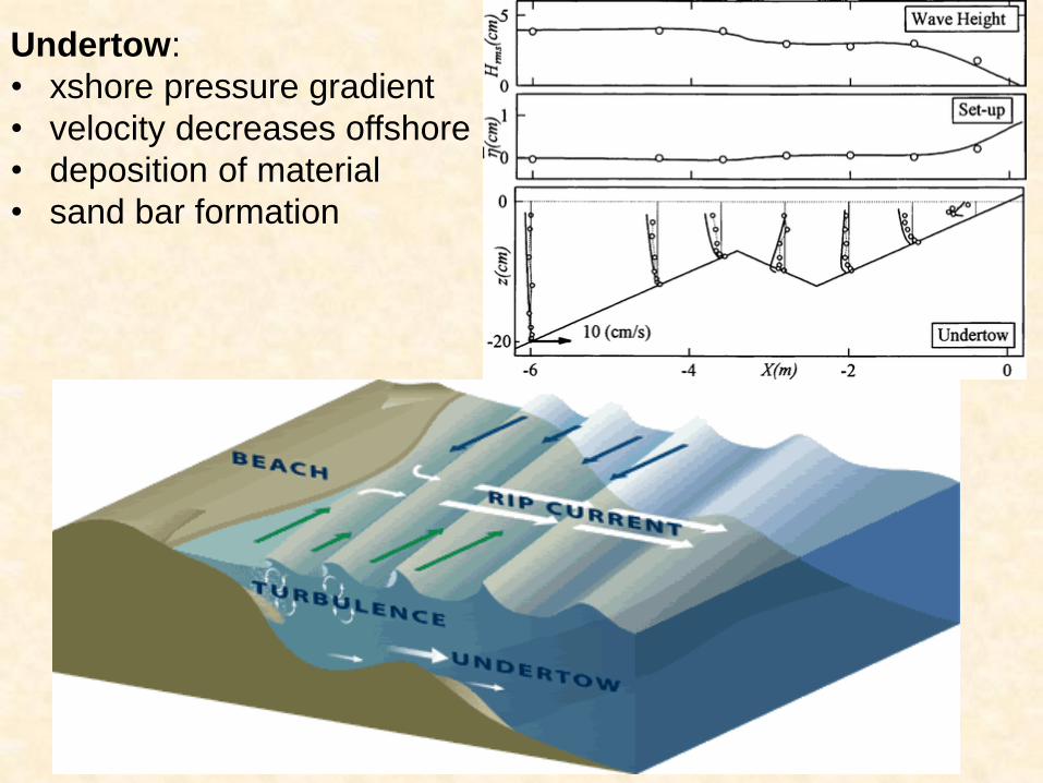
Undertow:
• xshore pressure gradient
• velocity decreases offshore
• deposition of material
• sand bar formation
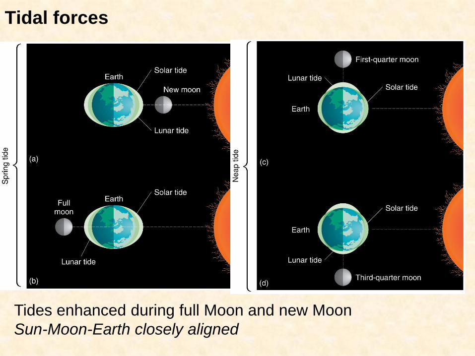
Tidal forces
Tides enhanced during full Moon and new Moon
Sun-Moon-Earth closely aligned
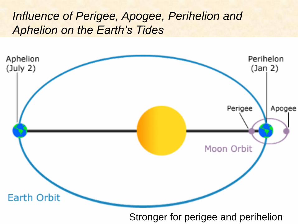
Influence of Perigee, Apogee, Perihelion and
Aphelion on the Earth’s Tides
Stronger for perigee and perihelion
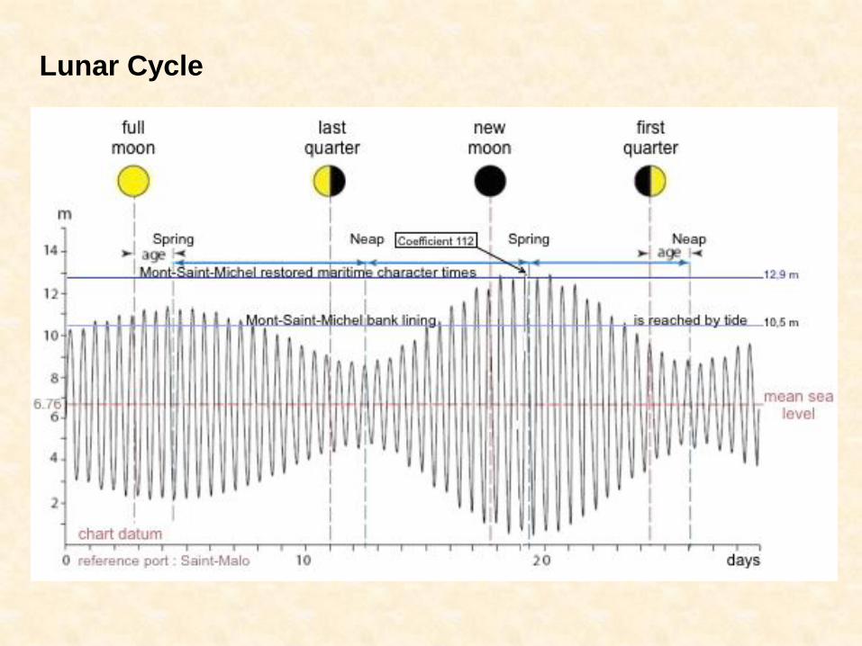
Lunar Cycle
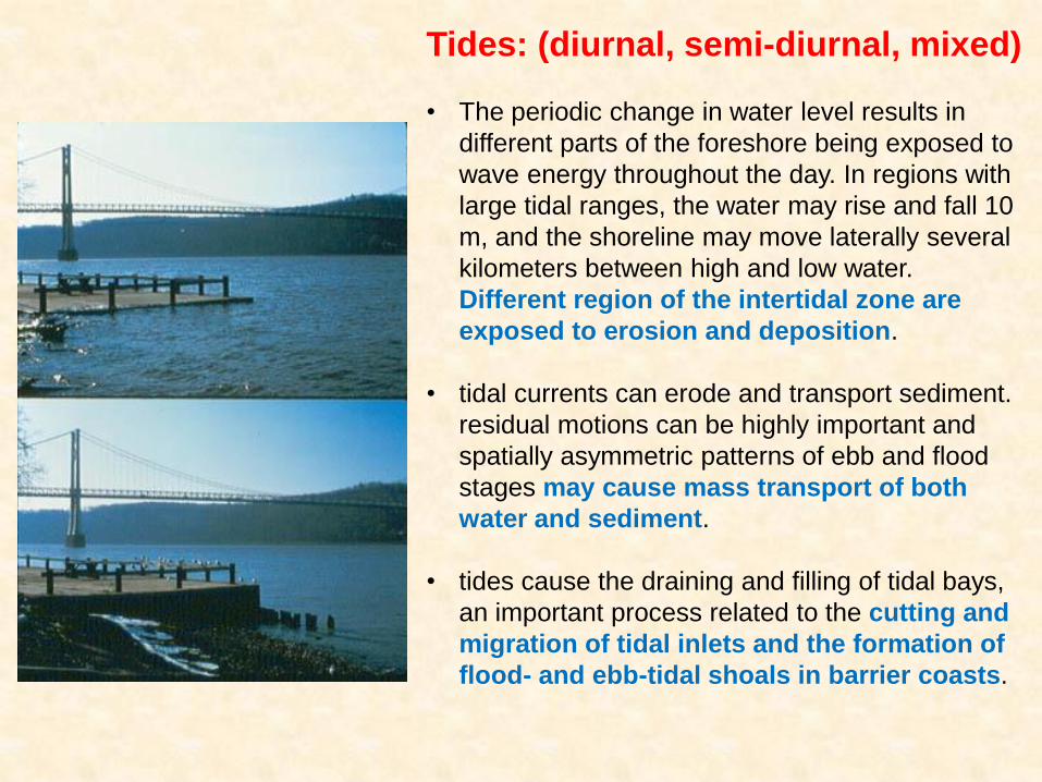
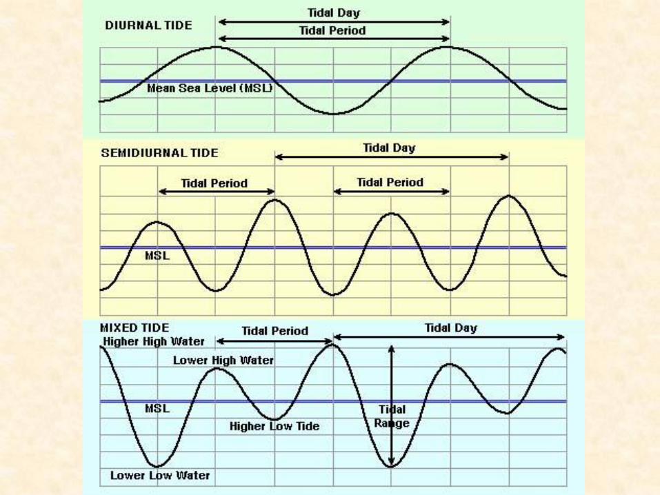
Tides: (diurnal, semi-diurnal, mixed)
• The periodic change in water level results in
different parts of the foreshore being exposed to
wave energy throughout the day. In regions with
large tidal ranges, the water may rise and fall 10
m, and the shoreline may move laterally several
kilometers between high and low water.
Different region of the intertidal zone are
exposed to erosion and deposition.
• tidal currents can erode and transport sediment.
residual motions can be highly important and
spatially asymmetric patterns of ebb and flood
stages may cause mass transport of both
water and sediment.
• tides cause the draining and filling of tidal bays,
an important process related to the cutting and
migration of tidal inlets and the formation of
flood- and ebb-tidal shoals in barrier coasts.
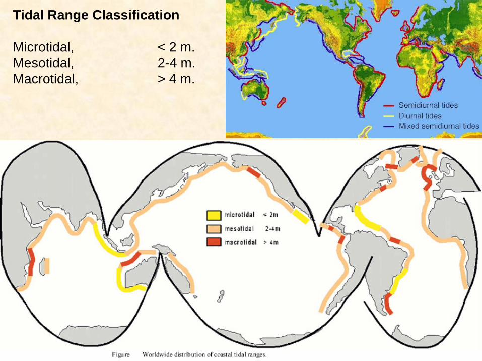
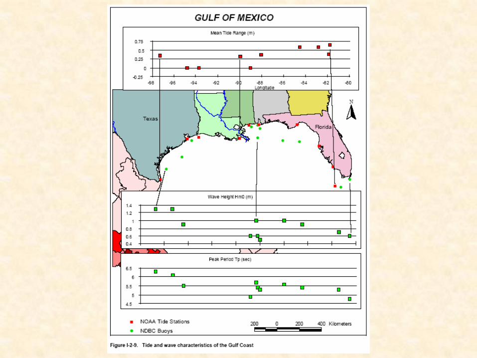
Tidal Range Classification
Microtidal, < 2 m.
Mesotidal, 2-4 m.
Macrotidal, > 4 m.
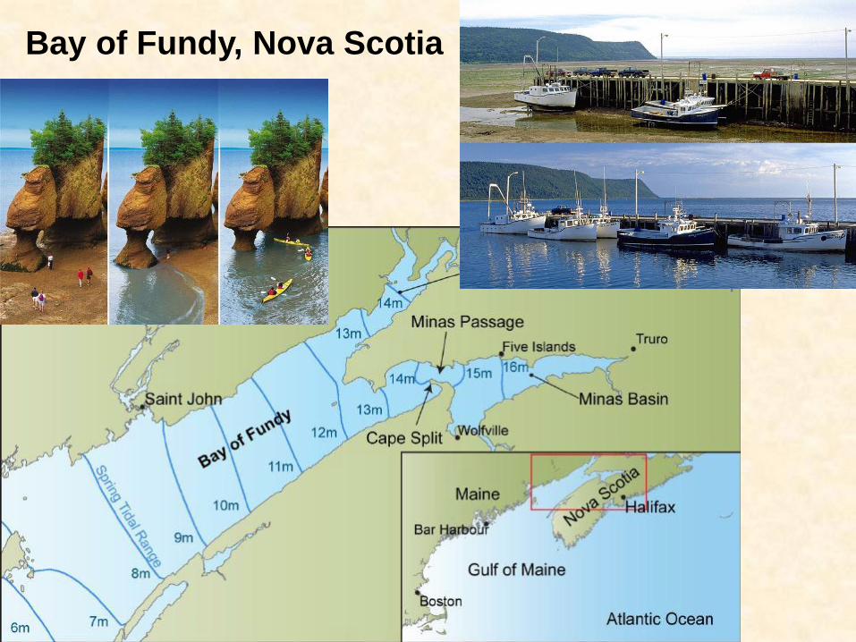
Bay of Fundy, Nova Scotia
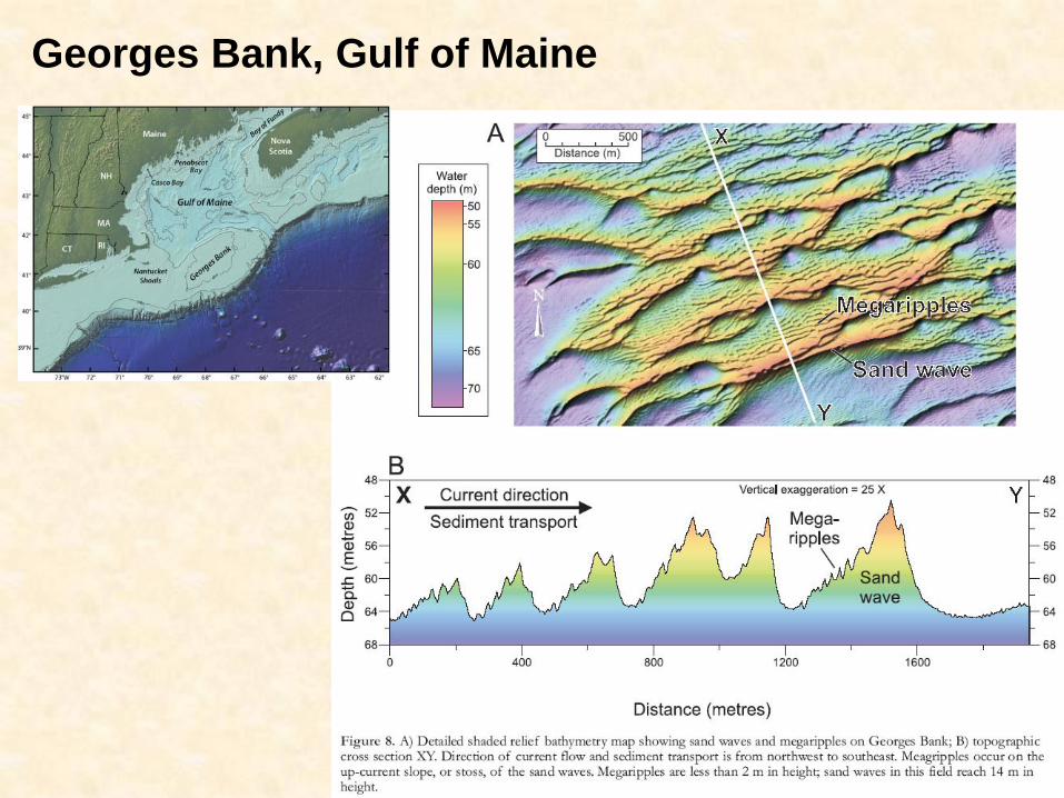
Georges Bank, Gulf of Maine
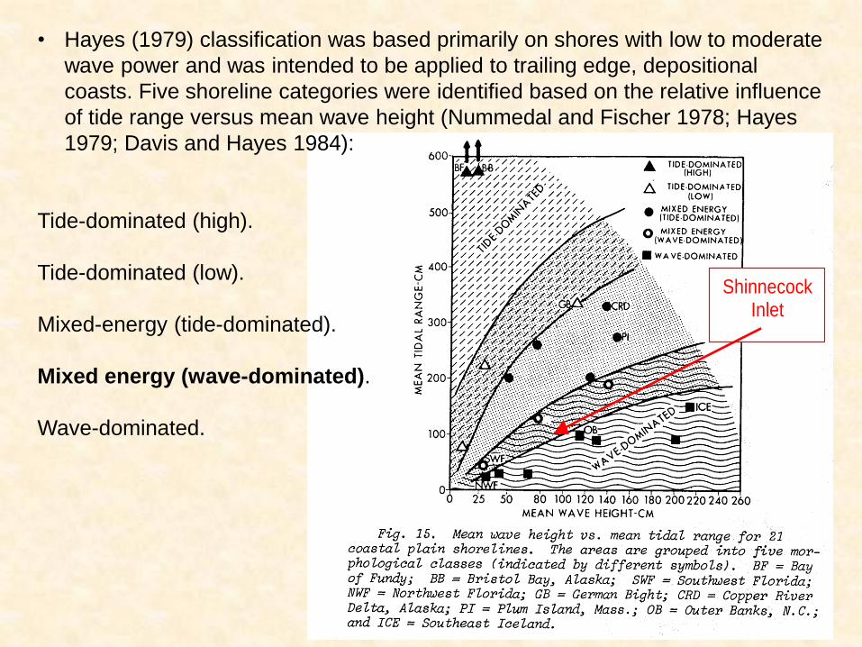
Shinnecock Inlet
• Hayes (1979) classification was based primarily on shores with low to moderate
wave power and was intended to be applied to trailing edge, depositional
coasts. Five shoreline categories were identified based on the relative influence
of tide range versus mean wave height (Nummedal and Fischer 1978; Hayes
1979; Davis and Hayes 1984):
Tide-dominated (high).
Tide-dominated (low).
Mixed-energy (tide-dominated).
Mixed energy (wave-dominated).
Wave-dominated.
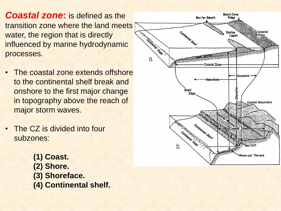
Coastal zone: is defined as the
transition zone where the land meets
water, the region that is directly
influenced by marine hydrodynamic
processes.
• The coastal zone extends offshore
to the continental shelf break and
onshore to the first major change
in topography above the reach of
major storm waves.
• The CZ is divided into four
subzones:
(1) Coast.
(2) Shore.
(3) Shoreface.
(4) Continental shelf.
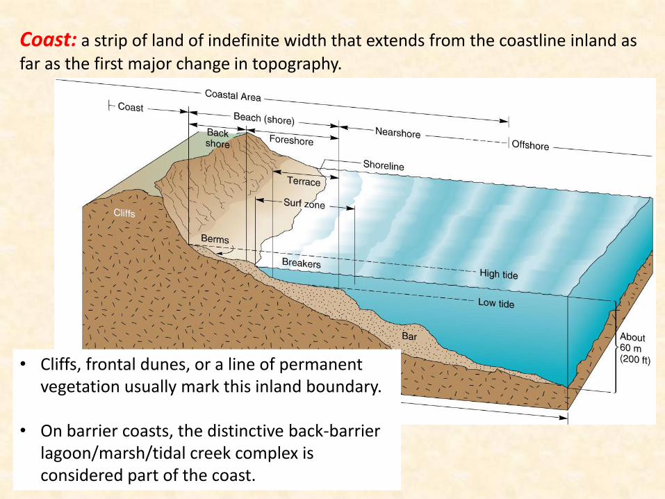
Coast: a strip of land of indefinite width that extends from the coastline inland as
far as the first major change in topography.
• Cliffs, frontal dunes, or a line of permanent vegetation usually mark this inland boundary.
• On barrier coasts, the distinctive back-barrier lagoon/marsh/tidal creek complex is considered part of the coast.
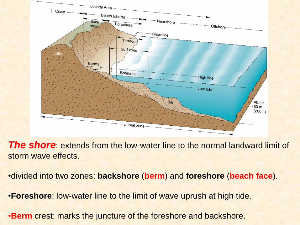
The shore: extends from the low-water line to the normal landward limit of
storm wave effects.
•divided into two zones: backshore (berm) and foreshore (beach face).
•Foreshore: low-water line to the limit of wave uprush at high tide.
•Berm crest: marks the juncture of the foreshore and backshore.
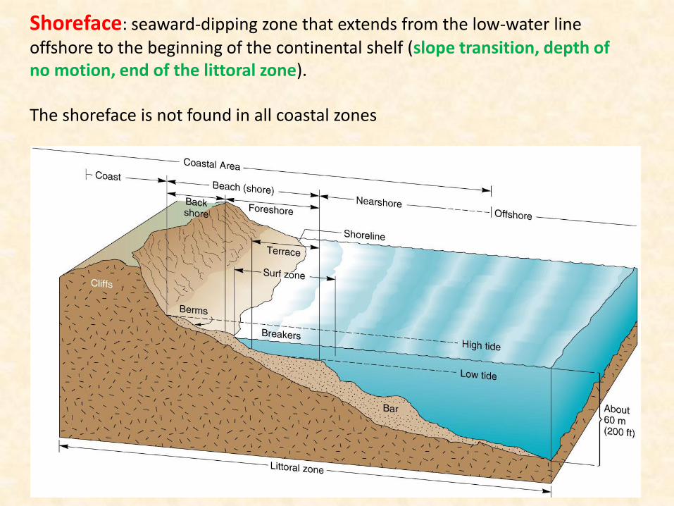
Shoreface: seaward-dipping zone that extends from the low-water line
offshore to the beginning of the continental shelf (slope transition, depth of no motion, end of the littoral zone). The shoreface is not found in all coastal zones
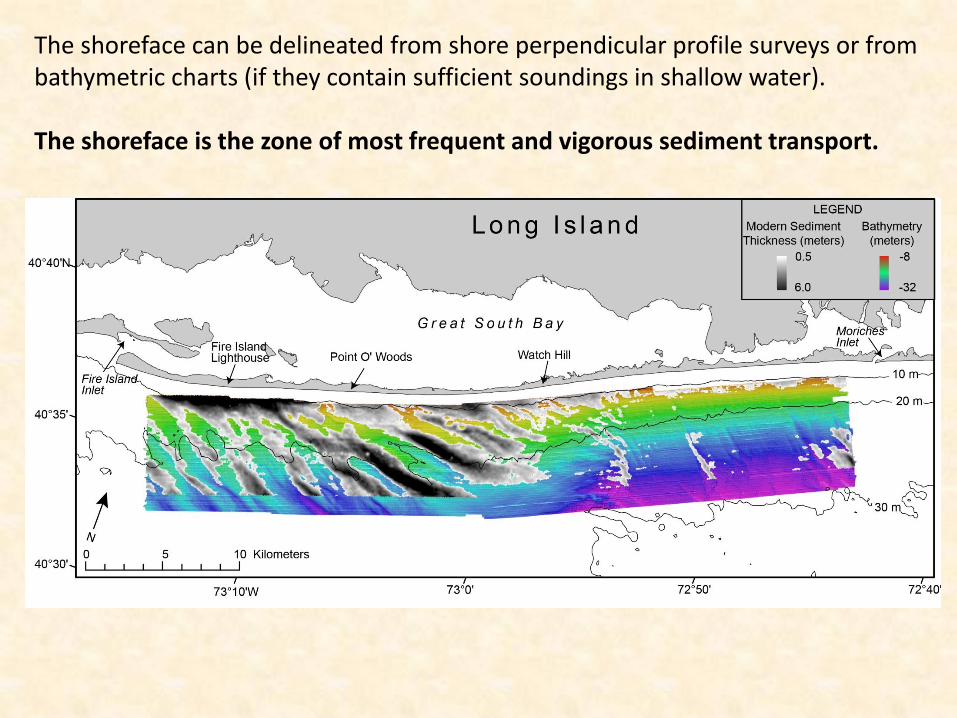
The shoreface can be delineated from shore perpendicular profile surveys or from bathymetric charts (if they contain sufficient soundings in shallow water). The shoreface is the zone of most frequent and vigorous sediment transport.
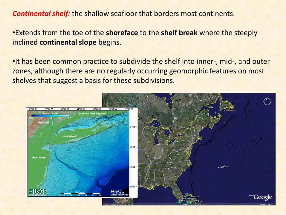
Continental shelf: the shallow seafloor that borders most continents. •Extends from the toe of the shoreface to the shelf break where the steeply inclined continental slope begins. •It has been common practice to subdivide the shelf into inner-, mid-, and outer zones, although there are no regularly occurring geomorphic features on most shelves that suggest a basis for these subdivisions.
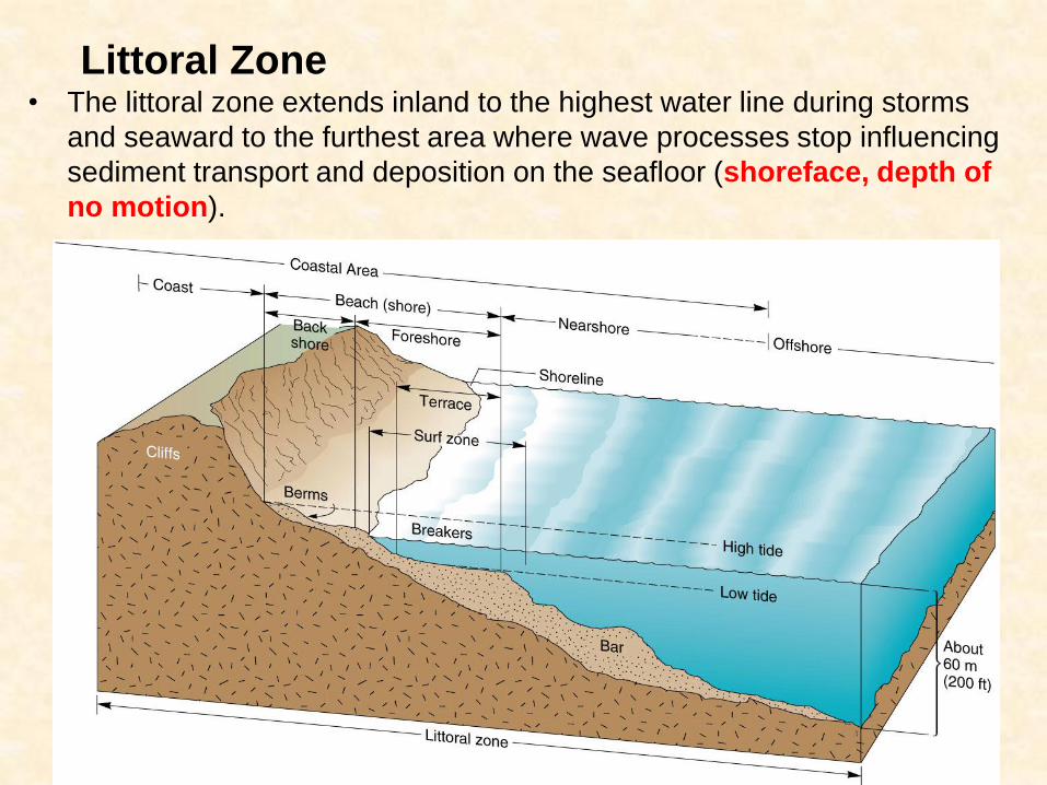
Littoral Zone • The littoral zone extends inland to the highest water line during storms
and seaward to the furthest area where wave processes stop influencing
sediment transport and deposition on the seafloor (shoreface, depth of
no motion).
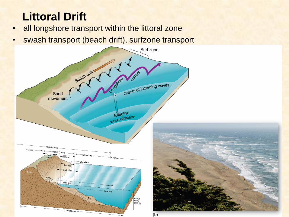
Littoral Drift • all longshore transport within the littoral zone
• swash transport (beach drift), surfzone transport
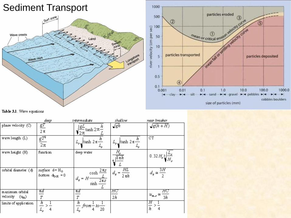
Sediment Transport
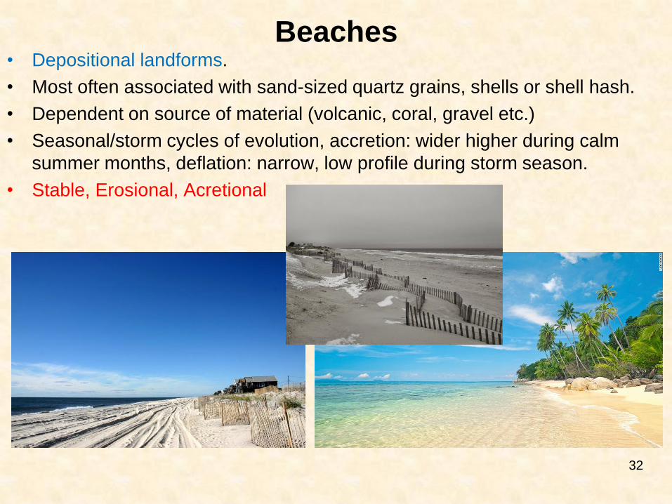
Beaches • Depositional landforms.
• Most often associated with sand-sized quartz grains, shells or shell hash.
• Dependent on source of material (volcanic, coral, gravel etc.)
• Seasonal/storm cycles of evolution, accretion: wider higher during calm
summer months, deflation: narrow, low profile during storm season.
• Stable, Erosional, Acretional
32
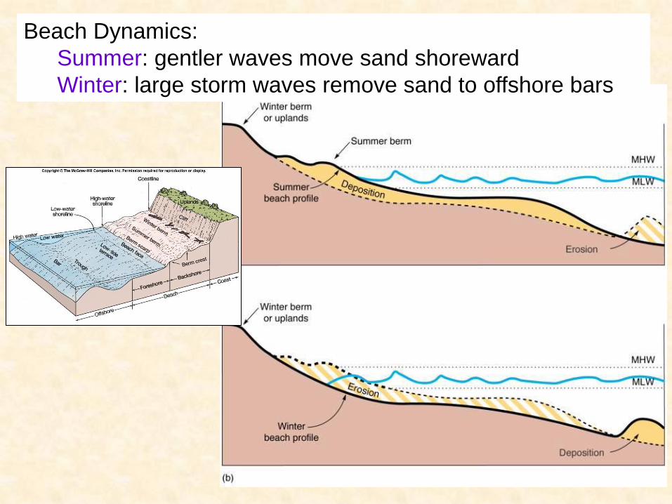
Beach Dynamics:
Summer: gentler waves move sand shoreward
Winter: large storm waves remove sand to offshore bars
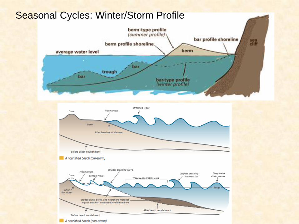
Seasonal Cycles: Winter/Storm Profile
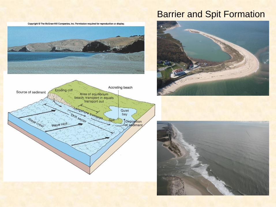
Barrier and Spit Formation
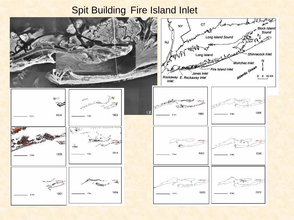
Spit Building Fire Island Inlet
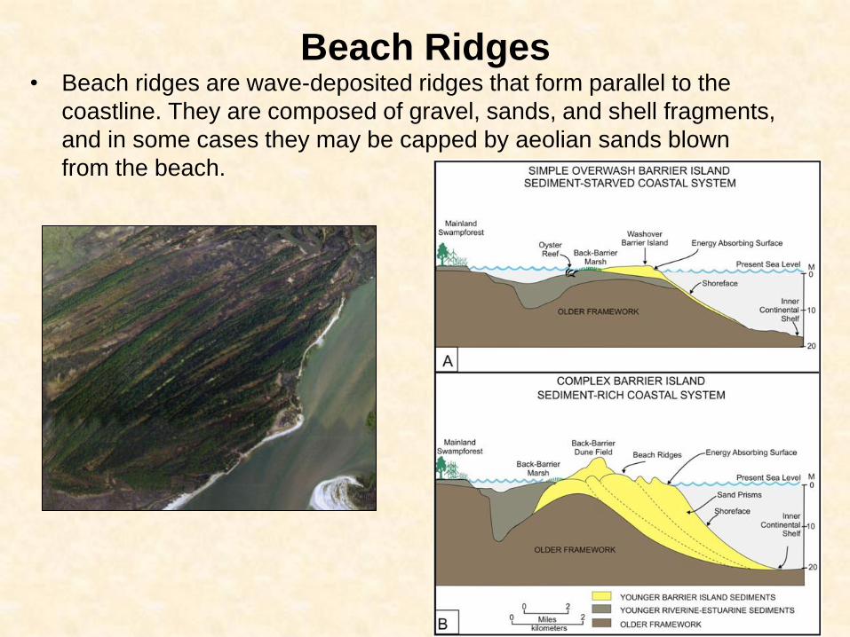
Beach Ridges • Beach ridges are wave-deposited ridges that form parallel to the
coastline. They are composed of gravel, sands, and shell fragments,
and in some cases they may be capped by aeolian sands blown
from the beach.
39
Source: Google 2008
40
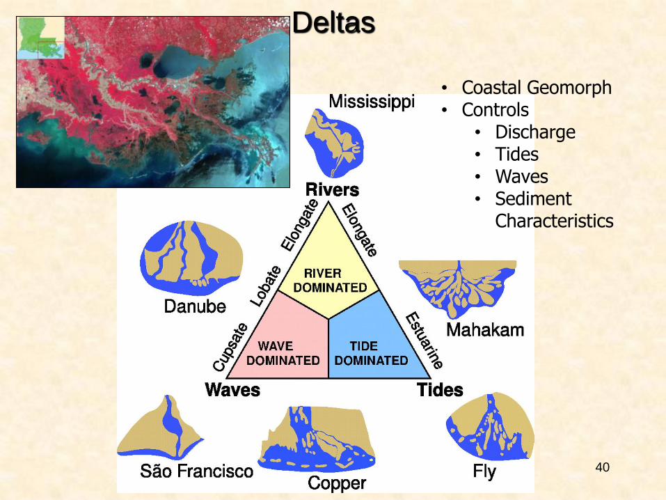
Deltas
• Coastal Geomorph • Controls
• Discharge • Tides • Waves • Sediment
Characteristics
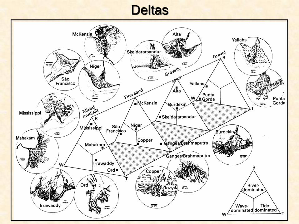
41
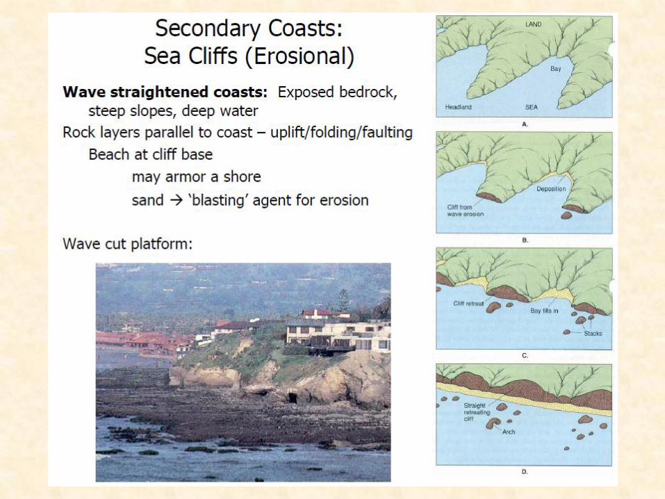
Deltas
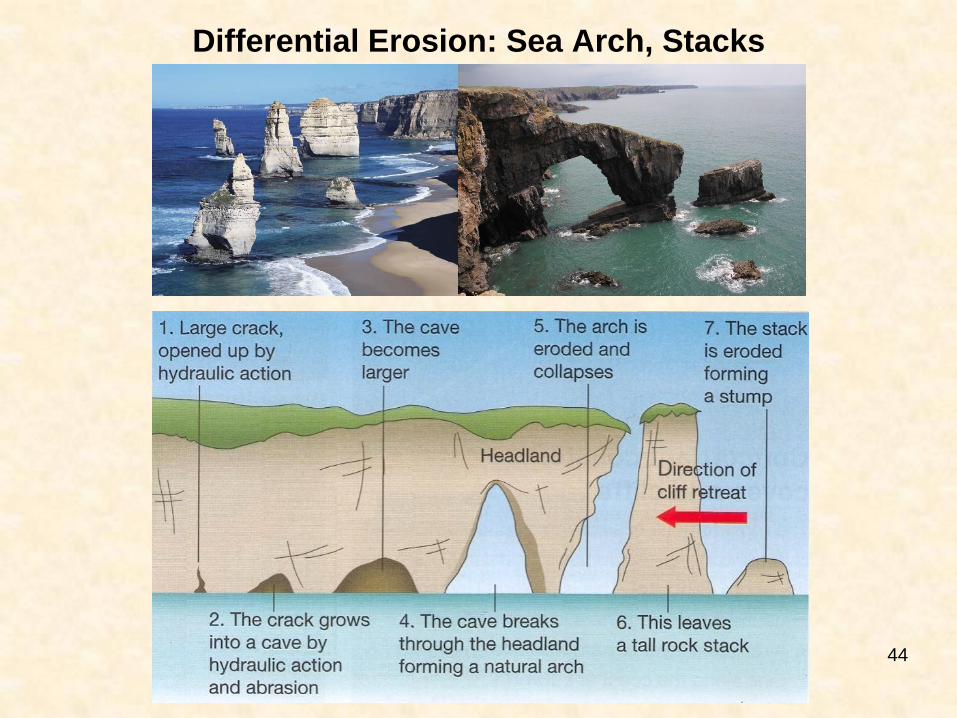
Differential Erosion: Sea Arch, Stacks
44
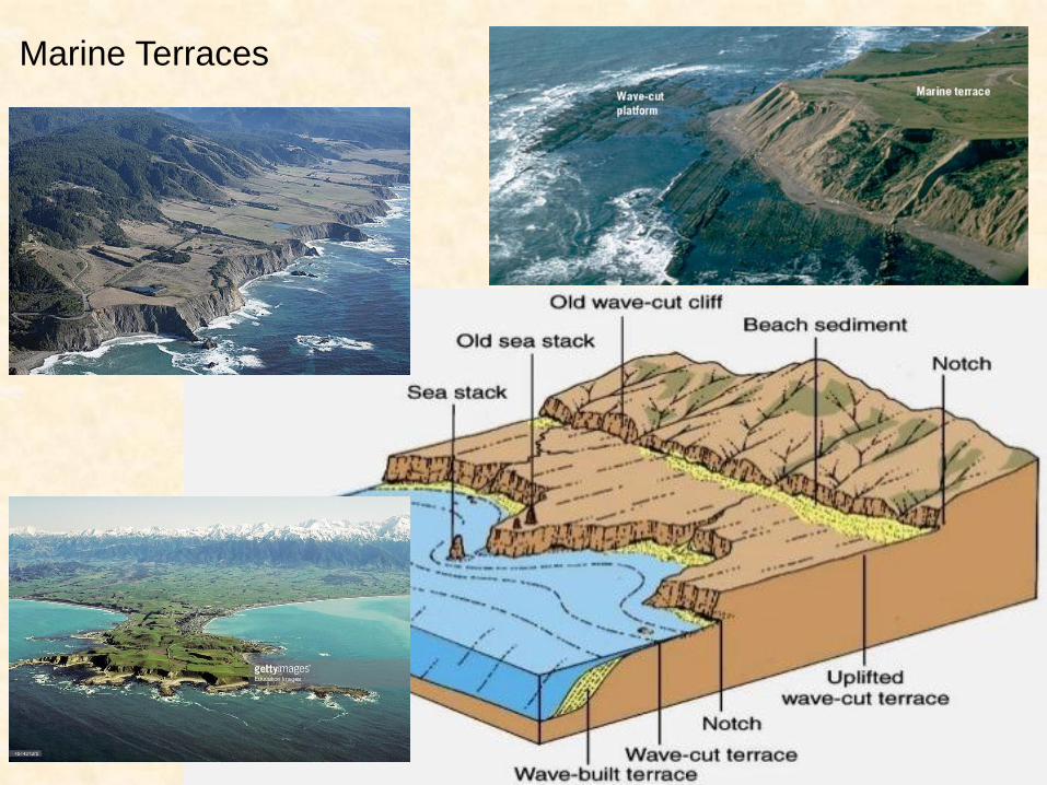
Marine Terraces
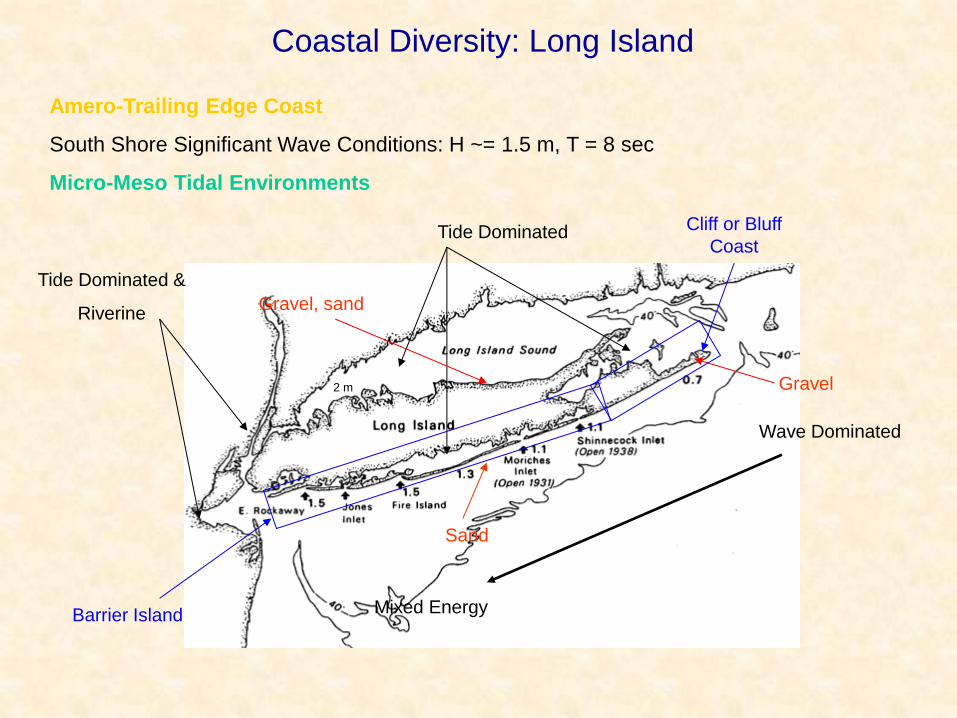
Amero-Trailing Edge Coast
South Shore Significant Wave Conditions: H ~= 1.5 m, T = 8 sec
Micro-Meso Tidal Environments
Coastal Diversity: Long Island
2 m
Tide Dominated
Tide Dominated &
Riverine
Wave Dominated
Mixed Energy
Gravel, sand
Gravel
Sand
Barrier Island
Cliff or Bluff
Coast
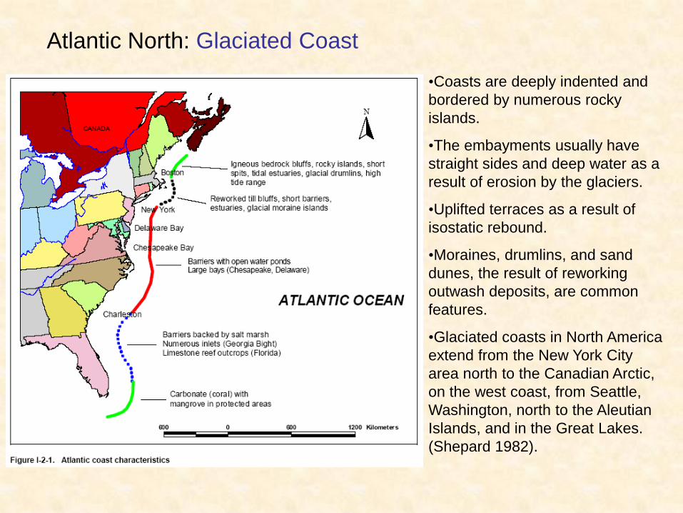
Atlantic North: Glaciated Coast
•Coasts are deeply indented and
bordered by numerous rocky
islands.
•The embayments usually have
straight sides and deep water as a
result of erosion by the glaciers.
•Uplifted terraces as a result of
isostatic rebound.
•Moraines, drumlins, and sand
dunes, the result of reworking
outwash deposits, are common
features.
•Glaciated coasts in North America
extend from the New York City
area north to the Canadian Arctic,
on the west coast, from Seattle,
Washington, north to the Aleutian
Islands, and in the Great Lakes.
(Shepard 1982).
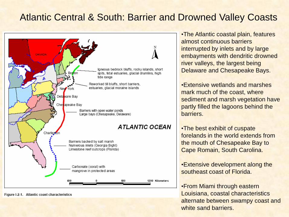
Atlantic Central & South: Barrier and Drowned Valley Coasts
•The Atlantic coastal plain, features
almost continuous barriers
interrupted by inlets and by large
embayments with dendritic drowned
river valleys, the largest being
Delaware and Chesapeake Bays.
•Extensive wetlands and marshes
mark much of the coast, where
sediment and marsh vegetation have
partly filled the lagoons behind the
barriers.
•The best exhibit of cuspate
forelands in the world extends from
the mouth of Chesapeake Bay to
Cape Romain, South Carolina.
•Extensive development along the
southeast coast of Florida.
•From Miami through eastern
Louisiana, coastal characteristics
alternate between swampy coast and
white sand barriers.
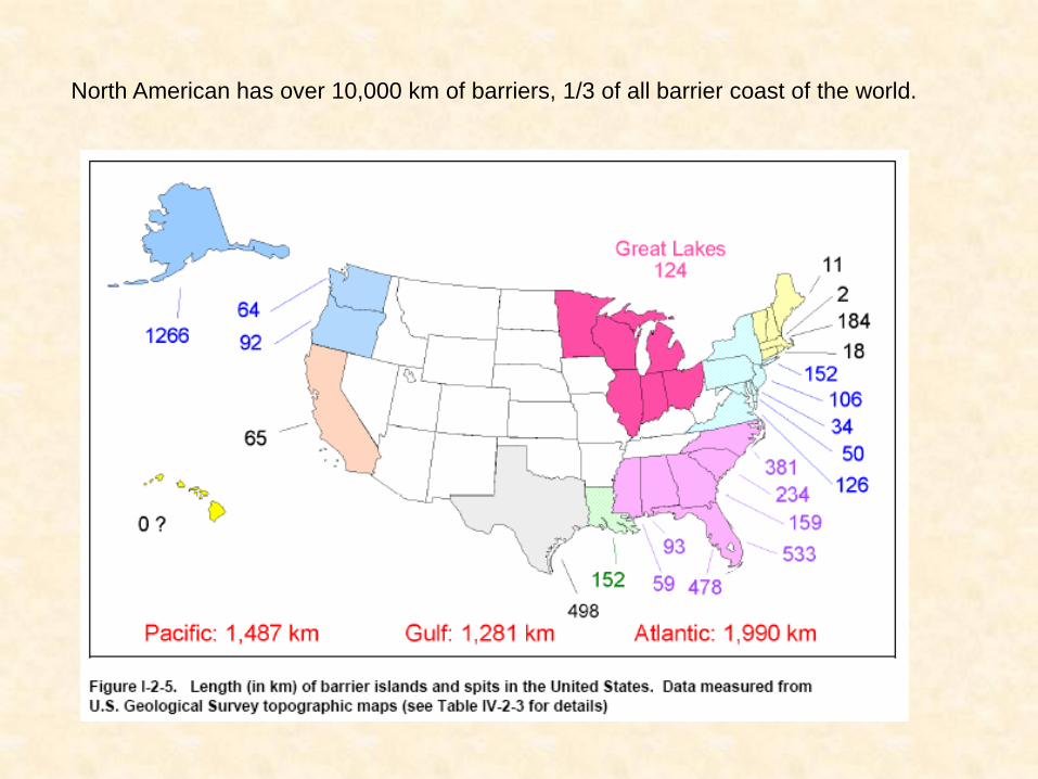
North American has over 10,000 km of barriers, 1/3 of all barrier coast of the world.
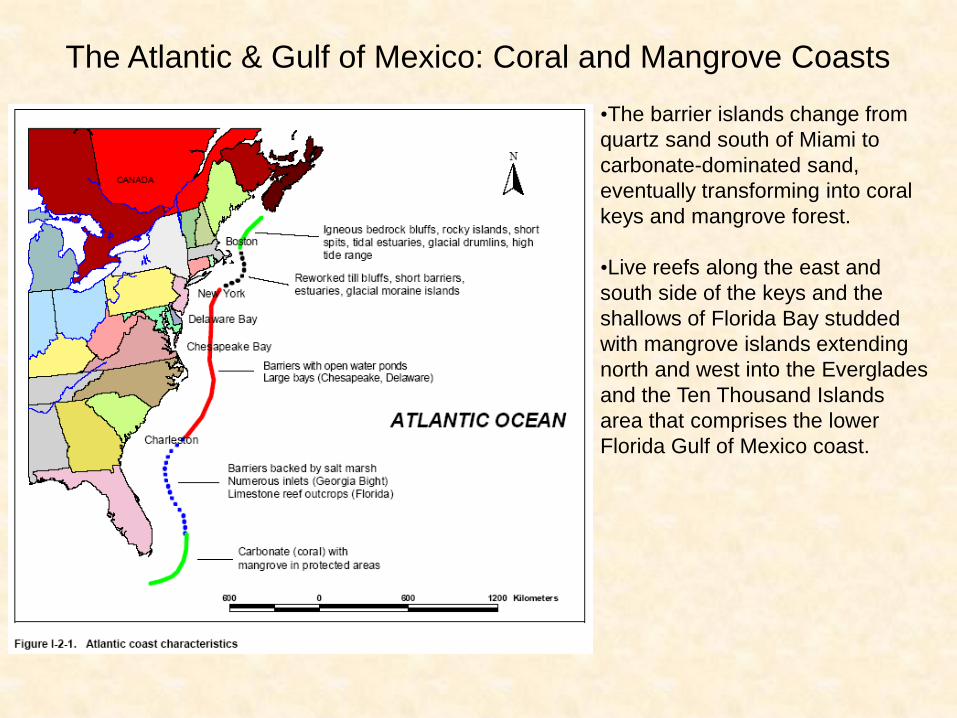
The Atlantic & Gulf of Mexico: Coral and Mangrove Coasts
•The barrier islands change from
quartz sand south of Miami to
carbonate-dominated sand,
eventually transforming into coral
keys and mangrove forest.
•Live reefs along the east and
south side of the keys and the
shallows of Florida Bay studded
with mangrove islands extending
north and west into the Everglades
and the Ten Thousand Islands
area that comprises the lower
Florida Gulf of Mexico coast.
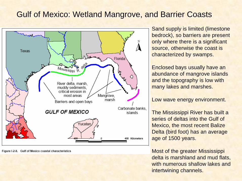
Gulf of Mexico: Wetland Mangrove, and Barrier Coasts
Sand supply is limited (limestone
bedrock), so barriers are present
only where there is a significant
source, otherwise the coast is
characterized by swamps.
Enclosed bays usually have an
abundance of mangrove islands
and the topography is low with
many lakes and marshes.
Low wave energy environment.
The Mississippi River has built a
series of deltas into the Gulf of
Mexico, the most recent Balize
Delta (bird foot) has an average
age of 1500 years.
Most of the greater Mississippi
delta is marshland and mud flats,
with numerous shallow lakes and
intertwining channels.
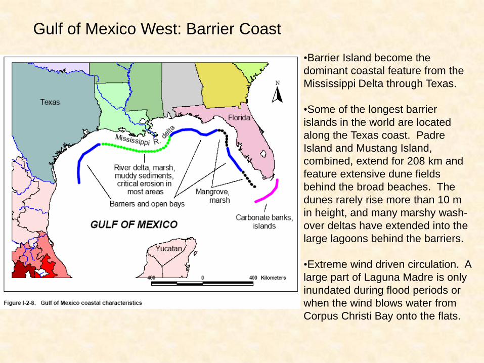
Gulf of Mexico West: Barrier Coast
•Barrier Island become the
dominant coastal feature from the
Mississippi Delta through Texas.
•Some of the longest barrier
islands in the world are located
along the Texas coast. Padre
Island and Mustang Island,
combined, extend for 208 km and
feature extensive dune fields
behind the broad beaches. The
dunes rarely rise more than 10 m
in height, and many marshy wash-
over deltas have extended into the
large lagoons behind the barriers.
•Extreme wind driven circulation. A
large part of Laguna Madre is only
inundated during flood periods or
when the wind blows water from
Corpus Christi Bay onto the flats.
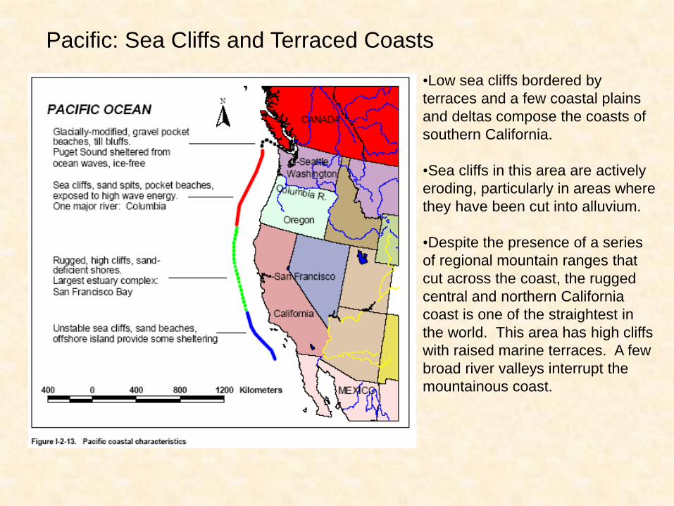
Pacific: Sea Cliffs and Terraced Coasts
•Low sea cliffs bordered by
terraces and a few coastal plains
and deltas compose the coasts of
southern California.
•Sea cliffs in this area are actively
eroding, particularly in areas where
they have been cut into alluvium.
•Despite the presence of a series
of regional mountain ranges that
cut across the coast, the rugged
central and northern California
coast is one of the straightest in
the world. This area has high cliffs
with raised marine terraces. A few
broad river valleys interrupt the
mountainous coast.
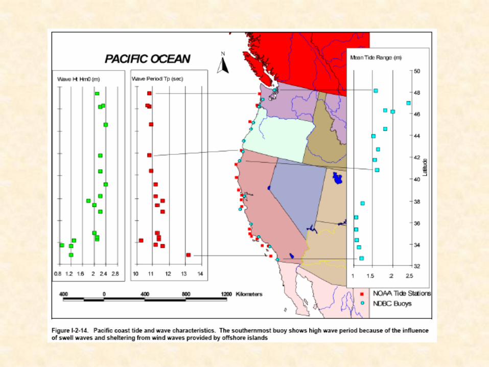
Pacific: Sea Cliffs and Terraced Coasts
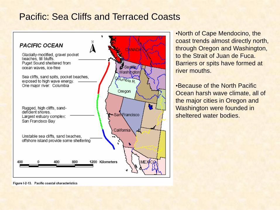
•North of Cape Mendocino, the
coast trends almost directly north,
through Oregon and Washington,
to the Strait of Juan de Fuca.
Barriers or spits have formed at
river mouths.
•Because of the North Pacific
Ocean harsh wave climate, all of
the major cities in Oregon and
Washington were founded in
sheltered water bodies.
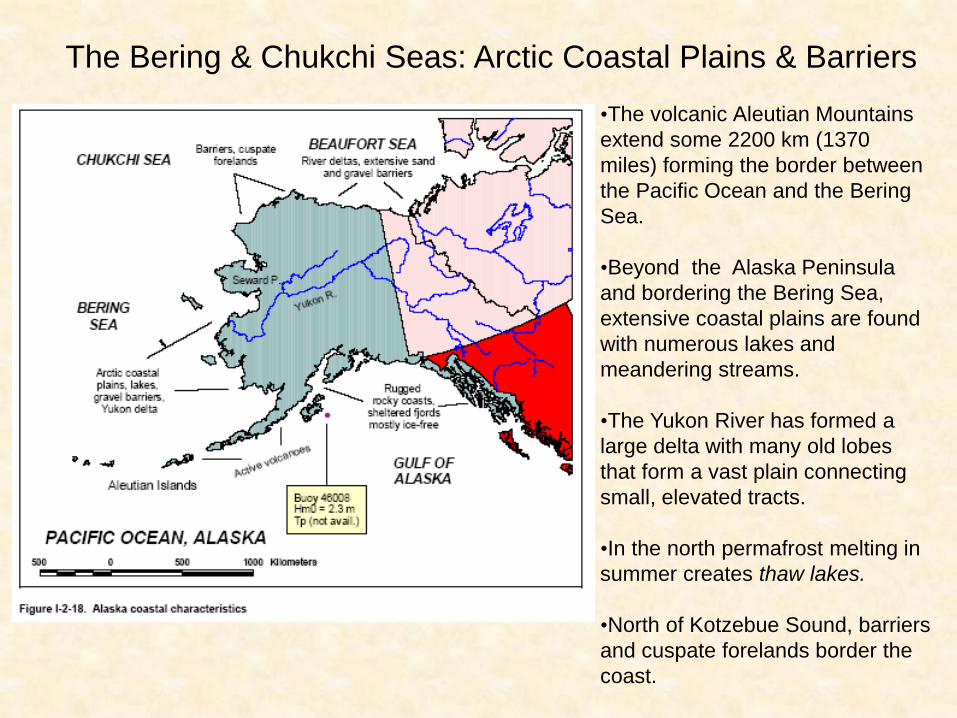
The Bering & Chukchi Seas: Arctic Coastal Plains & Barriers
•The volcanic Aleutian Mountains
extend some 2200 km (1370
miles) forming the border between
the Pacific Ocean and the Bering
Sea.
•Beyond the Alaska Peninsula
and bordering the Bering Sea,
extensive coastal plains are found
with numerous lakes and
meandering streams.
•The Yukon River has formed a
large delta with many old lobes
that form a vast plain connecting
small, elevated tracts.
•In the north permafrost melting in
summer creates thaw lakes.
•North of Kotzebue Sound, barriers
and cuspate forelands border the
coast.
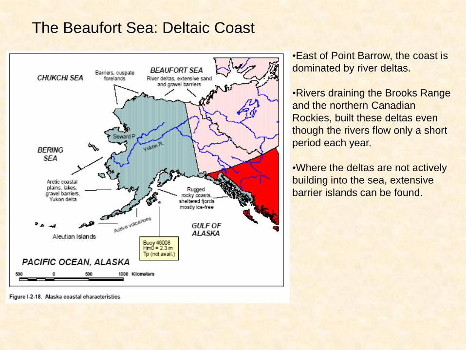
The Beaufort Sea: Deltaic Coast
•East of Point Barrow, the coast is
dominated by river deltas.
•Rivers draining the Brooks Range
and the northern Canadian
Rockies, built these deltas even
though the rivers flow only a short
period each year.
•Where the deltas are not actively
building into the sea, extensive
barrier islands can be found.
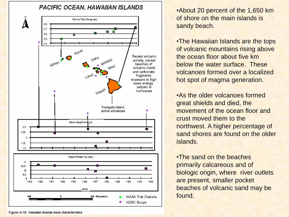
•About 20 percent of the 1,650 km
of shore on the main islands is
sandy beach.
•The Hawaiian Islands are the tops
of volcanic mountains rising above
the ocean floor about five km
below the water surface. These
volcanoes formed over a localized
hot spot of magma generation.
•As the older volcanoes formed
great shields and died, the
movement of the ocean floor and
crust moved them to the
northwest. A higher percentage of
sand shores are found on the older
islands.
•The sand on the beaches
primarily calcareous and of
biologic origin, where river outlets
are present, smaller pocket
beaches of volcanic sand may be
found.
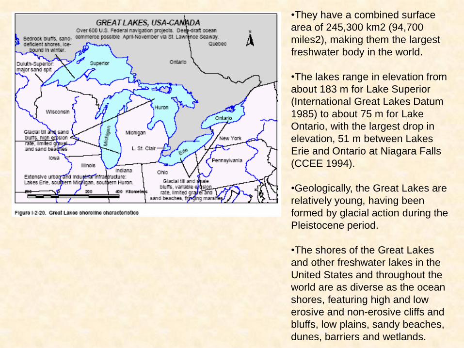
•They have a combined surface
area of 245,300 km2 (94,700
miles2), making them the largest
freshwater body in the world.
•The lakes range in elevation from
about 183 m for Lake Superior
(International Great Lakes Datum
1985) to about 75 m for Lake
Ontario, with the largest drop in
elevation, 51 m between Lakes
Erie and Ontario at Niagara Falls
(CCEE 1994).
•Geologically, the Great Lakes are
relatively young, having been
formed by glacial action during the
Pleistocene period.
•The shores of the Great Lakes
and other freshwater lakes in the
United States and throughout the
world are as diverse as the ocean
shores, featuring high and low
erosive and non-erosive cliffs and
bluffs, low plains, sandy beaches,
dunes, barriers and wetlands.