Embed Size (px)
Citation preview
02Collaborative Landscape Management for Villages around Tahura Nipa-Nipa, Southeast SulawesiAgFor Livelihood-Conservation Strategy - 02
Agroforestry and Forestry in Sulawesi (AgFor Sulawesi) - Environment Team Atiek Widayati, Jhon Roy Sirait, Ni’matul Khasanah and Sonya Dewi
December – 2014

Collaborative Landscape Management for
Villages around Tahura Nipa‐Nipa,
Southeast Sulawesi
AgFor Livelihood‐Conservation Strategy – 02
Agroforestry and Forestry in Sulawesi (AgFor Sulawesi) ‐ Environment Team
Atiek Widayati, Jhon Roy Sirait, Ni’matul Khasanah and Sonya Dewi
December ‐ 2014
Sitasi Widayati A, Sirait JR, Khasanah N and Dewi S. 2014. Collaborative Landscape Management for villages around Tahura Nipa‐Nipa, Southeast Sulawesi. AgFor Livelihood – Conservation Strategy ‐ 02. Bogor, Indonesia. World Agroforestry Centre (ICRAF) Southeast Asia Regional Program. 17p. Agroforestry and Forestry in Sulawesi (AgFor Sulawesi) is a five‐year project funded by the Department of Foreign Affairs, Trade and Development Canada. The World Agroforestry Centre is the lead organization of the project, which operates in the provinces of South Sulawesi, Southeast Sulawesi and Gorontalo. Website: www.worldagroforestry.org/agforsulawesi Disclaimer and copyright The World Agroforestry Centre (ICRAF) holds the copyright to its publications and web pages but encourages duplication, without alteration, of these materials for non‐commercial purposes. Proper citation is required in all instances. Information owned by others that requires permission is marked as such. The information provided by the Centre is, to the best of our knowledge, accurate although we do not guarantee the information nor are we liable for any damages arising from use of the information. Website links provided by our site will have their own policies that must be honoured. The Centre maintains a database of users although this information is not distributed and is used only to measure the usefulness of our information. Without restriction, please add a link to our website www.worldagroforestrycentre.org on your website or publication. Contributors (in alphabetical order) Atiek Widayati, Elissa Dwiyanti, Endri Martini, Hasantoha Adnan, Hendra Gunawan, Janudianto, Jhon Roy Sirait, James Roshetko, Mahrizal, M. Thoha Zulkarnain, Ni’matul Khasanah, Sonya Dewi, Subekti Rahayu Acknowledgements Contributions from Tahura Nipa‐Nipa Collaborative Management Working Group (Tim Kerja Pengelolaan Bersama Tahura Nipa‐Nipa) for the development of this strategy document are highly valued. World Agroforestry Centre Southeast Asia Regional Program Jl. CIFOR, Situ Gede, Sindang Barang, Bogor 16115 PO Box 161, Bogor 16001, Indonesia Tel: +62 251 8625415 Fax: +62 251 8625416 Email: icraf‐[email protected] http://www.worldagroforestry.org/regions/southeast_asia Cover photo: Subekti Rahayu December ‐ 2014

[iii]
TABLE OF CONTENTS
Table of Contents ............................................................................................................................................. iii
1. Introduction ............................................................................................................................................... 1
1.1. Livelihood and Conservation Strategies (LCS) ................................................................................... 1
1.2. Work coverage: Villages in Tahura Nipa-Nipa ................................................................................... 1
2. Tahura Nipa-Nipa and the livelihoods in the vicinity ................................................................................. 3
2.1. Forest conditions in Tahura Nipa-Nipa ............................................................................................. 3
2.2. Livelihoods and local economy ......................................................................................................... 3
2.3. Utilisation of ecosystem services in the vicinity of Tahura Nipa-Nipa .............................................. 4
2.4. SWOT and key issues in the area ...................................................................................................... 5
3. Strategies to address issues ....................................................................................................................... 6
3.1. Vision and mission............................................................................................................................. 7
3.2. Boundary and strategic partners ...................................................................................................... 7
3.3. Outcome challenges .......................................................................................................................... 7
3.4. Progress markers ............................................................................................................................... 8
4. Roadmap for action planning .................................................................................................................. 10
4.1. Negotiation and agreement on species allowed ............................................................................ 10
4.2. Timeline ........................................................................................................................................... 11
5. Overview of activities for implementation .............................................................................................. 11
6. References ............................................................................................................................................... 12
Appendix 1. Working Group members ........................................................................................................... 13
Appendix 2. Results of surveys and verification ............................................................................................. 14
Appendix 3. Socialisation in villages ................................................................................................................ 16


[1]
1. INTRODUCTION
1.1. LIVELIHOOD AND CONSERVATION STRATEGIES (LCS)
Forest frontiers in Indonesia have long served to cater for the agriculture-based livelihoods of rural
people living on the edge of forests. A strong link with forest resources and/or forest lands can pose
challenges or even conflicts because livelihoods need to be fulfilled while the natural functions need to
be maintained or even improved/restored. In this particular situation, both aspects of utilisation and
conservation need to be addressed comprehensively and strategies that encompass both aspects
should be developed.
As part of the Agroforestry and Forestry (AgFor) programme in Sulawesi, livelihood and conservation
issues receive substantial attention and need to be addressed well to contribute to the sustainability of
the forest and agroforest landscapes.
This strategy was developed as the foundation for AgFor and its partners to address specific livelihood
and conservation issues in its sites in Sulawesi. In AgFor, the overall approach to address livelihood and
conservation issues follows diagnostic-to-action steps as described in Figure 1. The strategy
development process should ensure ‘participatory’ and ‘inclusive’ principles, in which partnerships with
relevant actors and stakeholders, in the work area, are key.
Figure 1. Overall approach to address livelihood and conservation issues in AgFor
1.2. WORK COVERAGE: VILLAGES IN TAHURA NIPA-NIPA
Forest Parks (Taman Hutan Raya – Tahura) come under the jurisdiction of the subnational forestry
authorities. The main functions of these conservation parks include: research, science, education,
culture and ecotourism. Tahura Nipa-Nipa (Nipa-Nipa Forest Park), established in 1999, is located
between 03°54'05" – 03°58'00" S and 122°29'38" –122°04'25" N. The park covers an area of 7,877 ha
and administratively is located in two district-level administrations: Konawe District and Kendari City
(Figure 2), with the larger area under Konawe (5,575 ha).
[2]
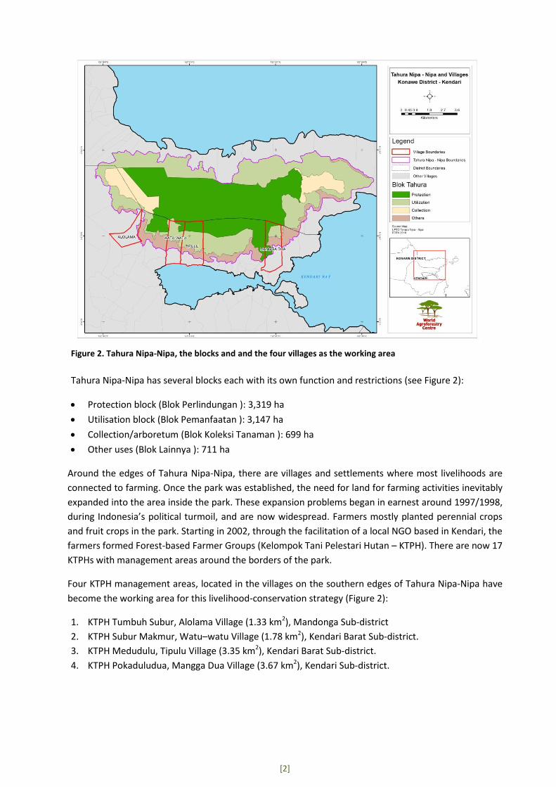
Figure 2. Tahura Nipa-Nipa, the blocks and and the four villages as the working area
Tahura Nipa-Nipa has several blocks each with its own function and restrictions (see Figure 2):
Protection block (Blok Perlindungan ): 3,319 ha
Utilisation block (Blok Pemanfaatan ): 3,147 ha
Collection/arboretum (Blok Koleksi Tanaman ): 699 ha
Other uses (Blok Lainnya ): 711 ha
Around the edges of Tahura Nipa-Nipa, there are villages and settlements where most livelihoods are
connected to farming. Once the park was established, the need for land for farming activities inevitably
expanded into the area inside the park. These expansion problems began in earnest around 1997/1998,
during Indonesia’s political turmoil, and are now widespread. Farmers mostly planted perennial crops
and fruit crops in the park. Starting in 2002, through the facilitation of a local NGO based in Kendari, the
farmers formed Forest-based Farmer Groups (Kelompok Tani Pelestari Hutan – KTPH). There are now 17
KTPHs with management areas around the borders of the park.
Four KTPH management areas, located in the villages on the southern edges of Tahura Nipa-Nipa have
become the working area for this livelihood-conservation strategy (Figure 2):
1. KTPH Tumbuh Subur, Alolama Village (1.33 km2), Mandonga Sub-district
2. KTPH Subur Makmur, Watu–watu Village (1.78 km2), Kendari Barat Sub-district.
3. KTPH Medudulu, Tipulu Village (3.35 km2), Kendari Barat Sub-district.
4. KTPH Pokaduludua, Mangga Dua Village (3.67 km2), Kendari Sub-district.
[3]
2. TAHURA NIPA-NIPA AND THE LIVELIHOODS IN THE VICINITY
2.1. FOREST CONDITIONS IN TAHURA NIPA-NIPA
Tahura Nipa-Nipa has an undulating to steep topography ranging from elevations of 25-1000 m asl
with slopes of between 8 to 40 %. It has good forest cover of up to 68% while the rest is shrubby
vegetation, mixed planted gardens and small areas of settlements and imperata land. The rich flora
richness of Nipa Nipa Park include, among others, Eha Castanopsis buruana BI. (eha), Metrosideros
Petiolata Kds. (besi/lara), Kalapia celebica (kalapi), Tetrameles nudiflora R.Br. (bolongita), and
Buchanania arborescens Bl. (ponto). Several fauna species also found in the park include (Bubalus
depressicomis Smith. (anoa), Cervus timorensis Muller & Schlege (rusa), Phalager spp., Macaca
muculata fascilaris Rafles , and Slaty Cuckoo-Dove (Turcoena manadensis – merpati hutan). 1
River streams in the forest are in good condition with a water discharge of 0.1-0.5 m/sec. Soil types in
the park are classified as podzolic and cambisol.
2.2. LIVELIHOODS AND LOCAL ECONOMY
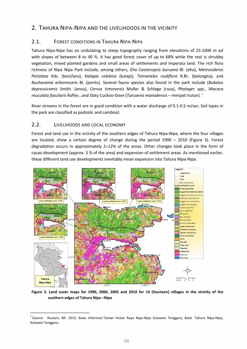
Forest and land use in the vicinity of the southern edges of Tahura Nipa-Nipa, where the four villages
are located, show a certain degree of change during the period 1990 – 2010 (Figure 3). Forest
degradation occurs in approximately 2–12% of the areas. Other changes took place in the form of
cacao development (approx. 5 % of the area) and expansion of settlement areas. As mentioned earlier,
these different land use developments inevitably mean expansion into Tahura Nipa-Nipa.
Figure 3. Land cover maps for 1990, 2000, 2005 and 2010 for 14 (fourteen) villages in the vicinity of the
southern edges of Tahura Nipa –Nipa
1 Source: Rustam, BR. 2013. Buku Informasi Taman Hutan Raya Nipa-Nipa Sulawesi Tenggara, Balai Tahura Nipa-Nipa,
Sulawesi Tenggara.
Tahura Nipa-Nipa
[4]
Anecdotal information indicates that poverty has reached up to 80% of the village population, 15 %
have an ‘average income’ and approximately 5% ‘above average income’. The poor are mostly
characterized by no permanent job and/or they own very little land.
In the villages around the park, especially on the southern edges of Kendari Barat Sub-district, cash
crops have become a major source of livelihoods, while to a lesser extent, horticulture and annual
crops are also important. Major crops in the villages include: cashew, clove, teak, durian, jackfruit,
mango, maize and vegetables.
Tree preference is based primarily on three criteria: multiple benefits, good value/price to fulfil basic
needs, and knowledge and skills for cultivation and management of particular species. The farmers
preferred crops, among others, are clove, cashew and fruit trees. Farmers in the villages see the
benefits of a mixed system as opposed to monoculture farming, mainly to accommodate uncertainties
of price and weather.
Although the main livelihood source is farming, many farmers in the villages also depend on other
livelihoods such as construction work, domestic help, fishing and motorcycle taxi (ojeg).
2.3. UTILISATION OF ECOSYSTEM SERVICES IN THE VICINITY OF TAHURA NIPA-NIPA
Ecosystem service refers to the services provided by the ecosystem processes and functions, which
may encompass three types of services: provision, regulation and support. Local communities can
utilise these services directly from the source or indirectly through various natural and man-made
processes. Categorisation of ecosystem services may encompass four or five types such as water,
biodiversity, biomass/carbon storage, soil, and landscape beauty, although other literature/studies
might propose fewer or more categories.
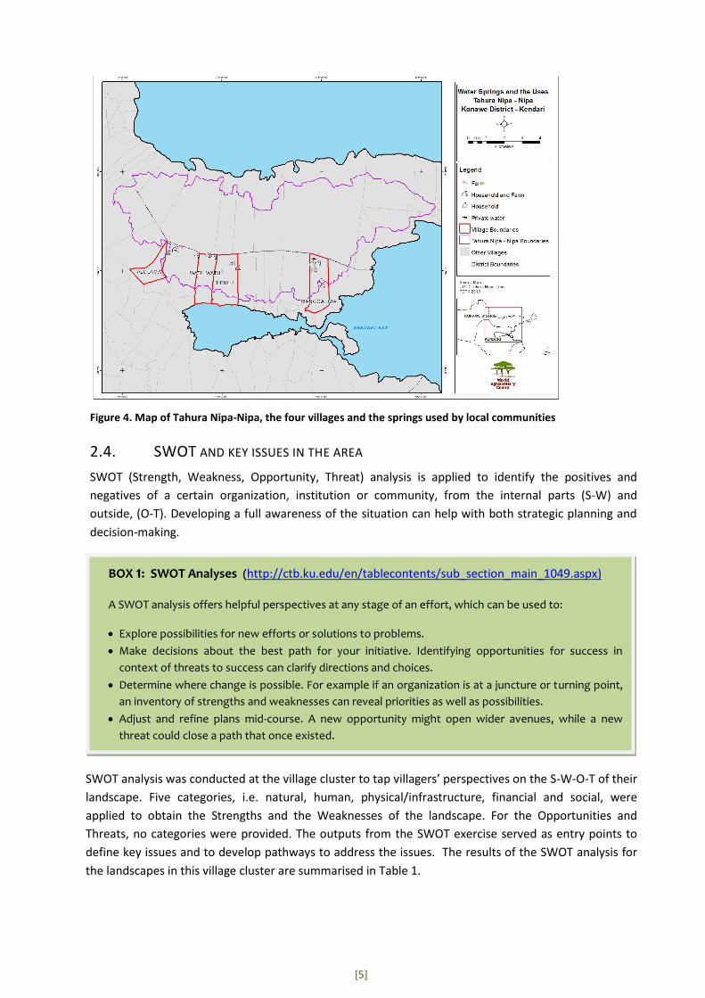
In the villages around the park, the primary water source for household use is from springs located in
several areas in the park (Figure 4). The villagers also utilise other water sources located in the park
such as streams, wells and water tanks (embung).
Plants and other flora from the park are also used for food and for decoration purposes such as orchids
and ferns. Although considered minor, there is also some indication of wildlife hunting for commercial
purposes such as cockatoo, deer and wild rooster.
Potential ecotourism objects/sites in the park include: waterfalls, natural bathing pools, scenic points
and the ruins of ancient/historical monuments.
[5]
Figure 4. Map of Tahura Nipa-Nipa, the four villages and the springs used by local communities
2.4. SWOT AND KEY ISSUES IN THE AREA
SWOT (Strength, Weakness, Opportunity, Threat) analysis is applied to identify the positives and
negatives of a certain organization, institution or community, from the internal parts (S-W) and
outside, (O-T). Developing a full awareness of the situation can help with both strategic planning and
decision-making.
SWOT analysis was conducted at the village cluster to tap villagers’ perspectives on the S-W-O-T of their
landscape. Five categories, i.e. natural, human, physical/infrastructure, financial and social, were
applied to obtain the Strengths and the Weaknesses of the landscape. For the Opportunities and
Threats, no categories were provided. The outputs from the SWOT exercise served as entry points to
define key issues and to develop pathways to address the issues. The results of the SWOT analysis for
the landscapes in this village cluster are summarised in Table 1.
BOX 1: SWOT Analyses (http://ctb.ku.edu/en/tablecontents/sub_section_main_1049.aspx)
A SWOT analysis offers helpful perspectives at any stage of an effort, which can be used to:
Explore possibilities for new efforts or solutions to problems.
Make decisions about the best path for your initiative. Identifying opportunities for success in
context of threats to success can clarify directions and choices.
Determine where change is possible. For example if an organization is at a juncture or turning point,
an inventory of strengths and weaknesses can reveal priorities as well as possibilities.
Adjust and refine plans mid-course. A new opportunity might open wider avenues, while a new
threat could close a path that once existed.
[6]
Table 1. SWOT results for the four Nipa Nipa villages
Strength Weakness
Abundant streams for water sources Rugged topography
Timber trees as an asset Low access to clean water
Ecotourism objects in Tahura Poor soil quality
Existence of Tahura farmer groups (KTPH) Lack of agricultural knowledge
Skilled farmer groups Pests and disease
Strong extension programme Low-skilled farmer groups and weak management
Collective action in village activities No lands on which to legally plant crops
Social club for collective financial savings Low capital and limited access to capital
Good education No or weak cooperative
Good roads and bridges High unemployment rate
Poor electricity facilities
Opportunity Threats
Opportunity for nurseries from local species Landslides threaten agricultural lands
Development of ecotourism facilities Floods
Extreme weather
Forest fire
Large scale plantation companies/investors
Land utilisation and management in the park areas are still problematic due to the conflicting interests
between the authorities and the communities. Conflict resolution efforts have been in place and have
been moving towards improved relations. The development of livelihood and conservation strategies
should align with the problem resolution efforts, but at the same time picking up a specific issue to be
addressed. From the SWOT analyses the restricted use of land emerges as part of ’weakness’, while
park richness such as timber trees and water sources appear as ‘strengths’. It is important for land
management strategies that farmers be actively involved in the protection efforts for the sake of the
sustainability of species richness and services. As farmers have identified potential opportunities such
as nurseries and ecotourism, a collaborative approach with the relevant actors may be able to take
these forward as potential livelihoods.
3. STRATEGIES TO ADDRESS ISSUES This strategy is developed to encourage change in the relevant actors in order to better manage their
landscape through actions that will maintain livelihoods and conserve natural resources and
ecosystems. Overall development of the strategy utilises the Outcome Mapping approach (see Box 2).
BOX 2: Outcome Mapping (Earl et al, 2001)
Outcome Mapping (OM) is an approach to plan, monitor and evaluate social change initiatives developed
by the International Development Research Centre (IDRC) in Canada. On a practical level, OM is a set of
tools and guidelines that steer projects or programmes teams through an iterative process to identify
their desired change and to work collaboratively to bring it about. Results are measured by the changes in
behaviour, actions and relationships of those individuals, groups or organisations with whom the initiative
is working directly and seeking to influence.

[7]
3.1. VISION AND MISSION
The vision of Tahura Nipa-Nipa area is for communities to prosper and sustainably manage the park for
its various functions of livelihoods, conservation, ecosystem services especially water, ecotourism and
science based on the harmony between communities and the park authorities.
The mission is collaborative land management with forest-agroforest practices through the appropriate
capacity strengthening of farmers and farmer groups (KTPH).
3.2. BOUNDARY AND STRATEGIC PARTNERS
Identification of partners, both boundary partners and strategic partners, in the development of
strategies is key to achieving outcomes in the area of work. Boundary partners consist of those
individuals, groups and organizations with whom the programme interacts directly to create change,
anticipate opportunities for influence and engage in mutual learning (Earl et al, 2001). The strategic
partners’ role is mainly to assist with achieving the outcomes; the implemented programme is not
expected to influence these partners.
The boundary partners for the LCS in Tahura Nipa-Nipa comprise individuals representing organisations
or institutions that: 1) have authority over the park area, 2) contribute to the management of the lands,
and 3) utilise the land and ecosystem services the forest provides. The boundary partners are from the
Tahura Nipa-Nipa authority (Balai Pengelola Unit Pelaksana Teknis Daerah (BP UPTD) Tahura Nipa-
Nipa), Agriculture and Forestry Office of Kendari City (Dinas Pertanian dan Kehutanan Kota Kendari
(Distanhut)) and forest farmer groups (Kelompok Tani Pelestari Hutan (KTPH)). The strategic partners
that provide advice and feedback to the strategy development and assist in facilitating the process
across the boundary partners are: village and sub-district offices and a Kendari-based local NGO
(Komunitas Teras).
The identified partners have formed a Working Group (WG). The WG aims to ensure that relevant
partners participate and are included in strategy development, and subsequent processes and
implement the strategy on the ground.
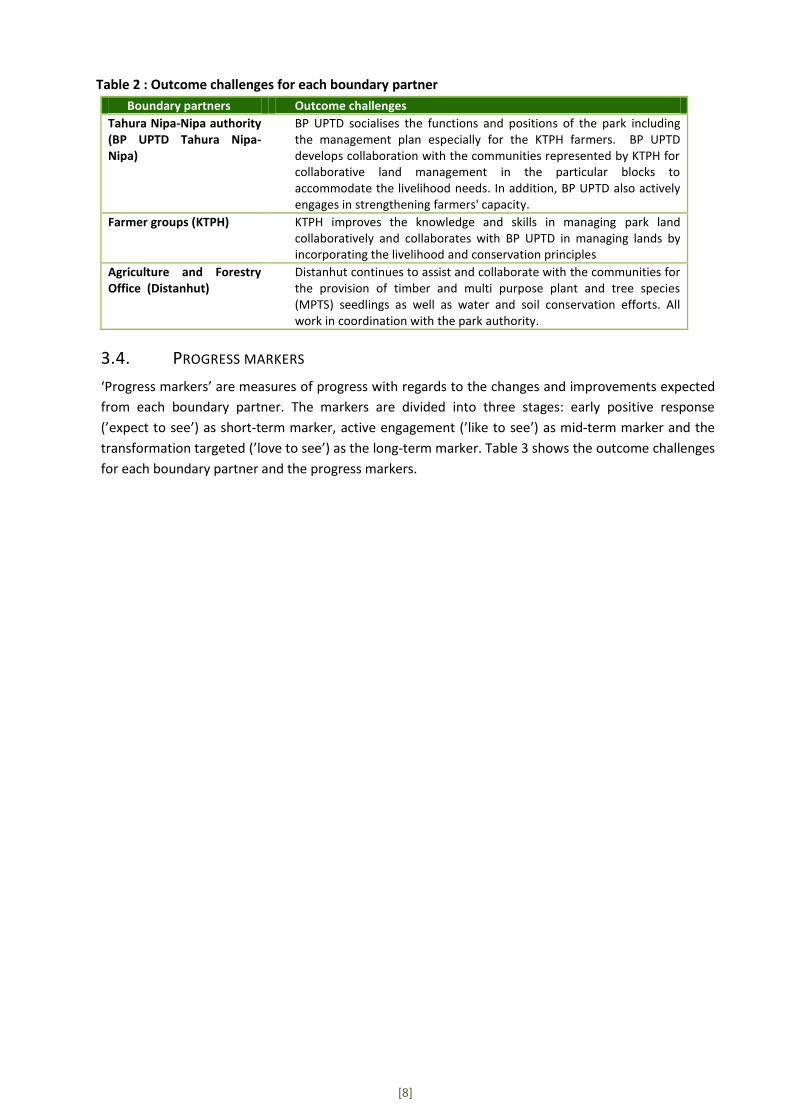
3.3. OUTCOME CHALLENGES
Outcome challenges describe the contribution of each boundary partner to the vision and reflect the
changes that are expected from each boundary partner. Outcome challenges also serve to set out the
ideal actions.
From the specific issues and mission to be addressed in Tahura Nipa-Nipa, the WG mapped the
outcome challenges as targets to achieve. A summary of challenges targeted is presented in Table 2.
[8]
Table 2 : Outcome challenges for each boundary partner
Boundary partners Outcome challenges
Tahura Nipa-Nipa authority (BP UPTD Tahura Nipa-Nipa)
BP UPTD socialises the functions and positions of the park including the management plan especially for the KTPH farmers. BP UPTD develops collaboration with the communities represented by KTPH for collaborative land management in the particular blocks to accommodate the livelihood needs. In addition, BP UPTD also actively engages in strengthening farmers' capacity.
Farmer groups (KTPH) KTPH improves the knowledge and skills in managing park land collaboratively and collaborates with BP UPTD in managing lands by incorporating the livelihood and conservation principles
Agriculture and Forestry Office (Distanhut)
Distanhut continues to assist and collaborate with the communities for the provision of timber and multi purpose plant and tree species (MPTS) seedlings as well as water and soil conservation efforts. All work in coordination with the park authority.
3.4. PROGRESS MARKERS
‘Progress markers’ are measures of progress with regards to the changes and improvements expected
from each boundary partner. The markers are divided into three stages: early positive response
(’expect to see’) as short-term marker, active engagement (’like to see’) as mid-term marker and the
transformation targeted (’love to see’) as the long-term marker. Table 3 shows the outcome challenges
for each boundary partner and the progress markers.

[9]
Table 3. Outcome challenges for each boundary partner and the progress markers
No Boundary partners
Outcome challenges Progress marker
Early positive response
(‘expect to see’)
Active engagement (’like to see’)
Transformation targeted
(’love to see’)
1 BP UPTD Tahura
BP UPTD socialises the functions and position of the park, including the management plan, with the public especially farmers around the borders within the KTPH
BP UPTD holds regular meetings with KTPH
BP UPTD conducts sessions to increase awareness of the farmers on functions of the park and the appropriate management activities
BP UPTD finally socialises the boundaries and helps the farmers to understand the function of Tahura Nipa-Nipa
BP UPTD develops collaboration with the communities represented by the KTPH for collaborative land management of particular blocks to accommodate livelihood needs
BP UPTD opens dialogues with KTPH on tree and plant species that are allowed to be planted in the park
BP UPTD is willing to accommodate the negotiation processes to achieve the final list of allowed species on the KTPH managed land
BP UPTD agrees to the proposed species based on conservation and livelihood considerations
BP UPTD actively engages in strengthening farmers' capacity
BP UPTD holds regular training programmes for appropriate planting within the park area
BP UPTD provides technical assistance on land and farm management needed by the KTPH farmers
BP UPTD assists in promoting and marketing the commodities from farmers’ lands or incorporating them in ecotourism
2 KTPH KTPH improves the knowledge and skills in managing park lands collaboratively
KTPH actively participates in the training programmes BP UPTD or other offices conduct
KTPH applies the principles of conservation in managing the park
KTPH becomes the learning centre for other farmers in managing land in the conservation area.
KTPH collaborates with BP UPTD in managing lands that fall under the park management to incorporate livelihood-conservation principles
KTPH invites the park BP UPTD BP to group discussions, and information sharing
KTPH takes the responsibility for protection efforts for lands under the park’s authority
KTPH works alongside BP UPTD in developing the collaborative planning for land management
3 Distanhut Distanhut continues to assist communities with timber and MPTS seedling provision programmes in collaboration with the park BP UPTD
Distanhut reviews the previous programme in order to improve the next stages
Distanhut makes a careful plan for the locations, amount and types of seedlings for the local communities/farmers
Distanhut conducts monitoring and evaluation for the seedling provision
Distanhut continues the activities and infrastructure development for water and soil conservation together with the communities in coordination with BP UPTD
Distanhut reviews the previous programme in order to improve the next stages
Distanhut designs the technical aspects of conservation planning based on the real condition on the ground and communities' needs
Distanhut conducts monitoring and evaluation for the implementation of community water and soil conservation efforts
[10]
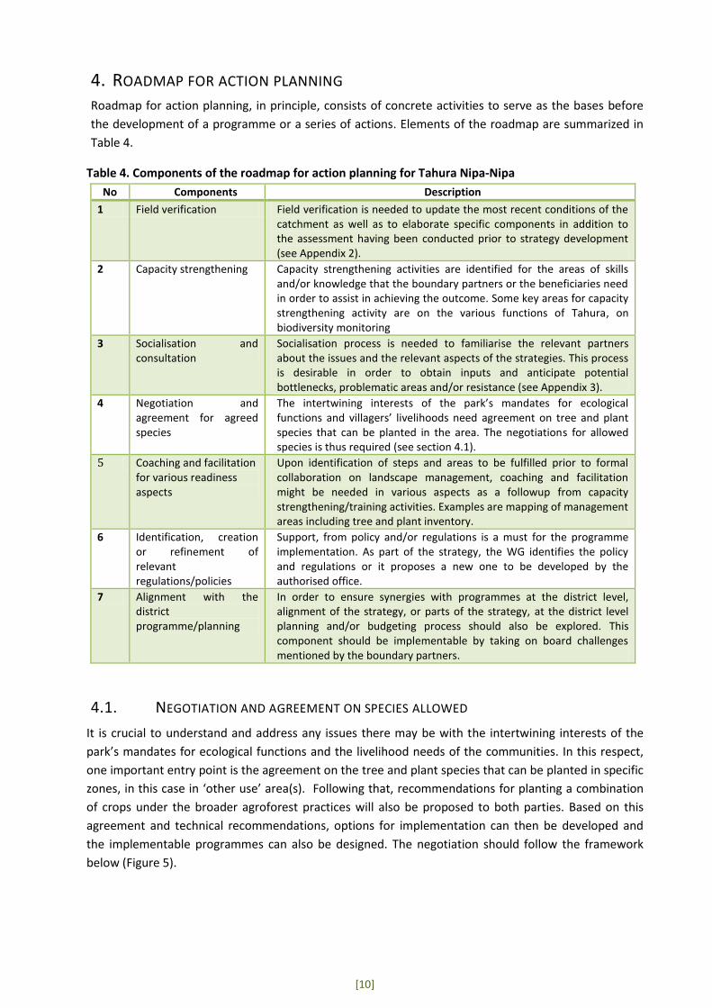
4. ROADMAP FOR ACTION PLANNING Roadmap for action planning, in principle, consists of concrete activities to serve as the bases before
the development of a programme or a series of actions. Elements of the roadmap are summarized in
Table 4.
Table 4. Components of the roadmap for action planning for Tahura Nipa-Nipa
No Components Description
1 Field verification Field verification is needed to update the most recent conditions of the catchment as well as to elaborate specific components in addition to the assessment having been conducted prior to strategy development (see Appendix 2).
2 Capacity strengthening Capacity strengthening activities are identified for the areas of skills and/or knowledge that the boundary partners or the beneficiaries need in order to assist in achieving the outcome. Some key areas for capacity strengthening activity are on the various functions of Tahura, on biodiversity monitoring
3 Socialisation and consultation
Socialisation process is needed to familiarise the relevant partners about the issues and the relevant aspects of the strategies. This process is desirable in order to obtain inputs and anticipate potential bottlenecks, problematic areas and/or resistance (see Appendix 3).
4 Negotiation and agreement for agreed species
The intertwining interests of the park’s mandates for ecological functions and villagers’ livelihoods need agreement on tree and plant species that can be planted in the area. The negotiations for allowed species is thus required (see section 4.1).
5 Coaching and facilitation for various readiness aspects
Upon identification of steps and areas to be fulfilled prior to formal collaboration on landscape management, coaching and facilitation might be needed in various aspects as a followup from capacity strengthening/training activities. Examples are mapping of management areas including tree and plant inventory.
6 Identification, creation or refinement of relevant regulations/policies
Support, from policy and/or regulations is a must for the programme implementation. As part of the strategy, the WG identifies the policy and regulations or it proposes a new one to be developed by the authorised office.
7 Alignment with the district programme/planning
In order to ensure synergies with programmes at the district level, alignment of the strategy, or parts of the strategy, at the district level planning and/or budgeting process should also be explored. This component should be implementable by taking on board challenges mentioned by the boundary partners.
4.1. NEGOTIATION AND AGREEMENT ON SPECIES ALLOWED
It is crucial to understand and address any issues there may be with the intertwining interests of the
park’s mandates for ecological functions and the livelihood needs of the communities. In this respect,
one important entry point is the agreement on the tree and plant species that can be planted in specific
zones, in this case in ‘other use’ area(s). Following that, recommendations for planting a combination
of crops under the broader agroforest practices will also be proposed to both parties. Based on this
agreement and technical recommendations, options for implementation can then be developed and
the implementable programmes can also be designed. The negotiation should follow the framework
below (Figure 5).
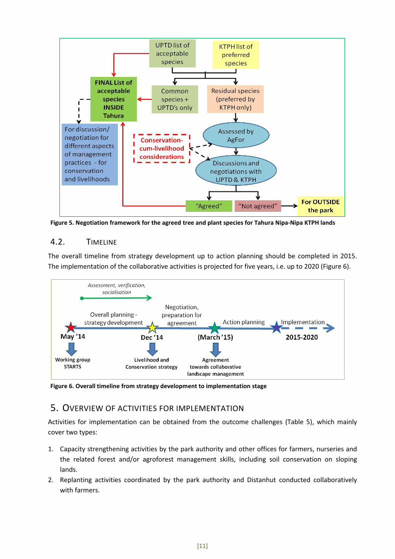
[11]
Figure 5. Negotiation framework for the agreed tree and plant species for Tahura Nipa-Nipa KTPH lands
4.2. TIMELINE
The overall timeline from strategy development up to action planning should be completed in 2015.
The implementation of the collaborative activities is projected for five years, i.e. up to 2020 (Figure 6).
Figure 6. Overall timeline from strategy development to implementation stage
5. OVERVIEW OF ACTIVITIES FOR IMPLEMENTATION Activities for implementation can be obtained from the outcome challenges (Table 5), which mainly
cover two types:
1. Capacity strengthening activities by the park authority and other offices for farmers, nurseries and
the related forest and/or agroforest management skills, including soil conservation on sloping
lands.
2. Replanting activities coordinated by the park authority and Distanhut conducted collaboratively
with farmers.

[12]
6. REFERENCES Rustam, BR. 2013. Buku Informasi Taman Hutan Raya Nipa-nipa Sulawesi Tenggara, Balai Tahura Nipa-
nipa, Sulawesi Tenggara.
Department for International Development (DFID). 1999. Sustainable Livelihood Guidance Sheet.
http://www.eldis.org/vfile/upload/1/document/0901/section2.pdf (last accessed 20 October 2014)
Earl S, Carden F, and Smutylo T. 2001. Outcome Mapping - Building Learning and Reflection into
Development Programs. International Development Research Centre, Ottawa.
"SWOT Analysis: Strengths, Weaknesses, Opportunities, and Threats." Chapter 3. Assessing Community
Needs and Resources. http://ctb.ku.edu/en/tablecontents/sub_section_main_1049.aspx (last accessed
21 October 2014)
World Agroforestry Centre-ICRAF Southeast Asia. 2014. Profil Klaster “Tahura Nipa-Nipa” (KTPH
Tumbuh Subur, KTPH Subur Makmur, KTPH Medudulu, KTPH Pokaduludua), Kabupaten Konawe-Kota
Kendari, Propinsi Sulawesi Tenggara. World Agroforestry Centre - ICRAF Southeast Asia Regional Office.
Bogor, Indonesia

[13]
APPENDIX 1. WORKING GROUP MEMBERS
Tim Kerja Pengelolaan Bersama Tahura Nipa-Nipa
Pembina : La Ode Yulardhi Junus, S.P (Ka. BP UPTD Tahura Nipa-Nipa)
Koordinator : Rustam BR, SP.,MP (Kasi. Perlindungan dan Pengembangan BP UPTD Tahura)
Anggota/Team Lapangan :
Syukur SP (Penyuluh Pertanian Kota Kendari)
Muh. Ulu Sultra, S.Hut (BP UPTD Tahura)
Nurmila (KTPH Tumbuh Subur)
La Zana (KTPH Tumbuh Subur)
Ruslan Taata S (KTPH Medudulu)
La Goly (KTPH Subur Makmur)
Johannes Jokka (KTPH Subur Makmur)
Jhon Roy Sirait (AgFor)
Hendra Gunawan (AgFor)
Hasantoha Adnan (AgFor)

[14]
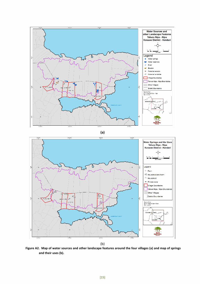
APPENDIX 2. RESULTS OF SURVEYS AND VERIFICATION Two types of survey for field checking and verification were conducted: 1) a survey on water sources
and other ecosystem service features, and 2) a survey on the species planted by farmers. A summary of
the surveys is presented in Table A1, Figure A1 (pictures) and Figure 2A (maps) below.
Table A1. Summary of verification activities
Activity Description Ecosystem service survey – especially for springs and other water sources
From the survey, it was found that Alolama Village (KTPH Tumbuh Subur) has one spring located 4–5 km from the settlement towards the park area. There is also one waterfall flowing into Alesowi Stream. For Mangga Dua Village (KTPH Pokaduludua) there are three springs and one waterfall for public bathing. Tipulu Village (KTPH Medudulu) has two springs and Watu Watu Village (KTPH Subur Makmur) has five springs all located around 3–4 km from the settlement areas.
Survey on trees and plants planted by the communities
Timber species planted are eha, ponto, bitti, kayu besi, bintangur, jati and damar. MPTS planted are coffee, clove, mango, rambutan, cashew nut, durian, langsat and jackfruit
Figure A1. Landscape and tree and plant species planted by farmers observed during field verification activities
[15]
(a)
(b)
Figure A2. Map of water sources and other landscape features around the four villages (a) and map of springs
and their uses (b).

[16]
APPENDIX 3. SOCIALISATION IN VILLAGES 1. Socialisation of the park boundaries and functions
Objective: to socialise the boundaries and functions of Tahura with the communities in the
surrounding villages.
Summary of presentation by the park authority:
Awareness materials were presented by Bp. Rustam BR as the head of protection and
development of the park authority.
The importance of protecting the park directly relates to the protection of ecosystem services,
especially water sources, for ecotourism potentials/objects, to prevent the downstream
villages and Kendari city from floods, erosion and from sedimentation in Kendari Bay. The park
authorities requested the cooperation of the communities to plant timber trees in their area to
support the park protection functions. The park has a replanting programme using several
forest species and it welcomes requests from the communities for seedlings.
Feedback from the farmers:
KTPH Subur Makmur mentioned that the park should also have the function of livelihood
support as well as conserving endemic species.
Farmers from KTPH Medudulu proposed that bamboo should be planted in the border area of
the park, which could also help the soil and protect the water functions.
KTPH Tumbuh Subur stressed the importance of protecting the park especially for water and
erosion protection.
Farmers from KTPH Pokaduludua requested that coordination and communication be improved
and that the park authority be willing to build partnerships with the KTPHs.
2. Socialisation of the governance and management aspects of Tahura Nipa-Nipa
Objective: to socialise the governance and management aspects of the park.
Summary of a presentation given by the park authority:
The socialisation materials were presented by Bp. Putra Fiat, the head of Tahura Nipa-Nipa
land use planning of the park
The main substance of the presentation was on the park establishment, the zonation and
other related regulations.
Feedback from the KTPHs:
The head of KTPH Tumbuh Subur requested full cooperation from his members for the
boundaries and regulations already established by the park authorities.
A representative from KTPH Subur Makmur also had similar requests for the members that they
do not expand further towards the park area and do not use burning to clear land. The farmers
requested that the park authorities conduct capacity building for the farmers for appropriate
land management.
The farmers from KTPH Medudulu urged the collaboration of both parties to comply with the
zonation and in managing the lands.

[17]
KTPH Pokaduludua expressed their concerns about the establishment of the park boundaries,
which are very close to the settlement. Some houses are said to be located inside the park
area. This issue of the boundary and boundary signs must be handled very carefully and taken
seriously by the authorities.


World Agroforestry CentreSoutheast Asia Regional ProgramJl. CIFOR, Situ Gede, Sindang Barang, Bogor 16115PO Box 161, Bogor 16001, IndonesiaTel: +62 251 8625415Fax: +62 251 8625416Email: [email protected]://www.worldagroforestry.org/regions/southeast_asia
Agroforestry and Forestry in Sulawesi (AgFor Sulawesi) is a �ve-year project funded by the Department of Foreign A�airs, Trade and Development Canada. The World Agroforestry Centre is the lead organization of the project, which operates in the provinces of South Sulawesi, Southeast Sulawesi and Gorontalo