Embed Size (px)
Citation preview
1
Colonel Richard G.ThompsonU.S. Army Corps of EngineersLos Angeles District
Corps of EngineersCorps of EngineersInitiatives in the Initiatives in the Coastal ZoneCoastal Zone
19 April 2002 19 April 2002
2
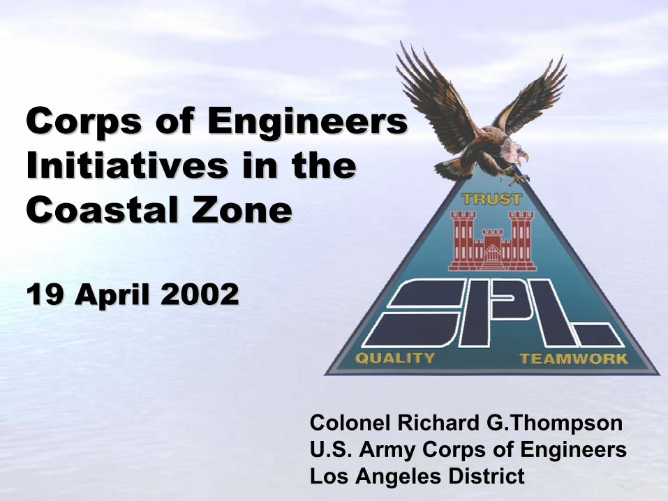
Coastal Sediment Management Issues Facing Us Today
� Shoreline Recession� Reduction in Sand Supply� Loss of Coastal Wetlands� Contaminated Sediment Loading� Lack of Coordination
3
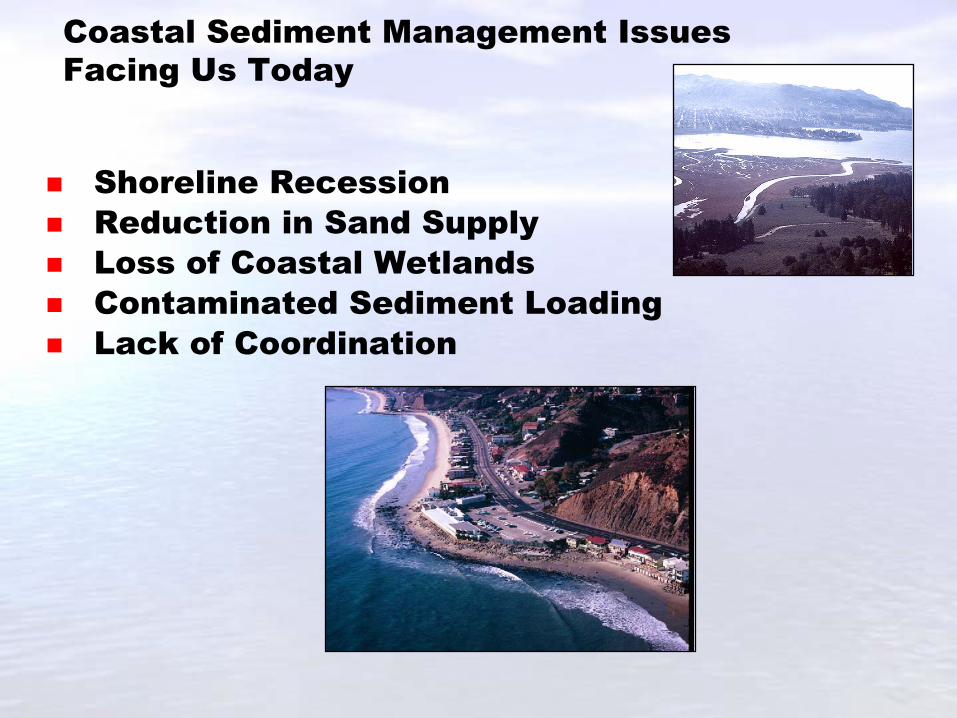
Current Activities and Opportunities
� Sand Bypass� Ecosystem Restoration� Beneficial Reuse Opportunities� Ocean Disposal Site Designation� Source Control
4
Focus on Regional Solutions For The Future
� National Regional Sediment Management (RSM)
� National Shoreline Erosion Control Development and Demonstration Program (Section 227)
� Coast of California Storm and Tidal Wave Studies
� California Public Beach Restoration Act� California Coastal Sediment Master Plan
5
California Coastal Sediments Master Plan
� Concept Borne by CSMW.� Comprehensive Sediments Management Plan.� Optimize Efficiency and Effectiveness.� Federal and Non-Federal Partners
6
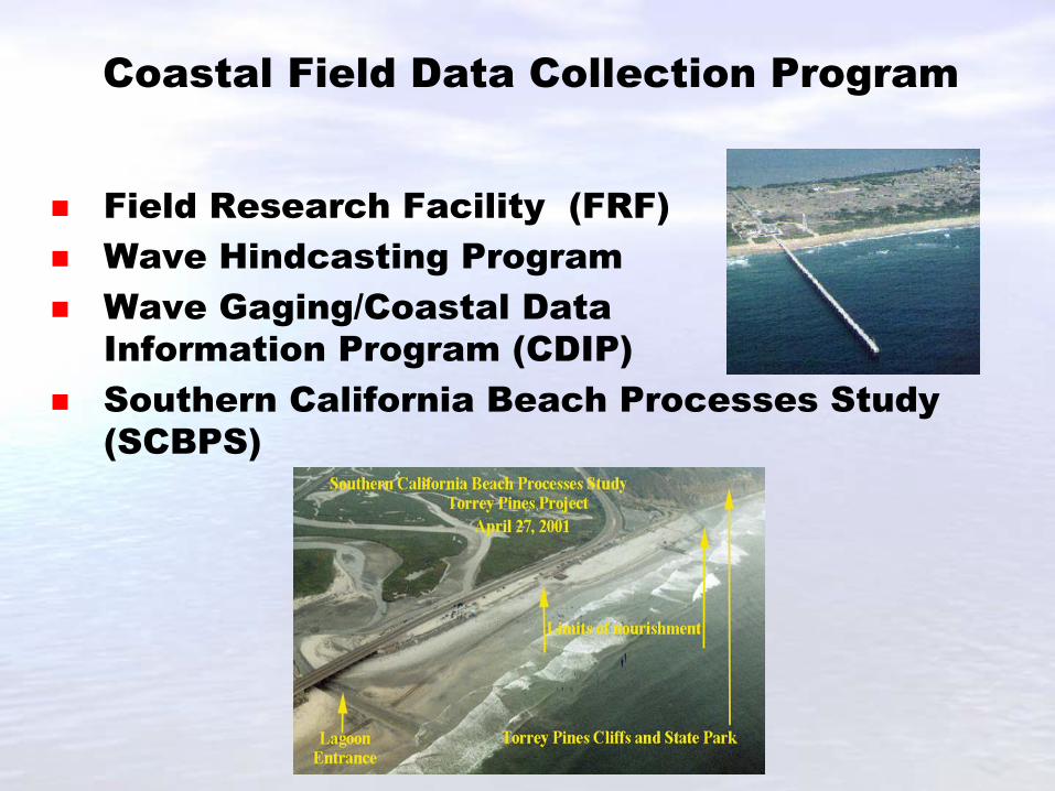
� Field Research Facility (FRF)� Wave Hindcasting Program� Wave Gaging/Coastal Data
Information Program (CDIP) � Southern California Beach Processes Study
(SCBPS)
Coastal Field Data Collection Program
7
Recommendations
� Continue partnership with Federal, State and Local Agencies
� Visit FRF at Duck, NC� Begin work on National Shoreline Management
Study� Participate in RSM National Policy
Development
Slide 1 Good afternoon. My name is Dick Thompson. I command the United States Army Corps of Engineers District responsible for a quarter million square mile area in the southwest corner of the United States covering Southern California, Southern Nevada, Arizona and part of Utah. The District is headquartered in Los Angeles and its 700 civilian employees are stationed at 22 locations throughout this region. In partnership with local governments we provide flood protection to the 20 million people who live in this region, protect 420 miles of the Pacific shoreline and support navigation projects at 14 ports through which a third of all manufactured goods enter this country. We enhance and protect the environment of the region, and support local, state and federal agencies in their response to disasters. As a vital part of our nations military, we provide engineering and construction support to the military installations in the region, which include some of the Army and Air Force’s most important facilities. We exist to serve the needs of our nation and our service has been required in these regions since 1898. I’m delighted to be here this afternoon to present to you all the U.S. Army Corps of Engineers initiatives regarding the management of coastal zone matters. My presentation will include our efforts at both the local level and also at the national level, which includes regional sand management programs, and initiatives to understand the physics of the nearshore and surf zone environments. Slide 2 We see some major issues regarding the management of coastal sediments across our Nation. These issues are especially prevalent in the state of California, and include concerns regarding: The recession of shorelines, the shoreline of California is constantly changing as a result of natural oceanographic and geologic processes, and because of human activities associated with coastal development and adjacent watersheds; A reduction in sand supply to our beaches due to various structural developments inhibiting the transport of sand, by capturing sediment behind dams and debris basins or by impeding the natural transport of sediments within the littoral system; •A significant loss of coastal wetlands is a serious problem that southern California faces. It is estimated by some studies that southern California has lost anywhere from 70-95% of our historic wetlands; An increase in contaminated and fine grain sediment loading within our bays and harbors adversely impacting shipping and navigation to our ports, when dredging could not be accomplished in a timely manner due to a lack of suitable disposal sites. Additionally, the continuous buildup of sediments within our coastal estuaries is changing the ecosystem within these areas, impacting both the biology and recreational opportunities at these sites; And additionally, the lack of coordination between agencies on federal, state and local projects that could holistically address some of these problems to produce more efficient and effective solutions. Slide 3 Some of the current activities that we are involved in to address coastal sediment management challenges include: Undertaking bypassing of sediments where navigation structures are interfering with the transport of sediments within the littoral system; Restoration of coastal ecosystems by dredging in-situ sediment polluted with various chemical constituents and enhancing wetland and estuarine ecosystems through various means to increase tidal circulation and restore lost habitat;
We attempt to identify every opportunity to beneficially reuse dredged sediments. Examples include use of dredged sediments to provide fill material for construction and port development projects, development of fish and wildlife habitats, and renourishing eroding beaches. Additionally, we coordinate with and assist USEPA in identifying and designating ocean disposal sites for receipt of non-contaminated sediments, not typically suitable for beneficial reuse. These sites have proven to be economically necessary to our Nation’s major Ports and Harbors for disposal of large volumes of finer grain sediments that are dredged for the purposes of either navigation improvements or maintenance of existing navigation channels and mooring areas. In dealing with contaminated sediments problem within the marine environment, the Corps is involved in several studies that will identify means for controlling contaminated sediments at their sources prior to these sediments reaching the ocean. These include developing watershed best management practices and implementing structural measures to capture polluted sediments upstream.
Slide 4 On a national perspective, the Corps of Engineers is involved in numerous programs to develop methodologies to manage sediments on a regional scale and to develop innovative measures to abate the erosion of shorelines. Our national regional sediment management demonstration program is focused on assessing the benefits of managing sediment resources as a regional scale resource rather than a localized project resource. It is the only new start initiation in the research and design program, which indicates how crucial RSM is to the Corps and our use of the limited research funds to focus on this program. This six-year program will provide opportunities for seven national areas that include the northern Gulf of Mexico, Northeast Florida, Southeast Lake Michigan, Southeast New Jersey shore, South shore of Long Island, the Mouth of the Columbia River, and California, to develop tools to efficiently manage regional coastal sediment resources. Our National Shoreline Erosion Control Development and Demonstration Program (Section 227) is evaluating the functional and structural performance of innovative or non-traditional approaches for abating coastal erosion and improving sediment retention via field demonstration. Numerous shore protection methods and approaches are being considered, monitored and evaluated at sites representing varying energy conditions and shoreline morphologies. The programs goals are to advance the state of the art of shoreline erosion control technology, encourage the development of innovate solutions, and provide technical and public information designed to further the use of well-engineered alternative approaches. The California Public Beach Restoration Act was allocated by the governor and legislature for $10 Million in FY00-01 to be applied to beach nourishment studies and projects. The funds are administered by the Department of Boating and Waterways. Projects and studies were solicited, reviewed and ranked for implementation. Our Coast of California Storm and Tidal Wave Studies, have been completed for our San Diego and Orange County regions, and are currently underway for the Los Angeles and Ventura/Santa Barbara counties, provide us an understanding of the coastal processes within these regions, through an extensive data collection and numerical analyses program. The results of these studies have and will in the future be used to provide the coastal engineering foundation for site specific and regional study areas, to better design projects and programs to provide shore protection to local coastal communities. Specifically here in California, we are working with the State Resources Agency to formulate an overall California Coastal Sediments Master Plan where we hope to develop a region-wide management plan encompassing the entire California coastline to maintain and restore the health of California’s beaches and shoreline, and to preserve and protect California’s coastal sediment resources.
Slide 5 The California Coastal Sediment Master Concept was borne by the Coastal Sediments Management Workgroup. The Plan will provide a comprehensive strategy to smartly manage the State’s sediment resources by managing the related needs of beach nourishment, port and harbor dredging, coastal wetland and estuarine restoration, and flood control system maintenance within coastal watersheds. •Implementation of the Master Plan’s comprehensive management strategy should result in efficient and effective use of federal, state and local water resources and ecosystem restoration funds, by cooperatively and/or collectively applying these funds to develop and execute regional solutions to solve a multitude of localized coastal and water resources problems. •We anticipate that preparation of the Master Plan will be accomplished through a formal partnership between the US Army Corps of Engineers (and possibly other Federal agencies) and the State Resources Agency (and possibly local or regional non-Federal agencies/coalitions). Slide 6 Our coastal field data collection program is active on both the east and west coasts and provides valuable data analyses and coastal processes theories to develop solutions for coastal engineering design and sediment management. The program includes: The Field Research Facility, the worlds only field research laboratory located at Duck, North Carolina. The lab is used by USGS, U.S. Navy, NOAA, universities and many other customers. The lab is active in the National Ocean Partnership. Wave Hindcasting Program: The Corps is providing accurate, reliable long-term data on the Climatology of waves, currents and water levels along the Atlantic, Pacific, Gulf of Mexico, and Great Lakes coastlines to be used to calculate statistical parameters for use in the planning and design of coastal projects. Long-term data are paramount to the functional/structural design and economic evaluation of coastal navigation projects. The Coastal Data Information Program (CDIP), operated by Scripps Institute of Oceanography (SIO) and supported by the Corps of Engineers and the California Department of Boating and Waterways, makes offshore wave measurements along the West Coast of the United States. CDIP has also developed the methods for modeling how these waves are changed by island blocking and refraction by ocean floor contours as they propagate towards the beach. These modeled waves and historical measurements are presented on the Internet, and are typically viewed by up to ninety thousand individuals each day. The creation of the capabilities and the data sources that this project will provide could bring substantial benefits to California and the nation. Southern California Beach Processes Study: The SCBPS is a jointly sponsored program by the State of California and the Corps of Engineers that began in 2001 to develop and implement strategies for monitoring and modeling beach erosion that will result in more effective local and regional management of shorelines. The study uses wave measurements and modeling provided by CDIP. Slide 7 Strengthen partnerships with other Federal, State and local agencies, which leverages resources among the agencies, provides opportunities for information exchange, permits complimenting gathering and analyses efforts, and encourages project collaboration to merge varying levels of interests. I’d like to invite the commission to visit our Field Research Facility at Duck, North Carolina, as they are involved in many activities, which provide data necessary for researches to understand the coastal and nearshore environments. Begin work on the National Shoreline Management Study that will provide Congress a description of the extent of and the causes of erosion and accretion along the shores of the United States and a description of the systematic movement of sand along the nation's shores. Furthermore, this study will describe the economic and environmental effects
caused by the erosion and the accretion process. It will provide a description of the resources committed by Federal, State and local governments to restore and renourish these shores. The study will be presented to Congress with recommendations regarding appropriate levels of Federal and non-federal participation in shore protection as well as recommendations on the use of a "systems approach" (i.e., regional sediment management approach) to sand management as a means for integrating planning and management decisions pertaining to adjacent Federal and State navigation and beach restoration projects. I’d like to encourage the Commission to take an active role in the future development of polices associated with the regional management of coastal sediments, above and beyond focuses on littoral cells, that includes a more holistic approach through evaluating coastal watershed sediment transport (or lack of transport) with their respective littoral cells. I thank you for the opportunity to brief you on the Corps active involvement in Coastal Zone Management matters. My staff and I are prepared to answer any questions you may have.