Embed Size (px)
Citation preview
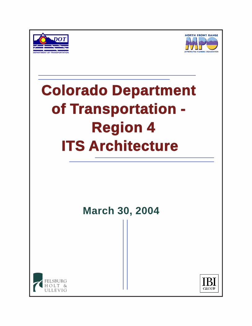
Colorado Departmentof Transportation -
Region 4ITS Architecture
FELSBURGH O L T &U L L E V I G
March 30, 2004
DEPARTMENT OF TRANSPORTATION
DOT

CDOT REGION 4
REGIONAL ITS ARCHITECTURE
Prepared for:
Colorado Department of Transportation - Region 4 1420 2nd Street
Greeley, CO 80631
Project Manager: Larry J. Haas, P.E.
Prepared by:
Felsburg Holt & Ullevig 6300 South Syracuse Way, Suite 600
Centennial, CO 80111 (303) 721-1440
Project Manager: Richard R. Follmer, P.E., PTOE
In Association with:
IBI Group
9055 East Mineral Circle, Suite 100 Centennial, CO 80112
(303) 713-1013
Project Manager: Greg A. MacKinnon, P.E.
FHU Reference No. 03-185 March 30, 2004

Regional ITS Architecture March 30, 2004
TABLE OF CONTENTS
Page EXECUTIVE SUMMARY ------------------------------------------------------------------------------------------- i I. INTRODUCTION AND OVERVIEW ------------------------------------------------------------------- 1
A. Overview ------------------------------------------------------------------------------------------- 1 B. Project Approach --------------------------------------------------------------------------------- 1 C. Organization of the Report --------------------------------------------------------------------- 2
II. NATIONAL ITS ARCHITECTURE INTRODUCTION---------------------------------------------- 3
A. Introduction ---------------------------------------------------------------------------------------- 3 B. Physical Architecture ---------------------------------------------------------------------------- 3 C. Federal Highway Administration (FHWA) and Federal Transit Administration (FTA) Regulations-------------------------------------------------------------------------------- 6
III. BACKGROUND INFORMATION----------------------------------------------------------------------- 8
A. Description of the Study Area ----------------------------------------------------------------- 8 B. Identification of Stakeholders---------------------------------------------------------------- 10 C. Other Planning Efforts------------------------------------------------------------------------- 11 E. Regional Transportation Issues------------------------------------------------------------- 23
IV. MARKET PACKAGES SELECTION----------------------------------------------------------------- 24
B. Advanced Traveler Information Systems ------------------------------------------------- 27 C. Advanced Public Transportation Systems------------------------------------------------ 27 D. Emergency Management--------------------------------------------------------------------- 29 E. Maintenance and Construction Management-------------------------------------------- 30 F. Commercial Vehicle Operations ------------------------------------------------------------ 31
G. Archived Data Management ----------------------------------------------------------------- 31 V. OPERATIONAL CONCEPT --------------------------------------------------------------------------- 33
A. Operational Concept Overview-------------------------------------------------------------- 33 B. Regional Traffic Control----------------------------------------------------------------------- 36 C. Broadcast and Interactive Traveler Information ----------------------------------------- 38 D. Regional Transit Operations ----------------------------------------------------------------- 40 E. Incident Management ------------------------------------------------------------------------- 42 F. Weather Data Collection and Dissemination--------------------------------------------- 44 G. Commercial Vehicle Operations ------------------------------------------------------------ 44 H. ITS Data Warehouse -------------------------------------------------------------------------- 45 I. Emissions Monitoring and Management-------------------------------------------------- 45 J. Rail Operations Coordination---------------------------------------------------------------- 46
VI. AGREEMENTS BETWEEN ORGANIZATIONS -------------------------------------------------- 47
Regional ITS Architecture March 30, 2004
TABLE OF CONTENTS (Continued)
Page VII. SYSTEM FUNCTIONAL REQUIREMENTS, INTERFACE REQUIREMENTS AND INFORMATION EXCHANGES ---------------------------------------------------------------- 50 VIII. IDENTIFICATION OF ITS STANDARDS----------------------------------------------------------- 53
A. Common Standards---------------------------------------------------------------------------- 54 B. The National Transportation Communications for ITS Protocol Family (NTCIP) 56 C. Roadside to Vehicle Communications Protocols---------------------------------------- 59 D. Exchange of Video Images ------------------------------------------------------------------ 59
IX. ITS PROJECT PRIORITIES FOR IMPLEMENTATION ---------------------------------------- 60 X. NEXT STEPS --------------------------------------------------------------------------------------------- 62 APPENDIX A FEDERAL HIGHWAY ADMINISTRATION FINAL RULE APPENDIX B ELEMENTS OF INTERAGENCY AGREEMENTS APPENDIX C ITS ARCHITECTURE DIAGRAMS APPENDIX D ITS STANDARDS

Regional ITS Architecture March 30, 2004
LIST OF FIGURES
Page Figure 1. National Architecture “Sausage” Diagram-------------------------------------------------- 4 Figure 2. Regional Traffic Control------------------------------------------------------------------------- 6 Figure 3. Regional ITS Architecture Study Area------------------------------------------------------- 9 Figure 4. CDOT ITS Branch ITS Inventory ----------------------------------------------------------- 18 Figure 5. Fort Collins ITS Inventory -------------------------------------------------------------------- 19 Figure 6. Greeley ITS Inventory ------------------------------------------------------------------------- 20 Figure 7. Loveland ITS Inventory ----------------------------------------------------------------------- 21 Figure 8. Windsor ITS Inventory------------------------------------------------------------------------- 22 Figure 9. Application of ITS Standards ---------------------------------------------------------------- 54 LIST OF TABLES Table 1. NFR RTP Transportation System Management Projects----------------------------- 13 Table 2. ITS Element Inventory------------------------------------------------------------------------- 15 Table 3. Transportation Issues in Study Area------------------------------------------------------- 23 Table 4 Selected ATMS Market Packages---------------------------------------------------------- 26 Table 5. Selected ATIS Market Packages ----------------------------------------------------------- 27 Table 6. Selected APTS Market Packages ---------------------------------------------------------- 28 Table 7. Selected EM Market Packages ------------------------------------------------------------- 29 Table 8. Selected MCM Market Packages----------------------------------------------------------- 30 Table 9. Selected CVO Market Packages ----------------------------------------------------------- 31 Table 10. Selected Archived Data Market Packages ----------------------------------------------- 32 Table 11. Agency-to-Agency Relationships ----------------------------------------------------------- 34 Table 12 Information Flow Definitions ----------------------------------------------------------------- 35 Table 13. Traveler Information Relationships and Information Flows--------------------------- 40 Table 14. Regional Transit Operations Relationships and Information Flows ---------------- 41 Table 15. NTCIP Center to Field Standards ---------------------------------------------------------- 57 Table 16. TCIP Standards--------------------------------------------------------------------------------- 58
Regional ITS Architecture March 30, 2004
LIST OF ABBREVIATIONS AND ACRONYMS AASHTO American Association of State Highway and Transportation Officials AD Archived Data Management APCD Air Pollution Control Division APTS Advanced Public Transportation System ATIS Advanced Traveler Information System ATMS Advanced Traffic Management System AVI Automatic Vehicle Identification AVL Automatic Vehicle Location AVSS Advanced Vehicle Safety Systems C2C Center-to-Center C2F Center-to-Field CAD Computer Aided Dispatch CC Control Center Business Area Standard CCTV Closed Circuit Television CDOT Colorado Department of Transportation CDPHE Colorado Department of Public Health and Environment CO Carbon Monoxide CORBA Common Object Request Broker Architecture COLT City of Loveland Transit CPT Common Public Transportation Business Area Standard CSTOC Colorado Springs Traffic Operations Center CTMC Colorado Transportation Management Center CVISN Commercial Vehicle Information Systems and Network CVO Commercial Vehicle Operations DATEX Data Exchange Between Systems DMS Dynamic Message Signs DSRC Dedicated Short-Range Communications EM Emergency Management EPA Environmental Protection Agency ESS Environmental Sensor Station FC Fare Collection Business Area Standard FCC Federal Communications Commission FHWA Federal Highway Administration FMCSA Federal Motor Carrier Safety Administration FTA Federal Transit Administration HAR Highway Advisory Radio HLT Hanging Lake Tunnels Traffic Operations Center HOT High Occupancy Toll HOV High Occupant Vehicle – any vehicle carrying two or more passengers HRI Highway-Rail Intersection IGA Inter-Governmental Agreement IM Incident Management Business Area Standard IMMS Incident Management Message Sets ISP Information Service Provider

Regional ITS Architecture March 30, 2004
ITE Institute of Transportation Engineers ITS Intelligent Transportation Systems – the application of advanced
(primarily electronic) technology to transportation systems to reduce congestion and vehicle emissions and to improve safety.
IVR Interactive Voice Response MCM Maintenance and Construction Management MOU Memorandum of Understanding MPO Metropolitan Planning Organization MS/ETMCC Message Sets for External Traffic Management Center Communication NEMA National Electrical Manufacturers Association NFR North Front Range NFRT & AQPC North Front Range Transportation & Air Quality Planning Council NTCIP The National Transportation Communications for ITS Protocol OB Onboard Business Area Standard PI Passenger Information Business Area Standard RMNP Rocky Mountain National Park RTP Regional Transportation Plan SCH Scheduling/Runcutting Business Area Standard SDO Standards Development Organization SONET Synchronous Optical Network SOV Single Occupant Vehicle SP Spatial Representation Business Area Standard RWIS Road Weather Information System TCIP Transit Communications Interface Protocols TDMM Traffic Management Data Dictionary TMC Traffic Management System TPR Transportation Planning Region TSM Transportation Systems Management USDOT United States Department of Transportation WIM Weigh-In-Motion XML eXtensible Markup Language
Regional ITS Architecture March 30, 2004
Page i
EXECUTIVE SUMMARY Overview On April 8, 2001, the Federal Highway Administration (FHWA) established a Final Rule and the Federal Transit Administration (FTA) established a policy on the use of the National ITS Architecture. The purpose of this rule/policy is to foster integration between existing regional ITS deployments and to ensure that subsequent deployments will be integrated into the existing systems. The rule/policy establishes that jurisdictions intending to deploy ITS projects and that wish to seek funding from the Highway Trust Fund and the Mass Transit Account must conform to the National ITS Architecture and appropriate standards. Within the Colorado Department of Transportation’s (CDOT) Region 4, federal funding has been used to deploy ITS projects both along I-25 and within the City of Fort Collins. Therefore, CDOT Region 4, together with the North Front Range Transportation & Air Quality Planning Council (NFRT & AQPC), have prepared this Regional ITS Architecture as well as a companion ITS Strategic Plan to guide the deployment of ITS applications over the next ten years. The regional ITS Architecture must include the following elements1:
� Description of the Region or Project � Identification of Stakeholders � Operational Concept � Agreements � System Functional Requirements � Interface Requirements and Information Exchanges � Identification of ITS Standards � Sequence of Projects Required for Implementation
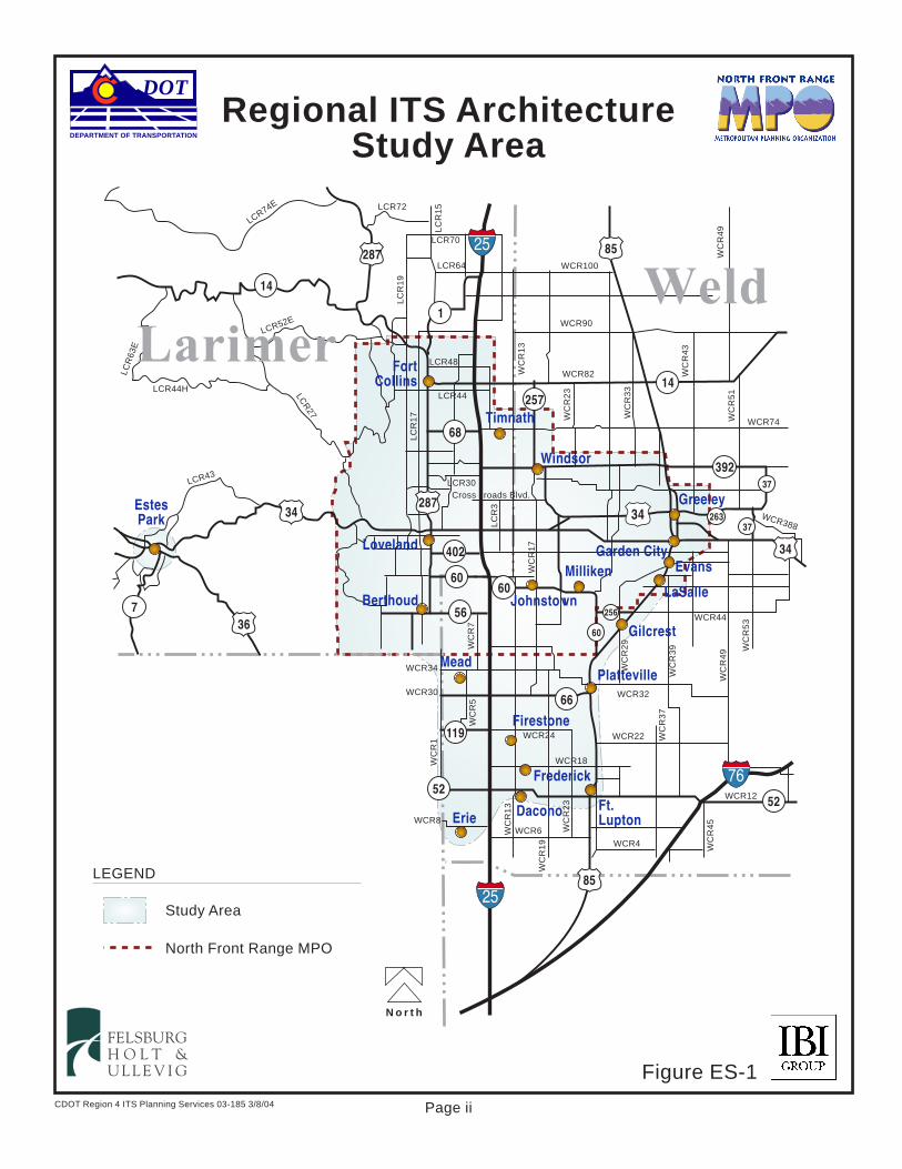
Description of the Study Area The study area, as shown on Figure ES-1, is generally bounded by US 85 and US 287 to the east and west, and the North Front Range Metropolitan Planning Organization (MPO) boundary and Weld County Road (WCR) 8 to the north and south. The bulk of the study area is made up of the North Front Range MPO, the MPO responsible for transportation planning within much of the study area. The study area is also fully contained within the boundaries of CDOT Region 4. CDOT Region 4 is responsible for the traffic operations and roadway maintenance for the freeway and the state roadways in the study area. Together, these agencies are taking the responsibility of preparing both the Regional ITS Architecture and the ITS Strategic Plan for the study area.
1 January 8, 2001, U.S. Department of Transportation, Federal Highway Administration, 23 CFR Part 940, FHWA Docket
No. FHWA-99-5899 (http://www.its.dot.gov/aconform/archrule_final_1.htm)
N o r t h
CDOT Region 4 ITS Planning Services 03-185 3/8/04
Figure ES-1
Page ii
Regional ITS ArchitectureStudy Area
FELSBURGH O L T &U L L E V I G
Study Area
North Front Range MPO
LEGEND
52
392
85287
14
34
367
287
56
119
52
66
257
1
60
25
2585
34
34
14
76
68
256
402
60
37
37263
60
FortCollins
EstesPark
Ft.Lupton
Platteville
Gilcrest
Greeley
Windsor
Erie
LaSalle
EvansMilliken
Berthoud Johnstown
Firestone
Loveland
Dacono
Frederick
Timnath
Mead
Garden City
LarimerWeld
DEPARTMENT OF TRANSPORTATION
DOT
LCR74E
LCR
63E
LCR44H LCR
27
LCR52E
LCR43
LCR72
LC
R1
5
LCR70
LC
R1
9
LCR64 WCR100
WCR90
WCR82
WC
R2
3
WC
R3
3
WC
R4
3
WC
R5
1
WCR388
WC
R5
3WCR44
WC
R4
9
WC
R3
9
WC
R2
9
WCR32
WCR34
WCR24
WCR30
WCR18
WCR8WCR6
WCR4
WCR22
WC
R1
WC
R1
3
WC
R1
9
WC
R2
3
WC
R3
7
WC
R4
5
WCR12
WC
R4
9
LC
R1
7
LCR48
LCR44
LCR30
WC
R1
7
WCR74
WC
R7
WC
R5
WC
R1
3
LC
R3
Cross roads Blvd.
Regional ITS Architecture March 30, 2004
Page iii
The study area includes the most populous portions of Larimer and Weld Counties, including portions of the Upper Front Range TPR (the growing communities to the south of the North Front Range MPO and Estes Park, and the gateway to the Rocky Mountain National Park). Within the study area are three major communities, Fort Collins, Greeley and Loveland, which have already deployed some ITS elements and are expecting to expand their deployments. In addition, both CDOT Region 4 and CDOT Transportation Management Center (CTMC) operate and maintain ITS equipment within the study area. The study area is adjacent to the Denver Regional Council of Governments Transportation Planning Region (TPR), the TPR immediately south of the study area. This MPO completed and adopted a Regional ITS Architecture and ITS Strategic Plan in March 2002. Operational Concept The purpose of the Operational Concept is to describe the roles and responsibilities of the participating transportation, transit and safety agencies and other providers, and to discuss the resources that each agency will apply or contribute in the deployment of ITS. The Operational Concept establishes the roles and responsibilities between organizations including responsibilities for implementation, operation and maintenance and the level of information, status, and control sharing among the entities. The reasons for developing an Operational Concept include: � Maintaining conformance with USDOT Regional ITS Architecture Guidelines. � Identifying the requirements of, and laying the groundwork for, the necessary institutional
agreements, such as Memorandums of Understanding (MOUs) and Inter-Governmental Agreements (IGAs).
� Identifying outstanding issues, agreements, and relationships to be developed by the ITS
Working Group. � Identifying suggestions for continued regional coordination and cooperation during
implementation of the Regional ITS Architecture. Several of the market packages selected for the study area require jurisdictional interaction and a definition of regional operational concepts. These market packages are:
� Regional Traffic Control � Broadcast and Interactive Traveler Information � Regional Transit Operations (taking a regional view of transit ITS deployments) � Incident Management � Weather Data Collection and Dissemination � Commercial Vehicle Operations

Regional ITS Architecture March 30, 2004
Page iv
� ITS Data Warehouse � Emissions Monitoring and Management � Rail Operations Coordination Each of these market packages require an operational concept that will involve multiple jurisdictional relationships. In several cases, multiple traffic and emergency management agencies will need to form relationships with each other to define specific roles and responsibilities for the implementation of the market package. Regional Traffic Control This market package allows for flow of information among traffic management systems and centers and allows a unified approach to highway network management. This market package enables the sharing of data, CCTV images and device control between traffic management centers (TMCs). The CDOT CTMC will serve as the concentration point for Regional Traffic Control, but provision will also be made for regional coordination directly between local TMCs and other key agencies. CDOT ITS Branch, CDOT Region 4, and cities and counties will coordinate the sharing of data and/or control of field equipment to better respond to traffic congestion. Broadcast and Interactive Traveler Information The CDOT CTMC is primarily responsible for the statewide transportation management and traveler information system. The information being collected includes roadway, traffic and construction conditions, traffic advisories, incident and weather information. The information is being disseminated through the CoTrip website, broadcast fax, media providers and other partners, and on the roadway via Dynamic Message Signs (DMS), Highway Advisory Radio (HAR) and cell phones/PDA’s. CDOT is also deploying a statewide program to make traveler information available by dialing 511 (the number assigned nationally for traveler information). Within the study area, there is an interest to also deploy regional web sites, public television broadcasts and transit traveler information systems.
Colorado Transportation Management Center

Regional ITS Architecture March 30, 2004
Page v
The CDOT ITS Branch will take the role of primary Information Service Provider (ISP) in the study area, with an information-sharing link to local or regional public and private ISPs. An information sharing relationship has been identified between CTMC and all other agencies with respect to Broadcast and Interactive Traveler Information. These agencies include traffic management, transit management, emergency management (including law enforcement) and the media. Information such as roadway network conditions and traffic conditions, transit system performance, transit automatic vehicle location (AVL) data, incident information, travel time information, roadway statistics, etc. will be collected by the CTMC from various agencies. The CTMC will condense the information and disseminate the information in near real time to other agencies and local/regional ISPs. Regional Transit Operations The three transit agencies in the region, Transfort, The Bus, and COLT, are all considering or beginning to deploy ITS technologies on their fleets, including Automatic Vehicle Location, Computer Aided Dispatch, Regional Fare Payment System and Online Trip Planning. Therefore, the Operational Concept takes the perspective of a Regional Transit Management subsystem that exchanges information with other transit agencies, an electronic fare collection system, and also provides traveler information via personal and remote devices (such as electronic “Next Bus” bus signs). The transit agencies will also share information with CDOT and local traffic management, as well as with emergency management agencies. Incident Management Within the study area, an incident management plan has been developed for I-25, as well as plans for several smaller areas. This ITS Architecture supports the expansion of incident
management planning to also include a technology component that provides for the near real-time sharing of incident information and transportation system condition information between traffic management agencies and emergency management agencies to enable quicker detection and verification of incidents and implementation of a coordinated and efficient response for both predicted and unexpected incidents. The entities involved in sharing information will include traffic, transit, law enforcement and emergency management centers, weather service entities and event promoters to detect and verify incidents and implement response. Dynamic Message Sign on I-25
Regional ITS Architecture March 30, 2004
Page vi
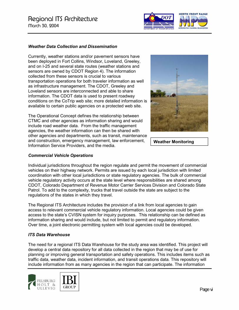
Weather Data Collection and Dissemination Currently, weather stations and/or pavement sensors have been deployed in Fort Collins, Windsor, Loveland, Greeley, and on I-25 and several state routes (weather stations and sensors are owned by CDOT Region 4). The information collected from these sensors is crucial to various transportation operations for both traveler information as well as infrastructure management. The CDOT, Greeley and Loveland sensors are interconnected and able to share information. The CDOT data is used to present roadway conditions on the CoTrip web site; more detailed information is available to certain public agencies on a protected web site. The Operational Concept defines the relationship between CTMC and other agencies as information sharing and would include road weather data. From the traffic management agencies, the weather information can then be shared with other agencies and departments, such as transit, maintenance and construction, emergency management, law enforcement, Information Service Providers, and the media. Commercial Vehicle Operations Individual jurisdictions throughout the region regulate and permit the movement of commercial vehicles on their highway network. Permits are issued by each local jurisdiction with limited coordination with other local jurisdictions or state regulatory agencies. The bulk of commercial vehicle regulatory activity occurs at the state level where responsibilities are shared among CDOT, Colorado Department of Revenue Motor Carrier Services Division and Colorado State Patrol. To add to the complexity, trucks that travel outside the state are subject to the regulations of the states in which they travel. The Regional ITS Architecture includes the provision of a link from local agencies to gain access to relevant commercial vehicle regulatory information. Local agencies could be given access to the state’s CVISN system for inquiry purposes. This relationship can be defined as information sharing and would include, but not limited to permit and regulatory information. Over time, a joint electronic permitting system with local agencies could be developed. ITS Data Warehouse The need for a regional ITS Data Warehouse for the study area was identified. This project will develop a central data repository for all data collected in the region that may be of use for planning or improving general transportation and safety operations. This includes items such as traffic data, weather data, incident information, and transit operations data. This repository will include information from as many agencies in the region that can participate. The information
Weather Monitoring
Regional ITS Architecture March 30, 2004
Page vii
will be available to all agencies and regional transportation organizations. It is anticipated that the repository may be maintained by the North Front Range MPO and would likely provide a web-based interface to allow access to the data. The impact of the ITS Data Warehouse on the Operational Concept is that it allows an unlimited number of agencies access to data (depending on rules of use and access) collected by other agencies, that may be used to improve operating efficiency and decision-making. Emissions Monitoring and Management The cities of Greeley and Fort Collins are currently in "maintenance" status for CO emissions, and Weld and Larimer County’s are being considered for designation as non-attainment areas.2 As a result, the North Front Range MPO is considering a potential deployment of distributed sensors as part of a program to monitor individual vehicle emissions and contribute to the general air quality monitoring in the area. Colorado Department of Public Health and Environment’s (CDPHE) Air Pollution Control Division (APCD) is responsible for the existing air quality monitoring stations within the region. Establishing a link in the regional architecture between traffic management centers and APCD will provide additional mechanisms for dissemination of air quality advisories in the region. This relationship can be defined as information sharing and would include air quality data. The traveling public could also use the information to voluntarily reduce driving and/or use transit or carpool for travel within the region. Rail Operations Coordination Railroad coordination supports alleviating arterial congestion by improving safety and operation at highway/rail intersections. Several major roadways in the study area cross rail lines at-grade, or run parallel to the rail lines such that side streets cross at-grade. When a train is in the crossing, traffic and emergency vehicles are delayed. The Rail Operations Coordination market package provides a level of strategic coordination between rail operations and traffic management centers. Rail operation centers provide train schedules, maintenance schedules, and any other forecast events that will result in highway-rail intersection (HRI) closures. This information is used to develop forecast HRI closure times and durations, which may be used in advanced traffic control strategies, and/or to enhance the quality of traveler information.
2 The official decision will be made on April 15, 2004.
Regional ITS Architecture March 30, 2004
Page viii
Next Steps In order to maintain the regional ITS Architecture for the study area, the North Front Range MPO will form an ITS Committee as a regional forum for discussion of regional ITS issues and deployment progress. The ITS Committee will meet at least every six months to discuss current and anticipated ITS issues.
Some initial agenda items for the ITS Committee could include:
� Definition of a separate funding pool and project category for ITS projects within the RTP.
� Definition of an interim amendment process in order to maintain the plan outside of the regular schedule.
� Development of agreements to coordinate regional ITS planning between the neighboring TPRs (North Front Range, Upper Front Range and DRCOG) and CDOT.
Regional ITS Architecture March 30, 2004
Page 1
I. INTRODUCTION AND OVERVIEW A. Overview On April 8, 2001, the Federal Highway Administration (FHWA) established a Final Rule and the Federal Transit Administration (FTA) established a policy on the use of the National ITS Architecture. The purpose of this rule/policy is to foster integration between existing regional ITS deployments and to ensure that subsequent deployments will be integrated into the existing systems. The rule/policy establishes that jurisdictions intending to deploy ITS projects and that wish to seek funding from the Highway Trust Fund and the Mass Transit Account must conform to the National ITS Architecture and appropriate standards. Within the Colorado Department of Transportation’s (CDOT) Region 4, federal funding has been used to deploy ITS projects both along I-25 and within the City of Fort Collins. Therefore, CDOT Region 4, together with the North Front Range Transportation & Air Quality Planning Council (NFRT & AQPC), have prepared this Regional ITS Architecture as well as a companion ITS Strategic Plan for the study area, to guide the deployment of ITS applications over the next ten years. B. Project Approach The development of the ITS Architecture for the study area followed the process described below: � Assemble ITS Working Group – An ITS working group was established as the body that
provided feedback and oversaw development of the Regional ITS Architecture. Members of the working group are the management and technical staff from numerous agencies that expressed interest in ITS implementation.
� Document Transportation Issues and ITS Inventory – Through a review of current
planning documents and extensive interviews with members of the ITS Working Group and the study area stakeholders, the current transportation issues that can be addressed by ITS were documented and summarized. In addition, the existing and immediately pending ITS implementations were documented.
� Select Market Packages – In consultation with the ITS Working Group, a review of the
National ITS Architecture market packages was undertaken, and a list of market packages applicable to the study area was developed as a starting point for addressing the identified transportation issues.
� Develop Operational Concept – An operational concept was developed to relate the roles
of the transportation and safety agencies in the study area with regard to their roles and responsibilities with the planned ITS deployments.
Regional ITS Architecture March 30, 2004
Page 2
� Inter-Agency Agreements – This involves the identification of the agreements necessary to support the operational concepts. As an example, inter-agency agreements will be required to define the roles and responsibilities of the participating agencies in order to share the use and operation of the infrastructure deployed in ITS projects.
� Functional Requirements and Interface Requirements – ITS Architecture diagrams were
developed to represent the functions and interfaces expressed in the operational concepts. � ITS Standards – The ITS standards applicable to the defined interfaces and market
packages were identified.
� Definition of Project Implementation Sequence – The final step in the development of the ITS Architecture for the study area was a definition of the key relationships for project implementation.
C. Organization of the Report Following this introduction, this report is divided into nine sections as follows:
� Section II –National ITS Architecture Introduction: This section provides information on the context of ITS Architecture development and a background overview of the primary elements in the National ITS Architecture.
� Section III – Background Information: This section provides a description of the study area; an identification of the stakeholders; a summary of other planning efforts; a summary of transportation issues; and a summary of existing and immediately pending ITS implementations within the study area.
� Section IV – Market Package Selection: This section provides a summary of the market packages identified as applicable to the study area.
� Section V – Operational Concept: The operational concept presents the relationships between transportation, transit, safety agencies and other providers in the study area.
� Section VI – Agreements Between Organizations: Existing and proposed interagency cooperative agreements, plus considerations for developing these agreements.
� Section VII - System Functional Requirements, Interface Requirements, and Information Exchanges: Introduction to the approach of developing physical ITS architecture diagrams for the study area.
� Section VIII - Identification of ITS Standards: Introduction to the standards development effort and identification of standards based on the selected market packages.
� Section IX - Sequence of Projects Required for Implementation: Identifies any projects that must have precedence over others in order to implement the overall ITS vision for the study area.
Regional ITS Architecture March 30, 2004
Page 3
II. NATIONAL ITS ARCHITECTURE INTRODUCTION A. Introduction This section provides background information on the National ITS Architecture and the final FHWA rulemaking regarding the development of regional ITS Architectures. The National ITS Architecture provides a common framework for planning, defining, and integrating intelligent transportation systems. It is a mature product that reflects the contributions of a broad cross-section of the ITS community (transportation practitioners, systems engineers, system developers, technology specialists, etc.). The architecture defines:
� The functions (e.g., gather traffic information or request a route) that are required for ITS.
� The physical entities or subsystems where these functions reside (e.g., the roadside or the vehicle).
� The information flows that connect these functions and physical subsystems together into an integrated system.3
Although the architecture is not technology-specific, it is function-specific. The architecture is employed to structure the planning and design process along with the general functions of ITS systems. The architecture further defines these functions into two categories: physical and logical. B. Physical Architecture The physical architecture provides a framework for the physical elements of ITS systems. These elements include cars, people, computers, buses, trucks, etc. Figure 1, National Architecture “Sausage” Diagram, provides an illustration of the physical architecture. The physical elements are broken into large groups called subsystem categories. These are functional categories that describe what their member physical entities (subsystems) do. The four major subsystem categories are: 1. Traveler Subsystems: Systems or applications that provide information to travelers
(e.g., traffic conditions). 2. Center Subsystems: Systems or applications that process and use information to
control the transportation network (e.g., signal timing). 3. Vehicle Subsystems: Systems or applications that provide driver information and
safety on vehicle platforms (e.g., in-vehicle signing).
3 US DOT, National ITS Architecture, Version 5.0

Regional ITS Architecture March 30, 2004
Page 4
4. Field Subsystems: Systems or applications deployed in the field that collect transportation data and are ideally controlled from a center (e.g., traffic signals).
Figure 1. National Architecture “Sausage” Diagram
The bubbles (or “sausages”) between the subsystem categories represent the communications medium. For example, the Roadway subsystem (within the “Field” subsystem category) could potentially be communicating with the Vehicle, the Transit Vehicle, the Commercial Vehicle, the Maintenance Vehicle, and the Emergency Vehicle subsystems (within the “Vehicle” subsystem category) via short-range wireless links. Terminators Terminators are generally defined as people, systems and general environment that are outside the boundary of ITS but still impact ITS systems. Interfaces between subsystems and terminators need to be defined, but there are no ITS-related functional requirements associated with terminators. Since regional architectures are usually developed from a specific agency(s) perspective, a subsystem that is out of the control of the entity’s perspective is called a terminator. This is done to illustrate ownership or control of the proposed services.

Regional ITS Architecture March 30, 2004
Page 5
Architecture Flows An architecture flow is simply the information that is exchanged between subsystems and terminators in the Physical Architecture. These architecture flows and their communication requirements define the interfaces which form the basis for much of the ongoing standards work in the National ITS Architecture program. The current US DOT guidelines require that the regional ITS Architecture be developed at a sufficient level of detail to show subsystems and architecture flows. Market Packages While the physical architecture components, such as subsystems and architecture flows, provide a good tool for organizing the ITS design process, they are difficult to discuss with anyone who is not familiar with the National ITS Architecture. The Market Packages provide an accessible, deployment-oriented perspective to the National Architecture. They are tailored to fit – separately or in combination – real world transportation problems and needs. The Market Packages also help in the design process by categorizing improvements and can serve as another check to make sure areas are not over or under covered. Market Packages utilize one or more Equipment Packages that must work together to deliver a given transportation service and the architecture flows that connect them and other important external systems. In other words, they identify the pieces of the Physical Architecture that are required to implement a particular transportation service. Equipment Packages group like processes of a particular subsystem together into an “implementable” package. For example, the Market Package “Regional Traffic Control” is made up of the subsystems “Traffic Management” and “Roadway”, as well as the terminator “Other Traffic Management” and “Traffic Operations Personnel” (see Figure 2). The service to be provided is regional traffic control. In order to do this, the entity must have control or access to physical equipment and processes under the traffic management and roadway subsystems. The specific equipment package needed is “TMC Regional Traffic Control.” This equipment package provides capabilities for analyzing, controlling, and optimizing area-wide traffic flow. These capabilities provide for integrating control of a network signal system with control of the freeway, considering current demand as well as expected demand. The goal is to provide the capability for real-time traffic adaptive control while balancing inter-jurisdictional control issues to achieve regional solutions. The terminator “Other Traffic Management” shows that the information collected must be accessible by other traffic management centers. The architecture flow indicates that “traffic information coordination” and “traffic control coordination” will be exchanged between the “Traffic Management” subsystem and “Other Traffic Management” terminator. The “Traffic Operations Personnel” and the corresponding architecture flow illustrate their role in the system.
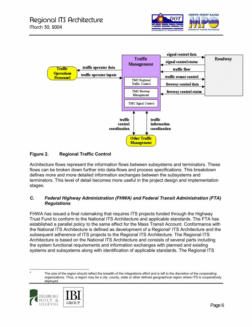
Regional ITS Architecture March 30, 2004
Page 6
Figure 2. Regional Traffic Control Architecture flows represent the information flows between subsystems and terminators. These flows can be broken down further into data-flows and process specifications. This breakdown defines more and more detailed information exchanges between the subsystems and terminators. This level of detail becomes more useful in the project design and implementation stages.
C. Federal Highway Administration (FHWA) and Federal Transit Administration (FTA) Regulations
FHWA has issued a final rulemaking that requires ITS projects funded through the Highway Trust Fund to conform to the National ITS Architecture and applicable standards. The FTA has established a parallel policy to the same effect for the Mass Transit Account. Conformance with the National ITS Architecture is defined as development of a Regional4 ITS Architecture and the subsequent adherence of ITS projects to the Regional ITS Architecture. The Regional ITS Architecture is based on the National ITS Architecture and consists of several parts including the system functional requirements and information exchanges with planned and existing systems and subsystems along with identification of applicable standards. The Regional ITS
4 The size of the region should reflect the breadth of the integrations effort and is left to the discretion of the cooperating
organizations. Thus, a region may be a city, county, state or other defined geographical region where ITS is cooperatively deployed.

Regional ITS Architecture March 30, 2004
Page 7
Architecture would be tailored to address the local situation and ITS investment needs.5 The rule/policy became effective on April 8, 2001. The purpose of the regional ITS Architecture is to serve as a guide for the development of ITS projects and programs and be consistent with ITS strategies and projects contained in applicable transportation plans. Having developed a regional ITS Architecture means that a regional framework for ensuring institutional agreement and technical integration for the implementation of ITS projects or groups of projects is in place. The regional ITS Architecture must include the following elements:6
� Description of the Region or Project � Identification of Stakeholders � Operational Concept � Agreements � System Functional Requirements � Interface Requirements and Information Exchanges � Identification of ITS Standards � Sequence of Projects Required for Implementation
Each of these areas is covered in subsequent sections of this report.
5 January 8, 2001, U.S. Department of Transportation, Federal Highway Administration, 23 CFR Part 940, FHWA Docket
No. FHWA-99-5899 (http://www.its.dot.gov/aconform/archrule_final_1.htm) 6 IBID

Regional ITS Architecture March 30, 2004
Page 8
III. BACKGROUND INFORMATION A. Description of the Study Area The study area, as shown on Figure 3, is generally bounded by US 85 and US 287 to the east and west, and the North Front Range MPO boundary and Weld County Road (WCR) 8 to the north and south. The bulk of the study area is made up of the North Front Range MPO, the MPO responsible for transportation planning within much of the study area. The study area is also fully contained within the boundaries of CDOT Region 4. CDOT Region 4 is responsible for the traffic operations and roadway maintenance for the freeway and the state roadways in the study area. Together, these agencies are taking the responsibility of preparing both the Regional ITS Architecture and the ITS Strategic Plan for the study area. The study area includes the most populous portions of Larimer and Weld Counties, including portions of the Upper Front Range TPR (the growing communities to the south of the North Front Range MPO and Estes Park, and the gateway to the Rocky Mountain National Park). Within the study area are three major communities, Fort Collins, Greeley and Loveland, which have already deployed some ITS elements and are expecting to expand their deployments. In addition, both CDOT Region 4 and CDOT Transportation Management Center (CTMC) operate and maintain ITS equipment within the study area. The study area is adjacent to the Denver Regional Council of Governments Transportation Planning Region (TPR), the TPR immediately to the south of the study area. This MPO completed and adopted a Regional ITS Architecture and ITS Strategic Plan in March 2002.

N o r t h
CDOT Region 4 ITS Planning Services 03-185 3/8/04
Figure 3
Page 9
Regional ITS ArchitectureStudy Area
FELSBURGH O L T &U L L E V I G
Study Area
North Front Range MPO
LEGEND
52
392
85287
14
34
367
287
56
119
52
66
257
1
60
25
2585
34
34
14
76
68
256
402
60
37
37263
60
FortCollins
EstesPark
Ft.Lupton
Platteville
Gilcrest
Greeley
Windsor
Erie
LaSalle
EvansMilliken
Berthoud Johnstown
Firestone
Loveland
Dacono
Frederick
Timnath
Mead
Garden City
LarimerWeld
DEPARTMENT OF TRANSPORTATION
DOT
LCR74E
LCR
63E
LCR44H LCR
27
LCR52E
LCR43
LCR72
LC
R1
5
LCR70
LC
R1
9
LCR64 WCR100
WCR90
WCR82
WC
R2
3
WC
R3
3
WC
R4
3
WC
R5
1
WCR388
WC
R5
3WCR44
WC
R4
9
WC
R3
9
WC
R2
9
WCR32
WCR34
WCR24
WCR30
WCR18
WCR8WCR6
WCR4
WCR22
WC
R1
WC
R1
3
WC
R1
9
WC
R2
3
WC
R3
7
WC
R4
5
WCR12
WC
R4
9
LC
R1
7
LCR48
LCR44
LCR30
WC
R1
7
WCR74
WC
R7
WC
R5
WC
R1
3
LC
R3
Cross roads Blvd.
Regional ITS Architecture March 30, 2004
Page 10
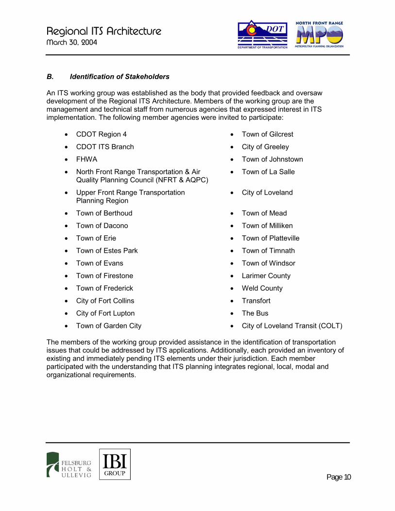
B. Identification of Stakeholders An ITS working group was established as the body that provided feedback and oversaw development of the Regional ITS Architecture. Members of the working group are the management and technical staff from numerous agencies that expressed interest in ITS implementation. The following member agencies were invited to participate:
� CDOT Region 4 � Town of Gilcrest
� CDOT ITS Branch � City of Greeley
� FHWA � Town of Johnstown
� North Front Range Transportation & Air Quality Planning Council (NFRT & AQPC)
� Town of La Salle
� Upper Front Range Transportation Planning Region
� City of Loveland
� Town of Berthoud � Town of Mead
� Town of Dacono � Town of Milliken
� Town of Erie � Town of Platteville
� Town of Estes Park � Town of Timnath
� Town of Evans � Town of Windsor
� Town of Firestone � Larimer County
� Town of Frederick � Weld County
� City of Fort Collins � Transfort
� City of Fort Lupton � The Bus
� Town of Garden City � City of Loveland Transit (COLT) The members of the working group provided assistance in the identification of transportation issues that could be addressed by ITS applications. Additionally, each provided an inventory of existing and immediately pending ITS elements under their jurisdiction. Each member participated with the understanding that ITS planning integrates regional, local, modal and organizational requirements.
Regional ITS Architecture March 30, 2004
Page 11
C. Other Planning Efforts A number of other related planning studies that cover the study area were reviewed to assist in the summary of both transportation issues and ITS inventory. The following is a brief summary of the nine documents reviewed for this study. The 2020 Statewide Transportation Plan, Investing In Colorado’s Future – This document presents broad transportation planning issues and concepts for the entire state. The 2030 Transportation Plan is currently in development. This document lists the following as major statewide issues that have transportation impacts: � Traffic Congestion – population growth is increasing congestion statewide; � Transportation Safety – the transportation infrastructure must promote safe travel; � Transportation System Management and Operation – an efficient use of the existing
infrastructure is required; � Personal Mobility – Colorado’s citizens must have personal mobility; � Goods Movement – efficient and effective goods movement will promote economic well
being; and � Funding – transportation funding is scarce. The document recognizes that “ITS helps maximize the potential of existing transportation infrastructure”, which directly responds to several of the issues above. In 1998, the state developed an ITS Strategic Plan and ITS Business Plan that define a $67 million plan to fund the annual operation of the Colorado Traffic Operations Center, ITS device maintenance (including the telecommunications network) and CDOT Region ITS activities. The document recognizes the need to complete ITS corridor studies in order to plan and expand ITS technology deployment statewide. Intelligent Transportation Systems Strategic Plan, CDOT 2002 – CDOT ITS Branch prepared a statewide strategic plan to provide guidance and direction for current and future ITS investment and implementation across the state. This document also identifies as a key element the need to institutionalize the ITS Core Services into CDOT’s current business areas and functions. The primary goal of the CDOT ITS Branch is to provide an overall traveler information and traffic management system that effectively utilizes the existing system and seamlessly grows to incorporate future system elements, and one in which information is managed as an asset of value to transportation system users and transportation providers of all types.

Regional ITS Architecture March 30, 2004
Page 12
The elements of the vision adopted to achieve this goal include: � Improve mobility through maximization of productivity of existing transportation system. � Improve mobility through travel choice and travel efficiency. � Increase traveler safety. � Increase intermodal connectivity and inter-jurisdictional coordination. In order to provide an integrated statewide traveler information traffic management system, the strategic investment described in the plan focuses on two areas: 1) preventative maintenance and replacement of the existing infrastructure, and 2) statewide expansion of the enabling infrastructure. The expansion of the enabling infrastructure includes: � Completion and update of 4 traffic management centers (~$28.4 million)7. � Completion of a statewide fiber optic network (~$58.5 million). � Implementations expanding the number of traveler information system related field devices
(~$77.5 million). The deployment timeframe is tied to the availability of funding. The highest priority elements are the traffic management centers and the deployment of the long haul high speed communication system elements. North Front Range 2025 Regional Transportation Plan (RTP) – This document establishes strategies and a plan for the deployment of transportation improvements in the North Front Range TPR, which respond to significant projected growth. By 2025, it is projected that households in the region will grow from 129,000 to 269,000 and that employment will increase from 144,000 to 327,000 jobs. This corresponding growth relates to a no-build projection of an average increase of 129% in vehicle-miles traveled over the region. The RTP is currently being updated. The document identifies two key strategies to guide the development of transportation improvements: � Employ Transportation Demand Management to effect a modal shift from single occupant
vehicles (SOV) to other modes in the region. � Focus regional planning and multi-modal mobility along the Regionally Significant Corridors
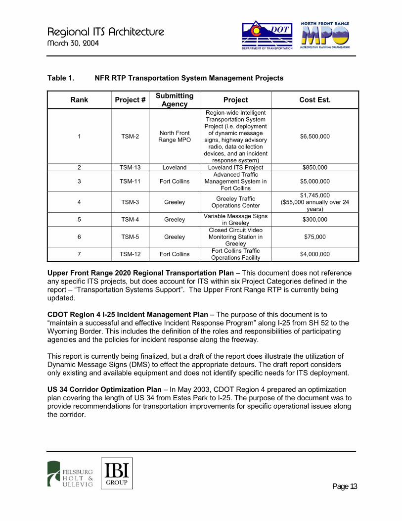
in the region. Of the seven project categories defined in the North Front Range RTP, “Transportation Systems Management” has been identified almost exclusively for the definition of the ITS projects within the region. The financial plan programs several ITS projects as shown in Table 1.
7 The Transportation Commission is currently programming $21 million for traffic management centers.
Regional ITS Architecture March 30, 2004
Page 13
Table 1. NFR RTP Transportation System Management Projects
Rank Project # Submitting Agency Project Cost Est.
1 TSM-2 North Front Range MPO
Region-wide Intelligent Transportation System Project (i.e. deployment
of dynamic message signs, highway advisory
radio, data collection devices, and an incident
response system)
$6,500,000
2 TSM-13 Loveland Loveland ITS Project $850,000
3 TSM-11 Fort Collins Advanced Traffic
Management System in Fort Collins
$5,000,000
4 TSM-3 Greeley Greeley Traffic Operations Center
$1,745,000 ($55,000 annually over 24
years)
5 TSM-4 Greeley Variable Message Signs in Greeley $300,000
6 TSM-5 Greeley Closed Circuit Video Monitoring Station in
Greeley $75,000
7 TSM-12 Fort Collins Fort Collins Traffic Operations Facility $4,000,000
Upper Front Range 2020 Regional Transportation Plan – This document does not reference any specific ITS projects, but does account for ITS within six Project Categories defined in the report – “Transportation Systems Support”. The Upper Front Range RTP is currently being updated. CDOT Region 4 I-25 Incident Management Plan – The purpose of this document is to “maintain a successful and effective Incident Response Program” along I-25 from SH 52 to the Wyoming Border. This includes the definition of the roles and responsibilities of participating agencies and the policies for incident response along the freeway. This report is currently being finalized, but a draft of the report does illustrate the utilization of Dynamic Message Signs (DMS) to effect the appropriate detours. The draft report considers only existing and available equipment and does not identify specific needs for ITS deployment. US 34 Corridor Optimization Plan – In May 2003, CDOT Region 4 prepared an optimization plan covering the length of US 34 from Estes Park to I-25. The purpose of the document was to provide recommendations for transportation improvements for specific operational issues along the corridor.
Regional ITS Architecture March 30, 2004
Page 14
It was recognized that certain ITS elements would be beneficial to this corridor; however, specific ITS planning was not considered in anticipation of the development of a regional ITS Strategic Plan. Estes Valley Transportation Alternatives Study – In April 2003, CDOT Region 4 prepared this study to address transportation problems within Estes Park and surrounding area. To address traffic and parking issues due to seasonal and tourist traffic passing through Estes Park to and from Rocky Mountain National Park (RMNP), several ITS deployments were recommended. Specifically, it was recommended that a parking management system be developed that includes DMS, Highway Advisory Radio (HAR), and electronic information kiosks in order to provide information on parking availability; real-time bus arrival and departure times; and local weather and traffic conditions. Northern Colorado Truck Mobility/SH 14 Relocation Study – In December 2001, the City of Fort Collins prepared this study to determine the feasibility of relocating the truck route outside the city. One of the findings of the report is that there is a perception that SH 14, the current truck route, is negatively impacted by weather and other incidents on US 287, I-25 and/or I-80. One of the recommendations of the report is to conduct an incident management study focused northward from Fort Collins to better understand the impacts of these conditions on SH 14. Greeley Comprehensive Transportation Plan – In June 2002, the City of Greeley prepared a Transportation Plan that identified several ITS deployments within the City of Greeley. The following are the recommended ITS goals: � Implement video detection at signalized intersections; � Install closed circuit television cameras at key intersections and major activity centers and
congested arterials; � Install fiber optic cable in roadway right-of-way; � Develop traveler information systems; � Establish a Traffic Operations Center that would be the control center for these elements; � Develop means of coordination with other modes via ITS; and � Develop a regional ITS plan that includes:
- Access to data from Fort Collins, Loveland, Denver, and CDOT Region 4, and - Connections to CDOT Variable Message Signs in the Greeley area.
Regional ITS Architecture March 30, 2004
Page 15
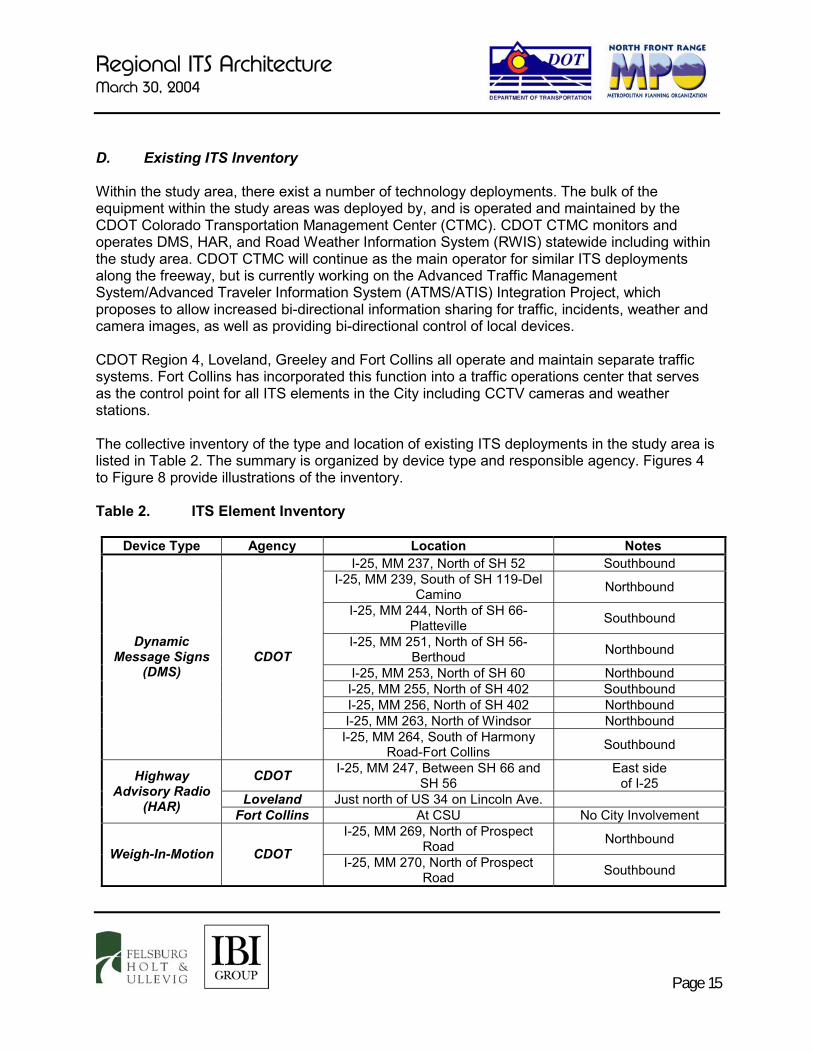
D. Existing ITS Inventory Within the study area, there exist a number of technology deployments. The bulk of the equipment within the study areas was deployed by, and is operated and maintained by the CDOT Colorado Transportation Management Center (CTMC). CDOT CTMC monitors and operates DMS, HAR, and Road Weather Information System (RWIS) statewide including within the study area. CDOT CTMC will continue as the main operator for similar ITS deployments along the freeway, but is currently working on the Advanced Traffic Management System/Advanced Traveler Information System (ATMS/ATIS) Integration Project, which proposes to allow increased bi-directional information sharing for traffic, incidents, weather and camera images, as well as providing bi-directional control of local devices. CDOT Region 4, Loveland, Greeley and Fort Collins all operate and maintain separate traffic systems. Fort Collins has incorporated this function into a traffic operations center that serves as the control point for all ITS elements in the City including CCTV cameras and weather stations. The collective inventory of the type and location of existing ITS deployments in the study area is listed in Table 2. The summary is organized by device type and responsible agency. Figures 4 to Figure 8 provide illustrations of the inventory. Table 2. ITS Element Inventory
Device Type Agency Location Notes I-25, MM 237, North of SH 52 Southbound
I-25, MM 239, South of SH 119-Del Camino Northbound
I-25, MM 244, North of SH 66-Platteville Southbound
I-25, MM 251, North of SH 56-Berthoud Northbound
I-25, MM 253, North of SH 60 Northbound I-25, MM 255, North of SH 402 Southbound I-25, MM 256, North of SH 402 Northbound I-25, MM 263, North of Windsor Northbound
Dynamic Message Signs
(DMS) CDOT
I-25, MM 264, South of Harmony Road-Fort Collins Southbound
CDOT I-25, MM 247, Between SH 66 and SH 56
East side of I-25
Loveland Just north of US 34 on Lincoln Ave.
Highway Advisory Radio
(HAR) Fort Collins At CSU No City Involvement I-25, MM 269, North of Prospect
Road Northbound Weigh-In-Motion CDOT I-25, MM 270, North of Prospect
Road Southbound

Regional ITS Architecture March 30, 2004
Page 16
Device Type Agency Location Notes I-25, MM 241, North of SH 119-Del
Camino West side
of I-25
I-25 MM 251, North of SH 56 West side of I-25
CDOT
I-25, MM 259, North of Crossroads Blvd.
East side of I-25
10th Street at 35th Avenue
Includes Pavement Sensor Greeley 3rd Street at
12th Avenue Snow Emergency Center
Taft Avenue/1st Street Intersection Includes Pavement Sensor Loveland
US 34/Redwood Ave. Intersection Pavement Sensor Elizabeth Street at Taft Hill Road Shields Street at Harmony Road
Prospect Road at Timberline Road Timberline Road at Carpenter Road
(LCR 32)
College Avenue at the Poudre River Mountain Vista Drive at Busch Drive
Fort Collins Timberline Road at Poudre River Includes Automatic
De-Icing Equipment
Off Parkwood Drive Rainfall Gauge #1-COMM to Fort Collins via Radio
Weather Station
Windsor At Windsor Reservoir Rainfall Gauge #2- COMM
to Fort Collins via Radio Stream
Monitoring Station
Greeley US 85 at 8th Street Poudre River
Weld County 1950 “O” Street in Greeley
Loveland Police/Fire – 810 E. 10th Street
Emergency Operations – 410 E. 5th Street
Estes Park 170 McGregor Avenue
Emergency Dispatch
Larimer County
2501 Midpoint Drive Fort Collins
Sheriff Department Communication Center
I-25, South of US 34 I-25, North of Fort Collins
US 34, 1 Mile East of SH 257 SH 257, North of US 34 Business
SH 14, West of I-25 US 34, East of Estes Park
CDOT
US 36, East of Estes Park Lemay Avenue at Stuart Street College Avenue at Laurel Street
College Avenue at Horsetooth Road
Automatic Traffic Recorder
College Avenue at Columbia Road

Regional ITS Architecture March 30, 2004
Page 17
Device Type Agency Location Notes Horsetooth Road at Meadowlark
Avenue
Drake Road at Constitution Avenue Shields Street at Rolland Moore
Park
Fort Collins
Drake Road at Research Boulevard CDOT 1420 2nd Street, Greeley
Fort Collins 626 Linden Street Greeley 1300 “A” Street, Building E
Traffic Operations
Center Loveland 105 W. 5th Street Fort Collins 6570 Portner Road
Greeley 1200 “A” Street Transit
Operations Center Loveland 318 N. Garfield
Fort Collins Trapeze Software Greeley ParaMatch Software
Transit Scheduling
Software Loveland Trapeze Software Paratransit Transfort Fleet Device
AVL Loveland Fleet Device Transfort Fleet Device Transit Security Loveland Fleet Device
Fort Collins City-Wide Connection of Numerous Traffic Signals
Greeley City-Wide Circular Ring Around City
Loveland City-Wide Mostly Owned by Platte River Power Authority
Fiber-Optic Network
Windsor City-Wide Connects Town Hall, Library, Public Works Shop and Six Schools
10th Street at 35th Avenue Greeley US 34 Bypass at 23rd Avenue Loveland Taft Avenue/1st Street Intersection
College Avenue at Prospect Road College Avenue at Drake Road
College Avenue at Foothills Parkway
College Avenue at Horsetooth Road College Avenue at Harmony Road Harmony Road at Lemay Avenue
Harmony Road at Timberline Road
Video Surveillance
Fort Collins
Harmony Road at Ziegler Road

CDOT Region 4 ITS Planning Services 03-185 3/30/04
N o r t h
DEPARTMENT OF TRANSPORTATION
DOT CDOT ITS BranchITS Inventory - January 2004
FELSBURGH O L T &U L L E V I G Figure 4
Page 18
392
85
287
34
287
56
119
52
66
257
1
60
25
25 85
34
14
76
68
256
402
60
263
60
FortCollins
Ft.Lupton
Platteville
Gilcrest
Greeley
Windsor
Erie
LaSalle
EvansMilliken
Berthoud Johnstown
Firestone
Loveland
Dacono
Frederick
Timnath
Mead
Garden City
Larimer
WeldWCR82
WC
R2
3
WC
R3
3
WC
R4
3
WC
R5
1
WCR44
WC
R4
9
WC
R3
9
WC
R2
9
WCR32
WCR34
WCR24
WCR30
WCR18
WCR8WCR6
WCR4
WCR22
WC
R1
WC
R1
3
WC
R1
9
WC
R2
3
WC
R3
7
WC
R4
5
WCR12
WC
R4
9
LC
R1
7
LCR48
LCR44
LCR30
WC
R1
7
WCR74
WC
R7
WC
R5
WC
R1
3
LC
R3
Cross roads Blvd.
LC
R1
9
N o r t h
392
85
287
34
287
56
119
52
66
257
1
60
25
25 85
34
14
76
68
256
402
60
263
60
FortCollins
Ft.Lupton
Platteville
Gilcrest
Greeley
Windsor
Erie
LaSalle
EvansMilliken
Berthoud Johnstown
Firestone
Loveland
Dacono
Frederick
Timnath
Mead
Garden City
Larimer
WeldWCR82
WC
R2
3
WC
R3
3
WC
R4
3
WC
R5
1
WCR44
WC
R4
9
WC
R3
9
WC
R2
9
WCR32
WCR34
WCR24
WCR30
WCR18
WCR8WCR6
WCR4
WCR22
WC
R1
WC
R1
3
WC
R1
9
WC
R2
3
WC
R3
7
WC
R4
5
WCR12
WC
R4
9
LC
R1
7
LCR48
LCR44
LCR30
WC
R1
7
WCR74
WC
R7
WC
R5
WC
R1
3
LC
R3
Cross roads Blvd.
LC
R1
97
34EstesPark
LCR43
Larimer
N o r t h
392
85
287
34
287
56
119
52
66
257
1
60
25
25 85
34
14
76
68
256
402
60
263
60
FortCollins
Ft.Lupton
Platteville
Gilcrest
Greeley
Windsor
Erie
LaSalle
EvansMilliken
Berthoud Johnstown
Firestone
Loveland
Dacono
Frederick
Timnath
Mead
Garden City
Larimer
WeldWCR82
WC
R2
3
WC
R3
3
WC
R4
3
WC
R5
1
WCR44
WC
R4
9
WC
R3
9
WC
R2
9
WCR32
WCR34
WCR24
WCR30
WCR18
WCR8WCR6
WCR4
WCR22
WC
R1
WC
R1
3
WC
R1
9
WC
R2
3
WC
R3
7
WC
R4
5
WCR12
WC
R4
9
LC
R1
7
LCR48
LCR44
LCR30
WC
R1
7
WCR74
WC
R7
WC
R5
WC
R1
3
LC
R3
Cross roads Blvd.
LC
R1
97
34EstesPark
LCR43
NOTE: CTMC in Lakewood
Study Area
North Front Range MPO
Highway Advisory Radio1. MM297, E. Side of I-25
DMS Sign1. MM237, I-25 Southbound2. MM239, I-25 Northbound3. MM244, I-25 Southbound4. MM251, I-25 Northbound5. MM253, I-25 Northbound6. MM255, I-25 Southbound7. MM256, I-25 Northbound8. MM263, I-25 Northbound9. MM264, I-25 Southbound
Weather Station1. MM241, I-25 West Side2. MM251, I-25 West Side3. MM259, I-25 East Side
Weigh-In-Motion Station1. MM269, I-25 Northbound2. MM270, I-25 Southbound
Automatic Traffic Recorder1. I-25, South of US 342. US 34, 1 Mile E. of SH 2573. SH257, N. of US 34 Business4. SH 14, W. of I-255. I-25, North of Fort Collins6. US34, E. of Estes Park7. US 36, E. of Estes Park
CDOT Traffic Operations1. 1420 2nd St., Greeley
LEGEND
ATR
DMS
60
N o r t h
392
85
287
34
287
56
119
52
66
257
1
60
25
25 85
34
14
76
68
256
402
60
263
60
FortCollins
Ft.Lupton
Platteville
Gilcrest
Greeley
Windsor
Erie
LaSalle
EvansMilliken
Berthoud Johnstown
Firestone
Loveland
Dacono
Frederick
Timnath
Mead
Garden City
Larimer
WeldWCR82
WC
R2
3
WC
R3
3
WC
R4
3
WC
R5
1
WCR44
WC
R4
9
WC
R3
9
WC
R2
9
WCR32
WCR34
WCR24
WCR30
WCR18
WCR8WCR6
WCR4
WCR22
WC
R1
WC
R1
3
WC
R1
9
WC
R2
3
WC
R3
7
WC
R4
5
WCR12
WC
R4
9
LC
R1
7
LCR48
LCR44
LCR30
WC
R1
7
WCR74
WC
R7
WC
R5
WC
R1
3
LC
R3
Cross roads Blvd.
LC
R1
9
DMS
LC
R3
N o r t h
392
85
287
34
287
56
119
52
66
257
1
60
25
25 85
34
14
76
68
256
402
60
263
60
FortCollins
Ft.Lupton
Platteville
Gilcrest
Greeley
Windsor
Erie
LaSalle
EvansMilliken
Berthoud Johnstown
Firestone
Loveland
Dacono
Frederick
Timnath
Mead
Garden City
Larimer
WeldWCR82
WC
R2
3
WC
R3
3
WC
R4
3
WC
R5
1
WCR44
WC
R4
9
WC
R3
9
WC
R2
9
WCR32
WCR34
WCR24
WCR30
WCR18
WCR8WCR6
WCR4
WCR22
WC
R1
WC
R1
3
WC
R1
9
WC
R2
3
WC
R3
7
WC
R4
5
WCR12
WC
R4
9
LC
R1
7
LCR48
LCR44
LCR30
WC
R1
7
WCR74
WC
R7
WC
R5
WC
R1
3
LC
R3
Cross roads Blvd.
LC
R1
9
DMS
68Timnath
LCR44
N o r t h
392
85
287
34
287
56
119
52
66
257
1
60
25
25 85
34
14
76
68
256
402
60
263
60
FortCollins
Ft.Lupton
Platteville
Gilcrest
Greeley
Windsor
Erie
LaSalle
EvansMilliken
Berthoud Johnstown
Firestone
Loveland
Dacono
Frederick
Timnath
Mead
Garden City
Larimer
WeldWCR82
WC
R2
3
WC
R3
3
WC
R4
3
WC
R5
1
WCR44
WC
R4
9
WC
R3
9
WC
R2
9
WCR32
WCR34
WCR24
WCR30
WCR18
WCR8WCR6
WCR4
WCR22
WC
R1
WC
R1
3
WC
R1
9
WC
R2
3
WC
R3
7
WC
R4
5
WCR12
WC
R4
9
LC
R1
7
LCR48
LCR44
LCR30
WC
R1
7
WCR74
WC
R7
WC
R5
WC
R1
3
LC
R3
Cross roads Blvd.
LC
R1
9
LC
R3
Cross roads Blvd.
N o r t h
392
85
287
34
287
56
119
52
66
257
1
60
25
25 85
34
14
76
68
256
402
60
263
60
FortCollins
Ft.Lupton
Platteville
Gilcrest
Greeley
Windsor
Erie
LaSalle
EvansMilliken
Berthoud Johnstown
Firestone
Loveland
Dacono
Frederick
Timnath
Mead
Garden City
Larimer
WeldWCR82
WC
R2
3
WC
R3
3
WC
R4
3
WC
R5
1
WCR44
WC
R4
9
WC
R3
9
WC
R2
9
WCR32
WCR34
WCR24
WCR30
WCR18
WCR8WCR6
WCR4
WCR22
WC
R1
WC
R1
3
WC
R1
9
WC
R2
3
WC
R3
7
WC
R4
5
WCR12
WC
R4
9
LC
R1
7
LCR48
LCR44
LCR30
WC
R1
7
WCR74
WC
R7
WC
R5
WC
R1
3
LC
R3
Cross roads Blvd.
LC
R1
9
56
60
N o r t h
392
85
287
34
287
56
119
52
66
257
1
60
25
25 85
34
14
76
68
256
402
60
263
60
FortCollins
Ft.Lupton
Platteville
Gilcrest
Greeley
Windsor
Erie
LaSalle
EvansMilliken
Berthoud Johnstown
Firestone
Loveland
Dacono
Frederick
Timnath
Mead
Garden City
Larimer
WeldWCR82
WC
R2
3
WC
R3
3
WC
R4
3
WC
R5
1
WCR44
WC
R4
9
WC
R3
9
WC
R2
9
WCR32
WCR34
WCR24
WCR30
WCR18
WCR8WCR6
WCR4
WCR22
WC
R1
WC
R1
3
WC
R1
9
WC
R2
3
WC
R3
7
WC
R4
5
WCR12
WC
R4
9
LC
R1
7
LCR48
LCR44
LCR30
WC
R1
7
WCR74
WC
R7
WC
R5
WC
R1
3
LC
R3
Cross roads Blvd.
LC
R1
9
60
N o r t h
392
85
287
34
287
56
119
52
66
257
1
60
25
25 85
34
14
76
68
256
402
60
263
60
FortCollins
Ft.Lupton
Platteville
Gilcrest
Greeley
Windsor
Erie
LaSalle
EvansMilliken
Berthoud Johnstown
Firestone
Loveland
Dacono
Frederick
Timnath
Mead
Garden City
Larimer
WeldWCR82
WC
R2
3
WC
R3
3
WC
R4
3
WC
R5
1
WCR44
WC
R4
9
WC
R3
9
WC
R2
9
WCR32
WCR34
WCR24
WCR30
WCR18
WCR8WCR6
WCR4
WCR22
WC
R1
WC
R1
3
WC
R1
9
WC
R2
3
WC
R3
7
WC
R4
5
WCR12
WC
R4
9
LC
R1
7
LCR48
LCR44
LCR30
WC
R1
7
WCR74
WC
R7
WC
R5
WC
R1
3
LC
R3
Cross roads Blvd.
LC
R1
9
DMS
N o r t h
392
85
287
34
287
56
119
52
66
257
1
60
25
25 85
34
14
76
68
256
402
60
263
60
FortCollins
Ft.Lupton
Platteville
Gilcrest
Greeley
Windsor
Erie
LaSalle
EvansMilliken
Berthoud Johnstown
Firestone
Loveland
Dacono
Frederick
Timnath
Mead
Garden City
Larimer
WeldWCR82
WC
R2
3
WC
R3
3
WC
R4
3
WC
R5
1
WCR44
WC
R4
9
WC
R3
9
WC
R2
9
WCR32
WCR34
WCR24
WCR30
WCR18
WCR8WCR6
WCR4
WCR22
WC
R1
WC
R1
3
WC
R1
9
WC
R2
3
WC
R3
7
WC
R4
5
WCR12
WC
R4
9
LC
R1
7
LCR48
LCR44
LCR30
WC
R1
7
WCR74
WC
R7
WC
R5
WC
R1
3
LC
R3
Cross roads Blvd.
LC
R1
9
119
WC
R5
N o r t h
392
85
287
34
287
56
119
52
66
257
1
60
25
25 85
34
14
76
68
256
402
60
263
60
FortCollins
Ft.Lupton
Platteville
Gilcrest
Greeley
Windsor
Erie
LaSalle
EvansMilliken
Berthoud Johnstown
Firestone
Loveland
Dacono
Frederick
Timnath
Mead
Garden City
Larimer
WeldWCR82
WC
R2
3
WC
R3
3
WC
R4
3
WC
R5
1
WCR44
WC
R4
9
WC
R3
9
WC
R2
9
WCR32
WCR34
WCR24
WCR30
WCR18
WCR8WCR6
WCR4
WCR22
WC
R1
WC
R1
3
WC
R1
9
WC
R2
3
WC
R3
7
WC
R4
5
WCR12
WC
R4
9
LC
R1
7
LCR48
LCR44
LCR30
WC
R1
7
WCR74
WC
R7
WC
R5
WC
R1
3
LC
R3
Cross roads Blvd.
LC
R1
9
NB
Timnath
N o r t h
392
85
287
34
287
56
119
52
66
257
1
60
25
25 85
34
14
76
68
256
402
60
263
60
FortCollins
Ft.Lupton
Platteville
Gilcrest
Greeley
Windsor
Erie
LaSalle
EvansMilliken
Berthoud Johnstown
Firestone
Loveland
Dacono
Frederick
Timnath
Mead
Garden City
Larimer
WeldWCR82
WC
R2
3
WC
R3
3
WC
R4
3
WC
R5
1
WCR44
WC
R4
9
WC
R3
9
WC
R2
9
WCR32
WCR34
WCR24
WCR30
WCR18
WCR8WCR6
WCR4
WCR22
WC
R1
WC
R1
3
WC
R1
9
WC
R2
3
WC
R3
7
WC
R4
5
WCR12
WC
R4
9
LC
R1
7
LCR48
LCR44
LCR30
WC
R1
7
WCR74
WC
R7
WC
R5
WC
R1
3
LC
R3
Cross roads Blvd.
LC
R1
9
NB
DMS
N o r t h
392
85
287
34
287
56
119
52
66
257
1
60
25
25 85
34
14
76
68
256
402
60
263
60
FortCollins
Ft.Lupton
Platteville
Gilcrest
Greeley
Windsor
Erie
LaSalle
EvansMilliken
Berthoud Johnstown
Firestone
Loveland
Dacono
Frederick
Timnath
Mead
Garden City
Larimer
WeldWCR82
WC
R2
3
WC
R3
3
WC
R4
3
WC
R5
1
WCR44
WC
R4
9
WC
R3
9
WC
R2
9
WCR32
WCR34
WCR24
WCR30
WCR18
WCR8WCR6
WCR4
WCR22
WC
R1
WC
R1
3
WC
R1
9
WC
R2
3
WC
R3
7
WC
R4
5
WCR12
WC
R4
9
LC
R1
7
LCR48
LCR44
LCR30
WC
R1
7
WCR74
WC
R7
WC
R5
WC
R1
3
LC
R3
Cross roads Blvd.
LC
R1
9
NB
Timnath
N o r t h
392
85
287
34
287
56
119
52
66
257
1
60
25
25 85
34
14
76
68
256
402
60
263
60
FortCollins
Ft.Lupton
Platteville
Gilcrest
Greeley
Windsor
Erie
LaSalle
EvansMilliken
Berthoud Johnstown
Firestone
Loveland
Dacono
Frederick
Timnath
Mead
Garden City
Larimer
WeldWCR82
WC
R2
3
WC
R3
3
WC
R4
3
WC
R5
1
WCR44
WC
R4
9
WC
R3
9
WC
R2
9
WCR32
WCR34
WCR24
WCR30
WCR18
WCR8WCR6
WCR4
WCR22
WC
R1
WC
R1
3
WC
R1
9
WC
R2
3
WC
R3
7
WC
R4
5
WCR12
WC
R4
9
LC
R1
7
LCR48
LCR44
LCR30
WC
R1
7
WCR74
WC
R7
WC
R5
WC
R1
3
LC
R3
Cross roads Blvd.
LC
R1
9
NB
DMS
DMS
60
WC
R7
N o r t h
392
85
287
34
287
56
119
52
66
257
1
60
25
25 85
34
14
76
68
256
402
60
263
60
FortCollins
Ft.Lupton
Platteville
Gilcrest
Greeley
Windsor
Erie
LaSalle
EvansMilliken
Berthoud Johnstown
Firestone
Loveland
Dacono
Frederick
Timnath
Mead
Garden City
Larimer
WeldWCR82
WC
R2
3
WC
R3
3
WC
R4
3
WC
R5
1
WCR44
WC
R4
9
WC
R3
9
WC
R2
9
WCR32
WCR34
WCR24
WCR30
WCR18
WCR8WCR6
WCR4
WCR22
WC
R1
WC
R1
3
WC
R1
9
WC
R2
3
WC
R3
7
WC
R4
5
WCR12
WC
R4
9
LC
R1
7
LCR48
LCR44
LCR30
WC
R1
7
WCR74
WC
R7
WC
R5
WC
R1
3
LC
R3
Cross roads Blvd.
LC
R1
9
56
60
N o r t h
392
85
287
34
287
56
119
52
66
257
1
60
25
25 85
34
14
76
68
256
402
60
263
60
FortCollins
Ft.Lupton
Platteville
Gilcrest
Greeley
Windsor
Erie
LaSalle
EvansMilliken
Berthoud Johnstown
Firestone
Loveland
Dacono
Frederick
Timnath
Mead
Garden City
Larimer
WeldWCR82
WC
R2
3
WC
R3
3
WC
R4
3
WC
R5
1
WCR44
WC
R4
9
WC
R3
9
WC
R2
9
WCR32
WCR34
WCR24
WCR30
WCR18
WCR8WCR6
WCR4
WCR22
WC
R1
WC
R1
3
WC
R1
9
WC
R2
3
WC
R3
7
WC
R4
5
WCR12
WC
R4
9
LC
R1
7
LCR48
LCR44
LCR30
WC
R1
7
WCR74
WC
R7
WC
R5
WC
R1
3
LC
R3
Cross roads Blvd.
LC
R1
9
60
N o r t h
392
85
287
34
287
56
119
52
66
257
1
60
25
25 85
34
14
76
68
256
402
60
263
60
FortCollins
Ft.Lupton
Platteville
Gilcrest
Greeley
Windsor
Erie
LaSalle
EvansMilliken
Berthoud Johnstown
Firestone
Loveland
Dacono
Frederick
Timnath
Mead
Garden City
Larimer
WeldWCR82
WC
R2
3
WC
R3
3
WC
R4
3
WC
R5
1
WCR44
WC
R4
9
WC
R3
9
WC
R2
9
WCR32
WCR34
WCR24
WCR30
WCR18
WCR8WCR6
WCR4
WCR22
WC
R1
WC
R1
3
WC
R1
9
WC
R2
3
WC
R3
7
WC
R4
5
WCR12
WC
R4
9
LC
R1
7
LCR48
LCR44
LCR30
WC
R1
7
WCR74
WC
R7
WC
R5
WC
R1
3
LC
R3
Cross roads Blvd.
LC
R1
9
DMS
DMS
WC
R5
N o r t h
392
85
287
34
287
56
119
52
66
257
1
60
25
25 85
34
14
76
68
256
402
60
263
60
FortCollins
Ft.Lupton
Platteville
Gilcrest
Greeley
Windsor
Erie
LaSalle
EvansMilliken
Berthoud Johnstown
Firestone
Loveland
Dacono
Frederick
Timnath
Mead
Garden City
Larimer
WeldWCR82
WC
R2
3
WC
R3
3
WC
R4
3
WC
R5
1
WCR44
WC
R4
9
WC
R3
9
WC
R2
9
WCR32
WCR34
WCR24
WCR30
WCR18
WCR8WCR6
WCR4
WCR22
WC
R1
WC
R1
3
WC
R1
9
WC
R2
3
WC
R3
7
WC
R4
5
WCR12
WC
R4
9
LC
R1
7
LCR48
LCR44
LCR30
WC
R1
7
WCR74
WC
R7
WC
R5
WC
R1
3
LC
R3
Cross roads Blvd.
LC
R1
9
119
WC
R5
N o r t h
392
85
287
34
287
56
119
52
66
257
1
60
25
25 85
34
14
76
68
256
402
60
263
60
FortCollins
Ft.Lupton
Platteville
Gilcrest
Greeley
Windsor
Erie
LaSalle
EvansMilliken
Berthoud Johnstown
Firestone
Loveland
Dacono
Frederick
Timnath
Mead
Garden City
Larimer
WeldWCR82
WC
R2
3
WC
R3
3
WC
R4
3
WC
R5
1
WCR44
WC
R4
9
WC
R3
9
WC
R2
9
WCR32
WCR34
WCR24
WCR30
WCR18
WCR8WCR6
WCR4
WCR22
WC
R1
WC
R1
3
WC
R1
9
WC
R2
3
WC
R3
7
WC
R4
5
WCR12
WC
R4
9
LC
R1
7
LCR48
LCR44
LCR30
WC
R1
7
WCR74
WC
R7
WC
R5
WC
R1
3
LC
R3
Cross roads Blvd.
LC
R1
9
DMS
N o r t h
392
85
287
34
287
56
119
52
66
257
1
60
25
25 85
34
14
76
68
256
402
60
263
60
FortCollins
Ft.Lupton
Platteville
Gilcrest
Greeley
Windsor
Erie
LaSalle
EvansMilliken
Berthoud Johnstown
Firestone
Loveland
Dacono
Frederick
Timnath
Mead
Garden City
Larimer
WeldWCR82
WC
R2
3
WC
R3
3
WC
R4
3
WC
R5
1
WCR44
WC
R4
9
WC
R3
9
WC
R2
9
WCR32
WCR34
WCR24
WCR30
WCR18
WCR8WCR6
WCR4
WCR22
WC
R1
WC
R1
3
WC
R1
9
WC
R2
3
WC
R3
7
WC
R4
5
WCR12
WC
R4
9
LC
R1
7
LCR48
LCR44
LCR30
WC
R1
7
WCR74
WC
R7
WC
R5
WC
R1
3
LC
R3
Cross roads Blvd.
LC
R1
9
DMS
DMS
ATR
ATR
ATR
ATR
ATR
ATR
ATR
54
6
7
1/2
9
8
3
6/7
15
2
4
1
1
3
1
2
1
3
2
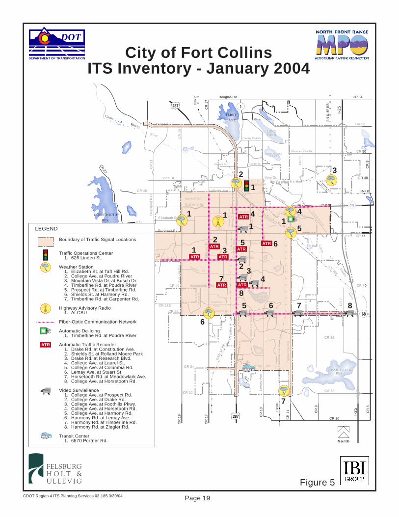
CDOT Region 4 ITS Planning Services 03-185 3/30/04
N o r t h
DEPARTMENT OF TRANSPORTATION
DOT
City of Fort CollinsITS Inventory - January 2004
FELSBURGH O L T &U L L E V I G
TERRY
LAKE
LONGPOND
LINDENMEIERLAKE
HORSETOOTH
RES.
FOSSIL CREEKRES.
WARRENLAKE
CacheLa
Poudre
River
Cache
La
PoudreR
iver
BN
& S
F R
R
UP
RR
UP
RR
BNRR
GW RW
BN
& S
F R
R
Douglas Rd. CR 54
CR 52
CR 50
CR 48
CR 44
CR 36
CR 32
Country Club Dr.
Mountain View Dr.
Conifer St.Hickory St.
Vine Dr.Vine Dr.
CR
21
CR 46 LaPorte Ave.
Mountain Ave.
Mulberry St.
Elizabeth St.
Prospect Rd.CR 44Lake St.
Laurel St.
How
es
St.
Ma
son
St.
Co
lleg
e A
ve.
Stuart St.
Sto
ver
St.
CR
23
CR 42 Drake Rd.
Swallow Rd.
CR 40 Horsetooth Rd.
CR 38E Se
ne
ca S
t.
Troutman
Pkwy.
Harmony Rd.CR 38
Trilby Rd.CR 34
CR 30
CR 32
CR
19
CR
19
CR
17 CR
13
CR
11 CR
9
I-2
5
CR
5
Tim
be
rlin
e R
d.
Le
may
Ave
.L
em
ay
Ave
.
Summ
it View D
r.
CR
9E
I-2
5
Buckingham St.
Lincoln Ave.
Riverside Ave.
Ove
rla
nd
Tra
il
Taft
Hill
Rd
.
CR
17
Sh
ield
s S
t.
CR
7
CR 40
CR
5
CR 54G
1287
14
287
68
186
TERRY
LAKE
LONGPOND
LINDENMEIERLAKE
FOSSIL CREEKRES.
WARRENLAKE
Poudre
River
Cache
La
PoudreR
iver
BN
& S
F R
R
UP
RR
BNRR
GW RW
BN
& S
F R
R
CR 52
CR 50
CR 48
CR 44
CR 36
CR 32
Country Club Dr.
Mountain View Dr.
Conifer St.Hickory St.
Vine Dr.Vine Dr.
CR
21
CR 46 LaPorte Ave.
Mountain Ave.
Mulberry St.
Elizabeth St.
Prospect Rd.CR 44Lake St.
Laurel St.
How
es
St.
Ma
son
St.
Co
lleg
e A
ve.
Stuart St.
Sto
ver
St.
CR 42 Drake Rd.
Swallow Rd.
CR 40 Horsetooth Rd.
CR 38E Se
ne
ca S
t.
Troutman
Pkwy.
Harmony Rd.CR 38
Trilby Rd.CR 34
CR 32
CR
19
Tim
be
rlin
e R
d.
Le
may
Ave
.L
em
ay
Ave
.
Summ
it View D
r.
CR
9E
Buckingham St.
Lincoln Ave.
Riverside Ave.
Ove
rla
nd
Tra
il
Taft
Hill
Rd
.
Sh
ield
s S
t.
CR
7
CR 40
CR 54G
14
68
186
TERRY
LAKE
LONGPOND
LINDENMEIERLAKE
FOSSIL CREEKRES.
WARRENLAKE
River
Cache
La
Poudre
BN
& S
F R
R
GW RW
BN
& S
F R
R
CR 36
CR 32
Country Club Dr.
Mountain View Dr.
Conifer St.Hickory St.
Vine Dr.Vine Dr.
CR
21
CR 46 LaPorte Ave.
Mountain Ave.
Mulberry St.
Elizabeth St.
Prospect Rd.CR 44Lake St.
Laurel St.
How
es
St.
Ma
son
St.
Co
lleg
e A
ve.
Stuart St.
Sto
ver
St.
CR 42 Drake Rd.
Swallow Rd.
CR 40 Horsetooth Rd.
CR 38E Se
ne
ca S
t.
Troutman
Pkwy.
Harmony Rd.CR 38
Trilby Rd.CR 34
CR 32
CR
19
Tim
be
rlin
e R
d.
Le
may
Ave
.L
em
ay
Ave
.
Summ
it View D
r.
CR
9E
Buckingham St.
Lincoln Ave.
Riverside Ave.
Ove
rla
nd
Tra
il
Taft
Hill
Rd
.
Sh
ield
s S
t.
CR
7
CR 54G
TERRY
LAKE
LONGPOND
LINDENMEIERLAKE
FOSSIL CREEKRES.
WARRENLAKE
Poudre
River
Cache
La
PoudreR
iver
BN
& S
F R
R
UP
RR
BNRR
GW RW
BN
& S
F R
R
CR 52
CR 50
CR 48
CR 44
CR 36
CR 32
Country Club Dr.
Mountain View Dr.
Conifer St.Hickory St.
Vine Dr.Vine Dr.
CR
21
CR 46 LaPorte Ave.
Mountain Ave.
Mulberry St.
Elizabeth St.
Prospect Rd.CR 44Lake St.
Laurel St.
How
es
St.
Ma
son
St.
Co
lleg
e A
ve.
Stuart St.
Sto
ver
St.
CR 42 Drake Rd.
Swallow Rd.
CR 40 Horsetooth Rd.
CR 38E Se
ne
ca S
t.
Troutman
Pkwy.
Harmony Rd.CR 38
Trilby Rd.CR 34
CR 32
CR
19
Tim
be
rlin
e R
d.
Le
may
Ave
.L
em
ay
Ave
.
Summ
it View D
r.
CR
9E
Buckingham St.
Lincoln Ave.
Riverside Ave.
Ove
rla
nd
Tra
il
Taft
Hill
Rd
.
Sh
ield
s S
t.
CR
7
CR 40
CR 54G
14
68
186
Boundary of Traffic Signal Locations
Traffic Operations Center1. 626 Linden St.
Weather Station1. Elizabeth St. at Taft Hill Rd.2. College Ave. at Poudre River3. Mountain Vista Dr. at Busch Dr.4. Timberline Rd. at Poudre River5. Prospect Rd. at Timberline Rd.6. Shields St. at Harmony Rd.7. Timberline Rd. at Carpenter Rd.
Highway Advisory Radio1. At CSU
Fiber-Optic Communication Network
Automatic De-Icing1. Timberline Rd. at Poudre River
Automatic Traffic Recorder1. Drake Rd. at Constitution Ave.2. Shields St. at Rolland Moore Park3. Drake Rd. at Research Blvd.4. College Ave. at Laurel St.5. College Ave. at Columbia Rd.6. Lemay Ave. at Stuart St.7. Horsetooth Rd. at Meadowlark Ave.8. College Ave. at Horsetooth Rd.
Video Surviellance1. College Ave. at Prospect Rd.2. College Ave. at Drake Rd.3. College Ave. at Foothills Pkwy.4. College Ave. at Horsetooth Rd.5. College Ave. at Harmony Rd.6. Harmony Rd. at Lemay Ave.7. Harmony Rd. at Timberline Rd.8. Harmony Rd. at Ziegler Rd.
Transit Center1. 6570 Portner Rd.
LEGEND
ATR
KINGSBURY
ATR
ATRATR
ATR
ATRATR
ATR ATR
TERRY
LAKE
LONGPOND
LINDENMEIERLAKE
FOSSIL CREEKRES.
WARRENLAKE
Poudre
River
Cache
La
PoudreR
iver
BN
& S
F R
R
UP
RR
BNRR
GW RW
BN
& S
F R
R
CR 52
CR 50
CR 48
CR 44
CR 36
CR 32
Country Club Dr.
Mountain View Dr.
Conifer St.Hickory St.
Vine Dr.Vine Dr.
CR
21
CR 46 LaPorte Ave.
Mountain Ave.
Mulberry St.
Elizabeth St.
Prospect Rd.CR 44Lake St.
Laurel St.
How
es
St.
Ma
son
St.
Co
lleg
e A
ve.
Stuart St.
Sto
ver
St.
CR 42 Drake Rd.
Swallow Rd.
CR 40 Horsetooth Rd.
CR 38E Se
ne
ca S
t.
Troutman
Pkwy.
Harmony Rd.CR 38
Trilby Rd.CR 34
CR 32
CR
19
Tim
be
rlin
e R
d.
Le
may
Ave
.L
em
ay
Ave
.
Summ
it View D
r.
CR
9E
Buckingham St.
Lincoln Ave.
Riverside Ave.
Ove
rla
nd
Tra
il
Taft
Hill
Rd
.
Sh
ield
s S
t.
CR
7
CR 40
CR 54G
14
68
186
TERRY
LAKE
LONGPOND
LINDENMEIERLAKE
FOSSIL CREEKRES.
WARRENLAKE
River
Cache
La
Poudre
BN
& S
F R
R
GW RW
BN
& S
F R
R
CR 36
CR 32
Country Club Dr.
Mountain View Dr.
Conifer St.Hickory St.
Vine Dr.Vine Dr.
CR
21
CR 46 LaPorte Ave.
Mountain Ave.
Mulberry St.
Elizabeth St.
Prospect Rd.CR 44Lake St.
Laurel St.
How
es
St.
Ma
son
St.
Co
lleg
e A
ve.
Stuart St.
Sto
ver
St.
CR 42 Drake Rd.
Swallow Rd.
CR 40 Horsetooth Rd.
CR 38E Se
ne
ca S
t.
Troutman
Pkwy.
Harmony Rd.CR 38
Trilby Rd.CR 34
CR 32
CR
19
Tim
be
rlin
e R
d.
Le
may
Ave
.L
em
ay
Ave
.
Summ
it View D
r.
CR
9E
Buckingham St.
Lincoln Ave.
Riverside Ave.
Ove
rla
nd
Tra
il
Taft
Hill
Rd
.
Sh
ield
s S
t.
CR
7
CR 54G
TERRY
LAKE
LONGPOND
LINDENMEIERLAKE
FOSSIL CREEKRES.
WARRENLAKE
Poudre
River
Cache
La
PoudreR
iver
BN
& S
F R
R
UP
RR
BNRR
GW RW
BN
& S
F R
R
CR 52
CR 50
CR 48
CR 44
CR 36
CR 32
Country Club Dr.
Mountain View Dr.
Conifer St.Hickory St.
Vine Dr.Vine Dr.
CR
21
CR 46 LaPorte Ave.
Mountain Ave.
Mulberry St.
Elizabeth St.
Prospect Rd.CR 44Lake St.
Laurel St.
How
es
St.
Ma
son
St.
Co
lleg
e A
ve.
Stuart St.
Sto
ver
St.
CR 42 Drake Rd.
Swallow Rd.
CR 40 Horsetooth Rd.
CR 38E Se
ne
ca S
t.
Troutman
Pkwy.
Harmony Rd.CR 38
Trilby Rd.CR 34
CR 32
CR
19
Tim
be
rlin
e R
d.
Le
may
Ave
.L
em
ay
Ave
.
Summ
it View D
r.
CR
9E
Buckingham St.
Lincoln Ave.
Riverside Ave.
Ove
rla
nd
Tra
il
Taft
Hill
Rd
.
Sh
ield
s S
t.
CR
7
CR 40
CR 54G
14
68
186
TERRY
LAKE
LONGPOND
LINDENMEIERLAKE
FOSSIL CREEKRES.
WARRENLAKE
River
Cache
La
Poudre
BN
& S
F R
R
GW RW
BN
& S
F R
R
CR 36
CR 32
Country Club Dr.
Mountain View Dr.
Conifer St.Hickory St.
Vine Dr.Vine Dr.
CR
21
CR 46 LaPorte Ave.
Mountain Ave.
Mulberry St.
Elizabeth St.
Prospect Rd.CR 44Lake St.
Laurel St.
How
es
St.
Ma
son
St.
Co
lleg
e A
ve.
Stuart St.
Sto
ver
St.
CR 42 Drake Rd.
Swallow Rd.
CR 40 Horsetooth Rd.
CR 38E Se
ne
ca S
t.
Troutman
Pkwy.
Harmony Rd.CR 38
Trilby Rd.CR 34
CR 32
CR
19
Tim
be
rlin
e R
d.
Le
may
Ave
.L
em
ay
Ave
.
Summ
it View D
r.
CR
9E
Buckingham St.
Lincoln Ave.
Riverside Ave.
Ove
rla
nd
Tra
il
Taft
Hill
Rd
.
Sh
ield
s S
t.
CR
7
CR 54G
TERRY
LAKE
LONGPOND
LINDENMEIERLAKE
FOSSIL CREEKRES.
WARRENLAKE
Poudre
River
Cache
La
PoudreR
iver
BN
& S
F R
R
UP
RR
BNRR
GW RW
BN
& S
F R
R
CR 52
CR 50
CR 48
CR 44
CR 36
CR 32
Country Club Dr.
Mountain View Dr.
Conifer St.Hickory St.
Vine Dr.Vine Dr.
CR
21
CR 46 LaPorte Ave.
Mountain Ave.
Mulberry St.
Elizabeth St.
Prospect Rd.CR 44Lake St.
Laurel St.
How
es
St.
Ma
son
St.
Co
lleg
e A
ve.
Stuart St.
Sto
ver
St.
CR 42 Drake Rd.
Swallow Rd.
CR 40 Horsetooth Rd.
CR 38E Se
ne
ca S
t.
Troutman
Pkwy.
Harmony Rd.CR 38
Trilby Rd.CR 34
CR 32
CR
19
Tim
be
rlin
e R
d.
Le
may
Ave
.L
em
ay
Ave
.
Summ
it View D
r.
CR
9E
Buckingham St.
Lincoln Ave.
Riverside Ave.
Ove
rla
nd
Tra
il
Taft
Hill
Rd
.
Sh
ield
s S
t.
CR
7
CR 40
CR 54G
14
68
186
Elizabeth St.
TERRY
LAKE
LONGPOND
LINDENMEIERLAKE
FOSSIL CREEKRES.
WARRENLAKE
Poudre
River
Cache
La
PoudreR
iver
BN
& S
F R
R
UP
RR
BNRR
GW RW
BN
& S
F R
R
CR 52
CR 50
CR 48
CR 44
CR 36
CR 32
Country Club Dr.
Mountain View Dr.
Conifer St.Hickory St.
Vine Dr.Vine Dr.
CR
21
CR 46 LaPorte Ave.
Mountain Ave.
Mulberry St.
Elizabeth St.
Prospect Rd.CR 44Lake St.
Laurel St.
How
es
St.
Ma
son
St.
Co
lleg
e A
ve.
Stuart St.
Sto
ver
St.
CR 42 Drake Rd.
Swallow Rd.
CR 40 Horsetooth Rd.
CR 38E Se
ne
ca S
t.
Troutman
Pkwy.
Harmony Rd.CR 38
Trilby Rd.CR 34
CR 32
CR
19
Tim
be
rlin
e R
d.
Le
may
Ave
.L
em
ay
Ave
.
Summ
it View D
r.
CR
9E
Buckingham St.
Lincoln Ave.
Riverside Ave.
Ove
rla
nd
Tra
il
Taft
Hill
Rd
.
Sh
ield
s S
t.
CR
7
CR 40
CR 54G
14
68
186
TERRY
LAKE
LONGPOND
LINDENMEIERLAKE
FOSSIL CREEKRES.
WARRENLAKE
River
Cache
La
Poudre
BN
& S
F R
R
GW RW
BN
& S
F R
R
CR 36
CR 32
Country Club Dr.
Mountain View Dr.
Conifer St.Hickory St.
Vine Dr.Vine Dr.
CR
21
CR 46 LaPorte Ave.
Mountain Ave.
Mulberry St.
Elizabeth St.
Prospect Rd.CR 44Lake St.
Laurel St.
How
es
St.
Ma
son
St.
Co
lleg
e A
ve.
Stuart St.
Sto
ver
St.
CR 42 Drake Rd.
Swallow Rd.
CR 40 Horsetooth Rd.
CR 38E Se
ne
ca S
t.
Troutman
Pkwy.
Harmony Rd.CR 38
Trilby Rd.CR 34
CR 32
CR
19
Tim
be
rlin
e R
d.
Le
may
Ave
.L
em
ay
Ave
.
Summ
it View D
r.
CR
9E
Buckingham St.
Lincoln Ave.
Riverside Ave.
Ove
rla
nd
Tra
il
Taft
Hill
Rd
.
Sh
ield
s S
t.
CR
7
CR 54G
TERRY
LAKE
LONGPOND
LINDENMEIERLAKE
FOSSIL CREEKRES.
WARRENLAKE
Poudre
River
Cache
La
PoudreR
iver
BN
& S
F R
R
UP
RR
BNRR
GW RW
BN
& S
F R
R
CR 52
CR 50
CR 48
CR 44
CR 36
CR 32
Country Club Dr.
Mountain View Dr.
Conifer St.Hickory St.
Vine Dr.Vine Dr.
CR
21
CR 46 LaPorte Ave.
Mountain Ave.
Mulberry St.
Elizabeth St.
Prospect Rd.CR 44Lake St.
Laurel St.
How
es
St.
Ma
son
St.
Co
lleg
e A
ve.
Stuart St.
Sto
ver
St.
CR 42 Drake Rd.
Swallow Rd.
CR 40 Horsetooth Rd.
CR 38E Se
ne
ca S
t.
Troutman
Pkwy.
Harmony Rd.CR 38
Trilby Rd.CR 34
CR 32
CR
19
Tim
be
rlin
e R
d.
Le
may
Ave
.L
em
ay
Ave
.
Summ
it View D
r.
CR
9E
Buckingham St.
Lincoln Ave.
Riverside Ave.
Ove
rla
nd
Tra
il
Taft
Hill
Rd
.
Sh
ield
s S
t.
CR
7
CR 40
CR 54G
14
68
186
TERRY
LAKE
LONGPOND
LINDENMEIERLAKE
FOSSIL CREEKRES.
WARRENLAKE
River
Cache
La
Poudre
BN
& S
F R
R
GW RW
BN
& S
F R
R
CR 36
CR 32
Country Club Dr.
Mountain View Dr.
Conifer St.Hickory St.
Vine Dr.Vine Dr.
CR
21
CR 46 LaPorte Ave.
Mountain Ave.
Mulberry St.
Elizabeth St.
Prospect Rd.CR 44Lake St.
Laurel St.
How
es
St.
Ma
son
St.
Co
lleg
e A
ve.
Stuart St.
Sto
ver
St.
CR 42 Drake Rd.
Swallow Rd.
CR 40 Horsetooth Rd.
CR 38E Se
ne
ca S
t.
Troutman
Pkwy.
Harmony Rd.CR 38
Trilby Rd.CR 34
CR 32
CR
19
Tim
be
rlin
e R
d.
Le
may
Ave
.L
em
ay
Ave
.
Summ
it View D
r.
CR
9E
Buckingham St.
Lincoln Ave.
Riverside Ave.
Ove
rla
nd
Tra
il
Taft
Hill
Rd
.
Sh
ield
s S
t.
CR
7
CR 54G
TERRY
LAKE
LONGPOND
LINDENMEIERLAKE
FOSSIL CREEKRES.
WARRENLAKE
Poudre
River
Cache
La
PoudreR
iver
BN
& S
F R
R
UP
RR
BNRR
GW RW
BN
& S
F R
R
CR 52
CR 50
CR 48
CR 44
CR 36
CR 32
Country Club Dr.
Mountain View Dr.
Conifer St.Hickory St.
Vine Dr.Vine Dr.
CR
21
CR 46 LaPorte Ave.
Mountain Ave.
Mulberry St.
Elizabeth St.
Prospect Rd.CR 44Lake St.
Laurel St.
How
es
St.
Ma
son
St.
Co
lleg
e A
ve.
Stuart St.
Sto
ver
St.
CR 42 Drake Rd.
Swallow Rd.
CR 40 Horsetooth Rd.
CR 38E Se
ne
ca S
t.
Troutman
Pkwy.
Harmony Rd.CR 38
Trilby Rd.CR 34
CR 32
CR
19
Tim
be
rlin
e R
d.
Le
may
Ave
.L
em
ay
Ave
.
Summ
it View D
r.
CR
9E
Buckingham St.
Lincoln Ave.
Riverside Ave.
Ove
rla
nd
Tra
il
Taft
Hill
Rd
.
Sh
ield
s S
t.
CR
7
CR 40
CR 54G
14
68
186
TERRY
LAKE
LONGPOND
LINDENMEIERLAKE
FOSSIL CREEKRES.
WARRENLAKE
River
Cache
La
Poudre
BN
& S
F R
R
GW RW
BN
& S
F R
R
CR 36
CR 32
Country Club Dr.
Mountain View Dr.
Conifer St.Hickory St.
Vine Dr.Vine Dr.
CR
21
CR 46 LaPorte Ave.
Mountain Ave.
Mulberry St.
Elizabeth St.
Prospect Rd.CR 44Lake St.
Laurel St.
How
es
St.
Ma
son
St.
Co
lleg
e A
ve.
Stuart St.
Sto
ver
St.
CR 42 Drake Rd.
Swallow Rd.
CR 40 Horsetooth Rd.
CR 38E Se
ne
ca S
t.
Troutman
Pkwy.
Harmony Rd.CR 38
Trilby Rd.CR 34
CR 32
CR
19
Tim
be
rlin
e R
d.
Le
may
Ave
.L
em
ay
Ave
.
Summ
it View D
r.
CR
9E
Buckingham St.
Lincoln Ave.
Riverside Ave.
Ove
rla
nd
Tra
il
Taft
Hill
Rd
.
Sh
ield
s S
t.
CR
7
CR 54G
TERRY
LAKE
LONGPOND
LINDENMEIERLAKE
FOSSIL CREEKRES.
WARRENLAKE
Poudre
River
Cache
La
PoudreR
iver
BN
& S
F R
R
UP
RR
BNRR
GW RW
BN
& S
F R
R
CR 52
CR 50
CR 48
CR 44
CR 36
CR 32
Country Club Dr.
Mountain View Dr.
Conifer St.Hickory St.
Vine Dr.Vine Dr.
CR
21
CR 46 LaPorte Ave.
Mountain Ave.
Mulberry St.
Elizabeth St.
Prospect Rd.CR 44Lake St.
Laurel St.
How
es
St.
Ma
son
St.
Co
lleg
e A
ve.
Stuart St.
Sto
ver
St.
CR 42 Drake Rd.
Swallow Rd.
CR 40 Horsetooth Rd.
CR 38E Se
ne
ca S
t.
Troutman
Pkwy.
Harmony Rd.CR 38
Trilby Rd.CR 34
CR 32
CR
19
Tim
be
rlin
e R
d.
Le
may
Ave
.L
em
ay
Ave
.
Summ
it View D
r.
CR
9E
Buckingham St.
Lincoln Ave.
Riverside Ave.
Ove
rla
nd
Tra
il
Taft
Hill
Rd
.
Sh
ield
s S
t.
CR
7
CR 40
CR 54G
14
68
186
Troutman
Pkwy.
Harmony Rd.
TERRY
LAKE
LONGPOND
LINDENMEIERLAKE
FOSSIL CREEKRES.
WARRENLAKE
Poudre
River
Cache
La
PoudreR
iver
BN
& S
F R
R
UP
RR
BNRR
GW RW
BN
& S
F R
R
CR 52
CR 50
CR 48
CR 44
CR 36
CR 32
Country Club Dr.
Mountain View Dr.
Conifer St.Hickory St.
Vine Dr.Vine Dr.
CR
21
CR 46 LaPorte Ave.
Mountain Ave.
Mulberry St.
Elizabeth St.
Prospect Rd.CR 44Lake St.
Laurel St.
How
es
St.
Ma
son
St.
Co
lleg
e A
ve.
Stuart St.
Sto
ver
St.
CR 42 Drake Rd.
Swallow Rd.
CR 40 Horsetooth Rd.
CR 38E Se
ne
ca S
t.
Troutman
Pkwy.
Harmony Rd.CR 38
Trilby Rd.CR 34
CR 32
CR
19
Tim
be
rlin
e R
d.
Le
may
Ave
.L
em
ay
Ave
.
Summ
it View D
r.
CR
9E
Buckingham St.
Lincoln Ave.
Riverside Ave.
Ove
rla
nd
Tra
il
Taft
Hill
Rd
.
Sh
ield
s S
t.
CR
7
CR 40
CR 54G
14
68
186
TERRY
LAKE
LONGPOND
LINDENMEIERLAKE
FOSSIL CREEKRES.
WARRENLAKE
River
Cache
La
Poudre
BN
& S
F R
R
GW RW
BN
& S
F R
R
CR 36
CR 32
Country Club Dr.
Mountain View Dr.
Conifer St.Hickory St.
Vine Dr.Vine Dr.
CR
21
CR 46 LaPorte Ave.
Mountain Ave.
Mulberry St.
Elizabeth St.
Prospect Rd.CR 44Lake St.
Laurel St.
How
es
St.
Ma
son
St.
Co
lleg
e A
ve.
Stuart St.
Sto
ver
St.
CR 42 Drake Rd.
Swallow Rd.
CR 40 Horsetooth Rd.
CR 38E Se
ne
ca S
t.
Troutman
Pkwy.
Harmony Rd.CR 38
Trilby Rd.CR 34
CR 32
CR
19
Tim
be
rlin
e R
d.
Le
may
Ave
.L
em
ay
Ave
.
Summ
it View D
r.
CR
9E
Buckingham St.
Lincoln Ave.
Riverside Ave.
Ove
rla
nd
Tra
il
Taft
Hill
Rd
.
Sh
ield
s S
t.
CR
7
CR 54G
TERRY
LAKE
LONGPOND
LINDENMEIERLAKE
FOSSIL CREEKRES.
WARRENLAKE
Poudre
River
Cache
La
PoudreR
iver
BN
& S
F R
R
UP
RR
BNRR
GW RW
BN
& S
F R
R
CR 52
CR 50
CR 48
CR 44
CR 36
CR 32
Country Club Dr.
Mountain View Dr.
Conifer St.Hickory St.
Vine Dr.Vine Dr.
CR
21
CR 46 LaPorte Ave.
Mountain Ave.
Mulberry St.
Elizabeth St.
Prospect Rd.CR 44Lake St.
Laurel St.
How
es
St.
Ma
son
St.
Co
lleg
e A
ve.
Stuart St.
Sto
ver
St.
CR 42 Drake Rd.
Swallow Rd.
CR 40 Horsetooth Rd.
CR 38E Se
ne
ca S
t.
Troutman
Pkwy.
Harmony Rd.CR 38
Trilby Rd.CR 34
CR 32
CR
19
Tim
be
rlin
e R
d.
Le
may
Ave
.L
em
ay
Ave
.
Summ
it View D
r.
CR
9E
Buckingham St.
Lincoln Ave.
Riverside Ave.
Ove
rla
nd
Tra
il
Taft
Hill
Rd
.
Sh
ield
s S
t.
CR
7
CR 40
CR 54G
14
68
186
TERRY
LAKE
LONGPOND
LINDENMEIERLAKE
FOSSIL CREEKRES.
WARRENLAKE
River
Cache
La
Poudre
BN
& S
F R
R
GW RW
BN
& S
F R
R
CR 36
CR 32
Country Club Dr.
Mountain View Dr.
Conifer St.Hickory St.
Vine Dr.Vine Dr.
CR
21
CR 46 LaPorte Ave.
Mountain Ave.
Mulberry St.
Elizabeth St.
Prospect Rd.CR 44Lake St.
Laurel St.
How
es
St.
Ma
son
St.
Co
lleg
e A
ve.
Stuart St.
Sto
ver
St.
CR 42 Drake Rd.
Swallow Rd.
CR 40 Horsetooth Rd.
CR 38E Se
ne
ca S
t.
Troutman
Pkwy.
Harmony Rd.CR 38
Trilby Rd.CR 34
CR 32
CR
19
Tim
be
rlin
e R
d.
Le
may
Ave
.L
em
ay
Ave
.
Summ
it View D
r.
CR
9E
Buckingham St.
Lincoln Ave.
Riverside Ave.
Ove
rla
nd
Tra
il
Taft
Hill
Rd
.
Sh
ield
s S
t.
CR
7
CR 54G
TERRY
LAKE
LONGPOND
LINDENMEIERLAKE
FOSSIL CREEKRES.
WARRENLAKE
Poudre
River
Cache
La
PoudreR
iver
BN
& S
F R
R
UP
RR
BNRR
GW RW
BN
& S
F R
R
CR 52
CR 50
CR 48
CR 44
CR 36
CR 32
Country Club Dr.
Mountain View Dr.
Conifer St.Hickory St.
Vine Dr.Vine Dr.
CR
21
CR 46 LaPorte Ave.
Mountain Ave.
Mulberry St.
Elizabeth St.
Prospect Rd.CR 44Lake St.
Laurel St.
How
es
St.
Ma
son
St.
Co
lleg
e A
ve.
Stuart St.
Sto
ver
St.
CR 42 Drake Rd.
Swallow Rd.
CR 40 Horsetooth Rd.
CR 38E Se
ne
ca S
t.
Troutman
Pkwy.
Harmony Rd.CR 38
Trilby Rd.CR 34
CR 32
CR
19
Tim
be
rlin
e R
d.
Le
may
Ave
.L
em
ay
Ave
.
Summ
it View D
r.
CR
9E
Buckingham St.
Lincoln Ave.
Riverside Ave.
Ove
rla
nd
Tra
il
Taft
Hill
Rd
.
Sh
ield
s S
t.
CR
7
CR 40
CR 54G
14
68
186
TERRY
LAKE
LONGPOND
LINDENMEIERLAKE
FOSSIL CREEKRES.
WARRENLAKE
River
Cache
La
Poudre
BN
& S
F R
R
GW RW
BN
& S
F R
R
CR 36
CR 32
Country Club Dr.
Mountain View Dr.
Conifer St.Hickory St.
Vine Dr.Vine Dr.
CR
21
CR 46 LaPorte Ave.
Mountain Ave.
Mulberry St.
Elizabeth St.
Prospect Rd.CR 44Lake St.
Laurel St.
How
es
St.
Ma
son
St.
Co
lleg
e A
ve.
Stuart St.
Sto
ver
St.
CR 42 Drake Rd.
Swallow Rd.
CR 40 Horsetooth Rd.
CR 38E Se
ne
ca S
t.
Troutman
Pkwy.
Harmony Rd.CR 38
Trilby Rd.CR 34
CR 32
CR
19
Tim
be
rlin
e R
d.
Le
may
Ave
.L
em
ay
Ave
.
Summ
it View D
r.
CR
9E
Buckingham St.
Lincoln Ave.
Riverside Ave.
Ove
rla
nd
Tra
il
Taft
Hill
Rd
.
Sh
ield
s S
t.
CR
7
CR 54G
TERRY
LAKE
LONGPOND
LINDENMEIERLAKE
FOSSIL CREEKRES.
WARRENLAKE
Poudre
River
Cache
La
PoudreR
iver
BN
& S
F R
R
UP
RR
BNRR
GW RW
BN
& S
F R
R
CR 52
CR 50
CR 48
CR 44
CR 36
CR 32
Country Club Dr.
Mountain View Dr.
Conifer St.Hickory St.
Vine Dr.Vine Dr.
CR
21
CR 46 LaPorte Ave.
Mountain Ave.
Mulberry St.
Elizabeth St.
Prospect Rd.CR 44Lake St.
Laurel St.
How
es
St.
Ma
son
St.
Co
lleg
e A
ve.
Stuart St.
Sto
ver
St.
CR 42 Drake Rd.
Swallow Rd.
CR 40 Horsetooth Rd.
CR 38E Se
ne
ca S
t.
Troutman
Pkwy.
Harmony Rd.CR 38
Trilby Rd.CR 34
CR 32
CR
19
Tim
be
rlin
e R
d.
Le
may
Ave
.L
em
ay
Ave
.
Summ
it View D
r.
CR
9E
Buckingham St.
Lincoln Ave.
Riverside Ave.
Ove
rla
nd
Tra
il
Taft
Hill
Rd
.
Sh
ield
s S
t.
CR
7
CR 40
CR 54G
14
68
186
32
1
41
11
12
35 6
2 34
8
7
6
5 6 7 8
4
51
7
Figure 5
Page 19

CDOT Region 4 ITS Planning Services 03-185 3/30/04
DEPARTMENT OF TRANSPORTATION
DOT
FELSBURGH O L T &U L L E V I G
City of GreeleyITS Inventory - January 2004
Sout
h
CachePoudre River
La
Cache
Poudre
Rive
rLa
Pla
tte
River
Boundary of Traffic Signal Locations
Traffic Operations Center1. 1300 "A" St., Bldg. E
Weather Station1. 10th St. at 35th Ave.
Video Surveillance1. US 34 Bypass at 23rd Ave.2. 10th St. at 35th Ave.
LEGEND
Transit Center1. 1200 "A" St.
Snow Emergency Center1. 3rd St. at 12th Ave.
Weld County Dispatch Center1. 1950 "O" St.
Stream Monitoring Station1. US 85 at 8th St.
Fiber-Optic Communication Network
KINGSBURY
D
AIMSCOMMUNITY
COLLEGE
ISLANDGROVEPARK
UNC
UN
C
UN
C
CR 56
W. 20th St.
W. 10th St.
W. 4th St.
34Bypass
CR 64
Bypass
263
8585
71st
Ave
.
59th West
Ridge Ave.
65th
Ave
.
59th
Ave
.
47th
Ave
.
50th
Ave
.
54th
Ave
.
43rd
Ave
.
35th
Ave
.
C St.
1st St.
N. 2
5th
Ave
.
F St.
O St.
CR
35
CR 62
2nd St.
A St.
C St.
25th St.
20th St.
26th St.
1st
Ave
.
16th St.
18th St.
20th St.
Bypass
Business
28thSt.
Reser
voir
Rd.
27thSt.
28th
Ave
.
22ndSt.
28th
Ave
.
23rd
Ave
.
16th St.
13th St.
38th
Ave
.
39th
Ave
. 7th St.
10th St.
26th
Ave
.
85
5th St.
9th St.10th St.
Ash
Ave
.
Bal
sam
Ave
.
UP
RR
GW RW
2nd
Ave
.
7th
Ave
.
10th
Ave
.11
th A
ve.
14th
Ave
.
34
34Business
Sout
h
CachePoudre River
La
Cache
Poudre
Rive
rLa
Pla
tte
River
AIMSCOMMUNITY
COLLEGE
ISLANDGROVEPARK
UNC
UN
C
UN
C
CR 56
W. 20th St.
W. 10th St.
W. 4th St.
34Bypass
CR 64
Bypass
263
8585
71st
Ave
.
59th West
Ridge Ave.
65th
Ave
.
59th
Ave
.
47th
Ave
.
50th
Ave
.
54th
Ave
.
43rd
Ave
.
35th
Ave
.
C St.
1st St.
N. 2
5th
Ave
.
F St.
O St.
CR
35
CR 62
2nd St.
A St.
C St.
25th St.
20th St.
26th St.
1st
Ave
.
16th St.
18th St.
20th St.
Bypass
Business
28thSt.
Reser
voir
Rd.
27thSt.
28th
Ave
.
22ndSt.
28th
Ave
.
23rd
Ave
.
16th St.
13th St.
38th
Ave
.
39th
Ave
. 7th St.
10th St.
26th
Ave
.
85
5th St.
9th St.10th St.
Ash
Ave
.
Bal
sam
Ave
.
UP
RR
GW RW
2nd
Ave
.
7th
Ave
.
10th
Ave
.11
th A
ve.
14th
Ave
.
34
34Business
N o r t h
CachePoudre
La
AIMSCOMMUNITY
COLLEGE
UNC
UN
C
UN
C
W. 20th St.
W. 10th St.
W. 4th St.
34Bypass
71st
Ave
.
59th West
Ridge Ave.
65th
Ave
.
59th
Ave
.
47th
Ave
.
50th
Ave
.
54th
Ave
.
43rd
Ave
.
35th
Ave
.
1st St.2nd St.
A St.
25th St.
20th St.
26th St.
1st
Ave
.
28thSt.
Reser
voir
Rd.
27thSt.
28th
Ave
.
22ndSt.
28th
Ave
.
23rd
Ave
.
16th St.
13th St.
38th
Ave
.
39th
Ave
. 7th St.
10th St.
26th
Ave
.
5th St.
9th St.10th St.
UP
RR
2nd
Ave
.
7th
Ave
.
10th
Ave
.11
th A
ve.
14th
Ave
.
34Business
Sout
h
CachePoudre River
La
Cache
Poudre
Rive
rLa
Pla
tte
River
AIMSCOMMUNITY
COLLEGE
ISLANDGROVEPARK
UNC
UN
C
UN
C
CR 56
W. 20th St.
W. 10th St.
W. 4th St.
34Bypass
CR 64
Bypass
263
8585
71st
Ave
.
59th West
Ridge Ave.
65th
Ave
.
59th
Ave
.
47th
Ave
.
50th
Ave
.
54th
Ave
.
43rd
Ave
.
35th
Ave
.
C St.
1st St.
N. 2
5th
Ave
.
F St.
O St.
CR
35
CR 62
2nd St.
A St.
C St.
25th St.
20th St.
26th St.
1st
Ave
.
16th St.
18th St.
20th St.
Bypass
Business
28thSt.
Reser
voir
Rd.
27thSt.
28th
Ave
.
22ndSt.
28th
Ave
.
23rd
Ave
.
16th St.
13th St.
38th
Ave
.
39th
Ave
. 7th St.
10th St.
26th
Ave
.
85
5th St.
9th St.10th St.
Ash
Ave
.
Bal
sam
Ave
.
UP
RR
GW RW
2nd
Ave
.
7th
Ave
.
10th
Ave
.11
th A
ve.
14th
Ave
.
34
34Business
28th
Ave
.
10th St.
Sout
h
CachePoudre River
La
Cache
Poudre
Rive
rLa
Pla
tte
River
AIMSCOMMUNITY
COLLEGE
ISLANDGROVEPARK
UNC
UN
C
UN
C
CR 56
W. 20th St.
W. 10th St.
W. 4th St.
34Bypass
CR 64
Bypass
263
8585
71st
Ave
.
59th West
Ridge Ave.
65th
Ave
.
59th
Ave
.
47th
Ave
.
50th
Ave
.
54th
Ave
.
43rd
Ave
.
35th
Ave
.
C St.
1st St.
N. 2
5th
Ave
.
F St.
O St.
CR
35
CR 62
2nd St.
A St.
C St.
25th St.
20th St.
26th St.
1st
Ave
.
16th St.
18th St.
20th St.
Bypass
Business
28thSt.
Reser
voir
Rd.
27thSt.
28th
Ave
.
22ndSt.
28th
Ave
.
23rd
Ave
.
16th St.
13th St.
38th
Ave
.
39th
Ave
. 7th St.
10th St.
26th
Ave
.
85
5th St.
9th St.10th St.
Ash
Ave
.
Bal
sam
Ave
.
UP
RR
GW RW
2nd
Ave
.
7th
Ave
.
10th
Ave
.11
th A
ve.
14th
Ave
.
34
34Business
CachePoudre
La
AIMSCOMMUNITY
COLLEGE
UNC
UN
C
UN
C
W. 20th St.
W. 10th St.
W. 4th St.
34Bypass
71st
Ave
.
59th West
Ridge Ave.
65th
Ave
.
59th
Ave
.
47th
Ave
.
50th
Ave
.
54th
Ave
.
43rd
Ave
.
35th
Ave
.
1st St.2nd St.
A St.
25th St.
20th St.
26th St.
1st
Ave
.
28thSt.
Reser
voir
Rd.
27thSt.
28th
Ave
.
22ndSt.
28th
Ave
.
23rd
Ave
.
16th St.
13th St.
38th
Ave
.
39th
Ave
. 7th St.
10th St.
26th
Ave
.
5th St.
9th St.10th St.
UP
RR
2nd
Ave
.
7th
Ave
.
10th
Ave
.11
th A
ve.
14th
Ave
.
34Business
Sout
h
CachePoudre River
La
Cache
Poudre
Rive
rLa
Pla
tte
River
AIMSCOMMUNITY
COLLEGE
ISLANDGROVEPARK
UNC
UN
C
UN
C
CR 56
W. 20th St.
W. 10th St.
W. 4th St.
34Bypass
CR 64
Bypass
263
8585
71st
Ave
.
59th West
Ridge Ave.
65th
Ave
.
59th
Ave
.
47th
Ave
.
50th
Ave
.
54th
Ave
.
43rd
Ave
.
35th
Ave
.
C St.
1st St.
N. 2
5th
Ave
.
F St.
O St.
CR
35
CR 62
2nd St.
A St.
C St.
25th St.
20th St.
26th St.
1st
Ave
.
16th St.
18th St.
20th St.
Bypass
Business
28thSt.
Reser
voir
Rd.
27thSt.
28th
Ave
.
22ndSt.
28th
Ave
.
23rd
Ave
.
16th St.
13th St.
38th
Ave
.
39th
Ave
. 7th St.
10th St.
26th
Ave
.
85
5th St.
9th St.10th St.
Ash
Ave
.
Bal
sam
Ave
.
UP
RR
GW RW
2nd
Ave
.
7th
Ave
.
10th
Ave
.11
th A
ve.
14th
Ave
.
34
34Business
14th
Ave
.
Sout
h
CachePoudre River
La
Cache
Poudre
Rive
rLa
Pla
tte
River
AIMSCOMMUNITY
COLLEGE
ISLANDGROVEPARK
UNC
UN
C
UN
C
CR 56
W. 20th St.
W. 10th St.
W. 4th St.
34Bypass
CR 64
Bypass
263
8585
71st
Ave
.
59th West
Ridge Ave.
65th
Ave
.
59th
Ave
.
47th
Ave
.
50th
Ave
.
54th
Ave
.
43rd
Ave
.
35th
Ave
.
C St.
1st St.
N. 2
5th
Ave
.
F St.
O St.
CR
35
CR 62
2nd St.
A St.
C St.
25th St.
20th St.
26th St.
1st
Ave
.
16th St.
18th St.
20th St.
Bypass
Business
28thSt.
Reser
voir
Rd.
27thSt.
28th
Ave
.
22ndSt.
28th
Ave
.
23rd
Ave
.
16th St.
13th St.
38th
Ave
.
39th
Ave
. 7th St.
10th St.
26th
Ave
.
85
5th St.
9th St.10th St.
Ash
Ave
.
Bal
sam
Ave
.
UP
RR
GW RW
2nd
Ave
.
7th
Ave
.
10th
Ave
.11
th A
ve.
14th
Ave
.
34
34Business
CachePoudre
La
AIMSCOMMUNITY
COLLEGE
UNC
UN
C
UN
C
W. 20th St.
W. 10th St.
W. 4th St.
34Bypass
71st
Ave
.
59th West
Ridge Ave.
65th
Ave
.
59th
Ave
.
47th
Ave
.
50th
Ave
.
54th
Ave
.
43rd
Ave
.
35th
Ave
.
1st St.2nd St.
A St.
25th St.
20th St.
26th St.
1st
Ave
.
28thSt.
Reser
voir
Rd.
27thSt.
28th
Ave
.
22ndSt.
28th
Ave
.
23rd
Ave
.
16th St.
13th St.
38th
Ave
.
39th
Ave
. 7th St.
10th St.
26th
Ave
.
5th St.
9th St.10th St.
UP
RR
2nd
Ave
.
7th
Ave
.
10th
Ave
.11
th A
ve.
14th
Ave
.
34Business
Sout
h
CachePoudre River
La
Cache
Poudre
Rive
rLa
Pla
tte
River
AIMSCOMMUNITY
COLLEGE
ISLANDGROVEPARK
UNC
UN
C
UN
C
CR 56
W. 20th St.
W. 10th St.
W. 4th St.
34Bypass
CR 64
Bypass
263
8585
71st
Ave
.
59th West
Ridge Ave.
65th
Ave
.
59th
Ave
.
47th
Ave
.
50th
Ave
.
54th
Ave
.
43rd
Ave
.
35th
Ave
.
C St.
1st St.
N. 2
5th
Ave
.
F St.
O St.
CR
35
CR 62
2nd St.
A St.
C St.
25th St.
20th St.
26th St.
1st
Ave
.
16th St.
18th St.
20th St.
Bypass
Business
28thSt.
Reser
voir
Rd.
27thSt.
28th
Ave
.
22ndSt.
28th
Ave
.
23rd
Ave
.
16th St.
13th St.
38th
Ave
.
39th
Ave
. 7th St.
10th St.
26th
Ave
.
85
5th St.
9th St.10th St.
Ash
Ave
.
Bal
sam
Ave
.
UP
RR
GW RW
2nd
Ave
.
7th
Ave
.
10th
Ave
.11
th A
ve.
14th
Ave
.
34
34Business
KINGSBURY
Sout
h
CachePoudre River
La
Cache
Poudre
Rive
rLa
Pla
tte
River
AIMSCOMMUNITY
COLLEGE
ISLANDGROVEPARK
UNC
UN
C
UN
C
CR 56
W. 20th St.
W. 10th St.
W. 4th St.
34Bypass
CR 64
Bypass
263
8585
71st
Ave
.
59th West
Ridge Ave.
65th
Ave
.
59th
Ave
.
47th
Ave
.
50th
Ave
.
54th
Ave
.
43rd
Ave
.
35th
Ave
.
C St.
1st St.
N. 2
5th
Ave
.
F St.
O St.
CR
35
CR 62
2nd St.
A St.
C St.
25th St.
20th St.
26th St.
1st
Ave
.
16th St.
18th St.
20th St.
Bypass
Business
28thSt.
Reser
voir
Rd.
27thSt.
28th
Ave
.
22ndSt.
28th
Ave
.
23rd
Ave
.
16th St.
13th St.
38th
Ave
.
39th
Ave
. 7th St.
10th St.
26th
Ave
.
85
5th St.
9th St.10th St.
Ash
Ave
.
Bal
sam
Ave
.
UP
RR
GW RW
2nd
Ave
.
7th
Ave
.
10th
Ave
.11
th A
ve.
14th
Ave
.
34
34Business
D
Poudre River
Ash
Ave
.
Sout
h
CachePoudre River
La
Cache
Poudre
Rive
rLa
Pla
tte
River
AIMSCOMMUNITY
COLLEGE
ISLANDGROVEPARK
UNC
UN
C
UN
C
CR 56
W. 20th St.
W. 10th St.
W. 4th St.
34Bypass
CR 64
Bypass
263
8585
71st
Ave
.
59th West
Ridge Ave.
65th
Ave
.
59th
Ave
.
47th
Ave
.
50th
Ave
.
54th
Ave
.
43rd
Ave
.
35th
Ave
.
C St.
1st St.
N. 2
5th
Ave
.
F St.
O St.
CR
35
CR 62
2nd St.
A St.
C St.
25th St.
20th St.
26th St.
1st
Ave
.
16th St.
18th St.
20th St.
Bypass
Business
28thSt.
Reser
voir
Rd.
27thSt.
28th
Ave
.
22ndSt.
28th
Ave
.
23rd
Ave
.
16th St.
13th St.
38th
Ave
.
39th
Ave
. 7th St.
10th St.
26th
Ave
.
85
5th St.
9th St.10th St.
Ash
Ave
.
Bal
sam
Ave
.
UP
RR
GW RW
2nd
Ave
.
7th
Ave
.
10th
Ave
.11
th A
ve.
14th
Ave
.
34
34Business
CachePoudre
La
AIMSCOMMUNITY
COLLEGE
UNC
UN
C
UN
C
W. 20th St.
W. 10th St.
W. 4th St.
34Bypass
71st
Ave
.
59th West
Ridge Ave.
65th
Ave
.
59th
Ave
.
47th
Ave
.
50th
Ave
.
54th
Ave
.
43rd
Ave
.
35th
Ave
.
1st St.2nd St.
A St.
25th St.
20th St.
26th St.
1st
Ave
.
28thSt.
Reser
voir
Rd.
27thSt.
28th
Ave
.
22ndSt.
28th
Ave
.
23rd
Ave
.
16th St.
13th St.
38th
Ave
.
39th
Ave
. 7th St.
10th St.
26th
Ave
.
5th St.
9th St.10th St.
UP
RR
2nd
Ave
.
7th
Ave
.
10th
Ave
.11
th A
ve.
14th
Ave
.
34Business
Sout
h
CachePoudre River
La
Cache
Poudre
Rive
rLa
Pla
tte
River
AIMSCOMMUNITY
COLLEGE
ISLANDGROVEPARK
UNC
UN
C
UN
C
CR 56
W. 20th St.
W. 10th St.
W. 4th St.
34Bypass
CR 64
Bypass
263
8585
71st
Ave
.
59th West
Ridge Ave.
65th
Ave
.
59th
Ave
.
47th
Ave
.
50th
Ave
.
54th
Ave
.
43rd
Ave
.
35th
Ave
.
C St.
1st St.
N. 2
5th
Ave
.
F St.
O St.
CR
35
CR 62
2nd St.
A St.
C St.
25th St.
20th St.
26th St.
1st
Ave
.
16th St.
18th St.
20th St.
Bypass
Business
28thSt.
Reser
voir
Rd.
27thSt.
28th
Ave
.
22ndSt.
28th
Ave
.
23rd
Ave
.
16th St.
13th St.
38th
Ave
.
39th
Ave
. 7th St.
10th St.
26th
Ave
.
85
5th St.
9th St.10th St.
Ash
Ave
.
Bal
sam
Ave
.
UP
RR
GW RW
2nd
Ave
.
7th
Ave
.
10th
Ave
.11
th A
ve.
14th
Ave
.
34
34Business
1
2 1
1
11
1
1
Figure 6
Page 20
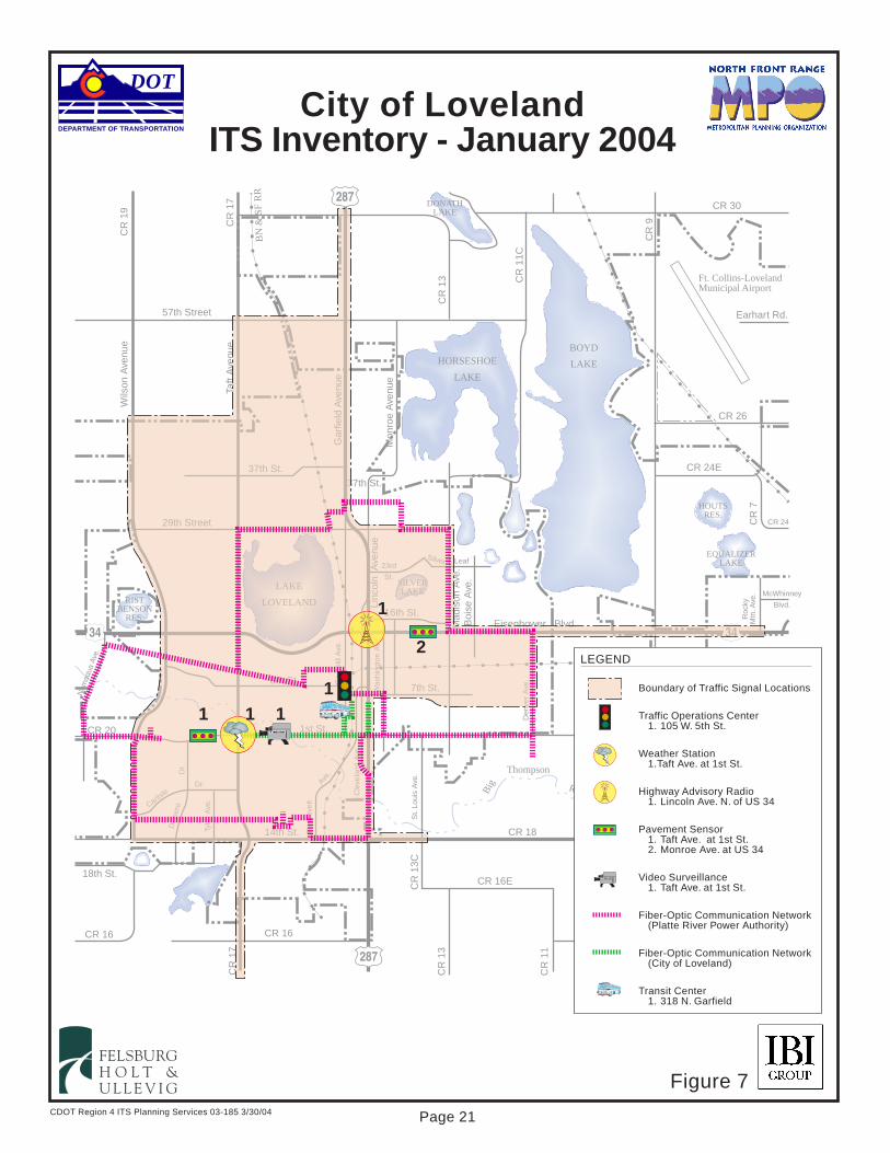
CDOT Region 4 ITS Planning Services 03-185 3/30/04
DEPARTMENT OF TRANSPORTATION
DOT
N o r t h
FELSBURGH O L T &U L L E V I G
City of LovelandITS Inventory - January 2004
Big
Thompson
River
SILVERLAKE
57th Street
37th St.
29th Street
Eisenhower Blvd.
8th St.
Nam
aqua
Ave
.
1st St.
14th St.
BOYD
LAKEHORSESHOE
LAKE
DONATHLAKE
HOUTSRES.
EQUALIZERLAKE
LAKE
LOVELANDRISTBENSON
RES.
Wils
on A
venu
eC
R 1
9
CR
17
Taft
Ave
nue
Gar
field
Ave
.G
arfie
ld A
venu
e
Mon
roe
Ave
nue
Linc
oln
Ave
nue
CR 16
Cle
vela
nd A
ve.
Roo
seve
lt
Was
hing
ton
Ave
.
7th St.
16th St.
CR
13C
St.
Loui
s A
ve.
CR 20
CR 16
18th St.
Tyle
r A
ve.
Dr.
Den
ver
Ave
.
Mad
ison
Ave
.B
oise
Ave
.
37th St.
CR
9E
CR 18
CR 16E
CR 16
CR
11
McWhinney
Blvd.
Roc
kyM
tn. A
ve.
CR 24CR
7
CR 24E
CR 26
Earhart Rd.
CR 30
CR
11C
CR
13
CR
17
CR
13
Ave.
Dot
seroCarlis
leDr.
23rd
St.
Silver Leaf
CR
9
GW RW
BN
& S
F R
R
Ft. Collins-LovelandMunicipal Airport
287
34 34
402
287
N o r t h
Big
Thompson
River
SILVERLAKE
57th Street
37th St.
29th Street
Eisenhower Blvd.
8th St.
1st St.
14th St.
BOYD
LAKEHORSESHOE
LAKE
DONATHLAKE
HOUTSRES.
EQUALIZERLAKE
LAKE
LOVELANDRISTBENSON
RES.
Wils
on A
venu
eC
R 1
9
CR
17
Taft
Ave
nue
Gar
field
Ave
.G
arfie
ld A
venu
e
Mon
roe
Ave
nue
Linc
oln
Ave
nue
CR 16
Cle
vela
nd A
ve.
Roo
seve
lt
Was
hing
ton
Ave
.
7th St.
16th St.
CR
13C
St.
Loui
s A
ve.
Tyle
r A
ve.
Dr.
Den
ver
Ave
.
Mad
ison
Ave
.B
oise
Ave
.
37th St.
CR
9E
CR 18
CR 16E
CR 16
CR
11
McWhinney
Blvd.
Roc
kyM
tn. A
ve.
CR
7
CR 24E
CR 26
Earhart Rd.
CR 30
CR
11C
CR
13
CR
17
CR
13
Ave.
Dot
seroCarlis
leDr.
23rd
St.
Silver Leaf
CR
9
GW RW
BN
& S
F R
R
Ft. Collins-LovelandMunicipal Airport
287
34
402
287
N o r t h
Big
Thompson
River
SILVERLAKE
57th Street
37th St.
29th Street
Eisenhower Blvd.
8th St.
Nam
aqua
Ave
.
1st St.
14th St.
BOYD
LAKEHORSESHOE
LAKE
DONATHLAKE
HOUTSRES.
EQUALIZERLAKE
LAKE
LOVELANDRISTBENSON
RES.
Wils
on A
venu
eC
R 1
9
CR
17
Taft
Ave
nue
Gar
field
Ave
.G
arfie
ld A
venu
e
Mon
roe
Ave
nue
Linc
oln
Ave
nue
CR 16
Cle
vela
nd A
ve.
Roo
seve
lt
Was
hing
ton
Ave
.
7th St.
16th St.
CR
13C
St.
Loui
s A
ve.
CR 20
CR 16
18th St.
Tyle
r A
ve.
Dr.
Den
ver
Ave
.
Mad
ison
Ave
.B
oise
Ave
.
37th St.
CR
9E
CR 18
CR 16E
CR 16
CR
11
McWhinney
Blvd.
Roc
kyM
tn. A
ve.
CR 24CR
7
CR 24E
CR 26
Earhart Rd.
CR 30
CR
11C
CR
13
CR
17
CR
13
Ave.
Dot
seroCarlis
leDr.
23rd
St.
Silver Leaf
CR
9
GW RW
BN
& S
F R
R
Ft. Collins-LovelandMunicipal Airport
287
34 34
402
287
N o r t h
Big
Thompson
River
SILVERLAKE
57th Street
37th St.
29th Street
Eisenhower Blvd.
8th St.
1st St.
14th St.
BOYD
LAKEHORSESHOE
LAKE
DONATHLAKE
HOUTSRES.
EQUALIZERLAKE
LAKE
LOVELANDRISTBENSON
RES.
Wils
on A
venu
eC
R 1
9
CR
17
Taft
Ave
nue
Gar
field
Ave
.G
arfie
ld A
venu
e
Mon
roe
Ave
nue
Linc
oln
Ave
nue
CR 16
Cle
vela
nd A
ve.
Roo
seve
lt
Was
hing
ton
Ave
.
7th St.
16th St.
CR
13C
St.
Loui
s A
ve.
Tyle
r A
ve.
Dr.
Den
ver
Ave
.
Mad
ison
Ave
.B
oise
Ave
.
37th St.
CR
9E
CR 18
CR 16E
CR 16
CR
11
McWhinney
Blvd.
Roc
kyM
tn. A
ve.
CR
7
CR 24E
CR 26
Earhart Rd.
CR 30
CR
11C
CR
13
CR
17
CR
13
Ave.
Dot
seroCarlis
leDr.
23rd
St.
Silver Leaf
CR
9
GW RW
BN
& S
F R
R
Ft. Collins-LovelandMunicipal Airport
287
34
402
287
N o r t h
Big
Thompson
River
SILVERLAKE
57th Street
37th St.
29th Street
Eisenhower Blvd.
8th St.
Nam
aqua
Ave
.
1st St.
14th St.
BOYD
LAKEHORSESHOE
LAKE
DONATHLAKE
HOUTSRES.
EQUALIZERLAKE
LAKE
LOVELANDRISTBENSON
RES.
Wils
on A
venu
eC
R 1
9
CR
17
Taft
Ave
nue
Gar
field
Ave
.G
arfie
ld A
venu
e
Mon
roe
Ave
nue
Linc
oln
Ave
nue
CR 16
Cle
vela
nd A
ve.
Roo
seve
lt
Was
hing
ton
Ave
.
7th St.
16th St.
CR
13C
St.
Loui
s A
ve.
CR 20
CR 16
18th St.
Tyle
r A
ve.
Dr.
Den
ver
Ave
.
Mad
ison
Ave
.B
oise
Ave
.
37th St.
CR
9E
CR 18
CR 16E
CR 16
CR
11
McWhinney
Blvd.
Roc
kyM
tn. A
ve.
CR 24CR
7
CR 24E
CR 26
Earhart Rd.
CR 30
CR
11C
CR
13
CR
17
CR
13
Ave.
Dot
seroCarlis
leDr.
23rd
St.
Silver Leaf
CR
9
GW RW
BN
& S
F R
R
Ft. Collins-LovelandMunicipal Airport
287
34 34
402
287
Was
hing
ton
Ave
.
16th St.
N o r t h
Big
Thompson
River
SILVERLAKE
57th Street
37th St.
29th Street
Eisenhower Blvd.
8th St.
Nam
aqua
Ave
.
1st St.
14th St.
BOYD
LAKEHORSESHOE
LAKE
DONATHLAKE
HOUTSRES.
EQUALIZERLAKE
LAKE
LOVELANDRISTBENSON
RES.
Wils
on A
venu
eC
R 1
9
CR
17
Taft
Ave
nue
Gar
field
Ave
.G
arfie
ld A
venu
e
Mon
roe
Ave
nue
Linc
oln
Ave
nue
CR 16
Cle
vela
nd A
ve.
Roo
seve
lt
Was
hing
ton
Ave
.
7th St.
16th St.
CR
13C
St.
Loui
s A
ve.
CR 20
CR 16
18th St.
Tyle
r A
ve.
Dr.
Den
ver
Ave
.
Mad
ison
Ave
.B
oise
Ave
.
37th St.
CR
9E
CR 18
CR 16E
CR 16
CR
11
McWhinney
Blvd.
Roc
kyM
tn. A
ve.
CR 24CR
7
CR 24E
CR 26
Earhart Rd.
CR 30
CR
11C
CR
13
CR
17
CR
13
Ave.
Dot
seroCarlis
leDr.
23rd
St.
Silver Leaf
CR
9
GW RW
BN
& S
F R
R
Ft. Collins-LovelandMunicipal Airport
287
34 34
402
287
N o r t h
Big
Thompson
River
SILVERLAKE
57th Street
37th St.
29th Street
Eisenhower Blvd.
8th St.
1st St.
14th St.
BOYD
LAKEHORSESHOE
LAKE
DONATHLAKE
HOUTSRES.
EQUALIZERLAKE
LAKE
LOVELANDRISTBENSON
RES.
Wils
on A
venu
eC
R 1
9
CR
17
Taft
Ave
nue
Gar
field
Ave
.G
arfie
ld A
venu
e
Mon
roe
Ave
nue
Linc
oln
Ave
nue
CR 16
Cle
vela
nd A
ve.
Roo
seve
lt
Was
hing
ton
Ave
.
7th St.
16th St.
CR
13C
St.
Loui
s A
ve.
Tyle
r A
ve.
Dr.
Den
ver
Ave
.
Mad
ison
Ave
.B
oise
Ave
.
37th St.
CR
9E
CR 18
CR 16E
CR 16
CR
11
McWhinney
Blvd.
Roc
kyM
tn. A
ve.
CR
7
CR 24E
CR 26
Earhart Rd.
CR 30
CR
11C
CR
13
CR
17
CR
13
Ave.
Dot
seroCarlis
leDr.
23rd
St.
Silver Leaf
CR
9
GW RW
BN
& S
F R
R
Ft. Collins-LovelandMunicipal Airport
287
34
402
287
N o r t h
Big
Thompson
River
SILVERLAKE
57th Street
37th St.
29th Street
Eisenhower Blvd.
8th St.
Nam
aqua
Ave
.
1st St.
14th St.
BOYD
LAKEHORSESHOE
LAKE
DONATHLAKE
HOUTSRES.
EQUALIZERLAKE
LAKE
LOVELANDRISTBENSON
RES.
Wils
on A
venu
eC
R 1
9
CR
17
Taft
Ave
nue
Gar
field
Ave
.G
arfie
ld A
venu
e
Mon
roe
Ave
nue
Linc
oln
Ave
nue
CR 16
Cle
vela
nd A
ve.
Roo
seve
lt
Was
hing
ton
Ave
.
7th St.
16th St.
CR
13C
St.
Loui
s A
ve.
CR 20
CR 16
18th St.
Tyle
r A
ve.
Dr.
Den
ver
Ave
.
Mad
ison
Ave
.B
oise
Ave
.
37th St.
CR
9E
CR 18
CR 16E
CR 16
CR
11
McWhinney
Blvd.
Roc
kyM
tn. A
ve.
CR 24CR
7
CR 24E
CR 26
Earhart Rd.
CR 30
CR
11C
CR
13
CR
17
CR
13
Ave.
Dot
seroCarlis
leDr.
23rd
St.
Silver Leaf
CR
9
GW RW
BN
& S
F R
R
Ft. Collins-LovelandMunicipal Airport
287
34 34
402
287
Boundary of Traffic Signal Locations
Traffic Operations Center1. 105 W. 5th St.
Weather Station1.Taft Ave. at 1st St.
Highway Advisory Radio1. Lincoln Ave. N. of US 34
Pavement Sensor1. Taft Ave. at 1st St.2. Monroe Ave. at US 34
Video Surveillance1. Taft Ave. at 1st St.
Fiber-Optic Communication Network(Platte River Power Authority)
Fiber-Optic Communication Network(City of Loveland)
Transit Center1. 318 N. Garfield
LEGEND
N o r t h
Big
Thompson
River
SILVERLAKE
57th Street
37th St.
29th Street
Eisenhower Blvd.
8th St.
Nam
aqua
Ave
.
1st St.
14th St.
BOYD
LAKEHORSESHOE
LAKE
DONATHLAKE
HOUTSRES.
EQUALIZERLAKE
LAKE
LOVELANDRISTBENSON
RES.
Wils
on A
venu
eC
R 1
9
CR
17
Taft
Ave
nue
Gar
field
Ave
.G
arfie
ld A
venu
e
Mon
roe
Ave
nue
Linc
oln
Ave
nue
CR 16
Cle
vela
nd A
ve.
Roo
seve
lt
Was
hing
ton
Ave
.
7th St.
16th St.
CR
13C
St.
Loui
s A
ve.
CR 20
CR 16
18th St.
Tyle
r A
ve.
Dr.
Den
ver
Ave
.
Mad
ison
Ave
.B
oise
Ave
.
37th St.
CR
9E
CR 18
CR 16E
CR 16
CR
11
McWhinney
Blvd.
Roc
kyM
tn. A
ve.
CR 24CR
7
CR 24E
CR 26
Earhart Rd.
CR 30
CR
11C
CR
13
CR
17
CR
13
Ave.
Dot
seroCarlis
leDr.
23rd
St.
Silver Leaf
CR
9
GW RW
BN
& S
F R
R
Ft. Collins-LovelandMunicipal Airport
287
34 34
402
287
N o r t h
Big
Thompson
River
SILVERLAKE
57th Street
37th St.
29th Street
Eisenhower Blvd.
8th St.
1st St.
14th St.
BOYD
LAKEHORSESHOE
LAKE
DONATHLAKE
HOUTSRES.
EQUALIZERLAKE
LAKE
LOVELANDRISTBENSON
RES.
Wils
on A
venu
eC
R 1
9
CR
17
Taft
Ave
nue
Gar
field
Ave
.G
arfie
ld A
venu
e
Mon
roe
Ave
nue
Linc
oln
Ave
nue
CR 16
Cle
vela
nd A
ve.
Roo
seve
lt
Was
hing
ton
Ave
.
7th St.
16th St.
CR
13C
St.
Loui
s A
ve.
Tyle
r A
ve.
Dr.
Den
ver
Ave
.
Mad
ison
Ave
.B
oise
Ave
.
37th St.
CR
9E
CR 18
CR 16E
CR 16
CR
11
McWhinney
Blvd.
Roc
kyM
tn. A
ve.
CR
7
CR 24E
CR 26
Earhart Rd.
CR 30
CR
11C
CR
13
CR
17
CR
13
Ave.
Dot
seroCarlis
leDr.
23rd
St.
Silver Leaf
CR
9
GW RW
BN
& S
F R
R
Ft. Collins-LovelandMunicipal Airport
287
34
402
287
N o r t h
Big
Thompson
River
SILVERLAKE
57th Street
37th St.
29th Street
Eisenhower Blvd.
8th St.
Nam
aqua
Ave
.
1st St.
14th St.
BOYD
LAKEHORSESHOE
LAKE
DONATHLAKE
HOUTSRES.
EQUALIZERLAKE
LAKE
LOVELANDRISTBENSON
RES.
Wils
on A
venu
eC
R 1
9
CR
17
Taft
Ave
nue
Gar
field
Ave
.G
arfie
ld A
venu
e
Mon
roe
Ave
nue
Linc
oln
Ave
nue
CR 16
Cle
vela
nd A
ve.
Roo
seve
lt
Was
hing
ton
Ave
.
7th St.
16th St.
CR
13C
St.
Loui
s A
ve.
CR 20
CR 16
18th St.
Tyle
r A
ve.
Dr.
Den
ver
Ave
.
Mad
ison
Ave
.B
oise
Ave
.
37th St.
CR
9E
CR 18
CR 16E
CR 16
CR
11
McWhinney
Blvd.
Roc
kyM
tn. A
ve.
CR 24CR
7
CR 24E
CR 26
Earhart Rd.
CR 30
CR
11C
CR
13
CR
17
CR
13
Ave.
Dot
seroCarlis
leDr.
23rd
St.
Silver Leaf
CR
9
GW RW
BN
& S
F R
R
Ft. Collins-LovelandMunicipal Airport
287
34 34
402
287
CR
9E
N o r t h
Big
Thompson
River
SILVERLAKE
57th Street
37th St.
29th Street
Eisenhower Blvd.
8th St.
Nam
aqua
Ave
.
1st St.
14th St.
BOYD
LAKEHORSESHOE
LAKE
DONATHLAKE
HOUTSRES.
EQUALIZERLAKE
LAKE
LOVELANDRISTBENSON
RES.
Wils
on A
venu
eC
R 1
9
CR
17
Taft
Ave
nue
Gar
field
Ave
.G
arfie
ld A
venu
e
Mon
roe
Ave
nue
Linc
oln
Ave
nue
CR 16
Cle
vela
nd A
ve.
Roo
seve
lt
Was
hing
ton
Ave
.
7th St.
16th St.
CR
13C
St.
Loui
s A
ve.
CR 20
CR 16
18th St.
Tyle
r A
ve.
Dr.
Den
ver
Ave
.
Mad
ison
Ave
.B
oise
Ave
.
37th St.
CR
9E
CR 18
CR 16E
CR 16
CR
11
McWhinney
Blvd.
Roc
kyM
tn. A
ve.
CR 24CR
7
CR 24E
CR 26
Earhart Rd.
CR 30
CR
11C
CR
13
CR
17
CR
13
Ave.
Dot
seroCarlis
leDr.
23rd
St.
Silver Leaf
CR
9
GW RW
BN
& S
F R
R
Ft. Collins-LovelandMunicipal Airport
287
34 34
402
287
N o r t h
Big
Thompson
River
SILVERLAKE
57th Street
37th St.
29th Street
Eisenhower Blvd.
8th St.
1st St.
14th St.
BOYD
LAKEHORSESHOE
LAKE
DONATHLAKE
HOUTSRES.
EQUALIZERLAKE
LAKE
LOVELANDRISTBENSON
RES.
Wils
on A
venu
eC
R 1
9
CR
17
Taft
Ave
nue
Gar
field
Ave
.G
arfie
ld A
venu
e
Mon
roe
Ave
nue
Linc
oln
Ave
nue
CR 16
Cle
vela
nd A
ve.
Roo
seve
lt
Was
hing
ton
Ave
.
7th St.
16th St.
CR
13C
St.
Loui
s A
ve.
Tyle
r A
ve.
Dr.
Den
ver
Ave
.
Mad
ison
Ave
.B
oise
Ave
.
37th St.
CR
9E
CR 18
CR 16E
CR 16
CR
11
McWhinney
Blvd.
Roc
kyM
tn. A
ve.
CR
7
CR 24E
CR 26
Earhart Rd.
CR 30
CR
11C
CR
13
CR
17
CR
13
Ave.
Dot
seroCarlis
leDr.
23rd
St.
Silver Leaf
CR
9
GW RW
BN
& S
F R
R
Ft. Collins-LovelandMunicipal Airport
287
34
402
287
N o r t h
Big
Thompson
River
SILVERLAKE
57th Street
37th St.
29th Street
Eisenhower Blvd.
8th St.
Nam
aqua
Ave
.
1st St.
14th St.
BOYD
LAKEHORSESHOE
LAKE
DONATHLAKE
HOUTSRES.
EQUALIZERLAKE
LAKE
LOVELANDRISTBENSON
RES.
Wils
on A
venu
eC
R 1
9
CR
17
Taft
Ave
nue
Gar
field
Ave
.G
arfie
ld A
venu
e
Mon
roe
Ave
nue
Linc
oln
Ave
nue
CR 16
Cle
vela
nd A
ve.
Roo
seve
lt
Was
hing
ton
Ave
.
7th St.
16th St.
CR
13C
St.
Loui
s A
ve.
CR 20
CR 16
18th St.
Tyle
r A
ve.
Dr.
Den
ver
Ave
.
Mad
ison
Ave
.B
oise
Ave
.
37th St.
CR
9E
CR 18
CR 16E
CR 16
CR
11
McWhinney
Blvd.
Roc
kyM
tn. A
ve.
CR 24CR
7
CR 24E
CR 26
Earhart Rd.
CR 30
CR
11C
CR
13
CR
17
CR
13
Ave.
Dot
seroCarlis
leDr.
23rd
St.
Silver Leaf
CR
9
GW RW
BN
& S
F R
R
Ft. Collins-LovelandMunicipal Airport
287
34 34
402
287
River
CR
9E
N o r t h
Big
Thompson
River
SILVERLAKE
57th Street
37th St.
29th Street
Eisenhower Blvd.
8th St.
Nam
aqua
Ave
.
1st St.
14th St.
BOYD
LAKEHORSESHOE
LAKE
DONATHLAKE
HOUTSRES.
EQUALIZERLAKE
LAKE
LOVELANDRISTBENSON
RES.
Wils
on A
venu
eC
R 1
9
CR
17
Taft
Ave
nue
Gar
field
Ave
.G
arfie
ld A
venu
e
Mon
roe
Ave
nue
Linc
oln
Ave
nue
CR 16
Cle
vela
nd A
ve.
Roo
seve
lt
Was
hing
ton
Ave
.
7th St.
16th St.
CR
13C
St.
Loui
s A
ve.
CR 20
CR 16
18th St.
Tyle
r A
ve.
Dr.
Den
ver
Ave
.
Mad
ison
Ave
.B
oise
Ave
.
37th St.
CR
9E
CR 18
CR 16E
CR 16
CR
11
McWhinney
Blvd.
Roc
kyM
tn. A
ve.
CR 24CR
7
CR 24E
CR 26
Earhart Rd.
CR 30
CR
11C
CR
13
CR
17
CR
13
Ave.
Dot
seroCarlis
leDr.
23rd
St.
Silver Leaf
CR
9
GW RW
BN
& S
F R
R
Ft. Collins-LovelandMunicipal Airport
287
34 34
402
287
N o r t h
Big
Thompson
River
SILVERLAKE
57th Street
37th St.
29th Street
Eisenhower Blvd.
8th St.
1st St.
14th St.
BOYD
LAKEHORSESHOE
LAKE
DONATHLAKE
HOUTSRES.
EQUALIZERLAKE
LAKE
LOVELANDRISTBENSON
RES.
Wils
on A
venu
eC
R 1
9
CR
17
Taft
Ave
nue
Gar
field
Ave
.G
arfie
ld A
venu
e
Mon
roe
Ave
nue
Linc
oln
Ave
nue
CR 16
Cle
vela
nd A
ve.
Roo
seve
lt
Was
hing
ton
Ave
.
7th St.
16th St.
CR
13C
St.
Loui
s A
ve.
Tyle
r A
ve.
Dr.
Den
ver
Ave
.
Mad
ison
Ave
.B
oise
Ave
.
37th St.
CR
9E
CR 18
CR 16E
CR 16
CR
11
McWhinney
Blvd.
Roc
kyM
tn. A
ve.
CR
7
CR 24E
CR 26
Earhart Rd.
CR 30
CR
11C
CR
13
CR
17
CR
13
Ave.
Dot
seroCarlis
leDr.
23rd
St.
Silver Leaf
CR
9
GW RW
BN
& S
F R
R
Ft. Collins-LovelandMunicipal Airport
287
34
402
287
N o r t h
Big
Thompson
River
SILVERLAKE
57th Street
37th St.
29th Street
Eisenhower Blvd.
8th St.
Nam
aqua
Ave
.
1st St.
14th St.
BOYD
LAKEHORSESHOE
LAKE
DONATHLAKE
HOUTSRES.
EQUALIZERLAKE
LAKE
LOVELANDRISTBENSON
RES.
Wils
on A
venu
eC
R 1
9
CR
17
Taft
Ave
nue
Gar
field
Ave
.G
arfie
ld A
venu
e
Mon
roe
Ave
nue
Linc
oln
Ave
nue
CR 16
Cle
vela
nd A
ve.
Roo
seve
lt
Was
hing
ton
Ave
.
7th St.
16th St.
CR
13C
St.
Loui
s A
ve.
CR 20
CR 16
18th St.
Tyle
r A
ve.
Dr.
Den
ver
Ave
.
Mad
ison
Ave
.B
oise
Ave
.
37th St.
CR
9E
CR 18
CR 16E
CR 16
CR
11
McWhinney
Blvd.
Roc
kyM
tn. A
ve.
CR 24CR
7
CR 24E
CR 26
Earhart Rd.
CR 30
CR
11C
CR
13
CR
17
CR
13
Ave.
Dot
seroCarlis
leDr.
23rd
St.
Silver Leaf
CR
9
GW RW
BN
& S
F R
R
Ft. Collins-LovelandMunicipal Airport
287
34 34
402
287
KINGSBURY
1
2
1111
Figure 7
Page 21
KINGSBURY
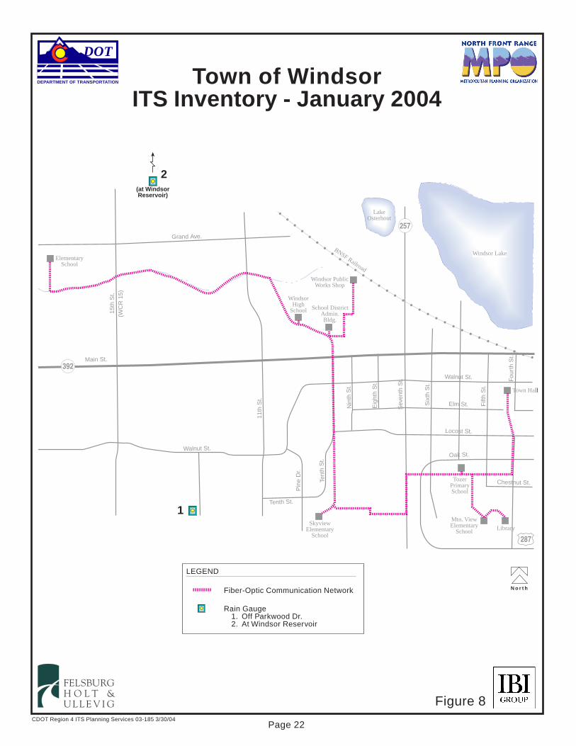
CDOT Region 4 ITS Planning Services 03-185 3/30/04
DEPARTMENT OF TRANSPORTATION
DOT
N o r t h
FELSBURGH O L T &U L L E V I G
Town of WindsorITS Inventory - January 2004
Windsor PublicWorks Shop
WindsorHigh
School School DistrictAdmin.Bldg.
ElementarySchool
SkyviewElementary
School
TozerPrimarySchool
Town Hall
Mtn. ViewElementary
School Library
Main St.
Grand Ave.
15th
St.
(WC
R 1
5)
Walnut St.
11th
St.
Pin
e D
r.
Tenth St.
Tent
h S
t.
Walnut St.
Elm St.
Locost St.
Oak St.
Chestnut St.
BNSF Railroad
Nin
th S
t.
Eig
hth
St.
Sev
enth
St.
Six
th S
t.
Fift
h S
t.
Fou
rth
St.
Windsor Lake
LakeOsterhout
Fiber-Optic Communication Network
Rain Gauge1. Off Parkwood Dr.2. At Windsor Reservoir
LEGEND
287
392
257
Windsor PublicWorks Shop
WindsorHigh
School School DistrictAdmin.Bldg.
ElementarySchool
SkyviewElementary
School
TozerPrimarySchool
Town Hall
Mtn. ViewElementary
School Library
Main St.
Grand Ave.
15th
St.
(WC
R 1
5)
Walnut St.
11th
St.
Pin
e D
r.
Tenth St.
Tent
h S
t.
Walnut St.
Elm St.
Locost St.
Oak St.
Chestnut St.
BNSF Railroad
Nin
th S
t.
Eig
hth
St.
Sev
enth
St.
Six
th S
t.
Fift
h S
t.
Fou
rth
St.
Windsor Lake
LakeOsterhout
287
392
257
(at WindsorReservoir)
1
2
Figure 8
Page 22

Regional ITS Architecture March 30, 2004
Page 23
E. Regional Transportation Issues Through the stakeholder and ITS Working Group meetings, a group of critical regional transportation issues that could be positively addressed by ITS applications were identified and defined. The summary of these issues is listed in Table 3. Table 3. Transportation Issues in Study Area
Corridor Improvement Problems � Greater density of traffic count stations � Greater availability of vehicle detection data � Greater density of weather stations and pavement sensors � En-route traffic conditions information (DMS, HAR) along key corridors and in urban areas � Traffic cameras at key interchanges � Synchronized and interconnected traffic signals on state highways � Speed warnings at hazardous locations � Anti-icing systems at hazardous locations � Support for protection of key infrastructure
Advanced Public Transportation Systems Problems � Electronic fare coordination between agencies � Multi-modal coordination with other transit agencies � Online trip planning services � Transit Signal Priority � Fee collection management at parking facilities � Traffic, incident and weather conditions data from other transportation agencies
Safety and Incident Management Problems � Improved highway-rail intersection safety � Regional incident management planning and routing � Improved management of road closures
Parking Management Problems � Parking management system in Estes Park
Center-to-Center Communications Problems � Improved data sharing between agencies � Communications infrastructure plan to accommodate ITS systems
Traveler Information Problems � Increased dissemination of congestion information, incident information, construction and roadway
closures information Emergency Management Problems
� Routing for emergency vehicles during congestion, incidents, and around train blockages � Protective measures for critical infrastructure
Maintenance and Construction Management Problems � Construction zone management and routing � Ice detection and control � Improved tracking and data collection from maintenance and emergency vehicles
Archived Data Management Problems � Improved ease of access to interagency transportation data.

Regional ITS Architecture March 30, 2004
Page 24
IV. MARKET PACKAGES SELECTION Market packages may be considered the “building blocks” of the National ITS Architecture, and are a “turning point” in the development of a ITS Strategic Plan or Regional ITS Architecture because the process of translating local needs, plans, and programs to ITS market packages provides the systems engineering perspective that is crucial to ITS planning (and required by the FHWA and FTA). Currently, there are 85 market packages included in the National ITS Architecture8. Market packages are grouped in the National ITS Architecture based upon the type of transportation service provided, as follows: � Advanced Traffic Management System (ATMS): Manage operation of the roadway
network. � Advanced Traveler Information System (ATIS): Provide real-time information to travelers. � Advanced Public Transportation System (APTS): Manage transit operations and make
transit use more convenient and safe. � Emergency Management (EM): Manage emergency response operations. � Maintenance and Construction Management (MCM): Manage maintenance and
construction activities and operations. � Commercial Vehicle Operations (CVO): Provides for the electronic monitoring of
commercial vehicle safety assurance and regulation, and exchange of related information. � Archived Data Management (AD): Store and retrieve transportation system information for
future analysis. � Advanced Vehicle Safety Systems (AVSS): Adds capability for improved safety to
vehicles. These market packages are generally applicable to private-sector industry initiatives only. Therefore, they were not considered in the analysis.
Market packages for the study area were selected in consultation with the ITS Working Group, identifying those market packages that expressly dealt with the transportation issues identified in Section III.E. The following subsections discuss each of these service areas and market packages selected for this study.
8 National ITS Architecture, Version 5.0

Regional ITS Architecture March 30, 2004
Page 25
A. Advanced Traffic Management Systems From discussions with stakeholders, the primary need in the study area is for roadway surveillance equipment in order to better monitor conditions and detect incidents. Other key needs include centralized or interconnected signal systems in rural areas (the cities of Greeley, Loveland and Fort Collins have already implemented such systems) and means of disseminating roadway information en-route to travelers via additional DMS and HAR. ATMS devices located along I-25 in the study area will be controlled by the CTMC in Lakewood. CDOT is currently undertaking the ATMS/ATIS Integration Project, a comprehensive attempt to integrate information from a wide range of roadside devices, as well as develop a "three-node" core of first tier centers: the CTMC, Colorado Springs Traffic Operations Center (CSTOC) and the Hanging Lake Tunnels Traffic Operations Center (HLT). According to the long-term vision of the ATMS/ATIS Integration project, the CTMC will be the "overall statewide center (and) will use the CSTOC and HLT as localized/regional hubs for the distribution of data and system functions within their own areas." The ATMS/ATIS Integration Project also proposes to allow increased bi-directional information sharing for traffic, incidents, weather and camera images, as well as providing bi-directional control of local devices. Other issues that may be addressed by market packages in this service area include incident management, parking management in Estes Park, and safety concerns such as highway-rail intersections, excessive speeds in some locations, and effective handling of road closures. Future considerations include: � A need for emissions monitoring and management to support the compliance with EPA
regulations. � Future High Occupancy Vehicle (HOV) lanes on I-25 at the south end of the study area. � Possible expansion of the High Occupancy Toll (HOT) Lanes program in the Denver region
to other parts of the state.

Regional ITS Architecture March 30, 2004
Page 26
Table 4 lists the selected ATMS market packages for the study area. Table 4 Selected ATMS Market Packages
Market Package Name Brief Description
Network Surveillance Collects information from field devices (detectors, CCTV, etc.) for monitoring of roadway conditions.
Surface Street Control Provides traffic signal control.
Freeway Control Controls devices installed along freeways, including control of cameras and dynamic message signs.
HOV Lane Management Manages HOV lanes by coordinating freeway ramp meters and connector signals with HOV lane usage signals
Traffic Information Dissemination Supports Dynamic Message Signs and Highway Advisory Radio
Regional Traffic Control Provides for the sharing of traffic information and control among traffic management centers to support a regional control strategy.
Incident Management System Detects incidents and provides links between transportation and emergency management centers to exchange information.
Traffic Forecast and Demand Management
Uses historical traffic data to predict future demand.
Electronic Toll Collection Uses electronic “tags” to collect tolls and process violations without requiring motorists to stop.
Emissions Monitoring and Management
Monitors individual vehicle emissions and provides general air quality monitoring using distributed sensors to collect the data.
Standard Railroad Grade Crossing Manages highway traffic at highway-rail intersections where rail operational speeds are less than 80 miles per hour.
Railroad Operations Coordination Provides an information link between rail operations and traffic management centers and emergency dispatch.
Parking Facility Management Provides monitoring and management of parking facilities.
Regional Parking Management Supports coordination between parking facilities to enable regional parking management strategies.
Speed Monitoring Monitors speeds of vehicles on roadways. DMS can then be used to post a safe speed reminder.
Roadway Closure Management Supports remotely controlled gates or barriers that close off roads in unsafe conditions, plus camera surveillance and traveler information.

Regional ITS Architecture March 30, 2004
Page 27
B. Advanced Traveler Information Systems The two primary market packages for providing traveler information are Broadcast Traveler Information, which relies on existing, low-cost broadcast communications to “push” information out to travelers (such as via fax or public television), and Interactive Traveler Information, which provides customized information in response to a request, such as via a web site or through an Interactive Voice Response (IVR) phone system. There are several existing broadcast and interactive traveler information systems existing and planned, including city and CDOT web sites, HAR, CDOT road conditions faxes, and future statewide CDOT 511 phone system. The CDOT ATMS/ATIS Integration Project will seek to enable central control of ATIS devices, and to provide statewide traveler information via CoTrip and 511. The study area also has an existing carpool match system that is currently operated by the North Front Range MPO with a 24-hour turnaround time. Plans are underway to upgrade to a real-time ride matching system. Table 5 lists the selected ATIS market packages for the study area. Table 5. Selected ATIS Market Packages
Market Package Name Brief Description
Broadcast Traveler Information Disseminates information over a wide area through existing infrastructures and low cost user equipment.
Interactive Traveler Information Provides tailored information in response to a traveler request. Includes dynamic web pages and 511 telephone information.
Dynamic Ridesharing Provides dynamic ridesharing/ride matching capability in real time. Some large companies provide this service.
C. Advanced Public Transportation Systems The three primary transit agencies in the study area: 1) Transfort (serving Fort Collins), 2) City of Loveland Transit (COLT), and 3) The Bus (Greeley), are all at various stages of deploying similar technologies, including Automatic Vehicle Location (AVL), Computer Aided Dispatch (CAD), electronic fare collection, and improved transit traveler information. As a result, these agencies have a unique cooperative opportunity to coordinate on the planning, procurement, and deployment of these technologies on a regional basis. Joint deployment will ensure that the transit agencies are able to easily share and exchange information, and can result in cost savings and greater “bargaining” power for procurement.
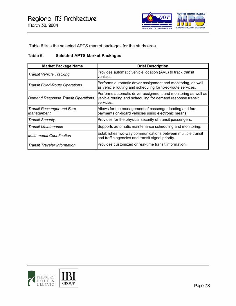
Regional ITS Architecture March 30, 2004
Page 28
Table 6 lists the selected APTS market packages for the study area. Table 6. Selected APTS Market Packages
Market Package Name Brief Description
Transit Vehicle Tracking Provides automatic vehicle location (AVL) to track transit vehicles.
Transit Fixed-Route Operations Performs automatic driver assignment and monitoring, as well as vehicle routing and scheduling for fixed-route services.
Demand Response Transit Operations Performs automatic driver assignment and monitoring as well as vehicle routing and scheduling for demand response transit services.
Transit Passenger and Fare Management
Allows for the management of passenger loading and fare payments on-board vehicles using electronic means.
Transit Security Provides for the physical security of transit passengers.
Transit Maintenance Supports automatic maintenance scheduling and monitoring.
Multi-modal Coordination Establishes two-way communications between multiple transit and traffic agencies and transit signal priority.
Transit Traveler Information Provides customized or real-time transit information.
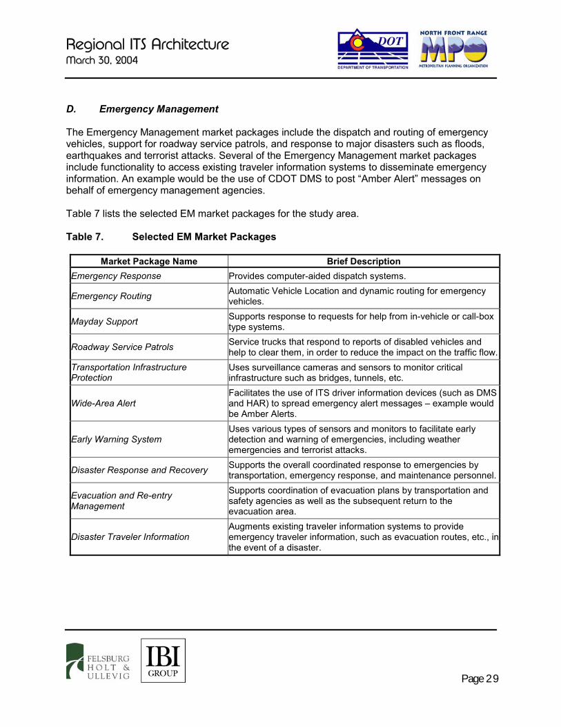
Regional ITS Architecture March 30, 2004
Page 29
D. Emergency Management The Emergency Management market packages include the dispatch and routing of emergency vehicles, support for roadway service patrols, and response to major disasters such as floods, earthquakes and terrorist attacks. Several of the Emergency Management market packages include functionality to access existing traveler information systems to disseminate emergency information. An example would be the use of CDOT DMS to post “Amber Alert” messages on behalf of emergency management agencies. Table 7 lists the selected EM market packages for the study area. Table 7. Selected EM Market Packages
Market Package Name Brief Description Emergency Response Provides computer-aided dispatch systems.
Emergency Routing Automatic Vehicle Location and dynamic routing for emergency vehicles.
Mayday Support Supports response to requests for help from in-vehicle or call-box type systems.
Roadway Service Patrols Service trucks that respond to reports of disabled vehicles and help to clear them, in order to reduce the impact on the traffic flow.
Transportation Infrastructure Protection
Uses surveillance cameras and sensors to monitor critical infrastructure such as bridges, tunnels, etc.
Wide-Area Alert Facilitates the use of ITS driver information devices (such as DMS and HAR) to spread emergency alert messages – example would be Amber Alerts.
Early Warning System Uses various types of sensors and monitors to facilitate early detection and warning of emergencies, including weather emergencies and terrorist attacks.
Disaster Response and Recovery Supports the overall coordinated response to emergencies by transportation, emergency response, and maintenance personnel.
Evacuation and Re-entry Management
Supports coordination of evacuation plans by transportation and safety agencies as well as the subsequent return to the evacuation area.
Disaster Traveler Information Augments existing traveler information systems to provide emergency traveler information, such as evacuation routes, etc., in the event of a disaster.

Regional ITS Architecture March 30, 2004
Page 30
E. Maintenance and Construction Management Market packages in this service area may be linked to problems concerning maintenance vehicles, work zones, and collecting/distributing weather and road conditions data. Currently, the cities of Fort Collins, Windsor, Greeley, Loveland, as well as CDOT Region 4, have deployed weather stations that are interconnected and can share data. Additionally, CDOT has deployed a statewide network of weather stations, the data from which are available on the CoTrip web site as well as more detailed information available separately for CDOT maintenance. However, more weather stations are needed in order to have a proper “grid” providing weather data collection throughout the region. Additional pavement sensors and anti-icing systems are also needed. Several cities are planning to install vehicle tracking systems on maintenance vehicles, including street sweepers and striping trucks. Table 8 lists the selected MCM market packages for the study area. Table 8. Selected MCM Market Packages
Market Package Name Brief Description Maintenance and Construction Vehicle and Equipment Tracking
Tracks the location of maintenance and construction vehicles and other equipment.
Maintenance and Construction Vehicle Maintenance
On-board diagnostics that provide maintenance and repair information for snowplows, trucks, etc.
Road Weather Data Collection Collection of weather and road conditions data using sensors installed near the roadway.
Weather Information Processing and Distribution
Processing and dissemination of road/weather conditions information to travelers, maintenance workers, etc.
Roadway Automated Treatment Automated anti-icing systems for bridges and roadways.
Winter Maintenance Supports winter road maintenance including snowplow operations, roadway treatments (i.e., salt spraying, etc.)
Roadway Maintenance and Construction
Supports scheduled and unscheduled maintenance and construction of ITS and non-ITS equipment.
Work Zone Management Enables construction delay and routing information to be provided en-route to drivers, and also facilitates providing this information to other agencies.
Work Zone Safety Monitoring “Intrusion Alarms” and other devices that warn if a vehicle is approaching a work zone at a high rate of speed or has entered the work zone. May also monitor movements of workers.
Maintenance and Construction Activity Coordination
Coordination of maintenance and construction activities between various agencies for improved operations.
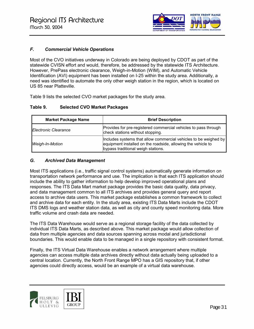
Regional ITS Architecture March 30, 2004
Page 31
F. Commercial Vehicle Operations Most of the CVO initiatives underway in Colorado are being deployed by CDOT as part of the statewide CVISN effort and would, therefore, be addressed by the statewide ITS Architecture. However, PrePass electronic clearance, Weigh-in-Motion (WIM), and Automatic Vehicle Identification (AVI) equipment has been installed on I-25 within the study area. Additionally, a need was identified to automate the only other weigh station in the region, which is located on US 85 near Platteville. Table 9 lists the selected CVO market packages for the study area. Table 9. Selected CVO Market Packages
Market Package Name Brief Description
Electronic Clearance Provides for pre-registered commercial vehicles to pass through check stations without stopping.
Weigh-In-Motion Includes systems that allow commercial vehicles to be weighed by equipment installed on the roadside, allowing the vehicle to bypass traditional weigh stations.
G. Archived Data Management Most ITS applications (i.e., traffic signal control systems) automatically generate information on transportation network performance and use. The implication is that each ITS application should include the ability to gather information to help develop improved operational plans and responses. The ITS Data Mart market package provides the basic data quality, data privacy, and data management common to all ITS archives and provides general query and report access to archive data users. This market package establishes a common framework to collect and archive data for each entity. In the study area, existing ITS Data Marts include the CDOT ITS DMS logs and weather station data, as well as city and county speed monitoring data. More traffic volume and crash data are needed. The ITS Data Warehouse would serve as a regional storage facility of the data collected by individual ITS Data Marts, as described above. This market package would allow collection of data from multiple agencies and data sources spanning across modal and jurisdictional boundaries. This would enable data to be managed in a single repository with consistent format. Finally, the ITS Virtual Data Warehouse enables a network arrangement where multiple agencies can access multiple data archives directly without data actually being uploaded to a central location. Currently, the North Front Range MPO has a GIS repository that, if other agencies could directly access, would be an example of a virtual data warehouse.

Regional ITS Architecture March 30, 2004
Page 32
Table 10 lists the Archived Data market packages. Table 10. Selected Archived Data Market Packages
Market Package Name Brief Description ITS Data Mart Collect data for future analysis for one agency only. ITS Data Warehouse Store data for multiple agencies. ITS Virtual Data Warehouse Supports networked access to data archives for multiple agencies. The following section discusses the process for developing the ITS project list, based upon this selection of market packages.
Regional ITS Architecture March 30, 2004
Page 33
V. OPERATIONAL CONCEPT The Operational Concept for the study area defines the roles and responsibilities of the participating key stakeholder agencies, as well as identifies information flows between the agencies. In the National ITS Architecture, market packages include a depiction relationship and data flow between different entities providing the “service” provided by the deployment of the market package. For example, the incident management system market package requires that traffic management and emergency management centers exchange information. This implies that an operational concept and an institutional relationship be established between the two organizations that are cooperating. Therefore, the identification of which market packages are and will be deployed in the study area led the way to defining the Operational Concept. Additionally, information used to develop the Operational Concept was gleaned from follow-up interviews with the stakeholder agencies regarding their current and desired level of operational interaction with other transportation and safety agencies. A. Operational Concept Overview The purpose of the Operational Concept is to describe the roles and responsibilities of the participating transportation, transit and safety agencies and other providers, and to discuss the resources that each agency will apply or contribute in the deployment of ITS. The Operational Concept establishes the roles and responsibilities between organizations including responsibilities for implementation, operation and maintenance and the level of information, status, and control sharing among the entities. The reasons for developing an Operational Concept include: � Maintaining conformance with USDOT Regional ITS Architecture Guidelines. � Identifying the requirements of, and laying the groundwork for, the necessary institutional
agreements, such as Memorandums of Understanding (MOUs) and Inter-Governmental Agreements (IGAs).
� Identifying outstanding issues, agreements, and relationships to be developed by the ITS
Working Group. � Identifying suggestions for continued regional coordination and cooperation during
implementation of the Regional ITS Architecture. Relationships between agencies embody two main components: � The roles and responsibilities that each agency plays in the relationship, and � The kinds of information that are shared between the agencies.
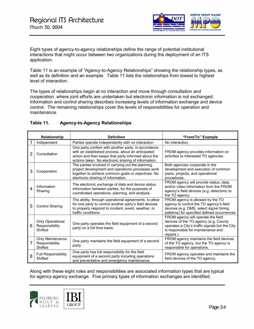
Regional ITS Architecture March 30, 2004
Page 34
Eight types of agency-to-agency relationships define the range of potential institutional interactions that might occur between two organizations during the deployment of an ITS application. Table 11 is an example of “Agency-to-Agency Relationships” showing the relationship types, as well as its definition and an example. Table 11 lists the relationships from lowest to highest level of interaction. The types of relationships begin at no interaction and move through consultation and cooperation, where joint efforts are undertaken but electronic information is not exchanged. Information and control sharing describes increasing levels of information exchange and device control. The remaining relationships cover the levels of responsibilities for operation and maintenance. Table 11. Agency-to-Agency Relationships
Relationship Definition “From/To” Example 1 Independent Parties operate independently with no interaction No interaction.
2 Consultation
One party confers with another party, in accordance with an established process, about an anticipated action and then keeps that party informed about the actions taken. No electronic sharing of information.
FROM agency provides information on activities to interested TO agencies.
3 Cooperation
The parties involved in carrying out the planning, project development and operations processes work together to achieve common goals or objectives. No electronic sharing of information.
Both agencies cooperate in the development and execution of common plans, projects, and operational procedures.
4 Information Sharing
The electronic exchange of data and device status information between parties, for the purposes of coordinated operations, planning, and analysis.
FROM agency will provide status, data, and/or video information from the FROM agency’s field devices (e.g. detectors) to the TO agency.
5 Control Sharing
The ability, through operational agreements, to allow for one party to control another party’s field devices to properly respond to incident, event, weather, or traffic conditions
FROM agency is allowed by the TO agency to control the TO agency’s field devices (e.g. DMS, select signal timing patterns) for specified defined occurrences
6 Only Operational Responsibility Shifted
One party operates the field equipment of a second party on a full time basis.
FROM agency will operate the field devices of the TO agency (e.g. County operates a City’s traffic signals but the City is responsible for maintenance and repairs.)
7 Only Maintenance Responsibility Shifted
One party maintains the field equipment of a second party.
FROM agency maintains the field devices of the TO agency, but the TO agency is responsible for operations.
8 Full Responsibility Shifted
One party has full responsibility for the field equipment of a second party including operations and preventative and emergency maintenance.
FROM agency operates and maintains the field devices of the TO agency.
Along with these eight roles and responsibilities are associated information types that are typical for agency-agency exchange. Five primary types of information exchanges are identified.

Regional ITS Architecture March 30, 2004
Page 35
Table 12 is an example “Information Flow Definitions” which provide both definitions and examples for each information type. These “information types” are related to the more specific “information flows” generated from the regional ITS Architecture. While the architecture defines data flow by specific market packages, the Operational Concept rolls those up into higher-level agency-agency flows, such as data, video, status, request and control. Table 12 Information Flow Definitions Information
Flows Definition “From/To” Example
Data
The dissemination of data gathered from one party’s field devices to another party. Data can include, but is not limited to, traffic, weather, parking, transit data, etc.
FROM agency sends data to the TO agency’s field devices.
Video The dissemination of live video and still images from one party’s field camera’s to another party.
FROM agency sends live video and still images to the TO agency.
Status
The ability for one party to monitor another party’s field devices, and receive such information as current signal timing/response plan, current message sets, etc.
FROM agency sends status information on its devices to the TO agency.
Request
The ability for one party to solicit either data or a command change, such as DMS messaging or signal timings, from another party.
FROM agency requests information or action from the TO agency.
Control
The ability for one party to control another party’s field devices. Control can include but is not limited to, changing DMS messaging, changing traffic signal timings, camera control, etc.
FROM agency issues control instruction to the TO agency’s field devices.

Regional ITS Architecture March 30, 2004
Page 36
Section IV presented the market packages selected for the region. Most market packages do not require interaction with other organizations, and can be generally implemented as stand-alone applications locally. In these cases, the market package itself defines the operational concept for deployment. However, several market packages have been identified as requiring jurisdictional interaction and the need to define regional operational concepts. These market packages are:
� Regional Traffic Control
� Broadcast and Interactive Traveler Information
� Regional Transit Operations (taking a regional view of transit ITS deployments)
� Incident Management
� Weather Data Collection and Dissemination
� Commercial Vehicle Operations
� ITS Data Warehouse
� Emissions Monitoring and Management
� Rail Operations Coordination
Each of these market packages requires an operational concept that will involve multiple jurisdictional relationships. In several cases, multiple traffic and emergency management agencies will need to form relationships with each other to define specific roles and responsibilities for the deployment of the market package. B. Regional Traffic Control This market package allows for flow of information among traffic management systems and centers and allows a unified approach to highway network management. This market package enables the sharing of data, CCTV images and device control between TMCs. The CDOT CTMC is intended to generally serve as the concentration point for Regional Traffic Control. CDOT ITS Branch, CDOT Region 4, cities and counties will ideally coordinate the sharing of data and/or control of field equipment to better respond to traffic congestion. The National ITS Architecture defines Regional Traffic Control as “This market package provides for the sharing of traffic information and control among traffic management centers to support a regional control strategy. This market package advances the Surface Street Control and Freeway Control Market Packages by adding the communications links and integrated control strategies that enable integrated interjurisdictional traffic control. The nature of optimization and the extent of information and control sharing is determined through working

Regional ITS Architecture March 30, 2004
Page 37
arrangements between jurisdictions. This package relies principally on roadside instrumentation supported by the Surface Street Control and Freeway Control Market Packages and adds hardware, software, and fixed-point to fixed-point communication capabilities to implement traffic management strategies that are coordinated between allied traffic management centers. Several levels of coordination are supported from sharing of information through sharing of control between traffic management centers.”9 The Regional Traffic Control Operational Concept focuses on the regional exchange of information between agencies for the purpose of relieving congestion and providing each participating agency with a “wide view” of the conditions on the road network – that is, conditions that are outside of their jurisdiction but still impact “their” roadways. Specifically, this operational concept provides for data (such as signal timing plans) and video exchanges between the CDOT CTMC, CDOT Region 4, and local agencies. There are five main relationships between jurisdictions with respect to Regional Traffic Control that have been identified: � CTMC to Local TMC: In this relationship, the local jurisdiction with traffic management
center and CTMC, operated by the CDOT ITS Branch, will be linked to allow for the potential of sharing traffic data and control.
� Local TMC to Adjacent Local TMC: In this relationship, adjacent jurisdictions with traffic management centers will be linked to allow for the potential of sharing traffic data and/or control.
� Local TMC to non-Adjacent Local TMC: In situations where traffic conditions in a non-adjacent jurisdiction can impact conditions in another jurisdiction, the relationship between the two jurisdictions is generally based on “requests” to allow sharing of data. Where there are no impacts from the non-adjacent agency, the relationship would involve no interaction and thus be independent.
� Local TMC to Non-Operator: This relationship involves a jurisdiction, such as Estes Park, that does not operate any field devices, but rather has another jurisdiction operate and maintain its signals. This relationship is considered a cooperative effort because there is no sharing of information or control. In these scenarios, agencies cooperate in the development and implementation of common operational procedures. It is an important relationship to illustrate because it indicates areas where there is the capability to implement a “regional or area wide” approach to traffic control.
9 USDOT, National ITS Architecture, Version 5.0

Regional ITS Architecture March 30, 2004
Page 38
� Local TMC to Operator (without Center): This relationship involves a jurisdiction that does not yet have a traffic management center and operates equipment such as signals without a signal system. In this scenario, there are no electronic links between agencies. However, the relationship between the agencies can be defined as cooperation. For example, in the absence of electronic links, situation specific signal timing plans may need to be activated manually through cooperation between the agencies.
To characterize the regional traffic control effort, five high level information exchanges have been identified to define the operational concept for each jurisdiction. These have been preliminarily formulated to demonstrate the actual exchanges that can happen between centers. They are: � Data: A Data function will include, but not be limited to, the sharing of road condition
detector data and signal timing.
� Video: Video will be shared for the purpose of monitoring traffic conditions. This allows implementation of regional control strategies that take into account traffic conditions beyond each individual jurisdiction.
� Status: The Status information type provides for sharing equipment status information, such as signal plan implementation or setting a message on a DMS.
� Request: In jurisdictional relationships where command of equipment and sharing of data is not direct, whether by agreement or the lack of a center, a Request function is necessary to “ask” for a modification to signal timing, etc.
� Control: A Control function will include implementing signal timing plans, etc., per jurisdiction-to-jurisdiction agreements. This allows for equipment in one jurisdiction to be controlled by another jurisdiction.
C. Broadcast and Interactive Traveler Information Partners in the ITS Working Group desire to expand current traveler information services provided within the region. The National ITS Architecture identifies two market packages that primarily support this function. Broadcast Traveler Information is defined as “This market package provides the user with a basic set of ATIS services; its objective is early acceptance. It involves the collection of traffic conditions, advisories, general public transportation, toll and parking information, incident information, air quality and weather information, and the near real time dissemination of this information over a wide area through existing infrastructures and low cost user equipment (e.g., FM subcarrier, cellular data broadcast).”10 10 USDOT, National ITS Architecture, Version 5.0

Regional ITS Architecture March 30, 2004
Page 39
Interactive Traveler Information is defined as “This market package provides tailored information in response to a traveler request. Both real-time interactive request/response systems and information systems that "push" a tailored stream of information to the traveler based on a submitted profile are supported. The traveler can obtain current information regarding traffic conditions, transit services, ride share/ride match, parking management, and pricing information.”11 The CDOT ITS Branch is primarily responsible for the statewide transportation management and traveler information system. The information being collected includes roadway, traffic and construction conditions, traffic advisories, incident and weather information. The information is being disseminated through the CoTrip website, broadcast fax, toll-free phone system, media providers and other partners, and on the roadway via DMS, HAR and cell phones/PDA’s.12 The ITS Strategic Plan for the study area has identified several new regional traveler information projects, including regional web sites and public television broadcasts. Transit traveler applications were also included, such as online trip planning and providing “next bus” information. The CDOT ITS Branch would likely take the role of primary Information Service Provider (ISP) in the study area, with an information-sharing link to local or regional public and private ISPs. An information sharing relationship has been identified between CTMC and all other agencies with respect to Broadcast and Interactive Traveler Information. The agencies include traffic management, transit management, emergency management (including law enforcement) and the media. Information such as roadway network conditions and traffic conditions, transit system performance, transit AVL data, incident information, travel time information, roadway statistics, etc. will be collected by the CTMC from various agencies. The CTMC will condense the information and disseminate the information in near real time to other agencies and local/regional ISPs. The National ITS Architecture provides two subsystems that represent the accessing of traveler information by the public. These are Remote Traveler Support and Personal Information Access. Remote Traveler Support refers to field devices such as the existing CDOT kiosks that provide static or dynamic traveler information. Personal Information Access refers to the accessing of customized traveler information via a personal electronic device such as a home computer, cell phone or PDA.
11 US DOT, National ITS Architecture, Version 5.0. 12 On July 21, 2000, the Federal Communications Commission (FCC) designated 511 as the nationwide telephone number
for traveler information and has given the state and local agencies the responsibility of implementing the traveler information service. The FCC will review the implementation progress in 2005.
FOR MORE INFORMATION
CoTrip Website http://www.cotrip.org
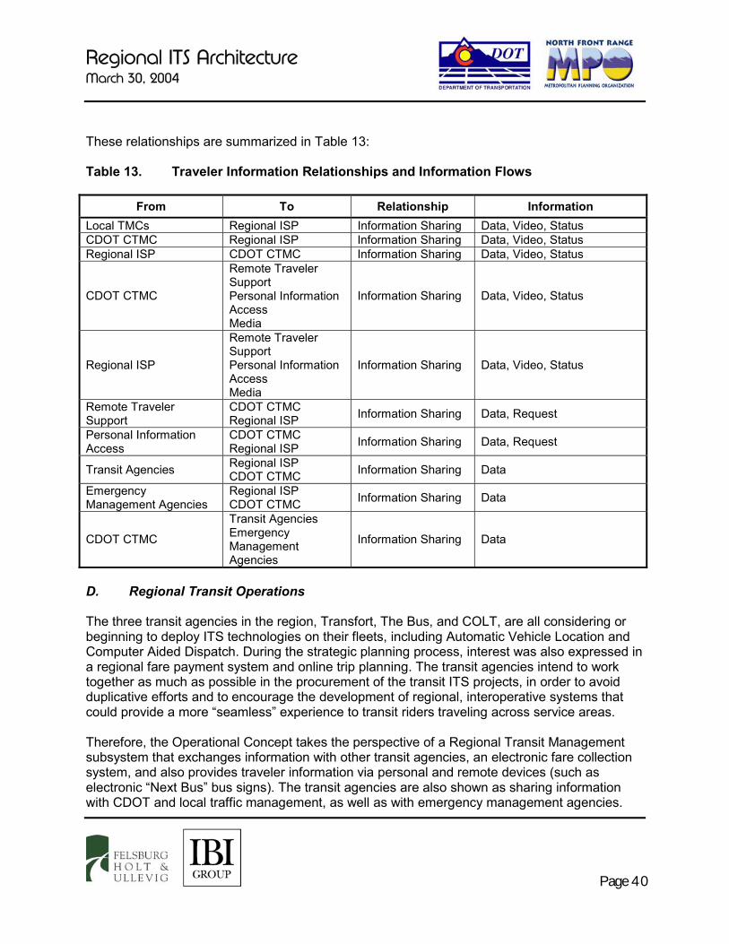
Regional ITS Architecture March 30, 2004
Page 40
These relationships are summarized in Table 13: Table 13. Traveler Information Relationships and Information Flows
From To Relationship Information Local TMCs Regional ISP Information Sharing Data, Video, Status CDOT CTMC Regional ISP Information Sharing Data, Video, Status Regional ISP CDOT CTMC Information Sharing Data, Video, Status
CDOT CTMC
Remote Traveler Support Personal Information Access Media
Information Sharing Data, Video, Status
Regional ISP
Remote Traveler Support Personal Information Access Media
Information Sharing Data, Video, Status
Remote Traveler Support
CDOT CTMC Regional ISP Information Sharing Data, Request
Personal Information Access
CDOT CTMC Regional ISP Information Sharing Data, Request
Transit Agencies Regional ISP CDOT CTMC Information Sharing Data
Emergency Management Agencies
Regional ISP CDOT CTMC Information Sharing Data
CDOT CTMC
Transit Agencies Emergency Management Agencies
Information Sharing Data
D. Regional Transit Operations The three transit agencies in the region, Transfort, The Bus, and COLT, are all considering or beginning to deploy ITS technologies on their fleets, including Automatic Vehicle Location and Computer Aided Dispatch. During the strategic planning process, interest was also expressed in a regional fare payment system and online trip planning. The transit agencies intend to work together as much as possible in the procurement of the transit ITS projects, in order to avoid duplicative efforts and to encourage the development of regional, interoperative systems that could provide a more “seamless” experience to transit riders traveling across service areas. Therefore, the Operational Concept takes the perspective of a Regional Transit Management subsystem that exchanges information with other transit agencies, an electronic fare collection system, and also provides traveler information via personal and remote devices (such as electronic “Next Bus” bus signs). The transit agencies are also shown as sharing information with CDOT and local traffic management, as well as with emergency management agencies.
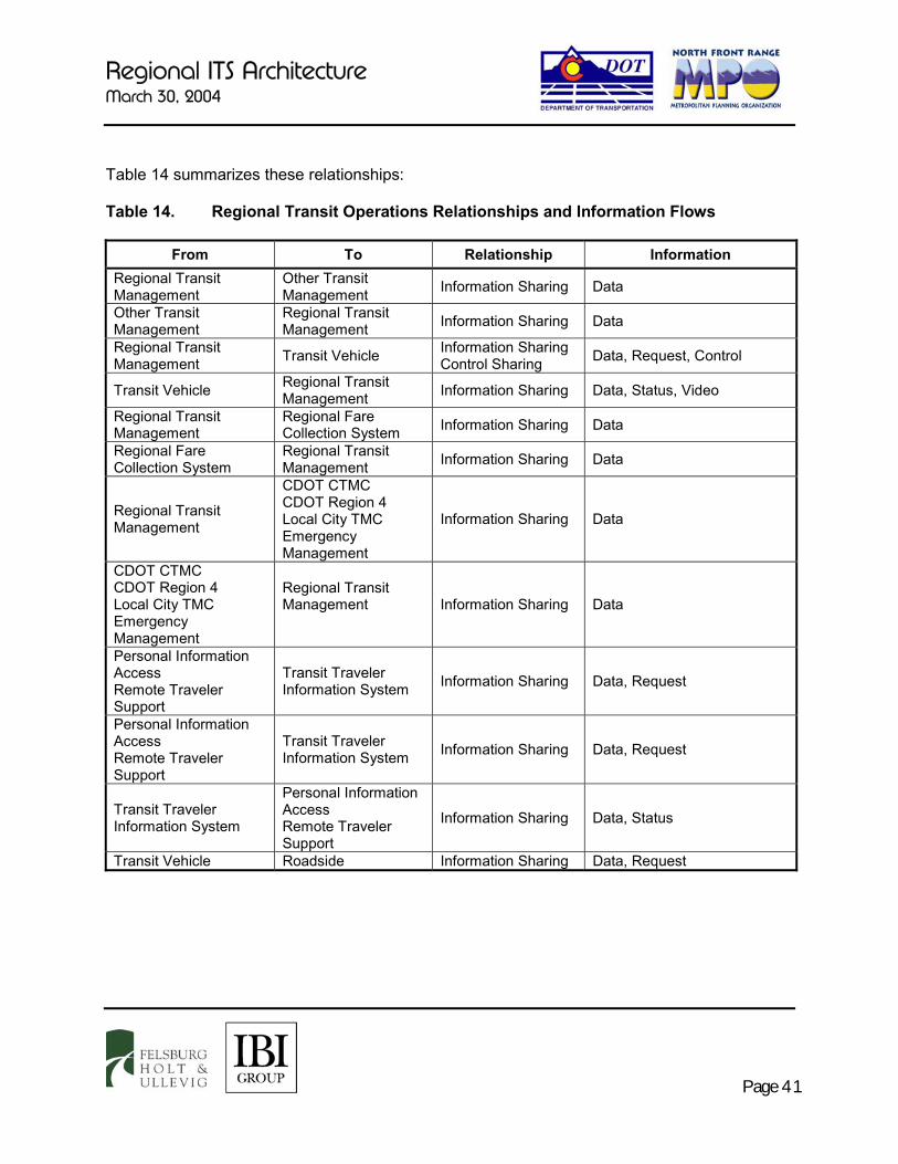
Regional ITS Architecture March 30, 2004
Page 41
Table 14 summarizes these relationships: Table 14. Regional Transit Operations Relationships and Information Flows
From To Relationship Information Regional Transit Management
Other Transit Management Information Sharing Data
Other Transit Management
Regional Transit Management Information Sharing Data
Regional Transit Management Transit Vehicle Information Sharing
Control Sharing Data, Request, Control
Transit Vehicle Regional Transit Management Information Sharing Data, Status, Video
Regional Transit Management
Regional Fare Collection System Information Sharing Data
Regional Fare Collection System
Regional Transit Management Information Sharing Data
Regional Transit Management
CDOT CTMC CDOT Region 4 Local City TMC Emergency Management
Information Sharing Data
CDOT CTMC CDOT Region 4 Local City TMC Emergency Management
Regional Transit Management
Information Sharing Data
Personal Information Access Remote Traveler Support
Transit Traveler Information System Information Sharing Data, Request
Personal Information Access Remote Traveler Support
Transit Traveler Information System Information Sharing Data, Request
Transit Traveler Information System
Personal Information Access Remote Traveler Support
Information Sharing Data, Status
Transit Vehicle Roadside Information Sharing Data, Request

Regional ITS Architecture March 30, 2004
Page 42
E. Incident Management This market package manages both predicted and unexpected incidents so that the impact to the transportation network and traveler safety is minimized. One of the components of incident management is the use of technology to collect and correlate information from diverse sources (traffic, transit, law enforcement and emergency management centers, weather services entities and event promoters) to detect and verify incidents and implement response. The National ITS Architecture defines Incident Management as “This market package manages both unexpected incidents and planned events so that the impact to the transportation network and traveler safety is minimized. The market package includes incident detection capabilities through roadside surveillance devices (e.g. CCTV) and through regional coordination with other traffic management, maintenance and construction management and emergency management centers as well as rail operations and event promoters. Information from these diverse sources is collected and correlated by this market package to detect and verify incidents and implement an appropriate response. This market package supports traffic operations personnel in developing an appropriate response in coordination with emergency management, maintenance and construction management, and other incident response personnel to confirmed incidents.”13 Within the region, an incident management plan has been developed for I-25, as well as plans for several smaller areas. The ITS Strategic Plan for this study area calls for the expansion of the I-25 plan to a region-wide coordinated response plan to handle incidents and events. The implementation of a coordinated response effort requires a technology component that provides for the near real-time sharing of incident information and transportation system condition information between traffic management agencies and emergency management agencies to enable quicker detection and verification of incidents and implementation of a coordinated and efficient response. At this time, few physical communication linkages between TMCs and emergency management centers exist. There are a variety of entities throughout the region that must have an active role within this market package to accomplish a coordinated response to incident situations. From an incident management perspective the following stakeholders have been identified: � CTMC and CDOT Region 4 � Ambulance Services � Colorado State Patrol � County Dispatch Centers � Local traffic management � Hospitals � Police Departments � Emergency Management Centers � Fire Departments � Transit agencies
13 USDOT, National ITS Architecture, Version 5.0
Regional ITS Architecture March 30, 2004
Page 43
Depending on the level of jurisdiction (state or local), different relationships between traffic management and emergency management occur. In general three relationships have been identified as being necessary to support the Incident Management function. These are: � Traffic and Transit Management to Emergency Management: This relationship
consists of coordinated sharing of incident information and related traffic conditions. The relationship with transit includes coordination in the case that the public needs to be evacuated from an area.
� Traffic Management to Traffic Management: For some incidents, coordination among multiple traffic management agencies will be needed. This coordination would include incident information, traffic information, and response plan implementation.
� Emergency, Transit or Traffic Management to Information Service Provider: This relationship will involve the sharing of incident information and related traffic condition information with ISPs for the dissemination to the general public.
To characterize the incident management effort, five high-level information exchanges have been identified to define the operational concept for each agency. These have been preliminarily formulated to demonstrate the actual exchanges that can happen between centers. They are: � Data: A Data function will include the sharing of incident and related traffic information.
� Video: Video will be shared for the purpose of incident detection, verification of incident conditions, and monitoring incident response activities. This will allow jurisdictions to implement and monitor response plans.
� Status: In order to take proper action in a regional incident response, it is important to know what messaging is currently on DMS and HAR that is controlled by other jurisdictions, and what signal response plans others are using. The Status information type provides for sharing equipment status information.
� Request: In jurisdictional relationships where command of equipment and sharing of data is not direct, whether by agreement or the lack of a center, a Request function is necessary to “ask” for a modification to DMS messaging, signal timing, etc.
� Control: A Control function will include changing DMS messaging, implementing incident signal timing plans, adjusting and zooming CCTV camera angles, etc., per jurisdiction-to-jurisdiction agreements. This allows for equipment in one jurisdiction to be controlled by another jurisdiction

Regional ITS Architecture March 30, 2004
Page 44
F. Weather Data Collection and Dissemination Two market packages deal with the collection and dissemination of weather data: Road Weather Data Collection, and Weather Information Processing and Distribution. Currently, weather stations and/or pavement sensors have been deployed in Fort Collins, Windsor, Loveland, Greeley, and on I-25 and several state routes (weather stations and sensors are owned by CDOT Region 4). The information collected from these sensors is crucial to various transportation operations. The CDOT, Greeley and Loveland sensors are interconnected and able to share information. The CDOT data is also posted to the CoTrip web site. The City of Fort Collins has its own server for collecting weather information. The ITS Strategic Plan for this study area identified numerous new locations for weather stations and/or pavement sensors in the region, in order to build a more complete “grid” of weather coverage. From a regional standpoint, a need exists to expand access to the CDOT weather server, integrate with the Fort Collins weather server, and deploy additional weather stations. Therefore, the Operational Concept defines the relationship between CTMC and other agencies as information sharing and would include road weather data. From the traffic management agencies, the weather information can then be shared with other agencies and departments, such as transit, maintenance and construction, emergency management, Information Service Providers, and the media. G. Commercial Vehicle Operations Individual jurisdictions throughout the region regulate and permit the movement of commercial vehicles on their highway network. Permits are issued by each local jurisdiction with limited coordination with other local jurisdictions or state regulatory agencies. The bulk of commercial vehicle regulatory activity occurs at the state level where responsibilities are shared among CDOT, Colorado Department of Revenue Motor Carrier Services Division and Colorado State Patrol. To add to the complexity, trucks that travel outside the state are subject to the regulations of the states in which they travel. The US Department of Transportation, Federal Motor Carrier Safety Administration (FMCSA) has embarked on a program called CVISN (Commercial Vehicle Information Systems and Networks). CVISN refers to the collection of information systems and communication networks that support commercial vehicle operations (CVO). “These include information systems owned and operated by governments, motor carriers, and other stakeholders. FMCSA’s CVISN program is not trying to create a new information system, but rather to create a way for existing and newly designed systems to exchange information through the use of standards and available communications infrastructure. The CVISN program provides a framework or “architecture” that will enable government agencies, the motor carrier industry, and other parties engaged in CVO safety assurance and regulation to exchange information and
FOR MORE INFORMATION
CVISN Program Website http://www.jhuapl.edu/cvisn/ Colorado CVISN Program Website http://www.revenue.state.co.us/MCS_dir/cvisn.htm Federal Motor Carrier Safety Administration Web Site http://www.fmcsa.dot.gov

Regional ITS Architecture March 30, 2004
Page 45
conduct business transactions electronically. The goal of the CVISN program is to improve the safety and efficiency of commercial vehicle operations”.14 This includes electronic clearance at weigh stations, electronic administrative process, safety monitoring and reporting, and oversize/overweight vehicle permitting/tracking. The Regional ITS Architecture includes the provision of a link from local agencies to gain access to relevant commercial vehicle regulatory information. Local agencies could be given access to the state’s CVISN system for inquiry purposes. This relationship can be defined as information sharing and would include, but not limited to permit and regulatory information. Over time, a joint electronic permitting system with local agencies could be developed. Formal agreements for access to this information will be required. H. ITS Data Warehouse The ITS Strategic Plan for the study area identified the need for a regional ITS Data Warehouse. This project will develop a central data repository for all data collected in the region that may be of use for planning or improving general transportation and safety operations. This includes items such as traffic data, weather data, incident information, and transit operations data. This repository will include information from as many agencies in the region that can participate. The information will be available to all agencies and regional transportation organizations. It is anticipated that the repository may be maintained by the North Front Range MPO and will likely provide a web-based interface to allow access to the data. The location of the repository has not yet been confirmed. The impact of the ITS Data Warehouse on the Operational Concept is that it allows an unlimited number of agencies access to data (depending on rules of use and access) collected by other agencies, that may be used to improve operating efficiency and decision-making. I. Emissions Monitoring and Management This market package monitors individual vehicle emissions and provides general air quality monitoring using distributed sensors to collect the data. The collected information is transmitted to the emissions management subsystem for processing. Both individual detection and identification of vehicles that exceed emissions standards and general area-wide monitoring of air quality are supported by this market package. For area-wide monitoring, this market package measures air quality, identifies sectors that are non-compliant with air quality standards, and collects, stores and reports supporting statistical data. The cities of Greeley and Fort Collins are currently in "maintenance" status for CO emissions, and Weld and Larimer County’s are being considered for designation as non-attainment areas.15
Colorado Department of Public Health and Environment’s (CDPHE) Air Pollution Control Division (APCD) is responsible for the existing air quality monitoring stations within the region. Based on the air quality conditions, advisories are issued by APCD. Establishing a link in the 14 Kim E. Richeson, Introductory Guide to CVISN (POR-99-7186) Preliminary Version P.2, February 2000 15 The official decision will be made on April 15, 2004.

Regional ITS Architecture March 30, 2004
Page 46
regional architecture between traffic management centers and APCD will provide additional mechanisms for dissemination of air quality advisories in the region. This relationship can be defined as information sharing and would include air quality data. The traveling public could use the information to voluntarily reduce driving and/or use transit or carpool for travel within the region. J. Rail Operations Coordination Railroad coordination supports alleviating arterial congestion by improving safety and operation at highway and rail intersections. Several major roadways in the study area cross rail lines at-grade, or run parallel to the rail lines such that side streets cross at-grade. When a train is in the crossing, traffic and emergency vehicles are delayed. The Rail Operations Coordination market package provides a level of strategic coordination between rail operations and traffic management centers. Rail operation centers provide train schedules, maintenance schedules, and any other forecast events that will result in highway-rail intersection (HRI) closures. This information is used to forecast HRI closure times and durations, which may be used in advanced traffic control strategies, and/or to enhance the quality of traveler information.16 Due to the national scope of the railroads, coordination at the local level can be a challenge. However, many jurisdictions across the country face the same challenge and a national solution could be developed that meets local and national needs.
16 USDOT, National ITS Architecture, Version 5.0
Regional ITS Architecture March 30, 2004
Page 47
VI. AGREEMENTS BETWEEN ORGANIZATIONS The operational concept presented in the previous section defines the overall relationships between transportation and safety agencies within the study area. In order to fully implement the operational concept, formal agreements are necessary to define the roles and responsibilities of the agencies involved. Note that these agreements may have technological and operational impacts on the development of some of the systems. This section discusses existing, planned and potential agreements. Common elements of agreements are listed in Appendix B. The following are projects and implementations that require establishment of formal agreements: � Regional Traffic Control: There are some informal agreements currently in place. For
example, CDOT Region 4 maintenance currently coordinates with the CTMC to have DMS messages posted on the freeway. As the network of ITS implementations grow along each of the corridors and regionally, many agencies will be responsible for operation and maintenance of ITS devices such as traffic signals, vehicle detectors, CCTV cameras, DMS and RWIS stations. Agreements that detail the authority, priorities for shared operation, and liability will be necessary to share the current and future ITS implementations. This is especially important for devices with which agencies have sensitivities regarding shared control (i.e. traffic signals). Interim agreements to support interagency signal coordination and to use existing ITS systems to their full effectiveness should be the primary set of agreements.
In order to implement center-to-center coordination, formal agreements between the agencies with control centers must be developed to define a plan for compliance with the NTCIP standards for center-to-center communications. The CTMC is involved in a number of such agreements, which may serve as the basis for agreements in the study area. Currently, there is an MOU for video and data sharing being formalized with the City of Fort Collins. It is critical that other agencies anticipating deployment of new traffic management centers are also involved in the development of the agreements.
� Weather Information Processing and Distribution: The agencies within the study area have a great desire to improve the availability of information to assist the public in transportation decisions and to facilitate efficient application of maintenance resources. Of specific interest is the weather station information, but the agreements for sharing other traveler information follow the same concept. Fort Collins, Windsor, Loveland, Greeley and CDOT Region 4 all have access to their own weather stations. Some agencies are sharing, but most are not. Agreements that define the maintenance responsibilities and the means and format by which information will be shared will facilitate coordination of the existing and future information sources. The agreements should also detail how it will be distributed to the public.

Regional ITS Architecture March 30, 2004
Page 48
� Regional Transit Operations: The three transit agencies and the MPOs in the study area
expressed interest in regional transit service. This will require coordinated planning, cooperative funding, and interoperability in terms of technology and information sharing. Agreements will be necessary to define the center-to-center coordination requirements between the agencies (i.e. what information, such as scheduling and location data, will be shared and the means and format of that information). In addition, these agreements will identify the responsibilities of the agencies, such as equipping and maintaining their fleet to be capable to participate in the regional system.
� Incident Management: There is an existing incident management plan for I-25 within the study area. This plan defines the roles of key agencies in responding to incidents along the freeway based on the incident location and severity. There is interest in expanding the coverage of incident managements plans to consider other major highways within the study area. In addition, there is a desire to develop responses that include the use of existing and future ITS deployments (i.e. signal timing plans and DMS messaging). The sharing of ITS devices becomes critical as maintenance and device reliability will be an issue for all agencies involved. These agreements must be sure to address device availability as well as the means by which control conflicts (i.e. competing messages on a DMS) can be resolved.
� Regional Data Warehouse: Agreements between participating agencies and the MPO, who may host the data warehouse, will define the data content and format to be delivered and stored in the warehouse. Data access and availability as well as any liability will also be defined in the agreements. The location of the repository has not yet been decided.
� 511 Traveler Information: The Federal Communications Commission (FCC) has designated 511 as the nationwide telephone number for traveler information. CDOT is implementing a statewide system which will be available in 2004. Agreements that define the availability, format and liability of data, as well as links to local agencies and private companies (such as airlines) need to be set as part of the development and deployment of the system.
� Communications: As the communication networks in the study area grow, there will be opportunities for sharing of communications infrastructure. In fact, it is expected that the communications planning will embody that concept in order to leverage a communications network that best serves the needs of the agencies within the study area. The CTMC is involved in a number of shared resources agreements with other agencies in the state, which may serve as the basis for the agreements required in the study area. The CTMC and the City of Fort Collins are currently negotiating such an agreement. The purpose of the agreement is to define the ownership and subsequently responsibilities for maintenance and repair of the network. Provision in these agreements should accommodate new participants as the infrastructure network grows.

Regional ITS Architecture March 30, 2004
Page 49
� Emissions Monitoring and Management: The main purpose of this agreement is to
determine an effective deployment and maintenance of emissions monitoring stations. The agreements will involve the participating agencies within the study area and the state APCD. The agreements must define the operations and maintenance requirements for both the emissions monitoring stations as well as the system as a whole. In addition, roles and responsibilities of each of the participating agencies must be defined.
� Rail Operations Coordination: Agreements both within the ITS Working Group and the rail
interests within the study area, will be necessary to determine the means by which the agencies will communicate. The main purpose of the coordination is to determine the location of trains to determine if roadways are blocked.

Regional ITS Architecture March 30, 2004
Page 50
VII. SYSTEM FUNCTIONAL REQUIREMENTS, INTERFACE REQUIREMENTS AND INFORMATION EXCHANGES
The Regional ITS Architecture uses the National ITS Architecture as a basis for the development of a number of architecture flow diagrams that represent the system functional requirements, interface requirements, and information exchanges for the region. Section II of this report has illustrated how the National ITS Architecture market packages can be used to develop a physical architecture diagram that depicts subsystems, equipment packages, and architecture flows for a given ITS design. Architecture flow diagrams, provided in Appendix C, have been developed for the purpose of illustrating the relationships between CDOT CTMC, CDOT Region 4, local jurisdictions, transit, and emergency services. The following physical architecture diagrams were developed: � CDOT Traveler Information and Traffic Management: Physical architecture diagram
showing the traffic management and traveler information operations for the CDOT CTMC and CDOT Region 4 centers.
� Emergency Management: “Typical” emergency management physical architecture, covering essential emergency management functions such as dispatching emergency vehicles, implementing emergency response plans, coordination with other centers, and handling evacuations.
� Maintenance and Construction: Maintenance and construction operations for CDOT Region 4, including dispatch and control of maintenance vehicles, work zone coordination with other centers, and controlling roadside systems such as barriers and warning systems.
� “Typical” Local Jurisdiction: Physical architecture for a small city with a traffic management center, signal system, maintenance and construction operations, and coordination with traveler information. The City of Fort Collins is the model for this physical architecture as it is the most advanced in its ITS deployments; however, this architecture may also serve as a model for Loveland and Greeley as more systems are deployed in these areas.
� Regional Transit Agency: Physical architecture for the regional transit agencies, considering potential deployments of AVL, transit traveler information, security monitoring, and an electronic fare collection system.
� Archived Data Management: Physical architecture for the deployment of an ITS Data Warehouse that would collect and store transportation data from multiple agency sources.
Regional ITS Architecture March 30, 2004
Page 51
Unless otherwise noted, the diagrams were developed from the perspective of CDOT, in that they show those relationships directly impacting CDOT’s operations in the region. It should be noted that the diagrams depict all relationships that are considered possible or desirable based on stakeholder feedback, and includes existing, planned, and future operations. The architecture flow diagrams summarize the flow of information between each of the entities interfacing directly with CDOT Region 4 and the CDOT CTMC as well as the interface requirements for each of these entities. The diagrams also identify each of the equipment packages that will be required to meet the system functional requirements for the region. Following the National ITS Architecture physical architecture template, the equipment packages are shown as boxes inside the more major subsystems. Major subsystems represented in the diagrams include: � Traffic Management – CDOT CTMC: This subsystem represents the CDOT ITS
Branch traffic management operations at the CTMC. Included are equipment packages for incident detection, traffic surveillance, equipment maintenance, service patrol management, and collection/dissemination of traffic information. Traffic Management is shown to interact with most of the other subsystems, exchanging traffic data, traffic images, weather information and incident data with other TMCs, emergency management, transit management and local Information Service Providers.
� Maintenance and Construction Management (MCM): This subsystem represents maintenance department operations for CDOT Region 4. Equipment packages were selected to indicate all aspects of the department’s various maintenance and work zone management duties, encompassing vehicle maintenance, winter roadway maintenance, safety, environmental monitoring, and work zone incident management. The Maintenance and Construction Management subsystem is shown to interact with CDOT Region 4 traffic management to exchange information on weather information and work zone activities, as well as controlling work zone and weather station devices at the roadway, and interacting with maintenance vehicles. The subsystem is also shown as providing work zone information and plans to other major subsystems. The Local Jurisdiction physical architecture diagram also includes a MCM subsystem, which would represent a local city MCM department.
� Emergency Management: CDOT works closely with both local and state emergency response agencies. During incidents and emergencies, the first responder agency notifies local emergency management agencies as well as the local traffic management office. The Emergency Management subsystem therefore is considered to represent all emergency response agencies operating in the region, including local police and fire, Colorado State Patrol, and Larimer and Weld County emergency dispatch.
� Information Service Provider: The CDOT CTMC collects and distributes camera images, weather information and traffic information to travelers over its web site and via roadside

Regional ITS Architecture March 30, 2004
Page 52
devices. The ISP subsystem is shown coordinating with an “Other ISP” terminator, which may be local public or private ISPs.
� Maintenance and Construction Vehicle: Equipment packages for the CDOT Region
4 and Local Jurisdiction maintenance vehicle subsystem include vehicle monitoring and diagnostics, vehicle location tracking, and work zone and winter maintenance support. Information is exchanged with Roadside and Maintenance and Construction Management subsystems.
� Archived Data Management: Two market packages are represented in part by this subsystem: a multi-agency Data Warehouse and the smaller single-agency Data Mart. Regionally, a data warehouse is not yet in place but has been identified in the ITS Strategic Plan for this study area as more advanced traffic management systems are deployed. The Data Warehouse is particularly needed for the collection and storage of traffic volume and accident data.
� Roadway: The Roadway subsystem represents all ITS equipment currently deployed or to potentially be deployed, roadside in the study area. This includes work zone safety equipment, DMS, speed monitoring equipment, weather stations/pavement sensors, traffic signal control, video surveillance, anti-icing systems, etc.
� Transit Management: This subsystem represents the three major transit service providers: COLT, Tranfort and The Bus.
� Transit Vehicle: The transit vehicle subsystem represents all equipment that may be deployed on Transfort, The Bus, and COLT vehicles, including AVL, security systems, scheduling/dispatch systems, maintenance monitoring, and transit signal priority.
� Parking Management: As a potential future system that has not been defined, the Parking Management subsystem is shown without any equipment packages that would define its functionality; however, it is assumed that such a system would likely interact with the Traffic and Transit Management subsystems.
� Personal Information Access and Remote Traveler Support: These subsystems refer to devices used by the public to access traveler information within the study area.
� Commercial Vehicle Administration (Colorado CVISN): This subsystem is shown to provide a basic commercial vehicle information exchange between the CVISN program and CDOT and local traffic management.
� Terminators: Terminators are represented by yellow rounded rectangles. These are elements that interact with the study area subsystems via data sharing (but are considered “outside” systems), and include local media, weather services, a potential future link to the Colorado Toll Administration, and rail operations.

Regional ITS Architecture March 30, 2004
Page 53
VIII. IDENTIFICATION OF ITS STANDARDS ITS Standards are leading the way towards interoperability and integration of ITS devices and systems. From the US DOT ITS Standards Program web site (http://www.standards.its.dot.gov/standards.htm), “The U.S. DOT ITS Standards Program is working toward the widespread use of standards to encourage the interoperability of ITS systems. Through cooperative agreements with five standards development organizations (SDOs), the Standards Program is accelerating development of about 100 non-proprietary, industry-based, consensus ITS standards, and is encouraging public-sector participation in the development process. The Standards Program is maturing from a primarily standards development program to a standards deployment program by rapidly moving into standards deployment support. Such support includes helping to build credibility in the standards through testing and case studies, providing standards resource information, supporting training and technical assistance to deployers, developing deployment experience-based guidance such as "lessons learned," and assessing the readiness of standards for deployment.” The ITS Standards govern communications between the following interfaces between various ITS subsystems as defined in the National ITS Architecture: � Center to Center (Example: Traffic Management Center (TMC) to Emergency
Dispatch Center)
� Center to Roadside (Field) (Example: TMC to DMS)
� Center to Vehicle/Traveler (Example – Information service provider to kiosk, Emergency Dispatch Center to emergency response vehicle)
� Roadside to Roadside (Example – traffic signal controller to railroad crossing equipment)
� Roadside to Vehicle (Example – transit signal priority or electronic toll collection)
The physical architecture flows between these subsystems from the National ITS Architecture are linked to appropriate ITS standards. For example, the DMS sign controller software developed for CDOT is compliant with the standard “National Transportation Communications for ITS Protocol (NTCIP) 1203 – Object Definitions for Dynamic Message Signs”. This use of the standard enables one software driver to communicate with NTCIP-compliant DMS signs from different vendors, as shown on Figure 9.

Regional ITS Architecture March 30, 2004
Page 54
Figure 9. Application of ITS Standards Appendix D provides a matrix of the study area market packages mapped to applicable ITS Standards, based upon the most recent information in Version 5.0 of the National ITS Architecture. These standards include the broad range of projects and programs proposed by the ITS Strategic Plan for this study area that is to be implemented by all of the stakeholders. The following subsections provide more information on key standards and their applicability. A. Common Standards There are a series of standards that define terms, data elements and message sets, and foundation standards that cut across many market packages. These standards form the basis for interoperability among systems by defining a common set of terms and information elements. The several standards that should be adopted and used by regional jurisdictions in the development of ITS applications include: � Data Dictionary for Advanced Traveler Information System (ATIS): A minimum set
of media-independent data elements needed by potential information service providers to deploy ATIS services and provide the basis for future interoperability of ATIS devices.
� Message Set for Advanced Traveler Information System (ATIS): A basic message set using the data elements from the ATIS data dictionary needed by potential information service providers to deploy ATIS services and to provide the basis for future interoperability of ATIS devices.

Regional ITS Architecture March 30, 2004
Page 55
� Message Sets for External TMC Communication (MS/ETMCC): A message set standard for communication between transportation system management centers and other ITS centers, including traffic and transit management systems, information service providers, emergency management systems, and emissions management systems.
� National Location Referencing Information Report: A basis for location referencing standardization activities by various application communities and SDOs.
� Standard for Common Incident Management Message Sets (IMMS) for use by Emergency Management Centers (EMC): Standards describing the form and content of the incident management message sets for emergency management systems to traffic management systems and from emergency management systems to the emergency telephone system or E911.
� Standard for Data Dictionaries for Intelligent Transportation Systems: A set of meta-entities and meta-attributes for ITS data dictionaries, as well as associated conventions and schemes, that enable describing, standardizing, and managing all ITS data.
� Standard for Functional Level Traffic Management Data Dictionary (TMDD): This document includes data elements for traffic control, ramp metering, traffic modeling, video camera control traffic, parking management and weather forecasting, as well as data elements related to detectors, actuated signal controllers, vehicle probes, and dynamic message signs. It also contains data elements for roadway links, for incidents and traffic-disruptive roadway events.
� Standard for Traffic Incident Management Message Sets for Use by EMCs: Enables consistent standardized communications among incident management centers, fleet and freight management centers, information service providers, emergency management centers, planning subsystems, traffic management centers and transit management centers.
These key baseline standards are critical for the deployment of a wide range of market packages because they establish the common vocabulary of data elements and message structures that allow regional ITS applications to exchange data and information with each other. The adoption of this common vocabulary is of particular importance for the exchange of information between the CDOT CTMC ATMS and ATIS and the various transit and traffic signal systems deployed or planned in the region.

Regional ITS Architecture March 30, 2004
Page 56
B. The National Transportation Communications for ITS Protocol Family (NTCIP) The National Transportation Communications for ITS Protocol (NTCIP) standards committee is a specialized SDO focus group comprised of AASHTO, ITE and National Electrical Manufacturers Association (NEMA) delegates. This joint committee provides for the development of a family of ITS standards that apply to the majority of interfaces between traffic and transit management systems and devices. These standards are referred to in shorthand as the NTCIP for traffic systems, and the Transit Communications Interface Protocols (TCIP) for transit systems. NTCIP The NTCIP standards provide a suite of communications protocols and data definitions for center-to-center (C2C) and center-to-field (C2F) ITS communications. NTCIP currently provides two alternative protocol choices for center-to-center communications. One is Data Exchange Between Systems (DATEX) and the other is based on the widely used Internet standard Common Object Request Broker Architecture (CORBA). However, work is underway to develop an eXtensible Markup Language (XML) based standard. Additional dialogue among stakeholders will be required before a choice is made. This cooperative selection of a regional and statewide C2C standard will be critical to the deployment of the Regional Traffic Control market package. For C2F applications, the NTCIP is the first set of standards for the transportation industry that allows traffic control systems to be built using a “mix and match” approach with equipment from different manufacturers. Therefore, NTCIP standards reduce the need for reliance on specific equipment vendors and customized one-of-a-kind software.17 Key C2F standards that should be adopted and used by regional jurisdictions are shown in Table 15 below.
17 US Department of Transportation, Intelligent Transportation Systems, Standards Fact Sheet, July 2001, NTCIP 9001,
National Transportation Communications for ITS Protocol (NTCIP) Guide
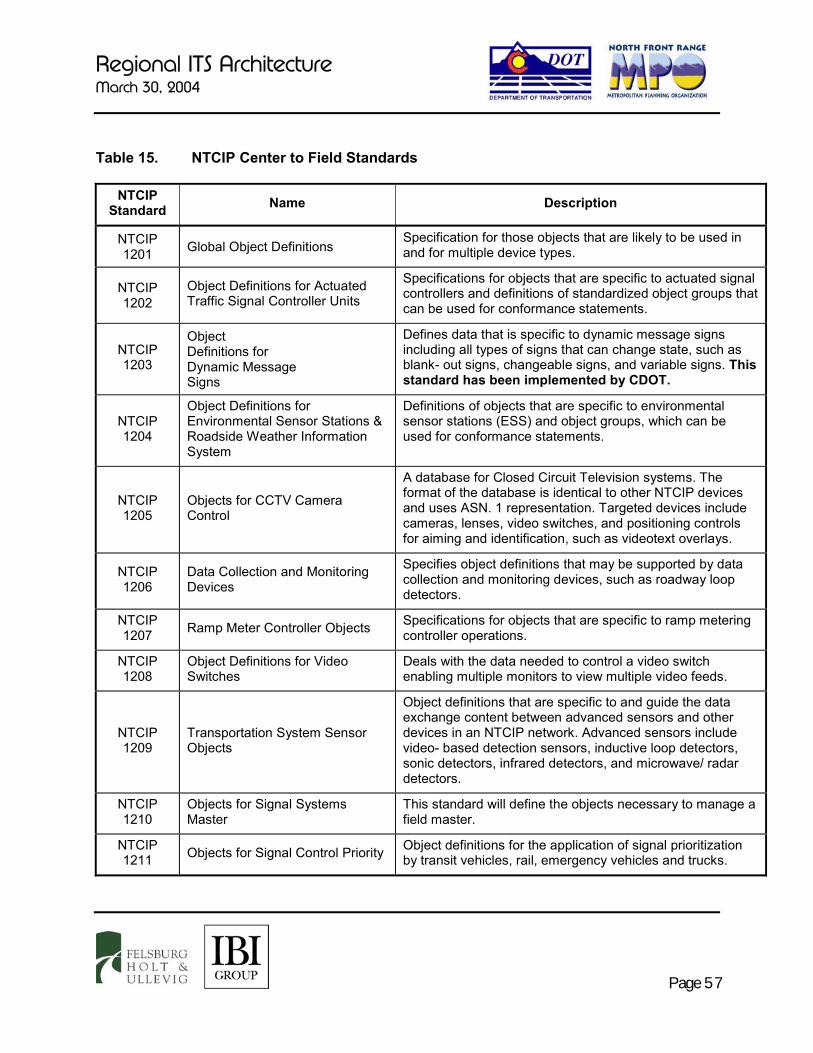
Regional ITS Architecture March 30, 2004
Page 57
Table 15. NTCIP Center to Field Standards
NTCIP Standard Name Description
NTCIP 1201 Global Object Definitions
Specification for those objects that are likely to be used in and for multiple device types.
NTCIP 1202
Object Definitions for Actuated Traffic Signal Controller Units
Specifications for objects that are specific to actuated signal controllers and definitions of standardized object groups that can be used for conformance statements.
NTCIP 1203
Object Definitions for Dynamic Message Signs
Defines data that is specific to dynamic message signs including all types of signs that can change state, such as blank- out signs, changeable signs, and variable signs. This standard has been implemented by CDOT.
NTCIP 1204
Object Definitions for Environmental Sensor Stations & Roadside Weather Information System
Definitions of objects that are specific to environmental sensor stations (ESS) and object groups, which can be used for conformance statements.
NTCIP 1205
Objects for CCTV Camera Control
A database for Closed Circuit Television systems. The format of the database is identical to other NTCIP devices and uses ASN. 1 representation. Targeted devices include cameras, lenses, video switches, and positioning controls for aiming and identification, such as videotext overlays.
NTCIP 1206
Data Collection and Monitoring Devices
Specifies object definitions that may be supported by data collection and monitoring devices, such as roadway loop detectors.
NTCIP 1207 Ramp Meter Controller Objects Specifications for objects that are specific to ramp metering
controller operations.
NTCIP 1208
Object Definitions for Video Switches
Deals with the data needed to control a video switch enabling multiple monitors to view multiple video feeds.
NTCIP 1209
Transportation System Sensor Objects
Object definitions that are specific to and guide the data exchange content between advanced sensors and other devices in an NTCIP network. Advanced sensors include video- based detection sensors, inductive loop detectors, sonic detectors, infrared detectors, and microwave/ radar detectors.
NTCIP 1210
Objects for Signal Systems Master
This standard will define the objects necessary to manage a field master.
NTCIP 1211 Objects for Signal Control Priority Object definitions for the application of signal prioritization
by transit vehicles, rail, emergency vehicles and trucks.

Regional ITS Architecture March 30, 2004
Page 58
An NTCIP compliant DMS sign driver for use in all future DMS installation throughout the state has been adopted by CDOT. As new traffic management systems are deployed, each jurisdiction should look for opportunities to incorporate these C2F protocols into their deployments. TCIP TCIP is a suite of data interface standards for the transit industry (http://www.tcip.org/). This suite of standards includes the wide range of transit ITS applications. A summary of the TCIP standards is found in Table 16. Table 16. TCIP Standards
TCIP Standard Name Description
1400 Framework Document Defines how the various TCIP standards work together.
1401 Common Public Transportation (CPT) Business Area Standard
Defines those data elements and data frames that are generic to multiple TCIP Business areas.
1402 Incident Management (IM) Business Area Standard
Defines the data elements and messages used for exchanging information on incident management operations.
1403 Passenger Information (PI) Business Area Standard
Defines the data elements and messages used for passenger information data exchange.
1404 Scheduling/Runcutting (SCH) Business Area Standard
Defines the data elements and messages used for exchanging information about transit schedules and runcutting information.
1405 Spatial Representation (SP) Business Area Standard
Defines the data elements and messages used for exchange of location and spatial concepts.
1406 Onboard (OB) Business Area Standard
Defines the data elements and messages used for exchanging information about devices and operations aboard the transit vehicle.
1407 Control Center (CC) Business Area Standard
Defines the data elements and messages used for exchanges between control centers.
1408 Fare Collection (FC) Business Area Standard
Defines the data elements and messages used for exchanging information about fare collection operations.

Regional ITS Architecture March 30, 2004
Page 59
The decision to implement transit ITS standards will lie with the regional transit agencies as they move forward with their ITS deployments. It is highly recommended that these decisions be made collaboratively between the agencies. C. Roadside to Vehicle Communications Protocols Dedicated Short-Range Communications (DSRC) includes protocols for exchanging information between roadside equipment and vehicles using the highway. The DSRC protocols include signal priority for transit and emergency vehicles. Currently many jurisdictions provide signal preemption privileges for emergency vehicles at signalized intersections. Most of these installations use an infrared light technology that transmits a signal from the emergency vehicle to a receiver at the intersection. The receiver is linked to the local signal controller, which then safely cycles the traffic signal to provide the emergency vehicle with the right-of-way in the direction of travel. This same technology could be used to provide bus transit signal priority. Consideration should be given to use a common protocol for both applications. Another application that requires DSRC is electronic toll collection, which is currently deployed along E-470. There are currently proposals under review by the Colorado Toll Enterprise to add toll-financed express lanes to I-70, I-25 and C-470 in Denver and potentially other parts of the state. Some of these efforts would include the implementation of HOT lanes. A recent Colorado statute authorizing HOT lanes included an amendment that requires any HOT lane DSCR technology be compatible with E-470's DSRC technology. The E-470 toll transponders are based upon the California Title 21 standard. D. Exchange of Video Images The National ITS Standards effort has not addressed the exchange of video images because of the existence of an extensive body of standards and conventions that already exist in this area. However, the region is adopting an ad-hoc “standard” to enable the exchange of video images. CDOT has been working with many local and regional agencies to install a Synchronous Optical Network (SONET) based high-speed regional ITS communications backbone. As part of this effort, CDOT is deploying Nortel JungleMUX communications mutiplexers that will allow video and data to be sent over the fiber optic network. CDOT is providing many of the local jurisdictions with this equipment as part of the CDOT ITS integration program. Further, CDOT has adopted Panasonic CCTV cameras and switchers as the statewide common equipment standard. Panasonic cameras and switches will be installed as part of the CDOT integration effort with local jurisdictions. The use of common equipment will ease integration and the sharing of video images.
Regional ITS Architecture March 30, 2004
Page 60
IX. ITS PROJECT PRIORITIES FOR IMPLEMENTATION The regional ITS Strategic Plan identified a number of potential ITS projects for Region 4, segregated into three groups: regional ITS projects, corridor ITS projects and transit ITS projects. The regional ITS projects are those that have a regional impact and provide the infrastructure and basis for other agency or location specific ITS implementations. Corridor ITS projects are those that are focused on improvements to significant planning corridors within the study area. Transit ITS projects are those that enhance the operations or safety of the transit service providers in the study area. As part of the ITS Strategic Plan process, the ITS Working Group held a workshop to collaboratively determine near-, mid-, and long-term ITS project priorities for the region. Near-term priorities for new ITS deployments include: � Develop Regional Communications Plan: The development of a regional communications
plan will define the communication requirements for both the center-to-field and the center-to-center communications. The plan will define how subsequent ITS deployments will connect to existing communications and control infrastructure. The communications infrastructure will grow with the deployment of ITS projects for both corridor and transit projects.
� Enhance Center-to-Center Coordination: Building on the communications planning and
deployment, center-to-center communications will provide the means to coordinate between agencies within the study area. Of particular importance for this deployment is establishment of the necessary agreements that will define the purpose and functions of the center-to-center connections. Interim agreements to support interagency signal coordination and to use existing ITS systems to their full effectiveness should be the primary set of agreements.
� Enhance Regional Incident Management Planning: Expanding from existing incident
management planning on I-25, incident management plans and the means to automatically deploy a response need to be developed for other major roadways and corridors. The key corridors for incident management planning include US 85, US 287 and US 34.
� Deploy Transit Vehicle Tracking: The primary interest for transit agencies is the
implementation of technology to allow real-time tracking of transit vehicles. The vehicle tracking information can be shared over the planned regional communications network and the center-to-center connections.
� Improve Regional Transit Service Coordination: Regional Service Coordination requires
the development of regional transit routes and will facilitate interagency coordination at transfer points between transit companies. Implementation of this high priority service relies on regional communications and transit vehicle tracking.
Regional ITS Architecture March 30, 2004
Page 61
� Provide Transit Trip Planning: Regional transit coordination and transit vehicle tracking are required to allow ITS deployments to provide transit trip planning tools, such as a trip planning web site. The information gathered by the transit agencies will be made available to the public to improve intra- and inter-agency trip planning.
� Deployment of Local Traffic Operation Centers: In order to facilitate monitoring and
control functions by state and local agencies, local traffic operation centers need to be deployed. The local traffic operations centers (especially in Loveland and Greeley) will have the responsibility of monitoring and controlling devices within their jurisdiction while maintaining the ability to coordinate between agencies. The successful deployment of these centers is dependent upon the communications planning.
� Deployment of Regional Data Warehouse: With the increase of corridor and regional ITS
deployments, more data will become available for both operations and planning. A means to store and retrieve this data will be necessary to make the data usable on a regional basis.
Regional ITS Architecture March 30, 2004
Page 62
X. NEXT STEPS In order to maintain the regional ITS Architecture for the study area, the North Front Range MPO will form an ITS Committee as a regional forum for discussion of regional ITS issues and deployment progress.
The ITS Committee will meet at least every six months to discuss current and anticipated ITS issues. Consistent with the schedule for formal regional transportation plan updates, the ITS Committee will specifically assess whether updates to the ITS Architecture will be required. The need to update the architecture will be precipitated by changes in transportation issues and the need to implement market packages not yet considered. In addition, revisions in the National ITS Architecture may require consideration, including the addition of new market packages.
Some initial agenda items for the ITS Committee could include:
� Definition of a separate funding pool and project category for ITS projects within the RTP.
� Definition of an interim amendment process in order to maintain the plan outside of the regular schedule.
� Development of agreements to coordinate regional ITS planning between the neighboring TPRs (North Front Range, Upper Front Range and DRCOG) and CDOT.
In order to prepare ITS projects for inclusion in the TIP, the project sponsors will need to work with the ITS Committee in order to demonstrate that a systems engineering analysis has been applied to the projects, per the Federal requirements.
APPENDIX AFederal Highway
Administration Final Rule
Regional ITS Architecture March 30, 2004
Appendix A
APPENDIX A FEDERAL HIGHWAY ADMINISTRATION FINAL RULE In consideration of the foregoing, the FHWA amends Chapter I of title 23, Code of Federal Regulations, as set forth below:
PART 655--[AMENDED]
1. The authority citation for part 655 continues to read as follows: Authority: 23 U.S.C. 101(a), 104, 109(d), 114(a), 217, 315, and 402(a); 23 CFR 1.32,
and 49 CFR 1.48(b). Subpart D--[Removed and reserved] 2 Remove and reserve subpart D of part 655, consisting of §§ 655.401, 655.403, 655.405,
655.407, 655.409, 655.411. 3. Add a new subchapter K, consisting of part 940, to read as follows: SUBCHAPTER K--INTELLIGENT TRANSPORTATION SYSTEMS PART 940--INTELLIGENT TRANSPORTATION SYSTEM ARCHITECTURE AND STANDARDS Sec.
940.1 Purpose.
940.3 Definitions.
940.5 Policy.
940.7 Applicability.
940.9 Regional ITS architecture.
940.11 Project implementation.
940.13 Project administration.

Regional ITS Architecture March 30, 2004
Appendix A
Authority: 23 U.S.C. 101, 106, 109, 133, 315, and 508; sec 5206(e), Pub. L. 105-178, 112 Stat. 457 (23 U.S.C. 502 note); and 49 CFR 1.48. § 940.1 Purpose.
This regulation provides policies and procedures for implementing section 5206(e) of the Transportation Equity Act for the 21st Century (TEA-21), Public Law 105-178, 112 Stat. 457, pertaining to conformance with the National Intelligent Transportation Systems Architecture and Standards.
§ 940.3 Definitions.
Intelligent Transportation System (ITS) means electronics, communications, or information processing used singly or in combination to improve the efficiency or safety of a surface transportation system.
ITS project means any project that in whole or in part funds the acquisition of technologies or systems of technologies that provide or significantly contribute to the provision of one or more ITS user services as defined in the National ITS Architecture.
Major ITS project means any ITS project that implements part of a regional ITS initiative that is multi-jurisdictional, multi-modal, or otherwise affects regional integration of ITS systems.
National ITS Architecture (also "national architecture") means a common framework for ITS interoperability. The National ITS Architecture comprises the logical architecture and physical architecture which satisfy a defined set of user services. The National ITS Architecture is maintained by the United States Department of Transportation (DOT) and is available on the DOT web site at http://www.its.dot.gov.
Project level ITS architecture is a framework that identifies the institutional agreement and technical integration necessary to interface a major ITS project with other ITS projects and systems.
Region is the geographical area that identifies the boundaries of the regional ITS architecture and is defined by and based on the needs of the participating agencies and other stakeholders. In metropolitan areas, a region should be no less than the boundaries of the metropolitan planning area.
Regional ITS architecture means a regional framework for ensuring institutional agreement and technical integration for the implementation of ITS projects or groups of projects.
Systems engineering is a structured process for arriving at a final design of a system. The final design is selected from a number of alternatives that would accomplish the same objectives and considers the total life-cycle of the project including not only the technical merits of potential solutions but also the costs and relative value of alternatives.

Regional ITS Architecture March 30, 2004
Appendix A
§ 940.5 Policy.
ITS projects shall conform to the National ITS Architecture and standards in accordance with the requirements contained in this part. Conformance with the National ITS Architecture is interpreted to mean the use of the National ITS Architecture to develop a regional ITS architecture, and the subsequent adherence of all ITS projects to that regional ITS architecture. Development of the regional ITS architecture should be consistent with the transportation planning process for Statewide and Metropolitan Transportation Planning.
§ 940.7 Applicability. (a) All ITS projects that are funded in whole or in part with the highway trust fund, including
those on the National Highway System (NHS) and on non-NHS facilities, are subject to these provisions.
(b) The Secretary may authorize exceptions for:
(1) Projects designed to achieve specific research objectives outlined in the National ITS Program Plan under section 5205 of the TEA-21, or the Surface Transportation Research and Development Strategic Plan developed under 23 U.S.C. 508; or
(2) The upgrade or expansion of an ITS system in existence on the date of enactment of the TEA-21, if the Secretary determines that the upgrade or expansion:
(i) Would not adversely affect the goals or purposes of Subtitle C (Intelligent Transportation Systems Act of 1998) of the TEA-21;
(ii) Is carried out before the end of the useful life of such system; and
(iii) Is cost-effective as compared to alternatives that would meet the conformity requirement of this rule.
(c) These provisions do not apply to funds used for operations and maintenance of an ITS system in existence on June 9, 1998.
§ 940.9 Regional ITS architecture. (a) A regional ITS architecture shall be developed to guide the development of ITS projects
and programs and be consistent with ITS strategies and projects contained in applicable transportation plans. The National ITS Architecture shall be used as a resource in the development of the regional ITS architecture. The regional ITS architecture shall be on a scale commensurate with the scope of ITS investment in the region. Provision should be made to include participation from the following agencies, as appropriate, in the development of the regional ITS architecture: highway agencies; public safety agencies (e.g., police, fire, emergency/medical); transit operators; Federal lands agencies; State
Regional ITS Architecture March 30, 2004
Appendix A
motor carrier agencies; and other operating agencies necessary to fully address regional ITS integration.
(b) Any region that is currently implementing ITS projects shall have a regional ITS
architecture by [Insert date 30 days after publication in the Federal Register plus 48 months].
(c) All other regions not currently implementing ITS projects shall have a regional ITS
architecture within four years of the first ITS project for that region advancing to final design.
(d) The regional ITS architecture shall include, at a minimum, the following:
(1) A description of the region;
(2) Identification of participating agencies and other stakeholders;
(3) An operational concept that identifies the roles and responsibilities of participating agencies and stakeholders in the operation and implementation of the systems included in the regional ITS architecture;
(4) Any agreements (existing or new) required for operations, including at a minimum those affecting ITS project interoperability, utilization of ITS related standards, and the operation of the projects identified in the regional ITS architecture;
(5) System functional requirements;
(6) Interface requirements and information exchanges with planned and existing systems and subsystems (for example, subsystems and architecture flows as defined in the National ITS Architecture);
(7) Identification of ITS standards supporting regional and national interoperability; and
(8) The sequence of projects required for implementation. (e) Existing regional ITS architectures that meet all of the requirements of paragraph (d) of
this section shall be considered to satisfy the requirements of paragraph (a) of this section.
(f) The agencies and other stakeholders participating in the development of the regional
ITS architecture shall develop and implement procedures and responsibilities for maintaining it, as needs evolve within the region.
Regional ITS Architecture March 30, 2004
Appendix A
§ 940.11 Project implementation. (a) All ITS projects funded with highway trust funds shall be based on a systems
engineering analysis. (b) The analysis should be on a scale commensurate with the project scope. (c) The systems engineering analysis shall include, at a minimum:
(1) Identification of portions of the regional ITS architecture being implemented (or if a regional ITS architecture does not exist, the applicable portions of the National ITS Architecture);
(2) Identification of participating agencies roles and responsibilities;
(3) Requirements definitions;
(4) Analysis of alternative system configurations and technology options to meet requirements;
(5) Procurement options;
(6) Identification of applicable ITS standards and testing procedures; and
(7) Procedures and resources necessary for operations and management of the system.
(d) Upon completion of the regional ITS architecture required in §§ 940.9(b) or 940.9(c), the final design of all ITS projects funded with highway trust funds shall accommodate the interface requirements and information exchanges as specified in the regional ITS architecture. If the final design of the ITS project is inconsistent with the regional ITS architecture, then the regional ITS architecture shall be updated as provided in the process defined in § 940.9(f) to reflect the changes.
(e) Prior to the completion of the regional ITS architecture, any major ITS project funded
with highway trust funds that advances to final design shall have a project level ITS architecture that is coordinated with the development of the regional ITS architecture. The final design of the major ITS project shall accommodate the interface requirements and information exchanges as specified in this project level ITS architecture. If the project final design is inconsistent with the project level ITS architecture, then the project level ITS architecture shall be updated to reflect the changes. The project level ITS architecture is based on the results of the systems engineering analysis, and includes the following:

Regional ITS Architecture March 30, 2004
Appendix A
(1) A description of the scope of the ITS project;
(2) An operational concept that identifies the roles and responsibilities of participating agencies and stakeholders in the operation and implementation of the ITS project;
(3) Functional requirements of the ITS project;
(4) Interface requirements and information exchanges between the ITS project and other planned and existing systems and subsystems; and
(5) Identification of applicable ITS standards. (f) All ITS projects funded with highway trust funds shall use applicable ITS standards and
interoperability tests that have been officially adopted through rulemaking by the DOT. (g) Any ITS project that has advanced to final design by [Insert the effective date of this rule]
is exempt from the requirements of paragraphs (d) through (f) of this section. § 940.13 Project administration. (a) Prior to authorization of highway trust funds for construction or implementation of ITS
projects, compliance with § 940.11 shall be demonstrated. (b) Compliance with this part will be monitored under Federal-aid oversight procedures as
provided under 23 U.S.C. 106 and 133.
APPENDIX BElements of
Interagency Agreements

Regional ITS Architecture March 30, 2004
Appendix B
APPENDIX B ELEMENTS OF INTERAGENCY AGREEMENTS Agreements are established to clearly define responsibilities among the involved parties. The level of formality generally increases as risks escalate and when financial transactions take place. Formality will also increase when the performance or lack of performance on the part of one organization impacts the operations of another. For example, if an agency maintains and operates the traffic signals of another agency, failure to restore a failed traffic signal in a timely fashion could have a significant impact. As different systems are linked together, they will depend upon each other. The clear definition of responsibilities for all parties will help ensure smooth operations. The following is an annotated checklist of elements to consider in the development of an agreement for ITS operations and maintenance. Not all elements are relevant to each relationship and information flow. The level of specificity will depend on the nature of the information link.
� Operational Concept (A layman’s introduction to the nature and purpose of the agreement.)
� Duties of Responsible Organizations (A summary of duties and responsibilities.)
� Information Sharing (Aspects of sharing information to be considered). - Provision of Information - Information Type (Data, Video, Status, and Request) - Information Rights - Information Reuse - Information Identification - Information Availability - Information Accuracy
� Control Sharing (Aspects of sharing control to be considered with rights and priorities being clearly understood.)
- Provision of Control - Control Rights - Control Restrictions - Control Priority - Control Availability
� Connections (Defines how the connection is made.) - Provision of Equipment - Physical Access Point - Demarcation Point - Security - Configuration Management - Standards and Protocols
� System Documentation
� Operations - Contacts

Regional ITS Architecture March 30, 2004
Appendix B
- Hours of Operations - Responsibilities
� Maintenance - Contacts - Hours of Operations - Responsibilities - Response Time
� Liability - Indemnity - Damage to Equipment
� Ownership - Equipment - Software - Intellectual Property
� Coordination - Notification - Periodic Reporting - Pre-Change Coordination Meeting
� Dispute Resolution
� Termination of Agreement
� Compensation
APPENDIX CITS Architecture
Diagrams

APPENDIX DITS Standards

FELSBURGH O L T &U L L E V I G
303.721.1440fax [email protected]
6300 �South Syracuse Way, Suite 600Centennial, CO 80111
DEPARTMENT OF TRANSPORTATION
DOT
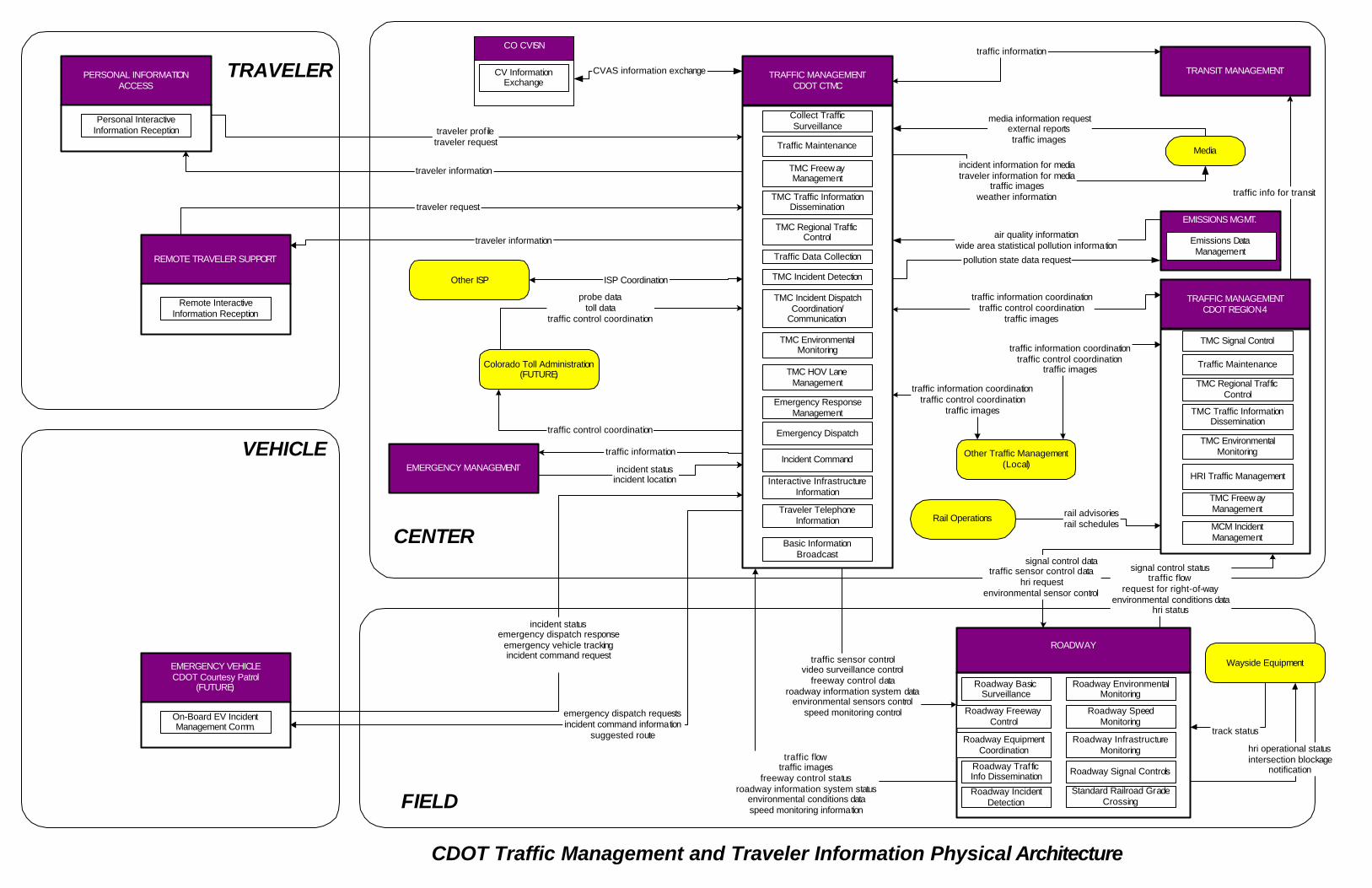
CENTER
TRAFFIC MANAGEMENTCDOT CTMC
Collect TrafficSurveillance
Traffic Maintenance
TMC Freew ayManagement
TMC Traffic InformationDissemination
TMC Regional TrafficControl
Traffic Data Collection
TMC Incident Detection
Roadway TrafficInfo Dissemination
Roadway EquipmentCoordination
Roadway FreewayControl
Roadway IncidentDetection
Roadway BasicSurveillance
traffic flowtraffic images
freeway control statusroadway information system status
environmental conditions dataspeed monitoring informationFIELD
TRAVELER
VEHICLE
TMC Incident DispatchCoordination/
Communication
PERSONAL INFORMATIONACCESS
Personal InteractiveInformation Reception
TMC EnvironmentalMonitoring
Roadway EnvironmentalMonitoring
Roadway SpeedMonitoring
Roadway InfrastructureMonitoring
TRANSIT MANAGEMENT
traffic information
EMERGENCY VEHICLECDOT Courtesy Patrol
(FUTURE)
On-Board EV IncidentManagement Comm.
emergency dispatch requestsincident command information
suggested route
incident statusemergency dispatch response
emergency vehicle trackingincident command request
TMC HOV LaneManagement
REMOTE TRAVELER SUPPORT
Remote InteractiveInformation Reception
traveler prof iletraveler request
traveler information
traveler request
traveler information
Colorado Toll Administration(FUTURE)
probe datatoll data
traffic control coordination
traffic control coordination
TRAFFIC MANAGEMENTCDOT REGION 4
TMC Signal Control
Traffic Maintenance
TMC Regional TrafficControl
TMC Traffic InformationDissemination
TMC EnvironmentalMonitoring
signal control datatraffic sensor control data
hri requestenvironmental sensor control
signal control statustraffic flow
request for right-of-wayenvironmental conditions data
hri status
traffic information coordinationtraffic control coordination
traffic images
Other Traffic Management(Local)
traffic information coordinationtraffic control coordination
traffic images
traffic information coordinationtraffic control coordination
traffic images
CDOT Traffic Management and Traveler Information Physical Architecture
Roadway Signal Controls
traffic info for transit
CO CVISN
CV InformationExchange
CVAS information exchange
Media
media information requestexternal reportstraffic images
incident information for mediatraveler information for media
traffic imagesweather information
pollution state data request
air quality informationwide area statistical pollution information
EMISSIONS MGMT.
Emissions DataManagement
HRI Traffic Management
Standard Railroad GradeCrossing
ROADWAY
traffic sensor controlvideo surveillance control
freeway control dataroadway information system data
environmental sensors controlspeed monitoring control
Wayside Equipment
track status
hri operational statusintersection blockage
notification
Rail Operations rail advisoriesrail schedules
Other ISP ISP Coordination
Incident Command
Emergency ResponseManagement
Emergency Dispatch
TMC Freew ayManagement
MCM IncidentManagement
Basic InformationBroadcast
Traveler TelephoneInformation
Interactive InfrastructureInformation
EMERGENCY MANAGEMENT
traffic information
incident statusincident location

CENTER
FIELD
TRAVELER
VEHICLE
TRAFFIC MANAGEMENT(Local TMC)
Collect TrafficSurveillance
EMISSIONS MANAGEMENT
Emissions DataManagement
LOCAL INFORMATION SERVICEPROVIDER
Interactive InfrastructureInformation
EMERGENCY MANAGEMENT
Emergency ResponseManagement
LOCAL MAINTENANCE ANDCONSTRUCTION MANAGEMENT
MCM Vehicle Tracking
ROADWAY(Local Jurisdiction)
Roadway Basic Surveillance
PERSONAL INFORMATIONACCESS
Personal InteractiveInformation Reception
REMOTE TRAVELER SUPPORT
Remote InteractiveInformation Reception
Traveler TelephoneInformation Traffic Maintenance
TMC Signal Control
TMC Regional TrafficControl
TMC Incident Detection
TMC Incident DispatchCoordination/
Communications
TMC Traffic NetworkPerformance Evaluation
Roadway Equipment Coordination
Roadway Signal Controls
Roadway Incident Detection
Incident Command
Roadway Emissions Monitoring
Standard Rail Crossing
HRI Traffic Managment
TMC Speed Monitoring
Roadway Speed Monitoing
Roadway EnvironmentalMonitoring
TMC EnvironmentalMonitoring
Roadway Automated Treatment
MCM AutomatedTreatment System
Control
Traffic Data Collection
traveler profiletraveler request
traveler information
traveler information
traveler request
road network conditions
traffic flowtraffic images
request for right-of-waysignal control status
hri statusspeed monitoring informationenvironmental conditions data
traffic sensor controlvideo surveillance control
signal control datahri control data
hri requestspeed monitoring control
environmental sensors control
Other Traffic Management(CDOT CTMS, Region 4,
Other Cities)
traffic control coordinationtraffic information coordination
incident informationincident response status
resource request
incident informationresource deployment status
road network conditionstraffic images
wide area statistical pollution info
pollution state data request
area pollution datavehicle emissions data
MAINTENANCE ANDCONSTRUCTION VEHICLE
MCM Vehicle LocationTracking
maint and constr vehicle location datamaint and constr dispatch status
maint and constr vehicle operational data
roadway treatment system statusenvironmental conditions data
field device status
roadway treatment system controlenvironmental sensors control
maint and constr datainformation,
road weather informationmaint and const resource response
roadway maintenance statusequipment maintenance status
maint and constr work plans
"Typical" Local Jurisdiction ITS Physical Architecture
MCM EnvironmentalInformation CollectionMCM Environmental
Information ProcessingMCM WinterMaintenanceManagement
MCM Road Maintenanceand Construction
maint and constr resource requestroad network conditions
maint and const dispatch informationmaint and const vehicle system control
CO CVISN
CV InformationExchange
CVAS information exchange
Media
media information request, external reports,traffic images
incident information for media, travelerinformation for media, traffic images, weather
information
Other ISPISP Coordination
parking information
parking lot data request
PARKING MANAGEMENT
weather informationWeather Service
TRANSIT VEHICLE
EMERGENCY VEHICLE local signal priority request
local signal preemption request
Roadway Signal Priority

CENTER
FIELD
TRAVELER
VEHICLE
TRAFFIC MANAGEMENTCDOT CTMS
TMC Incident DispactchCoord./Comm.
TMC Signal Control
TMC Traffic InformationDissemination
EMERGENCY MANAGEMENT
Emergency Call-Taking
Emergency Dispatch
Emergency Routing
Mayday Support
Service PatrolManagement (Future)
INFORMATION SERVICEPROVIDER
ISP Emergency TravelerInformation
Traveler TelephoneInformation
ROADWAY
Roadway Signal Priority
Field Barrier SystemControl
PERSONAL INFORMATIONACCESS
EMERGENCY VEHICLE
On-Board EV IncidentManagement Comm.
On-board EV En RouteSupport
REMOTE TRAVELER SUPPORT
MAINTENANCE ANDCONSTRUCTION MANAGEMENT
MCM IncidentManagement
MCM RoadwayMaintenance and
Construction
TRANSIT MANAGEMENT
Transit CenterInformation Services
Transit Center Security
VEHICLE(Personal Vehicle)
Remote BasicInformation Reception
Emergency EarlyWarning System
Personal BasicInfomation Reception
Roadway Traffic InfoDissemination
EmergencyEnvironmental Monitoring
TMC Incident Detection
Emergency ResponseManagement
Incident Command
Emergency EvacuationSupport
Personal InteractiveInformation Reception
Remote InteractiveInformation Reception
emergency route requestemergency traffic control request
incident informationtransoporation system statusemergency plan coordination
incident response statusresource request
evacuation information
incident response statustransportation system status
incident informationemergency transit service request
incident response statusemergency plan coordination
evacuation information
emergency dispatch requestssuggested route
emergency dispatch responseincident status
emergency vehicle tracking data
road network conditionstraffic images
emergency routesincident information
emergency plan coordinationemergency traffic control information
resource deployment statusroad network status assessment
transit emergency dataemergency plan coordination
emergency transit schedule infoemergency transit service responsetransit system status assessment
local signal preemption request
current asset restrictionswork zone information
roadway maintenance statusincident information
emergency plan coordinationM&C resource response
M&C work plansroad network status assessmentsignal control status
barrier system statusroadway information system status
signal control databarrier system control
roadway information system data
incident informationalert notification
evacuation information
incident informationtransportation system statusemergency plan coordination
incident response statusM&C resource requestevacuation information
alert status
emergency traveler information
emergency traveler information request
emergency traveler information
emergency traveler information request
emergency traveler information
TRAFFIC MANAGEMENT(CDOT Region 4, Local TMCs)
TMC Incident DispactchCoord./Comm.
TMC Signal Control
M&C resource responseM&C work plans
road network status assessmentwork zone information
M&C resource requestroad network status assessment
TMC Evacuation Support
Transit EvacuationSupport
transit information request
road network conditions
transit and fare schedules
Other EmergencyManagement
emergency plan coordinationincident command information coordination
incident response coordinationresource coordination
transportation system status
road network conditionsemergency routes
incident informationemergency plan coordination
emergency traffic control informationresource deployment status
emergency route requestemergency traffic control request
incident informationtransoporation system statusemergency plan coordination
incident response statusresource request
emergency traveler information request
Emergency Management Physical Architecture
emergency dispatch requestssuggested route emergency dispatch response
incident statusemergency vehicle tracking data
weather infoWeather Service
CENTER
FIELD
TRAVELER
VEHICLE
MAINTENANCE ANDCONSTRUCTION MANGEMENT
CDOT REGION 4
MCM Speed Monitoring
MCM Vehicle Tracking
MCM Vehicle andEquipment Maintenance
Management
MCM EnvironmentalInformation Collection
MCM EnvironmentalInformation Processing
MCM AutomatedTreatment Sytem Control
MCM MaintenanceDecision Support
MCM WinterMaintenanceManagement
MCM Work ZoneManagement
MCM RoadwayMaintenance and
Construction
MCM Work Zone SafetyManagement
MCM Work ActivityCoordination
ROADWAY
Roadway AutomatedTreatment
Roadway Work ZoneTraffic Control
Roadway SpeedMonitoring Control
Roadway EnvironmentalMonitoring
TRAFFIC MANAGEMENTCDOT REGION 4
TMC EnvironmentalMonitoring
TMC Incident DispatchCoordination/
Communication
Traffic Maintenance
TMC Work Zone TrafficManagement
MAINTENANCE ANDCONSTRUCTION VEHICLE
MCV Vehicle LocationTracking
MCV Vehicle SystemMonitoring and
Diagnostics
MCV RoadwayMaintenance and
Construction
MCV WinterMaintenance
MCV Work Zone Support
maint and constr vehicle location datamaint and constr vehicle conditions
maint and const dispatch statusmaint and constr vehicle operational data
work zone status
maint and const dispatch informationmaint and const vehicle system control
road weather informationmaint and constr resource response
roadway maintenance statusequipment maintenance status
work zone informationcurrent asset restrictions
maint and constr work plans
maint and constr resource requestroad network conditionsfield equipment status
work plan feedback
TMC Speed Monitoring
environmental conditions dataroadway treatment system status
field device statusroadway information system status
traffic imagesspeed monitoring information
work zone warning status
speed monitoring controlenvironmental sensors control
roadway treatment control systemroadway information system data
video surveillance controlwork zone warning device control
speed monitoring controlenvironmental sensors control
roadway information system data
speed monitoring informationenvironmental conditions data
roadway informationsystem status
CDOT Region 4 Maintenance and Construction PhysicalArchitecture
OTHER TRAFFICMANAGEMENT
(CDOT CTMC, Local TMCs)
current asset restrictionsmaint and constr work plansroadway maintenance status
work plan feedback
CENTER
FIELD
TRAVELER
VEHICLE
TRANSIT MANAGEMENT
Transit Center Trackingand Dispatch
Transit Center Fixed-Route Operations
TRAFFIC MANAGEMENT
TMC MultimodalCoordination
INFORMATION SERVICEPROVIDER
Interactive InfrastructureInformation
REMOTE TRAVELER SUPPORT
Remote Transit FareManagement
PERSONAL INFORMATIONACCESS
Personal InteractiveInformation Reception
TRANSIT VEHICLE
On-Board Transit TripMonitoring
On-Board Fixed RouteSchedule Management
SECURITY MONITORING
Field Secure AreaSensor Monitoring
Field Secure AreaSurveillance
ROADWAY
Roadway Signal Priority
EMERGENCY MANAGEMENT
Center Secure AreaAlarm Support
Transit GarageOperations
Transit CenterParatransit Operations
On-Board ParatransitOperations
Transit Center Fare andLoad Management
On-Board Transit Fareand Load Management
Center Secure AreaSurveillance
Transit Center Security
On-Board TransitSecurity
On-Board Maintenance
Transit GarageMaintenance
Transit Center Multi-Modal Coordination
On-Board Transit SignalPriority
Transit CenterInformation Services
Remote TransitInformation Services
transit and fare schedulesdemand responsive transit plan
transit request confirmation
transit vehicle location datatransit vehicle schedule performance
transit vehicle passenger and use datafare and payment statusrequest for bad tag listemergency notification
transit vehicle conditionstransit vehicle operator authentication information
transit information requestdemand responsive transit request
selected routes
MAINTENANCE ANDCONSTRUCTION MANAGEMENT
current asset restrictionsroadway maintenance status
work zone information
road network conditionsrequest transit information
transit vehicle operator instructionsbad tag list
fare management informationrequest for vehicle measures
emergency acknowledgetransit vehicle operator authentication update
transit schedule information
transit fare and passenger statustransit information user request
transit fare informationtransit traveler information
secure area surveillance data
secure areasurveillance control
incident response status
emergency acknowledgesecure area sensor control
secure area surveillance control
transit emergency data
emergency notificationsecure area sensor datasecure area surveillance
transit vehicle location data
signal control status
signal control data
transit system data
local signal priority request
personal transit information
transit information user request
Other Transit Managementtransit fare coord.
transit service coord.transit traveler info coord.
Regional Transit Agency Physical Architecture
PaymentInstrument
payment
request for payment
Other ISP
ISP coordinationparking information
parking lot data request
PARKING MANAGEMENT
transaction statusWeather Service
Financial Institutionpayment request
Media Information Request, External Reports

CENTER
FIELD
TRAVELER
VEHICLE
ARCHIVE MANAGEMENT(Regional ITS Data Warehouse)
Government ReportingSystem System
ITS Data Repository
Traffic and RoadsideData Archival
ROADWAY(All Jurisdictions)
Roadway Data Collectiondata collection and monitoring control
roadside archive data
TRAFFIC MANAGEMENT(Internal ITS Data Mart)
Traffic Data Collectionarchive requests
archive status
traffic archive data
EMERGENCY MANAGEMENT(Internal ITS Data Mart)
Emergency DataCollection
COMMERCIAL VEHICLEADMINISTRATION
(Internal ITS Data Mart)
CV Data Collection
TRANSIT MANAGEMENT(Internal ITS Data Mart)
Transit Data Collection
INFORMATION SERVICEPROVIDER
(Internal ITS Data Mart)
ISP Data Collection
MAINTENANCE &CONSTRUCTION MANAGEMENT
(Internal ITS Data Mart)
MCM Data Collection
archive requestsarchive status
transit archive data
archive requestsarchive status
traveler archive data maint. and const. archive data
archive requestsarchive status
archive requestsarchive status
CV archive data
archive requestsarchive status
emergency archive data
Archived Data Management Physical Architecture
Government ReportingSystem Support
ITS Data Repository
Government ReportingSystem Support
ITS Data Repository
Government ReportingSystem Support
ITS Data Repository
Government ReportingSystem Support
ITS Data Repository
Government ReportingSystem Support
ITS Data Repository
Government ReportingSystem Support
ITS Data Repository

Region 4 ITS Market Packages to ITS Standards Matrix
Standard Bro
adca
st T
rave
ler I
nfor
mat
ion
CV
Adm
inis
trativ
e P
roce
sses
Dem
and
Res
pons
e Tr
ansi
t Ope
ratio
ns
Dis
aste
r Res
pons
e an
d R
ecov
ery
Dis
aste
r Res
pons
e Tr
avel
er In
form
atio
n
Dyn
amic
Rid
esha
ring
Dyn
amic
Rou
te G
uida
nce
Ear
ly W
arni
ng S
yste
m
Ele
ctro
nic
Cle
aran
ce
Ele
ctro
nic
Toll
Col
lect
ion
Em
erge
ncy
Res
pons
e
Em
erge
ncy
Rou
ting
Em
issi
ons
Mon
itorin
g an
d M
anag
emen
t
Eva
cuat
ion
and
Ree
ntry
Man
agem
ent
Free
way
Con
trol
HO
V L
ane
Man
agem
ent
Inci
dent
Man
agem
ent S
yste
m
Inte
ract
ive
Trav
eler
Info
rmat
ion
ITS
Dat
a M
art
ITS
Dat
a W
areh
ouse
ITS
Virt
ual D
ata
War
ehou
se
Mai
nten
ance
and
Con
stru
ctio
n A
ctiv
ity C
oord
inat
ion
Mai
nten
ance
and
Con
stru
ctio
n V
ehic
le M
aint
enan
ce
Mai
nten
ance
and
Con
stru
ctio
n V
ehic
le T
rack
ing
May
day
Sup
port
Mul
ti-m
odal
Coo
rdin
atio
n
Net
wor
k S
urve
illan
ce
Par
king
Fac
ility
Man
agem
ent
Rai
lroad
Ope
ratio
ns C
oord
inat
ion
Reg
iona
l Par
king
Man
agem
ent
Reg
iona
l Tra
ffic
Con
trol
Roa
d W
eath
er D
ata
Col
lect
ion
Roa
dway
Aut
omat
ed T
reat
men
t
Roa
dway
Clo
sure
Man
agem
ent
Roa
dway
Mai
nten
ance
and
Con
stru
ctio
n
Roa
dway
Ser
vice
Pat
rols
Spe
ed M
onito
ring
Sta
ndar
d R
ailro
ad G
rade
Cro
ssin
g
Sur
face
Stre
et C
ontro
l
Traf
fic F
orec
ast a
nd D
eman
d M
anag
emen
t
Traf
fic In
form
atio
n D
isse
min
atio
n
Tran
sit F
ixed
-Rou
te O
pera
tions
Tran
sit M
aint
enan
ce
Tran
sit P
asse
nger
and
Far
e M
anag
emen
t
Tran
sit S
ecur
ity
Tran
sit T
rave
ler I
nfor
mat
ion
Tran
sit V
ehic
le T
rack
ing
Tran
spor
tatio
n In
frast
ruct
ure
Pro
tect
ion
Wea
ther
Info
rmat
ion
Pro
cess
ing
and
Dis
tribu
tion
Wei
gh-In
-Mot
ion
Wid
e A
rea
Ale
rt
Win
ter M
aint
enan
ce
Wor
k Zo
ne M
anag
emen
t
Wor
k Zo
ne S
afet
y M
onito
ring
A Conceptual ITS Architecture: An ATIS Perspective x x x x x x x x x x x x x x x xAdaptive Cruise Control: Operating Characteristics and User Interface x x x x x x xADMS Data Dictionary Specifications x x xArchiving ITS Related Traffic Monitoring Data x x xMetadata Content for ITS Generated Data x x xAdvanced Transportation Controller (ATC) App. Program Interface x x x x xAdvanced Transportation Controller (ATC) x x x x xATC Cabinet x x x x xConverting ATIS Message Standards from ASN.1 to XML x x x x x x x x x x x x x x x x x x x x x x xCommercial Vehicle Credentials x xCommercial Vehicle Safety and Credentials Information Exchange x xCommercial Vehicle Safety Reports xData Dictionary for Advanced Traveler Information System (ATIS) x x x x x x x x xData Radio Channel (DARC) System x xDriver Safety MonitoringDriver Visibility ImprovementInterface x x x x x x xInformation Report on ITS Terms and DefinitionsInformation Report x x x xISP-Vehicle Location Referencing Message Profiles x x x xISP-Vehicle Location Referencing Standard x x x xITIS (International Traveler Information Systems) Phrase Lists x x x x x x x x x x x x x x x x x x x x x xITS Data Bus Conformance Test Procedure xITS Data Bus Data Security Services Recommended Practice xITS Data Bus Gateway Recommended Practice xITS Data Bus Protocol - Application Layer Recommended Practice xITS Data Bus Protocol - Link Layer Recommended Practice xITS Data Bus Protocol - Physical Layer Recommended Practice xITS Data Bus Protocol - Thin Transport Layer Recommended Practice xITS Data Dictionaries GuidelinesITS In-Vehicle Message Priority x x x x x x xMayday Industry Survey Information Report x x x(Def. & Meas.) x x x x x x xMessage Set for Advanced Traveler Information System (ATIS) x x x x x x x x x x x x xMessage Set for External TMC Communication (MS/ETMCC) x x x x x x x x x x x x x x x x x x x x x x x x x x x x x x x x xMessage Sets for DSRC ETTM & CVO x x x xMessages for Handling Strings and Look-Up Tables in ATIS Standards x x x x x x x x x x x x x
March 2004 1
Region 4 ITS Market Packages to ITS Standards Matrix
Standard Bro
adca
st T
rave
ler I
nfor
mat
ion
CV
Adm
inis
trativ
e P
roce
sses
Dem
and
Res
pons
e Tr
ansi
t Ope
ratio
ns
Dis
aste
r Res
pons
e an
d R
ecov
ery
Dis
aste
r Res
pons
e Tr
avel
er In
form
atio
n
Dyn
amic
Rid
esha
ring
Dyn
amic
Rou
te G
uida
nce
Ear
ly W
arni
ng S
yste
m
Ele
ctro
nic
Cle
aran
ce
Ele
ctro
nic
Toll
Col
lect
ion
Em
erge
ncy
Res
pons
e
Em
erge
ncy
Rou
ting
Em
issi
ons
Mon
itorin
g an
d M
anag
emen
t
Eva
cuat
ion
and
Ree
ntry
Man
agem
ent
Free
way
Con
trol
HO
V L
ane
Man
agem
ent
Inci
dent
Man
agem
ent S
yste
m
Inte
ract
ive
Trav
eler
Info
rmat
ion
ITS
Dat
a M
art
ITS
Dat
a W
areh
ouse
ITS
Virt
ual D
ata
War
ehou
se
Mai
nten
ance
and
Con
stru
ctio
n A
ctiv
ity C
oord
inat
ion
Mai
nten
ance
and
Con
stru
ctio
n V
ehic
le M
aint
enan
ce
Mai
nten
ance
and
Con
stru
ctio
n V
ehic
le T
rack
ing
May
day
Sup
port
Mul
ti-m
odal
Coo
rdin
atio
n
Net
wor
k S
urve
illan
ce
Par
king
Fac
ility
Man
agem
ent
Rai
lroad
Ope
ratio
ns C
oord
inat
ion
Reg
iona
l Par
king
Man
agem
ent
Reg
iona
l Tra
ffic
Con
trol
Roa
d W
eath
er D
ata
Col
lect
ion
Roa
dway
Aut
omat
ed T
reat
men
t
Roa
dway
Clo
sure
Man
agem
ent
Roa
dway
Mai
nten
ance
and
Con
stru
ctio
n
Roa
dway
Ser
vice
Pat
rols
Spe
ed M
onito
ring
Sta
ndar
d R
ailro
ad G
rade
Cro
ssin
g
Sur
face
Stre
et C
ontro
l
Traf
fic F
orec
ast a
nd D
eman
d M
anag
emen
t
Traf
fic In
form
atio
n D
isse
min
atio
n
Tran
sit F
ixed
-Rou
te O
pera
tions
Tran
sit M
aint
enan
ce
Tran
sit P
asse
nger
and
Far
e M
anag
emen
t
Tran
sit S
ecur
ity
Tran
sit T
rave
ler I
nfor
mat
ion
Tran
sit V
ehic
le T
rack
ing
Tran
spor
tatio
n In
frast
ruct
ure
Pro
tect
ion
Wea
ther
Info
rmat
ion
Pro
cess
ing
and
Dis
tribu
tion
Wei
gh-In
-Mot
ion
Wid
e A
rea
Ale
rt
Win
ter M
aint
enan
ce
Wor
k Zo
ne M
anag
emen
t
Wor
k Zo
ne S
afet
y M
onito
ring
National Location Referencing Information Report x xNational Names Phrase List x x x x x x x x x x x x x x x x x x x x x x xNTCIP - Application Profile for File Transfer Protocol (FTP) x x x x x x x x x x x x x x x x x x x x x x x x x x x x x x x x x x x x x x x x x x x x x x x x xFramework x x x x x x x x x x x x x x x x x x x x x x x x x x x x x x x x x x x x x x x x xNTCIP - Application Profile for Trivial File Transfer Protocol x x x x x x x x x x x x x x x x x x x x x x x x x x x x x x x x x x x x x x x x xNTCIP - Generic Reference Model for Traffic Management x x x x x x x x x x x x x x x x x x x x x x x x x x x x x x x x x x x x x x x x xArchitecture x x x x x x x x x x x x x x x x x x x x x x x x x x x x x x x x x x x x x x xNTCIP - Applications Profile for Data Exchange ASN.x (DATEX) x x x x x x x x x x x x x x x x x x x x x x x x x x x x x x x x x x x x x x x x x x xNTCIP - Base Standard: Octet Encoding Rules (OER) x x x x x x x x x x x x x x x x x x x x x x x x x x x x x x x x x x x x x x x x x x x x x x x xNTCIP - Class A and Class C Communications Profiles x x x x x x x x x x x x xNTCIP - Class B Profile x x x x x x x x x x x x x x x x x xNTCIP - CORBA Near Real Time Data Service x x x x x x x x x x x x x x x x x x x x x x x x x x x x x x x xNTCIP - CORBA Naming Convention x x x x x x x x x x x x x x x x x x x x x x x x x x x x xNTCIP - CORBA Security Service x x x x x x x x x x x x x x x x x x x x x x x x x x x x x x x xNTCIP - Data Collection & Monitoring Devices x x x x x x x x xNTCIP - Data Dictionary for Closed Circuit Television (CCTV) x x x x x x x x x xNTCIP - Global Object Definitions x x x x x x x x x x x x x x x x x x x x xNTCIP - Information Profile for CORBA x x x x x x x x x x x x x x x x x x x x x x x x x x x x x x x xNTCIP - Information Profile for DATEX x x x x x x x x x x x x x x x x x x x x x x x x x x x x x x xNTCIP - Internet (TCP/IP and UDP/IP) Transport Profile x x x x x x x x x x x x x x x x x x x x x x x x x x x x x x x x x x x x x x x x x x x x x x x x x xNTCIP - Message Set for Weather Reports x x x x x x x x x x xNTCIP - Object Definitions for Actuated Traffic Signal Controller Units x x x x x x xNTCIP - Object Definitions for Dynamic Message Signs x xRoadside Weather Information System x x x x x x x xNTCIP - Object Definitions for Video Switches x x x x x x x xNTCIP - Objects for Signal Control Priority x x x x x x xNTCIP - Objects for Signal Systems Master x x x x x xNTCIP - Point to Multi-Point Protocol Using RS-232 Subnetwork Profile x x x x x x x x x x x x x xNTCIP - Profiles - Framework and Classification of Profiles x x x x x x x x x x x x xNTCIP - Ramp Meter Controller Objects x x x x xNTCIP - Simple Transportation Management Framework (STMF) x x x x x x x x x x x x x x x x x x x x x x x x x x x x x x x x x x x x x x x x xNTCIP - Simple Transportation Management Protocol (STMP) x x x x x x x x x x x x x x x x x x xNTCIP - Structure and Identification of Management Information x x x x x x x x x x x x x x x x x x x x x x x x x x x x x x x x x x x x x x x x xNTCIP - Subnet Profile for Ethernet x x x x x x x x x x x x x x x x x x x x x x x x x x x x x x x x x x xNTCIP - Subnet Profile for Point-to-Point Protocol using RS 232 x x x x x x x x x x x x x x x x xNTCIP - Subnet Profile for PMPP Over FSK modems x x x x x x x x x x x x x x x x x x xNTCIP - Transportation System Sensor Objects x x x x x x x x x x
March 2004 2

Region 4 ITS Market Packages to ITS Standards Matrix
Standard Bro
adca
st T
rave
ler I
nfor
mat
ion
CV
Adm
inis
trativ
e P
roce
sses
Dem
and
Res
pons
e Tr
ansi
t Ope
ratio
ns
Dis
aste
r Res
pons
e an
d R
ecov
ery
Dis
aste
r Res
pons
e Tr
avel
er In
form
atio
n
Dyn
amic
Rid
esha
ring
Dyn
amic
Rou
te G
uida
nce
Ear
ly W
arni
ng S
yste
m
Ele
ctro
nic
Cle
aran
ce
Ele
ctro
nic
Toll
Col
lect
ion
Em
erge
ncy
Res
pons
e
Em
erge
ncy
Rou
ting
Em
issi
ons
Mon
itorin
g an
d M
anag
emen
t
Eva
cuat
ion
and
Ree
ntry
Man
agem
ent
Free
way
Con
trol
HO
V L
ane
Man
agem
ent
Inci
dent
Man
agem
ent S
yste
m
Inte
ract
ive
Trav
eler
Info
rmat
ion
ITS
Dat
a M
art
ITS
Dat
a W
areh
ouse
ITS
Virt
ual D
ata
War
ehou
se
Mai
nten
ance
and
Con
stru
ctio
n A
ctiv
ity C
oord
inat
ion
Mai
nten
ance
and
Con
stru
ctio
n V
ehic
le M
aint
enan
ce
Mai
nten
ance
and
Con
stru
ctio
n V
ehic
le T
rack
ing
May
day
Sup
port
Mul
ti-m
odal
Coo
rdin
atio
n
Net
wor
k S
urve
illan
ce
Par
king
Fac
ility
Man
agem
ent
Rai
lroad
Ope
ratio
ns C
oord
inat
ion
Reg
iona
l Par
king
Man
agem
ent
Reg
iona
l Tra
ffic
Con
trol
Roa
d W
eath
er D
ata
Col
lect
ion
Roa
dway
Aut
omat
ed T
reat
men
t
Roa
dway
Clo
sure
Man
agem
ent
Roa
dway
Mai
nten
ance
and
Con
stru
ctio
n
Roa
dway
Ser
vice
Pat
rols
Spe
ed M
onito
ring
Sta
ndar
d R
ailro
ad G
rade
Cro
ssin
g
Sur
face
Stre
et C
ontro
l
Traf
fic F
orec
ast a
nd D
eman
d M
anag
emen
t
Traf
fic In
form
atio
n D
isse
min
atio
n
Tran
sit F
ixed
-Rou
te O
pera
tions
Tran
sit M
aint
enan
ce
Tran
sit P
asse
nger
and
Far
e M
anag
emen
t
Tran
sit S
ecur
ity
Tran
sit T
rave
ler I
nfor
mat
ion
Tran
sit V
ehic
le T
rack
ing
Tran
spor
tatio
n In
frast
ruct
ure
Pro
tect
ion
Wea
ther
Info
rmat
ion
Pro
cess
ing
and
Dis
tribu
tion
Wei
gh-In
-Mot
ion
Wid
e A
rea
Ale
rt
Win
ter M
aint
enan
ce
Wor
k Zo
ne M
anag
emen
t
Wor
k Zo
ne S
afet
y M
onito
ring
NTCIP - Transportation Transport Profile x x x x x x x x x x x x x x x x x xNTCIP - XML in C2C Communication x x x x x x x x x x x x x x x x x x x x x x x x x x x x x x x x x x x x x x x x xOn-Board Land Vehicle Mayday Reporting Interface x xRDS (Radio Data System) Phrase List x x x x x x x x x x x x x x x x x x x x x x xRules for Standardizing Street Names and Route IDs x x x x x x x x x x x x x x x x x x x x x x xSecurity/Privacy of Vehicle/RS Communications including Smart Card Communications x x xProvisional Specification for DSRC x x x x x x xSpecification for Dedicated Short Range Communication (DSRC) Physical Layer using Microwave in the 902-928 MHz x x x x x x xSpecification for Dedicated Short Range Communication (DSRC) Data Link Layer: Medium Access and Logical Link Control x x x x x x xMedia x x xuse by EMCs x x x x x x x x x x x x x x x x x x x x x x x x x x x x xStandard for Data Dictionaries for Intelligent Transportation SystemsStandard for Emergency Management Data Dictionary x x x x x(TMDD) x x x x x x x x x x x x x x x x x x x x x x x x x x x x x x x x x x x xStandard for Hazardous Material IMMS for use by EMCs x x x x x xStandard for Message Set Template for ITS
Standard for Message Sets for Vehicle/Roadside Communications x x x x xWhile Driving x x x x x x xStandard for Navigation and Route Guidance Man-Machine Interface Transactions x x x x x x xStandard for Public Safety IMMS for use by EMCs x x x x x xEMCs x x x x x x x x x xStandard Railroad Grade Crossing xStandard Specification for 5.9 GHz Physical Layer x x x x xStandard Specification for 5.9 GHz Data Link Layer x x x x x xStandard Specification for DSRC - Data Link Layer x x xStandard Specification for DSRC - Physical Layer 902-928 MHz x x x x xSubcarrier Traffic Information Channel (STIC) System x xTCIP - Common Public Transportation (CPT) Business Area Standard x x x x x x x x xTCIP - Control Center (CC) Business Area Standard x x x x x x x x x x x x x x x x x x xTCIP - Fare Collection (FC) Business Area Standard x x x x x x xTCIP - Framework Document x x x x x x x xTCIP - Incident Management (IM) Business Area Standard x x x x x x x x x
March 2004 3
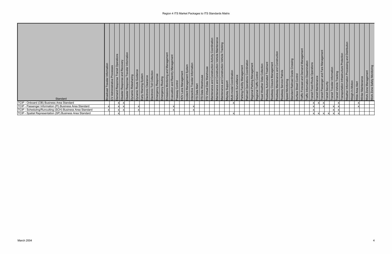
Region 4 ITS Market Packages to ITS Standards Matrix
Standard Bro
adca
st T
rave
ler I
nfor
mat
ion
CV
Adm
inis
trativ
e P
roce
sses
Dem
and
Res
pons
e Tr
ansi
t Ope
ratio
ns
Dis
aste
r Res
pons
e an
d R
ecov
ery
Dis
aste
r Res
pons
e Tr
avel
er In
form
atio
n
Dyn
amic
Rid
esha
ring
Dyn
amic
Rou
te G
uida
nce
Ear
ly W
arni
ng S
yste
m
Ele
ctro
nic
Cle
aran
ce
Ele
ctro
nic
Toll
Col
lect
ion
Em
erge
ncy
Res
pons
e
Em
erge
ncy
Rou
ting
Em
issi
ons
Mon
itorin
g an
d M
anag
emen
t
Eva
cuat
ion
and
Ree
ntry
Man
agem
ent
Free
way
Con
trol
HO
V L
ane
Man
agem
ent
Inci
dent
Man
agem
ent S
yste
m
Inte
ract
ive
Trav
eler
Info
rmat
ion
ITS
Dat
a M
art
ITS
Dat
a W
areh
ouse
ITS
Virt
ual D
ata
War
ehou
se
Mai
nten
ance
and
Con
stru
ctio
n A
ctiv
ity C
oord
inat
ion
Mai
nten
ance
and
Con
stru
ctio
n V
ehic
le M
aint
enan
ce
Mai
nten
ance
and
Con
stru
ctio
n V
ehic
le T
rack
ing
May
day
Sup
port
Mul
ti-m
odal
Coo
rdin
atio
n
Net
wor
k S
urve
illan
ce
Par
king
Fac
ility
Man
agem
ent
Rai
lroad
Ope
ratio
ns C
oord
inat
ion
Reg
iona
l Par
king
Man
agem
ent
Reg
iona
l Tra
ffic
Con
trol
Roa
d W
eath
er D
ata
Col
lect
ion
Roa
dway
Aut
omat
ed T
reat
men
t
Roa
dway
Clo
sure
Man
agem
ent
Roa
dway
Mai
nten
ance
and
Con
stru
ctio
n
Roa
dway
Ser
vice
Pat
rols
Spe
ed M
onito
ring
Sta
ndar
d R
ailro
ad G
rade
Cro
ssin
g
Sur
face
Stre
et C
ontro
l
Traf
fic F
orec
ast a
nd D
eman
d M
anag
emen
t
Traf
fic In
form
atio
n D
isse
min
atio
n
Tran
sit F
ixed
-Rou
te O
pera
tions
Tran
sit M
aint
enan
ce
Tran
sit P
asse
nger
and
Far
e M
anag
emen
t
Tran
sit S
ecur
ity
Tran
sit T
rave
ler I
nfor
mat
ion
Tran
sit V
ehic
le T
rack
ing
Tran
spor
tatio
n In
frast
ruct
ure
Pro
tect
ion
Wea
ther
Info
rmat
ion
Pro
cess
ing
and
Dis
tribu
tion
Wei
gh-In
-Mot
ion
Wid
e A
rea
Ale
rt
Win
ter M
aint
enan
ce
Wor
k Zo
ne M
anag
emen
t
Wor
k Zo
ne S
afet
y M
onito
ring
TCIP - Onboard (OB) Business Area Standard x x x x x x x xTCIP - Passenger Information (PI) Business Area Standard x x x x x x x x x x xTCIP - Scheduling/Runcutting (SCH) Business Area Standard x x x x x x x x xTCIP - Spatial Representation (SP) Business Area Standard x x x x x x x x
March 2004 4